Embed Size (px)
Citation preview
.3,..DOCUREIT RESUME
ED 151 e17 _..
so 011 027 /,
TITLE , Bringing Energy to-the People: 'Washington, D.C. andGhana. Grades 6,7. Interdisciplinary Student/Teadher-
". Materials in Energy,' the Environment, and the- .
Econoiy.. ,
INSTITUTION- _ National Science Teachers AssoC'tation, Washington,\D.C. .
SPONS AGENCY Office, of the Assiitant Secretiry,forIntergovernmental and Institutional' RelatiOnsADOE),Vaihington, D.C. Education, Eusiness and.-LaborAffairs. .
REPORT-NO HCP/U3841-0006PU4 BATE Feb 78 %-C.01171/ACT .EX-76C-10-3841 . . /IOTE : . 69p.; For related documents, see SO..011 028-030 ;
Best copy available_ .
.AVAILABLE FROM U.S. Departaent of Energy, TechniCal InformationOffice; P.O. Box 62, Oak' Ridge, Tennessee-37830(free, paper cover) .
V 1
\ -
EDRS PRICE 1F-S0'.83 Plus"Postage. HC Not Aiailable from EDRS.DESCRIPTORS Class Actiiities; *Comparative Analysis; Cross
ii, ° CulturaiNStudies; Elementary Secondary Education;*Energy; *Energy Conservation; Grade 6; Gride 7;Graphs; Interdisciplinary Approach; IntermediateGrades; Junioi High Schools; Lesson Plans; NagSkills; Physical Geography; Sciences; Social'Studies-Units; Teacher Developed Materials: *World . .
Geography ,
IDENTIFIERS *District of Columbia; *Ghana (Accra),. a
ABSTRACT ,
This instructional unit contains four 4assfoolessons dealing with energy for use in grades six and seven; TheoVeralk,Objective is to provide students with a Comparative overviewof two bisic.energy concepts: energy is a basic need in all cultures;,And energy use affects the way people live. In the lessons, which caneasily be integrated into studies of world cultures and physicalgeography of the world, student's compare Accra, Ghana, with the
'.Vashington, D.C. area in terms of climate, geographic location.,energy dependence, and services that meet their'needs.,Thelesson/5 developed by teachers are: (1) hiGeographica,1 Pictdre of TwoCitiee;, (2) Tracing the Source's of Electric Power in Ghana and in theVashington,D.C.Area; (3) Two Transportation Systems: How Are TheyAlike? How Are They Different; and (4) How Is Electricity Used In.TwoDifferent Cultures7The second lesson'can also be taught in sciencecourses. Students construct climagraplis, analyze and interpret factsheet maps and' bar graphs, answer questions about highway apd roadmaps, and examine case studies. A time allotment varying from one to
'four classes; for each of the four lessons is suggested, but will-- probably vary depending on student Interest and ability. Each lessoncontains complete teacher MIA student aterials backgroundinformation for the teacher on the topic under stndi..(Author/R5)
#e41.
'HCP/,,U 3841-00064 -i 11115 DOCUMEN1OHO BEEN REP
DUCED EXACTLY AS RECEIVED FR*,. THE PERSON OR ORGANIZATION ORIGIN.ATING) IT POINTS OF VIEW OR OPINIONSNo, STATED 00 NOT NECESSARILY REPRE-
. SENT OFFICIAL NATIONAL INSTITUTE OF4-.1 . EDUCATION POSITION OR-POLICY
U S DEARTA4ENT OF HEALTH.EDUCATION II WELFARE
NATIONAL INSTITUTE OFEDUCATION
0/ 7"1"MIVIMLLIN 1r1-1
8,
oNational ScienceTeachers Association
'PERMISSION TO REPRODUCE THISMATERIAL. IN MICROFICHE ONLYA E N GRANT D
AI THE EDU L RESOURCESINFORMA CENTER (ERIC) -ANDUSER THE ERIC SYSTEM,"
InterdisciplinaryStudent/Teachin Energ , theand t co
erialsonment,
DRING G ENERGYsib T E PEOPLE!'Was Ingtion, D.C. and Ghana
ades 6,7
February 1978
Prepared forU.S. Department of Energy, )Office of Education, Business and Labor'AffairsUnder Contract No. EX-78C-1,Q-3841
2 A
1
4
aThis material was produced by the National Science
Teachers Association under contract with the U.S.
Department Of Energy. . The fact, statistics, -and
conclusions are thote of the authors.
Copies of these materialt may be ordered from:
U.S. epartment of EnergyTec ical Information OfficeP.O. Box 62Oak Ridge, TN 37830
ri 4
Field Test Draft
Please send your comments Oh the usefulness
of. this material- to: ,'
National Sdience Tear ilers Association1742 Connecticut Avenue, R.W.Washington, D.C,, 20009
.
7
1.0
.
This instructional unit was produced-by NSTA's,
Project for an Energy-Enriched Curriculum undercontract #EX-76C-10-3,841 frpm the Educataoh Pro-grams Branch, Office of Public Affair4 the U.S..Energy Research and Dev4lopihent Administration*-(now U.e..Department of Energy) ; The NSTA , '..-
,
.7 project staff is-as'folloVs4
. '"'
., .
JOhrrA. Towler, Project directorKing C. Kryger,.Associate . .
roject DirectorPHelen H. Carey, 4ditor*-Cooi.dinator
.., . -
0,"Bringing Energy to the People':., WashingtIn,! D.C.'s;and Ghana" is the product of a. writing session . %*
. .hel4 at the University of Maryland during Summer.1977. The following teachers were the main
. contributors to this.urfif:
Jacquelyn:L. Lendsey Bette JohnsorfMontpelier Elementary , Dunloggn Miadie SchOol
School -Howard County, MarylandPrince Georges County,
Maryland
Olivia Swinton :
Friendship Education.Center
Washfngton, D.C.
V
.Aetist: ,Jessica'Morgan.
(;
, .
The PEEC staff also wishes to acknowledge ,thecooperation of the NatidhalCouncil for the SociStudies-(NCSS) and'its.Executive-Directdr, Bri nLarkin. The NCSS has -suggested teacher's and con- '
sultants to us and has assisted in evaluation and.
. review of the social studies aspects'oi this'ur.!-
January 1978- 2') Jahn M. Fowler
'Project Director
4
A
le
t.
4
%
11
BRINGING ENERGY TO THE PEOPLE:r. Washington, D.C. and Ghana-
'Introduction The social studies curriculum at the sixth andseventh grade levels consists of studies ofworld cultures as' well as the physical geography-.of the world. This unit covers both areas ofstudy in a comparative overview bf.two basic
''energy concdpts, which 'are: 1) energy is a basicneed in all cultures, and 2) energy use affectsthe way people live.
In this unit students will be able to compareGhana with the Washington, D.C.. area in terms ofclimate, geographic location, energy dependency,aneservices that help people meet their needs.
-A time 'allotment for each of the ft:Air lessons hbeen suggested, but will probably vary depen-ding on such factors as the ability (z) the Btu-dentS, interest, and how the unit islintegratedinto an existing 4pnit of study on Africa.
Each lesson contains complete teacher and stu-dent materials and'suggestions for extending the.learning beyond the classroom and for indepen-dent study.
Lesson Title Target Audience
1. A Geographical Picture Social StUdiesof Two ,Cities
2. Tracing the Sources of Social-Studies andElectric Power in Ghana & Science'
--\in.the Washington,' D.C. Area
3. Two Transportation Systems: Social StudiesHow Are They Alike? HowAre They Different?
4. Howe. Is Electricity Used in Social StudiesTwo Different Cultures?
5
-a
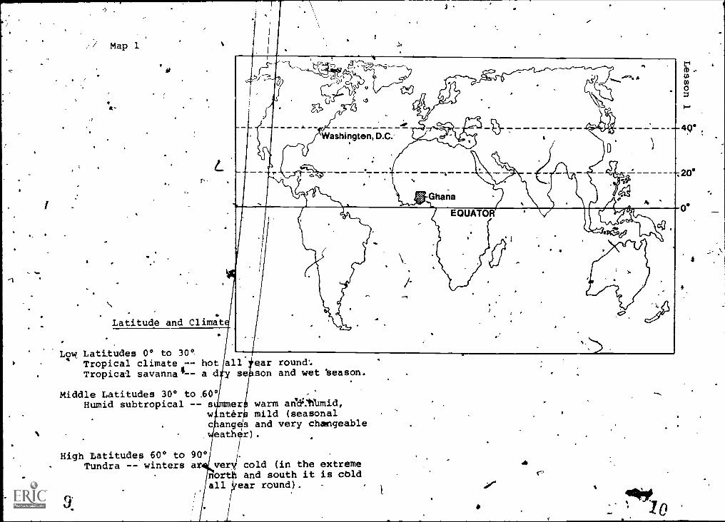
Lesson 1: A GEOGRAPHICAL PICTURE OF TWO OsITIES
* .
NOverview This lesson is intended to develop the student§'\ .- understanding of the-exact geographic locations
of two Cities and the effects of-those locations. .on each city. .
.--
Ob4ectives The studerit should be able to:1. Locate-Ghana and Washington, D.C. using
longitude and latitude lines.. 2. Discuss the climate in two capital cities--
ikcd'ra, Ghana and ?ashingtdn, D.C.
Materials World map or'globe.
Background To show.locatiop on a map-, map - makers use sets ofInformation lines. One set runs north and south, the other
('Teacher Uge Only) . set runs east and west.I
.,tines that Tun eastand wett4-
are called, latitudelines. ,These lines give .the position of ;a placein,reference to the equator. Latitude. lines are
, parallel to the equator and are equidistant fromthe-equator for their entire length around the-.earth: Latitude lines are numbered from 0° to90°; the equator. is and.the North Pole andSouth Pole are. 90.V. To. avoid confuSion, the lat-itude line at 4,0° betkeen the equator and theNorth Pole," for example, is 4(" °' North latitude.'In the same way, the 40° line between the equatorand the South Pole'ls 40° South latitude. Thelatitude °Ca place *usually gives us some indi-cation of theclimate. The low latitudes, 0° to30° are near the equator. These places of lowlatitudes are sometimes called the tropics. Atropical climate is a hot climate throughout theyear because in this area the sun's rays aremdst*direct. 'The middle latitudes, 30° to 60°'north arid south of the equator, have very change-able. weather and seasonAl changes. This area hasa temperate clithate. The high latitudes, 60° to
3
.4
90°, have a.cold climate. At 66 1/2° N latitudeand 66 1/2° S latitude, them is a day in, winterwh n the sun neve; rises above 'the horizon.They alo.have 6-\'clay in the summer when the sunnever gots helot./ the horizon.
Iqngitude lipes run from the North Pole to theSouth Pcgeand meet at the poles. The distancebetween any two longitude lines is greatest atethe equator. Longitude lines are numbered in de-grets from 0° at Greenwich,, England to 180° atthe International Date Line in thdoPacific Ocean.
Teaching Tell the'students that they are going to learnStrategies how to locate places on &ap. 'Give the students
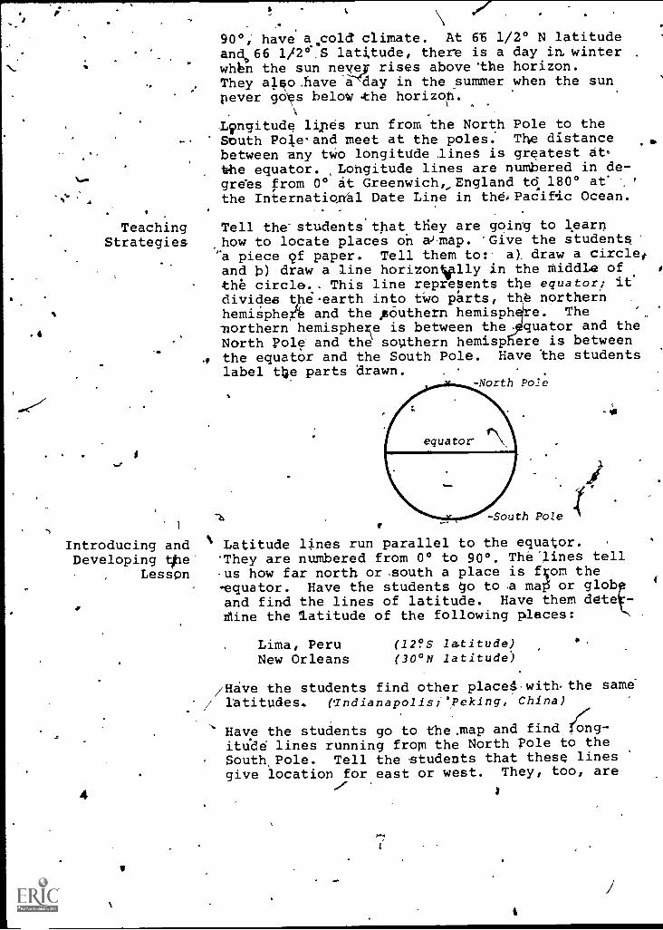
''a piece cf paper. Tell them to:- aY draw a circlesand b) draw a line horizonVlly in the middle ofthe circle.- This line represents the equator; itdivides the.earth into two prts, the northernhemisphe and the AOuthern hemisph e. The '
northern hemisphere is between the. quator and theNorth Pole and the southern hemisp ere is between
., the equator and the South Pole. Have the studentslabel the parts drawn.
-North Pole
1
-South Pole
Introducing and ' Latitude lines run parallel to the equator.Developing ttle They are numbered from 0° to 90°. The-lines tell
Lesson us how far north or ,south a place is fv)m the-equator. Have the students 4o to ,a map or globand find the lines of latitude. Have them ddte -dine the latitude of the following places:
4
Lima, Peru (12?.5 latitude)New Orleans (30°N latitude)
/Hive the students find other placel,with,the same/ latitudes. (Tndianapolis; ',Peking, China)
Have the students go to themap and find 4g-itik6 lines running from the North Pole to theSouth Pole. Tell the students that these linesgive location for east or west. They, too, are
47.
Concluding theLesson
numbered in degrees like latitude line$. Havethe students find 0° longitude. Tell the students'that this placevis in GreenWich, Englatid, andthatthe decision to use Greenwich:was, made Manyyears ago.i Show the students the InternationalDate Line At 180° East ox West longitude. Usingthe map or globe,, have the students'find the .
longitude of the following plebes:
New OrleansHamburg, GermanyNew Delhi, India -
Lima, Peru
(90 °W longitudp)(10°E longitude)'`(7.7°E longitude)Y77.°W longitude)
When longitude and are used together,you can find the exact location cif a place.Have the students locate the follbwing:-
New Orleans (30°NLima; Peru (12°SNew Delhi,, India (28°SHamburg, Germany (53 !AT
4
latitA 90°W longitude)latitude; 77°W longitude)latitude-, 77°E longitude)latitude; 10.°E longitude)
Tell the students that we are going to study t*o.s.capital, cities, Accrat Ghana (Africa) and Washing-ton,,D.t. Have the students locate the two cities.Ask themto look at Map 1 and desCribe the kindof climate they -would expect to find in Washing-ton, D:C. and in Accra, Ghana. 4
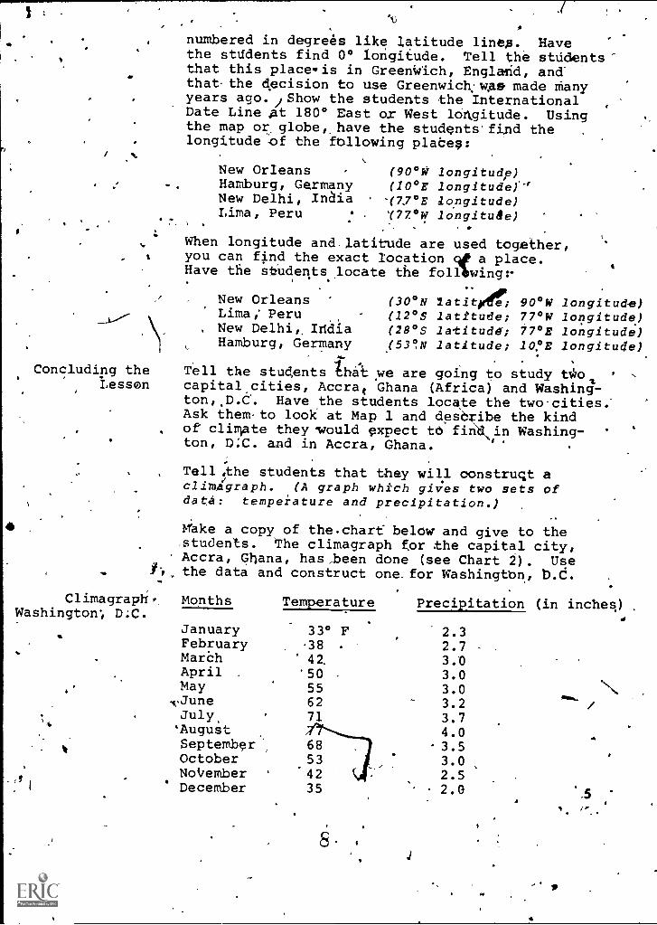
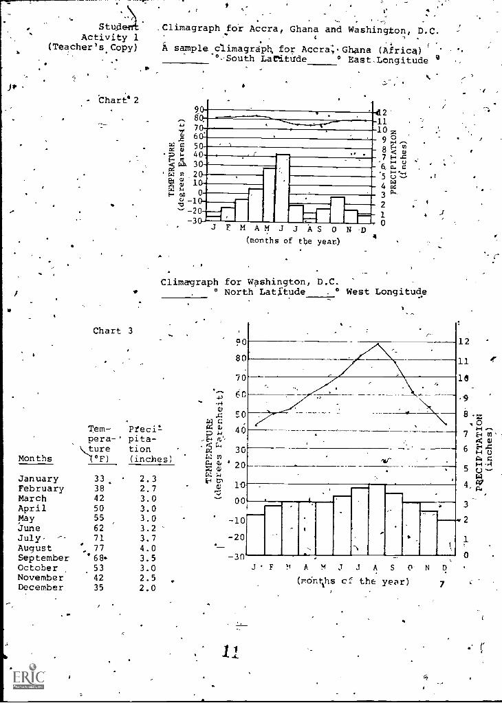
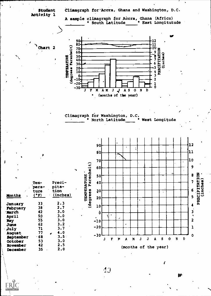
Tell,the students that they will construct aclimagraph. (A graph which gis;es two sets ofdata: temperature and precipitation.)
Make a copy of the.chart below and give to the,students. The climagraph for the capital city,Accra, Ghana, has ,.been done (see Chart 2). Usethe data and construct one for Washingtbn,
Climagraph, Months Temperature Precipitation (in inches)Washington; D.C.
;4.
JanuaryFebruaryMarshApril ,
May,.JuneJuly.AugustSeptemberOctoberNok/emberDecember
33° F38 -
42.
'50556271
1
2.32.73.03.03.03.23.74.0
-3.53.02.52.0
'or
A
.5
I
Map 1 a.
In0
-4
-720'
Latitude and Climat
Low Latitudes 0° to 30°Tropical climate -- hotTropical savanna4 - a d
Middle Latitudes 30° to .60°Humid subtropical -- s
wc
High Latitudes 60° to 90°
9.
all ear round'.se son and wet 'season.
,
er warm aria amid,nter mild (seasonalang s and very changeable
eathar).
t.
Tundra -- winters at- Very cold (in the extremenorth and south it is coldall frear round). -
1
-
4111401JP
0
/
r 4
Stud Climagraph for Accra, Ghana and Washington, D.C.-Activity 1 c
.-,
(Teacher's Copy) i sample climagraph. for Accr4.Ghana (Afric4)(
°,-South Lafttade ° East,Longitude..
Months
JanuaryFebruaryMarchAprilMayJuneJuly. -.
AugustSeptemberOctoberNovemberDecember
- Chart' 2
- -.
2'11
4.J 30z .Z . .,900,4,-..
2,4, c E-, (4cd a) 8 < cy).4 7 E.-. ..cF t , Oi-d
%viaIX C... C
. 4..,4.4r.4) m 5 c..) ,-- /
%li S4,3
4 cc1-. 00 0 3
73 .' -203 J F M AM J J As 0
(months of the year.)N
a
10
Chart
-Tem-pera-'ture'f°F)
Climagraph for° North
Washington,Latitude
90
80
70
60
46
30
' 20
1-0
00
-10
-20
-30J F
D.C.° West Longitude
D
7
12
11
18
-9
7
6
5
4.
3
2
0
4.
0HE.it4
HE''C1:14
H047
3
Pfecilpita-tion(inches)
a)
a')-I
,E4(;',
c c''
f.:.: CO
a'7, 0%
Lt.: 1.4
E-1
c,--
___
M J J A S N
(mcinchs cf the year)
33.3842505562
7177
'684534235
2.32.73.03.03.03.23.74.03.53.02.52.0
%.-
I
1-
-...-
---e.
lir
(""
to
Overview
Objectives
Time Allotnient
BackgroundInformation
(Tdacher Use Only)
V
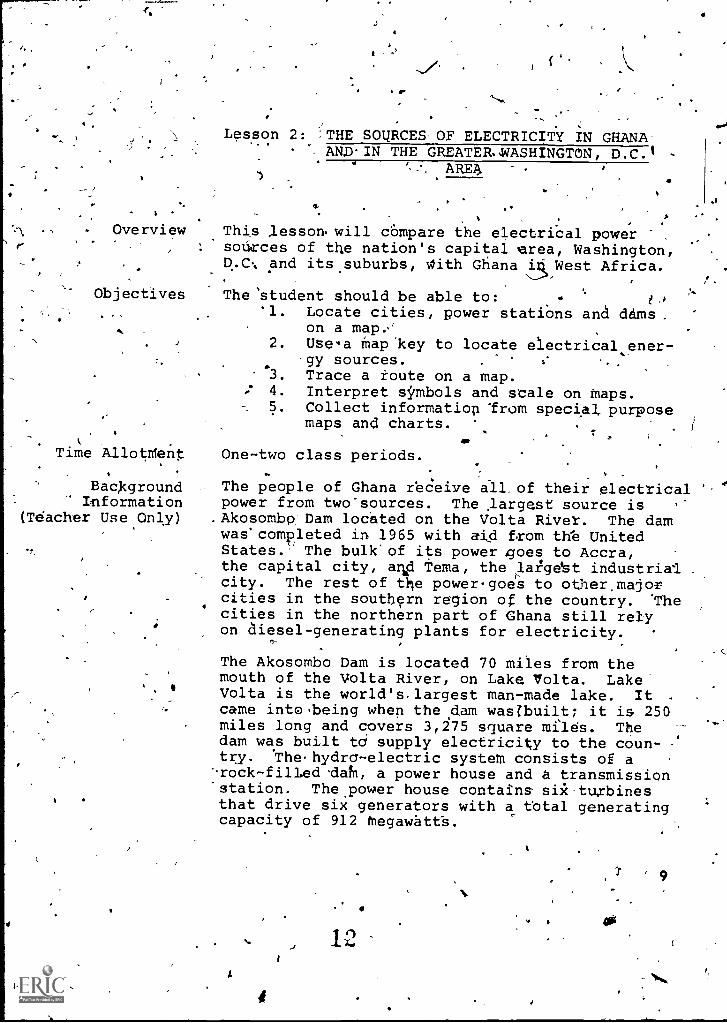
Lesson 2: THE SOURCES OF ELECTRICITY IN GHANAANDIN THE GREATER.WASHINGTON, D.C.I
ARES
This lesson will compare the electrical powersources of the nation's capital area, Washington,q.c., and its suburbs, With Ghana 5 West Africa.
The 'student should be able to:'1. Locate cities, power stations and dams,
on a map.2. Use'a Map 'key to locate electrical ener-
gy sources.3. Trace a route on a map.4. Interpret symbols and scale on Maps.5. Collect informatiop Irom special purpose
maps and charts.
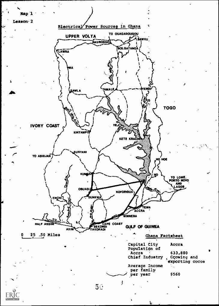
One-two class periods.
The people of Ghana receive all. of their electricalpower from two-sources. The largest source is
.Akosombo:Dam located on the Volta River. The damwas'completed in 1965 with aid from th'e UnitedStates.'' The bulk' of its power goes to Accra,the capital city, arkd Tema, the lagebt industrial .
city. The rest of the power-goes to other,majorcities in the southern region of the country. Thecities in the northern part of Ghana still relyon diesel-generating plants for electricity.
The Akosombo Dam is located 70 miles from themouth of the Volta River, on Lake Volta. Lake
4 Volta is the world's, largest man-made lake. It .
came into being when the dam wasZbuilt; it is 250miles long and covers 3,275 square miles. Thedam was built td supply electricity to the coun-try. 'Thehydra-electric systeM consists of a
'Arock -filied dain, a power house and a transmission'station. The power house contains six turbinesthat drive six generators with a total generatingcapacity of 912 Megawattb.
A
12
9
s.
Developing theLesson
10
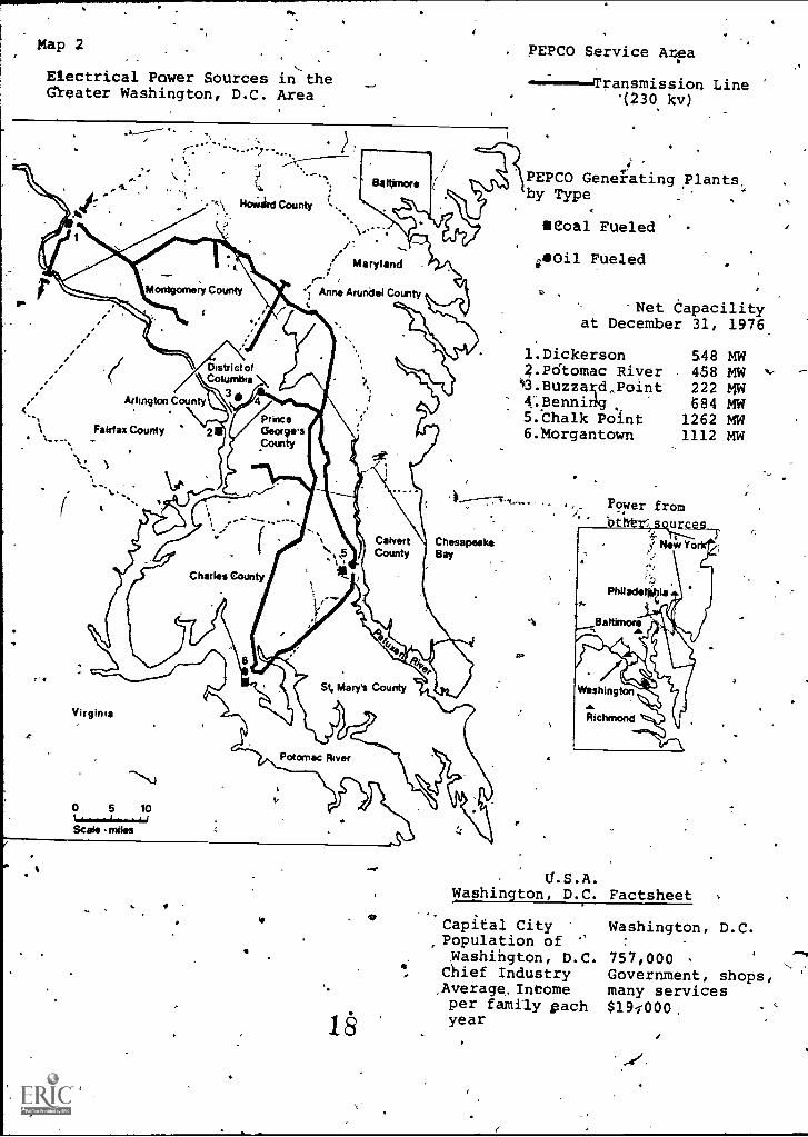
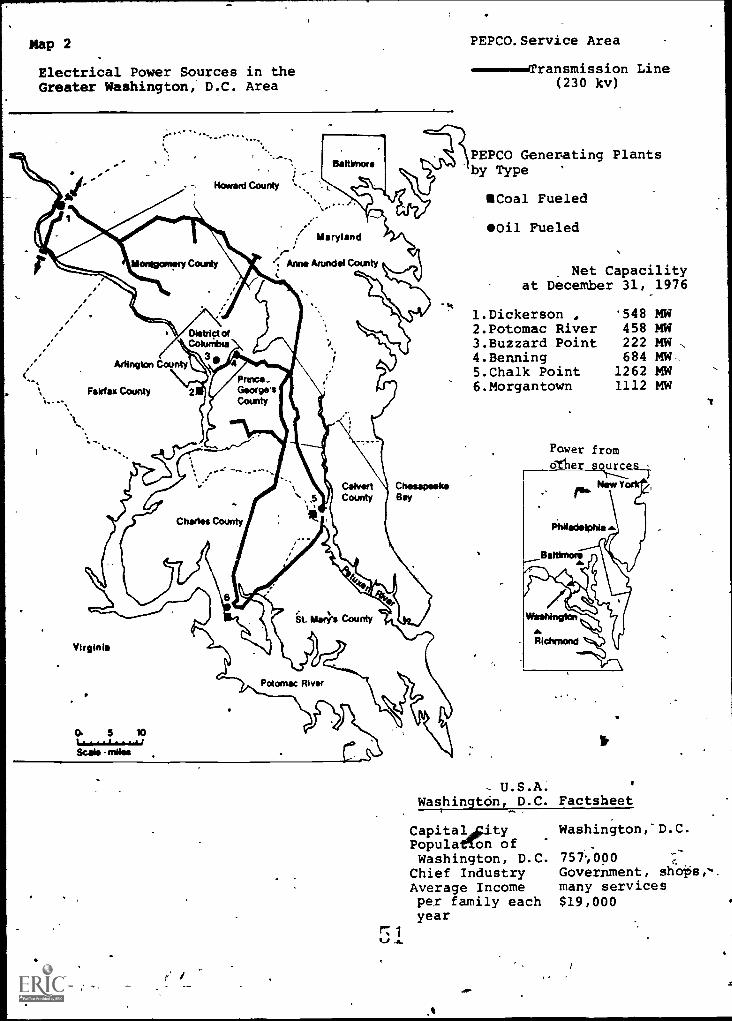
The Potomac Electric Power Company prOvides''eleetridal power to the Washifigton, D.C. area.'(This area includes the nation's capital andmany portions of Prince George's County, Mont-
gomery County, inNaryllandm+ArbnThe canpany serves about. 643 s "juare miles. Six gemrsting
stations /power plants suppl y 4,286:megamattd of power
to over 2,000,000' people in the gmater.Wafalington area.
Give students the Factsheet/maps of.Ghana ana the USA
(Map 1) andhelp them draw comparisons betweenthe sources of power in Ghana and in the Greater
.
Washington, D.C. area. . . %
.. .
1.;' What is the capital of Ghana? (Accra.)
ol
Of the United States? (Washington, .D.C.)0 .,.Lt62.14...
2. Which capital city has the most(WaShington, D.C. -- only a few.
3. What is the main industry in Ghana?'.2-(Growing and exporting cocoa.) 1
'4. Where do people earn more money each.year -- in Accra or in' Washington, D.C,?(Washington, D.C.)
. -
) S. Look at the electrital,energy sources in
Marta on the map. Find the Volta River.With your fihgers trace 'the Volta Riverfrom its mouth to thejlkosombo Dam.' Use
your ruler and the map scale'to measurethe distance from the mouth of the VoltaRiver to the'VoltaDam. How'fak is it? c
(About 70
'10Measure
poizer line 'from the dam, to Takoradi.How many miles? Wh4t would this 'be. in
kilometems? (170*mities or 272 kilometers.)
6. Point to Lake yolta on the l ap. A few-.years aga 80,000 people,lived on theland now, covered-by the water in the dam.-These people had to move ,somewhere elfe.
Where,do you think they moved to?(Allow time for stpdpnt answers. Many.)
moved to Accra: You may wish to explain
that when big:krojc-cts likedabs,are'Planned, goverhmefi,tshelP people to re-
S.
1
.nota
*,
rtr
141# e
a
/ .
locate in other places and often helpthem find ,housing and jObs. Shofildthe discussion take this direct-Job,'you may want to go into the feelfrOs-ofpeople toward - relocating in new placesand leaving old and familiar ones.)
'7., What energy sources are used to produceelectricity in Washington, DX. (Oiland coal are used in power plants toelectricity. There are no hydroelecttIC,stations.) f'
,
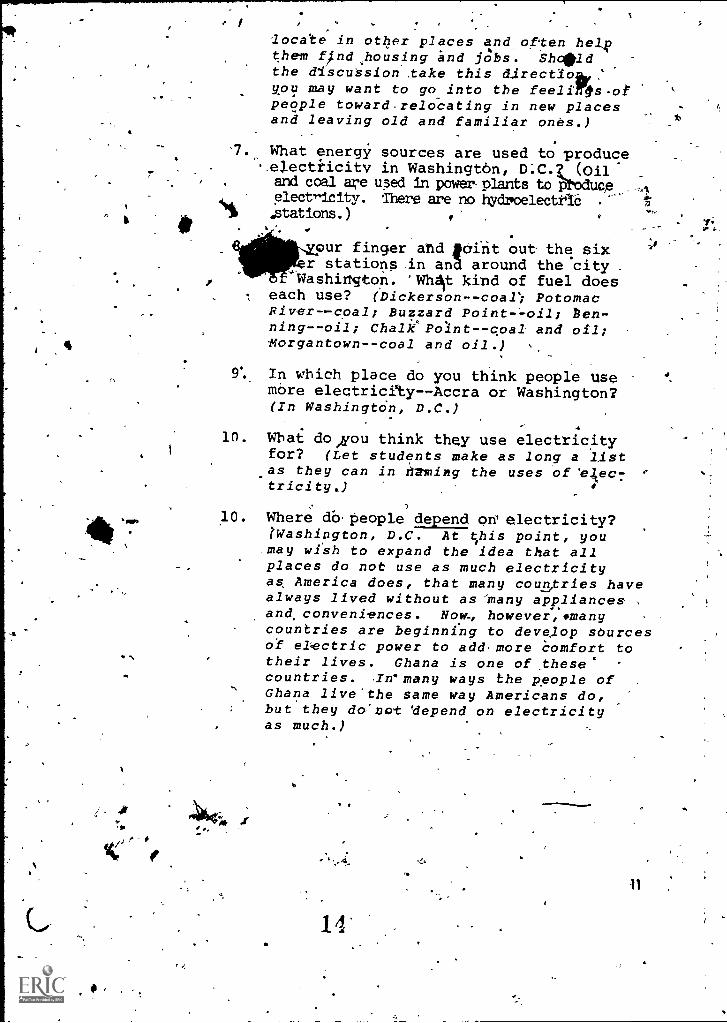
our finger and faint out the sixr stations in ana around the city
Washington. 'Whit kind of fuel doesT each use? (Dickerson- -coal; Potomac
Rivercoal; Buzzard Pointoil; ben-ningoil; Chalk PoIntcoal and oil;organtowncoal and oil.)
9% In which place do you think people Usemore electricety--Accra or Washington?(In WashingtOn, D.C.)
9.,,
10. What do ,you think they use electricityfor? (Let students make as long a listas they can in 1-2xlimg the uses of 'e;ec7tricity.)
7
10. Where db.people depend on' electricity?tWashington, D.C. At this point, youmay wish to expand the idea that allplaces do not use as much electricityas America does, that many countries havealways lived without as many appliances ,
and, conveniences. Now, however,smanycountries are beginning to deve,lop sourcesof electric power to add-more Comfort totheir lives. Ghana is one of these'countries. Irmany ways the people ofGhana live'the same way Americans do,but they do:not 'depend on electricityas much.)
14'
Concluding the Rene r the times when the'electricity.
went off?Lesson Wha a-pliances wouldn't_runlanymore? How did,
you 1?- What things did you substitute forways to cook? To ,heat the house? For T.V. andlights to read by?
Where does Washington, D.C. get its power if
the generating station/power plants, shut dm/Atli atonce?Where can the people of Accra get poi* something
' happens to the -electric power that canes nmml theAkosornb6 Dam?
)
,e,,
Distribute copies of the CASe Study. Have'two'
students take the parts of''--tha girls talking as
,.:.the'rest of the class foliows along with thestory. _". .
. -.- '
, ,
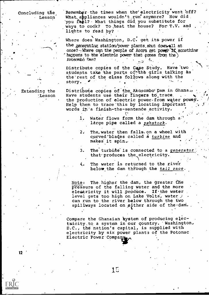
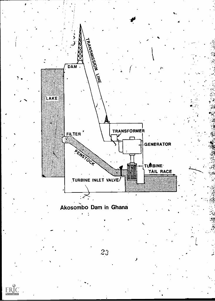
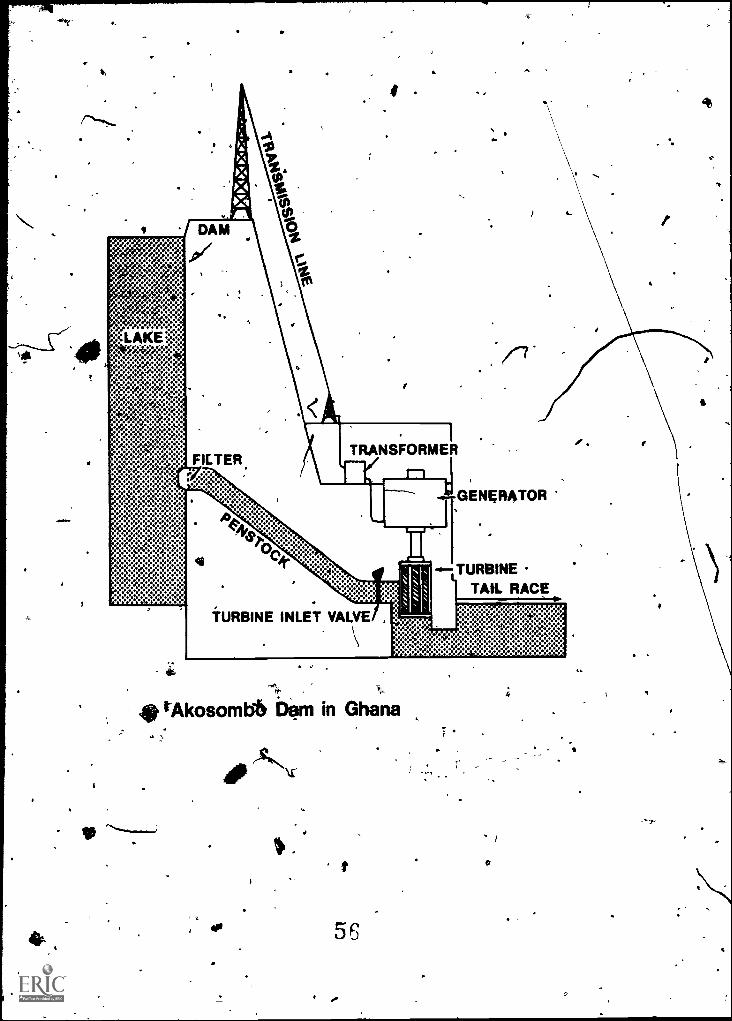
Extending the Distribute copies of the Akosombvpam in Ghana., f'
:Lesson Have students use their lingers to trace_ . 1,, r,
the production of electric powerJfrom water powei.Help them to trace-this by locating important 1.
words in'a finish-the-sentende.activity. ,
1. Water flows from the dam throughlarge pipe called a pehstock.
The, water then falls. on a wheel withcprved'bla4es called i turbine andmakei it spin., -
The turbine' is connected to a generator:.that-produces the l lectricity._
4.. The water is returned to the riverbelow_the dam thkough the tail race.
Note: The, higher the dam, the greater thepressure of the falling water and the moreelealtricity it will produce. Ifthe waterlevel gets too high on Lake Volta, watercan run to the river below through the twospillways located on.either side of the dam.,
Compare the Ghanaian system of producing el,ec-tmicity.to a system in our country. 'Washington,D.C., the nation's capital, is supplied withelectricity by six power plants of the PotomacElectric
12
V
4
1
Give each student a copy of Electrical Power.Sources in tie Greater Waehington,,D.C:-Area'(Map 2). Have the,students'study ihe pictute.
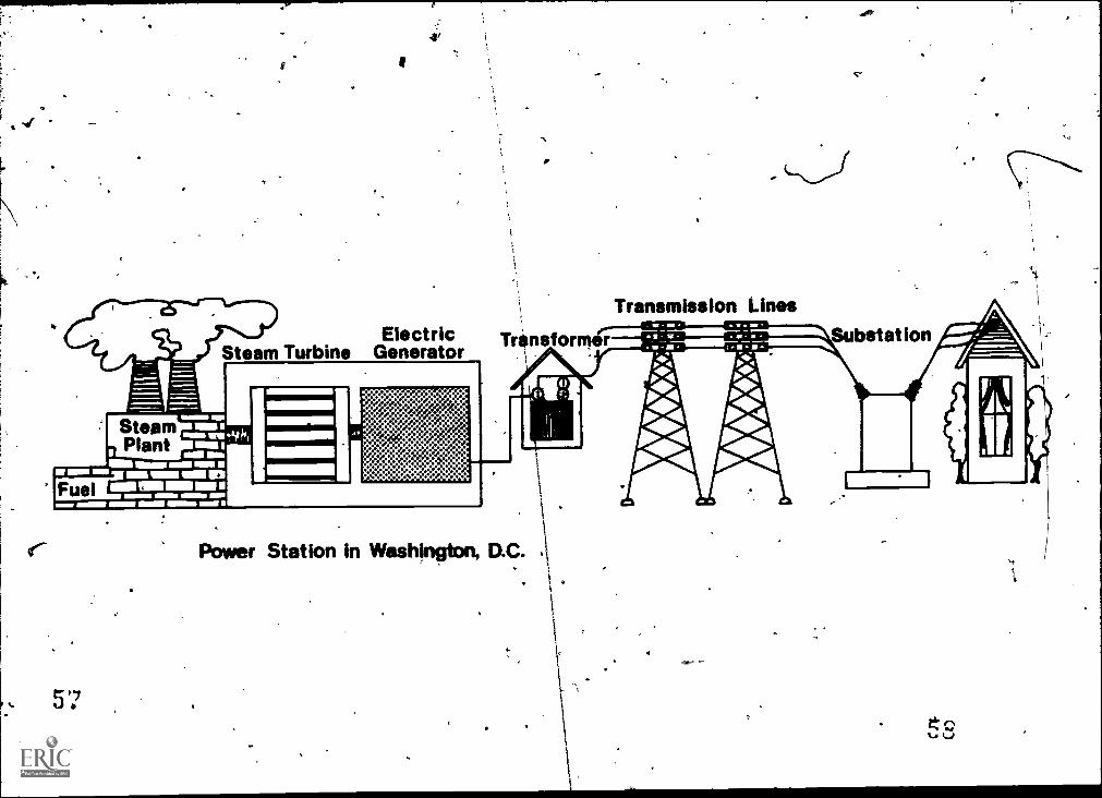
. In the Wathington, D,C. area electrical energy-is produced by thermal energy:' 'This meansoil, or coal are used to Oroduce.electritity.Look at the picture.,
1. The fuel Used in the Washingtop,D.C.area to'produce electricity iS coal,.oil:
r 2. 'It goes through special prOcessing andthen is sent into the furnace whereIt is burned to predu e heat which is usedto boil water & create
m3. The steamturns the tur ine which
'sends energy to the electrical generator;
!4. 'Electricity is sent through transformersfortransMissioc and distribution.
Energy Source Look et .the diagram of the dam in Ghana andComparisons the power station in Washington.D.C: What do
you see that is familiar? (Transformer, gener-ator, "turbine, transmision-'11ne.S.)
_What.is different? (Student: answers _will var.Ow possible answer is: the.fuel dam iswater power so the-dam is a Aydro7electricpopre_c sourcb. The power station in Nashiniton,D.C. uses coal or oil, sit is a thermal,elaVtric poWe'r source.)
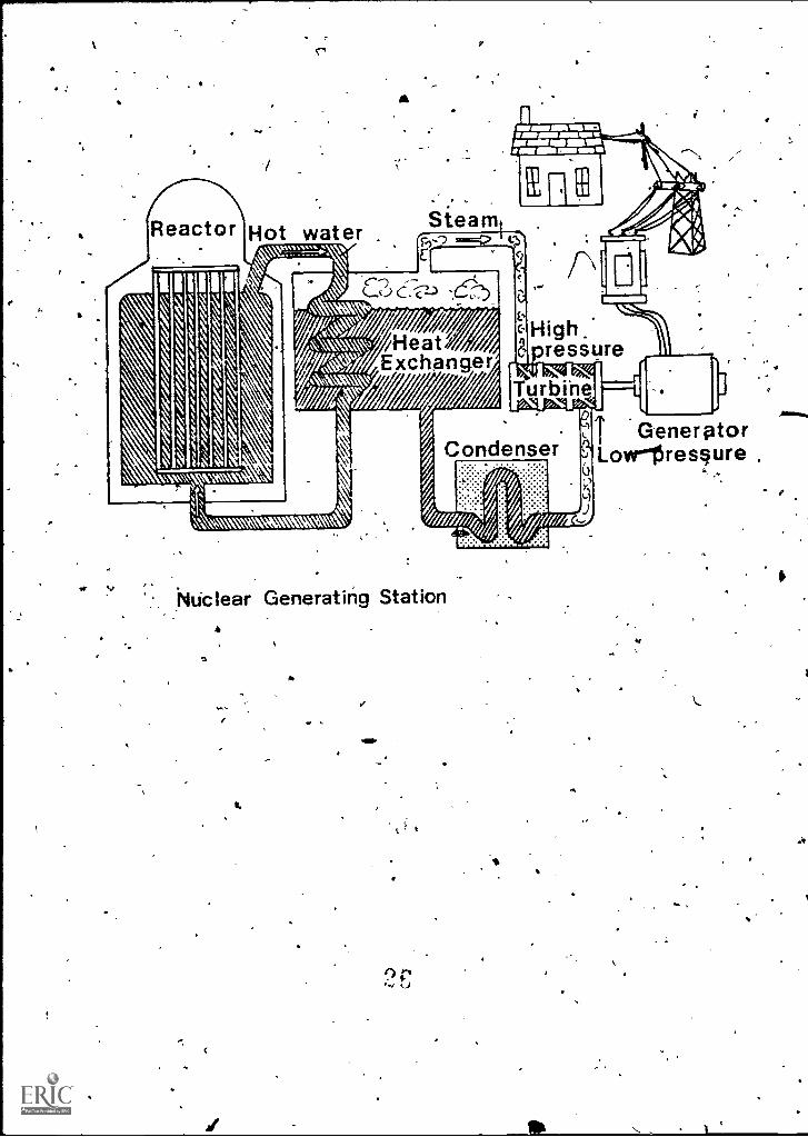
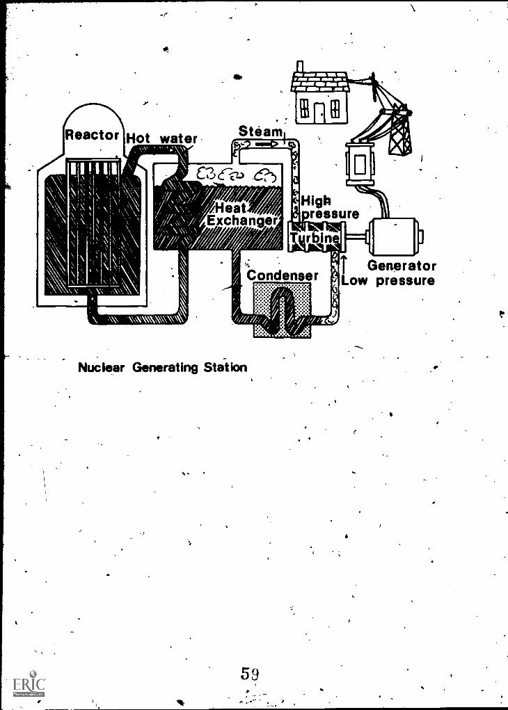
Look at the pictureof a Nuclear Generating Station.What do you see Otat is similar to the fossilfuel burning plant? (Steam,"turbine, condenser,generator, transmission lines.)
What is different? (The fuel source is the majordifference.)
Sources 1. Energy-Environment SQurce Book, John M. Fowler.
2. Ghana '76: An gfficial Handbook, Govern-ment Publication.
3. Chanaand Beyond Junior Secondarlf Geographies'for West Africa, i'gip. Turner..
-
4.. PEPCO Annual Repork191k.
S
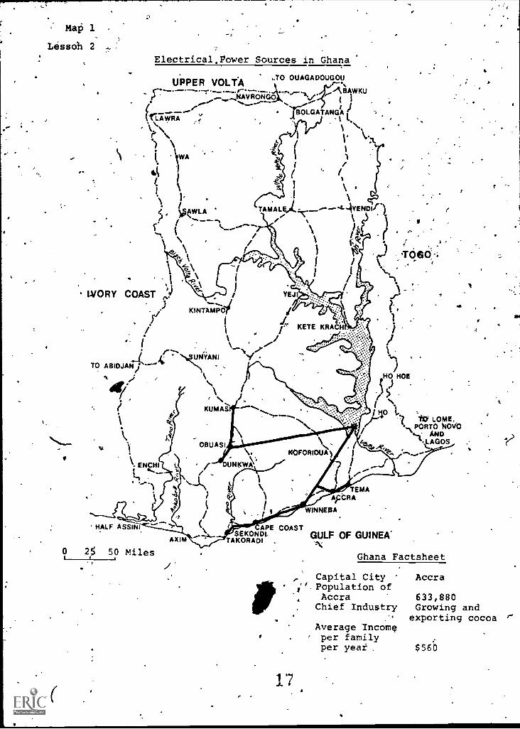
Map 1
Lessoh 2
Electrical power Sources in Ghana
UPPER VOLTA 0 OUAGADOUGOU
^BAWKUr...........__,..........-..0-*---31:7,0--,. ,..
......NAVRONGO/../ N.,.......-- % (i ) .
......- TE-IraLGATANGAfri.AVIRA (1,' I 1
r\ 4,
l /1
I. \WA ii.43 i 1
..? I
1
i. . .1
< AWLA TAMALE), ------42-4YENDIf)l" )0
^ ._ \--..t
1
%\\ 1
1
f.;
IVORY COAST-10
.
YEJI....
,)-KINTAMPO
I Li../.
/ i / KETE
( \\ '''I..... .."if.:".. UNYANI '1 -
. %.TO ABIDJAN/`HO HOE)
.KUMA? 110 L =
110 Lome,PORTO
NDk.. Ko"
.). ANDLAGOSOBUASI
ENCHI
ti
TEMAApCRA
WINNEOA.
' HALF ASSINI CAPE COASTSEKONDI, GULF OF GUINEA'XIM TAKORADI
0 2,5 50 Miles
7
'1
Ghana Factsheet
,' Capital City Accra". Population of
Accra 633,880Chief Industry Growing and
exporting cocoaAverage Incomeper familyper yea $56
Map 2
Electrical Power Sources in theateater Washington, D.C. Area
(1.Arlington County
Fairfax County
ChesapeakeBay
Virginta
0 5 10
Scale -miles
PEPCO Service Arta
....;----Transmission Line'(230 kv)
,i
PEPCO Generating Plants.by Type
ewa Fueled
4,0i1 Fueled
Net Capacilityat December 31, 1976
1.Dickerson 548 MW4.Pdtomac River - 458 MW'03.Buzzard,Point 222 MW4:penning 684 MW5.Chalk Point 1262 MW6.4organtown 1112 MW
U.S.A.Washington, D.C.
Capital City,Population of
Washington, D.C.Chief Industry,Average,InComeper family eachyear
Factsheet
Washington, D.C.
757,000Government, shops,many services$191000.
r
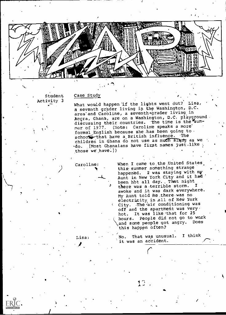
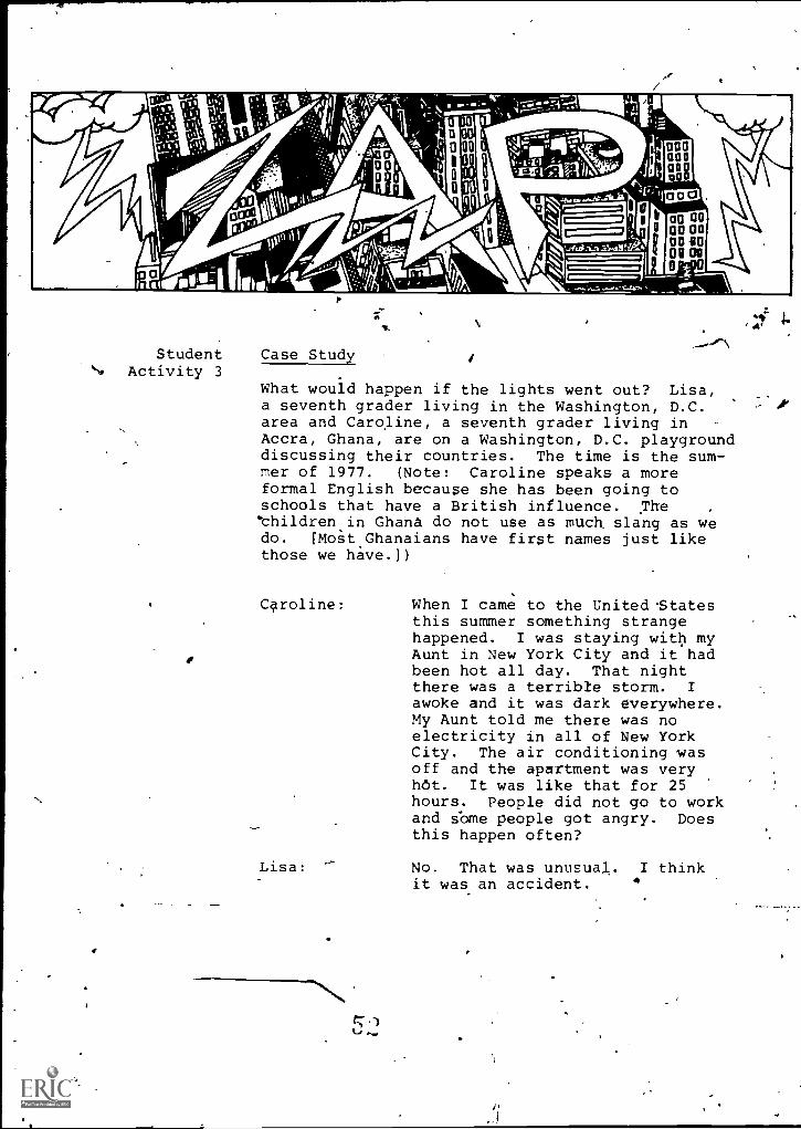
Student Case StudyActivity 3
What would happen 'if the lights went out? Lisa,
a seventh grader living ip the Washington, D.C.area'and Caroline, a seventh,grader living in
Acqra, Ghana, are on a Washington, D.C. playground.discussing their countries. The time is theoisum-
1.c mer of 1977. (Note: Caroline speaks a more'
formal English because she -has been going to
schoolii--that have a.British influence. Thechildren in Ghana do not use as mutt st4vg as we °,
-do. .[Most Ghanaians have first names just like
those wd,have.])
Caroline:
Lisa:
I
When I came to_the _United States.,thissummer something strangehappened. I was staying with myAunt in New York City and it hadbeen hbt all day., That nightthere was aterrible storm. I
awoke and it was dark everywhere.My Aunt told tie .there,was noelectricity in of NeW YorkCity. The)air conditioning wasoff and the apartmefit was very,hot. It was like 'that for 25hours. People did not go to woxkand some people got angry. Does
this happen often?
No. That was unusual. I thinkit was an accident.
e
/
Caroline: pid it ever 'happen in, Washifigton?
No, I don't think so. PEPCO,
says it never happened here - yet.
'Lisa:
Caroline:
roline:
Caroline:
Lisa:
A
Caroline:.
Lisa:
What is PEPCO?
PEPCO is the Pot, mac Electric.Power' Company. They make theelectricity here.
h, that's like our ElectricCorporation in Accra the capitalcity. Accra is my hometown-andit's the capital of'Ghana. Whywouldn't the power fail here?
-I guess because we get noWerfrom six cover plants/generating stationsaround the 71shington area, and if one isn'tworking the,othei-s could still work.
Suppose they all went out?-
Mall., we belong to a network ofmerw producers called the Pennsylvania,'few Jersey, Maryland Interconnection. thenit's very It or very cold and we-need.morepower than we mice here, we can aetpowerfrom this interconnection. In an emergencythat's where the -power would come frost:
But if it would?
`Well, in-the,summer,,the air con-, ditioning wouldn't work. That
would be awful: If you stay hereall summer you'll find Washingtonreally gets hot. Food might spoilbecause the refrigerator wouldbe off too! And the subway wouldn'twork, so people would have a hardtime getting to work. And.therewouldn'-t be any traffic lights, sotraffic would get tangled up.' There_
20
-2-
4
wouldn't even be and I'd suremiss that. But it would be worseat night. Without street lightsyou couldn't even be outside atnight.% It would be one grand mess!
Caroline: Would you go to school? ,
Lisa: Yes, we'd go to school no matterwhat! 1.
-Sounds pretty bad. You really''depend on electricity.
Why, We couldn't even cook beausea lot of homes use electric appliances.And what would really be bad is wecouldn't even go to the shoppingcenters or to the movies! That'sscary!
Caroline:
Lisa:
Caroline:, In my country, I don't think weneed ele4ricity as;=much as you do,
,
Lisa: You mean that if the electricity_J went off, ybu would do the same
things you normally, do?
-Caroline: I think so, Our temperature
$ stays pretty much they same so
we don't need electricitydefo".heat our homes. It does not getbelow.60°.
Lisa: But its hot in Ghana. How do youkeep cool?
Caroline: I'm used to-it and it doesn'tbother me.! We don't use,air con-ditioners. .We "fan ourselves some-
/ times.
4Lisa: How do you e6ek food, and keep
\. your food coldZ.
Caroline: My mother uses the charcoal potand cooks outside.- Grandnia does,too. Most people in Ghana cookthis way. It's like a patio cook-out - only Ghanaians cook thisway most of the time. We have arefrigerator, but most hpmeb
r
Lisa:
Caroline:
don't have them. We buy fresh meatsand vegetables every day from themarket.
What about reading and T.V.?.
4
Well, at night if the lights wereout, I woild use a candle or anoil lamp. Most Ghanaians dOn'thave a T.V--set so we wouldn'tmiss it.
Lisa: So a power blackout wouldn't botheryou?
Caroline: Oh, yes! But it wouldn't be asbad as it is.hvre. Pedple couldstill go to work because wewould use electricity from dieselpower plants.
)
Lisa: Could you get power;from othercountries, like thegIvory Coastor Togo?
J Caroline: No, we sell a lot of energy toTogo and we don't have an inter.:-connection as you called it.All of our electri4ty comes fromAkoSombo Dam or diesel generatingplants or from candles, oil lamps
,1/410
and charcoal stoves.
c
9 fl
leo
4r,
CI
f
"'
TRANSFORMER
Ike
IF GENERATOR
LTliBINETAIL RACE
Akosombo Dam in Ghana
4
of.
Steam furbini-, G
r_ _ --TiE ' ":11 1
Stea1-.1'7
7-1- r-it-Aci
. Transmission tines,----Transformar
/\7\4 ,
ii:i!!;aipt
2.4
re-viv.,..r Station in D.C.
\SilbStEit iGft
/!,tyl I ,
a 1.t
[
f4
25
a
1
Reactor Hot water
1111
Nie)/7 Meat/gaiT Exchanger
:W 2.41ma= m u=VS
Steamc
ET -
Condenser
Nuclear Generating Station
.3
I.
t
Gener ?toryrPressure
c
Lesion TRANSPORTATION SYSTEMS ARE ALIKE,AND DIFFERENT
Overview Tiansportation systems provided y-two cities'" and national governments are des ribed in thislesson. The relationship between energy use andvarious methods of transporting people and goodsis pointed out, especially as these .relate toexisting.facilities.
r.- Objectives
0
The student should be able to:1. Measure and compare distances.2. Locate places and trace routes on a
aeries of maps.3. List the Ad ntages-and disadvantages of
Ihigh energy use in transportation syStems.'
*1-'
Time Allotment One-two class periods.
Teaching Open the lesson by pointing to the word Trans-Strategies portation on the Chalkboard and get the defini-
tion from the class. Ask: Why is transportationimportant?, Place the question on board andencourage students6to speculate on what theircity,would be like without.this service.
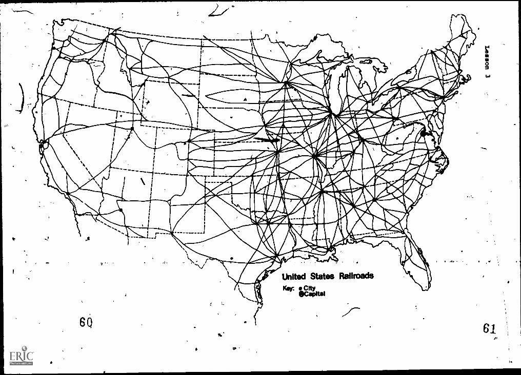
D'eveloping the Part 1 Railroads in the United StatesLesson A
Direct the attentionef'the class to the mapshowing U.S. Railroads. Point out that this mapdoes not show all of the railroad lines. A maplike that woulTlie too difficult to read. Withdesk atlases or a wall map, ask students to lo-cate and 'print the names of the cities that haveseveral railroad lines crossing them. Dots onthe'map will helpthem find these cities.
When students Haire fini'shed this part, ask: Whatother transportation forms do you think thesecities might h e? (Airlines, highwaq systems,subways, ships iver barges, etc.)
ti
2 7 .1Ic
a
23
Ask: According to thpmap, can people and thingsget t ashington, D.C. by rail? Ask the studentsto tr ce_the rail routes into the capital byusing'their finger or tracing the lihes with apencil. _/
.
%
Using Washington, D.C, as a starting point,',havestudents trace a southern route to the westcoast. Have then trace a northern route, takingimaginary goods from Washington to a place inCalifornia. Locate a route that will take themfrom coast to 'coast through the central parts ofthenation.' Encourage students to speculate onthe advantages of coast to coast rail service.How do railroads link the continent frolii northto south? Discuss how the railroads help the.United States. How do they help cities?
Railroads in Ghaha.
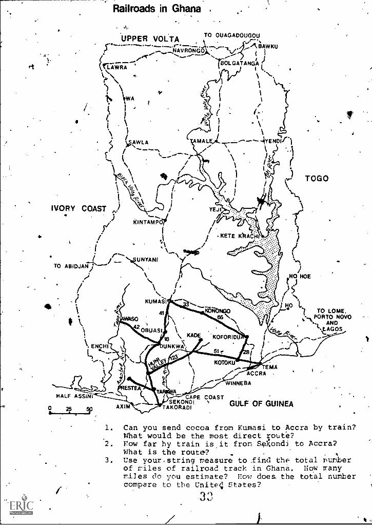
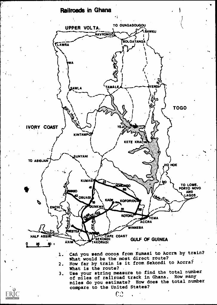
Distribute the map showing railfoads in Ghana.Have students locate the places where, railroadlines teem-to be Concentrated. Have them traoetvarious routes with their 'fingers,." point -butthat Ghana's railrogd system is Iodated almost VI;
entirely in the south. You mi4ht mention thatthese tracks are of special importatice in gettin44cocoa to marketplaces" and shipping ports,. Tiacklength is nearly 592 miles. Main lines run fromAccra to Kumasi. This is called .the Eastern Line.,The Western Line connects the cities of Takoradi,and Kbrasi. The Central Line runs westward tojoin the Westerff_Line at Huni Valrey. Shortef.lines of track-connect resource sites to distri-bution centers and are not shown on the map. 'Pointout that"-he numbers on the map show the distanAs,between towns. Have studefits compute, distancesby adding several together to get a total. AsJ'
a series of questions such as: Suppose "I want
to take cocoa to from . How farwould the .train travel?
Another activity could involve making tap time..schedules for the trains. Have an interestedgroup of students make up a distance and.timechart and telly their ideas to the class.
Ask students whit goods they think are transported.
to and from the northern parts of Ghana. A
geography text should help them find these pro-),
ducts. Contrai the railroads in Ghana with thenetwork of rail lines in the United States.
24
Have students use'the string measure to -find- distances and answer the three questions on the0
map showing t4e railroads inighana:
Answers to Questions on Railroads in Ghaha
1. Yes. Train'would have to- go from Kumasi ,to
Konongo then travel south to Koforidua andKotoku. From there the train would travel'southeast to Tema. It would be just a shorthop south from Tema\ to Accra. Going theother ,wa-y -round would require much more time.
At least 200 miles.
3. Nearly 600 miles. The United States hasvastly more miles of track.
If the class's interest .takes this turn, discusswhether the railrpsds are "finished" as a majormeans of transpOtation. Have students thinkabout jammed highways and crowded oairways:Should a new age of railroad building get under-way? Can railroads send more goods and peopleon their way with less energy than trucks andbusses- can?
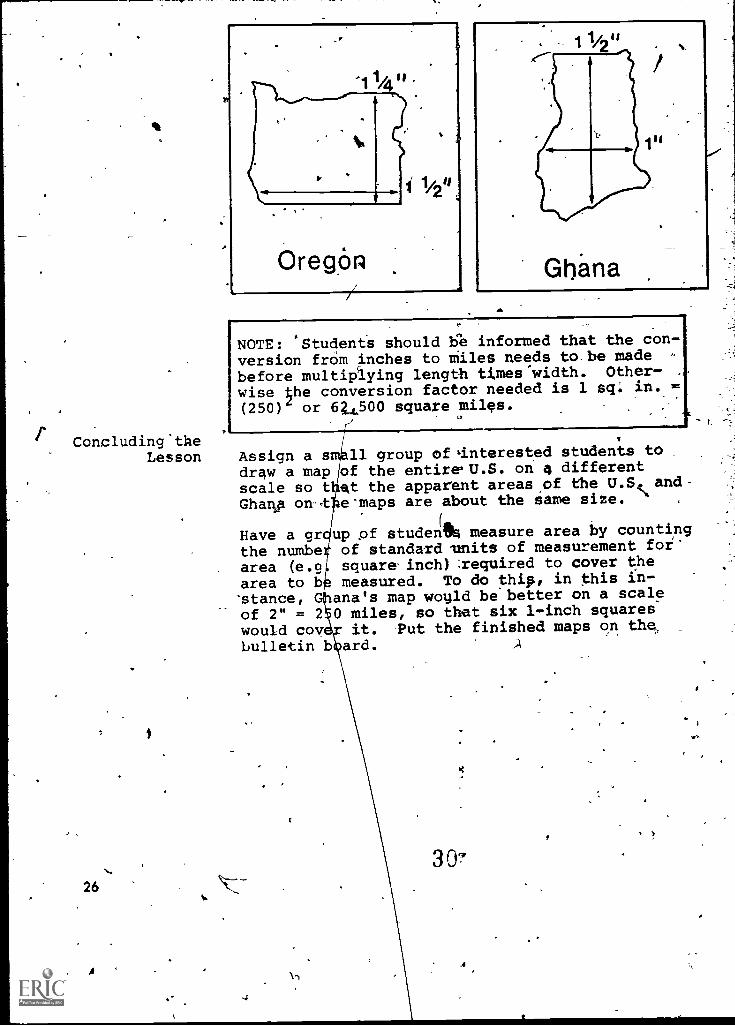
Introduce a comparison between Ghana and theWashington, D.C. metropolitan area. The com-parison should emphasize the two capital cities,rather than geographic size. Ghana is nearly 14times the size of the Washington, D.C. area.Ghana has an area of 92,000 square miles; Washing-ton metropolitan about 6,700. Students mightlike to find a state that had a land area com-parable to Ghana's. An atlas or a World Almanacare useful reference books. Ghana and the stateof Oregoh are close.
String Show students how to use a piece of stringy as aMeasuring ,measuring instrument. Use an overhead.projector
Instruments to show them how. Lay a piece of string over aboundary line on a world map. ,The length ofstring can then be measured against the scale lineon the map. Div,ide'thp class into groups of fourstudents each and giVe each group too pieces of.string about 10 inches fbhg (25 cm.). Have stu-dents locate and find states in the U45. thatcomprise nearly the same area as Ghana. See below.Have students use their-string measure in dbm- '
pleting the exercises in Part 2.
25
23
-
Concluding 'theLesson
26
A
NOTE: Students should be informed that the con-version from inches to Miles needs to be made -
before multiplying length times-width. Other-
wise 4he conversion factor needed is 1 sq. in.
(250) or 64500 square miles.
Assign a sdraw a mapscale so tGharlp on-t
Have a grthe numbearea (e.garea to b'stance,of 2" = 2would coybulletin b
11 group of 'interested students toof the entire,U.S. on differentat the apparent areas of the U.S. and-e-maps are about the same size.
(AL
up of student% measure area by countingof standard mnits of measurement forsquare, inch) required to cover the
measured. To do thip, in this in-ana's map woyld be better on a scale0 miles, so that six 1-inch squares
it. Put the finished maps on thenard.
30-
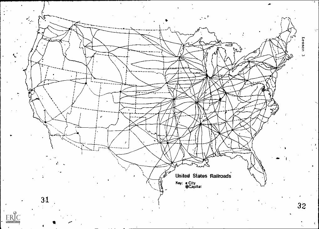
fr United States RailroadsKey: City
@Capital
ID
0
32
Railroads in Ghana ,
UPPER VOLTA TO OUAGADOUGOU1"-- ,,,
sr -.--- -,.. ---. ................r- - .--:. , .......,...' ......."" A, BAWKU..... ,NAVRONGO
. i ( 1( .... r#.4.---"- ------ -... ....-
. TiOLGATANGAtrawRA1 1
I '') \ / -k
iS \WAr
V li. 1i1
1 ' / /I.. 1
.\\ I \1
e. 1)1§,A,WL A MALE)... ....---"---AYENDIP)? .i .-------,
1:-. t \ )(
N,
f\\ 44 fi
1
1, )...- TOGOi / \I
1
I \-.\-F-'N I
i."1.
11/IDRY COAST ,) YEJI 1
.1.- j Ir.ji KINT AMP Or'
11
4. /1
l ; KETE/... t
..1 1Ic ......
\."7k
UNTANT %.N.
TO ABIDJAN) ----** ),e;
\ / HO 140E. \ t .)
\\\ I 1) 5i KumAil \1491
1 TO LOME,,..... PORTO NOVO
.1
6 4WAS()
', ANDOBUASI...t.
-....
Nt AGOS
k. ENCHI
HALF ASSINI
AXIM
CAPE COASTSEKONDI ' GULF OF GUINEATAKORAM
TEMAACCRA
WINNEBA
1. Can you send cocoa from Kumasi to Accra by train?What would be the most direct route?
2. row far by train is,it from Sgrsondi to Accra?What is the route?
.
3. Use your. string measure to find the total nurberof riles of railroad track in Ghana. Now manymiles do you estimate? flow does the total numbercompare to the Uniteq States?
3 r),
111
r
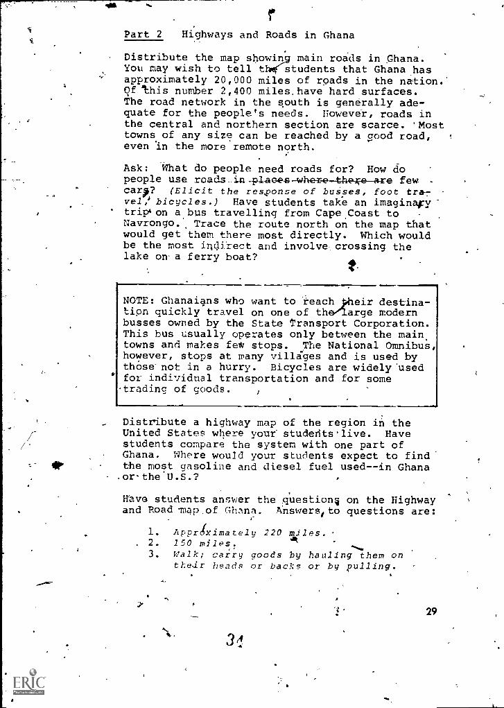
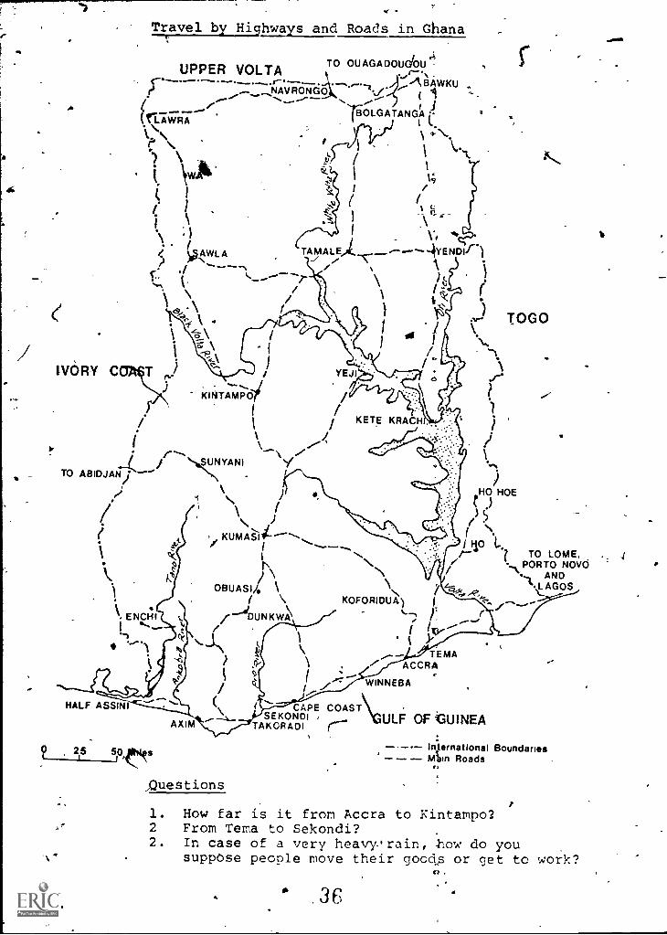
Part 2 Highways and Roads in Ghana
Distribute the map showin main roads in Ghana.You may wish to tell th students that Ghana hasapproximately 20,000 miles of roads in the nation.of this number 2,400 miles, have hard surfaces.The road network in the south is generally ade-quate for the people's needs. However, roads inthe central and northern section are scarce. Mosttowns of any size can be reached by a Good road,even In the more remote north.
Ask: What do people need roads for? How dopeople use roads-in,placee where the are few -
carp? (Elicit the response of busses, foot tra-vel, bicycles.) Have students take an imaginary'trip4on a bus travelling from CapeCoast toNavrongo., Trace the route north on the map thatwould get them there most directly. Which wouldbe the most indirect and involve crossing thelake on- a ferry boat?
NOTE: Ghanaians who want to reach loileir destina-tion quickly travel on one of the large modernbusses owned by the State Transport Corporation.This bus usually operates only between the main.towns and makes feet/ stops. ,The National Omnibus,however, stops at many villages and is used bythose not in a hurry. Bicycles are widely 'usedfor individual transportation and for sometrading of goods.
- Distribute a highway map of the region in theUnited States where your studerits.live. Havestudents compare the system with one part ofGhana. Where would your students expect to findthe most gasoline and diesel fuel used--in Ghana.orthe.U.S.?
Have students answer the questionq on the Highwayand Road map,of Ghana. Answerstto questions are:
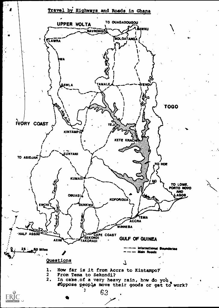
1. ApprOximately 220 miles.. 2. 150 miles. at
3. Walk; carry goods by hauling them ontLedr heads or backs or by pulling.
29
ti
30
Highways and Roads in Washington, D.C.
People in Washington, D.C. depend g 'eatly on ahighway system.' Most workers get, their jobsin privately owned cars on modern. reeways. How-ever, people are 'beginning to use the mass tran-sit system mote often. This.systeM combines thesubway and the bus system. Terminals can befound at the airport and.at the railroad station.
Have students look at a road map of the Washingtonarea, which is available at any gas station.Have them compare the highway system to Ghana'sin terms of service and energy use. Discuss theenergy that went into the building of the U.S.
- -highways2--frot the ga.soline_in this car tothe oil-based asphalt paVing. ,
1
ti
,-
Travel by Highways and Roads in Ghana;
O
iTO
-...
O. OU ,-,itv.c..2.( ;...--
3lEtOLGATANGA (...
,* __....---(rawRA1\ .
r1
\ ire.\) \
. i. \YIA'-;1.
k.1
(I' r
..... i \,t -\ 1 \.,N.. ) TAyAL,,_._------\ \
, AWLA --4YENDIr ..)
c: ./ ------- t̀. --*-- ;_.... \.,, t'
l'/ / (1 k1 N\
Ct<9 .
-1?..t.
TOGO(-.-f \ '1 1 "w....
1\I / ;
r
IVORY- C T ,J
i .1.
-,_JKINT AMP Or /i 1 I KETE
\\ ../.4' i\.
i o,
. r--- ,,\'Y.1. i '',S&.JNYANI
)TO ABIDJANi -----\
1.140 HOE.,; \ I ()/ \\ )
i \? ,, KUMA*S-1114"----......i1
1 110 .I...
'Xr's \ /) .,,PORTAONDNOVO
--\1... \ i 4,..-?,
,,,11,__AGOS
\ OBUASIh \ \( \ KOFORIDUA) 1
_..../ \ '"---I 1 ._,\ ENCHI / DUNKWA
f IKV-----. .,f) O
N....3,N \ --) \TEMA
, Z I..: ,
WINNEBA
ACCRA
...----/ ck. f ,
HALF ASSINI \ CAPE COAST\( (
AXIM TAKORADI r ULF. OF GUINEASEKONDI ;
0 215 50,,(11144r International BoundanesRoads
Questions
1. How far is it from Accra to Kintampo:2 From Tema to Sekondi?2. In case of a very heavvrain, -how do you
suppose people move their goods or get to work?
36CI
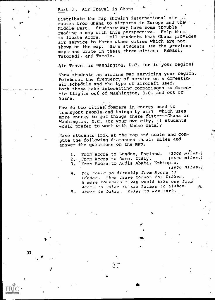
Part 3. Air Travel in Ghana
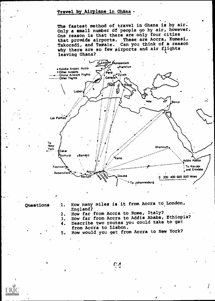
Distribute the map shdwing international airf- routes from Ghana to airpbrts in Europe and the
Middle East. Students may have some troublereading a map with this perspective. Help themto locate Accra. Tell students that Ghana providesair service to three other cities which are notshown on the map. Have students use the previousmaps and write in these three cities: Kumasi,Takoradi, and Tamale.
324
Air Travel in Washington, D.C. (or in your region)
Show students an airline map servicing your region.Poinbt out the frequency of service on a domestic.air.schedule and the type of aircraft used.Both these make interesting comparisons to domes-tic flights ouf of Washington, D.C. arid-out of
Ghana.
-How do two cities. compare in energy used totransport people. and things by air? Which usesmore energy to get things there fasterGhana orWashington, D.C. (or your own city, if studentswould prefer to work with these data)?
Have students look at the map and scale and cm:-pute the following distances in, air miles andanswer the questions on the map.
1. From Accra to London, England. (3200 miles.)
2. From Accra to Rome, Italy. (2600 miles.)
3. From Accra,to Addis Ababa, Ethiopia.(2600 miles.)
4. You could go directly from Accra toLOndon. Then leave London for Litbon.A more roundabout way would take one froth
Accra to D.ikar to Las Palmas to Lisbon.
5. Accra to Dakar. Dakar to New York.
V
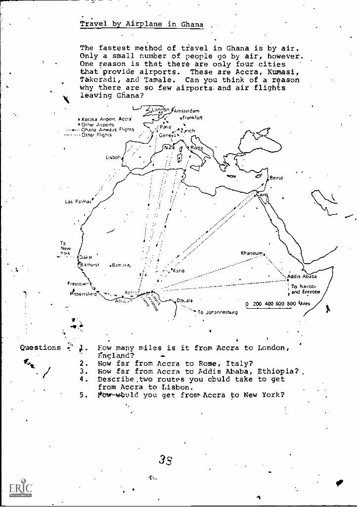
Travel by Airplane in Ghana
The fastest method of travel in Ghana is by air.Only a small number of people go by air, however.One reason is that there are only four citiesthat provide airports. These are Accra, Kumasi,Takoradi, and Tamale. Can you think of a reasonwhy there are so few airports. and air flights
1kleaving Ghana?
Amsterdam
o Kotoka Airport, Accra" "FrankfurtOt'ler ;Airports :ParisGhana Airwais Flights 4 .'24rIch
--- --Otner Flights Gerrrya. .
Las patty-Iasi
ToNewYork
Lisbon
Beirut
Dakar
Bathurst eBarr.i.n.
Freetown!
Oij,on Vbc!
Khartoum.,.
X .
sj
'KanoAbaba
- ...................... 1 To Nairobi
and Entebbe
Dotrala 0 200 400 600 800 tildesTo Johannesburg
Questions 1. How many miles is it from Accra to London,fngland?
2. How far from Accra to Rome, Italy?/
3. How far from Accra to Addis Ababa, Ethiopia?,4. Describe.two routes you cbuld take to get
from Accra to Lisbon.5. lkow-wtuld you get from-Accra to New York?
3=
f
4411.1.0w-
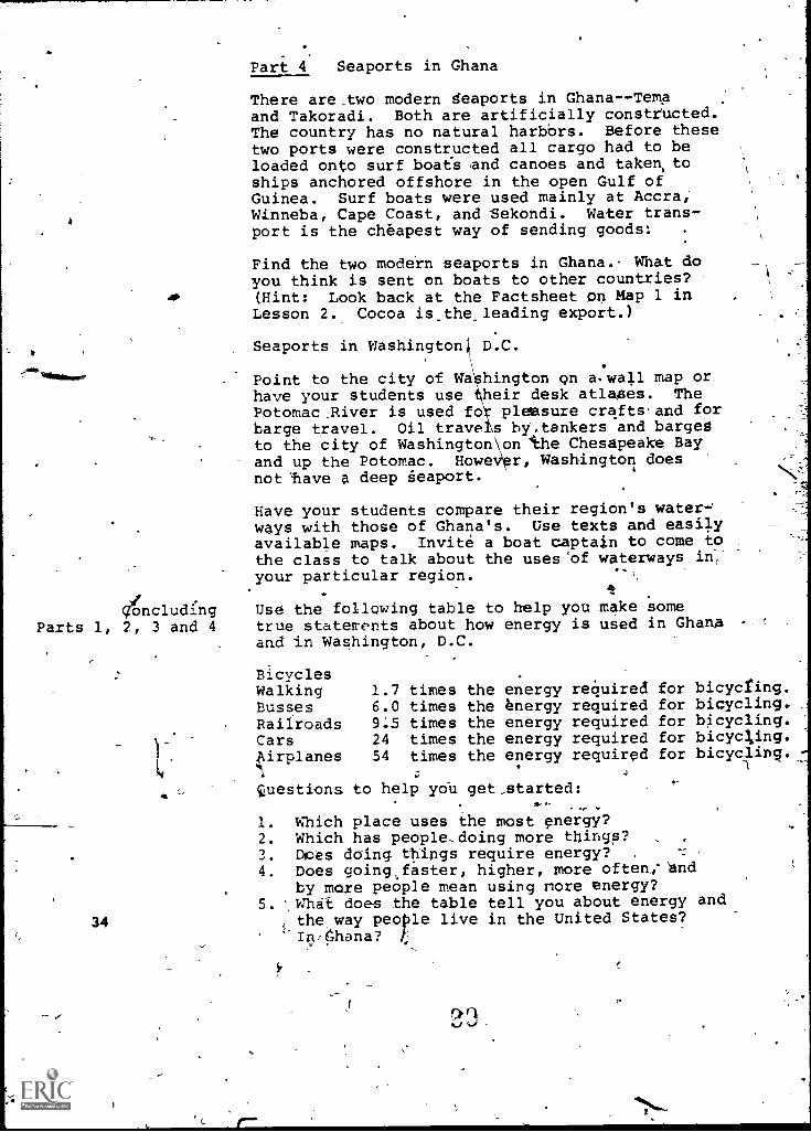
Part 4 Seaports in Ghana
There are,two modern seaports in GhanaTemaand Takoradi. Both are artificially constructed.The country has no natural harbors. Before thesetwo ports were constructed all cargo had to beloaded onto surf boats and canoes and taken toships anchored offshore in the open Gulf ofGuinea. Surf boats were used mainly at Accra,Winneba, Cape Coast, and Sekondi. Water trans-port is the cheapest way of sending goods:
Find the two modern seaports in Ghana. What doyou think is sent on boats to other countries?
AP (Hint: Look back at the Factsheet on Map 1 inLesson 2. Cocoa is_the_leading export.)
Seaports in Washington D.C.
Point to the city of WA hington on a.wall map orhave your students use heir desk atlases. ThePotomac.River is used-fo pleasure crafts'and forbarge travel. Oil trave s hy.tankers and bargesto the city of Washington on the Chesapeake Bayand up the Potomac. Howe r, Washington doesnot'have a deep seaport.
Have your students compare their region's waterways with those of Ghana's. Use texts and easilyavailable maps. Invite a boat captain to come tothe class to talk about the uses'of waterways in:your particular region.
4ncludlng Use the following table to help you make s ome
Parts 1, 2, 3 and 4 true statements about how energy is used in Ghanaand in Washington, D.C.
BicyclesWalking 1.7 times the energy required for bicycling.Busses 6.0 times the energy required for bicycling.Railroads 9.5 times the energy required for bicycling.Cars 24 times the energy required for bicycling.Airplanes 54 times the energy required for bicycling._-:
4
questions to help yoll get_started:-
1. Which place uses the most energy?2.Whichhaspeople,doingmorethirga ?3. Does doing things require energy?4. Does going faster, higher, more often,; `and
by more people mean using more energy?5. ',W1.1A-t does the table tell you about energy and
34 the way people live in the United States?Ini6hana?
Lesson 4: HOW IS ELECTRICITY USED IN WASHINGTON, D.C.AND IN GHANA? BY WHOM? -WHERE DOES MOST (IF'
IT COME FROM?
Overview In this legson the student will study the electricalenergy consumption in two parts of'the world.Emphasis will be placed qp population and per capi-ta energy consumption.
Objectives The student should be able to:.1. Compare electrical use in Washingtoro,D.C.
, and in Ghana by using a bar graph.2. Predict trends from prepared information.3. Interpret a table.
Time Allotment Four class periods.
Background Electricity in the Washington, D.C. area has beenInformation a basic need for the total population for many
.Teacher Use Only) years. Electricity in Ghana was used as earlyas 1914, but its people were not significantlydependent on it until after the Akosombo Dam wascompleted in 1965.
rThe use of electrical energy is on the rise inGhana. As of 1976, only approximately 35% of itstotal'population had electrical service, but the_demand for electricity is constantly increasing.To meet these demandsL,Another dam will be built.As more electkical exrgy becomes available tothe people of Ghana and they become more energydependent, you will'find,that they too will demandand consume more and more.
Note: This lesson is composed of four sets ofactivities. Each set of activities is designedto help students understand the dependence bfpeople in, the Washington, 'D.C. area on electricalenergy; and the emerging energy dependency inthe country bIN,Ghana. 1
o
35
36
p
In each activity there are questions and problemsthat 'involve large numbers. Mahy of thdm have °
been rounded off so that arithmetic opera-ti-ons for the studentp Will, in mdst cases,be simplified.
(In'some cases, it may be necessary to helpstudents set up the problem and helpethemfinethe solution,)
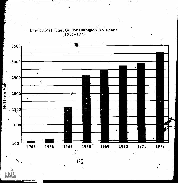
Student Energy _Use in GhanaActivity 1
ofi;
D' actions: Look carefully at the bar graph.n answer each question below.
1. The vertical axis is the straight up anddown line. What does.it show?(Millions of KWH of energy consumed in Ghana
'" between J965 and 1972.) ..
2. .The horizo4a1 axis runs across from leftto right. How many years are'shown?(Eight years.)
3. What year. shows the most energy being used?(1972.)
4. What trend do you see developing energyuse in'Ghana?(Energy use is increasing each year.)
.4114L Energy lase in Ghana took a big juMp upward"between 1966 and 1967. What do'yc5U think
used such a big' jump?3 completion of the Akosombo Dam.)
4
Jc.
'3500
3000
2500
20000A
1500
1000
500
f
Electrical Energy-Consumption in ihana1965-1972
,\
o
1..
1965 1966 1967 1968 1969
.
r
4k
t 1
A
1970- 1971I
42
..
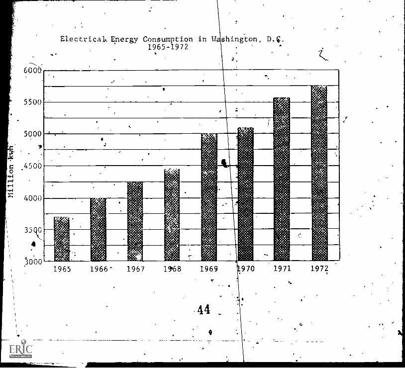
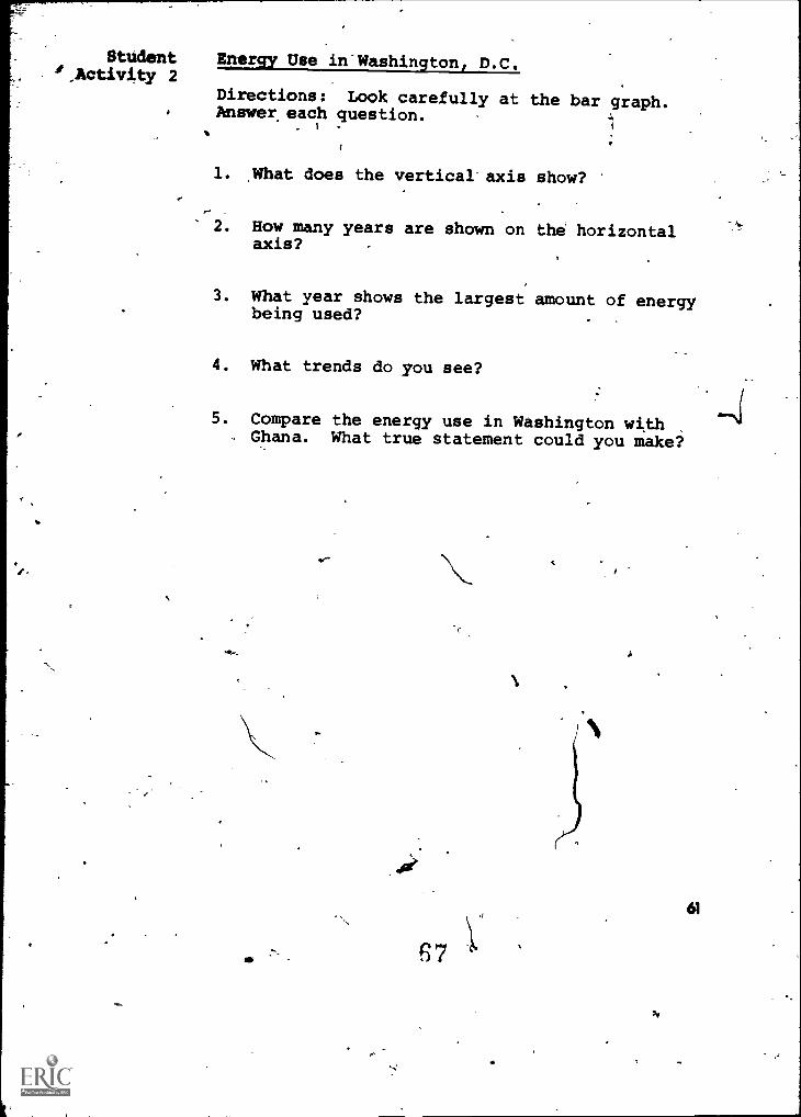
StudentActivity 2
4
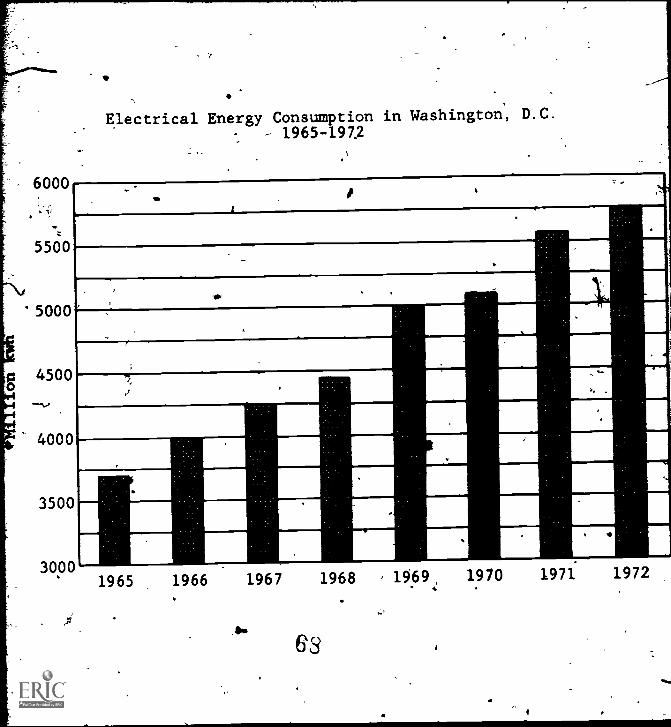
Energy Use in Washington, D.C.,
Directions:. Look carefully at the bar graph.Answer each question.
1. What does,the vertical axis show?(Millions of KWH of energy consumed in Washing-
--ton., D.C. between 1965 and 1972.)
2. How many'yeari are shown on the horizontalaxis?(Eight years.)
3. What year shows the largest amount of energybeing used?(19/72.)
4. What trends do you see?LOriergy use is increasing each yea-r.)
. Co pare the energy usein Washington withGh na. What true statementcould-you make?'
(A sp:ers will vary. Two possibilities fdllov.
Th re has been a steady increase in the use_of"electricity overlithe past eight years.OR Washington, D.C. uses more electricity .'
than all of-Ghana.)
38
1
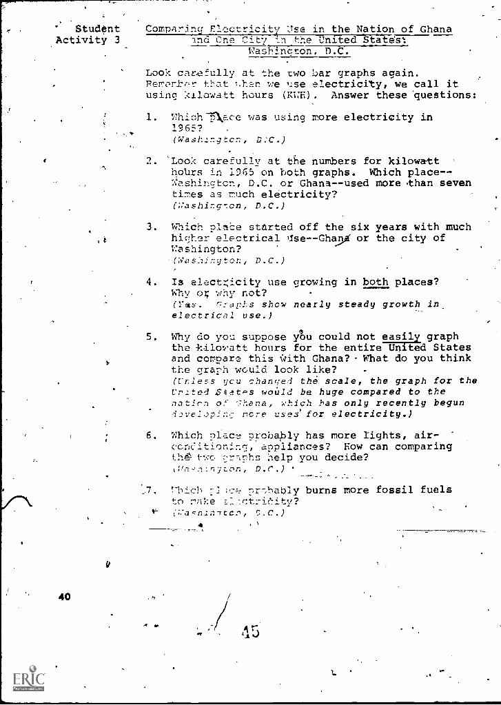
Student Comparincl' : }se in the Nation of GhanaActivity 3 and Cne City In the United State's:
Vashincton, D.C.
t
40
Look carefully at the two bar graphs again.Perrcr tbat 1.han we 'Ise electricity, we call itusing kilowatt hours (KWH). Answer these 'questions:
1. Which-5\ace was using more electricity in196'4?(Wash.lr.gtcn, D.'C.)
2. 'Look carefully at the numbers for kilowatthotirs in 1965 on both graphs. Which place--Washington, D.C. or Ghana--used more than seventimes as nuch electricity?(;:ashing7cn, D.C.)
3. Which pla.ce started off the six years with muchhigher electrical Ise--Gh90 or the city ofWashington?(Was:Ii;:gton, D.C.)
4. Is enct.;icity use growing in both places?Why o; why not?(Yas. Graphs show nearly steady growth inelectrical use.)
5. Why do you suppose Au could not easily graphthe kilowatt hours for the entire United Statesand compare this with Ghana? What do you thinkthe graph would look like?(Unless you chanqed th6 scale, the graph for theUr.:ted Ztatc's could be huge compared to thenatirn of '.Tana, *which has only recently begun
rcre cases' for electricity.)
5. Which glace crcbaply has more fights, air-ccneitioning, appliances? How can comparingth two gr-,nhs help you decide?
a.r.)
T' ich 7] ,c;-: prr.,ba'cly burns more fossil fuelsto riAkn
,N
lot
5-
Student Guide
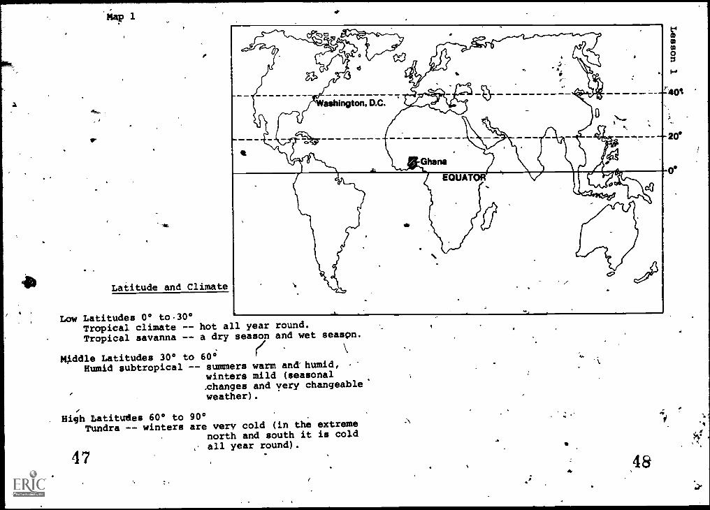
Latitude and Climate
Low Latitudes 0° to30°Tropical climate --Tropical savanna --
Middle Latitudes 30° toHumid subtropical -
hot all year round.a dry season and wet seaspn.
60° (/
- summers warm ana humid,winters mild (seasonal,changes and very changeable'weather).
High Latitudes 60° to 90°Tundra -- winters are very cold (in the extreme
north and south it is coldall year round).
47
Student Climagraph for'Accra, Ghana and Washington, D.C.Activity 1
A sample climagraph for Accra, Ghana (Africa)South Latitude ° East Longitutude
9
8Chart 2 Lb 7
A
7114 6cs 5
4
N 3
2O 1
ea
12111.0
9
E-1
7 II A1.4
54 pi32
10
J F M AM J 4.7 A S 0
(months of the year)N D
Climagraph fin' Washington, D.C.o North Latitude ° West Longitude
-
9 0
80
70
ri 60
M 50
40
30
20
10
0
,
Months .
.Tem-pera-ture( °F)
Preci-pita-tion(inches)
$41:71
January 33 2.3 0fCS
February 38 2.7
-March 42 3.0
April 50 3.0May 55 3.0June 62 3.2,July 71 3.7August 77 r 4.0September '68 3.5October 53 3.0November 42 2.5
\ December 35 2.0
-J
- 10
- 20
-30 JFPAMJJASOND
rij
(months of the year)
A
12
11
10
9
8
6
5
4
3
2
4
d
.f
Map 1.
Lesson- 2
. f'`
Electrica Power Sources in Ghana
UPPER VOL
`r_LAWRA
VA
WvALA
TO OUAGADOUGOUTAfasii-dik...-..y..
TCOLGATANGit l.N. c-
1 A
TAMA
A
k
IVORY COAST
TO ABIDJAN/
e
KINTAMPOr
UNYANI
KUM,
KITE
TOGO
MOE
TO LOME,PORTO NOVO
ANDAGOS
OSUASI
I
HALF ASSI
0 25 ,50 Miles
e
AXIM
PE COASTSEKOSDI
TAKORADI
EMAACCRA
WJNNERA
GULF OF GUINEA
4Ghana Factsheet
Capital CityPopulati6n ofAccraChief Industry
Average Incomeper familyper year
Accra
633,880Gcowing and
exporting cocoa
$560
Map 2
Electrical Power Sources in theGreater Washington, D.C. Area
PEPCO.Service Area
Transmission Line(230 kv)
PEPCO Generating Plantsby Type
'Coal Fueled
0i1 Fueled
Net Capacilityat December 31, 1976
1.Dickerson ,2.Potomac River3.Buzzard Point4.Benning5.Chalk Point6. Morgantown
*548 MW458 MW222 MW684 MW,
1262 MW1112 MW
U.S.AWashington, D.0
CapitalAcityPopulaeron ofWashington, D.0Chief IndustryAverage Incomeper family eachyear
Factsheet
Washington,-D.C.
757-000_-
Government, shCOs,--.
many services$19,000
Student Case Study\. Activity 3
I
ex
What would happen if the lights went out? Lisa,a seventh grader living in the Washington, D.C.area and Caroline, a seventh grader living inAccra, Ghana, are on a Washington, D.C. playgrounddiscussing their countries. The time is the sum-mer of 1977. (Note: Caroline speaks a moreformal English because she has been going toschools that have a British influence. The'children in Ghana do not use as much slang as wedo. [Most Ghanaians have first names just likethose we have.])
Caroline:
Lisa:
When I came to the United 'Statesthis summer something strangehappened. I was staying with myAunt in New York City and it hadbeen hot all day. That nightthere was a terrible storm. I
awoke and it was dark everywhere.My Aunt told me there was noelectricity in all of New YorkCity. The air conditioning wasoff and the apartment was veryhOt. It was like that for 25hours. People did not go to workand some people got angry. Doesthis happen often?
No. That was unusual. I thinkit was an accident.
1
41,
Caroline:
Lisa:
Did it ever happen,in Washingto
Np, I d n't think so. PEPCOsays it ever happened here -*yet.
Caroline: What is P PCO?
.,
Lisa: PEPCO is the Potomac ElectricPower C.i.any. They make theelectri ity here.
Caroline:
Lisa:
Oh, that's like our ElectricCorporation in Accra the capitalcity. Accra is my ho town andit's the capital of a. Whywouldn't the power I here?
I guess becaUse we get power
-
from' six power plants/generating stationsaround the '..htshington area, and if one isn't
worldng the others could sill work.
Caroline: Suppose they all went out?
Lisa: Well, we belong to a network ofenergy producers called the Pennsylvania,
New Jersey, Maryland Intercomecticn. Whenit's very hot or very cold and we heed morenewer the* we make here, we can wet power
from this:interconnection. In an emergencythat's where the power would come fram.
Caroline: But if it would?
Lisa: Well,,in the summer the air con-ditioning wouldn't work. Thatwould be awful! If you stay hereall summer you'll find Washingtonreally gets hot. Food might spoilbecause the refrigerator wouldbe off too! And the subway wouldn'twork, so people would have a hardtime getting to work. And .theewouldn't be any traffic lights sotraffic would get tangled up. There
r')
wouldn't even be T.V., and I'd suremj.ss that. But it would be worseat night. Without street lightsyou coul even be outside atnight. would be one grand mess!
Caroline: Would you go to school?
Lisa:
4
Caroline:
Lisa:
Caroline:
Lisa:
Caroline:
Lisa:
Caroline.:
Yes, we'd go to school -- no matterwhat!
Sounds pretty bad. You reallydepend on electricity.
Why, we couldn't even'cook because -t
a lot of homes use electric appliances.And what would really be bad is weCouldn't even go to the shoppingcenters or to the movies! That'pscary!
In my country, I don't think weneed electricity as much as you do.
You mean that if the electricitywent off, you would do the sametgings you normally do?
I think so. Our temperaturestays pretty much the same, soWe don't need electricity to .
heat our homes. It does not getbelow 60°.
4But it's hot in Ghana. How do youkeep cool?
I'm used to it and it doesn't ,
bother me. We don'tjuse air cop -,ditioners. We fan ourselves some-times.
Lisa: ,How d9 you cook food, and keepydur food cold?
.
My riaher uses the charcoal .potand cooks outside. Grandma does,too. Most people in Ghana cookthis way. It's like a' -patio cook-out - only Ghanaians cook thisway'most of the time. We have arefrigerator, but most homes
54
,Lisa:
Caroline:
p.
don!t have them. We buy fresh meatsand vegetables every_day from the
market.
What about reading and T.V.?
Well, at night if the lights wereout, I would use a-candle or anoil lamp, Most Ghanaians don'tPiave a T.V. set so we wouldn'tmiss it. .
Lisa:' So a power blackout wouldn't bother
you?
- Caroline: Oh,' yes! But it wouldn't be as..`bad as it is here. People could
still- go to work ,because wewould use ricity from dieselpower plan
Lisa: Could you eget power frqm other.-countries, like the Ivory'Coastor Togo?
Csrolinl: ot, we sell a lot of ene to
_Togo and we don)t have an later.:
connection as you called it,
All of our elstricity comes from
Akosombo-Dam diesea. generatingplants or from candles, oil lampsand charcoal stoves. 7
P
rt
-
v
Steam Turbine GeneratorElectric
=-_
Transmission Lines
Tr nsformer
fr'r[ ,,I,
Substation
Power Station in Washington, D.C.
5'7a
\
. ;
l'\ 1 vi
A s '1\ ' , \\ ;- NI
\ \' \ \\ // /ii1 `
V sss
.
1 t \ \\ \\ \\\ \\\ \\ \\\I\ I\
\\\ \A\\V\A
im= /MIMI =II MO MOB InMI sum MO 11=11ini =IN um JIM II
/
/ 1 .
II II11 11
.:
I 1 I
Leeson 3/
hk
Railroads in Ghana
UPPER VOLTA.,NAVRONG
...."" )lirOLGATANGA
\WA
:1
TO OUAGADOUGOU
T MA L
I
\
0- -4YEND1Pt
KETE
or. TOGO
1HO HOE
/ TO LOME ,PORTO NOVO
as, AND`. LAGOS
HALF ASSIN
0 Mum
APSEKONDI
E COAST
TAKORADIGULF OF GUINEA
EMAACCRA
W1NNEBA
1. Can you send cocoa from Kumasi to Accra by train?What would be the most direct route?
2. How far by train is it from Sekondi to Accra?
What is the route?3. Use your string measure to find the total number
of miles of railroad track in Ghana. How many
miles do you estimate? How does the total numbercompare to the United States?
C 4
Travel by Highways and Roads in Ghana
UPPER -VOLTATO OUAGADOUGOU
F.,___.-..................:,r-.-,....iNAVRONG --"%."N" A wow
....".....--1-----........,--- , ..... t
(crivIii; 1 1
irOLGATANGIA
\ N.
1 %I1
I 1I
1
/ "-----,TAMALE)._ --4YENDIPI, v
.0, WWLA1 i
...., i4,.. .............
I \1
1/ t
f.
\ t
\I /*\ /
I
` I151 I 1IVORY COAST ,...) v...
. IT JI.,..) 1' if KINTAMP
1
°/
KETE KR1 /
t /\ 40":. tr-. - _.--
......\ ....
I UNYANI YTO ABIDJAN/
S.11
$/ Kumla ...-.. ...1 .....--..
N. 7 TO TOME,I PORTO NOVO\ i t
1441 AND
.1.
OBUASIA 1 AGOSKOFORIDU
NA)\ ENCHI 0/NKW/1 '., 1
111
ii EMA)/
ACCRAt/ f.,.,;. WINNEBA
(t CAPE COAST
TOGO
HO HOE
HALF ASSIN
AXIM
ZS WW1
Questions
SEKONDI GULF OF GUINEATAKORADI
" *gm. Internet Iona Sounded..Alin Roods
1. How far is it from Accra to Kintampo/2 From Tema to Sekondi?2. In catie,of a very heavy rain, how do yo14.
ifippose peoplos move their goods or get tcTwork?
63
Travel by Airplane in Ghana.
The fastest method of travel in Ghana is by air.Only a small number of people go by air, however.One reason is that there are only four citiesthat provide airports. These are Accra, Kumasi,Takoradi, and Tamale. Can you think of a reasonwhy there are so few airports and air fightsleaving Ghana?
Kotoka Airport AccraOther AirportsGhana Airways Flights
------ - Other Flights
labon
Las Pal Inas.
ToNewYork
Dakar
Bathurst Bamal.to
AmsterdamaFrankturt
a i.:*20richGenttyab.
Beirut
Freetown
Robertsf ref Cra
bidia
Khartoum..
. .'Kano ---
---- .-s.Addis Ababa..............
............... ............ To Nairobiand Entebbe
Douala 0 200 400 600 BOO Miles
To Johannesburg
Questions 1. How many miles is it from Accra to London,
England?2. How far from Accra to Rome, Italy?
3. How far from Accra to Addis Ababa, Ethiopia?
4. Describe two routes you could take to getfrom Accra to Lisbon.
5. How would you get from Accra to New York?
Lesson 4
Student Energy Use in Ghana'Activity 1
Directions: Look carefully at the bar graph.Then answer each question below.
1. The vertical axis is tft straight up anddown line. What does it show?
2. The horlzontal axis runs across from leftto right. How many years are shown?
3. What year shows the most energy being used?
4. What trend do you see developing about energyuse in Ghana?
Energy use in Ghana took a big jump upwardbetween 1966 and 1967. What do you thinkcaused such a. big jump?
r
59
1965 1966 1967 1968- 1969 1970 1971 1972
StUdent Energy Use in Washington, D.C.',Activity 2
Directions: Look carefully at the bar graph.Answer each question.
°
1. What does the vertical axis show?
2. How many years are shown on the horizontalaxis?
3. What year shows the largest amount of energybeing used?
4. What trends do you see?
5. Compare the energy use in Washington with. Ghana. What true statement could you make?
67
A
61
6000
5500
'5000
0 4500
4000
3500
3000
.
.
.'
Electrical Energy Consumption in Washington, D.C.
-.., - 1965-1972
.'.
. 11
.
.
,..
-
1965 1966 1967 1968 , 1969 1970 1971 1972
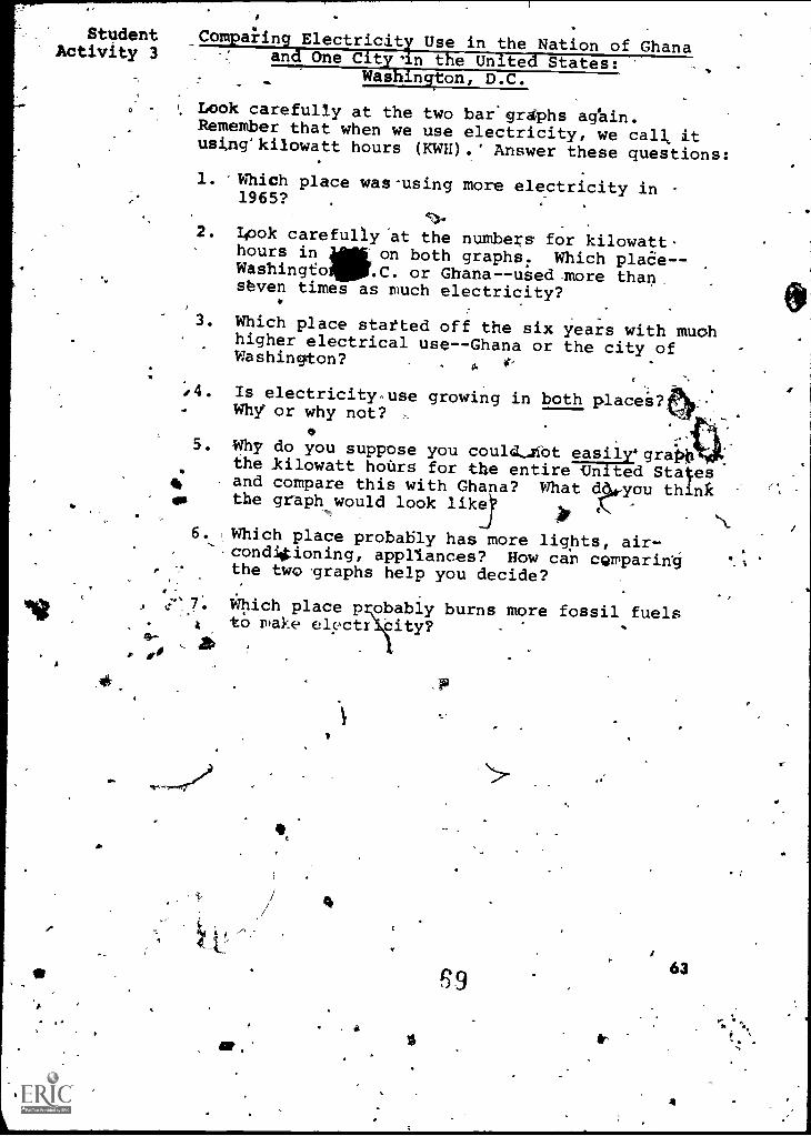
Student Comparing Electricity Use in the Nation of GhanaActivity 3 and One City 'in the United-States:Washington, D.C.
Look carefully at the two bar'graphsRemember that when we use electricity, we calk itusing'kilowatt hours (KWH).* Answer these questions:
1. Which place was-using more electricity in1965?
I.
2. Look carefully 'at the numbers for kilowatt.hours in on both graphs. Which plaoe--Washingto41111.C. or Ghana--used more than,seven times as much electricity?
3. Which place statted off the six years with muchhigher electrical use--Ghana or the city ofWashington?
.
.4. Is electricity -,use growing in both placei.why or why not?
O. -
5. Why do you suppose you could,Abt easil .graim.0. the kilowatt hours for the entire Un ted States4 and compare this with Ghana? What d4-you think
.,
fa the graph would look like ip {,. N
6. Which place probably has more lights, air-.,cond4ioning, appliances? How can cQmparing 6.%
the two graphs help you decide?.
. Which place p obably burns more fossil fuelsto make elvctr city?
a
W.
63
4