Embed Size (px)
Citation preview

Tonkin &Taylor
T&T Ref: 851378.15009 August 2011
Western Bay of Plenty District CouncilBarkes CornerGreertonTauranga3112
Attention: Peter Clark
RECEIVED1 1 AUG 2011
WESTERN BOPDISTRICT COUNCIL
Dear Peter
Landslip Assessment - Ruamoana Place, Omokoroa
1 IntroductionThree landslips have occurred on the coastal cliffs behind Ruamoana Place in Omokoroa. They are
endangering a public walkway. These landslips are likely to regress as the ground relaxes and theslope angle of the headscarp reduces. In consideration of public safety the Western Bay of PlentyDistrict Council (WBOPDC) has engaged Tonkin & Taylor Ltd to:
• Provide a visual assessment of the landslips behind 21 and 22 Ruamoana Place, 24Ruamoana Place and 27 and 28 Ruamoana Place
• Provide guidance regarding short term regression of the landslips
• Assess the short term risk to members of the public accessing the walkway
• Recommend appropriate set back distances for safety barriers behind the headscarps
• Assess the influence of existing large trees on slope stability
For the purposes of this report the landslips shall be referred to as Landslip 1 (21 and 22 RuamoanaPlace), Landslip 2 (24 Ruamoana Place), and Landslip 3 (27 and 28 Ruamoana Place). "Short term" is
taken as less than 1 year.
Information supplied in this report only applies to the stated landslips and should not be utilised forthe remainder of the peninsula. No assessment has been made of the stability of slopes betweenthese three landslips.
1.1 Site descriptionThe landslips are located on the western margin of Omokoroa Peninsula on steep coastal cliffsbetween 21 and 28 Ruamoana Place. This area has been subject to historic instability. The locationand extent of the landslips are shown on Figures 1 and 2 and photographs 1 to 4.
Tonkin & Taylor Ltd - Environmental and Engineering Consultants, Level 1, 36 Grey Street, Tauranga 3110, New ZealandPO Box 317, Tauranga 314o, Ph: 64-7-571 7360, Fax: 64 - 7 - 57 1 7390 , Email: [email protected], Website: www.tonkin.co.nz

2
1.2 Investigations undertakenInvestigations carried out by Tonkin and Taylor Ltd. comprised:
• Visual inspection of the landslips by an engineering geologist
• Production of geomorphological maps and cross sections of the landslips
• Comparison of the observed landslip features with pre-existing information in and aroundthe area
• Visual assessment of large trees situated on the slope between 21 Ruamoana Place and 17Bramley Drive
It should be noted that inspections were only undertaken where access or visual inspection waspossible.
2 Landslip morphology and activity
2.1 Landslip featuresThe three landslips occurred on steep coastal cliffs along the western margin of Omokoroa Peninsula.The height of the slopes varies between 10m and 21m, increasing to the south. The three landslipsinspected are summarised in Table 1 below.
Landslips Location
Landslip Features
Height (H) / Length including runout (L) / Width (W) in metres
Inferred maximumheadscarp regression
during recent slope failure
Landslip 121, 22
RuamoanaPlace
21 (H) / 73 (L) / 34 (W) 5-10
Landslip 224 Ruamoana
Place14.5 (H) / 30 (L) / 15 (W) 2
Landslip 327, 28
RuamoanaPlace
10.5 (H) / 12 (L) / 4 (W) 0.5
Table 1 - Size and extent of Landslips 1 to 3.
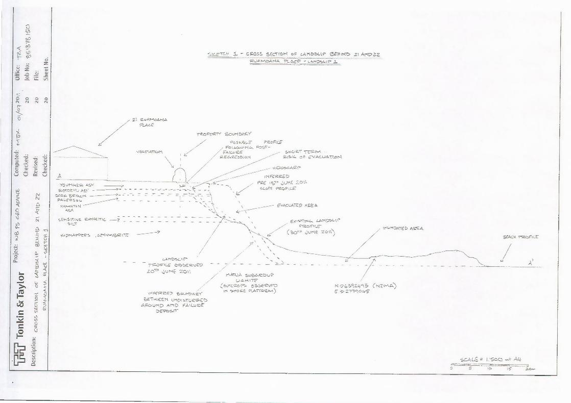
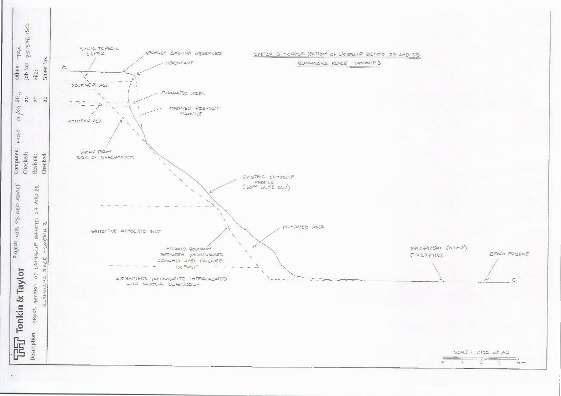
The locations of the landslips are shown on Figures 1 and 2. Cross sections through each landslip areprovided on sketches 1 to 3.
Landslip 1 failed at the base of the slope with subsequent landslip activity observed part way up theslope in the days following the initial movements. This secondary landslipping exploited a layer ofsensitive silt located approximately 11m up from the base of the slope.
Landslip 2 also failed at the base of the slope but the sensitive silt layer was unable to be seen as itwas covered by debris.
Landslip 3 occurred due to reactivation of an older landslip. Recent movements have involved onlyminor amounts of material with the majority being sourced from near the top of the slope. Asignificant sensitive silt layer was observed at the base of the slope but it was not involved in recentslope movements.
Western Bay of Plenty District Council T&T Ref: 851378.15009 August 2011
3
2.2 GeologyPublished geology shows the area involved in landslipping to contain distal ignimbrite l . This material
is overlain by several tephras and underlain by sediments of the Matua Subgroup comprisingfluviatile sands, gravels, lignites and silts. Site observations confirmed this sequence.
2.3 Future activityFuture landslip activity is expected for all three landslips within the short term and is likely to beongoing. The size and extent of future landslipping is difficult to predict, however the currentheadscarp slope angles are oversteep. A reduction in slope angle will occur as the slope relaxes and
attempts to reach a more stable profile. This will result in headscarp regression. Sketches 1 to 3indicate the possible short term headscarp regression.
The portion of the walkway behind Landslip 1 is considered to be at high risk of evacuation in theshort term. Landslips 2 and 3 display tension cracking and soft ground behind their headscarps.Headscarp regression would at least involve these portions of the slope. Several areas betweenBramley Drive and 28 Ruamoana Place exhibit tension cracking and drops in ground level. These
areas indicate past ground movements and areas that may be prone to future instability. Groundinvestigations would be required to determine slope stability in these areas. These features areshown on Figures 1 and 2.
3 Risk AnalysisThe risk to the public from further headscarp regression of landslips 1 to 3 has been assessed
according to Australian Geomechanics Society Guidelines (2007) 2 . Risk matrices taken from the AGSGuideline are provided in Appendix B. This approach provides a qualitative methodology for
determining the actual level of risk associated with future instability.
3.1 Risk to public accessing the walkwayLandslide risk analysis for Landslips 1 to 3 has been estimated based on short term risk. Short termdenotes a period of less than 1 year. Risk to the public has been analysed for people utilising theaccessway at the top of the slope only and excludes the risk to members of the public situated at thebase of the slope.
3.1.1 Landslip 1
The existing headscarp profile of landslip 1 is oversteep. Based on our knowledge of the soilsinvolved in the landslip and historic slope movements within the area, we consider that theheadscarp will recede to a slope angle between 40 and 50° in the short term. The current headscarp
is approximately 70°. Reduction of the slope angle to between 40 and 50° would result in headscarpregression of approximately 5-6m.
According to the AGS guidelines the risk to loss of life for a person standing on the walkway within6m of the headscarp is "Moderate to High". This risk reduces with distance from the headscarp butwe consider this risk rating is appropriate for the area between the headscarp and the hedge alongthe property boundaries of 21 and 22 Ruamoana Place. Moderate to High risk ratings for loss of life
are considered intolerable and risk reduction measures are required to reduce the risk to Low.
1 Briggs et al. (1996) Geology of the Tauranga area, Occasional report No. 22, University of Waikato, Department of EarthSciences2 Australian Geomechanics Society (2007) Landslide Risk Management
Western Bay of Plenty District Council T&T Ref: 851378.15009 August 2011

4
3.1.2 Landslip 2
The existing headscarp profile of Landslip 2 is also oversteep and contains well developed tensioncracks approximately 1.5m behind the headscarp. This suggests that future landslippage andrecession of the headscarp is almost certain within the short term. The expected short term
headscarp regression for Landslip 2 is approximately 3m.
According to the AGS guidelines the risk to loss of life for a person standing on the walkway abovethe headscarp is "Low to Moderate". However, there are mitigating circumstances that wouldreduce this risk. Either a person would have to be standing very close to the headscarp or, thelandslip would have to be large and move by a mechanism that is uncommon in this area. Wetherefore consider the appropriate risk rating to loss of life for a person standing on the walkwayabove the headscarp is "Low" as long as access to the headscarp is limited. This risk rating assumes
that Council will shift the existing safety barriers back 5m from the headscarp and the person at riskis standing outside these barriers. Relocating the barriers back 5m will still leave sufficient access forthe public utilising the walkway. The AGS guidelines suggest that "Low risk is tolerable and within arange that society can live with so as to secure certain benefits". However, the landslip will need tobe inspected regularly to watch for any changes. The risk to public will need to be reassessed if
further movements are observed and appropriate mitigation actions taken.
3.1.3 Landslip 3
Landslip 3 has an overhanging headscarp and is likely to recede within the short term. The limitedheight of the slope and prior knowledge of this landslip suggest that short term headscarp regressionmay be up to approximately 3m. Due to a thickening of sensitive soil in this area there is a risk ofdeeper seated failure in this area.
According to the AGS guidelines the risk to loss of life for a person standing on the walkway abovethe headscarp is "Very Low to Low". This risk rating assumes that existing safety barriers arepositioned 5m from the headscarp and the person at risk is standing outside these barriers. Theaccessway in this area will be unobstructed by repositioning the safety barriers. Under the guidelines
a Very Low to Low risk rating is considered acceptable.
4 Influence of large trees on slope stabilitySeveral large trees exist on the steep slopes between 21 Ruamoana Place and 17 Bramley Drive.Fallen or overhanging trees surcharge (load) the slope and provide little support in terms of slopestability. The western margin of Omokoroa Peninsula is prone to high winds which place pressure onthese trees and the soils in which they are rooted. They do not produce deep seated landslip activitywhen uprooted but remove surficial soil materials and result in small shallow seated failures.Exposed soil materials may then be subject to surface scour from overland flow. This is ultimately
detrimental to the global stability of the slope. Evidence of toppled trees and exposed soils can befound between 21 Ruamoana Place and 17 Bramley Drive.
We recommend that large trees that appear to be detrimental to slope stability (which areoverhanging or removing soil from the ground) be removed. Care must be taken in the execution ofthis task as dragging the trees over the steep slopes may expose surface soils and cause further
destabilisation of the slope. The felled trees should not be left on the slope.
The effect of other trees on the slope will need to be more closely assessed prior to their removal.
The establishment of small shrubs with deep root systems would be beneficial to slope stability.Removed vegetation should be replaced with such shrubs.
Western Bay of Plenty District Council T&T Ref: 851378.15009 August 2011
5
5 Discussion and RecommendationsThe assessed landslips behind Ruamoana Place are oversteep and vulnerable to headscarpregression. According to AGS guidelines the risk to loss of life caused by reactivation of the existinglandslips ranges from Very Low to High. This risk increases with proximity to the headscarp.Moderate to High risk ratings are considered intolerable and risk reduction measures are required toreduce the risk to Low. In the best interests of public safety we recommend that Council implement
the following safety precautions:
• Restrict public access behind Landslip 1. This would involve positioning the safety barrier aminimum of 6m back from the headscarp. We note that this would reach the boundary of a
private property and would therefore close the track.
• Reposition the safety barrier behind Landslip 2 a minimum of 5m back from the headscarp.
• Construct a safety barrier 5m from the headscarp of Landslip 3.
These safety measures will reduce the risk to loss of life to Low for Landslips 1 and 2 and Very Low toLow for Landslip 3. Regular monitoring should also be undertaken to detect any changes in landslipform and slope profile between existing landslips. If further movement is detected the risk to public
will need to be reassessed and appropriate mitigation actions taken.
We understand that WBOPDC is proposing to monitor the landslips with consideration given to
opening a 1 m wide walk space behind Landslip 1 in the summer months.
A few large trees between 21 Ruamoana Place and 17 Bramley Drive are causing destabilisation ofthe slope. These trees should be removed with caution to avoid overly damaging the soil underneath
and not left on the slope. Replanting these areas with small shrubs would be advisable.
6 LimitationsThis work has been carried out based on visual assessment of the landslips only. Furtherquantification of the landslip risk would require site investigations and regular monitoring.
Risk assessment has not been undertaken for public at the base of the slope. Landslipping,particularly during and after heavy rainfall has the potential to produce failure deposits withextensive run out distances. This poses a significant hazard to people walking in the area. A more
extensive study would also be required to quantify this risk, however signage warning of the hazardshould be considered for harbour access points to the beach and/or at regular intervals around thebase of the slope.
Western Bay of Plenty District Council T&T Ref: 851378.15009 August 2011

6
7 ApplicabilityThis report has been prepared for the benefit of Western Bay of Plenty District Council with respectto the particular brief given to us and it may not be relied upon in other contexts or for any otherpurpose without our prior review and agreement.
This opinion is not intended to be advice that is covered by the Financial Advisers Act 2010.
Tonkin & Taylor Ltd
Environmental and Engineering Consultants
Report prepared by:
Reviewed by:
Matthew Keam
David Milner
Engineering Geologist
Senior Engineering Geologist
Authorised for Tonkin & Taylor Ltd by:
Senior Civil Engineer
9-Aug-11p:\851378 \ 851378.150 \issueddocurnentAruamoana landslips\ 110705.mjk.ruamoana let rep.final.docx
Western Bay of Plenty District Council T&T Ref: 851378.15009 August 2011

Appendix A: Photographs, Figures and Sketches

Photograph 1- Size and form of Landslip 1.
Photograph 2- Extent of the failure deposit from Landslip 1.

Photograph 3- Size and extent of Landslip 2.
Photograph 4- Size and extent of Landslip 3.

• perator : External IV
CROWN COPYRIGHT RESERVED. LNZ DIGITAL
UCENCE No. -N/352200/03 TD093522.
LOCATION OF SERVICES IS INDICATIVE ONLY.
COUNCIL ACCEPTS NO L1ABLITY FOR ANY ERROR.
ARCHAEOLOGICAL DATA SLPPUED BY NZ ARCHAEOLOGICAL ASSOC./DEPT. OF CONSERVATION.
DATA COPIED AS AT Jul 2005.
'SEE .1r-eiCti2 Foe_cC.c,SS SECT O?-1
LANDSC,"I.
'bfr-ET214 ;be.
a0
0O
0co
00O
8
Cte.4.07-€11. :
tern iiay or Pk....gct Council
eomorphological map, Ruamoana Place, Omokoroa
Date : Mon 04 Jul Scale 1 : 500 Nona_

CVOCE 2: eomorphological map, Ruamoana Place, Omokoroa
Date : Mon 04 Jul Scale 1 : 500 Operator : External IVY
tg.ZTc►1 3 511!...toss sEL-710N
a
0
,r)
0Ql
r
a000C
C.,
0
C t
2
CROWN COPYRGHT RESERVED. LNZ DIGITAL
UCENOE No. I-N/352200/03 & TD093522.
ARCHAEOLOGICAL DATA SLPPUED BY NZ ARCHAEOLOGICAL ASSOC./DEPT. OF CONSERVATION.
DATA COPIED AS AT Jul 2005.
LOCATION OF SERVICES IS INDICATIVE ONLY.
COUNCIL ACCEPTS NO LIABILITY FOR ANY ERROR.
it-turiCATED AEA7
EgtVrir4C., t?Przo41(.8-
lo:)", " ,Nrke
SENSITIVE Rk.1-(0C-t•Ttc.SILT
y.AprkAPPVZS tcrk‘\^-.\6$2 t-Te
— PROFt(4
re-Oc'Ett"rf SCLR-II>APY
posstet.7 PeoFtl.Erolta ,, tr-tt, Po-St--
tr.-A/LW:2Etz E 4,CE OS( g.tsv- of •-N/Ar__VATIOI-4
HEA7-x-A‘Ze
PeE t Ts" JutE 2-Okk/4,1- • sLon PRoFtt.Z
— c'EvAcuATEP AcZEA.
4 \
I eltAr-\04,,NA
,tEe-E-t-A1-1(-,ty
yOUtC A..SWCacov-ku .....
ot\414 Sizo_tjK
1-1,\■••Atotc.1.1A.S.A
A
- CROSS SECS-(OM-1 oF CA1-1COLLP eeffir4D 21 ArOZZczvm..-vcAT-IA. Ft_AcE -LA.t-It■SLIP 1
O
•
0 CD 0N N N N11-
N-24::59Z-4`t5 (NZ‘^-\c,)
0
CU= C., 77CD vC. .,,,v ,...)E a, 5 a,o _= cu _=V V C 4 U
LOT" fume 2011 evq\.)A 5u8GeOuPc, t4
csv.sc.coto cSSEe\JMsttoRE olArCO2P-4)
0.4.e2cE SoL,HDoeeU1-1Dts-coeSE
esize..surtc> Art() FAILueEDEP=srr
SEACR CnocogICE
..soc. A4-waymmies===
17 ao-

I i ,
i I'
I II I ,,
/ ---_,...----,i i r1
/ / r----_______________ / /.. _ al o n o r 3)
/ f
P
I •O i
/1/ ..p- Ni Icy' '4 i' 311 3 61,-/, I
/ /1 ri 91- -I P m
3. pl y,, r
›
7.
m
7'7O0
1.
-v
Project: ,,05 PS cr0 Apv■cETonkin &TaylorDescription: ceoss c)C- LA4-44:4SLAF• port0VAD 214
guAl-tc.ArIA PLACE - SY-CI-4M 2-
Computed:
Checked:
Revised:
Checked:
201t Office: .-1--AA
20 Job No: %s
20 File:
20 Sheet No,
11-1Z 44. oi/o
0
cL3
•97
71-t IC- TO PSC> LLA YE C2. sckpric.„E-e Gs rzoL 1-19 o (3-sEtz-NJE.2
HeADSCAZe'
-> 6392600 6142m 4')1 ltS SEAGA PecetL4-c-
Ext ST1Nas LAnDSLtP
3oNE Zr...)t1)PC2clet LE
1-
v.z-rcj.k - GROSS S c'flot^k of LAT-V.1-k P SEKIm, 21- Art 2.%
ZVAP-LoArtA Pe_Ac.E - LArit>suP 3
s/CM-tc,E12.. ASH
EVAc-u4111) AEA
_It-tgal2zED poe-si_vr
4-
PrZ Ft (.,ERorriErKs ASK
Stu), -CECar-4zos)G of E vacs-AMori
SEr1 5%T\VE 0441'0(.0-lc_ 5\uT
trweizzz SOV,ADA Z*C.
e=-11-ucEr-1 uriotsrvcr-e.E -DGZr...7■-%?-4 I;;:• Art1> FA tu-AetE
r2EPoccr - -
v..■21-i At, FEIZS tAr4ttNASAZ CrE I rItElzcAcATEDv.) t714 Act, I. LI r:*
Ittumc>ovrel> AEA
C.
o o 0 0NNNN
-6a; -6-6 -6
Q e., a,... a) ......
u .,,, uE a) 5 a)O = a, ..=V v cc v
t0c.). ,:kt A4

Appendix B: Extracts from the Australian GeomechanicsSociety Guideline "Landslide Risk Management"

PRACTICE NOTE GUIDELINES FOR LANDSLIDE RISK MANAGEMENT 2007APPENDIX C: LANDSLIDE RISK ASSESSMENT
QUALITATIVE TERMINOLOGY FOR USE IN ASSESSING RISK TO PROPERTY
QUALITATIVE MEASURES OF LIKELIHOOD
Approximate Annual ProbabilityImplied Indicative Landslide
Recurrence IntervalDescription LevelDescriptor
IndicativeValue
NotionalBoundary
10 -I 5x10⁻²
5x10 -3
5x10
5x10⁻⁵
5x10 -6
10 years20 years
200 years
2000 years
20,000 years
200,000 years
The event is expected to occur over the design life. ALMOST CERTAIN A
10 -2 100 yearsThe event will probably occur under adverse conditions over thedesign life.
LIKELY B
10 -3 1000 years The event could occur under adverse conditions over the design life. POSSIBLE C
-410 10,000 yearsThe event might occur under very adverse circumstances over thedesign life. UNLIKELY D
105 100,000 yearsThe event is conceivable but only under exceptional circumstancesover the design life.
RARE E
10 -6 1,000,000 years The event is inconceivable or fanciful over the design life. BARELY CREDIBLE F
Note: (1) The table should be used from left to right; use Approximate Annual Probability or Description to assign Descriptor, not vice versa.
QUALITATIVE MEASURES OF CONSEQUENCES TO PROPERTY
Approximate Cost of DamageDescription Descriptor Level
IndicativeValue
NotionalBoundary
200%100%
40%
10%1%
Structure(s) completely destroyed and/or large scale damage requiring major engineering works forstabilisation. Could cause at least one adjacent property major consequence damage.
CATASTROPHIC 1
60%Extensive damage to most of structure, and/or extending beyond site boundaries requiring significantstabilisation works. Could cause at least one adjacent property medium consequence damage.
MAJOR 2
20%Moderate damage to some of structure, and/or significant part of site requiring large stabilisation works.Could cause at least one adjacent property minor consequence damage.
MEDIUM 3
5% Limited damage to part of structure, and/or part of site requiring some reinstatement stabilisation works. MINOR 4
0.5%Little damage. (Note for high probability event (Almost Certain), this category may be subdivided at anotional boundary of 0.1%. See Risk Matrix.)
INSIGNIFICANT 5
Notes: (2)
The Approximate Cost of Damage is expressed as a percentage of market value, being the cost of the improved value of the unaffected property which includes the land plus theunaffected structures.
(3) The Approximate Cost is to be an estimate of the direct cost of the damage, such as the cost of reinstatement of the damaged portion of the property (land plus structures), stabilisationworks required to render the site to tolerable risk level for the landslide which has occurred and professional design fees, and consequential costs such as legal fees, temporaryaccommodation. It does not include additional stabilisation works to address other landslides which may affect the property.
(4) The table should be used from left to right; use Approximate Cost of Damage or Description to assign Descriptor, not vice versa
91
Australian Geomechanics Vol 42 No 1 March 2007
r-
PRACTICE NOTE GUIDELINES FOR LANDSLIDE RISK MANAGEMENT 2007
APPENDIX C: - QUALITATIVE TERMINOLOGY FOR USE IN ASSESSING RISK TO PROPERTY (CONTINUED)
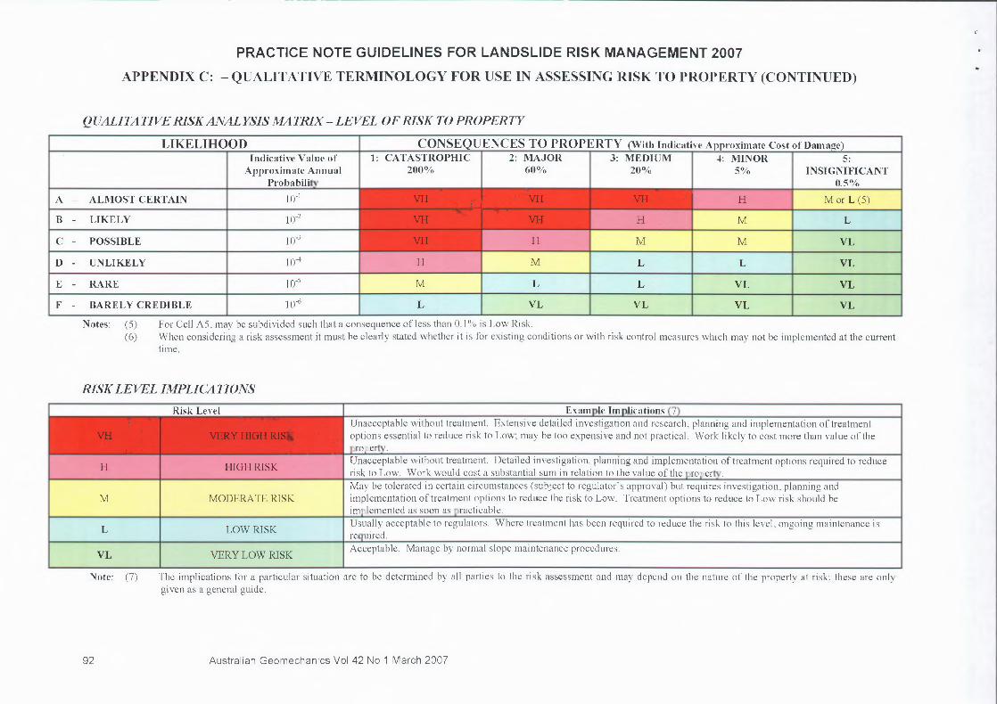
QUALITATIVE RISK ANALYSIS MATRIX - LEVEL OF RISK TO PROPERTY
LIKELIHOOD CONSEQUENCES TO PROPERTY (With Indicative Approximate Cost of Damage)Indicative Value of
Approximate AnnualProbability
1: CATASTROPHIC200%
2: MAJOR60%
3: MEDIUM20%
4: MINOR5%
5:INSIGNIFICANT
0.51)/0A — ALMOST CERTAIN 10-1 VII 11,11/11,rVH VH 1NOF H M or L (5)
B - LIKELY 10-2 VH VH H M L
C - POSSIBLE 1()-3 VH H M M VL
D- UNLIKELY 10-4 H M L L VL
E - RARE 10-5 M L L VL VL
F - BARELY CREDIBLE le L VL VL VL VL
Notes: ( 5 )
For Cell A5, may be subdivided such that a consequence of less than 0.1% is Low Risk.
(6)
When considering a risk assessment it must be clearly stated whether it is for existing conditions or with risk control measures which may not be implemented at the currenttime.
RISK LEVEL IMPLICATIONS
Risk Level Example Implications (7)
VH
.,.
VERY HIGH RISUnacceptable without treatment. Extensive detailed investigation and research, planning and implementation of treatmentoptions essential to reduce risk to Low; may be too expensive and not practical. Work likely to cost more than value of theproperty.
H HIGH RISKUnacceptable without treatment. Detailed investigation, planning and implementation of treatment options required to reducerisk to Low. Work would cost a substantial sum in relation to the value of the property.
M MODERATE RISKMay be tolerated in certain circumstances (subject to regulator's approval) but requires investigation, planning andimplementation of treatment options to reduce the risk to Low. Treatment options to reduce to Low risk should beimplemented as soon as practicable.
L LOW RISKUsually acceptable to regulators. Where treatment has been required to reduce the risk to this level, ongoing maintenance isrequired.
VL VERY LOW RISKAcceptable. Manage by normal slope maintenance procedures.
Note: (7)
The implications for a particular situation are to be determined by all parties to the risk assessment and may depend on the nature of the property at risk; these are onlygiven as a general guide.
92 Australian Geomechanics Vol 42 No 1 March 2007

PRACTICE NOTE GUIDELINES FOR LANDSLIDE RISK MANAGEMENT 2007
APPENDIX F- EXAMPLE OF VULNERABILITY VALUES
SUMMARY OF HONG KONG VULNERABILITY RANGES FOR PERSONS, AND RECOMMENDED VALUES FORLOSS OF LIFE FOR LANDSLIDING IN SIMILAR SITUATIONS
The following table is adapted from P J Finlay, G R Mostyn & R Fell (1999). Landslides: Prediction ofTravel Distance andGuidelines for Vulnerability of Persons. Proc 8 th . Australia New Zealand Conference on Geomechanics, Hobart. Australian
Geomechanics Society, ISBN 1 86445 0029, Vol 1, pp.105-113.
Case Range in DataRecommended
Value CommentsPerson in Open SpaceIf struck by a rockfall 0.1 - 0.7 0.5 May be injured but unlikely to cause deathIf buried by debris 0.8 - 1.0 1.0 Death by asphyxia almost certainIf not buried 0.1 - 0.5 0.1 High chance of survivalPersons in a VehicleIf the vehicle is buried/crushed 0.9 - 1.0 1.0 Death is almost certainIf the vehicle is damaged only 0 - 0.3 0.3 High chance of survivalPerson in a BuildingIf the building collapses 0.9 - 1.0 1.0 Death is almost certainIf the building is inundated with debrisand the person buried
0.8 - 1.0 1.0 Death is highly likely
If the debris strikes the building only 0 - 0.1 0.05 Very high chance of survival
EXAMPLE OF VULNERABILITY VALUES FOR DESTRUCTION OF PEOPLE, BUILDINGS AND ROADS
The following table is adapted from Marion Michael-Leiba, Fred Baynes, Greg Scott & Ken Granger (2002). Quantitative LandslideRisk Assessment of Cairns. Australian Geomechanics, June 2002.
Geomorphic UnitVulnerability Values
People Buildings RoadsHill slopes 0.05 0.25 0.3Proximal debris fan 0.5 1.0 1.0Distal debris fan 0.05 0.1 0.3
EXAMPLE OF VULNERABILITY VALUES FOR LIFE FOR ROCKFALLS AND DEBRIS FLOWS FORLAWRENCE HARGRAVE DRIVE PROJECT, COALCLIFF TO CLIFTON AREA, AUSTRALIA
The following table is adapted from R A Wilson, A T Moon, M Hendricks & I E Stewart (2005).Application of quantitative risk assessment to the Lawrence Hargrave Drive Project, New South Wales,Australia.
Landslide Risk Management - Hungr, Fell, Couture & Eberhardt (eds) 2005. Taylor & Francis Group, London, ISBN 04 1538 043X.
Order of magnitudeof landslide crossing
road (m 3 )
Rockfalls fromScarborough Cliff
Debris flow fromNorthern Amphitheatre
Landslide hits car Car hits landslide Landslide hits car Car hits landslide0.03 0.05 0.006 - -0.3 0.1 0.002 - -
3 0.3 0.03 0.001 -30 0.7 0.03 0.01 0.001
300 1 0.03 0.1 0.0033,000 1 0.03 1 0.003
NOTE: The above data should be applied with common sense, taking into account the circumstances of the landslide being studied.Judgment may indicate values other than the recommended value are appropriate for a particular case.
112 Australian Geomechanics Vol 42 No 1 March 2007