Embed Size (px)
Citation preview

Eastern Pennsylvania
BIRDING & WILDLIFE GUIDE
Eastern Pennsylvania
BIRDING & WILDLIFE GUIDE
Eastern Pennsylvania contains many habitats that contribute to a wealth of birding opportunities. If you’re a visitor to the area, this guide will help direct you to a myriad of nature experiences available in this section of Pennsylvania. If you’re a Pennsylvania resident looking for some new areas to explore, or want to find a spot you’ve been hearing about, this guide will help get you there.
Park
Ran
ger w
ith A
mer
ican
kes
tral,C
hest
er C
ount
y Pa
rks
Blue
Mar
sh L
ake,
SRH
A
Dela
ware
Wat
er G
ap N
WR
Dani
el P
. Cre
ight
on
2
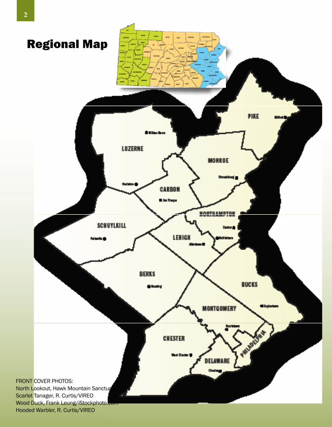
Regional Map
FRONT COVER PHOTOS:North Lookout, Hawk Mountain SanctuaryScarlet Tanager, R. Curtis/VIREOWood Duck, Frank Leung/iStockphoto.comHooded Warbler, R. Curtis/VIREO

Welcome to the Eastern Pennsylvania Birding and Wildlife Guide
3
Scar
let T
anag
er, p
hoto
by:
Bria
n E.
Sm
all/
VIRE
O
This guide focuses primarily on birding,
however, where there is habitat to support
birds, there will also be amphibians,
reptiles, mammals, butterflies, dragonflies
and other forms of wildlife. There will also
be interesting plants for the botanically
inclined. We believe that when you
are birding, you will see all these other
wonderful life forms as well.
This easy to use guide will help you find
natural areas that support birds and
other wildlife in a 13 county area of
eastern Pennsylvania, encompassing the
watersheds of the Lehigh, Schuylkill, and
Delaware Rivers in the state. You can also
visit Pennsylvania’s interactive Birding
Trail web site at www.pabirdingtrails.org.
The habitat of the region is diverse, leading
to a rich variety of birds and wildlife.
From estuarine wetlands, to piedmont
forests, to the ridges and valleys of the
Appalachians, and the unique plateau of
the Poconos, eastern Pennsylvania includes
many preserved areas, even in the more
developed regions.
Welcome to the natural areas of eastern
Pennsylvania, The Birthplace of American
Birding. We hope your birding and wildlife
experiences will be memorable.

Table of Contents 3 Welcome
5 Partners
6 Seasonal Timeline/Making Most of Birding/Hazards/Birding Ethics
8 Introduction: The Birthplace of Birding by Scott Weidensaul
18 Berks County
28 Bucks County
40 Carbon County
46 Exploring Audubon’s Lehigh/Palmerton Superfund Site
48 Chester County
56 Delaware County
60 Lehigh County
66 Kittatinny Ridge/Hawkwatching
68 Luzerne County
74 Pocono Mountains/Delaware Water Gap NRA/Eagle Watching
76 Monroe County
82 Montgomery County
90 Mill Grove/Academy of Natural Sciences
92 Northampton County
98 Philadelphia
106 Heritage Areas/Regional Trails
108 Pike County
118 Schuylkill County
124 Specialty Birds
126 Resources
130 Site Index
131 Regional Map
Acknowledgements
The following organizations provided additional support:Audubon Pennsylvania | National Audubon Society
The following served on the advisory team for design and production:Sherry Acevedo, Delaware & Lehigh Heritage Corridor Frederic “Fritz” Brock, Lehigh Gap Nature Center | Tim Fenchel and Susan Fordyce, Schuylkill River Heritage Area Monica Hoffman, PA Department of Conservation and Natural Resources | Dr. Dan Klem and Peter Saenger, Acopian Center for Ornithology-Department of Biology, Muhlenberg College | Katrina Knight, Baird Ornithological Club | Dan Kunkle, Lehigh Gap Nature Center | Terry Master, East Stroudsburg University
The following provided site nominations, site descriptions or photos:Nancy Beaubaire | Frederic “Fritz” Brock | Dave Brandes William Buchanan Brian Byrnes | Jessica Cirilo | Tom Clauser Marcia Clouser Kevin Crilley | Burt Ellsworth | Jay Erb | Bill Etter | Marilyn Flannery | Steven Fordyce | Susan FordyceWendy Frew | Joel Fry | Susan Gallagher | Laurie Goodrich Jon Hartman | Dave Hawk | Dan Hewko | Ron Holmes Paul Juris | John Kieffer | Dan Kunkle | Mary Linkevich David Long | Diane Madl | David Madl | Terry Master Bruce McNaught | Lisa Miller | Jen Naugle | Keith Russell Gary Smith | Darryl Speicher | Jackie SpeicherJohn N. Spencer | Chris Stieber | Bill SweeneyScott Weidensaul | Rick Wiltraut | Paul Zeph
Production by Dean Design, Lancaster, PAWeb site by JPL Productions, Harrisburg, PACover design by Susan Fordyce
This project was funded in part by the Community Conservation Partnerships Program, Environmental Stewardship Fund, under the administration of the PA Department of Conservation and Natural Resources, Bureau of Recreation and Conservation, and in part by the National Park Service.
© 2009 Schuylkill River Heritage Area and Delaware & Lehigh National Heritage Area. All rights reserved.
4
Preferred citation: Brock, F., S. Fordyce, D. Kunkle, and T. Fenchel. 2009. Eastern Pennsylvania Birding and Wildlife Guide. Pennsylvania Department of Conservation and Natural Resources, Harrisburg, PA. NOTE: All map locations are approximate.
PartnersThis guide was produced by a partnership of organizations. Pennsylvania DCNR, Schuylkill River National & State Heritage Area, and the Delaware & Lehigh National Heritage Corridor provided the funding, while Lehigh Gap Nature Center coordinated the project.
National Park ServiceSince 1916, the National Park Service has been caring for national parks, a network of nearly 400 natural, cultural and recreational sites across the nation. The National Park Service preserves the natural and cultural resources and values of the national park system for the enjoyment, education, and inspiration of this and future generations. Beyond national parks, the National Park Service helps communities across America preserve and enhance important local heritage and close-to-home recreational opportunities.www.nps.gov 202-354-2268
Pennsylvania Department of Conservation and Natural Resources, Bureau of Recreation and ConservationThe Pennsylvania Department of Conservation and Natural Resources is charged with maintaining and preserving the 117 state parks; managing the 2.1 million acres of state forest land; providing information on the state’s ecological and geologic resources; and establishing community conservation partnerships. www.dcnr.state.pa.us 717-783-2658
Schuylkill River National and State Heritage AreaThe Schuylkill River Heritage Area uses conservation, education, recreation, tourism, and cultural and historic preservation as tools for community revitalization and economic development. It includes the Schuylkill RiverWatershed five-county area in Schuylkill, Berks, Chester, Montgomery counties and includes the city of Philadelphia.www.schuylkillriver.org 484-945-0200
Delaware & Lehigh National Heritage CorridorThe Delaware & Lehigh National Heritage Corridor is a joint effort of private groups and interested citizens, county and municipal governments, the Commonwealth of Pennsylvania and the federal government to restore historic places, conserve green space for public use and preserve and interpret our heritage to enhance life for generations to come.www.delawareandlehigh.org 610-923-3548
Lehigh Gap Nature CenterLehigh Gap Nature Center is a private conservation organization, which has created an environmental education and research center on a former Superfund site on the Kittatinny Ridge at Lehigh Gap in eastern Pennsylvania.www.lgnc.org 610-760-8889
5

Making the Most of Your BirdingIf you are new to birding, try these time-tested techniques:
• Study field guides at home as well as using them in the field
• Move slowly and be quiet while searching for birds
• Wear neutral colors that blend with surroundings
• Consider finding a good spot, then standing still and allowing the birds to come to you
• Scan trees and shrubs watching for movement, and listen carefully –
many birds are heard first, and then seen
• Look at the bird as long as it is there, and then consult your field guide . . .
the guide will stay there, the bird will not
• Look at characteristics such as beak shape, feet, tail length, wing pattern (bars) and shape,
pattern of markings on the head, and behavior – not just the color of the bird
• Find the bird with your naked eyes, then continue looking at the bird and raise the binoculars in
front of your eyes as you keep looking at the bird
• Learn how to use the diopter feature of your binoculars to get clear vision (ask the binocular dealer
or any knowledgeable birder you encounter)
• Check the range map in the guide when you think you have it narrowed down to a few similar
species – some can be eliminated by range
• Learn to associate birds with particular habitats – Wood Thrushes like forests, Brown Thrashers
prefer brushy habitat
• Practice alone, but also bird with experienced birders
Seasonal Timeline
Winter
Bald Eagles along Delaware and Lehigh Rivers and at unfrozen lakes and reservoirs; woodpeckers in forests (easy to see without leaves); Horned Larks and Snow Buntings in agricultural fields; American Tree Sparrows in old fields; chickadees, titmice, finches, cardinals, and sparrows at feeders.
Spring
Waterfowl migration and amphibians breeding in March; Wood Ducks and Common Mergansers breeding and shad migration begins in April; thrushes, tanagers, orioles and warblers migrating through or returning to breed in May; First two weeks of May – peak warbler migration.
6

Potential HazardsBeing aware of potential hazards in the field will make your experience safer:
• Learn to identify and avoid poison ivy (very common) and poison sumac
(rare – only in boggy areas)
• Protect yourself from ticks (wear lighter clothing, check often during your outing,
and inspect yourself after a day in the field) and mosquitoes
• Be aware of venomous snakes (rattlesnake and copperhead) on trails –
they will almost never bother you unless provoked or stepped on
• Be aware of hunting seasons and game laws, especially when birding on State
Game Lands or other lands where hunting is allowed
Birding Ethics and Conservation• Observe from a distance, especially around nests. If the birds alter their
behavior because of you, you are too close
• Stay on trails or roads to avoid damaging habitat or disturbing nests
• Stay out of restricted areas and private property
• Do not use recorded calls to attract birds
• Take only photos, leave only footprints – carry out what you carried in, dispose
of wastes properly, minimize your impacts on the site
• Respect others using the site
• Spend as much money on conservation as you do on birding, and especially
support the parks and refuges where you bird
• Share your experiences – allowing a novice to look through your spotting scope
could make a convert for conservation
Summer
Mountain laurel blooms in early June; breeding birds including swallows, bluebirds, hummingbirds, tanagers, orioles, flycatchers, warblers and more through June and July; wildflowers, butterflies, and dragonflies peak; hawk, shorebird, and monarch butterfly migration begin in August.
Autumn
Hawk migration (falcons, hawks, eagles, Ospreys, Harriers) from late August through early December; southbound songbirds and Monarch Butterflies peak in September; ducks, geese, loons and other southbound waterfowl peak in October/November;
spectacular autumn foliage mid-October through mid-November.
7

Scott Weidensaul has written more than two dozen books on natural history, including his widely acclaimed Living on the Wind: Across the Hemisphere with Migratory Birds (1999), which was a finalist for the Pulitzer Prize, and Of a Feather: A Brief History of American Birding (2007), which traces 400 years of ornithological history. His writing has appeared in dozens of publications, including Smithsonian, the New York Times, Audubon, and many others. He also lectures widely on conservation. In addition to writing about wildlife, Weidensaul is an active field researcher whose work focuses on raptor migration, Saw-whet Owl movements, and hummingbirds.
8

Eastern Pennsylvania is a birding paradise.
From the gulls and waterfowl on lakes
Nockamixon or Ontelaunee, to the songbird-
haunted forests of the Pocono plateau and to the
Kittatinny Ridge overlooks like Hawk Mountain
and Bake Oven Knob with their parade of
migrant raptors–there is always something with
feathers to make a day outside worthwhile.
But beneath the forests and flowing water,
masked by the honks of geese and the spring
chorus of songbirds, lies history. Not just
the grand pageant of national history like
Valley Forge and
Independence Hall,
but ornithological
history. Mile for
mile, the Schuylkill
and Delaware
rivers may be the most important waterways
in the history of American bird study, just as
the lands they frame remain a treasure-trove for
modern birders.
This is where the American science of birds
got its start, but not in the way you might
expect. The pioneers of American ornithology
were layabouts and dreamers, convicted felons
Introduction: The Birthplace of American Birdingby Scott Weidensaul
“Mile for mile, the Schuylkill and Delaware rivers may be the most important waterways in the history of American bird study.”
9
and vainglorious peacocks, all of whom were
transformed by the birdlife along the Schuylkill
into brilliantly focused naturalists who, in turn,
changed the way we look at the natural world.
William Bartram had the right pedigree for
science; his father, John, rose from being a
simple farmer and taught himself science,
becoming one of the world’s greatest botanists;
their home, Bartram’s Garden, near the junction
of the Schuylkill and Delaware in Philadelphia,
was renowned for its plant collections. Young
Billy, born in 1739, absorbed his father’s
passions for
nature but little
of his drive. He
failed again and
again at business
and farming,
but in his thirties he found his mission in life,
setting off from the family home to explore the
Southeast, discovering dozens of new species
and, after returning to Philadelphia, writing an
account of his travels that made him as famous
as his father.
In later years, diplomats, scientists and even
presidents like Washington and Jefferson beat
Grea
t-hor
ned
Owl

a path to Bartram’s
Garden to see him, but
his fame attracted a
scruffier sort as well –
people like the scrawny
young Scotsman who
knocked one day in
1803, introducing
himself as the new
schoolteacher at Gray’s
Ferry, a mile further
along the Schuylkill.
Did Bartram’s eyes
narrow a bit, looking
at the underfed young
man? Did Bartram
know the fellow had
been imprisoned in
Scotland for blackmail? Was he put off the
chap’s breezy announcement that he wanted
to write and illustrate the first comprehensive
ornithological text on the birds of the New
World – even though he could not draw, and
didn’t even know what most of these wondrous
new birds were called?
Or did Bartram see a little of himself in
the young man, who was called Alexander
Wilson, and who would, within just 10 years
(and with a generous dose of Bartram’s help,
and by working himself into an early grave)
achieve his goal and lasting recognition as the
10
Father of American
Ornithology?
Perhaps. But what
neither man knew
was that just 25
miles upstream, at
an estate named Mill
Grove, another bird-
mad young man had
recently landed – the
illegitimate, Haitian-
born son of a French
naval captain. He
was a self-absorbed
18-year-old, fond of
dancing and shooting,
with no interest in
managing his father’s
land; by any objective assessment the young
fellow, christened Jean Rabine, was likely to
make nothing more of himself than a mildly
rich fop.
The one thing that did interest him very
much, though – the one thing that harnessed
his surprisingly sharp intellect and his
formidable, if self-taught, artistic skill – were
the birds he chased along the Schuylkill River,
painting them in works signed not with the
name he was given at birth, but the anglicized
version of the name his father had given him:
John James Audubon.
A. W
ilson
’s dr
awin
g of
Bar
n Sw
allo
ws. C
ourte
sy o
f the
Nat
iona
l Aud
ubon
Soc
iety
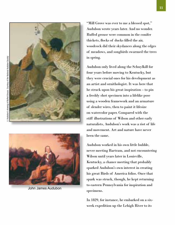
“Mill Grove was ever to me a blessed spot,”
Audubon wrote years later. And no wonder.
Ruffed grouse were common in the conifer
thickets, flocks of ducks filled the air,
woodcock did their skydances along the edges
of meadows, and songbirds swarmed the trees
in spring.
Audubon only lived along the Schuylkill for
four years before moving to Kentucky, but
they were crucial ones for his development as
an artist and ornithologist. It was here that
he struck upon his great inspiration – to pin
a freshly shot specimen into a lifelike pose
using a wooden framework and an armature
of slender wires, then to paint it lifesize
on watercolor paper. Compared with the
stiff illustrations of Wilson and other early
naturalists, Audubon’s work was a riot of life
and movement. Art and nature have never
been the same.
Audubon worked in his own little bubble,
never meeting Bartram, and not encountering
Wilson until years later in Louisville,
Kentucky, a chance meeting that probably
sparked Audubon’s own interest in creating
his great Birds of America folios. Once that
spark was struck, though, he kept returning
to eastern Pennsylvania for inspiration and
specimens.
In 1829, for instance, he embarked on a six-
week expedition up the Lehigh River to its
11
John James Audubon
J.J A
udub
on’s
draw
ing
of R
uffe
d Gr
ouse
. Cou
rtesy
of t
he N
atio
nal A
udub
on S
ocie
ty

12

headwaters, in what was then known as the
Great Pine Swamp – the virgin forest of white
pine, hemlock of hardwoods that covered what
is now Carbon and Luzerne counties, a forest
so deep and shadowed that it was also known
as “the Shades of Death.” There was nothing
gloomy about it to Audubon, though, who went
out each day with his gun Tear-jacket, living
in a logger’s cabin and eating “juicy venison,
excellent Bear flesh, and delightful trout,”
painting pileated woodpeckers, red-breasted
nuthatches, ravens, warblers and much more
– 95 of his great paintings in all.
Eastern Pennsylvania was the cradle of
American science, home to the American
Philosophical Society (whose members, at
the request
of Thomas
Jefferson,
gave a crash
course in the
natural sciences
to Meriwether Lewis, the introspective,
melancholic half of the Lewis and Clark
expedition. When they set out across the
West, Lewis was armed with the basics of
ornithology, along with medicine, botany,
ethnology and paleontology). In 1812, the
Academy of Natural Sciences opened it doors
– though not willingly to Audubon, who had
gotten himself crossways with the Academy
by denigrating Wilson’s work. George Ord,
“As the two rivers connect the landscape, so too does a continuous thread connect the lives of their great ornithologists.”
13
Wilson’s friend, biographer and collector, spent
the rest of his life savaging Audubon at every
opportunity.
As the two rivers connect the landscape, so
too does a continuous thread connect the lives
of their great ornithologists – though it runs
upstream, flowing through time from the
mouths of the rivers toward their headwaters
in the mountains. In 1823, a boy was born in
Reading, Berks County, along the Schuylkill
whose life linked the generation of pioneering
bird students with those who helped sparked the
general public’s interest in birds a century later.
Before his widowed mother moved the family
from Reading to Carlisle when he was 10, it’s
likely that young
Spencer Fullerton
Baird thrilled
to the sight of
passenger pigeon
flocks roosting
on the flanks of
Neversink Mountain, and flying down to an
immense boulder in the Schuylkill, known
to this day as “Pigeon Rock.” Baird was a
prodigy; a college graduate at 17, discoverer
(with his brother) of several new species of
birds including the least and yellow-bellied
flycatchers, friend and protégé of Audubon,
and later the founder of the National Museum
of Natural History and secretary of the
Smithsonian Institution.
Mal
lard

And as Audubon mentored Baird, so did Baird
mentor dozens of the best ornithologists of
the late 19th and early 20th centuries, many
of whom got their start as frontier collectors.
(Baird’s father-in-law was Inspector-General
of the U.S. Army, and through him, Baird
could post military officers with a knack for
science to almost any Western fort that he
wished).
Not all were Army surgeons and cavalry
officers, though. Among Baird’s many
correspondents was a young schoolteacher
from Berks County named Levi Mengel, who
even before he graduated high school in the
1880s had assembled a collection that would
eventually grow to thousands of eggs and
bird skins, and form the basis of the Reading
Public Museum, which he founded in 1907.
Mengel, in turn, struck up a friendship with
a young artist and museum collector at the
Academy of Natural Sciences named Earl
Poole, who eventually succeeded Mengel as
the director of the Reading Museum, and who
went on to an illustrious career as a scientist,
illustrator and educator.
The Schuylkill and the Delaware both
flow through the same, 220-mile-long
ridge, variously known as the Blue or First
Mountain but more formally called the
Kittatinny Ridge. The water gaps they form
are among the prettiest on Earth (though
recent commercial sprawl in the neighboring
14
valley has marred the Schuylkill gap). But along
this long, narrow ridgeline comes a great floodtide of
raptors each fall, one of the greatest bird migrations in
North America, and one whose history was pivotal for
conservation.
In the late 1920s, state ornithologist George Miksch
Sutton wrote a short note in an ornithological journal
about the unusual concentration of northern goshawks
turned in for bounty at one spot along the Kittatinny
on the Schuylkill/Berks county line, and a young
conservationist named Dick Pough – who would go on
to found the Nature Conservancy two decades later–
came to investigate.
Dead
haw
ks fr
om o
ne d
ay o
f sho
otin
g. C
ourte
sy H
awk
Mou
ntai
n Sa
nctu
ary A
rchi
ves

He found carnage on the ridge – gunners
blasting thousands of migrating hawks
each fall, their broken and rotting carcasses
littering the woods below. Pough tried to rally
support for ending the slaughter, using the
gruesome photographs he took, and was met
by a yawn – even many ornithologists and
conservationists thought hawks were “bad”
birds, not worthy of protection.
But Pough did energize a formidable woman
named Rosalie Edge, a New York veteran of
the women’s suffrage movement, and a largely
forgotten conservation heroine to whom we
owe Olympic and King’s Canyon national
parks, and the preservation of much of
Yosemite. Mrs. Edge formed the Emergency
Conservation Committee and leased the
mountaintop where the gunning was worst
– and in the nick of time, as a local hunting
club voted that same day to buy the land for
hawk-shooting.
Instead, the ridgetop became Hawk Mountain
Sanctuary, the world’s first refuge for birds
of prey, and one that has grown into one
15
Broa
d-wi
nged
haw
k, B
.K. W
heel
er/V
IREO
R.T.
Pet
erso
n on
Nor
th L
ooko
ut, H
awk
Mou
ntai
n Sa
nctu
ary A
rchi
ves
of the leading centers of raptor conservation
and research in the world. The rocks of North
Lookout, which rise high above the Little
Schuylkill River, have for generations been
the crossroads of naturalists like Roger Tory
Peterson and Rachel Carson, just to name a
few of the luminaries who made the pilgrimage
many times over the years.

16

History has flowed, just as have the rivers that
frame eastern Pennsylvania. Few parts of the
state have been hit as hard by development
– yet the birding opportunities here remain
rich. Stretching from the tidal marshes of
the lower Delaware, through the Piedmont
farmland to the extensive forests of the ridge-
and-valley system and the cool, conifer-laced
bogs of the Pocono plateau, it’s a region of
varied topography and habitat, and thus great
for birds.
It’s also a region which, despite its large
human population, still has a lot of public
land that’s open for birding, from state parks
like Hickory Run and Lehigh Gorge in Carbon
County, to state forests and natural areas like
Bruce Lake in Pike County and Brady’s Lake
in Monroe, as well as tens of thousands of
acres of state game lands, local and county
parks. The region also has an unusual number
of private preserves like Hawk Mountain, the
Lehigh Gap Nature Center and Tannersville
Cranberry Bog Preserve.
“Today, it’s still possible to walk the same paths, and see many of the same species, that the giants of early American ornithology saw.”
17
Today, it’s still possible to walk the same paths,
and see many of the same species, that the
giants of early American ornithology saw,
whether it’s spring migrants filling the old trees
at Bartram’s Garden, or the eastern phoebes
that still nest along Perkiomen Creek at Mill
Grove, where Audubon tied silver wires to their
legs to prove that the same phoebes came back
to nest each spring – the first crude attempt at
bird-banding.
You can chase Audubon’s ghost through the
“Shades of Death” on the upper Lehigh, where
northern warblers still abound, and where
ravens have returned after a century’s absence
– and if the passenger pigeons that once drank
from the Schuylkill are just a memory, the
sting is eased by resurgent peregrine falcons,
nesting in Allentown, Reading and on the cliffs
of the Delaware Water Gap, or bald eagles
in growing numbers throughout the region.
Everywhere you look in eastern Pennsylvania,
you’ll find birds. All you need is time,
binoculars – and this guide, of course.
East
ern
Blue
bird
LegendDogsAllowedRestroomsBiking
TrailsHikingTrails
HandicappedAccessibility
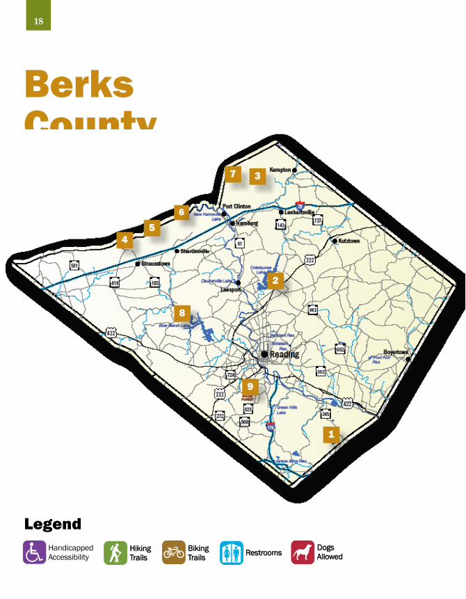
Berks County
1
2
3
45
6
18
7
8
9
DogsAllowedRestroomsBiking
TrailsHikingTrails

HAY CREEK — FRENCH CREEK STATE PARK
Location: Most of this large site is located in southeastern Berks County. About 20% of the site is in Chester County.
Owner & Contacts: (Total site approximately 12,000 acres) French Creek State Park–PA Department of Conservation and Natural Resources (7,475 acres)610-582-9680843 Park Rd., Elverson, PA 19520-9523www.dcnr.state.pa.us/stateparks/Parks/frenchcreek.aspx
Birdsboro Municipal Water Authority
Hopewell Furnace National Historic Site–National Park Service (848 acres)610-582-87732 Mark Bird Lane, Elverson, PA 19520www.nps.gov/hofu
Directions, Access & Parking: To reach the area from the south, at the intersection of Rt. 23 (Ridge Rd.) and Rt. 345, go north on Rt. 345 for at least 3 miles to the site. To reach the site from the north, from the intersection of U.S. 422 and Rt. 82, go south on Rt. 82 and cross the Schuylkill River. Shortly after crossing the river you will come to the intersection of Rt. 82 and Rt. 724 (Main St.). Go left (east) on Main St. for about 0.4 miles and turn right (south) on Rt. 345 (Chestnut St.). Continue south on Rt. 345 for about 3 miles to French Creek State Park. There are numerous places to park within the site. Restrooms are available.
Site Description: This site is a large block of unfragmented, low elevation forest with “interior forest birds” in abundance. Public lands include: French Creek State Park, Hopewell Furnace National Historic Site, Birdsboro Municipal Water Authority lands, and State Game Lands (SGL) No. 43. The site contains high-quality wooded riparian areas and healthy upland forest. Also present are food plots at SGL No. 43, fields (Hopewell) and recreation fields at the state park. In addition to Hay Creek, other creeks found at the site include: Six Penny Creek, French Creek, Baptism Creek and Pine Creek. The block also includes Pine Swamp, an acidic broadleaf swamp and a “site of concern” for The Nature Conservancy. The site is of particular importance due to the presence of endangered Bog Bluegrass the emergent hummock wetlands support the endangered Bog Turtle. French Creek State Park contains two lakes: Hopewell Lake – 68 acres, Scotts Run Lake – 22 acres.
Through the Seasons:Winter: Look for forest birds such as woodpeckers,nuthatches and chickadees.Spring: The area is excellent for warblers and other neotropical migrants such as flycatchers, Wood Thrush, Veery, Rose-breasted Grosbeak and Scarlet Tanager.Summer: A variety of neotropical migrants that are forest dependent nest at the site because of its large, unfragmented nature.Fall: Look for warblers and other migrant songbirds in late August and September.
Other Comments: Be sure to visit Hopewell Furnace National Historic Site if time permits. • The entire area has been designated an Important Bird Area by Audubon Pennsylvania.
1
19BerksW
ood
Thru
sh, G
. Bai
lery
/VIR
EO
20
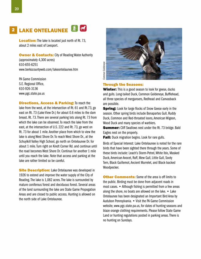
LAKE ONTELAuNEE
Location: The lake is located just north of Rt. 73, about 2 miles east of Leesport.
Owner & Contacts: City of Reading Water Authority (approximately 4,300 acres)610-655-6251www.berkscountyweb.com/lakeontelaunee.htm
PA Game CommissionS.E. Regional Office, 610-926-3136www.pgc.state.pa.us
Directions, Access & Parking: To reach the lake from the west, at the intersection of Rt. 61 and Rt.73, go east on Rt. 73 (Lake View Dr.) for about 0.6 miles to the dam breast. Rt. 73. There are several parking lots along Rt. 73 from which the lake can be observed. To reach the lake from the east, at the intersection of U.S. 222 and Rt. 73, go west on Rt. 73 for about 1 mile. Another place from which to view the lake is along West Shore Dr. To reach West Shore Dr., at the Schuylkill Valley High School, go north on Ontelaunee Dr. for about 1 mile. Turn right on Kindt Corner Rd. and continue until the road becomes West Shore Dr. Continue for another 1 mile until you reach the lake. Note that access and parking at the lake are rather limited so be careful.
Site Description: Lake Ontelaunee was developed in 1926 to extend and improve the water supply of the City of Reading. The lake is 1,082 acres. The lake is surrounded by mature coniferous forest and deciduous forest. Several areas of the land surrounding the lake are State Game Propogation Areas and are closed to public access. Hunting is allowed on the north side of Lake Ontelaunee.
Through the Seasons:Winter: This is a good season to look for geese, ducks and gulls. Long-tailed Duck, Common Goldeneye, Bufflehead, all three species of mergansers, Redhead and Canvasback are possible.Spring: Look for large flocks of Snow Geese early in the season. Other spring birds include Bonapartes Gull, Ruddy Duck, Common and Red-throated loons, American Wigeon, Wood Duck and many species of warblers.Summer: Cliff Swallows nest under the Rt. 73 bridge. Bald Eagles nest on the property.Fall: Duck migration begins. Look for rare gulls.
Birds of Special Interest: Lake Ontelaunee is noted for the rare birds that have been sighted there through the years. Some of these birds include: Leach’s Storm-Petrel, White Ibis, Masked Duck, American Avocet, Ruff, Mew Gull, Little Gull, Sooty Tern, Black Guillemot, Ancient Murrelet, and Black-backed Woodpecker.
Other Comments: Some of the area is off limits to the public. Birding must be done from adjacent roads in most cases. • Although fishing is permitted from a few areas along the shore, no boats are allowed on the lake. • Lake Ontelaunee has been designated an Important Bird Area by Audubon Pennsylvania. • Visit the PA Game Commission website, www.pgc.state.pa.us, for dates of hunting seasons and blaze orange clothing requirements. Please follow State Game Land or hunting regulations posted in parking areas. There is no hunting on Sundays.
2
Com
mon
Gol
dene
ye

STATE GAME LAND 110PINE SWAMP
Location: Pine Swamp is located south of Hawk Mountain Rd., about 2 miles east of the Headquarters Building at Hawk Mountain Sanctuary. State Game Land (SGL) No. 106 is located south of Hawk Mountain Rd. in both Berks and Schuylkill counties.
Owner & Contacts: PA Game CommissionS.E. Regional Office, 610-926-3136www.pgc.state.pa.us
Directions, Access & Parking: To reach Pine Swamp from I-78, take Lenhartsville exit No. 35. Go north on Rt. 143 for about 4 miles to the gas station on the right. Turn left at the blue Hawk Mountain sign onto Hawk Mountain Rd. Go west on Hawk Mountain Rd. for about 5 miles to Pine Swamp Rd. at the base of the mountain. Turn left onto Pine Swamp Rd. Proceed 0.4 miles and turn right to reach the first State Game Lands parking lot or continue about 200 feet further down Pine Swamp Rd. and park in the lot on the left. Another option is to park anywhere along the road and bird the surrounding woods. Pine Swamp Rd. loops through the woods and back to Hawk Mountain Rd. There is another State Game Land parking lot across Pine Swamp Rd. from the Civil Air Patrol camp.
Site Description: Pine Swamp and State Game Land No. 106 are almost entirely composed of mature deciduous forest with some pine groves. Parts of the game lands are very steep.
Through the Seasons:Winter: Look for typical deep forest birds including Pileated Woodpecker, Ruffed Grouse and Wild Turkey. Barred Owls are present some years.Spring: This is the best season to bird Pine Swamp and SGL No. 106. The entire area is an excellent place to see a large variety of warblers and other neotropical migrants such as Wood Thrush, Swainson’s Thrush, Veery and Scarlet Tanager.Summer: Nesting warblers include: Worm-eating, Hooded, Kentucky, Chestnut-sided, and Ovenbird. Ruffed Grouse, Wild Turkey and Pileated Woodpecker also nest in the area.Fall: Look for migrating warblers. The best birding in this season will be at Hawk Mountain Sanctuary’s North Lookout when the fall hawk migration is in full swing.
3
21Berks
Barre
d Ow
l, Fr
ank
Leun
g/iS
tock
phot
o.co
m
Other Comments: Be sure to visit Hawk Mountain Sanctuary, p. 25 (no dogs are allowed on Hawk Mountain property) • The area is open to hunting during season. • The Appalachian Trail goes through SGL No. 106. • As of early 2008 the Pennsylvania Game Commission was in the process of logging part of SGL No. 106. • Visit the PA Game Commission website, www.pgc.state.pa.us, for dates of hunting seasons and blaze orange clothing requirements. Please follow State Game Land or hunting regulations posted in parking areas. There is no hunting on Sundays.

STATE GAME LAND 110 KITTATINNY RIDGE MOuNTAINTOP
Location: The site is located on the Kittatinny Ridge (Blue Mountain) north of the Village of Strausstown, just east of where Rt. 183 crosses the mountain. This site straddles the ridge in Berks and Schuylkill Counties.
Owner & Contacts: PA Game Commission (10,000 acres)S.E. Regional Office610-926-3136www.pqc.state.pa.us
Directions, Access & Parking: From I-78, take the Strausstown exit No. 19. Follow Rt. 183 north for about 2.7 miles and turn right onto a dirt road near the mountaintop. The dirt road leads to a large parking lot 0.1 miles from Rt. 183. There are no restrooms. Be careful and give plenty of notice before turning off Rt. 183. Watch for fast-moving, downhill, traffic.
Site Description: Deciduous woodlands, edge habitat, and meadows make for interesting and rewarding wildlife viewing at this remote mountaintop site. Atop the Kittatinny Ridge and part of the 10,000-acre State Game Lands No. 110, the mountain top area is excellent habitat for nesting songbirds including warblers. The Appalachian Trail is within easy reach of the site and offers a ridge-top traverse. It is best to avoid the area during deer season (except Sundays) and use caution during other hunting seasons. The site is free and open to the public, sunrise to sunset, year-round.
Through the Seasons:Winter: Look for Wild Turkey, Pileated Woodpecker, and other typical woodland birds such as kinglets and nuthatches. Ruffed Grouse may also be present.Spring: The sides and top of the Kittatinny Ridge are a good place to see migrant warblers, Great Crested Flycatcher, Scarlet Tanager, Indigo Bunting, and other songbirds. Migrating hawks may be present on days with south and southwest winds.Summer: Several species of warblers, including Cerulean, Black-and-white, Worm-eating and Hooded, nest on the slopes of the mountain. Wood Thrush, Great Crested Flycatcher, Scarlet Tanager and Indigo Bunting should also be present. Wild Turkey and Ruffed Grouse are seen on occasion.Fall: Look for migrating raptors, especially at times when the wind is from the east or south. Migrating warblers are present in late August and September and Winter Wrens are possible in October and November.
Other Comments: If you visit during the fall hawk migration season (September through November), visit the hawk watch just east of Rt. 183 at the top of the mountain. The hawk watch is only about 100 yards from the highway and easy to access. • The Kittatinny Ridge has been designated an Important Bird Area by Audubon Pennsylvania. • Visit the PA Game Commission website, www.pgc.state.pa.us, for dates of hunting seasons and blaze orange clothing requirements. Please follow State Game Land or hunting regulations posted in parking areas. There is no hunting on Sundays.
4
22
Ruffe
d Gr
ouse
, B. B
oldu
an/V
IREO

STATE GAME LAND 110 KITTATINNY RIDGE NORTHKILL GAP
Location: Northkill Gap is located on the south flank of the Kittatinny Ridge (Blue Mountain) north of the Village of Shartlesville.
Owner & Contacts: PA Game Commission (10,000 acres)S.E. Regional Office610-926-3136www.pqc.state.pa.us
Directions, Access & Parking: From I-78, take Shartlesville exit No. 23. Travel north on Mountain Rd. At 0.3 miles, the road makes a 90-degree right turn. Do not follow the turn; continue straight onto Forge Dam Rd. for about 1.6 miles to a parking lot in a grove of hemlocks. There are no restrooms.
Site Description: Part of the 10,000-acre State Game Land No. 110 and the Kittatinny Ridge (Blue Mountain), the deciduous woodlands, sorghum fields, edge habitat, and scenic Northkill Creek of Northkill Gap offer a variety of wildlife watching and hiking opportunities. Cleared areas that offer a vista are available for fall raptor migration viewing. Another option for the more adventurous is the 1.5-mile Sand Spring Trail, which leads visitors from the Forge Dam Rd. parking area up a rocky and scenic ravine, ending at the mountaintop west of Northkill Gap. At the top of the mountain, take advantage of the Appalachian Trail that traverses 125 miles along the Kittatinny Ridge. (Take care and wear plenty of orange if you visit during hunting season.) The site is free and open to the public sunrise to sunset, year-round.
Through the Seasons: Winter: Birds such as Wild Turkey, Ruffed Grouse, Pileated Woodpecker, kinglets and other winter woodland birds and sparrows can be found.Spring: Look for migrating songbirds, especially warblers. Migrating hawks should be present on days with south or southwest winds.Summer: Nesting birds found in the area include Wild Turkey, Pileated Woodpecker, Eastern Wood-Pewee, Eastern Bluebird, Cedar Waxwing, Scarlet Tanager and Indigo Bunting. Nesting warblers include Northern Parula, Black-and-White, Chestnut-sided, Prairie, Common Yellowthroat, Hooded, Worm-eating and American Redstart.Fall: Look for migrating raptors on days when the wind is from the east or south. Migrating songbirds, including a variety of warblers, may be found in late August and September. Look for migrant sparrows in October. Other Comments: The Kittatinny Ridge has been designated an Important Bird Area by Audubon Pennsylvania. • Visit the PA Game Commission website, www.pgc.state.pa.us, for dates of hunting seasons and blaze orange clothing requirements. Please follow State Game Land or hunting regulations posted in parking areas. There’s no hunting on Sundays.
5
23Berks
Brow
n Cr
eepe
r, Co
rey H
usic
Down
y Woo
dpec
ker,
Core
y Hus
ic

STATE GAME LAND 110AuBuRN LOOKOuT
Location: The lookout is located on the Kittatinny Ridge (Blue Mountain), north of the Village of Shartlesville. This site straddles the ridge in Berks and Schuylkill Counties.
Owner & Contacts: PA Game CommissionS.E. Regional Office, 610-926-3136www.pgc.state.pa.us
Directions, Access & Parking: From the east, take I-78 Hamburg exit No 30 and go north on Rt. 61 for a short distance. Turn left at the traffic light for Cabela Dr. (There is a McDonalds at the northwest corner of the intersection.) Go about 0.2 miles and turn right on Mountain Rd. Go about 3 miles to the State Game Land sign on the right. Make a right onto the dirt road and drive 0.2 miles to reach the parking lot. From the west, take the I-78 Shartlesville exit No. 23 and go north on Mountain Rd. At 0.3 miles, the road makes a 90-degree right turn. Keep right on Mountain Rd. and continue for about 4 miles to the State Game Land sign on the left. From the lot, walk up the dirt road, past the gate until reaching the mountaintop. At the top, walk to the right for 50 yards and take a trail into the woods on the left. The lookout is about 100 yards away. There are no restrooms.
Site Description: An outstanding vista awaits those willing to hike the strenuous 800-foot elevation gain along the 1.3-mile access road and trail that leads to the Auburn Lookout. The lookout is part of the 10,000-acre State Game Land No. 110. The Appalachian Trail passes the lookout. The 2-acre boulder field on the north side of the ridge, surrounded by mixed deciduous woodland and second growth, is a great place to watch southbound raptors during the fall migration. The viewing is best when winds are from the west or northwest. Take care and wear plenty of orange if visiting during hunting season.
Through the Seasons:Winter: There is little in the way of birdlife to see during this season. However, if you decide to visit, the typical winter birds found in this habitat may be present.Spring: Look for migrating songbirds, especially warblers.Summer: Nesting birds include Pileated Woodpecker, Scarlet Tanager, Wood Thrush, Eastern Wood-Pewee and a variety of warblers.Fall: This is the best time to visit Auburn Lookout. The fall raptor season extends from early September through November (see “Site Description” for details as to the best viewing days). Be prepared for cool to cold conditions, especially on windy days. Migrating songbirds should be present from late August into October.
Other Comments: The Kittatinny Ridge has been designated an Important Bird Area by Audubon Pennsylvania. • Visit the PA Game Commission website, www.pgc.state.pa.us, for dates of hunting seasons and blaze orange clothing requirements. Please follow State Game Land or hunting regulations posted in parking areas. There is no hunting on Sundays.
6
24
Ospr
ey, C
orey
Hus
ic
East
ern
Tiger
Swa
llowt
ail,
Core
y Hus
ic
25Berks
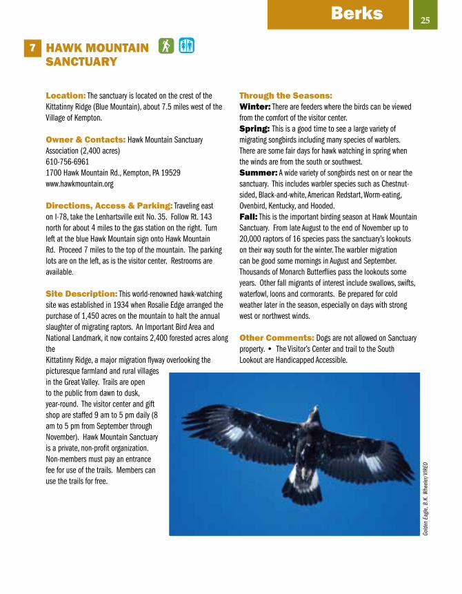
HAWK MOuNTAIN SANCTuARY
Location: The sanctuary is located on the crest of the Kittatinny Ridge (Blue Mountain), about 7.5 miles west of the Village of Kempton.
Owner & Contacts: Hawk Mountain Sanctuary Association (2,400 acres)610-756-69611700 Hawk Mountain Rd., Kempton, PA 19529www.hawkmountain.org
Directions, Access & Parking: Traveling east on I-78, take the Lenhartsville exit No. 35. Follow Rt. 143 north for about 4 miles to the gas station on the right. Turn left at the blue Hawk Mountain sign onto Hawk Mountain Rd. Proceed 7 miles to the top of the mountain. The parking lots are on the left, as is the visitor center. Restrooms are available.
Site Description: This world-renowned hawk-watching site was established in 1934 when Rosalie Edge arranged the purchase of 1,450 acres on the mountain to halt the annual slaughter of migrating raptors. An Important Bird Area and National Landmark, it now contains 2,400 forested acres along the Kittatinny Ridge, a major migration flyway overlooking the picturesque farmland and rural villages in the Great Valley. Trails are open to the public from dawn to dusk, year-round. The visitor center and gift shop are staffed 9 am to 5 pm daily (8 am to 5 pm from September through November). Hawk Mountain Sanctuary is a private, non-profit organization. Non-members must pay an entrance fee for use of the trails. Members can use the trails for free.
7
Gold
en E
agle
, B.K
. Whe
eler
/VIR
EO
Through the Seasons:Winter: There are feeders where the birds can be viewed from the comfort of the visitor center. Spring: This is a good time to see a large variety of migrating songbirds including many species of warblers. There are some fair days for hawk watching in spring when the winds are from the south or southwest.Summer: A wide variety of songbirds nest on or near the sanctuary. This includes warbler species such as Chestnut-sided, Black-and-white, American Redstart, Worm-eating, Ovenbird, Kentucky, and Hooded.Fall: This is the important birding season at Hawk Mountain Sanctuary. From late August to the end of November up to 20,000 raptors of 16 species pass the sanctuary’s lookouts on their way south for the winter. The warbler migration can be good some mornings in August and September. Thousands of Monarch Butterflies pass the lookouts some years. Other fall migrants of interest include swallows, swifts, waterfowl, loons and cormorants. Be prepared for cold weather later in the season, especially on days with strong west or northwest winds.
Other Comments: Dogs are not allowed on Sanctuary property. • The Visitor’s Center and trail to the South Lookout are Handicapped Accessible.

BLuE MARSH LAKE
Location: The lake is located about 10 miles northwest of Reading
Owner & Contacts: U.S. Army Corps of Engineers (6,500 acres total, Blue Marsh Lake – 1,150 acres)610-376-63371268 Palisades Dr., Leesport, PA 19533www.nap.usace.army.mil/sb/bm_guide.htm
Directions, Access & Parking: From the interchange of Rt. 183 with the U.S. 222 By-Pass (the former “Road To Nowhere”), go west on Rt. 183 for about 3 miles to Palisades Dr. and turn left (south). Proceed about 1 mile to the Dry Brooks Day Use Area (entrance fee charged from May 1 through September 30) and turn right to reach the parking lots. To reach the visitor center, return to Palisades Dr. and turn right. Go 0.7 miles and turn right for the visitor center. Maps of the lake and trails, and a bird list, are available in the visitor center. The lake has plenty of parking areas and restrooms.
Site Description: Since its dedication in 1978, this 8-mile-long Army Corps of Engineers impoundment of Tuplehocken Creek has been used for flood control, water storage, water quality, and recreation. It is a multi-use area that offers visitors swimming, fishing, water sports, hiking, horseback riding, cross-country skiing, birding and picnic areas. The lake is surrounded by about 5,000 acres, of which 1,500 are woodlands intermixed with areas of successional growth that provides ideal nesting grounds for an impressive number of birds. The habitat is enhanced by the adjacent 7,000 acres of State Game Land No. 280. The visitor center is open 8 am to 9 pm in summer and 8 am to 5 pm the remainder of the year. The boat launches are open 24 hours a day. All remote areas are open dawn to dusk.
8
26
Through the Seasons:Winter: Look for gulls and waterfowl on Blue Marsh Lake if the water is not frozen. The fields provide wintering habitat for Northern Harriers and Short-eared Owls. Typical winter birds can be found throughout the area.Spring: This is a good time to see a large variety of migrating songbirds. Look for loons, waterfowl and gulls on the lake in early spring. Brown Thrashers can be found near the visitor center.Summer: Birds that nest at Blue Marsh Lake include Willow Flycatcher, Brown Thrasher, Veery, Wood Thrush, Eastern Bluebird, Yellow Warbler, Common Yellowthroat, Yellow-breasted Chat, Orchard and Baltimore orioles, Eastern Towhee and Eastern Meadowlark.Fall: Migrating Broad-winged Hawks, Bald Eagles, Ospreys and other raptors can be seen from State Hill Lookout. Ducks, geese, loons and gulls use the lake for resting and feeding during the fall migration. A good variety of migrating songbirds can be seen some days.
Other Comments: The Tulpehocken Valley has a long and important history that dates from the 1720s. The Union Canal, established in 1828, was the first canal surveyed in the United States. You can ride your bike or take a leisurely stroll along a portion of the canal that is located just west of Bernville. • Blue Marsh Lake has been designated as an Important Bird Area by Audubon Pennsylvania. • Visit the PA Game Commission website, www.pgc.state.pa.us, for dates of hunting seasons and blaze orange clothing requirements. Please follow State Game Land or hunting regulations. There is no hunting on Sundays.

27Berks
NOLDE FOREST ENvIRONMENTAL EDuCATION CENTER
Location: The center is located on the west side of Rt. 625, about 4 miles south of Reading.
Owner & Contacts: PA Department of Conservation & Natural Resources (665 acres)610-796-36992910 New Holland Rd., Reading, PA 19607www.dcnr.state.pa.us/stateparks/parks/noldeforest.aspx
Directions, Access & Parking: To reach the center from the north, at the interchange of Rt. 422 and Lancaster Ave. (old Rt. 222), go south on Lancaster Ave. for about 0.6 miles and turn left on Rt. 625 (New Holland Rd.). Proceed for about 3.2 miles to the center. Nolde’s main entrance is on the right. Look for the large state park entrance sign on the right.
Site Description: In 1904, Jacob Nolde purchased 500 acres of land depleted by logging and farming, intending to create a pine forest. More than 90% of the 1.4 million conifers planted by the Nolde family on 310 acres survived. Today, in addition to the coniferous plantations, the center’s 665 acres include a mature hardwood forest of oak, maple, beech, tulip poplar, and birch. Eleven miles of trails traversing 500 feet of relief provide accessibility to woodlands, ponds and streams. Access to the property is free and open to the public dawn to dusk, year-round. Stop at the C. H. McConnell Environmental Education Hall for a trail map. The center is staffed 8 am to 4 pm, Monday through Friday.
Through the Seasons:Winter: The coniferous plantations provide a haven for Great Horned, Screech, Barred and Saw-whet owls. Other winter birds to be found in association with the coniferous plantations include Pileated Woodpecker, White-breasted and Red-breasted nuthatches, Golden-crowned Kinglet and Yellow-rumped Warbler.Spring: Look for migrating songbirds. Some of the owls mentioned in the “winter” section can be found throughout the year.Summer: Birds that breed at Nolde Forest Environmental Education Center include Great Crested Flycatcher, Veery, Wood Thrush, Louisiana Waterthrush and Scarlet Tanager.Fall: Migrating songbirds can be found in late August through early October.
Other Comments: Be sure to visit French Creek State Park and Hopewell Furnace National Historic Site, p. 19, if time permits.
9
Red-
brea
sted
Nut
hatc
h, Ja
son
Chee
ver/
iS
tock
phot
o.co
mNo
rther
n Sa
w-wh
et O
wl, R
. Aus
ting/
VIRE
O

28
Bucks County
12
3
4
5
6
7
8
9
10
LegendDogsAllowedRestroomsBiking
TrailsHikingTrails
HandicappedAccessibility

CHuRCHvILLENATuRE CENTER
Location: About 4.5 miles southwest of Newtown, in Northampton Township.
Owner & Contacts: Bucks County (650 acres)215-357-4005 501 Churchville Lane, Churchville, PA 18966www.churchvillenaturecenter.org
Directions, Access & Parking: From the intersection of Newtown Bypass (Routes 332 & 413) and Rt. 532 (Buck Rd.) southwest of Newtown, go south on Buck Rd. for about 3.8 miles and turn right on Rocksville Rd. for just 0.1 miles and turn right on Holland Rd. Go right (north) on Holland Rd. for about 0.3 miles and turn left on Churchville Lane. Go 0.4 miles and turn right into the Center. The Visitor Center is open Tuesday thru Sunday, 10 am to 5 pm. (See the center’s website for directions from other locations.) Restrooms are available.
Site Description: The site is a mixture of mature deciduous forest, pine stands, early successional forest, scrublands and fallow fields. A major feature near the center is the 180-acre Churchville Reservoir. There are a wildlife garden, bird feeding station and accessible boardwalk trails. The Visitor Center has interesting exhibits and a library with a great window from which to view birds at the many feeders. (Note: A good street map is helpful for finding any of the Bucks County sites.)
1
29BucksPa
inte
d Tu
rtle,
Dav
e Le
vand
usky
Coop
er’s
Hawk
, Joh
n Ki
effe
r
Through the Seasons:Winter: Typical winter species are present. Look for waterfowl on Churchville Reservoir.Spring: Look for migrating waterfowl on Churchville Reservoir. The center can be good for migrating warblers and other spring migrants.Summer: Nesting species of interest include Cooper’s Hawk and Prothonotary and Pine warblers. Great Egret and Great Blue Heron are often present at the reservoir.Fall: Look for migrating warblers in late August and September and waterfowl in late fall.
Other Comments: Churchville Reservoir is home to the state threatened Red-bellied Turtle. • Fishing is not permitted in the reservoir.
30
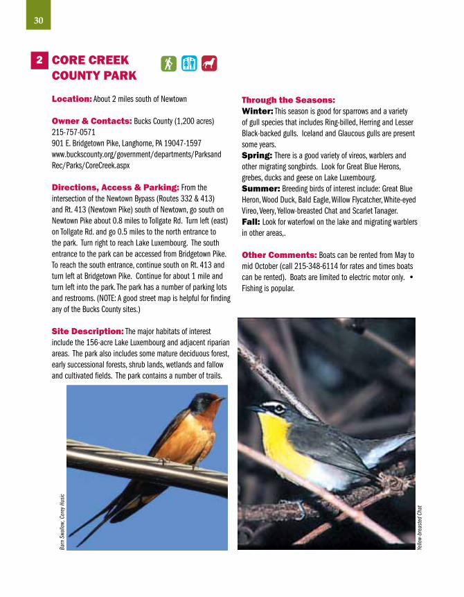
CORE CREEKCOuNTY PARK
Location: About 2 miles south of Newtown
Owner & Contacts: Bucks County (1,200 acres)215-757-0571901 E. Bridgetown Pike, Langhorne, PA 19047-1597www.buckscounty.org/government/departments/Parksand Rec/Parks/CoreCreek.aspx
Directions, Access & Parking: From the intersection of the Newtown Bypass (Routes 332 & 413) and Rt. 413 (Newtown Pike) south of Newtown, go south on Newtown Pike about 0.8 miles to Tollgate Rd. Turn left (east) on Tollgate Rd. and go 0.5 miles to the north entrance to the park. Turn right to reach Lake Luxembourg. The south entrance to the park can be accessed from Bridgetown Pike. To reach the south entrance, continue south on Rt. 413 and turn left at Bridgetown Pike. Continue for about 1 mile and turn left into the park. The park has a number of parking lots and restrooms. (NOTE: A good street map is helpful for finding any of the Bucks County sites.)
Site Description: The major habitats of interest include the 156-acre Lake Luxembourg and adjacent riparian areas. The park also includes some mature deciduous forest, early successional forests, shrub lands, wetlands and fallow and cultivated fields. The park contains a number of trails.
Through the Seasons:Winter: This season is good for sparrows and a variety of gull species that includes Ring-billed, Herring and Lesser Black-backed gulls. Iceland and Glaucous gulls are present some years.Spring: There is a good variety of vireos, warblers and other migrating songbirds. Look for Great Blue Herons, grebes, ducks and geese on Lake Luxembourg.Summer: Breeding birds of interest include: Great Blue Heron, Wood Duck, Bald Eagle, Willow Flycatcher, White-eyed Vireo, Veery, Yellow-breasted Chat and Scarlet Tanager. Fall: Look for waterfowl on the lake and migrating warblers in other areas,.
Other Comments: Boats can be rented from May to mid October (call 215-348-6114 for rates and times boats can be rented). Boats are limited to electric motor only. • Fishing is popular.
2Ba
rn S
wallo
w, C
orey
Hus
ic
Yello
w-br
east
ed C
hat

FIvE MILE WOODS
Location: About 3 miles west of Morrisville, in Lower Makefield Township
Owner & Contacts: Township of Lower Makefield (285 acres)215-493-66521305 Big Oak Rd., Morrisville, PA 19067www.Imt.org/parkrecfmw.htm
Directions, Access & Parking: From the interchange of U.S. 13 (Pine Rd.) and Trenton Ave. W. west of Morrisville, go north for almost 0.2 miles to Big Oak Rd. and turn left (west). Go about 2.5 miles on Big Oak Rd. and turn left to the nature center at Five Mile Woods, which is open to the public from dawn to dusk, 365 days a year. A map of the nature trails can be obtained at the nature center. Restrooms are available.
Site Description: The site is composed mostly of mature deciduous forest. Other habitats include early successional forest, shrub/scrub, a small swamp and a stream.
Through the Seasons:Winter: The woods are good for owls. Barred and Great Horned owls are present nearly always and Long-eared Owls can be found some winters. Spring: The woods are good for migrating warblers, vireos and flycatchers. American Woodcock and American Bittern are present at times.Summer: Breeding warblers of interest include Worm-eating and Hooded.Fall: Look for migrating warblers, vireos and flycatchers.
Other Comments: Five Mile Woods was preserved due to its environmental uniqueness. It straddles the “fall line” – the geological divide between the Coastal Plain and the Piedmont Plateau regions.
3
31Bucks
Long
ear
ed o
wl, C
orey
Hus
ic
Amer
ican
Bitte
rn, J
ason
Dou
cette
/iSto
ckph
oto.
com

32
NOCKAMIxON STATE PARK
Location: About 5 miles east of Quakertown and 9 miles north of Doylestown, in the townships of Bedminster and Haycock.
Owner & Contacts: PA Department of Conservation and Natural Resources 5,283 acres total (Lake Nockamixon – 1,450 acres)215-529-73001542 Mountain View Dr., Quakertown, PA 18951-5732www.dcnr.state.pa.us/stateparks/parks/nockamixon.aspx
Directions, Access & Parking: Nockamixon State Park in located along Rt. 563 (Mountain View Dr.), just off Rt. 313 to the west and Rt. 412 to the east. The main ac-cess points to the lake are on the south side of Rt. 563. Each access point has a large parking lot and a restroom.
Site Description: Lake Nockamixon is the most prominent feature of the park. Other habitats include mature and early successional deciduous forest, mature coniferous forest, shrub/scrub lands, and cultivated and fallow fields. The park contains 2.8 miles of paved bike trails and 3.5 miles of foot trails.
4
Less
er B
lack
back
Gul
l, Jo
stei
n Ha
uge/
iSto
ckph
oto.
com
Through the Seasons:Winter: This season is good for waterfowl and gulls.Spring: Look for Common Loons, waterfowl, Great Blue Herons, and a great variety of migrating songbirds.Summer: Breeding birds of interest include Great Blue Heron, Pine Warbler, Prairie Warbler and a variety of other songbirds.Fall: Look for warblers and other migrating songbirds in early fall and waterfowl later in the season. (Note: Lesser Black-backed Gulls can be expected almost daily from late September through early April)
Other Comments: Lake Nockamixon has become known for the many rare birds found there. These birds include Pacific Loon, American Oystercatcher, Long-tailed Jaeger and Long-billed Murrelet. • A recreational guide (including a map) is available at the park office. • A kayak or canoe is an ideal way to explore all the many fingers and coves of the lake. Either bring your own or rent one at the boat concession. Call 215-538-1340 for information.

PEACE vALLEY COuNTY PARK
Location: About 3 miles northwest of Doylestown, in New Britain Township.
Owner & Contacts: Bucks County (1,500 acres) (Lake Galena – 365 acres)215-345-7860170 Chapman Rd., Doylestown, PA 18901www.peacevalleynaturecenter.org/index.html
Directions, Access & Parking: From the intersection of Rt. 611 Bypass and Rt. 313 (Swamp Rd.) north of Doylestown, go northwest on Rt. 313 for about 2.2 miles and turn left (southwest) on New Galena Rd. Proceed 0.7 miles and turn left at Chapman Rd. Go another 0.3 miles to the Peace Valley Nature Center. For other access points to Lake Galena, go back to New Galena Rd. and turn left. Follow Lake Galena Rd. and look for the road to the public boat launch. There is another public boat launch on the south side of the lake, just off Creek Rd. about 0.3 miles from the dam.
Site Description: The most prominent feature of the park is the 365-acre Lake Galena. The lake is surrounded by a variety of prime birding habitats, nearly all of which are accessible via a network of well-maintained trails; there are 14 miles of trails, and a 6-mile paved hike and bike trail. There is a bird blind at the nature center’s feeding station, as well as a species logbook for the park. The Chapman Road Bridge is almost always a nice place to walk, especially in spring and summer.
Through the Seasons:Winter: Winter is a good time to search for unusual waterfowl, especially vagrant geese, which often mix in with the huge flock of wintering Canada Geese. Look for other winter birds at the feeders near the nature center.Spring: This is another good season to look for unusual waterfowl. Lesser Black-backed Gulls can be expected almost daily up through early April. Warblers and other migrating songbirds can be found in season.Summer: Breeding birds at this season are typical of the species that can be found in the proper habitat.Fall: Look for migrating warblers in late August and September. Waterfowl arrive in late October and November. Lesser Black-backed Gulls are present most days starting in late September.
Other Comments: Bird records have been kept almost religiously here for decades. The park has an impressive bird list of over 280 species. • The park’s trails are very popular with walkers, joggers and bikers on weekends. • Peace Valley County Park has been designated as an Important Bird Area by Audubon Pennsylvania.
5
33BucksCa
nada
Goo
se, C
orey
Hus
ic
Spot
ted
Sand
pipe
r, R.
Cur
tis/V
IREO

34
SILvER LAKE NATuRE CENTER
Location: Just north of Bristol Borough
Owner & Contacts: Bucks County (235 acres; Silver Lake – 27 acres, Magnolia Lake – 26 acres)215-785-11771306 Bath Rd., Bristol, PA 19007www.silverlakenaturecenter.org/default.html
Directions, Access & Parking: The nature center is located on the east side of Bath Rd., about 0.9 miles north of the intersection of Bath Rd. and U.S. 13 (Bristol Pike) Access to the center is possible by train from Center City Philadelphia via the SEPTA R7 line. Get off the train at the Bristol station. The visitor center building is open Tuesday- Saturday: 10 am to 5 pm and Sunday: noon to 5 pm. The building is closed Mondays. Parking is available at the visitor center. The trails are open daily sunrise to sunset. Restrooms are available. (Note: The center is very handicapped accessible.)
Site Description: Silver Lake Nature Center is part of the Bucks County Park System. It is a 235-acre complex within the Mill Creek Valley Park system. The lake is the terminus of several creeks. The Center is unique to Pennsylvania as well as Bucks County because it contains the best-protected Coastal Plain woodland remaining in the state. Habitats include: coastal plain woodland, the lake, marshes, wet meadows and an unglaciated bog. The grounds have about 4.5 miles of nature trails routed through or near the variety of habitats. There is a boardwalk and observation platform that overlooks Silver Lake.
Through the Seasons:Winter: This season is good for gulls and sparrows.Spring: Look for migrating waterfowl, warblers, American and Least bitterns and American Woodcock.Summer: Birds that have bred here include Virginia Rail, American Woodcock, Orchard Oriole, Rose-breasted Grosbeak and Spotted Sandpiper. Black-crowned Night-Heron is a possible breeder.Fall: Look for migrating warblers and waterfowl.
Other Comments: The Southern Bucks Home and Garden Club has built and maintains a butterfly garden at the Silver Lake Nature Center. • Silver Lake provides refuge for the threatened Red-bellied Turtle and the marsh is home for the threatened Coastal Plain Leopard Frog. • Peregrine Falcons are nesting nearby on the PA turnpike bridge, so they may be seen. Osprey also nest along the Delaware River and may be seen feeding in the lakes.
6
Amer
ican
Woo
dcoc
k, R
.& N
. Bow
ers/
VIRE
O
Red-
spot
ted
Purp
le, C
orey
Hus
ic

TINICuM COuNTY PARK/GIvING POND RECREATION AREA
Location: Along Rt. 32 (River Road), just north of Erwinna in Tinicum Township. The park is located between the Delaware River and the Delaware Canal.
Owner & Contacts: Tinicum County Park–Bucks County (126 acres)215-757-0571River Road (Rt. 32), Erwinna, PA www.buckscounty.org/government/departments/parksandrec/parks/tinicum.aspx
Giving Pond Recreation Area–PA Department of Conservation and Natural Resources (90 acres)610-982-5560www.dcnr.state.pa.us/stateparks/parks/delawarecanal.aspx
Directions, Access & Parking: From the Delaware River Bridge in Upper Black Eddy, go south on Rt. 32 (River Rd.) for about 2.5 miles. The parking lot for Giving Pond is on the right. Proceed another 2.2 miles to Tinicum County Park. The park is on both sides of River Rd. Both areas have large parking lots. Tinicum County Park and Giving Pond are open to the public from sunrise to sunset. Only the county park has restrooms.
Site Description: The park and pond lie in the flood plain of the Delaware River. The area is a mix of mature and early successional deciduous forest, shrub/scrub and marsh. Giving Pond is an old quarry that has been added to Delaware Canal State Park.
Through the Seasons:Winter: Look for waterfowl and gulls on the Delaware River.Spring: Birds of interest include warblers and other songbirds.Summer: Breeding birds at this season are typical of the species that can be found in the proper habitat.Fall: Look for waterfowl and a wide range of warblers and other fall migrants.
Other Comments: The historic John Stover House, which is open to the public, was built in the early 1800s. • Part of the Delaware & Lehigh Trail, Delaware Canal State Park marks the western boundary of Tinicum County Park. It is possible to walk the towpath of the canal, from Morrisville in lower Bucks County to Easton in Northampton County. (Note: The canal towpath sustained severe damage from three floods that occurred September 2004 through June 2006. Some sections of the towpath may still need repairs.)
7
35BucksM
alla
rds,
Cod
y God
dard
Racc
oon,
Bill
Buch
anan
/Joh
n He
inz N
WR

36
TYLER STATE PARK
Location: About 1 mile west of Newtown, in Newtown and Northampton townships.
Owner & Contacts: PA Department of Conservation and Natural Resources (1,711 acres)215-968-2021101 Swamp Rd., Newtown, PA 18940-1151www.dcnr.state.pa.us/stateparks/parks/tyler.aspx
Directions, Access & Parking: From the interchange of I-95 and Newtown/Yardley Rd. (Exit 49), drive west to the 4-lane bypass (Rt. 332) around Newtown. Take the bypass south around Newtown. The park entrance is on the left at the intersection of Swamp Rd. and the 4-lane bypass. There is another entrance off Rt. 332, about 0.3 miles west of the bypass. There are many parking areas and restrooms are available.
Site Description: The park contains three main habitats – forests, fields and wetlands. Neshaminy Creek, Bucks County’s largest creek, is dammed, creating a small lake. There are 10.5 miles of paved bike trails, 4 miles of gravel hiking trails, and 9 miles of bridle trails.
Through the Seasons:Winter: Snow Buntings are seen occasionally. The park is a good place for sparrows. Northern Harriers are often seen hunting over the fields. Other birds of interest include Hermit Thrush and Winter Wren.Spring: This season is good for migrating warblers and other songbirds. Yellow-throated and Prothonotary warblers are seen occasionally. Hooded Mergansers are possible on Neshaminy Creek.Summer: This is the best area in lower Bucks County for declining grassland species such as Bobolink, Grasshopper Sparrow, Eastern Meadowlark and Ring-necked Pheasant. Breeding birds of interest include Warbling and Yellow-throated vireos, Acadian and Willow flycatchers, Blue Grosbeak, Orchard Oriole and Kentucky Warbler.Fall: Look for migrating warblers and other songbirds.
Other Comments: Tyler State Park offers a large variety of recreation opportunities. A canoe rental concession is open daily from Memorial Day Weekend through Labor Day, weather permitting. Hours of operation are 11 am to 6 pm • There is a 27-hole disk golf course • The park is open for deer hunting one day in winter. The park is closed to the public that day. • Horses can be rented from a farm next to the park. • There are many picnic sites and fishing is available in Neshaminy Creek.
8
Prot
hono
tary
War
bler
, R. C
urtis
/VIR
EOEa
ster
n Co
ttont
ail,
Core
y Hus
ic

quAKERTOWN SWAMP
Location: The swamp is located about 2.5 miles south of Quakertown in the townships of East Rockhill and West Rockhill.
Owner & Contacts: Commonwealth of Pennsylvania (518 acres)See the Heritage Conservancy’s website: www.heritageconservancy.org/projects/quakertown_swamp.phpFor a brochure that shows where to park and view the heron nests:www.heritageconservancy.org/news/publications/pdf/ heron_walk.pdf
Directions, Access & Parking: Quakertown Swamp can be difficult to locate without a detailed map of the area. From the intersection of Rt. 309 and Rt. 663 just west of Quakertown, continue south on Rt. 309 for about 2 miles and turn left (east) at the traffic light at Tollgate Rd. In 0.3 miles turn right at the T-intersection onto Old Bethlehem Pike. In 0.9 miles, turn left onto Rich Hill Rd. Follow Rich Hill Rd. for 1.2 miles and turn left onto Muskrat Rd., then turn right into the small (4-car limit) State Game Lands parking area almost immediately. Parking is available on a limited basis on Muskrat Rd. but watch for traffic. Bird the area on both sides of Muskrat Rd. and make sure to watch for traffic.
Site Description: This site consists of swamp, marsh and other wetland habitat and includes areas of mature deciduous trees. There are no similar areas of this size (0.8 sq. mi.) in this part of Pennsylvania. More than 74 bird species nest in the swamp. In the late 1980s, Breeding Bird Census work confirmed the occurrence of Sora and Marsh Wren, two Pennsylvania Species of Special Concern. There is a large Great Blue Heron rookery west of Muskrat Rd. The best time to view the nests is in March and April before leaf-out.
Through the Seasons:Winter: Look for sparrows and other typical winter birds.Spring: This is the season to look for birds to be found in wetland habitat such as Least and, American bittern, Black-crowned Night-Heron, Great Blue Heron, Virginia Rail, Sora, Marsh Wren, Common Yellowthroat and Swamp Sparrow. The area can also be good for warblers and other songbirds.Summer: As noted in the “Site Description”, a large variety of birds nest in the swamp.Fall: Look for migrating Red-shouldered Hawk, Northern Harrier and a variety of songbirds.
Other Comments: There are no restrooms. • Quakertown Swamp has been listed as a first priority site in the Bucks County Natural Areas Inventory and is listed by the U.S. Fish and Wildlife Service as an all important wetland area. The Swamp is one of only seven wetlands in the Mid-Atlantic region to be identified by the U.S. Environmental Protection Agency through its Advanced Identification Program. • A portion of Quakertown Swamp is part of State Game Lands No. 319. • Quakertown Swamp has been designated an Important Bird Area by Audubon Pennsylvania. • Visit the PA Game Commission website, www.pgc.state.pa.us, for dates of hunting seasons and blaze orange clothing requirements. Please follow State Game Land or hunting regulations posted in parking areas. There is no hunting on Sundays.
9
37BucksGr
een
Frog
, Bill
Buch
anan
Grea
t Blu
e He
ron,
Cod
y God
dard

38
BOWMANS HILL SECTION OFWASHINGTON CROSSINGHISTORIC PARK
Location: Along the Delaware River on Rt. 32 (River Rd.) in Solebury and Upper Makefield Townships, about 2.5 miles south of New Hope and about 5 miles north Washington Crossing.
Owner & Contacts: Pennsylvania Historical and Museum Commission. (300 acres)P.O. 103, Washington Crossing, PA 18977215-493-4076www.phmc.state.pa.us/BHSM/toh/washington/washingtoncrossing.htm.
Directions, Access & Parking: From the intersection of Rt. 179 (Bridge St.) and Rt. 32 (Main St.) in New Hope, go south on Main St. which becomes River Rd. south of the borough for about 2.5 miles. The park is on both sides of River Rd. From the intersection of Re. 532 (General Washington Memorial Blvd.) and Rt. 32 (River Rd) in Washington Crossing, go north on River Rd. for about 5 miles to the park. There is adequate parking.
Site Description: Mature deciduous forest dominates the park. Other habitats inclulde early successional forest, grasslands, fallow fields and riparian habitat near the Delaware River.
Through the Seasons:Winter: Expect woodpeckers and other typical woodland birds of the season.Spring: This is considered the best site in Bucks County to see migrating warblers.Summer: Breeding birds of interest include Pileated Woodpecker, Worm-eating, Cerulean, Kentucky, Northern Parula, Louisiana Waterthrush, and Yellow-throated Warblers along the Delaware Canal. Prothonotary and Hooded Warblers also are possible some years.Fall: This is a good time to view warblers and other passerines.
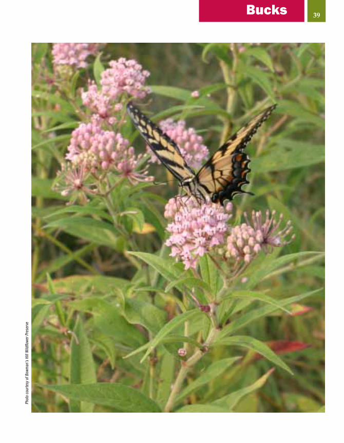
Other Comments: About 134 acres of the park are contained by the Bowman’s Hill Wildflower Preserve which has an entrance fee. The Visitor Center is open daily 9:00 am until 5:00 pm. The grounds are open daily 8:30 am until sunset. A very substantial fence protects the preserve’s many wildflowers from deer. The Visitor Center has a nice window from which to view the many bird feeders. While at the center, be sure to visit the Platt bird eggs and nests collection. For more information contact www.bhwp.org • The D&L Trail, which uses the Delaware Canal Towpath, passes through the site. There is a spur trail that connects the D&L Trail with Bowman’s Hill Wildflower Preserve. • Bowman’s Hill Tower (separate from the wildflower preserve) provides a great view of the Delaware River valley. As of late, unfortunately, the tower is rarely open to the public.
10
Ruby
-thro
ated
Hum
min
gbird
(fem
ale)
, Cor
ey H
usic
39BucksPh
oto
cour
tesy
of B
owm
an’s
Hill
Wild
flowe
r Pre
serv
e

Carbon County
12
3
4
40
LegendDogsAllowedRestroomsBiking
TrailsHikingTrails
HandicappedAccessibility
DogsAllowedRestroomsBiking
TrailsHikingTrails

CARBON COuNTYENvIRONMENTALEDuCATION CENTER
Location: The center is located on East White Bear Drive, about 5 miles west of Jim Thorpe.
Owner & Contacts: Carbon County Environmental Education Center (70 acres – 2,500 acres in adjacent Mauch Chunk Lake Park)570-645-8597151 East White Bear Drive, Summit Hill, PA 18250www.carboneec.org
Directions, Access & Parking: From the Northeast Extension of the Pennsylvania Turnpike (I-476), take the Mahoning Valley Exit and follow the signs for Jim Thorpe/U.S. 209 South. Follow U.S. 209 South into Lehighton. After crossing the Lehigh River, turn right (still U.S. 209 South) toward Jim Thorpe. Turn left at the first traffic light in Jim Thorpe (Broadway). Broadway becomes Lentz Trail then East White Bear Drive. Continue past the main entrance to Mauch Chunk Lake Park on your left. Continue 2.2 miles. The center will be on your left. The center building is open Monday through Friday, 8:00 am to 4:30 pm. The trails, pavilion and raptor mews (cages) are open 7 days a week from dawn to dusk. Parking and restrooms are available at the center.
Site Description: The Carbon County Environmental Education Center is housed in a converted 1920 dairy barn that is on 70 acres of woodland, wetland and meadow habitat with associated transition areas within Mauch Chunk Lake Park. Over 20 years of Christmas tree recycling have created 50+ yards of continuous hedgerows. This has become a special area for finding small mammals, birds and reptiles. The building and grounds underwent considerable changes. The center offers a variety of environmental education opportunities to youth, civic organizations and the general public.
Through the Seasons:Winter: Look for Pileated and Red-bellied woodpeckers and winter sparrows.Spring: Mauch Chunk Lake (330 acres) can be good for waterfowl in early spring. The songbird migration can be good at times.Summer: Nesting birds include several species of warblers, bluebirds, swallows and orioles.Fall: Look for migrating hawks, waterfowl on the lake, and songbirds.
Other Comments: If visiting the center, be sure to leave enough time to see historic Jim Thorpe. • Be sure to wear orange if birding the area during any hunting season. Orange vests are available on loan throughout the hunting season. • Visit the PA Game Commission website, www.pgc.state.pa.us, for dates of hunting seasons and blaze orange clothing requirements. Please follow State Game Land or hunting regulations posted in parking areas. There is no hunting on Sundays.
1
41Carbon
Woo
d Du
ck, F
rank
Leu
ng/iS
tock
phot
o.co
m

42
BELTzvILLE STATE PARK
Location: This state park is located 5 miles east of Lehighton, just off U.S. 209
Owner & Contacts: PA Department of Conservation and Natural Resources, U.S. Army Corps of Engineers (2,972 acres)610-377-00452950 Pohopoco Dr., Lehighton, PA 18235www.dcnr.state.pa.us/StateParks/parks/beltzville.aspx
Directions, Access & Parking: From the Northeast Extension of the Pennsylvania Turnpike (I-476), get off the turnpike at the interchange with U.S. 209 (Exit 74). Follow the signs to Beltzville State Park. The park is about 3 miles east of the turnpike exit. The main access points to Beltzville Lake are off Pohopoco Dr. that parallels the north side of the lake.
Site Description: The main feature of Beltzville State Park is the 949-acre Beltzville Lake. The remainder of the park is composed of a variety of habitats from mature deciduous and coniferous forests to cultivated and fallow fields. The lake is a popular recreational destination. There are 15 miles of hiking trails. Swimming is permitted in the lake. Beltzville Lake is one of few lakes in eastern Pennsylvania that does not have a horsepower limit for motorboats. There is a boat rental concession on the north side of the lake that is open daily in summer and on weekends in May and September. The lake is very popular with fishermen. The best time to bird the lake is from October through April when boating activity is at a minimum.
Through the Seasons:Winter: Look for waterfowl if the lake is not frozen. The lands surrounding the lake can be good for wintering birds. Rarities found during past winters have included Pine Grosbeak, Mountain Bluebird and Northern Shrike. Short-eared Owls have frequented the grassy areas near the parking lots on the north side of the lake.Spring: This is a good season for migrating waterfowl and gulls. Warblers and other migrating songbirds can be found in good numbers. Grassland sparrows such as Grasshopper and Savannah sparrow can be found in proper habitat.Summer: Several species of warblers nest in the park including Yellow-breasted Chat and Pine Warbler. Fall: Look for migrating songbirds in late August and September and waterfowl in October and November.
Other Comments: A number of rare bird sightings have taken place at Beltzville Lake. Some of these rarities have included American Oystercatcher, Arctic Tern and Violet-green Swallow. • Over 1,700 acres are open to hunting so be careful if birding the area during any of the State’s hunting seasons. • Visit the PA Game Commission website, www.pgc.state.pa.us, for dates of hunting seasons and blaze orange clothing requirements. Please follow State Game Land or hunting regulations posted in parking areas. There is no hunting on Sundays.
2
North
ern
Shrik
e, G
. McE
lroy/
VIRE
O
Com
mon
Yel
lowt
hroa
t, G.
Bai
ley/
VIRE
O

HICKORY RuN STATE PARK
Location: The park is located south of I-80 and west of the Northeast Extension of the Pennsylvania Turnpike (I-476)
Owner & Contacts: PA Department of Conservation and Natural Resources (approx. 15,500 acres)570-443-0400RR 1, Box 81, White Haven, PA 18661-9712www.dcnr.state.pa.us/stateparks/parks/hickoryrun.aspx
Directions, Access & Parking: From I-80, take Exit 274 at the Hickory Run State Park exit and drive east on Rt. 534 (right) for 6 miles. From the Northeast Extension of the Pennsylvania Turnpike (I-476), Take Exit 95 and drive west on Rt. 940 for 3 miles then turn east (left) on Rt. 534 and go 6 miles to the park.
Site Description: Hickory Run State Park is one of Pennsylvania’s largest state parks. The habitat consists mainly of mature deciduous forest with a few mature coniferous forest areas. Swimming and fishing are allowed at Sand Spring Lake. The park contains a number of small streams. There are 43 miles of hiking trails, 16 miles of cross-country skiing trails, and 21 miles of snowmobile trails.
Through the Seasons:Winter: Look for Ruffed Grouse, Wild Turkey, woodpeckers and other winter forest birds.Spring: The park is an excellent place to see migrating warblers, thrushes and forest birds such as Scarlet Tanager.Summer: Many species of warblers nest at Hickory Run State Park. Fall: Look for migrating warblers and other birds that like deep forest habitat.
Other Comments: Don’t miss the Boulder Field, a striking boulder strewn area that is a National Natural Landmark. The Boulder Field is a periglacial formation of boulders, formed by freezing and thawing. • Hunting is allowed in season. It is best not to bird the park at this time of year. • Hickory Run State Park has been designated an Important Bird Area by Audubon Pennsylvania. • Visit the PA Game Commission website, www.pgc.state.pa.us, for dates of hunting seasons and blaze orange clothing requirements. Please follow State Game Land or hunting regulations posted in parking areas. There is no hunting on Sundays.
3
43Carbon
Hawk
Fal
ls, H
ickor
y Run
Sta
te P
ark

44
LEHIGH GORGE STATE PARK
Location: Lehigh Gorge State Park is located along the Lehigh River, south of White Haven.
Owner & Contacts: PA Department of Conservation and Natural Resources570-443-0400RR 1, Box 81, White Haven, PA 18661www.dcnr.state.pa.us/stateparks/parks/lehighgorge.aspx
Directions, Access & Parking: The northern access point to the park is off Exit 273 of I-80 at White Haven. Follow Rt. 940 east to the White Haven Shopping Center. Go through the shopping center parking lot and bear left to the state park access area. Rockport is the central access area and can be reached from the south by following U.S. 209 South from Jim Thorpe to Rt. 93 North. Continue to Lehigh Gorge Dr., through Weatherly, into the small village of Rockport at Rt. 4014. Rockport is accessible from the north by following Rt. 940 west from Exit 273 of I-80. Turn left (south) onto Lehigh Gorge Dr. and continue to Rockport.
Site Description: The gorge follows 26 miles of abandoned railroad grade along the Lehigh River, providing opportunities for hiking, bicycling, sightseeing, photography and birding. The trail is closed to motor vehicles. Parking areas are provided in White Haven, Rockport and Glen Onoko. Very limited parking is available at Lehigh Tannery. Biking is very popular. Bicycles can be rented at several locations and there is shuttle service available throughout the area. Bicycles with wide tires are recommended. Several commercial operators offer whitewater rafting when water levels are appropriate. None of these activities creates problems for birders.
Through the Seasons:Winter: Look for typical winter birds that are found in deep woods such as Ruffed Grouse and woodpeckers.Spring: This time of year can be good for migrating warblers and other songbirds that like deep forest. A few ducks such as Common Mergansers can be seen on the Lehigh River on occasion.Summer: This is the season for breeding warblers. Also look for thrushes and Scarlet Tanagers.Fall: The warbler migration can be good at times in late August and September.
Other Comments: • Hunting is permitted is season so be careful birding at this time of year. • Visit the PA Game Commission website, www.pgc.state.pa.us, for dates of hunting seasons and blaze orange clothing requirements. Please follow State Game Land or hunting regulations posted in parking areas. There is no hunting on Sundays.
4
Lehi
gh R
iver,
Dela
ware
& L
ehig
h He
ritag
e Co
rrido
r, In
c.

45Carbon
View
from
Che
stnu
t Oak
Tra
il, L
ehig
h Ga
p Na
ture
Cen
ter (
p. 6
1), D
ave
Leva
ndus
ky

In 1829, John James Audubon journeyed through the deep forests and swamps of the upper Lehigh River watershed in Carbon and Luzerne counties in pursuit of birds to paint for his famous Birds of America. Today, you can follow a 53-mile auto tour of the region, stopping at a dozen points of interest along the way. The region is rich in cultural as well as natural resources, and there is plenty to do in the region for non-birders, such as river rafting, biking, fishing, and touring the cultural features of Jim Thorpe, Eckley Miner’s Village, the Number Nine Coal Mine, and the old Lehigh Canal and its impressive locks.
The tour can begin at White Haven (Luzerne County) or Jim Thorpe (Carbon County). Guide booklets and tapes are available for purchase at Hickory Run State Park, the Jim Thorpe Train Station, businesses in White Haven, or on the web at www.audubonslehigh.org. For more information, contact Exploring Audubon’s Lehigh, P.O. Box 134, Weatherly, PA 18255. Allow 3-6 hours for the complete tour.
46
Exploring Audubon’s Lehigh
Pile
ated
Woo
dpec
ker,
J.J. A
udub
on c
ourte
sy o
f Nat
iona
l Aud
ubon
Soc
iety
Audu
bon
Tour
sto
p, Ji
m T
horp
e, P
A/Ch
eryl
Kunk
le
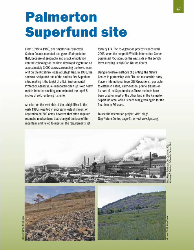
47
From 1898 to 1980, zinc smelters in Palmerton, Carbon County, operated and gave off air pollution that, because of geography and a lack of pollution control technology at the time, destroyed vegetation on approximately 3,000 acres surrounding the town, much of it on the Kittatinny Ridge at Lehigh Gap. In 1983, the site was designated one of the nations first Superfund sites, making it the target of a U.S. Environmental Protection Agency (EPA) mandated clean up. Toxic heavy metals from the smelting contaminated the top 6-8 inches of soil, rendering it sterile.
An effort on the west side of the Lehigh River in the early 1990s resulted in successful establishment of vegetation on 700 acres, however, that effort required extensive road systems that changed the face of the mountain, and failed to meet all the requirements set
forth by EPA. The re-vegetation process stalled until 2003, when the nonprofit Wildlife Information Center purchased 750 acres on the west side of the Lehigh River, creating Lehigh Gap Nature Center.
Using innovative methods of planting, the Nature Center, in partnership with EPA and responsible party Viacom International (now CBS Operations), was able to establish native, warm-season, prairie grasses on its part of the Superfund site. These methods have been used on most of the other land in the Palmerton Superfund area, which is becoming green again for the first time in 50 years.
To see the restoration project, visit Lehigh Gap Nature Center, page 61, or visit www.lgnc.org.
PalmertonSuperfund site
Wes
t Pla
nt, P
alm
erto
n Zi
nc C
o. c
irca
1950
. Co
urte
sy C
. Rei
nhar
t, Pa
lmer
ton
Cam
era
Club
Oc
tobe
r 200
8, D
an K
unkle
Octo
ber 2
002,
Dan
Kun
kle

LegendDogsAllowedRestroomsBiking
TrailsHikingTrails
HandicappedAccessibility
Chester County
12
3
45
48

BLACK ROCKSANCTuARY
Location: The sanctuary is located on a bend of the Schuylkill River, off Rt. 113 (Black Rock Rd.) in Phoenixville.
Owner & Contacts: Chester County (120 acres)610-469-1916935 Black Rock Rd., Phoenixville, PA 19460www.chesco.org/ccparks
Directions, Access & Parking: From the intersection of Rt. 23 (Nutt Rd.) and Rt. 113 (Bridge Rd.), go northeast on Rt. 113 for 0.6 miles to the T-intersection with Rt. 29 (Gay St.). Turn left and stay on Rt. 113 for about 1.7 miles until you reach Black Rock County Preserve on your right. There are two parking lots; one at the south end of the sanctuary and another just south of the Schuylkill River bridge.
Site Description: This site was reclaimed from a former coal “desiliting basin”. In the early 1900’s, waste from upstream coal operations contributed over 3-million tons of silt annually to the river. By the early 1930’s so much silt had settled behind the dams and in the river that it was no longer suitable for navigation or recreation. In 1945 the Commonwealth of Pennsylvania undertook the “Schuylkill River Project.” The river was dredged to remove built-up coal silt which was pumped into desilting basins built along the river. The basins were constructed of clay-filled berms about twenty feet high and trapped the coal silt as the water returned to the river. In the case of Black Rock, an 8,000-foot long berm was built to create an 80-acre basin.
Through the Seasons:Winter: Specialties that might be found in winter include Ring-necked Duck, Common Goldeneye, Yellow-bellied Sapsucker, Winter Wren and Purple Finch.Spring: Look for Wood Duck, Hooded Merganser, Green Heron and Wilson’s Snipe. Warblers and other passerines also are present.Summer: Some of the more interesting birds that breed in the sanctuary include Wood Thrush, White-eyed Vireo, Black-throated Blue Warbler and Rose breasted Grosbeak.Fall: Greater and Lesser yellowlegs are present at times. Look for migrating warblers and, later in the season, sparrows. Waterfowl may also be present in fall.
Other Comments: Portable toilet is available year-round. • Dogs must be leashed.
1
49Chester
Inte
rpre
tive
sign
at B
lack
Roc
k Sa
nctu
ary,
SRHA
Amer
ican
Wid
geon
, Cor
ey H
usic
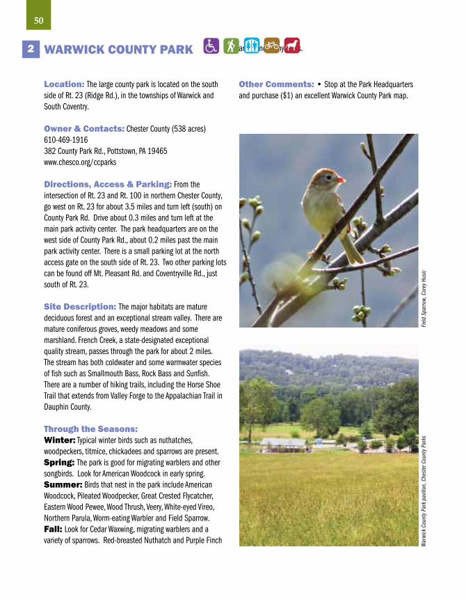
50
WARWICK COuNTY PARK
Location: The large county park is located on the south side of Rt. 23 (Ridge Rd.), in the townships of Warwick and South Coventry.
Owner & Contacts: Chester County (538 acres)610-469-1916382 County Park Rd., Pottstown, PA 19465www.chesco.org/ccparks
Directions, Access & Parking: From the intersection of Rt. 23 and Rt. 100 in northern Chester County, go west on Rt. 23 for about 3.5 miles and turn left (south) on County Park Rd. Drive about 0.3 miles and turn left at the main park activity center. The park headquarters are on the west side of County Park Rd., about 0.2 miles past the main park activity center. There is a small parking lot at the north access gate on the south side of Rt. 23. Two other parking lots can be found off Mt. Pleasant Rd. and Coventryville Rd., just south of Rt. 23.
Site Description: The major habitats are mature deciduous forest and an exceptional stream valley. There are mature coniferous groves, weedy meadows and some marshland. French Creek, a state-designated exceptional quality stream, passes through the park for about 2 miles. The stream has both coldwater and some warmwater species of fish such as Smallmouth Bass, Rock Bass and Sunfish. There are a number of hiking trails, including the Horse Shoe Trail that extends from Valley Forge to the Appalachian Trail in Dauphin County.
Through the Seasons:Winter: Typical winter birds such as nuthatches, woodpeckers, titmice, chickadees and sparrows are present.Spring: The park is good for migrating warblers and other songbirds. Look for American Woodcock in early spring.Summer: Birds that nest in the park include American Woodcock, Pileated Woodpecker, Great Crested Flycatcher, Eastern Wood Pewee, Wood Thrush, Veery, White-eyed Vireo, Northern Parula, Worm-eating Warbler and Field Sparrow.Fall: Look for Cedar Waxwing, migrating warblers and a variety of sparrows. Red-breasted Nuthatch and Purple Finch
are found many years.
Other Comments: • Stop at the Park Headquarters and purchase ($1) an excellent Warwick County Park map.
2
Fiel
d Sp
arro
w, C
orey
Hus
icW
arwi
ck C
ount
y Par
k pa
vilio
n, C
hest
er C
ount
y Par
ks

PICKERING CREEK TRAIL –WEST PIKELAND TOWNSHIP
Location: The trail is located along the north side of Pickering Creek, between Pikeland Rd. and Clover Mill Rd., in the eastern part of West Pikeland Township. The trail is proposed for continuation east and west of the site.
Owner & Contacts: Township of West Pikeland, (50 acres)610-827-7660
Directions, Access & Parking: From the intersection of Rt. 401 (Conestoga Rd.) and Rt. 113 (Kimberton Rd.), go northeast about 2 miles to Pikeland Rd. Turn right on Pikeland Rd. and go about 100 yards to the small parking lot on the left side of the road. The trail starts at the far end of the open field. The trail ends at Clover Mill Rd. where parking is extremely limited. There is room for about two cars at the most.
Site Description: The trail proceeds along the north side of the creek for .8 mile through a forested wetland.
Through the Seasons: Winter: Look for typical birds of the season such as sparrows, woodpeckers, chickadees and nuthatches.Spring: Migrating warblers and other songbirdsSummer: Typical species nest in the riparian habitat found along small streams.Fall: This season can be good for migrating warblers and other songbirds.
Other Comments: Parking is very limited. • There are no bathroom facilities. • There are vernal pools where amphibians can be found in early spring.
3
51Chester
Gray
Cat
bird
, Mich
ael S
tubb
lefie
ld/iS
tock
phot
o.co
m

52
NOTTINGHAM COuNTY PARK
Location: Near the Village of Nottingham, just west of Rt. 1, about 4 miles southwest of Oxford.
Owner & Contacts: Chester County (651 acres)610-932-2589150 Park Rd., Nottingham, PA 19362www.chesco.org/ccparks/
Directions, Access & Parking: From Rt. 1 go south past Kennett Square and Oxford and exit onto Rt. 272 at the Village of Nottingham. Go left on Rt. 272 South for .25 miles and turn right onto Herr Dr. Turn right onto Old Baltimore Pike and then right onto Park Rd. Follow signs to the park entrance on the left. Parking and restrooms are available. The park is open from 8 am to sunset.
Site Description: The park protects one of Pennsylvania’s unique and threatened habitats – serpentine barrens. Serpentine, a geologic outcrop of rare, light-green rock, produces soil low in essential nutrients and high in metals, such as magnesium, preventing most common plants from growing. The serpentine barrens support unique plants, many are rare in Pennsylvania. Nottingham County Park supports a large forest of pitch pine. Unusual wildflowers can be found spring through fall. Historic remains of quarry and mining operations can be found throughout the park. There are two small ponds, a small stream and passive recreation areas. There are several interesting nature trails.
Through the Seasons:Winter: Look for the usual winter birds such as Red-bellied Woodpecker, Northern Flicker, Carolina Chickadee and migrant sparrows.Spring: In this season, look for Red-shouldered Hawk, Tree Swallow, White-eyed Vireo, Pine and Prairie Warblers, and, on occasion, Whip-poor-will (mostly heard). The park can be good for migrating songbirds.Summer: Nesting birds of interest include White-eyed Vireo and Pine and Prairie Warblers. Summer Tanager is a possibility.Fall: Look for migrating songbirds.
Other Comments: If time permits, visit the famous and spectacular Longwood Gardens, (www.longwoodgardens.org)located on Rt. 1 northeast of Kennett Square.
4
Cour
tesy
Che
ster
Cou
nty P
arks
Sum
mer
Tana
ger,
R. C
urtis
/VIR
EO

WHITE CLAY CREEKPRESERvE
Location: The preserve is located in the southeast corner of Chester County, 3 miles north of Newark, Delaware. White Clay Creek Preserve shares a boundary with White Clay Creek State Park in Delaware (3,300 acres).
Owner & Contacts: PA Department of Conservation and Natural Resources (1,341 acres)610-274-2900P.O. Box 172, Laudenberg, PA 19350-0172www.dcnr.state.pa.us/stateparks/parks/whiteclaycreek.aspx
Directions, Access & Parking: To reach the preserve from Rt. 1, take Rt. 841 south through West Grove to Rt. 896. Go left (south) at Rt. 896 and proceed through the Village of Kimblesville to South Bank Rd. and turn left. Go about 0.4 miles to reach the parking lots near the London Tract Meeting House at the corner of South Bank, Sharpless and London Tract roads. There are also parking lots along Sharpless Rd. and London Tract Rd. There are no restrooms.
Site Description: White Clay Creek Valley, which forms the core of the preserve, varies from steep to gradually falling terrain with some flat bottomlands. The forests, native grass meadows, agricultural fields, wetlands, and branches of White Clay Creek provide excellent birding opportunities. Because White Clay Creek possesses outstanding scenic, wildlife, recreational and cultural value, it has been designated by Congress as a National Wild and Scenic River. A 3-mile hiking trail passes through the northern portion of the preserve and connects to trails in Delaware’s White Clay Creek State Park. An 8-mile equestrian trail and biking trail are also available. The park is free and open to the public from sunrise to sunset.
Through the Seasons:Winter: Look for Belted Kingfisher, Pileated Woodpecker and typical winter birds such as other woodpeckers, Carolina Chickadee and sparrows.Spring: The preserve is an excellent place to find migrating songbirds, especially warblers.Summer: Breeding birds of interest include Pileated Woodpecker, Indigo Bunting, Wood Thrush, Scarlet Tanager, Orchard and Baltimore orioles, and 16 species of warblers.Fall: Look for migrating songbirds.
Other Comments: There are several points of historical interest in the preserve. The Yeatman Mill House is probably the oldest house in the area. The London Tract Meeting House was built in 1729. • If time permits, visit the famous and spectacular Longwood Gardens (www.longwoodgardens.org)on Rt. 1 northeast of Kennett Square. • White Clay Creek Preserve has been designated an Important Bird Area by Audubon Pennsylvania.
5
53Chester
Orch
ard
Orio
le, R
. Cro
ssle
y/VI
REO

LegendDogsAllowedRestroomsBiking
TrailsHikingTrails
HandicappedAccessibility
Delaware County
1
2
3
54

jOHN HEINz NATIONAL WILDLIFE REFuGE AT TINICuM
Location: The refuge is located in the far southeastern corner of Delaware County, adjacent to Philadelphia and across I-95 from Philadelphia International Airport.
Owner & Contacts: U.S. Fish and Wildlife Service (1,200 acres) • 215-365-31188601 Lindbergh Blvd., Philadelphia, PA 19153www.fws.gov/northeast/heinz/
Directions, Access & Parking: The main entrance to the refuge is at 86th St. and Lindberg Blvd. From the north, traveling on I-95 South, take Exit 14 (Bartram Ave.). At the 5th traffic light turn right onto 84th St. At the second traffic light make a left onto Lindberg Blvd. From (I-476 South), (“The Blue Route”) stay in the left lane and follow signs for I-95 North. Get off Exit 10 of I-95. At the first light, turn left onto Bartram Ave. At the 4th light, turn left onto 84th St., at the second traffic light turn left onto Lindberg Blvd. From the South on I-95 North, follow the directions provided for I-476 after I-95 North. The refuge grounds are open every day of the year from sunrise to sunset, free of charge. Cusano Environmental Education Center is open daily from 8:30 am to 4:00 pm, free of charge. The Education Center is closed for all Federal holidays. The refuge is accessible via SEPTA’s Route 37 and 108 buses. Get off at the stop at 84th St. and Lindbergh Blvd. Restrooms are available.
Site Description: Tinicum Marsh is the largest remaining freshwater tidal wetland in Pennsylvania. A diked, non-tidal area of 145 acres, adjacent to the eastern end of Tinicum marsh, was donated to the City of Philadelphia by the Gulf Oil Corporation in 1955. The areas of open water, along with the adjacent heavily vegetated tidal wetlands, form an ideal habitat for thousands of migratory waterfowl.
Through the Seasons:Any season can be good for birding at John Heinz National Wildlife Refuge. Some of the birds found here are rarely seen anywhere else in Pennsylvania. These birds include Eurasian Wigeon, Tricolored Heron, King Rail, White Pelican, Eared Grebe, White Ibis, Yellow Rail, Curlew Sandpiper, Black-tailed Godwit, Gull-billed Tern, Sedge Wren and Painted Bunting.Winter: Commonly seen species include a variety of ducks and geese, raptors (including Bald Eagle and Red-shouldered Hawk), gulls, owls (including Saw-whet Owl), woodpeckers and a variety of songbirds.Spring: This is a good season for migrating waterfowl, herons, rails, many species of shorebirds, gulls, flycatchers, vireos, warblers and other passerines.Summer: Look for long-legged waders such as Great and Snowy egrets, Little-blue Heron, Black-crowned Night-Heron, Yellow-crowned Night-Heron and Glossy Ibis. Nesting birds of interest include Least Bittern, Virginia Rail and Common Moorhen. In late summer south-migrating shorebirds arrive in numbers and many species are possible. There are nesting White-eyed, Warbling and Red-eyed vireos, Willow and Great Crested flycatchers, Marsh Wren, Yellow Warbler, Common Yellowthroat, and Orchard and Baltimore orioles.Fall: This is another good season to visit the refuge. Look for migrating shorebirds and songbirds in early fall, waterfowl in late fall, and raptors, rails, gulls throughout the season.
Other Comments: The refuge was established by an act of Congress in 1972 to protect at least 200 acres of freshwater tidal marsh in Pennsylvania. • John Heinz National Wildlife Refuge has been designated an Important Bird Area by Audubon Pennsylvania.
1
55DelawareRo
n Ho
lmes
, Joh
n He
inz N
WR

56
RIDLEY CREEK STATE PARK
Location: About 2 miles northwest of Media
Owner & Contacts: PA Department of Conservation and Natural Resources (2,600 acres)610-892-39001023 Sycamore Mills Rd., Media, PA 19063www.dcnr.state.pa.us/stateparks/parks/ridleycreek.aspx
Directions, Access & Parking: The two main entrances to Ridley Creek State Park are on the north and east sides of the park. From the north, take Sandy Flash Dr. south from West Chester Pike (Rt. 3). To reach the park from the east, take Gradyville Rd. west from Providence Rd. Turn left (south) at Sandy Flash Dr. South to reach the park headquarters. Gradyville Rd. goes through the park to Delchester Rd. The park can be entered from the south by way of Painter Rd. Ample parking and restrooms are available throughout the park. The park is open daily sunrise to sunset.
Site Description: The park is mainly mature deciduous forest with some fine riparian habitat along Ridley Creek. There are also areas of mixed forest, shrub/scrub, and a few cultivated fields. There are 12 miles of trails that pass through a variety of habitats throughout the central portion of the park. There are hundreds of picnic tables in 14 picnic areas. Each area is equipped with restrooms. Ridley Creek is stocked with trout and provides excellent fishing.
Through the Seasons:Winter: Look for typical resident species and some migrating sparrows.Spring: The park is excellent for migrating songbirds, including many species of warblers.Summer: Typical nesting species of eastern deciduous forest are found in great numbers, including Wood Thrush, Veery, Scarlet Tanager, Red-eyed Vireo, Ovenbird and Acadian Flycatcher. Several nesting species found at the park are rare in the region, including Prairie Warbler, Chestnut-sided Warbler, American Redstart, Blue-winged Warbler, Kentucky Warbler, Hooded Warbler and Pileated Woodpecker.Fall: Migrant songbirds are again the highlight in the fall. After warblers come through in late August to early October, a number of sparrow species can be found in October and November, including Fox, Swamp and White-crowned sparrows.
Other Comments: The park office is the Hunting Hill Mansion, part of the “Ridley Creek State Park Historic District” which is on the National Register of Historic Places. • The Colonial Pennsylvania Plantation provides visitors with an accurate picture of life on a Delaware County farm prior to the American Revolution. A fee is charged for admission to the Colonial Plantation, which is open from April to October. • If time permits, be sure to visit Tyler Arboretum (next page) located just south of the state park. • The park is part of the Upper Ridley/Crum Important Bird Area designated by Audubon Pennsylvania.
2Bl
ack
and
Whi
te W
arbl
er, G
. Bai
ley/
VIRE
O
East
ern
Towh
ee , F
rank
Leu
ng/iS
tock
phot
o.co
m

TYLER ARBORETuM
Location: Tyler Arboretum is located immediately south of Ridley Creek State Park, about 2 miles northwest of Media.
Owner & Contacts: Tyler Arboretum (650 acres)610-566-9134515 Painter Rd., Media, PA 19063www.tylerarboretum.org
Directions, Access & Parking: From the Blue Route (I-476), take the Rt. 1 Springfield/Lima exit (Exit #5). Take Rt. 1 Southbound to Rt. 352. Turn right onto Rt. 352 North to the first intersection after the mall and turn right onto Barren Rd. Follow Barren Rd. past Penncrest High School (on the right). Turn left at the next intersection (small intersection with four-way stop signs) onto Painter Rd. Follow Painter Rd. about 1 mile to the Arboretum entrance, located on the right.
Site Description: One of the oldest arboreta in the United States, Tyler Arboretum encompasses over one square mile of renowned plant collections, champion trees, historic buildings, and 20 miles of hiking trails through woodlands, wetlands and meadows. The Arboretum is open year round, except Thanksgiving Day and Christmas Day, from 9:00 am to 5:00 or 8:00 pm, depending on the season. Members are admitted free. Admission is $5 for non-member adults (16 years and older) and $3 for non-member youth (3–15 years). Children under three are admitted free. Dogs are not permitted. Restrooms and parking are available.
Through the Seasons:Winter: Typical resident species and some sparrows are found in winter.Spring: Migrating songbirds, including many species of warblers, are the highlight of the spring season.Summer: Typical species of eastern deciduous forest nest in great numbers at Tyler Arboretum, including Wood Thrush, Veery, Scarlet Tanager, Ovenbird and Acadian Flycatcher.Fall: Migrating songbirds are again the highlight in the fall. Warblers pass through from late August to early October. Several species of sparrows are found later in the fall.
Other Comments: When in the area, visit Ridley Creek State Park (previous page). • Tyler Arboretum is part of the Upper Ridley/Crum Important Bird Area, designated by Audubon Pennsylvania.
3
57Delaware
East
ern
Phoe
be, C
orey
Hus
icVe
ery,
G. B
aile
y/VI
REO

LegendDogsAllowedRestroomsBiking
TrailsHikingTrails
HandicappedAccessibility
Lehigh County
1
2
3
4
5
6
7
58

BAKE OvEN KNOB
Location: On the crest of the Kittatinny Ridge (Blue Mountain) in Heidelberg Township, about 0.4 miles east of the east parking lot on Bake Oven Rd. at the crest of the ridge. This site straddles the ridge in Lehigh and Carbon counties.
Owner & Contacts: PA Game CommissionS.E. Office 610-926-3136www.pgc.state.pa.usFor information about the fall hawk count, call the Lehigh Gap Nature Center at 610-760-8889.
Directions, Access & Parking: From the interchange of I-78 and Rt. 100, take Rt. 100 north about 8.2 miles to the T-intersection with Rt. 309. Turn right onto Rt. 309. In just 0.2 miles, turn left (towards Germansville) onto Bake Oven Rd. Follow Bake Oven Rd. for about 4.3 miles through the stop sign at Mountain Rd. to the stop sign at the T-intersection with Church Rd. Turn left to continue on Bake Oven Rd. and turn right onto the gravel road that shortly enters the woods and begins up the ridge. Continue 1.7 miles to the parking lot that is on the right at the crest of the ridge. The trailhead is at the far end of the parking lot. Access to the knob is via the Appalachian Trail. Follow the trail (white blazed markers on the trees) east for about 0.4 miles.
Site Description: Bake Oven Knob is a prominent feature on the Kittatinny Ridge. Three outcroppings provide excellent lookout sites for hawk watching. The south lookout, at 1,560 feet above mean sea level (about 800 feet above the south base of the ridge), offers impressive views of the Lehigh Valley as well as an unobstructed view up the ridge to the northeast.
Through the Seasons:Winter: There is little in winter to interest a birder. Spring: There is a spring hawk flight but it is not as good as the fall flight. Other spring migrants include warblers and hardwood forest species such as Wood Thrush and Scarlet Tanager.Summer: Nesting birds of note include Ruffed Grouse (now rare), Wild Turkey, Pileated Woodpecker, Great Crested Flycatcher, Scarlet Tanager and several species of warblers including Black-and-white and Chestnut-sided.Fall: The biggest attraction is the fall raptor migration when up to 14 species of raptors can be seen in a single day. The fall warbler migration can be good some mornings in late August and September. Other migrants seen from Bake Oven Knob include loons, cormorants, geese, swans, Ruby-throated Hummingbirds, swallows and winter finches. Common Ravens are present many days.
Other Comments: Bake Oven Knob should be avoided during the rifle deer hunting season. • Take care when climbing over rocks that can be slippery when wet. • There are no restrooms • The Kittatinny Ridge has been designated an Important Bird Area by Audubon Pennsylvania. • Visit the PA Game Commission website, www.pgc.state.pa.us, for dates of hunting seasons and blaze orange clothing requirements. Please follow State Game Land or hunting regulations posted in parking areas. There is no hunting on Sundays.
1
59LehighCo
mm
on R
aven
, iSt
ockp
hoto
.com
Kar
en H
. Joh
nson
Broa
dwin
g Ha
wks,
Ken
Med
d/LG
NC

LEASER LAKE
Location: North of the Village of Jacksonville in Lynn Township.
Owner & Contacts: Lehigh County (228 acres)610-871-0281www.lehighcounty.org/recreation/rec.cfm
PA Fish and Boat Commission (313 acres)www.fish.state.pa.us
Directions, Access & Parking: From the interchange of I-78 and Rt. 100, take Rt. 100 north about 8.2 miles to the T-intersection with Rt. 309. Turn left onto Rt. 309 and go 2.6 miles to where it intersects with Rt. 143. Turn left onto Rt. 143 and drive 4.7 miles to Ontelaunee Rd. (look for the small brown Leaser Lake sign). Turn right onto Ontelaunee Rd. and go about 1 mile to the north parking lot. At the brown sign at 0.7 miles, bear left to stay on Ontelaunee Rd. Activity centers are located on the east, west and north sides of the lake. Each area has a paved parking lot. All three areas have restrooms but they are closed in winter.
Site Description: The 117-acre Leaser Lake was built by the PA Fish Commission for water-oriented recreation and opened for public use in 1971. The lake provides fishing from boats or shore. The land north of the lake was purchased by Lehigh County in the early 1970s. This area is entirely wooded and is an addition to State Game Lands No. 217.
Through the Seasons:Winter: Typical winter birds.Spring: Migrating birds of interest include waterfowl, waders (best if the water level is low), warblers and other woodland birds.Summer: Birds that nest in the woodlands on or at the base of the Kittatinny Ridge (Blue Mountain) include Ruffed Grouse (now rare), Wild Turkey, Pileated Woodpecker, Great Crested Flycatcher, Scarlet Tanager, Red-eyed and Yellow-throated Vireos, and Black-and-white, Chestnut-sided, Cerulean, Worm-eating, Kentucky and Hooded Warblers. Birds
that nest in the fields in the vicinity of Leaser Lake include: Eastern Meadowlark, Bobolink and Grasshopper, Savannah and Vesper Sparrows.Fall: Migrants include waterfowl, hawks and warblers.
Other Comments: Leaser Lake dam has a severe leak and the surface area of the lake may only be about 50 to 60 acres. Rehabilitation by PFBC is tentatively scheduled to begin in December 2009. • From a birding standpoint, the low water level makes the lake better for shorebirds but not as good for waterfowl.
2
60
Wor
m-e
atin
g W
arbl
er,
B. S
chor
re/V
IREO

LEHIGH GAP NATuRE CENTER
Location: On the west side of the Lehigh River at the water gap with the Kittatinny Ridge (Blue Mountain) and extending upriver about 2.5 miles. Main access point is in Lehigh County, but much of the center’s property is in Carbon County.
Owner & Contacts: Lehigh Gap Nature Center (750 acres)[email protected]
Directions, Access & Parking: From the traffic light at the intersection of Main St. and Rt. 873 (Walnut St.) in Slatington, go north on Rt. 873 for 1.7 miles to Paint Mill Rd. (unmarked) that enters Rt. 873 from a sharp angle on the right. Bear right onto Paint Mill Rd. and go 0.4 miles (cross under the Rt. 873 Lehigh River bridge) to where the road ends at the Osprey House. To reach the northern end of the Preserve, take Rt. 895 west from Bowmanstown. After crossing the Lehigh River, turn left (south) on Riverview Rd. and go about a mile. Park at the area where the road turns right and walk straight ahead to the ponds.
Site Description: The Refuge contains three ponds, riparian forest and wetlands adjacent to the Lehigh River, forested slopes, cliffs and talus slopes. About 350 acres of grassland have been established on formerly barren land on the side of the mountain. This area was damaged by pollution from a zinc smelter. The Center re-vegetated the mountainside by planting native, warm-season grasses.
Through the Seasons:Winter: Typical winter birds. There are feeders at the Osprey House.Spring: Migrating raptors, waterfowl on the Lehigh River, Scarlet Tanagers, Baltimore Orioles and a variety of warblers.Summer: Breeding birds include Wood Duck, Common Merganser, American Kestrel, Eastern Phoebe, Tree Swallow, Eastern Bluebird and Indigo Bunting. This is one of only two locations in Lehigh County where Prairie Warblers nest.Fall: Migrating raptors and a variety of other fall migrants.
Other Comments: Some trails may be under construction or not permanently marked. • The Kittatinny Ridge has been designated an Important Bird Area by Audubon Pennsylvania.
3
61LehighTw
elve
-spo
tted
Skim
mer
, Dan
Kun
kle
Prai
rie W
arbl
er, G
. McE
lroy/
VIRE
O

LITTLE LEHIGH PARKWAY
Location: Along the Little Lehigh Creek from the western edge of Allentown to where the Little Lehigh intersects with Cedar Creek near Martin Luther King, Jr. Dr.
Owner & Contacts: City of Allentown (583 acres)610-437-7628www.allentownpa.org/park_rec.htm
Directions, Access & Parking: From the interchange of I-78 and Cedar Crest Blvd. (Rt. 29), take Cedar Crest Blvd. south about 0.4 miles and turn left at the light onto Fish Hatchery Rd. Follow Fish Hatchery Rd. for about 0.3 miles to the parking lot at the fish hatchery that is on the left. (There is a parking lot on the south side of Fish Hatchery Rd. just after the bridge over the Little Lehigh Creek.) To access another parking area, proceed east on Fish Hatchery Rd. to the light at the intersection with Oxford Dr. Go through the intersection and immediately turn left toward the creek. There is a small parking lot at the bottom of the hill next to the creek and covered bridge. (Note: Little Lehigh Parkway can be accessed at other locations.)
Site Description: The Little Lehigh Parkway is a stream valley park that follows the Little Lehigh Creek through much of Allentown. The area along the creek floodplain is mostly grass but is marshy in spots. The hillsides that border the floodplain are wooded and brushy. In early morning, the sun gives excellent lighting of the wooded hillsides on the west side of the stream.
Through the Seasons:Winter: Birds of interest include Belted Kingfisher, White-breasted and Red-breasted nuthatches, Ruby-crowned and Golden-crowned kinglets, Yellow-rumped Warbler. Great Horned Owls sometimes can be found sleeping in the pine trees near the creek.Spring: Look for Great Crested Flycatcher, Scarlet Tanager, Baltimore Oriole and many species of warblers.Summer: Belted Kingfisher, Eastern Kingbird and Baltimore Oriole nest in or near the parkway.Fall: Typical fall migrants including many species of warblers
Other Comments: The few restrooms available are closed during winter. • Expect to see lots of joggers and walkers on nice days and especially on weekends.
4
62Ye
llow-
rum
ped
War
bler
, Cor
ey H
usic
Grea
t-hor
ned
Owl

jORDAN CREEK PARKWAY
Location: Jordan Creek Parkway is a large stream valley park that surrounds Jordan Creek in the townships of Whitehall and South Whitehall, just north of Allentown.
Owner & Contacts: Lehigh County (296 acres)610-871-0281www.lehighcounty.org/Recreation/rec.cfm
Directions, Access & Parking: From the intersection of Rt. 22 and 15th St., take the 15th St. exit and head north at the end of the exit ramp onto Mauch Chunk Rd. Follow Mauch Chunk Rd. north for 0.7 miles and make a sharp right at the light onto Scherersville Rd. Follow Scherersville Rd. 0.5 miles and park in the lot just past the tennis courts and maintenance building. Parking also is available at the community gardens about 0.2 miles west of the park maintenance building.
Site Description: Jordan Creek Parkway contains a variety of habitats that make for excellent birding. These habitats include the Jordan Creek, two water-filled mine holes, old-growth woods, relatively new woods and low-growth fields. There are numerous trails that wind through these habitats and make birding easy.
Through the Seasons:Winter: Typical winter residents include several species of woodpeckers, Tufted Titmouse, Black-capped Chickadee, nuthatches and a variety of sparrows.Spring: The park is one of the best places in the county to view migrating birds such as flycatchers, thrushes, vireos and warblers. The trees are tall and warbler viewing can be difficult. Good binoculars are a must.Summer: Breeding birds of interest include Great Crested Flycatcher, Warbling Vireo, Wood Thrush, Scarlet Tanager and Baltimore Oriole.Fall: Warblers and other songbirds occur with regularity but the spring migration is better.
Other Comments: Jordan Creek Parkway is very popular with walkers and mountain bikers. • Jordan Creek is heavily fished during the first week of trout season.
5
63Lehigh
Whi
te-th
roat
ed S
parro
w, G
. Bai
ley/
VIRE
O

TRExLER NATuRE PRESERvE(formerly Trexler-Lehigh County Game Preserve)
Location: In the townships of North Whitehall and Lowhill, about 2 miles west of Schnecksville.
Owner & Contacts: Lehigh County (1,108 acres)610-871-1444www.lehighcounty.org/Recreation/rec.cfm
Directions, Access & Parking: From the interchange of Rts. 22 and 309, drive north on Rt. 309 for about 5.5 miles to the traffic light at Sand Spring Rd. Continue north through the intersection for about 0.2 miles and turn left onto Game Preserve Rd. There is a large sign for the game preserve at Game Preserve Rd. Follow Game Preserve Rd. for 2.1 miles to the entrance to the Nature Preserve and Lehigh Valley Zoo on the left. Enter the gate and proceed to the parking lot at the zoo or the loop road that wanders through the preserve. This is the only access point to the preserve.
Site Description: General Harry C. Trexler founded the Trexler-Lehigh County Game Preserve in 1909 as a sanctuary for preservation of various wildlife species. Upon the General’s death in 1933 the people of Lehigh County inherited the preserve. The preserve consists of a variety of habitats that include riparian areas along the Jordan Creek, scrubland, grasslands and mature deciduous forest.
6
64Gr
eat-c
rest
ed F
lycat
cher
, Rob
ert B
lanc
hard
/iSto
ckph
oto.
com
North
ern
Card
inal
, G. B
aile
y/VI
REO
Through the Seasons:Winter: Look for Red-tailed Hawk, woodpeckers, nuthatches, Eastern Bluebirds and other typical winter birdsSpring: The preserve can be good for warblers and other neotropical migrantsSummer: There are nesting Great Crested and Willow flycatchers, Eastern Bluebird, Scarlet Tanager, Baltimore oriole and Field and Grasshopper sparrowsFall: Warblers and other songbirds are present
Other Comments: The Trexler Nature Preserve is undergoing changes and it is anticipated more of the preserve will be open for public use in the future. • The Lehigh Valley Zoo is located within the Trexler Nature Preserve. For more information on the zoo, call 610-799-4171 or visit the zoo’s web site at www.lvzoo.org.

FRANKO FARM RECREATION AREA
Location: On the top of South Mountain in Salisbury Township
Owner & Contacts: Township of Salisbury (92 acres)610-797-4000
Directions, Access & Parking: From the intersection of South 4th St. (Rt. 145) and Emaus Ave. in Allentown, go east on Emaus Ave. for 1.2 miles to the intersection with Honeysuckle Rd. (the Eastern Salisbury Ambulance & Fire Rescue building is on the southeast corner). Turn right on Honeysuckle and go up South Mountain for 0.5 miles to the intersection with Black River Rd. Turn left onto Black River Rd. and go another 0.2 miles. The Franko Farm Recreation Area is on the left. Park in the lot to the left of the house or drive another 200 yards and turn left for the parking lot at the picnic pavilion and athletic fields. The area is open dawn to dusk.
Site Description: Franko Farm Recreation Area contains birding habitats that range from mature woods, young, second-growth woods and a variety of brushy areas. All areas are easy to bird because of the numerous, well-maintained trails that crisscross the property. Some of the most interesting birds can be found along the PPL electric transmission line easement. There is a small pond near the entrance to the park.
Through the Seasons: Winter: Look for Wild Turkeys, woodpeckers, including Pileated, and typical winter species.Spring: This is the best season to bird the park. Spring migrants include a variety of flycatchers, thrushes, vireos, many species of warblers, Scarlet Tanager and both Orchard and Baltimore orioles. On some days a decent spring hawk migration can be observed when winds are from the south or southwest. Summer: June is an excellent time to observe nesting birds such as Great Crested and Willow flycatchers, Eastern Kingbird, Tree Swallow, Brown Thrasher, Red-eyed and White-eyed vireos, Blue-winged and Yellow warblers, Common Yellowthroat, Indigo Bunting and Orchard and Baltimore orioles. Some years Yellow-breasted Chat nests in the brush under the power lines. Fall: The fall warbler migration can be good some days. Other Comments: There is a toilet near the picnic pavilions that is open all year.
7
65Lehigh
Brow
n Th
rash
er, S
teph
en M
uskie
/iSto
ckph
oto.
com

The Kittatinny Ridge is the southern-most mountain in Pennsylvania’s Ridge and Valley Province. This region of the Appalachians was formed as the North American crust buckled under pressure created when the African continental plate plowed into North America seventy million years ago.
The Kittatinny, also called Blue Mountain, stretches more than 175 miles through Pennsylvania and extends into New Jersey and New York. The Native Americans of the region called it Kittatinny, “Endless Mountain.” To the north are many more ridges, none of which is nearly as long as the Kittatinny. To the south lie the Great Valley and the cities of Reading, Allentown, Bethlehem, and Easton.
Each autumn, tens of thousands of raptors use the Kittatinny during migration. The Kittatinny is very important for these migrating raptors because it is the longest, unbroken and continuous ridge. This allows the raptors to conserve energy because they don’t have to
change ridges to ride the updrafts. Tens of thousands of hawkwatchers also flock to the numerous lookouts on the ridge, including world-famous Hawk Mountain Sanctuary.
The Kittatinny has several other important values to wildlife and wildlife watchers. Its extensive areas of un-fragmented forest are rich habitat for forest interior songbirds such as Scarlet Tanagers and Wood Thrushes. In spring and fall, its forests serve as important stopover sites for migrating songbirds, and a leading line for migrating Ruby-throated Hummingbirds and Monarch Butterflies. Its forests serve as an important dispersal corridor for wildlife species such as Black Bear. The mountain is also an important watershed area for all the rivers and streams flowing to the south.
Like all natural areas, various forms of development threaten the Kittatinny and a variety of conservation efforts are focused on preserving its habitats.
66
Kittatinny Ridge
Bake
Ove
n Kn
ob, D
an K
unkle
Blue Mountain/Kittatinny Ridge

67
Hawkwatching was “invented” in eastern Pennsylvania in the 1930s at Hawk Mountain. From there, it spread up and down the Kittatinny to Bake Oven Knob and Waggoner’s Gap, and soon spread throughout the continent and now the world. From watch sites in eastern Pennsylvania, 16 species of raptors occur regularly including hawks, falcons, eagles, Ospreys, harriers, and vultures.
Most of the region’s well-known hawk watching sites are on the Kittatinny Ridge since the ridge serves as a leading line, concentrating migrating raptors each autumn. Some of these sites have individual site descriptions in the text. However, many more hawk watch sites operate in eastern Pennsylvania each fall, and a trip to any of them in the right season and right weather conditions can produce close-up raptor sightings or impressive numbers of raptors.
Here is a list of some of the more prominent sites and contact information for them:
Rose Tree Park (Delaware Co.)www.rtphawkwatch.orgDirections: Rose Tree Park is on Route 252, 2 miles north of Media, PA and 1/4-mile north of Route 1 (Media by-pass) on Route 252.
Militia Hill Hawkwatch, Fort Washington State Parkwww.wyncoteaudubon.org/mhhw.htmDirections: Fort Washington State Park is located just north of Philadelphia on PA 73, 1 3/8 miles north of PA 309.
Council Cup Scenic Overlook–page 69
Kittatinny Ridge SitesAny place on the Kittatinny Ridge with a view to the north and east will afford views of migrating hawks in autumn in the right wind conditions. Sites are found at various locations along the ridge, often requiring a hike to reach them. Some of these places with expansive views, many of which are count sites, are: Delaware Water Gap–page 75, Wind Gap, Little Gap, Lehigh Gap–page 61, Lehigh Furnace, Bake Oven Knob–page 59, Bear Rocks, PA 309, Hawk Mountain Sanctuary–page 25, the Pinnacle, Port Clinton, State Game Lands 110–page 22, and Route 183 Hawkwatch.
Hawkwatching
A yo
ung
hawk
watc
her,
Tim
Fen
chel
Red-
taile
d Ha
wk, R
andy
Fla
men
t.

LegendDogsAllowedRestroomsBiking
TrailsHikingTrails
HandicappedAccessibility
Luzerne County
1
2
3
4
5
68

COuNCIL CuPSCENIC OvERLOOK
Location: Council Cup is located about 2 miles east of Wapwallopen.
Owner & Contacts: Pennsylvania Power and Light, Inc (88 acres)866-832-3312 – Energy Information CenterOffice hours 8 am to 3:30 pm Monday-Friday.Part of the Susquehanna Riverlands Environmental Preservewww.pplweb.com/community/enviro_preserves/susq_index.htmOperated in cooperation with the PA Game Commissionwww.pgc.state.pa.us
Directions, Access & Parking: From I-80, take exit 256, Rt. 93 west to Rt. 239 north. At Wapwallopen, turn right at the Council Cup sign onto Wapwallopen Rd. Drive 2 miles and turn left onto Maple Lane (T 394). Travel 0.5 miles and turn left at the Council Cup sign. Drive 0.5 miles and turn left again. Drive 0.4 miles and turn right into the parking lot.
Site Description: Enjoy a day hawk watching during the fall raptor migration or wander the woodlands for numerous songbirds. A series of wide and well-marked wooded trails lead through a forested natural area and across a right-of-way to a 700-foot-high bluff overlooking the Susquehanna River valley and long ridges to the north. A grassy stretch along the hilltop provides a welcome spot to linger and observe migrating raptors. Local volunteers conduct hawk counts each autumn. Council Cup Scenic overlook is open 8 am to dusk, April to December. There are no restrooms.
Through the Seasons:Winter: This is not a very good time to bird the overlook. However, typical winter birds should be present.Spring: Look for migrating songbirds and raptors.Summer: This is an excellent season to bird the area. Nesting birds of interest include Eastern Wood-Pewee, Blue-headed and Red-eyed vireos, Wood Thrush, and Blackburnian, Pine and Worm-eating warblers, Ovenbird and Scarlet Tanager. In the right-of-way corridor, you can find Chestnut-sided, Prairie and Black-and-white warblers. Golden-winged warblers nested in this corridor in the recent past.Fall: August through November is the best time to visit for raptors. In September, Broad-winged Hawks are common, while October offers views of Sharp-shinned and Red-tailed hawks. Osprey, Peregrine Falcons and Bald Eagles are occasionally seen from the lookout as well. The raptor migration often is good at Council Cup Scenic Overlook on days when it is poor at more popular lookouts such as Hawk Mountain Sanctuary–page 26 and Bake Oven Knob–page 61.
Other Comments: • The area is open to hunting. Be careful if birding the area during any hunting season. • Visit the PA Game Commission website for dates of hunting seasons and blaze orange clothing requirements. Please follow State Game Land or hunting regulations posted in parking areas. There is no hunting on Sundays.
1
69Luzerne
Blue
-hea
ded
Vire
o, R
.& N
. Bow
ers/
VIRE
O

70
KIRBY PARKNATuRAL AREA
Location: Kirby Park Natural Area is located on the west side of the Susquehanna River, across from downtown Wilkes Barre.
Owner & Contacts: City of Wilkes Barre (80 acres)Parks and Recreation: 570-208-4240www.kirbypl.wilkes.edu/
Directions, Access & Parking: Take I-81 to Rt. 309 North (Cross Valley Expressway) to Exit 2 (Center City). From the exit ramp, turn left onto Wilkes-Barre Blvd. At the 5th traffic light turn right onto E. Market St. Take Market St. halfway around Public Square so that when you leave the Square (which is actually more like a traffic circle) you are still on Market St. Go across the Market St. Bridge over the Susquehanna River and immediately (before the traffic light) turn right toward Reilly’s Classic Cars. Drive over the levee, park in the parking area, and walk beneath the bridge. Follow the trails through the meadow and toward the forest. Birding is best along the trails farther back in the forest.
Site Description: Kirby Park Natural Area is bordered on the east by the Susquehanna River and on the west by a levee that was built in 1937. The levee separates the Natural Area from the city’s recreational park. In earlier years, the area served as an arboretum, a greenhouse, and a zoo in the northern part. Gravel mining took place in the southern part. The riparian habitat along the river provides excellent habitat for migrating and nesting birds. The forested floodplain has easily accessible trails open to the public daily from dawn to dusk. Restrooms and plenty of parking are available.
Through the Seasons:Winter: Typical birds present at this season include woodpeckers, chickadees, nuthatches and a variety of sparrows.Spring: The area is best birded in May during the peak warbler migration when 15 to 20 species of warblers may be seen.Summer: Birds that nest during this season include Yellow-throated and Red-eyed vireos and Baltimore Orioles. Peregrine Falcons have nested in the area for at least 5 years. Scan the buildings across the river from Kirby Park for perched falcons.Fall: Look for migrating songbird from late August to early October.
Other Comments: The recreational part of the park contains restrooms, parking areas, playground, pond, picnic pavilions, 10 tennis courts, 1 baseball diamond, 3 softball fields, 4 horseshoe courts, fireplaces and grills, running track field, football field, Vita Course, and concession stand.
2
Balti
mor
e Or
iole
, Bob
Bal
estri
/iSto
ckph
oto.
com
Red-
eyed
Vire
o, R
.& N
. Bow
ers/
VIRE
O

MOCANAquA LOOP TRAIL
Location: The trail is located on the east side of the Susquehanna River, about 13 miles east of Berwick.
Owner & Contacts: Earth Conservancy570-823-3445www.earthconservancy.org/projects/recamenities.htm
Directions, Access & Parking: From Berwick, travel Rt. 11 north for about 13 miles. Turn right onto Rt. 239 south and cross the Susquehanna River. Turn left to the parking area on the east side of the river. From I-80, take Exit 256 and go north on Rt. 93. Make a right turn at Rt. 239 and proceed to the parking lot noted above. There is a sign in the parking lot indicating the need to cross the railroad tracks and continue up the gravel road to the trail.
Site Description: Traversing a ridge top, this 8-mile hiking/biking trail contains several scenic overlooks with panoramic views of the Susquehanna River, surrounding mountains, and valleys below. Located in an undeveloped wooded area, the trail meanders through rugged terrain and becomes steep and rocky – proper footwear is a must. Use caution when crossing the railroad tracks at the parking lot. The trail is open year-round 8 am to sunset.
Through the Seasons:Winter: Although there is limited birding at this season, year round residents include Pileated Woodpecker and Wild Turkey.Spring: Look for spring migrants including many species of warblers. Watch for soaring hawks and vultures.Summer: Summer breeders include Least Flycatcher and several species of warblers.Fall: Migrating raptors can be seen some days. Look for songbirds from late August to early October.
Other Comments: Located at trail head are a rest room, picnic tables and benches, bicycle racks, a water fountain, grills.
3
71Luzerne
Palm
War
bler
, Cor
ey H
usic
Turk
ey V
ultu
re, D
ave
Leva
ndus
ky

72
NESCOPECKSTATE PARK
Location: This state park is located about 5 miles northwest of White Haven.
Owner & Contacts: PA Department of Conservation and Natural Resources (3,550 acres)570-403-2006Box 1137, Honey Hole Rd., Drums, PA 18222www.dcnr.state.pa.us/stateparks/parks/nescopeck.aspx
Directions, Access & Parking: Traveling west on I-80, take exit 273 (White Haven, Freeland). Turn right onto Rt. 940 and, at the stop sign, go straight onto Rt. 437 for about 4.5 miles. Past the power lines, turn left onto Honey Hole Rd. and travel about 2 miles to enter the Lake Frances Day Use Area.
Site Description: Nescopeck State Park offers a diversity of habitats including forests, fields, and over 200 acres of wetlands including many vernal ponds. A beautiful 6-mile stretch of Nescopeck Creek flows through the park and offers some of eastern Pennsylvania’s finest fly fishing. The parking areas at the Lake Frances and Lower Day Use Areas, and at the numerous trailheads along Honey Hole Road and Lake Frances Rd., offer access to good birding habitat. There are 19 miles of hiking trails. Due to the unique natural resources in the park, mountain biking is prohibited on park trails. The park also features year-round environmental education and interpretive services. The park is open sunrise to sunset.
Through the Seasons:Winter: Look for Wild Turkey, Ruffed Grouse, Pileated Woodpecker and other birds of winter that like deep woods.Spring: Wood Duck, Osprey, Belted Kingfisher can be found near wet areas. Six species of woodpeckers are present in spring and summer. Also look for Least and Great Crested flycatchers, Wood Thrush, Veery, many species of migrating warblers, and Scarlet Tanager.Summer: Nesting warblers include Blue-winged, Chestnut-sided, Yellow, Black-throated Green, Blackburnian, Black-and-white, American Redstart, Ovenbird, Louisiana Waterthrush and Common Yellowthroat. Other birds that nest in the park include several species of flycatchers and thrushes, Rose-breasted Grosbeak and Scarlet Tanager.Fall: Migrating songbirds are present in good numbers on some days.
Other Comments: When in the area, be sure to visit Hickory Run State Park–p. 43 and Lehigh George State Park–p. 44 if time permits. • Most of the park is open to hunting. Use caution if visiting the park during hunting season. State Game Land 187 borders Nescopeck State Park on three sides. • Visit the PA Game Commission website, www.pgc.state.pa.us, for dates of hunting seasons and blaze orange clothing requirements. Please follow State Game Land or hunting regulations posted in parking areas. There is no hunting on Sundays.
4Bl
ack-
thro
ated
Gre
en W
arbl
er, D
ave
Leva
ndus
ky
Card
inal
Flo
wer,
Dan
Kunk
le

SEvEN TuBS NATuRE AREA
Location: The site is located about 4 miles southeast of downtown Wilkes-Barre.
Owner & Contacts: Luzerne County (527 acres)570-331-7046 Parks and Recreationwww.gwvas.org/tubsfolder/audubontrail.html
Directions, Access & Parking: From I-81, take Rt. 115 South for about 1.5 miles. Make a sharp right into the entrance, marked by a sign. Follow the road down to find a regular parking lot on the left and a handicapped parking lot further down the road on the right.
Site Description: The “tubs”, for which Seven Tubs Nature Area is named, are a series of unique glacial potholes found along Wheelbarrow Run. The tubs were created by a series of glaciers that passed in and out of the area during the last two million years. The Greater Wyoming Valley Audubon Society maintains a blue-blazed 1.5-mile loop Audubon Trail, which traverses a variety of habitats including mature upland forest, wetlands, barrens, and a riparian area along Laurel Run Creek and Wheelbarrow Run. Mountain biking is allowed on trail loop around Laurel Run. An active rail line borders the site and can be noisy. Use caution during wet conditions on steep hillsides. The area is open 8 am to dusk daily, Memorial Day through Labor Day, and closed the rest of the year.
Through the Seasons:Winter: The area is closed.Spring: The area opens Memorial Day.Summer: Nesting warblers of interest include Black-throated Green, Black-throated Blue, Black-and-white, and Ovenbird. Other nesting birds include Broad-winged Hawk, Great-crested Flycatcher, Brown Creeper, Wood and Hermit thrushes, and Dark-eyed Junco.Fall: The area is closed after Labor Day.
Other Comments: There are a number of state parks in close proximity including Archbald Pothole, Ricketts Glenn, Frances Slocum, Tobyhanna, and Gouldsboro parks. For more information visit www.dcnr.state.pa.us and select State Parks on left. These parks are in the Northeast Pennsylvania Mountain Region.
5
73Luzerne
Dark
-eye
d Ju
nco,
Jim
Juric
a/iS
tock
phot
o.co
mOv
enbi
rd, J
. Wed
ge/V
IREO

The Pocono Mountains of Northeastern Pennsylvania includes 2,400 square miles of wooded peaks and valleys on a plateau with numerous lakes, bogs, and streams with beautiful waterfalls. Ecologically, the Poconos are a touch of Canada in Pennsylvania and are home to numerous wildlife species, including birds such as Magnolia and Blackburnian warbler typical of more northerly forests.
Four counties encompass the Poconos region: Carbon, Monroe, Pike, and Wayne. The region boasts 7 state parks, 72,000 acres of state forest, the Delaware Water Gap National Recreation Area, and numerous state game land areas.
Known for its natural wonders and close to the metropolitan New York and Philadelphia regions, the Poconos is also a haven for visitors and has been inundated with development pressure. In spite of the residential and resort development, the Poconos remain a natural wonder. Thanks to the many protected areas, it is still possible to witness the mass blooming of Pennsylvania’s state flower, the mountain laurel in June, and the equally impressive display of rhododendron blossoms in July. From bears to bobcats and eagles to otters, the Poconos remain a haven for wildlife and people.
74
Pocono Mountains
Ding
man
’s Fa
lls, C
ourte
sy o
f Nat
iona
l Par
k Se
rvice
Lehi
gh R
iver–
Mud
Run

75
The Delaware River forms the border between Pennsylvania and New Jersey/New York and is the largest un-dammed river in the East. The middle 40 miles pass between forested mountains with few signs of human development before cutting through the Kittatinny Ridge forming the spectacular Delaware Water Gap. From here the Delaware continues 200 miles to Delaware Bay.
Kayaking, canoeing, fishing, and other water activities are popular on the Delaware, whose watershed supplies water to 10% of the nation’s people. In the 1950s, the federal government proposed to build a large dam at Tocks Island, north of the water gap, and began acquiring the surrounding land in Pennsylvania and New Jersey. After a long and controversial fight, the Tocks Island Dam was finally de-authorized and the land (about 70,000 acres) became the Delaware Water Gap National Recreation Area.
On the Pennsylvania side, steep slopes with waterfalls drop from the Pocono Plateau to the Delaware. The streamsides are cloaked with hemlock forests and rhododendrons. 5 birding sites in this guide are located within the Delaware Water Gap NRA. Black bears, Bald Eagles, and many more wildlife species thrive in the recreation area.
The Kittatinny Ridge is bisected by the river at Delaware Water Gap where the river and NRA intersect with the Appalachian Trail. As a result, the Delaware Water Gap National Recreation Area is not only a terrific place to find birds and other wildlife, but is also a fabulous outdoor recreation area for hiking and water related activities.
Bald eagle watching is a very popular winter activity in the Pocono Mountains. December through March, the Middle and Upper Delaware Scenic and Recreational River and the Lackawaxen River are special spots for sightings whenever the waters are not frozen. The eagles migrate south from Maine and parts of Canada to reach open waters in which to feed. The Pocono Mountains provides an ideal habitat with clean water and undisturbed land with lots of food and large trees in which to roost, perch and nest. Contact The Eagle Institute at 570-685-5960 or visit their web site at www.eagleinstitute.org for more information.
Delaware Water Gap NationalRecreation Area
Eagle Watching
Bald
Eag
le, R
.& N
. Bow
ers/
VIRE
O
Dela
ware
Wat
er G
ap,
Cour
tesy
of N
atio
nal P
ark
Serv
ice

LegendDogsAllowedRestroomsBiking
TrailsHikingTrails
HandicappedAccessibility
Monroe County
1
2
3
4
5
76
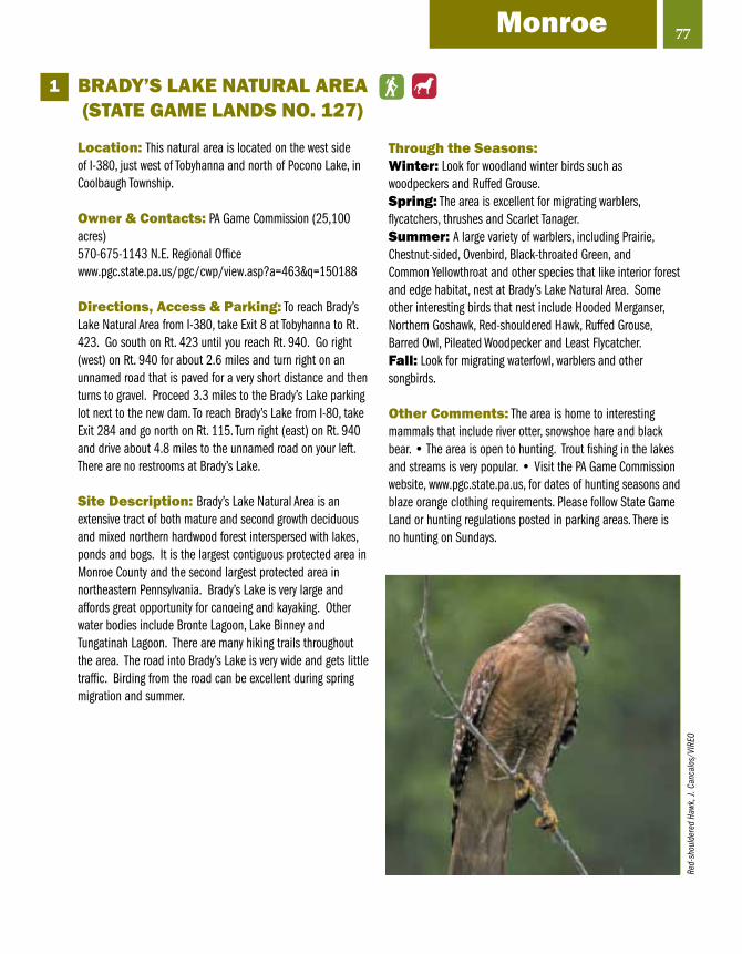
BRADY’S LAKE NATuRAL AREA (STATE GAME LANDS NO. 127)
Location: This natural area is located on the west side of I-380, just west of Tobyhanna and north of Pocono Lake, in Coolbaugh Township.
Owner & Contacts: PA Game Commission (25,100 acres)570-675-1143 N.E. Regional Officewww.pgc.state.pa.us/pgc/cwp/view.asp?a=463&q=150188
Directions, Access & Parking: To reach Brady’s Lake Natural Area from I-380, take Exit 8 at Tobyhanna to Rt. 423. Go south on Rt. 423 until you reach Rt. 940. Go right (west) on Rt. 940 for about 2.6 miles and turn right on an unnamed road that is paved for a very short distance and then turns to gravel. Proceed 3.3 miles to the Brady’s Lake parking lot next to the new dam. To reach Brady’s Lake from I-80, take Exit 284 and go north on Rt. 115. Turn right (east) on Rt. 940 and drive about 4.8 miles to the unnamed road on your left. There are no restrooms at Brady’s Lake.
Site Description: Brady’s Lake Natural Area is an extensive tract of both mature and second growth deciduous and mixed northern hardwood forest interspersed with lakes, ponds and bogs. It is the largest contiguous protected area in Monroe County and the second largest protected area in northeastern Pennsylvania. Brady’s Lake is very large and affords great opportunity for canoeing and kayaking. Other water bodies include Bronte Lagoon, Lake Binney and Tungatinah Lagoon. There are many hiking trails throughout the area. The road into Brady’s Lake is very wide and gets little traffic. Birding from the road can be excellent during spring migration and summer.
Through the Seasons:Winter: Look for woodland winter birds such as woodpeckers and Ruffed Grouse.Spring: The area is excellent for migrating warblers, flycatchers, thrushes and Scarlet Tanager.Summer: A large variety of warblers, including Prairie, Chestnut-sided, Ovenbird, Black-throated Green, and Common Yellowthroat and other species that like interior forest and edge habitat, nest at Brady’s Lake Natural Area. Some other interesting birds that nest include Hooded Merganser, Northern Goshawk, Red-shouldered Hawk, Ruffed Grouse, Barred Owl, Pileated Woodpecker and Least Flycatcher. Fall: Look for migrating waterfowl, warblers and other songbirds.
Other Comments: The area is home to interesting mammals that include river otter, snowshoe hare and black bear. • The area is open to hunting. Trout fishing in the lakes and streams is very popular. • Visit the PA Game Commission website, www.pgc.state.pa.us, for dates of hunting seasons and blaze orange clothing requirements. Please follow State Game Land or hunting regulations posted in parking areas. There is no hunting on Sundays.
1
77Monroe
Red-
shou
lder
ed H
awk,
J. C
anca
los/
VIRE
O

78
LONG POND/HYPSY GAP
Location: South of I-80 and northwest of Rt. 115, in Tunkhannock Township
Owner & Contacts: The Nature Conservancy & City of Bethlehem Authority (20,000 acres)570-643-7922 or 888-560-8700www.nature.org/wherewework/northamerica/states/pennsylvania/preserves/art825.html
Directions, Access & Parking: From I-80, take Exit 284 (Rt. 115). Turn south on Rt. 115 towards Effort. After 3.1 miles, bear left at the Long Pond and Pocono Raceway signs onto Long Pond Road. Proceed on Long Pond Road for about 3.5 miles. At this point there are some very nice fields that have Bobolink in season. In another 0.4 miles you reach a T-intersection. Turn right onto Kuhenbeaker Rd., drive 1.3 miles, and bear left onto Hypsy Gap Road. Go 1.5 miles to gate T-5 on the left. Park near the gate (but don’t block access), walk down the path to a fork and turn right. After 200 yards, take a left into the area surrounding Grass Lake.
Continue along Hypsy Gap Rd. another 0.5 miles to a second pull-off on the left at gate T-6. This area is also owned by the Bethlehem Authority and provides access to Conservancy land. Walk straight up the trail to the first left turn, and follow that through the barren until it reaches Hypsy Gap Road.
Drive back to the intersection with Kuhenbeaker Rd. and take a short left over a bridge to a dirt road on the right. Park and walk through a rhodora barren.
Site Description: Nestled along the southern escarpment of the Pocono plateau, Long Pond embodies the region’s boreal heritage, harboring species tolerant to cooler temperatures reminiscent of its glacial past. Representing the only natural community of its kind in the world, the mesic till barrens at Long Pond are interspersed in a vast landscape of swamps, bogs, marshes and shallow ponds surrounded by red spruce, balsam fir and eastern hemlock – woodlands more characteristic of Canada’s northern climate.
Through the Seasons: Winter: Look for winter mixed-flock species, Northern Harrier, Great Horned Owl and Barred Owl. Spring: This season is good for migrating ducks, American Bittern and warblers.Summer: Nesting birds of interest include Red-shouldered Hawk, Swamp Sparrow and warblers that include Chestnut-sided, Nashville, Louisiana Waterthrush, Golden-winged, Prairie and Common Yellowthroat.Fall: Look for migrating songbirds and waterfowl.
Other Comments: Look for river otter and black bear. • This is one of The Nature Conservancy’s “Last Great Places” due to high levels of biodiversity, especially among plants and insects. • Long Pond has been designated an Important Bird Area by Audubon Pennsylvania. If you want to kayak or canoe Long Pond, call The Nature Conservancy office at 570-643-7922 for permission.
2
Swam
p Sp
arro
w, R
. Cur
tis/V
IREO

DELAWARE WATER GAPNATIONAL RECREATION AREAPARK HEADquARTERS
Location: The headquarter building is at Bushkill located east of U.S. 209, near the intersection of River Rd. and Hidden Lake Dr. (Watch for the signs to the NPS headquarters building.)
Owner & Contacts: National Park Service (100 acres)570-588-2451www.nps.gov/dewa/
Directions, Access & Parking: From I-80, take Exit 309 just east of East Stroudsburg and proceed north on Rt. 209. In 1.5 miles, make a right on Buttermilk Falls Rd. and proceed 0.6 miles, turn left onto River Rd. and continue for about 7 miles and turn right on an unmarked, dirt road that is known locally at the Freeman Tract Rd. Any place along this road can be excellent for birding, especially during the spring warbler migration. To reach the Park Headquarters Building, return to River Rd., turn right and go another mile. Parking and restrooms are available at the headquarters building.
To reach another good birding spot from the headquarters, drive north on River Rd. and turn right on Community Dr. Park on the right side of the road past the farm complex. Various trails lead from this spot. One trail leads to the Delaware River while the other trail goes left (north) to a swamp created by an old beaver pond.
Site Description: The important feature at the Headquarters Building is the large standing dead timber swamp that originally was created by beavers. There is a boardwalk with observation decks for bird watching along the margin of the swamp. The remainder of the area is prime river bottom habitat consisting of a mature deciduous forest with numerous wooded swamps and old beaver ponds.
Through the Seasons:Winter: Look for forest birds such as woodpeckers, nuthatches, titmice, cardinals and White-throated Sparrows.Spring: Birds seen during this season include Red-headed Woodpecker, Pileated Woodpecker, Great Crested Flycatcher, Tree Swallow, Eastern Bluebird, Yellow-throated, Blue-headed and Red-eyed vireos, and Swamp Sparrow. This is possibly the best place in Monroe County to see a large variety of warblers.Summer: Look for cavity nesting birds such as Red-headed Woodpecker, Pileated Woodpecker, Tree Swallow and Blue Bird.Fall: Look for migrating warblers and other birds that like wooded swamps such as Swamp Sparrow.
Other Comments: The Delaware Water Gap National Recreation Area offers some of the best birding in eastern Pennsylvania. Be sure to get a map and other information about the many places to visit. Part of the Delaware Water Gap NRA is in New Jersey, where there are more birding & wildlife watching opportunities. • There are many hunters in the area during deer and turkey season so be sure to wear orange if birding the site during these times of the year. • The Delaware Water Gap National Recreation Area has been designated an Important Bird Area by Audubon Pennsylvania.
3
79Monroe
Red-
head
ed W
oodp
ecke
r, Bi
ll Ra
boin
/iSto
ckph
oto.
com
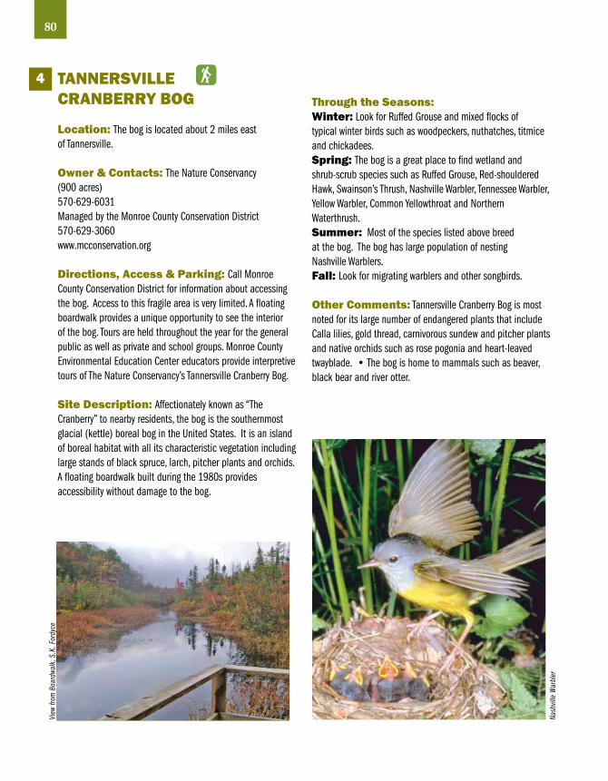
80
TANNERSvILLE CRANBERRY BOG
Location: The bog is located about 2 miles east of Tannersville.
Owner & Contacts: The Nature Conservancy(900 acres)570-629-6031Managed by the Monroe County Conservation District570-629-3060www.mcconservation.org
Directions, Access & Parking: Call Monroe County Conservation District for information about accessing the bog. Access to this fragile area is very limited. A floating boardwalk provides a unique opportunity to see the interior of the bog. Tours are held throughout the year for the general public as well as private and school groups. Monroe County Environmental Education Center educators provide interpretive tours of The Nature Conservancy’s Tannersville Cranberry Bog.
Site Description: Affectionately known as “The Cranberry” to nearby residents, the bog is the southernmost glacial (kettle) boreal bog in the United States. It is an island of boreal habitat with all its characteristic vegetation including large stands of black spruce, larch, pitcher plants and orchids. A floating boardwalk built during the 1980s provides accessibility without damage to the bog.
Through the Seasons:Winter: Look for Ruffed Grouse and mixed flocks of typical winter birds such as woodpeckers, nuthatches, titmice and chickadees.Spring: The bog is a great place to find wetland and shrub-scrub species such as Ruffed Grouse, Red-shouldered Hawk, Swainson’s Thrush, Nashville Warbler, Tennessee Warbler, Yellow Warbler, Common Yellowthroat and Northern Waterthrush.Summer: Most of the species listed above breed at the bog. The bog has large population of nesting Nashville Warblers.Fall: Look for migrating warblers and other songbirds.
Other Comments: Tannersville Cranberry Bog is most noted for its large number of endangered plants that include Calla lilies, gold thread, carnivorous sundew and pitcher plants and native orchids such as rose pogonia and heart-leaved twayblade. • The bog is home to mammals such as beaver, black bear and river otter.
4
View
from
Boa
rdwa
lk, S
.K. F
ordy
ce
Nash
ville
War
bler

CHERRY vALLEY NWR,BLAKESLEE FARM
Location: The farm is located in the Cherry Valley, about 5 miles south of Stroudsburg.
Owner & Contacts: The Nature Conservancy (285 acres)570-643-7922www.poconos.net/cherrycreek/7.htm
Directions, Access & Parking: From Stroudsburg, take Rt. 191 south past the Stroudsmoor resort (1 mile) into Cherry Valley and proceed 4 miles to Cherry Valley Rd. Turn right (west) on Cherry Valley Rd. and go about 2.5 miles and turn left on Blakeslee Rd. Proceed 0.5 miles to Blakeslee Farm with its fallow fields and meandering stream on the right. From Bangor Borough in Northampton County, take Rt. 191 north over the Blue Mountain and down into the Cherry Valley. At Cherry Valley Rd. turn left and follow the directions given above. Park along the road and bird the surrounding fields, meadows and stream. The road is narrow and parking is limited but, luckily, there is very little traffic. There are no restrooms.
Site Description: The 285-acre Blakeslee Farm was acquired through the Conservancy’s farmland preservation plan for the Cherry Valley. The property is composed mainly of mature deciduous forest, Cherry Creek, and an excellent creek side riparian habitat. The site also contains fallow fields, grassland/savanna, early successional forest, swamp and marsh. The main feature of the farm is the meandering Cherry Creek with its swampy margins. This is probably the best place in Monroe County to see shore birds.
Through the Seasons:Winter: Species to look for this season include Common Merganser, Red-tailed Hawk, Rough-legged Hawk, American Kestrel, and winter sparrows.Spring: Look for Green-winged Teal, Blue-winged Teal, Northern Pintail, Wilson’s Snipe and other shore birds, American Pipit and Eastern Bluebird. The farm can be a good place to see migrating warblers.Summer: Nesting birds include Great Blue Heron, Wood Duck, Killdeer, Willow Flycatcher, Yellow-throated Vireo, American Redstart, Savannah Sparrow and Eastern Meadowlark.Fall: Look for migrating raptors, warblers, sparrows and other songbirds.
Other: The site contains a number of rare plants and amphibians. • The Cherry Valley is identified in the Monroe County Natural Areas Inventory as an outstanding wildlife area with national significance. • Cherry Valley National Wildlife Refuge was authorized by Congress in 2009, but has not been developed as of this printing in April 2009. The valley has experienced very little of the development activity that has taken place in similar areas of eastern Pennsylvania.
5
81MonroeLe
sser
Yel
lowl
egs,
G. B
aile
y/VI
REO
Sava
nnah
Spa
rrow,
R. C
urtis
/VIR
EO
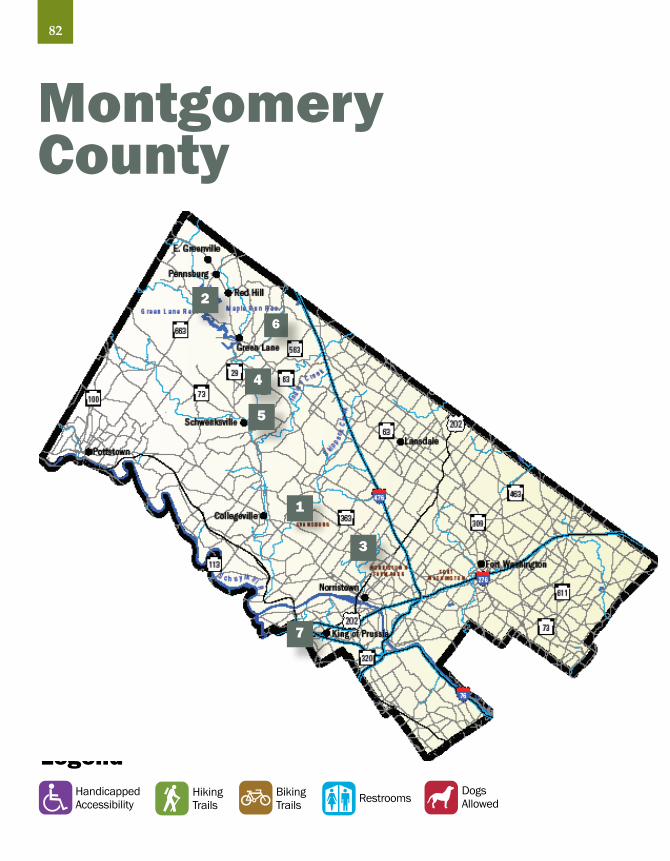
LegendDogsAllowedRestroomsBiking
TrailsHikingTrails
HandicappedAccessibility
Montgomery County
1
2
3
4
5
6
7
82

EvANSBuRGSTATE PARK
Location: Evansburg State Park is located in south central Montgomery County, along Skippack Creek, between Norristown and Collegeville.
Owner & Contacts: PA Department of Conservation and Natural Resources (3,400 acres)610-409-1150851 Mary Hall Rd., Collegeville, PA 19426-1212www.dcnr.state.pa.us/stateparks/Parks/evansburg.aspx
Directions, Access & Parking: From Collegeville, take the Germantown Pike east about 1.5 miles. From Rt. 73, take Rt. 363 south to the Germantown Pike. Turn right on Germantown Pike and go about 2.2 miles to the park. To reach the park headquarters and nature center, at the intersection of Evansburg Rd. and Mill Rd. on the north side of the park, go south on Mill Rd. and turn left at May Hall Rd. and go about 0.8 miles to both the headquarters and nature center. It would be helpful to get a park map at the headquarters. Access to the park can be obtained from a number of other roads. There should be no problem finding parking.
Site Description: Evansburg State Park is located in the Skippack Creek valley and provides over 5 square miles of contiguous open space in a highly suburbanized area of Montgomery County. The park consists mostly of northern and southern hardwood types in various stages of growth. There are fallow fields, cropland and meadows. The park contains 6 miles of hiking trails and 5 miles of mountain bike trails. Skippack Creek is a major part of the park.
Other Comments: The park provides a large variety of recreational activities and can be very crowded on weekends in spring, summer and fall.
Through the Seasons:Winter: In the forested areas of the park you will find the typical winter birds. Spring: The park can be good for warblers and other migrating songbirds. Skippack Creek supports small numbers of Green and Great Blue herons.Summer: Breeding birds of interest include Wood Thrush, Scarlet Tanager, Baltimore Oriole and several species of warblers.Fall: Look for migrating warblers and other songbirds in early fall.
1
83Montgomery
Red-
belli
ed W
oodp
ecke
r, Bi
ll Ra
boin
/iSto
ckph
oto.
com

84
GREEN LANE RESERvOIR,GREEN LANE PARK
Location: The reservoir is located in northern Montgomery County, less than 1 mile southwest of the boroughs of East Greenville, Pennsburg and Red Hill, and 1 mile northwest of Green Lane.
Owner & Contacts: Mongtomery County/Aqua Pennsylvania (3,400 acres total, reservoir - 800 acres)215-234-45282144 Snyder Road, Green Lane, PA 18054http://parks.montcopa.org/parks
Birding information: www.dvoc.org/DelValBirding/Places/GreenLanePA.htm
Directions, Access & Parking: To reach the Church Rd. shorebird area, from the intersection of Rt. 29 (Gravel Pike) and Water St., go south on Water St. which becomes Church Rd. at State St. for 2.9 miles until you reach the parking lot at the lake. To reach the Walt Rd. boat launch from Rt. 29 (Main St.) in Pennsburg, turn right at 11th St. and proceed about 0.3 miles to the intersection of 11th St. and Montgomery Ave. Stay on 11th St.; it becomes Walt Rd. Continue on Walt Rd. and look for the entrance on the right. For another view of the reservoir, from the intersection of Rt. 663 and Knight Rd., go east on Knight Rd. for about 0.3 miles to where the road crosses the reservoir. There is a lookout and small parking lot on the right just after the first lake crossing.
Site Description: The main feature is the 800-acre Green Lane Reservoir. The reservoir, along with a variety of terrestrial habitats, makes the area attractive to an impressive variety of birds. In addition to the reservoir, there are two smaller lakes, mixed riparian and upland oak forests, conifer plantations, red-cedar barrens, fallow fields and shallow marsh/meadow.
Through the Seasons:Winter: If the reservoir remains unfrozen, this is a good time to see waterfowl that can include Greater White-fronted Goose, Cackling Goose, Canvasback, Redhead, and more. The resident pair of Bald Eagles begins to nest by mid-winter. There are feeders at the nature center on the west side of Rt. 29 about 1.4 miles south of Red Hill. Turn right at the sign for Marlborough Elementary School and proceed straight ahead to the nature center.Spring: Bald Eagles are raising young by spring. Look for migrating waterfowl in March and April. Some days are good for migrating songbirds.Summer: If the water level in the reservoir is low, start looking for shore birds in late July. Great Egret, Great Blue Heron, Black-crowned Night-Heron, Green Heron and cormorant are often present.Fall: Look for late arriving shorebirds. As in winter, the variety of waterfowl can be quite impressive with up to 30 species for the season. Some areas adjacent to the reservoir can be good for sparrow species that include Lincoln’s, Vesper, Swamp and White-crowned.
Other Comments: Green Lane Reservoir is the best place is southeastern Pennsylvania to see sandpipers and other shorebirds during the fall migration. However, the water level must be low to expose the mud flats at Church Road and other locations. Up to 30 species of shorebirds are possible from late July through September • There is a toilet at the Walt Rd. boat launch area • There is heavy traffic on park trails on weekends from spring through fall • Green Lane Reservoir has been designated an Important Bird Area by Audubon Pennsylvania.
2
Shor
t-bill
ed D
owitc
her,
G. B
aile
y/VI
REO

NORRISTOWNFARM PARK
Location: North side of Norristown, in the Borough of Norristown and the Townships of East Norriton and West Norriton.
Owner & Contacts: PA Department of Conservation and Natural Resources (690 acres), Operated and maintained by Montgomery County610-270-02152500 Upper Farm Rd., Norristown, PA 19403www.schuylkillriver.org/Detail.aspx?id=151http://parks.montcopa.org/parks
Directions, Access & Parking: The main entrance is off Germantown Pike, on the north side of the park. From the intersection of South U.S. 202 and Germantown Pike, go west on Germantown Pike for about 1 mile. The entrance to the park is on the left at Barley Sheaf Dr./ Upper Farm Rd. Stop and get a park map at the entrance.
Site Description: The park is a large, open space in a highly suburbanized area of Montgomery County. The primary habitats include mature deciduous forest, cultivated and fallow fields, Stoney Creek and creek side riparian habitat. Norristown Farm Park has paved hiking/biking trails, athletic fields and fishing in Stoney Creek. Parking and restrooms are available at several locations. One of the best places to park for birding is the last parking lot before the road ends at a stone arch bridge. This parking lot has toilets and a pavilion.
Through the Seasons:Winter: Look for typical winter species such as woodpeckers, chickadees, titmice and a variety of sparrows.Spring: The park can be good for migrating warblers and other songbirds.Summer: Least Bittern bred in the park in 2006. Fall: The farm pond often attracts American Bittern, American Coot and a wide assortment of waterfowl. Look for sparrows in the proper habitat.
Other Comments: The park was recently a working farm on the site of the former Norristown State Hospital.
3
85MontgomeryCh
ippi
ng S
parro
w, C
orey
Hus
ic
Amer
ican
Coot
, Lau
re N
eish
/iSto
ckph
oto.
com

86
PERKIOMEN TRAILNORTH SECTION
Location: Along the Perkiomen Creek, in northern Montgomery County, between Green Lane and Spring Mount, in the townships of Marlborough and Upper Salford.
Owner & Contacts: Montgomery County (about 5 liner miles)610-278-3555http://trails.montcopa.org/trails
Directions, Access & Parking: There are three trailheads: 1) Green Lane Park has a large parking lot at the intersection of Snyder and Deep Creek roads in Upper Perkiomen Valley Park, 2) Crusher Road trailhead on south side of the road about 0.2 miles east of Rt. 29, 3) Harmon Road trailhead parking is available at William Rahmer Park, about 0.5 miles south of Salford.
Site Description: The Perkiomen Trail is a linear park that passes through many communities and neighborhoods in the Perkiomen Creek valley. The trail allows users to travel through towns that grew and developed, in part, because of the railroad corridor. The trail is open during daylight hours.
Through the Seasons:Winter: Look for Pileated Woodpecker in heavily wooded areas.Spring: Many species of warblers and other songbirds can be found during migration. Red-headed Woodpeckers are often present at the Spring Mountain end. Look for Great Blue Heron, Osprey, Wood Duck and Broad-winged Hawk along the creek.Summer: Expect the typical breeding birds to be found along a large stream valley. This includes Great Crested Flycatcher, Warbling Vireo, Baltimore Oriole and the like.Fall: This is a good season to see migrating warblers.
Other Comments: Birders must remember that much of the trail passes private property and that they should always stay on the trail. Birders should only leave the trail at access points that are clearly marked as a public place. • Expect heavy use of the trail during weekends.
4
Belte
d Ki
ngfis
her,
Fran
k Le
ung/
iSto
ckph
oto.
com

SPRING MOuNTAIN
Location: About 2 miles northeast of Schwenksville, in Upper Salford Township.
Owner & Contacts: Montgomery County, Upper Salford Township and multiple private owners (about 500 acres)610-278-3555 (Montgomery County)757 Spring Mountain Rd., Schwenksville, PA 19473www.springmountain-fun.com/directions.htm
Directions, Access & Parking: From the intersection of Rt. 113 and Rt. 63 in Harleysville, go northwest on Rt. 63 for about 1.7 miles to Shelly Rd. Turn left on Shelly Rd. and follow the signs to Spring Mountain. Shelly Rd. becomes Schwenksville Rd. below Salford Station Rd. At Spring Mount Rd. turn right (west). Spring Mountain is on the south side of Spring Mount Rd. From the intersection of Rt. 29/73 and Spring Mount Rd. just north of Schwenksville, go east on Spring Mount Rd. Spring Mountain is on the right after you cross the Perkiomen Creek. Park in the lot at the ski area. Better yet, park in the large lot on the south side of Spring Mount Rd., just past the creek.
Site Description: The site is composed of a variety of habitats that include mature deciduous forest, early successional forest, shrub/scrub and grasslands. There is considerable riparian habitat adjacent to the Perkiomen Creek.
Through the Seasons:Winter: Look for Great Blue Heron and a variety of waterfowl along Perkiomen Creek. Woodpeckers, nuthatches, chickadees, titmice and kinglets can be found in the woods. A variety of wintering sparrows can be found in the grassland and savannah areas. Spring: A great variety of warblers and other migrating songbirds can be found in spring. Wood Duck, Hooded and Common mergansers, Pied-billed Grebe, Belted Kingfisher and Spotted Sandpiper are possible along Perkiomen Creek.Summer: A large variety of birds nest at Spring Mountain. These birds include Wood Duck, Great Blue Heron, Green Heron, Scarlet Tanager, Rose-breasted Grosbeak and Baltimore and Orchard orioles, to name a few.Fall: Look for migrating raptors such as Red-tailed, Cooper’s and Sharp-shinned hawks. The woods and tree rows can be good for warblers and other songbirds. A variety of sparrows can be found in the proper habitat.
Other Comments: The Perkiomen Trail passes Spring Mountain on the east side of Perkiomen Creek.
5
87MontgomeryGr
een
Hero
n, T
im F
ench
el

88
uNAMI CREEK vALLEY
Location: East of Green Lane, in the townships of Marlborough and Salford.
Owner & Contacts: Multiple owners (over 2,000 acres)See “Natural Lands Trust” website:www.natlands.org/projects/project.asp?fldProjectId=3
Directions, Access & Parking: From the intersection of Rts. 29 and 63 in Green Lane, go southeast on Rt. 63 (Sumneytown Pike) about 1.4 miles and make a sharp left on Geryville Pike. Go about 0.2 miles and turn right on Swamp Creek Rd. At Magazine Rd. bear right and cross the creek. Follow Swamp Creek Rd. that parallels Unami Creek for about 3.6 miles to where the road crosses Unami Creek. Any area along Swamp Creek Rd. can be good for birding but finding a satisfactory place to park can be a problem. Be careful not to trespass on posted property. There are several scout camps located on both sides of the creek.
Site Description: The Unami Creek Valley is one of the largest contiguous tracts of mature deciduous forest in southeastern Pennsylvania. The unusual size and integrity of the woodlands explains why the area has been given a top priority for protection by the The Natural Lands Trust. Unami Creek is considered to be an “exceptional value” stream which is the highest value granted by the PA Department of Environmental Protection.
Through the Seasons:Winter: A variety of woodpeckers, including Pileated, is present. Look for Hooded Mergansers on Unami Creek.Spring: This is the best season to visit the valley. Warblers of special importance include Hooded, Kentucky, Yellow-throated and Louisiana Waterthrush. Yellow-throated Vireo, Acadian Flycatcher and Rose-breasted Grosbeak also are present.Summer: The above-listed birds all breed in the Unami Creek Valley.Fall: Look for migrant ducks and grebes on the creek. Migrating warblers and other songbirds are present in early fall.
Other Comments: There are no restrooms in the Unami Creek Valley. • The valley is crowded with fishermen the first week of trout season • Mink and beaver are present year round • The Unami Creek Valley has been designated an Important Bird Area by Audubon Pennsylvania
6
Yello
w-th
roat
ed V
ireo,
Bria
n E,
Sm
all/
VIRE
O
Caro
lina
Wre
n, M
r_Ja
mse
y/iS
tock
phot
o.co
m

vALLEY FORGE NATIONALHISTORICAL PARK
Location: The park is located on the south side of the Schuylkill River, west of U.S. 422, and north of the Pennsylvania Turnpike (I-76). Part of the park is in Chester County.
Owner & Contacts: National Park Service (3,500 acres)610-783-10081400 N. Outer Line Drive, King of Prussia, PA 19406www.nps.gov/vafo/
Directions, Access & Parking: The main entrance to the park is at the interchange of U.S. 422 and Rt. 23 (Port Kennedy Rd.). Stop and get a visitor’s map at the Welcome Center. Ample parking and restrooms are within the park. This is one of those sites where you drive to different spots, or use the walks or roads throughout the park.
Site Description: Valley Forge National Historical Park is one of the few, large, contiguous, protected areas in southeastern Pennsylvania that has a variety of habitat types including a river, numerous streams and forested wetlands, eastern deciduous forest, and tall-grass meadows. The park’s tall grass meadows are home to many birds year around, but especially abound in songbirds that nest in late spring. The woodlands harbor spring nesting birds such as Wood Thrush.
Through the Seasons:Winter: Look for Black Duck, Bufflehead and Belted Kingfisher along the Schuylkill River. Other birds of winter include woodpeckers and typical winter species.Spring: A very good place to see migrating warblers and other songbirds. Wood Duck and Spotted Sandpiper are found along the river.Summer: Nesting birds include several species of flycatchers, Green Heron, Common Yellowthroat and Eastern Meadowlark.Fall: This is another season for migrating songbirds.
Other Comments: The park is heavily used throughout the summer • The park is severely impacted by White-tailed Deer, and they will almost walk up to you. • A wealth of information about the birds at Valley Forge NHP is available, in large part because park staff, university cooperators, members of the Audubon Society, and volunteers have birded at the park for the past 30 years.
7
89MontgomeryHu
ts in
Win
ter,
Valle
y For
ge N
atio
nal H
istor
ic Pa
rk

From 1803 to 1806, Mill Grove was the first home in America of artist and naturalist John James Audubon. Today, the John James Audubon Center at Mill Grove (JJAC) preserves and displays one of the nation’s largest collections of Audubon art inside its 245-year-old farmhouse, listed on the National Register of Historic Places. An educational center of the National Audubon Society, JJAC is dedicated to connecting people with the natural world by interpreting Audubon’s legacy and encouraging guests to explore the 175-acre estate, which remains largely as John found it—a haven for birds and wildlife.
The site boasts a variety of bird and wildlife habitat from wooded slopes to open meadows to riparian hillsides. More than 180 different species of birds have been observed onsite, while approximately 60 species have been found nesting within the sanctuary. The site offers approximately 5 miles of interior walking trails in addition to the 4-mile Audubon Loop Trail, a paved
bike path that circles the property and links to the Perkiomen and Schuylkill River Trails.
In addition, the site’s art museum (located inside the historic home) contains a wide variety of Audubon art. Visitors will find original prints (1826-1838) from John James Audubon’s seminal work, The Birds of America, throughout the house. Regular museum exhibits also include examples from Audubon’s lesser-known work, The Viviparous Quadrupeds, in which he sought to document North America’s mammals. The special exhibition gallery on the second floor houses changing exhibitions by contemporary artists working in Audubon’s naturalist tradition.
Mill Grove is located at 1201 Pawlings Road, Audubon, PA 19403. 610-666-5593. The museum has an admission fee. http://pa.audubon.org/centers_mill_grove.html
90
john james Audubon Center at Mill Grove
Mill
Grov
e, G
reg
Mat
kosk
y

91
The Academy of Natural Sciences is Philadelphia’s Natural History Museum. Founded in 1812 “for the encouragement and cultivation of the sciences, and the advancement of useful learning.” the Academy is the oldest continuously operating natural science research institution and museum in the Americas. The unique aspect of this statement of purpose lies in the word “useful,” a mandate the Academy has continuously redefined through research and education that reflects the societal needs of the times.
The Academy’s history mirrors the evolution of the relationship between the American people and the natural world. It was founded when the United States hugged the Atlantic coastline, and Philadelphia was the cultural, commercial, and scientific center of the new nation. Classic expeditions to explore the western wilderness brought back new species of plants and animals. These specimens were studied, catalogued and formed the foundation of the Academy’s scientific collections.
Today, the Academy’s permanent exhibits include halls of dioramas of North American, Asian, and African animals and natural history; dinosaurs; and butterflies. There are also numerous changing exhibits as well as a calendar of events and programs. The museum’s
collections include nearly 200,000 study skins of birds. These collections are available for scholarly work, but not open to the public.
The museum is at 19th Street and Ben Franklin Parkway in Philadelphia. There is an admission fee. You can learn more about the Academy at www.ansp.org.
Academy ofNatural Sciences
Giga
ntos
auru
s sk
ull,
cour
tesy
Aca
dem
y of N
atur
al S
cienc
es

LegendDogsAllowedRestroomsBiking
TrailsHikingTrails
HandicappedAccessibility
Northampton County
1
2
3
4
5
6
7
92

jACOBSBuRGENvIRONMENTALEDuCATION CENTER
Location: Along the Bushkill Creek in Bushkill Township, about 2 miles north of Nazareth
Owner & Contacts: PA Department of Conservation and Natural Resources (1,168 acres)610-746-2801835 Jacobsburg Rd., Wind Gap, PA 18091www.dcnr.state.pa.us/stateparks/parks/jacobsburg.aspx
Directions, Access & Parking: From the intersection of Rt. 22 with Rt. 33, take Rt. 33 north 7 miles to the Belfast exit. At the end of the exit ramp, turn right, go to the next stop sign, and turn left onto Belfast Rd. The main parking area is about 0.5 miles down the road. There are other parking areas throughout the park, including one on Henry Rd. that is open from 8:30 am to 3:30 pm, and others on Jacobsburg Rd. across from Fehr Rd., Douglasville Rd. and State Park Rd. The park is open from sunrise to sunset. Restrooms are available.
Site Description: The rolling terrain offers habitats that range from fields in various stages of successional growth to hardwood forests dominated by oak trees. About 2.5 miles of Bushkill Creek and its tributaries wind through the center. The portion of the center’s woodland, known as Henry’s Woods, is one of the most beautiful natural resources in Northampton County. A 1.9-mile loop trail passes through mature stands of hemlock and dramatic slate outcroppings adjacent to Bushkill Creek. This is one of the best places to bird. All total, there are 18.5 miles of trails.
Through the Seasons:Winter: Winter birds include woodpeckers, chickadees, titmice, and a variety of sparrows. The center has several feeders where birds can be observed.Spring: This is a good time to see migrating songbirds including many species of warblers. Louisiana Waterthrush can often be found along the stream in Henry’s Woods.Summer: Breeding birds of interest include Great Crested Flycatcher, both species of cuckoo, Yellow-breasted Chat and Scarlet Tanager. Of special recent interest was the presence of breeding Winter Wren and Hooded Warbler.Fall: The Center can be a good place to observe migrating songbirds.
Other Comments: The main parking area has an information board with a trail map. Individual maps are usually available. Maps may also be picked up at the park office on Jacobsburg Rd., just past its intersection with Belfast Rd., about a mile beyond the main parking lot. The office is open from 8 am to 4 pm., Monday through Friday. • For birding, it is best to arrive early since the park can become very crowded, especially on weekends. • Hunting is allowed in the park. Areas where hunting is allowed are clearly marked. • The Jacobsburg National Historic District lies almost entirely within the boundaries of the Center. For a change from birding, visit the various exhibits that celebrate the Henry gun works where the famous Henry Rifle was made.
1
93NorthamptonYe
llow-
bille
d Cu
ckoo
, R. C
urtis
/VIR
EO
Loui
siana
Wat
erth
rush
, R. C
urtis
/VIR
EO

94
D&L TRAIL(Freemansburg to Palmer Township)
Location: Along the towpath of the Lehigh Canal, on the north side of the Lehigh River, for a distance of 5.5 miles.
Owners: Borough of Freemansburg and the townships of Bethlehem and Palmer (each municipality owns its portion of the D&L Trail)
Directions, Access & Parking: There are four locations from which the trail can be accessed. From the interchange of I-78 and Rt. 412, go north on Rt. 412 (Hellertown Rd.) for 0.8 miles and turn right onto Shimersville Rd.. Proceed north for 1.0 mile and cross the Lehigh River to Freemansburg (Main St.). After crossing the river, go north on Main St. for about 0.7 miles and park in the lot next to the tavern or on the street. The trail is between the parking lot and the river.
To reach the next access point, go north on Main St. for 0.3 miles and turn right (east) on Freemansburg Highway. Go east for 1.7 miles and turn right (south) on Farmersville Rd. Proceed for 1.0 mile to Wilson Ave. There is a small parking on the right; the trail is between the parking lot and the river.
The third access point can be reached by going back north on Farmersville Rd. and turning right on Freemansburg Highway. Go east for 1.5 miles, passing over Rt. 33, to the green and white Fish & Boat Commission Rt. 33 Access sign and turn right. Drive another 1.8 miles passing under Rt. 33 twice until the road ends at a large, paved parking lot next to the river.
To reach the last access, go back to Freemansburg Highway, turn right, and go 2.3 miles to 25th St. Turn right on 25th St. and go 0.6 miles to Lehigh Dr. Turn right on Lehigh Dr., proceed 100 yards, and turn right into Riverview Park. There are two parking lots. The trail, which is paved in this area, goes between the two parking lots. Walk west past the playground and the athletic fields to reach the good birding areas.
Site Description: This section of the D&L Trail is composed of mature bottomland forest with a dense under story in many places. There are many large sycamores. Sections of the Lehigh Canal contain water. The Lehigh River is never far from the trail.
Through the Seasons: Winter: The area is good for woodpeckers, Carolina Wren and other typical winter birds. Look for waterfowl on the Lehigh River.Spring: This is the season to see a large variety of migrating songbirds. Waterfowl, herons and Ospreys can be seen on or near the river.Summer: Many interesting nesting species call the Lehigh River area home. Yellow-throated Warbler is a breeding bird of special interest. Warbling Vireo can be found at regular intervals along the entire length of the trail. Great Crested Flycatcher, Northern Parula, American Redstart, Scarlet Tanager, and Baltimore Oriole nest near the trail.Fall: This season can be good for migratory songbirds and waterfowl.
Other Comments: When complete, the D&L Trail will go from Bristol in lower Bucks County to Wilkes-Barre, a distance of 165 miles. Many other sections of the D&L Trail are open and provide good birding. • The only access area with restrooms is Riverview Park and these restrooms are closed in winter. • Watch for bike riders, especially on weekends.
2
Yello
w-th
roat
ed W
arbl
er, A
. & J.
Bin
ns/V
IREO

95Northampton
MARTINS CREEKENvIRONMENTALPRESERvE
Location: Also known as “Tekening”, the preserve is located along the Delaware River in Lower Mount Bethel Township, just north of the PPL Martin’s Creek Steam Electric Station, and about 2 miles southwest of Belvidere, New Jersey.
Owner & Contacts: PPL Electric Utilities (223 acres)6605 Foul Rift Rd., Bangor, PA 180131-800-354-8383www.pplweb.com/martins+creek+preserve/
Directions, Access & Parking: From the Village of Martin’s Creek, go north on Rt. 611 for about a mile to the intersection with Martins Creek- Belvidere Highway. Go straight onto Martins Creek-Belvidere Highway. In 2.9 miles, turn right onto Foul Rift/Depues Ferry Rd. at the PPL Martins Creek sign. Proceed down Foul Rift/Depues Ferry Rd. and follow signs to the south parking area.To reach the boat launch area, follow signs on Foul Rift/Depues Ferry Rd. before the south parking lot. To reach the north parking lot, drive another 2.3 miles along Martins Creek-Belvidere Highway and look for the Tekening sign on the right.
Site Description: The preserve contains mostly mature deciduous woodlands with lush understory and occasional red cedars. There are open fields and views of the river. There are about five miles of trails, with trailheads at both the north and south ends of the preserve. The Blue Trail parallels the river, passing by Foul Rift, an area of whitewater rapids.
Through the Seasons:Winter: A feeding station located near the boat launch is worth a visit at this time of year. It has had up to 40 White-crowned Sparrows along with a variety of other sparrows. Waterfowl are often present on the Delaware River.Spring: The preserve attracts warblers and other migrating songbirds. A good birding loop begins at the north parking lot. Take the Orange Trail (the first off the trailhead) and follow it through the woods and fields until a steep stairway on the left leads toward the river where you can pick up the Blue Trail back to the parking lot.Summer: This season is excellent for nesting Scarlet Tanager, Eastern Bluebird, several species of warblers, and woodland hawks. Common Merganser and Wood Duck nest along the river. Green Herons are present in summer. There are active Osprey nests on the large power line towers along Martins Creek-Belvidere Highway and on platforms near the south entrance to the area. Peregrine Falcons have nested on the PPL property.Fall: The preserve can be good for the typical fall migrants.
Other Comments: During summer, a toilet is available at the boat launch area. • Hunting is permitted in season. • A picnic area is located near the boat access area with tables, grills and toilets. There is no running water. Picnic facillities open 7am to 9pm
3
Ospr
ey n
est

MINSI LAKE ANDBEAR SWAMP
Location: Minsi Lake and Bear Swamp are located in Upper Mount Bethel Township, near the base of Blue Mountain, about 4 miles northeast of Bangor and 4 miles west of Portland.
Owner & Contacts: Pennsylvania Fish Commission (Minsi Lake – 311 acres)www.fish.state.pa.us/water/lakes/minsi/00minsi.htm (Minsi Lake)Northampton County (Bear Swamp – 262 acres)www.northamptoncounty.org/northampton (see “Minsi Lake Wilderness Area” and “Bear Swamp Park & Archery Complex”)
Directions: To reach the archery complex parking lot at Bear Swamp from the intersection of Rt. 512 and Rt. 191, turn left (north) on Rt. 191 and go about 2.4 miles to the intersection with Lake Minsi Dr. Turn right onto Lake Minsi Dr. and follow it 1.3 miles to the stop sign at the intersection with Creek Rd. Turn left on Creek Rd. (which is labeled Lake Minsi Dr. in places) and go 0.7 miles to the parking lot on the right.To reach the west parking lot at Minsi Lake, go another 0.3 miles on Creek Rd. and turn left at Blue Mountain Rd. then take an immediate right into the lot entrance.To reach the east parking lot, return to Creek Road/Lake Minsi Dr. and continue 0.3 miles. Turn left onto East Shore Dr. and proceed 0.5 miles to the parking lot.
Site Description: Minsi Lake (117 acres) is a shallow, man-made Pennsylvania Fish Commission lake. Much of the area surrounding the lake is mature woodlands. There is a nature trail that circles the lake. Bear Swamp is part of the Bear Swamp Archery Complex. The boardwalk trail, the feature attraction of Bear Swamp, is a raised trail through a small section of a sphagnum swamp that covers an extensive area on both sides of the road. There is a small pond and interpretive area at the entrance to the trail. Access the trail by parking at the archery target range. Cross the road, walk west (left) along an old railroad bed for 100 yards, then take the second right just before the stone fence row. Cross the gravel area and go to the right of a short wooden walkway (which leads to the interpretive building and pond) to reach the path to the boardwalk. The boardwalk makes almost a complete loop through the swamp.
Through the Seasons:Winter: Barred Owls are present all year. Pileated Woodpeckers and Wild Turkeys also are present.Spring: Lake Minsi is good for migrating waterfowl, Osprey, and swallows. Other spring migrants include vireos, thrushes, flycatchers, including Acadian, Scarlet Tanagers and a large variety of warblers. Swamp Sparrows and Common Yellowthroats are common along the elevated boardwalk at Bear Swamp during spring and summer. Summer: Birds that nest in the area include Great Crested Flycatcher, Acadian Flycatcher, Scarlet Tanager, Wood Thrush, Veery and a variety of warblers.Fall: The area is good for migrating songbirds. Waterfowl can be found at Minsi Lake.
Other Comments: Both areas are open to the public from dawn until dusk daily. • The parking areas at Minsi Lake have information boards with posted regulations, bird lists, and trail maps. Both parking lots have toilets. • Because the soil is poorly drained throughout the park, muddy conditions can exist at any time of the year on the trails.
4
96
Indi
go B
untin
g, G
. Bar
tley/
VIRE
O
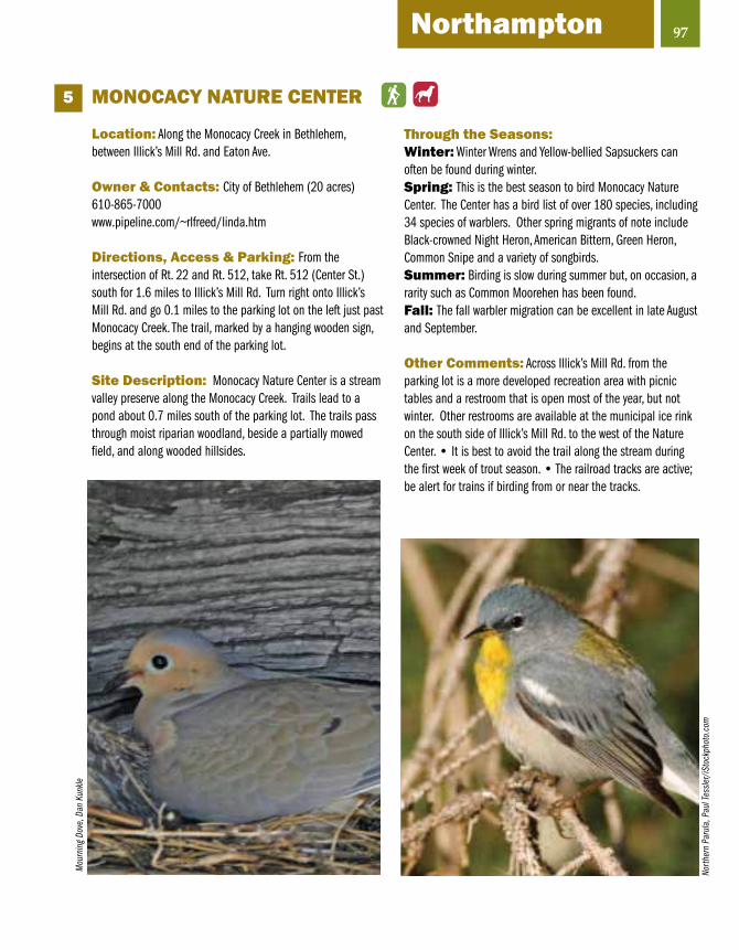
97Northampton
MONOCACY NATuRE CENTER
Location: Along the Monocacy Creek in Bethlehem, between Illick’s Mill Rd. and Eaton Ave.
Owner & Contacts: City of Bethlehem (20 acres)610-865-7000www.pipeline.com/~rlfreed/linda.htm
Directions, Access & Parking: From the intersection of Rt. 22 and Rt. 512, take Rt. 512 (Center St.) south for 1.6 miles to Illick’s Mill Rd. Turn right onto Illick’s Mill Rd. and go 0.1 miles to the parking lot on the left just past Monocacy Creek. The trail, marked by a hanging wooden sign, begins at the south end of the parking lot.
Site Description: Monocacy Nature Center is a stream valley preserve along the Monocacy Creek. Trails lead to a pond about 0.7 miles south of the parking lot. The trails pass through moist riparian woodland, beside a partially mowed field, and along wooded hillsides.
Through the Seasons:Winter: Winter Wrens and Yellow-bellied Sapsuckers can often be found during winter. Spring: This is the best season to bird Monocacy Nature Center. The Center has a bird list of over 180 species, including 34 species of warblers. Other spring migrants of note include Black-crowned Night Heron, American Bittern, Green Heron, Common Snipe and a variety of songbirds.Summer: Birding is slow during summer but, on occasion, a rarity such as Common Moorehen has been found.Fall: The fall warbler migration can be excellent in late August and September.
Other Comments: Across Illick’s Mill Rd. from the parking lot is a more developed recreation area with picnic tables and a restroom that is open most of the year, but not winter. Other restrooms are available at the municipal ice rink on the south side of Illick’s Mill Rd. to the west of the Nature Center. • It is best to avoid the trail along the stream during the first week of trout season. • The railroad tracks are active; be alert for trains if birding from or near the tracks.
5M
ourn
ing
Dove
, Dan
Kun
kle
North
ern
Paru
la, P
aul T
essle
r/iS
tock
phot
o.co
m

RESERvOIR PARK(Hellertown Reservoir)
Location: The park is located in along Polk Valley Rd. in Lower Saucon Township, about 1.4 miles east of Hellertown. (Local birders often refer to this park as “Hellertown Reservoir.”)
Owner & Contacts: Hellertown Borough Authority (257 acres)610-838-8051 (Hellertown Borough Authority)
Directions, Access & Parking: From the intersection of I-78 with Rt. 412 in Hellertown, take Rt. 412 south for 2.1 miles through downtown Hellertown to Polk Valley Rd. (This road is immediately past a MacDonald’s on the right and a small shopping plaza and bank on the left; it is also labeled “McAdoo Ave.”) Turn left onto Polk Valley Rd. and go 0.7 miles to the stop sign facing the Saucon Valley school complex. Turn right to continue on Polk Valley Rd. Continue on Polk Valley Rd. another 0.4 miles. Turn right onto Reservoir Rd. and go 0.3 miles down a hill and across a small stone bridge. Bear left to the small parking area at the gated entrance to the park.
Site Description: Reservoir Park is part of a protected watershed property. The park is mostly wooded with stands of tall oak, tulip poplar, pines, hemlocks and other coniferous and deciduous trees. There is a large fenced-in pond, several smaller ponds, and two streams. To the left of the parking area, there is a large picnic pavilion with playing fields nearby. There are hiking paths around the pavilion and pond areas and in the woods beyond the ponds. The main paths are paved or gravel and provide easy, though slightly, hilly walking.
Through the Seasons:Winter: Reservoir Park is good for woodpeckers, including Pileated that are believed to nest here. Great Horned Owls can be heard in the late afternoon. Screech Owls and Wild Turkeys also are present.Spring: In early spring, Eastern Phoebes nest in the pavilions and other small buildings. Spring migrants include many species of warblers, Scarlet Tanager, and various thrushes.Summer: Blue-winged Warbler, Black-and-white Warbler, Ovenbird, American Redstart and Veery nest in the park. Acadian Flycatcher and Kentucky Warbler are present some years.Fall: Although spring is best, the fall migration can be good some days.
Other Comments: A restroom located near the pavilion is open May to October.
6
98
Woo
d Fr
og, D
an K
unkle
Blac
k-ca
pped
Chi
ckad
ee, B
ruce
McQ
ueen
/iSto
ckph
oto.
com

99Northampton
HuGH MOOREHISTORICAL PARK
Location: The park is located along the banks of the Lehigh River in the City of Easton.
Owner & Contacts: City of Easton (259 acres)30 Centre Square, Easton, PA 18042www.canals.org/
Directions, Access & Parking: From the intersection of Rt. 33 and Rt. 22, take Rt. 22 east for 2 miles to the 25th St. exit. At the end of the exit ramp, bear right onto 25th St. and follow it south for 1.5 miles. Just before the Glendon Bridge, turn right onto Lehigh Dr. and go 0.5 miles to the stop sign and turn right, then cross over the bridge into the park. At the end of the bridge, turn right and proceed 0.4 miles to the main parking lot. Restrooms are available.
Site Description: Hugh Moore Historical Park stretches narrowly along 6 miles of the Lehigh River from the confluence of the Delaware and Lehigh rivers to the Bethlehem Boat Club at Hope Rd in Bethlehem Twp. Oak and hickory dominate the upland forested slopes while the bottomland forest consists mainly of American Sycamore, Cottonwood, Box Elder, Silver Maple and Black Walnut. A 2-mile section of the Lehigh Canal was rewatered in 1975 and is used for mule-drawn canal boat rides in season. (Note: This description covers the main part of the park reached by the bridge noted in the “directions” section. For the section of the park that is on the north side of the Lehigh River, see the “D&L Trail” site description–p.94.)
Through the Seasons:Winter: Look for waterfowl, gulls and land birds associated with riparian habitat.Spring: Migrating waterfowl that can be seen in spring include Common and Hooded merganser, Bufflehead, Common Goldeneye, Wood Duck and Green-winged Teal. Osprey and Great Blue Heron can be seen fishing along the river. The Lehigh River floodplain is an excellent place to see a great variety of migrating songbirds, including many species of warblers.Summer: Breeding birds of interest include Wood Duck, Great Crested Flycatcher, Veery, Wood Thrush, Yellow-throated Vireo, Warbling Vireo (very common), Rose-breasted Grosbeak, and Orchard and Baltimore orioles. Many warblers nest here, including a high density of American Redstart, Northern Parula, Yellow, and Worm-eating. Yellow-throated Warbler, a rare breeder for Northampton County, can be found in the tall sycamores on the north side of the river. Fall: Look for migrating songbirds during late August through early October. Migrating waterfowl, herons, gulls and raptors often can be seen using the Lehigh River corridor.
Other Comments: Visit the Emrick Technology Center just west of the playground. • Enjoy a ride on the Josiah White II Canal Boat if you are there in season. • Visit the Canal Museum and Crayola Center on the square in downtown Easton. Information about these other attractions is at www.canals.org.
7W
arbl
ing
Vire
o, G
. McE
lroy/
VIRE
O
Herri
ng G
ull,
A. M
orris
/VIR
EO
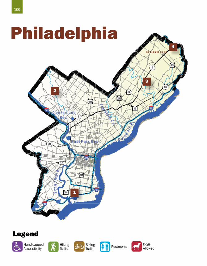
LegendDogsAllowedRestroomsBiking
TrailsHikingTrails
HandicappedAccessibility
1
2
3
100
4
Philadelphia

101Philadelphia
FAIRMOuNT PARK SYSTEM
In the 1790s, several yellow fever epidemics spurred Philadelphia to seek
a system to provide safe drinking water to its citizens. An 1801 center square waterworks was built, replaced in 1815 by the Fairmount Water Works and a reservoir atop Faire Mount. This former reservoir site is now occupied by the Philadelphia Museum of Art.
Throughout the early 1800s industrial pollution impacted water quality and made safeguarding the Schuylkill River, the city’s main water supply, extremely important.
In the Consolidation Act of 1854 the County of Philadelphia became the City of Philadelphia. This act granted the City of Philadelphia the power to acquire areas within the city as open public space.
Fairmount Park was officially founded in 1855 when the Lemon Hill estate was dedicated as a public park and renamed Fairmount Park. Thousands of citizens signed a petition urging the purchase of Lemon Hill. Over the years other summer homes and villa properties were purchased to protect the Schuylkill’s watershed and the city’s water supply. Today Fairmount Park is sprinkled with these historic homes and estates, including Strawberry Mansion, Woodmont, Belmont Mansion and Sedgley. One of the West Park estates, the 80-acre Spring Hill, later became part of the Philadelphia Zoo. Unlike New York City’s Central Park with its man-made landscapes, Fairmount Park evolved through this absorption of older estates, their tree groves and open meadowland without significant alterations.
The Park’s 9,200 acres accounts for over 10% of the total land area in Philadelphia. Other sites within Fairmount Park include Bartram’s Garden, Memorial Hall, Please Touch Museum, Philadelphia Horticulture Center, and the Centennial Arboretum.
Over 200 species of birds are known to occur within the park system each year. Of these 80-100 are breeding species, while 90-100 are wintering species. The majority of species recorded are landbirds, but many species of waterfowl also occur along with some waders, shorebirds and marshbirds.
The greatest diversity and concentration of birds occurs during the spring and autumn when migrating birds use the park as a stopover site. Almost all of the species of landbirds that migrate through eastern Pennsylvania and New Jersey occur annually within the park during migration. Because so many birds migrate through Philadelphia, at least during the spring, birds tend to occur throughout the park system during migration, even in the park’s smallest and most disturbed parcels.
Most of the land within the park system is deciduous forest. These large, mature forests attract several forest breeding species like Veery, Pileated Woodpecker, Louisiana Waterthrush and Barred Owl.
Five major forested streams in the Philadelphia area and attract a number of stream-side and riparian breeders including Louisiana Waterthrush, Acadian Flycatcher, Warbling Vireo, Belted Kingfisher, Wood Duck, and (until recently) Cerulean Warbler. Philadelphia’s other streams were buried for use as sewers many years ago.
Fairmount Park has been designated an Important Bird Area by Audubon Pennsylvania.
Memorial Hall from the Centennial Exposition, now the Please Touch Museum
Mich
ael B
rans
com
, cou
rtesy
the
Plea
se T
ouch
Mus
eum

102
F.D. ROOSEvELT PARK (Fairmount Park)
Location: The Park is located at the south end of Broad St., on the west side of the street, across from the Wachovia Spectrum and the Wachovia Center.
Owner & Contacts: City of Philadelphia (348 acres)215-683-0211 (Bellaire Manor)www.fairmountpark.org/FdrPark.asp
Directions, Access & Parking: From the interchange of I-76 with Broad St., go south on Broad St. for about 0.4 miles and turn right (west) on Pattison Ave. Entrances to F. D. Roosevelt Park are on your left (south) not far from Broad St.
Site Description: FDR Park’s existing waterways are remnants of the tidal marsh and channel system that originally occupied the area. The park also includes two ecosystems that are nearly extinct in Pennsylvania – coastal plain forests and fresh water tidal marsh. Restrooms and lots of parking spaces are available.
Through the Seasons: Winter: A large variety of ducks can be found, including Northern Shoveler, Gadwall, American Wigeon, Redhead, Ring-necked Duck and Ruddy Duck. Other birds of interest include Pied-billed Grebe, American Coot, Great Blue Heron, Rusty Blackbird and Fox Sparrow. Surf Scoter, Ross’s Goose, Cackling Goose and Eurasian Wigeon are present some winters.Spring: Look for migrating waterfowl, herons, gulls,cormorants, raptors and a variety of songbirds, including, at times, Yellow-breasted Chat. Summer: Nesting birds include Tree, Barn and Rough-winged swallows, Warbling Vireo, Yellow Warbler, Common Yellowthroat, Cedar Waxwing and Baltimore Oriole.Fall: Look for waterfowl, herons, cormorants, gulls, raptors and songbirds.
Other Comments: The park can be busy on weekends • F.D. Roosevelt Park was designed by the Olmstead Brothers architectural firm • Bellaire Manor, now a part of the FDR golf course, was constructed between 1735 and 1750. Its original owner, Samuel Preston, served as the trustee of William Penn’s estate • The American Swedish museum was built in FDR park during the nation’s Sesquicentennal exposition in 1926 to commerate the Swedes’ arrival in 1638 • F.D. Roosevelt Park is part of Fairmount Park, which has been designated an Important Bird Area by Audubon Pennsylvania.
1
North
ern
Shov
eler
, R.&
N. B
ower
s/VI
REO
Dbl.-
cres
ted
Corm
oran
t, Fr
ank
Leun
g/iS
tock
phot
o.co
m

103Philadelphia
WISSAHICKON CREEK PARK(Fairmount Park)
Location: The park extends along the Wissahickon Creek in northwest Philadelphia from Montgomery County to the Schuylkill River.
Owner & Contacts: City of Philadelphia (2,091 acres)215-685-9285www.fairmountpark.org/WissahickonEC.asp
Directions, Access & Parking: There are a number of roads from which the park can be accessed. The Wissahickon Environmental Center is located at 300 Northwest Ave. Carpenter’s Woods is at Wayne Ave. and Sedgwick St. A good city map is helpful for locating access points to the park.
Site Description: The park extends for 7 miles along Wissahickon Creek. Despite its city location, the park is an island that is wild and free from the intrusion of the city and its traffic sounds. The mature deciduous forest, Wissahickon Creek, scenic outcrops, historic stone bridges, ruins that date from the 1700s, and battle sights from the American Revolution contribute to the park’s attractiveness. There is an extensive network of trails
Through the Seasons:Winter: Birds to be found include wintering raptors, owls, woodpeckers and songbirds.Spring: The park is an excellent place to find migrating warblers, kinglets, thrushes, vireos and other songbirds.Summer: Nesting species of interest include Wood Duck, Eastern Screech-Owl, Acadian Flycatcher, Eastern Wood-Pewee, Red-eyed and Yellow-throated vireos, Wood Thrush, Veery, Louisiana Waterthrush, Common Yellowthroat, Scarlet Tanager and Baltimore oriole.Fall: Look for a large variety of migrating songbirds, including many species of warblers.
Other Comments: The park is part of Fairmount Park, which has been designated an Important Bird Area by Audubon Pennsylvania.
2
East
ern
Woo
d Pe
wee,
R.&
N. B
ower
s/VI
REO
Blue
Jay,
iSto
ckph
oto.
com
Ste
phen
Mus
kie

104
PENNYPACK CREEK PARK(Fairmount Park)
Location: The park is located along the Pennypack Creek in northeast Philadelphia. It extends from Montgomery County to Torresdale Ave. not far from the Schuylkill River.
Owner & Contacts: City of Philadelphia (1,776 acres)215-685-0407www.fairmountpark.org/PennypackEC.asp
Directions, Access & Parking: The park is acces-sible at numerous locations. One location is at the Pennypack Environmental Center off Verree Rd. Another location is Fox Chase Farm. A good city map is helpful for locating access points to the park.
Site Description: Pennypack Creek Park extends for 6 miles through the city along Pennypack Creek. The park consists mostly of mature deciduous forest and the Pennypack Creek floodplain that includes some wetlands. There are areas of early succussional forest, shrub/scrub and both cultivated and fallow fields. There are hiking and bridle path trails throughout the park.
Through the Seasons:Winter: At this season, look for wintering owls, woodpeckers and a variety of passerines.Spring: Birds to be found along the creek include Solitary and Spotted sandpipers, Great Blue Heron, Belted Kingfisher, woodpeckers and a large variety of warblers and other migrating songbirds.Summer: Nesting species include: Wood Duck, Eastern Screech-Owl, Acadian Flycatcher, Eastern Wood Pewee, Red-eyed, Warbling and White-eyed vireos, Wood Thrush, Veery, Scarlet Tanager, Indigo Bunting, Orchard and Baltimore orioles and much more.Fall: In early Fall, look for migrating warblers, flycatchers and other songbirds. Solitary and Spotted sandpipers, Great Blue Heron, Belted Kingfisher, raptors and woodpeckers are present.
Other Comments: John James Audubon and Alexander Wilson, two of America’s most noted ornithologists, spent many hours along the banks of Pennypack Creek • There are many historic structures in the park. The Holmsburg Bridge at U.S. 13 was built in 1697 and is the oldest stone arch bridge still carrying traffic. The Pennypack Baptist Church was built is 1688 • The park is heavily used on weekends during warm weather
3
Gray
Squ
irrel
, Joe
Gou
gh/iS
tock
phot
o.co
m

105Philadelphia
BENjAMIN RuSH STATE PARK Location: The park is located in northeast Philadelphia, on the east side of Roosevelt Blvd., about 1.5 miles south of the PA Turnpike (I-276).
Owner & Contacts: PA Department of Conservation and Natural Resources (275 acres)215-591-5250 (Fort Washington State Park office)www.dcnr.state.pa.us/State/Parks/parks/benjaminerush.aspx
Directions, Access & Parking: Currently, the only way to access the park is from the south on Roosevelt Avenue. When driving north on Roosevelt Blvd., stay in the right set of lanes. The entrance to the park is located about 0.2 miles north of Byberry Rd. When leaving the park, you must turn right on Roosevelt Blvd. There is plenty of parking available but none of the lots is paved.
Site Description: The park is a mixture of mature deciduous forest, fallow fields and a small stream with riparian habitat. The park is undeveloped at this time (Spring 2008) but is scheduled for improvement soon. This will involve adding a parking area and improving trails and signage but other than that the plan is to keep it green for passive recreation uses. It is the best place in Philadelphia to see Bobolinks, Vesper and Savanna sparrows, and a variety of other sparrows and field birds. Model plane enthusiasts use the field on the east side of the park.
Through the Seasons:Winter: Look for owls, woodpeckers and a variety of sparrows.Spring: The park can be good for migrating warblers and other passerines. Look for migrating sparrows and Bobolink.Summer: Breeding birds of interest include Eastern Kingbird, Tree, Barn and Rough-winged swallows, Warbling and Red-eyed vireos, Wood Thrush, Yellow Warbler and Orchard and Baltimore orioles.Fall: Look for migrating passerines. Vesper, Savannah and White-crowned sparrows are often present. Dickcissel has been found on occasion.
Other Comments: Access to the park is difficult (see “Directions, Access & Parking” section). • The park is reported to have the world’s largest community gardens. • The park has been designated an Important Bird Area by Audubon Pennsylvania.
4
Fox S
parro
w, R
. Cro
ssle
y/VI
REO
Amer
ican
Tree
Spa
rrow,
J. Ja
ntun
en/V
IREO

A National Heritage Area or Corridor is a region that has been recognized by the United States Congress for its unique qualities and resources. It is a place where a combination of natural, cultural, historic and recreational resources has shaped a cohesive, nationally distinctive landscape. A National Heritage Area or Corridor is a joint effort of private groups and interested citizens, county and municipal governments, the Commonwealth of PA Department of Conservation and Natural Resources and the National Park Service, Department of Interior.
The Schuylkill River National and State Heritage Area (www.schuylkillriver.org) encompasses a five-county area along the Schuylkill River including parts of Schuylkill, Berks, Chester, Montgomery and Philadelphia Counties. To interpret the stories of the people who shaped this region, the Heritage Area uses as an overarching theme the River of Revolutions, interpreting the region’s people and their lives within the context of the American, Industrial and Environmental Revolutions.
The Delaware & Lehigh National Heritage Corridor (www.delawareandlehigh.org) works with its many public and private partners to conserve cultural and natural resources in the five-county region of Pennsylvania that traverses the historic Delaware and Lehigh Canals. Since the D&L’s designation by Congress in 1988, its mission has been to enrich the communities within the Corridor through actions and partnerships that conserve the resources, tell the stories and enhance the quality of life for residents of the Corridor. The 165-mile D&L Trail follows the canals and railroads along the Delaware and Lehigh rivers in eastern Pennsylvania.
106
Heritage AreasSchuylkill River, Delaware & Lehigh

107
The eastern Pennsylvania region is blessed with a large number of trails, including national, regional, and local trails. The most famous of these is the Appalachian National Scenic Trail (AT), which bisects the region from southwest to northeast, mostly along the top of the Kittatinny Ridge–pages 22,23,68,121. The AT is the oldest long-distance trail in the nation, extending over 2,100 miles from Georgia to Maine. Its trademark white blazes (rectangles of paint) can be followed easily along the trail. The Pennsylvania section is notorious for its rocks.
Two other national/state trails intersect with the AT in a north-south direction, following the regions major waterways. The Schuylkill River Trail will extend from Philadelphia to Pottsville, intersecting the AT near Hamburg. The Delaware & Lehigh (D&L) Trail intersects with the AT at Lehigh Gap near Palmerton/Slatington. The D&L follows the Delaware and Lehigh Rivers and overland railroads on a path from Wilkes-Barre in the north to Bristol, just outside Philadelphia, in the south. Both the Schuylkill River Trail and the D&L Trail are under construction with many sections completed. Many of these trail sections along their respective rivers are good for birding and wildlife watching.
The Perkiomen Trail follows Perkiomen Creek from Green Lane–p. 84, to the Schuylkill River Trail just north of Valley Forge National Historical Park–p. 89. The Perkiomen offers some climbs in addition to sections that are rail-trails. It also passes through several small, charming towns that welcome trail users.
Forbidden Drive and Green Ribbon Trail in Philadelphia follows the historic Wissahickon Creek–p. 103 and offers spectacular vistas through natural gorges. Because of its proximity to Fairmount Park–pp. 101-104, there are many wildlife-viewing opportunities along this trail.
Numerous other local trails can be found throughout the region. Most of them traverse natural areas or at least corridors of natural habitat and are good places to look for birds locally.
Regional Trails

LegendDogsAllowedRestroomsBiking
TrailsHikingTrails
HandicappedAccessibility
Pike County
1
2
3
4
5
6
7
108
8
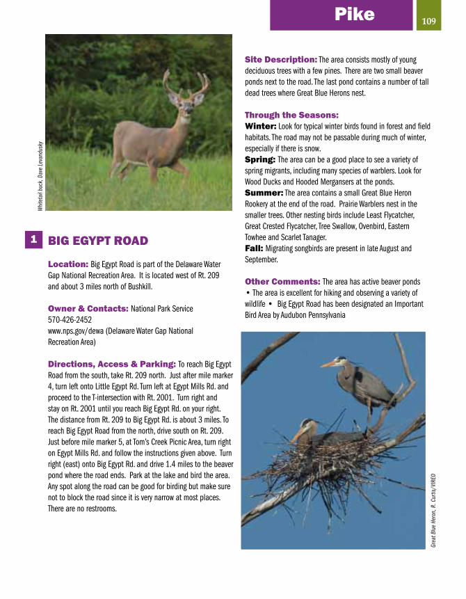
BIG EGYPT ROAD
Location: Big Egypt Road is part of the Delaware Water Gap National Recreation Area. It is located west of Rt. 209 and about 3 miles north of Bushkill.
Owner & Contacts: National Park Service570-426-2452www.nps.gov/dewa (Delaware Water Gap National Recreation Area)
Directions, Access & Parking: To reach Big Egypt Road from the south, take Rt. 209 north. Just after mile marker 4, turn left onto Little Egypt Rd. Turn left at Egypt Mills Rd. and proceed to the T-intersection with Rt. 2001. Turn right and stay on Rt. 2001 until you reach Big Egypt Rd. on your right. The distance from Rt. 209 to Big Egypt Rd. is about 3 miles. To reach Big Egypt Road from the north, drive south on Rt. 209. Just before mile marker 5, at Tom’s Creek Picnic Area, turn right on Egypt Mills Rd. and follow the instructions given above. Turn right (east) onto Big Egypt Rd. and drive 1.4 miles to the beaver pond where the road ends. Park at the lake and bird the area. Any spot along the road can be good for birding but make sure not to block the road since it is very narrow at most places. There are no restrooms.
Site Description: The area consists mostly of young deciduous trees with a few pines. There are two small beaver ponds next to the road. The last pond contains a number of tall dead trees where Great Blue Herons nest.
Through the Seasons:Winter: Look for typical winter birds found in forest and field habitats. The road may not be passable during much of winter, especially if there is snow.Spring: The area can be a good place to see a variety of spring migrants, including many species of warblers. Look for Wood Ducks and Hooded Mergansers at the ponds. Summer: The area contains a small Great Blue Heron Rookery at the end of the road. Prairie Warblers nest in the smaller trees. Other nesting birds include Least Flycatcher, Great Crested Flycatcher, Tree Swallow, Ovenbird, Eastern Towhee and Scarlet Tanager. Fall: Migrating songbirds are present in late August and September.
Other Comments: The area has active beaver ponds • The area is excellent for hiking and observing a variety of wildlife • Big Egypt Road has been designated an Important Bird Area by Audubon Pennsylvania
1
109PikeW
hite
tail
buck
, Dav
e Le
vand
usky
Grea
t Blu
e He
ron,
R. C
urtis
/VIR
EO

110
BRuCE LAKENATuRAL AREA
Location: Bruce Lake is located on the south side of I-84, between Routes 390 and 402 and just north of Promised Land State Park.
Owner & Contacts: PA Bureau of Forestry, Delaware State Forest (2,845 acres)717-895-4000 (District Forester)www.dcnr.state.pa.us./FORESTRY/stateforests/delawarenatural.aspx
Directions, Access & Parking: From the interchange of I-84 and Rt. 390, go south about 0.1 miles to a small parking lot on your left. A trail leads from this parking lot to Egypt Meadow Lake and Bruce Lake. Egypt Meadow Lake is a short (0.4 mile) hike but the hike to Bruce Lake is a little over 2 miles. Be sure to get a Promised Land Trail System map before heading out to bird as there are lots of trails and the area is very large. Maps are available at map boxes at each parking lot or at Promised Land State Park headquarters. Map boxes may be empty some of the time. To reach the second parking area, drive south on Rt. 390 and look for the parking lot on the right. There is a third parking area on the left side of Rt. 390 a little further south. The trail system extends south into Promised Land State Park. There are no restrooms.
Site Description: The Bruce Lake Natural Area consists of mature deciduous and coniferous forest, swamps, riparian habitat and Bruce Lake and Egypt Meadows Lake.
Through the Seasons:Winter: Look for typical winter birds to be found in a forest habitatSpring: The Bruce Lake Natural Area is an excellent place to see a variety of spring migrants, including many species of warblers. Look for migrating waterfowl on Bruce Lake and Egypt Meadows Lake in March and April. Summer: There is a Great Blue Heron rookery at Bruce Lake. A large variety of warblers and other woodland and grassland birds nest in the area.Fall: The area is an excellent place to see migrating songbirds in late August and September. Migrating waterfowl can be present in October and November.
Other Comments: Bruce Lake is a natural glacial lake. • The area is excellent for hiking and observing a variety of wildlife. • The area has been designated an Important Bird Area by Audubon Pennsylvania.
2
Blac
k Be
ar, C
ourte
sy o
f Nat
iona
l Par
k Se
rvice
Canv
asba
ck, F
. Leu
ng/iS
tock
phot
o.co
m

111
ESHBACH’S FARM
Location: Eshbach’s Farm is part of the Delaware Water Gap National Recreation Area. It is located between Rt. 209 and the Delaware River, midway between mile markers 6 and 7, just north of Tom’s Creek Picnic Area.
Owner & Contacts: Delaware Water Gap National Recreation Area, National Park Service570-426-2452www.nps.gov/dewa
Directions, Access & Parking: As noted above, the farm is located on the east side of Rt. 209 between mile markers 6 and 7. Look for the sign to the Eshbach Boat Launch. Drive back on the dirt road until you reach the boat launch area at the river. Here you will find a small parking lot at the boat launch and an outdoor toilet. There is a farm complex on the west side of Rt. 209 not far from the road to the boat launch
Site Description: The area consists of cultivated and fallow fields, riparian habitat along the Delaware River, and the Delaware River. Most of the area is in fields but some of the best birding can be found in the tall trees along the Delaware River.
Through the Seasons: Winter: Look for waterfowl and Bald Eagles along the Delaware River. Wintering sparrows may be found in the weedy fields.Spring: The trees along the river can be a good place to find migrating songbirds including vireos, warblers, Scarlet Tanager and Baltimore Oriole. Migrating waterfowl can be found on the Delaware River in March and April. Bald Eagle and Osprey may be present.Summer: Nesting birds include Great Crested Flycatcher, Eastern Kingbird, Warbling Vireo, several species of warblers, Indigo Bunting and Baltimore Oriole.Fall: Look for migrating songbirds in August and September. Raptors and waterfowl may be present from September through November.
Other Comments: A boat launch provides easy access to the Delaware River. • The area is an excellent place to see wildlife. • The farm has been designated an Important Bird Area by Audubon Pennsylvania.
3
PikeRo
se-b
reas
ted
Gros
beak
, Bill
Rabo
in/iS
tock
phot
o.co
m
Com
mon
Mer
gans
er (f
emal
e), D
an K
unkle

112
LACKAWAxEN RIvER/EAGLE INSTITuTE OFFICE
Location: The Eagle Institute office is located in Lackawaxen, at the west end of the Roebling Bridge.
Owner & Contacts: Eagle Institute 845-557-6162176 Scenic Dr., Lackawaxen, PA www.eagleinstitute.org
Directions, Access & Parking: From the Hawley area, follow Rt. 590 along the Lackawaxen River. Turn left at Lackawaxen firehouse. Follow Scenic Dr. to Robeling Bridge. The office is at the entrance to the bridge. From the Milford area, follow U.S. 6 west about 15 miles to Rt. 434. Turn right at the Exxon station; stay straight when Rt. 434 turns into Rt. 590 in Greeley. Follow Rt. 590 north to Lackawaxen, cross the railroad tracks, and follow the signs to Roebling Bridge. There is a nice, paved parking lot next to the bridge. Restrooms are available.
Site Description: The area includes the Delaware River and the adjacent river bottom forest.
Through the Seasons: Winter: The main attraction in winter is the number of Bald Eagles that can be seen along the Delaware River. Also look for waterfowl.Spring: Look for migrating waterfowl in March and April. The trees along the river are a good place to look for spring migrants. The best place in the area to see spring migrants might be along the canal towpath on the New York side of the Delaware River.Summer: Rough-winged and Cliff swallows nest at the bridge. Warbling Vireo nest in the tall trees along the river.Fall: Look for migrating songbirds and waterfowl. Bald Eagles arrive for the winter in late fall.
Other Comments: The area is part of the Upper Delaware River National Scenic and Recreation River. • The Upper Delaware watershed hosts the largest number of wintering Bald Eagles in the northeast, and a growing year round population of eagles has made the area an ideal location for eagle watching. • Take a walk or drive across the Historic 1848 Delaware Aqueduct (Roebling Aqueduct) to Minisink Ford, New York. • Other places to visit include the Eagle Institute office at the west end of the bridge and the Zane Grey Museum (570-685-4871) that is located in the home where Zane Grey lived from 1914-1918. The museum is open seasonally, usually Memorial Day Weekend through Labor Day Weekend. • The area has been designated an Important Bird Area by Audubon Pennsylvania.
4
Bald
Eag
le

113
PECKS POND
Location: The pond is located on the east side of Rt. 402, adjacent to the Village of Pecks Pond.
Owner & Contacts: Delaware State Forest, Pecks Pond – (420 acres)717-895-4000www.peckspond.com/ (marina)
Directions, Access & Parking: From the north, at the intersection of I-80 and Rt. 402, go south on Rt. 402 for about 6.5 miles. Pecks Pond is on the east side of Rt. 402. From the south, at the intersection of Rt. 402 and Rt. 2004, go north on Rt. 402 for about 2 miles.
Site Description: The main feature of this site is Peck’s Pond, a large, shallow lake with a forested shoreline and many marshy areas. A canoe, kayak or rowboat is needed to bird the area since most of the shore is inaccessible by foot. Boats can be rented at Pecks Pond Marina along Rt.402. The area also contains early successional forest, riparian habitat and a stream. Pecks Pond is part of the Delaware State Forest.
Through the Seasons:Winter: Look for forest birds such as woodpeckers, nuthatches and chickadees. There may be waterfowl on the pond in areas where the water remains unfrozen.Spring: Pecks Pond can be a good place to view migrating loons, grebes, other waterfowl and herons. Look for Ospreys and Bald Eagles. Numbers of migrating songbirds are often present in May. Summer: A variety of nesting warblers and other songbirds nest in the forest surrounding Pecks Pond.Fall: Migrating songbirds are present in early fall while waterfowl can be found in October and November.
Other Comments: The pond ecosystem is an important feature of Pecks Pond. • Pecks Pond offers a true back-to-nature escape. The pond is a quiet, peaceful place to fish and boat at your leisure. • The Pecks Pond Marina has a bait and tackle shop, USGS maps, and a map of Pecks Pond Lake. There is a lake view restaurant and a Pennsylvania Fishing Museum.
5
PikePi
ed-b
illed
Gre
be, J
emin
i Jos
eph/
iSto
ckph
oto.
com
Ceda
r Wax
wing
, G. F
riede
n /iS
tock
phot
o.co
m

114
POCONO ENvIRONMENTALEDuCATION CENTER
Location: The Center is located within the Delaware Water Gap National Recreation Area, just west of U.S. 209, about 0.5 miles west of the Village of Dingman’s.
Owner & Contacts: Pocono Environmental Education Center (1,000+ acres)570-828-2319RR 2, Box 1010, Dingmans Ferry, PA 18328www.peec.org/
Directions, Access & Parking: From the north, at the interchange of I-80 and U.S. 209, take U.S. 209 south through Milford and Dingmans Ferry. Look for the sign to the Center between mile marker 8 and 9. Turn right on Briscoe Mountain Rd., proceed 0.5 miles, and turn right again to reach the Visitor Education and Administration Building Center. There is plenty of parking at the Center. From the south, take U.S. 209 north and look for the sign to PEEC after you pass mile marker 8. Turn left and drive a short distance to the Center. There are restrooms.
Site Description: The Pocono Environmental Education Center (PEEC) is located within the Delaware Water Gap National Recreation Area. The primary habitats include mature deciduous forest, mature coniferous forest, several small ponds and riparian buffer. There are 13 miles of trails. Be sure to get a trail map at the Visitor Center. There are individual maps for many of the trails. Canoeing is possible on the ponds. The Visitor Education and Administrative Building is the hub of activity at PEEC. The building houses two classrooms, a library, craft center, darkroom, store, indoor pool, offices, educational displays, and meeting areas for presentations and dances. There are 47 cabins that can comfortably sleep from two to 16 persons on wooden bunk beds. All cabins have modern facilities.
Through the Seasons:Winter: Look for birds typically found in a mainly wooded environment. Rare species found at PEEC in winter have included Black-backed Woodpecker.Spring: PEEC is an excellent place to see a large variety of migrating songbirds, especially warblers. Herons may be present at the ponds.Summer: Many species of warblers and other songbirds nest in the area. Fall: This is a good time to look for migrating songbirds. The best time to bird PEEC in fall is September.
Other Comments: The Center offers a large variety of events and educational workshops. Major improvements have been made in recent years. Improvements for 2008 included repaved campus roads, refurbished cabins, and the addition of recreation areas for volleyball and basketball. • PEEC has been designated an Important Bird Area by Audubon Pennsylvania.
6
Mou
ntai
n La
urel
, Cou
rtesy
of N
atio
nal P
ark
Serv
ice

115
PROMISED LANDSTATE PARK
Location: The park is located about 10 miles north of Canadensis, on both sides of Rt. 390.
Owner & Contacts: PA Department of Conservation and Natural Resources (about 3,000 acres)570-676-3428RR 1, Box 96, Greentown, PA 18426-9735www.dcnr.state.pa.us/stateparks/promisedland.aspx
Directions, Access & Parking: To access the park from the south, at the intersection of Rt. 390 and Rt.447 in Canadensis, go north through Skytop for about 10 miles. To reach the park from the north, at the interchange of I-84 and Rt. 390, go south of Rt. 390 for about 3 miles.
Site Description: Promised Land State Park contains extensive mature deciduous and coniferous forest. There are two large lakes: Promised Land Lake–422 acres, and Lower Lake–173 acres. There are 50 miles of hiking trails in the park and surrounding Delaware State Forest that provide access to many natural scenic areas that can be good for birding. Some of the trails extend north into the Bruce Lake Natural Area. Bikers and hikers can also share the 6.5-mile paved road around Promised Land Lake. There are a variety of facilities in the park, including restrooms, changing rooms for bathers in summer, and many places to camp. An excellent trail map and other information on the park is available at park headquarters. There are lots of picnic tables.
Through the Seasons:Winter: The park is good for woodpeckers, nuthatches and other winter birds.Spring: Look for migrating warblers and other forest birds such at Scarlet Tanager and nesting Bald Eagles at Lower Lake. The two lakes can be good for migrating waterfowl at times.Summer: Many species of warblers nest at Promised Land State Park. Fall: Look for migrating warblers in early fall and waterfowl later in the season.
Other Comments: Promised Land State Park is surrounded by 12,464 acres of Pennsylvania’s Delaware State Forest. • The two lakes are good for fishing and have five boat launch areas. Boats must display a PA boat registration sticker. • There is an active Bald Eagle nest at Lower Lake. • The park has been designated an Important Bird Area by Audubon Pennsylvania.
7
PikeBo
bcat
, Mer
lin B
enne
r
Bird
Hid
e, P
rom
ised
Land
Sta
te P
ark
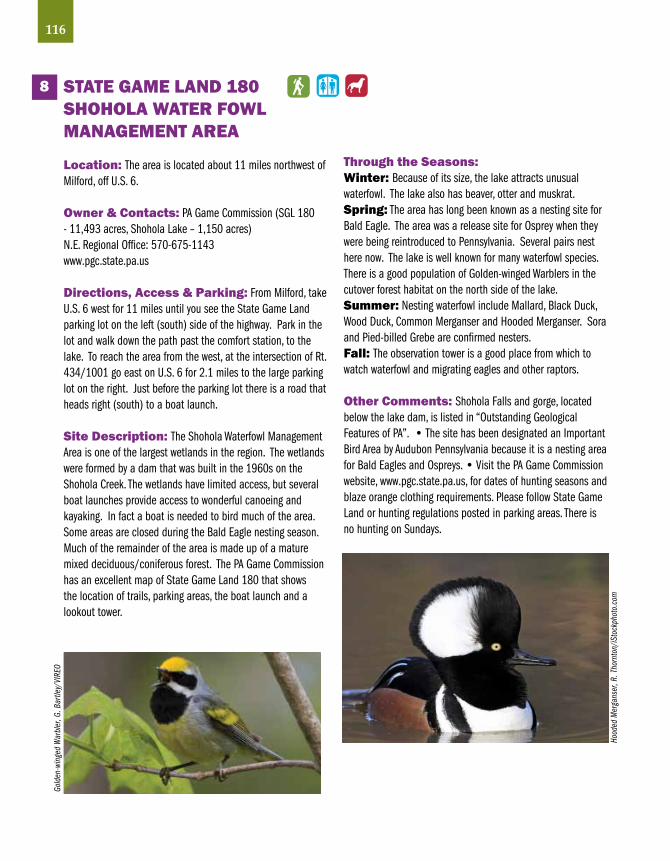
116
STATE GAME LAND 180 SHOHOLA WATER FOWLMANAGEMENT AREA
Location: The area is located about 11 miles northwest of Milford, off U.S. 6.
Owner & Contacts: PA Game Commission (SGL 180 - 11,493 acres, Shohola Lake – 1,150 acres) N.E. Regional Office: 570-675-1143www.pgc.state.pa.us
Directions, Access & Parking: From Milford, take U.S. 6 west for 11 miles until you see the State Game Land parking lot on the left (south) side of the highway. Park in the lot and walk down the path past the comfort station, to the lake. To reach the area from the west, at the intersection of Rt. 434/1001 go east on U.S. 6 for 2.1 miles to the large parking lot on the right. Just before the parking lot there is a road that heads right (south) to a boat launch.
Site Description: The Shohola Waterfowl Management Area is one of the largest wetlands in the region. The wetlands were formed by a dam that was built in the 1960s on the Shohola Creek. The wetlands have limited access, but several boat launches provide access to wonderful canoeing and kayaking. In fact a boat is needed to bird much of the area. Some areas are closed during the Bald Eagle nesting season. Much of the remainder of the area is made up of a mature mixed deciduous/coniferous forest. The PA Game Commission has an excellent map of State Game Land 180 that shows the location of trails, parking areas, the boat launch and a lookout tower.
Through the Seasons:Winter: Because of its size, the lake attracts unusual waterfowl. The lake also has beaver, otter and muskrat.Spring: The area has long been known as a nesting site for Bald Eagle. The area was a release site for Osprey when they were being reintroduced to Pennsylvania. Several pairs nest here now. The lake is well known for many waterfowl species. There is a good population of Golden-winged Warblers in the cutover forest habitat on the north side of the lake.Summer: Nesting waterfowl include Mallard, Black Duck, Wood Duck, Common Merganser and Hooded Merganser. Sora and Pied-billed Grebe are confirmed nesters.Fall: The observation tower is a good place from which to watch waterfowl and migrating eagles and other raptors.
Other Comments: Shohola Falls and gorge, located below the lake dam, is listed in “Outstanding Geological Features of PA”. • The site has been designated an Important Bird Area by Audubon Pennsylvania because it is a nesting area for Bald Eagles and Ospreys. • Visit the PA Game Commission website, www.pgc.state.pa.us, for dates of hunting seasons and blaze orange clothing requirements. Please follow State Game Land or hunting regulations posted in parking areas. There is no hunting on Sundays.
8
Gold
en-w
inge
d W
arbl
er, G
. Bar
tley/
VIRE
O
Hood
ed M
erga
nser
, R. T
horn
ton/
iSto
ckph
oto.
com

117Pike
Cana
da G
eese
, cou
rtesy
Del
awar
e &
Lehi
gh N
atio
nal H
erita
ge C
orrid
or

LegendDogsAllowedRestroomsBiking
TrailsHikingTrails
HandicappedAccessibility
Schuylkill County
1
23
4
118
5

STATE GAME LAND 110KITTATINNY RIDGE,PORT CLINTON
Location: The site is located on the north side of the Kittatinny Ridge (Blue Mountain) west of Port Clinton.
Owner & Contacts: PA Game Commission (10,000 acres)S.E. Regional Office610-926-3136www.pqc.state.pa.us
Directions, Access & Parking: From I-78, take the Hamburg exit No. 30. Follow Rt. 61 north toward Port Clinton. Turn left onto Broad Street and go about 1.2 miles to a parking area on the right.
Site Description: This 3-4 square mile area within the 10,000-acre State Gamelands No. 110 is something special. Explore ridges and valleys on short trails that overlook the forested creeks and canyons of the northern flanks of the Kittatinny Ridge. From the parking area, walk uphill along the ravine to the top of the hill. Once at the top, bear left and then make another left a bit further along the path to hike a linear 0.9-mile trail along the southwest ridge. Back at the top of the hill, follow the loop trail to the Schuylkill River and back up to the north side of the ravine.
Through the Seasons:Winter: Look for typical winter birds such as Wild Turkey, woodpeckers, nuthatches and sparrows.Spring: The ridge offers excellent songbird migration habitat. Summer: The recently logged Southwest Ridge hosts a high density of breeding warblers that include Hooded Warbler and Yellow-breasted Chat. The loop trail hosts breeding songbirds that include Great Crested Flycatcher, Blue-gray Gnatcatcher, Red-eyed Vireo and a variety of warblers. Whip-poor-will can be heard at the top of the hill and near forest edges along the ravine.Fall: The site is part of the Kittatinny Ridge raptor migration corridor. Look for migrating raptors throughout the fall. The migration along the north side of the ridge is best on days when winds are from the west or northwest. Look for migrating songbirds in late August through early October.
Other Comments: If you visit in the fall, consider visiting the world-famous Hawk Mountain Sanctuary–page 26 • The Kittatinny Ridge has been designated an Important Bird area by Audubon Pennsylvania. • Visit the PA Game Commission website, www.pgc.state.pa.us, for dates of hunting seasons and blaze orange clothing requirements. Please follow State Game Land or hunting regulations posted in parking areas. There is no hunting on Sundays.
1
119SchuylkillBl
ue-G
ray G
natc
atch
er, P
aul T
essle
r/iS
tock
phot
o.co
m

120
LOCuST LAKESTATE PARK
Location: Locust Lake State Park is located about 4 miles southwest of Mahanoy City.
Owner & Contacts: PA Department of Conservation and Natural Resources (1,089 acres) (Locust Lake – 52 acres)570-467-2404 • RR. 1 Barnesville, PA 18214www.dcnr.state.pa.us/stateparks/parks/locustlake.aspx
Directions, Access & Parking: From Pottsville, follow Rt. 61 north to St. Claire. Turn right onto Hancock St./SR 1006 at the park sign. Follow 1006 7.8 miles and turn right on SR 1011. Stay on 1011 at the stop sign (bear right), and turn right on T489 at the park sign. From I-81, Exit at 131A and follow SR1008 1.2 miles west. Turn left on SR 1006/1011 for 1 mile then turn left on SR 1011 at the park sign. Stay on 1011 at the stop sign and turn right on T489 at the park sign. Parking and restrooms are available.
Site Description: Locust Lake State Park nestles on the side of Locust Mountain and is comprised mainly of mature deciduous forest. Locust Lake is a popular fishing lake. There are two campgrounds with a total of 282 campsites located near the lake. The campgrounds are open from early April to mid-October. The concessions are open daily from Memorial Day to Labor Day and weekends during the fall. Rowboats and canoes are available for rent on an hourly and daily basis. A paved, one-mile, bike trail circles the lake. A number of hiking trails wind through the park and vary from level trails to steep, challenging trails for hearty hikers. The park gets busy during summer, especially on weekends.
Through the Seasons:Winter: Look for typical winter forest birds such as woodpeckers, nuthatches, titmice and chickadees.Spring: Migrant waterfowl can be found on Locust Lake on occasion. In May, look for Wood Thrush, Veery, Scarlet Tanager and a variety of migrating warblers.Summer: Scarlet Tanagers and several species of nesting warblers can be found.Fall: Look for migrating songbirds from late August through early October and waterfowl in October and November.
Other Comments: Hunting is permitted during season. • Locust Lake State Park is only 6 miles from Tuscarora State Park. • The state park adjoins 600 acres of Weiser State Forest. • Visit the PA Game Commission website, www.pgc.state.pa.us, for dates of hunting seasons and blaze orange clothing requirements. Please follow State Game Land or hunting regulations posted in parking areas. There is no hunting on Sundays.
2W
hite
-bre
aste
d Nu
that
ch, C
orey
Hus
ic
Red
Adm
iral,
Core
y Hus
ic
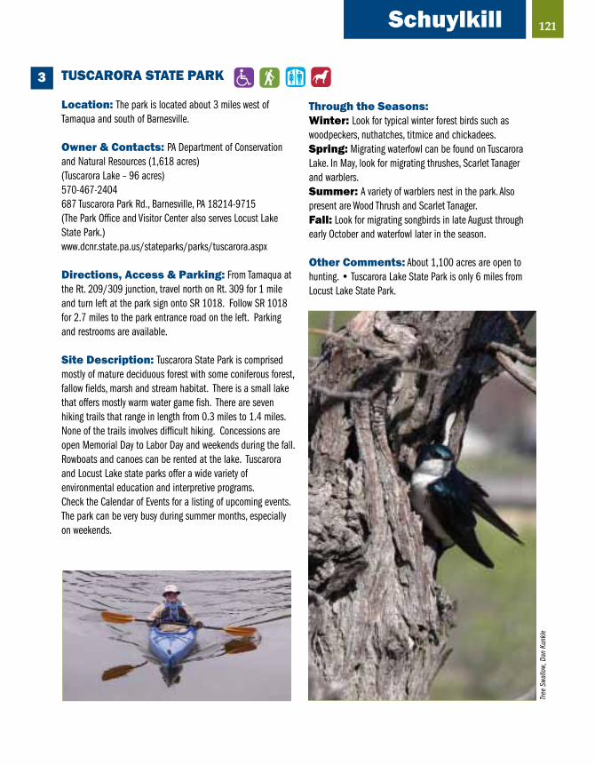
121
TuSCARORA STATE PARK
Location: The park is located about 3 miles west of Tamaqua and south of Barnesville.
Owner & Contacts: PA Department of Conservation and Natural Resources (1,618 acres) (Tuscarora Lake – 96 acres)570-467-2404687 Tuscarora Park Rd., Barnesville, PA 18214-9715(The Park Office and Visitor Center also serves Locust Lake State Park.)www.dcnr.state.pa.us/stateparks/parks/tuscarora.aspx
Directions, Access & Parking: From Tamaqua at the Rt. 209/309 junction, travel north on Rt. 309 for 1 mile and turn left at the park sign onto SR 1018. Follow SR 1018 for 2.7 miles to the park entrance road on the left. Parking and restrooms are available.
Site Description: Tuscarora State Park is comprised mostly of mature deciduous forest with some coniferous forest, fallow fields, marsh and stream habitat. There is a small lake that offers mostly warm water game fish. There are seven hiking trails that range in length from 0.3 miles to 1.4 miles. None of the trails involves difficult hiking. Concessions are open Memorial Day to Labor Day and weekends during the fall. Rowboats and canoes can be rented at the lake. Tuscarora and Locust Lake state parks offer a wide variety of environmental education and interpretive programs. Check the Calendar of Events for a listing of upcoming events. The park can be very busy during summer months, especially on weekends.
Through the Seasons:Winter: Look for typical winter forest birds such as woodpeckers, nuthatches, titmice and chickadees.Spring: Migrating waterfowl can be found on Tuscarora Lake. In May, look for migrating thrushes, Scarlet Tanager and warblers.Summer: A variety of warblers nest in the park. Also present are Wood Thrush and Scarlet Tanager.Fall: Look for migrating songbirds in late August through early October and waterfowl later in the season.
Other Comments: About 1,100 acres are open to hunting. • Tuscarora Lake State Park is only 6 miles from Locust Lake State Park.
3
Schuylkill
Tree
Swa
llow,
Dan
Kun
kle

LANDINGvILLE MARSH
Location: The site is located along the Schuylkill River, about one mile south of the Borough of Landingville.
Owner: PA Department of Environmental Protection/Bureau of Abandoned Mine Reclamation.
Directions, Access & Parking: If approaching from the south on Rt. 61, about 4 miles north of Port Clinton, take Rt. 895 West toward Auburn. After driving about 1.8 miles turn right (north) on Hickory Dr. at the Omnova Solutions sign. Go about 1.5 miles to Tunnel Rd. and turn left. Proceed another 1.1 miles to the Tunnel Road Trailhead parking lot on the right. There is plenty of parking available. The Schuylkill River Trail’s Bartram Section crosses Canal Street at the parking lot. To reach the Tunnel Road Trailhead from the small Borough of Landingville (population – 175), turn east into Cherry St. and go about a block to Canal St. Cherry St. is not much more than an alley. It is located across the road from the large Community Fire Company parking lot. Go south on Canal St., cross the one-lane bridge over the Schuylkill River, and continue south along the east side of the river. The parking lot is about 0.8 miles south of Landingville. Bird the trail in either direction from the parking lot. You can also bird along the road but watch for traffic. There are no restrooms.
Site Description: The main features of the site are the marshes and open water along the Schuylkill River. The areas along the trail are mostly wooded. Some field habitat is present on the west side of the river.
Through the Seasons:Winter: Ducks, Great Blue Herons and Belted Kingfishers may be present if the water remains open. Look for typical winter birds such as woodpeckers, titmice, chickadees, nuthatches and winter sparrows.Spring: This is the season to see a variety of waterfowl, Great Blue and Green herons, possibly bitterns and rails. The area is good for migrating warblers.Summer: Birds that breed in the area include Wood Duck, Great Crested Flycatcher, Eastern Kingbird, Wood Thrush, Yellow Warbler, Common Yellowthroat, Scarlet Tanager and Swamp Sparrow.Fall: Look for migrating warblers in late August and September and waterfowl and sparrows in October and November.
Other Comments: The PA Fish & Boat Commission has a public fishing and boating “Auburn Access” area on the west side of the river south of Landingville. To reach this area, drive south from Landingville on Meadow Dr. for about 1 mile and turn left into the parking lot.
4
122Vi
rgin
ia R
ail,
R.&
N. B
ower
s/VI
REO
Blue
Fla
g Iri
s, D
an K
unkle

123Schuylkill
RATTLING RuN – KITTATINNY RIDGE
The site is located along Rattling Run, in Port Clinton. Owner & Contacts: Port Clinton Water Co-Op.Contact information is unavailable.
Directions, Access & Parking: From I-78, take the Hamburg exit 30. Follow Rt. 61 north into Port Clinton. Turn right onto Clinton St. across Rt. 61 from the Peanut Shop and the Port Clinton Hotel. Be careful of the heavy traffic on Rt. 61 and give plenty of warning before turning onto Clinton St. Drive to the end of the street and park on the grass on the left next to Rattling Run. Cross the wooden bridge to the trail.
Site Description: Salamanders appreciate the numerous seeps that keep this 2-mile footpath along Rattling Run a bit soggy. The trail follows a lush mountain ravine of eastern hemlocks and white pines that provides ideal forest habitat for nesting birds. The area is free and open to the public year-round. Please observe any water quality regulation postings. There are no restrooms.
5
Amer
ican
Reds
tartt
(fem
ale)
, G. B
aile
y/VI
REO
Through the Seasons:Winter: Look for winter birds typically found in this type of habitat.Spring: The best times to visit Rattling Run are in spring and early summer. Migrating songbirds can be found. Look for salamanders.Summer: Nesting birds of interest include Acadian Flycatcher, Red-eyed Vireo, Veery, Wood Thrush, Worm-eating Warbler, Ovenbird and Louisiana Waterthrush.Fall: Migrating songbirds may be present during late August and September.
Other Comments: If you go in the fall, consider visiting the world-famous Hawk Mountain Sanctuary, page 25. Dogs are not allowed on Hawk Mountain property.

Guide to specialty birdsSpecies Habitat Site(s) Season
Pied-billed Grebe lakes, ponds Shohola late spring--early autumn Roosevelt Park – Phila. autumn through spring
Ross’s Goose lakes, fields Lake Ontelaunee autumn through spring
Greater White- lakes, fields Lake Ontelaunee, autumn through spring fronted Goose Green Lane, Peace Valley
Hooded Merganser lakes, ponds Shohola, Brady’s Lake late spring–early autumn
Great Blue Heron swamp (with trees) Quakertown Swamp, March–May (rookery) Big Egypt Road, Bruce Lake
American Bittern wetlands, wet meadows Long Pond, Quakertown spring Swamp, Del. Water Gap NRA HQs
Least Bittern wetlands John Heinz NWR spring–summer
virginia Rail wetlands Quakertown Swamp spring–summer John Heinz NWR
Sora wetlands Quakertown Swamp spring–summer John Heinz, Shohola, Landingville Marsh
Shorebirds mudflats, shallow water Green Lane, Cherry Valley May, Aug–Sept
Lesser Black- lakes Peace Valley, Core fall through spring backed Gull Creen, Lake Nockamixon
Iceland Gull lakes Lake Nockamixon December through March
Northern Harrier grassland Long Pond spring–autumn
Bald Eagle (nesting) lakes, rivers with forest Teekening Preserve early spring–summer Shohola, Green Lane, Core Creek, Promised Land
Osprey (nesting) lakes, rivers with forests Shohola, Teekening spring–summerPeregrine Falcon cliffs, tall structures Teekening Preserve early spring--summer
124

125
Guide to specialty birds (continued)
Species Habitat Site(s) Season
Migrating raptors ridges Hawk Mt. Sanctuary autumn (some in spring) Bake Oven Knob, Kittatinny Ridge sites
Red-headed open woods and Delaware Water Gap spring–autumn Woodpecker swamps HQs, Green Lane
Common Nightwaks bare rocks, roofs Lehigh Gap Nature Ctr. summer–early autumn
Prairie Warbler scrub Lehigh Gap Nature Ctr. spring—mid summer Long Pond, Nottingham
Golden-winged scrub Shohola, Long Pond spring—mid summer Warbler
Yellow-throated riparian forest and Washington’s Crossing, spring—mid summer Warbler along canal Unami Creek, Hugh Moore Park, D&L Trail
Cerulean Warbler mature forest Leaser Lake, Bake Oven spring—mid summer Knob, Washington’s Crossing
Worm-eating forest Leaser Lake, Bake Oven spring—mid summer Warbler Knob, Unami Creek SGL 106/Pine Swamp
Blue Grosbeak grassland Lehigh Gap Nature Ctr. summer Tyler State Park
Grassland Sparrows grassland Leaser Lake, Tyler spring—mid summer State Park, Beltzcville Cherry Valley
Eastern Meadowlark grassland Leaser Lake, Tyler State Park spring–early summer Long Pond Cherry Valley, Blue Marsh Lake
Bobolink grassland Leaser Lake, Long Pond spring–early summer

126
ResourcesGeneralDelaware & Lehigh National Heritage CorridorWeb: www.delawareandlehigh.org
Schuylkill River Heritage AreaPhone: 484-945-0200Web: www.schuylkillriver.org
Pennsylvania AudubonWeb: http://pa.audubon.org
PA Department of Conservation and Natural ResourcesWeb: www.dcnr.state.pa.us
Berks CountyGreater Reading Convention and Visitors Bureau2525 N. 12th Street, Suite 101Reading, PA 19605Phone: 800-443-6610Web: www.readingberkspa.com
Baird Ornithological Club, Reading, PAWeb:http://hometown.aol.com/kargardner/myhomepage/pagebaird.htm
Bucks CountyBucks County Conference and Visitors Bureau3207 Street Road, Bensalem, PA 19020Phone: 215-639-0300Web: www.buckscountycvb.org
Bucks County Audubon Society6324 Upper York RoadNew Hope, Pennsylvania 18938Phone: 215-297-5880Web: www.bcas.org
Carbon, Monroe, Pike, and Wayne CountyPocono Mountains Visitors Bureau1004 Main Street Stroudsburg, PA 18360Phone: 800-762-6667Web: www.800poconos.com
Northeast PA Audubon SocietyBox 711 Honesdale, Pennsylvania 18431 Phone: (570) 253-9250Web: www.nepaaudubonsociety.org
Monroe County Conservation District Environmental Education Center8050 Running Valley RoadStroudsburg, PA 18360Phone: 570-629-3061Web: www.mcconservation.org/EnvironEducation/abouteecenter.html
Chester CountyChester County Conference and Visitors Bureau400 Exton Square Parkway, Exton, PA 19341Phone: 800-228-9933Web: www.brandywinevalley.com
Delaware CountyBrandywine Conference and Visitors BureauOne Beaver Valley RoadChadds Ford, PA 19317Phone: 800-343-3983Web:www.brandywinecvb.org

127
Lehigh and Northampton CountyLehigh Valley Convention and Visitors Bureau840 Hamilton Street, Suite 200Allentown, PA 18101Phone: 800.747.0561Web: www.lehighvalleypa.org
Lehigh Valley Audubon SocietyP.O. Box 290Emmaus, PA 18049Web: www.lehigh.edu/~bcm0/lvas/index.html
Luzerne CountyLuzerne County Convention and Visitors Bureau56 Public Square, Wilkes Barre, PA 18701Phone: 888-905-2872Web: www.tournepa.comMontgomery CountyValley Forge Convention and Visitors Bureau600 West Germantown Pike, Suite 130Plymouth Meeting, PA 19462Phone: 800.441.3549Web: www.valleyforge.org/Visitors
Valley Forge AudubonWeb: www.valleyforgeaudubon.org
PhiladelphiaGreater Philadelphia Tourism and Marketing Corp. 30 S. 17th Street, Suite 1710Philadelphia, PA 19103Phone: 215-599-0776Web: www.philadelphiausa.travel/www.gophila.com
Academy of Natural Sciences1900 Benjamin Franklin ParkwayPhiladelphia, PA 19103 Web: www.ansp.org
Delaware Valley Ornithological Clubc/o Academy of Natural SciencesWeb: www.dvoc.org/Main.htm
Wyncote Audubon SocietyWeb: www.wyncoteaudubon.org
Schuylkill CountySchuylkill County Visitors Bureau200 E. Arch Street, Pottsville, PA 17901Phone: 800-765-7282Web: www.schuylkill.org
Resources (continued)
Snow
Gee
se, S
teve
n P.
For
dyce

128
My Birding Notes:

129
My Birding Notes:

Auburn Lookout-SGL 110 ...............................................24Bake Oven Knob ............................................................59Beltzville State Park .......................................................42Benjamin Rush State Park ............................................105Big Egypt Road ............................................................109Black Rock Sanctuary ....................................................49Blue Marsh Lake ............................................................26Bowman’s Hill/Washington Crossing Historic Park ..........38Brady’s Lake Natural Area-SGL 127 ................................77Bruce Lake Natural Area...............................................110Carbon County Environmental Education Center .............41Cherry Valley, Blakeslee Farm .........................................81Churchville Nature Center ..............................................29Core Creek County Park ..................................................30Council Cup Scenic Overlook ..........................................69D & L Trail ......................................................................94Delaware Water Gap NRA Park HQ ..................................79Delaware Water Gap ......................................................75Eshbach’s Farm ............................................................111Evansburg State Park .....................................................83F.D. Roosevelt Park .......................................................102Fairmont Park System ..................................................101Five Mile Woods .............................................................31Frank Farm Recreation Area ...........................................65French Creek State Park .................................................19Green Lane Reservoir, Green Lane Park ..........................84Hawk Mountain Sanctuary .............................................25Hay Creek-French Creek State Park ................................19Hickory Run State Park ..................................................43Hugh Moore Historical Park ...........................................99Jacobsburg Environmental Education Center ..................93John Heinz National Wildlife Refuge at Tinicum ..............55John James Audubon Center at Mill Grove ......................90Jordan Creek Parkway ....................................................63Kirby Park Natural Area ..................................................70Kittatinny Ridge .............................................................66Kittatinny Ridge Mountaintop-SGL 110 ..........................22Kittatinny Ridge, Northkill Gap-SGL 110 .........................23Kittatinny Ridge, Port Clinton-SGL 110 .........................119Lackawaxen River/Eagle Institute Office .......................112Lake Ontelaunee ............................................................20Landingville Marsh .......................................................122Leaser Lake ...................................................................60Lehigh Gap Nature Center ..............................................61Lehigh Gorge State Park .................................................44
Little Lehigh Parkway .....................................................62Locust Lake State Park ................................................120 Long Pond/Hypsy Gap....................................................78Martins Creek Environmental Preserve ...........................95Minsi Lake and Bear Swamp ..........................................96Mocanaqua Loop Trail ....................................................71 Monocacy Nature Center................................................97Nescopeck State Park ....................................................72Nockamixon State Park ..................................................32Nolde Forest E.E. Center .................................................27Norristown Farm Park .....................................................85Nottingham County Park ................................................52Palmerton Superfund Site ..............................................47Peace Valley County Park ...............................................33Peck’s Pond .................................................................113Pennypack Creek Park ..................................................104Perkiomen Trail North Section ........................................86Pickering Creek Trail - West Pikeland Township................51Pine Swamp ...................................................................21Pocono Environmental Education Center ......................114Pocono Mountains .........................................................74Promised Land State Park ............................................115Quakertown Swamp .......................................................37Rattling Run .................................................................123Reservoir Park ................................................................98Ridley Creek State Park ..................................................56Seven Tubs Nature Area..................................................73Shohola Water Fowl Management Area-SGL 180 ..........116Silver Lake Nature Center...............................................34Spring Mountain ............................................................87State Game Land 110 ...................................... 21-24, 119State Game Land 127 ....................................................77State Game Land 180 ..................................................116Tannersville Cranberry Bog .............................................80Tinicum County Park/Giving Pond Recreation Area .........35Trexler Nature Preserve ..................................................64Tuscarora State Park ....................................................121Tyler Arboretum ..............................................................57Tyler State Park ..............................................................36Unami Creek Valley ........................................................88Valley Forge National Historical Park ..............................89Warwick County Park ......................................................50White Clay Creek Preserve ..............................................53Wissahickon Creek Park ...............................................103
Site Index (SGL = State Game Land)
130

Regional Map

Eastern Pennsylvania
BIRDING & WILDLIFE GUIDE
Eastern Pennsylvania
BIRDING & WILDLIFE GUIDE
Eastern Pennsylvania contains many habitats that contribute to a wealth of birding opportunities. If you’re a visitor to the area, this guide will help direct you to a myriad of nature experiences available in this section of Pennsylvania. If you’re a Pennsylvania resident looking for some new areas to explore, or want to find a spot you’ve been hearing about, this guide will help get you there.
Park
Ran
ger w
ith A
mer
ican
kes
tral,C
hest
er C
ount
y Pa
rks
Blue
Mar
sh L
ake,
SRH
A
Dela
ware
Wat
er G
ap N
WR
Dani
el P
. Cre
ight
on