1
Old Timers Graham Creek North Canyon Pine Point Middle Mountain Pine River 524 6 9 8 7 1 7 7 1 9 697 7 1 2 7 09 707 8 0 7 716 7 1 3 7 0 8 711 710 694 699 7 0 1 696 6 9 5 702 700 7 1 8 715 620 135 US-160 1 3 3 CTY-501 6 0 4 1 6 0 6 0 8 1 5 0 7 5 5 1 3 5 . A 0 6 9 1 31 CTY-526 7 5 5 . A 601 ST-521 C T Y- 5 2 7 US-160B 131.C 755.A1 755.C BAYFIELD The U.S. Department of Agriculture (USDA) prohibits discrimination in all its programs and activities on the basis of race, color, national origin, age, disability, and where applicable, sex marital status, familial status, parental status, religion, sexual orientation, genetic information, political beliefs, reprisal, or because all or part of an individuals income is derived from any public assistance program. (Not all prohibited bases apply to all programs.) Persons with disabilities who require alterative means for communication of program information (Braille, large print, audio tape, ect.) should contact USDA’S TARGET Center at (202) 720-2600 (voice and TDD). To file a complaint of discrimination, write to USDA, Director, Office of Civil Rights, 1400 Independence Avenue, S.W., Washington, D.C. Designated routes open to motorized use are represented by the symbols in the legend. All other routes are closed to motorized use. This map is meant to be used to identify open roads and trails and as a supplement to other maps such as the Forest Visitor Map, or a USGS Topographic map. IT IS NOT INTENDED TO BE USED SOLELY FOR NAVIGATION. Vehicles used for off-highway recreation on all public lands must comply with Colorado law requiring the registration of all terrain vehicles (ATVs), unlicensed motorcycles (dirt bikes), and unlicensed four-wheel drives. Registration fees fund the Colorado OHV Program. For more information go to: http://parks.state.co.us/ Motorized access off of designated routes for various permitted activities (such as livestock operations, minerals exploration, timber sales, firewood cutting, recreation special uses, etc.) is allowed under the specific terms and conditions of the permit and/or contract. BEAVER MEADOWS AND SAULS CREEK TRAVEL MAP San Juan National Forest Columbine Ranger District September 2011 Columbine Ranger District 367 Pearl St Bayfield, CO 81122 970-884-2512 160 25 70 DENVER DURANGO VICINITY MAP Legend Day Use Area Campground Landscape Boundary - Travel Restricted to Designated Routes Dispersed Camping - See Note Below Roads Open to All Vehicles, Yearlong Roads Open to All Vehicles, Seasonal Roads Open to Highway Legal Vehicles Only, Yearlong State or US Highway Other Public Roads Trails Open to Wheeled Vehicles Only < 50" or Less in Width, Seasonal Cities and Towns Non-Forest Service Lands Motor vehicle use off of designated roads for the purpose of dispersed camping is permitted on NFS lands for up to 300 feet from the centerline of the road unless other restrictions apply. DISPERSED CAMPING This map dated 9/2011 shows National Forest System Roads, and National Forest System Trails in the Sauls Creek and Beaver Meadows Travel Management Area. These lands are managed by the Columbine Ranger District of the San Juan National Forest. Every effort has been made to standardize signage on roads and trails. Roads that are open for motorized use are displayed with a sign (typically a road number and/or road name). Trail users should pay close attention to signs, especially the symbols explaining what the route is open to. All trail users are expected to follow ethics associated with Leave No Trace and Tread Lightly! Programs, such as: recognizing when trails are too wet and muddy for use; staying on designated trails and not creating new ones; no cutting switchbacks; and packing-out what you pack-in. All summer motor vehicle use is restricted to the designated routes shown on this map, and CROSS COUNTRY TRAVEL IS PROHIBITED. Any road or trail not on this Travel Map is officially closed to motorized use. This map is not intended to display winter travel designations. PURPOSE AND CONTENTS OF THIS MAP Stay the Trail - www.staythetrail.org Tread Lightly - www.TreadLightly.org Leave No Trace - www.lnt.org San Juan National Forest - www.fs.usda.gov/sanjuan FOR ADDITIONAL INFORMATION

EAST FLORIDA E #597.E Upper Lemon - Uncover … require alterative means for communication of program information ... lands for up to 300 feet from the centerline of the road ... Leave

Embed Size (px)

Citation preview

MIDDLE MTN #724

Miller

Old Timers

Graham Creek

North Canyon

Pine Point

MiddleMountain

Pine River

Vallecito

Upper Lemon

EAST FLORIDA E #597.E

524

69 8

7 17 7 19

697

712 709

707

807

716

713

708

711

710

694

699

7 0 1

696695702

700

718

715

620

135

US-160

13 3

CTY-5

01

6 04

160

608

150

75 5

135.A

069

131

CTY-5

26

755.A

601

ST-521

CTY-527

US-160B

131.C

755.A

1

755.CBAYFIELD

The U.S. Department of Agriculture (USDA)prohibits discrimination in all its programs andactivities on the basis of race, color, nationalorigin, age, disability, and where applicable, sexmarital status, familial status, parental status,religion, sexual orientation, genetic information,political beliefs, reprisal, or because all or part ofan individuals income is derived from any publicassistance program. (Not all prohibited basesapply to all programs.) Persons with disabilitieswho require alterative means for communicationof program information (Braille, large print, audiotape, ect.) should contact USDA’S TARGETCenter at (202) 720-2600 (voice and TDD). Tofile a complaint of discrimination, write to USDA,Director, Office of Civil Rights, 1400Independence Avenue, S.W., Washington, D.C.

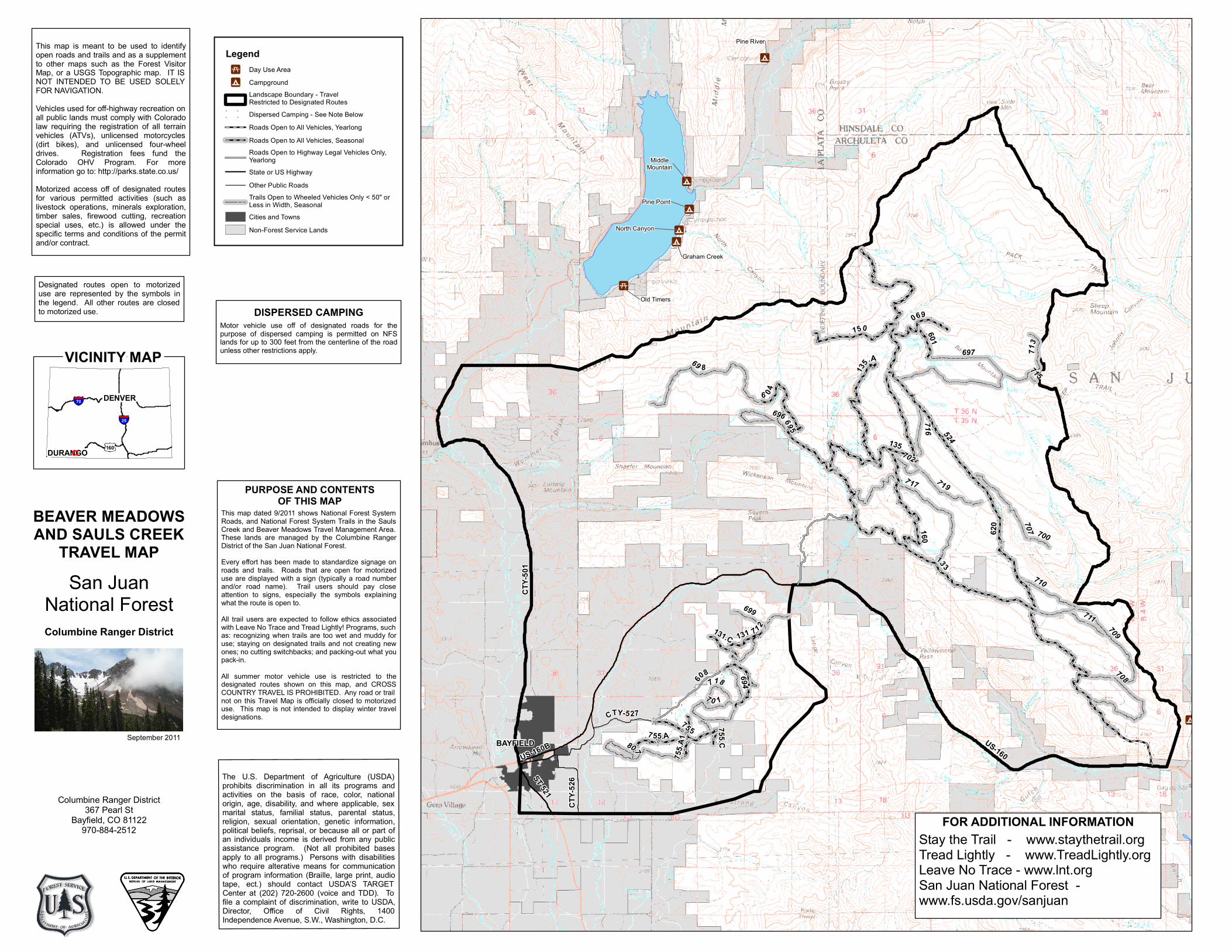
Designated routes open to motorizeduse are represented by the symbols inthe legend. All other routes are closedto motorized use.

This map is meant to be used to identifyopen roads and trails and as a supplementto other maps such as the Forest VisitorMap, or a USGS Topographic map. IT ISNOT INTENDED TO BE USED SOLELYFOR NAVIGATION.Vehicles used for off-highway recreation onall public lands must comply with Coloradolaw requiring the registration of all terrainvehicles (ATVs), unlicensed motorcycles(dirt bikes), and unlicensed four-wheeldrives. Registration fees fund theColorado OHV Program. For moreinformation go to: http://parks.state.co.us/Motorized access off of designated routesfor various permitted activities (such aslivestock operations, minerals exploration,timber sales, firewood cutting, recreationspecial uses, etc.) is allowed under thespecific terms and conditions of the permitand/or contract.

BEAVER MEADOWSAND SAULS CREEK

TRAVEL MAPSan Juan

National ForestColumbine Ranger District

September 2011

Columbine Ranger District367 Pearl St

Bayfield, CO 81122970-884-2512

160

25

70 DENVER

DURANGO

VICINITY MAP

LegendDay Use AreaCampgroundLandscape Boundary - TravelRestricted to Designated RoutesDispersed Camping - See Note BelowRoads Open to All Vehicles, YearlongRoads Open to All Vehicles, SeasonalRoads Open to Highway Legal Vehicles Only, YearlongState or US HighwayOther Public RoadsTrails Open to Wheeled Vehicles Only < 50" or Less in Width, SeasonalCities and TownsNon-Forest Service Lands

Motor vehicle use off of designated roads for thepurpose of dispersed camping is permitted on NFSlands for up to 300 feet from the centerline of the roadunless other restrictions apply.

DISPERSED CAMPING

This map dated 9/2011 shows National Forest SystemRoads, and National Forest System Trails in the SaulsCreek and Beaver Meadows Travel Management Area.These lands are managed by the Columbine RangerDistrict of the San Juan National Forest.Every effort has been made to standardize signage onroads and trails. Roads that are open for motorizeduse are displayed with a sign (typically a road numberand/or road name). Trail users should pay closeattention to signs, especially the symbols explainingwhat the route is open to.All trail users are expected to follow ethics associatedwith Leave No Trace and Tread Lightly! Programs, suchas: recognizing when trails are too wet and muddy foruse; staying on designated trails and not creating newones; no cutting switchbacks; and packing-out what youpack-in.All summer motor vehicle use is restricted to thedesignated routes shown on this map, and CROSSCOUNTRY TRAVEL IS PROHIBITED. Any road or trailnot on this Travel Map is officially closed to motorizeduse. This map is not intended to display winter traveldesignations.

PURPOSE AND CONTENTSOF THIS MAP

Stay the Trail - www.staythetrail.orgTread Lightly - www.TreadLightly.orgLeave No Trace - www.lnt.orgSan Juan National Forest -www.fs.usda.gov/sanjuan

FOR ADDITIONAL INFORMATION