Embed Size (px)
Citation preview
East End Historical Makers Driving Tour 1
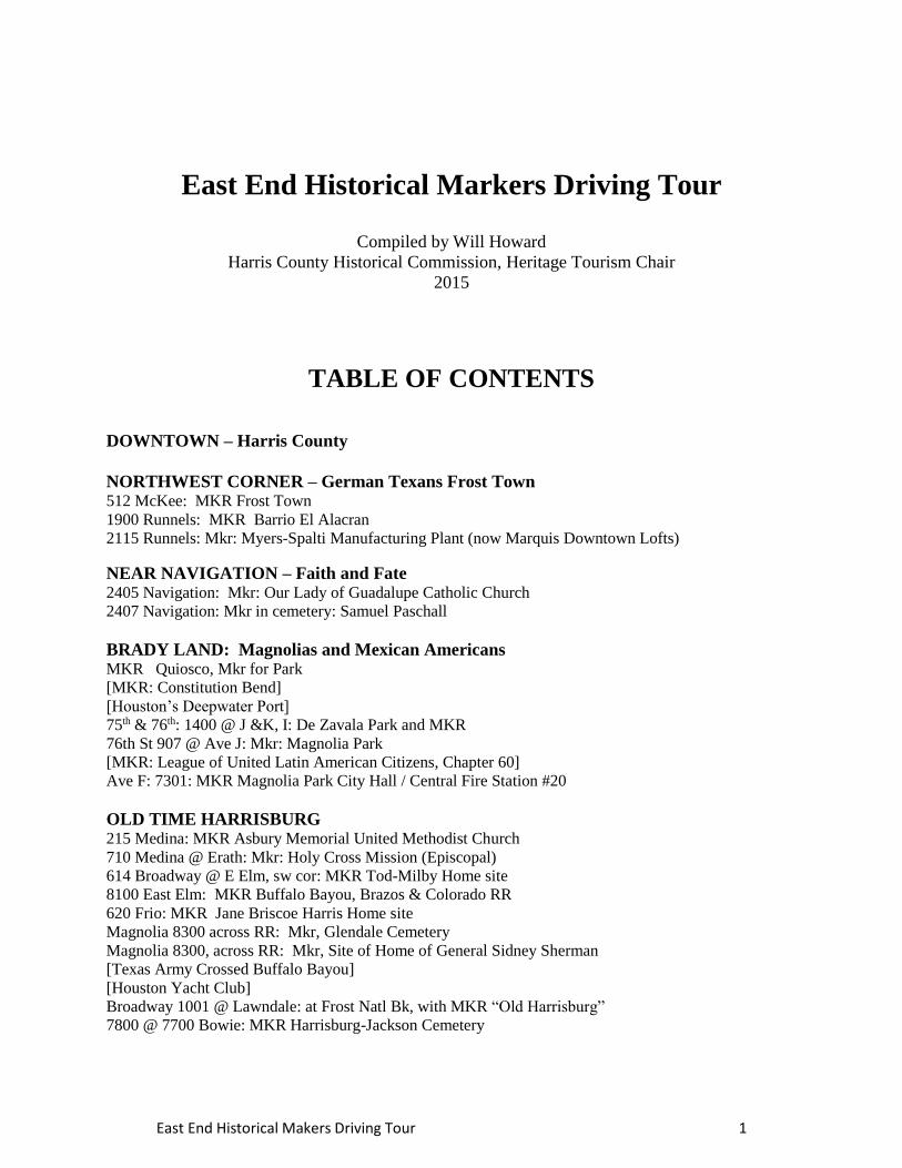
East End Historical Markers Driving Tour
Compiled by Will Howard
Harris County Historical Commission, Heritage Tourism Chair
2015
TABLE OF CONTENTS
DOWNTOWN – Harris County
NORTHWEST CORNER – German Texans Frost Town 512 McKee: MKR Frost Town
1900 Runnels: MKR Barrio El Alacran
2115 Runnels: Mkr: Myers-Spalti Manufacturing Plant (now Marquis Downtown Lofts)
NEAR NAVIGATION – Faith and Fate 2405 Navigation: Mkr: Our Lady of Guadalupe Catholic Church
2407 Navigation: Mkr in cemetery: Samuel Paschall
BRADY LAND: Magnolias and Mexican Americans MKR Quiosco, Mkr for Park
[MKR: Constitution Bend]
[Houston’s Deepwater Port]
75th & 76th: 1400 @ J &K, I: De Zavala Park and MKR
76th St 907 @ Ave J: Mkr: Magnolia Park
[MKR: League of United Latin American Citizens, Chapter 60]
Ave F: 7301: MKR Magnolia Park City Hall / Central Fire Station #20
OLD TIME HARRISBURG 215 Medina: MKR Asbury Memorial United Methodist Church
710 Medina @ Erath: Mkr: Holy Cross Mission (Episcopal)
614 Broadway @ E Elm, sw cor: MKR Tod-Milby Home site
8100 East Elm: MKR Buffalo Bayou, Brazos & Colorado RR
620 Frio: MKR Jane Briscoe Harris Home site
Magnolia 8300 across RR: Mkr, Glendale Cemetery
Magnolia 8300, across RR: Mkr, Site of Home of General Sidney Sherman
[Texas Army Crossed Buffalo Bayou]
[Houston Yacht Club]
Broadway 1001 @ Lawndale: at Frost Natl Bk, with MKR “Old Harrisburg”
7800 @ 7700 Bowie: MKR Harrisburg-Jackson Cemetery
East End Historical Makers Driving Tour 2
FOREST PARK CEMETERY [Clinton @ Wayside: Mkr: Thomas H. Ball, Jr.]
[Otherwise Mkr: Sam (Lighnin’) Hopkins]
THE SOUTHERN RIM: Country Club and Eastwood 7250 Harrisburg: MKR Immaculate Conception Catholic Church
Brookside Dr. 6328: MKR Angelo and Lillian Minella House
5500 Harrisburg at 670 Altic: MKR Evergreen Cemetery
5737: Kemp: MKR Dawson Cemetery
100 Telephone Road – MKR Lantrip Elementary School
NEAR EAST CORNER: African American Faith 2508 Clay: MKR St. Nicholas Catholic Church
[Canal St.: Mt. Zion Missionary Baptist Church]
[Mt. Zion Missionary Baptist Church]
T H E M A R K E R T O U R
[ Square brackets around markers denote those markers that are physically located elsewhere,
but the texts are included here at relevant historical spots. ]
POSSIBLE DRIVING INSTRUCTIONS IN ITALICS
Enter East End from Downtown:
Go north on San Jacinto St to corner of Congress St, glance left, proceed on San Jacinto one block.
After seeing the marker, be prepared to TURN Right at the next intersection onto Franklin Street
Harris County 200 block San Jacinto at 1115 Congress, maker at corner in raised garden in Quebedeaux Park
Recognize by casual gesture enroute to Frost Town markers.
Marker Text: Inhabited during the 17th century by Karankawa and Orcoquiza Indians,
and considered in 1756 by Spain for site of Presidio de San Agustin de Ahumada, this region was
settled permanently in 1822 by the colonists of Stephen F. Austin. In 1824 John R. Harris (1790-
1829) received title to 4,428 acres of land in Buffalo Bayou-Braes Bayou Junction area, and
started village named for his family and for Harrisburg, Pa., founded by his grandfather. Colonial
settlements in the vicinity were Cedar Bayou, Lynchburg, Midway, Morgan's Point, New
Kentucky, and Stafford's Point.
First step toward local government was taken when Stephen F. Austin and the Baron de
Bastrop met (1824) with colonists at the house of William Scott, Midway, to explain
colonization laws. Harrisburg, a town by 1826, was one of the original and most
influential colonial municipalities, with a major role in Texas War for Independence, which won
freedom in 1836.
East End Historical Makers Driving Tour 3
The county of Harrisburg (later Harris) was created Dec. 30, 1836. The capital of the
Texas Republic was within its boundaries for several years. In the Civil War, it was a command
and ordnance center (1863-65), of Trans-Mississippi Department, Confederate Army. It has since
grown into a center for world commerce.
At next corner TURN R onto Franklin St, Proceed several block on Franklin.
TURN L onto Chenevert, prepare to fork R under the McKee St. overhead sign,
Chenevert curves L, TURN R onto McKee St., into James Bute Park
NW CORNER – German Texans Frost Town
Frost Town Community 512 McKee St,. in James Bute Park, Houston
Marker Text: The Frost Town Community developed on the property of Jonathan Benson
Frost, a veteran of the Texas war for independence. After the battle of San Jacinto in 1836, Frost
returned to his Tennessee home and brought his family to Texas, establishing a blacksmith shop
and homestead about one mile east of the new city of Houston. He died from cholera in 1837,
and in 1838, his brothers, Samuel Miles Frost and James Coleman Frost, subdivided his property,
creating one of Houston’s earliest additions, which remained in residential use until the early
1990s. German immigrants soon settled here, and by the 1850s, Frost Town was a thriving
community which reflected its residents’ cultural heritage. Several prominent Houston-area
German families lived in the settlement. Others in the area included Irish immigrants and
employees of the Galveston, Houston & Henderson Railroad, which reached the area in 1853.
By the 1870s, Frost Town was a community in transition. Area railroads had contributed
to industrial development between Houston and Frost Town, and freedmen moved into the
community, which was now considered part of Houston’s Second Ward. By the early 20th
century, unskilled workers began to move into Frost Town, which was now connected to
industries on the north side of Buffalo Bayou by a steel truss swing bridge built in 1904.
Mexican residents began to move into Frost Town, while Anglo-European residents left, further
shifting the community’s demographics.
Between 1930 and 1950, Frost Town became increasingly isolated because of industrial
development. Residents began relocating following World War II, when the Elysian Viaduct and
U. S. Highway 59 were constructed through the area, eliminating Frost Town’s residential
buildings. Today, James Bute Park marks the former community, which existed for more than
100 years.
Cross McKee St Bridge. Reverse direction back onto McKee via veer R, turn L on Nance, turn L on McKee,
re-cross bridge, then L onto Runnels to go under 9 overpasses; find on left under 2nd overpass
El Barrio del Alacrán
1901 blk of Runnels, near N Hamilton, under US 59/69
East End Historical Makers Driving Tour 4
Marker Text: Between 1910 and 1920, Houston attracted a large number of Mexican
immigrants and Mexican Americans to the Second Ward where the old Frost Town and
Schrimpf’s Field neighborhoods offered inexpensive housing for industrial workers. In the
1930s, the Spanish-speaking residents gave the area a new name - El Alacrán, The Scorpion.
Churches, the Rusk Settlement House, Rusk School and sports leagues provided social and
educational services for the community. Urban renewal and highway construction in the 1950s
demolished El Alacrán. Once a notoriously impoverished neighborhood, El Alacrán gave many
residents a working start toward full integration into American society. (2013)
Continue on Runnels, past RR
Myers-Spalti Manufacturing Plant
(Now Downtown Lofts)
2115 Runnels, at front door facing east
Marker Text: The City of Houston developed rapidly in the 19th century due in large part
to its capacity for shipping and transportation. This was made possible by waterways, such as
Buffalo Bayou, and railroads, five of which radiated from the city in 1861. Houston's industrial
center, the warehouse district, grew up east of Main Street, along the banks of Buffalo Bayou.
In 1860, Samuel May Williams sold this property to Houston physician D.F. Stuart, who
built a warehouse in the 1880s for cotton storage. The Lottman brothers purchased the site in
1893 and converted the building into a mattress factory. In 1904, they sold the property to H.F.
Spalti, vice-president of Olive & Myers Manufacturing Company of Dallas. Spalti and Company
President W. B. Myers started Myers-Spalti on this site. J. A. Grieves assisted them in
developing the Houston branch of their successful mattress and furniture factory.
The original warehouse housed the millwork and planning sections of the company. Built
in 1905, Warehouse Number Two housed the shipping, cabinetry and finishing departments, and
Warehouse Number Three contained the printing and management offices. By 1907, a rail line
extended onto the property from nearby tracks. Myers-Spalti added a fourth warehouse for
storage in 1909 and additional structures in the 1920s. The company moved operations in the
1950s.
The development of Houston's industrial architecture can be seen in this site's building
styles, which range from brick and heavy timber to concrete slab and columns. Since the 1950s,
the buildings have housed hardware sales, electronics and manufacturing, storage and other light
industrial businesses. The structures were once part of a city marketplace project and later
developed into residential housing. (2003)
At Guadalupe Park at Jensen Drive, continue “straight” across onto Navigation.
NEAR NAVIGATION – Faith and Fate
East End Historical Makers Driving Tour 5
Our Lady of Guadalupe Catholic Church
2405 Navigation at S. Jensen (near front)
Marker Text: In 1911, Houston's Church of the Immaculate Conception sent four Oblate
priests to establish a mission church to serve the city's Spanish-speaking population. At that time,
Houston’s Mexican community was growing rapidly, absorbing many refugees that were fleeing
the Revolution of 1910. After purchasing this block, the Oblates built a wood frame structure
here and named it for Mexico's patron saint. The building served as both church and school, and
services and classes were in Spanish. Sr. Benitia Vermeerch began a 23-year career as school
principal in 1915, and later founded the Missionary Catechists of Divine Providence.
In 1921, when the mission was elevated to parish status, one of the four founding priests,
Father Esteban de Anta, a native of Spain, became the first pastor. Construction on a second
church building commenced that year, and it was dedicated two years later.
In 1973 the Sacred Heart order assumed responsibility for the church, but its traditional
role ministering to immigrant communities remained the same. Still a focal point for Houston's
Mexican American community, Our Lady of Guadalupe Church became the home church to
many Central American and Vietnamese refugees in the 1970s.
Park vehicle on St. Charles side street or behind St. Vincent Cemetery
Samuel Paschall
2405 Navigation & St. Charles, St. Vincent Cemetery
Grave Marker Text: Born in Tennessee in 1815. Private in Captain Amasa Turner's
company at the Battle of San Jacinto. Served in the Texas army from February 13, 1836 to June
30, 1837. Died June 6, 1874. Wife, Bridget O'Reilly.
[ Richard Dowling ] Dowling is buried in St. Vincent Cemetery.
[Marker is elsewhere at: 1700 blk N Macgregor Dr,]
Marker Text: (January 14, 1837 - September 23, 1867) Born in 1837 near Tuam, County
Galway, Ireland, Richard Dowling emigrated to New Orleans in 1846 during the Irish potato
famine. In 1857, Dick married Elizabeth Anne Odlum in Houston. By 1860 he had owned 3 bars,
installed Houston's first gas lighting in his home and business, and was a charter member of
Houston Hook and Ladder company No. 1.
During the Civil War, Dick was first lieutenant, Company F, Cook's Regiment, First
Texas Heavy Artillery. He was in command at Fort Griffin in 1863. On September 8 he held fast
with only 6 cannon and 47 men inside the fort despite rumors of a Federal invasion and orders to
East End Historical Makers Driving Tour 6
retreat. Twenty-seven ships carrying Maj. Gen. William B. Franklin and 5,000 Union troops
sailed into Sabine Pass; Dowling and "the Irish Davis Guards" shot so accurately that Franklin's
forces surrendered in 45 minutes. The Confederate Congress called the Battle of Sabine Pass
"one of the most brilliant ... achievements ... of this war."
Discharged as a major in 1865, Dick reopened his most famous bar, "The Bank of
Bacchus." In 1866 he formed the first oil company in Houston. By 1867, he owned more
than 22 square blocks of downtown Houston and vast lands across Texas. Dick Dowling
died of yellow fever at age 30 and is buried in Houston's St. Vincent's Cemetery.
Proceed about 45 blocks on Navigation, TURN L on S/Sgt Garcia St (aka 69th),
R on Ave Q, to Hidalgo Park, L on 70th St.,
BRADY LAND: Magnolias and Mexican Americans
Proceed on Navigation, TURN L on 69th (S/Sgt Macario Garcia),
R on Ave Q, to Hidalgo Park, TURN L to face Quiosco
Hidalgo Park Quiosco
7000 Avenue Q & N. 70th St.
RTHL Marker Text: This unique structure was commissioned by the Mexican American
Community of Magnolia Park under the leadership of local physician A. G. Gonzales. Built at a
cost of $2,300, September 16, 1934, the anniversary of Mexico's independence from Spain. The
City of Houston acquired the park property in 1926 when the City of Magnolia Park was
annexed.
Created in the style of Faux Bois (false wood) or El Trabajo Rustico (rustic work), the 25'
X 25' Quiosco is constructed of an iron frame covered entirely with hand-molded textured
concrete, giving it the appearance of having been built from raw and processed tree products.
The eight columns supporting the roof resemble tree trunks, each with a different bark texture.
The hand railings appear to be made from branches fastened together to encircle the structure.
The ceiling was designed to look like wood shingles, and the roof has a thatch-like covering. A
unique apparent on the stage floor, and a flag pole atop the roof resembles a tree branch. An
inscription on one of the Quiosco steps read "Houston Mexicans to their City, V. Lozano." The
structure was designed and constructed by Houston resident and Mexican native Vidal Lozano
(1888-1936). Lozano was employed as an iron works molder and pipe fitter, and the Hidalgo
Park Quiosco is the only known public example of his artwork.
A common structure in public urban areas of Mexico, the gazebo-like Quiosco continues
to serve the Magnolia Park community as a venue for Mexican American presentations
entertainment and celebrations.
East End Historical Makers Driving Tour 7
From 70th, turn R on Peavy into parking lot between Buffalo Bayou and Hidalgo Park;
Visit Quiosco and view Bayou
[ Houston's Deep-Water Port ] Marker is located across Buffalo Bayou: Wayside & Clinton Dr, Gate 8
[ Recognize from Bayou side of Hidalgo Park ]
Marker Text: As early as the 1820s, ships began using Buffalo Bayou to connect
Harrisburg, now part of Houston, to Galveston Bay and the Gulf of Mexico. As more people
came to Houston, traffic and commerce along the bayou grew and the need for a deeper
waterway became apparent. After Charles Stewart, U.S. Congressman from Houston, brought
attention to the need for work along the bayou in the 1880s, U.S. Representative Joseph C.
Hutcheson championed a bill allowing for the committee on rivers and harbors to survey the
waterway. Congressman Thomas Ball led the delegation on the survey tour and they agreed that
Houston was destined to be a seaport. The destruction of Galveston’s port during the great storm
of 1900 created increased pressure for a larger and safer inland deep-water port.
During the early 1900s, Thomas Ball tried to convince Congress to support fully a
deepwater port for Houston. Business and civic leaders joined forces in 1909, allowing Ball to
propose the “Houston Plan,” in which local constituents offered to pay half the cost of the deep-
water dredging. Congress accepted the offer and this cost-sharing agreement set a precedent for
funding of future federal projects. Work began in 1912 and the 52-mile long deep-water channel
officially opened on November 10, 1914. By 1919, Houston was the second-largest spot cotton
export port in the U.S., with exports growing exponentially each year during the 1920s. Business
along the port grew, bringing new industries such as paper mills, motor fuel refineries and the
first container terminal along the Texas gulf coast. Houston’s deep-water port transformed a
fledgling community into an internationally recognized center of commerce. (2013)
[ Constitution Bend ] [now referred to as the Port of Houston Turning Basin]
Marker is elsewhere – Wayside and Clinton Dr., Gate 8
[Recognize on Bayou side of park.]
Marker Text: Now Houston's famous ship-turning basin, this bend in Buffalo Bayou was
named for the "Constitution," first steamboat to turn around here in June 1837. At the time,
Houston was less than a year old. It was serving as temporary capital of the Republic of Texas,
which was itself barely more than a year old. According to one story, the town's founders, John
and Augustus Allen (brothers), paid the captain of the boat $1,000 to make the trip as a publicity
measure. The trading vessel was approximately 150 x 24 x 8 feet in size, with one deck, no mast,
a round stern, male figurehead, and a cabin on the deck.
The "Constitution's" trip up Buffalo Bayou was not easy. Lines were run from it to trees
and the boat was laboriously hauled forward by windlass. It ran aground twice. At one
grounding, famous passenger Thomas Jefferson Chambers (patriot of the Republic) had enough
time to visit a friend on shore. Upon their arrival at Houston, 35 of the 150
East End Historical Makers Driving Tour 8
passengers memorialized the captain for his landmark voyage.
The exit of the "Constitution" was no more graceful than her entrance: she had to back
down the narrow bayou until she reached a spot wide enough to turn around. The name of this
bend records that event. (1970)
Reverse, L on 70th, L on Q, and R on Hedrick St, exit park by
proceeding straight on W. Hedrick beside Sunbelt Hike and Bike Trail,
cross Navigation and cross Canal, and proceed 1 block and notice that the next street
intersection does not have a street sign but it is F street where you
TURN L, cross RR, proceed about a block to
Magnolia Park City Hall
and Central Fire Station [No. 20] 7301 Avenue F
RTHL Marker Text: The City of Magnolia Park was incorporated on July 1, 1913, on
property first developed by John Thomas Brady in1890 as a large excursion park. For the
municipality’s first ten years, city offices were located in various temporary facilities, all situated
along Harrisburg Boulevard.
By the early 1920s, officials decided to consolidate administrative offices for the mayor
and city aldermen with the central fire station in a single building at the site of the city’s original
fire station, which was razed to make way for the new structure. Designed by the Houston
architectural firm of McLelland & Fink and constructed by Magnolia Park contractor Charley
Dahl, the combined city hall and fire station was dedicated on July 1, 1923, the tenth anniversary
of Magnolia Park’s incorporation.
On October 16, 1926, the City of Houston annexed the city of Magnolia Park. This
facility then served the Houston fire department as Fire Station No. 20 and as a Regional
Battalion Headquarters. A Houston police department substation was also located here.
Eventually, the Houston police department vacated the building and Fire Station No. 20 was
relocated in 1973. The building has also served as a Harris County precinct voting location.
The two-story dark red brick and cast stone building is divided by vertical piers into sections,
with an entrance door leading to a stairway to second floor offices on the west, and the fire
station and subsequent additions to the east. Later renovations included a brick calaboose
appended to the building’s east side. The parapet over the entry contains a scalloped pediment
framing a cast stone panel inscribed "City Hall."
L on 75th, R on Ave H
Lorenzo de Zavala
7521 Avenue H, (in front of school)

East End Historical Makers Driving Tour 9
Marker Text: (1789-1836) Three miles east is homesite and grave of a signer of the Texas
Declaration of Independence and first vice-president of the republic of Texas -- an illustrious
statesman of two nations. He was born in Mexico. De Zavala, an ardent liberal and earnest
advocate of democratic reforms served his native country as representative in the Spanish Cortes,
Madrid; minister of the treasury; president of Chamber of Deputies; governor of State of Mexico
and ambassador to France. De Zavala tired of Santa Anna's tyranny, resigned his ambassadorship
and moved here in 1835.
When Mexican officials learned of his taking refuge in Texas and ordered his arrest, he
became a strong leader in cause of Texas independence. Voters in Harrisburg sent him in 1835 to
the Consultation at San Felipe de Austin and later to the Independence Convention at
Washington-on-the-Brazos.
The de Zavala home, a plank-covered log house across from San Jacinto battleground,
served as a hospital for both sides after the battle. An observer on the scene described de Zavala
as "the most interesting man in Texas" -- he was a leading author, learned publicist, philosopher,
historian, economist and constant lover of liberty. (1968)
[Supplemental Plaque Text] Marker moved from Channelview Community. Grave
marker moved to San Jacinto Battleground. 1936 granite Centennial marker at home site, 16
miles east.
L on 76th to corner of Ave J.
Magnolia Park (Community) 907 76th Street & Avenue J (marker at NW corner of De Zavala Park)
Marker Text: Originally developed as a sprawling excursion park by John Thomas Brady
in 1890, Magnolia Park earned its name from its abundance of Magnolia trees planted in the area
starting in 1909, the Magnolia Park Land Company redeveloped the park into two residential
subdivisions, Magnolia Park (1909) and Central Park (1912), which were incorporated together
in 1913 as the City of Magnolia Park. Covering two square miles, the city was bordered on the
north and east by Buffalo Bayou and the ship channel, on the south by Brays Bayou and on the
west by rail lines. Eventually, the City of Magnolia Park was annexed by the City of Houston in
1926.
While the founders of Magnolia Park were of European descent, persons of Mexican
descent have dominated most of its history, making it one of Houston's first Mexican American
communities. The area experience dramatic growth in its Mexican American population as
Mexican citizens left their county to escape the turmoil of the Mexican revolution of the 1910s.
Magnolia Park's two Roman Catholic churches, Immaculate Conception (1911) and
Immaculate Heart of Mary (1925), have served its Hispanic residents for over 80 years. The
area's oldest public schools - Franklin Elementary, DeZavala Elementary and Edison Junior High
- all predate 1926. Major community parks include Hidalgo Park (1927) and DeZavala Park
(1945). Magnolia Park Post 472 of the American Legion was chartered in 1928 and continues to
serve the community. Council 60 of the League of United Latin American Citizens (LULAC) -
Houston's first - was formed here in 1934. Today, Magnolia Park continues as a thriving
Hispanic community in Houston.
East End Historical Makers Driving Tour 10
[ League of United Latin American Citizens, Council 60 ] Marker is elsewhere at 3004 Bagby St.
(Original organizational meetings occurred here in De Zavala Park)
Marker Text: On February 17, 1929, representatives from three organizations met in
Corpus Christi to merge and form the League of United Latin American Citizens (LULAC). The
new group sought to unify statewide efforts to challenge racism and inequities toward Texas'
Hispanic residents, while also promoting patriotism, education and equality.
Although needing only ten members to charter a new council, more than 20 Houston men
met in 1934 at a filling station and bookstore at 74th and Navigation to form LULAC Council
60, of Magnolia Park. The group immediately set out to eradicate local prejudice and
discrimination, and adopted the national organization's primary goals: improving education,
employment and civil rights. Many of their early efforts were combined with the Latin American
Club of Harris County, with which they merged in 1939 to become simply LULAC Council 60
of Houston. Local work included securing jobs for Mexican Americans in wartime industries;
similar efforts later opened the door to Mexican Americans in the city's police and fire
departments.
The initially all-male Council 60 organized the LULAC Women Council 22 in 1948 and
the Junior LULAC Council in 1949. Throughout the 1940s and 1950a, LULAC, at the state
level, was involved with the American G. I. Forum in bringing cases before Texas courts, with
one, Pete Hernandez v. State of Texas, going before the U.S. Supreme Court. The cases resulted
in anti-discriminatory decisions, including school desegregation and jury selection. In 1955,
LULAC 60 moved to a two-story stucco clubhouse at 3004 Bagby.
From these headquarters, Council 60 began several important programs, including the
"Little School of the 400," considered to be a model for Project Head Start, and SER, which
became Operation SER/Jobs For Progress. The group continues to provide
leadership for the national organization. (2005)
Proceed on 76th, R on Navigation, go about 15 blocks,
L at Harrisburg Ave,
as you cross bridge over Bray’s Bayou slow and prepare to turn R,
(Harrisburg Ave. becomes Broadway St.)
TURN R off Broadway onto Sycamore, then R on Medina
OLD HARRISBURG AREA
Asbury Memorial United Methodist Church
215 Medina

East End Historical Makers Driving Tour 11
Marker Text: In 1866, former slave William Burley came to Harrisburg to minister to
newly emancipated African Americans. He purchased property for a home and a church at the
intersection of Sycamore and Fennell Streets along the banks of Brays Bayou. The church was
named the Methodist Episcopal Church of Harrisburg. The Freedmen’s Bureau, a federal agency
dedicated to helping former slaves, sponsored a community school on the church grounds until
1870. This early African-American public school was a predecessor of a late 1800s Harrisburg
School.
Throughout the 20th Century, the church served as a focal point for the area’s black
community. The Loving Band of Hope, a group dedicated to assisting Harrisburg’s African-
American residents, often convened on church grounds. The congregation modified its name
several times, first changing to Trinity Methodist Episcopal Church of Harrisburg in 1900 to
distinguish itself from another congregation. In 1926, when Houston annexed Harrisburg, the
church became Asbury Methodist Episcopal Church, in honor of noted Bishop Francis Asbury.
In 1929, the church moved to 215 Medina Street and in subsequent years added additional
property. Additional name changes occurred in 1939 and in 1968, when the institution became
known as Asbury Memorial United Methodist Church. Noted members included Savannah
Georgia Kay, a civic leader who made significant contributions to education in Harrisburg; Tom
Blue, who was a former slave of Sam Houston’s; and Wilson Burley, who served in the 84th
U.S. Colored Infantry during the Civil War. Today, Asbury Memorial United Methodist Church
continues to serve as a spiritual leader in Houston.
Proceed on Medina St. enter Bray’s Greenway Park, view Bray’s Bayou,
reverse, go south on Medina
Holy Cross Mission (Episcopal)
710 Medina at Erath, Houston
Marker Text: A religious force since 1865, when the Rev. J. M. Curtis and 24 Harrisburg
communicants met in a mission called Nativity, changed to Holy Cross about 1875. Numbering
from 12 to 50 as the local economy shifted, members-- especially the women-- spent years
raising building funds. At last, in 1895, a red brick church with a steeple was erected, facing
Erath Street.
Although repaired after 1900 hurricane damage, that structure eventually fell into ruin.
The present church and parish house were dedicated on April 4, 1920, by Bishop Clinton S.
Quin.
Proceed on Medina to corner, circle the block via
TURN R on East Erath, R on Fennell, R on East Elm, stop at Broadway corner
Tod-Milby Homesite
East Elm & 614 Broadway, Houston
(Marker is Missing)
East End Historical Makers Driving Tour 12
Marker Text: John Grant Tod (1808-1877), a Kentuckian, left home at 17 to go to sea.
Served in Mexican, U. S. navies. Came to Texas, 1837; served in Republic navy, 1837-1845, as
naval agent, supervising purchase and equipment of vessels of second Texas navy; commander,
naval yard at Galveston; acting secretary of navy; commodore. Tod carried official notification
of Texas' annexation from the Congress of the United States, presenting it to President Anson
Jones, January 13, 1846. Served in U. S. Navy as agent of the Quartermaster's Department
during Mexican War, 1846-1848. Assistant state engineer, 1857-1859. Was one of organizers
and builders of Texas' first railroad, the Buffalo Bayou, Brazos and Colorado; came to
Harrisburg to serve as its treasurer.
Purchased cottage here and moved into it with his family in November, 1866. This
remained the family residence for seventy-six years. Additions made by son-in-law, C. H. Milby,
resulted in a large brick house. This structure, known as the "Milby House," was an historic
landmark until demolished in 1959. Captain Tod and his family are buried in Glendale Cemetery,
five blocks southeast on Magnolia Street.
R on Broadway feeder, L on Erath overpass, L on Broadway, R on Cypress,
cross bridge over water onto Brady’s Island, fork L toward Brady’s Landing Restaurant,
drive to back corner behind Restaurant to near water’s edge;
view to the left the powerful junction of Bray’s and Buffalo bayous.
[ Texas Army Crossed Buffalo Bayou ] [Mkr is elsewhere: 12000 blk of Lawndale, 3000 ft. S. downstream in Pasadena]
Acknowledge as water is seen.
Marker Text: The Texas army under command of General Sam Houston crossed Buffalo
Bayou on April 19, 1836 on a raft built from Isaac Batterson's house and began the march which
terminated with the victory at San Jacinto April 21, 1836.
[ Houston Yacht Club ] Marker is elsewhere at, 3620 Miramar Drive, La Porte
[ During the 1910s and 1920s, the Club’s headquarters was
across the Bayou from Brady’s Island. ]
Marker Text: The Houston Yacht Club was organized in 1897 by a group of prominent
citizens. Members met in the Binz Building in downtown Houston and were led by the first
Commodore, Dan E. Kennedy. After Kennedy's death in 1904, the boatmen reorganized as the
Houston Yacht and Power Boat Club, receiving a charter from the State of Texas in 1905.
Financial difficulties forced the group to reorganize, and the Houston Launch Club was formed
in 1906. A clubhouse designed by architect R. D. Steele, was completed on Buffalo Bayou in
1910. The members moved to a new Spanish mission clubhouse designed by architect Wyatt
Hedrick in 1927, and retained the Houston Yacht Club name.
The club began hosting regattas in the early 1900s and has hosted local, regional, national
and world championships. Members have raced in all levels of competition, including the
East End Historical Makers Driving Tour 13
Olympics. Although primarily a private boating club, the organization has supported community
activities and was active in the development of the ship channel.
During time of war, members have offered their crafts for service, and have helped patrol
the ship channel, bay and Gulf. The clubhouse has served as a refuge for area residents during
natural disasters.
(If you are a small group, on a slow dining day, go inside the restaurant to view the maritime
industrial scene through the windows.)
Leave parking lot, re-cross water bridge,
notice old building on left at 8200 Cypress and the immediately
adjacent paved alleyway on the left, go left into the alley,
emerge facing E. Elm St., turn left, go 5 feet to
Site of the General Offices
Buffalo Bayou, Brazos & Colorado Railroad 8100 East Elm Street
Marker Text: Building of a railroad from here to the Brazos, to handle commerce of rich
plantations, was attempted unsuccessfully in 1840-41 by early merchant Andrew Briscoe and the
Harrises who founded Harrisburg. Their holdings, including Harrisburg town site, were sold in
1847 to a group of Bostonians and Texans-- headed by San Jacinto hero Gen. Sidney Sherman--
who succeeded in building the first railroad in Texas.
The Buffalo Bayou, Brazos & Colorado Railway was chartered Feb. 11, 1850.
Construction materials, shipped from Boston to Galveston, came up Buffalo Bayou by barges.
Chief engineer John A. Williams began survey in May 1851. When a few miles of track were
laid, the first passengers ever to ride a train in Texas went to Thomas Point (3 mi. W), April 21,
1853, to a celebration featuring salutes from "Twin Sisters" cannon used in 1836 Battle of San
Jacinto. Four months later tracks reached Stafford's Point, and B. B. B. & C. operations officially
began, with Harrisburg as the terminal.
One block north of here were depot, roundhouse and docks; a half block south, site of
1836 Texas Capitol.
The road was sold in 1870, and name was changed to Galveston, Harrisburg & San
Antonio. It eventually became part of the Southern Pacific system. (1967)
Curve R onto Frio, proceed to flag pole
Jane Briscoe Harris Home Site 620 Frio
Proceed, cross RR, at school, TURN L onto E. Magnolia, proceed, pass Lavaca,
East End Historical Makers Driving Tour 14
go into sandy parking lot. Get out of car, cross RR, view cemetery through locked gate.
If you wish to enter, call before the tour to the Glendale Historical Society for arrangements
281-288-7888.
Glendale Cemetery
8300 Magnolia Street, across RR.
Marker Text: Burial place, Texas heroes and pioneers. Began as private plot of family of
John R. Harris, founder of Harrisburg (now part of Houston). First burial, on July 23, 1839, was
of Mrs. Harris' cousin, Judge John Birdsall, an ex-attorney general of Texas. A cemetery
developed without management or legal status. In 1897, local ladies formed Glen Dale Cemetery
Company and kept grounds in order for years. After a period of neglect, a group began
restoration in 1952. Glendale Cemetery Association, Inc., now manages the property and
provides perpetual care.
Site of the Home of General Sidney Sherman
8300 Magnolia Street, across RR, in cemetery, front, far left corner
Marker Text: Site of the home of General Sidney Sherman - 1805 - - 1873 - Commander
of the left wing of the Army at the Battle of San Jacinto - Member of the Texas Congress, 1842-
1843 - - - Builder of the first Texas Railroad - - - This house was burned in 1853.
TURN L Lavaca St., R onto Lawndale, enter into Frost Bank parking lot, circle to SW front of building to find 2
standing historical markers on Harrisburg and the bank’s own marker on itself on the exterior wall
Old Harrisburg
1001 Broadway at Lawndale
Marker Text: Early Texas port and trading post. Site of state's first steam saw, grist mills
and railroad terminal. Town founded, 1826, by John R. Harris, who was first settler in 1823.
Became shipping center for early colonies, established when Texas was part of Mexico, with
boats carrying cargo to and from Texas ports and points in the United States and Mexico.
Became the seat of government of the Republic of Texas, March 22 - April 13, 1836,
when David G. Burnet, President of the ad interim government and several of his cabinet resided
near here in the home of Mrs. Jane Harris (site marked), widow of town founder. Here President
Burnet adopted the flag for the Texas Navy. In 1835, local resident, Mrs. Sarah Dodson, had
made here the first tri-color lone star flag.
East End Historical Makers Driving Tour 15
General Santa Anna attacked the town with 750 Mexican soldiers on April 16 attempting
to capture Burnet and his cabinet. The whole town was burned. After Texas gained its
independence at nearby San Jacinto, the town was rebuilt and again thrived.
The Buffalo, Bayou, Brazos and Colorado, first railroad in Texas began here in 1852 and
by the Civil War made the town a Confederate rail center. Became a part of Houston, by
annexation, in 1926.
Old Harrisburg 1000 Broadway at Lawndale
Marker Text: The town was founded in 1826 by John Richardson Harris, a native of
New York state and one of the "Old Three Hundred" Texas colonists. He died of Yellow fever in
1829, while visiting in New Orleans. His wife, Jane Birdsall Harris, and the oldest of their four
children, arrived in Harrisburg in 1833.
The Harris home located three blocks north of this site, at her invitation, the government
of the Republic of Texas, retreating before the advancing Mexican forces, made her home the
capitol of the Republic from March 22 until April 13, 1836. On April 16 a patrol of the Mexican
army burned the town, including the Harris home. Following the victory at San Jacinto Mrs.
Harris and her children rebuilt their home, and she lived there until her death in1869. She is
buried in Glendale cemetery, at the foot of East Magnolia Street. Harrisburg prospered for a
time, being the first, railroad terminal in Texas as well as the head of navigation on Buffalo
Bayou.
The neighboring city grew more rapidly, however, and in 1926 Harrisburg was annexed
by the city of Houston. Marker erected by the Rotary Club of Harrisburg July, 1984
Proceed west across Broadway on Lawndale several blocks,
at San Antonio St. U-turn back on Lawndale, prepare to turn R on Bowie, TURN R onto obscure Bowie street, stop, view, prefer not to enter
Harrisburg-Jackson Cemetery
7700 Bowie St. at 7800 Lawndale
Marker is in near right corner
Marker Text: The earliest origins of this cemetery are undocumented. African American
burials likely began with development of the local cattle industry and area railroads during the
1840s and 1850s. By the 1870s an African American community was well established in
Harrisburg. About that time, former slaves began to establish their own fraternal organizations.
The Mutual Benevolent Association was chartered in 1878. As a service to its members, the
association arranged and sometimes financed burial services on this site, located between
Harrisburg and what apparently was a proposed freedman's town which never materialized.
Ownership of the land changed several times in the ensuing years, and a benevolent organization
called Loving Band of Hope acquired the property in 1899, caring for the cemetery for 23 years.
In 1922, the Jackson Funeral Home, among the oldest African American funeral homes in
East End Historical Makers Driving Tour 16
Houston, bought the cemetery property and used it as its primary burial ground until the last
recorded burial in 1967.
Among the graves is that of Tom Blue, once a body servant of Sam Houston. Blue
reported that he was present at the Battle of San Jacinto. He served Houston until escaping to
Mexico before the Emancipation Proclamation and later returned to live out his long life in
Harrisburg. Also buried here are Steve Ray, a rodeo rider and cowboy on the Samuel Allen
Ranch in Pasadena; black civic leader George W. Sanders; Wilson Burley, who fought in the
Civil War in the 84th U.S. Colored Infantry; Austin C. Winfree, a buffalo soldier who served in
Cuba during the Spanish American War; and veterans of World War I.
The cemetery is a chronicle of the African American slaves, former slaves and pioneers
of Harrisburg and of Texas. (2000)
Retake Lawndale via proceed up Bowie, R on Kellogg, L on Lawndale,
fork R right to continue Lawndale at Y intersection, proceed west about 15 blocks
Forest Park Cemetery:
Two burials with markers elsewhere
[ Thomas H. Ball, Jr. ] Marker located elsewhere at Wayside & Clinton, Gate 8
[The marker is elsewhere, but Ball is buried here.]
Marker Text: Thomas, H. Ball, Jr., son of the Rev. and Mrs. Thomas H. Ball, was born in
Huntsville, Texas, on January 14, 1859. He graduated from Austin College in Huntsville in 1877.
He married Minnie F. Thomason in 1882, and they became the parents of four children.
Ball studied law in a Huntsville law office and in 1887, one year prior to his admittance
to the Texas Bar, he was elected mayor of Huntsville. He served three terms.
In 1896 Ball was elected to the U. S. Congress. During his four congressional terms he
played a key role in gaining Federal authorization and funding for the building of the
Houston Ship Channel. He returned to Houston in 1903 as the law partner of Frank
Andrews. Ball provided many years of free legal counsel and lobbying on behalf of the
Harris County Navigation District and earned local acclaim as the "Father of the Port."
The town of Tomball, established in north Harris County on the Trinity and Brazos Valley
Railroad which Ball represented, was named for him.
After a narrow defeat in the 1914 Texas Democratic Gubernatorial Primary, Ball
practiced law in Houston and in 1923 was appointed counsel of the Harris County Navigation
District. Ball died on May 7, 1944, and is buried in Houston's Forest Park Cemetery.
[Sam (Lightnin') Hopkins] [Marker is elsewhere at Dowling St at Francis St, but Hopkins is buried here.]
Marker Text: (March 15, 1912 - January 30, 1982) African American blues singer and
guitarist Sam Hopkins was born in Centerville, Leon County, Texas in 1912, the youngest of five
East End Historical Makers Driving Tour 17
children of Abe and Frances (Washington) Hopkins. Sam learned to play guitar from John Henry
and Joel Hopkins, two of his older brothers, and began his musical career in central Texas under
the guidance of Texas Blues pioneers Alger "Texas" Alexander and Blind Lemon Jefferson.
Hopkins traveled throughout the south for many years but ultimately settled in Houston
in the mid-1940s. He became a mainstay of Houston’s Third Ward music clubs, especially those
located on and around Dowling Street. Hopkins was "discovered" by an Aladdin Records talent
scout in 1946 and was sent to Los Angeles for his first recording sessions. It was during these
sessions that Hopkins picked up the nickname "Lightnin’" and recorded his first hit record, "Katy
Mae." After returning to Houston, Hopkins recorded for Gold Star, one of the earliest labels to
record Blues in Houston.
Despite recording success, Hopkins continued to play and sing at Houston dance parties,
street corners, and Dowling Street establishments. He also continued to record and tour, although
he rarely played outside of Texas during the 1950s. The popularity of folk and blues music of the
1960s brought additional attention to Hopkins, and he performed to more integrated audiences,
including several performances at New York’s Carnegie Hall. After a prolific career that
included approximately 100 recorded albums, and over 600 songs, Hopkins died in 1982; he is
buried in Houston’s Forest Park Lawndale Cemetery. (2010)
Proceed Lawndale, past Wayside, then after the Convent,
TURN R on Fair Oaks Road, L on Brookside Dr.
The SOUTHERN RIM: Country Club and Eastwood
Angelo and Lillian Minella House 6328 Brookside Drive
RTHL Marker Text: By 1946, Angelo and Lillian Minella had moved to Houston, where
Angelo operated a plumbing and heating supply company. The couple hired architect Allen R.
Williams, Jr. to design this residence, finished in 1950. It was one of several "Century Built
Homes" designed by Williams, who developed a standardized, all-masonry plan used in various
iterations by other Houston families. Built of concrete tiles, the home features a complex
roofline, dominant brick chimney and planter boxes, and the clean, asymmetrical lines typical of
mid-20th century Ranch style houses.
Circle block via L on Hockley, L on Jefferson, L on Fair Oaks,
Fair Oaks curves and becomes Jamail, turn L onto Wayside, pass golf course and under RR,
turn R on Harrisburg, go about 5 blocks, at Forest Hill St turn into church parking lot,
marker faces Harrisburg in green space between sanctuary and office building
Immaculate Conception Catholic Church
7250 Harrisburg at Forest Hill
Marker Text: In October 1911, the Oblates of Mary Immaculate established their Roman
Catholic society’s first parish in Harris County and named it Immaculate Conception. The site

East End Historical Makers Driving Tour 18
chosen was on Harrisburg Boulevard in the incorporated community of Magnolia Park, which
was annexed by the City of Houston in 1926. For the parish’s first anniversary on October 6,
1912, a three building campus comprising a wood-frame church, rectory, and school and
boarding house was dedicated. The school and boarding house were administered by the Sisters
of Divine Providence. A consolidated school and auditorium brick building dedicated in
September 1936 replaced these facilities, with the school auditorium serving as the church. The
1912 church building was relocated two miles away and converted into a brick building to serve
another parish, Queen of Peace, which was originally a mission church of Immaculate
Conception. In March 1957, a Neo-Romanesque style church was dedicated to complement the
style of the 1936 school and auditorium. The boarding house ceased operating and in 1969 the
school closed permanently.
Adhering to their motto as Oblates of Mary Immaculate, the priests of Immaculate
Conception ministered to the needy and conducted extensive missionary work in southeast and
central Texas. For decades, the priests were assigned the ministry for the state penitentiary
system in Huntsville. Immaculate Conception was the mother church of the first predominantly
Hispanic Catholic church in Houston, named Our Lady of Guadalupe. At least nine parishes in
Harris and surrounding counties can trace their histories to the missionary efforts of Immaculate
Conception. Entering its second century of existence, Immaculate Conception continues to be an
influential institution in the magnolia park community and beyond.
Reverse, go back W on Harrisburg about 20 blocks to near 5500 Harrisburg,
watch for “Altic Metro RR” station, TURN L across Metro tracks onto Altic St.,
cross more RR tracks, drive gently through cemetery, marker is at back
Evergreen Cemetery
670 Altic St
Marker Text: The Evergreen Cemetery Association organized in 1894 and purchased 25
acres at this site to establish a cemetery. The first recorded burial was that of the infant Nellie
Storkes on October 4, 1894.
Charles Hooper replaced first sexton Joseph Grenedig in 1898 and served until 1924. He
was succeeded by his son, James, during whose tenure (1924-1936) of the original 25 acres were
sold. Hooper family members cared for all or part of the cemetery until 1984.
Three distinctive ethnic burial arrangements exist here. Southern folk burial sites are
often subdivided by families and enclosed by a fence with an arched gate. German families are
buried together and their grave stones decorated by fine craftsmanship. Rows of evergreens and
crepe myrtles often separate the German sections. Hispanic grave sites tend to be individually
situated and decorated with floral arrangements.
Among those buried in the cemetery are veterans of conflicts ranging from the Civil War
to World War II, city and county officials, and local labor group and fraternal organizational
members including the Masons, Odd Fellows, Knights of Pythias, and Woodmen of the World.
The cemetery is maintained by an association comprised of descendants of people buried here.
Continue south on Altic, TURN R onto Polk, pass Lockwood, veer R onto Telephone Road
East End Historical Makers Driving Tour 19
Dora B. Lantrip Elementary School
100 Telephone Road
Marker Text: Eastwood Elementary School was constructed in 1916 on land deeded by
William A. Wilson, the developer of Eastwood, one of Houston’s first master-planned
neighborhoods. Designed by City of Houston architect Maurice Sullivan in the mission
architectural style, it was the first Houston school arranged on the "cottage plan," featuring
classrooms occupying a series of free-standing pavilions that were designed to be more "home-
like" and less institutional.
The school’s first principal, Dora B. Lantrip (1868-1951), served in the position for
twenty-six years and was known for her innovative school administration. During World War I,
she directed the students’ planting of flower and vegetable gardens at the school. Each year,
Lantrip’s students elected a "city council," "mayor," and "health inspector" to introduce them to
the government process and public participation. During the summers of the 1920s and 1930s,
Lantrip traveled throughout the world, bringing back souvenirs and costumes that students could
try on each fall. The souvenirs lined the halls of the school and helped to teach the students about
world geography and culture. Lantrip retired in 1942, and the school was renamed in her honor
in the early 1950s.
Beginning in 1975, Lantrip Elementary instituted an ecology magnet program to
encourage students from all backgrounds with an interest in the specialized subject matter to
attend. Students now grow flowers and vegetables in the campus greenhouse, perpetuating the
science and nature focus first initiated by Dora B. Lantrip. (2010)
TURN L on McKinney, L on Sidney or Cullen, R on Polk,
go about 15 blocks, TURN L on Live Oak, R on Clay Avenue
Near East CORNER:
African American Faith
St. Nicholas Catholic Church 2508 Clay Avenue at St. Charles
RTHL Marker Text: Founded in 1887 as Houston's first Catholic church for blacks, St.
Nicholas parish was located at the corner of Chenevert and Lamar streets. This building,
designed by Leo Diehlmann, was completed in 1924. Prominent features include twin projecting
towers--one taller with an open belfry and one lower capped tower, corbelled brick detailing, and
East End Historical Makers Driving Tour 20
curvilinear parapets. St. Nicholas parish remains an important part of Houston's Third Ward. -
1987
R on St. Charles, L on Polk, R on St. Emmanuel St,
Go about 12 blocks through entertainment zone to “end” of St. Emmanuel,
avoid going rightward into the underpass to the right but instead sharply turn Right onto
Franklin, go 1 block, then L on Hutchins, TURN L angularly across RR onto Commerce St.
pause to consider two last “elsewhere” markers.
[ Fourth Missionary Baptist Church ]
2708 Webster St at Nagle St, Houston
Acknowledge at Commerce.
[The marker is elsewhere on Webster, but the church began nearby on Commerce.]
Marker Text: Organized as Watts Chapel in 1877, Fourth Missionary Baptist Church was
established by the Rev. Henry Watts, a native of South Carolina. Watts arrived in Houston that
same year, and with the help of fellow Houston ministers and deacons, secured a place of
worship on Commerce Street. In 1883, he and church trustees purchased land and moved the
church to West Broadway, and the congregation changed its name to Fourth Missionary Baptist
Church in 1884. The church moved again to a location at the corner of Dowling and Lamar,
rebuilding after a storm destroyed their building in 1900, and again after a fire in 1910.
Under the leadership of the Rev. Alex H. Branch, the church moved in 1927. When the
Rev. Branch passed away in 1932, members elected his son, Eldridge Stanley Branch, as pastor.
During the Rev. Dr. E. S. Branch’s pastorate, Fourth Missionary Baptist Church moved here
(1946) and attained its status as a leading Christian institution. Members have helped Houston
residents in a variety of ways, including a kindergarten (1941), well baby clinic, food clinics,
programs to help the needy during Christmas and a low-income housing complex. The church
has also focused on missions, working closely with a Baptist church in Panama, organizing Bella
Vista Church on East 36th Street in Houston and ministering in Jamaica, Haiti, Trinidad and the
Philippines.
The church has hosted the Missionary Baptist General Convention of Texas several times
and in 1968 became the first black church to join the Union Baptist Association, an important
step in the integration of churches in the state. Today, Fourth Missionary Baptist Church
continues as a vital spiritual and social leader in Houston.
[ Mt. Zion Missionary Baptist Church ]
Marker elsewhere at 2301 Nagle
Acknowledge at Commerce
[This marker is located elsewhere on Nagle, the final home of the church, but the church had a long life
near here, first on Commerce St and then on Canal Street (then named German Street.)]
Marker Text: Mt. Zion Missionary Baptist Church was one of three African American
churches founded in Houston in 1866, the year after the end of the Civil War and the
emancipation of enslaved Texans. The congregation was organized by the Rev. Henry Stewart,
and first met in a tent on Commerce Street. In the fall of 1866, the Freedmen’s Bureau
East End Historical Makers Driving Tour 21
established a school on the church’s property for formerly enslaved children and adults, one of
the first three such schools in Houston. After the closing of the Freedmen’s Bureau schools in
1870, the congregation continued to use their church as an educational facility as late as 1882.
In 1872, Stewart, along with church trustees, purchased a small lot in the Second Ward,
fronting German Street (later Canal Street). Church structures were destroyed by fire in 1873, by
a great "norther" in 1876, and by the great hurricane of 1900; each time, the church rebuilt. The
congregation purchased property at 2301 Nagle Street in 1928, and a new edifice was
constructed at this location in 1941. The property on Canal Street was sold in 1944. In 1963, the
church was expanded, retaining the 1941 structure as the
nucleus of the larger building. An adjacent parsonage was also added at this time.
As one of Houston’s earliest African American churches, Mt. Zion Missionary Baptist
Church has served as a mother church within its vicinity, aiding in the establishment of many
churches throughout the years and fostering their growth. Today, Mt. Zion Missionary Baptist
Church continues in this role as an important institution within Houston’s African American
community.
END OF TOUR Back into Downtown on Commerce
~~~ * ~~~