Embed Size (px)
Citation preview
Early Trigonometry
Calculations
used to
Determine Distances
Across Impassable Obstacles
during the early
Government Land Surveys
1858
Jerold F. Penry, LS
During the early government land surveys in Nebraska, the deputy surveyors occasionally had to determine the distance across bodies of water or areas that could not be measured by staying on a straight line. In the case of crossing rivers or lakes, when an offset line was not an option, trigonometry had to be used. It was also not always feasible to establish a right angle triangle to easily determine the required distance. Trigonometry involving oblique triangles was then used, but this required a higher degree of math. Usually, only the deputy surveyor was capable of doing such calculations. Without the aid of modern calculators to assist in the calculations, the surveyor carried a book of logarithms. Using logarithms required only having to perform addition and subtraction. The example that follows are notes taken by U. S. Deputy Surveyor Charles A. Manners while surveying the Base Line between the states of Kansas and Nebraska in 1858. In a stretch of three miles, the crew had to cross the Republican River four times. Normally this river would not have required the use of trigonometry, but during the time of the survey it was at flood stage and was 5’ to 8’ deep. The usual method in using trigonometry was to first establish a witness point on the near side of the non-navigable river where the instrument was then set up over this point. (A “witness point” is the correct term used instead of “meander corner” when the river was not navigable or meandered). The flagman was sent across the river where he established another witness point on the opposite bank. This second point was placed on the surveyed line. From the instrument point, a baseline was established either upstream or downstream along the bank where a temporary point was placed at the far end of the baseline. The baseline was accurately measured with the chain. While sighting the flagman on the opposite side of the river, the instrumentman turned the angle to the temporary point at the opposite end of the baseline. The instrumentman then moved to the temporary point at the far end of the baseline, sighted the flagman across the river, and turned the angle to the point on the near side of the river where he was initially set up. The crew now had two measured angles and one measured distance of the oblique triangle which was sufficient to determine the other unknown distances and angles through trigonometry using logarithm tables.
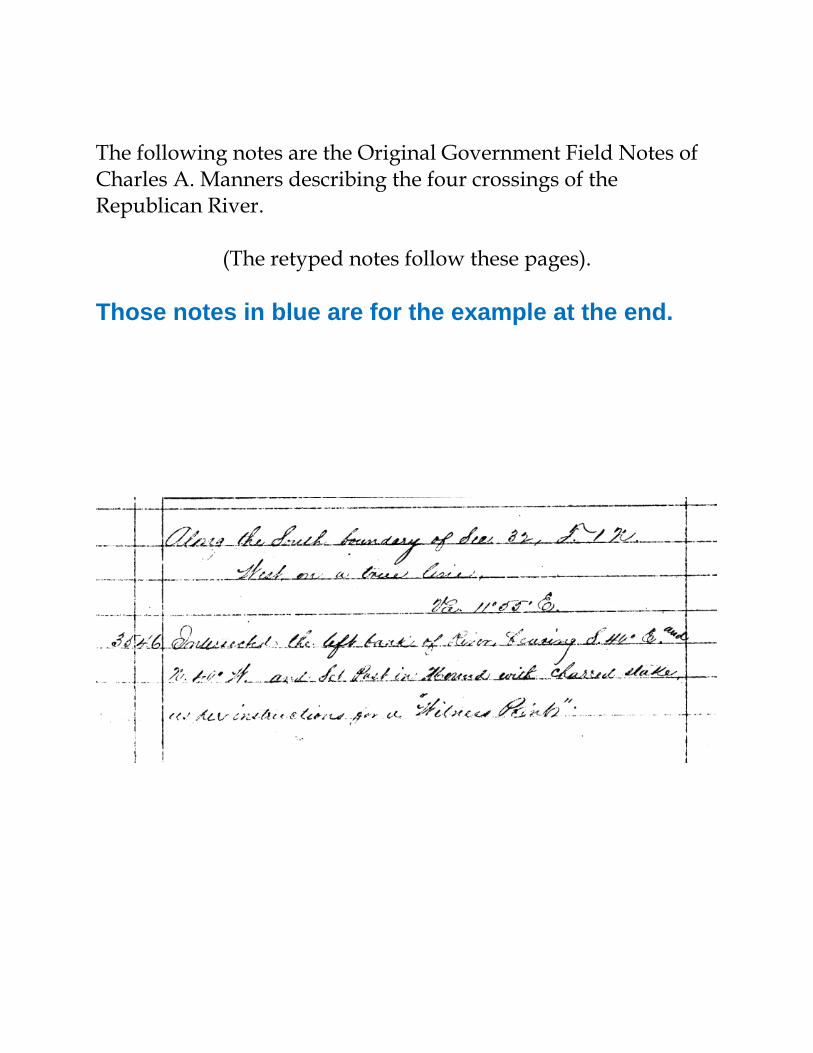
The following notes are the Original Government Field Notes of Charles A. Manners describing the four crossings of the Republican River.
(The retyped notes follow these pages).
Those notes in blue are for the example at the end.

1
2


3

4


Topographic map of the Republican River at Superior, Nebraska.
Along the South boundary of Sec. 32, T1N, [R6W]. West on a true line. Va. 11°55’ E. 35.46 [chains] – Intersected the left bank of River, bearing S. 40° E. and N. 40° W. and Set Post in Mound with charred stake as per instructions for a “Witness Point”.
----------
Base Line. Range 6 West To obtain the distance across the river, I caused a flag to be set in line on the right bank and then from the Witness Point on the left bank measured a base N. 40°16’ W., 3.84 chains to a Station from which the flag on the right bank bears S. 68°18’ W., making the distance across the river = 9.84 chains.
[Diagram] As the Sine of 21°42’ = 9.567904 Is to the Sine of 108°34’ = 9.976787 So is the Base 3.84 0.584331
10.561118 9.567904
To dist across = 9.84 chains = Log. 0.993214.
1 2 3 4

35.46 added to 9.84 makes 45.30 chains. 45.30 [chains] – Intersected the right bank of the river bearing N. 35° W. and S. 35° E., 5.30 chains West of the ¼ sec. cor. at which point I set Post for a Witness Point and also for a Witness to the ¼ sec. cor. from which post A Willow 5 in. dia. bears S. 27° E, 29 links distant.
----------
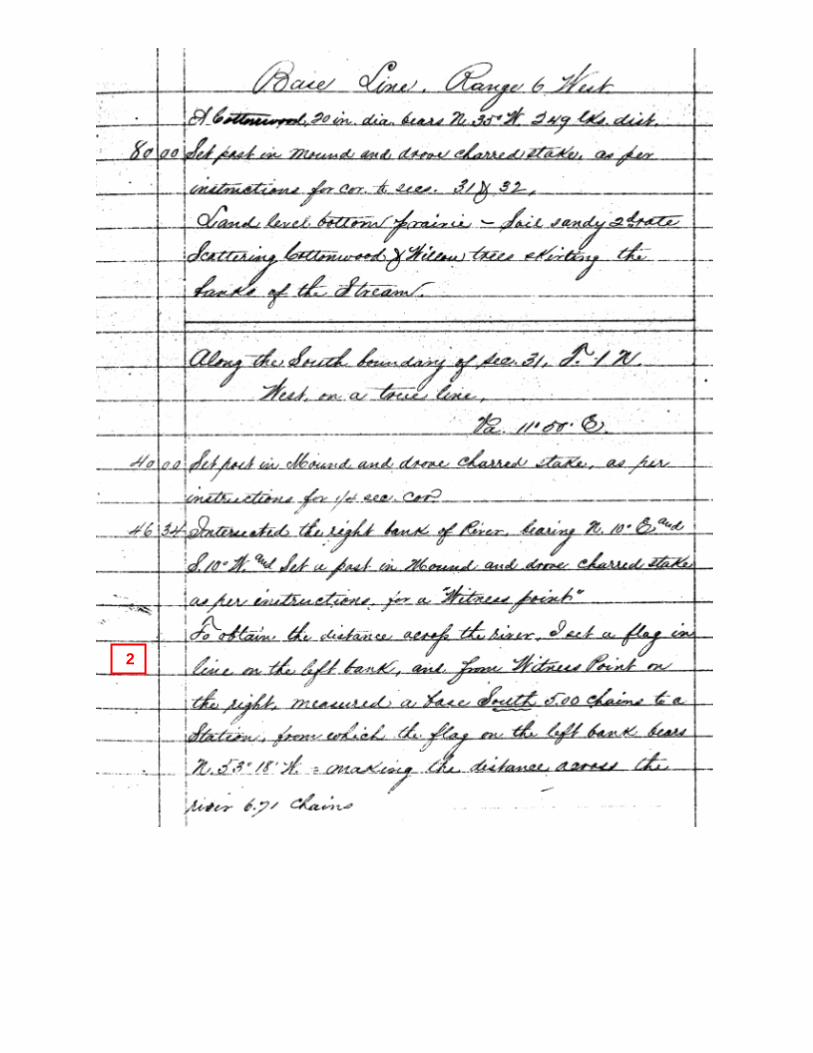
Base Line. Range 6 West A Cottonwood 20 in. dia. bears N. 35° W., 249 links distant. 80.00 [chains] – Set post in mound and drove charred stake, as per instructions for cor. to sections 31 & 32. Land level bottom prairie. Soil sandy 2nd rate. Scattering Cottonwood & Willow trees skirting the banks of the Stream. Along the South boundary of Sec. 31, T1N, [R6W]. West on a true line. Va. 11°50’ East 40.00 [chains] – Set post in mound and drove charred stake, as per instructions for ¼ sec. cor. 46.34 [chains] – Intersected the right bank of river bearing N. 10° E., and S. 10° W. and Set a post in Mound and drove charred stake as per instructions for a ”Witness point”. To obtain the distance across the river, I set a flag in line on the left bank and from Witness Point on the right measured a base South 5.00 chains to a Station from which the flag on the left bank bears N. 53°18’ W., making the distance across the river 6.71 chains.
----------
Base Line. Range 6 West Nat. Tang: 53°18’ = 1.341602 5 Distance across river = 6.7080145 46.34 added to 6.71 makes 53.05 chains. 53.05 [chains] – Intersected the left bank of River bearing N. 10° E. and S. 10° W. and Set a Post for Witness point from which A cottonwood, 9 in. dia. bears N. 89° W., 31 links distant. A willow 3 in. dia. bears S. 2° W., 17 links distant. Enter timber on left bank of River bearing with bank. 60.00 [chains] – Leave timber and enter Prairie bearing N. 30° E. and S. 30° W. 80.00 [chains] – Set post in mound and drove charred stake as per instructions for cor. to Township one North, Ranges 6 & 7 West. Land level bottom – Soil sandy 2nd rate. Timber, Cottonwood and Willow.
----------

Base Line. Range 7 West
Along the South boundary of Sec. 36, T1N [R7W]. West on a true line. Va. 11°50’ E. 26.30 [chains] – Intersected left bank of river bearing N. 25° W. and S. 25° E. and Set Post in Mound and drove charred stake as per instructions for a Witness Point. To attain distances across river, I set a flag in line on the right bank and then from the Witness Point on left bank of river, measured a base N. 22° W. , 5.00 chains to a station from which the flag on right bank bears S. 46° 55’ W., making distance across on line 6.83 chains.
[Diagram]
----------
Base Line. Range 7 West As Sine is 43°05’ = 9.834460 Is to Sine 68°55’ 9.969909 So is 5.00 ch. Log: = 0.698970 10.068879
9.834460 To dist across 6.83 Log = 0.834419 6.83 added to 26.30 makes 33.13 chains 33.13 [chains] – Intersected right bank of river bearing N. 25° W. and S. 25° W. and Set post for a Witness Point from which A Willow 5 in. dia. bears N. 60° W., 7 links distant. A Willow 5 in. dia. bears S. 64° E., 18 links distant. Compared measuring chains with Standard and found them correct. July 18, 1858. 40.00 [chains] – Set post in Mound and drove charred stake as per instructions for ¼ sec. cor. 60.00 [chains] – Leave prairie and enter Timber, bearing S.W. & N. 60° E. 77.00 [chains] – Intersected right bank of River again, bearing N. 25° E. and S. 25° W. and Set post with charred stake as per instructions for a Witness point, from which A Cottonwood 14 in. dia. bears N. 20° E., 28 links distant. A Cottonwood 10 in. dia. bears S. 20° W., 22 links distant. To obtain distance across river, I produced
----------
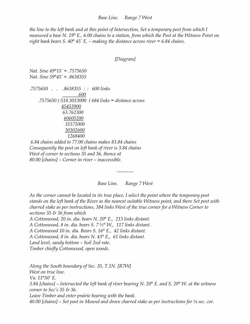
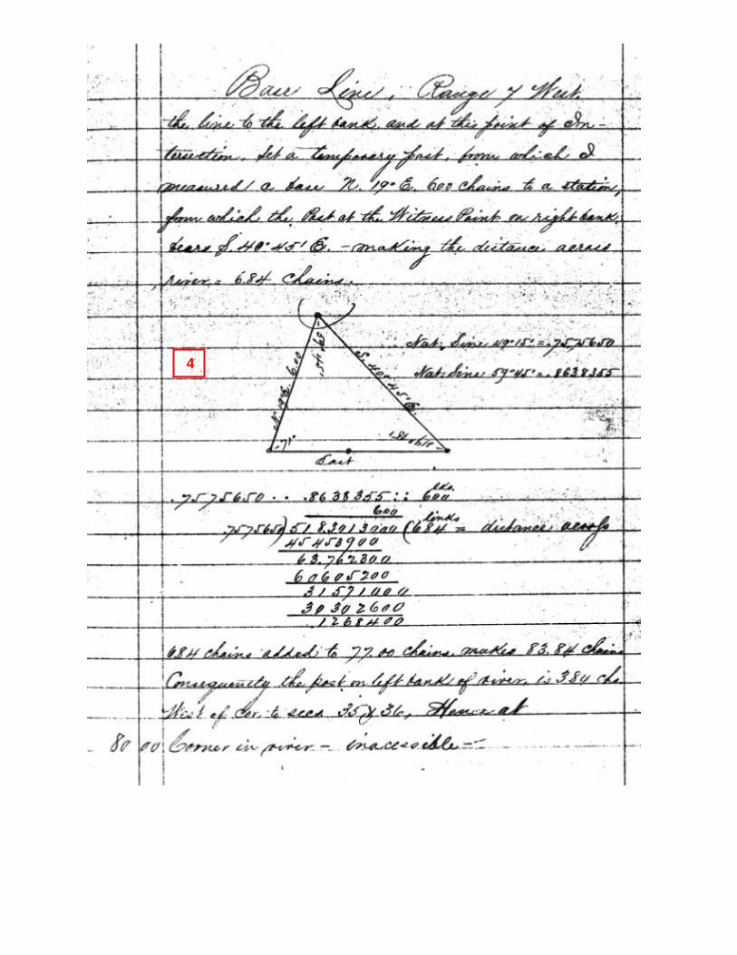
Base Line. Range 7 West the line to the left bank and at this point of Intersection, Set a temporary post from which I measured a base N. 19° E., 6.00 chains to a station, from which the Post at the Witness Point on right bank bears S. 40° 45’ E. – making the distance across river = 6.84 chains.
[Diagram]
Nat. Sine 49°15’ = .7575650 Nat. Sine 59°45’ = .8638355 .7575650 . . .8638355 : : 600 links 600 .7575650 ) 518.3013000 ( 684 links = distance across 45453900 63.762300 60605200 31571000 30302600 1268400 6.84 chains added to 77.00 chains makes 83.84 chains Consequently the post on left bank of river is 3.84 chains West of corner to sections 35 and 36, thence at 80.00 [chains] – Corner in river – inaccessible.
----------
Base Line. Range 7 West As the corner cannot be located in its true place, I select the point where the temporary post stands on the left bank of the River as the nearest suitable Witness point, and there Set post with charred stake as per instructions, 384 links West of the true corner for a Witness Corner to sections 35 & 36 from which A Cottonwood, 20 in. dia. bears N. 20° E., 213 links distant. A Cottonwood, 8 in. dia. bears S. 7 ½° W., 117 links distant. A Cottonwood 10 in. dia. Bears S. 16° E., 42 links distant. A Cottonwood, 8 in. dia. bears N. 43° E., 61 links distant. Land level, sandy bottom – Soil 2nd rate. Timber chiefly Cottonwood, open woods. Along the South boundary of Sec. 35, T.1N. [R7W] West on true line. Va. 11°50’ E. 3.84 [chains] – Intersected the left bank of river bearing N. 20° E. and S. 20° W. at the witness corner to Sec’s 35 & 36. Leave Timber and enter prairie bearing with the bank. 40.00 [chains] – Set post in Mound and drove charred stake as per instructions for ¼ sec. cor.

SECTION 32
(1N-6W)
SECTION 31
(1N-6W)
1
2

SECTION 36 (1N-7W)
= MEASURED BASE LINE = RIVER CROSSING (CALCULATED)
= THIRD LEG OF TRIANGLE
3
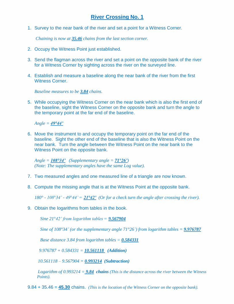
River Crossing No. 1 1. Survey to the near bank of the river and set a point for a Witness Corner.
Chaining is now at 35.46 chains from the last section corner.
2. Occupy the Witness Point just established. 3. Send the flagman across the river and set a point on the opposite bank of the river
for a Witness Corner by sighting across the river on the surveyed line. 4. Establish and measure a baseline along the near bank of the river from the first
Witness Corner.
Baseline measures to be 3.84 chains.
5. While occupying the Witness Corner on the near bank which is also the first end of
the baseline, sight the Witness Corner on the opposite bank and turn the angle to the temporary point at the far end of the baseline.
Angle = 49°44’
6. Move the instrument to and occupy the temporary point on the far end of the
baseline. Sight the other end of the baseline that is also the Witness Point on the near bank. Turn the angle between the Witness Point on the near bank to the Witness Point on the opposite bank.
Angle = 108°34’ (Supplementary angle = 71°26’)
(Note: The supplementary angles have the same Log value).
7. Two measured angles and one measured line of a triangle are now known. 8. Compute the missing angle that is at the Witness Point at the opposite bank.
180° - 108°34’ - 49°44’ = 21°42’ (Or for a check turn the angle after crossing the river).
9. Obtain the logarithms from tables in the book. Sine 21°42’ from logarithm tables = 9.567904
Sine of 108°34’ (or the supplementary angle 71°26’) from logarithm tables = 9.976787
Base distance 3.84 from logarithm tables = 0.584331
9.976787 + 0.584331 = 10.561118 (Addition)
10.561118 – 9.567904 = 0.993214 (Subtraction)
Logarithm of 0.993214 = 9.84 chains (This is the distance across the river between the Witness
Points).
9.84 + 35.46 = 45.30 chains. (This is the location of the Witness Corner on the opposite bank).

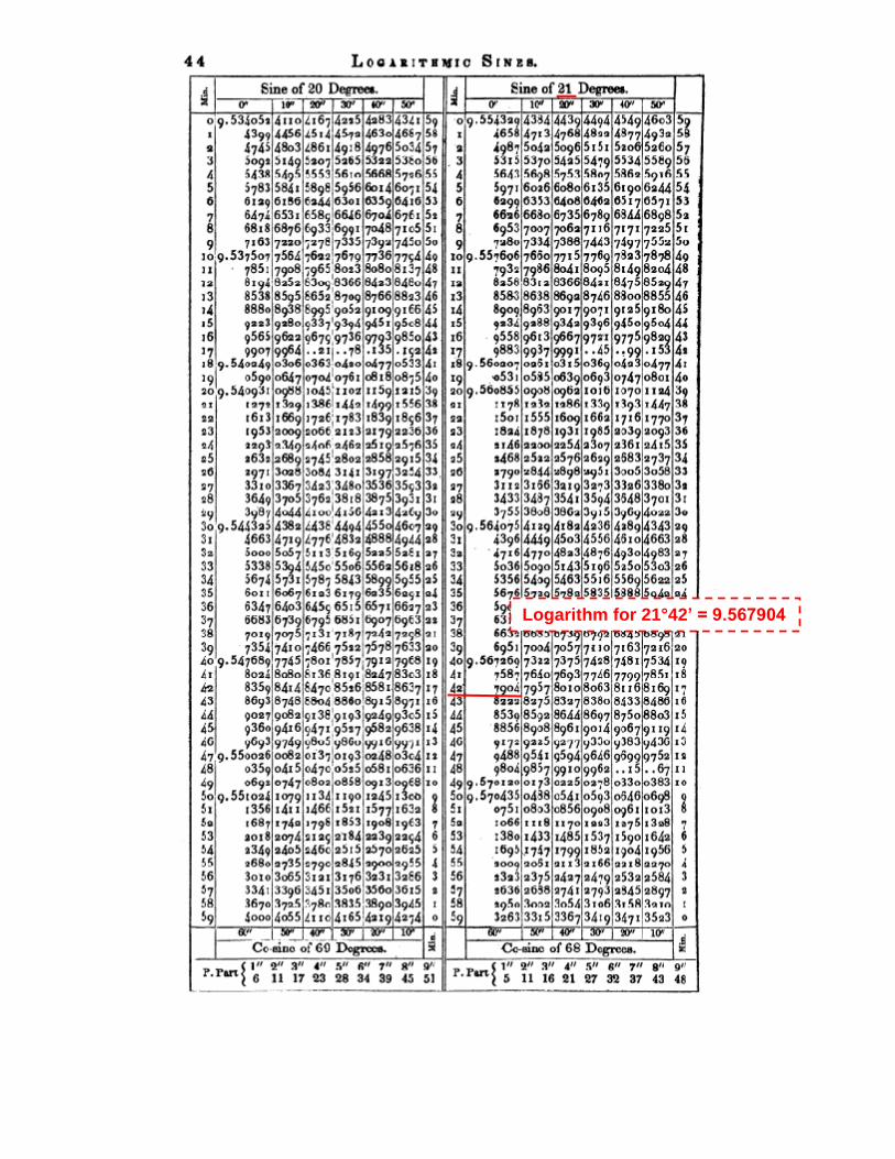
Logarithm for 21°42’ = 9.567904

Logarithm for 71°26’ = 9.976787

Logarithm for 384 = .584331
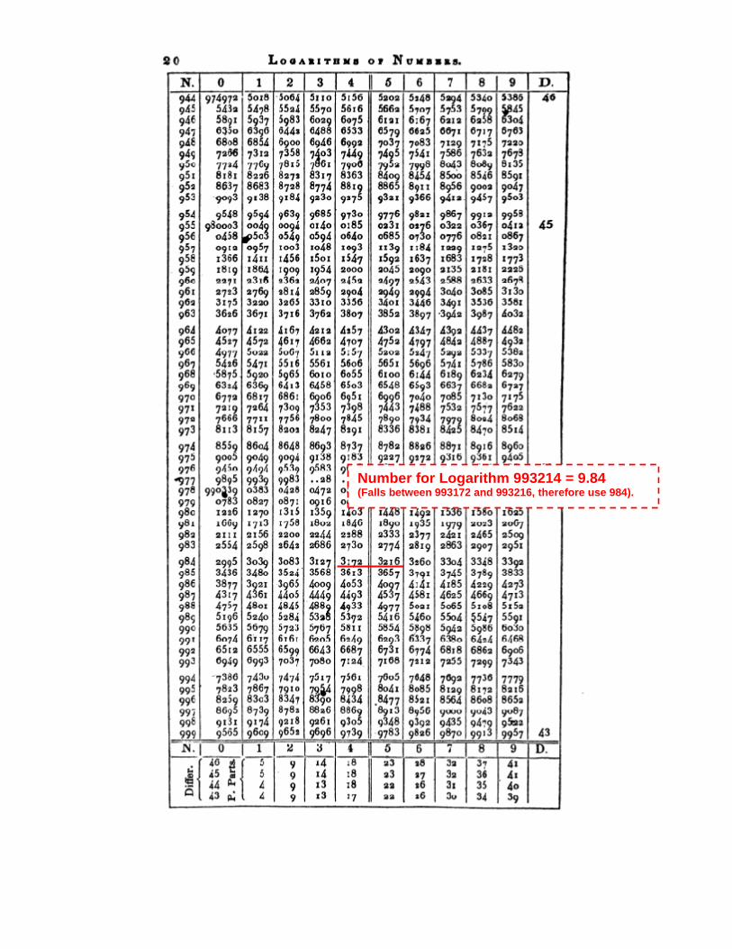
Number for Logarithm 993214 = 9.84 (Falls between 993172 and 993216, therefore use 984).


![Legislative Assembly WEDNESDAY NOVEMBER€¦ · the Seventeen-mile Rocks passage on the Brisbane River being impassable except . 1718 Supply. [ASSEl\lBLY.] Supply. at certain stages](https://img.pdfslide.us/doc/110x75/5ea20272d7a41d1de12c5d8a/legislative-assembly-wednesday-november-the-seventeen-mile-rocks-passage-on-the.jpg)