Embed Size (px)
Citation preview
E. C. Pavlis QuickTime™ and aPhoto - JPEG decompressor
are needed to see this picture.
Geoscience Australia Seminar
Canberra, Australia
29 August, 2005
Implications of SLR Network VariationsOn
Geodetic and Geophysical Products
Erricos C. PavlisJoint Center for Earth Systems Technology / JCETUniversity of Maryland Baltimore County / UMBC
Geoscience Australia Seminar 2005 2E. C. Pavlis QuickTime™ and aPhoto - JPEG decompressor
are needed to see this picture.
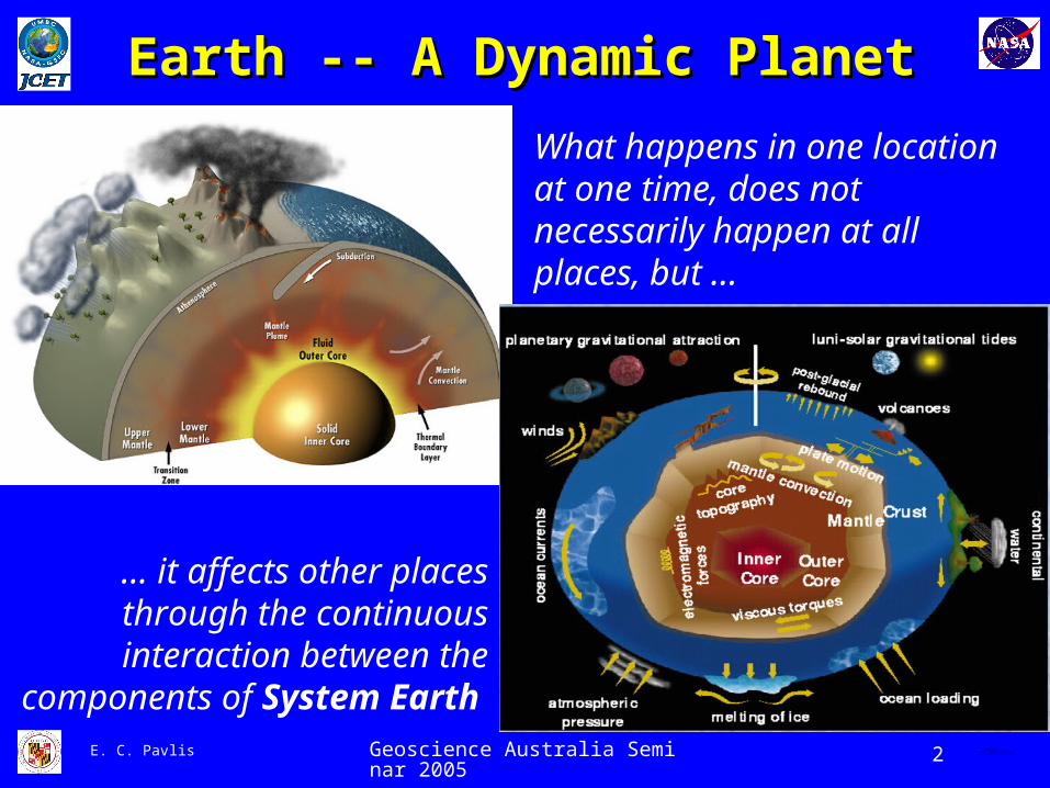
Earth -- A Dynamic PlanetEarth -- A Dynamic Planet
What happens in one location at one time, does not necessarily happen at all places, but …
… it affects other places through the continuous interaction
between the components of System Earth
Geoscience Australia Seminar 2005 3E. C. Pavlis QuickTime™ and aPhoto - JPEG decompressor
are needed to see this picture.
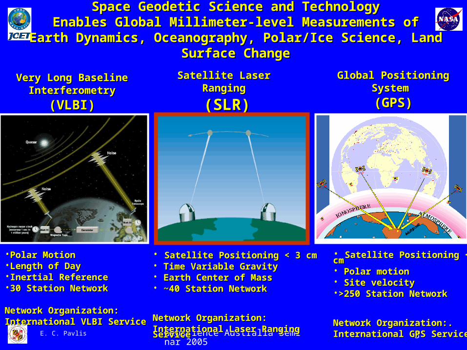
Space Geodetic Science and TechnologySpace Geodetic Science and TechnologyEnables Global Millimeter-level Measurements ofEnables Global Millimeter-level Measurements of
Earth Dynamics, Oceanography, Polar/Ice Science, Land Surface ChangeEarth Dynamics, Oceanography, Polar/Ice Science, Land Surface Change
Very Long BaselineVery Long BaselineInterferometryInterferometry
(VLBI)(VLBI)
Satellite LaserSatellite LaserRangingRanging
(SLR)(SLR)
Global PositioningGlobal PositioningSystem System
(GPS)(GPS)
•Polar Motion Polar Motion •Length of DayLength of Day•Inertial ReferenceInertial Reference•30 Station Network30 Station Network
Network Organization:Network Organization:International VLBI ServiceInternational VLBI Service
• Satellite Positioning < 3 cmSatellite Positioning < 3 cm• Time Variable GravityTime Variable Gravity• Earth Center of MassEarth Center of Mass• ~40 Station Network~40 Station Network
Network Organization:Network Organization:International Laser Ranging International Laser Ranging ServiceService
• Satellite Positioning <10 Satellite Positioning <10 cmcm• Polar motionPolar motion• Site velocitySite velocity•>250 Station Network>250 Station Network
Network Organization:.Network Organization:.International GPS ServiceInternational GPS Service

Geoscience Australia Seminar 2005 4E. C. Pavlis QuickTime™ and aPhoto - JPEG decompressor
are needed to see this picture.
QuickTime™ and aTIFF (LZW) decompressor
are needed to see this picture.
Satellite Laser Ranging (SLR)Satellite Laser Ranging (SLR)GRAVITY (Earth)
DYNAMICS (Satellite Orbits)
GEOMETRY (Ranges from stations)
ANALYSIS (Math. & Stat. Physical Model)
Geodetic & Geophysical ParametersGeodetic & Geophysical Parameters
QuickTime™ and aTIFF (LZW) decompressor
are needed to see this picture.
QuickTime™ and aTIFF (LZW) decompressor
are needed to see this picture.
QuickTime™ and aTIFF (LZW) decompressor
are needed to see this picture.
Geoscience Australia Seminar 2005 5E. C. Pavlis QuickTime™ and aPhoto - JPEG decompressor
are needed to see this picture.
QuickTime™ and aTIFF (LZW) decompressor
are needed to see this picture.
Geoscience Australia Seminar 2005 10E. C. Pavlis QuickTime™ and aPhoto - JPEG decompressor
are needed to see this picture.
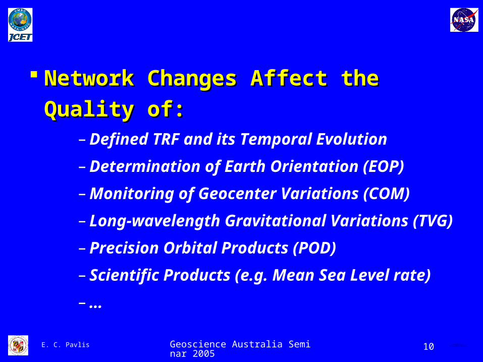
Network Changes Affect the Quality of:Network Changes Affect the Quality of: – Defined TRF and its Temporal Evolution
– Determination of Earth Orientation (EOP)
– Monitoring of Geocenter Variations (COM)
– Long-wavelength Gravitational Variations (TVG)
– Precision Orbital Products (POD)
– Scientific Products (e.g. Mean Sea Level rate)
– …
Geoscience Australia Seminar 2005 11E. C. Pavlis QuickTime™ and aPhoto - JPEG decompressor
are needed to see this picture.
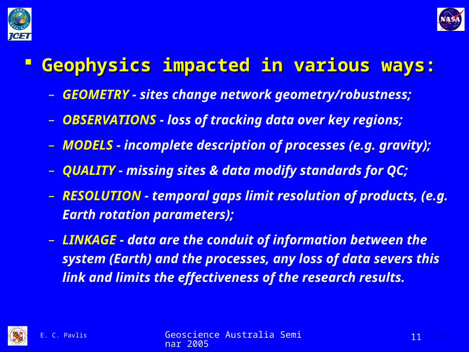
Geophysics impacted in various ways:Geophysics impacted in various ways:
– GEOMETRY - sites change network geometry/robustness;
– OBSERVATIONS - loss of tracking data over key regions;
– MODELS - incomplete description of processes (e.g. gravity);
– QUALITY - missing sites & data modify standards for QC;
– RESOLUTION - temporal gaps limit resolution of products,
(e.g. Earth rotation parameters);
– LINKAGE - data are the conduit of information between the
system (Earth) and the processes, any loss of data severs
this link and limits the effectiveness of the research results.

Geoscience Australia Seminar 2005 12E. C. Pavlis QuickTime™ and aPhoto - JPEG decompressor
are needed to see this picture.
SLR Weekly Analysis Scheme
CDDIS/EDC
AnalysisCenter
LAGEOS 1
ETALON 2
ETALON 1
LAGEOS 2
LAGEOSNEQs
ETALONNEQs
LAGEOS +
ETALONNEQs
Relative weighting
ACCUMULATEDNEQs OF LAGEOS
AND ETALONFROM PREVIOUS
WEEKLYREDUCTIONS
•STATION COORDINATES•STATION VELOCITIES•EOP SERIES (DAILY SINCE 1993)•WEEKLY DEGREE-1 HARMONICS•WEEKLY SECOND DEGREE • HARMONICS•ORBITAL PARAMETERS, …
PRODUCTSPRODUCTS
DATADATA
Geoscience Australia Seminar 2005 13E. C. Pavlis QuickTime™ and aPhoto - JPEG decompressor
are needed to see this picture.
Typical Weekly SLR Data SetTypical Weekly SLR Data Set
QuickTime™ and aTIFF (LZW) decompressor
are needed to see this picture.
Geoscience Australia Seminar 2005 14E. C. Pavlis QuickTime™ and aPhoto - JPEG decompressor
are needed to see this picture.
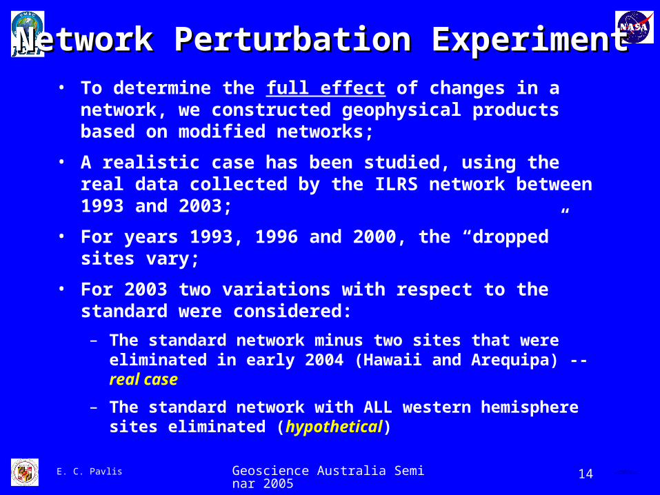
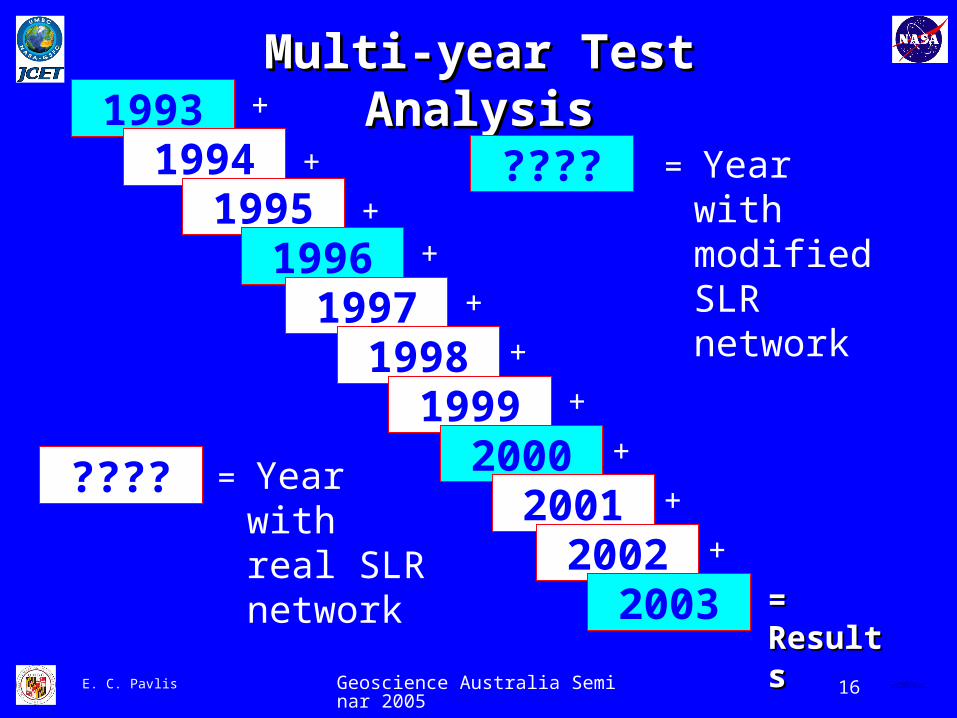
• To determine the full effect of changes in a network, we constructed geophysical products based on modified networks;
• A realistic case has been studied, using the real data collected by the ILRS network between 1993 and 2003;
• For years 1993, 1996 and 2000, the “dropped” sites vary;
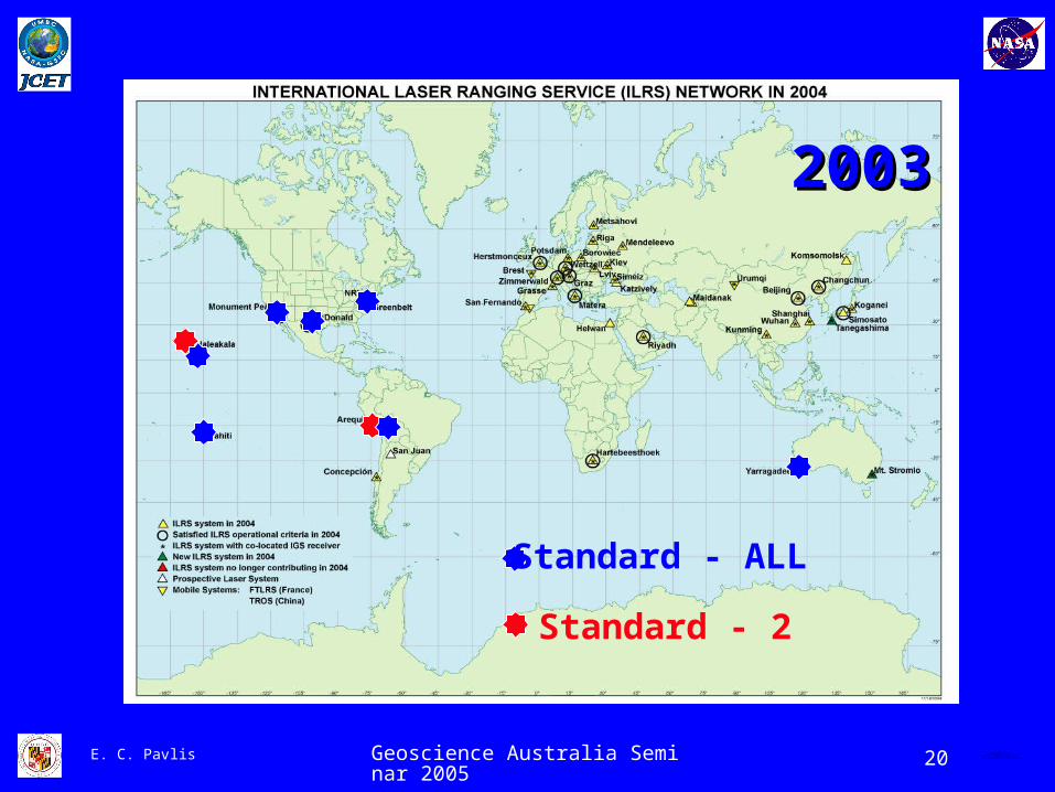
• For 2003 two variations with respect to the standard were considered:
– The standard network minus two sites that were eliminated in early 2004 (Hawaii and Arequipa) -- real case
– The standard network with ALL western hemisphere sites eliminated (hypothetical)
Network Perturbation ExperimentNetwork Perturbation Experiment
Geoscience Australia Seminar 2005 16E. C. Pavlis QuickTime™ and aPhoto - JPEG decompressor
are needed to see this picture.
Multi-year Test AnalysisMulti-year Test Analysis1993
19941995
19961997
19981999
20002001
20022003
+
+
++
+
+
+
+
+
+
= Results= Results
???? = Year with modified SLR network
???? = Year with real SLR network
Geoscience Australia Seminar 2005 20E. C. Pavlis QuickTime™ and aPhoto - JPEG decompressor
are needed to see this picture.
Standard - 2
Standard - ALL
20032003

Geoscience Australia Seminar 2005 21E. C. Pavlis QuickTime™ and aPhoto - JPEG decompressor
are needed to see this picture.
Definition of the
TTerrestrial
RReference
FFrame - TRF

Geoscience Australia Seminar 2005 22E. C. Pavlis QuickTime™ and aPhoto - JPEG decompressor
are needed to see this picture.
0
30
60
90
0
30
60
90
120
210
240
270
300
330
ILRS Network 2003: Standard
North Sites
South Sites 0
30
60
90
0
30
60
90
120
210
240
270
300
330
ILRS Network 2003: Standard - NASA Sites
North Sites
South Sites
0
30
60
90
0
30
60
90
120
210
240
270
300
330
ILRS Network 2003: Standard - Hawaii & Arequipa
North Sites
South Sites
ALL
2 sites
Geoscience Australia Seminar 2005 23E. C. Pavlis QuickTime™ and aPhoto - JPEG decompressor
are needed to see this picture.
Geocenter Monitoring
(COM)

Geoscience Australia Seminar 2005 24E. C. Pavlis QuickTime™ and aPhoto - JPEG decompressor
are needed to see this picture.
Terrestrial SpaceTerrestrial SpaceGeocenter -- Reference Frame OriginGeocenter -- Reference Frame Origin
QuickTime™ and aTIFF (LZW) decompressor
are needed to see this picture.
Unique contribution from SLRUnique contribution from SLR

Geoscience Australia Seminar 2005 25E. C. Pavlis QuickTime™ and aPhoto - JPEG decompressor
are needed to see this picture.
COM Component STD - 2 STD - ALL AccuracyAccuracy
∆X[mm]
µ -2.3 -7.7 33
50 - 100 %50 - 100 %RMS 4.6 6.0
∆Y[mm]
µ 0.2 6.5 33
50 - 100 %50 - 100 %RMS 6.0 4.7
∆Z[mm]
µ 8.4 10.0 55
100 - 100 - 200%200%RMS 11.4 16.1
COM Variation Compared to Present Accuracy

Geoscience Australia Seminar 2005 26E. C. Pavlis QuickTime™ and aPhoto - JPEG decompressor
are needed to see this picture.
TRF Component STD - 2 STD - ALL
AccuracyAccuracy
(over 10y)(over 10y)
∆VX
[mm/y]
µ -0.7 -0.5 1.51.5
300-400%300-400%RMS 7.2 6.6
∆VY
[mm/y]
µ 1.6 0.4 1.51.5
300-400%300-400%RMS 29.7 6.4
∆VZ
[mm/y]
µ 2.4 2.4 4.04.0
400 %400 %RMS 20.1 20.1
TRF Changes Compared to Present Accuracy
Geoscience Australia Seminar 2005 27E. C. Pavlis QuickTime™ and aPhoto - JPEG decompressor
are needed to see this picture.
EEarth
OOrientation
PParameters
-- EOP
Geoscience Australia Seminar 2005 28E. C. Pavlis QuickTime™ and aPhoto - JPEG decompressor
are needed to see this picture.
QuickTime™ and aTIFF (LZW) decompressor
are needed to see this picture.
QuickTime™ and aTIFF (LZW) decompressor
are needed to see this picture.
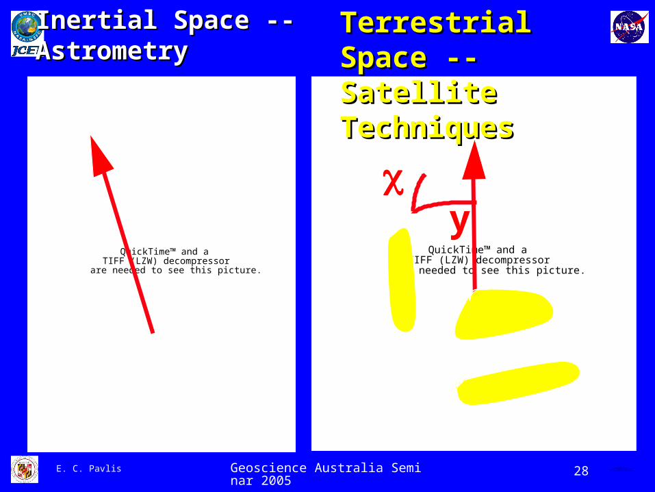
y
Inertial Space --Inertial Space --AstrometryAstrometry
Terrestrial Space --Terrestrial Space --Satellite TechniquesSatellite Techniques
Geoscience Australia Seminar 2005 29E. C. Pavlis QuickTime™ and aPhoto - JPEG decompressor
are needed to see this picture.
QuickTime™ and aTIFF (LZW) decompressor
are needed to see this picture.
QuickTime™ and aTIFF (LZW) decompressor
are needed to see this picture.
QuickTime™ and aTIFF (LZW) decompressor
are needed to see this picture.
QuickTime™ and aTIFF (LZW) decompressor
are needed to see this picture.
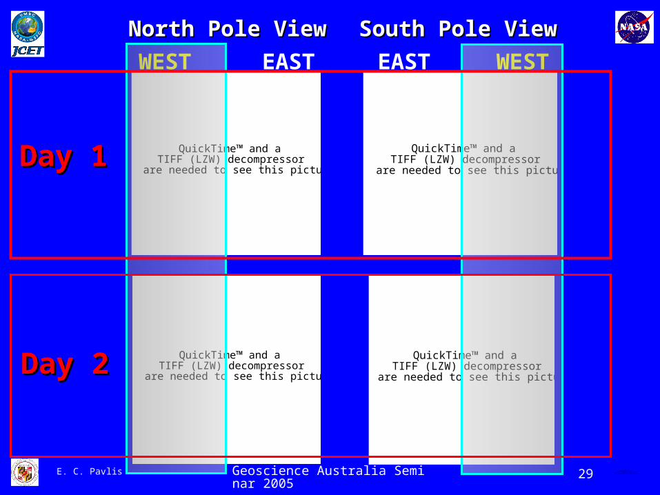
North Pole ViewNorth Pole View South Pole ViewSouth Pole View
WEST EASTEAST WEST
Day 1Day 1
Day 2Day 2
Geoscience Australia Seminar 2005 30E. C. Pavlis QuickTime™ and aPhoto - JPEG decompressor
are needed to see this picture.
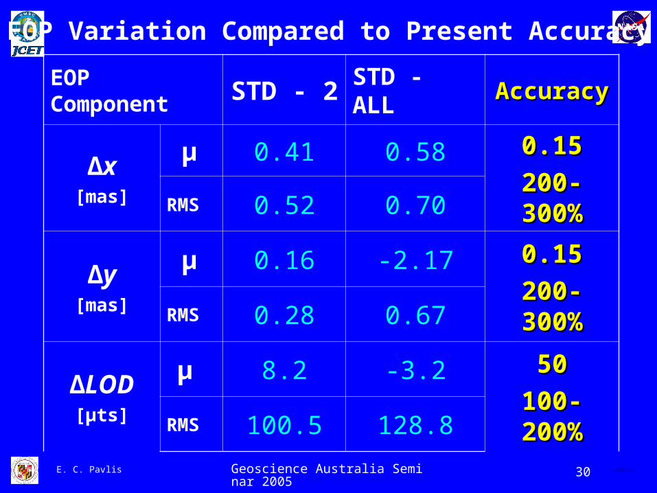
EOP Component STD - 2 STD - ALL AccuracyAccuracy
∆x[mas]
µ 0.41 0.58 0.150.15
200-300%200-300%RMS 0.52 0.70
∆y[mas]
µ 0.16 -2.17 0.150.15
200-300%200-300%RMS 0.28 0.67
∆LOD[µts]
µ 8.2 -3.2 5050
100-200%100-200%RMS 100.5 128.8
EOP Variation Compared to Present Accuracy

Geoscience Australia Seminar 2005 31E. C. Pavlis QuickTime™ and aPhoto - JPEG decompressor
are needed to see this picture.
Temporal Variations of
Gravity
Long wavelength

Geoscience Australia Seminar 2005 32E. C. Pavlis QuickTime™ and aPhoto - JPEG decompressor
are needed to see this picture.
Harmonic Component STD - 2 STD - ALL AccuracyAccuracy
J2 x 1011 RMS 6.4 6.633
~ 100 %~ 100 %
C(2,1) & S(2,1)x 1010
RMS 4.3 & 2.8 5.8 & 7.01.3 & 1.11.3 & 1.1
200-500%200-500%
C(2,2) & S(2,2)x 1011
RMS 22 & 18 34 & 267.1 & 3.67.1 & 3.6
200-400%200-400%
TVG Variation Compared to Present Accuracy

Geoscience Australia Seminar 2005 33E. C. Pavlis QuickTime™ and aPhoto - JPEG decompressor
are needed to see this picture.
Mean Sea Level RateJASON / TOPEX POD Product based on two TRFs
TRF 1: Official T/P Project TRF (CSR’s SSC(CSR)95 L 01)TRF 2: ITRF2000
Study performed by GSFC’s Altimetry Group (Scott Luthcke, Brian Beckley, et al.) and presented at the last JASON SWT, St. Petersburg, Florida.

Geoscience Australia Seminar 2005 34E. C. Pavlis QuickTime™ and aPhoto - JPEG decompressor
are needed to see this picture.
Impact of Improved TOPEX Orbits…
…from Improved Reference Frame
Before …Before … … … AfterAfterAscending/DescendingAscending/Descending
Mean ± = 152.5 ± 7.8
mm Mean ± = 152.5 ± 5.7 mm
S. B. Luthcke & B. Beckley
2.1 mm REDUCTION in RMS2.1 mm REDUCTION in RMS
Compare this to 1.8 to 3.1 mm/y MSL Rise Estimates !!!Compare this to 1.8 to 3.1 mm/y MSL Rise Estimates !!!
Geoscience Australia Seminar 2005 35E. C. Pavlis QuickTime™ and aPhoto - JPEG decompressor
are needed to see this picture.
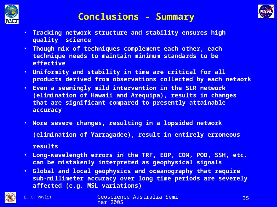
Conclusions - Summary
• Tracking network structure and stability ensures high quality science
• Though mix of techniques complement each other, each technique needs to maintain minimum standards to be effective
• Uniformity and stability in time are critical for all products derived from observations collected by each network
• Even a seemingly mild intervention in the SLR network (elimination of Hawaii and Arequipa), results in changes that are significant compared to presently attainable accuracy
• More severe changes, resulting in a lopsided network (elimination
of Yarragadee), result in entirely erroneous results
• Long-wavelength errors in the TRF, EOP, COM, POD, SSH, etc. can be mistakenly interpreted as geophysical signals
• Global and local geophysics and oceanography that require sub-millimeter accuracy over long time periods are severely affected (e.g. MSL variations)