Embed Size (px)
Citation preview
DUNN COUNTY LAND & WATER RESOURCE MANAGEMENT PLAN
Fourth Edition
2017 - 2026
DUNN COUNTY
LAND CONSERVATION COMMITTEE
LAND & WATER CONSERVATION DIVISION
Dunn County Environmental Services Department
Land & Water Conservation Division
800 Wilson Avenue, Room 330
Menomonie, Wisconsin 54751
(715) 232-1496
Dunn County Land and Water Resource Management Plan | Fourth Edition | 2017-2026 | Page 1
County Board Chair Steven A. Rasmussen
County Manager Paul Miller
Land Conservation Committee Thomas Quinn, Chair Gary Seipel, Vice Chair Gary Bjork Mike Kneer Diane Morehouse Barb Shannon, Farm Service Agency Chair
Land and Water Conservation Division Staff NRCS-Menomonie Field Office Daniel Prestebak, County Conservationist John Sippl, District Conservationist Christopher Gaetzke, Conservation Planner Tammy Pellett, Soil Conservation Technician Amanda Hanson, Conservation Planner KaYing Vang, Soil Conservationist Richard Ingli, Conservation Planner Robert Kaner, Conservation Engineering Technician Richard Mechelke, Conservation Planner Janell Newcomb, Support Specialist Primary Author Lindsay Olson, Water Quality Specialist Dan Prestebak, County Conservationist
Citizens Advisory Committee Members
Gary Bjork Dunn County LCC, dairy & crop farmer, Town of Colfax
Lee Boland Woodland owner, Town of Colfax
John Cole Ducks Unlimited
Aaron Dietsche Dairy farmer, CCA, Town of Grant
Brian Doane Chippewa Valley Bean
Laura Donavan Student, UW-Stout, UW-Stout LAKES REU
David Eckhardt Fairmont - Menomonie Mine
Ryan Gondeck Dunn County Fish and Game
Neil Koch Town of Menomonie Board
Charles Harschlip Dairy farmer, Town of Rock Creek
Merlin Jones Wisconsin Woodland Owners Association
Randy Knaack Mayor, City of Menomonie
Ron Prochnow Crop farmer, Town of Red Cedar
Rick Remington West Wisconsin Land Trust
Gary Seipel Dunn County LCC, Crop farmer, Town of Eau Galle
Scott Sinz Alliance of Dunn County Conservation and Sports Clubs
Kathy Stahl Prairie Enthusiasts, Lower Chippewa Invasives Partnership
John Thomas Landowner, Town of Dunn
Ron Verdon Tainter Menomin Lake Improvement Association
Dunn County Land and Water Resource Management Plan | Fourth Edition | 2017-2026 | Page 2
Technical Advisory Committee Members
Dustin Binder Engineer/Superintendent, Dunn County Highway Division
Ben Bublitz Planning/Zoning Enforcement Officer, Dunn County Planning & Land Use Control Division
Dolly Catlin Strategic Planner, Dunn County Planning & Land Use Control Division
Tom Carlson Dunn County Surveyor
Jess Carstens Wildlife Manager, WI DNR
Randy Eide Public Works Director, City of Menomonie
Chris Gaetzke Conservation Planner, Dunn County LWCD
Morgan Gerk Dunn County Solid Waste Director
Amanda Hanson Conservation Planner, Dunn County LWCD
Mark Hazuga Water Resource Management Specialist, WI DNR
Richard Ingli Conservation Planner, Dunn County LWCD
Jay Jordan Private Consulting Forester
Terry Kafka Water Resource Specialist, WI DNR
Robert Kaner Conservation Engineering Technician, Dunn County LWCD
Ruth King Water Resource Management Specialist, WI DNR
Paul Laliberte Basin Supervisor, WI DNR
Ted Ludwig Red Cedar Basin Monitoring Group
Wendy MacDougall Health Officer/Director, Dunn County Health Department
Richard Mechelke Conservation Planner, Dunn County LWCD
Matt Molback Forester, WI DNR
Janell Newcomb Support Specialist, Dunn County LWCD
Lindsay Olson Water Quality Specialist, Dunn County LWCD
Tammy Pellett Soil Conservation Technician, NRCS
Daniel Prestebak County Conservationist, Dunn County LWCD
John Sippl District Conservationist, NRCS
Buzz Sorge Program and Policy Analyst, WI DNR
Eric Turner Dunn County Economic Development, Executive Director
KaYing Vang Soil Conservationist, NRCS
Katie Wantoch Dunn County Agriculture Educator, UWEX
Dan Zerr Natural Resource Educator, UWEX
Dunn County Land and Water Resource Management Plan | Fourth Edition | 2017-2026 | Page 3
EXECUTIVE SUMMARY This 2017 fourth edition of the Dunn County Land and Water Resource Management Plan (LWRM Plan)
will provide direction for the Dunn County Land and Water Conservation Division for the next ten years.
This LWRM Plan meets the requirements of Wisconsin Act 27, Chapter 92 of the Wisconsin Statutes and
is consistent with the Dunn County Comprehensive Land Use Plan, 2010-2030.
The community of Dunn County is requesting “clean” “fishable-swimmable” water. Farmers, students,
citizens, businesses, the City of Menomonie, the Natural Resources Conservation Service, University of
Wisconsin-Stout, the Wisconsin Department of Natural Resources, University of Wisconsin Cooperative
Extension Service (UWEX), the County of Dunn, and many other partners have come together and
initiated several new programs in the past five years that are leading toward clean water. Many of these
initiatives are recognized here and are products of a community engaged in conservation and water
quality.
The plan is laid out in six sections:
1. Executive summary
2. New programs initiated implementing the 2012 LWRM Plan
3. Assessment of Dunn County’s natural resources
4. Planning process to develop this LWRM
5. A work plan containing goals, objectives, and action items
6. An appendix containing supporting documentation
Through the implementation of the 2017 Plan, LWCD will continue to identify the social infrastructure
and community capacity that will enhance the achievement of measurable and sustainable results. It is
the intention of Dunn County Land and Water Conservation Division to continue to build upon the many
new programs and initiatives that were developed while implementing the 2012 plan. These initiatives
identify and understand the obstacles that inhibit people, governments, and non-governmental
organizations from realizing the goal of healthy soil and clean water. This will be done by linking the
management of natural resources and water quality restoration work to active citizenship through civic
governance. This will create an active role for all citizens and institutions to solve the challenges of
resource management and work toward the common goal of clean water.
Dunn County Land and Water Resource Management Plan | Fourth Edition | 2017-2026 | Page 4
Table of Contents EXECUTIVE SUMMARY .................................................................................................................................. 3
List of Figures ................................................................................................................................................ 7
List of Tables ................................................................................................................................................. 8
NEW PROGRAMS AND INITIATIVES .............................................................................................................. 9
Dunn County Board of Supervisors ........................................................................................................... 9
Directional Plan ..................................................................................................................................... 9
Farmland Preservation Plan ................................................................................................................ 10
Non-Metallic Mining ........................................................................................................................... 10
Livestock Siting .................................................................................................................................... 11
Shoreland Protection Ordinance ........................................................................................................ 11
Water Quality Contingency Fund ........................................................................................................ 11
Water Quality Specialist Position ........................................................................................................ 12
Dunn Environmental Education Steering Committee ............................................................................. 12
Hay River Farmer-Led Watershed Council .............................................................................................. 13
Interstate Civic Governance Organizing Agency ..................................................................................... 14
Lower Chippewa Invasives Partnership .................................................................................................. 14
Red Cedar Basin Assessment .................................................................................................................. 15
Red Cedar Demonstration Farm ............................................................................................................. 16
Red Cedar Watershed TMDL Implementation Plan ................................................................................ 17
Town of Grant Agricultural Enterprise Area ........................................................................................... 18
Tri-County Groundwater Level Monitoring Pilot Project ........................................................................ 19
UW-Stout LAKES-REU Program ............................................................................................................... 19
Water Quality Monitoring ....................................................................................................................... 20
Wilson and Annis Creek Watershed Partnership .................................................................................... 21
RESOURCE ASSESSMENT ............................................................................................................................. 22
Soils ......................................................................................................................................................... 23
Water Resources ..................................................................................................................................... 27
Watersheds ......................................................................................................................................... 27
Designated Waters .............................................................................................................................. 31
Total Maximum Daily Load Plan for Lakes Tainter and Menomin ...................................................... 35
Other Water Quality Concerns ........................................................................................................... 37
Wetlands ............................................................................................................................................. 38
Groundwater ....................................................................................................................................... 39
Dunn County Land and Water Resource Management Plan | Fourth Edition | 2017-2026 | Page 5
Land Resources ....................................................................................................................................... 41
Woodlands .......................................................................................................................................... 41
State Natural Areas ............................................................................................................................. 42
County Parks, Forests, and other Lands .............................................................................................. 42
Plant and Animal Resources ................................................................................................................... 43
Invasive Species .................................................................................................................................. 43
Endangered Resources ........................................................................................................................ 44
Wildlife Areas ...................................................................................................................................... 44
PLANNING PROCESS .................................................................................................................................... 45
Purpose and Authority ............................................................................................................................ 45
Public Participation ................................................................................................................................. 47
Agency and Non- Governmental Organization Participation ................................................................. 48
NR 151 Implementation .......................................................................................................................... 49
Conservation Planning ........................................................................................................................ 49
Technical Assistance ........................................................................................................................... 49
Nutrient Management Planning ......................................................................................................... 49
Soil and Water Resource Management Program ............................................................................... 50
Information and Education ................................................................................................................. 50
Priority Farm Strategy ......................................................................................................................... 50
Regulations in Dunn County.................................................................................................................... 51
Farmland Preservation Program ......................................................................................................... 51
Dunn County Manure Management Ordinance ................................................................................. 52
Non Metallic Mining Reclamation Ordinance ..................................................................................... 52
NR 216 ................................................................................................................................................. 53
Complaints .......................................................................................................................................... 53
WORK PLAN ................................................................................................................................................ 53
Goals, Objectives, and Actions ................................................................................................................ 54
Priorities .................................................................................................................................................. 54
Budget and Funding ................................................................................................................................ 54
Implementation and Monitoring ............................................................................................................ 55
Conclusion ............................................................................................................................................... 55
Goal 1: Maintain, Protect and Improve our Surface Water Resources .................................................. 56
Goal 2: Conserve Long Term Soil Productivity of Cropland .................................................................... 60
Goal 3: Protect Ground Water Quantity and Quality ............................................................................. 61
Dunn County Land and Water Resource Management Plan | Fourth Edition | 2017-2026 | Page 6
Goal 4: Preserve Rural Character, Protect the Environment and Related Natural Resources for
Residents, Visitors, and Future Generations .......................................................................................... 63
Goal 5: Educate and Engage the Public in Natural Resource Management ........................................... 66
Plan Partners ........................................................................................................................................... 67
Private Organizations .......................................................................................................................... 67
Local .................................................................................................................................................... 70
Statewide ............................................................................................................................................ 71
Federal ................................................................................................................................................ 72
APPENDIX .................................................................................................................................................... 73
Exhibit 1: Dunn County LWRM Plan Committee Meeting Schedule ....................................................... 73
Exhibit 2: Information & Education Methods ......................................................................................... 74
Exhibit 3: Endangered Species Listed in Dunn County by the Wisconsin Natural Heritage Inventory ... 75
Exhibit 4: Cost-Share Practice/Funding Source Table & Guidance for Completing NR 151 Codes......... 79
Exhibit 5: Components of NR 151 ........................................................................................................... 82
Exhibit 6: Estimated Funding Available to Implement Planned Activities .............................................. 83
Exhibit 7: Public Hearing Notice .............................................................................................................. 84
Exhibit 8: Acronyms ................................................................................................................................ 85
Dunn County Land and Water Resource Management Plan | Fourth Edition | 2017-2026 | Page 7
List of Figures Figure 1. The Dunn County Directional Plan Pyramid ................................................................................... 9
Figure 2. LWCD Engineering Technician Bob Kaner (left) teaching LAKES-REU students about surveying
and engineering practices used to design water quality best management practices .............................. 20
Figure 3. Wilson Creek Watershed ............................................................................................................. 21
Figure 4. Land cover in Dunn County .......................................................................................................... 23
Figure 5. Average soil loss from agricultural fields ..................................................................................... 24
Figure 6. Crop types by percentage of cropland ......................................................................................... 25
Figure 7. Erosion vulnerability by parcel in the Wilson and Annis Creek Watersheds ............................... 26
Figure 8. Watersheds in Dunn County ........................................................................................................ 27
Figure 9. Class I, II, and III trout streams ..................................................................................................... 31
Figure 10. Outstanding and exceptional resource waters .......................................................................... 32
Figure 11. Impaired waters of Dunn County (WDNR, 2016) ....................................................................... 33
Figure 12. HUC 12 watersheds in the Red Cedar River Basin TMDL area ................................................... 36
Figure 13. Streambank stabilization along Lake Menomin at Menomin Park, Menomonie, WI ................ 37
Figure 14. Mapped wetlands in Dunn County (WDNR, 2016) .................................................................... 38
Figure 15. Groundwater contamination susceptibility ............................................................................... 40
Figure 16. Water use in Dunn County by category ..................................................................................... 41
Figure 17. View from the tower at Hoffman Hills in autumn ..................................................................... 44
Figure 18. 1965 Letter to Senator Gaylord Nelson from Herbert Wallace, Chair of the Dunn County Soil
and Water Conservation District ................................................................................................................ 47
Dunn County Land and Water Resource Management Plan | Fourth Edition | 2017-2026 | Page 8
List of Tables Table 1. Impaired waters of Dunn County .................................................................................................. 34
Table 2. Aquatic invasive species present in Dunn County by waterbody ................................................. 43
Table 3. Terrestrial invasive species present in Dunn County .................................................................... 43
Table 4. Information and education methods to implement the LWRM Plan ........................................... 74
Dunn County Land and Water Resource Management Plan | Fourth Edition | 2017-2026 | Page 9
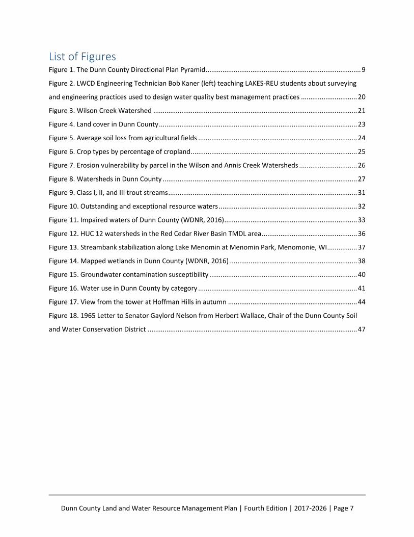
NEW PROGRAMS AND INITIATIVES Dunn County Board of Supervisors Directional Plan Over the course of the last year, Dunn County government engaged in strategic planning (Figure 1). This
was a coordinated collaborative process done for the first time on a county-wide basis. All twenty-nine
elected officials and twenty-two department managers participated in the project. Analysis was both
qualitative and quantitative and concentrated in two research areas: (1) development and prioritization
of enterprise-wide initiatives, and (2) alignment of current department programs with prioritized issues
and goals.
Results of the issue identification study designated four policy priority areas: The Environment, Public
Outreach and Information, Legislative, and Criminal Justice. Additionally, the Executive Committee
defined the county vision, mission, and values to assist in the application of the strategic plan - a
framework defined as The Directional Plan.
Figure 1. The Dunn County Directional Plan Pyramid
This framework was then used to align over one-hundred and seventy current county programs with the
goals of the four prioritized issues. Assessment determined that seventy-two programs align specifically

Dunn County Land and Water Resource Management Plan | Fourth Edition | 2017-2026 | Page 10
to the Environmental Policy. These include programs in the following departments: Administration,
UWEX, Public Works-Facilities and Highway, Health Department, Emergency Management, Sheriff, Solid
Waste and Recycling, and Environmental Services.
The Environmental Policy Statement:
“Dunn County is committed to protecting the environment and improving
environmental practices within the community as well as for government operations
and facilities. The County recognizes that the protection of the environment, particularly
water quality, is a key component of enhancing the quality of life for its residents and
will integrate environmental awareness into its core philosophies to allow continued
progress and future sustainability.”
When considering updating the Land and Water Resource Management Plan and reviewing programs
within the Land and Water Conservation Division (LWCD), all twenty-seven current programs have
strong alliance with three of the strategic plan initiatives: Environmental, Public Outreach and
Information, and Legislative. The Directional Plan was unanimously adopted by the Dunn County Board
on March 16, 2016. The strategic planning process is now part of the culture and plans are moving
forward to introduce priority-based budgeting to further integrate long-range planning and strategic
thinking.
Farmland Preservation Plan Dunn County’s Farmland Preservation Plan, as required by Wis. Stat. § 91.10(2), was updated and
incorporated into the Dunn County Comprehensive Land Use Plan in April of 2016. In order for a county
and its residents to participate in the Farmland Preservation Program, the county must have a state-
certified farmland preservation plan pursuant to Wis. Stat. § 91.10 which clearly identifies farmland
preservation goals, objectives and policies. At this time the towns of Grant, Lucas, and Wilson have
adopted farmland preservation zoning on areas identified in the plan as areas that the county intends to
preserve for agricultural use. LWCD is working with the owners of these parcels to ensure they are in
compliance with the runoff rules contained NR-151 so that they may qualify for farmland preservation
tax credits.
Non-Metallic Mining Because of an increase in the interest in non-metallic mining of silica sand (industrial sand or frac sand)
in western Wisconsin, the Dunn County Board approved a moratorium on non-metallic mining
reclamation permits in January of 2012. A work group comprising of members of the Health
Department, Environmental Services (Land Conservation, Planning and Land Use Control Divisions), and
Highway Department were charged with studying and analyzing the potential impacts of non-metallic
mining in regard to the health, safety, and welfare of Dunn County residents and to make
recommendations to their respective governing committees and the County Board of Supervisors.
After reviewing applicable federal, state and local laws and receiving input from the public and the
mining industry, a document titled Non-Metallic Mining and Processing in Dunn County--Environmental
Impacts and Regulatory Analysis with Recommendations to Improve Industry Oversight was published.
The data collected in this process was then used to create standards that were adopted in the
Comprehensive Zoning Ordinance separating industrial sand mines from construction aggregate mines.
Dunn County Land and Water Resource Management Plan | Fourth Edition | 2017-2026 | Page 11
The new standards for industrial sand mines and all mines over 25 acres minimize the risks to the health,
safety, and welfare of Dunn County residents and natural environment.
Livestock Siting Dunn County adopted Wisconsin’s statewide livestock siting standards in the Comprehensive Zoning
Ordinance in 2014. New and expanding livestock operations with over 500 animal units that are located
in the 16 Towns that have adopted the ordinance are subject to these new rules. The ordinance also
requires that livestock facilities of this size be located in the Intensive Agriculture District. Language in
the ordinance requires a hearing before the Board of Adjustment to ensure that the standards and
procedures of law are being met. The standards address:
Property line and road setbacks
Management and training plans
Odor management
Nutrient management
Manure storage facilities
Runoff management
Shoreland Protection Ordinance In June of 2012, the Board of Supervisors adopted a Shoreland Protection Ordinance for Dunn County
that contained standards that were more restrictive than the minimum standards contained in NR-115.
The Board attempted to treat all riparian landowners equally and required a 35-foot no-mow buffer
zone in residential areas and 35-foot tillage setback on all cropland adjacent to navigable water. The 35-
foot tillage setback could be reduced to 20 feet if the Phosphorous Index on the adjacent field was 2 or
less. The ordinance also included impervious surface mitigation and restrictions on viewing corridors.
The standards were developed in an open public process and were intended to be implemented in a
manner that requires riparian landowners to contribute equally to improved water quality.
Unfortunately, standards such as these that went beyond the minimum State Standards were repealed
in the biennial budget bill, 2015 Wisconsin Act 55. The tillage setback contained in NR 151.03 is still in
effect but not contained in any county ordinance at this time (see Exhibit 4: Cost-Share Practice/Funding
Source Table & Guidance for Completing NR 151 Codes).
Water Quality Contingency Fund In 2015, the Board began designating and making available up to $100,000 of the Contingency Fund for
water quality improvement projects. Requests are submitted to the Committee on Administration from
any of the standing committees of the Board including the Land Conservation Committee. Some of the
projects selected for funding included applying lime and collecting and analyzing soil samples so that
LWCD can track changes in the health of the soil at the Red Cedar Demonstration Farm; winter water
sampling in the Red Cedar River and Hay River conducted by UW-Stout to help determine groundwater
phosphorus contributions to Lakes Tainter and Menomin; developing a scorecard so that waterfront
property owners can evaluate their property for potential phosphorus runoff into lake and rivers; and,
purchasing the Wellntel units that monitor groundwater levels in the Tri-County Groundwater Level
Monitoring Project.
Dunn County Land and Water Resource Management Plan | Fourth Edition | 2017-2026 | Page 12
Water Quality Specialist Position As part of the 2015 budget process the Board created a new Water Quality Specialist position. This is a
professional position within the LWCD focused on the management of the county’s surface and
groundwater resources. The purpose of the position is to develop programs, policies, technical
standards, data, and research to identify water resource issues and use management tools, practices
and social skills to help people manage those issues. The Water Quality Specialist is a member of the
Red Cedar Partnership, is involved in the Red Cedar Basin Assessment Project and the Tri-County
Groundwater Level Monitoring Project, as well as being part of many community educational events
that raise the public’s awareness to water issues. In a true collaborative effort, the City of Menomonie
contributes partial funding for this position.
Dunn Environmental Education Steering Committee The Dunn Environmental Education Steering Committee (DEESC) is a group of environmental and youth
education advocates that formed in 2014 to provide multiple opportunities for citizens to become more
aware, active, and knowledgeable on the environment. DEESC currently has members that work for
Dunn County LWCD, Solid Waste & Recycling, and the NRCS. The group uses the civic governance
approach at their meetings to be open and transparent in all decisions, goals and direction.
Identity Statement: DEESC is a group that will use Civic Governance as a new approach
to educating citizens needed to produce a basis to govern for the common good and
sustain democracy as a just system while achieving goals toward environmental action.
Purpose/Mission: The mission of the DEESC is to develop awareness in students that will
inspire to create a sustainable interaction with the environment and its natural
resources.
The DEESC developed a list of equipment and materials needed to host field days and educational
events. From that list both LWCD and NRCS purchased equipment to the extent possible. Save Our Hills
Alliance, Inc., a local non-profit conservation organization, donated a 5’ x 8’ enclosed trailer to store and
transport the equipment. The DEESC affixed decals on the trailer to identify it and they also maintain it
so it can be brought to multiple events each year.
The DEESC hosted their first annual Spring Environmental Field Day for Boyceville and Colfax 5th grade
students at the SDMA Bjornson Education-Recreation Center in Knapp, Wisconsin, in May of 2015. This
field trip gave students opportunities to learn about four environmental topics including Soils 101, water
through stream monitoring, land surveying, and native/invasive plant identification. They also assisted
with the Tri-County Land Judging Contest, that was hosted by Dunn County, where 130 students
representing 6 schools participated.
Through September of 2016, they have participated in, assisted with, or organized numerous events
including the Conservation Awareness Poster & Speaking Contests; The Red Cedar Watershed
Conference; Spring Environmental Field Day, Career Explorers at the Red Cedar Demonstration Farm;
Boys & Girls Club Field Day at Lake Menomin Park; and, Farm-City Day (Kid’s Day).
Dunn County Land and Water Resource Management Plan | Fourth Edition | 2017-2026 | Page 13
Hay River Farmer-Led Watershed Council The Hay River Farmer-Led Watershed Council is one of four farmer-directed conservation groups in the
St. Croix and Red Cedar River - Farmer-Led Watershed Council Project. The purpose of the project is to
develop a model that engages farmers in water quality leadership roles that can be replicated
throughout the Red Cedar Basin and the State of Wisconsin. Increasing farmer knowledge of water
quality issues, the adoption of conservation practices utilizing performance-based incentives, and
enhancing agricultural productivity are also goals of the project. Dry Run, Horse Creek and Rocky Branch
Farmer-Led Watershed Councils located in St. Croix, Polk, and Pierce Counties along with Hay River
Farmer-Led Watershed Council in Dunn and Barron Counties work toward improving soil health and
water quality while sharing information with each other.
The Hay River Famer-Led Watershed is located in both Barron and Dunn Counties and includes Big
Beaver Creek, Little Beaver Creek, Vance Creek, and the North Fork of the Hay River. The Barron County
Towns of Vance Creek and Prairie Farm and the Dunn County Towns of New Haven, Sheridan, Tiffany,
and Hay River all have land included in the watershed.
The farmers of the Council are enabled to influence and choose the strategies of increasing conservation
and improving water quality in their watershed and community. The Council is assisted by staff from
LWCD and UWEX. The staff act as a resource to provide information and technical support while the
farmers take the lead and are the decision makers. Financial and administrative support is appreciated
from the McKnight Foundation of Minnesota, Wisconsin Farmers Union, USDA-Sustainable Agricultural
Research and Education, and DNR. The Council also values input from agency partners including USDA-
Natural Resource Conservation (NRCS) Service Menomonie Field Office; NRCS Northwest Area Office;
UWEX; Wisconsin Department of Agriculture, Trade and Consumer Protection (DATCP); and the DNR.
On June 26th of 2013 those people owning 20 or more acres of land in the watershed were invited to
gather at Pioneer Park in Prairie Farm to learn about the project. The first Council meeting was held on
August 13th of 2013. The Council tends to meet more often during the winter months and less often
during the growing season. They decided to call themselves the Hay River Farmer-Led Watershed
Council and by January, 2014 approved their Mission Statement and Goal.
Mission Statement: A voluntary, producer-led program to promote and enhance
environmentally sound management of soil and water in the Hay River Watershed.
The goal of the Farmer Led Watershed is to keep soil and nutrients on the land through increased
adoption of best management practices including, but not limited to: grassed waterways, no-till and
minimum till systems, perennials, and cover crops.
To date, the Hay River Farmer-Led Council has provided three seminars with guest speakers open to the
public focused on topics relevant to farmers such as soil health, contract grazing, and cover crops. They
have also attended the Red Cedar Conference at the University of Wisconsin-Stout in Menomonie, and
have also had farmers and staff featured in 2 breakout sessions with high attendance. They also have an
edge-of-field monitor that collects information on surface runoff, and have a field plot comparing the
effects of no-till, single, and multi-species cover crops to conventional farming methods. The farmers
have attended events hosted by the other three Farmer-Led Councils to gain knowledge and share their
thoughts to improve their farming practices and learn from the challenges and success of others.
Dunn County Land and Water Resource Management Plan | Fourth Edition | 2017-2026 | Page 14
Furthermore, the Council works together to select incentives that they believe will assist farmers in
improving their own soil health and water quality. Incentives were first offered in 2014 and have been
offered every year thereafter. Incentives include farm walkovers, soil testing, cover crops, Haney soil
testing, and grassed waterways.
Interstate Civic Governance Organizing Agency Civic organizing, guided by civic governance principles, is a new approach for managing watersheds,
lakes, and many other natural resources. By working with local citizens and organizations, the LWCD can
greatly expand management of Dunn County’s natural resources well beyond the capabilities of local
government. Active civic engagement develops trust, expands awareness, develops meaningful
partnerships, and ultimately raises the level of citizen involvement. Developing civic engagement
following civic standards and principles ensures that the LWCD cultivates a lasting infrastructure that will
hold people accountable for producing outcomes that are transparent, collaborative, and sustainable.
The principles of civic governance are being practiced by members of the Dunn and St. Croix County
Land and Water Conservation staff through membership in the Interstate Civic Governance Organizing
Agency. The project is currently funded by a Department of Natural Resources (DNR) Lake Planning
Grant awarded to the Tainter Menomin Lake Improvement Association. The main purpose of the project
is to implement Environmental Protection Agency (EPA) approved 9 key element plans.
Dunn County LWCD staff have successfully provided leadership using civic governance standards and
principles by organizing farmer led watersheds, invasive species cooperatives, and environmental
education events. By bringing stakeholders together and expanding citizen engagement, the LWCD has
been able to harness and capitalize on the passion and great work of Dunn County’s citizens.
The staff of the LWCD have adopted the following purpose statement and civic standards which will be
used for implementing this Land and Water Resource Management Plan.
Purpose Statement: To work with people to sustainably use, enhance and preserve Dunn County’s
natural resources by developing the civic imagination and infrastructure needed to make a case for civic
governance as our way to govern for the common good.
All Dunn LWCD decision making is based on these civic standards:
● All those impacted by the problem are stakeholders and help define the problem in light of civic
principles and the realities of their situation.
● All stakeholders are accountable for contributing resources (leadership/time, knowledge,
constituencies & dollars) to solve the problem.
● All stakeholders are engaged in decision-making and policy-making that contributes to the
common good.
● All stakeholders implement policies grounded in civic principles in the places where they have
the authority to act.
Lower Chippewa Invasives Partnership In 2011, a concerned citizen approached the LWCD with a request to work on terrestrial invasive species
on roadsides that were spreading to their private property. Dunn County LWCD responded by bringing
local non-profit organizations, government agencies, corporations, and other concerned citizens
Dunn County Land and Water Resource Management Plan | Fourth Edition | 2017-2026 | Page 15
together to discuss options. The original group started a Cooperative Weed Management Area in 2012
named the West Central Wisconsin Invasive Plant Management Area (WCWIPMA). This group formed a
mission statement of fostering partner cooperation and community action on invasive species and then
started engaging in many projects.
Initial projects were working with local schools, private landowners, citizen groups/organizations, and
public properties to educate and restore native habitat by controlling, eliminating, and monitoring
terrestrial invasive plants. The group expanded to include speaking at conferences and events to
educate the public on what, where, when, why, and how invasive plants establish and spread. Several
grants from the State of Wisconsin funded the purchase of an enclosed trailer, field event equipment,
citizen monitoring/training, transportation for schools to events, and organizational growth. With the
help of many dedicated citizens, UW-Stout, and LWCD staff, thirty-one NR40-listed terrestrial invasive
species have been found in Dunn County.
WCWIPMA continued to grow to become the first, local non-profit, Cooperative Invasive Species
Management Area in the state and in 2015 changed their name to Lower Chippewa Invasives
Partnership (LCIP). This organization, chaired by Dunn LWCD staff member Chris Gaetzke, completes
over 25 presentations, poster exhibits, educational events, and projects annually. A need for more
information to be shared publically led to a service learning project with UW-Eau Claire to develop the
LCIP website, www.lcinvasives.org, and a LCIP Facebook page that contains information on invasive
plants and events.
LCIP has a growing momentum thanks to the implementation of the Civic Governance model in early
2015. This organizational model facilitates citizen participation through a transparent approach that
defines everybody as a citizen with a role to serve the community. Monthly meetings, work events,
presentations, and educational events are focused on the goals, direction, and standards found in the
LCIP Governing Document. The Civic Governance approach has led to LCIP becoming one of the three
organizations to win the 2016 Invasive Crusader Award from the Wisconsin Invasive Species Council.
Red Cedar Basin Assessment The Red Cedar Basin Assessment for Water Quality Improvement is a three-year project which
implements a number of components relevant to the Red Cedar River TMDL Implementation Plan, “A
River Runs Through Us: A Water Quality Strategy for the Land and Waters of the Red Cedar River Basin”.
The plan calls for a 40 percent reduction in the amount of phosphorus that reaches Tainter Lake within
the next 10 years. The phosphorus comes from a variety of inputs across the watershed. The Red Cedar
Basin Assessment Project will address these key areas:
● Sociological – Survey work performed by UW-Stout will assess attitudes, social networks, and
opportunities for soil health and water quality improvement among farmers and cropland
renters. The assessment will lead to the development of a community capacity model, which will
outline strategies for the civic engagement necessary for long-term water quality improvement.
● Economic – UW-Stout economics students and faculty will analyze the impacts of poor water
quality on businesses, real estate/property values, tourism, and recreation. Research of this
nature was performed in the Menomonie area and conservative estimates concluded that
improved water quality would translate to approximately $36 million dollars in additional
Dunn County Land and Water Resource Management Plan | Fourth Edition | 2017-2026 | Page 16
economic activity. Research during the summer of 2016 and beyond will focus on the economic
impact of water pollution in the Chetek chain of lakes.
● Community Capacity – The community’s capacity to collaborate on initiatives is necessary to
support sustainable, cost-effective change in water quality. To do so, the Multi-Level Community
Capacity Model developed by Dr. Mae Davenport of the University of Minnesota will be adapted
for use in the Red Cedar Basin. This model will combine the economic, sociological, and
ethnographic research to form a framework to develop evidenced-based policies and projects
that will support long term water quality improvement in the Red Cedar Basin.
● Biophysical – The biophysical characteristics of the Red Cedar River Basin will be assessed using
three methods:
A limnological analysis of the Tainter-Menomin reservoir system through water sample
analysis by UW-Stout
2D modeling of the Tainter-Menomin reservoir system using CE-QUAL-W2
GIS analysis using the Agricultural Conservation Planning framework performed by the
US Army Corps of Engineers
These analyses will provide a better understanding of nutrient and algal dynamics, leading to more
efficient targeting of water quality improvement practices. The results will also provide much needed
new water quality data to support updates to the total maximum daily load (TMDL) targets and provide
a base study for assessment of management effectiveness.
Red Cedar Demonstration Farm
Promoting Soil Health and Water Quality through Education
The Red Cedar Demonstration Farm is located on approximately 150 acres of farmland owned by Dunn
County and the City of Menomonie on the east side of Menomonie within the Red Cedar Basin. In the
spring of 2015, the county entered into a five-year lease with the Chippewa Valley Technical College
(CVTC) for the purpose of changing land management practices to those that would promote healthy
soil and improve water quality. Soil health is defined as the continued capacity of the soil to function as
a vital living ecosystem that sustains plants, animals, and humans. Extensive soil health testing is being
done to document the existing soil conditions following many years of corn and soybean production
using conventional tillage and planting methods. Future tests will be taken to demonstrate anticipated
increases in soil organic matter, soil microorganisms, and water infiltration rates.
Management of the farm is directed by a steering committee titled the Dunn County Soil and Water
Health Partnership. Committee members include: Dan Prestebak, County Conservationist; Rick Ingli,
LWCD Conservation Planner; John Sippl, District Conservationist, Natural Resources Conservation Service
(NRCS); Mark Denk, Farm Business Production Management Instructor at the Chippewa Valley Technical
College (CVTC); and, Katie Wantoch, Dunn County Agriculture Educator, UWEX.
Some of the things the Partnership hopes to accomplish are:
● Provide an opportunity for soil and water conservation education, on-farm research, and field
demonstrations
● Implement the four major concepts of creating a healthier soil:
Increase biodiversity by having a minimum of three crops in the rotation
Dunn County Land and Water Resource Management Plan | Fourth Edition | 2017-2026 | Page 17
Reduce soil disturbance by using no-till planting methods
Maximize soil cover by establishing cover crops
Provide a continuous living root by establishing cover crops
● Demonstrate potential for increased crop yields utilizing fewer inputs, including commercial
fertilizer application, fuel for implements, etc.
● Demonstrate increased water efficiency and improve water quality
● Reduce the impact of off-site movement of soil, runoff, and erosion from cropland
Some of the accomplishments achieved in the first year:
UWEX tests on one acre grids (150 samples)
Variable rate lime application
Haney soil health test on one acre grids (150 samples)
Establish a three-crop rotation (corn, soybeans, small grain) on 125 acres
Establish a four- crop rotation (corn, soybeans, small grain, full season cover) on 25 acres
No-till drill 18 acres of multi-species cover crops following small grain harvest
Air-flow 17 acres of multi-species cover crops following small grain harvest
No-till drill 37 acres of winter wheat following soybean harvest
Aerial application of 22 acres of winter rye prior to corn harvest
One field day for farmers and one field day for non-farmers
The Red Cedar Demonstration Farm provides an opportunity for agency staff to experience the
challenges that Dunn County farmers face as the practice of “improving soil health” is instituted
throughout the county. Members of the Dunn County Soil and Water Health Partnership are excited for
this opportunity and welcome the chance to link soil health and water quality and share their findings
with farmers, students, and citizens throughout the State.
Red Cedar Watershed TMDL Implementation Plan Following the approval of the TMDL for Lakes Tainter and Menomin in 2012, a stakeholder group called
the Red Cedar Water Quality Partnership (Partnership) formed to write an implementation plan for the
TMDL. The plan, titled “A River Runs Through Us: A Water Quality Strategy for the Land and Waters of
the Red Cedar River Basin,” includes the nine-key elements required to be included in watershed plans
using Sec. 319 funds by the Environmental Protection Agency.
The implementation plan outlines an interim goal to reduce phosphorus from nonpoint sources
upstream from Tainter Lake by 40 percent within 10 years. This is a realistic goal set by the Partnership
which recognizes that achieving the full 65 percent reduction will likely take longer than 10 years. When
achieved, the interim goal will reduce the phosphorus load to Lakes Tainter and Menomin by 186,000
pounds of phosphorus per year.
To ensure the success of the implementation plan, an emphasis was placed on developing education,
outreach, and civic engagement strategy. The Partnership recognizes the role that residents have in
achieving true water quality improvement. Civic engagement principles are used to inspire greater
citizen involvement in solving the water quality problems facing the watershed. Farmer-led watershed
councils, field days at the Red Cedar Demonstration Farm, and lake associations are some of the way
citizens are encouraged to become involved in taking ownership of the solution.

Dunn County Land and Water Resource Management Plan | Fourth Edition | 2017-2026 | Page 18
A major outreach and education activity of the implementation plan is continued support of The Red
Cedar Watershed Conference: Land, Water, and People Coming Together. This conference is put on
annually by the Tainter Menomin Lake Improvement Association (TMLIA) with sponsorship from the
city, county, and area non-government organizations (NGOs) and corporations. Nearly 400 people were
in attendance to listen to three world-renowned keynote speakers at the 2016 Conference. This marked
the fourth year of the conference and the highest turnout yet.
To track, monitor, and modify the implementation strategy, the plan outlines four ‘realms’ that will be
tracked. They are listed in the relative chronological order they will occur in:
1. Attitudes, knowledge, and social networks
2. Participation by stakeholders (farmer-led councils, attending field days, soil testing, farm
assessments, etc.)
3. Land management changes on the ground that directly reduce phosphorus loads to rivers and
lakes
4. Water quality monitoring
Town of Grant Agricultural Enterprise Area In 2002, the people in the Town of Grant, Dunn County, adopted a Comprehensive Plan for the Town
with the following goals:
Goal 1: Preserve the Red Cedar River from development
Goal 2: Protect the rural character of the town
Goal 3: Keep farms viable
Goal 4: Preserve productive farmland for continued agricultural use
In 2009, farmers in the Town of Grant began participating in the Town of Grant Phosphorus Reduction
Pilot Project aimed at reducing soil erosion and the amount of nutrients leaving their fields and entering
local streams. Many local farmers benefitted by adopting no-till planting, updating soil samples, and
developing fertility management plans that avoid over application of commercial fertilizer. Staff from
Dunn County LWCD and River Country RC&D helped producers with these practices. Landowners who
participated in the project saved time and fuel and increased profits while improving water quality.
In 2013, the Dunn County Towns of Grant, Colfax, Otter Creek, and Sand Creek and the Chippewa
County Towns of Auburn and Cooks Valley petitioned the State and were granted an Agricultural
Enterprise Area (AEA). Landowners in AEAs are not subject to any new land use regulations but the
designation is intended to encourage preservation of agricultural land use and to promote agricultural
economic development.
The Town of Grant AEA encompasses 25,908 acres in an area where cropland and forest land make up
95 percent of the present land use. The theme of the AEA is supporting an “agricultural way of life”. To
date, one long-term contract has been signed. LWCD staff will continue to work with landowners
considering entering a long-term contract to ensure compliance with the NR 151 performance
standards.

Dunn County Land and Water Resource Management Plan | Fourth Edition | 2017-2026 | Page 19
Tri-County Groundwater Level Monitoring Pilot Project Residents of Chippewa, Dunn, and Eau Claire Counties are concerned about the documented increase in
the use of groundwater. In 2015, the Counties, in partnership with the Wisconsin Geological and Natural
History Survey and the U.S. Geological Survey Wisconsin Water Science Center, began working to
monitor and protect this shared natural resource. Land Conservation staff in each county worked with
five well owners who agreed to voluntarily install groundwater level sensing systems designed by the
Wellntel Corporation of Milwaukee. The Wellntel units have been measuring daily, static groundwater
levels to document long term and seasonal trends in groundwater fluctuations. Data is transferred from
the monitoring device to the internet where it will be shared with the public in the fall of 2016. The
collected data will be used to:
1. Form a better understanding of the groundwater resource
2. Create a knowledge base for making water management decisions affecting all three counties,
including the permitting of high-capacity wells
3. Evaluate the accuracy and suitability of this technology
The Wellntel units are a relatively new technology that appear to reliably monitor groundwater levels in
a way that is less invasive than prior technologies. Part of the study will be to scientifically document the
accuracy and effectiveness of the new Wellntel units. Data will be compared to that of traditional
pressure transducers which are more expensive and require the use of time consuming data collection
methods.
The Counties, with the assistance of all project partners, are prepared and plan to implement this
program for the next several years. Project partners are especially interested in installing this technology
on wells near potential new, large-scale water users to develop baseline data and evaluate changes in
groundwater levels that may occur. Dunn County funded five units through a request from the county
water quality contingency fund. Additional units will be installed within the county as the program
develops.
UW-Stout LAKES-REU Program UW-Stout has been home to the Linking Applied Knowledge in Environmental Sustainability Research
Experience for Undergraduates (LAKES REU) program starting in 2014 and continuing for three
summers. This program brings 10-15 students from around the country to Menomonie to study the root
causes of phosphorus pollution for 10 weeks during the summer. The program is funded by the National
Science Foundation and provides students with room and board, travel expenses, and a living stipend.
Students are mentored by professors to addresses the complex nature of water quality impairments by
conducting research in the areas of sociology, economics, ecology, anthropology, geology, geography,
mathematics, and communications.
Dunn County LWCD has been part of the LAKES-REU Program by offering assistance to faculty and
students in research project design, providing datasets, hosting field outings (Figure 2), and educating
students on topics such as soil health and agriculture basics. Water quality is a top concern of citizens in
Dunn County and improving water quality is a primary goal of LWCD. The results of the LAKES-REU
student’s research continues to fill in gaps in knowledge about the complex water quality challenges the
county faces and will ultimately help LWCD and other agencies to further their efforts to improve local
water quality.
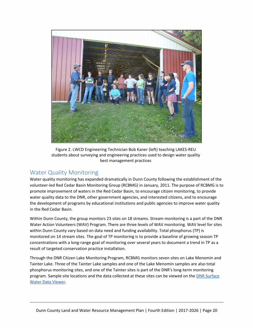
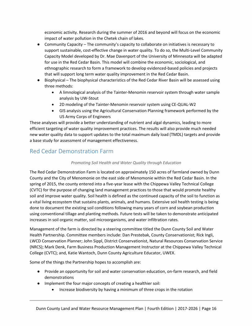
Dunn County Land and Water Resource Management Plan | Fourth Edition | 2017-2026 | Page 20
Figure 2. LWCD Engineering Technician Bob Kaner (left) teaching LAKES-REU students about surveying and engineering practices used to design water quality
best management practices
Water Quality Monitoring Water quality monitoring has expanded dramatically in Dunn County following the establishment of the
volunteer-led Red Cedar Basin Monitoring Group (RCBMG) in January, 2011. The purpose of RCBMG is to
promote improvement of waters in the Red Cedar Basin, to encourage citizen monitoring, to provide
water quality data to the DNR, other government agencies, and interested citizens, and to encourage
the development of programs by educational institutions and public agencies to improve water quality
in the Red Cedar Basin.
Within Dunn County, the group monitors 23 sites on 18 streams. Stream monitoring is a part of the DNR
Water Action Volunteers (WAV) Program. There are three levels of WAV monitoring. WAV level for sites
within Dunn County vary based on data need and funding availability. Total phosphorus (TP) is
monitored on 14 stream sites. The goal of TP monitoring is to provide a baseline of growing season TP
concentrations with a long-range goal of monitoring over several years to document a trend in TP as a
result of targeted conservation practice installation.
Through the DNR Citizen Lake Monitoring Program, RCBMG monitors seven sites on Lake Menomin and
Tainter Lake. Three of the Tainter Lake samples and one of the Lake Menomin samples are also total
phosphorus monitoring sites, and one of the Tainter sites is part of the DNR’s long-term monitoring
program. Sample site locations and the data collected at these sites can be viewed on the DNR Surface
Water Data Viewer.

Dunn County Land and Water Resource Management Plan | Fourth Edition | 2017-2026 | Page 21
In addition to volunteer monitoring, DNR Fisheries conducts monitoring at many additional locations in
the county for the purpose of monitoring conditions for fish habitat. As with the citizen-based data, the
location of the monitoring sites and data are available for viewing on the Surface Water Data Viewer.
Additional volunteers to perform monitoring are always needed.
Beginning in 2015, Dunn County contracted with UW-Stout Professor Dr. Bill James to collect winter
phosphorus concentrations at locations on the Red Cedar and Hay Rivers above Lake Tainter. Samples
were collected under freezing conditions when surface water runoff was minimal and groundwater was
contributing the majority of water in the rivers. Data will be used as part of an ongoing study of
determining groundwater contributions of phosphorus to lakes. These samples are being analyzed for
both total phosphorus and dissolved phosphorus which is the form of phosphorus available to algae for
assimilation, driving growth and bloom development. This research will continue in 2016-2018 as a part
of the Red Cedar Basin Assessment (see below).
Wilson and Annis Creek Watershed Partnership Wilson Creek, located in in western Dunn and eastern St. Croix Counties (Figure 3), and Annis Creek,
which flows into Wilson Creek about two miles northwest of Menomonie, are class II trout streams with
some tributaries being class I. After their confluence, the two waterways flow together into Lake
Menomin just above the dam before joining the waters of the Red Cedar River. Over 11 miles of Wilson
Creek and 3.4 miles of Coon Creek, a tributary to Annis, have been 303(d) listed for reasons of excess
sedimentation, phosphorus, and other pollutants. A 303(d) listing means that these streams are
impaired and the water quality does not meet the minimum standards set by the EPA. The impairments
to the creeks have caused elevated water temperature, degraded habitat, and a degraded biological
community.
Figure 3. Wilson Creek Watershed
Dunn County Land and Water Resource Management Plan | Fourth Edition | 2017-2026 | Page 22
In 2015, the LWCD and NRCS submitted an application for funding through the National Water Quality
Initiative Program. The funding was granted for Wilson Creek in the Spring of 2016. These funds support
the installation of conservation “best management practices” on land in the Wilson Creek Watershed
while general Environmental Quality Incentive Program funds are available to landowners in the Annis
Creek Watershed. Additional funding opportunities exist and may be leveraged to expand the project to
include trout stream restoration.
To ensure the success of the project, LWCD and NRCS initiated the Wilson and Annis Creek Watershed
Partnership, a citizen-led group tasked with guiding project implementation. The Civic Governance
model is being used to ensure that all community members have the ability and opportunity to serve as
stakeholders in the project. This partnership promotes land stewardship practices and works together to
select conservation best management practices to prioritize, such as grassed waterways, stream bank
restoration, cover crop establishment, stream crossings and manure storage structures. These practices
will improve soil health and water quality with the goal of removing Wilson Creek from the federal
impaired waters list.
RESOURCE ASSESSMENT Dunn County is located in West Central Wisconsin. The county is bordered to the north by Polk and
Barron Counties, to the east by Chippewa and Eau Claire Counties, to the south by Pepin County, and to
the west by Pierce and St. Croix Counties. Dunn County has a total land and water area of approximately
552,960 acres. It is rectangular in size, about 24 miles east to west, and 36 miles north to south.
Topography in the county ranges from flat, wide-open fields in the eastern areas to rough hilly terrain in
the western and northern areas. Throughout most of the county, sandstone bedrock is prevalent. In the
higher elevations of the western portion of the county, sandstone is capped by dolomitic limestone.
Dunn County consists of 22 unincorporated towns, 7 incorporated villages, and one city. The county seat
is located in the City of Menomonie, which is the largest municipality.
Dunn County lies totally within the Lower Chippewa River Basin and is divided into eight watersheds,
four draining into the Red Cedar River before it empties into the Chippewa River, and four draining into
the lower Chippewa River. The three biggest lakes in the county are all impoundments, Tainter Lake,
Lake Menomin and Lake Eau Galle. Each of these lakes is susceptible to excess phosphorus loading and
algal blooms. Dunn County is home to a number of impaired lakes, rivers, and streams. Watershed plans
have been, and continue to be, drafted to address these impairments and the concerns of citizens.
Groundwater provides drinking water for all county residents and a majority of the water used by
industry. The county relies on one primary aquifer located in the sandstone bedrock that underlies a
wide variety of soils ranging from loamy sands to heavy silts. Having one aquifer means that wells
cannot be drilled deeper to solve groundwater contamination issues, making it that much more
important to protect the aquifer and prevent groundwater pollution from occurring. A major concern of
Dunn County citizens is septage spreading on agricultural lands. Citizens want to be assured that septage
spreading is being monitored and performed only on suitable sites.
Frac sand mining - Much of the sandstone bedrock on the western side of the county is of the Cambrian
formation which is made up of sand particles of the ideal size and shape for hydraulic fracking or “frac
Dunn County Land and Water Resource Management Plan | Fourth Edition | 2017-2026 | Page 23
sand” in the oil and natural gas
industry. The long term impact of frac
sand mining on drainage patterns,
groundwater, and wildlife is
undetermined, but it definitely has
the potential to change much of the
natural landscape. Frac sand mining
has been and continues to be a
concern of citizens in the county and
as such is addressed in this plan.
Invasive Species - Invasive species of
both the terrestrial and aquatic
variety threaten native flora and
fauna. Dunn County recognizes this
threat and has dedicated staff time to
address this concern.
Soil Erosion - Soil erosion is one of the
biggest threats to both the
agricultural economy and water
quality. Soil erosion can occur from
both wind and runoff/rainfall and
results in the loss of productive
topsoil. The Dunn County LWCD
works with agricultural landowners to
reduce soil erosion by promoting
erosion-reducing farming practices
such as reduced tillage, planting cover
crops, and contour farming.
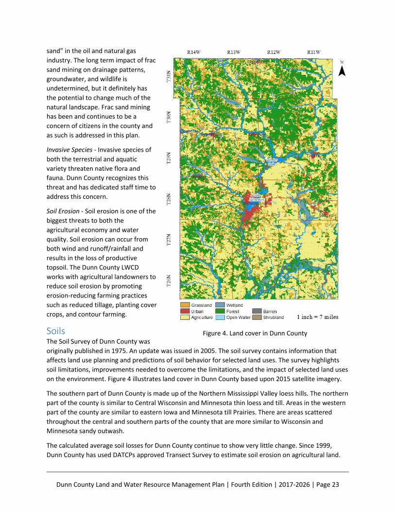
Soils The Soil Survey of Dunn County was
originally published in 1975. An update was issued in 2005. The soil survey contains information that
affects land use planning and predictions of soil behavior for selected land uses. The survey highlights
soil limitations, improvements needed to overcome the limitations, and the impact of selected land uses
on the environment. Figure 4 illustrates land cover in Dunn County based upon 2015 satellite imagery.
The southern part of Dunn County is made up of the Northern Mississippi Valley loess hills. The northern
part of the county is similar to Central Wisconsin and Minnesota thin loess and till. Areas in the western
part of the county are similar to eastern Iowa and Minnesota till Prairies. There are areas scattered
throughout the central and southern parts of the county that are more similar to Wisconsin and
Minnesota sandy outwash.
The calculated average soil losses for Dunn County continue to show very little change. Since 1999,
Dunn County has used DATCPs approved Transect Survey to estimate soil erosion on agricultural land.
Figure 4. Land cover in Dunn County

Dunn County Land and Water Resource Management Plan | Fourth Edition | 2017-2026 | Page 24
Minor changes in the yearly calculated soil loss can be contributed to changes in the soil loss formula
itself (which took place in 2008) and to changes in staff who conducted the survey.
Soil erosion concerns are a twofold problem. When soil is eroded from an area, it is transported and
deposited in another area. The original soil suffers the loss of some of its productivity when the upper
layer is removed. The soil that is eroded is deposited as sediment in another location. If this sediment
makes its way to surface water, the nutrients that were in the soil are now available to water loving
plants including algae. It is necessary to reduce soil erosion for the sustainability of food and crop
production. Sediment is also the number one source of nonpoint source pollution.
The percent of ground cover after planting is one of the management practices that can have a
significant influence on soil erosion. The county is experiencing a steady increase of residue left after
planting especially in the categories over 50%. Conservation planning efforts have and will continue to
encourage producers to leave more than 30% residue.
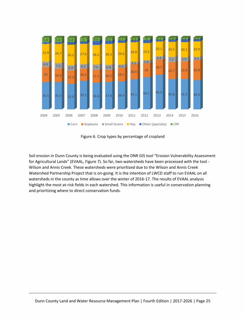
Data from the DATCP approved transect survey is used to assess soil erosion (Figure 5), cropping trends
(Figure 6), and tillage methods. Soil erosion rates in Dunn County have not significantly changed over
the past 12 years.
Figure 5. Average soil loss from agricultural fields
0%
10%
20%
30%
40%
50%
60%
70%
80%
90%
100%
2004 2005 2006 2007 2008 2009 2010 2011 2012 2013 2014 2015 2016
84.3 82.2 83.7 82.7 82.8 87.2 86.5 86.4 83.2 82.4 84.1 83.7 83.2
8.7 10.4 9.9 10.5 108.7 7.8 8.7 10.1 10.8 9.1 10 9.7
3.4 3.2 3.8 3.1 3.4 2.2 3.1 2.4 3.2 2.4 4.6 3.3 3.53.6 4.2 2.6 3.7 3.8 1.9 2.6 2.6 2.7 4.4 2.2 3 3.5
Less Than or equal T 1-2 T 2-3 T Greater than 3 T
Dunn County Land and Water Resource Management Plan | Fourth Edition | 2017-2026 | Page 25
Figure 6. Crop types by percentage of cropland
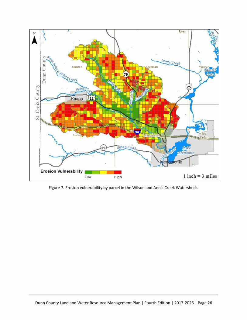
Soil erosion in Dunn County is being evaluated using the DNR GIS tool “Erosion Vulnerability Assessment
for Agricultural Lands” (EVAAL, Figure 7). So far, two watersheds have been processed with the tool -
Wilson and Annis Creek. These watersheds were prioritized due to the Wilson and Annis Creek
Watershed Partnership Project that is on-going. It is the intention of LWCD staff to run EVAAL on all
watersheds in the county as time allows over the winter of 2016-17. The results of EVAAL analysis
highlight the most at-risk fields in each watershed. This information is useful in conservation planning
and prioritizing where to direct conservation funds.
2004 2005 2006 2007 2008 2009 2010 2011 2012 2013 2014 2015 2016
35.5 35.5 32.9 39.2 36.6 37.8 38.4 41.1 44.1 46.440.8 41.3 39.9
19 16.617.2
16.2 17.1 16.2 18.120.5 19
20.722.7 23.9 26.8
6.9 7.56.9 6.2 7.6 6.9 4.3
3.2 3.84.4 7.2 5.9 4.3
22.9 24.7 26.2 27.6 26.2 28.3 29.6 26.8 23.520.1 20.2 20.2 20.9
2 1.8 3.6 3.2 5.3 4.3 3.2 2.6 4.3 2.1 3.1 3.8 3.35.8 5.9 5.4 5 4.6 4.2 3.7 3.3 3 2.7 2.4 2.2 1.7
Corn Soybeans Small Grains Hay Other (specialty) CRP
Dunn County Land and Water Resource Management Plan | Fourth Edition | 2017-2026 | Page 26
Figure 7. Erosion vulnerability by parcel in the Wilson and Annis Creek Watersheds
Dunn County Land and Water Resource Management Plan | Fourth Edition | 2017-2026 | Page 27
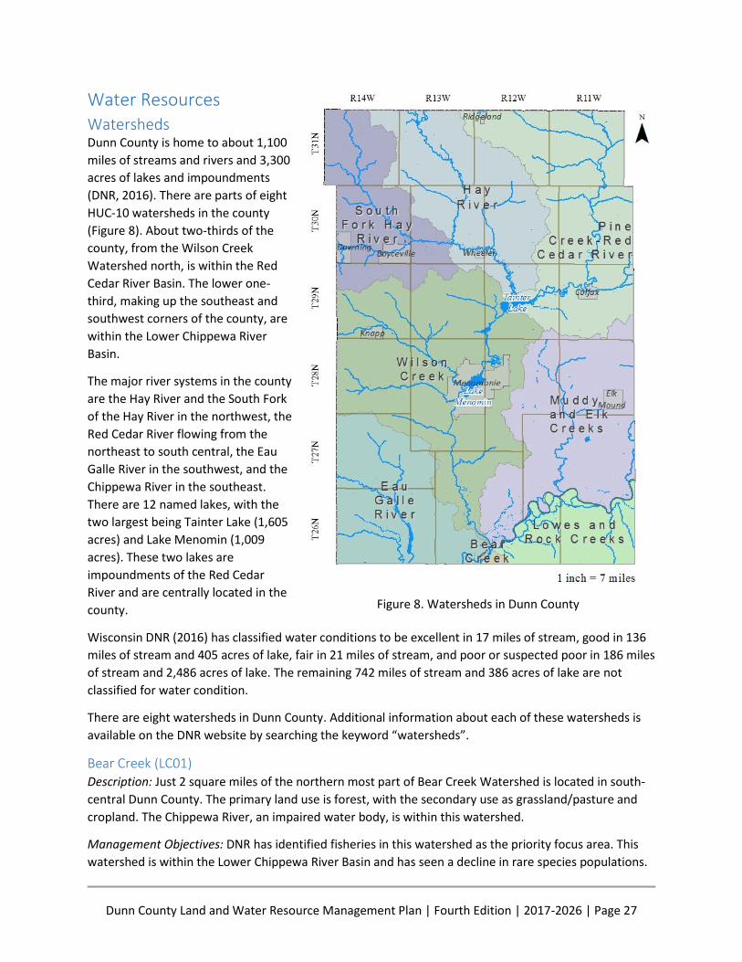
Water Resources Watersheds Dunn County is home to about 1,100
miles of streams and rivers and 3,300
acres of lakes and impoundments
(DNR, 2016). There are parts of eight
HUC-10 watersheds in the county
(Figure 8). About two-thirds of the
county, from the Wilson Creek
Watershed north, is within the Red
Cedar River Basin. The lower one-
third, making up the southeast and
southwest corners of the county, are
within the Lower Chippewa River
Basin.
The major river systems in the county
are the Hay River and the South Fork
of the Hay River in the northwest, the
Red Cedar River flowing from the
northeast to south central, the Eau
Galle River in the southwest, and the
Chippewa River in the southeast.
There are 12 named lakes, with the
two largest being Tainter Lake (1,605
acres) and Lake Menomin (1,009
acres). These two lakes are
impoundments of the Red Cedar
River and are centrally located in the
county.
Wisconsin DNR (2016) has classified water conditions to be excellent in 17 miles of stream, good in 136
miles of stream and 405 acres of lake, fair in 21 miles of stream, and poor or suspected poor in 186 miles
of stream and 2,486 acres of lake. The remaining 742 miles of stream and 386 acres of lake are not
classified for water condition.
There are eight watersheds in Dunn County. Additional information about each of these watersheds is
available on the DNR website by searching the keyword “watersheds”.
Bear Creek (LC01) Description: Just 2 square miles of the northern most part of Bear Creek Watershed is located in south-
central Dunn County. The primary land use is forest, with the secondary use as grassland/pasture and
cropland. The Chippewa River, an impaired water body, is within this watershed.
Management Objectives: DNR has identified fisheries in this watershed as the priority focus area. This
watershed is within the Lower Chippewa River Basin and has seen a decline in rare species populations.
Figure 8. Watersheds in Dunn County
Dunn County Land and Water Resource Management Plan | Fourth Edition | 2017-2026 | Page 28
These populations are threatened by sedimentation from erosion filling in the natural coarse substrate.
Dunn County will continue to manage the land in this watershed to reduce soil erosion by working with
landowners to develop soil health and implement best management practices on their land.
Eau Galle River (LC03) Description: Much of the southern half (65,000 out of 171,000 total acres) of the Eau Galle River
Watershed is located in southwest Dunn County. The main stem of the Eau Galle River, as well as
Knight’s Creek and some tributaries, are class II trout streams, with some tributaries being class I.
Missouri Creek is listed as impaired due to sediment/total suspended solids and has degraded habitat as
a result. The primary land use in the watershed is agriculture in the lowlands and uplands, with
forestland dominating the side slopes. A small amount of pasture/grassland also exists in the watershed.
Management Objectives: Trout streams in the Eau Galle Watershed are primarily threatened by runoff
from agricultural activities including barnyards, feedlots, and streambank grazing. Flooding and
streambank scour is also a concern. A primary management goal of the Eau Galle River Watershed is to
reduce the amount of sediments entering waters in this watershed by implementing best management
practices (BMPs) that promote infiltration and water storage, thus reducing sediment and pollutant
laden runoff from entering the system. Ultimately, these practices could lead to Missouri Creek
becoming delisted from the Impaired Waters List by the DNR. The DNR also has plans to conduct
biological monitoring in the Eau Galle River.
Wilson Creek (LC04) Description: Wilson Creek is a 245 square mile watershed mostly in West Central Dunn County with a
small area in St. Croix County. Most of the streams in this watershed are class II trout streams, with
several class I streams in the upper tributaries of Wilson and Gilbert Creeks. These coldwater streams
are fed by springs which are commonly found in this part of Dunn County. Forestland makes up 40% of
the watershed, while the remainder of the land use is agriculture, grassland, and some wetlands. The
main stem of Wilson Creek, as well as its tributary Coon Creek, is impaired for the reasons of total
phosphorus and suspended sediment, respectively. Sources of pollution include streambank pasturing
and agricultural nonpoint source runoff.
Management Objectives: The northern-most HUC12 sub-basins of this watershed are included in the
Tainter-Menomin TMDL and will be managed according the TMDL Implementation Plan. The NRCS
successfully secured National Water Quality Initiative funding in 2016 for the Wilson Creek HUC12 sub-
basin that is not included in the TMDL. This funding is expected to extend for three years and makes
additional Environmental Quality Incentives Program funding available to landowners in this
subwatershed.
Stemming from this recent initiative, the DNR has added several water quality monitoring sites along
Wilson Creek. Additionally, the DNR has undertaken recent trout habitat work on Wilson Creek and
Gilbert Creek to restore trout habitat to degraded stream segments. Most of these projects are located
on public easements and create valuable recreation areas for citizens. Parts of Wilson and Coon Creek,
located in this watershed, are impaired and will be managed with a goal of reducing total phosphorus
and sediment to levels that would result in the DNR’s removal of the water from the 303(d) list.
Dunn County Land and Water Resource Management Plan | Fourth Edition | 2017-2026 | Page 29
Hay River (LC05) Description: The Hay River Watershed spans across Barron and Dunn Counties with the lower third being
in north-central Dunn County. The Hay River is impaired due to total phosphorus and flows into Tainter
Lake (which is also impaired) at its terminus. A 1989-90 study found that 94 percent of the Hay River
phosphorus load is controllable. Of the total load, about 80 percent is from polluted nonpoint source
runoff and 20 percent is from point sources. All main tributaries to the Hay River in Dunn County are
class II trout streams, with several class I streams flowing into Big Beaver Creek from the uplands.
Management Objectives: The Hay River has been subject to a number of studies over the past few
decades due to its contribution to the downstream Tainter Lake. A primary management objective is to
reduce the amount of phosphorus entering the River to an acceptable level, leading to its delisting by
the DNR from the Impaired Waters List. A TMDL has been written and approved for the Red Cedar Basin,
and the Hay River Watershed will be managed according the TMDL Implementation Plan.
At the time of this writing, the Hay River Watershed is also the location of Dunn County’s only Farmer-
Led Watershed (FLW), which was initiated in 2013. Farmer-led watersheds allow farmers to become
knowledgeable about, engaged in, and form leadership over water quality issues. The Hay River FLW has
received grants and adopted conservation practices using those funds with a goal to improve water
quality in the watershed.
South Fork Hay River (LC06) Description: The South Fork of the Hay River is located in northwest Dunn County. This watershed drains
agricultural and forested land. About one-third of the watershed is located in Dunn County, one-third in
St. Croix County, and the remaining one-third being located in Barron and Polk Counties. There are no
impaired waters in this watershed and all streams are either class I or class II trout streams. Problems
facing surface waters in this watershed include streambank erosion, sedimentation of riffle and pool
areas, organic and nutrient loading from animal waste, and elevated stream temperatures (DNR, 2016).
The South Fork of the Hay River Watershed was selected as a priority watershed in 1993 and the project
was closed in 2005. The DNR performed a final stream inventory in 2015 to gather data on long-term
effects of the project.
Management Objectives: DNR goals for the watershed include continued monitoring of fish tissue and
wetland restorations. The South Fork of the Hay River is located within the Red Cedar River Watershed
TMDL area and will be managed as a part of the Red Cedar River Basin TMDL Implementation Plan to
reduce phosphorus loading into Tainter Lake.
Pine Creek and Red Cedar River (LC07) Description: The Pine Creek and Red Cedar River Watershed is located in northeast Dunn County. The
Red Cedar River, Eighteen Mile Creek, Running Valley Creek, and an unnamed tributary to Eighteen Mile
Creek are degraded and listed on the impaired waters list for reasons of sedimentation and phosphorus
pollution. Many of these streams are class I, II, and III trout streams, and Sand Creek is designated by the
DNR as an exceptional resource water. Concerns in this watershed are primarily from streambank
pasturing and agricultural runoff.
Management Objectives: A management priority within this watershed is to work toward delisting the
impaired streams. The Red Cedar River has been subject to a number of studies over the past few
decades due to its contribution to the downstream Tainter Lake. A TMDL has been written and approved
Dunn County Land and Water Resource Management Plan | Fourth Edition | 2017-2026 | Page 30
for the Red Cedar Basin, and the Red Cedar River Watershed will be managed according the TMDL
Implementation Plan.
Other priorities and goals identified by the DNR include continued monitoring of fish tissue and
evaluation of stream base flow.
Muddy and Elk Creeks (LC13) Description: The Muddy and Elk Creek Watersheds comprise about 91,000 acres in southeast Dunn
County. This area is dominated by large, flat agricultural fields, most commonly in a corn-bean rotation
of row crops. A large wetland area found in the central part of the watershed is managed as the Muddy
Creek State Wildlife Area. Other protected areas in the Dunn County portion of the watershed include
the Dunnville State Wildlife Area (commonly referred to as the Dunnville Bottoms) and Hoffman Hills
State Recreation Area. In the northern part of the watershed, Muddy Creek begins as a class II trout
stream and becomes a class III in the main stem. Big Elk Creek and a smaller, unnamed stream are class I
trout streams and designated as exceptional resource waters by the DNR. A portion of Elk Creek flowing
out of Elk Creek Lake is impaired and listed on the Impaired Waters List due to phosphorus pollution
resulting in use restrictions.
Management Objectives: This watershed will be managed to maintain and improve the existing trout
streams and exceptional resource waters as well as work toward improving Elk Creek to a level that it
may be delisted by DNR from the Impaired Waters List. Management of the state natural and recreation
areas, as well as encouraging best management practice implementation in farmland of the watershed,
will improve surface waters and ensure they continue to serve as healthy fisheries. Due to the flat
nature of the watershed, stream buffers, reduced/no tillage, and cover crop adoption are the primary
agricultural conservation practices that will be promoted. The DNR has also identified invasive species
management in Elk Creek and biological monitoring as a priority for the watershed.
Lowes and Rock Creeks (LC24) Description: The Lowes and Rock Creek Watershed is located in southeast Dunn County and is
approximately 32,000 acres in size. The streams in the Dunn County portion of this watershed include
Cook, Rock, Cranberry, Duscham, and Fall Creeks. Rock Creek upstream of the Rock Falls Millpond is
impaired due to suspended sediment/solids leading to elevated water temperatures and degraded
habitat. It is considered a class II trout stream below the millpond. Coon and Fall Creeks are also class II
trout streams. Land use in the watershed is dominated by vast, flat agricultural fields and some
pasturing. Forestland increases with proximity to the Chippewa River, and some areas of wetland also
exist, including the Rock Falls Wildlife Area, through which Rock Creek flows.
Management Objectives: Current DNR management objectives are to continue citizen-based stream
monitoring at Fall Creek. In 2015, phosphorus exceeded state standards in Fall Creek 100% of the time.
LWCD efforts to implement BMPs in this watershed will also help reduce both phosphorus and sediment
inputs into streams, ideally leading to the delisting of Fall Creek from the impaired waters list.
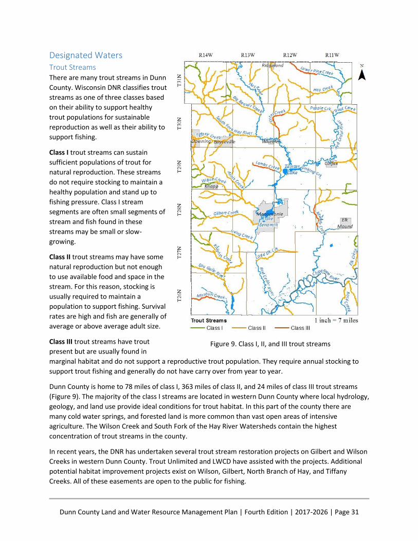
Dunn County Land and Water Resource Management Plan | Fourth Edition | 2017-2026 | Page 31
Designated Waters Trout Streams There are many trout streams in Dunn
County. Wisconsin DNR classifies trout
streams as one of three classes based
on their ability to support healthy
trout populations for sustainable
reproduction as well as their ability to
support fishing.
Class I trout streams can sustain
sufficient populations of trout for
natural reproduction. These streams
do not require stocking to maintain a
healthy population and stand up to
fishing pressure. Class I stream
segments are often small segments of
stream and fish found in these
streams may be small or slow-
growing.
Class II trout streams may have some
natural reproduction but not enough
to use available food and space in the
stream. For this reason, stocking is
usually required to maintain a
population to support fishing. Survival
rates are high and fish are generally of
average or above average adult size.
Class III trout streams have trout
present but are usually found in
marginal habitat and do not support a reproductive trout population. They require annual stocking to
support trout fishing and generally do not have carry over from year to year.
Dunn County is home to 78 miles of class I, 363 miles of class II, and 24 miles of class III trout streams
(Figure 9). The majority of the class I streams are located in western Dunn County where local hydrology,
geology, and land use provide ideal conditions for trout habitat. In this part of the county there are
many cold water springs, and forested land is more common than vast open areas of intensive
agriculture. The Wilson Creek and South Fork of the Hay River Watersheds contain the highest
concentration of trout streams in the county.
In recent years, the DNR has undertaken several trout stream restoration projects on Gilbert and Wilson
Creeks in western Dunn County. Trout Unlimited and LWCD have assisted with the projects. Additional
potential habitat improvement projects exist on Wilson, Gilbert, North Branch of Hay, and Tiffany
Creeks. All of these easements are open to the public for fishing.
Figure 9. Class I, II, and III trout streams
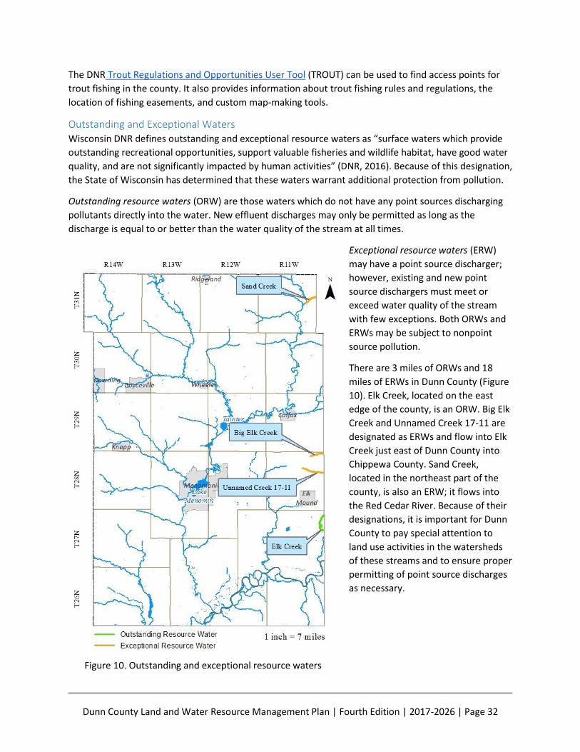
Dunn County Land and Water Resource Management Plan | Fourth Edition | 2017-2026 | Page 32
The DNR Trout Regulations and Opportunities User Tool (TROUT) can be used to find access points for
trout fishing in the county. It also provides information about trout fishing rules and regulations, the
location of fishing easements, and custom map-making tools.
Outstanding and Exceptional Waters Wisconsin DNR defines outstanding and exceptional resource waters as “surface waters which provide
outstanding recreational opportunities, support valuable fisheries and wildlife habitat, have good water
quality, and are not significantly impacted by human activities” (DNR, 2016). Because of this designation,
the State of Wisconsin has determined that these waters warrant additional protection from pollution.
Outstanding resource waters (ORW) are those waters which do not have any point sources discharging
pollutants directly into the water. New effluent discharges may only be permitted as long as the
discharge is equal to or better than the water quality of the stream at all times.
Exceptional resource waters (ERW)
may have a point source discharger;
however, existing and new point
source dischargers must meet or
exceed water quality of the stream
with few exceptions. Both ORWs and
ERWs may be subject to nonpoint
source pollution.
There are 3 miles of ORWs and 18
miles of ERWs in Dunn County (Figure
10). Elk Creek, located on the east
edge of the county, is an ORW. Big Elk
Creek and Unnamed Creek 17-11 are
designated as ERWs and flow into Elk
Creek just east of Dunn County into
Chippewa County. Sand Creek,
located in the northeast part of the
county, is also an ERW; it flows into
the Red Cedar River. Because of their
designations, it is important for Dunn
County to pay special attention to
land use activities in the watersheds
of these streams and to ensure proper
permitting of point source discharges
as necessary.
Figure 10. Outstanding and exceptional resource waters
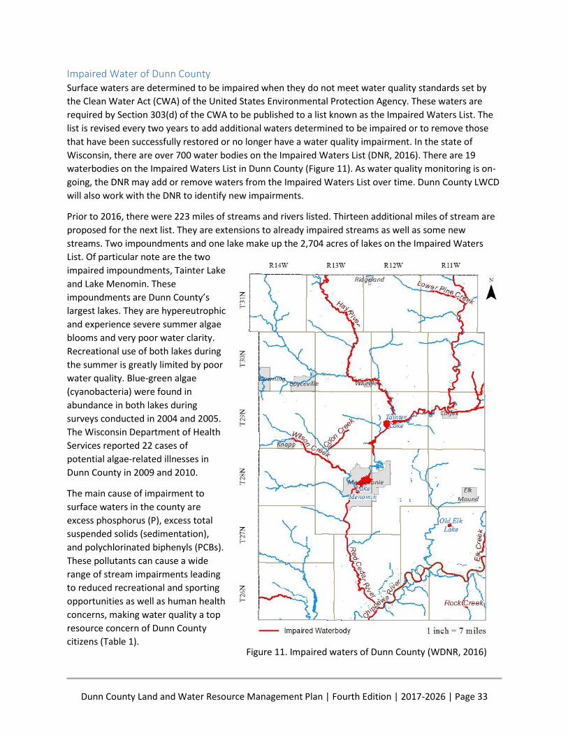
Dunn County Land and Water Resource Management Plan | Fourth Edition | 2017-2026 | Page 33
Impaired Water of Dunn County Surface waters are determined to be impaired when they do not meet water quality standards set by
the Clean Water Act (CWA) of the United States Environmental Protection Agency. These waters are
required by Section 303(d) of the CWA to be published to a list known as the Impaired Waters List. The
list is revised every two years to add additional waters determined to be impaired or to remove those
that have been successfully restored or no longer have a water quality impairment. In the state of
Wisconsin, there are over 700 water bodies on the Impaired Waters List (DNR, 2016). There are 19
waterbodies on the Impaired Waters List in Dunn County (Figure 11). As water quality monitoring is on-
going, the DNR may add or remove waters from the Impaired Waters List over time. Dunn County LWCD
will also work with the DNR to identify new impairments.
Prior to 2016, there were 223 miles of streams and rivers listed. Thirteen additional miles of stream are
proposed for the next list. They are extensions to already impaired streams as well as some new
streams. Two impoundments and one lake make up the 2,704 acres of lakes on the Impaired Waters
List. Of particular note are the two
impaired impoundments, Tainter Lake
and Lake Menomin. These
impoundments are Dunn County’s
largest lakes. They are hypereutrophic
and experience severe summer algae
blooms and very poor water clarity.
Recreational use of both lakes during
the summer is greatly limited by poor
water quality. Blue-green algae
(cyanobacteria) were found in
abundance in both lakes during
surveys conducted in 2004 and 2005.
The Wisconsin Department of Health
Services reported 22 cases of
potential algae-related illnesses in
Dunn County in 2009 and 2010.
The main cause of impairment to
surface waters in the county are
excess phosphorus (P), excess total
suspended solids (sedimentation),
and polychlorinated biphenyls (PCBs).
These pollutants can cause a wide
range of stream impairments leading
to reduced recreational and sporting
opportunities as well as human health
concerns, making water quality a top
resource concern of Dunn County
citizens (Table 1).
Figure 11. Impaired waters of Dunn County (WDNR, 2016)

Dunn County Land and Water Resource Management Plan | Fourth Edition | 2017-2026 | Page 34
Table 1. Impaired waters of Dunn County
Name Start Mile
End Mile
Pollutant Impairment Status Date
Listed
Chippewa River 21 38 PCBs Contaminated Fish Tissue
303d Listed 4/1/98
Chippewa River 38 59 PCBs Contaminated Fish Tissue
303d Listed 4/1/98
Coon Creek 0 3 Unknown Pollutant Degraded Biological Community
303d Listed 4/1/14
Coon Creek 0 3 Sediment/Total Suspended Solids
Elevated Water Temperature, Degraded Habitat
303d Listed 4/1/02
Eau Galle River 0 9 Total P Impairment Unknown 303d Listed 4/1/14
Eighteen Mile Creek
0 5 Total P Water Quality Use Restrictions
303d Listed 4/1/12
Eighteen Mile Creek
5 6 Total P Water Quality Use Restrictions
303d Listed 4/1/12
Elk Creek 0 4 Total P Water Quality Use Restrictions
303d Listed 4/1/12
Hay River 0 38 Total P Impairment Unknown 303d Listed 4/1/12
Jarrett Creek at Schneider Ave
0 3 Chloride Chronic Aquatic Toxicity, Acute Aquatic Toxicity
Proposed for List
4/1/16
Lake Menomin - - Total P Eutrophication, Excess Algal Growth, Elevated pH
TMDL Approved
4/1/98
Lower Pine Creek 0 7 Total P Impairment Unknown 303d Listed 4/1/12
Lower Pine Creek 14 17 Total P Impairment Unknown 303d Listed 4/1/14
Missouri Creek 9 14 Sediment/Total Suspended Solids
Degraded Habitat 303d Listed 4/1/98
Old Elk Lake - - Total P, Low DO, Eutrophication 303d Listed 4/1/98
Old Elk Lake - - Sediment/Total Suspended Solids
Degraded Habitat 303d Listed 4/1/98
Red Cedar River 0 9 Total P Impairment Unknown 303d Listed 4/1/14
Red Cedar River 0 9 PCBs Contaminated Fish Tissue
303d Listed 4/1/06
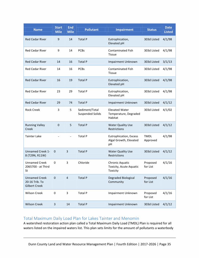
Dunn County Land and Water Resource Management Plan | Fourth Edition | 2017-2026 | Page 35
Name Start Mile
End Mile
Pollutant Impairment Status Date
Listed
Red Cedar River 9 14 Total P Eutrophication, Elevated pH
303d Listed 4/1/98
Red Cedar River 9 14 PCBs Contaminated Fish Tissue
303d Listed 4/1/98
Red Cedar River 14 16 Total P Impairment Unknown 303d Listed 3/1/13
Red Cedar River 14 16 PCBs Contaminated Fish Tissue
303d Listed 4/1/98
Red Cedar River 16 19 Total P Eutrophication, Elevated pH
303d Listed 4/1/98
Red Cedar River 23 29 Total P Eutrophication, Elevated pH
303d Listed 4/1/98
Red Cedar River 29 74 Total P Impairment Unknown 303d Listed 4/1/12
Rock Creek 3 5 Sediment/Total Suspended Solids
Elevated Water Temperature, Degraded Habitat
303d Listed 4/1/02
Running Valley Creek
0 5 Total P Water Quality Use Restrictions
303d Listed 4/1/12
Tainter Lake - - Total P Eutrophication, Excess Algal Growth, Elevated pH
TMDL Approved
4/1/98
Unnamed Creek 1-8 (T29N, R11W)
0 3 Total P Water Quality Use Restrictions
303d Listed 4/1/12
Unnamed Creek 2065700 - at Third St
0 3 Chloride Chronic Aquatic Toxicity, Acute Aquatic Toxicity
Proposed for List
4/1/16
Unnamed Creek 20-16 Trib. To Gilbert Creek
0 4 Total P Degraded Biological Community
Proposed for List
4/1/16
Wilson Creek 0 3 Total P Impairment Unknown Proposed for List
4/1/16
Wilson Creek 3 14 Total P Impairment Unknown 303d Listed 4/1/12
Total Maximum Daily Load Plan for Lakes Tainter and Menomin A watershed restoration action plan called a Total Maximum Daily Load (TMDL) Plan is required for all
waters listed on the impaired waters list. This plan sets limits for the amount of pollutants a waterbody
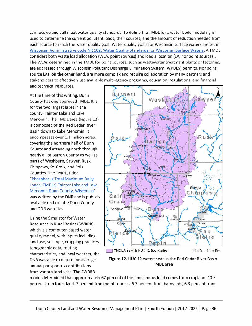
Dunn County Land and Water Resource Management Plan | Fourth Edition | 2017-2026 | Page 36
can receive and still meet water quality standards. To define the TMDL for a water body, modeling is
used to determine the current pollutant loads, their sources, and the amount of reduction needed from
each source to reach the water quality goal. Water quality goals for Wisconsin surface waters are set in
Wisconsin Administrative code NR 102: Water Quality Standards for Wisconsin Surface Waters. A TMDL
considers both waste load allocation (WLA, point sources) and load allocation (LA, nonpoint sources).
The WLAs determined in the TMDL for point sources, such as wastewater treatment plants or factories,
are addressed through Wisconsin Pollutant Discharge Elimination System (WPDES) permits. Nonpoint
source LAs, on the other hand, are more complex and require collaboration by many partners and
stakeholders to effectively use available multi-agency programs, education, regulations, and financial
and technical resources.
At the time of this writing, Dunn
County has one approved TMDL. It is
for the two largest lakes in the
county: Tainter Lake and Lake
Menomin. The TMDL area (Figure 12)
is composed of the Red Cedar River
Basin down to Lake Menomin. It
encompasses over 1.1 million acres,
covering the northern half of Dunn
County and extending north through
nearly all of Barron County as well as
parts of Washburn, Sawyer, Rusk,
Chippewa, St. Croix, and Polk
Counties. The TMDL, titled
“Phosphorus Total Maximum Daily
Loads (TMDLs) Tainter Lake and Lake
Menomin Dunn County, Wisconsin”,
was written by the DNR and is publicly
available on both the Dunn County
and DNR websites.
Using the Simulator for Water
Resources in Rural Basins (SWRRB),
which is a computer-based water
quality model, with inputs including
land use, soil type, cropping practices,
topographic data, routing
characteristics, and local weather, the
DNR was able to determine average
annual phosphorus contributions
from various land uses. The SWRRB
model determined that approximately 67 percent of the phosphorus load comes from cropland, 10.6
percent from forestland, 7 percent from point sources, 6.7 percent from barnyards, 6.3 percent from
Figure 12. HUC 12 watersheds in the Red Cedar River Basin TMDL area
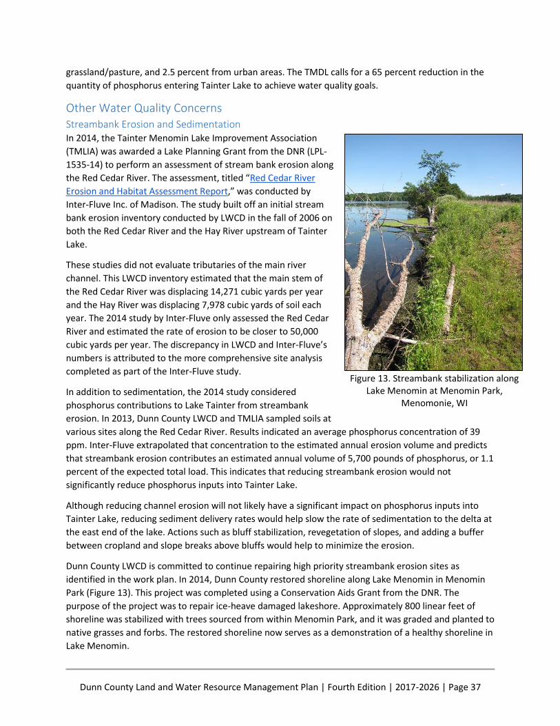
Dunn County Land and Water Resource Management Plan | Fourth Edition | 2017-2026 | Page 37
grassland/pasture, and 2.5 percent from urban areas. The TMDL calls for a 65 percent reduction in the
quantity of phosphorus entering Tainter Lake to achieve water quality goals.
Other Water Quality Concerns Streambank Erosion and Sedimentation In 2014, the Tainter Menomin Lake Improvement Association
(TMLIA) was awarded a Lake Planning Grant from the DNR (LPL-
1535-14) to perform an assessment of stream bank erosion along
the Red Cedar River. The assessment, titled “Red Cedar River
Erosion and Habitat Assessment Report,” was conducted by
Inter-Fluve Inc. of Madison. The study built off an initial stream
bank erosion inventory conducted by LWCD in the fall of 2006 on
both the Red Cedar River and the Hay River upstream of Tainter
Lake.
These studies did not evaluate tributaries of the main river
channel. This LWCD inventory estimated that the main stem of
the Red Cedar River was displacing 14,271 cubic yards per year
and the Hay River was displacing 7,978 cubic yards of soil each
year. The 2014 study by Inter-Fluve only assessed the Red Cedar
River and estimated the rate of erosion to be closer to 50,000
cubic yards per year. The discrepancy in LWCD and Inter-Fluve’s
numbers is attributed to the more comprehensive site analysis
completed as part of the Inter-Fluve study.
In addition to sedimentation, the 2014 study considered
phosphorus contributions to Lake Tainter from streambank
erosion. In 2013, Dunn County LWCD and TMLIA sampled soils at
various sites along the Red Cedar River. Results indicated an average phosphorus concentration of 39
ppm. Inter-Fluve extrapolated that concentration to the estimated annual erosion volume and predicts
that streambank erosion contributes an estimated annual volume of 5,700 pounds of phosphorus, or 1.1
percent of the expected total load. This indicates that reducing streambank erosion would not
significantly reduce phosphorus inputs into Tainter Lake.
Although reducing channel erosion will not likely have a significant impact on phosphorus inputs into
Tainter Lake, reducing sediment delivery rates would help slow the rate of sedimentation to the delta at
the east end of the lake. Actions such as bluff stabilization, revegetation of slopes, and adding a buffer
between cropland and slope breaks above bluffs would help to minimize the erosion.
Dunn County LWCD is committed to continue repairing high priority streambank erosion sites as
identified in the work plan. In 2014, Dunn County restored shoreline along Lake Menomin in Menomin
Park (Figure 13). This project was completed using a Conservation Aids Grant from the DNR. The
purpose of the project was to repair ice-heave damaged lakeshore. Approximately 800 linear feet of
shoreline was stabilized with trees sourced from within Menomin Park, and it was graded and planted to
native grasses and forbs. The restored shoreline now serves as a demonstration of a healthy shoreline in
Lake Menomin.
Figure 13. Streambank stabilization along Lake Menomin at Menomin Park,
Menomonie, WI
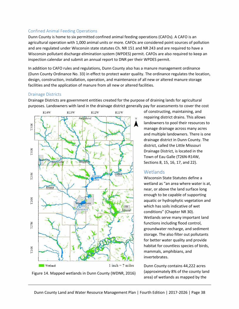
Dunn County Land and Water Resource Management Plan | Fourth Edition | 2017-2026 | Page 38
Confined Animal Feeding Operations Dunn County is home to six permitted confined animal feeding operations (CAFOs). A CAFO is an
agricultural operation with 1,000 animal units or more. CAFOs are considered point sources of pollution
and are regulated under Wisconsin state statutes Ch. NR 151 and NR 243 and are required to have a
Wisconsin pollutant discharge elimination system (WPDES) permit. CAFOs are also required to keep an
inspection calendar and submit an annual report to DNR per their WPDES permit.
In addition to CAFO rules and regulations, Dunn County also has a manure management ordinance
(Dunn County Ordinance No. 33) in effect to protect water quality. The ordinance regulates the location,
design, construction, installation, operation, and maintenance of all new or altered manure storage
facilities and the application of manure from all new or altered facilities.
Drainage Districts Drainage Districts are government entities created for the purpose of draining lands for agricultural
purposes. Landowners with land in the drainage district generally pay for assessments to cover the cost
of constructing, maintaining, and
repairing district drains. This allows
landowners to pool their resources to
manage drainage across many acres
and multiple landowners. There is one
drainage district in Dunn County. The
district, called the Little Missouri
Drainage District, is located in the
Town of Eau Galle (T26N-R14W,
Sections 8, 15, 16, 17, and 22).
Wetlands Wisconsin State Statutes define a
wetland as “an area where water is at,
near, or above the land surface long
enough to be capable of supporting
aquatic or hydrophytic vegetation and
which has soils indicative of wet
conditions” (Chapter NR 30).
Wetlands serve many important land
functions including flood control,
groundwater recharge, and sediment
storage. The also filter out pollutants
for better water quality and provide
habitat for countless species of birds,
mammals, amphibians, and
invertebrates.
Dunn County contains 44,222 acres
(approximately 8% of the county land
area) of wetlands as mapped by the Figure 14. Mapped wetlands in Dunn County (WDNR, 2016)
Dunn County Land and Water Resource Management Plan | Fourth Edition | 2017-2026 | Page 39
DNR Wetland Inventory (Figure 14). This information is based on air photo interpretation between 1978
and 1979 and includes only those wetlands of five or more acres in size. The soil survey of Dunn County
(Soil Survey Staff et. al., 2016) indicates there are 53,600 acres of hydric soils in the county.
Many of the County’s wetlands had been drained and filled, primarily for agricultural purposes, prior to
the Wetland Conservation Compliance Provisions (also known as the “Swampbuster provisions”) of the
1985 Farm Bill. Per the Swampbuster provisions, persons converting any wetland into farmland after
November 28, 1990, are ineligible for federal program benefits until the functions of the wetland that
was converted are mitigated. These federal regulations, along with state rules and regulations and
education about the importance of wetlands, have greatly reduced the amount of wetlands being
drained or degraded.
Dunn County LWCD is committed to protecting remaining wetlands and does not fund or provide
assistance for projects which involve draining or filling these valuable resources. The restoration of
historically drained wetlands is a priority.
Groundwater Dunn County’s groundwater was originally investigated by the Wisconsin Geological and Natural History
Survey in the “Executive Summary of the Dunn County Groundwater Resource Investigation” (Lippelt
and Madison, 1988). During the study, 600 domestic well samples were collected and analyzed for
chemistry. This study produced the first groundwater maps of the county showing soil attenuation
potential, water table elevation, depth to bedrock, aquifer potential, and chemical parameters.
Groundwater in Dunn County is plentiful and generally easy to access in an unconfined Cambrian age
sandstone aquifer. The aquifer is overlain by a wide variety of soils with varying recharge rates. Surficial
deposits affecting groundwater recharge include loams in the majority of the county, sandy deposits
along the west boundary, peat in the east-central wetlands, and sand and gravel in the Red Cedar and
Chippewa River floodplains. Areas where these surficial deposits are overlain by highly permeable
medium to coarse textured soils are more susceptible to groundwater contamination due to high
recharge rates (Figure 15). The recharge rate is the time it takes for surface water, such as rain, to move
downward to groundwater. Soils with higher recharge rates have less time to absorb contaminants than
low recharge soils, which can mean easier contamination to groundwater.
To reduce the probability of groundwater contamination, the LWCD’s approach is to reduce or eliminate
potential contamination sources. This can be done by properly abandoning unused wells and manure
storage structures, improving the manure storage ordinance, and monitoring land spreading of septage.
To that effect, the county’s manure management ordinance safeguards water quality by assuring the
proper installation of manure storage structures. The county offers cost-sharing to abandon unused
wells.
One of the items identified by committee members for the LWRM Plan development was a lack of
recent groundwater quality data and a central repository for such data. To address this need, the county
is developing a county-wide water database which will include a section for groundwater.
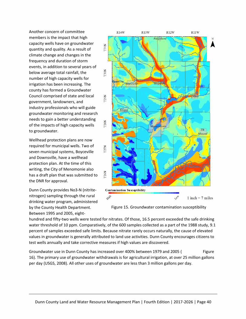
Dunn County Land and Water Resource Management Plan | Fourth Edition | 2017-2026 | Page 40
Another concern of committee
members is the impact that high
capacity wells have on groundwater
quantity and quality. As a result of
climate change and changes in the
frequency and duration of storm
events, in addition to several years of
below average total rainfall, the
number of high capacity wells for
irrigation has been increasing. The
county has formed a Groundwater
Council comprised of state and local
government, landowners, and
industry professionals who will guide
groundwater monitoring and research
needs to gain a better understanding
of the impacts of high capacity wells
to groundwater.
Wellhead protection plans are now
required for municipal wells. Two of
seven municipal systems, Boyceville
and Downsville, have a wellhead
protection plan. At the time of this
writing, the City of Menomonie also
has a draft plan that was submitted to
the DNR for approval.
Dunn County provides No3-N (nitrite-
nitrogen) sampling through the rural
drinking water program, administered
by the County Health Department.
Between 1995 and 2005, eight-
hundred and fifty-two wells were tested for nitrates. Of those, 16.5 percent exceeded the safe drinking
water threshold of 10 ppm. Comparatively, of the 600 samples collected as a part of the 1988 study, 9.1
percent of samples exceeded safe limits. Because nitrate rarely occurs naturally, the cause of elevated
values in groundwater is generally attributed to land use activities. Dunn County encourages citizens to
test wells annually and take corrective measures if high values are discovered.
Groundwater use in Dunn County has increased over 400% between 1979 and 2005 ( Figure
16). The primary use of groundwater withdrawals is for agricultural irrigation, at over 25 million gallons
per day (USGS, 2008). All other uses of groundwater are less than 3 million gallons per day.
Figure 15. Groundwater contamination susceptibility
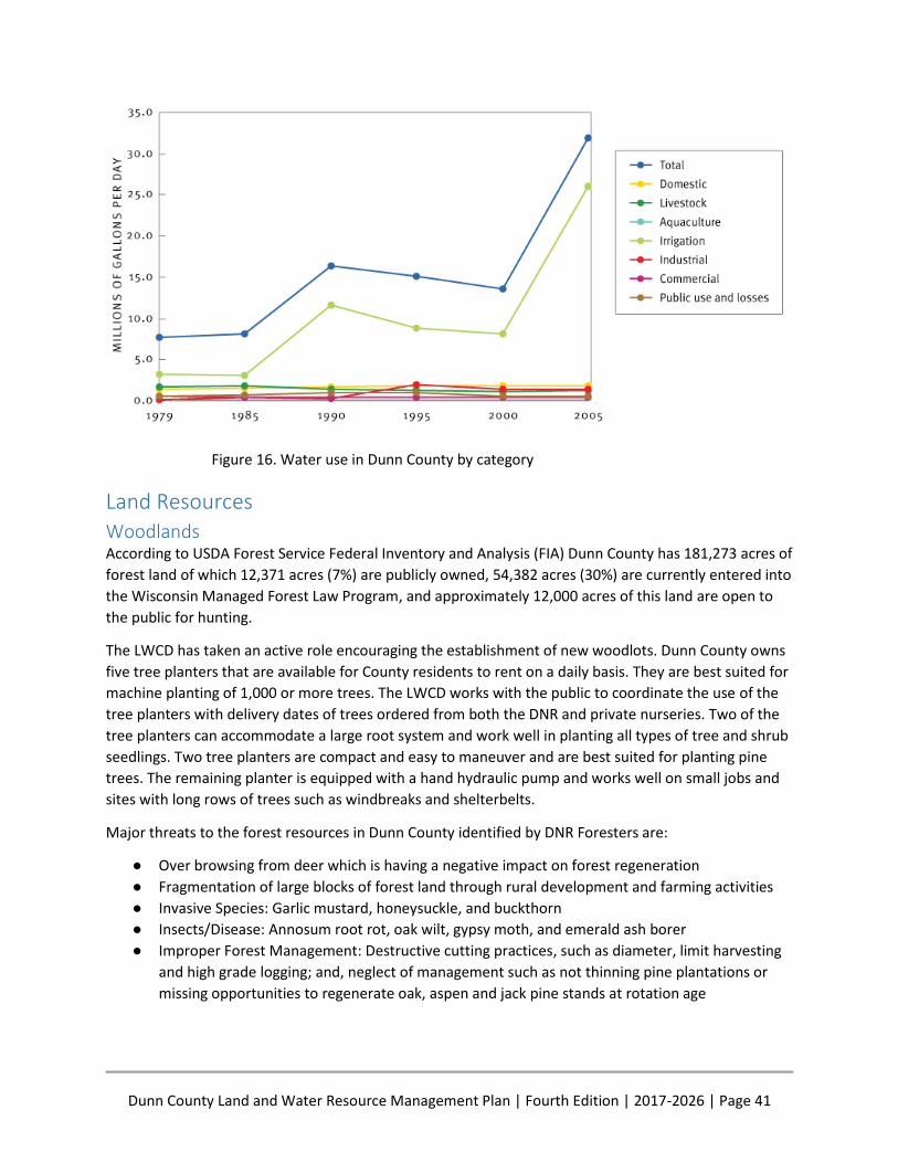
Dunn County Land and Water Resource Management Plan | Fourth Edition | 2017-2026 | Page 41
Figure 16. Water use in Dunn County by category
Land Resources Woodlands According to USDA Forest Service Federal Inventory and Analysis (FIA) Dunn County has 181,273 acres of
forest land of which 12,371 acres (7%) are publicly owned, 54,382 acres (30%) are currently entered into
the Wisconsin Managed Forest Law Program, and approximately 12,000 acres of this land are open to
the public for hunting.
The LWCD has taken an active role encouraging the establishment of new woodlots. Dunn County owns
five tree planters that are available for County residents to rent on a daily basis. They are best suited for
machine planting of 1,000 or more trees. The LWCD works with the public to coordinate the use of the
tree planters with delivery dates of trees ordered from both the DNR and private nurseries. Two of the
tree planters can accommodate a large root system and work well in planting all types of tree and shrub
seedlings. Two tree planters are compact and easy to maneuver and are best suited for planting pine
trees. The remaining planter is equipped with a hand hydraulic pump and works well on small jobs and
sites with long rows of trees such as windbreaks and shelterbelts.
Major threats to the forest resources in Dunn County identified by DNR Foresters are:
● Over browsing from deer which is having a negative impact on forest regeneration
● Fragmentation of large blocks of forest land through rural development and farming activities
● Invasive Species: Garlic mustard, honeysuckle, and buckthorn
● Insects/Disease: Annosum root rot, oak wilt, gypsy moth, and emerald ash borer
● Improper Forest Management: Destructive cutting practices, such as diameter, limit harvesting
and high grade logging; and, neglect of management such as not thinning pine plantations or
missing opportunities to regenerate oak, aspen and jack pine stands at rotation age
Dunn County Land and Water Resource Management Plan | Fourth Edition | 2017-2026 | Page 42
State Natural Areas Prior to European settlement, Dunn County contained a mosaic of natural communities ranging from
prairies and oak savannas to vast pine and hardwood forests to wet meadows. Through decades of
intensive settlement, the quality and extent of these communities have been extremely reduced by
urbanization, agriculture, industry, and by the ecological impact of fire suppression and the spread of
exotic plant species. Fortunately, there are areas in the county where the natural ecosystem has
persisted. These eight areas have received permanent protection through the State’s Natural Areas
Preservation Program:
● Nine Mile Island – 1,587 Acres
● Otter Creek Oak Barrens – 405 Acres
● Caryville Oak Savanna – 420 Acres (owned by Dunn County)
● Lower Chippewa River – 2,184 Acres
● Red Cedar River Savanna – 210 Acres
● Muddy Creek Sedge Meadow – 195 Acres
● Big Beaver Meadow – 110 Acres
● Dunnville Bottoms – 594 Acres
County Parks, Forests, and other Lands The county park system consists of 22 properties including 16 parks, 3 public shooting ranges, and 2
cultural/historic museums. The largest park is Lake Menomin Park which consists of 147 acres with more
than 35 acres of restored native prairie and one mile of shoreline on Lake Menomin. All of the county
parks are included in the Dunn County Outdoor Recreation Plan and are managed by the Facilities
Committee of the County Board. LWCD regularly assists with improvement projects by providing
technical design and installation supervision for projects using County Conservation Aids funding.
The county owns and leases out 160 acres of cropland located next to “The Neighbors of Dunn County,”
which is Dunn County’s skilled nursing home facility. This land is now managed as the Red Cedar
Demonstration Farm which promotes soil health for improved productivity and better water quality.
The Dunn County Highway Department owns and manages several parcels of land primarily for use as
sources of gravel and other road building materials. LWCD assists with reclamation on four sites.
LWCD is responsible for managing three islands located in the Chippewa River. The upper island is 420
acres in size and is designated as the Caryville Oak Savanna State Natural Area. It contains one of the
largest remaining oak savanna and native prairies in the State.
The next island is called Happy Island and covers about 1,100 acres. There were nine farms on this island
in the 1940s when the county purchased the land from willing sellers because it was cheaper than
maintaining a bridge to the Island. About 300 acres of pine were planted in the open fields after humans
moved off the Island. The remainder of the Island is floodplain forest and river bottom hardwoods.
The downstream island is called Pasture Island. Access to this 500-acre Island is by boat only. A road
suitable for logging equipment is being considered that would allow harvesting the forty to fifty acres of
red and white pine. These trees were planted in the 1950s and have not received any management since
that time.
Dunn County Land and Water Resource Management Plan | Fourth Edition | 2017-2026 | Page 43
Plant and Animal Resources Invasive Species Invasive species are non-native plants, animals, and pathogens whose introductions are likely to cause
economic or environmental harm or harm to human health. Invasive species can alter ecological
relationships among native species and can affect ecosystem function and structure.
A majority of aquatic invasive monitoring in Dunn County has been done by the Beaver Creek Reserve
with assistance from the Red Cedar Monitoring Group and concerned citizens. A “Clean Boats, Clean
Waters” Program has been undertaken by volunteers on Lakes Tainter and Menomin for the past
several years. Aquatic and terrestrial invasive species present in Dunn County are listed in Table 2 and
Table 3 below.
Table 2. Aquatic invasive species present in Dunn County by waterbody
Water Body Species
Chippewa River Rusty Crayfish (Orconectes rusticus)
Lake Eau Galle Curly-leaf Pondweed (Potamogeton crispus)
Lake Menomin Curly-leaf Pondweed Chinese Mystery Snail (Bellamya chinensis)
Red Cedar River Rusty Crayfish
Tainter Lake Curly-leaf Pondweed Chinese Mystery Snail
Table 3. Terrestrial invasive species present in Dunn County
Classification Species
Prohibited Amur cork tree (Phellodendron amurense) Common barberry (Berberis vulgaris L.) Japanese honeysuckle (Lonicera japonica) Phragmites or common reed (Phragmites australis)
Prohibited/Restricted Amur honeysuckle (Lonicera maackii) Japanese hops (Umulus japonicus) Phragmites or common reed (Phragmites australis) Wild chervil (Anthriscus sylvestris)
Restricted
Autumn olive (Elaeagnus umbellata) Bell’s or showy bush honeysuckle (Lonicera x bella) Black locust (Robinia pseudoacacia) Canada thistle (Cirsium arvense) Celandine (Chelidonium majus) Common buckthorn (Rhamnus cathartica) Creeping bellflower (Campanula rapunculoide) Crown vetch (Securigera varia)
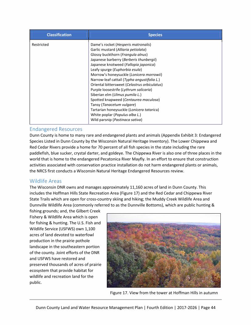
Dunn County Land and Water Resource Management Plan | Fourth Edition | 2017-2026 | Page 44
Classification Species
Restricted Dame’s rocket (Hesperis matronalis) Garlic mustard (Alliaria petiolata) Glossy buckthorn (Frangula alnus) Japanese barberry (Berberis thunbergii) Japanese knotweed (Fallopia japonica) Leafy spurge (Euphorbia esula) Morrow’s honeysuckle (Lonicera morrowii) Narrow-leaf cattail (Typha angustifolia L.) Oriental bittersweet (Celastrus orbiculatus) Purple loosestrife (Lythrum salicaria) Siberian elm (Ulmus pumila L.) Spotted knapweed (Centaurea maculosa) Tansy (Tanacetum vulgare) Tartarian honeysuckle (Lonicera tatarica) White poplar (Populus alba L.) Wild parsnip (Pastinaca sativa)
Endangered Resources Dunn County is home to many rare and endangered plants and animals (Appendix Exhibit 3: Endangered
Species Listed in Dunn County by the Wisconsin Natural Heritage Inventory). The Lower Chippewa and
Red Cedar Rivers provide a home for 70 percent of all fish species in the state including the rare
paddlefish, blue sucker, crystal darter, and goldeye. The Chippewa River is also one of three places in the
world that is home to the endangered Pecatonica River Mayfly. In an effort to ensure that construction
activities associated with conservation practice installation do not harm endangered plants or animals,
the NRCS first conducts a Wisconsin Natural Heritage Endangered Resources review.
Wildlife Areas The Wisconsin DNR owns and manages approximately 11,160 acres of land in Dunn County. This
includes the Hoffman Hills State Recreation Area (Figure 17) and the Red Cedar and Chippewa River
State Trails which are open for cross-country skiing and hiking; the Muddy Creek Wildlife Area and
Dunnville Wildlife Area (commonly referred to as the Dunnville Bottoms), which are public hunting &
fishing grounds; and, the Gilbert Creek
Fishery & Wildlife Area which is open
for fishing & hunting. The U.S. Fish and
Wildlife Service (USFWS) own 1,100
acres of land devoted to waterfowl
production in the prairie pothole
landscape in the southeastern portion
of the county. Joint efforts of the DNR
and USFWS have restored and
preserved thousands of acres of prairie
ecosystem that provide habitat for
wildlife and recreation land for the
public.
Figure 17. View from the tower at Hoffman Hills in autumn
Dunn County Land and Water Resource Management Plan | Fourth Edition | 2017-2026 | Page 45
PLANNING PROCESS Purpose and Authority
The legislature finds that the soil resources of the State are being depleted by wind and water erosion
and that the waters of this State are being polluted by nonpoint sources of pollution. The legislature
further finds that these are statewide problems endangering the health and welfare of the State’s
citizens, its recreational resources, agricultural productivity and industrial base.
The legislature declares it to be the policy of this State to halt and reverse the depletion of the State’s soil
resources and pollution of its waters.
Chapter 92, Wisconsin Statutes (1982)
The purposes of the land and water resource management planning program are to conserve long-term
soil productivity, protect the quality of related natural resources, enhance water quality and focus on
severe erosion problems.
WI Act 27, Amendments to Chapter 92.10 (2), Wisconsin Statutes (1997)
Local leadership in natural resource management is an important component of Wisconsin Act 27 which
amended Chapter 92 of the Wisconsin Statutes in 1997. Elected officials and policy makers have
reaffirmed that local leaders are in the best position to successfully manage natural resources. More
importantly, it is local government’s responsibility to engage the public in land use management
planning that impacts the quality of the natural resources in each county.
As evidenced by the below 1965 letter to Senator Gaylord Nelson (Figure 18), the local management of
natural resources dates well before November 16th, 1982, when the Dunn County Board of Supervisors
officially designated the Land Conservation Committee as the County Board’s agent to authorize and
approve Land Conservation Committee (LCC) powers and programs. The resolution also charged the LCC
with approval of annual and long-range plans.
The first Dunn County Land and Water Resource Management Plan was adopted in 2000, and it was
updated in 2007 and again in 2012. The planning process for this Fourth Edition to the Dunn County
Land and Water Resource Management Plan began in January of 2016. The main purpose of the plan is
to guide LWCD in its mission “To protect, preserve and enhance the natural resources of Dunn County”.
It is also intended to provide information and guidance to the citizens of Dunn County and Dunn County
government, and to facilitate coordination between Federal, State, and local units of government and
programs. Plan implementation will continue through 2026.

Dunn County Land and Water Resource Management Plan | Fourth Edition | 2017-2026 | Page 46
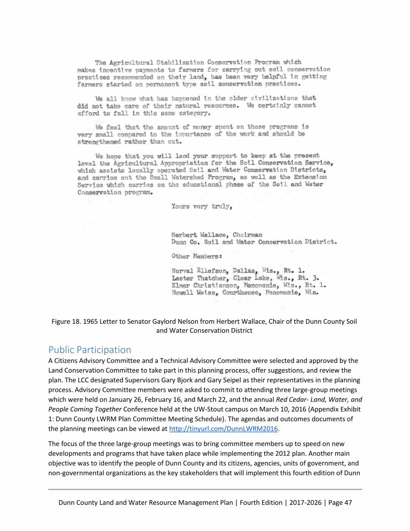
Dunn County Land and Water Resource Management Plan | Fourth Edition | 2017-2026 | Page 47
Figure 18. 1965 Letter to Senator Gaylord Nelson from Herbert Wallace, Chair of the Dunn County Soil and Water Conservation District
Public Participation A Citizens Advisory Committee and a Technical Advisory Committee were selected and approved by the
Land Conservation Committee to take part in this planning process, offer suggestions, and review the
plan. The LCC designated Supervisors Gary Bjork and Gary Seipel as their representatives in the planning
process. Advisory Committee members were asked to commit to attending three large-group meetings
which were held on January 26, February 16, and March 22, and the annual Red Cedar- Land, Water, and
People Coming Together Conference held at the UW-Stout campus on March 10, 2016 (Appendix Exhibit
1: Dunn County LWRM Plan Committee Meeting Schedule). The agendas and outcomes documents of
the planning meetings can be viewed at http://tinyurl.com/DunnLWRM2016.
The focus of the three large-group meetings was to bring committee members up to speed on new
developments and programs that have taken place while implementing the 2012 plan. Another main
objective was to identify the people of Dunn County and its citizens, agencies, units of government, and
non-governmental organizations as the key stakeholders that will implement this fourth edition of Dunn

Dunn County Land and Water Resource Management Plan | Fourth Edition | 2017-2026 | Page 48
County’s Land and Water Resource Management Plan. All planning meetings were structured to give
committee members the opportunity to learn, discuss, ask questions, identify resource concerns, and
identify their role in implementation.
Staff members of the LWCD took part in the planning process by attending, presenting, and participating
in all of the meetings in addition to meeting periodically to discuss elements of the plan. The Land
Conservation Committee will hold a public hearing on the 2017 Land and Water Resource Management
Plan on October 25th, 2016 at 8:30 a.m. in Room 58 of the Dunn County Government Center, 800
Wilson Avenue, Menomonie, WI 54751. The public notice for the Public Hearing can be found in
Appendix Exhibit 7: Public Hearing Notice.
The Plan will be presented to the Dunn County Board of Supervisors for approval on November 15th,
2016 and the State Land and Water Conservation Board on December 6th, 2016.
Agency and Non- Governmental Organization Participation Cooperation with local and area DNR, Farm Service Agency (FSA), NRCS, UWEX and UW-Stout staff has
been an integral part of the past Land and Water Resource Management Plan implementation success.
It was also a fundamental part of this planning process. Agencies and organizations were contacted early
in the planning process and are well represented on the Advisory Committees. Below is a list of
presentations from the planning meetings that express cooperation and collaboration. Copies of the full
presentations can be found at http://tinyurl.com/DunnLWRM2016
Dunn County’s Directional Plan, Dolly Catlin, Strategic Planner, Dunn County Planning and Land
Use Control Division
Introduction to Sociology, Its Purpose and Process in Watershed Planning, Dr. Nels Paulson,
Social Scientist, UW Stout
Wisconsin’s Runoff Rules for Farmers, NR 151, Terence Kafka, Water Resource Management
Specialist, WI DNR
Stormwater and Phosphorus Reduction Efforts in the City of Menomonie, Randy Eide, Director of
Public Works, City of Menomonie
In addition, breakout sessions on the following topics were presented and moderated by DNR, LWCD,
NRCS, and UWEX staff.
Soils
Ground Water
Surface Water Quality
Red Cedar Demonstration Farm, Linking Soil Health and Water Quality
Tainter/Menomin TMDL Implementation Plan
Managing Non-Ag Resources - Woodlands, Native Habitat, Pollinators
Following the Red Cedar Conference, LWCD and NRCS staff lead discussions that allowed Committee
members to provide final thoughts and concerns:
Open Discussion: Surface and Groundwater
Open Discussion: Implementation of “Runoff Rules for Farmers” in Dunn County
Open Discussion: Soil Health, Big Picture Items
Dunn County Land and Water Resource Management Plan | Fourth Edition | 2017-2026 | Page 49
Open Discussion: What is still on your mind?
NR 151 Implementation At the February 16th, 2016, planning meeting, Terrance Kafka, Program and Planning Analyst in charge
of NR 151 Agricultural Performance Standards and Prohibitions for DNR’s West Central Region, led a
focused discussion of NR 151 including the performance standards and prohibitions. At the March 22,
2016, planning meeting, Leah Nicol, Conservation Planner, and Bob Kaner, Conservation Engineering
Technician, led the open discussion on the Agricultural Performance Standards. The concept that each
farm and farmer is unique is a principle that was identified in the planning process and lends itself well
to the task of evaluating each farm. See WI Administrative Codes ATCP 50 and NR 151 for complete
codes and details.
Dunn County takes a voluntary approach with landowners to implement the state’s performance
standards with limited enforcement through the Manure Management Ordinance and the Farmland
Preservation Standards for soil and water conservation. Landowners will continue to be encouraged to
voluntarily implement conservation practices that comply with Wisconsin’s nonpoint source runoff
rules; however, it is possible to require landowners to comply if voluntary efforts are not successful. To
require landowners to comply with the prohibitions and performance standards seventy percent cost
sharing must be offered.
Conservation Planning Dunn County’s Conservation Planners work with landowners who are interested in developing
conservation plans for their land. The conservation planning process is voluntary and gives landowners
the opportunity to select options that will protect their farm’s soil and productivity, health, and
moisture holding capacity; improve the quality of the water leaving the farm; attract desirable wildlife;
and, protect the productive value of the land for future generations. After the landowner selects the
practices that will complement his or her operation, a reasonable schedule of implementation is setup
to install or apply the practices. The list of conservation practices that can be included in a conservation
plan and used to meet the Agricultural Performance Standards can be found in the cost-share funding
table (Exhibit 4: Cost-Share Practice/Funding Source Table & Guidance for Completing NR 151 Codes)
Technical Assistance Assistance to the public is the primary service provided by the LWCD and is an important tool for
achieving proper resource management in Dunn County. This assistance may or may not be associated
with a specific program, but it addresses a wide variety of resource needs of the general public, other
agencies, towns, and municipalities. It is important that the LWCD maintain a personnel resource base
of diverse knowledge and expertise in natural resources to most effectively serve the public.
Nutrient Management Planning The purpose of the Nutrient Management Planning Program is to work with landowners to develop and
implement plans that control the amount, source, form, location, and timing of plant nutrient
applications. This includes the application of manure, soil amendments, commercial fertilizers, and
legumes in order to improve soil fertility while minimizing the movement of nutrients to surface water
and groundwater. An important component in a nutrient management plan is to meet state Agricultural
Performance Standards. The Dunn County LWCD has been holding nutrient management classes in
conjunction with the Chippewa Valley Technical College that allow landowners to develop their own
Dunn County Land and Water Resource Management Plan | Fourth Edition | 2017-2026 | Page 50
plans. These plans follow the NRCS 590 Standard, University of Wisconsin fertilizer recommendations,
and use soil sample data from Wisconsin-certified soil testing labs. Plans are developed with SNAP-Plus
software and calculate a value for the Wisconsin Phosphorus Index (PI). This value is taken into
consideration when performing nutrient management planning to determine a field’s potential to
deliver phosphorus to surface water.
Soil and Water Resource Management Program Dunn County receives an annual Soil and Water Resource Management (SWRM) Grant from the DATCP
that assists with implementation of the LWRM Plan. Since adoption of the first LWRM Plan in 2000, the
LWCD has made abandoning idle manure storage structures a high priority for these cost-share dollars.
This cost sharing can be used to meet the statutory requirement of the need to offer 70 percent cost
sharing before a landowner can be required to meet an Agricultural Performance Standard.
Information and Education The Dunn County LWCD, DEESC and UWEX will carry out the bulk of the local information and education
activities pertaining to the NR 151 nonpoint runoff rules, conservation practices, and available cost
sharing. Emphasis will also be placed on using one-on-one contacts with landowners. To increase
general knowledge and awareness, the publication What Farmers Need to Know-Wisconsin’s Runoff
Rules DNR Publication No. WT 756, REV. 1/13 will be the primary handout for educating landowners and
public on NR-151 requirements.
General circulation press releases and articles will be provided to local newspapers and articles will also
be published in the UWEX newsletter that is mailed to producers and rural landowners. Education and
training on specific conservation practices will also be provided through research plots, field days, and
workshops.
Priority Farm Strategy The Dunn County LWCD intends to work cooperatively with DNR and other agency staff to implement
the NR 151 runoff rules in Dunn County. Following is a description of the activities that the LWCD
proposes to undertake in this joint effort with the state. Actual work activity type and work
accomplishments will be dependent on the availability of adequate financial and human resources for
conservation practice installation.
The following prioritization process will be used to contact landowners and implement practices needed
to comply with the NR 151 nonpoint source runoff rules:
Farmland Preservation Program participants
Land and livestock facilities located in the Tainter Lake/Lake Menomin TMDL watershed
New and expanding livestock facilities in zoned towns (state livestock siting standards were
adopted in 2014 for facilities with over 500 animal units)
Complaints
Permitted livestock facilities (Dunn County Manure Management Ordinance)
Livestock facilities in surface water quality management areas
Voluntary requests from landowners
Strategies used to evaluate farms and work with landowners to achieve compliance include the use of
the following resources:

Dunn County Land and Water Resource Management Plan | Fourth Edition | 2017-2026 | Page 51
A scorecard to evaluate barnyards, farmsteads, and parcels of land for compliance with all of the
components of NR 151 (Appendix Exhibit 5: Components of NR 151)
Notice of Continuing Compliance letter issued to landowners who have received cost sharing for
components of NR 151 and are now required to stay in compliance
Scorecard reviews for landowners receiving Farmland Preservation tax credits through the
Farmland Preservation Program and the Town of Grant Agricultural Enterprise Area
Nutrient Management Planning courses taught by LWCD staff in conjunction with the Chippewa
Valley Technical College where farmers can develop their own plan
Use the DATCP-developed Microsoft Access-based Farmland Preservation tracking program
Inform landowners of available federal cost-share programs such as the EQIP through NRCS
Provide DATCP bond cost-sharing for conservation practices
Provide DATCP SEG cost-sharing for nutrient management plan implementation
Discuss NR 151 performance standards and offer scorecard evaluations and technical assistance
to landowners when developing conservation and nutrient management plans and designing
and installing conservation practices
Revise Farmland Preservation Standards for Soil and Water Conservation to include the 2012
prohibitions that are now included in ATCP 50
Explore funding opportunities and develop or purchase a conservation practice, phosphorus
reduction, and NR-151 compliance tracking software program
Identify and secure other sources of cost-share funding
Regulations in Dunn County Farmland Preservation Program Dunn County’s Soil and Water Conservation Standards were established by the Land Conservation
Committee and approved by the Wisconsin Land and Water Conservation Board. They state that:
Participants in the Farmland Preservation Program shall implement Soil and Water Conservation
Standards according to a schedule of compliance approved by the LCC on all lands for which the
participant claims Farmland Preservation tax credits. The standards to be implemented are
those required under ATCP 50.04, Wis. Adm. Code.
Participants in the Farmland Preservation Program shall eliminate gully erosion on participating
cropland according to a schedule of compliance approved by the LCC. Conservation practices
shall be based on the Technical Guide. Surface water runoff shall be delivered to a legal outlet or
natural watercourse.
These standards apply to all Farmland Preservation agreements still in effect and to all landowners
claiming Farmland Preservation credits through Exclusive Agricultural Zoning. This standard will be
updated within the next two years to include revisions to NR 151 that are now incorporated into ATCP
50.
Dunn County LWCD staff will evaluate land that is proposed for new enrollment in the Farmland
Preservation Program, either under long-term agreements or under Farmland Preservation zoning, for
compliance with NR 151 nonpoint runoff rules. Landowners considering enrolling under a long-term
agreement will be made aware of the conservation compliance requirements of the program and will be
offered assistance to come into full compliance with the conservation standards prior to signing the
Dunn County Land and Water Resource Management Plan | Fourth Edition | 2017-2026 | Page 52
long-term agreement. Owners of land proposed for enrollment under zoning will be assisted on a first-
come, first-served basis.
Dunn County LWCD staff will be responsible for documentation and recording of compliance
determinations related to participants in the Farmland Preservation Program. Nutrient management
checklists will be requested each year and full farm evaluations will be done every four years. A single
sheet form has been developed and is used to serve as the method of documenting evaluation findings.
A certificate of compliance with a unique number will be issued to each participant with a copy of their
NR 151 evaluation results.
If a Farmland Preservation Program participant fails to comply with NR 151 runoff rules as directed and
within the allotted time frame, the Dunn County LWCD will initiate action to issue a Notice of
Noncompliance for the Farmland Preservation Program. Dunn County LWCD staff will work with local
DNR staff in undertaking enforcement action associated with NR 151.09 for any landowners who need
to correct one or more NR 151 non-compliance issues on their land but who also refuse to do so
voluntarily.
Dunn County Manure Management Ordinance In 1999, the Dunn County Farm Bureau expressed concerns about groundwater contamination from
abandoned earthen manure storage structures. A committee was established to draft a county-wide
Manure Management Ordinance. The final draft was prepared and adopted by the Dunn County Board
of Supervisors in April, 2000.
The Ordinance has four main components:
1. It requires all new or altered manure storage structures to be constructed according to NRCS
standards and specifications.
2. All landowners who alter or construct a new manure storage structure must develop a Nutrient
Management Plan in accordance with NRCS 590 Standard.
3. Structures that have been idled for more than one year must be abandoned.
4. All temporary manure stacks must be located away from areas that have the potential to pollute
the surface or groundwater.
The revision of this ordinance is underway and expected to be revised in 2017.
Non Metallic Mining Reclamation Ordinance The mining for non-metallic minerals (sand, gravel, limestone, etc.) is regulated by several different
programs and agencies. The LWCD regulates the reclamation of nonmetallic mines when operations
cease in all areas of the county.
Dunn County’s Chapter 20 Non Metallic Mining Reclamation Ordinance requires each mine larger than
one acre to have an approved Reclamation Plan and financial assurance. The Reclamation Plan must
state a post mining land use and the procedure that will be followed to obtain that land use. The LWCD
is responsible for reviewing the proposed Reclamation Plan to ensure that the procedure outlined meets
the requirements of Chapter 20 and NR 135. Annual fees are collected based on the number of un-
reclaimed acres in each mine. This encourages reclamation as an ongoing process of mining rather than
waiting until all of the material is removed before restoration begins. At this time, there are 26
permitted non-metallic mines in the county covering approximately 510 acres.
Dunn County Land and Water Resource Management Plan | Fourth Edition | 2017-2026 | Page 53
NR 216 Chapter NR 216 of the Wisconsin Administrative Code, Storm Water Discharge Permits, requires that a
notice of intent shall be filed with the DNR by any landowner who disturb one or more acres of land.
This disturbance can create a point source discharge of storm water from the construction site to waters
of the state and is therefore regulated by DNR. Agriculture is exempt from this requirement for activities
such as planting, growing, cultivating and harvesting of crops for human or livestock consumption and
pasturing or yarding of livestock as well as sod farms and tree nurseries. Agriculture is not exempt from
the requirement to submit a notice of intent for one or more acres of land disturbance for the
construction of structures such as barns, manure storage facilities or barnyard runoff control systems
(See s. NR 216.42(2), Wis. Adm. Code.). Furthermore, construction of an agricultural building or facility
must follow an erosion and sediment control plan consistent with s. NR 216.46, Wis. Adm. Code,
including meeting the performance standards of s. NR 151.11, Wis. Adm. Code. An agricultural building
or facility is not required to meet the post-construction performance standards of NR 151.12, Wisconsin
Administrative Code.
Dunn County LWCD staff work in cooperation with landowners and DNR’s Stormwater Specialist on
projects that are covered by the code including construction of manure storage structures and non-
metallic mining reclamation plans.
Complaints The LWCD receives complaints on various resource concerns throughout each year. When complaints
are received, LWCD staff will review available information and make a field visit to determine if there is
a valid resource concern or violation of a current ordinance. If a resource concern is identified that may
be a violation of NR 243 or NR 151, LWCD staff will investigate the complaint with DNR staff. The final
determination as to whether a site is compliant with state runoff rules will be made by the DNR. It will
be the DNR’s responsibility to generate and issue the various compliance letters associated with these
farm contacts. Given adequate financial and human resources, it will continue to be the county’s
responsibility to provide technical planning, design and construction inspection services to correct non-
compliant sites. The county, with the assistance of DNR staff, will also attempt to secure financial
resources needed to make an official “offer of cost sharing” in order to correct non-compliant sites.
WORK PLAN The plan is primarily focused on “improving water quality by improving soil health and reducing soil
erosion”. This will be accomplished by implementing a multi-strategy approach in conservation
programming that builds awareness of local soil and water resource issues, promotes conservation as a
social norm, builds trust, and encourages citizens and farmers to be more engaged in conservation
initiatives that promote practice adoption in the community.
This work plan is intended to cover the first ten years of implementation (2017-2026) and contains
broad goals identified in this and previous planning processes. Priorities are identified under each goal
along with measurable performance benchmarks. An annual work plan will be developed and submitted
to DATCP with the annual staffing grant request.
The plan defines LWCD’s goals in resource conservation as:
Dunn County Land and Water Resource Management Plan | Fourth Edition | 2017-2026 | Page 54
Goal 1: Maintain, Protect and Improve Our Surface Water Resources
Goal 2: Conserve Long Term Soil Productivity of Cropland
Goal 3: Protect Groundwater Quantity and Quality
Goal 4: Preserve Rural Character, Protect the Environment and Related Natural
Resources for Residents, Visitors, and Future Generations
Goal 5: Educate and Engage the Public in Natural Resource Management
Goals, Objectives, and Actions Goals are statements describing the end result desired over the long term.
Objectives are the concepts used to reach a goal. An objective is ideally stated in numeric terms that are
readily measurable. An objective should provide an answer as to why investments of time and money
are made in a given action item.
Action items are the activities undertaken to reach individual objectives. Action items may, in reality,
address more than one plan objective or goal and may be listed more than once.
The work plan section of the LWRM Plan identifies the resource concerns in Dunn County, the goals to
maintain or improve them, and the objectives and action items necessary to accomplish these goals. It
also identifies key partners for each action item and lists evaluation tools and accomplishments where
appropriate.
Priorities The action Items identified in the work plan have been prioritized by how effective they may be at
achieving or reaching a goal. More importantly, they are prioritized to reflect needs identified in the
planning process and the anticipated availability of staff and funding to meet that need.
Each “Action Item” is designated in the work plan as a high, medium, or low priority indicated by the
number of stars (★). At a minimum, each high priority item contains a benchmark listed in the
“Evaluation Tools” column.
★★★ High Priority
★★ Medium Priority
★ Low Priority
Budget and Funding The LWRM Plan is a document that can be used by all partners that work to protect the natural
resources of the county. A combination of private, local, state, and federal sources of funding will be
needed to implement the goals contained in the plan. The work plan goals and objectives will be used to
develop projects and apply for grant funding as the plan is implemented.
LWCD currently has eight full time staff positions and annually receives funding from the State of
Wisconsin through the joint DATCP/DNR Soil and Water Resource Management Grant process. NRCS

Dunn County Land and Water Resource Management Plan | Fourth Edition | 2017-2026 | Page 55
currently has three full time staff positions in Dunn County. County staff time and the anticipated
amount of available cost share funding from all sources will be included in each annual work plan.
It is the intention that this plan will be implemented to the extent possible with available staff and
funding. An estimate of available staff time, funding, and cost-share money is included in Appendix
Exhibit 6: Estimated Funding Available to Implement Planned Activities.
It is understood that to fully implement each goal in this plan, a substantial amount of additional staff
time and money is needed. Additional contributions will also be made by many different agencies,
departments, non-profit organizations, and citizens during this ten-year period.
Implementation and Monitoring Plan evaluation will assess whether the objectives and action items of the LWRM Plan are being
accomplished. The Dunn County LCC will review the work plan annually in January prior to completing
the LWCD Annual Report and the annual DATCP/DNR County Activities Report on Land and Water
Resource Management activities. A new work plan will be developed each year beginning in 2018 and
included in the Annual DATCP/DNR grant request.
The annual transect survey will continue to be used as long as the software is available to monitor
cropland soil loss and to track changes in tillage and land use. DNR water quality monitoring data will be
reviewed periodically and additional monitoring will be initiated as resources become available. The Red
Cedar Basin Monitoring Group currently has 7 lake monitoring sites and 23 stream monitoring sites in
Dunn County. Data is collected at additional sites by DNR staff for fisheries management and water
quality health assessments. Significant changes in water quality or clarity are reported to DNR and
LWCD.
The work plan can be adjusted at any time. A public meeting to review plan progress and solicit input on
plan implementation and new direction will be scheduled in 2021. This meeting will be open to the
public and members of the Advisory Committees.
Conclusion Throughout this planning process, the Dunn County Community, through the Citizens and the Technical
Advisory Committees, the Land Conservation Committee, and the Land and Water Conservation Division
Staff have established a commitment to improve and maintain the quality of soil, water, and other
natural resources. This will be accomplished by providing assistance to resource users in rural and urban
areas, city and town governments, and through public awareness and education.
It is understood that implementing this plan is dependent on funding from many different entities
including the State and Dunn County. The Land Conservation Committee intends to implement this plan
with available staff and funding. Currently, the State statutory funding amounts are not being met and
are inadequate to fully implement all of the work plan action items.
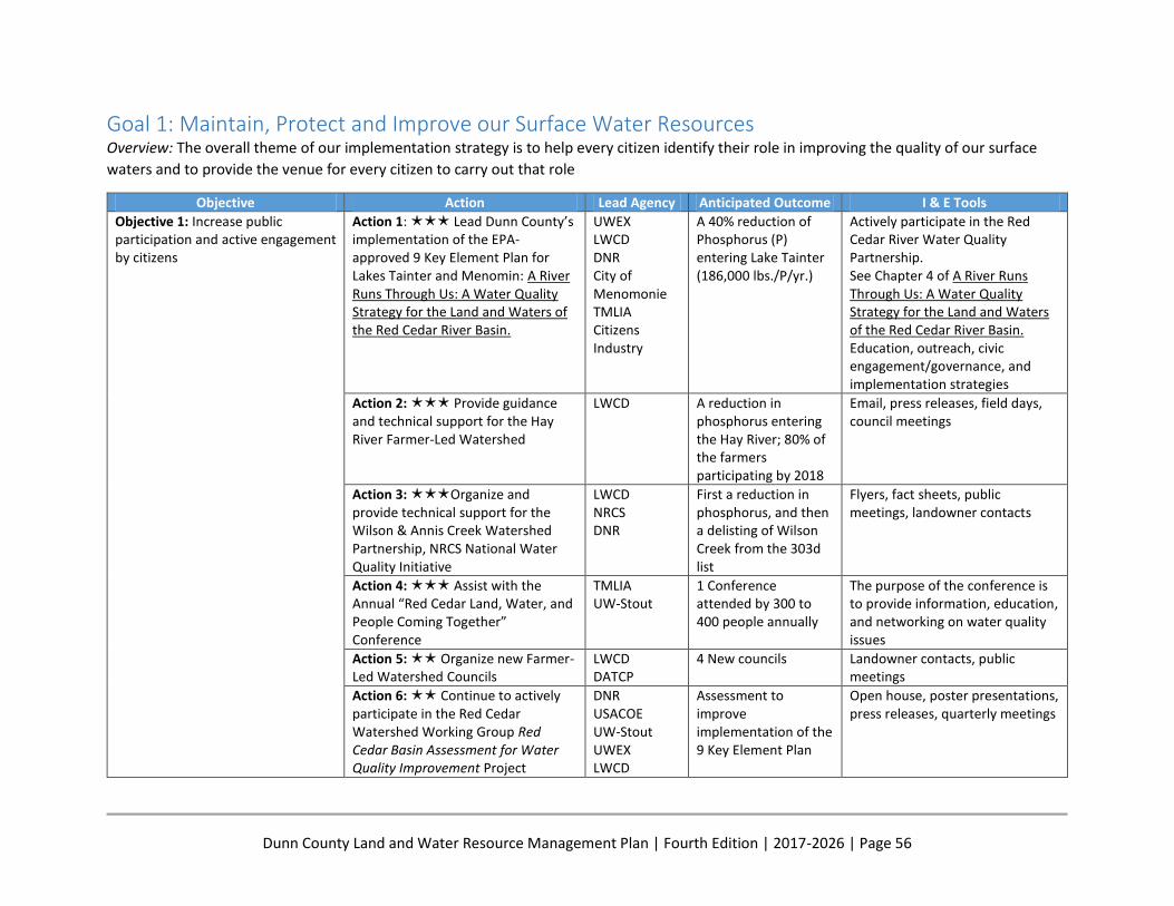
Dunn County Land and Water Resource Management Plan | Fourth Edition | 2017-2026 | Page 56
Goal 1: Maintain, Protect and Improve our Surface Water Resources Overview: The overall theme of our implementation strategy is to help every citizen identify their role in improving the quality of our surface
waters and to provide the venue for every citizen to carry out that role
Objective Action Lead Agency Anticipated Outcome I & E Tools
Objective 1: Increase public participation and active engagement by citizens
Action 1: Lead Dunn County’s implementation of the EPA-approved 9 Key Element Plan for Lakes Tainter and Menomin: A River Runs Through Us: A Water Quality Strategy for the Land and Waters of the Red Cedar River Basin.
UWEX LWCD DNR City of Menomonie TMLIA Citizens Industry
A 40% reduction of Phosphorus (P) entering Lake Tainter (186,000 lbs./P/yr.)
Actively participate in the Red Cedar River Water Quality Partnership. See Chapter 4 of A River Runs Through Us: A Water Quality Strategy for the Land and Waters of the Red Cedar River Basin. Education, outreach, civic engagement/governance, and implementation strategies
Action 2: Provide guidance and technical support for the Hay River Farmer-Led Watershed
LWCD A reduction in phosphorus entering the Hay River; 80% of the farmers participating by 2018
Email, press releases, field days, council meetings
Action 3: Organize and provide technical support for the Wilson & Annis Creek Watershed Partnership, NRCS National Water Quality Initiative
LWCD NRCS DNR
First a reduction in phosphorus, and then a delisting of Wilson Creek from the 303d list
Flyers, fact sheets, public meetings, landowner contacts
Action 4: Assist with the Annual “Red Cedar Land, Water, and People Coming Together” Conference
TMLIA UW-Stout
1 Conference attended by 300 to 400 people annually
The purpose of the conference is to provide information, education, and networking on water quality issues
Action 5: Organize new Farmer-Led Watershed Councils
LWCD DATCP
4 New councils Landowner contacts, public meetings
Action 6: Continue to actively participate in the Red Cedar Watershed Working Group Red Cedar Basin Assessment for Water Quality Improvement Project
DNR USACOE UW-Stout UWEX LWCD
Assessment to improve implementation of the 9 Key Element Plan
Open house, poster presentations, press releases, quarterly meetings
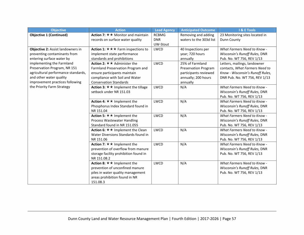
Dunn County Land and Water Resource Management Plan | Fourth Edition | 2017-2026 | Page 57
Objective Action Lead Agency Anticipated Outcome I & E Tools
Objective 1 (Continued) Action 7: Monitor and maintain records on surface water quality
RCBMG DNR UW-Stout
Removing and adding waters to the 303d list
23 Monitoring sites located in Dunn County
Objective 2: Assist landowners in preventing contaminants from entering surface water by implementing the Farmland Preservation Program, NR 151 agricultural performance standards, and other water quality improvement practices following the Priority Farm Strategy
Action 1: Farm inspections to implement state performance standards and prohibitions
LWCD 40 Inspections per year; 720 hours annually
What Farmers Need to Know - Wisconsin’s Runoff Rules, DNR Pub. No. WT 756, REV 1/13
Action 2: Administer the Farmland Preservation Program and ensure participants maintain compliance with Soil and Water Conservation Standards
LWCD 25% of Farmland Preservation Program participants reviewed annually; 200 hours annually
Letters, mailings, landowner contacts, What Farmers Need to Know - Wisconsin’s Runoff Rules, DNR Pub. No. WT 756, REV 1/13
Action 3: Implement the tillage setback under NR 151.03
LWCD N/A What Farmers Need to Know - Wisconsin’s Runoff Rules, DNR Pub. No. WT 756, REV 1/13
Action 4: Implement the Phosphorus Index Standard found in NR 151.04
LWCD N/A What Farmers Need to Know -Wisconsin’s Runoff Rules, DNR Pub. No. WT 756, REV 1/13
Action 5: Implement the Process Wastewater Handling Standard found in NR 151.055
LWCD N/A What Farmers Need to Know - Wisconsin’s Runoff Rules, DNR Pub. No. WT 756, REV 1/13
Action 6: Implement the Clean Water Diversions Standards found in NR 151.06
LWCD N/A What Farmers Need to Know - Wisconsin’s Runoff Rules, DNR Pub. No. WT 756, REV 1/13
Action 7: Implement the prevention of overflow from manure storage facility prohibition found in NR 151.08.2
LWCD N/A What Farmers Need to Know - Wisconsin’s Runoff Rules, DNR Pub. No. WT 756, REV 1/13
Action 8: Implement the prevention of unconfined manure piles in water quality management areas prohibition found in NR 151.08.3
LWCD N/A What Farmers Need to Know - Wisconsin’s Runoff Rules, DNR Pub. No. WT 756, REV 1/13
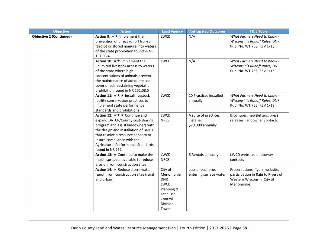
Dunn County Land and Water Resource Management Plan | Fourth Edition | 2017-2026 | Page 58
Objective Action Lead Agency Anticipated Outcome I & E Tools
Objective 2 (Continued)
Action 9: Implement the prevention of direct runoff from a feedlot or stored manure into waters of the state prohibition found in NR 151.08.4
LWCD N/A What Farmers Need to Know - Wisconsin’s Runoff Rules, DNR Pub. No. WT 756, REV 1/13
Action 10: Implement the unlimited livestock access to waters of the state where high concentrations of animals prevent the maintenance of adequate sod cover or self-sustaining vegetation prohibition found in NR 151.08.5
LWCD N/A What Farmers Need to Know - Wisconsin’s Runoff Rules, DNR Pub. No. WT 756, REV 1/13
Action 11: Install livestock facility conservation practices to implement state performance standards and prohibitions
LWCD 10 Practices installed annually
What Farmers Need to Know - Wisconsin’s Runoff Rules, DNR Pub. No. WT 756, REV 1/13
Action 12: Continue and expand DATCP/County cost-sharing program and assist landowners with the design and installation of BMPs that resolve a resource concern or insure compliance with the Agricultural Performance Standards found in NR 151
LWCD NRCS
A suite of practices installed; $70,000 annually
Brochures, newsletters, press releases, landowner contacts
Action 13: Continue to make the mulch spreader available to reduce erosion from construction sites
LWCD NRCS
6 Rentals annually LWCD website, landowner contacts
Action 14: Reduce storm water runoff from construction sites (rural and urban)
City of Menomonie DNR LWCD Planning & Land Use Control Division Towns
Less phosphorus entering surface water
Presentations, flyers, website, participation in Rain to Rivers of Western Wisconsin (City of Menomonie)
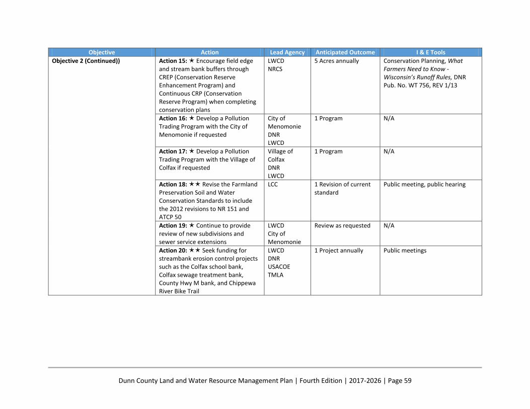
Dunn County Land and Water Resource Management Plan | Fourth Edition | 2017-2026 | Page 59
Objective Action Lead Agency Anticipated Outcome I & E Tools
Objective 2 (Continued)) Action 15: Encourage field edge and stream bank buffers through CREP (Conservation Reserve Enhancement Program) and Continuous CRP (Conservation Reserve Program) when completing conservation plans
LWCD NRCS
5 Acres annually Conservation Planning, What Farmers Need to Know - Wisconsin’s Runoff Rules, DNR Pub. No. WT 756, REV 1/13
Action 16: Develop a Pollution Trading Program with the City of Menomonie if requested
City of Menomonie DNR LWCD
1 Program N/A
Action 17: Develop a Pollution Trading Program with the Village of Colfax if requested
Village of Colfax DNR LWCD
1 Program N/A
Action 18: Revise the Farmland Preservation Soil and Water Conservation Standards to include the 2012 revisions to NR 151 and ATCP 50
LCC 1 Revision of current standard
Public meeting, public hearing
Action 19: Continue to provide review of new subdivisions and sewer service extensions
LWCD City of Menomonie
Review as requested N/A
Action 20: Seek funding for streambank erosion control projects such as the Colfax school bank, Colfax sewage treatment bank, County Hwy M bank, and Chippewa River Bike Trail
LWCD DNR USACOE TMLA
1 Project annually Public meetings
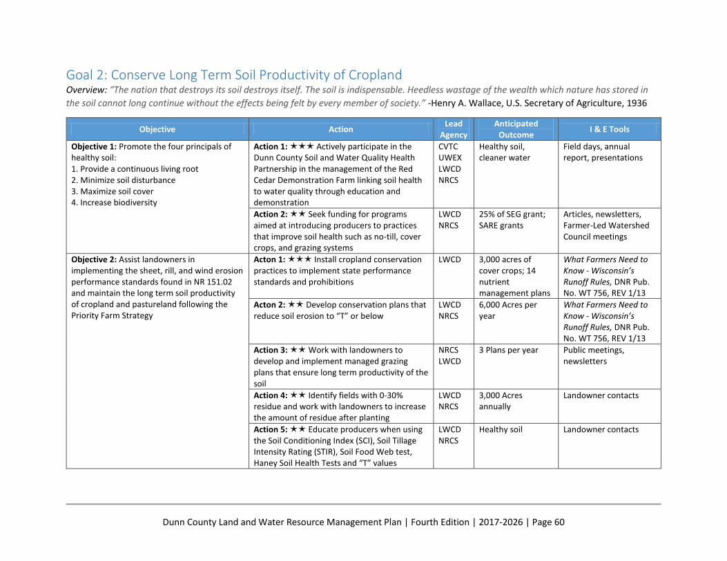
Dunn County Land and Water Resource Management Plan | Fourth Edition | 2017-2026 | Page 60
Goal 2: Conserve Long Term Soil Productivity of Cropland Overview: “The nation that destroys its soil destroys itself. The soil is indispensable. Heedless wastage of the wealth which nature has stored in
the soil cannot long continue without the effects being felt by every member of society.” -Henry A. Wallace, U.S. Secretary of Agriculture, 1936
Objective Action Lead
Agency Anticipated
Outcome I & E Tools
Objective 1: Promote the four principals of healthy soil: 1. Provide a continuous living root 2. Minimize soil disturbance 3. Maximize soil cover 4. Increase biodiversity
Action 1: Actively participate in the Dunn County Soil and Water Quality Health Partnership in the management of the Red Cedar Demonstration Farm linking soil health to water quality through education and demonstration
CVTC UWEX LWCD NRCS
Healthy soil, cleaner water
Field days, annual report, presentations
Action 2: Seek funding for programs aimed at introducing producers to practices that improve soil health such as no-till, cover crops, and grazing systems
LWCD NRCS
25% of SEG grant; SARE grants
Articles, newsletters, Farmer-Led Watershed Council meetings
Objective 2: Assist landowners in implementing the sheet, rill, and wind erosion performance standards found in NR 151.02 and maintain the long term soil productivity of cropland and pastureland following the Priority Farm Strategy
Acton 1: Install cropland conservation practices to implement state performance standards and prohibitions
LWCD 3,000 acres of cover crops; 14 nutrient management plans
What Farmers Need to Know - Wisconsin’s Runoff Rules, DNR Pub. No. WT 756, REV 1/13
Acton 2: Develop conservation plans that reduce soil erosion to “T” or below
LWCD NRCS
6,000 Acres per year
What Farmers Need to Know - Wisconsin’s Runoff Rules, DNR Pub. No. WT 756, REV 1/13
Action 3: Work with landowners to develop and implement managed grazing plans that ensure long term productivity of the soil
NRCS LWCD
3 Plans per year Public meetings, newsletters
Action 4: Identify fields with 0-30% residue and work with landowners to increase the amount of residue after planting
LWCD NRCS
3,000 Acres annually
Landowner contacts
Action 5: Educate producers when using the Soil Conditioning Index (SCI), Soil Tillage Intensity Rating (STIR), Soil Food Web test, Haney Soil Health Tests and “T” values
LWCD NRCS
Healthy soil Landowner contacts

Dunn County Land and Water Resource Management Plan | Fourth Edition | 2017-2026 | Page 61
Goal 3: Protect Ground Water Quantity and Quality Overview: Groundwater is referred to as Wisconsin’s “buried treasure.” Conservation and protection of groundwater was identified as a natural
resource concern and priority in Dunn County’s first Land & Water Resource Management Plan. In this planning session, committee members
recognized that groundwater is abundant in Dunn County and provides critical base flow to our creeks and streams, water for industry, and
provides drinking water for all county residents
Objective Action Lead Agency Anticipated Outcome I & E Tools
Objective 1: Increase public awareness and provide education on ground water quality and quantity
Action 1: Continue to participate and expand the Tri-County Groundwater Level Monitoring Project
LWCD USGS
2 New wells added per year Press release, presentations
Action 2: Develop a groundwater council comprised of stakeholders to guide groundwater monitoring and research in the county
LWCD Public Health UWEX UW-Stout
1 Council developed Interactive mapping and information sharing on LWCD website, press releases, public meetings
Action 3: Continue to distribute and secure funding for additional ground water attenuation maps
LWCD Print 50 maps and reprint as needed; provide digital copy on LWCD website
Website
Action 4: Address and assess the impact of high capacity wells on ground water resources
LWCD DNR
N/A Public meetings, reports
Action 5: Coordinate with the DNR to keep a current list of approved sites for land spreading of septage and ensure the sites meet standards
DNR LWCD
One List N/A
Objective 2: Prevent contaminants from entering ground water
Action 1: Continue the farmer-written Nutrient Management Planning Program developed with Chippewa Valley Technical College to help farmers write and implement plans meeting NR 151.07(3) – Nutrient Management Standard
LWCD CVTC UWEX
6,000 Acres of nutrient management plans per year
Letters, flyers, What Farmers Need to Know - Wisconsin’s Runoff Rules, DNR Pub. No. WT 756, REV 1/13
Action 2: Promote the proper closure of idle manure storage structures
LWCD NRCS
2 Structures properly closed per year
Cost share brochure, website, one-on-one contacts
Action 3: Promote the proper decommissioning of abandoned wells
LWCD NRCS
3 Wells decommissioned per year
Cost share brochure, website, one-on-one contacts
Action 4: Administer the Dunn County Manure Management Ordinance
LWCD NRCS
2 Permits issued; site visits
Website

Dunn County Land and Water Resource Management Plan | Fourth Edition | 2017-2026 | Page 62
Objective Action Lead Agency Anticipated Outcome I & E Tools
Objective 3: Increase infiltration to recharge ground water
Action 1: Encourage preservation and restoration of wetlands
NRCS Pheasants Forever Ducks Unlimited
20 Acres restored annually Landowner contacts
Action 2: Encourage infiltration-friendly land use and best management practices
LWCD Rain to Rivers
Increase infiltration, less erosion
Provide education with presentations and discussions
Action 3: Assist the Planning and Land Use Control Division with administration of the Shoreland Zoning Ordinance
Planning & Land Use Control Division
LWCD
Provide assistance to the Planning and Land Use Control Division when requested
Landowner contacts, presentations and discussions
Action 4: Assist in the creation of standards for development in groundwater recharge areas
Planning & Land Use Control Division
LWCD
One ordinance Assist with draft groundwater ordinance for Dunn County
Action 5: Encourage development of rain gardens and the use of rain barrels
UWEX Sustainable Dunn TMLIA
2 Public workshops/meetings Participate in Rain to Rivers of Western Wisconsin as a guest member

Dunn County Land and Water Resource Management Plan | Fourth Edition | 2017-2026 | Page 63
Goal 4: Preserve Rural Character, Protect the Environment and Related Natural Resources for Residents, Visitors, and Future Generations Overview: Dunn County is blessed with an abundance of natural resources. These resources are highly valued for their natural beauty, wildlife
habitat, the recreational opportunities they provide, and their contribution to the economy
Objective Action Lead Agency Anticipated Outcome I & E Tools
Objective 1: Preserve farmland and an agricultural way of life in rural Dunn County
Action 1: Continue to conduct the annual transect survey to monitor soil erosion rates, tillage, and cropping trends
LWCD Annual transect survey N/A
Action 2: Assist landowners in the Town of Grant AEA as they consider entering long-term Farmland Preservation contracts
LWCD Planning & Land Use Control Division
2 Contracts per year Town meetings, land owner contacts
Action 3: Assist the Planning and Land Use Control Division with implementing the Dunn County Farmland Preservation Plan
Planning & Land Use Control Division
Protection of farmland Public meetings, public hearings
Action 4: Use EVAAL software to identify areas of high erosion potential for targeted planning efforts
LWCD Efficient planning in targeted areas
N/A
Objective 2: Improve and enhance the natural resources of property owned by Dunn County
Action 1: Develop a long-range plan for the Dunn County-owned Islands including hardwood and softwood timber management, recreation, invasive species control, and endangered species preservation
LWCD DNR Lower Chippewa River Alliance
1 Plan Public meeting
Action 2: Manage the Dunn County Islands including maintaining logging roads and administering timber sales
LWCD DNR
Maintain 5 miles of access road and one crossing; two timber sales
N/A
Action 3: Assist the Facilities Committee in maintaining Dunn County parks as aesthetically pleasing recreational areas
Facilities LWCD
2 Projects per year County website
Action 4: Assist the Facilities Committee in making Dunn County Public Shooting Ranges as safe as possible
Facilities LWCD The Alliance
3 Safe public shooting ranges; Successful grant applications
Website
Dunn County Land and Water Resource Management Plan | Fourth Edition | 2017-2026 | Page 64
Objective Action Lead Agency Anticipated Outcome I & E Tools
Objective 2 (Continued) Action 5: Continue to monitor and manage the three Knights Creek PL 566 structures including updating the Emergency Action Plans
LWCD NRCS Planning & Land Use Control Division
3 Structures maintained; Keep Emergency Action Plans current
Emergency Action Plan
Objective 3: Support community organizations and public agencies that promote the recreational use of natural resources
Action 1: Promote recreational use of private land enrolled in programs that have public access requirements such as the Managed Forest Law, Wildlife Damage, and the Voluntary Public Access Program
DNR The Alliance
Increased recreational opportunities for the public
Maps, websites, public meetings
Action 2: Continue to provide the tree planter rental program for Dunn County residents (5 county-owned tree planters)
LWCD DNR
12 Landowner rentals Website, landowner contacts
Action 3: Organize and provide guidance and technical support for the Lower Chippewa Invasives Partnership (LCIP)
LCIP Citizens Highway LWCD NRCS DNR
Coordination of the efforts of citizens to combat aquatic and terrestrial invasive species
Website, workshops, events, displays, presentations
Action 4: Continue to support trout stream restoration projects on Gilbert and Wilson Creeks and the Eau Galle River
TU DNR
One half mile per year Newsletters, one-on- one contacts
Action 5: Support acquisition and restoration of natural areas, wetlands, trout streams, fish and wildlife areas, parks, boat landings, and recreational lands
County Board The Alliance WWLT DNR PF TU
Additional public land acquisition and restoration
Coordinate with agencies to provide assistance as requested
Action 6: Administer the Wildlife Damage Abatement and Claims Program and the Deer Donation Program
USDA-APHIS DNR Fish & Game
Implement one program Website, brochures, landowner contacts
Action 7: Assist the Dunn County Snowmobile Association (DCSA) by administering and coordinating the local Snowmobile Trails Program
DCSA LWCD
290 Miles of groomed trails
Snowmobile Association website and published trail maps
Dunn County Land and Water Resource Management Plan | Fourth Edition | 2017-2026 | Page 65
Objective Action Lead Agency Anticipated Outcome I & E Tools
Objective 3 (Continued)
Action 8: Continue to administer and financially support the County Conservation Aids Program
LWCD DNR
1 Project per year Word of mouth
Action 9: Coordinate and attend the all-agency meetings
NRCS FSA LWCD DNR USFWLS
2 Meetings per year Email request for agenda Items and agendas
Action 10: Continue to be an advisor to the Dunn County Alliance of Conservation and Sports Clubs
The Alliance LWCD DNR
8 Meetings per year Email request for agenda items and agendas
Action 11: Work with the Planning and Land Use Control Division and the agriculture community to implement the livestock siting language that is contained in the Comprehensive Zoning Ordinance
Planning & Land Use Control Division
LWCD
Applications reviewed as submitted
Livestock siting incorporated in 2014, provide assistance as requested
Action 12: Administer the Non Metallic Mining Reclamation Ordinance including the monitoring of active acres and encouraging reclamation as an on-going process of mining, thereby minimizing contamination of surface and groundwater
LWCD DNR
Issue annual permits to all mines (currently 26)
Letters, contacts, 20 site visits per year

Dunn County Land and Water Resource Management Plan | Fourth Edition | 2017-2026 | Page 66
Goal 5: Educate and Engage the Public in Natural Resource Management Overview: All Dunn County citizens are stakeholders and play a role in the management of the county’s natural resources
Objective Action Lead Agency Anticipated Outcome I & E Tools
Objective 1: Improve public awareness and provide educational opportunities to preserve rural character, farms, and the environment
Action 1: Organize and participate in the Dunn Environmental Education Steering Committee (DEESC)
DEESC Environmental Field Days, newsletter
Environmental Field Days, trailer with equipment & supplies, Dunn County website
Action 2: Continue and implement the civic governance approach to policy implementation, organizing, resource management, and building community capacity
LWCD TMLIA ICGOA
Efficient resource management and community engagement
Civic Governance Policy Document
Action 3: Continue the Conservation Awareness Poster & Speaking Contests, Land Judging Contest, and other youth education activities
DEESC 5 Events annually Teacher contacts, newsletter, letters, Dunn County website
Action 4: Develop and Implement an NR 151 parcel tracking software system
IT Division LWCD
1 Tracking system developed
N/A
Action 5: Assist landowners, towns and Dunn County in protecting the environmentally sensitive areas, conservation features, and environmental corridors
Planning & Land Use Control Division
Provide assistance as requested
Public meetings, Definitions are located in the Final Report
Action 6: Conservation practices installed to implement LWRM Plan priorities
LWCD Install 30 practices per year
Dunn County Conservation Assistance Program Brochure
Action 7: Permits issued or obtained in connection with practices installed
LWCD Issue 3 manure storage permits; Assist with 3 DNR permits
Dunn County Conservation Assistance Program Brochure
Action 8: Annual review of the LWRM Plan implementation by the Land Conservation Committee
LCC Annual review at the January LCC Meeting
Public notice
Action 9: Complete an Annual Work Plan by April 15th each year and submit with annual DATCP/DNR annual grant application
LCC LWCD
One Annual Work Plan N/A
Dunn County Land and Water Resource Management Plan | Fourth Edition | 2017-2026 | Page 67
Plan Partners There are many groups and agencies that are involved with resource conservation in Dunn County.
Carrying out the provisions of this LWRM Plan will require the cooperation of many individuals and
organizations. The following is an overview of the organizations and agencies, many of which were
represented on the Advisory Committee, that will work together with the Dunn County Land and Water
Conservation Division and Committee to implement this plan.
Private Organizations Ducks Unlimited Ducks Unlimited (DU) conserves, restores, and manages wetlands and associated habitats for North
America's waterfowl. These habitats also benefit other wildlife and people. Ducks Unlimited is the
sponsor of a North American Waterfowl Conservation Act grant project that pays for acquisition and
restoration of prairie potholes in Northwestern Wisconsin.
The Alliance of Dunn County Conservation and Sports Clubs The Alliance is a non-profit 501(c)(3) dedicated to the education of all the major conservation and
environmental organizations in the county. It represents over one thousand local sports men and
women. It serves as a forum to share information and discuss subjects of county-wide interest. Its
nonprofit tax status allows the organization to accept tax exempt donations unlike most other clubs. The
Alliance recommends a County Conservation Aids project to the Planning, Resources and Development
Committee each year. They also host an annual fishing event (“Sharing our Resources on the Water”) for
those with disabilities and seniors, and they apply for grants to purchase land for conservation purposes
and public use.
Dunn County Farm Bureau The Dunn County Farm Bureau is a grassroots non-profit, non-government organization financed with a
total membership of over 750 with 448 of those being voting members.
They were formally organized in 1953 by a group of county farmers looking for a voice in agricultural
policy on the local, state and national level. The Dunn County Farm Bureau is affiliated with the largest
general farm organization in the state, the Wisconsin Farm Bureau, and the largest general farm
organization in the nation, the American Farm Bureau.
With a mission to lead the farm and rural community through legislative representation, education,
public relations and leadership development, the Farm Bureau’s goal is to be a unified voice for
agriculture. Through grassroots efforts, the Farm Bureau enhances and strengthens the lives of families
and neighbors on the local, state, and national levels. Farm Bureau members also share concerns with
urban neighbors and work with each other to find solutions to food safety and supply, animal welfare,
and environmental concerns for the common good. The organization takes pride in developing future
leaders.
Dunn County Farmers Union The Dunn County Farmers Union is a membership organization committed to supporting family farms
and rural communities. Their county chapter is affiliated with the statewide Wisconsin Farmers Union
and the National Farmers Union. Their chapter works to educate their members and the general public
on farm and rural issues. They advocate for policies at the local, state, and federal level that provide
Dunn County Land and Water Resource Management Plan | Fourth Edition | 2017-2026 | Page 68
positive economic impacts and fair prices for family farmers, maintain strong conservation and
environmental practices, encourage renewable energy development, and promote sustainable and
resilient rural communities. The Farmers Union has a long commitment to supporting cooperative
economic development. They partner in providing educational opportunities to rural youth through
both statewide leadership development programs and Summer Youth Camps held at their Kamp
Kenwood location on Lake Wissota in Chippewa Falls. Their Dunn County chapter includes both farm and
rural members.
Dunn County Fish and Game The Dunn County Fish and Game is perhaps the largest and most active sports-person’s club in the
county. Because of its size and commitment to conservation, the group is involved in a variety of
activities including purchasing land; operation and support of the Menomonie Public Shooting Range;
Hunter Safety education; pheasant rearing and stocking; trout habitat restoration on Gilbert Creek;
distribution of meat for the Dunn County Deer Donation Program; supporting veterans through outdoor
sporting events; and, they are the home of Post #114 Conservation Career Explorers Post. The club also
provides a scholarship for youth that are pursuing a secondary degree in a conservation-related career.
Dunn County Snowmobile Association The Dunn County Snowmobile Association represents 14 different snowmobile clubs and coordinates
the development, maintenance, and grooming of over 290 miles of snowmobile trails in Dunn County
each year. The County Conservationist is the official Snowmobile Trail Coordinator for Dunn County and
the LWCD has a great working relationship with the Association for distributing approximately $72,000
of trail maintenance funding annually.
Pheasants Forever – Red Cedar Chapter Red Cedar Pheasants Forever organized in 1990 and has spent over $1,000,000 on habitat projects that
benefit the Ring-necked Pheasant and other wildlife species in Dunn County. Projects include land
acquisition, planting native grass cover, wildlife food plots, wetland restoration, and establishing
pollinator habitat. These land management projects have complemented the successful Jilin and Iowa
Wild Pheasant Restoration Projects that the Department of Natural Resources has completed within the
county.
LWCD staff have assisted Pheasants Forever with grants from Wisconsin’s Knowles-Nelson Stewardship
Program, the North American Wetland Conservation Act, and the National Wild Turkey Federation Super
Fund. These projects have provided an additional 450 acres of land added to the public land base in the
county in an area that is presently under heavy development pressure from the population centers of
Menomonie and Eau Claire.
Red Cedar Basin Monitoring Group The Red Cedar Basin Monitoring Group officially organized in February of 2011 with the main objective
being promotion of citizen involvement in anything that can be done to help the waters of the basin.
They monitor water quality on many streams in the watershed and on Lakes Tainter and Menomin.
Aquatic invasive species are being monitored on both lakes and streams and road salt runoff is
monitored in the City of Menomonie. Data is entered into the Wisconsin Surface Water Database. In
addition, they monitor bats in the county. Training and equipment is provided to those willing to commit
to any of these efforts.
Dunn County Land and Water Resource Management Plan | Fourth Edition | 2017-2026 | Page 69
Red Cedar River Water Quality Partnership The authors of the Red Cedar River Basin Total Maximum Daily Load (TMDL) Implementation Plan make
up the Red Cedar River Water Quality Partnership. This diverse stakeholder group was formed in 2013
and is charged with overseeing the execution of the TMDL Implementation Plan and all education,
outreach, engagement, and implementation activities. The group has developed a foundational
document that describes how the Partnership functions and describes its identity and purpose.
Members include UWEX, Wisconsin DNR, Dunn and Barron Counties, NRCS, City of Menomonie, town
government and elected officials, citizens, local non-governmental organizations, lake associations, and
corporate representatives.
Sustainable Dunn Sustainable Dunn is a not-for-profit grassroots organization that was formed in 2006. It seeks to provide
educational programs for the community about issues related to sustainability. Using the principles of
sustainability, a community can create a prosperous and secure future by using its resources wisely now
so that future generations will have them for their needs.
Sustainable Dunn has worked with the City of Menomonie and Dunn County to assist with creation of
Sustainability Action Plans. Besides providing ongoing educational programs, Sustainable Dunn has
bimonthly meetings with the City of Menomonie, Dunn County, UW-Stout, and other community groups
that create a climate for sharing ideas and encouraging actions that promote efficient use of resources
with minimal impact on the environment.
Tainter Menomin Lake Improvement Association The Tainter Menomin Lake Improvement Association (TMLIA) is organized to address the following
objectives:
1. To support the protection and improvement of Lakes Tainter and Menomin for the benefit of
the general public
2. To provide educational information on water quality and environmental issues affecting our
lakes and the watersheds that feed them
3. To collaborate with conservation and environmental organizations in making initiatives happen
to protect and improve Wisconsin's inland lakes
4. To promote and advocate legislative action to improve water quality
5. To seek funding from local, state, and federal sources in the pursuit of their goals and objectives
The Association and the LWCD have a long history of working together. Since our 2007 plan update, the
Association and the LWCD have worked together on several projects including the production of
bathymetric maps for Tainter and Menomin Lakes, the EPA approved Red Cedar River Total Maximum
Daily Load (TMDL) Plan, the 2016-18 Red Cedar Basin Assessment for Water Quality Project and
completing a study of the sediment sources into each Lake. TMLIA partnered to offer public workshops
on waterfront landscaping, projects related to restoring the Jarrett Creek watershed, infiltration gardens
at Lakeside Park and projects related to civic governance. The Association leads and sponsors the annual
Red Cedar Land, Water and People Coming Together Conference.
Dunn County Land and Water Resource Management Plan | Fourth Edition | 2017-2026 | Page 70
Trout Unlimited The mission of Trout Unlimited (TU) is to conserve, protect, and restore America’s coldwater fisheries
and their watersheds. Dunn County works most closely with the Kiap TU Wish and Wisconsin Clear
Waters Chapters of Trout Unlimited. Members of these TU chapters serve as partners and advocates for
water quality and habitat improvement projects in Dunn County. Most recent, TU has served a valuable
role in the restoration of segments of Gilbert and Wilson Creeks in the western part of the county. The
vision of TU is "By the next generation, Trout Unlimited will ensure that robust populations of native and
wild coldwater fish once again thrive within their North American range, so that our children can enjoy
healthy fisheries in their home waters.”
West Central Wisconsin Regional Planning Commission The West Central Wisconsin Regional Planning Commission (WCWRPC) is statutorily charged with the
responsibility of planning for the physical, social, and economic development of the region (West
Central Wisconsin). To accomplish this mission, the Commission conducts area-wide planning and
provides technical assistance to local governments. WCWRPC completed the “Dunn County Conditions
and Trends Report” in 2009 and “The West Central Wisconsin Comprehensive Plan” in September of
2010. More recently, WCWRPC began working on identifying and defining environmentally sensitive
areas and conservation features most valued by the county and its residents. In addition, WCWRPC
completed grant applications and started grant administration for the Red Cedar Basin Assessment for
Water Quality Improvement Project.
West Wisconsin Land Trust West Wisconsin Land Trust (WWLT) is a private non-profit conservation organization based in Dunn
County whose mission is focused on preserving the natural character of western Wisconsin. WWLT
works with private landowners, municipalities, government agencies, and other conservation partners
to protect important ecological and scenic land throughout western Wisconsin. Since 1998, WWLT has
conserved over 25,000 acres in 18 counties.
Local City of Menomonie With a population of 16,000, the City of Menomonie is the largest municipality in Dunn County. The City
has adopted a Stormwater Ordinance and taken several steps to meet its Municipal Separate Storm
Sewer System MS4 requirements. This has resulted in a 33% reduction of total suspended solids
entering Lake Menomin and the Red Cedar River. A 44% reduction in the phosphorus load is projected
by 2025. The City of Menomonie is an active partner in the “Rain to Rivers--Wise Choices for Cleaner
Water” education campaign sponsored by the Chippewa Valley Stormwater Forum.
Dunn County Health Department The Dunn County Health Department’s mission is to promote the health of all people in the community
by working toward a safe and healthy environment, preventing disease and disability, and promoting
positive health practices. The Health Department collects drinking water sample results for the county
and administers the Private Water Systems Ordinance. The Department is also concerned with the toxic
effects that blue-green algae can have on humans and pets. People can be exposed to these toxins
through contact with the skin (e.g., when swimming), through inhalation (e.g., when motor boating or
water skiing), or by swallowing contaminated water.
Dunn County Land and Water Resource Management Plan | Fourth Edition | 2017-2026 | Page 71
Dunn County Public Works Department - Highway Division The Dunn County Highway Division builds and maintains Dunn County’s highways. The Highway
Department is required to complete wetland mitigation for some construction projects. They implement
storm water and erosion control measures during highway construction and play a major role in
protecting water quality.
Environmental Services Department The Dunn County Environmental Services Department is responsible for collectively managing the
natural resources of the county. The four divisions function as a self-directed management team
without a department head.
The four divisions are:
Land and Water Conservation
Planning and Land Use Control
Surveying
Solid Waste and Recycling
Towns Towns in Dunn County have taken the lead role in developing “smart growth” plans for their
communities. The LWCD has worked with nearly all of the towns to identify important farmland and to
complete the Agriculture and Natural Resource Elements of their plans. The Dunn County Towns
Association meets quarterly and is an available and efficient avenue for distributing information to the
towns. All LCC meeting agendas are e-mailed to the Town Chairmans and Clerks.
Statewide University of Wisconsin Cooperative Extension Service The University of Wisconsin Extension (UWEX) is responsible under state law for research and
educational programs related to soil and water conservation. The LWCD works with the Katie Wantoch,
Dunn County UWEX Agriculture Educator; Paul Kivlin, Nutrient and Pest Management Specialist; and
Dan Zerr, the Natural Resources Educator on the Red Cedar Demonstration Farm, Farmer Led
Watershed, the Tainter Menomin Implementation team and several other projects.
Wisconsin Department of Agriculture, Trade, & Consumer Protection The WI Department of Agriculture, Trade, and Consumer Protection (DATCP) is responsible for serving as
the central agency for setting up and implementing statewide soil and water conservation policies and
administering the state’s soil and water conservation programs. DATCP provides assistance and reviews
county land and water resource management plans and has overall responsibility for the Wisconsin
Farmland Preservation/Working Lands Initiative Program and the Conservation Reserve Enhancement
Program. The Dunn County LWCD receives funding from the DATCP/DNR joint allocation each year for
staff and to administer a cost-sharing program.
Wisconsin Department of Natural Resources The Department of Natural Resources (DNR) manages nearly all state owned land and protects all public
waters of the state. The DNR provides cost sharing and technical assistance to implement a variety of
resource programs such as the Wildlife Damage Abatement and Claims Program, Animal Waste
Dunn County Land and Water Resource Management Plan | Fourth Edition | 2017-2026 | Page 72
Management Program (NR 243), County Conservation Aids Program, Fisheries Management Programs,
Lake Management Programs, and Forestry Assistance Programs (such as the Wisconsin Managed Forest
Law Program). The LWCD has historically maintained a good working relationship with the DNR.
Wisconsin Land and Water Conservation Association The Wisconsin Land and Water Conservation Association (WI Land + Water) is a membership
organization representing all of the state’s 72 County Land Conservation Committees (LCCs). On behalf
of county LCCs, WI Land + Water lobbies elected officials and government agencies to secure financial
and program support for local conservation activities.
In addition, several state conservation education and recognition programs are sponsored by WI Land +
Water. On a larger basis, the National Association of Conservation Districts (NACD), comprised of over
3,000 local conservation districts and departments throughout the nation, provides national support and
lobbying efforts on behalf of local LCCs. Dunn County is a member of the Wisconsin Land and Water
Conservation Association and the National Association of Conservation Districts.
Federal Farm Service Agency Also a part of the USDA, the Farm Service Agency (FSA) administers a variety of agricultural assistance
programs including production controls, price supports, and conservation incentives. There is an FSA
representative on the Dunn County LCC that serves as a regular voting member to encourage further
coordination and cooperation between agencies. Specific conservation programs which FSA has partial
or sole responsibility for administering include the Conservation Reserve Program and conservation
loans.
Natural Resources Conservation Service The Natural Resources Conservation Service (NRCS) is a sub-agency of the FSA. The NRCS and Dunn
County LCC and LWCD have a long history of cooperatively assisting landowners in Dunn County. The
LCC and NRCS have a Memorandum of Understanding that is reviewed every five years. This
memorandum spells out the roles and responsibilities of each agency. Some of the existing conservation
programs that NRCS has been given partial or sole responsibility for administering include: Conservation
Reserve Program, Conservation Compliance, Conservation Stewardship Program, Farm and Ranchlands
Protection Program, Sodbuster, Swampbuster, Wetland Reserve Program, Environmental Quality
Incentives Program, and, soil survey development and updates.
USDA-Animal & Plant Health Inspection Service - Wildlife Services In cooperation with the DNR, the Dunn County LCC contracts with USDA-Animal & Plant Health
Inspection Service - Wildlife Services (APHIS-WS) to administer the Wildlife Damage Abatement and
Claims Program in Dunn County. This program covers abatement measures and crop damage caused by
wild white tailed deer, elk, black bear, Canada geese, and turkeys.
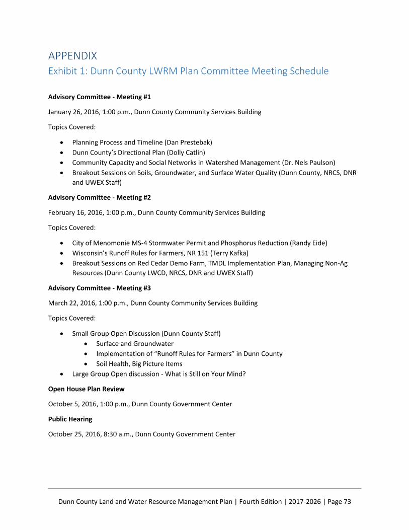
Dunn County Land and Water Resource Management Plan | Fourth Edition | 2017-2026 | Page 73
APPENDIX Exhibit 1: Dunn County LWRM Plan Committee Meeting Schedule
Advisory Committee - Meeting #1
January 26, 2016, 1:00 p.m., Dunn County Community Services Building
Topics Covered:
Planning Process and Timeline (Dan Prestebak)
Dunn County’s Directional Plan (Dolly Catlin)
Community Capacity and Social Networks in Watershed Management (Dr. Nels Paulson)
Breakout Sessions on Soils, Groundwater, and Surface Water Quality (Dunn County, NRCS, DNR
and UWEX Staff)
Advisory Committee - Meeting #2
February 16, 2016, 1:00 p.m., Dunn County Community Services Building
Topics Covered:
City of Menomonie MS-4 Stormwater Permit and Phosphorus Reduction (Randy Eide)
Wisconsin’s Runoff Rules for Farmers, NR 151 (Terry Kafka)
Breakout Sessions on Red Cedar Demo Farm, TMDL Implementation Plan, Managing Non-Ag
Resources (Dunn County LWCD, NRCS, DNR and UWEX Staff)
Advisory Committee - Meeting #3
March 22, 2016, 1:00 p.m., Dunn County Community Services Building
Topics Covered:
Small Group Open Discussion (Dunn County Staff)
Surface and Groundwater
Implementation of “Runoff Rules for Farmers” in Dunn County
Soil Health, Big Picture Items
Large Group Open discussion - What is Still on Your Mind?
Open House Plan Review
October 5, 2016, 1:00 p.m., Dunn County Government Center
Public Hearing
October 25, 2016, 8:30 a.m., Dunn County Government Center
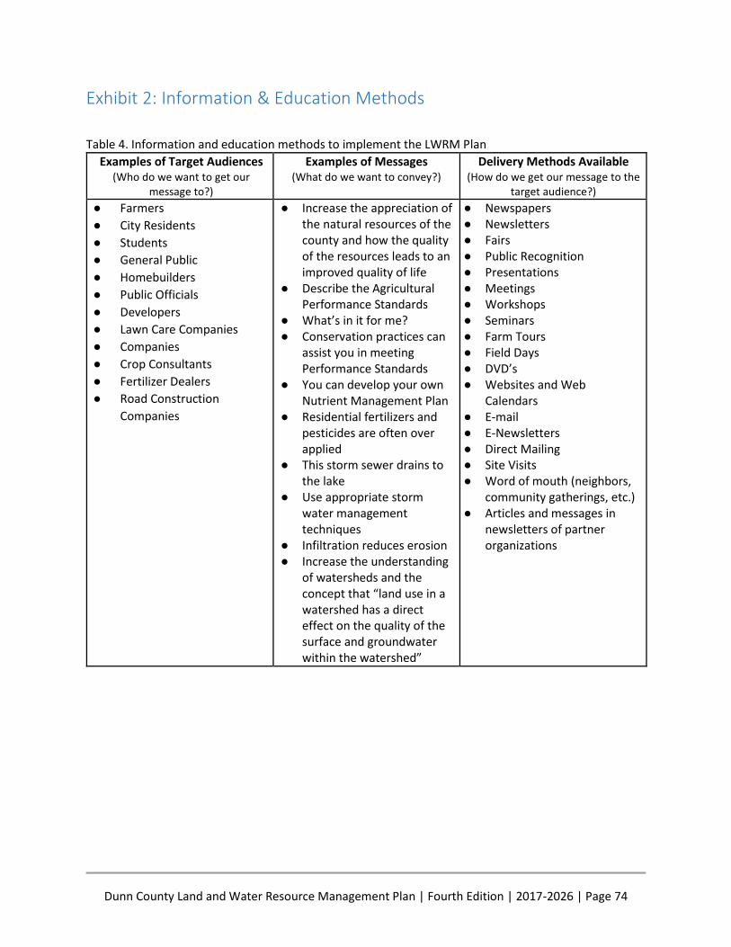
Dunn County Land and Water Resource Management Plan | Fourth Edition | 2017-2026 | Page 74
Exhibit 2: Information & Education Methods
Table 4. Information and education methods to implement the LWRM Plan
Examples of Target Audiences (Who do we want to get our
message to?)
Examples of Messages (What do we want to convey?)
Delivery Methods Available (How do we get our message to the
target audience?)
● Farmers
● City Residents
● Students
● General Public
● Homebuilders
● Public Officials
● Developers
● Lawn Care Companies
● Companies
● Crop Consultants
● Fertilizer Dealers
● Road Construction
Companies
● Increase the appreciation of the natural resources of the county and how the quality of the resources leads to an improved quality of life
● Describe the Agricultural Performance Standards
● What’s in it for me? ● Conservation practices can
assist you in meeting Performance Standards
● You can develop your own Nutrient Management Plan
● Residential fertilizers and pesticides are often over applied
● This storm sewer drains to the lake
● Use appropriate storm water management techniques
● Infiltration reduces erosion ● Increase the understanding
of watersheds and the concept that “land use in a watershed has a direct effect on the quality of the surface and groundwater within the watershed”
● Newspapers ● Newsletters ● Fairs ● Public Recognition ● Presentations ● Meetings ● Workshops ● Seminars ● Farm Tours ● Field Days ● DVD’s ● Websites and Web
Calendars ● E-mail ● E-Newsletters ● Direct Mailing ● Site Visits ● Word of mouth (neighbors,
community gatherings, etc.) ● Articles and messages in
newsletters of partner organizations
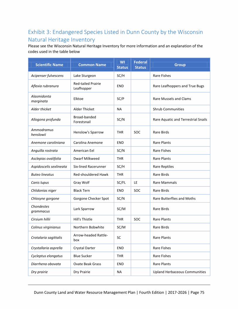
Dunn County Land and Water Resource Management Plan | Fourth Edition | 2017-2026 | Page 75
Exhibit 3: Endangered Species Listed in Dunn County by the Wisconsin Natural Heritage Inventory Please see the Wisconsin Natural Heritage Inventory for more information and an explanation of the
codes used in the table below
Scientific Name Common Name WI
Status
Federal Status
Group
Acipenser fulvescens Lake Sturgeon SC/H Rare Fishes
Aflexia rubranura
Red-tailed Prairie Leafhopper
END Rare Leafhoppers and True Bugs
Alasmidonta marginata
Elktoe SC/P Rare Mussels and Clams
Alder thicket Alder Thicket NA Shrub Communities
Allogona profunda
Broad-banded Forestsnail
SC/N Rare Aquatic and Terrestrial Snails
Ammodramus henslowii
Henslow's Sparrow THR SOC Rare Birds
Anemone caroliniana Carolina Anemone END Rare Plants
Anguilla rostrata American Eel SC/N Rare Fishes
Asclepias ovalifolia Dwarf Milkweed THR Rare Plants
Aspidoscelis sexlineata Six-lined Racerunner SC/H Rare Reptiles
Buteo lineatus Red-shouldered Hawk THR Rare Birds
Canis lupus Gray Wolf SC/FL LE Rare Mammals
Chlidonias niger Black Tern END SOC Rare Birds
Chlosyne gorgone Gorgone Checker Spot SC/N Rare Butterflies and Moths
Chondestes grammacus
Lark Sparrow SC/M Rare Birds
Cirsium hillii Hill's Thistle THR SOC Rare Plants
Colinus virginianus Northern Bobwhite SC/M Rare Birds
Crotalaria sagittalis
Arrow-headed Rattle-box
SC Rare Plants
Crystallaria asprella Crystal Darter END Rare Fishes
Cycleptus elongatus Blue Sucker THR Rare Fishes
Diarrhena obovata Ovate Beak Grass END Rare Plants
Dry prairie Dry Prairie NA Upland Herbaceous Communities
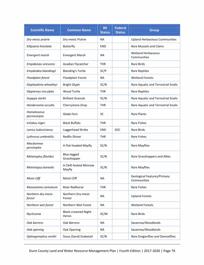
Dunn County Land and Water Resource Management Plan | Fourth Edition | 2017-2026 | Page 76
Scientific Name Common Name WI
Status
Federal Status
Group
Dry-mesic prairie Dry-mesic Prairie NA Upland Herbaceous Communities
Ellipsaria lineolata Butterfly END Rare Mussels and Clams
Emergent marsh Emergent Marsh NA Wetland Herbaceous Communities
Empidonax virescens Acadian Flycatcher THR Rare Birds
Emydoidea blandingii Blanding's Turtle SC/P Rare Reptiles
Floodplain forest Floodplain Forest NA Wetland Forests
Glyphyalinia wheatleyi Bright Glyph SC/N Rare Aquatic and Terrestrial Snails
Glyptemys insculpta Wood Turtle THR Rare Reptiles
Guppya sterkii Brilliant Granule SC/N Rare Aquatic and Terrestrial Snails
Hendersonia occulta Cherrystone Drop THR Rare Aquatic and Terrestrial Snails
Homalosorus pycnocarpos
Glade Fern SC Rare Plants
Ictiobus niger Black Buffalo THR Rare Fishes
Lanius ludovicianus Loggerhead Shrike END SOC Rare Birds
Lythrurus umbratilis Redfin Shiner THR Rare Fishes
Macdunnoa persimplex
A Flat-headed Mayfly SC/N Rare Mayflies
Melanoplus flavidus
Blue-legged Grasshopper
SC/N Rare Grasshoppers and Allies
Metretopus borealis
A Cleft-footed Minnow Mayfly
SC/N Rare Mayflies
Moist cliff Moist Cliff NA Geological Features/Primary Communities
Moxostoma carinatum River Redhorse THR Rare Fishes
Northern dry-mesic forest
Northern Dry-mesic Forest
NA Upland Forests
Northern wet forest Northern Wet Forest NA Wetland Forests
Nycticorax
Black-crowned Night-Heron
SC/M Rare Birds
Oak barrens Oak Barrens NA Savannas/Woodlands
Oak opening Oak Opening NA Savannas/Woodlands
Ophiogomphus smithi Sioux (Sand) Snaketail SC/N Rare Dragonflies and Damselflies
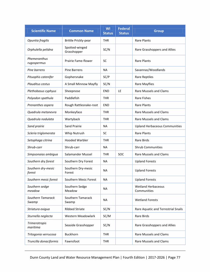
Dunn County Land and Water Resource Management Plan | Fourth Edition | 2017-2026 | Page 77
Scientific Name Common Name WI
Status
Federal Status
Group
Opuntia fragilis Brittle Prickly-pear THR Rare Plants
Orphulella pelidna
Spotted-winged Grasshopper
SC/N Rare Grasshoppers and Allies
Phemeranthus rugospermus
Prairie Fame-flower SC Rare Plants
Pine barrens Pine Barrens NA Savannas/Woodlands
Pituophis catenifer Gophersnake SC/P Rare Reptiles
Plauditus cestus A Small Minnow Mayfly SC/N Rare Mayflies
Plethobasus cyphyus Sheepnose END LE Rare Mussels and Clams
Polyodon spathula Paddlefish THR Rare Fishes
Prenanthes aspera Rough Rattlesnake-root END Rare Plants
Quadrula metanevra Monkeyface THR Rare Mussels and Clams
Quadrula nodulata Wartyback THR Rare Mussels and Clams
Sand prairie Sand Prairie NA Upland Herbaceous Communities
Scleria triglomerata Whip Nutrush SC Rare Plants
Setophaga citrina Hooded Warbler THR Rare Birds
Shrub-carr Shrub-carr NA Shrub Communities
Simpsonaias ambigua Salamander Mussel THR SOC Rare Mussels and Clams
Southern dry forest Southern Dry Forest NA Upland Forests
Southern dry-mesic forest
Southern Dry-mesic Forest
NA Upland Forests
Southern mesic forest Southern Mesic Forest NA Upland Forests
Southern sedge meadow
Southern Sedge Meadow
NA Wetland Herbaceous Communities
Southern Tamarack Swamp
Southern Tamarack Swamp
NA Wetland Forests
Striatura exigua Ribbed Striate SC/N Rare Aquatic and Terrestrial Snails
Sturnella neglecta Western Meadowlark SC/M Rare Birds
Trimerotropis maritima
Seaside Grasshopper SC/N Rare Grasshoppers and Allies
Tritogonia verrucosa Buckhorn THR Rare Mussels and Clams
Truncilla donaciformis Fawnsfoot THR Rare Mussels and Clams

Dunn County Land and Water Resource Management Plan | Fourth Edition | 2017-2026 | Page 78
Scientific Name Common Name WI
Status
Federal Status
Group
Vallonia parvula Trumpet Vallonia SC/N Rare Aquatic and Terrestrial Snails
Vertigo nylanderi Deep-throated Vertigo SC/N Rare Aquatic and Terrestrial Snails
Vireo bellii Bell's Vireo THR Rare Birds
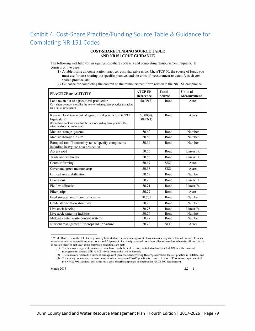
Dunn County Land and Water Resource Management Plan | Fourth Edition | 2017-2026 | Page 79
Exhibit 4: Cost-Share Practice/Funding Source Table & Guidance for Completing NR 151 Codes
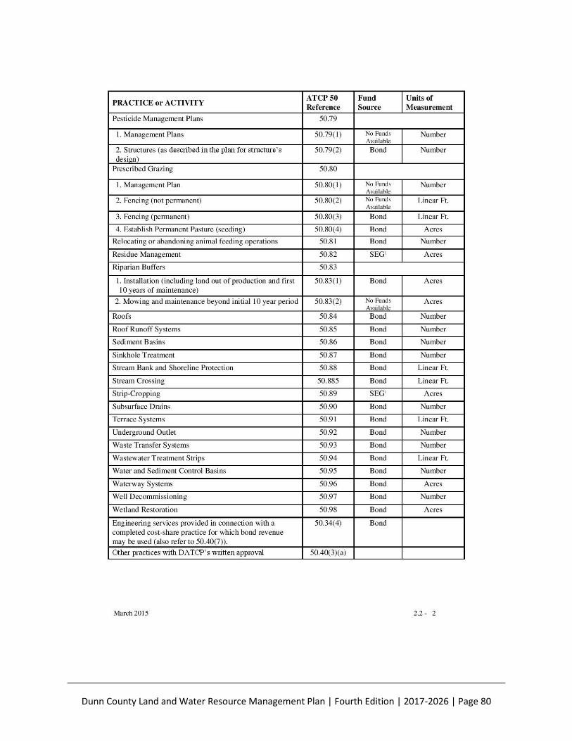
Dunn County Land and Water Resource Management Plan | Fourth Edition | 2017-2026 | Page 80
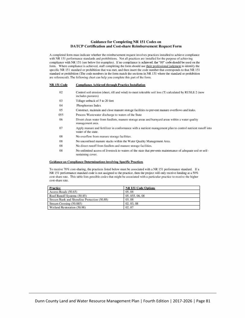
Dunn County Land and Water Resource Management Plan | Fourth Edition | 2017-2026 | Page 81

Dunn County Land and Water Resource Management Plan | Fourth Edition | 2017-2026 | Page 82
Exhibit 5: Components of NR 151

Dunn County Land and Water Resource Management Plan | Fourth Edition | 2017-2026 | Page 83
Exhibit 6: Estimated Funding Available to Implement Planned Activities The following table contains what is believed to be a reasonable estimate of the funding available from
Dunn County and the State of Wisconsin based on past revenue and expenses to implement the planned
activities identified in the Work Plan
2014 2015 2016 2017
County Revenue for Staffing
$360,995 *
$430,318 * $549,867 ■
$547,739 ■■
State Revenue for Staffing
$149,267 ** $155,047 ** $152,127 $155,232 ***
Hours Available 12,000 12,000 14,000 14,000
State Cost Share $59,333 ** $27,246 ** $104,050 ■■■ $69,500 ***
*2014 and 2015 Figures represent county-source funding as reported on the financial report to DATCP
**2014 and 2015 Figures are actual amounts received/expended from DATCP. State cost-share amounts include
both bond and SEG funds
***2017 Figures are from the Preliminary DATCP/DNR Joint Allocation Plan
■ 2016 Adopted Dunn County Budget
■■ 2017 Proposed Dunn County Budget
■■■2016 SWRM bond and SEG fund allocation ($80,800) + 2015 Cost-share conservation plan extension into
2016 ($23,250)
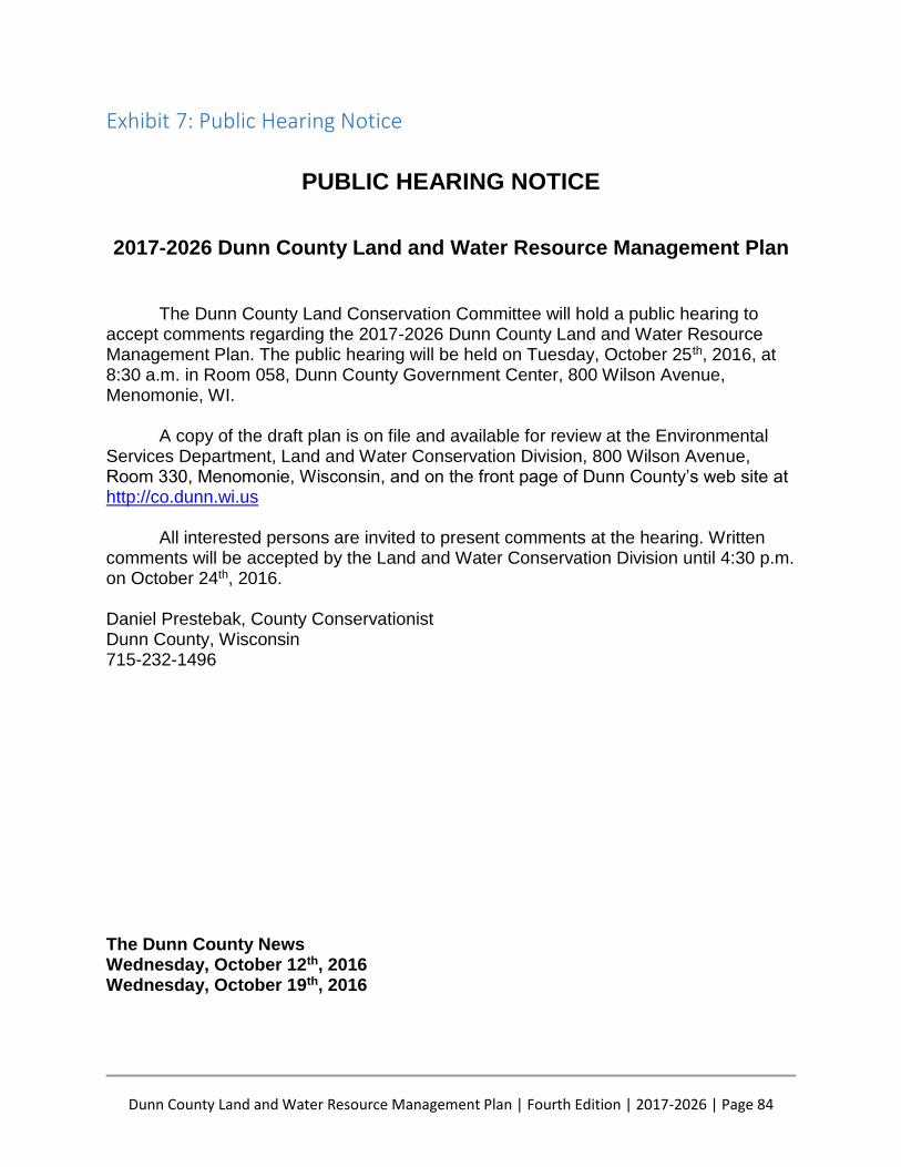
Dunn County Land and Water Resource Management Plan | Fourth Edition | 2017-2026 | Page 84
Exhibit 7: Public Hearing Notice
PUBLIC HEARING NOTICE
2017-2026 Dunn County Land and Water Resource Management Plan
The Dunn County Land Conservation Committee will hold a public hearing to accept comments regarding the 2017-2026 Dunn County Land and Water Resource Management Plan. The public hearing will be held on Tuesday, October 25th, 2016, at 8:30 a.m. in Room 058, Dunn County Government Center, 800 Wilson Avenue, Menomonie, WI.
A copy of the draft plan is on file and available for review at the Environmental Services Department, Land and Water Conservation Division, 800 Wilson Avenue, Room 330, Menomonie, Wisconsin, and on the front page of Dunn County’s web site at http://co.dunn.wi.us
All interested persons are invited to present comments at the hearing. Written comments will be accepted by the Land and Water Conservation Division until 4:30 p.m. on October 24th, 2016. Daniel Prestebak, County Conservationist Dunn County, Wisconsin 715-232-1496 The Dunn County News Wednesday, October 12th, 2016 Wednesday, October 19th, 2016

Dunn County Land and Water Resource Management Plan | Fourth Edition | 2017-2026 | Page 85
Exhibit 8: Acronyms AEA Agricultural Enterprise Area
APHIS-WS USDA-Animal & Plant Health Inspection Service-Wildlife Services
BMPs Best management practices
CAFO Confined Animal Feeding Operation
CREP Conservation Reserve Enhancement Program
CRP Conservation Reserve Program
CVTC Chippewa Valley Technical College
CWA Clean Water Act
DATCP Department of Agriculture, Trade and Consumer Protection
DCSA Dunn County Snowmobile Association
DEESC Dunn Environmental Education Steering Committee
DNR Department of Natural Resources
DU Ducks Unlimited
ENS Environmental Services Department
EPA Environmental Protection Agency
ERW Exceptional Resource Waters
EQIP Environmental Quality Incentives Program
EVAAL Erosion Vulnerability Assessment for Agricultural Lands
Facilities Dunn County Facilities and Parks Division
FIA Federal Inventory and Analysis
Fish & Game Dunn County Fish & Game Association
FLW Farmer-Led Watershed
FPP Farmland Preservation Program
FSA Farm Service Agency
GWA Groundwater attenuation
ICGOA Interstate Civic Governance Organizing Agency
IT Dunn County Information Technology
LA Load Allocation (Nonpoint Sources)
LAKES-REU Linking Applied Knowledge in Environmental Sustainability Research Experience
for Undergraduates
LCC Land Conservation Committee
LCIP Lower Chippewa Invasives Partnership
LWCD Land and Water Conservation Division
LWRM Land & Water Resource Management
NACD National Association of Conservation Districts
NGOs Non-Government Organizations
No3-N Nitrite-Nitrogen
NRCS Natural Resources Conservation Service
ORW Outstanding Resource Waters
P Phosphorus
Partnership Red Cedar River Water Quality Partnership
PCBs Polychlorinated biphenyls
PI Phosphorus Index
Dunn County Land and Water Resource Management Plan | Fourth Edition | 2017-2026 | Page 86
PF Pheasants Forever
PPM Parts Per Million
RCBMG Red Cedar Basin Monitoring Group
RC&D River Country Resource Conservation & Development
RUSLE2 Revised Universal Soil Loss Equation 2
SARE Sustainable Agriculture Research and Education
SCI Soil Conditioning Index
SEG Segregated
SNAP-Plus Nutrient Management Planning Software Program
STIR Soil Tillage Intensity Rating
SWRB Simulator for Water Resources in Rural Basins
SWRM Soil & Water Resource Management
The Alliance Dunn County Alliance of Conservation and Sports Clubs
“T” Tolerable Soil Loss
TMDL Total Maximum Daily Load
TMLIA Tainter Menomin Lake Improvement Association
TP Total Phosphorus
TROUT Trout Regulations and Opportunities User Tool
TU Trout Unlimited
USACOE U.S. Army Corp of Engineers
USDA United States Department of Agriculture
USDA-APHIS-WS United States Department of Agriculture-Animal & Plant Health
Inspection Service-Wildlife Services
USFWS U.S. Fish and Wildlife Service
USGS United States Geological Survey
UWEX University of Wisconsin Cooperative Extension Service
WAV Water Action Volunteers
WCWIPMA West Central Wisconsin Invasive Plant Management Area
WCWRPC West Central Wisconsin Regional Planning Commission
WDNR Wisconsin Department of Natural Resources
WI Land + Water Wisconsin Land + Water Conservation Association
WLA Waste Load Allocation (Point Source)
WLWCA Wisconsin Land + Water Conservation Association
WWLT West Wisconsin Land Trust
WPDES Wisconsin Pollutant Discharge Elimination System

![The Dunn Family of Moore County, NC – Miscellaneous Records · THE DUNN FAMILY OF MOORE COUNTY, NC – MISCELLANEOUS RECORDS Prepared by Morgan Jackson [] Page 2 Joseph Dunn 1 white](https://img.pdfslide.us/doc/110x75/5f1eceebb7ffce38825773e1/the-dunn-family-of-moore-county-nc-a-miscellaneous-records-the-dunn-family-of.jpg)