Embed Size (px)
Citation preview
June 28, 2013
Peace River Project Water Use Plan Dunlevy Boat Ramp Feasibility, Design and Costing Final Report Reference: GMSWORKS-54 Dunlevy Replacement Boat Ramp Feasibility Study
Moffatt & Nichol
DUNLEVY REPLACEMENT BOAT RAMP
FEASIBILITY STUDY
June 28, 2013
BC Hydro June 28, 2013
DUNLEVY BOAT RAMP FEASIBILITY STUDY ii
DUNLEVY REPLACEMENT BOAT RAMP
FEASIBILITY STUDY
June 28, 2013
7937 – FINAL
Prepared for:
6911 Southpoint Drive
Burnaby, BC, V3N 4X8
Prepared by:
777 West Broadway, Suite 301
Vancouver, BC V5Z 4J7
REV DESCRIPTION DATE ISSUED PREPARED
BY REVIEWED
BY APPROVED
BY
G Final Report June 28, 2013 PH MN PH
F Options 5, 5A, 5B,6, 6A &6B - Draft
May 31, 2013 PH MN PH
E Revised Draft April 22, 2013 PH
D Revised Draft – Option 4 April 4, 2013 PH PH
C Revised Draft March 19, 2013 PH PH
B Revised Draft March 13, 2013 PH MN PH
A Draft February 27, 2013 PH MN PH
BC Hydro June 28, 2013
DUNLEVY BOAT RAMP FEASIBILITY STUDY iii
Table of Contents
1. INTRODUCTION .................................................................................................................................... 1
1.1 PROJECT BACKGROUND .......................................................................................................................... 1
1.2 SCOPE OF WORK ................................................................................................................................... 2
1.3 DATA COLLECTION ................................................................................................................................. 3
1.4 REPORT ORGANIZATION .......................................................................................................................... 3
2. FEASIBILITY DESIGN FOR REPLACEMENT BOAT RAMP AT DUNLEVY ..................................................... 4
2.1 BC HYDRO USER REQUIREMENTS ............................................................................................................. 4
2.2 DESIGN CRITERIA ................................................................................................................................... 4
2.2.1 Codes and Standards .................................................................................................................... 4
2.2.2 References ..................................................................................................................................... 5
2.2.3 Materials and Testing ................................................................................................................... 5
2.2.4 Units of Measurement .................................................................................................................. 5
2.2.5 Project Datum and Elevations ....................................................................................................... 5
2.2.6 Design Life ..................................................................................................................................... 5
2.2.7 Environmental Loads and Effects .................................................................................................. 5
2.2.8 Landslides and Tsunamis .............................................................................................................. 7
2.2.9 Marine Criteria .............................................................................................................................. 8
2.2.10 Structural Loads ........................................................................................................................ 12
2.2.11 Geotechnical Information ......................................................................................................... 12
2.2.12 Functional Criteria ..................................................................................................................... 12
2.2.13 Navigation Aids and Signs ......................................................................................................... 14
2.2.14 Parking Area ............................................................................................................................. 14
2.2.15 Utilities ...................................................................................................................................... 14
2.2.16 Washrooms and Garbage Receptacles ..................................................................................... 14
2.2.17 Safety by Design ........................................................................................................................ 15
3. CONCEPTUAL LAYOUTS OF REPLACEMENT BOAT LAUNCH RAMP ...................................................... 16
3.1 CONDITION OF EXISTING BOAT LAUNCH RAMP .......................................................................................... 16
3.2 TOPOGRAPHY OF EXISTING BOAT RAMP ................................................................................................... 16
3.3 OPTIONS 1 & 1A -REPLACEMENT BOAT LAUNCH RAMP – EAST-WEST ALIGNMENT WITH LOWER SECTION PARALLEL
TO LAKE BED SLOPE .................................................................................................................................... 16
3.4 OPTION 2 – REPLACEMENT BOAT LAUNCH RAMP - STRAIGHT - EAST-WEST ALIGNMENT ................................... 18
3.5 OPTION 3 – ALTERNATE REPLACEMENT BOAT RAMP - NORTH-SOUTH ALIGNMENT........................................... 18
3.6 OPTION 4 – EAST- WEST ALIGNMENT - AT - GRADE GRAVEL RAMP .............................................................. 19
3.7 OPTION 5 – EAST - WEST ALIGNMENT - RAMP TOE AT EL. 660M ................................................................. 20
3.8 OPTION 5A – EAST - WEST ALIGNMENT - RAMP TOE AT EL. 654M BUILT IN TWO PHASES ............................ 20
3.9 OPTION 5B – EAST - WEST ALIGNMENT - RAMP TOE AT EL. 658M .............................................................. 21
3.10 OPTION 5C – EAST - WEST ALIGNMENT - RAMP TOE AT EL. 654M BUILT IN TWO PHASES .......................... 21
3.11 OPTION 6 – EAST-WEST ALIGNMENT - RAMP TOE AT EL. 654M ................................................................ 22
3.12 OPTION 6A – EAST-WEST ALIGNMENT - RAMP TOE AT EL. 654M BUILT IN TWO PHASES .......................... 22

BC Hydro June 28, 2013
DUNLEVY BOAT RAMP FEASIBILITY STUDY iv
3.13 OPTION 6B – EAST-WEST ALIGNMENT - RAMP TOE AT EL. 654M BUILT IN TWO PHASES .......................... 23
4. OPINION OF PROBABLE CONSTRUCTION COSTS ................................................................................. 24
4.1 OPTION 1 – REPLACEMENT BOAT LAUNCH RAMP – EAST-WEST ALIGNMENT WITH LOWER SECTION ALONG SLOPE –
CONCRETE/GRAVEL SURFACE ...................................................................................................................... 24
4.2 OPTION 1A – REPLACEMENT BOAT LAUNCH RAMP – EAST-WEST ALIGNMENT WITH LOWER SECTION ALONG SLOPE
– CONCRETE SURFACE ................................................................................................................................ 25
4.3 OPTION 2 - REPLACEMENT BOAT LAUNCH RAMP – STRAIGHT - EAST-WEST ALIGNMENT .................................. 26
4.4 OPTION 3 - REPLACEMENT BOAT LAUNCH RAMP – NORTH-SOUTH ALIGNMENT-CONCRETE/GRAVEL SURFACE ..... 27
4.5 OPTION 3A - REPLACEMENT BOAT LAUNCH RAMP – NORTH - SOUTH ALIGNMENT – CONCRETE SURFACE ........... 28
4.6 OPTION 4 - AT- GRADE GRAVEL RAMP .................................................................................................... 29
4.7 OPTION 5 – EAST-WEST ALIGNMENT - RAMP TOE AT EL. 660M................................................................... 30
4.8 OPTION 6 – EAST-WEST ALIGNMENT - RAMP TOE AT EL. 654M .................................................................. 31
OPTION 5A – RAMP TOE AT EL. 654M IN TWO PHASES ................................................................................... 32
4.9 OPTION 5B – EAST-WEST ALIGNMENT - RAMP TOE AT EL. 658M ................................................................ 33
4.10 OPTION 5C – RAMP TOE AT EL. 654M IN TWO PHASES............................................................................ 34
4.11 OPTION 6A – RAMP TOE AT EL. 654M IN TWO PHASES ........................................................................... 35
4.12 OPTION 6B – RAMP TOE AT EL. 654M IN TWO PHASES ........................................................................... 36
4.13 SUMMARY ....................................................................................................................................... 37
4.14 LIMITATIONS OF THE COST ESTIMATES................................................................................................... 39
4.15 ASSUMPTIONS AND EXCLUSIONS ........................................................................................................... 39
5. CONCLUSIONS .................................................................................................................................... 41
5.1 OPTIONS 1 & 1A – EAST-WEST ORIENTATION WITH DOGLEG ..................................................................... 41
5.2 OPTION 2- EAST-WEST ORIENTATION WITHOUT DOGLEG ........................................................................... 42
5.3 OPTIONS 3 & 3A – NORTH-SOUTH ALIGNMENT ........................................................................................ 42
5.4 OPTION 4 – GRAVEL SURFACED RAMP .................................................................................................... 43
5.5 OPTION 5 – EAST-WEST ALIGNMENT - RAMP TOE AT EL. 660M .................................................................. 43
5.6 OPTION 5A – EAST-WEST ALIGNMENT - RAMP TOE AT EL. 654M BUILT IN TWO PHASES ................................. 44
5.7 OPTION 5B – EAST-WEST ALIGNMENT - RAMP TOE AT EL. 658M ................................................................ 44
5.8 OPTION 5C – EAST-WEST ALIGNMENT - RAMP TOE AT EL. 654M BUILT IN TWO PHASES ................................. 45
5.9 OPTION 6 – EAST –WEST ALIGNMENT – RAMP TOE AT EL. 654M ................................................................ 45
5.10 OPTION 6A – EAST- WEST ALIGNMENT - RAMP TOE AT EL 654M BUILT IN TWO PHASES ................................ 46
5.11 OPTION 6B – EAST- WEST ALIGNMENT - RAMP TOE AT EL 654M BUILT IN TWO PHASES ................................ 46
5.12 RISKS .............................................................................................................................................. 47
6. RECOMMENDATIONS ......................................................................................................................... 48
7. CLOSURE ............................................................................................................................................ 49
APPENDIX A: Drawings
APPENDIX B: Cost Estimates
BC Hydro June 28, 2013
DUNLEVY BOAT RAMP FEASIBILITY STUDY v
LIST OF TABLES
Table 1: Maximum and Minimum Temperature Range for Dunlevy .............................................................. 6
Table 2: Summary of Estimate of Design Ice Thickness................................................................................... 7
Table 3: Water Level Elevations Referenced to Geodetic Datum ................................................................... 9
Table 4: Maximum Design Vessel .................................................................................................................... 9
Table 5: Occurrences by Month of Wind Speeds (km/h, west-south)........................................................... 10
Table 6: Frequency by Direction of Wind Speeds (km/h) .............................................................................. 10
Table 7: Extremal wind speeds (South, km/h)............................................................................................... 11
Table 8: Summary of Significant Wave Heights for the existing Dunlevy site ............................................... 12
Table 9: Opinion of Probable Construction Cost – Option 1 – Concrete/Gravel Surface .............................. 24
Table 10: Option 1: Estimated Annual Maintenance Cost ............................................................................ 24
Table 11: Opinion of Probable Construction Cost – Option 1A – Concrete Surface...................................... 25
Table 12: Option 1A: Estimated Annual Maintenance Cost .......................................................................... 25
Table 13: Opinion of Probable Construction Cost – Option 2 ....................................................................... 26
Table 14: Option 2: Estimated Annual Maintenance Cost ............................................................................ 26
Table 15: Opinion of Probable Construction Cost – Option 3 – Concrete/Gravel Surface ............................ 27
Table 16: Option 3: Estimated Annual Maintenance Cost ............................................................................ 27
Table 17: Opinion of Probable Construction Cost – Option 3A – Concrete Surface...................................... 28
Table 18: Option 3: Estimated Annual Maintenance Cost ............................................................................ 28
Table 19: Option 4: At-Grade Gravel Ramp ................................................................................................... 29
Table 20: Option 4: Estimated Annual Maintenance Cost ............................................................................ 29
Table 21: Opinion of Probable Construction Cost – Option 5- Ramp toe at El. 660m .................................. 30
Table 22: Opinion of Probable Construction Cost – Option 6 – Ramp Toe at El. 654m ................................ 31
Table 23: Opinion of Probable Construction Cost – Option 5A- Ramp toe at El. 660m ................................ 32
Table 24: Opinion of Probable Construction Cost – Option 5B- Ramp toe at El. 658m ................................ 33
Table 25: Opinion of Probable Construction Cost – Option 5C- Ramp toe at El. 658m ................................ 34
Table 26: Opinion of Probable Construction Cost – Option 6A- Ramp toe at El. 660m ................................ 35
Table 27: Opinion of Probable Construction Cost – Option 6B- Ramp toe at El. 658m ................................ 36
Table 28: Summary of Estimates for Capital and Annual Maintenance Costs .............................................. 38
LIST OF FIGURES
Figure 1: Water Surface Elevations at Williston Reservoir .............................................................................. 8
Figure 2: Turn-Around Area ........................................................................................................................... 13
Figure 3: Ramp Head and Toe Details ........................................................................................................... 13
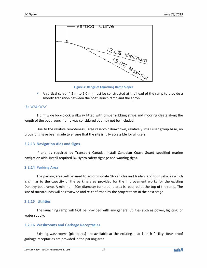
Figure 4: Range of Launching Ramp Slopes ................................................................................................... 14
BC Hydro June 28, 2013
DUNLEVY BOAT RAMP FEASIBILITY STUDY 1
1. INTRODUCTION
1.1 PROJECT BACKGROUND
As part of the Water Use Agreement, BC Hydro (BCH) is obligated to provide physical works on
the reservoir that will allow recreational/sports users to access the Peace River and Williston Reservoir
throughout the annual water level cycles in the river and reservoirs. The Peace Water Use Plan
Consultative Committee (PWUPCC) was tasked with the mandate to determine the requirements and
make recommendations for recreational access on the river and reservoir. PWUPCC recommended a
package that included operating constraints and physical works for the Peace System that will result in
enhanced recreational access to the Williston Reservoir, the Dinosaur Reservoir, and the Peace River
below Peace Canyon Dam.
Based on the PWUPCC recommendations, the Comptroller of Water Rights issued the Order to
BCH to prepare feasibility studies to improve recreational access to the reservoirs. Subsequently, BCH
issued a Request for Proposal (RFP) in March 2009 for a consultant to undertake a feasibility study for
access to the Peace River, and the Williston and Dinosaur Reservoirs including improvements to the
existing access points on the reservoir.
In June 2009, the Moffatt & Nichol (M&N) project team was engaged by BCH to undertake the
feasibility study. The Terms of Reference (TOR) for the feasibility study as provided by BCH required the
M&N project team to fulfill the following tasks:
Perform a reconnaissance survey of the existing boat launch ramp and the best relocation alternative for a replacement boat ramp at Dunlevy on the Peace Reach of the Williston Reservoir. The preferred relocation alternative is to be identified by the project team; and,
Determine the feasibility of the alternative boat launch ramps and (where relevant) of the upgraded or relocated dock and breakwater based on engineering technical feasibility, archaeological feasibility, and environmental criteria, and also provide recommendations for each site.
In March 2010, Moffatt & Nichol (M&N) submitted a feasibility study final report1 to fulfill the
requirements of the TOR which included a review and recommendation of recreational access for the
Dunlevy area on the Williston Reservoir. At that time, two sites were investigated, Dunlevy West located
on the west side of the Dunlevy inlet, and the existing Dunlevy boat ramp site located on the east side of
the Dunlevy Inlet. A reconnaissance site survey was undertaken for each location by the project team.
The feasibility for the sites was reviewed from engineering, environmental and archaeological
perspective.
The M&N 2010 feasibility report recommended that the existing Dunlevy site was potentially
feasible subject to further geotechnical evaluation for erosion.
1 Moffatt & Nichol report dated March 5, 2010 titled “GMSWORKS 12/13 – Water License Requirements
Peace and Williston Recreational Access Feasibility Study, Reach, and Dinosaur Lake-FINAL REPORT”
BC Hydro June 28, 2013
DUNLEVY BOAT RAMP FEASIBILITY STUDY 2
Geotechnical investigations were carried out by EXP Services Inc. (EXP); formerly Trow
Associates and the results of the investigations were presented in EXP’s report2 dated September 3,
2010. Based on the results of the geotechnical investigations, M&N prepared detailed design and
probable construction cost estimates3 for a new boat launch ramp at the existing Dunlevy site. The
proposed new boat launch ramp is orientated in a south–north direction versus an east-west layout for
the existing ramp.
Subsequent reviews by BCH recognized the need to consider a range of alternative sites in order
to arrive at the optimal site taking into account factors such as constructability, user requirements, ease
of access, costs, etc., which included Josef Creek Inlet as a potential site for a replacement ramp as well
as an alternative site on the west side of Dunlevy inlet. M&N provided a report4 on the feasibility level
designs and cost estimates for four sites for comparison, namely Existing Dunlevy, Dunlevy West, Josef
Creek with access through the Ross property and Josef Creek with access through the Provincial Park
property.
Based on the findings in M&N report dated October 23, 2012, BCH confirmed that the existing
Dunlevy site was best suited for providing a replacement ramp. However, in a further effort to reduce
the capital costs, BCH requested M&N to prepare feasibility designs for the existing east-west boat ramp
location to determine if improvements to the existing boat ramp could provide cost reductions for the
capital costs over a new north-south boat ramp at the existing Dunlevy site.
Subsequent to Revision E dated April 22, 2013 of this draft report, BC Hydro hosted a boat
launch ramp workshop on May 9, 2013 to develop additional options by considering revised operating
water levels and other factors. As result, the conceptual layouts for Options 5, 5A, 6 and 6A were
conceived in the workshop.
1.2 SCOPE OF WORK
The scope of the work is as follows:
Prepare and provide conceptual designs for the existing boat ramp location at Dunlevy. This option is identified as the base option case, and consideration should be given for a graveled surface ramp at the current location;
Prepare and provide tweaks to the design of replacement Dunlevy boat ramp at the existing site to reduce costs; and,
Prepare cost estimates of construction costs for both options.
2 EXP (Trow Associates) report dated September 3, 2010 titled “Geotechnical Report – Proposed BC Hydro
Boat Launch Ramp, Dunlevy Main Site, Williston Reservoir, BC” 3 M&N memorandum dated May 18, 2011 titled “Williston Reservoir and Peace River Boat Launch Ramp
Cost Estimate.” 4 M&N report dated October 23, 2012, and titled “Dunlevy Replacement Boat Ramp Facility Feasibility
Study.”
BC Hydro June 28, 2013
DUNLEVY BOAT RAMP FEASIBILITY STUDY 3
1.3 DATA COLLECTION
Bathymetry surveys of the existing Dunlevy site at the replacement ramp location was done by
TerraSond in August 2010. Atek Hydrographic Surveys Ltd also carried out bathymetry surveys in May
2009 for the existing Dunlevy site. These bathymetry surveys were used to prepare base drawings for
the feasibility design layouts of the boat launch ramp facility.
A geotechnical investigation was carried out by EXP Services (EXP) in July 2010 for the
replacement boat ramp at the Dunlevy site. Two deep drill-holes were done (6m and 14m depth) and
two shallow test pits (only 200mm deep). However, the drill-holes (AH1 & AH2) were not located along
the alignment of the preferred option (Option 5), so it would be prudent to carry out a more focused
field investigation before the next design stage. This is confirmed in Section 2.2.11.
1.4 REPORT ORGANIZATION
Section 2 describes the user requirements and the design basis for the feasibility design of the
existing boat ramp replacement. Section 3 describes the features of the layout of the boat ramp
feasibility. An opinion of probable construction costs for the feasible designs are presented in Section
4, with conclusions and recommendations in Section 5. Our closing remarks are in Section 6.
Appendix A contains drawings including a project location map, feasible layout plans of the
replacement facilities. Appendix B contains the details of the cost estimate.

BC Hydro June 28, 2013
DUNLEVY BOAT RAMP FEASIBILITY STUDY 4
2. FEASIBILITY DESIGN FOR REPLACEMENT BOAT RAMP AT DUNLEVY
2.1 BC HYDRO USER REQUIREMENTS
BCH user requirements were determined through consultation with local stakeholders who
identified their needs in the 2007 Peace Water Use Plan, Committee Report. Subsequent Peace River
and Reservoir Access Public meetings were held to verify that the design option had fulfilled the
stakeholders’ expectations.
BCH notes of the community meetings were presented to the Comptroller of Water Rights to
confirm that BC Hydro had fulfilled the requirement of the Peace River Recreational Access component
of the Water License. The design criteria for the boat ramp facility were developed from BCH User
requirement documents.
2.2 DESIGN CRITERIA
The design criteria document outlines the basis and parameters for the planning and the
feasibility designs of the boat launch ramp, riprap protection, parking area, and access road at the
existing Dunlevy site. The design criteria comply with BC Hydro Site Specific User Requirements. In the
event of a discrepancy, the BC Hydro Site Specific User Requirements will take precedence over the
design criteria.
2.2.1 Codes and Standards
The structures will be designed to conform to the most current version of the following codes
and standards at the time of the study:
US Army Corps of Engineers, Coastal Engineering Manual;
US Army Corps of Engineers, Shore Protection Manual;
Oregon State Marine Board, Layout and Design Guidelines for Recreational Boat Launching Facilities;
Layout, Design and Construction Handbook for Small Craft Boat Launching Facilities, California Department of Boating and Waterways, Division of Boating Facilities;
Layout and Design Guidelines for Marina Berthing Facilities, California Department of Boating and Waterways, Division of Boating Facilities;
Park Design Guidelines and Data, Province of British Columbia, Ministry of Environment Lands and Parks;
National Building Code of Canada; and,
CERIA; CUR; CETMEF; The Rock Manual, The Use of Rock in Hydraulic Engineering, 2nd Edition 2007.
BC Hydro June 28, 2013
DUNLEVY BOAT RAMP FEASIBILITY STUDY 5
2.2.2 References
Sodhi, D.S., S.L. Borland and Stanley J.M. (1996), Ice Action on Riprap, Small Scale Tests. CRREL Report 96-12; and,
White K.D., (2004) Method to Estimate River Ice Thickness based on Meteorological Data. US Army Cold Regions Research and Engineering Laboratory, Hanover, New Hampshire, ERDC/CRREL Technical Note 04-3.
2.2.3 Materials and Testing
Materials and testing will be specified to conform to the most current edition of the relevant
standards, where applicable, as published by the following organizations:
Canadian Standards Association (CSA); and,
American Society of Testing and Materials (ASTM).
In the event of any discrepancy, CSA shall take precedence over ASTM.
2.2.4 Units of Measurement
Construction drawings and specifications will be in accordance with the International System of
Units (SI) metric units. All dimensions shall be in millimeters unless noted otherwise.
2.2.5 Project Datum and Elevations
Horizontal coordinates are in meters to the UTM NAD83 Zone 10 coordinate system. All
elevations are referenced to geodetic datum, and are in metres unless noted otherwise.
2.2.6 Design Life
The launching ramp of the proposed facility will be designed for a thirty (30) year service life.
This service life assumes that a regular inspection and maintenance program is implemented to repair
damage and deterioration which is normal for structures exposed to wave, current and ice forces. The
mooring anchors for the floating timber breakwater will be designed for a thirty (30) year service life.
Due to regulatory requirements for untreated timber to be used for in water works, the structural
timber members for the floating breakwater will have a ten (10) year service life.
2.2.7 Environmental Loads and Effects
Environmental loads are in accordance with the data published in the supplement of the
National Building Code of Canada (NBCC). It is assumed that the environmental loads and effects for
Mackenzie is applicable to Dunlevy as provided in Table C-2 in Appendix C of the NBCC. The relevant
data for Dunlevy are included as below:
BC Hydro June 28, 2013
DUNLEVY BOAT RAMP FEASIBILITY STUDY 6
(A) RAINFALL
15 minutes - 10 mm
One day - 50 mm
Annual total - 350 mm
(B) GROUND SNOW
Ss ground snow load 1 in 50 yr - 5.1 kPa
Sr associated rain load 1 in 50 yr - 0.2 kPa
(C) WIND PRESSURE
Hourly Wind Pressure:
1/10 yr - 0.25 kPa
1/50 yr - 0.32 kPa
(D) TEMPERATURE
The maximum and minimum temperature ranges for Mackenzie have been adopted for Dunlevy
as shown in Table 1 below.
Table 1: Maximum and Minimum Temperature Range for Dunlevy
January July 2.5%
2.5% 1% Dry Wet
°C ° C ° C ° C
-34 -38 27 17
(E) CURRENT
The current at the existing Dunlevy site was considered negligible.
(F) ICE
In a design review meeting held at BC Hydro Edmonds offices on December 18, 2012, Klohn
Crippen Berger (BC Hydro’s review Engineer) proposed that the riprap could be designed based on
metocean conditions only due to limited ice information, observational based (empirical) design method
and high associated cost of riprap. Any potential movement to the riprap due to ice forces could be
repaired under an annual maintenance of the facility. Adopting the approach based on the riprap being
designed for metocean conditions will likely have a reduction on the capital cost for the boat ramp
facility; however, there could be a potential increase in the annual maintenance cost. Additional costs to
repair riprap for ice damage can be included in annual maintenance budget for the facility. For the
BC Hydro June 28, 2013
DUNLEVY BOAT RAMP FEASIBILITY STUDY 7
purposes of this study, a 1 in 30 year design wave will be used to size the riprap protection as the worse
scenario governing the riprap design.
If ice force effects are to be considered on the riprap and taken into account in the design of the
scour protection for the boat ramp, it should be noted that there is no data collection for ice formations
on the Williston Reservoir and Peace River except for anecdotal information from local fishermen who
ice fish in the winter months.
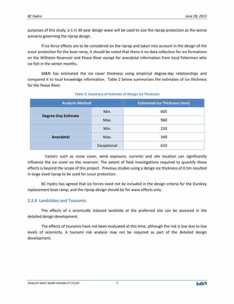
M&N has estimated the ice cover thickness using empirical degree-day relationships and
compared it to local knowledge information. Table 2 below summarizes the estimates of ice thickness
for the Peace River.
Table 2: Summary of Estimate of Design Ice Thickness
Analysis Method Estimated Ice Thickness (mm)
Degree-Day Estimate Min. 605
Max. 960
Anecdotal
Min. 250
Max. 340
Exceptional 610
Factors such as snow cover, wind exposure, currents and site location can significantly
influence the ice cover on the reservoir. The extent of field investigations required to quantify these
effects is beyond the scope of this project. Previous studies using a design ice thickness of 0.5m resulted
in large sized riprap to be used for scour protection.
BC Hydro has agreed that ice forces need not be included in the design criteria for the Dunlevy
replacement boat ramp, and the riprap design should be for wave effects only.
2.2.8 Landslides and Tsunamis
The effects of a seismically induced landslide at the preferred site can be assessed in the
detailed design development.
The effects of tsunamis have not been evaluated at this time, although the risk is low due to low
levels of seismicity. A tsunami risk analysis may not be required as part of the detailed design
development.
BC Hydro June 28, 2013
DUNLEVY BOAT RAMP FEASIBILITY STUDY 8
2.2.9 Marine Criteria
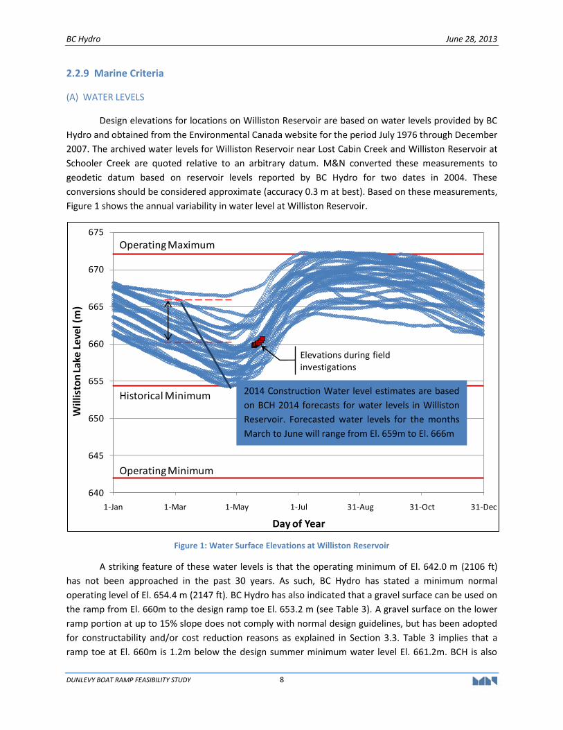
(A) WATER LEVELS
Design elevations for locations on Williston Reservoir are based on water levels provided by BC
Hydro and obtained from the Environmental Canada website for the period July 1976 through December
2007. The archived water levels for Williston Reservoir near Lost Cabin Creek and Williston Reservoir at
Schooler Creek are quoted relative to an arbitrary datum. M&N converted these measurements to
geodetic datum based on reservoir levels reported by BC Hydro for two dates in 2004. These
conversions should be considered approximate (accuracy 0.3 m at best). Based on these measurements,
Figure 1 shows the annual variability in water level at Williston Reservoir.
Figure 1: Water Surface Elevations at Williston Reservoir
A striking feature of these water levels is that the operating minimum of El. 642.0 m (2106 ft)
has not been approached in the past 30 years. As such, BC Hydro has stated a minimum normal
operating level of El. 654.4 m (2147 ft). BC Hydro has also indicated that a gravel surface can be used on
the ramp from El. 660m to the design ramp toe El. 653.2 m (see Table 3). A gravel surface on the lower
ramp portion at up to 15% slope does not comply with normal design guidelines, but has been adopted
for constructability and/or cost reduction reasons as explained in Section 3.3. Table 3 implies that a
ramp toe at El. 660m is 1.2m below the design summer minimum water level El. 661.2m. BCH is also
640
645
650
655
660
665
670
675
1-Jan 1-Mar 1-May 1-Jul 31-Aug 31-Oct 31-Dec
Will
isto
n L
ake
Leve
l (m
)
Day of Year
Operating Maximum
Historical Minimum
Operating Minimum
Elevations during field investigations
2014 Construction Water level estimates are based
on BCH 2014 forecasts for water levels in Williston
Reservoir. Forecasted water levels for the months
March to June will range from El. 659m to El. 666m
BC Hydro June 28, 2013
DUNLEVY BOAT RAMP FEASIBILITY STUDY 9
examining the option of building the ramp toe at El. 658m with a design low water level El. 659.2m, i.e.
1.2m above the toe of the ramp .
Based on the historical minimum and maximum pool water levels, the design water levels for
sites on the Williston Reservoir are as follows:
Table 3: Water Level Elevations Referenced to Geodetic Datum
Water Level Designation Elevation with respect to
Geodetic Datum (GD) (metres)
Recorded High Water Elevation 672.2
Recorded Low Water Elevation 654.4
Design Low Water Elevation for Summer Boating Season 661.2
Design Low Water Elevation for All Year Boating Season 654.4
NB: The elevation of the toe of the ramp is 1.2m (minimum water depth) below the Design Low Water Elevation.
Construction Water Levels will be based on forecasted data provided by BC Hydro. The
construction methodology and schedule for the replacement boat ramp will be determined in
collaboration with BC Hydro, consultant and contractor.
(B) BATHYMETRY AND TOPOGRAPHY
Water depths are based on hydrographic surveys carried out by TerraSond in August 2010 and
Atek Hydrographic Surveys in May 2008. Upland contours were generated using LIDAR data provided by
BC Hydro. McElhanney was engaged by BCH in May 2013 to provide additional topography survey
information for the upland areas. All water depth contours are in metres referenced with respect to
geodetic datum.
(C) DESIGN VESSELS
The maximum design vessel is shown in Table 4.
Table 4: Maximum Design Vessel
Vessel Type Length
(metres) Width
(metres) Max. Draft
(metres)
Maximum Power Boat 6.1 2.4 1
(D) WIND
The closest long-term wind data is available from Canada's National Climate Archive at
Mackenzie Airport. Data was collected for the directions of concern for wind wave generations at the
project site, south through west. This information is shown in occurrences in Tables 5 and 6. The data
BC Hydro June 28, 2013
DUNLEVY BOAT RAMP FEASIBILITY STUDY 10
was collected as 2-min average wind speed and reported hourly from 1971-2010, recorded at 10 meters
above ground.
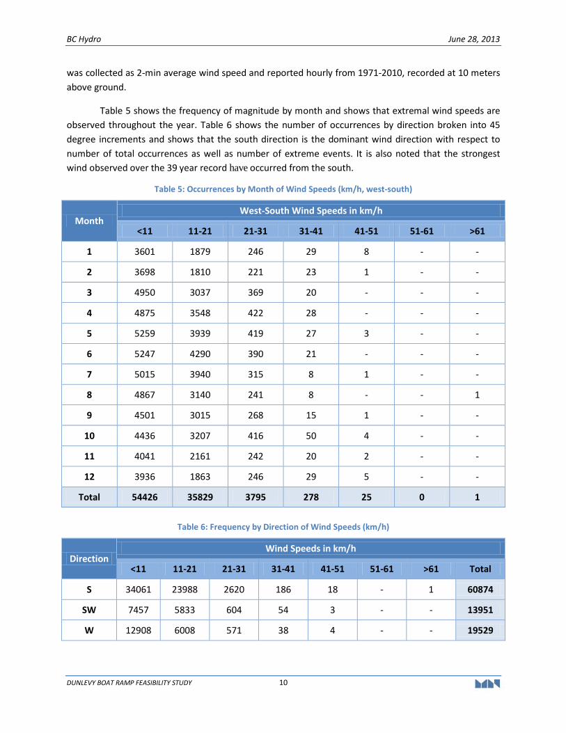
Table 5 shows the frequency of magnitude by month and shows that extremal wind speeds are
observed throughout the year. Table 6 shows the number of occurrences by direction broken into 45
degree increments and shows that the south direction is the dominant wind direction with respect to
number of total occurrences as well as number of extreme events. It is also noted that the strongest
wind observed over the 39 year record have occurred from the south.
Table 5: Occurrences by Month of Wind Speeds (km/h, west-south)
Month West-South Wind Speeds in km/h
<11 11-21 21-31 31-41 41-51 51-61 >61
1 3601 1879 246 29 8 - -
2 3698 1810 221 23 1 - -
3 4950 3037 369 20 - - -
4 4875 3548 422 28 - - -
5 5259 3939 419 27 3 - -
6 5247 4290 390 21 - - -
7 5015 3940 315 8 1 - -
8 4867 3140 241 8 - - 1
9 4501 3015 268 15 1 - -
10 4436 3207 416 50 4 - -
11 4041 2161 242 20 2 - -
12 3936 1863 246 29 5 - -
Total 54426 35829 3795 278 25 0 1
Table 6: Frequency by Direction of Wind Speeds (km/h)
Direction Wind Speeds in km/h
<11 11-21 21-31 31-41 41-51 51-61 >61 Total
S 34061 23988 2620 186 18 - 1 60874
SW 7457 5833 604 54 3 - - 13951
W 12908 6008 571 38 4 - - 19529
BC Hydro June 28, 2013
DUNLEVY BOAT RAMP FEASIBILITY STUDY 11
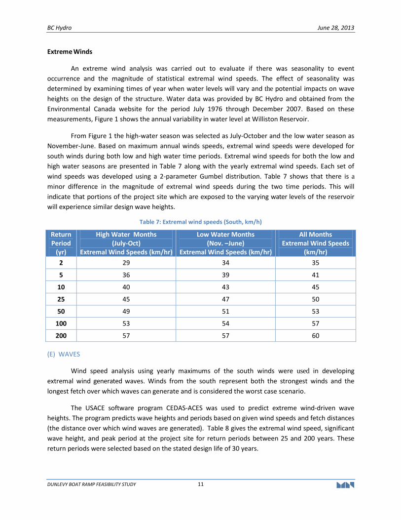
Extreme Winds
An extreme wind analysis was carried out to evaluate if there was seasonality to event
occurrence and the magnitude of statistical extremal wind speeds. The effect of seasonality was
determined by examining times of year when water levels will vary and the potential impacts on wave
heights on the design of the structure. Water data was provided by BC Hydro and obtained from the
Environmental Canada website for the period July 1976 through December 2007. Based on these
measurements, Figure 1 shows the annual variability in water level at Williston Reservoir.
From Figure 1 the high-water season was selected as July-October and the low water season as
November-June. Based on maximum annual winds speeds, extremal wind speeds were developed for
south winds during both low and high water time periods. Extremal wind speeds for both the low and
high water seasons are presented in Table 7 along with the yearly extremal wind speeds. Each set of
wind speeds was developed using a 2-parameter Gumbel distribution. Table 7 shows that there is a
minor difference in the magnitude of extremal wind speeds during the two time periods. This will
indicate that portions of the project site which are exposed to the varying water levels of the reservoir
will experience similar design wave heights.
Table 7: Extremal wind speeds (South, km/h)
Return Period
(yr)
High Water Months (July-Oct)
Extremal Wind Speeds (km/hr)
Low Water Months (Nov. –June)
Extremal Wind Speeds (km/hr)
All Months Extremal Wind Speeds
(km/hr)
2 29 34 35
5 36 39 41
10 40 43 45
25 45 47 50
50 49 51 53
100 53 54 57
200 57 57 60
(E) WAVES
Wind speed analysis using yearly maximums of the south winds were used in developing
extremal wind generated waves. Winds from the south represent both the strongest winds and the
longest fetch over which waves can generate and is considered the worst case scenario.
The USACE software program CEDAS-ACES was used to predict extreme wind-driven wave
heights. The program predicts wave heights and periods based on given wind speeds and fetch distances
(the distance over which wind waves are generated). Table 8 gives the extremal wind speed, significant
wave height, and peak period at the project site for return periods between 25 and 200 years. These
return periods were selected based on the stated design life of 30 years.
BC Hydro June 28, 2013
DUNLEVY BOAT RAMP FEASIBILITY STUDY 12
Table 8: Summary of Significant Wave Heights for the existing Dunlevy site
Return Period Wind Speed (km/h) Significant Wave Height (m) Peak Period (sec)
25 50 0.46 2.5
50 53 0.5 2.6
100 57 0.55 2.7
200 60 0.61 2.9
(F) WATER AREAS
The general requirements for the boat launch ramp water areas are as follows:
Minimum water depth of 1.2 m at design low water;
Minimum bottom width at the ramp will not be less than the combined width of the boat launching ramp, walkway and riprap shoulders or other shore protection immediately adjacent to the launching ramp; and,
Minimum length of 15 m (50ft) beyond the toe of the ramp at design low water. Area in the front will be clear of navigation obstructions.
2.2.10 Structural Loads
(A) LAUNCHING RAMP DECK LOADS
The launching ramps will be designed to carry the weight of a vehicle with a loaded boat trailer.
The design weight of a loaded boat trailer is 4,400 kg and is assumed the maximum for the ramp design.
The total weight of some vehicles plus the loaded boat trailer may exceed the above design weight.
2.2.11 Geotechnical Information
Geotechnical investigation at the existing Dunlevy ramp site was performed by EXP and results
of the investigations are provided in a report titled “Geotechnical Report, Proposed BC Hydro Boat
Launch Ramp, Dunlevy Main Site, Williston Reservoir, BC” dated September 3, 2010. At a boat launch
ramp workshop held on May 9, 2013 at BC Hydro Edmonds offices, additional geotechnical
investigations were considered to be necessary to define potential risks at the toe of the ramp due to
observed sharp changes in the ground profile at the El. 660m.
2.2.12 Functional Criteria
(A) LAUNCHING RAMPS
The existing boat launch ramp is a single lane ramp, 6m wide. As this is a replacement ramp, the
same width will be adopted.
BC Hydro June 28, 2013
DUNLEVY BOAT RAMP FEASIBILITY STUDY 13
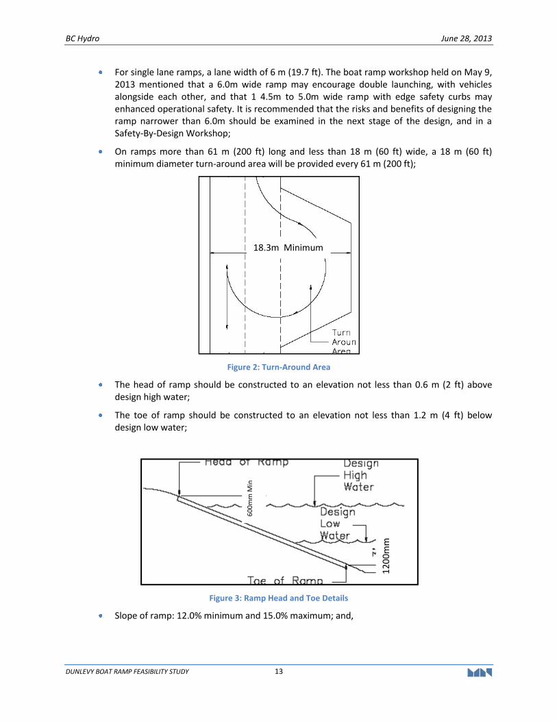
For single lane ramps, a lane width of 6 m (19.7 ft). The boat ramp workshop held on May 9, 2013 mentioned that a 6.0m wide ramp may encourage double launching, with vehicles alongside each other, and that 1 4.5m to 5.0m wide ramp with edge safety curbs may enhanced operational safety. It is recommended that the risks and benefits of designing the ramp narrower than 6.0m should be examined in the next stage of the design, and in a Safety-By-Design Workshop;
On ramps more than 61 m (200 ft) long and less than 18 m (60 ft) wide, a 18 m (60 ft) minimum diameter turn-around area will be provided every 61 m (200 ft);
Figure 2: Turn-Around Area
The head of ramp should be constructed to an elevation not less than 0.6 m (2 ft) above design high water;
The toe of ramp should be constructed to an elevation not less than 1.2 m (4 ft) below design low water;
Figure 3: Ramp Head and Toe Details
Slope of ramp: 12.0% minimum and 15.0% maximum; and,
18.3m Minimum
120
0mm
60
0m
m M
in
BC Hydro June 28, 2013
DUNLEVY BOAT RAMP FEASIBILITY STUDY 14
Figure 4: Range of Launching Ramp Slopes
A vertical curve (4.5 m to 6.0 m) must be constructed at the head of the ramp to provide a smooth transition between the boat launch ramp and the apron.
(B) WALKWAY
1.5 m wide lock-block walkway fitted with timber rubbing strips and mooring cleats along the
length of the boat launch ramp was considered but may not be included.
Due to the relative remoteness, large reservoir drawdown, relatively small user group base, no
provisions have been made to ensure that the site is fully accessible for all users.
2.2.13 Navigation Aids and Signs
If and as required by Transport Canada, install Canadian Coast Guard specified marine
navigation aids. Install required BC Hydro safety signage and warning signs.
2.2.14 Parking Area
The parking area will be sized to accommodate 16 vehicles and trailers and four vehicles which
is similar to the capacity of the parking area provided for the improvement works for the existing
Dunlevy boat ramp. A minimum 20m diameter turnaround area is required at the top of the ramp. The
size of turnarounds will be reviewed and re-confirmed by the project team in the next stage.
2.2.15 Utilities
The launching ramp will NOT be provided with any general utilities such as power, lighting, or
water supply.
2.2.16 Washrooms and Garbage Receptacles
Existing washrooms (pit toilets) are available at the existing boat launch facility. Bear proof
garbage receptacles are provided in the parking area.
BC Hydro June 28, 2013
DUNLEVY BOAT RAMP FEASIBILITY STUDY 15
2.2.17 Safety by Design
During the detailed design phase, safety by design workshop will be conducted on the following:
Reduce the width of the ramp from 6.0m to discourage two vehicles from launching
beside each other. A 4.5m to 5.0m with safety edge curbs may enhance operational
safety;
Safety curbs and elevation marker etched into into ramp to provide information on
where to launch safely; and,
Lock block walkway.
BC Hydro June 28, 2013
DUNLEVY BOAT RAMP FEASIBILITY STUDY 16
3. CONCEPTUAL LAYOUTS OF REPLACEMENT BOAT LAUNCH RAMP
3.1 CONDITION OF EXISTING BOAT LAUNCH RAMP
The existing boat launch ramp has an east-west alignment and is subjected to wind and wave
attack from predominantly occurring southerly wind generated waves. Scour protection was not placed
along the southern edge of the existing boat ramp. As a result, sections of the existing concrete panels
of the boat ramp have been severely eroded from wind generated southerly waves. Currently, concrete
traffic barriers have been placed as a temporary barricade preventing public use of the existing boat
launch ramp.
3.2 TOPOGRAPHY OF EXISTING BOAT RAMP
Generally, the profile along the centerline of the existing boat ramp is comprised of two main
gradients. From the top of the ramp towards the bottom of the ramp, the gradient is approximately 14%
(1 in 7.2) between El. 674m to El. 664m. From lake bed contour at El. 664m, the gradient of the
shoreline steepens sharply to 53.4% (1 in 1.9) to El. 631m offshore. While the upper portion of the ramp
is at the preferred gradient for boat launch operations, the lower section of the ramp is too steep to
function as a boat ramp and fill will have to be placed to provide a suitable gradient for a boat ramp.
If the orientation of the replacement ramp is kept in an east-west alignment, large volumes of
fill will be required to form the required slope at the lower section in order to form the preferred slope
of the ramp. However, if the alignment of the ramp is orientated along the slope of the bank in a south
to north orientation, a lesser amount of cut and fill will be needed to achieve the low water elevation
toe of the ramp. Protection of embankment upslope and downslope areas with riprap will be required.
3.3 OPTIONS 1 & 1A -REPLACEMENT BOAT LAUNCH RAMP – EAST-WEST ALIGNMENT WITH LOWER SECTION PARALLEL TO LAKE BED SLOPE
BC Hydro has requested that a gravel surface be considered for the lower section of the
proposed ramp commencing from El. 660 m to the design toe elevation of the ramp. Gravel-surfaced
boat launch ramps are the least expensive and are typically used for temporary facilities. This type of
loose surface provides very limited traction and is generally not recommended because of safety,
capacity and maintenance issues. However, at the lowest level of the boat ramp, the use is expected to
be infrequent. Surface erosion and wear and tear will be dependent on water levels, wave and ice forces
acting on the ramp. This area may likely require more frequent maintenance to keep the lower section
of the ramp operational.
The existing parking and upper turnaround areas will be retained as shown on Drawing SK1.
Option 1 of the proposed concrete boat launch ramp is 6.0 m wide and is 200 m long with a top
of ramp at El. 674.7 m and a toe of ramp at El. 653.2 m, allowing access at all water levels. The layout of
the proposed ramp is dogleg shaped with gradient of 14.4%. The upper section of the ramp is orientated
in the existing East-West direction with a turnaround at approximately halfway down the ramp. The
lower section of the ramp is orientated in North-South direction from the turnaround. A 200 mm high
BC Hydro June 28, 2013
DUNLEVY BOAT RAMP FEASIBILITY STUDY 17
curb will be placed on the outer perimeter of the turnaround as a barrier to prevent vehicles and trailers
from going over the steeper section of the slope.
A lock-block walkway located along the length of the ramp is proposed for accessing launched
boats. Erosion prone slopes will be protected with riprap in areas subjected to wave action. Riprap was
sized for wind generated waves as a 55kg rock material with a D505 size of 275 mm and a layer thickness
of 550mm. The underlying filter stone will be 260 mm thick.
The components of the proposed replacement boat ramp are as follows:
Demolish and remove the existing concrete panels;
Re-grade and shape ramp alignment as shown on plan layout on Drawing SK 1;
Incrementally increase the size of upper turnaround at the top of the ramp;
A 6m wide single lane, an overall 148 m long ramp with 101 lin. m of concrete surface and 47 lin. m of gravel surface;
A safety curb at the lower turnaround area and elevations marked imprinted into ramp surface to provide a clear understanding as to where it is safe to launch;
Signage should be provided to show launch parameters and description of elevation markers to users;
A lock-block walkway access along the length on the ramp (optional);
A lower turnaround area at the change of alignment of the ramp from south to north;
Scour protection along the excavated and fill faces along the boat ramp alignment; and,
Floating log breakwater anchored with chains and concrete anchor blocks along southern side of the ramp.
Operation safety should be discussed further in the next stage in a Safety-By-Design workshop.
As discussed in Section 2, Drawing SK1A shows the typical profile and section through the ramp.
The parking and turnaround area will have capacity for parking 16 vehicles and trailers and four vehicles.
To attenuate wave heights in the vicinity of the boat ramp from the predominate southerly wind
generated waves, a 85 m long, 3 m wide floating log breakwater will be provided on the southern side of
the boat ramp. The floating breakwater will only be effective to attenuate short return period waves
such as 1 in 1 year to 1 in 2 year waves which occurs in the normal operating summer conditions and will
also attenuate the beam on waves acting on the boats making launching and retrieving operations safer.
The mooring anchors for the floating breakwater will be designed for the 1 in 50 year wave forces.
Option 1A is similar to Option 1 but considers a boat ramp slope completely surfaced in
concrete.
5 D50 is defined as the median diameter or the medium value of the particle size distribution, it is the
value of the particle diameter at 50% in the cumulative distribution.
BC Hydro June 28, 2013
DUNLEVY BOAT RAMP FEASIBILITY STUDY 18
3.4 OPTION 2 – REPLACEMENT BOAT LAUNCH RAMP - STRAIGHT - EAST-WEST ALIGNMENT
For comparison purposes, a layout showing a straight east-west alignment of the boat ramp was
prepared. As indicated in Section 3.3, a large volume of fill will be required to form the lower section of
the boat ramp slope as shown on Drawing SK 2. Scour protection will be designed to resist wind
generated wave forces. Riprap was sized as a 55 kg rock material with a D50 size of 275mm and a layer
thickness of 550mm. The underlying filter stone will be 260mm thick.
Further geotechnical analysis will be required to determine if the native ground will be capable
to support the large weight of fill without causing slope failure.
The main components of the proposed replacement boat ramp are as follows:
Demolish and remove the existing concrete panels;
Re-grade and shape ramp alignment as shown on plan layout on Drawing SK 2;
Incrementally increase the size of upper turnaround at the top of the ramp;
A 6m wide single lane, an overall 153m long boat ramp with 105 lin. m of concrete surface and 48 lin. m of gravel surface;
A safety curb at the lower turnaround area and elevations marked imprinted into ramp surface to provide a clear understanding as to where it is safe to launch;
Signage should be provided to show launch parameters and description of elevation markers to users;
A lock-block walkway access along the length on the ramp (optional);
A lower turnaround area at the change of alignment of the ramp from south to north;
Scour protection along the excavated and fill faces along the boat ramp alignment; and,
Floating log breakwater anchored with chains and concrete anchor blocks along southern side of the ramp.
Operation safety should be discussed further in the next stage in a Safety-By-Design workshop.
3.5 OPTION 3 – ALTERNATE REPLACEMENT BOAT RAMP - NORTH-SOUTH ALIGNMENT
An alternate boat launch ramp at the existing Dunlevy site in a north-south alignment starting
from the north side of the existing parking lot was proposed as shown on Drawing SK 3. The main
advantage with this layout is that the ramp is protected from predominant southerly wind and waves by
the parking lot headland. The orientation of the boat ramp also facilitates relatively calm conditions for
launching and retrieving boats. The main disadvantage is that the ramp has to be formed along steep
embankments which will require large areas of cut and fill for placement riprap protection. A concrete
surfaced ramp will be provided from the top of the ramp to the turnaround area at El. 660m. A gravel
surfaced ramp will be provided from El. 660m to the toe of the ramp at El. 653.2m. Scour protection will
be designed to resist wind generated wave forces. Similar to Options 1 and 1A, the riprap was sized as
55 kg rock material with a D50 size of 275mm and a layer thickness of 550mm. The underlying filter
stone will be 260mm thick.
BC Hydro June 28, 2013
DUNLEVY BOAT RAMP FEASIBILITY STUDY 19
The main components of the proposed replacement boat ramp are as follows:
Demolish and remove the existing concrete panels;
Re-grade and shape ramp alignment as shown on plan layout on Drawing SK 3;
Revised parking and upper turnaround area at the top of the ramp;
A 6m wide single lane, an overall 197m long boat ramp with 152 lin. m of concrete surface and 45 lin. m of gravel surface;
A lock-block walkway access along the length on the ramp;
A lower turnaround area; and,
Scour protection along the excavated and fill faces along the boat ramp alignment.
Option 3A is similar to Option 3 but considers a ramp slope completely surfaced in concrete.
3.6 OPTION 4 – EAST- WEST ALIGNMENT - AT - GRADE GRAVEL RAMP
BCH has requested M&N to describe a conceptual layout for a simple grade and gravel surfaced
boat launch ramp option. Also as directed by BCH, Option 4 will be located in the east-west orientation
of the existing ramp with finished surfaces matching the existing ground grades, to disregard erosion
protection and the provision of a floating log wave attenuator for the ramp. We have assumed that the
existing concrete panels will be demolished and replaced with a gravel driving surface.
The gravel surface will only extend 80m from the top of the ramp at El. 674.6m to the end of
the ramp at El. 662.0m. Beyond the end of the ramp at El. 662.0m, the existing ground becomes very
steep with a gradient of 53.4% (1 in 1.9) down to El. 631.0m offshore. At this steep gradient, the natural
terrain is unusable for boat launch operations, therefore no gravel surfacing will be provided beyond El.
662.0m. A 200mm high precast concrete curb will have to be placed at the end of the ramp to provide a
physical barrier to prevent trailer wheels from going over the steep section of the slope. The precast
concrete curb will be designed to have a buried foundation section, sufficiently to resist overturning
forces from a trailer wheel impact.
El. 663.2m is the limiting water elevation for launching boats in this option. Based in the water
level variation graph (Figure 1) in the reservoir, the lowest water level range in the reservoir could result
in unavailability of the ramp for use up to from the end of November to beginning of July. However, at
higher water level ranges, the ramp could potentially have all year access.
The placement of a floating log wave attenuator on the southern side of the ramp provides
some protection from waves generated from the predominant south and south west winds. Without the
floating attenuator, boaters will be subjected to beam on waves which can cause the boat to the roll and
make launching and retrieving difficult. In some extreme weather conditions, a boat could be pushed
towards the shoreline possibly endangering the safety of the occupants in the boat and also doing
damage to the hull of the vessel.
Drawings for Option 4 have not been prepared since it does not comply with the design criteria
and is an option that could not be recommended for a permanent boat ramp facility. A gravel surfaced
BC Hydro June 28, 2013
DUNLEVY BOAT RAMP FEASIBILITY STUDY 20
ramp has very limited traction and often requires four wheel drive tow vehicle. It requires frequent
maintenance to keep it operational and has safety and capacity issues associated with it.
3.7 OPTION 5 – EAST - WEST ALIGNMENT - RAMP TOE AT EL. 660M
The conceptual layout of the boat ramp with a toe El. 660m is shown in Drawing SK 5. The layout
of the proposed replacement ramp is shown aligned in the east-west orientation of the original ramp.
The original boat ramp is comprised of two rows concrete panels with gravel infill between
panels. The slope is approximately 11% and the toe of the ramp is at approximately El. 668m. The top
section of the existing ramp is severely eroded with half the width of the ramp unusable due to erosion
damage.
The proposed toe of the replacement ramp is shown at El. 660m. Option 5 shows gradient of
15% with a cast-in place concrete slab with V-grooves as shown in Drawing SK 5. The width of the
concrete ramp is 6m wide with 1m wide shoulders on either side of the ramp. The excavated slopes of
the replacement ramp are 2H to 1V, and are protected with geotextile, filter stone and riprap. The
design operating water levels for Option 5 at low water is El. 661.2m. The design high water is at El.
672.2m.
An 86m long floating log breakwater located on the south side of the ramp is proposed to
attenuate the predominant waves from south – south west direction. This breakwater will improve boat
launch and retrieval conditions at the site and reduce wave erosion at the ramp.
The proposed turnaround area at the top of the ramp is defined by a turning circle diameter of
20m. The new turnaround area generally fits within the existing turnaround area but at a lower
elevation than the existing ground. The elevation of the turnaround is at El. 673.2m and is connected to
the existing access road.
The access road connecting the proposed turnaround area at the top of the ramp will need to be
re-graded at 10% slope similar to the existing slope. 2H to 1V side slopes along the either side of the
access road will be cut to tie in to the original ground elevation of the road. Side slopes beyond high
water level will be protected with hydraulic seeding. Navigation markers will be required to identify top
of cut slopes along the length of the ramp.
BCH has directed M&N to exclude the lock block walkway from this option. This should be
discussed further in a Safety-By-Design Workshop because it has boat safety implications.
3.8 OPTION 5A – EAST - WEST ALIGNMENT - RAMP TOE AT EL. 654M BUILT IN TWO PHASES
Option 5A considers the ramp built in two phases to a final ramp toe El. 654m. Phase I would
entail the ramp toe being built to EL. 660m. In Phase II, the ramp toe is extended from El. 660m to El.
654m.
For Phase I Option 5A, the ramp toe is assumed to be built at the intercept point of the existing
slopes of where the slope changes steeply which is El. 660m. It is also assumed that the water levels at
BC Hydro June 28, 2013
DUNLEVY BOAT RAMP FEASIBILITY STUDY 21
the time of construction will facilitate building the entire ramp in the dry. The ramp slope will be built at
15% and will require the new ramp slope to be formed by excavating the existing ground as shown in
Drawing SK 5B. The width of the concrete ramp is 6m wide with 1m wide shoulders on either side of the
ramp. The excavated slopes of the replacement ramp are 2H to 1V, and are protected with geotextile,
filter stone and riprap. Navigation markers will be required to identify top of cut slopes along the length
of the ramp.
BCH has directed M&N to exclude the lock block walkway from this option. This should be
discussed further in a Safety-By-Design Workshop because it has boat safety implications.
Other Phase I construction activities would also include:
An 86m long floating timber breakwater located on the south side of the ramp is proposed to attenuate the predominant waves from south – south west direction. This breakwater will improve boat launch and retrieval conditions at the site and reduce wave erosion at the ramp;
The proposed turnaround area at the top of the ramp is defined by a turning circle diameter of 20m. The new turnaround area generally fits within the existing turnaround area but at a lower elevation and existing ground. The elevation of the turnaround is at El. 673.2m and is connected to the existing access road; and,
The access road connecting the proposed turnaround area at the top of the ramp will need to be re-graded at 10% slope similar to the existing slope. 2H to 1V side slopes along the either side of the access road will be cut to tie in to the original ground elevation of the road. Side slopes beyond high water level will be protected with hydraulic seeding.
Phase II, Option 5A assumes the water level in the reservoir to be at El. 654m at the time of
construction to facilitate building the ramp extension in the dry. The ramp slope extension will be 15%
and the design operating low water level for the boating season is El. 655.2m. The ramp extension will
require a large volume of imported fill to form the ramp extension as shown in Drawing SK 5A, which is
considered to be impractical and costly to be built in the short construction window. Other extension
options such as sheet piles, and pile and deck were considered to be too costly and impractical to be
constructed due to the height of structure required to form the ramp slope.
3.9 OPTION 5B – EAST - WEST ALIGNMENT - RAMP TOE AT EL. 658M
BC Hydro has requested that a ramp toe at El. 658m be considered as this would reduce the
average annual non-accessible days from 6 days for a ramp toe of El. 660m to one day for a ramp toe El.
658m. Option 5B is similar to Option 5 with the ramp toe constructed at El. 658m.
It is assumed that water levels at the time of construction will be low enough to permit
construction of the ramp toe without a cofferdam.
3.10 OPTION 5C – EAST - WEST ALIGNMENT - RAMP TOE AT EL. 654M BUILT IN TWO PHASES
Option 5C is similar to Option 5A, with the Phase I ramp toe El. 658m and Phase II ramp toe
elevation at El. 654m
BC Hydro June 28, 2013
DUNLEVY BOAT RAMP FEASIBILITY STUDY 22
It is assumed that water levels at the time of construction for both phases will be low enough to
allow construction of the ramp toe without a cofferdam.
3.11 OPTION 6 – EAST-WEST ALIGNMENT - RAMP TOE AT EL. 654M
The conceptual layout for the boat ramp with a toe El. 654m is shown in Drawing SK 6. The
layout of the proposed replacement ramp is shown aligned in the east-west orientation of the original
ramp.
The proposed toe of the replacement ramp is shown at El. 654m. Option 6 shows gradient of
15% with a cast-in place concrete slab with V-grooves as shown in Drawing SK 6. The width of the
concrete ramp is 6m wide with 1m wide shoulders on either side of the ramp. The excavated slopes of
the replacement ramp are 2H to 1V, and are protected with geotextile, filter stone and riprap. The
extent of the cut slopes for the ramp and turnaround area encroaches more into the existing parking
area for Option 6 than Option 5.
The design operating low water levels for the boating season is El. 655.2m. The design high
water level is at El. 672.2m.
An 86m long floating timber breakwater located on the south side of the ramp is proposed to
attenuate the predominant waves from south – south west direction. This breakwater will improve boat
launch and retrieval conditions at the site and reduce wave erosion at the ramp.
The proposed turnaround area at the top of the ramp is defined by a turning circle diameter of
20m. The new turnaround area generally fits within the existing turnaround area but at a lower
elevation and existing ground. The elevation of the turnaround is at El. 673.2m and is connected to the
existing access road.
The access road connecting the proposed turnaround area at the top of the ramp will need to be
re-graded at 10% slope similar to the existing slope. 2H to 1V side slopes along the either side of the
access road will be cut to tie in to the original ground elevation of the road. Side slopes beyond high
water level will be protected with hydraulic seeding.
Navigation markers will be required to identify top of cut slopes along the length of the ramp.
BCH has directed M&N to exclude the lock block walkway from this option. This should be
discussed further in a Safety-By-Design Workshop because it has boat safety implications.
3.12 OPTION 6A – EAST-WEST ALIGNMENT - RAMP TOE AT EL. 654M BUILT IN TWO PHASES
Option 6A considers the ramp built in two phases to a final ramp toe El. 654m. Phase I would
entail the ramp toe being built to EL. 660m. In Phase II, the ramp toe is extended from El. 660m to El.
654m.
The conceptual layout for Option 6A assumes the entire ramp is formed by excavating the
existing sloping ground as shown on Drawing SK 6A. It is also assumes that the water levels at the time
BC Hydro June 28, 2013
DUNLEVY BOAT RAMP FEASIBILITY STUDY 23
of construction will facilitate building the entire ramp in the dry. The final ramp toe is set to coincide
with the existing ground at El. 654m and is then projected up the slope at 15%. At El. 660m, the Phase I
ramp toe elevation commences by excavating the existing ground as shown in Drawing SK 6A. An area
approximately 29m long in front of the toe of the ramp will be excavated level to permit future
excavation in the existing ground to extend the ramp toe to El. 654m as shown in the profile on Drawing
SK 6A. Navigation marker buoys with short tethers will be used in the level area to mark the potential
navigation hazard of the area when water levels are too shallow to allow for launching boats. These
navigation buoys could be susceptible to propeller damage when the buoys are just submerged. The
width of the concrete ramp is 6m wide with 1m wide shoulders on either side of the ramp. The
excavated slopes of the replacement ramp are 2H to 1V, and are protected with geotextile, filter stone
and riprap.
Navigation markers will be required to identify top of cut slopes along the length of the ramp.
BCH has directed M&N to exclude the lock block walkway from this option. This should be
discussed further in a Safety-By-Design Workshop because it has boat safety implications.
Other Phase I construction activities would also include:
An 86m long floating timber breakwater located on the south side of the ramp is proposed to attenuate the predominant waves from south – south west direction. This breakwater will improve boat launch and retrieval conditions at the site and reduce wave erosion at the ramp;
The proposed turnaround area at the top of the ramp is defined by a turning circle diameter of 20m. The new turnaround area generally fits within the existing turnaround area but at a lower elevation and existing ground. The elevation of the turnaround is at El. 673.2m and is connected to the existing access road; and,
The access road connecting the proposed turnaround area at the top of the ramp will need to be re-graded at 10% slope similar to the existing slope. 2H to 1V side slopes along the either side of the access road will be cut to tie in to the original ground elevation of the road. Side slopes beyond high water level will be protected with hydraulic seeding.
Phase II, Option 6A assumes the water level in the reservoir to be at El. 654m at the time of
construction to facilitate building the ramp extension without the use of a cofferdam. Additional
mobilization and demobilization will be required for Phase II construction.
The ramp slope extension will be 15% and the design operational water level for boating is El.
655.2m. The ramp extension will requires excavation to form the ramp extension as shown in Drawing
SK 6A.
3.13 OPTION 6B – EAST-WEST ALIGNMENT - RAMP TOE AT EL. 654M BUILT IN TWO PHASES
Similar to Option 6A, Option 6B considers the ramp built in two phases to a final ramp toe El.
654m. Phase I would entail the ramp toe being built to EL. 658m. In Phase II, the ramp toe is extended
from El. 660m to El. 654m.
BC Hydro June 28, 2013
DUNLEVY BOAT RAMP FEASIBILITY STUDY 24
4. OPINION OF PROBABLE CONSTRUCTION COSTS
The opinion of probable construction costs for the various sites are summarized in the tables
below. The cost estimates are considered, order-of-magnitude Class D estimates.
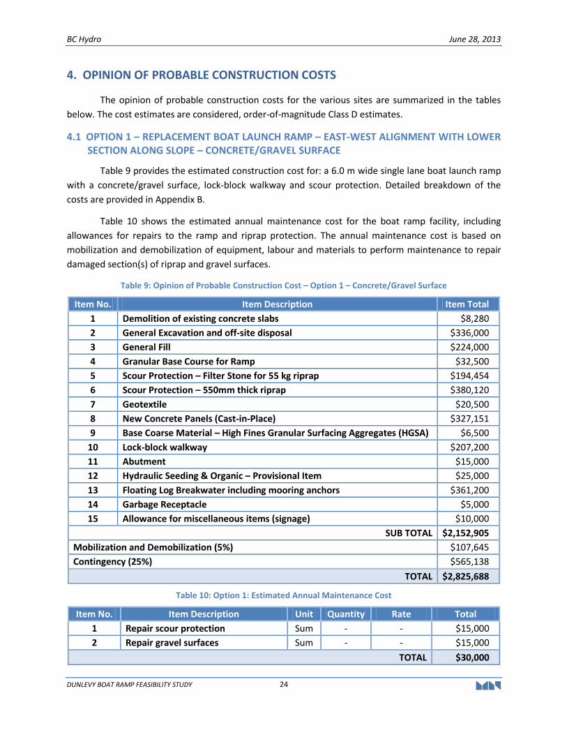
4.1 OPTION 1 – REPLACEMENT BOAT LAUNCH RAMP – EAST-WEST ALIGNMENT WITH LOWER SECTION ALONG SLOPE – CONCRETE/GRAVEL SURFACE
Table 9 provides the estimated construction cost for: a 6.0 m wide single lane boat launch ramp
with a concrete/gravel surface, lock-block walkway and scour protection. Detailed breakdown of the
costs are provided in Appendix B.
Table 10 shows the estimated annual maintenance cost for the boat ramp facility, including
allowances for repairs to the ramp and riprap protection. The annual maintenance cost is based on
mobilization and demobilization of equipment, labour and materials to perform maintenance to repair
damaged section(s) of riprap and gravel surfaces.
Table 9: Opinion of Probable Construction Cost – Option 1 – Concrete/Gravel Surface
Item No. Item Description Item Total
1 Demolition of existing concrete slabs $8,280
2 General Excavation and off-site disposal $336,000
3 General Fill $224,000
4 Granular Base Course for Ramp $32,500
5 Scour Protection – Filter Stone for 55 kg riprap $194,454
6 Scour Protection – 550mm thick riprap $380,120
7 Geotextile $20,500
8 New Concrete Panels (Cast-in-Place) $327,151
9 Base Coarse Material – High Fines Granular Surfacing Aggregates (HGSA) $6,500
10 Lock-block walkway $207,200
11 Abutment $15,000
12 Hydraulic Seeding & Organic – Provisional Item $25,000
13 Floating Log Breakwater including mooring anchors $361,200
14 Garbage Receptacle $5,000
15 Allowance for miscellaneous items (signage) $10,000
SUB TOTAL $2,152,905
Mobilization and Demobilization (5%) $107,645
Contingency (25%) $565,138
TOTAL $2,825,688
Table 10: Option 1: Estimated Annual Maintenance Cost
Item No. Item Description Unit Quantity Rate Total
1 Repair scour protection Sum - - $15,000
2 Repair gravel surfaces Sum - - $15,000
TOTAL $30,000
BC Hydro June 28, 2013
DUNLEVY BOAT RAMP FEASIBILITY STUDY 25
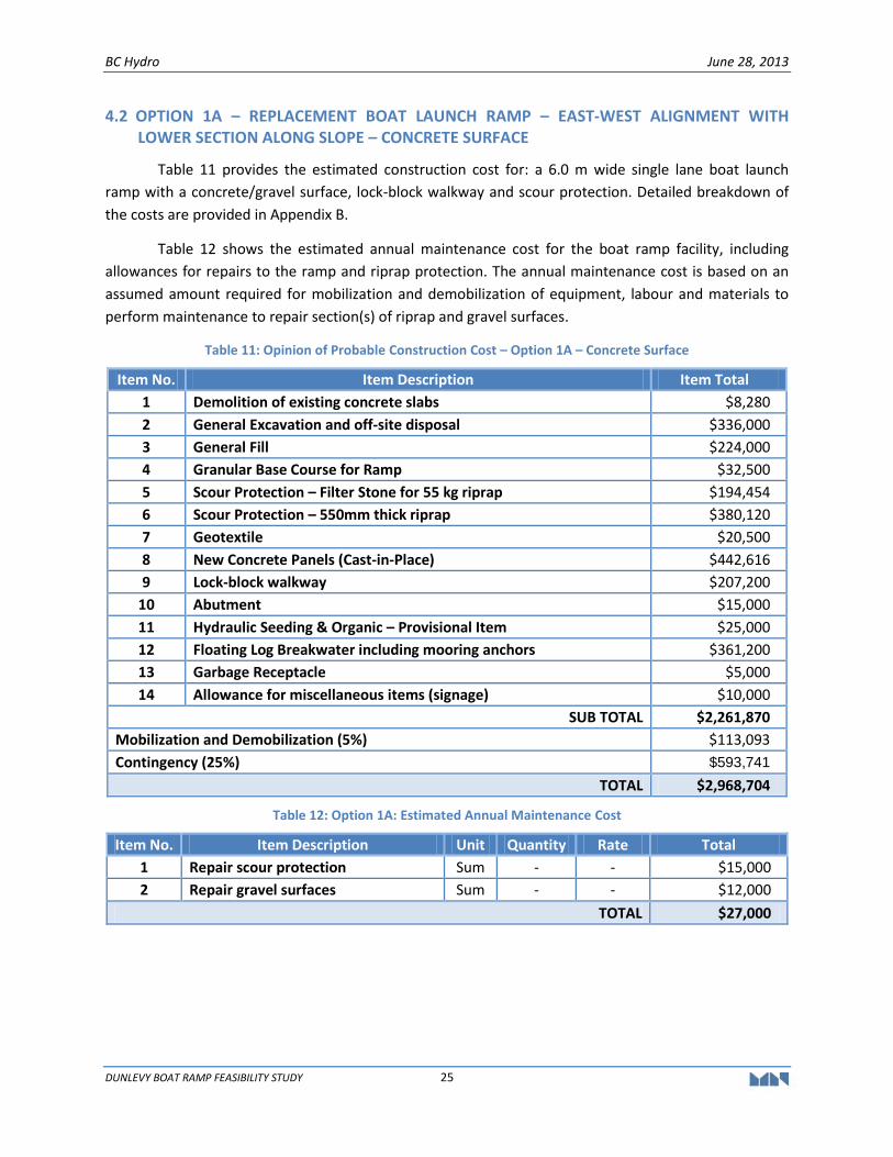
4.2 OPTION 1A – REPLACEMENT BOAT LAUNCH RAMP – EAST-WEST ALIGNMENT WITH LOWER SECTION ALONG SLOPE – CONCRETE SURFACE
Table 11 provides the estimated construction cost for: a 6.0 m wide single lane boat launch
ramp with a concrete/gravel surface, lock-block walkway and scour protection. Detailed breakdown of
the costs are provided in Appendix B.
Table 12 shows the estimated annual maintenance cost for the boat ramp facility, including
allowances for repairs to the ramp and riprap protection. The annual maintenance cost is based on an
assumed amount required for mobilization and demobilization of equipment, labour and materials to
perform maintenance to repair section(s) of riprap and gravel surfaces.
Table 11: Opinion of Probable Construction Cost – Option 1A – Concrete Surface
Item No. Item Description Item Total
1 Demolition of existing concrete slabs $8,280
2 General Excavation and off-site disposal $336,000
3 General Fill $224,000
4 Granular Base Course for Ramp $32,500
5 Scour Protection – Filter Stone for 55 kg riprap $194,454
6 Scour Protection – 550mm thick riprap $380,120
7 Geotextile $20,500
8 New Concrete Panels (Cast-in-Place) $442,616
9 Lock-block walkway $207,200
10 Abutment $15,000
11 Hydraulic Seeding & Organic – Provisional Item $25,000
12 Floating Log Breakwater including mooring anchors $361,200
13 Garbage Receptacle $5,000
14 Allowance for miscellaneous items (signage) $10,000
SUB TOTAL $2,261,870
Mobilization and Demobilization (5%) $113,093
Contingency (25%) $593,741
TOTAL $2,968,704
Table 12: Option 1A: Estimated Annual Maintenance Cost
Item No. Item Description Unit Quantity Rate Total
1 Repair scour protection Sum - - $15,000
2 Repair gravel surfaces Sum - - $12,000
TOTAL $27,000
BC Hydro June 28, 2013
DUNLEVY BOAT RAMP FEASIBILITY STUDY 26
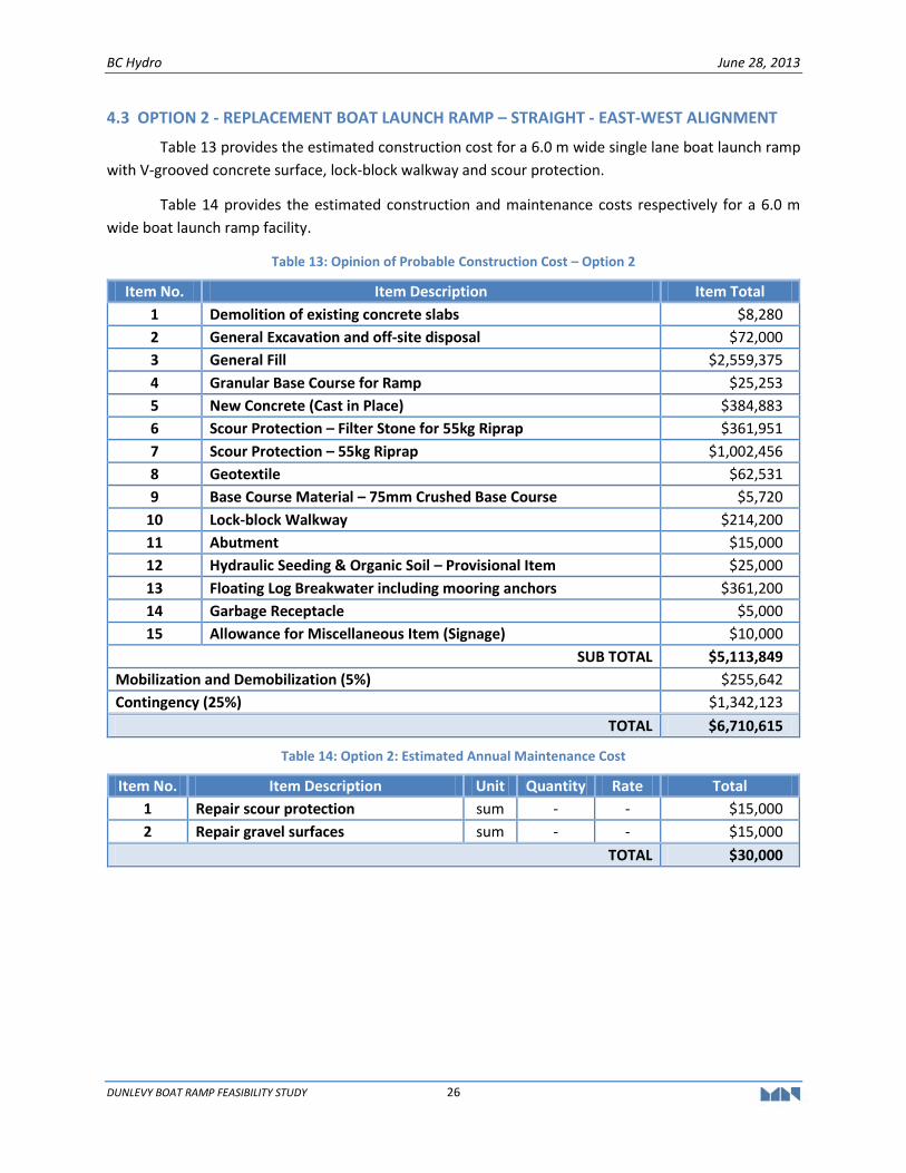
4.3 OPTION 2 - REPLACEMENT BOAT LAUNCH RAMP – STRAIGHT - EAST-WEST ALIGNMENT
Table 13 provides the estimated construction cost for a 6.0 m wide single lane boat launch ramp
with V-grooved concrete surface, lock-block walkway and scour protection.
Table 14 provides the estimated construction and maintenance costs respectively for a 6.0 m
wide boat launch ramp facility.
Table 13: Opinion of Probable Construction Cost – Option 2
Item No. Item Description Item Total
1 Demolition of existing concrete slabs $8,280
2 General Excavation and off-site disposal $72,000
3 General Fill $2,559,375
4 Granular Base Course for Ramp $25,253
5 New Concrete (Cast in Place) $384,883
6 Scour Protection – Filter Stone for 55kg Riprap $361,951
7 Scour Protection – 55kg Riprap $1,002,456
8 Geotextile $62,531
9 Base Course Material – 75mm Crushed Base Course $5,720
10 Lock-block Walkway $214,200
11 Abutment $15,000
12 Hydraulic Seeding & Organic Soil – Provisional Item $25,000
13 Floating Log Breakwater including mooring anchors $361,200
14 Garbage Receptacle $5,000
15 Allowance for Miscellaneous Item (Signage) $10,000
SUB TOTAL $5,113,849
Mobilization and Demobilization (5%) $255,642
Contingency (25%) $1,342,123
TOTAL $6,710,615
Table 14: Option 2: Estimated Annual Maintenance Cost
Item No. Item Description Unit Quantity Rate Total
1 Repair scour protection sum - - $15,000
2 Repair gravel surfaces sum - - $15,000
TOTAL $30,000
BC Hydro June 28, 2013
DUNLEVY BOAT RAMP FEASIBILITY STUDY 27
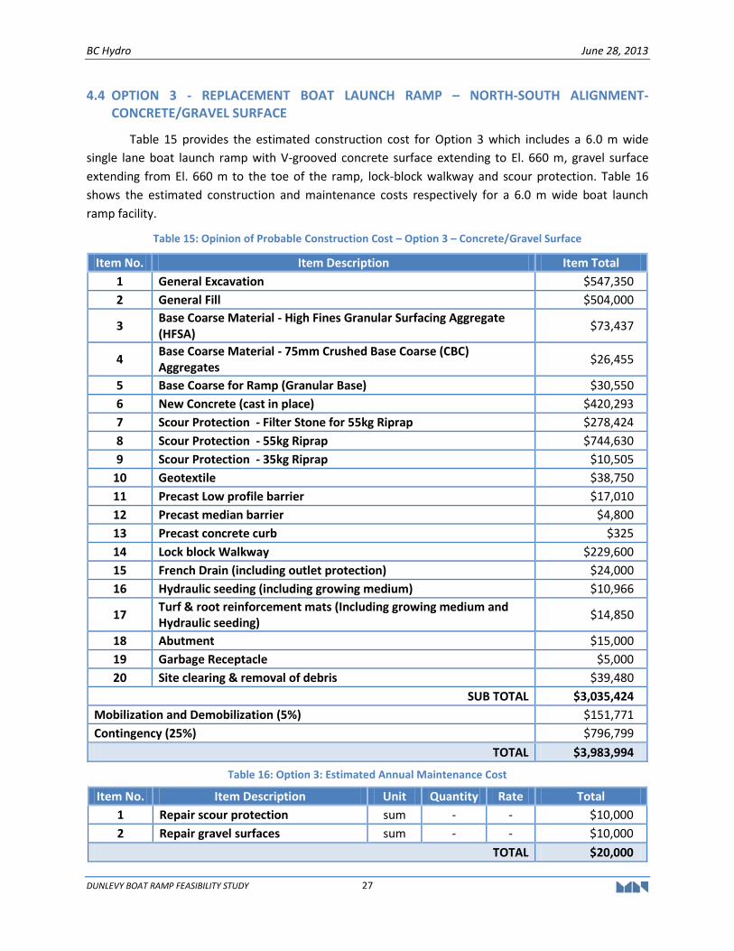
4.4 OPTION 3 - REPLACEMENT BOAT LAUNCH RAMP – NORTH-SOUTH ALIGNMENT-CONCRETE/GRAVEL SURFACE
Table 15 provides the estimated construction cost for Option 3 which includes a 6.0 m wide
single lane boat launch ramp with V-grooved concrete surface extending to El. 660 m, gravel surface
extending from El. 660 m to the toe of the ramp, lock-block walkway and scour protection. Table 16
shows the estimated construction and maintenance costs respectively for a 6.0 m wide boat launch
ramp facility.
Table 15: Opinion of Probable Construction Cost – Option 3 – Concrete/Gravel Surface
Item No. Item Description Item Total
1 General Excavation $547,350
2 General Fill $504,000
3 Base Coarse Material - High Fines Granular Surfacing Aggregate (HFSA)
$73,437
4 Base Coarse Material - 75mm Crushed Base Coarse (CBC) Aggregates
$26,455
5 Base Coarse for Ramp (Granular Base) $30,550
6 New Concrete (cast in place) $420,293
7 Scour Protection - Filter Stone for 55kg Riprap $278,424
8 Scour Protection - 55kg Riprap $744,630
9 Scour Protection - 35kg Riprap $10,505
10 Geotextile $38,750
11 Precast Low profile barrier $17,010
12 Precast median barrier $4,800
13 Precast concrete curb $325
14 Lock block Walkway $229,600
15 French Drain (including outlet protection) $24,000
16 Hydraulic seeding (including growing medium) $10,966
17 Turf & root reinforcement mats (Including growing medium and Hydraulic seeding)
$14,850
18 Abutment $15,000
19 Garbage Receptacle $5,000
20 Site clearing & removal of debris $39,480
SUB TOTAL $3,035,424
Mobilization and Demobilization (5%) $151,771
Contingency (25%) $796,799
TOTAL $3,983,994
Table 16: Option 3: Estimated Annual Maintenance Cost
Item No. Item Description Unit Quantity Rate Total
1 Repair scour protection sum - - $10,000
2 Repair gravel surfaces sum - - $10,000
TOTAL $20,000
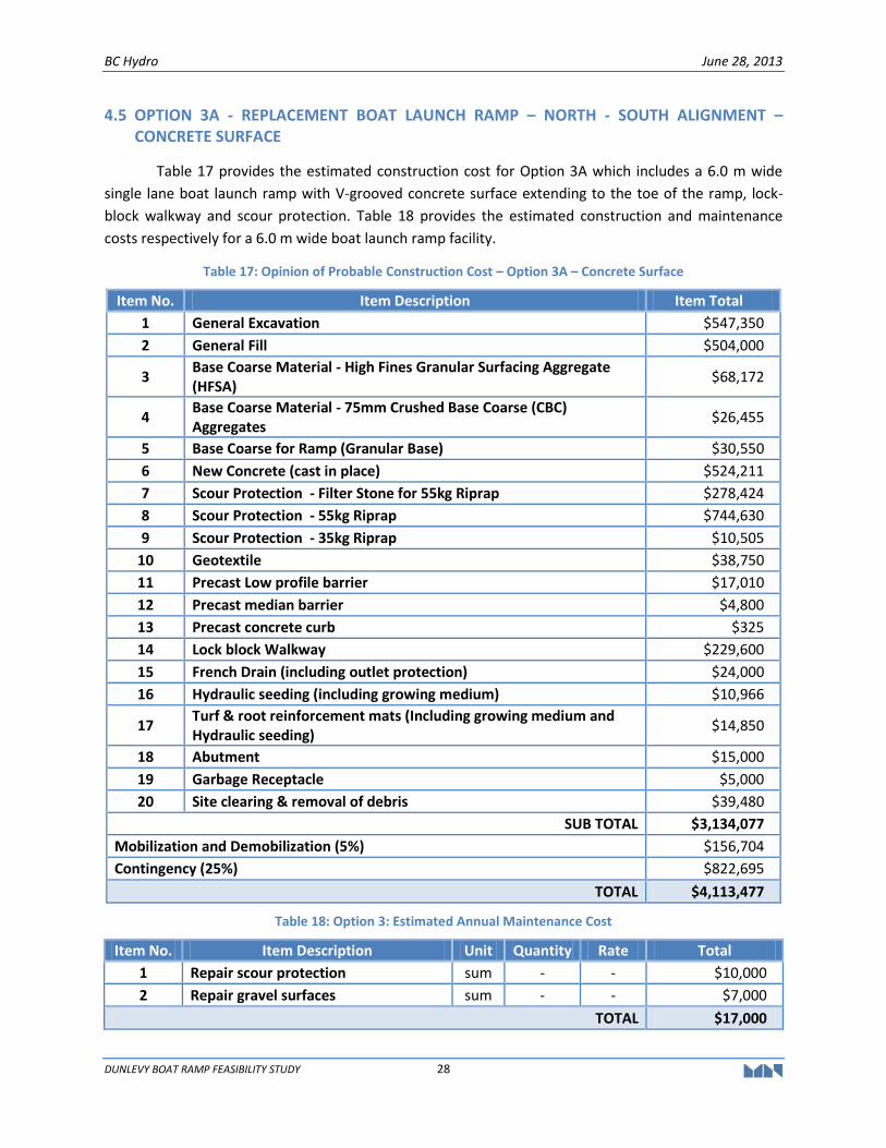
BC Hydro June 28, 2013
DUNLEVY BOAT RAMP FEASIBILITY STUDY 28
4.5 OPTION 3A - REPLACEMENT BOAT LAUNCH RAMP – NORTH - SOUTH ALIGNMENT – CONCRETE SURFACE
Table 17 provides the estimated construction cost for Option 3A which includes a 6.0 m wide
single lane boat launch ramp with V-grooved concrete surface extending to the toe of the ramp, lock-
block walkway and scour protection. Table 18 provides the estimated construction and maintenance
costs respectively for a 6.0 m wide boat launch ramp facility.
Table 17: Opinion of Probable Construction Cost – Option 3A – Concrete Surface
Item No. Item Description Item Total
1 General Excavation $547,350
2 General Fill $504,000
3 Base Coarse Material - High Fines Granular Surfacing Aggregate (HFSA)
$68,172
4 Base Coarse Material - 75mm Crushed Base Coarse (CBC) Aggregates
$26,455
5 Base Coarse for Ramp (Granular Base) $30,550
6 New Concrete (cast in place) $524,211
7 Scour Protection - Filter Stone for 55kg Riprap $278,424
8 Scour Protection - 55kg Riprap $744,630
9 Scour Protection - 35kg Riprap $10,505
10 Geotextile $38,750
11 Precast Low profile barrier $17,010
12 Precast median barrier $4,800
13 Precast concrete curb $325
14 Lock block Walkway $229,600
15 French Drain (including outlet protection) $24,000
16 Hydraulic seeding (including growing medium) $10,966
17 Turf & root reinforcement mats (Including growing medium and Hydraulic seeding)
$14,850
18 Abutment $15,000
19 Garbage Receptacle $5,000
20 Site clearing & removal of debris $39,480
SUB TOTAL $3,134,077
Mobilization and Demobilization (5%) $156,704
Contingency (25%) $822,695
TOTAL $4,113,477
Table 18: Option 3: Estimated Annual Maintenance Cost
Item No. Item Description Unit Quantity Rate Total
1 Repair scour protection sum - - $10,000
2 Repair gravel surfaces sum - - $7,000
TOTAL $17,000
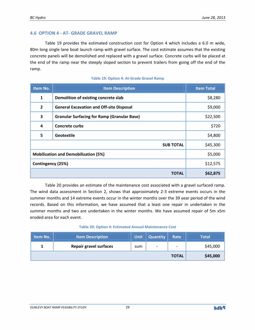
BC Hydro June 28, 2013
DUNLEVY BOAT RAMP FEASIBILITY STUDY 29
4.6 OPTION 4 - AT- GRADE GRAVEL RAMP
Table 19 provides the estimated construction cost for Option 4 which includes a 6.0 m wide,
80m long single lane boat launch ramp with gravel surface. The cost estimate assumes that the existing
concrete panels will be demolished and replaced with a gravel surface. Concrete curbs will be placed at
the end of the ramp near the steeply sloped section to prevent trailers from going off the end of the
ramp.
Table 19: Option 4: At-Grade Gravel Ramp
Item No. Item Description Item Total
1 Demolition of existing concrete slab $8,280
2 General Excavation and Off-site Disposal $9,000
3 Granular Surfacing for Ramp (Granular Base) $22,500
4 Concrete curbs $720
5 Geotextile $4,800
SUB TOTAL $45,300
Mobilization and Demobilization (5%) $5,000
Contingency (25%) $12,575
TOTAL $62,875
Table 20 provides an estimate of the maintenance cost associated with a gravel surfaced ramp.
The wind data assessment in Section 2, shows that approximately 2-3 extreme events occurs in the
summer months and 14 extreme events occur in the winter months over the 39 year period of the wind
records. Based on this information, we have assumed that a least one repair in undertaken in the
summer months and two are undertaken in the winter months. We have assumed repair of 5m x5m
eroded area for each event.
Table 20: Option 4: Estimated Annual Maintenance Cost
Item No. Item Description Unit Quantity Rate Total
1 Repair gravel surfaces sum - - $45,000
TOTAL $45,000
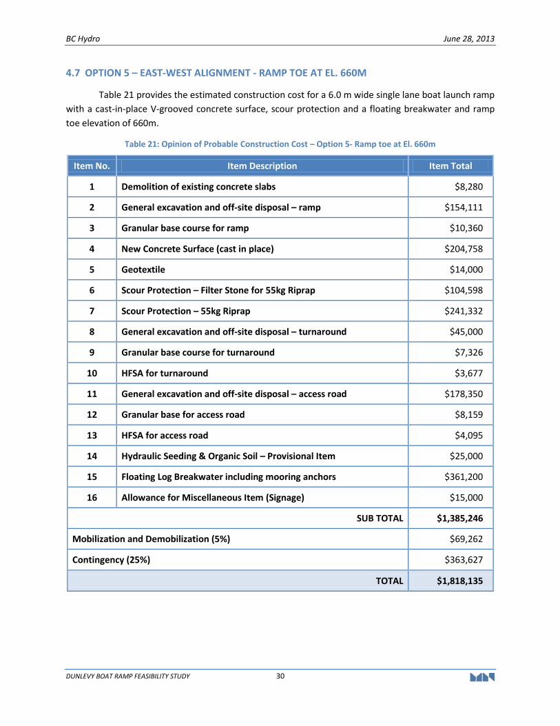
BC Hydro June 28, 2013
DUNLEVY BOAT RAMP FEASIBILITY STUDY 30
4.7 OPTION 5 – EAST-WEST ALIGNMENT - RAMP TOE AT EL. 660M
Table 21 provides the estimated construction cost for a 6.0 m wide single lane boat launch ramp
with a cast-in-place V-grooved concrete surface, scour protection and a floating breakwater and ramp
toe elevation of 660m.
Table 21: Opinion of Probable Construction Cost – Option 5- Ramp toe at El. 660m
Item No. Item Description Item Total
1 Demolition of existing concrete slabs $8,280
2 General excavation and off-site disposal – ramp $154,111
3 Granular base course for ramp $10,360
4 New Concrete Surface (cast in place) $204,758
5 Geotextile $14,000
6 Scour Protection – Filter Stone for 55kg Riprap $104,598
7 Scour Protection – 55kg Riprap $241,332
8 General excavation and off-site disposal – turnaround $45,000
9 Granular base course for turnaround $7,326
10 HFSA for turnaround $3,677
11 General excavation and off-site disposal – access road $178,350
12 Granular base for access road $8,159
13 HFSA for access road $4,095
14 Hydraulic Seeding & Organic Soil – Provisional Item $25,000
15 Floating Log Breakwater including mooring anchors $361,200
16 Allowance for Miscellaneous Item (Signage) $15,000
SUB TOTAL $1,385,246
Mobilization and Demobilization (5%) $69,262
Contingency (25%) $363,627
TOTAL $1,818,135
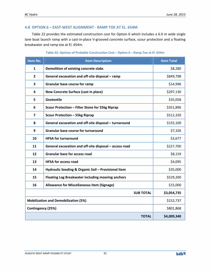
BC Hydro June 28, 2013
DUNLEVY BOAT RAMP FEASIBILITY STUDY 31
4.8 OPTION 6 – EAST-WEST ALIGNMENT - RAMP TOE AT EL. 654M
Table 22 provides the estimated construction cost for Option 6 which includes a 6.0 m wide single
lane boat launch ramp with a cast-in-place V-grooved concrete surface, scour protection and a floating
breakwater and ramp toe at El. 654m.
Table 22: Opinion of Probable Construction Cost – Option 6 – Ramp Toe at El. 654m
Item No. Item Description Item Total
1 Demolition of existing concrete slabs $8,280
2 General excavation and off-site disposal – ramp $849,798
3 Granular base course for ramp $14,996
4 New Concrete Surface (cast in place) $297,130
5 Geotextile $35,058
6 Scour Protection – Filter Stone for 55kg Riprap $351,896
7 Scour Protection – 55kg Riprap $512,320
8 General excavation and off-site disposal – turnaround $155,100
9 Granular base course for turnaround $7,326
10 HFSA for turnaround $3,677
11 General excavation and off-site disposal – access road $227,700
12 Granular base for access road $8,159
13 HFSA for access road $4,095
14 Hydraulic Seeding & Organic Soil – Provisional Item $35,000
15 Floating Log Breakwater including mooring anchors $529,200
16 Allowance for Miscellaneous Item (Signage) $15,000
SUB TOTAL $3,054,735
Mobilization and Demobilization (5%) $152,737
Contingency (25%) $801,868
TOTAL $4,009,340
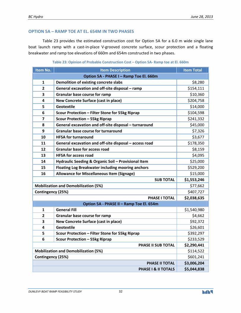
BC Hydro June 28, 2013
DUNLEVY BOAT RAMP FEASIBILITY STUDY 32
OPTION 5A – RAMP TOE AT EL. 654M IN TWO PHASES
Table 23 provides the estimated construction cost for Option 5A for a 6.0 m wide single lane
boat launch ramp with a cast-in-place V-grooved concrete surface, scour protection and a floating
breakwater and ramp toe elevations of 660m and 654m constructed in two phases.
Table 23: Opinion of Probable Construction Cost – Option 5A- Ramp toe at El. 660m
Item No. Item Description Item Total
Option 5A - PHASE I – Ramp Toe El. 660m
1 Demolition of existing concrete slabs $8,280
2 General excavation and off-site disposal – ramp $154,111
3 Granular base course for ramp $10,360
4 New Concrete Surface (cast in place) $204,758
5 Geotextile $14,000
6 Scour Protection – Filter Stone for 55kg Riprap $104,598
7 Scour Protection – 55kg Riprap $241,332
8 General excavation and off-site disposal – turnaround $45,000
9 Granular base course for turnaround $7,326
10 HFSA for turnaround $3,677
11 General excavation and off-site disposal – access road $178,350
12 Granular base for access road $8,159
13 HFSA for access road $4,095
14 Hydraulic Seeding & Organic Soil – Provisional Item $25,000
15 Floating Log Breakwater including mooring anchors $529,200
16 Allowance for Miscellaneous Item (Signage) $15,000
SUB TOTAL $1,553,246
Mobilization and Demobilization (5%) $77,662
Contingency (25%) $407,727
PHASE I TOTAL $2,038,635
Option 5A - PHASE II – Ramp Toe El. 654m
1 General Fill $1,540,980
2 Granular base course for ramp $4,662
3 New Concrete Surface (cast in place) $92,372
4 Geotextile $26,601
5 Scour Protection – Filter Stone for 55kg Riprap $392,297
6 Scour Protection – 55kg Riprap $233,529
PHASE II SUB TOTAL $2,290,441
Mobilization and Demobilization (5%) $114,522
Contingency (25%) $601,241
PHASE II TOTAL $3,006,204
PHASE I & II TOTALS $5,044,838
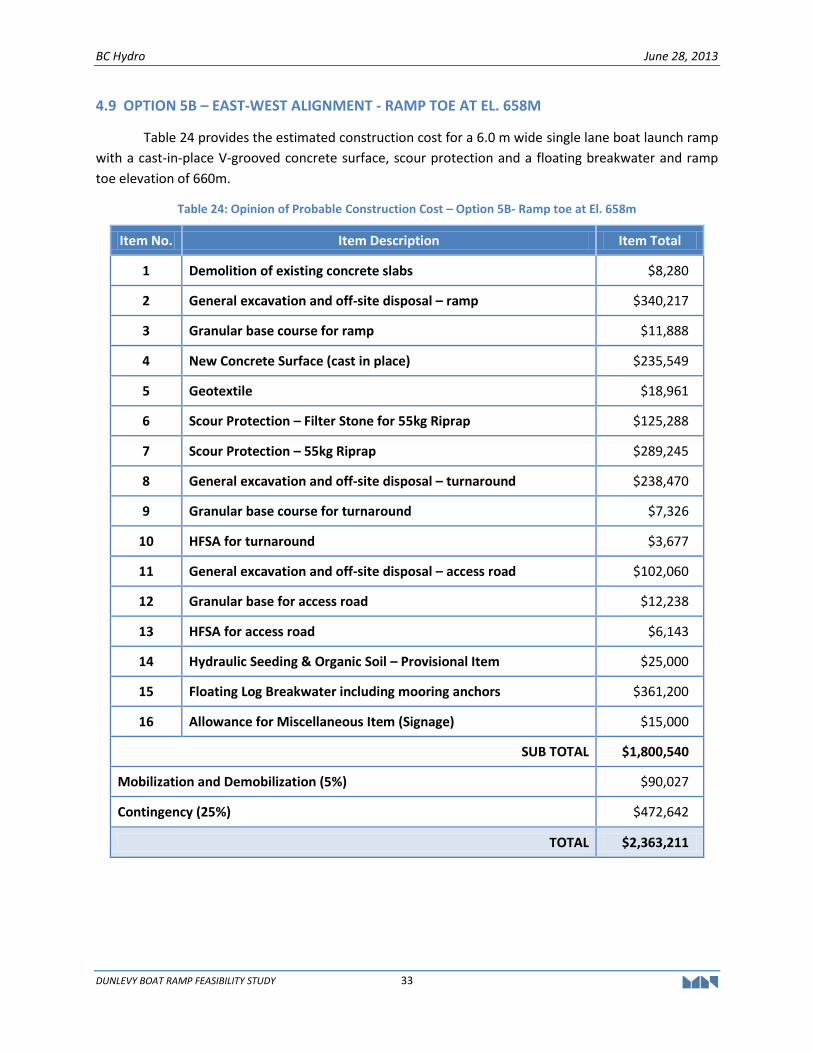
BC Hydro June 28, 2013
DUNLEVY BOAT RAMP FEASIBILITY STUDY 33
4.9 OPTION 5B – EAST-WEST ALIGNMENT - RAMP TOE AT EL. 658M
Table 24 provides the estimated construction cost for a 6.0 m wide single lane boat launch ramp
with a cast-in-place V-grooved concrete surface, scour protection and a floating breakwater and ramp
toe elevation of 660m.
Table 24: Opinion of Probable Construction Cost – Option 5B- Ramp toe at El. 658m
Item No. Item Description Item Total
1 Demolition of existing concrete slabs $8,280
2 General excavation and off-site disposal – ramp $340,217
3 Granular base course for ramp $11,888
4 New Concrete Surface (cast in place) $235,549
5 Geotextile $18,961
6 Scour Protection – Filter Stone for 55kg Riprap $125,288
7 Scour Protection – 55kg Riprap $289,245
8 General excavation and off-site disposal – turnaround $238,470
9 Granular base course for turnaround $7,326
10 HFSA for turnaround $3,677
11 General excavation and off-site disposal – access road $102,060
12 Granular base for access road $12,238
13 HFSA for access road $6,143
14 Hydraulic Seeding & Organic Soil – Provisional Item $25,000
15 Floating Log Breakwater including mooring anchors $361,200
16 Allowance for Miscellaneous Item (Signage) $15,000
SUB TOTAL $1,800,540
Mobilization and Demobilization (5%) $90,027
Contingency (25%) $472,642
TOTAL $2,363,211

BC Hydro June 28, 2013
DUNLEVY BOAT RAMP FEASIBILITY STUDY 34
4.10 OPTION 5C – RAMP TOE AT EL. 654M IN TWO PHASES
Table 25 provides the estimated construction cost for Option 5C for a 6.0 m wide single lane
boat launch ramp with a cast-in-place V-grooved concrete surface, scour protection and a floating
breakwater and ramp toe elevations of 658m and 654m constructed in two phases.
Table 25: Opinion of Probable Construction Cost – Option 5C- Ramp toe at El. 658m
Item No. Item Description Item Total
Option 5C - PHASE I – Ramp Toe El. 658m
1 Demolition of existing concrete slabs $8,280
2 General excavation and off-site disposal – ramp $340,217
3 Granular base course for ramp $11,888
4 New Concrete Surface (cast in place) $235,549
5 Geotextile $18,961
6 Scour Protection – Filter Stone for 55kg Riprap $125,288
7 Scour Protection – 55kg Riprap $289,245
8 General excavation and off-site disposal – turnaround $238,470
9 Granular base course for turnaround $7,326
10 HFSA for turnaround $3,677
11 General excavation and off-site disposal – access road $102,060
12 Granular base for access road $12,238
13 HFSA for access road $6,143
14 Hydraulic Seeding & Organic Soil – Provisional Item $25,000
15 Floating Log Breakwater including mooring anchors $529,200
16 Allowance for Miscellaneous Item (Signage) $15,000
SUB TOTAL $1,968,540
Mobilization and Demobilization (5%) $98,427
Contingency (25%) $516,742
PHASE I TOTAL $2,583,709
Option 5C - PHASE II – Ramp Toe El. 654m
1 General Fill $1,201,270
2 Granular base course for ramp $3,108
3 New Concrete Surface (cast in place) $61,581
4 Geotextile $28,426
5 Scour Protection – Filter Stone for 55kg Riprap $207,532
6 Scour Protection – 55kg Riprap $552,827
PHASE II SUB TOTAL $2,054,744
Mobilization and Demobilization (5%) $102,737
Contingency (25%) $539,370
PHASE II TOTAL $2,696,851
PHASE I & II TOTALS $5,280,562
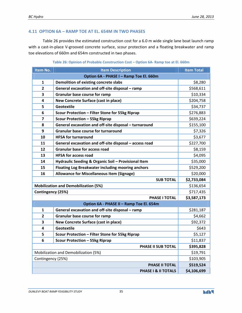
BC Hydro June 28, 2013
DUNLEVY BOAT RAMP FEASIBILITY STUDY 35
4.11 OPTION 6A – RAMP TOE AT EL. 654M IN TWO PHASES
Table 26 provides the estimated construction cost for a 6.0 m wide single lane boat launch ramp
with a cast-in-place V-grooved concrete surface, scour protection and a floating breakwater and ramp
toe elevations of 660m and 654m constructed in two phases.
Table 26: Opinion of Probable Construction Cost – Option 6A- Ramp toe at El. 660m
Item No. Item Description Item Total
Option 6A - PHASE I – Ramp Toe El. 660m
1 Demolition of existing concrete slabs $8,280
2 General excavation and off-site disposal – ramp $568,611
3 Granular base course for ramp $10,334
4 New Concrete Surface (cast in place) $204,758
5 Geotextile $34,737
6 Scour Protection – Filter Stone for 55kg Riprap $276,883
7 Scour Protection – 55kg Riprap $639,224
8 General excavation and off-site disposal – turnaround $155,100
9 Granular base course for turnaround $7,326
10 HFSA for turnaround $3,677
11 General excavation and off-site disposal – access road $227,700
12 Granular base for access road $8,159
13 HFSA for access road $4,095
14 Hydraulic Seeding & Organic Soil – Provisional Item $35,000
15 Floating Log Breakwater including mooring anchors $529,200
16 Allowance for Miscellaneous Item (Signage) $20,000
SUB TOTAL $2,733,084
Mobilization and Demobilization (5%) $136,654
Contingency (25%) $717,435
PHASE I TOTAL $3,587,173
Option 6A - PHASE II – Ramp Toe El. 654m
1 General excavation and off-site disposal – ramp $281,187
2 Granular base course for ramp $4,662
3 New Concrete Surface (cast in place) $92,372
4 Geotextile $643
5 Scour Protection – Filter Stone for 55kg Riprap $5,127
6 Scour Protection – 55kg Riprap $11,837
PHASE II SUB TOTAL $395,828
Mobilization and Demobilization (5%) $19,791
Contingency (25%) $103,905
PHASE II TOTAL $519,524
PHASE I & II TOTALS $4,106,699
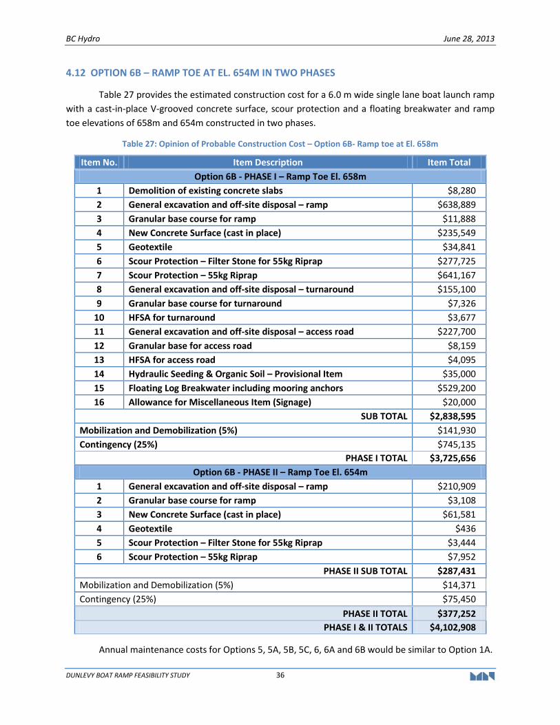
BC Hydro June 28, 2013
DUNLEVY BOAT RAMP FEASIBILITY STUDY 36
4.12 OPTION 6B – RAMP TOE AT EL. 654M IN TWO PHASES
Table 27 provides the estimated construction cost for a 6.0 m wide single lane boat launch ramp
with a cast-in-place V-grooved concrete surface, scour protection and a floating breakwater and ramp
toe elevations of 658m and 654m constructed in two phases.
Table 27: Opinion of Probable Construction Cost – Option 6B- Ramp toe at El. 658m
Item No. Item Description Item Total
Option 6B - PHASE I – Ramp Toe El. 658m
1 Demolition of existing concrete slabs $8,280
2 General excavation and off-site disposal – ramp $638,889
3 Granular base course for ramp $11,888
4 New Concrete Surface (cast in place) $235,549
5 Geotextile $34,841
6 Scour Protection – Filter Stone for 55kg Riprap $277,725
7 Scour Protection – 55kg Riprap $641,167
8 General excavation and off-site disposal – turnaround $155,100
9 Granular base course for turnaround $7,326
10 HFSA for turnaround $3,677
11 General excavation and off-site disposal – access road $227,700
12 Granular base for access road $8,159
13 HFSA for access road $4,095
14 Hydraulic Seeding & Organic Soil – Provisional Item $35,000
15 Floating Log Breakwater including mooring anchors $529,200
16 Allowance for Miscellaneous Item (Signage) $20,000
SUB TOTAL $2,838,595
Mobilization and Demobilization (5%) $141,930
Contingency (25%) $745,135
PHASE I TOTAL $3,725,656
Option 6B - PHASE II – Ramp Toe El. 654m
1 General excavation and off-site disposal – ramp $210,909
2 Granular base course for ramp $3,108
3 New Concrete Surface (cast in place) $61,581
4 Geotextile $436
5 Scour Protection – Filter Stone for 55kg Riprap $3,444
6 Scour Protection – 55kg Riprap $7,952
PHASE II SUB TOTAL $287,431
Mobilization and Demobilization (5%) $14,371
Contingency (25%) $75,450
PHASE II TOTAL $377,252
PHASE I & II TOTALS $4,102,908
Annual maintenance costs for Options 5, 5A, 5B, 5C, 6, 6A and 6B would be similar to Option 1A.
BC Hydro June 28, 2013
DUNLEVY BOAT RAMP FEASIBILITY STUDY 37
4.13 SUMMARY
In reviewing the above cost estimates, it is important to note the following:
The estimates are concept level only and are not intended to be used to establish a project budget. The estimates are intended to provide an indication of the probable costs to determine which boat launch ramp facility alternative(s) warrant further consideration;
The estimates are based on Moffatt & Nichol’s in-house experience and data for projects of a similar nature;
The estimates are based upon mid-2012 and 2013 price levels in Canadian dollars;
The estimates exclude any land purchase, permits, navigation and site signage, archaeological investigation assessment, additional habitat compensation programs, removal and remediation of contaminated materials and other hazardous waste;
A contingency allowance of 25% was included in the cost estimates to cover unforeseen construction costs at the feasibility stage of this project; and,
The estimates exclude taxes.
Table 25 below summaries the capital cost estimate and annual maintenance costs rounded to
the nearest thousand for the various locations.
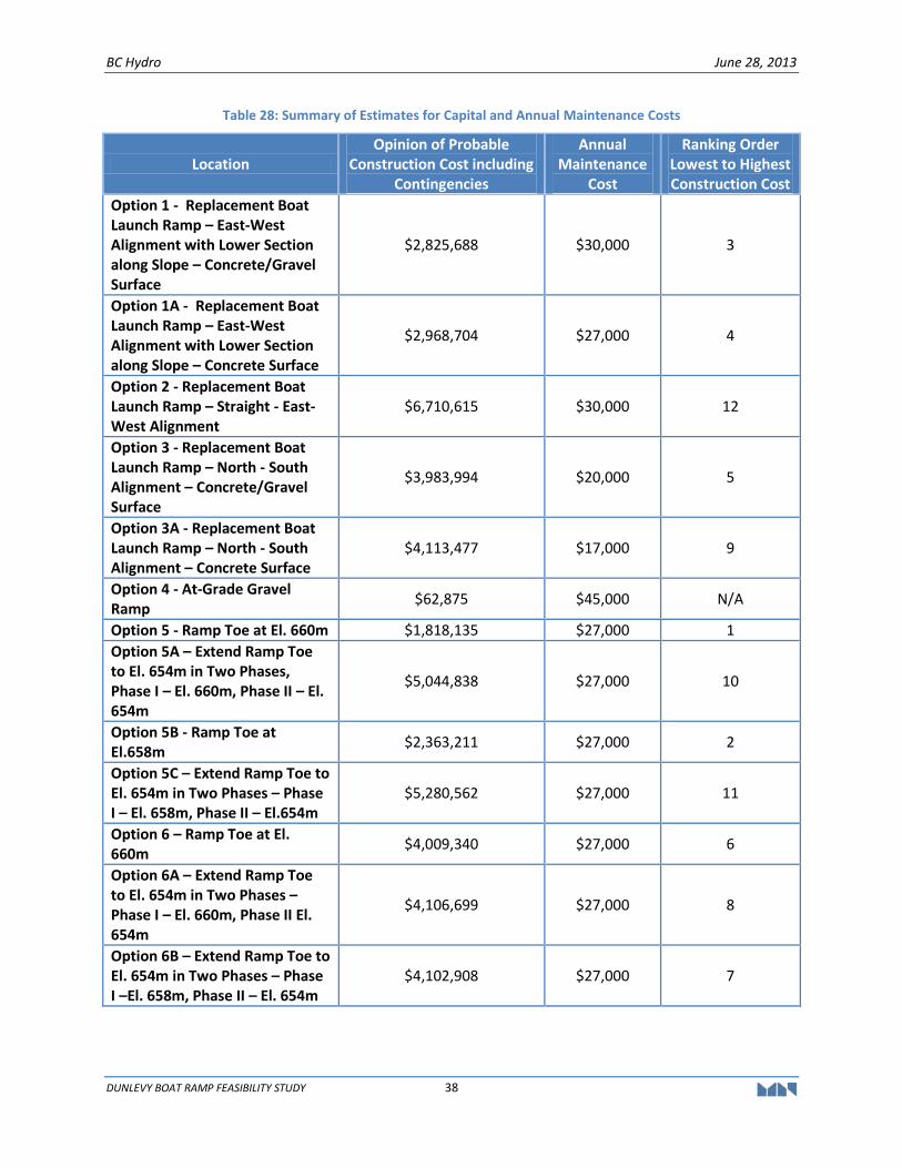
BC Hydro June 28, 2013
DUNLEVY BOAT RAMP FEASIBILITY STUDY 38
Table 28: Summary of Estimates for Capital and Annual Maintenance Costs
Location Opinion of Probable
Construction Cost including Contingencies
Annual Maintenance
Cost
Ranking Order Lowest to Highest Construction Cost
Option 1 - Replacement Boat Launch Ramp – East-West Alignment with Lower Section along Slope – Concrete/Gravel Surface
$2,825,688 $30,000 3
Option 1A - Replacement Boat Launch Ramp – East-West Alignment with Lower Section along Slope – Concrete Surface
$2,968,704 $27,000 4
Option 2 - Replacement Boat Launch Ramp – Straight - East-West Alignment
$6,710,615 $30,000 12
Option 3 - Replacement Boat Launch Ramp – North - South Alignment – Concrete/Gravel Surface
$3,983,994 $20,000 5
Option 3A - Replacement Boat Launch Ramp – North - South Alignment – Concrete Surface
$4,113,477 $17,000 9
Option 4 - At-Grade Gravel Ramp
$62,875 $45,000 N/A
Option 5 - Ramp Toe at El. 660m $1,818,135 $27,000 1
Option 5A – Extend Ramp Toe to El. 654m in Two Phases, Phase I – El. 660m, Phase II – El. 654m
$5,044,838 $27,000 10
Option 5B - Ramp Toe at El.658m
$2,363,211 $27,000 2
Option 5C – Extend Ramp Toe to El. 654m in Two Phases – Phase I – El. 658m, Phase II – El.654m
$5,280,562 $27,000 11
Option 6 – Ramp Toe at El. 660m
$4,009,340 $27,000 6
Option 6A – Extend Ramp Toe to El. 654m in Two Phases – Phase I – El. 660m, Phase II El. 654m
$4,106,699 $27,000 8
Option 6B – Extend Ramp Toe to El. 654m in Two Phases – Phase I –El. 658m, Phase II – El. 654m
$4,102,908 $27,000 7
BC Hydro June 28, 2013
DUNLEVY BOAT RAMP FEASIBILITY STUDY 39
4.14 LIMITATIONS OF THE COST ESTIMATES
The cost estimates are based on the feasibility level drawings as presented in Appendix A and is
considered to be a Class D Estimate. The estimate is based on feasibility level drawings and the design
basis in Appendix C of this report as well as the results of all site investigations to date. This estimate
should be sufficient to provide the ranking of options.
We wish to emphasize that even with the preparation of an accurate construction budget (e.g.
within +/- 20% to 25%) that the costs may vary significantly from this estimate due to fluctuations in
materials and labour costs, and to uncertainties including market conditions (i.e., bid competition).
In view of the above uncertainties and the importance of not under-estimating the costs, we
have included a contingency amount of 25% on all items. We have attempted to identify the major cost
components and have made provisional allowances where possible.
In providing estimates of construction cost, it is recognized that neither the client nor M&N has
control over the costs of labour, equipment, or materials, or over contractors' methods of determining
prices or bidding. Normal variance in Contractor bid prices can range from 10% to 20%. These feasibility
estimates of construction cost are based on M&N’s reasonable professional judgment and experience
and do not constitute a warranty, expressed or implied, that contractors' bids will not vary from the
estimate of feasibility cost prepared by the consultant.
4.15 ASSUMPTIONS AND EXCLUSIONS
In addition to the general limitations discussed above, our cost estimate is based on the
following assumptions and exclusions:
Assumptions:
Water levels at the time when the boat launch ramp will be constructed is at the lowest possible elevation (El.653.0 metres), so that the majority of the ramp is constructed in the dry.
BC Hydro will determine the extent of the in-waterworks which is dependent on water levels at the time of construction. BC Hydro intends to construct the ramp when dry, whenever possible. Therefore, the quantities may decrease depending on reservoir water levels at the time when construction is undertaken.
The cost of mobilization/demobilization, which includes insurance and bonding, is estimated to be approximately 5% of the total construction cost. The cost of mobilization also includes general cost to meet basic environmental requirements; such as silt-curtain, dust control and sediments control. This percentage was obtained from recent similar projects including the Roberts Bank Environmental Habitat Compensation Project (RBEHC) and the Deltaport Barge Ramp Construction Project.
The unit rates for the supply, transport and installation of filter stone, riprap, 25mm HFSA, 75mm CBC were based on quotations for supply and installation from local suppliers in or near Chetwynd, and from a contractor who recently provided estimates for construction for
BC Hydro June 28, 2013
DUNLEVY BOAT RAMP FEASIBILITY STUDY 40
similar boat ramp facility on the Peace Reach. The travel time between the different quarry sources to the Dunlevy was estimated to be 4hrs for a round trip.
The unit rate of $385/m2 for Cast-In-Place concrete supply and placement was derived from a March 2013 quotation for the Taylor Boat Ramp project.
The cost estimate includes a 25% contingency allowance, which we consider to be appropriate for a project at this stage of development. The estimates, including the contingency amount, are considered accurate to +/- 20% given the uncertainties noted above.
Exclusions:
The cost estimate excludes:
Habitat compensation works (if required);
Indirect costs for engineering and project management;
Indirect costs for owner’s project management, construction administration, and third party consulting fees; and,
All applicable taxes, land purchase, permits, and regulatory approvals.
BC Hydro June 28, 2013
DUNLEVY BOAT RAMP FEASIBILITY STUDY 41
5. CONCLUSIONS
Our general conclusions for the replacement boat ramp options at the existing Dunlevy site are
as follows.
5.1 OPTIONS 1 & 1A – EAST-WEST ORIENTATION WITH DOGLEG
It is potentially feasible to construct a replacement boat launch ramp at the existing site in the
east-west alignment as shown for Options 1, and 1A. Boat launching operations can be improved by
using a floating breakwater on the southern side of the ramp which will attenuate some of the
predominant southerly waves. The dogleg shaped ramp alignment requires a curb barrier along the
outer edge of the turnaround area to prevent trailers and vehicles from going over the steep
embankment. If bank erosion at the south end of the site can be mitigated with placement of scour
protection and global bank erosion rates in the Dunlevy inlet are determined not to be critical to this
area, then developing a new replacement ramp in current alignment could be feasible.
The advantages of Option 1 and 1A are:
Covers the full recorded operating range of water levels;
Utilizes the existing cut slopes of the original boat ramp minimizing earthworks for the upper section of the ramp;
Existing parking lot not affected by this layout;
Existing access road that is in good condition;
Option 1 is the third lowest cost alternative mainly due to the optimal alignment following the existing east-west orientation of the ramp and the lower section of the ramp run parallel with the steep contours of the site. This orientation reduces the fill and cut volumes needed to form the slope of the ramp; and,
Option 1A is the fourth lowest cost alternative. This option features a ramp slope with a concrete surface.
The disadvantages of Options 1 and 1A are:
The location is exposed to wave action from the southerly direction. The existing boat ramp has erosion occurring along the ramp;
Gravel surfaced in the lower section of the boat ramp for Option 1 provides very limited traction and is generally not recommended because of safety, capacity and maintenance issues;
Requires a floating breakwater to attenuate wave action on the ramp. The floating breakwater provides some shielding from southerly winds;
Timber material for the floating breakwater will have 10 year design life, and timber members will require replacement every 10-15 years;
Dogleg shaped ramp will require barriers at the outer edge of the turnaround area to prevent vehicles and trailers from accidentally going the edge of the slope; and,
BC Hydro June 28, 2013
DUNLEVY BOAT RAMP FEASIBILITY STUDY 42
May require more maintenance due to exposed location especially the gravel surface in the lower section of the ramp in Option 1.
5.2 OPTION 2- EAST-WEST ORIENTATION WITHOUT DOGLEG
Option 2 is similar to Options 1 and 1A but without a dogleg in the ramp alignment.
The advantages are:
Covers the full recorded operating range of water levels;
Existing access road that is in good condition;
Utilizes the existing cut slopes of the original boat ramp minimizing earthworks for the upper section of the ramp; and,
Existing parking lot not affected by this layout.
The disadvantages are:
The location is exposed to wave action from the southerly direction. The existing boat ramp has erosion occurring along the ramp;
Requires a large volume of fill at the lower section of the ramp to form the required slope for the boat ramp;
For consideration of the viability of Option 2, further geotechnical analysis will be required to determine if the native ground will be capable to support the large weight of fill without causing slope failure;
Requires a floating breakwater to attenuate wave action on the ramp. The floating breakwater provides some shielding form the southerly wind;
Timber material for the floating breakwater will have 10 year design life and timber members will require replacement every 10-15 years; and,
Option 2 is the highest cost alternative mainly due to the large of fill that will be required to form the require slope for the boat ramp.
5.3 OPTIONS 3 & 3A – NORTH-SOUTH ALIGNMENT
The north-south ramp alignment as shown in Options 3 and 3A provides the best orientation for
launching boats as the existing headland will provide a natural shelter from the predominant wind
generated southerly waves.
The advantages are:
Covers the full recorded operating range of water levels;
Provides the best orientation for safely launching boats; and,
Sheltered boat launch area will require less maintenance.
The disadvantages are:
BC Hydro June 28, 2013
DUNLEVY BOAT RAMP FEASIBILITY STUDY 43
Existing parking lot and access road will be reconfigured by this layout;
Requires larger volumes of earthworks to construct the ramp;
Option 3 is the fifth lowest cost alternative as this new north-south alignment will require larger volumes of cut and fill than Option 1 to form the new ramp alignment; and,
Option 3A is the ninth lowest cost alternative. This option considers the ramp slope made of concrete.
5.4 OPTION 4 – GRAVEL SURFACED RAMP
A gravel surfaced boat ramp in the existing ramp orientation was considered. The ramp is only
80m long and does not have scour protection or a floating breakwater.
The advantages are:
Existing parking lot and access road remain unchanged; and,
Least cost alternative.
The disadvantages are:
Does not comply with the design guidelines or the user requirements;
Truck and trailer cannot gain sufficient traction on a gravel surface at 15% grade;
Significant risk of a loaded vehicle and trailer getting stuck on the ramp and creating major ruts in the gravel surface and therefore will be a safety concern for the next user;
Limited access to the range of water levels in the reservoir;
Exposed to wind generated waves from the south;
Gravel surfaced boat launch ramp has very limited traction and has safety and capacity issues with the driving surface; and,
Requires frequent maintenance to keep the facility operational and has a higher maintenance cost.
This option should not be considered any further due to the safety and non-compliance with
design criteria and user requirements.
5.5 OPTION 5 – EAST-WEST ALIGNMENT - RAMP TOE AT EL. 660M
Option 5 is similar in alignment to Options 1&2 with a 15% slope at a lower ground profile than
Options 1&2. The ramp is toe constructed at El. 660 m with no further extensions to the ramp.
The advantages are:
Proposed boat ramp is operational for the majority of the summer boating season;
Proposed ramp layout fits generally within the footprint of the existing ramp; and,
Least cost option for the concrete surfaced ramps.
BC Hydro June 28, 2013
DUNLEVY BOAT RAMP FEASIBILITY STUDY 44
The disadvantages are:
The location is exposed to wave action from the southerly direction;
Requires a floating log breakwater to attenuate waves;
Timber logs for the floating breakwater will have a 10 year design life and timber members will have to be replaced every 10-15 years;
Navigation markers required to mark top of cut slopes when submerged; and,
Ramp will be expensive to extend to lower water levels due to the large fill quantities required to form the slope.
5.6 OPTION 5A – EAST-WEST ALIGNMENT - RAMP TOE AT EL. 654M BUILT IN TWO PHASES
Option 5A considers construction of the ramp to the low water elevation in two phases. Phase I
involves building the ramp to El. 660m, and Phase II involves extending the ramp to El 654m in another
construction season by filling to form the extended ramp slope.
The advantages are:
Covers the full recorded operating water level range in the reservoir;
Lowering the ground profile of the ramp reduces the amount of fill required for Phase II construction; and,
The upper section of the proposed ramp generally fit within the footprint of the existing ramp.
The disadvantages are:
The location is exposed to wave action from the southerly direction;
Requires a floating log breakwater to attenuate waves;
Timber logs for the floating breakwater will have a 10 year design life and timber members will have to be replaced every 10-15 years;
Additional mobilization and de-mobilization required for phased construction;
Navigation markers required to mark top of cut slopes when submerged; and,
Ramp extension requires large volume of fill to form the boat ramp slope.
5.7 OPTION 5B – EAST-WEST ALIGNMENT - RAMP TOE AT EL. 658M
Option 5B is similar in alignment to Option 5 with a 15% slope. The lower ramp toe El. 658m
reduces the annual non-accessible use of the ramp from 6 days to 1 day. The ramp is toe constructed at
El. 658 m with no further extensions to the ramp.
The advantages are:
Proposed boat ramp is operational for the majority of the summer boating season;
Proposed ramp layout fits generally within the footprint of the existing ramp; and,
BC Hydro June 28, 2013
DUNLEVY BOAT RAMP FEASIBILITY STUDY 45
Least cost option for the concrete surfaced ramps.
The disadvantages are:
The location is exposed to wave action from the southerly direction;
Requires a floating log breakwater to attenuate waves;
Timber logs for the floating breakwater will have a 10 year design life and timber members will have to be replaced every 10-15 years;
Navigation markers required to mark top of cut slopes when submerged; and,
Ramp will be expensive to extend to lower water levels due to the large fill quantities required to form the slope.
5.8 OPTION 5C – EAST-WEST ALIGNMENT - RAMP TOE AT EL. 654M BUILT IN TWO PHASES
Option 5C considers construction of the ramp to the low water elevation in two phases. Phase I
involves building the ramp to El. 658m, and Phase II involves extending the ramp to El 654m in another
construction season by filling the ground to form the extended ramp slope.
The advantages are:
Covers the full recorded operating water level range in the reservoir;
Lowering the ground profile of the ramp reduces the amount of fill required for Phase II construction; and,
The upper section of the proposed ramp generally fit within the footprint of the existing ramp.
The disadvantages are:
The location is exposed to wave action from the southerly direction;
Requires a floating log breakwater to attenuate waves;
Timber logs for the floating breakwater will have a 10 year design life and timber members will have to be replaced every 10-15 years;
Additional mobilization and de-mobilization required for phased construction;
Navigation markers required to mark the approach to the ramp, and the top of cut slopes when submerged; and,
Ramp extension requires large volume of fill to form the boat ramp slope.
5.9 OPTION 6 – EAST –WEST ALIGNMENT – RAMP TOE AT EL. 654M
Option 6 considers lowering the ground profile of the boat ramp so that proposed ramp is
constructed by excavating the existing slope to form the ramp that will be operable over the full water
level range.
The advantage is:
BC Hydro June 28, 2013
DUNLEVY BOAT RAMP FEASIBILITY STUDY 46
Covers the full recorded operating water level range in the reservoir.
The disadvantages are:
The location is exposed to wave action from the southerly direction;
Requires a floating log breakwater to attenuate waves;
Timber logs for the floating breakwater will have a 10 year design life and timber members will have to be replaced every 10-15 years; and,
Navigation markers required to mark top of cut slopes when submerged.
5.10 OPTION 6A – EAST- WEST ALIGNMENT - RAMP TOE AT EL 654M BUILT IN TWO PHASES
Option 6A considers lowering the ground profile of the boat ramp so that proposed ramp is
constructed by excavating into the existing ground to form the ramp that will be operable over the full
water level range but built in two Phases. In Phase I, the ramp toe is constructed to El. 660m and in
Phase II the ramp is constructed to El. 654m.
The advantage is:
Covers the full recorded operating water level range in the reservoir.
The disadvantages are:
The location is exposed to wave action from the southerly direction;
Requires a floating log breakwater to attenuate waves;
Timber logs for the floating breakwater will have a 10 year design life and timber members will have to be replaced every 10-15 years;
Additional mobilization and de-mobilization required for phased construction; and,
Navigation markers required to mark top of cut slopes and ramp approach when submerged.
5.11 OPTION 6B – EAST- WEST ALIGNMENT - RAMP TOE AT EL 654M BUILT IN TWO PHASES
Option 6B considers lowering the ground profile of the boat ramp so that proposed ramp is
constructed by excavating the boat ramp slope to a toe level of El. 654m. This allows the boat ramp to
operate over the full water level range, but is built in two Phases. In Phase I, the ramp toe is constructed
to El. 658m and in Phase II the ramp is constructed to El. 654m.
The advantage is:
Covers the full recorded operating water level range in the reservoir.
The disadvantages are:
The location is exposed to wave action from the southerly direction;
Requires a floating log breakwater to attenuate waves;
BC Hydro June 28, 2013
DUNLEVY BOAT RAMP FEASIBILITY STUDY 47
Timber logs for the floating breakwater will have a 10 year design life and timber members will have to be replaced every 10-15 years;
Additional mobilization and de-mobilization required for phased construction; and,
Navigation markers required to mark top of cut slopes when submerged.
5.12 RISKS
Other risks to be considered when developing this site are:
For consideration of the viability of Options 2, 5, 5A, 6 and 6A further geotechnical analysis will be required to determine if the native ground will be capable to support the large weight of fill without causing slope failure and bedrock elevations;
Habitat compensation works may be required;
Availability of suitable riprap and filter stone materials in the vicinity of the site could reduce costs significantly;
Excess excavated material will need to be disposed off-site, a suitable site will need to identified;
Construction methodology will need to be assessed to determine if ramp can be constructed in the low water window given the large volumes of materials that needs to be placed; and,
Construction of the lower section of the ramp will have to be done in the winter/spring months when the water level in the reservoir is low, however, construction in frozen ground will be difficult or water logged soil in spring may be problematic to construction.
BC Hydro June 28, 2013
DUNLEVY BOAT RAMP FEASIBILITY STUDY 48
6. RECOMMENDATIONS
Option 5 is the lowest cost concrete surfaced alternative with the ramp toe at El.660m. At this
water level range, the proposed boat ramp is operable for the majority of time in the summer months
May to October which is the typical boating season on the reservoir. This option is technically feasible,
but the east-west orientation of the boat ramp on the southern side of the site is more exposed to wind
and waves, providing a floating breakwater on the southern side of the ramp will attenuate waves and
improve boater safety. Providing the User requirements are satisfied with May to October operations
period only possibly 6 days in the season when the boat launch ramp is not operable, Option 5 is the
preferred alternative to be carried forward to preliminary and detailed design.
Option 5B is the second ranked alternative with a ramp toe El. 658m. This option reduces the
non-operable period from six days to one day during the summer boating season. The cost for Option 5B
is approximately 1.4 times Option 5.
Options 1 and 1A are technically feasible, but are in a more exposed orientation to the
predominant wind and wave direction, and are similar to Option 5. These two options are ranked third
and fourth respectively and are based on capital cost. These options are approximately one and half
times the estimated cost for Option 5. Higher maintenance costs will likely be associated with these
options.
Options 6, 6B and 6A are the sixth, seventh, and eighth ranked alternatives respectively. These
options are approximately two times the estimated cost of Option 5.
Options 3 and 3A are the fifth and ninth ranked alternatives respectively based on estimated
construction costs. However, from a technical and safety operational perspective; Options 3 or 3A are
the best options due to the sheltered North-South orientation of the boat launch ramp and associated
lower maintenance cost. Options 3 and 3A are approximately double the cost of Option 5.
Options 5A, 5C and 2 are the tenth, eleventh and twelfth ranked alternatives respectively based
on estimated construction cost. These options consider ramp extensions that require large volumes of
fill to form the lowest ramp toe elevation. These options are not recommended.
Option 4 is least expensive of the alternative, but is not recommended for a permanent boat
ramp facility as it does not meet the design criteria and user requirements.
If user requirements can be revised to accept some amount of non-accessible time that the boat
ramp can be usable in summer operating period, ramp construction costs can be considerable reduced.
Extension of the ramps to the lowest recorded water level of El. 654m may not be practical as
this water level typically occurs during the winter/spring months where areas are frozen and not
suitable for boating.
BC Hydro June 28, 2013
DUNLEVY BOAT RAMP FEASIBILITY STUDY 49
7. CLOSURE
This report has been prepared for the sole benefit of BC Hydro and its agents, and may not be
used by any third party without the expressed written consent of Moffatt & Nichol and BC Hydro. Any
use of this document by a third party is at the sole risk of such third party. The statements and
conclusions presented herein are valid as of the date of publication. Future changes in the conditions
affecting the underlying assumptions of this report may alter its findings and the conclusions. Moffatt &
Nichol does not undertake to revise and update this report should future events reflect changed
conditions.
We trust that this report meets BC Hydro’s requirements at this time. Should you have any
questions, or if we can be of further assistance, please contact us at any time.
Disclaimer:
Electronic versions (including Microsoft Word formats or Adobe Acrobat PDFs) are provided for reference only, and should not be relied upon as a final work product. Electronic copies are potentially subject to alteration by others beyond Moffatt & Nichol’s control, and Moffatt & Nichol assumes no responsibility for damages suffered by any party as a result of decisions made or actions based on any electronic report. Refer to the original, printed and signed version of this document for the official and final Moffatt & Nichol work product.
BC Hydro June 28, 2013
DUNLEVY EXISTING BOAT RAMP FACILITY FEASIBILITY STUDY Appendix A
APPENDIX A
DRAWINGS
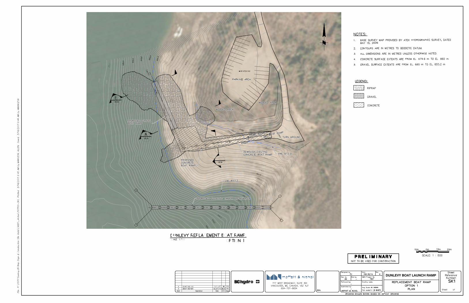
DUNLEVY BOAT LAUNCH RAMP
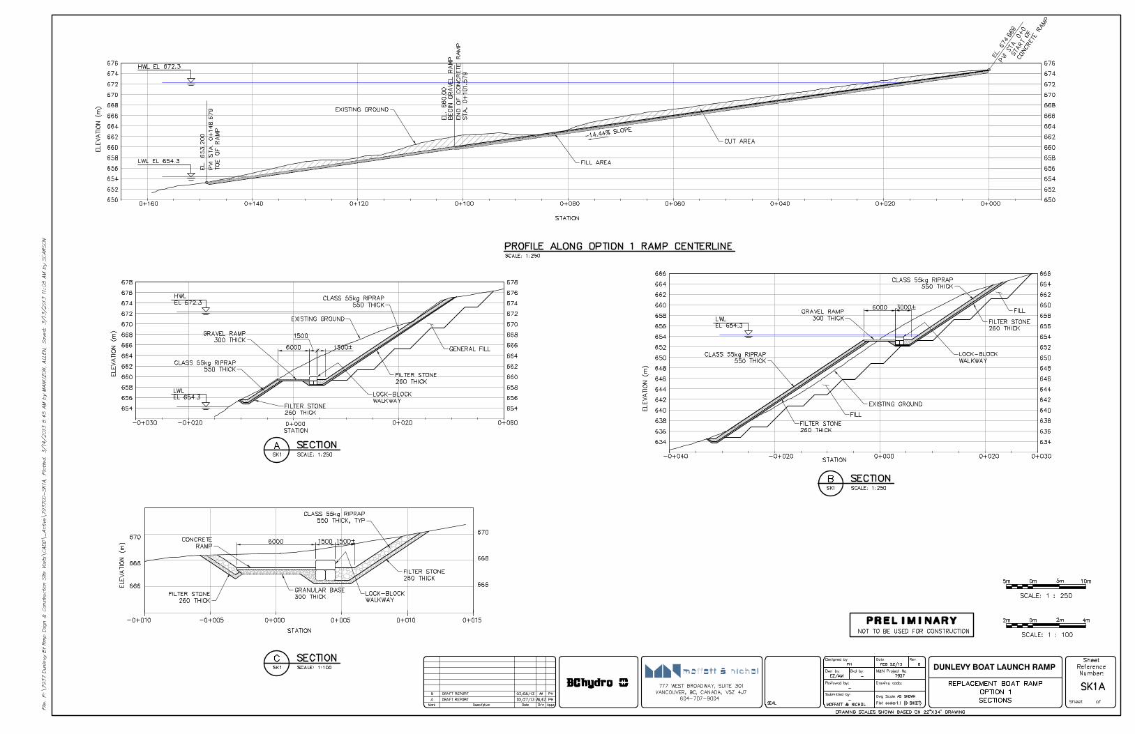
DUNLEVY BOAT LAUNCH RAMP
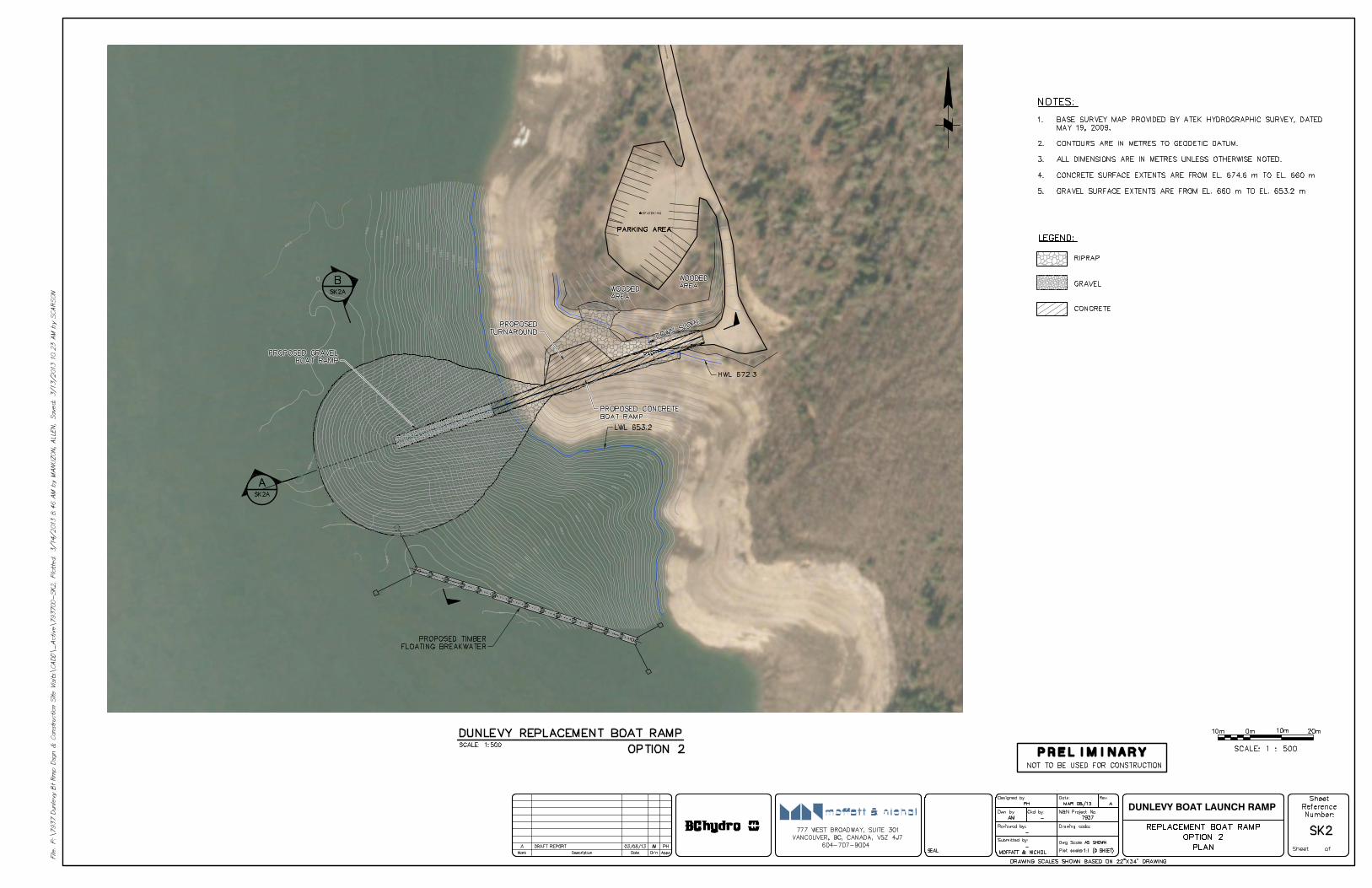
main entrance road
DUNLEVY BOAT LAUNCH RAMP
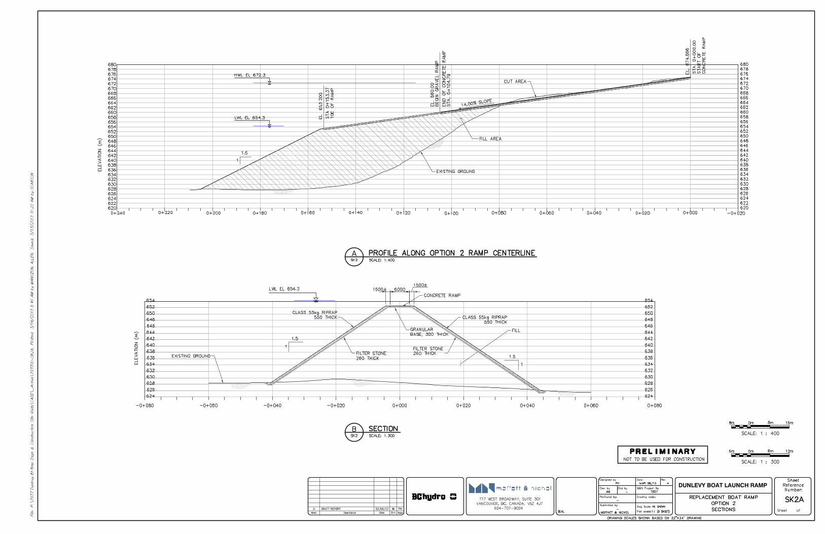
DUNLEVY BOAT LAUNCH RAMP
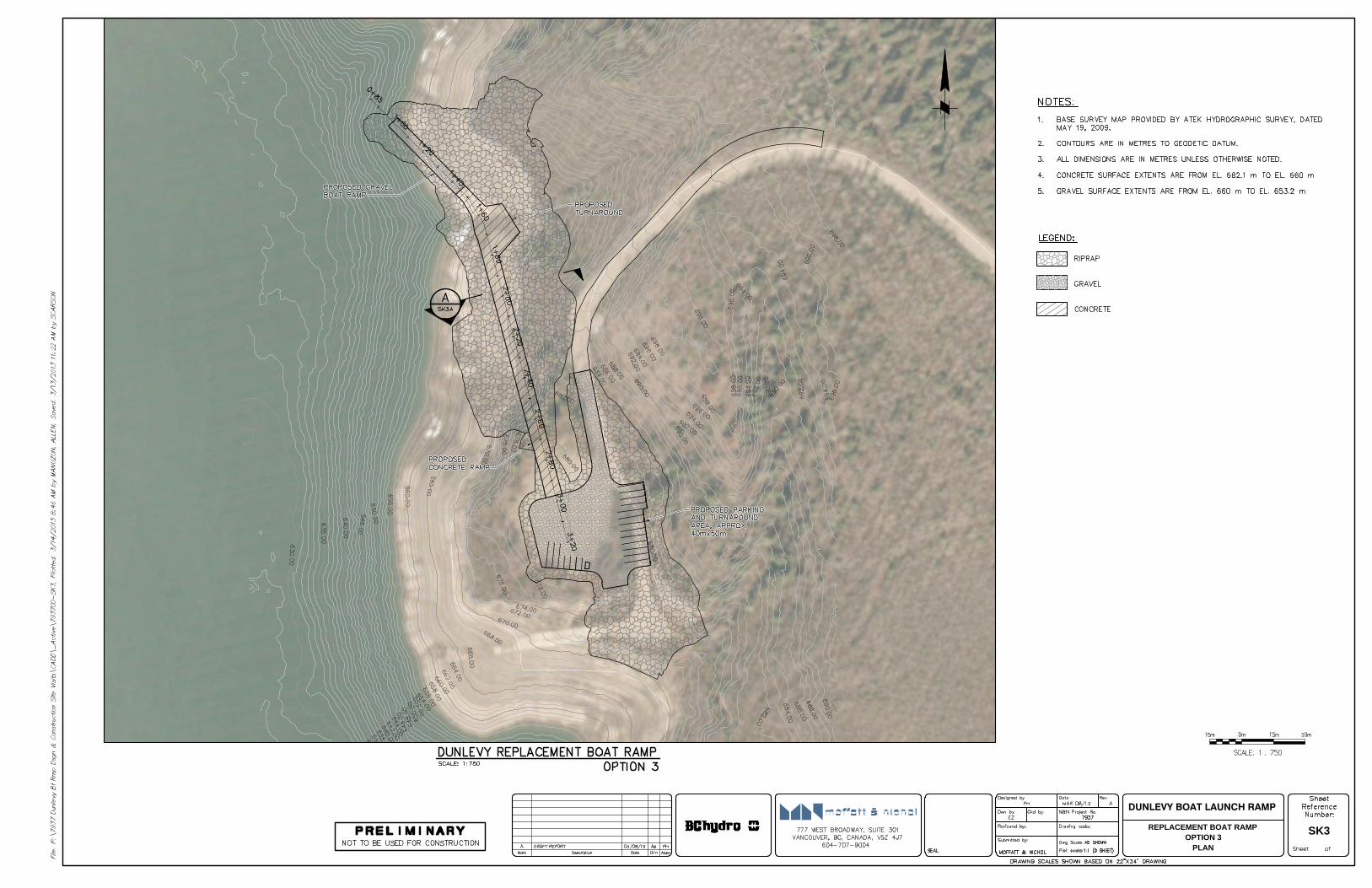
DUNLEVY BOAT LAUNCH RAMP
REPLACEMENT BOAT RAMP
OPTION 3
PLAN
SK3
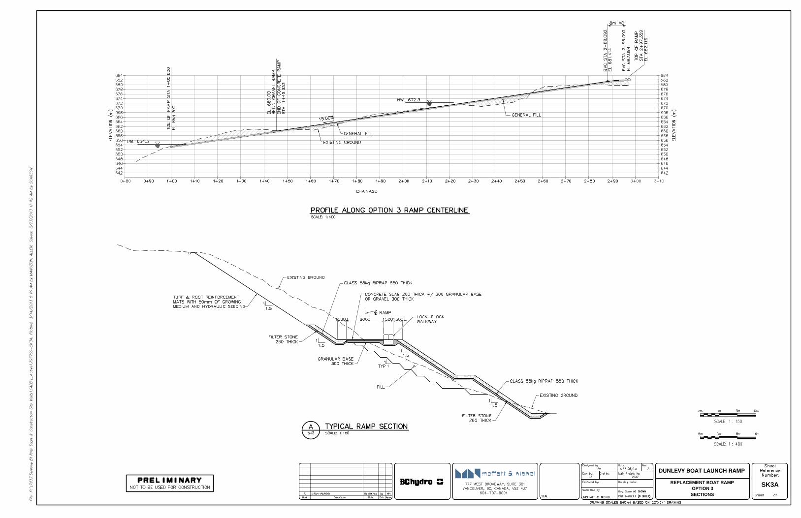
DUNLEVY BOAT LAUNCH RAMP
REPLACEMENT BOAT RAMP
OPTION 3
SECTIONS
SK3A
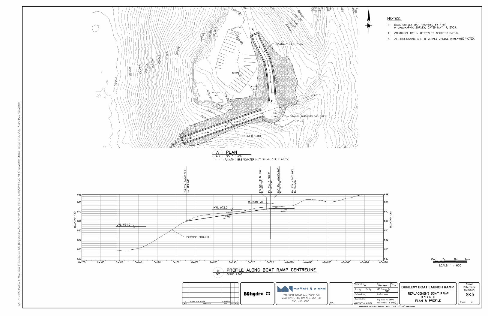
DUNLEVY BOAT LAUNCH RAMP
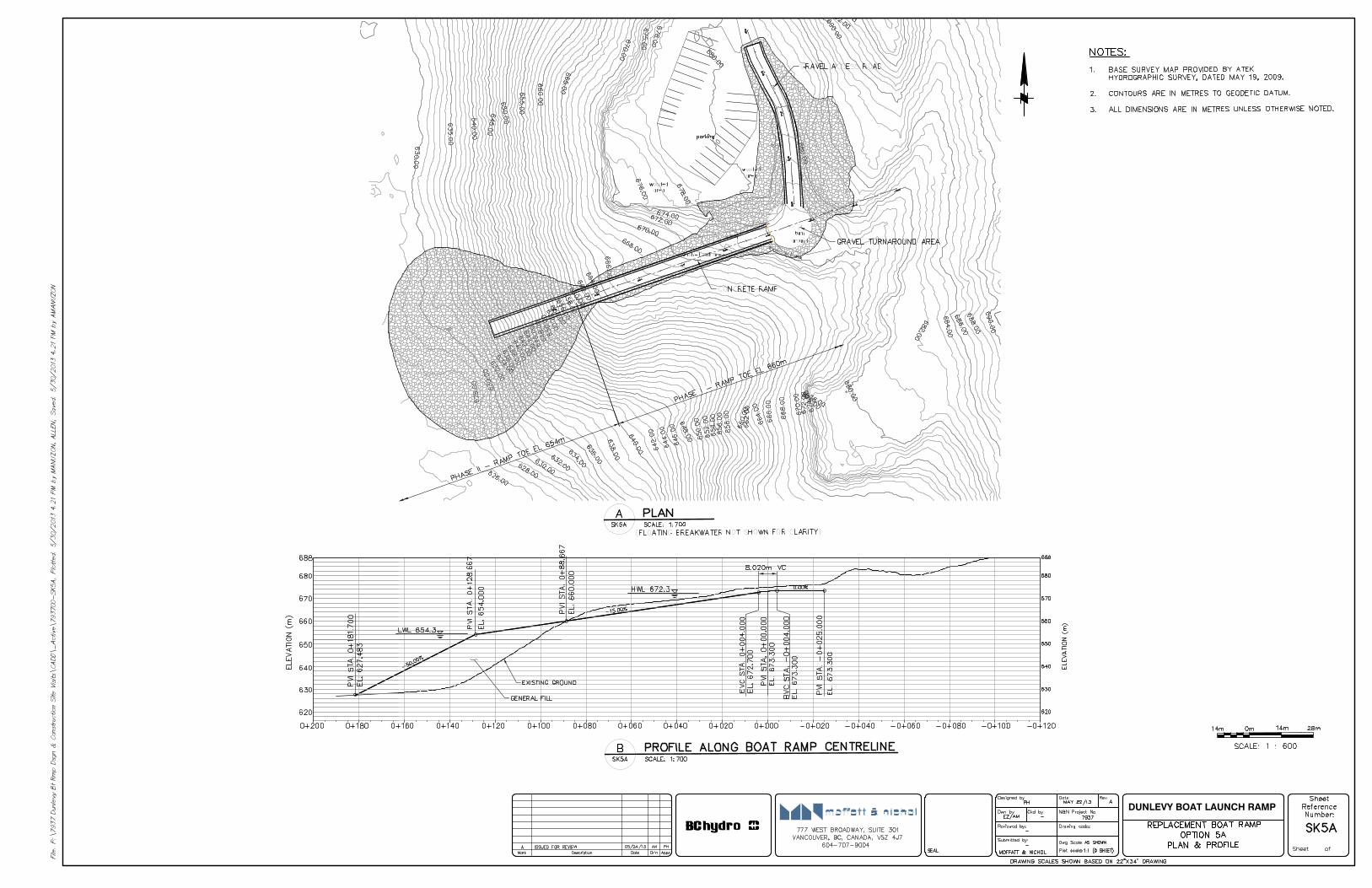
DUNLEVY BOAT LAUNCH RAMP
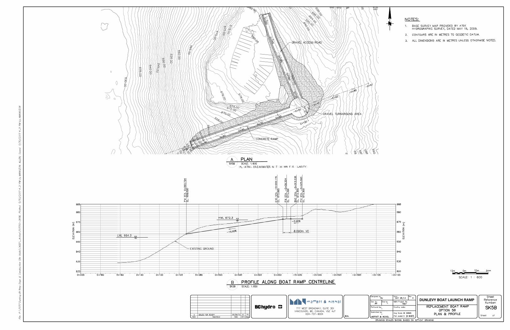
DUNLEVY BOAT LAUNCH RAMP
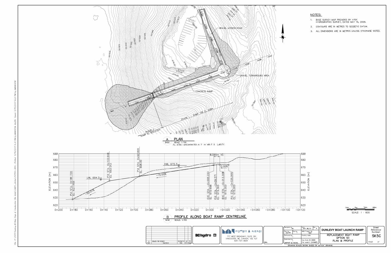
DUNLEVY BOAT LAUNCH RAMP
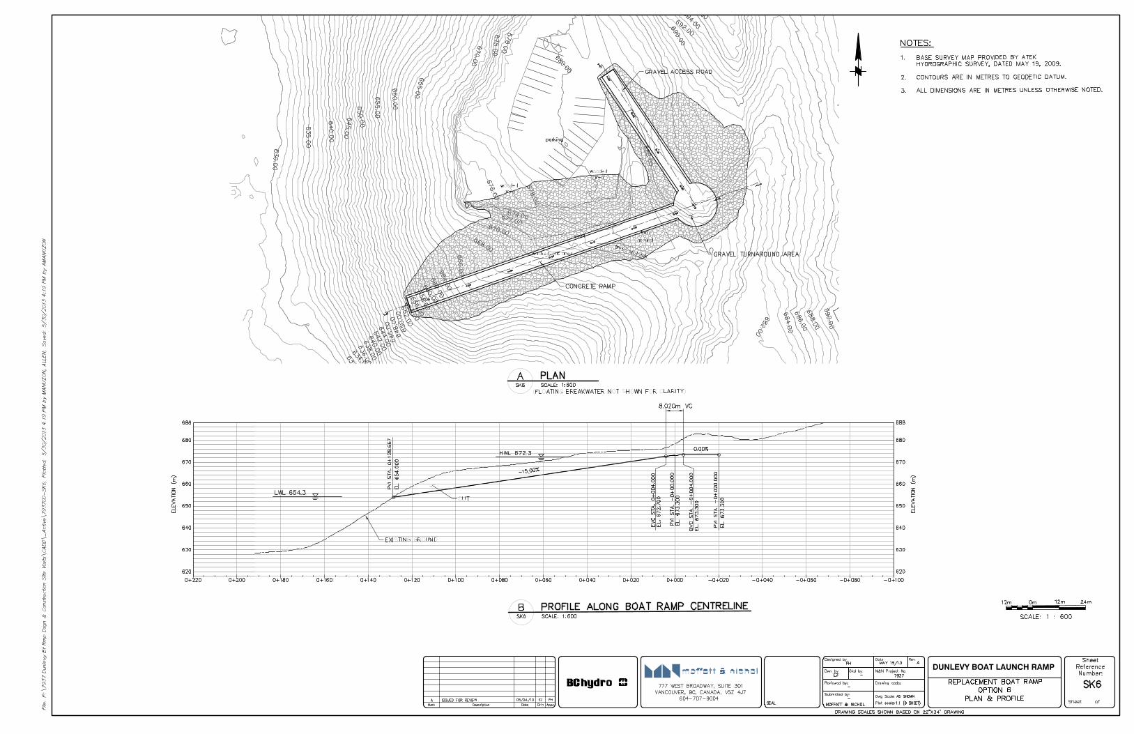
DUNLEVY BOAT LAUNCH RAMP
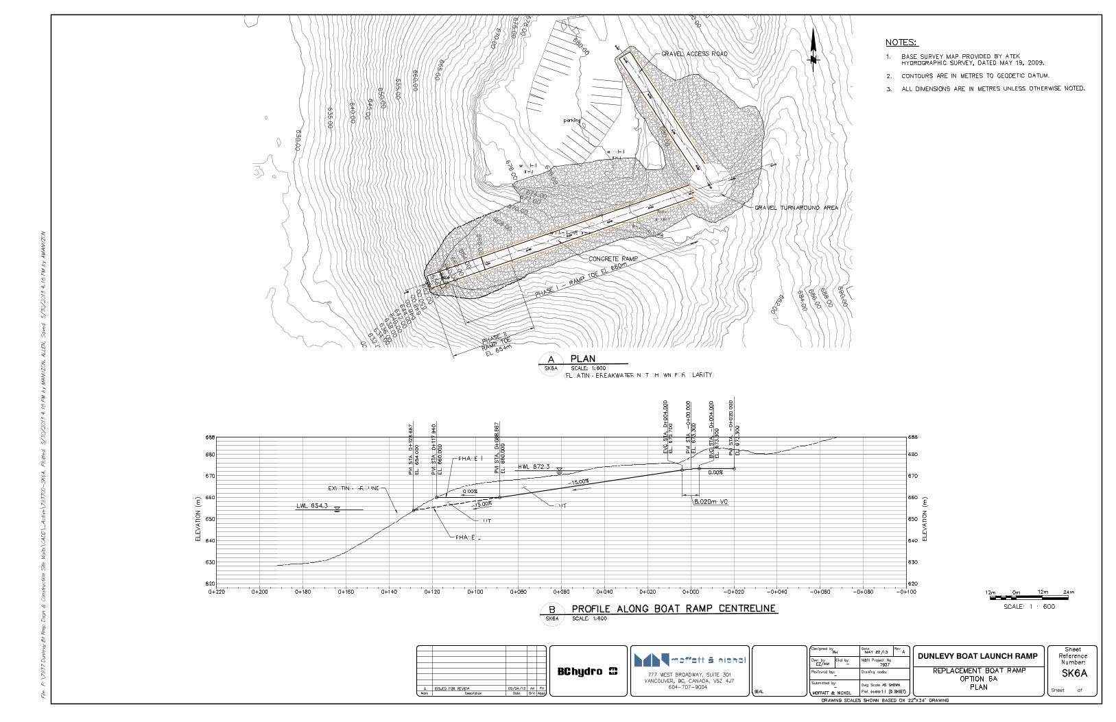
DUNLEVY BOAT LAUNCH RAMP
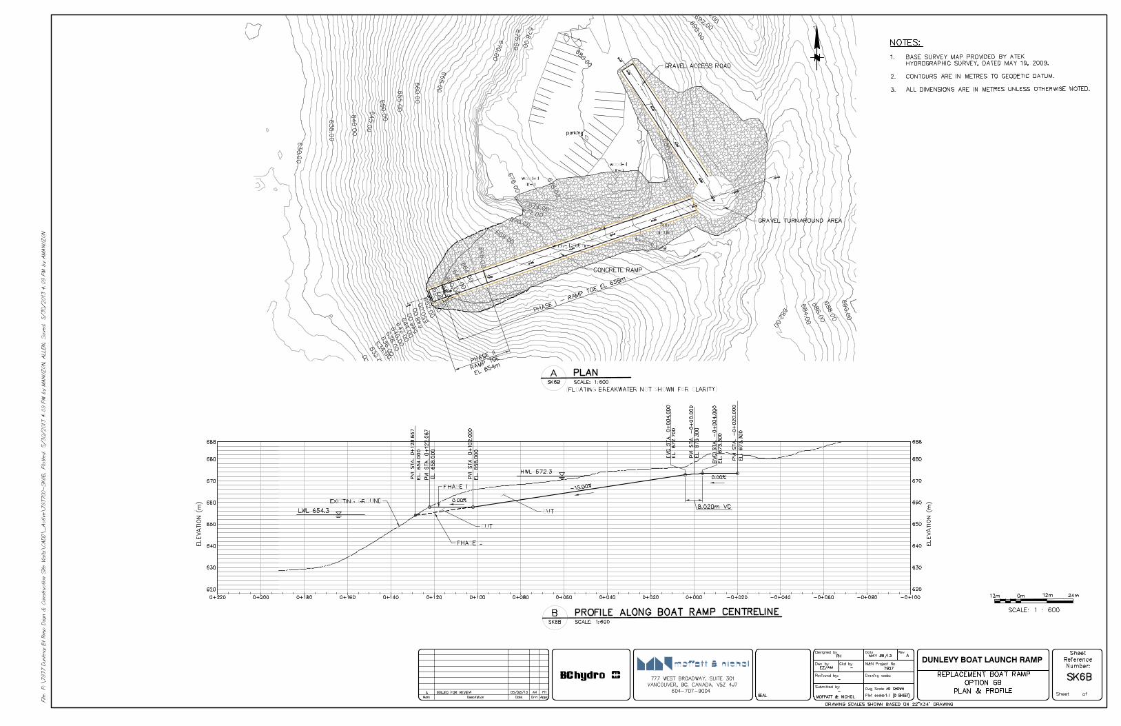
DUNLEVY BOAT LAUNCH RAMP
BC Hydro June 28, 2013
DUNLEVY EXISTING BOAT RAMP FACILITY FEASIBILITY STUDY Appendix B
APPENDIX B
COST ESTIMATES
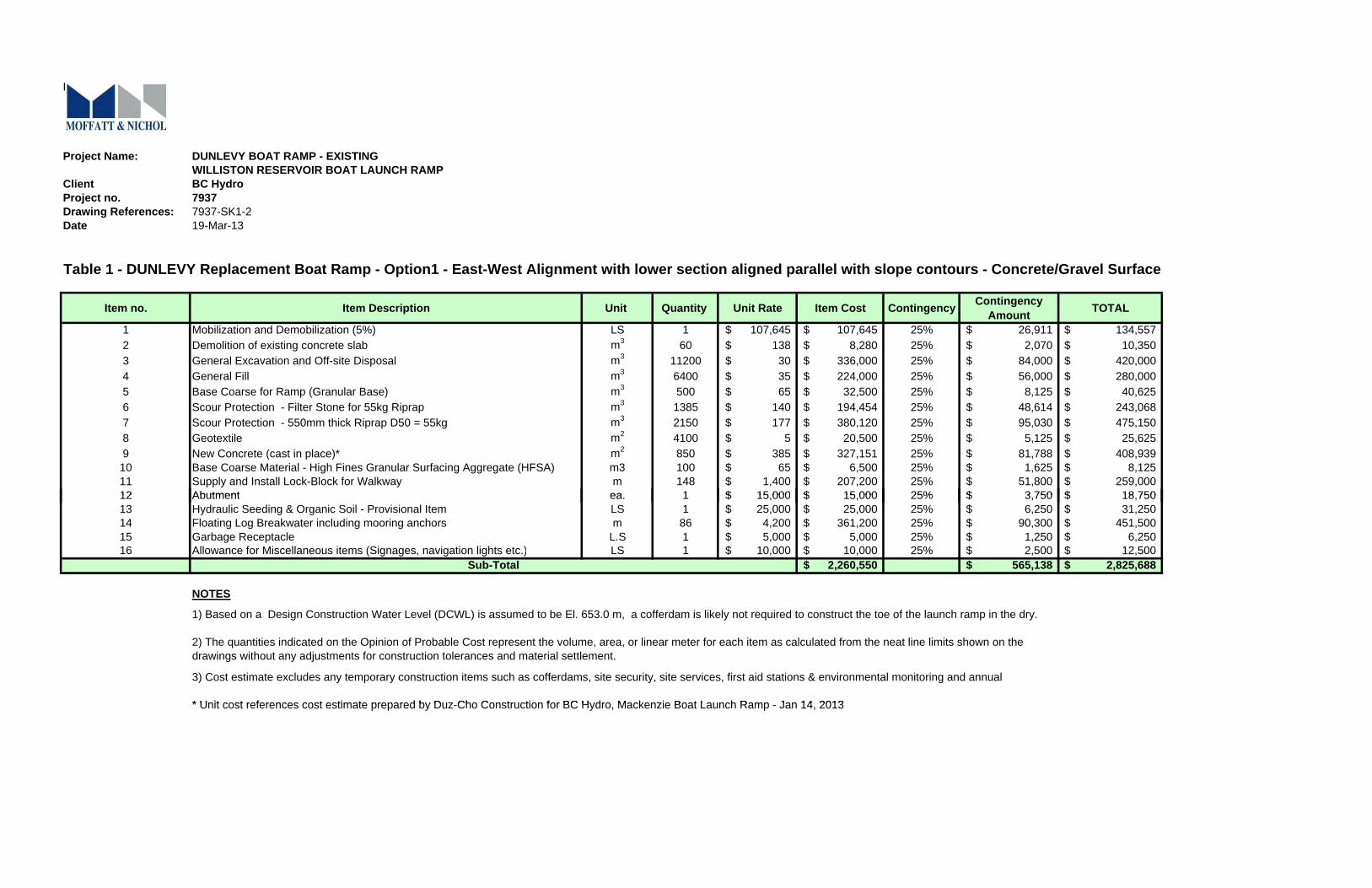
K-5
Project Name: DUNLEVY BOAT RAMP - EXISTINGWILLISTON RESERVOIR BOAT LAUNCH RAMP
Client BC HydroProject no. 7937Drawing References: 7937-SK1-2Date 19-Mar-13
Table 1 - DUNLEVY Replacement Boat Ramp - Option1 - East-West Alignment with lower section aligned parallel with slope contours - Concrete/Gravel Surface
Item no. Item Description Unit Quantity Unit Rate Item Cost Contingency Contingency Amount TOTAL
1 Mobilization and Demobilization (5%) LS 1 107,645$ 107,645$ 25% 26,911$ 134,557$ 2 Demolition of existing concrete slab m3 60 138$ 8,280$ 25% 2,070$ 10,350$ 3 General Excavation and Off-site Disposal m3 11200 30$ 336,000$ 25% 84,000$ 420,000$ 4 General Fill m3 6400 35$ 224,000$ 25% 56,000$ 280,000$ 5 Base Coarse for Ramp (Granular Base) m3 500 65$ 32,500$ 25% 8,125$ 40,625$ 6 Scour Protection - Filter Stone for 55kg Riprap m3 1385 140$ 194,454$ 25% 48,614$ 243,068$ 7 Scour Protection - 550mm thick Riprap D50 = 55kg m3 2150 177$ 380,120$ 25% 95,030$ 475,150$ 8 Geotextile m2 4100 5$ 20,500$ 25% 5,125$ 25,625$ 9 New Concrete (cast in place)* m2 850 385$ 327,151$ 25% 81,788$ 408,939$ 10 Base Coarse Material - High Fines Granular Surfacing Aggregate (HFSA) m3 100 65$ 6,500$ 25% 1,625$ 8,125$ 11 Supply and Install Lock-Block for Walkway m 148 1,400$ 207,200$ 25% 51,800$ 259,000$ 12 Abutment ea 1 15 000$ 15 000$ 25% 3 750$ 18 750$12 Abutment ea. 1 15,000$ 15,000$ 25% 3,750$ 18,750$ 13 Hydraulic Seeding & Organic Soil - Provisional Item LS 1 25,000$ 25,000$ 25% 6,250$ 31,250$ 14 Floating Log Breakwater including mooring anchors m 86 4,200$ 361,200$ 25% 90,300$ 451,500$ 15 Garbage Receptacle L.S 1 5,000$ 5,000$ 25% 1,250$ 6,250$ 16 Allowance for Miscellaneous items (Signages, navigation lights etc.) LS 1 10,000$ 10,000$ 25% 2,500$ 12,500$
2,260,550$ 565,138$ 2,825,688$
NOTES
* Unit cost references cost estimate prepared by Duz Cho Construction for BC Hydro Mackenzie Boat Launch Ramp Jan 14 2013
Sub-Total
1) Based on a Design Construction Water Level (DCWL) is assumed to be El. 653.0 m, a cofferdam is likely not required to construct the toe of the launch ramp in the dry.
2) The quantities indicated on the Opinion of Probable Cost represent the volume, area, or linear meter for each item as calculated from the neat line limits shown on the drawings without any adjustments for construction tolerances and material settlement.
3) Cost estimate excludes any temporary construction items such as cofferdams, site security, site services, first aid stations & environmental monitoring and annual
* Unit cost references cost estimate prepared by Duz-Cho Construction for BC Hydro, Mackenzie Boat Launch Ramp - Jan 14, 2013
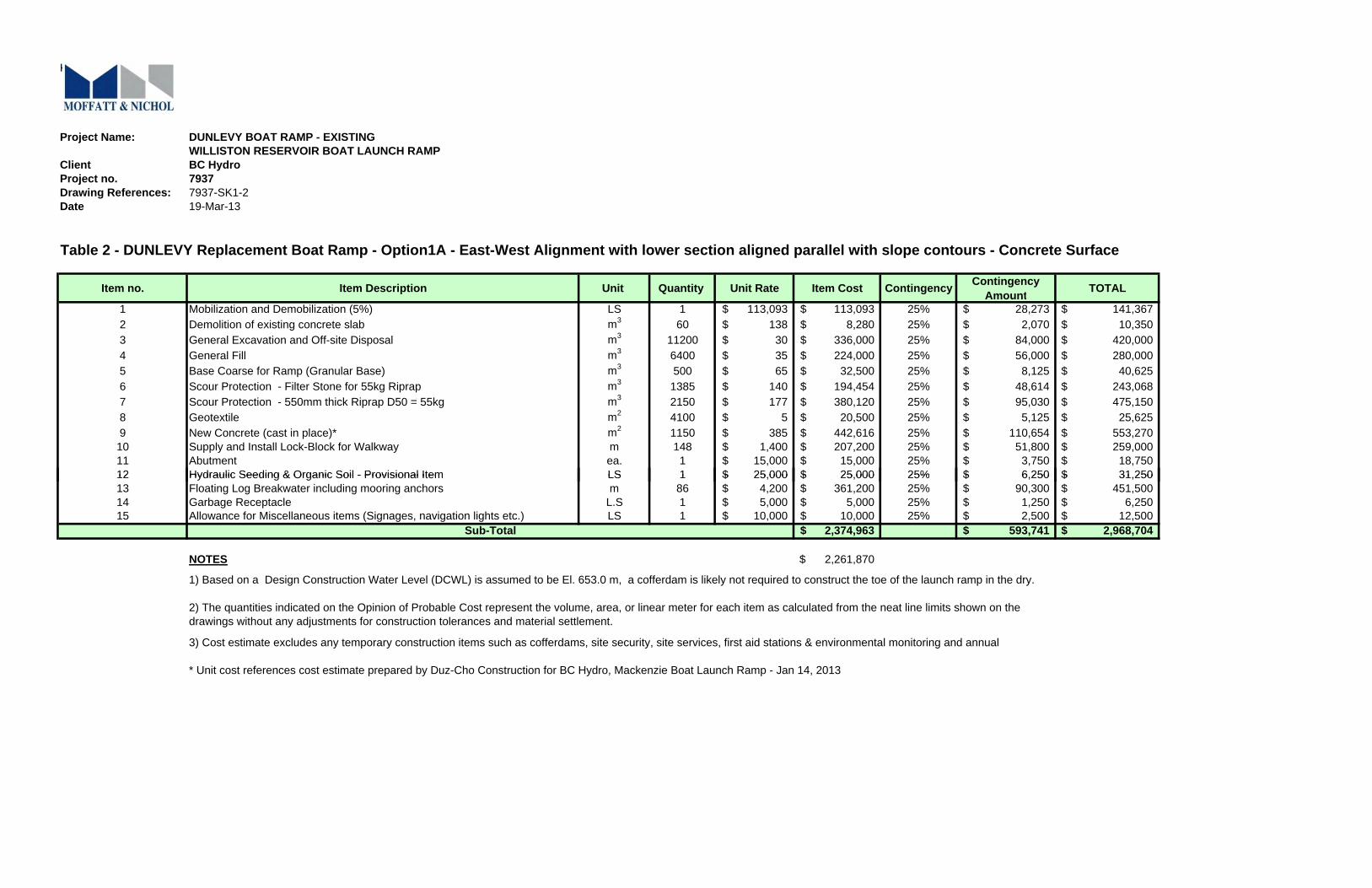
K-5
Project Name: DUNLEVY BOAT RAMP - EXISTINGWILLISTON RESERVOIR BOAT LAUNCH RAMP
Client BC HydroProject no. 7937Drawing References: 7937-SK1-2Date 19-Mar-13
Table 2 - DUNLEVY Replacement Boat Ramp - Option1A - East-West Alignment with lower section aligned parallel with slope contours - Concrete Surface
Item no. Item Description Unit Quantity Unit Rate Item Cost Contingency Contingency Amount TOTAL
1 Mobilization and Demobilization (5%) LS 1 113,093$ 113,093$ 25% 28,273$ 141,367$ 2 Demolition of existing concrete slab m3 60 138$ 8,280$ 25% 2,070$ 10,350$ 3 General Excavation and Off-site Disposal m3 11200 30$ 336,000$ 25% 84,000$ 420,000$ 4 General Fill m3 6400 35$ 224,000$ 25% 56,000$ 280,000$ 5 Base Coarse for Ramp (Granular Base) m3 500 65$ 32,500$ 25% 8,125$ 40,625$ 6 Scour Protection - Filter Stone for 55kg Riprap m3 1385 140$ 194,454$ 25% 48,614$ 243,068$ 7 Scour Protection - 550mm thick Riprap D50 = 55kg m3 2150 177$ 380,120$ 25% 95,030$ 475,150$ 8 Geotextile m2 4100 5$ 20,500$ 25% 5,125$ 25,625$ 9 New Concrete (cast in place)* m2 1150 385$ 442,616$ 25% 110,654$ 553,270$ 10 Supply and Install Lock-Block for Walkway m 148 1,400$ 207,200$ 25% 51,800$ 259,000$ 11 Abutment ea. 1 15,000$ 15,000$ 25% 3,750$ 18,750$ 12 Hydraulic Seeding & Organic Soil - Provisional Item LS 1 25 000$ 25 000$ 25% 6 250$ 31 250$12 Hydraulic Seeding & Organic Soil - Provisional Item LS 1 25,000$ 25,000$ 25% 6,250$ 31,250$ 13 Floating Log Breakwater including mooring anchors m 86 4,200$ 361,200$ 25% 90,300$ 451,500$ 14 Garbage Receptacle L.S 1 5,000$ 5,000$ 25% 1,250$ 6,250$ 15 Allowance for Miscellaneous items (Signages, navigation lights etc.) LS 1 10,000$ 10,000$ 25% 2,500$ 12,500$
2,374,963$ 593,741$ 2,968,704$
NOTES 2,261,870$
* Unit cost references cost estimate prepared by Duz-Cho Construction for BC Hydro, Mackenzie Boat Launch Ramp - Jan 14, 2013
Sub-Total
1) Based on a Design Construction Water Level (DCWL) is assumed to be El. 653.0 m, a cofferdam is likely not required to construct the toe of the launch ramp in the dry.
2) The quantities indicated on the Opinion of Probable Cost represent the volume, area, or linear meter for each item as calculated from the neat line limits shown on the drawings without any adjustments for construction tolerances and material settlement.
3) Cost estimate excludes any temporary construction items such as cofferdams, site security, site services, first aid stations & environmental monitoring and annual
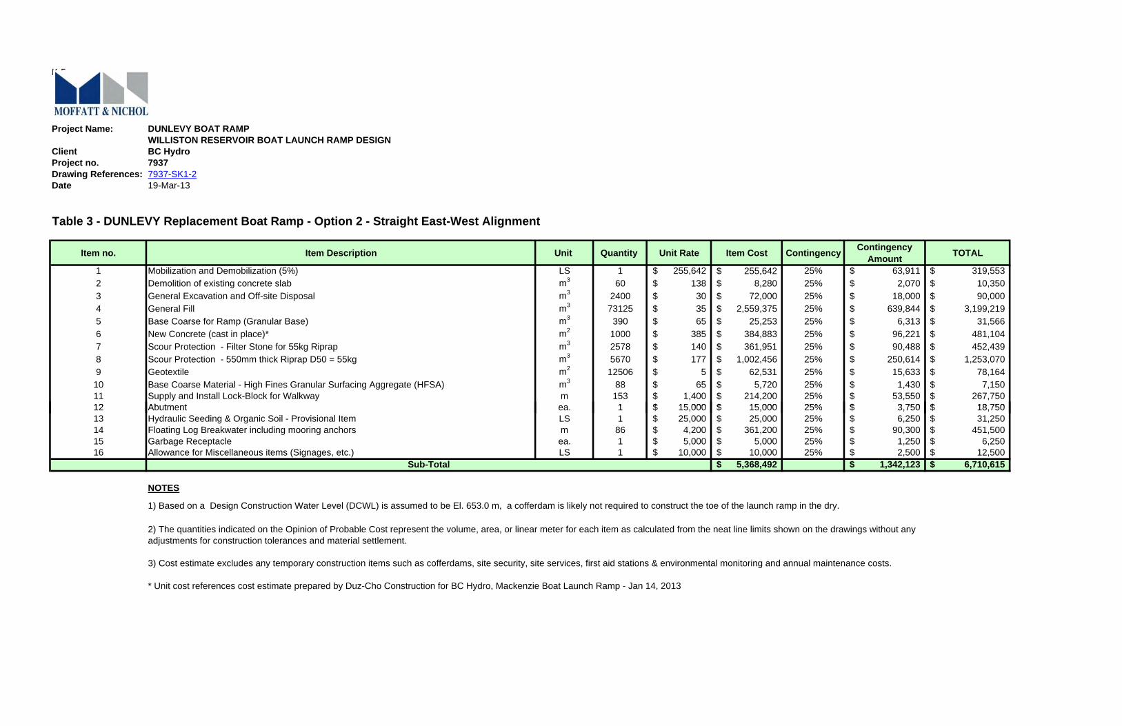
K-5
Project Name: DUNLEVY BOAT RAMPWILLISTON RESERVOIR BOAT LAUNCH RAMP DESIGN
Client BC HydroProject no. 7937Drawing References: 7937-SK1-2Date 19-Mar-13
Table 3 - DUNLEVY Replacement Boat Ramp - Option 2 - Straight East-West Alignment
Item no. Item Description Unit Quantity Unit Rate Item Cost Contingency Contingency Amount TOTAL
1 Mobilization and Demobilization (5%) LS 1 255,642$ 255,642$ 25% 63,911$ 319,553$ 2 Demolition of existing concrete slab m3 60 138$ 8,280$ 25% 2,070$ 10,350$ 3 General Excavation and Off-site Disposal m3 2400 30$ 72,000$ 25% 18,000$ 90,000$ 4 General Fill m3 73125 35$ 2,559,375$ 25% 639,844$ 3,199,219$ 5 Base Coarse for Ramp (Granular Base) m3 390 65$ 25,253$ 25% 6,313$ 31,566$ 6 New Concrete (cast in place)* m2 1000 385$ 384,883$ 25% 96,221$ 481,104$ 7 Scour Protection - Filter Stone for 55kg Riprap m3 2578 140$ 361,951$ 25% 90,488$ 452,439$ 8 Scour Protection - 550mm thick Riprap D50 = 55kg m3 5670 177$ 1,002,456$ 25% 250,614$ 1,253,070$ 9 Geotextile m2 12506 5$ 62,531$ 25% 15,633$ 78,164$
10 Base Coarse Material - High Fines Granular Surfacing Aggregate (HFSA) m3 88 65$ 5,720$ 25% 1,430$ 7,150$ 11 Supply and Install Lock-Block for Walkway m 153 1,400$ 214,200$ 25% 53,550$ 267,750$ 12 Abutment ea 1 15 000$ 15 000$ 25% 3 750$ 18 750$12 Abutment ea. 1 15,000$ 15,000$ 25% 3,750$ 18,750$ 13 Hydraulic Seeding & Organic Soil - Provisional Item LS 1 25,000$ 25,000$ 25% 6,250$ 31,250$ 14 Floating Log Breakwater including mooring anchors m 86 4,200$ 361,200$ 25% 90,300$ 451,500$ 15 Garbage Receptacle ea. 1 5,000$ 5,000$ 25% 1,250$ 6,250$ 16 Allowance for Miscellaneous items (Signages, etc.) LS 1 10,000$ 10,000$ 25% 2,500$ 12,500$
5,368,492$ 1,342,123$ 6,710,615$
NOTES
Sub-Total
3) Cost estimate excludes any temporary construction items such as cofferdams, site security, site services, first aid stations & environmental monitoring and annual maintenance costs.
1) Based on a Design Construction Water Level (DCWL) is assumed to be El. 653.0 m, a cofferdam is likely not required to construct the toe of the launch ramp in the dry.
2) The quantities indicated on the Opinion of Probable Cost represent the volume, area, or linear meter for each item as calculated from the neat line limits shown on the drawings without any adjustments for construction tolerances and material settlement.
* Unit cost references cost estimate prepared by Duz-Cho Construction for BC Hydro, Mackenzie Boat Launch Ramp - Jan 14, 2013
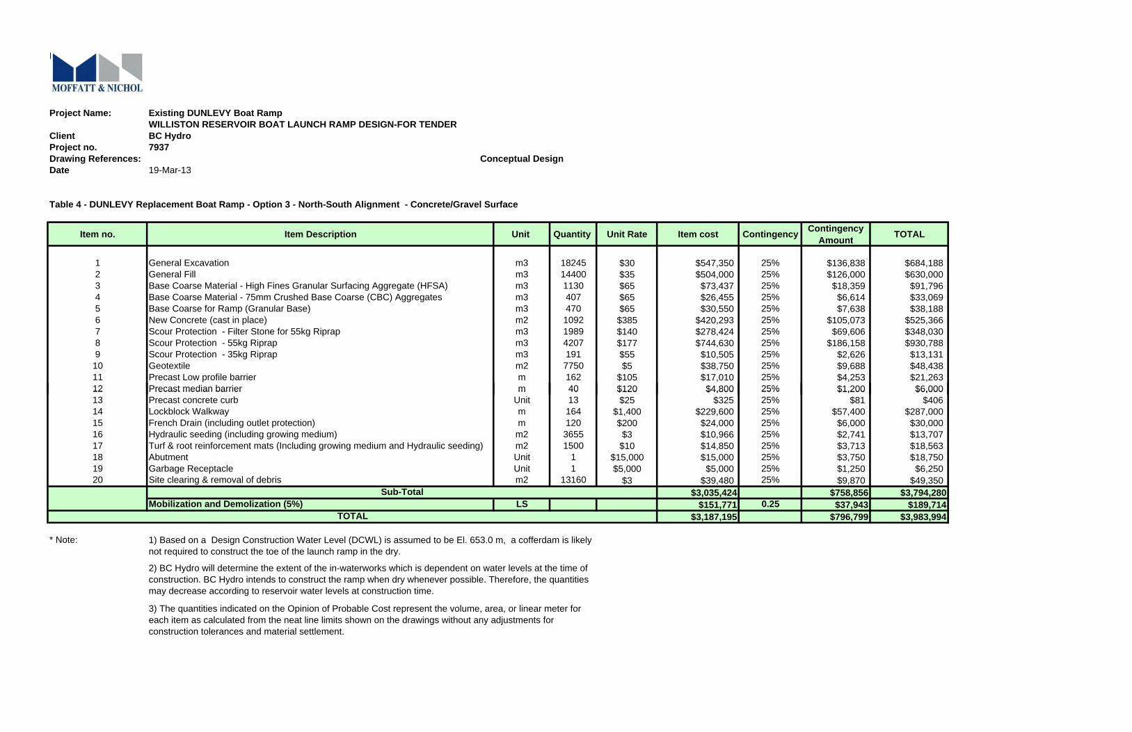
K-5
Project Name: Existing DUNLEVY Boat RampWILLISTON RESERVOIR BOAT LAUNCH RAMP DESIGN-FOR TENDER
Client BC HydroProject no. 7937Drawing References: Conceptual DesignDate 19-Mar-13
Table 4 - DUNLEVY Replacement Boat Ramp - Option 3 - North-South Alignment - Concrete/Gravel Surface
Item no. Item Description Unit Quantity Unit Rate Item cost Contingency Contingency Amount TOTAL
1 General Excavation m3 18245 $30 $547,350 25% $136,838 $684,1882 General Fill m3 14400 $35 $504,000 25% $126,000 $630,0003 Base Coarse Material - High Fines Granular Surfacing Aggregate (HFSA) m3 1130 $65 $73,437 25% $18,359 $91,7964 Base Coarse Material - 75mm Crushed Base Coarse (CBC) Aggregates m3 407 $65 $26,455 25% $6,614 $33,0695 Base Coarse for Ramp (Granular Base) m3 470 $65 $30,550 25% $7,638 $38,1886 New Concrete (cast in place) m2 1092 $385 $420,293 25% $105,073 $525,3667 Scour Protection - Filter Stone for 55kg Riprap m3 1989 $140 $278,424 25% $69,606 $348,0308 Scour Protection - 55kg Riprap m3 4207 $177 $744,630 25% $186,158 $930,7889 Scour Protection - 35kg Riprap m3 191 $55 $10,505 25% $2,626 $13,13110 Geotextile m2 7750 $5 $38,750 25% $9,688 $48,43811 Precast Low profile barrier m 162 $105 $17,010 25% $4,253 $21,26312 Precast median barrier m 40 $120 $4,800 25% $1,200 $6,00012 Precast median barrier m 40 $120 $4,800 25% $1,200 $6,00013 Precast concrete curb Unit 13 $25 $325 25% $81 $40614 Lockblock Walkway m 164 $1,400 $229,600 25% $57,400 $287,00015 French Drain (including outlet protection) m 120 $200 $24,000 25% $6,000 $30,00016 Hydraulic seeding (including growing medium) m2 3655 $3 $10,966 25% $2,741 $13,70717 Turf & root reinforcement mats (Including growing medium and Hydraulic seeding) m2 1500 $10 $14,850 25% $3,713 $18,56318 Abutment Unit 1 $15,000 $15,000 25% $3,750 $18,75019 Garbage Receptacle Unit 1 $5,000 $5,000 25% $1,250 $6,25020 Site clearing & removal of debris m2 13160 $3 $39,480 25% $9,870 $49,350
$3,035,424 $758,856 $3,794,280Mobilization and Demolization (5%) LS $151,771 0.25 $37,943 $189,714
$3,187,195 $796,799 $3,983,994
* Note:
Sub-Total
TOTAL
1) Based on a Design Construction Water Level (DCWL) is assumed to be El. 653.0 m, a cofferdam is likely not required to construct the toe of the launch ramp in the dry.
2) BC Hydro will determine the extent of the in-waterworks which is dependent on water levels at the time of construction. BC Hydro intends to construct the ramp when dry whenever possible. Therefore, the quantities may decrease according to reservoir water levels at construction time.
3) The quantities indicated on the Opinion of Probable Cost represent the volume, area, or linear meter for each item as calculated from the neat line limits shown on the drawings without any adjustments for construction tolerances and material settlement.
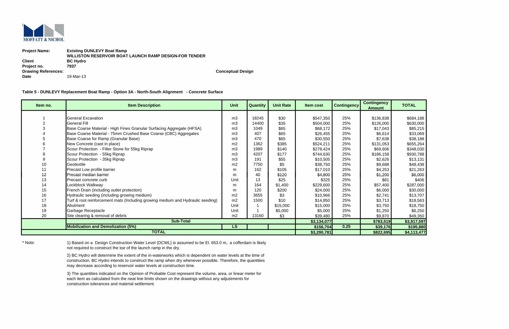
K-5
Project Name: Existing DUNLEVY Boat RampWILLISTON RESERVOIR BOAT LAUNCH RAMP DESIGN-FOR TENDER
Client BC HydroProject no. 7937Drawing References: Conceptual DesignDate 19-Mar-13
Table 5 - DUNLEVY Replacement Boat Ramp - Option 3A - North-South Alignment - Concrete Surface
Item no. Item Description Unit Quantity Unit Rate Item cost Contingency Contingency Amount TOTAL
1 General Excavation m3 18245 $30 $547,350 25% $136,838 $684,1882 General Fill m3 14400 $35 $504,000 25% $126,000 $630,0003 Base Coarse Material - High Fines Granular Surfacing Aggregate (HFSA) m3 1049 $65 $68,172 25% $17,043 $85,2154 Base Coarse Material - 75mm Crushed Base Coarse (CBC) Aggregates m3 407 $65 $26,455 25% $6,614 $33,0695 Base Coarse for Ramp (Granular Base) m3 470 $65 $30,550 25% $7,638 $38,1886 New Concrete (cast in place) m2 1362 $385 $524,211 25% $131,053 $655,2647 Scour Protection - Filter Stone for 55kg Riprap m3 1989 $140 $278,424 25% $69,606 $348,0308 Scour Protection - 55kg Riprap m3 4207 $177 $744,630 25% $186,158 $930,7889 Scour Protection - 35kg Riprap m3 191 $55 $10,505 25% $2,626 $13,13110 Geotextile m2 7750 $5 $38,750 25% $9,688 $48,43811 Precast Low profile barrier m 162 $105 $17,010 25% $4,253 $21,26312 Precast median barrier m 40 $120 $4,800 25% $1,200 $6,00012 Precast median barrier m 40 $120 $4,800 25% $1,200 $6,00013 Precast concrete curb Unit 13 $25 $325 25% $81 $40614 Lockblock Walkway m 164 $1,400 $229,600 25% $57,400 $287,00015 French Drain (including outlet protection) m 120 $200 $24,000 25% $6,000 $30,00016 Hydraulic seeding (including growing medium) m2 3655 $3 $10,966 25% $2,741 $13,70717 Turf & root reinforcement mats (Including growing medium and Hydraulic seeding) m2 1500 $10 $14,850 25% $3,713 $18,56318 Abutment Unit 1 $15,000 $15,000 25% $3,750 $18,75019 Garbage Receptacle Unit 1 $5,000 $5,000 25% $1,250 $6,25020 Site clearing & removal of debris m2 13160 $3 $39,480 25% $9,870 $49,350
$3,134,077 $783,519 $3,917,597Mobilization and Demolization (5%) LS $156,704 0.25 $39,176 $195,880
$3,290,781 $822,695 $4,113,477
* Note:
Sub-Total
TOTAL
1) Based on a Design Construction Water Level (DCWL) is assumed to be El. 653.0 m, a cofferdam is likely not required to construct the toe of the launch ramp in the dry.
2) BC Hydro will determine the extent of the in-waterworks which is dependent on water levels at the time of construction. BC Hydro intends to construct the ramp when dry whenever possible. Therefore, the quantities may decrease according to reservoir water levels at construction time.
3) The quantities indicated on the Opinion of Probable Cost represent the volume, area, or linear meter for each item as calculated from the neat line limits shown on the drawings without any adjustments for construction tolerances and material settlement.
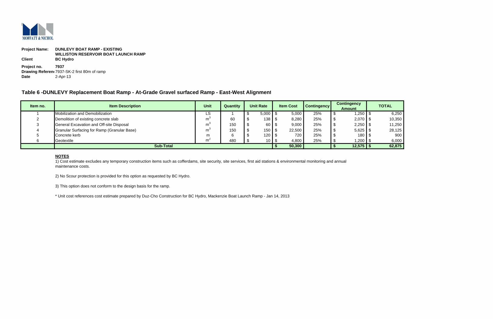
K-5
Project Name: DUNLEVY BOAT RAMP - EXISTINGWILLISTON RESERVOIR BOAT LAUNCH RAMP
Client BC Hydro
Project no. 7937Drawing Referenc7937-SK-2 first 80m of rampDate 2-Apr-13
Table 6 -DUNLEVY Replacement Boat Ramp - At-Grade Gravel surfaced Ramp - East-West Alignment
Item no. Item Description Unit Quantity Unit Rate Item Cost Contingency Contingency Amount TOTAL
1 Mobilization and Demobilization LS 1 5,000$ 5,000$ 25% 1,250$ 6,250$ 2 Demolition of existing concrete slab m3 60 138$ 8,280$ 25% 2,070$ 10,350$ 3 General Excavation and Off-site Disposal m3 150 60$ 9,000$ 25% 2,250$ 11,250$ 4 Granular Surfacing for Ramp (Granular Base) m3 150 150$ 22,500$ 25% 5,625$ 28,125$ 5 Concrete kerb m 6 120$ 720$ 25% 180$ 900$ 6 Geotextile m2 480 10$ 4,800$ 25% 1,200$ 6,000$
50,300$ 12,575$ 62,875$
NOTES
Sub-Total
1) Cost estimate excludes any temporary construction items such as cofferdams, site security, site services, first aid stations & environmental monitoring and annual maintenance costs.
* Unit cost references cost estimate prepared by Duz-Cho Construction for BC Hydro, Mackenzie Boat Launch Ramp - Jan 14, 2013
2) No Scour protection is provided for this option as requested by BC Hydro.
3) This option does not conform to the design basis for the ramp.
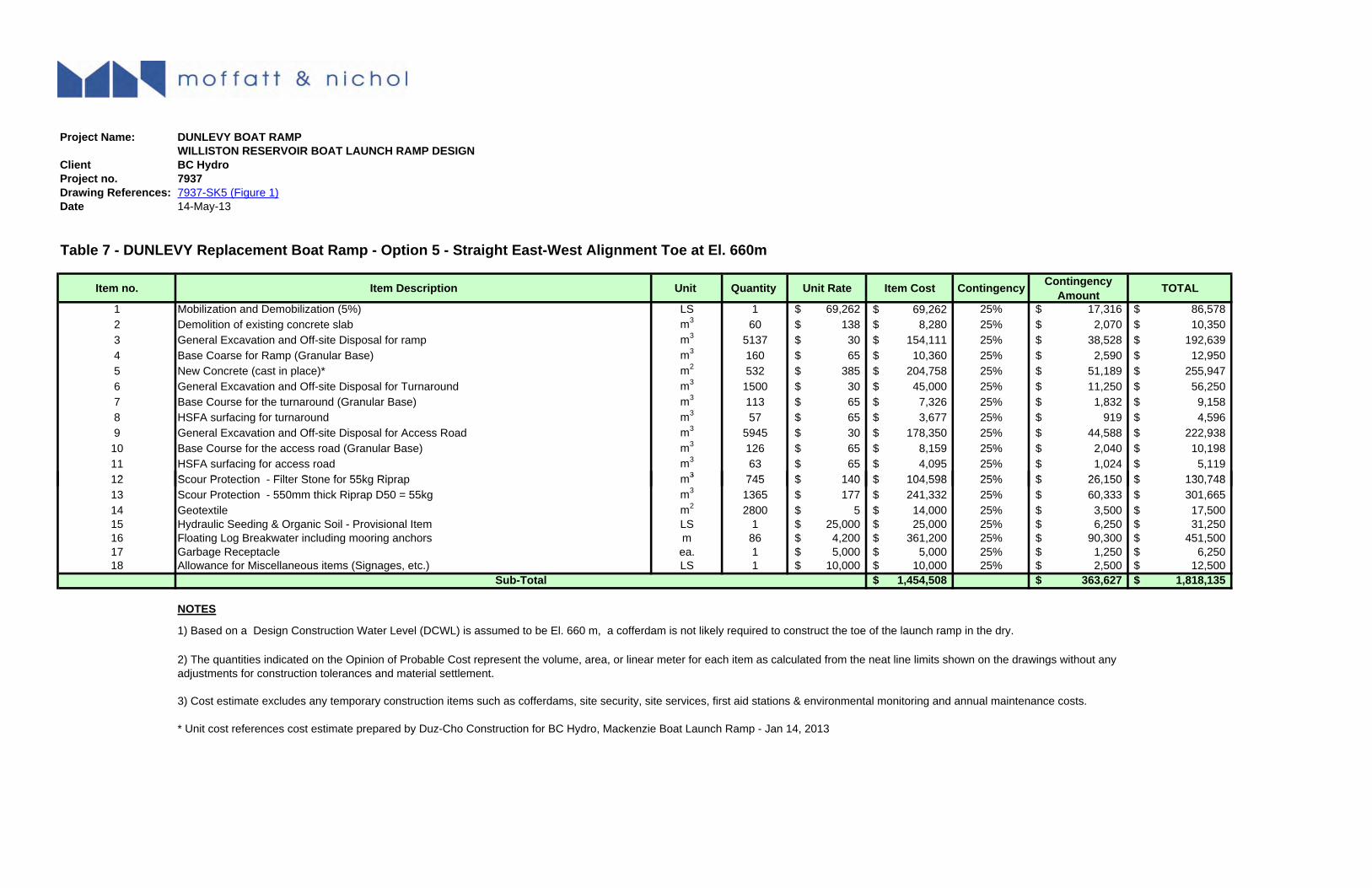
K-5
Project Name: DUNLEVY BOAT RAMPWILLISTON RESERVOIR BOAT LAUNCH RAMP DESIGN
Client BC HydroProject no. 7937Drawing References: 7937-SK5 (Figure 1)Date 14-May-13
Table 7 - DUNLEVY Replacement Boat Ramp - Option 5 - Straight East-West Alignment Toe at El. 660m
Item no. Item Description Unit Quantity Unit Rate Item Cost Contingency Contingency Amount TOTAL
1 Mobilization and Demobilization (5%) LS 1 69,262$ 69,262$ 25% 17,316$ 86,578$ 2 Demolition of existing concrete slab m3 60 138$ 8,280$ 25% 2,070$ 10,350$ 3 General Excavation and Off-site Disposal for ramp m3 5137 30$ 154,111$ 25% 38,528$ 192,639$ 4 Base Coarse for Ramp (Granular Base) m3 160 65$ 10,360$ 25% 2,590$ 12,950$ 5 New Concrete (cast in place)* m2 532 385$ 204,758$ 25% 51,189$ 255,947$ 6 General Excavation and Off-site Disposal for Turnaround m3 1500 30$ 45,000$ 25% 11,250$ 56,250$ 7 Base Course for the turnaround (Granular Base) m3 113 65$ 7,326$ 25% 1,832$ 9,158$ 8 HSFA surfacing for turnaround m3 57 65$ 3,677$ 25% 919$ 4,596$ 9 General Excavation and Off-site Disposal for Access Road m3 5945 30$ 178,350$ 25% 44,588$ 222,938$ 10 Base Course for the access road (Granular Base) m3 126 65$ 8,159$ 25% 2,040$ 10,198$ 11 HSFA surfacing for access road m3 63 65$ 4,095$ 25% 1,024$ 5,119$ 12 S P t ti Filt St f 55k Ri 3 745 140$ 104 598$ 25% 26 150$ 130 748$12 Scour Protection - Filter Stone for 55kg Riprap m3 745 140$ 104,598$ 25% 26,150$ 130,748$ 13 Scour Protection - 550mm thick Riprap D50 = 55kg m3 1365 177$ 241,332$ 25% 60,333$ 301,665$ 14 Geotextile m2 2800 5$ 14,000$ 25% 3,500$ 17,500$ 15 Hydraulic Seeding & Organic Soil - Provisional Item LS 1 25,000$ 25,000$ 25% 6,250$ 31,250$ 16 Floating Log Breakwater including mooring anchors m 86 4,200$ 361,200$ 25% 90,300$ 451,500$ 17 Garbage Receptacle ea. 1 5,000$ 5,000$ 25% 1,250$ 6,250$ 18 Allowance for Miscellaneous items (Signages, etc.) LS 1 10,000$ 10,000$ 25% 2,500$ 12,500$
1,454,508$ 363,627$ 1,818,135$
NOTES
Sub-Total
1) Based on a Design Construction Water Level (DCWL) is assumed to be El. 660 m, a cofferdam is not likely required to construct the toe of the launch ramp in the dry.
2) The quantities indicated on the Opinion of Probable Cost represent the volume, area, or linear meter for each item as calculated from the neat line limits shown on the drawings without any adjustments for construction tolerances and material settlement.
* Unit cost references cost estimate prepared by Duz-Cho Construction for BC Hydro, Mackenzie Boat Launch Ramp - Jan 14, 2013
3) Cost estimate excludes any temporary construction items such as cofferdams, site security, site services, first aid stations & environmental monitoring and annual maintenance costs.
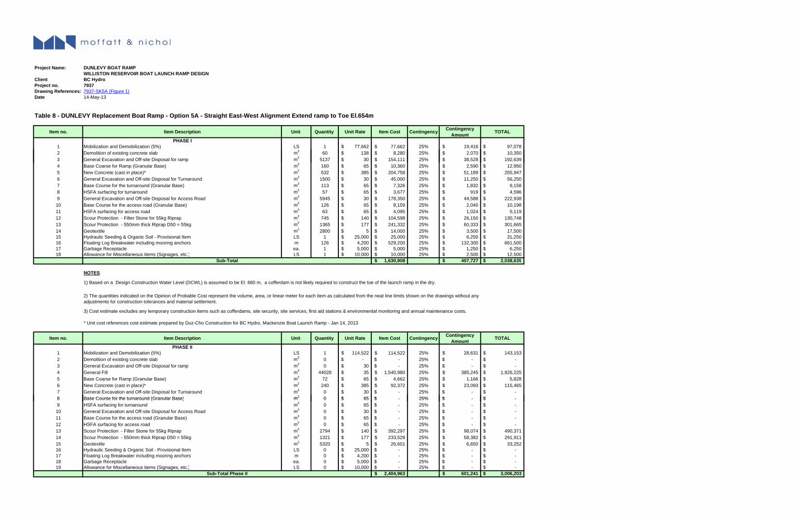
K-5
Project Name: DUNLEVY BOAT RAMPWILLISTON RESERVOIR BOAT LAUNCH RAMP DESIGN
Client BC HydroProject no. 7937Drawing References: 7937-SK5A (Figure 1)Date 14-May-13
Table 8 - DUNLEVY Replacement Boat Ramp - Option 5A - Straight East-West Alignment Extend ramp to Toe El.654m
Item no. Item Description Unit Quantity Unit Rate Item Cost Contingency Contingency Amount TOTAL
PHASE I1 Mobilization and Demobilization (5%) LS 1 77,662$ 77,662$ 25% 19,416$ 97,078$ 2 Demolition of existing concrete slab m3 60 138$ 8,280$ 25% 2,070$ 10,350$
3g
3 General Excavation and Off-site Disposal for ramp m3 5137 30$ 154,111$ 25% 38,528$ 192,639$ 4 Base Coarse for Ramp (Granular Base) m3 160 65$ 10,360$ 25% 2,590$ 12,950$ 5 New Concrete (cast in place)* m2 532 385$ 204,758$ 25% 51,189$ 255,947$ 6 General Excavation and Off-site Disposal for Turnaround m3 1500 30$ 45,000$ 25% 11,250$ 56,250$ 7 Base Course for the turnaround (Granular Base) m3 113 65$ 7,326$ 25% 1,832$ 9,158$ 8 HSFA surfacing for turnaround m3 57 65$ 3,677$ 25% 919$ 4,596$ 9 General Excavation and Off-site Disposal for Access Road m3 5945 30$ 178,350$ 25% 44,588$ 222,938$
10 Base Course for the access road (Granular Base) m3 126 65$ 8,159$ 25% 2,040$ 10,198$ 11 HSFA surfacing for access road m3 63 65$ 4,095$ 25% 1,024$ 5,119$ 12 Scour Protection - Filter Stone for 55kg Riprap m3 745 140$ 104,598$ 25% 26,150$ 130,748$ 13 Scour Protection - 550mm thick Riprap D50 = 55kg m3 1365 177$ 241,332$ 25% 60,333$ 301,665$ 14 Geotextile m2 2800 5$ 14,000$ 25% 3,500$ 17,500$ 15 Hydraulic Seeding & Organic Soil - Provisional Item LS 1 25,000$ 25,000$ 25% 6,250$ 31,250$ 16 Floating Log Breakwater including mooring anchors m 126 4,200$ 529,200$ 25% 132,300$ 661,500$ 17 Garbage Receptacle ea. 1 5,000$ 5,000$ 25% 1,250$ 6,250$ 18 Allowance for Miscellaneous items (Signages, etc.) LS 1 10,000$ 10,000$ 25% 2,500$ 12,500$
1,630,908$ 407,727$ 2,038,635$
NOTES
Sub-Total
* Unit cost references cost estimate prepared by Duz-Cho Construction for BC Hydro, Mackenzie Boat Launch Ramp - Jan 14, 2013
Item no. Item Description Unit Quantity Unit Rate Item Cost Contingency Contingency Amount TOTAL
PHASE II1 Mobilization and Demobilization (5%) LS 1 114,522$ 114,522$ 25% 28,631$ 143,153$ 2 Demolition of existing concrete slab m3 0 -$ -$ 25% -$ -$ 3 General Excavation and Off-site Disposal for ramp m3 0 30$ -$ 25% -$ -$ 4 General Fill m3 44028 35$ 1,540,980$ 25% 385,245$ 1,926,225$ 5 Base Coarse for Ramp (Granular Base) m3 72 65$ 4,662$ 25% 1,166$ 5,828$ 6 New Concrete (cast in place)* m2 240 385$ 92,372$ 25% 23,093$ 115,465$ 7 General Excavation and Off-site Disposal for Turnaround m3 0 30$ -$ 25% -$ -$ 8 Base Course for the turnaround (Granular Base) m3 0 65$ $ 25% $ $
1) Based on a Design Construction Water Level (DCWL) is assumed to be El. 660 m, a cofferdam is not likely required to construct the toe of the launch ramp in the dry.
2) The quantities indicated on the Opinion of Probable Cost represent the volume, area, or linear meter for each item as calculated from the neat line limits shown on the drawings without any adjustments for construction tolerances and material settlement.
3) Cost estimate excludes any temporary construction items such as cofferdams, site security, site services, first aid stations & environmental monitoring and annual maintenance costs.
8 Base Course for the turnaround (Granular Base) m3 0 65$ -$ 25% -$ -$ 9 HSFA surfacing for turnaround m3 0 65$ -$ 25% -$ -$
10 General Excavation and Off-site Disposal for Access Road m3 0 30$ -$ 25% -$ -$ 11 Base Course for the access road (Granular Base) m3 0 65$ -$ 25% -$ -$ 12 HSFA surfacing for access road m3 0 65$ -$ 25% -$ -$ 13 Scour Protection - Filter Stone for 55kg Riprap m3 2794 140$ 392,297$ 25% 98,074$ 490,371$ 14 Scour Protection - 550mm thick Riprap D50 = 55kg m3 1321 177$ 233,529$ 25% 58,382$ 291,911$ 15 Geotextile m2 5320 5$ 26,601$ 25% 6,650$ 33,252$ 16 Hydraulic Seeding & Organic Soil - Provisional Item LS 0 25,000$ -$ 25% -$ -$ 17 Floating Log Breakwater including mooring anchors m 0 4,200$ -$ 25% -$ -$ 18 Garbage Receptacle ea. 0 5,000$ -$ 25% -$ -$ 19 Allowance for Miscellaneous items (Signages, etc.) LS 0 10,000$ -$ 25% -$ -$
2,404,963$ 601,241$ 3,006,203$ Sub-Total Phase II

K-5
Project Name: DUNLEVY BOAT RAMPWILLISTON RESERVOIR BOAT LAUNCH RAMP DESIGN
Client BC HydroProject no. 7937Drawing References: 7937-SK5BDate 28-May-13
Table 9 - DUNLEVY Replacement Boat Ramp - Option 5B - Straight East-West Alignment Toe at El. 658m
Item no. Item Description Unit Quantity Unit Rate Item Cost Contingency Contingency Amount TOTAL
1 Mobilization and Demobilization (5%) LS 1 90,027$ 90,027$ 25% 22,507$ 112,534$ 2 Demolition of existing concrete slab m3 60 138$ 8,280$ 25% 2,070$ 10,350$ 3 General Excavation and Off-site Disposal for ramp m3 11341 30$ 340,217$ 25% 85,054$ 425,271$ 4 Base Coarse for Ramp (Granular Base) m3 184 65$ 11,888$ 25% 2,972$ 14,860$ 5 New Concrete (cast in place)* m2 612 385$ 235,549$ 25% 58,887$ 294,436$ 6 General Excavation and Off-site Disposal for Turnaround m3 7949 30$ 238,470$ 25% 59,618$ 298,088$ 7 Base Course for the turnaround (Granular Base) m3 113 65$ 7,326$ 25% 1,832$ 9,158$ 8 HSFA surfacing for turnaround m3 57 65$ 3,677$ 25% 919$ 4,596$ 9 General Excavation and Off-site Disposal for Access Road m3 3402 30$ 102,060$ 25% 25,515$ 127,575$ 10 Base Course for the access road (Granular Base) m3 189 65$ 12,238$ 25% 3,059$ 15,297$ 11 HSFA surfacing for access road m3 95 65$ 6,143$ 25% 1,536$ 7,678$ 12 S P t ti Filt St f 55k Ri 3 892 140$ 125 288$ 25% 31 322$ 156 610$12 Scour Protection - Filter Stone for 55kg Riprap m3 892 140$ 125,288$ 25% 31,322$ 156,610$ 13 Scour Protection - 550mm thick Riprap D50 = 55kg m3 1636 177$ 289,245$ 25% 72,311$ 361,556$ 14 Geotextile m2 3792 5$ 18,961$ 25% 4,740$ 23,701$ 15 Hydraulic Seeding & Organic Soil - Provisional Item LS 1 25,000$ 25,000$ 25% 6,250$ 31,250$ 16 Floating Log Breakwater including mooring anchors m 86 4,200$ 361,200$ 25% 90,300$ 451,500$ 17 Garbage Receptacle ea. 1 5,000$ 5,000$ 25% 1,250$ 6,250$ 18 Allowance for Miscellaneous items (Signages, etc.) LS 1 10,000$ 10,000$ 25% 2,500$ 12,500$
1,890,567$ 472,642$ 2,363,209$
NOTES
Sub-Total
1) Based on a Design Construction Water Level (DCWL) is assumed to be El. 658 m, a cofferdam is not likely required to construct the toe of the launch ramp in the dry.
2) The quantities indicated on the Opinion of Probable Cost represent the volume, area, or linear meter for each item as calculated from the neat line limits shown on the drawings without any adjustments for construction tolerances and material settlement.
* Unit cost references cost estimate prepared by Duz-Cho Construction for BC Hydro, Mackenzie Boat Launch Ramp - Jan 14, 2013
j
3) Cost estimate excludes any temporary construction items such as cofferdams, site security, site services, first aid stations & environmental monitoring and annual maintenance costs.
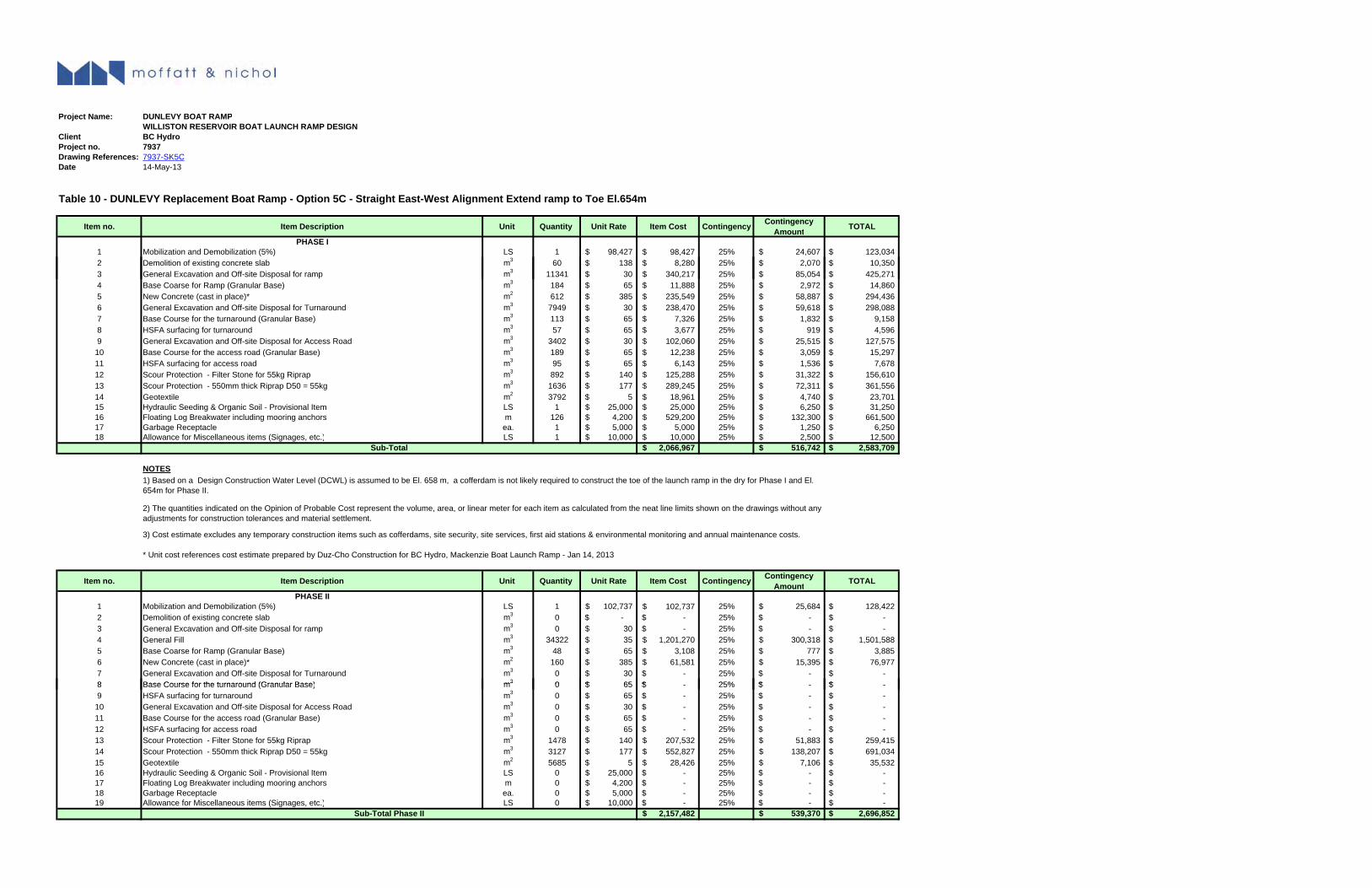
K-5
Project Name: DUNLEVY BOAT RAMPWILLISTON RESERVOIR BOAT LAUNCH RAMP DESIGN
Client BC HydroProject no. 7937Drawing References: 7937-SK5CDate 14-May-13
Table 10 - DUNLEVY Replacement Boat Ramp - Option 5C - Straight East-West Alignment Extend ramp to Toe El.654m
Item no. Item Description Unit Quantity Unit Rate Item Cost Contingency Contingency Amount TOTAL
PHASE I1 Mobilization and Demobilization (5%) LS 1 98,427$ 98,427$ 25% 24,607$ 123,034$ 2 Demolition of existing concrete slab m3 60 138$ 8,280$ 25% 2,070$ 10,350$
3g
3 General Excavation and Off-site Disposal for ramp m3 11341 30$ 340,217$ 25% 85,054$ 425,271$ 4 Base Coarse for Ramp (Granular Base) m3 184 65$ 11,888$ 25% 2,972$ 14,860$ 5 New Concrete (cast in place)* m2 612 385$ 235,549$ 25% 58,887$ 294,436$ 6 General Excavation and Off-site Disposal for Turnaround m3 7949 30$ 238,470$ 25% 59,618$ 298,088$ 7 Base Course for the turnaround (Granular Base) m3 113 65$ 7,326$ 25% 1,832$ 9,158$ 8 HSFA surfacing for turnaround m3 57 65$ 3,677$ 25% 919$ 4,596$ 9 General Excavation and Off-site Disposal for Access Road m3 3402 30$ 102,060$ 25% 25,515$ 127,575$
10 Base Course for the access road (Granular Base) m3 189 65$ 12,238$ 25% 3,059$ 15,297$ 11 HSFA surfacing for access road m3 95 65$ 6,143$ 25% 1,536$ 7,678$ 12 Scour Protection - Filter Stone for 55kg Riprap m3 892 140$ 125,288$ 25% 31,322$ 156,610$ 13 Scour Protection - 550mm thick Riprap D50 = 55kg m3 1636 177$ 289,245$ 25% 72,311$ 361,556$ 14 Geotextile m2 3792 5$ 18,961$ 25% 4,740$ 23,701$ 15 Hydraulic Seeding & Organic Soil - Provisional Item LS 1 25,000$ 25,000$ 25% 6,250$ 31,250$ 16 Floating Log Breakwater including mooring anchors m 126 4,200$ 529,200$ 25% 132,300$ 661,500$ 17 Garbage Receptacle ea. 1 5,000$ 5,000$ 25% 1,250$ 6,250$ 18 Allowance for Miscellaneous items (Signages, etc.) LS 1 10,000$ 10,000$ 25% 2,500$ 12,500$
2,066,967$ 516,742$ 2,583,709$
NOTES
Sub-Total
* Unit cost references cost estimate prepared by Duz-Cho Construction for BC Hydro, Mackenzie Boat Launch Ramp - Jan 14, 2013
Item no. Item Description Unit Quantity Unit Rate Item Cost Contingency Contingency Amount TOTAL
PHASE II1 Mobilization and Demobilization (5%) LS 1 102,737$ 102,737$ 25% 25,684$ 128,422$ 2 Demolition of existing concrete slab m3 0 -$ -$ 25% -$ -$ 3 General Excavation and Off-site Disposal for ramp m3 0 30$ -$ 25% -$ -$ 4 General Fill m3 34322 35$ 1,201,270$ 25% 300,318$ 1,501,588$ 5 Base Coarse for Ramp (Granular Base) m3 48 65$ 3,108$ 25% 777$ 3,885$ 6 New Concrete (cast in place)* m2 160 385$ 61,581$ 25% 15,395$ 76,977$ 7 General Excavation and Off-site Disposal for Turnaround m3 0 30$ -$ 25% -$ -$ 8 Base Course for the turnaround (Granular Base) m3 0 65$ $ 25% $ $
1) Based on a Design Construction Water Level (DCWL) is assumed to be El. 658 m, a cofferdam is not likely required to construct the toe of the launch ramp in the dry for Phase I and El. 654m for Phase II.
2) The quantities indicated on the Opinion of Probable Cost represent the volume, area, or linear meter for each item as calculated from the neat line limits shown on the drawings without any adjustments for construction tolerances and material settlement.
3) Cost estimate excludes any temporary construction items such as cofferdams, site security, site services, first aid stations & environmental monitoring and annual maintenance costs.
8 Base Course for the turnaround (Granular Base) m3 0 65$ -$ 25% -$ -$ 9 HSFA surfacing for turnaround m3 0 65$ -$ 25% -$ -$
10 General Excavation and Off-site Disposal for Access Road m3 0 30$ -$ 25% -$ -$ 11 Base Course for the access road (Granular Base) m3 0 65$ -$ 25% -$ -$ 12 HSFA surfacing for access road m3 0 65$ -$ 25% -$ -$ 13 Scour Protection - Filter Stone for 55kg Riprap m3 1478 140$ 207,532$ 25% 51,883$ 259,415$ 14 Scour Protection - 550mm thick Riprap D50 = 55kg m3 3127 177$ 552,827$ 25% 138,207$ 691,034$ 15 Geotextile m2 5685 5$ 28,426$ 25% 7,106$ 35,532$ 16 Hydraulic Seeding & Organic Soil - Provisional Item LS 0 25,000$ -$ 25% -$ -$ 17 Floating Log Breakwater including mooring anchors m 0 4,200$ -$ 25% -$ -$ 18 Garbage Receptacle ea. 0 5,000$ -$ 25% -$ -$ 19 Allowance for Miscellaneous items (Signages, etc.) LS 0 10,000$ -$ 25% -$ -$
2,157,482$ 539,370$ 2,696,852$ Sub-Total Phase II
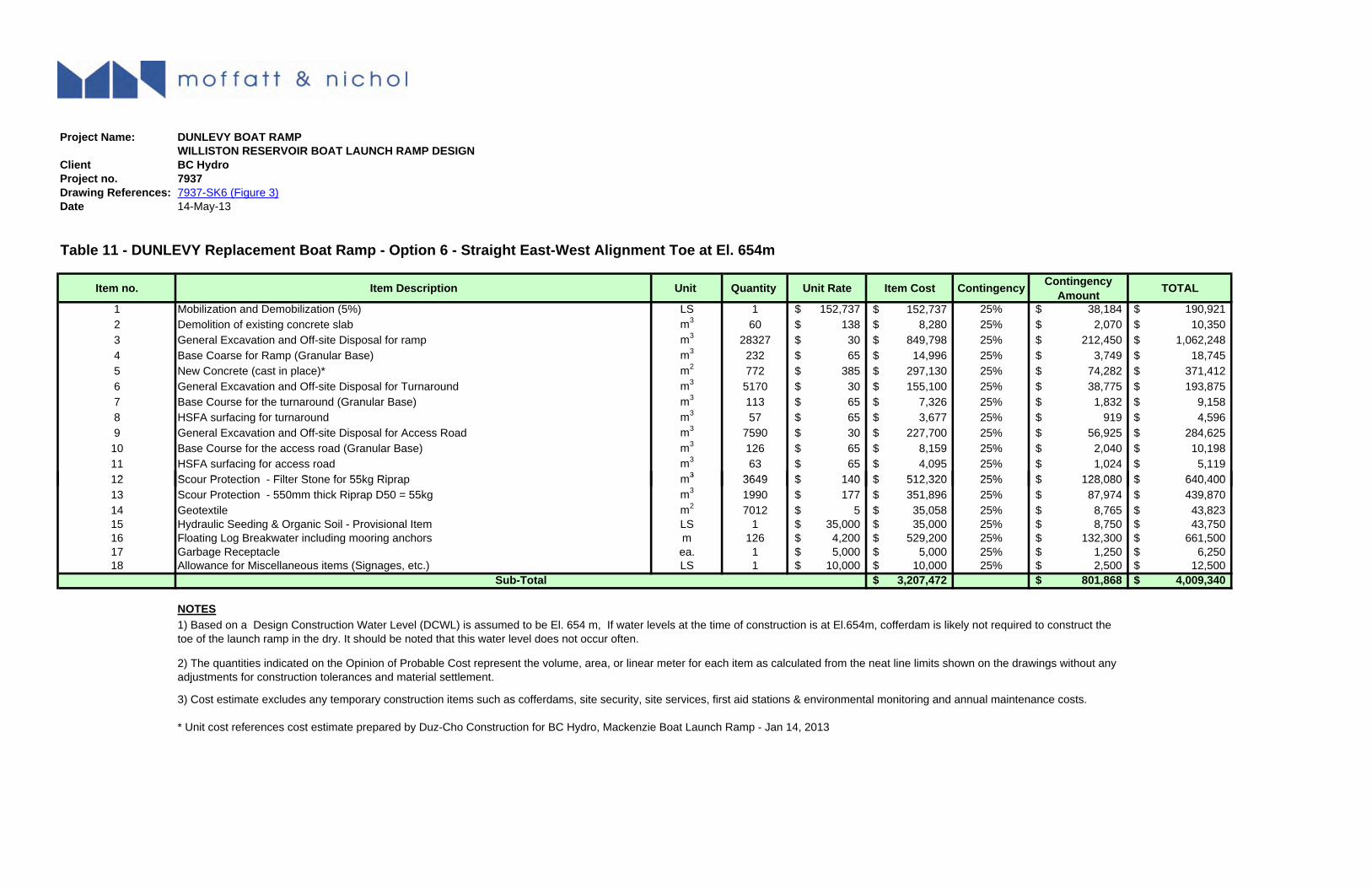
K-5
Project Name: DUNLEVY BOAT RAMPWILLISTON RESERVOIR BOAT LAUNCH RAMP DESIGN
Client BC HydroProject no. 7937Drawing References: 7937-SK6 (Figure 3)Date 14-May-13
Table 11 - DUNLEVY Replacement Boat Ramp - Option 6 - Straight East-West Alignment Toe at El. 654m
Item no. Item Description Unit Quantity Unit Rate Item Cost Contingency Contingency Amount TOTAL
1 Mobilization and Demobilization (5%) LS 1 152,737$ 152,737$ 25% 38,184$ 190,921$ 2 Demolition of existing concrete slab m3 60 138$ 8,280$ 25% 2,070$ 10,350$ 3 General Excavation and Off-site Disposal for ramp m3 28327 30$ 849,798$ 25% 212,450$ 1,062,248$ 4 Base Coarse for Ramp (Granular Base) m3 232 65$ 14,996$ 25% 3,749$ 18,745$ 5 New Concrete (cast in place)* m2 772 385$ 297,130$ 25% 74,282$ 371,412$ 6 General Excavation and Off-site Disposal for Turnaround m3 5170 30$ 155,100$ 25% 38,775$ 193,875$ 7 Base Course for the turnaround (Granular Base) m3 113 65$ 7,326$ 25% 1,832$ 9,158$ 8 HSFA surfacing for turnaround m3 57 65$ 3,677$ 25% 919$ 4,596$ 9 General Excavation and Off-site Disposal for Access Road m3 7590 30$ 227,700$ 25% 56,925$ 284,625$ 10 Base Course for the access road (Granular Base) m3 126 65$ 8,159$ 25% 2,040$ 10,198$ 11 HSFA surfacing for access road m3 63 65$ 4,095$ 25% 1,024$ 5,119$ 12 S P t ti Filt St f 55k Ri 3 3649 140$ 512 320$ 25% 128 080$ 640 400$12 Scour Protection - Filter Stone for 55kg Riprap m3 3649 140$ 512,320$ 25% 128,080$ 640,400$ 13 Scour Protection - 550mm thick Riprap D50 = 55kg m3 1990 177$ 351,896$ 25% 87,974$ 439,870$ 14 Geotextile m2 7012 5$ 35,058$ 25% 8,765$ 43,823$ 15 Hydraulic Seeding & Organic Soil - Provisional Item LS 1 35,000$ 35,000$ 25% 8,750$ 43,750$ 16 Floating Log Breakwater including mooring anchors m 126 4,200$ 529,200$ 25% 132,300$ 661,500$ 17 Garbage Receptacle ea. 1 5,000$ 5,000$ 25% 1,250$ 6,250$ 18 Allowance for Miscellaneous items (Signages, etc.) LS 1 10,000$ 10,000$ 25% 2,500$ 12,500$
3,207,472$ 801,868$ 4,009,340$
NOTES
Sub-Total
1) Based on a Design Construction Water Level (DCWL) is assumed to be El. 654 m, If water levels at the time of construction is at El.654m, cofferdam is likely not required to construct the toe of the launch ramp in the dry. It should be noted that this water level does not occur often.
2) The quantities indicated on the Opinion of Probable Cost represent the volume, area, or linear meter for each item as calculated from the neat line limits shown on the drawings without any adjustments for construction tolerances and material settlement.
* Unit cost references cost estimate prepared by Duz-Cho Construction for BC Hydro, Mackenzie Boat Launch Ramp - Jan 14, 2013
j
3) Cost estimate excludes any temporary construction items such as cofferdams, site security, site services, first aid stations & environmental monitoring and annual maintenance costs.
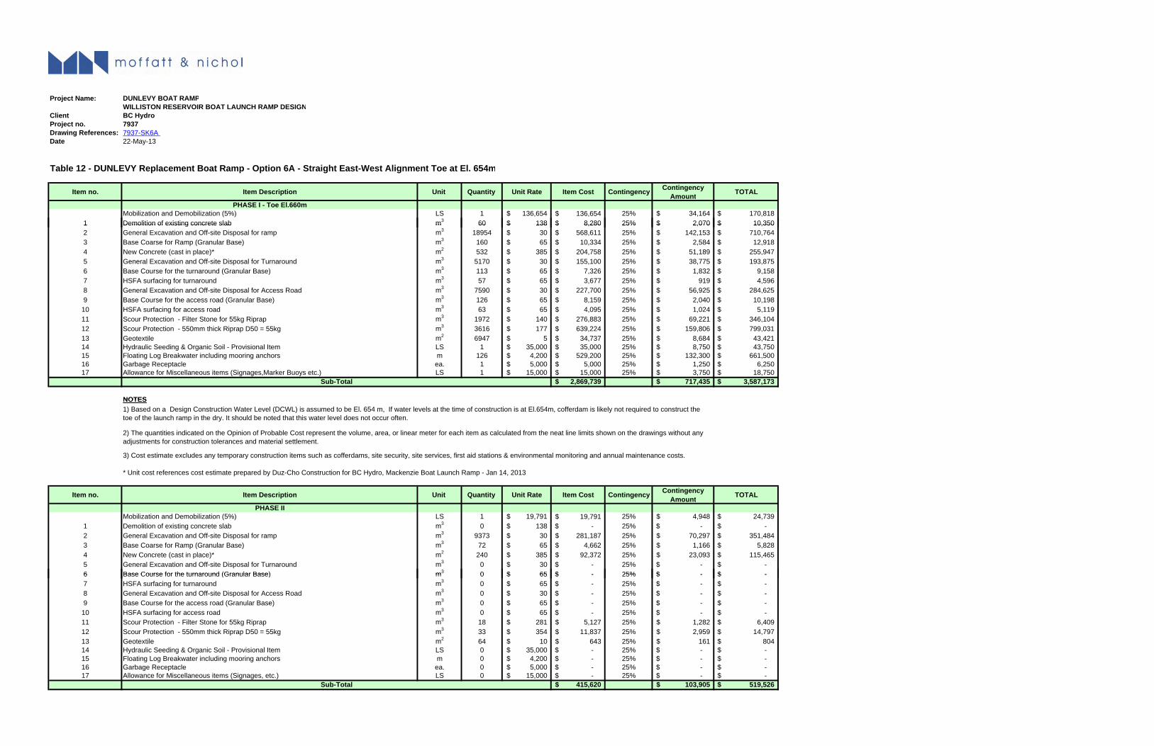
K-5
Project Name: DUNLEVY BOAT RAMPWILLISTON RESERVOIR BOAT LAUNCH RAMP DESIGN
Client BC HydroProject no. 7937Drawing References: 7937-SK6A Date 22-May-13
Table 12 - DUNLEVY Replacement Boat Ramp - Option 6A - Straight East-West Alignment Toe at El. 654m
Item no. Item Description Unit Quantity Unit Rate Item Cost Contingency Contingency Amount TOTAL
PHASE I - Toe El.660mMobilization and Demobilization (5%) LS 1 136,654$ 136,654$ 25% 34,164$ 170,818$
1 Demolition of existing concrete slab m3 60 138$ 8,280$ 25% 2,070$ 10,350$ 1 Demolition of existing concrete slab m 60 138$ 8,280$ 25% 2,070$ 10,350$ 2 General Excavation and Off-site Disposal for ramp m3 18954 30$ 568,611$ 25% 142,153$ 710,764$ 3 Base Coarse for Ramp (Granular Base) m3 160 65$ 10,334$ 25% 2,584$ 12,918$ 4 New Concrete (cast in place)* m2 532 385$ 204,758$ 25% 51,189$ 255,947$ 5 General Excavation and Off-site Disposal for Turnaround m3 5170 30$ 155,100$ 25% 38,775$ 193,875$ 6 Base Course for the turnaround (Granular Base) m3 113 65$ 7,326$ 25% 1,832$ 9,158$ 7 HSFA surfacing for turnaround m3 57 65$ 3,677$ 25% 919$ 4,596$ 8 General Excavation and Off-site Disposal for Access Road m3 7590 30$ 227,700$ 25% 56,925$ 284,625$ 9 Base Course for the access road (Granular Base) m3 126 65$ 8,159$ 25% 2,040$ 10,198$
10 HSFA surfacing for access road m3 63 65$ 4,095$ 25% 1,024$ 5,119$ 11 Scour Protection - Filter Stone for 55kg Riprap m3 1972 140$ 276,883$ 25% 69,221$ 346,104$ 12 Scour Protection - 550mm thick Riprap D50 = 55kg m3 3616 177$ 639,224$ 25% 159,806$ 799,031$ 13 Geotextile m2 6947 5$ 34,737$ 25% 8,684$ 43,421$ 14 Hydraulic Seeding & Organic Soil - Provisional Item LS 1 35,000$ 35,000$ 25% 8,750$ 43,750$ 15 Floating Log Breakwater including mooring anchors m 126 4,200$ 529,200$ 25% 132,300$ 661,500$ 16 Garbage Receptacle ea. 1 5,000$ 5,000$ 25% 1,250$ 6,250$ 17 Allowance for Miscellaneous items (Signages,Marker Buoys etc.) LS 1 15,000$ 15,000$ 25% 3,750$ 18,750$
2,869,739$ 717,435$ 3,587,173$
NOTES
Sub-Total
NOTES
* Unit cost references cost estimate prepared by Duz-Cho Construction for BC Hydro, Mackenzie Boat Launch Ramp - Jan 14, 2013
Item no. Item Description Unit Quantity Unit Rate Item Cost Contingency Contingency Amount TOTAL
PHASE IIMobilization and Demobilization (5%) LS 1 19,791$ 19,791$ 25% 4,948$ 24,739$
1 Demolition of existing concrete slab m3 0 138$ -$ 25% -$ -$ 2 General Excavation and Off-site Disposal for ramp m3 9373 30$ 281,187$ 25% 70,297$ 351,484$ 3 Base Coarse for Ramp (Granular Base) m3 72 65$ 4,662$ 25% 1,166$ 5,828$ 4 New Concrete (cast in place)* m2 240 385$ 92,372$ 25% 23,093$ 115,465$ 5 General Excavation and Off-site Disposal for Turnaround m3 0 30$ -$ 25% -$ -$ 6 Base Course for the turnaround (Granular Base) m3 0 65$ -$ 25% -$ -$
1) Based on a Design Construction Water Level (DCWL) is assumed to be El. 654 m, If water levels at the time of construction is at El.654m, cofferdam is likely not required to construct the toe of the launch ramp in the dry. It should be noted that this water level does not occur often.
2) The quantities indicated on the Opinion of Probable Cost represent the volume, area, or linear meter for each item as calculated from the neat line limits shown on the drawings without any adjustments for construction tolerances and material settlement.
3) Cost estimate excludes any temporary construction items such as cofferdams, site security, site services, first aid stations & environmental monitoring and annual maintenance costs.
6 Base Course for the turnaround (Granular Base) m 0 65$ -$ 25% -$ -$ 7 HSFA surfacing for turnaround m3 0 65$ -$ 25% -$ -$ 8 General Excavation and Off-site Disposal for Access Road m3 0 30$ -$ 25% -$ -$ 9 Base Course for the access road (Granular Base) m3 0 65$ -$ 25% -$ -$
10 HSFA surfacing for access road m3 0 65$ -$ 25% -$ -$ 11 Scour Protection - Filter Stone for 55kg Riprap m3 18 281$ 5,127$ 25% 1,282$ 6,409$ 12 Scour Protection - 550mm thick Riprap D50 = 55kg m3 33 354$ 11,837$ 25% 2,959$ 14,797$ 13 Geotextile m2 64 10$ 643$ 25% 161$ 804$ 14 Hydraulic Seeding & Organic Soil - Provisional Item LS 0 35,000$ -$ 25% -$ -$ 15 Floating Log Breakwater including mooring anchors m 0 4,200$ -$ 25% -$ -$ 16 Garbage Receptacle ea. 0 5,000$ -$ 25% -$ -$ 17 Allowance for Miscellaneous items (Signages, etc.) LS 0 15,000$ -$ 25% -$ -$
415,620$ 103,905$ 519,526$ Sub-Total
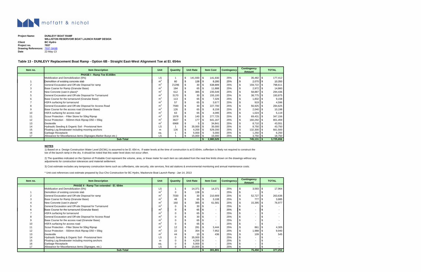
K-5
Project Name: DUNLEVY BOAT RAMPWILLISTON RESERVOIR BOAT LAUNCH RAMP DESIGN
Client BC HydroProject no. 7937Drawing References: 7937-SK6BDate 22-May-13
Table 13 - DUNLEVY Replacement Boat Ramp - Option 6B - Straight East-West Alignment Toe at El. 654m
Item no. Item Description Unit Quantity Unit Rate Item Cost Contingency Contingency Amount TOTAL
PHASE I - Ramp Toe El.658mMobilization and Demobilization (5%) LS 1 141,930$ 141,930$ 25% 35,482$ 177,412$
1 Demolition of existing concrete slab m3 60 138$ 8,280$ 25% 2,070$ 10,350$ 1 Demolition of existing concrete slab m 60 138$ 8,280$ 25% 2,070$ 10,350$ 2 General Excavation and Off-site Disposal for ramp m3 21296 30$ 638,889$ 25% 159,722$ 798,611$ 3 Base Coarse for Ramp (Granular Base) m3 184 65$ 11,888$ 25% 2,972$ 14,860$ 4 New Concrete (cast in place)* m2 612 385$ 235,549$ 25% 58,887$ 294,436$ 5 General Excavation and Off-site Disposal for Turnaround m3 5170 30$ 155,100$ 25% 38,775$ 193,875$ 6 Base Course for the turnaround (Granular Base) m3 113 65$ 7,326$ 25% 1,832$ 9,158$ 7 HSFA surfacing for turnaround m3 57 65$ 3,677$ 25% 919$ 4,596$ 8 General Excavation and Off-site Disposal for Access Road m3 7590 30$ 227,700$ 25% 56,925$ 284,625$ 9 Base Course for the access road (Granular Base) m3 126 65$ 8,159$ 25% 2,040$ 10,198$
10 HSFA surfacing for access road m3 63 65$ 4,095$ 25% 1,024$ 5,119$ 11 Scour Protection - Filter Stone for 55kg Riprap m3 1978 140$ 277,725$ 25% 69,431$ 347,156$ 12 Scour Protection - 550mm thick Riprap D50 = 55kg m3 3627 177$ 641,167$ 25% 160,292$ 801,459$ 13 Geotextile m2 6968 5$ 34,841$ 25% 8,710$ 43,551$ 14 Hydraulic Seeding & Organic Soil - Provisional Item LS 1 35,000$ 35,000$ 25% 8,750$ 43,750$ 15 Floating Log Breakwater including mooring anchors m 126 4,200$ 529,200$ 25% 132,300$ 661,500$ 16 Garbage Receptacle ea. 1 5,000$ 5,000$ 25% 1,250$ 6,250$ 17 Allowance for Miscellaneous items (Signages,Marker Buoys etc.) LS 1 15,000$ 15,000$ 25% 3,750$ 18,750$
2,980,525$ 745,131$ 3,725,656$
NOTES
Sub-Total
NOTES
* Unit cost references cost estimate prepared by Duz-Cho Construction for BC Hydro, Mackenzie Boat Launch Ramp - Jan 14, 2013
Item no. Item Description Unit Quantity Unit Rate Item Cost Contingency Contingency Amount TOTAL
PHASE II - Ramp Toe extended - El. 654mMobilization and Demobilization (5%) LS 1 14,371$ 14,371$ 25% 3,593$ 17,964$
1 Demolition of existing concrete slab m3 0 138$ -$ 25% -$ -$ 2 General Excavation and Off-site Disposal for ramp m3 7030 30$ 210,909$ 25% 52,727$ 263,636$ 3 Base Coarse for Ramp (Granular Base) m3 48 65$ 3,108$ 25% 777$ 3,885$ 4 New Concrete (cast in place)* m2 160 385$ 61,581$ 25% 15,395$ 76,977$ 5 General Excavation and Off-site Disposal for Turnaround m3 0 30$ -$ 25% -$ -$ 6 Base Course for the turnaround (Granular Base) m3 0 65$ $ 25% $ $
3) Cost estimate excludes any temporary construction items such as cofferdams, site security, site services, first aid stations & environmental monitoring and annual maintenance costs.
1) Based on a Design Construction Water Level (DCWL) is assumed to be El. 654 m, If water levels at the time of construction is at El.654m, cofferdam is likely not required to construct the toe of the launch ramp in the dry. It should be noted that this water level does not occur often.
2) The quantities indicated on the Opinion of Probable Cost represent the volume, area, or linear meter for each item as calculated from the neat line limits shown on the drawings without any adjustments for construction tolerances and material settlement.
6 Base Course for the turnaround (Granular Base) m3 0 65$ -$ 25% -$ -$ 7 HSFA surfacing for turnaround m3 0 65$ -$ 25% -$ -$ 8 General Excavation and Off-site Disposal for Access Road m3 0 30$ -$ 25% -$ -$ 9 Base Course for the access road (Granular Base) m3 0 65$ -$ 25% -$ -$
10 HSFA surfacing for access road m3 0 65$ -$ 25% -$ -$ 11 Scour Protection - Filter Stone for 55kg Riprap m3 12 281$ 3,444$ 25% 861$ 4,305$ 12 Scour Protection - 550mm thick Riprap D50 = 55kg m3 22 354$ 7,952$ 25% 1,988$ 9,940$ 13 Geotextile m2 44 10$ 436$ 25% 109$ 545$ 14 Hydraulic Seeding & Organic Soil - Provisional Item LS 0 35,000$ -$ 25% -$ -$ 15 Floating Log Breakwater including mooring anchors m 0 4,200$ -$ 25% -$ -$ 16 Garbage Receptacle ea. 0 5,000$ -$ 25% -$ -$ 17 Allowance for Miscellaneous items (Signages, etc.) LS 0 15,000$ -$ 25% -$ -$
301,801$ 75,450$ 377,252$ Sub-Total