Embed Size (px)
Citation preview
DRYLAND HUSBANDRY IN THE SUDAN
Grassroots Experience and Development
Edited by
Muna M. M. Ahmed Mohamed Fadl Elmoula Idris
Tegegne Teka
Dryland Husbandry Project (DHP) Sudan
Organisation for Social Science
Research in Eastern and Southern Africa
University of Khartoum Khartoum, Sudan
Addis Ababa, Ethiopia 2004
© 2004 Dryland Husbandry Project (DHP) Organisation for Social Science Research in Eastern and Southern Africa (OSSREA) and University of Khartoum All Rights Reserved. Published 2004 Printed in Ethiopia ISBN 1904855431 Organisation for Social Science Research in Eastern and Southern Africa (OSSREA) P.O.Box 31971, Addis Ababa, Ethiopia E-mail: [email protected] [email protected]
http://www.ossrea.net University of Khartoum P. O. Box 321 Khartoum Sudan Cover Photograph from DHP Sudan Typesetting: Selamawit Getachew Text layout: Alemtsehay Zewde The Dryland Husbandry Project (OSSREA) acknowledges the support of the Swedish International Development Co-operation Agency (Sida/SAREC).
Contents List of Tables, Figures, Maps and Plates ………………... iv
Acronyms and Abbreviations …………………………… vi
Team Members of the Project …………………………... vii
Acknowledgements …………………………………….. ix
Preface …………………………………………………... xi
Chapter One 1
Introduction ……………………………………….…….. 1
Chapter Two …………………………………………… 8
Methods of Project Implementation – pre-
implementation, projection and post-implementation …... 8
Chapter Three ……………………………………. 21
Project Description – environmental and socio-economic
profiles and indigenous knowledge ……………………... 21
Chapter Four …………………………………………… 58
Project Activities ………………………………………... 58
Chapter Five …………………………………………… 82
Gender Issues – training, livestock and income
generating activities …………………………………….. 82
Chapter Six …………………………………………….. 91
Project results, lessons learned, conclusions and recommendations ……………………………………….. 91
References ………………………………………………. 100
Appendix I ……………………………………………… 104
Scientific Documents and Reports by DHP Sudan ……………. 104
Appendix II ………………………………………….……….... 105
Local Components ……………………………………………. 105
List of Tables
Table 2.1 Master checklist of evaluating parameters …………….….. 16
Table 3.1 Normal climatological data of Kassala State for 30 Years
(1967-1997) …………………………………………………. 23
Table 3.2 Mean monthly Climatic data of Kassala State (1996-1998) 24
Table 3.3 Terrain units and associated vegetation of Kassala State …… 33
Table 3.4 Mesquit spread along river Gash during the period 1962-1996 ……………………………………………………….… 34
Table 3.5 Estimates of areas and standing woody biomass in Kassala State (1989)…………………………………………. 35
Table 3.6 The annual flow of water courses and river of Kassala State (In million cubic meters)…………………………………….. 38
Table 3.7 Name of each ina and its date and duration ……………….… 52
Table 4.1 Livestock population, Kassala State ………………………… 69
Table 4.2 Number of training courses financed by DHP ……………. 71
Table 4.3 Range management training ………………………………… 75
Table 4.4 Vegetation biomass determination form ………………….. 77
Table 6.1 Summary of local inputs (in kind and cash) / estimate …… 108
List of Figures and Maps
Figure 2.1 Five steps procedure (flow chart of the framework) ………. 15
Figure 2.2 The concept of value function ………………………………. 18
Map 3.1 Locality of Kassala State ……………………………………. 25
Map 3.2 Environmental degradation and desertification in Kassala State ………………………………………………………… 29
Map 3.3 Vegetation and land use …………………………………….. 32
Map 3.4 Main water courses, Kassala State ……………………….…. 37
Map 3.5 Terrain units of the Kassala State …………………………… 41
Map 3.6 The major ethnic nomads of Kassala State …………………. 45
Map 3.7 Pastoral nomadism and livestock routes in Kassala State …... 46
List of Plates
Plate 1 Sensitisation, awareness raising and dialogue session ……….. 7
Plate 2 Awareness raising for formal leaders ……………………….. 7

Plate 3 Construction of crescent-shaped terraces (May 2003) ……… 60
Plate 4 Community participation in range reseeding ……………….. 60
Plate 5 Reseeded Malawia enclosure (December, 2003) ………….. 61
Plate 6 Standing hay crop of indigenous plant-Malawia enclosure (December, 2003) …………………………………………… 61
Plate 7 Seeds collection Malawia enclosure (December, 2003) ……. 62
Plate 8 Dry Grateit water basin-siltation and bush encroachment 64
Plate 9 Grateit water basin after silt removal, bush eradication, Floor grading (full of water) ………………………………… 64
Plate 10 Pulling water from deep hand-dug wells by animals, before DHP intervention (embankment and basin floor grading) ….. 65
Plate 11 Consolidated water-basin embankment by the pastoralists Resulted in holding enough run-off water …………………...
65
Plate 12 Digging the Hafir floor ……………………………………… 66
Plate 13 Compacting Hafir floor …………………………………… 66
Plate 14 Three-stones traditional stoves ……………………………… 86
Plate 15 Improved stoves developed by DHP ………………………... 87
Plate 16 Female paravets during practical training ………………… 87
Plate 17 Milk collection for processing ……………………………… 89
Plate 18 Milk products processing laboratory ………………………... 89
Plate 19 Milk products (cheese and yoghurt) ………………………… 90
Plate 20 Pastoralists during Mesquite eradication campaign (Manual control) …………………………………………….. 93
vi
Acronyms and Abbreviations
AU Animal Unit = 500 kg
DHP Dryland Husbandry Project
FAO Food and Agricultural Organization
FED Feddan = 0.42 hectare
FNC Forestry National Cooperation
GDAC Gash Delta Agricultural Cooperation
GIS Geographic Information System
EPOS Environmental Policy and Society
IGAD Intergovernmental Authority on Drought and Development
IES Institute of Environmental Studies, University of Khartoum
ILO International Labour Organization
NGO Non-governmental Organization
OSSREA Organisation for Social Science Research in Eastern and
Southern Africa
PARC Pan African Rinderpest Campaign
RPA Range and Management Administration
SWC Soil and Water Conservation
TLU Tropical Livestock Unit = 250 kg = 1 zeb
UNHCR United Nations High Commission for Refugees
UNEP United Nations Environmental Programme
UNDP United Nations Development Programme

vii Team Members of the Project
The team members of the Dryland Husbandry Project - Sudan (DHP-Sudan)
who worked with pastoralists and agro-pastoralists since the
implementation of the project are:
Members of the National Steering Committee (NSC): Khartoum
Professor Hashim Mohamed El Hadi, Chairman (NSC)
Professor Yousif Abu Gedeiri, National Co-ordinator, 1995-2000
Dr. Hashim El Atta, National Co-ordinator, 2000-2003
Prof. Muna Mahjoub Ahmed, National Co-ordinator, 2003-
Mr. Mohamed Fadel Elmula Idris, Project Manager
Prof. Babiker Abbass, Faculty of Vet. Medicine, 1995-1999
Prof. Dafalla Ibrahim, Camel Research Centre
Mr. Ali Darag, Range Expert, 1995-1999
Mr. Mohamed El Amin Abdel Rahman, Range and Pasture Admin.
Mrs. Fathia Salih, NGO
Dr. Yagoub Abdalla, Social Scientist
Dr. Mustafa Babiker, Social Scientist, 1995-1999
Dr. Adam Drosa, Pastoralists Union, 1995-1999 Members of the Field Management Committee- Kassala
Mr. Abdalla A. Sharief, Director of Agriculture - Chair Person
Mr. Fathelrahman A. Mohamed, Director of Range and pasture
Administration. Member/ Anchor for implementation of Range
Improvement and Water Management
Dr. Mustafa Mohamed Ali, Director of Animal Resources Administration.
Member and Anchor for the conduct of paravet training
Mr. Bakri Babiker, Pastoralists' Union Representative, Member
Mr. Idris Shalal, Beni Amir tribe representative /member
viii
Mr. Ahmed Hameid, Rashaida tribe representative/member
Mr. Nair Tahir Onour, Hadendawa tribe representative/member
Ms. Aziza Abdalla Mohamed, women representative/ member
Mrs. Salwa M. Abdalla, NGO representative /member
Mr. Mohamed Fadl Emoula, DHP Manager /member
Range, Water and Gender Committees
Composed of 10 members at the project site
The grassroots at the implementation site
The project vehicle driver

ix
Acknowledgements
The National Steering Committee (NSC) of the Dryland Husbandry Project
(DHP) - Sudan would like to acknowledge with warm gratitude the
financial support of the Swedish International Development Corporation
Agency (Sida/SAREC). Our sincere thanks go to OSSREA for the regional
co-ordination and to Prof. Abdel Ghaffar Mohamed Ahmed, the Executive
Secretary for his encouragement and support.
Our warm thanks are extended to Dr. Tegegne Teka, the regional DHP
coordinator for his supervision, keen interest, close follow-up and his great
enthusiasm on the project. We are grateful to Prof. Mohamed Salih whose
valuable comments and contributions were very helpful at the beginning of
the project. We also note the contributions of the Ministry of Planning,
IGAD desk.
We recognise the support and interest of the University of Khartoum in
the Dryland Husbandry Project (DHP) and allowed the Institute of
Environmental Studies (IES) to serve as a focal institution for the project.
Our appreciation and thanks go to Prof. Yousif Abu Gideiri, Director of
IES, who became the first National Co-ordinator of DHP. He gave the
project great and sound start and strong strides using his vast expertise. Our
appreciation also goes to his successor, Prof. Hashim Al Atta and the
present Director of IES, Prof. Muna Mahjoub Ahmed. Prof. Ahmed besides
her contribution in the gender issue served as a resource person in the
project. She took great interest and provided leadership to DHP Sudan as
the National Co-ordinator. She supervised the project and witnessed its
finalisation. We thank all academic staff and members of IES for their help,
acceptability, hospitality and all the efforts rendered to the National
Steering Committee and the project.
We thank and appreciate the Range and Pasture Administration
(Ministry of Agriculture) and its staff in Khartoum and Kassala, Faculty of
Veterinary Medicine and the Camel Research Centre (UoK), Pastoralists
Union and all the NGOs that contributed to the project. Thanks are also
extended to Kassala State Governor ('Wali') and to the State Ministries

x
especially the Minister of Agriculture, Animal Resources and Irrigation and
to its ministers: Prof. El Amin Daffalla and his successor Dr. Babikir
Abdalla for their valuable help and facilitation. Many thanks to the
Department of Animal Resources, Kassala for running the Community
Animal Health Workers or Paravet training.
Our appreciation goes to the members of the Field Management
Committee in Kassala for their great efforts at the field level in enhancing
awareness, empowerment and follow-up. Our warm and sincere thanks are
extended to Mr. Mohamed Fadel El Mula, the manager of the project for his
patience, keen interest, close follow-up and wide knowledge in range
science and management that contributed greatly to the execution and
success of the project. We are deeply indebted to the countless persons who
helped in different ways in the implementation of the activities of the
project.

xi
Preface
Sudan is the largest country in Africa and two third of the landmass is arid or
semi desert. Pastoralists and agro-pastoralists in the drylands have been
affected by drought and famine. Not only natural disasters but also lack of
proper policies have contributed to the increasing rate of poverty and
impoverishment in the rural areas. Desertification is on the increase, the
rangeland resources have been depleting and livestock production has faced
limitations. Like other countries in the region, we must put more efforts along
with people in the drylands to create a more suitable environment for humans,
animals and plants in the Sudan. For the drylands to regenerate, among other
things, focus has to be on soil conservation, rangeland improvement, water
management and pasture.
The Dryland Husbandry Project (DHP) in the Sudan wanted to work in the
drylands on priorities set out by people at the grassroots. It initiated the project
in a bottom up approach. DHP Sudan was co-ordinated by the Organisation for
Social Science Research in Eastern and Southern Africa (OSSREA). The
Swedish International Development co-operation Agency, Sida SAREC
financed the project. DHP Sudan was initiated in 1995 and properly launched in
1996. It ended in 2003.
DHP Sudan aimed at involving pastoralists in the management and
conservation to renew their natural resources through a bottom up approach.
The project also wanted to improve rangelands, animal production and to carry
out action-oriented research. The project also aimed at raising the awareness of
pastoralists. It wanted to promote and engage indigenous knowledge of
pastoralists in development and capacity building. Its other objective was
strengthening the pastoral women’s role and involvement in the management of
their environment and by improving the livelihood of the pastoralists.
The activities of DHP Sudan and that of the Government supported each
other. The project also worked and co-operated with NGOs. It involved
researchers, extension agents and the local community in its attempt to bring
about change in the dryland areas.
This book therefore contains the activities that were implemented together
with pastoralists and agro-pastoralists at the grassroots in Kassala State in

xii
eastern Sudan. Chapter one deals with project interventions in extension work,
trial-based action-oriented research, gender-based activities and policy
dialogue. The second chapter is on project pre-implementation preparations
such as data collection, workshops, interviews and PRA discussions. The
participation of pastoralists in range improvement and water management was
considered. Indigenous knowledge and ethno-veterinary were looked at along
with the conduct of proper surveys, interviews, and collection of documents.
The Ministry of Agriculture also thought of post project considerations in the
project area.
Chapter three explains Kassala State where the project was implemented.
The environmental profile included the climate, hydrology, the natural
vegetation, the semi natural vegetation (man-made), and land use systems. The
social-economic profile includes population, the pastoral communities, the
livestock population, and husbandry practices. Chapter four deals with
activities of rangeland improvement and water management, the two most
important elements in the project. The range personnel carried out training of
pastoralists. These are capacity building interventions that gained acceptance
by the pastoralists and agro-pastoralists and their local leaders. Chapter five
covers gender issues and the socio-economic research among the Rashaida
pastoralist women in livestock production. The last chapter deals with the
achievements of the project and the lessons learned. It raises issues of the
adoption of bottom-up approach, field research that employed extension
methodology, implementation of action-oriented and participatory activities.
We hope that the results and the outcomes of the project will contribute to the
improvement of rangelands, water harvesting and animal resources and will
benefit the pastoralists and agro-pastoralists in Kassala State in particular and
the Sudan in general.
Tegegne Teka Regional Project Co-ordinator OSSREA
CHAPTER ONE DRYLAND HUSBANDRY IN THE SUDAN Muna M.M. Ahmed Mohammed Fadl Elmula Idris Tegegne Teka
1.1 Introduction Sudan is the largest IGAD Member State, with a land area of approximately 2.5 million square km. Its population is approx. 30 million, 75% of whom live in rural areas. The economy depends predominantly on agriculture, which contributes about 30% of the GDP.
Two thirds of the area of the Sudan is arid or in semi-desert zone. Recurrent droughts have rendered many pastoralists and small cultivators in the drylands vulnerable to famine and impoverishment. However, the causes of the present crisis in the rural production systems in the country cannot be attributed to drought and desertification alone. Misguided economic policies have played an important role in the deteriorating situation of the population in the drylands.
Breaking this vicious circle of ecological stress and increasing vulnerability of the populations of the drylands requires an increased production from small-scale cultivation and livestock husbandry. Training and research must facilitate re-oriented development planning that allows for dialogue among local communities, researchers, extensionists, planners, and decision-makers.
One of the major problems of livestock production in the Sudan is the deterioration of its rangeland resources. Several factors have contributed to this problem, including over-grazing and the expansion of large-scale mechanised agriculture on marginal grazing lands. Moreover, drought and desertification have contributed to severe rangeland degradation. Land sat 5 TM maps indicated in 1983/84 that the semi-desert 455,000 square km (18.4 per cent of the area of the Sudan) and some parts of the northern fringes of the low rainfall Savanna were severely affected by desertification and environmental degradation. These two zones constitute more than 26 per cent of the total range area in the country.
The range rehabilitation and desertification control strategy is based on an ecological approach; whereby the corrective measures are chosen to correspond to the environmental conditions which prevail in a specific eco-system. The restoration of degraded eco-systems is a difficult task, especially under nomadic open grazing systems. Demonstration of the corrective measures will contribute to the rehabilitation and improvement of the grazing resources. The

2 Dryland Husbandry in the Sudan
rangelands are divided according to this strategy, into four management zones.
a) Zone/1 Semi-desert (Rainfall 0-75 mm) This zone comprises 455,000 square km., in North Kordofan, North Darfur, White Nile and Kassala States and the Red Sea Hills. The corrective measures include: legal prohibition on cultivation; peoples' participation in environmental protection programmes through new incentives; reduced wood consumption by modifying household consumption patterns; application of intensive range management and development models; and seeding forage plant species, particularly Blepharis sp. Moreover, application of water-spreading techniques to utilise run-off water in major water courses; establishment of multi-purpose nurseries; seed collection and improvement; introduction of drought resistant plant-species; emphasis on camels and sheep as animals adapted to the arid environment by using solar energy and wind energy in water pumping.
b) Zone/2 Low Rainfall Savanna (300-600 mm) This zone is located in the so-called central rangelands, between the semi-desert and the wet Savanna to the South. The corrective strategy is to: minimise seasonal fire effects; stop expansion of mechanised agriculture; apply community forestry; expand gum belt, develop agro-pastoralism, sand dune stabilisation and water melon production.
c) Zone/3 High Rainfall Savanna (600-800 mm) This zone includes southern Kordofan State, southern Darfur, southern Kassala, Blue Nile and some parts of Upper Nile States. The corrective measures include application of various environmental conservation methods and protection of natural resources (range, forests, soil and water); integrated rural development, collection of seeds for seedling in degraded areas for genetic conservation; increased livestock off-take; improved animal health; tsetse fly eradication; new livestock breeds and conservation of wildlife.
d) Zone/4 the Nile Ship (0-150 mm) The desertification problem in this zone is manifested by the higher rates of sand encroachment into the rivers that cover large areas of agricultural land. The corrective measures include the expansion of shelter belts for the protection of the Nile banks.

Ahmed, Idris and Teka. Dryland Husbandry in the Sudan 3
1.2 The Project Location and Target Groups In the original document, North Kordofan, in the mid-west and Butana in the east were proposed as two distinct locations, for the project. But for budgetary reasons and the wide distance between the two areas, the steering committee has found it appropriate to discard one, and accordingly, planned to concentrate on the Butana plains of Kassala State.
a. The Kordofan Location, which is situated within the semi-desert zone, and whose population, beside traditional rain-fed farming keep livestock (sheep, goats, camels) is characterised by the following: Due to water availability, the area surrounding some of the
towns has been subject to severe degradation caused by over-cultivation, overgrazing, and woodcutting.
The population has suffered considerably during the last two decades from recurrent droughts, which reduced livestock, the main source of subsistence.
Soils are formed on sand sheets and sand dunes with low content of available moisture. The clay pockets have higher capacities and high wilting points.
Combretum, Albizzia Savanna woodland, dominates the major area. Acacia senegal on sand dominate the northern part. The dominant grass species include Cenchrus bifiorus, Andropogon gayanus and Schoenfeldia gracilis.
The evidence of severe environmental degradation is limited to land surrounding major settlements and permanent water points. Degradation usually starts within a small circle, which grows in diameter with increased human and animal activities. If the process is allowed to continue, large areas can be degraded, hence affecting the availability of grazing lands around such settlements. The site suggested is more than 800 km west of Khartoum.
The main target pastoralists groups in this area are the Hamar and the
Kababish tribes. They are primarily camel, goat and sheep pastoralists. Animals and animal products provide the main stay of their economic life, a source of prestige, and a capital reserve to be tapped during bad years.
Both Hamar and Kababish adhere to a complex migrating pattern, which involves a cyclical movement from the dry season to the south and then northward where they spend the rainy season. As the dry season advances, the herds are moved in the direction of permanent settlements where the herders join their families for the rest of the dry season. Local leadership plays an important role among these societies. They organize the

4 Dryland Husbandry in the Sudan
management of the family herds, solve disputes and help in development efforts.
Since the early 1970s, the Kababish and Hamar have been subjected to severe droughts, which contributed to a sharp decline in livestock, i.e. less than 50% of the pre-drought situation.
b. The Butana is in the eastern region of the Sudan. It is inhabited by the
Shukriya tribe. These groups follow a patrilineal segmentary system, which divides the tribe into six sections. These sections are further divided into expanded families with rights and obligations in pasture, water, and agricultural land. Grazing is communal for all members of the tribe, but wells are considered private and are generally controlled by the extended families. The Shukriya keep cattle, camel, sheep and goats. Unlike the Hamar and the Kababish whose climate and sandy soil are
not suitable for large agricultural production, the Shukriya climate and clay soil is suitable for agricultural production. They cultivate rain-fed sorghum. The Shukriya have suffered in some areas, from the encroachment of large-scale rain-fed and irrigated agriculture, which appropriate large areas of their traditional farms and grazing lands. The establishment of water centres (reservoirs and wells) without a proper system of range management has contributed to over-grazing in many areas and hence the degradation of the range resources.
The project is intended to give special attention to disadvantaged pastoral communities by creating an enabling environment for them to maintain a balanced production system. Range improvement and disease control is conducted by pastoral development agents and by the provision of veterinary services. Both serve the pastoral societies and assist them to recover from the devastating effects of drought, poverty and destitution. 1.3 Project Team Members The project has a three-level structure at the country level. The National Steering Committee (NSC). It is based in the Institute of
Environmental Studies, University of Khartoum. It is responsible for policy, programmes, supervision, monitoring and co-ordination at the National and State level of DHP-Sudan. Members of the NSC have been listed earlier.
The Field Management Committee (FMC). This is a local structure that implements the project. It is based in the Ministry of Agriculture in Kassala State. Members of the FMC are mentioned earlier. The FMC works with the community members.
Ahmed, Idris and Teka. Dryland Husbandry in the Sudan 5
There are basic monitoring committees that operate at the grassroots level. They mobilise the grassroots and are responsible for direct supervision of implementation. They are Water Management Committee Members and Range Improvement and Management Committee Members. Those in the Water Management Committee are:
1. Mustafa Mohamed Dabaloub (Pastoralist) 2. Karar Elamin (Pastoralist) 3. Ibrahim Ahmed Dabaloub (Pastoralist) 4. Mustafa Ahmed Mohamed (Pastoralist) 5. Ibrahim Tahir (Pastoralist)
Those in Range Improvement and Management Committee are:
1. Abu Zeinab A. Osman (Pastoralist) 2. Mohamed Osman Ahmed (Pastoralist) 3. Mohamed R. Osman (Pastoralist) 4. Mustafa M. Dabaloub (Pastoralist) 5. Karar Elamin (Pastoralist)
1.4 Project Objectives The project intends to integrate a triangular relationship among researchers/extension agents, policy makers and pastoral communities. Its overall objectives include the following:
1) To establish a structure for training and subsequent follow-up support to Pastoral Development Agents/Veterinary Scouts from among the local pastoralist communities.
2) To develop a methodology for participatory research trials emphasising water management and animal disease control involving pastoralists, researchers, extensionists, NGO’s, and local authorities.
3) To initiate a dialogue among local actors in range management concerning how to sustain a viable structure of services and research activities which address locally perceived needs.
4) To establish contacts between participatory institutions and their organisations with experience in developing similar technologies, and in community-based service provision.
5) To exchange research findings, experience and resources with IGAD member states on dryland management.
6) To implement field trials for demonstration and dissemination of research results.

6 Dryland Husbandry in the Sudan
1.5 Project Justification Like other member states, the drylands of the Sudan have experienced severe ecological, social and economic degradation as a result of desertification, deforestation, drought and other natural human factors. The predicament of the populations of these areas calls for urgent and new dryland husbandry policies. 1.6 Scope of Project Implementation The project framework was agreed upon by all the countries involved (Ethiopia, Kenya, Sudan and Uganda) and was also considered by Dryland Husbandry Regional Co-ordinator of OSSREA. It identified the following issues: a. Extension and Methodologies This covers assessment and improvement of the types of extension approaches prevailing and develops new ones that will serve the participatory and action-research. It includes:
- Workshops, field-day and seminars - Publications and fact sheets - Electronic media including radio programmes and video films - Technical training and demonstration
b. Trial-based Action-oriented Research This is intended to cover: - Rangeland improvement and management - Water resource management in the pastoral areas - Indigenous knowledge systems practised, production and marketing
c. Gender-based Activities
Geared to assess and address the following:
- The gender relations in resource management - Gender specific needs, awareness, training and empowerment - Introduction of income generating activities
d. Initiation of Policy Dialogue
This is to address policy through: - Sensitisation (Plates 1 & 2). - Lobbying and institutional building

Ahmed, Idris and Teka. Dryland Husbandry in the Sudan 7
Plate 1. Sensitisation, awareness raising & dialogue session
Plate 2. Awareness raising for formal leaders

CHAPTER TWO
METHODS OF PROJECT IMPLEMENTATION Muna M.M. Ahmed Mohammed Fadl Elmula Idris Hassan Ibrahim
2.1 Introduction Dryland agricultural systems are under threat from a combination of socio-economic and biophysical changes that are culminating in a downward spiral of degradation of land and water resources. Poverty and drought in many arid and semi-arid areas have lead to excessive pressure on often-fragile ecosystems and the natural resource base. It also encourages the land users to adopt a resource depleting survival techniques. In situations where fresh water is becoming polluted and scarce in supply and where there is increased food demand in many drought-prone areas, the need for optimal use of available water resource is becoming more urgent. This stems from uncertainty and/or overall inadequacy and irregular distribution of rainfall that leads to insufficient storage of available water in the soil profile. The problem is aggravated by adoption of inappropriate water use techniques.
Farmers in a number of countries as a means to conserve water have practised the use of various indigenous forms of water harvesting techniques. Classification of water harvesting techniques is as varied as the terminology used by different authors. Within the context of the “Sub-Saharan Water Harvesting Study” of the World Bank, these techniques may be divided into rainwater harvesting and floodwater harvesting. Basically, each unit in the first group consists of a run-off area and infiltration basin. Practically, water harvesting systems for plant production falls under three basic categories: micro-catchments (rainwater harvesting or within-field catchments system) macro-catchments system (external long slope catchments technique) and flood water farming (water spreading or spate irrigation). An overview of the various categories of water harvesting systems is described in detail by Critchley et al. (1987).
Few projects have managed to combine technical efficiency with low cost and acceptability to local farmers or agro-pastoralists. This is partially

Ahmed , Idris and Teka. Dryland Husbandry in the Sudan 9
due to the selection of suitable approach with regard to the prevailing socio-economic conditions (Critchley et al., 1991). Selection of the proper system should ideally evolve from evaluating the experience of the existing traditional techniques and from shortcomings of previous projects. To achieve such goals, quantitative evaluation of project performance is necessary to select specific alternative and for planning processes. This would minimise potential adverse impacts in future projects. When the model is applied only to screen alternatives, the information obtained is normally not used to modify water-harvesting project. However, when the model is used for planning process a feedback loop is used to continuously modify the proposed project through successive alterations of the development process. In using the framework as analytical tool, it is necessary to consider four elements. They are the spatial and temporal boundaries of analysis, the measurement data, the relevance of the kind of evaluating indicators with technique in use and to local conditions and the need to evaluate the causes and effects of the indicator in the context and combination of other indicators.
As stated in the national water strategy, surface water is not a limiting factor for irrigated crop production in central Sudan. In contrast, in the eastern and western parts of the country, water is neither dependable nor adequate for mechanised production of the country’s staple food. Consequently, various water-harvesting projects were initiated since 1950 by the department of soil conservation, some donors and non-governmental organisations. These projects are concentrated in Darfor, Kassala and Red Sea provinces and recently in Khartoum province. The performance of these projects is not quantified yet, and the experience gained in most cases is seldom used as a feedback when new projects were developed. Hence, the main objective of this work is to develop a general, analytic, systematic, and quantitative framework for evaluating the performance of water harvesting techniques so as to be used as a general decision-making tool. 2.2 Project Pre-Implementation
Project pre-implementation phase before the advent of DHP efforts, the issues pertaining to range improvement, management, conservation and water management in the pastoral areas were entirely the responsibility of government institutions such as the range and pasture administration and the national water corporation. The pastoralists had no role in any of the services rendered to them. The situation applies to the veterinary services that are confined within the reach of the government veterinary personnel. The remote areas are almost neglected.
It is worth mentioning that prior to the implementation of DHP-Sudan, initial workshop was organised on 29th – 30th November 1995 in Khartoum entitled: Dryland Husbandry in the Sudan, the main objectives of which were to:
10 Dryland Husbandry in the Sudan
- Provide background knowledge on the country ‘s dryland with
emphasis on pastoral communities. - Furnish the participants with regional and international experience
on dryland research needs for Sudan and recommendations of ways and means for improvement.
From the recommendations of the workshop, and consequently after attending the second regional workshop in Ethiopia in May 1996 the following interventions were considered for implementation in Sudan.
- Training of range management personnel
- Training of pastoral development agents (PDAS) or paravets to render veterinary services in remote pastoral areas.
- Range improvement and management through involvement of pastoralists.
- Water management for pastoralists and their livestock involving the pastoralist in bush control, silt removal and construction using simple tools.
- Gender issues conducting surveys using PRA and questionnaires and seminars.
2.3 Project Administration
The project was designed to operate at three levels namely policy and planning, field activities and the day-to-day management.
A national steering committee was established at the top level as a policy making and supervisory body. The committee members are from:
Institute of Environmental Studies U of K (IES)
Faculty of Veterinary Sciences, U of K
Range and Pasture Administration, Ministry of Agriculture
and Forestry (RPA)
Camel Research Unit, U of K (CRU)
Pstoralists Union
NGOs Representative
The field manager is to lead a group of researchers, extensionists, and co-operating agencies at the field level (village committees and pastoralists leaders.)

Ahmed , Idris and Teka. Dryland Husbandry in the Sudan 11
The national co-ordinator is in charge of the day-to-day administration of project activities, financial management, and co-ordination between the various parties involved. Actually a definite role was specified for each of the three leading co-operating institutions, the IES (overall administration, RPA (field activities and training of staff and pastoralists), CRU (research and paravet training).
The field management committee at the project site (Kassala), carries out the day-to-day management and co-ordination of project activities in the project locations with regards to planning and implementation.
Co-ordinators for range and water management, animal health care (paravet training), and Gender issues were appointed.
Sub-committees for range and water management and Gender issues are formed at each intervention site (the basins of Garatiet, Garadieb, the open range reseeding site and Degein); the sub-committees form a strong link between the grassroots and the field management committee.
2.4 Project Implementation
The proper implementation has been effected in two phases: Phase one started in 1996-1998; during this period the interventions mentioned in the pre-implementation were all conducted as follows:
1. Range improvement and management involving pastoralists. The methodology adopted included: construction of crescent terraces, seeds collection and seed broadcasting by the pastoralists.
2. Water management for pastoralist - as an outcome of the intensive surveys with the help of pastoralists’ knowledge of the area particularly the sources of the run-off and its direction. Ten km canal was constructed using heavy machinery and pastoralist manual labour, to convey the run-off to Tambi, Gratiet and Garadieb water basins.
3. Water harvesting for better utilisation of the range resources in western Butana; this comprised, surveying watershed and catchments areas suitable for hand-dug ‘haffirs’ (ponds).
4. Training of the paravets selected from the pastoral community and preparation of a paravet training manual. Also training of range management technical personnel has been initiated.
- Surveys were conducted to collect pastoralists, indigenous knowledge related to ethno-veterinary practices and adaptive knowledge of pastoralists in the Butana.
- Survey and study of conservation of forestry products; the use and application of improved stoves were conducted.

12 Dryland Husbandry in the Sudan
The 2nd Phase of the project implementation and consolidation started
from 1999 - 31st December 2003. During this last phase all the activities performed in phase one continued to be undertaken in addition to:
- Collection and production of plant encyclopedia for the areas and
the Butana. - Participatory action research on fodder crops was conducted with
agro-pastoralists. - Documentation of interventions results in separate reports.
2.5 Project Post-Implementation After the project ended in December 2003, the field management committee took over the steering committee’s responsibility and it is now in a position to play a major role in planning, execution, and day-to-day administration of the project activities.
The co-ordination is well established between the FMC and the beneficiaries who are happy with development interventions achieved in range improvement, water management, pastoral development agents and paravet training.
A strong link had been developed with basic monitoring committees and the Ministry of Agriculture that fosters the members of the FMC.
Before the rainy season of 2003, the intervention of range improvement through water harvesting was implemented in 9,000 feddans (3,780 ha) in Khartoum State in an area falling in the same ecological zone.
The Ministry of Agriculture is fully considering the up keeping and development of the interventions implemented by DHP. The following model is suggested:
A compromise-programming model to evaluate the performance of
water harvesting techniques as outlined below is suggested.
Farmers in dry land farming to conserve and optimally use the scarce water resources have used various indigenous water-harvesting techniques. The performance of these techniques was evaluated in descriptive terms to be unsuccessful in the past. Therefore, a quantitative evaluation model based on compromise technique was developed in this study. The model can be applied both in the evaluation of project impacts to select specific technique and in planning process to minimise potential adverse impacts in future projects. Model structure is based on a hierarchical arrangement of indicators for quality of performance, attributes, and parameters. A master checklist of performance indicators with their relevant criteria was proposed for latter use and modification during the course of action or local plan. The model employs a conceptual transformation function to determine the degree of attainment of the desired criteria. An overall index to capture the

Ahmed , Idris and Teka. Dryland Husbandry in the Sudan 13
combined effects of all indicators was used on the basis of the theory of ideals. The overall index can be used to evaluate project performance. For model validation and to detect the fragile and adverse parameters in the water harvesting technique in question, a warning system was incorporated in the model. The developed model can be used by interdisciplinary research team or by every decision-maker. For the purpose of model application, data collection from two study sites in Sudan was initiated and the program was coded in Q-basic PC computer. Model Development Water harvesting techniques when practised in different countries or even within one country have different types of physical, biological and operating rules, and management practices. Hence, they differ widely in their performance in terms of technical and economical efficiencies, and social and environmental impacts. These techniques are usually employed to accelerate development of rural areas and achieve various objectives. Hence, the framework can be used for evaluating their performance and needs to reflect the degree of attainment of these objectives quantitatively. Evaluation of the attainment of each objective will aid in detecting the shortcomings and areas that need strengthening. On the other hand, arrival to overall performance is a useful tool to compare between alternative techniques. Most of the available methods for evaluating water resource development projects are based on either a quantitative checklist approach (FAO, 2003) or descriptive statistics. Use of descriptive statistics as a sole tool was criticised for their linearity assumption and non-consideration of non-quantifiable objectives. However, use of non- commensurate approach is described to be inaccurate and does not facilitate detection of changes due to time (Mohammed, 1992).
Mohammed (1992), reviewed analytical multi-objective decision making techniques in depth. They range from simple ranking and rating procedures to mathematical programming algorithms. However, compromise programming is considered by various scholars to be the most suitable and powerful mathematical tool for evaluation and comparison of different water resource development techniques. This is based on its ease of use, use of weighting systems to express the views of different evaluators and its ability to aggregate objectives and criteria through several levels so as to develop one overall evaluating index of performance. Compromise programming method seeks to identify the non-inferior alternative or Technique State with least distance from the ideal or optimum state for each objective. The decision-maker specified the ideal level of achievement and the criteria weight. When the ideal point is infeasible, the efficient solution closest to the ideal point is defined as the best compromise (or optimum) solution. Although an overall index of performance that captures the intended objectives is found it does not identify the satisfaction level or
14 Dryland Husbandry in the Sudan
detect presence of a problem for each objective. Therefore, another decision-making tool needs to be used.
In such a case a statistical tool to red flag the potential problems may be used. One of the possible candidates is to employ tests of significance difference.
The proposed evaluation framework can be described as comprehensive (consider all parameters affected by water resource development), systematic (assessment being replicable by different analysts), and interdisciplinary (includes different decision makers with broad range of experience, talents and disciplines including the physical, biological and social sciences). In addition, the model will be in agreement with the FAO general framework for land evaluation. The model will be hierarchical in nature, use measurable units and alert the user to sensitive or adverse areas. The model nature is based on five-step procedure as follows (Fig. 2.1): Step 1: System Identification and Data Inventory The model hierarchical structure to systematically identify goals and objectives is based on three levels. This is to account for the different levels of information used. The lowest level is a key level that is concerned with quantification of each evaluation indicator. The data may be obtained from historical records, by direct measurement or through assessments. The data need to be available, replicable, with adequacy to show cause and effects and early detection.
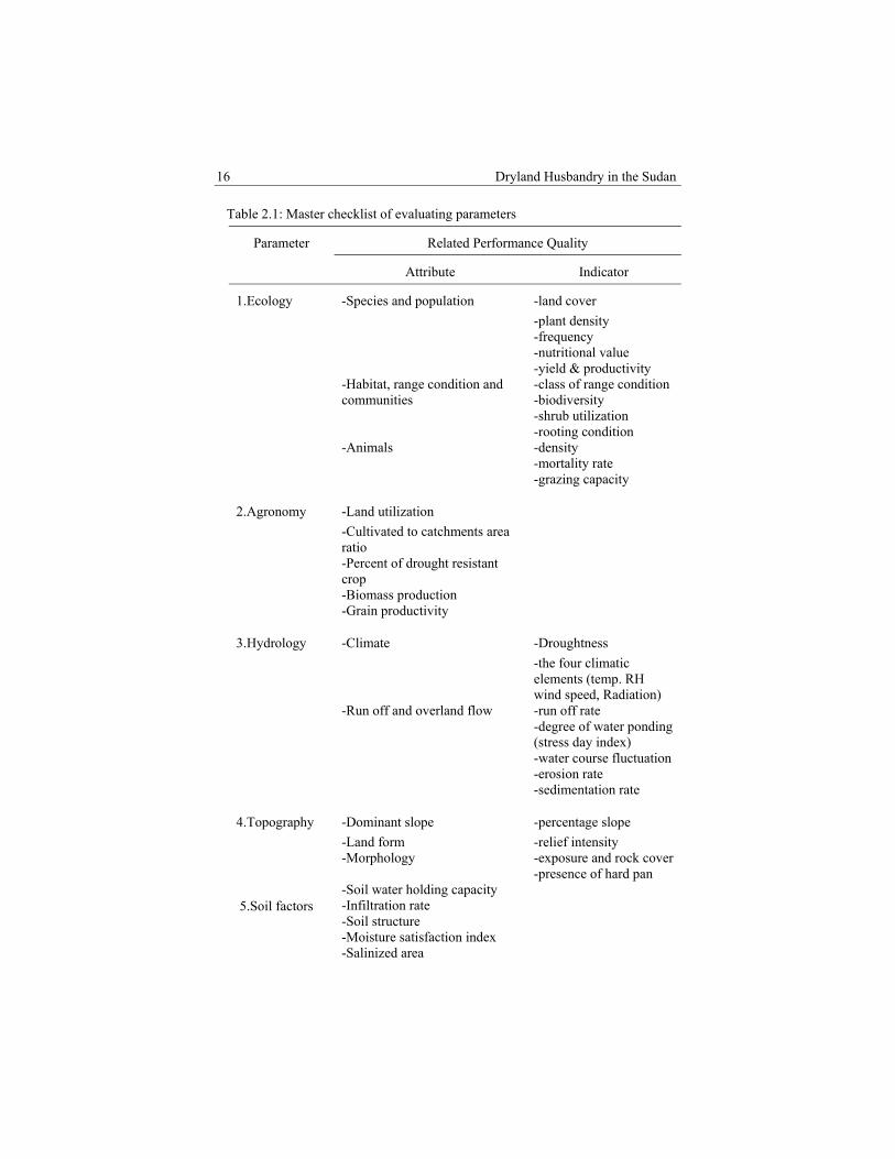
The master reference framework checklist of indicators (Table 2.1) is grouped into attributes to represent a unit or an aspect of significance worthy of separate consideration in water resource development. In turn, these attributes are grouped into parameters. They include: Ecology, agronomy, hydrology, topography, soil factors, human-interest, environmental factors, economics and design aspects, construction and structures. In case of real application to specific case study, the checklist and tables may be used as a guide to select the action or local set of indicators.
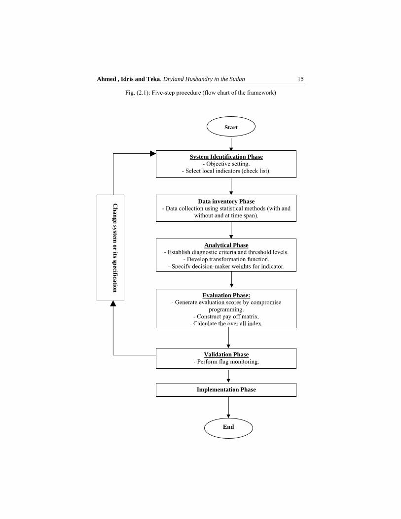
Ahmed , Idris and Teka. Dryland Husbandry in the Sudan 15
Fig. (2.1): Five-step procedure (flow chart of the framework)
System Identification Phase - Objective setting.
- Select local indicators (check list).
Start
Data inventory Phase - Data collection using statistical methods (with and
without and at time span).
Analytical Phase - Establish diagnostic criteria and threshold levels.
- Develop transformation function. - Specify decision-maker weights for indicator.
Evaluation Phase: - Generate evaluation scores by compromise
programming. - Construct pay off matrix.
- Calculate the over all index.
Validation Phase - Perform flag monitoring.
Implementation Phase
End
Ch
ange system
or its specification
16 Dryland Husbandry in the Sudan
Table 2.1: Master checklist of evaluating parameters
Parameter Related Performance Quality
Attribute Indicator
1.Ecology -Species and population
-Habitat, range condition and communities -Animals
-land cover
-plant density -frequency -nutritional value -yield & productivity -class of range condition -biodiversity -shrub utilization -rooting condition -density -mortality rate -grazing capacity
2.Agronomy -Land utilization
-Cultivated to catchments area ratio -Percent of drought resistant crop -Biomass production -Grain productivity
3.Hydrology -Climate
-Run off and overland flow
-Droughtness
-the four climatic elements (temp. RH wind speed, Radiation) -run off rate -degree of water ponding (stress day index) -water course fluctuation -erosion rate -sedimentation rate
4.Topography -Dominant slope
-Land form -Morphology
-percentage slope
-relief intensity -exposure and rock cover -presence of hard pan
5.Soil factors -Soil water holding capacity -Infiltration rate -Soil structure -Moisture satisfaction index -Salinized area
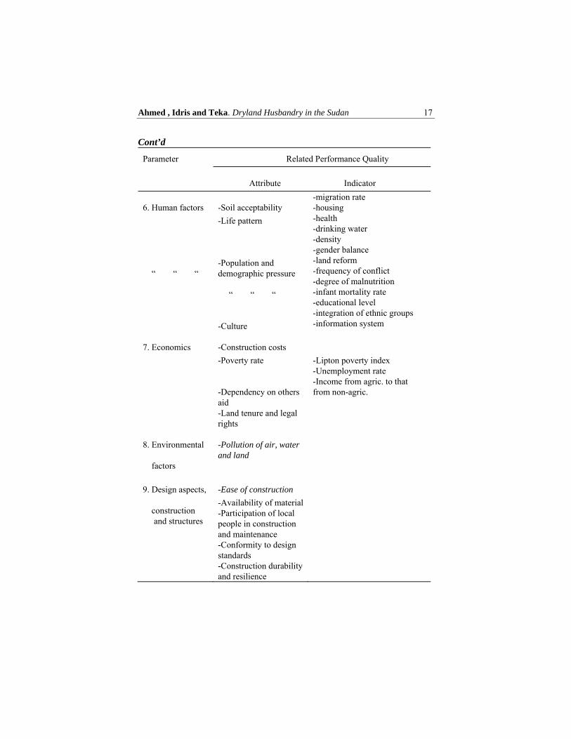
Ahmed , Idris and Teka. Dryland Husbandry in the Sudan 17
Cont’d
Parameter Related Performance Quality
Attribute Indicator
6. Human factors
“ “ “
-Soil acceptability
-Life pattern
-Population and demographic pressure
“ “ “
-Culture
-migration rate -housing -health -drinking water -density -gender balance -land reform -frequency of conflict -degree of malnutrition -infant mortality rate -educational level -integration of ethnic groups -information system
7. Economics -Construction costs
-Poverty rate -Dependency on others aid -Land tenure and legal rights
-Lipton poverty index -Unemployment rate -Income from agric. to that from non-agric.
8. Environmental
factors
-Pollution of air, water and land
9. Design aspects,
construction and structures
-Ease of construction
-Availability of material -Participation of local people in construction and maintenance -Conformity to design standards -Construction durability and resilience
18 Dryland Husbandry in the Sudan
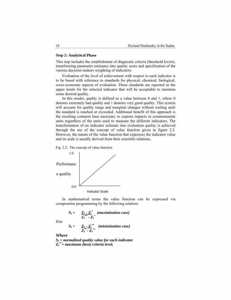
Step 2: Analytical Phase
This step includes the establishment of diagnostic criteria (threshold levels), transforming parameter estimates into quality score and specification of the various decision-makers weighting of indicators.
Evaluation of the level of achievement with respect to each indicator is to be based with reference to standards for physical, chemical, biological, socio-economic aspects of evaluation. These standards are reported as the upper limits for the selected indicator that will be acceptable to maintain some desired quality.
In this model, quality is defined as a value between 0 and 1, where 0 denotes extremely bad quality and 1 denotes very good quality. This system will account for quality range and marginal changes without waiting until the standard is reached or exceeded. Additional benefit of this approach is the resulting common base necessary to express impacts in commensurate units regardless of the units used to measure the different indicators. The transformation of an indicator estimate into evaluation quality is achieved through the use of the concept of value function given in figure 2.2. However, the nature of the value function that expresses the indicator value and its scale is usually derived from their scientific relations. Fig. 2.2: The concept of value function
In mathematical terms the value function can be expressed via compromise programming by the following relation:
SI = ZI - Zi
* (maximization case) ZI
** - ZI*
Else SI = ZI - Zi
** (minimization case) ZI
* - ZI**
Where SI = normalized quality value for each indicator ZI
**= maximum (best) criteria level,
Indicator Scale
Performanc
e quality
0.0
1.0

Ahmed , Idris and Teka. Dryland Husbandry in the Sudan 19
ZI* = minimum (worst) criteria level,
ZI = the score of the indicator in question
Each indicator used represents only a part of the set of evaluation parameters. It is therefore, important to view these parts together as part of the whole evaluation system. In doing so, however, it must be recognised that some indicators are of lower importance than the others and they can be discarded. To reflect the relative importance of the evaluation indicators a total of 1000 points were distributed among the indicators. Assignment of the relative weight: (a) may be made by quantifying the research team subject to value judgement. Consequently, the mean value may be used. On the other hand, separate evaluation iteration may be made to reflect the final output in terms of each individual evaluator.
Socio-psychological scaling techniques and Delphi procedure (ranked pair wise comparisons and controlled feed back) may be used to quantify the value judgement (a). Step 3: Evaluation Phase
The quality scores developed in the previous step need to be arranged with their respective indicator weight in pay-off matrix. The pay-off matrix may include the performance scores of the project at different time span. As such, the pay off matrix shows the objectives, parameters, indicator relative scores, and criteria weight.
The overall performance index for each state of the project and for each water harvesting technique may be calculated using the compromise distance (Lj), for each objective and for the whole project:
Where: Lj = compromise distance from the ideal point, ni = total number of basic indicator a i= indicator relative weight of importance such that ∑ aI = 1 Si = the normalized value of basic indicator (i) for project state or water-harvesting technique (j) Pi = distance scaling parameter (P = 1, 2,00).
Step 4: Validation Phase
Warning system or flag monitoring is used to detect the presence of any “fragile” elements of the project or water harvesting technique.
E
EOX
22
Where: X2 = Chi- square Where O = Observed value (with) the project E = Expected value (without the project

20 Dryland Husbandry in the Sudan
Unfortunately, these fragile elements change from project to project and
there is no special formula to identify them a priori. Thus, each parameter used in evaluation must be considered a potential fragile element that could, for some project, be crucial in determining the magnitude and significance of the overall project or technique impact.
The approach used to identify these potential areas is to key out with red flags parameters that change significantly in adverse direction. These red flags can be measured by chi-square technique. This is expected to reflect changes between the case of with and without the project or the changes developed during the course of project life. After the red flag is identified the potential problem area must be investigated in detail to determine the causative factors. Consequently, design aspects may be altered and the whole process is interacted till valid and acceptable conclusions are achieved.
Step 5: Implementation Phase This is the final step to evaluate the overall impact and, thereby, select the most viable alternative technique to be physically implemented in the study site. However, in case of presence of a tie Sparsman rank correlation may be used. Model Application
Action frame works for the case under investigation are the cutting edge of the model, the part where theory changes to action. For the purpose of model application two study areas with different types of water harvesting techniques were selected, namely: Kassala dry land husbandry project and Khartoum water-harvesting technique. In both sites water-harvesting project is directed for range improvement in rural areas. To date, the process of data collection is not closed. At the same time, a wide range of information relating to both sites is being collected and PC computer coding of the model in Q-basic was made.
Conclusion The developed model is conceptually a useful aid in determining the impacts of water resource development projects. The model benefited during its formulation from the FAO framework for land evaluation (FAO, 1976, 1993 and 2003).
It must, however, be used with caution and common sense, and should not become a mechanical tool to perform evaluation.

Ahmed , Idris and Teka. Dryland Husbandry in the Sudan 21
The set of indicators, value functions, and weights given in the checklist are only a starting point in the course of the study. As the system is used, they are expected to get better.

CHAPTER THREE
PROJECT DESCRIPTION Fath El Rahman Ahmed Mohamed Husein Mustafa Mohamed Yagoub Abdalla Mohamed
3.1 Project site Kassala State is situated in eastern Sudan between latitudes 14o 15’ and 37o 15’ N and longitudes 34o 30’- and 37o 55’. It also borders east Eritrean hills in the east and River Nile and Red Sea States in the North and Khartoum and Gedaref States in the West and South. Covers an area of about 24,282 km2 (Map 3.1). The four major towns of the State are Aroma, Kassala, Khashmel Girba and New Halfa.
The most characteristic features of this land are several seasonal rivers flowing from the East. The Atbara River with its two tributaries, Setit and Basalam rivers both have a flow of water during the greatest part of the year. The Atbara belongs to the watershed of the Nile. The Gash River runs along a watercourse (wadi), carrying water directly, after a shower, into a very fertile inland delta (the Gash Die).
3.2 Project Environmental Profile
3.2.1 Climate
Due to its location, the Kassala State has various types of climatic conditions. Moreover, the existing topography with its significant variation over relatively short distances has had a noticeable influence. The Kassala State can be broadly divided into arid climate in the northern parts and semi-arid in the southern parts. Aridity decreases gradually southwards. The central part falls between arid and semi-arid zone.
Mean maximum temperature in Kassala State occurs in summer months with values of 40oC in May. Mean minimum temperature is 15oC in January (Tables 3.1 & 3.2). Kassala State falls within the arid and semi-arid region where rainfall is unreliable for domestic and economic uses. The average annual rainfall is about 225 mm while evaporation amounts to 2- 2.5 mm. The main sources of water supply are surface (UNDP et al., 1992). Means

Fath Mohamed, Husein Mohamed and Yagoub Mohamed. Project Description
23
annual rainfall ranges from 200-250 mm. occurring dominantly between May to October. Rainfall (monthly or annually) for the last three years considered (1996-1998) showed marked lowering in the mean, indicating the drought conditions prevailing in the State. The trend is very much marked for the northern districts compared to the southern parts.
The meteorological normal for the period 1967-1997 displayed considerably high rates of evaporation prevailing in the area. The yearly amount of evaporation is given as 125.7 piche (mm). January was correspondingly the lowest month of annual evaporation (8.8 piche (mm), coinciding with the lowest temperature during the same month. The three driest months have the highest evaporation rates reaching up to 34% of the total annual evaporation.
Climatic condition systems are reflected on soil chemical and physical properties, maturity, capabilities and use. Climatic elements of rainfall, and winds are essential in the soil formation at nearly equal level with drainage system and geological structure portion.
Slight reduction from normal precipitation can cause severe reductions in plant yield especially in areas below 300 mm of precipitation, while much greater reduction in precipitation may have no influence on plant yield in areas with over 800 mm. Holecheck, et al. (1989) defined precipitation drought as prolonged dry weather when precipitation is less than 75% of average annual amount. Using these criteria, over the past 30 years (1967-1997) drought in the Kassala State has occurred in 50% of the years. The most severe and wide-spared drought in Kassala State occurred during the years 1965, 1970 and 1984 (Vandijk, 1995). Droughts are common phenomena on rangeland of Kassala State, but are sometimes confused with aridity, which is defined also by Holecheck et al. (1989) as permanent condition of a general lack of water. This is the case of the northern part of the State, where grass production is reduced by about 60% during the consecutive years of drought. As estimated by Abdel Ati (1985), the desert had advanced 100 km of the Latitude 17o north between 1958 – 1978.

Dryland Husbandry in the Sudan 24
Table 3.1: Normal Climatological Data of Kassala State for 30 Years (1967 to 1997)
Month Temperature (oC) Rainfall (mm)
Relative Humidity
(%)
Evaporation (mm)
Wind prevailing
direction
Mean wind Speed (Km/h)
Minimum Maximum Mean
January 15 32.7 24.4 0.5 45 8.8 NNE 4 February 16.3 34.0 25.7 TR 40 10.4 NNE 4March 20.3 37.7 29.0 3.6 33 13.1 NNE 4 April 24.4 40.1 32.3 11.5 28 14.5 NNE 4 May 26.1 40.6 33.4 17.25 29 14.9 S 4June 25.6 40.2 32.9 39.8 39 12.5 S 6 July 24.3 36.2 30.3 90.25 57 8.4 S 6 August 22.7 33.9 28.3 78.95 64 6.3 S 5September 24.2 38.3 31.3 71.65 54 7.6 S 4 October 25.8 37.6 31.7 33.05 42 10.4 S 3 November 22.5 37.6 29.8 8.9 39 10.2 NNE 3 December 19.0 36.7 27.9 TR 45 8.6 NNE 4 Year 354.95
SOURCE: Meteorological Department – Kassala Station

Fath Mohamed, Husein Mohamed and Yagoub Mohamed. Project Description
25
Table 3.2: Mean monthly climatic data of Kassala state for the years (1996 to 1998)
Month 1996 1997 1998
Temp (oC)
R.F (mm)
R H (%) Evap. (mm)
Temp (oC)
R.F (mm)
R.H (%)
Evap. (mm)
Temp (oC)
R.F (mm)
R.H (%)
Evap. (mm)
January 24.5 0 50 25.1 0 55 12.5 24.7 0 58 12.6 February 28.1 0 57 24.7 0 62 13.7 25.7 0 46 14.9 March 30.2 0.3 39 28.7 TR 43 18.1 29.0 TR 41 17.3 April 32.4 1.8 37 31.4 4.0 28 18.9 33.0 2.4 33 19.4 May 33.2 12.3 41 32.9 3.9 41 18.2 34.2 7.0 30 19.1 June 31.9 104.2 54 32.9 3.7 48 18.4 34.0 3.6 42 19.4 July 30.8 29.4 60 16.0 30.1 86.0 61 12.9 30.4 90.2 63 13.0 August 27.7 40.0 66 10.7 27.7 65.9 64 10.8 28.0 189.6 74 8.2 September 30.5 14.8 66 11.0 31.7 31.1 59 13.6 29.3 18.1 68 8.7 October 30.9 1.7 48 16.4 31.3 12.7 53 13.9 31.2 2.4 56 13.3 November 28.9 TR 47 15.6 29.4 0.3 51 14.4 30.4 0 44 17.0 December 27.4 0 61 12.8 27.4 0 64 12.1 26.5 0 60 14.0Year 0 207.6 313.3

Dryland Husbandry in the Sudan
26
Map 3.1: Locality of the Kassala State
SOURCE: Compiled from Sudan 1:20000 series, corrected 1998
Fath Mohamed, Husein Mohamed and Yagoub Mohamed. Project Description
27
3.2.2 Soil and Geomorphology
The prominent soil type in the State is clay soil, ranging from shallow cracking to deep cracking. Vast expanses of sand sheets covering in clay are uncommon.
Depending on one prospective, land may be thought of as the source of food, living space, and materials that support human life, a viewpoint emphasizing the use of land for production. But an alternative view is that based on conservation.
Soil is a country’s most precious natural resource, aptly described as ‘’ the bridge between the inanimate and the living’’. It consists of weathered and decomposed bedrock, water, air, organic material formed from plant and animal decay and thousands of different life forms, mainly micro-organisms and insects. All play their part in maintaining the complex ecology of a healthy soil (Caracalla, 1993); he also pointed out that the soil is a non-renewable resource. Once it is destroyed, it is gone forever.
Although soil erosion does occur naturally, the process is slow. Man has increased the rate of natural erosion by at least 2 to 5 times and over the centuries has destroyed an estimated 2,000 million ha of land. There is a good evidence that past civilisations, in Mediterranean and in Central America, collapsed as a result of soil erosion following the cutting of forest on steep slopes and other destructive practices (Orr, 1984). Brown (1985) attributed significant climate shifts and changes in landuse. Recently the United Nations Environment Program (UNEP) undertook a survey to assess desertification in countries in Sudano-Sahelian region of Africa. The survey focused on five manifestations of desertification-sand dune encroachment, the deterioration in rangelands, forest depletion, the deterioration of irrigation systems and problems in rain-fed agriculture. In reference to these five indicators, the desertification, rate in the Sudan during the periods of (1977-1984) is significantly increasing (Map 3.2).
Toulmin (1995) found that knowledge about the desertification convention is mainly limited to those people who have been involved in the negotiation. People need better information about the convention. This information should be made easily available to people in many different kinds of organisations, from the local to national levels.
According to Walker (1980) the most insidious form of soil erosion is called sheet erosion and occurs when the whole surface of field is gradually eroded in a more or less uniform way. The process is insidious because it is not immediately obvious that soil is being lost. The only evidence of sheet erosion may be that the roots of trees or crops, or the bottoms of fence posts, become increasingly exposed. Yet, by the time a farmer notices such things, he may have lost few tones of soil per hectare. On average field, a
Dryland Husbandry in the Sudan
28
farmer who loses just 1.5 cm of topsoil, barely enough to notice, will have lost about 190 tones of soil per hectare. Rill erosion can occur on steep land and land which slopes more gently. Rills can develop into gullies but even as rills, they represent a serious loss of soil. Toulmin (1995) pointed out that heavy rainfalls at the start of the wet season can loosen soil and carry it away, particularly when fields are bare and there are no contour terraces or bunds to stop the water running away. This was confirmed by Vnik (1987) who showed that a rain shower more than 25 mm on bare soil could cause 250,000 m3 of runoff/km2.
The effects of soil erosion is tied with varies aspects of wind conditions. Erosion starts off a chain reaction of events, of which the first sign is a decline in crop yield. Then, as soil is lost and gullies deepen, the use to which land is put must be changed. Croplands become pasture, pasture turns to shrub. Eventually, the land goes out of production altogether. Food becomes dearer and scarcer and malnutrition is more common (Toulmin, 1995).
Preventing soil erosion is a great deal easier than curing it; soil that has been carried to valleys below can never be economically returned. But once erosion has been controlled, it is usually possible to restore fertility to the land and increase its productivity. FAO now has considerable experience in countries where deforestation and erosion are almost equally severe; replanting is now proceeding apace. However, damaged pasture can also be developed to a point where production is higher than before erosion set in. This requires an active rangeland development program. Some areas are reseeded with forage plants, which are hardier and more nutritious than those previously grown. (Woldu et al. 1997).
Generally, El Karouri (1965) pointed out that salanization-alkalinization is a time and space-dynamic soil degradation process in semi-arid regions. Weber and Stay (1986) showed that salinity and laterite is soil related to particularly difficult conditions for reforestation. Saline soils occur frequently in depressions and basins where evaporation or evapotranspiration is high, moisture in the upper soil layers is transported upwards, the result of the moisture rising to the surface is the appearance of sodium salt crystals.
Strong concentration of sodium salts can be a significant obstacle to reforestation efforts. Often on site with high concentration of sodium salts, pH values will also be high and around 8.5 (Keive et al., 1976). Metternicht and Zinck (1996) found that the main causes of spectral confusion, making different salinity-alkalinity degrees, were the type and abundance of the vegetation cover that confront the reflectance values when the soil surface is not bare. Moreover, the topsoil textures, especially the presence of large amount of silt-plus-clay that hinders the effect of variable salt and sodium content, and the mixture of topsoil properties under field conditions where
Fath Mohamed, Husein Mohamed and Yagoub Mohamed. Project Description
29
salt, particle size, organic matter, crusting and soil moisture mutually interfere.
Soil conservation is not a negative activity, involving huge expenses and small returns. Soil conservation is positive; even in the short-term it results in substantial increases in agricultural production, and in the long-term it ensures the productivity of the most important natural resources (Keive et al., 1976).
Soil conservation has been regarded as an important science that falls into two categories; the first is known as the biological techniques of erosion control; they involve a fundamental assessment of the suitability of the crops being grown and of the techniques being used to farm them. The second category is the physical techniques, such as the many different forms of terracing which now exist, methods of gully control, dams for controlling floodwater and siltation, and overall watershed management.
FAO has been involved in projects to develop watersheds in arid areas and to initiate increasing interest in simpler techniques of channelling of the surface runoff from micro-catchments directly to food crops, fodder, pasture and trees or into small storage structures in which it can be retained for domestic or livestock use (Critchley, 1987).
Water harvesting technique programs intend to increase the availability of water to grow plants in conditions where moisture is the primary limiting factor. Moreover, tree-planting project in semi-arid areas using water-harvesting technique has become more common. Critchely (1987) gave an over view of water harvesting techniques, which are likely to be of increasing significance in the future within the semi-arid areas of sub-Sahara Africa. It has been demonstrated to be an effective technique when system is designed appropriately and its role inevitably becomes more important as people are forced into drier areas through population pressure. The semi-circular loops (crescent shaped terraces and similar designs) have proved to be successful in eastern and western Sudan, the main usage of the loops being for grass and trees. 3.2.3 Vegetation and Range Resources Latitude, climate, relief, soil and human activities generally influence vegetation cover. Accordingly, it is understandable that there is a wide variation in vegetation types (Jones, 1979). A feature of vegetation in the tropics is the diversity of its plants, and large numbers of species, genera, and families to which they belong (Cobley, 1976). The vegetation types are of varying mixture of grasses and herbs either without any woody vegetation at all, or more usually, with a variable scatter of scrub bushes up to 2 meters high interspersed with bare area. In the semi-desert area of Sudan Harrison and Jackson, (1958) found that, annual and perennial
Dryland Husbandry in the Sudan
30
grasses occur in about equal amounts, (except on the dark cracking clays where perennial grasses are virtually absent).
The following simplified classification of the vegetation cover that is on the zone classification of Harrison and Jackson (1958) has been used in Kassala State (Map 3.3).
Map 3.2: Environmental degradation and desertification in Kassala State

Fath Mohamed, Husein Mohamed and Yagoub Mohamed. Project Description
31
Semi-desert grassland and bare areas The vegetation is a variable cover of grasses and herbs with trees and shrubs in large areas. Vegetation is mostly absent on rocky land or on soils that are strongly saline. The most common grass species are Aristida spp. Trees are rare; the most common ones are Acacia ehrenbergiana (salam) and Acacia tortilis sub sp. radiana (seyal) occurring along drainage lines. Semi-desert grassland on clay
The cracking clays and clay loams’ of the semi-desert zone and the water course undulating clay plains of the central Butana carry mainly short grasses of the species Schoenefeldia gracilis (gabash) and some herbs such as Blepharis spp. (siha). Trees and shrubs are rare on the Butana plains. However, Acacia mellifera (kitir) occurs around ‘jebels’ (hills) and along water courses which are particularly numerous in the central Butana. Also Acacia nubica (laot) occurs frequently near jebels in the undulating clay plain.
This zone is used for grazing, mainly by camels and goats but where water is available near the mountains of the central Butana cattle also are found. Many areas are overgrazed, and are practically bare. Water courses (wadis), in the northeast and west of the State, usually receive floods. After floods recede, sorghum (dura) is grown. On very gently sloping soils, small earth mud (terraces) are constructed in some places to prevent runoff and supply sufficient moisture for a quick maturing sorghum crop. Arid zone grassland on clay This is in the southern part of the Butana. The grasses are more abundant, taller and more varied. The main grass is Cymbopogon nervatus (Naal). Others are Sorghum spp. (Naggara) and herbs such as Ipomoea spp. (tuber) Ocimum (Rihan) and Setaria spp (Unsikkina).
These grasslands are heavily grazed. Rain-fed dura is sporadically grown by terrace cultivation or low-lying water receiving sites (Table 3.3). Acacia mellifera thorn land The Acacia mellifera (Kitr) thornland occurs in the northern part of semi-arid climate zone.There are few other trees and shrubs; Acacia nubica (laot), Balaintes aegyptiaca (Hegleg) and Cadaba rotuntifolia (Kurmut) are a few worth mentioning, in the northern part of the zone where grassland is dominant. In the southern part the thorn shrubs cover much larger areas.
Dryland Husbandry in the Sudan
32
Grasses are tall, such as Cymbopogon and sorghum spp. In the southern part of the zone, large areas have been cleared for extensive mechanised farming of dura. Gash Delta This inland delta is watered from the seasonal Gash River. The original vegetation has been altered greatly by long use. In the upper part of the Gash River Tamarix spp. (Tarfa) are the dominant trees. Downstream there are also many other trees. such as Acacia nilotica (Sunt), Acacia seyal (talh), zizyphus spina christi (Sider) and Acacia ehrenbergiana (Salam). Shrubs such as Capparis decidua (tundub) and Calotropis procera (Usher) are also common. Weeds are numerous such as Indigofera oblongifolia (Dehassir). Prosopis Chilensis (Mesquite) Mesquite is found almost everywhere in the state, especially in the Gash delta as long as there is water collection (Table 3.4). Its negative impacts include: (a) extra cost of land preparation for agricultural production, (b) reduction of rangeland productivity, (c) adverse effect in the pastoral environment in general, and (d) negative impact on biodiversity. Hence, the government of Sudan declared 1995 as Prosopis eradication year.

Fath Mohamed, Husein Mohamed and Yagoub Mohamed. Project Description
33
Map 3.3: Vegetation and land use
Dryland Husbandry in the Sudan
34
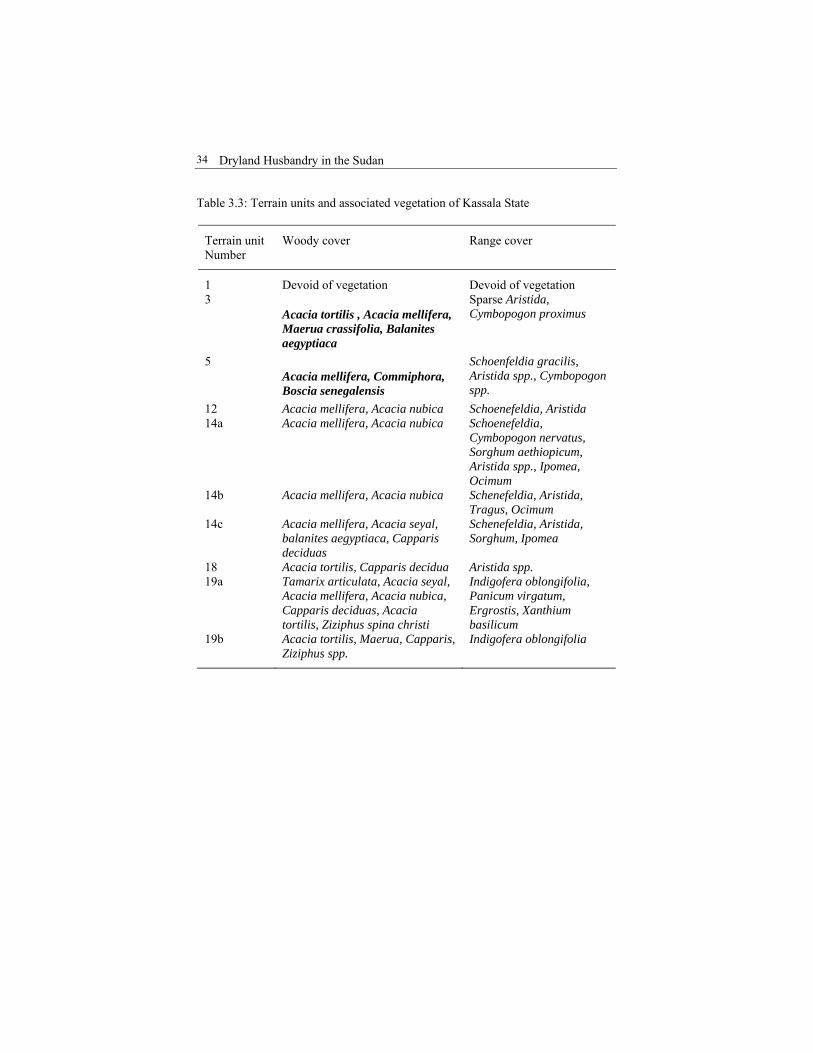
Table 3.3: Terrain units and associated vegetation of Kassala State
Terrain unit Number
Woody cover Range cover
1 Devoid of vegetation Devoid of vegetation 3
Acacia tortilis , Acacia mellifera, Maerua crassifolia, Balanites aegyptiaca
Sparse Aristida, Cymbopogon proximus
5 Acacia mellifera, Commiphora, Boscia senegalensis
Schoenfeldia gracilis, Aristida spp., Cymbopogon spp.
12 Acacia mellifera, Acacia nubica Schoenefeldia, Aristida 14a Acacia mellifera, Acacia nubica Schoenefeldia,
Cymbopogon nervatus, Sorghum aethiopicum, Aristida spp., Ipomea, Ocimum
14b Acacia mellifera, Acacia nubica Schenefeldia, Aristida, Tragus, Ocimum
14c Acacia mellifera, Acacia seyal, balanites aegyptiaca, Capparis deciduas
Schenefeldia, Aristida, Sorghum, Ipomea
18 Acacia tortilis, Capparis decidua Aristida spp. 19a Tamarix articulata, Acacia seyal,
Acacia mellifera, Acacia nubica, Capparis deciduas, Acacia tortilis, Ziziphus spina christi
Indigofera oblongifolia, Panicum virgatum, Ergrostis, Xanthium basilicum
19b Acacia tortilis, Maerua, Capparis, Ziziphus spp.
Indigofera oblongifolia
Fath Mohamed, Husein Mohamed and Yagoub Mohamed. Project Description
35
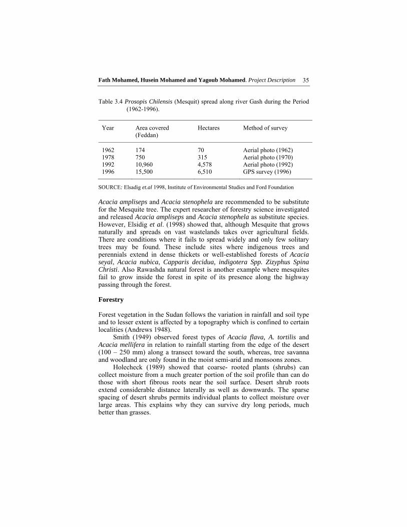
Table 3.4 Prosopis Chilensis (Mesquit) spread along river Gash during the Period
(1962-1996).
Year Area covered (Feddan)
Hectares Method of survey
1962 174 70 Aerial photo (1962) 1978 750 315 Aerial photo (1970) 1992 10,960 4,578 Aerial photo (1992) 1996 15,500 6,510 GPS survey (1996)
SOURCE: Elsadig et.al 1998, Institute of Environmental Studies and Ford Foundation Acacia ampliseps and Acacia stenophela are recommended to be substitute for the Mesquite tree. The expert researcher of forestry science investigated and released Acacia ampliseps and Acacia stenophela as substitute species. However, Elsidig et al. (1998) showed that, although Mesquite that grows naturally and spreads on vast wastelands takes over agricultural fields. There are conditions where it fails to spread widely and only few solitary trees may be found. These include sites where indigenous trees and perennials extend in dense thickets or well-established forests of Acacia seyal, Acacia nubica, Capparis decidua, indigotera Spp. Zizyphus Spina Christi. Also Rawashda natural forest is another example where mesquites fail to grow inside the forest in spite of its presence along the highway passing through the forest. Forestry Forest vegetation in the Sudan follows the variation in rainfall and soil type and to lesser extent is affected by a topography which is confined to certain localities (Andrews 1948).
Smith (1949) observed forest types of Acacia flava, A. tortilis and Acacia mellifera in relation to rainfall starting from the edge of the desert (100 – 250 mm) along a transect toward the south, whereas, tree savanna and woodland are only found in the moist semi-arid and monsoons zones.
Holecheck (1989) showed that coarse- rooted plants (shrubs) can collect moisture from a much greater portion of the soil profile than can do those with short fibrous roots near the soil surface. Desert shrub roots extend considerable distance laterally as well as downwards. The sparse spacing of desert shrubs permits individual plants to collect moisture over large areas. This explains why they can survive dry long periods, much better than grasses.
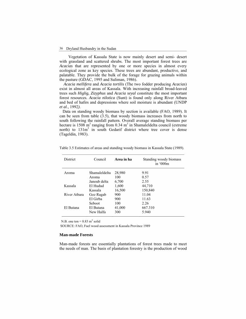
Dryland Husbandry in the Sudan
36
Vegetation of Kassala State is now mainly desert and semi- desert with grassland and scattered shrubs. The most important forest trees are Acacias that are represented by one or more species in almost every ecological zone as key species. These trees are abundant, productive, and palatable. They provide the bulk of the forage for grazing animals within the pasture (GDAC, 1995 and Suliman, 1986). Acacia mellifera and Acacia tortilis (The two fodder producing Acacias) exist in almost all areas of Kassala. With increasing rainfall broad-leaved trees such Higlig, Zizyphus and Acacia seyal constitute the most important forest resources. Acacia nilotica (Sunt) is found only along River Atbara and bed of hafirs and depressions where soil moisture is abundant (UNDP et al., 1992). Data on standing woody biomass by section is available (FAO, 1989). It can be seen from table (3.5), that woody biomass increases from north to south following the rainfall pattern. Overall average standing biomass per hectare is 1508 m3 ranging from 0.34 m3 in Shamaleldelta council (extreme north) to 131m3 in south Gedarif district where tree cover is dense (Tageldin, 1983). Table 3.5 Estimates of areas and standing woody biomass in Kassala State (1989).
District Council Area in ha Standing woody biomass in ‘000m
Aroma Shamaleldelta Aroma Janoub delta
28,980 100 6,700
9.91 0.57 2.55
Kassala El Hudud Kassala
1,600 16,500
44,710 150,840
River Atbara Goz Ragab El Girba Seboot
900 900 100
11.04 11.63 2.26
El Butana El Butana New Halfa
41,000 300
667.310 5.940
N.B. one ton = 8.83 m3 solid SOURCE: FAO, Fuel wood assessment in Kassala Province 1989 Man-made Forests Man-made forests are essentially plantations of forest trees made to meet the needs of man. The basis of plantation forestry is the production of wood

Fath Mohamed, Husein Mohamed and Yagoub Mohamed. Project Description
37
and often forest products, within economic limits of the main centres of consumption and export of such produce (ElHouri, 1989).
In the absence of natural forests and in view of their limitations, plantations of trees are often the only solution to meet the needs of man for forest products, to protect other resources and for amenity purposes (Elrasheed 1983).
Success of plantation forest includes: (a) small stand - initial project efforts are kept to a small scale, (b) encourage existing conservation activities parallel to newly introduced technologies, and (c) local participation in enriching the indigenous knowledge and expectation to be met. These are particularly important to consider during the planning stages. Inter-cropping was practised by growing forage crops between the rows of planted trees and shrubs. Excellent results have been obtained. 3.2.4 Hydrology Water as the ‘’source of life’’ needs to be understood in the broadest sense. Whilst water is essential to the survival of living creatures, it is also indispensable to the development of activities in the primary sector (Alissoutin, 1997).
Therefore, the physical factors which influence grazing potential, for instance, moisture availability for plants is a land quality, determined by rainfall, potential evapotranspiration, runoff and water holding of the soil material (Keive et al., 1976). On the other hand, Holecheck (1989), reported that the type and amount of vegetation has a strong influence on the deposition of precipitation. We believe that in the near future range management practices will be geared primarily toward water production rather than forage production. Surface Water
Atbara River
Atbara River is the most downstream tributary of the Nile; it flows into the main Nile at about 320km downstream. Its catchments lie in Ethiopia with an area of 112460 km2 and at altitude ranging from 2,500 to 3,500 meters above sea level. The tributary of the Atbara is the Setit. Atbara River flows from June to December and is dry for the rest of the year.
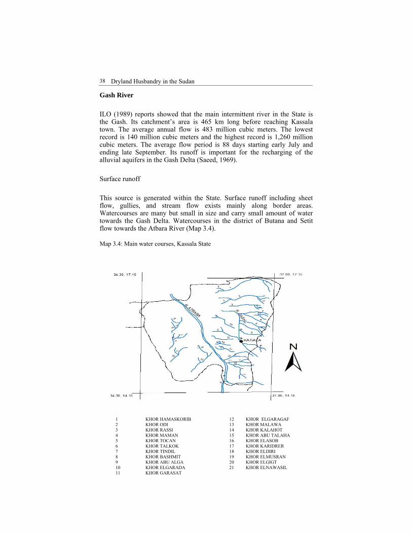
Dryland Husbandry in the Sudan
38
Gash River
ILO (1989) reports showed that the main intermittent river in the State is the Gash. Its catchment’s area is 465 km long before reaching Kassala town. The average annual flow is 483 million cubic meters. The lowest record is 140 million cubic meters and the highest record is 1,260 million cubic meters. The average flow period is 88 days starting early July and ending late September. Its runoff is important for the recharging of the alluvial aquifers in the Gash Delta (Saeed, 1969).
Surface runoff
This source is generated within the State. Surface runoff including sheet flow, gullies, and stream flow exists mainly along border areas. Watercourses are many but small in size and carry small amount of water towards the Gash Delta. Watercourses in the district of Butana and Setit flow towards the Atbara River (Map 3.4). Map 3.4: Main water courses, Kassala State
1 KHOR HAMASKORIB 12 KHOR ELGARAGAF 2 KHOR ODI 13 KHOR MALAWA 3 KHOR RASSI 14 KHOR KALAHOT 4 KHOR MAMAN 15 KHOR ABU TALAHA 5 KHOR TOCAN 16 KHOR ELASOB 6 KHOR TALKOK 17 KHOR KARIDRER 7 KHOR TINDIL 18 KHOR ELDIRI 8 KHOR BASHMIT 19 KHOR ELMUSRAN 9 KHOR ABU ALGA 20 KHOR ELGIGT 10 KHOR ELGARADA 21 KHOR ELNAWASIL 11 KHOR GARASAT
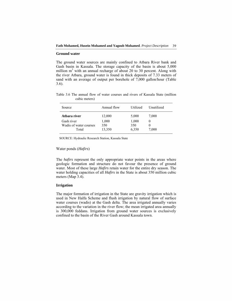
Fath Mohamed, Husein Mohamed and Yagoub Mohamed. Project Description
39
Ground water The ground water sources are mainly confined to Atbara River bank and Gash basin in Kassala. The storage capacity of the basin is about 5,000 million m3 with an annual recharge of about 20 to 30 percent. Along with the river Atbara, ground water is found in thick deposits of 7.33 meters of sand with an average of output per borehole of 7,000 gallon/hour (Table 3.6).
Table 3.6 The annual flow of water courses and rivers of Kassala State (million cubic meters)
Source Annual flow Utilized Unutilized
Atbara river 12,000 5,000 7,000
Gash river 1,000 1,000 0 Wadis of water courses 350 350 0
Total 13,350 6,350 7,000
SOURCE: Hydraulic Research Station, Kassala State
Water ponds (Hafirs)
The hafirs represent the only appropriate water points in the areas where geologic formation and structure do not favour the presence of ground water. Most of these large Hafirs retain water for the entire dry season. The water holding capacities of all Hafirs in the State is about 350 million cubic meters (Map 3.4). Irrigation The major formation of irrigation in the State are gravity irrigation which is used in New Halfa Scheme and flush irrigation by natural flow of surface water courses (wadis) at the Gash delta. The area irrigated annually varies according to the variation in the river flow; the mean irrigated area annually is 300,000 feddans. Irrigation from ground water sources is exclusively confined to the basin of the River Gash around Kassala town.
Dryland Husbandry in the Sudan
40
Water catchments Vandijk (1995) found that the State, although rich in drainage systems, still loses some of runoff water to depressions and rivers. It has been, therefore, planned by soil department to develop earth embankment and small dams across the seasonal streams to secure water for cultivation for forestry and range purposes.
Over the past years various governmental agencies have been trying to assist by constructing earth dykes for water spreading (ILO, 1989). Indigenous soil and water conservation (SWC) applied in the area by settling nomadic communities had been given more attention. Scoons et. al. (1996) found that the combination of previous practice and introduced innovation of (SWC) offers an important route to success.
On the base of soil science contexts, the factors that determine the water holding capacity are soil texture and organic content. In general terms the heavier the soil, the more moisture it can hold after it has been soaked by infiltration of rainwater. To increase the soil water holding capacity, several ways could be used as follows:
1. Break up top layers to increase infiltration and produce a granular
structure 2. Mulching to reduce surface drying 3. Practising sub-soil ploughing or (ripping) to break up the
compacted layers 4. Using green manure cover crop to provide additional organic
matter and to protect the surface during dry season 5. Practising contour cultivation as well as other soil and water
conservation techniques
In any case, soil water holding capacity remains one of the key factors in successful reforestation efforts in arid zone (Badi, 1965). 3.2.5 Land Use Crop production and animal raising are the two main occupations that determine land use pattern in Kassala State. In the past namely before the colonial era, pastoral nomadism was the dominant way of life. The livestock number was much smaller compared to the available rangelands. Agriculture at that time was only confined to areas favourable for settlement where small-scale subsistence traditional rain-fed cultivation was practised (map 3.5).
This State, like the rest of the country, was opened to the outside world. The economy was then oriented towards market and cash economy crops
Fath Mohamed, Husein Mohamed and Yagoub Mohamed. Project Description
41
resulting in a gradual change of the traditional forms of land use (animal raising and subsistence small scale traditional rain-fed cultivation). As a result, land use changed rapidly leading to sharp competition for land and emergence of an economy with a dual nature (traditional and modern). From an economic point of view agriculture can be divided into subsistence, semi-commercial and commercial types of farming which fall under the major agricultural systems, that is rain-fed and irrigated farming each including a number of sub-systems.
Agricultural development and its demographic consequences in this state have affected other forms and land use. The area available for livestock production and forestry has significantly decreased resulting in fodder shortage. This is one of the reasons why DHP was situated here to find out ways and means of increasing fodder production and other associated needs (water, animal health etc.).
Livestock production system: is based on feed and water availability. For the provision of stable feeds, the available area in Kassala State can be divided into wet and dry season pastures, within which pastoralists carry out their seasonal movements; they are well-defined areas. The wet season pastures are not accessible during the dry season due to lack of drinking water. The wet season pasture forms an attractive grazing ground because of the good pasture quality and the unhealthy climate in the southern areas. Therefore, this natural pasture is the major wet season feed resource. However, due to the expansion of mechanised agriculture from the south and the establishment of the irrigated schemes, the wet season pasture has terribly decreased.
The woodland savanna is dry season pasture. It is less nutritive and most accessible after October. Its area has also decreased considerably as a result of expanding cultivation. Other dry season forage is crop residues from irrigated and rain fed farming, which is of poor quality.

Dryland Husbandry in the Sudan
42
Map 3.5: Terrain units of the Kassala State
Fath Mohamed, Husein Mohamed and Yagoub Mohamed. Project Description
43
Due to the expansion of cultivation on traditional pasture land and the growing livestock number, the grazing and browsing intensity of livestock have increased. Overgrazing has seriously affected pasture quality and some times productivity. Livestock production faces serious feed resource problems. At present dry season feed resources form the major constraint to the number and productivity of livestock in this part of the country. The crop residue market is becoming lucrative in the dry season. In the wet season pressure on feed resources is, therefore, increasing and resulting in serious overgrazing of the most valuable rangeland. To overcome these difficulties, vertical expansion to increase fodder production in both quantity and quality was thought to be the way out. 3.3 Project Socio-Economic Profile 3.3.1 Population The world population is rapidly changing; with growing population, densities lead to scarcity of land and widespread changes in land use. Excessive human activities lead to deforestation, overgrazing, depletion of land and water resources and a wide variety of environmental problems. To solve these problems and to make sure that the future generation has a better life, more careful management of these resources is needed.
Kassala State is a vast plain, that is roughly considered the homeland of the Beja, the numerically and practically dominant group it also harbors Hadundowa, Beni Amer, Bishareen and Halanga, and the stock of Arab origin that includes; Shukriya, Kawahla, Lahawaien, and Rashaida as nomads, semi-nomads or settled people. There are also other pastoral groups such as kenana, Rufaa and Ambararo who move into the state from southern Gedaref during the rainy season (Map 3.6).
Population distribution and land use patterns in the state plain have largely followed the norms of precipitation and the availability of permanent source of water (Ibrahim, 1988). The estimated population in 1993 is about 1,234,562. The estimated population growth per year is 4.73% as natural increase or approximately 5.6% when migration and refugees are included. The urban population is 19.3 % while the rural people is 80.7 %. The pastoral people comprise 35% of the rural people and 25% of the total population of Kassala State. A significant number of refugees are settled in transition camps along the eastern border and in selected areas near irrigated schemes and urban centres.
The recent rapid population growth entails an increasing demand for both food and feed in addition to energy requirements. So, the wise utilisation of existing resources, particularly soil and water, is an increasing

Dryland Husbandry in the Sudan
44
imperative. The hostile conditions of arid lands and their narrow margin need special consideration (Dirar, 1997).
The early diagnosis of such impact is of paramount importance. The effect of desertification appears most dramatically in hunger, disease, immigration and premature death brought about by continuous crop failure and by the massive destruction of livestock. 3.3.2 Pastoral Communities Ecosystems The pastoral production systems in the eastern Sudan have essentially evolved under conditions of low natural biological productivity and inadequate water supplies. Under such conditions, the pastoralists have adapted a set of strategies that facilitate survival by allowing the utilization of multiple resources. Among these strategies are herd diversification and resource management mobility (Negassa, 1993) (Map 3.6).
However, the mixed economy of animal husbandry and rain-fed farming has had important consequences for the structure and the division of labour, with animal husbandry and cultivation restricted to men. Women’s responsibilities are confined to the domestic sphere involving such activities as cooking, washing, child care, handicraft such as weaving mats, and the erection and disassembly of tents when the family is on the move (Babiker 1997).
All evidence allies with FAO’s (1986) conclusion which emphasized pastoralism /nomadism/ as the most favourable systems of animal production in dry regions. Mobility, therefore, broadens access to pasture since a herder locked into an area with poor rainfall risks a total loss. This is why pastoralists adopted the rotational strategy of shifting herds from rainfall-deprived areas to better-endowed areas (Map 3.7) (Swallow, 1993). Moreover, mobility allows pastoralists’ herds to utilize widely dispersed forage resources at times when they are most nutritious. It should also be pointed out that this intermittent use of the range is said to improve forage and increase the carrying capacity relative to those areas where the range remains unexplored or grazed throughout the year (Hassan, 1993).
There is an indication in the foregoing discussion that pastoralism will continue to play an important economic role, and contributes significantly to local as well as the national economy, although rangeland tenure is still a tribal, traditional right of attachment and use. This right, however, is not adequately exercised currently (Abusin et al 1988). Jamma (1993) reviewed the case of the Beja (Hadundowa) where the right use is exercised by the smallest tribal managing unit belonging to one ancestor, historically. However, in the south of the State small-scale pastoralists have lost access to wet season grazing areas as a result of government policies that support rain-fed cultivation.
Fath Mohamed, Husein Mohamed and Yagoub Mohamed. Project Description
45
In evaluating rural development programmes, policy-makers believed that the pastoralists were not getting their fair share of the social services because of their mobility, which makes it difficult for the government to provide them with basic social services (Ndagala, 1993). The policy solution to this problem is the re-settlement of pastoralists as normal response that has sustained the economic viability of pastoralism (Babiker, 1997). Finally, the impact of these new adaptations necessarily brings with it fundamental changes in the structure of the pastoral household, the division of labour and gender role (Myers et al., 1992). Agricultural Potential In the course of the 20th century, agricultural schemes were developed in eastern Sudan. These schemes are situated in the north in the form of 300,000 feddans Gash Delta irrigation schemes. In the south, large- scale mechanized farming estates have been established since the mid-1940s. The estates continued to expand to cover New Halfa area in the form of 360,000 feddans. The main crops grown are cotton, sorghum, groundnut, wheat, sesame and fodder crops in most of the schemes, as well as sugarcane schemes.
In good rainy season (1988), FAO estimated that 1 to 3 million feddan of woodland in this belt were cleared for mechanised farming. In more recent years some major disadvantages of the mechanised farming are being stressed; yield continues to be very low, soil erosion has become serious, the income inequality created between mechanised and traditional farming is extreme. Soil fertility is seriously threatened and regional economic inequalities are accentuated.
Beck et al. (1989) reviewed that it is generally accepted that the impacts associated with the uncontrolled expansion of mechanized farming constituted the major cause of permanent wood losses. In addition, mechanized farming is practiced in the Butana plains north of isohyets 400-mm in seasons of exceptionally good rains. This isohyt is known as the “Grazing line” north of which (i.e. lower rainfall) is considered as marginal land in which mechanized farming is prohibited. The cropping land continues to cover the marginal areas below 200mm rainfall isohytes line. This occupies the main grazing ground and blocks the routes for seasonal migration of livestock.
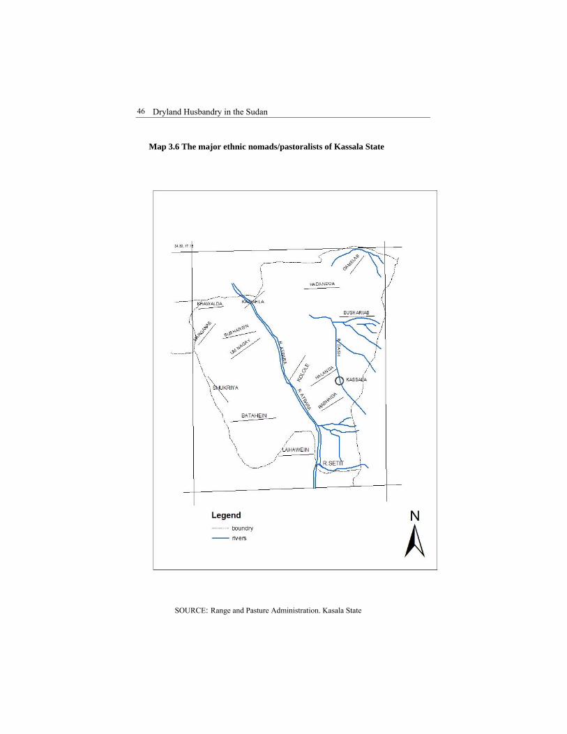
Dryland Husbandry in the Sudan
46
Map 3.6 The major ethnic nomads/pastoralists of Kassala State
SOURCE: Range and Pasture Administration. Kasala State
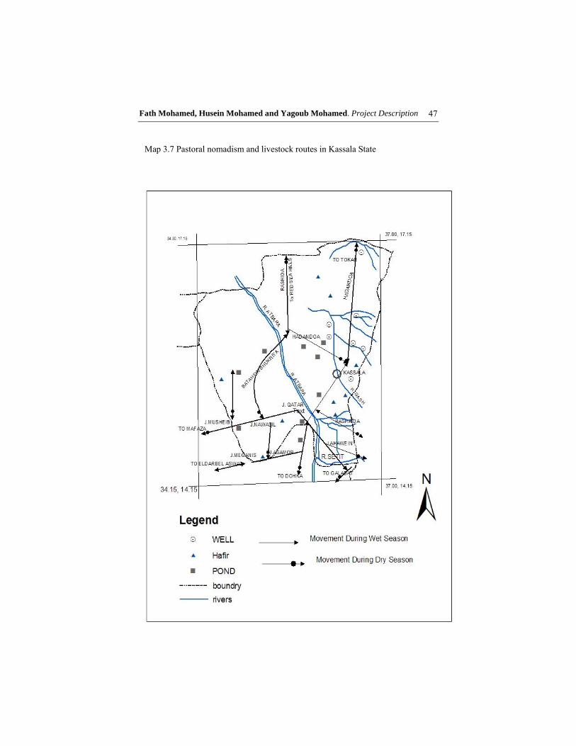
Fath Mohamed, Husein Mohamed and Yagoub Mohamed. Project Description
47
Map 3.7 Pastoral nomadism and livestock routes in Kassala State
Dryland Husbandry in the Sudan
48
Grazing is practised on stubble; the dry matter of most of the scheme crop residues are totaling 1,803,000 tons. Nyangito (1997) showed that the crop residues are of low quality roughages; they are high in lignocelluloses cell wall materials and low in energy also low in readily available carbohydrate such as sugar and starch as well as nitrogen and certain materials, particularly, calcium and phosphorus. Moreover, pyric acid may be present in these residues and is found to play a negative role by binding important minerals such a P, Mg, Fe and Cu.
Low digestibility of crop residues is associated with high lignin and silica content. These are encrusting substances that are resistant to microbial digestion in the rumen. Moreover, these structural carbohydrates have a complex structure that is not easily attacked by the rumen micro- organisms digestive enzymes (Van Soest and Wine, 1967). In addition, only one third of the rain-fed crop residues could be utilized, depending on the availability of stock-water in the stubbles of cultivated areas. Overgrazing has become more acute in low rainfall belt as a result of migration of animals from the cultivated areas of the south. 3.3.3 Livestock Population and Husbandry Sudan is the richest among African and Arabic countries with regard to livestock numbers including cattle, sheep, goats, and camels constitute about 27 million of animal units. In addition to other functions, the animal wealth contributes greatly to the national income i.e. about 50% of the total agricultural production value and about 20% of the gross domestic production value (Bot et al., 1989).
Livestock rearing in the Kassala State is considered among the most prominent economic activities pursued by almost 80% of the State’s rural population. Livestock owned by the people are sheep, goats, cattle and camels. Accurate statistics of livestock numbers are always difficult to get, in view of the dynamic and constant mobility of pastoral nomads. The present data available is based on computations of rates of animal increase and off-take.
The composition of the herd of Kassala State is 15.9% cattle, 37.3 % sheep, 30.3 % goats, and 16.5% camels. General trend of herd population since 1996 is gradually increasing with 2.9% growth rate. Livestock distribution pattern is unstable and fluid depending on land attachment. This system of transhumance actually represented optimal resource use, as livestock have access to green pasture and abundant water particularly throughout the year, considering that pasture is available to an animal within a radius of about 15-20km around water point. (Thibaud et al., 1995).

Fath Mohamed, Husein Mohamed and Yagoub Mohamed. Project Description
49
Generally, livestock in Kassala State move northwards in the wet season and southwards in the dry season, (Map 3.7). Biting insects and muddy conditions of the southern areas during the rainy season force livestock to move northwards to utilise grazing in the drier areas which get enriched with water supplies as a result of rains. After the rainy season, grazing and water get scarce and livestock are moved southwards where they find abundant natural grazing and browsing material as well as crop residues. Extensive livestock system depends mainly on fodder production from natural ranges (Sulaiman 1983). Moreover, livestock production is also determined by nutrition rather than water availability or animal health problems (Jensen and Ureness, 1981). A wide range of studies as reported by Holechek et al. (1989) were considered in showing that, range ruminants consume 2-3% of live body weight per day of dry matter when forage availability is not restricted.
The reports of Animal Resources Administration between 1984-1985 have shown a drop in animal population by exactly 10% for camels and goats, 20% for sheep and 40% for cattle. The conclusion that can be drawn from this is that livestock numbers in the Kassala State suffered the1984-1985 drought. Livestock started to increase (exceeding 2-3 million in 1999) due to improvement of range conditions, and also due to control of epidemic diseases by Organisations working in this field, such as Pan African Rinder Pest Campaign that started work in the Sudan from year 1989 (RMA Office, Kassala, 1989)
Services directed towards the existing animal population in the state are highly negligible if not completely absent. The pastoral sector is almost out of consideration. However, after the recent conflict on available resources, the concept of animal incorporation in the agricultural rotation was drawn but not a sound or reliable implementation has been endeavoured. Moreover, the pre-existing services such as water points are completely neglected. The ephemeral grass areas cannot support the animal population except for few months after the elapse of the rainfall period, so the conflict between crop and animal production is at its highest degree. 3.4 Culture and Indigenous Knowledge of Pastoralists A wide range of studies considered indigenous knowledge as the knowledge developed by people in a given community overtime and will continue to develop it. It is based on local culture and environment, and is dynamic and changing through its ability to incorporate knowledge from outside. In fact every community possesses indigenous knowledge and for this reason such knowledge is given different names such as “local knowledge”, “indigenous technical knowledge”, etc.

Dryland Husbandry in the Sudan
50
The level and degree of indigenous knowledge differs from person to person based on certain factors such as age, experience etc. Most members of the community have a sort of common knowledge; others have shared knowledge on specific items while still others possess specialised knowledge gained through apprenticeship.
Pastoralists as a group, living in remote areas, achieved a high degree of self-reliance and specific culture of their own and their way of life is centred around their developed experiences which helped them to adapt to the harsh conditions of their environment. 3.4.1 Adaptive Knowledge Pastoralists in the northeastern part of the Sudan faced many challenges that resulted in pushing them to marginal areas. The development of mechanised rain-fed farming as well as irrigated agriculture occupied most of the traditional areas used by pastoralists. Under such circumstances, they developed coping strategies to respond to problems in the field of range management, water availability and the health of their animals. These strategies are based on survival and attempt to save their livestock. In such harsh environments with frequent years of droughts, animal loss by death is high. Hence, diversification is an important adaptive strategy. They keep different types of animals such as camels combined with sheep and goats. Another form of adaptation is farming done by some members of the family to produce food and to sell the excess to replenish the lost animals.
Mobility to long distances is also an important adaptive mechanism to overcome shortages of grazing, scarcity of water and to avoid areas infested by insects. There is a trend to keep the type of animals suitable to harsh conditions. For this reason, there is the dominance of camels and small ruminants (sheep and goats) and fewer cattle. Their adaptive knowledge also extends to social aspects. They started farming links and alliances with sedentary population through tribal agreement allowing them to use the farmlands after harvest. Such agreements specify dates when pastoralists are allowed to graze in tribal lands and when to leave the area. In the Butana area, Agab et al. (1992) found that there are at least four herding strategies adopted by pastoralists. The four systems differed significantly in several factors, notably, herd size moving as one group, level of sedenterization, the use of labor and composition of the herd.
Pastoralists, knowledge and their behavior is changing as a result of interactions with other communities and environments. Animal husbandry is affected by diffusion of some technical packages. However, ethno-veterinary practices are still maintained and combined with some aspects of technical practices.
Fath Mohamed, Husein Mohamed and Yagoub Mohamed. Project Description
51
Agricultural Practices
Three types of lands are known in the area, namely depressions, running water- courses (wadis) and high lands (Dahur).
"Dahur" is a high land dominated by hard surface brown clay soil. This type of soil is known locally as "Azaza" and mainly used for grazing.
Depression land is locally known as "Mahwa" which is covered by heavy cracking clay soil known as "Foda". This type of soil is used for cultivation. Ploughing is essential to get the best production of this Foda soil.
The Delta land refers to the area adjacent to the wadi, which is seasonally flooded. The soil is heavy cracking with fine texture. The soils of these lands are also known as Foda and are considered as the best land for cultivation.
Three types of cultivation are practised in the area. These are:
- Terrace cultivation - Beldat cultivation - Wadi cultivation
Terrace cultivation is practised in areas of slow runoff. The terrace trap-
water increases soil moisture. Acreage under terrace cultivation is increasing as a result of drought. At present tractors are used for construction of terraces. Using tractors is considered as a major factor leading to the increase in area cultivated. Terrace cultivation is usually near settlements.
Beldat cultivation is always near the settlement in areas where the topography allows for slow run-off that gives the soil chance to increase its moisture holding capacity. Saluka is the local hand tool used in this type of cultivation. "Feitareta Geshaesh" is the most important variety of dura in the Beldat and its straw is believed to be a good animal fodder.
Wadi cultivation is concentrated in areas that receive flood from seasonal wadis or khors during June-September. Mugud is the main Dura variety cultivated in these deltas. Tractors are used in ploughing and sowing these areas. Wadi cultivation is situated at far distance from villages.
Size of the farm is determined by the method of cultivation used. In Saluka cultivation cropped areas are generally small and range in size from 2-10 acres, while in mechanised farming the size may reach 250 acres.
Sorghum is the only crop cultivated in the area. Different varieties are grown in different localities within Butana area. Geshaesh variety is preferred in north and west areas, while "Korokolu" is the main variety in east and southern parts. In beldat cultivation of some vegetables (Okra and cucumber) and fruits (watermelon) are grown by women.

Dryland Husbandry in the Sudan
52
Sowing date in wadi cultivation is governed by the flooding, while in beldat and terrace cultivation sowing date is determined by the optimal soil moisture depending on farmer experience. Due to drought, sowing is carried out immediately after the early rains.
In Saluka cultivation sowing is done when the soil moisture is adequate for easy practice. In mechanised cultivation, farmers either plough their farm before the rains and use the Saluka for sowing or they wait till the emergence of weeds and then plough and sow when the degree of moisture allows for the movement of the tractor. Drought and Coping Strategies The climate is characterised by five locally distinguished periods: Karif: Rainy season proper, July-September Darat: A hot dry spell immediately after the rainy season,
October-November Shitta: The cool period, December-February Seif: The hot period, March-May Rushash: Early showers, June-July In common with all Sudanese tribes, Shukryia in the Butana divide the lunar year into 28 "inas" or phases. The ina is a 13-day phase of the moon (Table 3.7). Predictive Indicators of Drought
- The rainy season is reckoned by the phases of the moon. The reckoning is not predictive; it is an expectation or proxy indicator. Rain showers in the Bitain or Tirraya or the Dura'a is the continuation of the summer or the beginning of a good rainy season.
- Stars are also used for expectation of the rainy season. If Elzahra star does not appear till the start of the rainy season, local people believe that they would have a bad season.
- Northerly wind after mid-June with much dust is a sign of a bad season. Lack of clouds, poorly early rains, and intermittent rainy season condition are indicators for a poor productive season.
- Growth of plants is an indicator of the rainy season.

Fath Mohamed, Husein Mohamed and Yagoub Mohamed. Project Description
53
Table 3.7: Name of each 'ina' and its date and duration
No. Name of the 'ina' Start date of the 'ina'
Remarks
1 Saratan or Natuh 22 April Seif (the hot period) 2 El Butain 5 May 3 Thuraya or Tirayah 18 May 4 AD-Dabaran 31 Masy Hottest period of the Seif 5 Al-Haga'a 13 June 6 Al-Hana'a 26 June 7 AD-Dura'a 9 July Beginning of a good rainy
season 8 AN-Natra 22 July Actual start of the rainy
season 9 At-Tarfa 4 August 10 Aj-Jabha 17 August The peak of the rainy season 11 Al-Kharasan 31 August 12 As-Sarfa 13 September 13 Al-Iwa 26 September 14 As-Simak
Alazall 9 October
15 Al-Ghafur 22 October Transition between seasons 16 Ar-Rabani 4 November Transition between seasons 17 Al-Ikleel 17 November The start of the cool season 18 Al-Galib 30 November 19 Ash-Shawla 13 December The peak of the cool season 20 An-Na'ayem 26 December 21 Abuldah 8 January 22 Sa'adu Dabih 21 January 23 Sa'adu Saud 3 February 24 Sa'adu Bolakh 16 February The end of the cool season 25 Sa'adu Akhbiya 1 March 26 Al-Farie
Alawal 14 March
27 Al-Farie Athani 27 March 28 Batn Alhoot 9 April The start of the hot season

Dryland Husbandry in the Sudan
54
A good year means:
- Sufficient crop production to allow storage for the future - High level of livestock production - No need for secondary occupation.
Drought Year Results in:
- Shortage of food, water and pasture - Migration for work elsewhere - Economic insecurity - Danger of famine and poor health
Adjustment when drought strikes:
- Southwards migration and seasonal migration to irrigated schemes
- Change mode of living - Migrate outside Sudan
Disposal of assets in times of drought
Prefer to sell: 1. Animals 2. Crops 3. Other assets
Reason for preferring to sell animals
- Animals kept as security against crop failure - Crops safeguard against famine
Investment in years of crop surplus
- Livestock - Farmland - Trade - Others
Drought year strategy to minimise animal losses
- Migration with animals southwards - Sell some to feed others
Supplementation Crushed dura sorghum grain is given to animals that are in poor condition and to those which fail to graze naturally due to reasons of health during the late dry season. Dura residue (straw), stored after the rainy season is used
Fath Mohamed, Husein Mohamed and Yagoub Mohamed. Project Description
55
for feeding livestock after the range is fully utilised and during the dry season. Crop residues may be utilised in the field or it may be cut and fed to animals. Salt is provided twice, or more often, to all animals during the periods when grass is dry, especially at the onset of rains (rushash). The practice is not performed during the wet season, as it is believed that the pasture is then rich in salt.
In good years when dura production is high and prices are cheap, some herders use this opportunity and supplement with dura to increase birth rate in sheep, which is directly related to nutritive feeding. Breeding Breeders do their best in order to regulate breeding as to achieve birth of their livestock to coincide with the rainy season when conditions are favourable. High mortality rates are observed obviously among new-born animals during the dry season when both pasture and water are scarce. For this purpose, the Shukryia used traditional techniques, some of which are mechanical. For example, to prevent mating, they tie the male genital organ as a way to control breeding (Kenan).
3.4.2 Ethno-Veterinary Practices and Diagnosis
Pastoralists as mentioned earlier, live in remote harsh areas with limited contacts with the outside world. Under such circumstances, they relied on their experience and local knowledge to care for the health of their animals. In this field, several researchers have studied ethno-veterinary practices. In northeastern Sudan, the ethno-veterinary practices of camel pastoralists are those of the traditional animal healers who possess a wide range of knowledge regarding camel diseases. Such healers perform surgical interventions, treatment of fractures, and they have a good degree of diagnostic accuracy. The study also found that phytotherapy is the most interesting aspect of traditional healers, practice. They possess a good knowledge of plants and plant products with proven therapeutic utility. Important plants used include Acacia nilotica pods, Striga hermonthica (parasite on sorghum and millet), Cassia senna and a wide range of plants used in healing practices. In some cases the urine of the animal is used as an antiseptic to wash hands or on wounds.
Camel herders also possess some knowledge and are capable of treating animals on the spot and carry out an initial diagnosis. If this initial diagnosis and treatment does not work, they resort to specialised healer.
Herders also use other techniques to control diseases. The movement of animals from certain ecozone during the rainy season is an important precautionary behaviour to avoid insect borne diseases. Another tactic is the

Dryland Husbandry in the Sudan
56
segregation of sick animals from the herd or avoids herds where infection is known.
Ethno-veterinary practices provide valuable clues for experts in the field of animal health to adapt and improve such cheap practices. More studies are needed to carry out detailed analysis of the plants used for healing to scientifically understand the active ingredients and packed in suitable forms for easy use by herders.
Plants and plant preparations used in treatment of human-beings and animals-phyto therapy- include the following: 1. Acacia nilotica (Sunut) (pods) The pods are rich in tannic acid (30% tannin); they are used as powerful astringent. A decoction is made of whole pods and is administered orally for severe diarrhea with instant response. Used externally in powder form for fever, measles and purulent wounds. Pods are used as fumigation and mouth gurgle with excellent results against coryza, rhinitis and sore throat in both men and animals. 2. Cassia senna (Senamaka) (leaves and pods) Well-known purgative and vermifuge for tape worms in both humans and animals. 3. Colocynthus vulgaris (Handal) (Fruit bulb) This herb is a desert creeper that grows and reaches maturity after the rainy season. The fruit bulb is very bitter that has anti-hementhic potential. The tar made from the seeds is used as treatment for mange in camels. The treatment of smearing all the skin is repeated two or three times after which the lesions heal. 4. Calotropis procera (Ushar) (leaves) This is an evergreen leafy plant, although animals avoid grazing the green leaves, but when the leaves are dry they are readily consumed. The dry leaves when fed to camels showing night blindness, the signs will disappear. 5. Cymbopogon proximus (Mahareib) (leaves) This is a perennial grass that grows in depressions. The leaves have an excellent lemon flavour. Decoction of the leaves has strong spasmolyic

Fath Mohamed, Husein Mohamed and Yagoub Mohamed. Project Description
57
action and hence dispensed for colic during birth, for headache, gastro-enteritis in both man and animals. In man it is a well-known hypotensive and sedative specially in hepatitis. In animals, it is also used in equine colic, lactic acidosis, emaciation, and inappetence. 6. Acacia mellifera (Kitter) (pods and bark) This shrub and/or tree is a very important browse. The pods and the bark are made into thick infusion for drenching animals against endoparasites. 7. Azadirachta indica (Neem) (leaves and seeds) This is a tree introduced to the Sudan from India. The leaves made into paste when applied to contusions, abscesses and lacerations give excellent healing of painless manner, with no scars formation. Dried leaves are used to ward insects. The sun-dried seed is macerated overnight and used to treat scabies and ringworm in camels and other stock. 8. Artemsia herba-alba (Sheih) (shoots & Leaves) This perennial plant is native to the deserts of the Sudan. It is used for its antispasmodic and carminative actions in the form of herbal tea made from the leaves. The shoots are used against mixed worm infestation in man and small ruminants but particularly indicated for tapeworms, especially in camels and sheep. 9. Balanites aegyptiaca (Hegleig) (fruit sap & fruit juice) It is a native tree that provides edible fruit for human and livestock. The leaves are browsed. The fruit sap is used as purgative. The fruit juice is indicated for chronic cough. A powder is made from its leaves, and the bark is used for abscesses in the soles of feet and the undersides. 10. Striga hermonthica (Buda) (plant material) This plant is a parasite on sorghum and maize. The leaves and flowers are strong anti-frothing agent; the dried material is powdered and administered orally twice or three times for bloated sheep, cattle and camel. 11. Hibiscus trionium (Wika) (fruit) This is wild okra; the fruits are dried and ground into fine flour mixed in small amounts in warm water and administered orally for mild but sustained

Dryland Husbandry in the Sudan
58
laxative effect. It is used in bloat, especially during the rainy season when large amounts of succulent legumes are consumed. Herders recommend the use of okra for expelling abdominal foreign bodies, especially plastic materials. 12. Acacia nubica (Laot) (roots) Spine scent shrub, the fumigant of its roots is used as anti-rheumatic. 13. Adansonia digita (Baobab tree) (fruit) The maceration of the mesocarps is used against dysentery and to stop diarrhoea. 14. Aerva jauanica (The whole plant woolly erect or sub-erect
perennial herb The poultice of the whole plant is used to treat swellings and wounds. 15. Fagonia critica (Um Shwika) (whole plant) Spinescet glabrous is an annual herb that grows on sandy hills and in lowland plains. The maceration of the whole plant is used as anti-spasmodic. The powdered fruits are mixed with sour milk and taken instantly as anti-purgative.
16. Jatropha glauca (roots and seeds) Succulent glabrous perennial under-shrub with yellow flowers one meter high, with hallow, and striate stems and papery white barks. The roots are used to relieve the pain after birth, whereas the seeds are used as laxatives.

CHAPTER FOUR PROJECT ACTIVITIES
Mohamed Fadl Elmoula Idris Mustafa Mohamed Ali Dafalla Ibrahim Mohamed Elamin Abd El Rahman
4.1 Management Activities DHP-Sudan, since its start in 1995/96, continued working with the pastoralists and agro-pastoralists in a community-based participatory action-oriented research aiming to achieve sustainable resources management and development.
Range improvement and management in this activity was attempted through water harvesting, seeding, and active involvement of pastoralists. The intervention continued to be conducted in Malawia fenced enclosure (600ha) contributed to the project by Kassala State Range and Pasture Administration. Using different types of Terraces-crescent (Plates 3 & 4), U, V. shaped-have enabled satisfactory management of run-off water for the benefit of the broadcasted desirable native range plants seeds. The resultant plant cover increased in both diversity and productivity. For example, the herbage production dry matter increased to more than four folds (from 0.12 Tons/acres to 0.50 tons/acres) (Plates 5, & 6).
The contrast in vegetation height and diversity between the stand inside and outside the enclosure tempted and induced the agro-pastoralists to adopt the idea of protecting the range plants during their germination and the active growth period.
The Malawia fenced research site, used as demonstration site, is becoming a dependable site for multiplication of native range plants seeds. An area of 42,000ha was reseeded in 1997 in the surroundings of the dry season drinking water basins of Grateit, Gardeib and Tambi using the seeds collected from Malawia site in 1996; the pastoralists were fully engaged in seed broadcasting and protection.
The formation of range development sub-committee at the large scale intervention sites played the major role in the mobilisation and hence active participation of the grass roots pastoralists in seed broadcasting and guarding.

Dryland Husbandry in the Sudan
60
Seed collection at the end of every growing season is becoming an activity before allowing the animals to graze the standing hay that remains after collection.
The desirable native plants seeds included; Eragrostis spp., Ipomea cardosepala, Indigofera spp., Sesbania sesban and Crotolaria senegalensis (plate 7).
In the open area around ‘Garateit’ and ‘Garadieb’ there is a dry season grazing resort every year. Mixed seeds of Belpharis persica and others are broadcasted before the onset of the rains to germinate and establish when the animals are far away in the wet season grazing areas.
Building of 3m X 4m red brick room for the Malawia permanent guards residence and a 6m X 5m as store room for keeping the seeds.
4.2 Water Management for Pastoralists and their Livestock This practical intervention started since the inception of the project in the wet season of 1996. The first activity was conducted to direct the water from the Gash River to Tambi basin whereby a canal was constructed to provide water for the nomadic pastoralists and their livestock during the dry season. Through the active participation of the community in the maintenance of Garateit and Garadieb three water basins continued to be the major activity of harnessing run-off water into the basins. The water management sub-committee was able to survey the watershed areas from which the surface run-off can be diverted through simple earth embankment where possible towards the basins before the rains and during the early sporadic showers.

Idris, Ali, Ibrahim and Rahman. Project Activities
61
Plate 4. Community participation in range reseeding
Plate 3. Construction of crescent-shaped terraces (May 2003)

Dryland Husbandry in the Sudan
62
Plate 5. Reseeded Malawia enclosure (December 2003)
Plate 6. Standing hay crop of indigenous plant- Malawia enclosure (December 2003)

Idris, Ali, Ibrahim and Rahman. Project Activities
63
Plate 7. Seeds collection in Malawia enclosure (December 2003)
The outcome of the intensive surveys resulted in construction of 17Km
canals to the basins. The simple designs implemented by the grassroots guided by the water management sub-committee have enriched the ground water aquifer of the basins raising the water table level to six meters below the basin floor (Plates 8, 9, 10 & 11).
Regular maintenance of damages occurring along the
embankments affected by strong water flows during heavy rains accompanied by wind storms are carried out by the beneficiaries.
Digging of silt trap wells at the inlets of the basins and removal of bushes from basins’ floors and catchments areas remain the responsibility of the beneficiaries.
4.3 Water Harvesting for Better Utilisation of the Range Resources This activity was planned to carry out in five areas to cover a considerable portion of the Butana plain (the western part). To be able to concentrate only four locations of Eastern Nile province of Khartoum State were selected and the main criteria was the experiences of the local inhabitants in traditional water harnessing methods. The areas selected included; Salamat wad Nayl, Elshamie, Umm Rakham and El Farie.

Dryland Husbandry in the Sudan
64
There are many seasonal shallow water-courses where their water is not utilised. Considerable livestock number could better utilise the range resources of the area, if such run-off is developed. The local inhabitants were found to have good experience in digging of hafirs with some modifications and some technical advise and training which could be improved for the better (Plates 12 & 13). Quite a good number of old silted hafirs are scattered all over the area that could provide sites for the collection of water if they could be de-silted enlarged and deepened.
Activities
Training of technical staff and key informant agro-pastoralists in the field of water management i.e. water harvesting by rehabilitation of some selected water ponds (hafirs) by the beneficiaries, range improvement through community involvement, and socio-economic aspects of collaborative working attitudes.
Objectives
The main objectives were: (a) to train the local inhabitants to acquire suitable sustainable techniques in hafirs excavation through practical training of key-informants to further train the grassroots, (b) to manage and improve the grazing resources in the areas commanded by the hafirs, and (c) to develop awareness among the agro-pastoralists on water management in the range areas and consequently manage the range resources in the vicinity of the hafirs and also improve when need arises.
Achievements
1. Training phase
The training phase was done at two levels. In the first one nine technicians were trained by professionals in all aspects of water management, range management and improvement as well as social aspects aimed at developing active good working relations among the beneficiaries. In the second, three outstanding technicians were allowed to train eleven key informants who later guided the grassroots under close supervision of technical trainers.
2. Implementation phase
This represents the actual work done by the beneficiaries, which had reflected the degree they perceived the techniques. During this phase supervisions from the project were performed, noting a good response of beneficiaries.

Idris, Ali, Ibrahim and Rahman. Project Activities
65
A good trend of imitation was observed whereby some individuals with the key informants and relatives started to develop some low lying catchment areas near their settlements for their small stock.
Plate 8. Dry Grateit water basin- siltation & bush
Plate 9. Grateit water basin after silt removal, bush eradication,
floor grading (full of water)

Dryland Husbandry in the Sudan
66
Plate 10. Pulling water from deep hand-dug wells by animals before DHP's intervention (embankment & basin floor grading)
Plate 11. Consolidated water basin embankment by the
pastoralists resulted in holding enough run-off water

Idris, Ali, Ibrahim and Rahman. Project Activities
67
Plate 12. Digging the Hafir floor
Plate 13. Compacting Hafir floor

Dryland Husbandry in the Sudan
68
For sustainability of the work, the beneficiaries were equipped with the necessary simple equipment of digging and earth removal devices to help them carry out future rehabilitation activities. Still seven of the trained key informants are supervising the up-keep of the four hafirs. The Range and Pasture Administration, Khartoum State, is keeping an open eye on the range condition in the intervention sites and conservation measures of the range are annually performed. 4.4 Participatory Action Research on Fodder Crops
This intervention was conducted to fulfil the following objectives: To up-grade the food and forage crops through introduction of an
indigenous food, fodder and cash crop (cowpea) under rain-fed farming system
To maximise the productivity of the fodder and the food crops at both quantity and quality level
To acquaint, the agro-pastoralists with the inclusion of an alternative crop, with the traditionally and continuously cultivated exhaustive food crop (Dura) The introduced crop being a legume that adds nitrogen to the soil, hence
increasing fertility, it is a food, cash and animal feed crop. Four selected farmers in different locations have been supplied with
cowpea seed. The Range and Pasture Administration, Kassala State, prepared half an acre for each farmer (ploughing and ridging) free of charge. The results obtained impressed three farmers who succeeded to establish a good crop. The crop is eaten as food source during the harvest period.
4.5 Plant Encyclopaedia for the Dry Savanna and Semi-arid Land of
Sudan (Butana, Eastern Sudan)
For the production of a plant encyclopedia for the dry land Savanna and semi-arid lands of the Sudan, the Butana plain of eastern Sudan and Kassala were taken as case studies representing drought affected areas. Assessment of the current status of the vegetation floristic composition has been carried out. The main activities included are the following: -
1. Field surveys for exploration, collection of information and plant specimens
2. Pressing of the collected specimens 3. Identification of the collected and pressed plant specimens (136
plants)

Idris, Ali, Ibrahim and Rahman. Project Activities
69
4. Allocation of the specimens in the herbarium of Range and Pasture Administration, and Al Neelain University herbarium. The information accompanying the plant specimens constituted the following: Ecological data (climatic, soil and topographic) Economic uses Photographic presentation of the landscape and individual
plants.
A separate progress report was prepared in an attempt to collect more specimens but the failures in rainfall in the consecutive rainy season hindered the acquisition of additional specimens. 4.6 Capacity Building The programs for training were set to strengthen the pastoralists and the institutions, capabilities for implementing sustainable development and build consensus on how to work together and facilitate greater collaboration by establishing mechanisms for wide consultations. 4.6.1 Paravet Training
Khartoum Veterinary School was first established, as one of six higher schools, on the first of January 1938. The other five higher schools were Kitcheners Schools of Medicine, Schools of Agriculture, Arts, and Law, Science and Engineering, which were later on amalgamated together to form the nucleus of the University of Khartoum.
Khartoum Veterinary School was administered and supervised academically by the Department of Veterinary Services, Government of the Sudan. In 1946, union of higher schools, except the medical, constituted the Gordon Memorial College. This college was upgraded in 1947 to a university college and was affiliated with the University of London. The latter was setting the examination papers and awarding the degrees.
The University College of Khartoum was officially transformed to the University of Khartoum on the 24th of July 1956. That meant the end of the “special relationship” with the University of London and the beginning of a new era of the University of Khartoum to grant its own degrees in the different faculties.
Kassala State has a large livestock population of the best breeds; according to estimates for the year 2002 there are about 3.6 million heads of cattle, sheep, goats, and camels. Table (4.1) shows the distribution of livestock by provinces.

Dryland Husbandry in the Sudan
70
Table 4.1: Livestock population, Kassala State.
Province Cattle Sheep Goats General Total
Kassala 85,000 192,000 234,000 180,000 691,000 Atbara river
159,000 395,000 224,500 133,000 911,500
Gash 148,000 267,000 177,000 103,000 695,000 Sitiet 143,000 352,000 224,000 123,000 842,000 Hamash Korieb
63,000 160,000 219,000 36,000 478,000
Total 598,000 1,366,000 1,078,500 575,000 3,617,500
1. Animal losses due to the 1984 drought were estimated as follows: Cattle 20%
Sheep 40%
Goats 10%
Camels 5%
2. Animal losses due to the 1990-1991 drought were: Cattle 10%
Sheep 15%
Goats 5%
Camels 2.5%
Major constraints to develop the livestock sector are:
1. Disease 2. Drought 3. Lack of funds allocated to veterinary services
Veterinary services are provided by 5 veterinary hospitals; 14 veterinary dispensaries; 6 annual mobile vaccination teams; and a number of community-based animal health workers in remote areas.

Idris, Ali, Ibrahim and Rahman. Project Activities
71
Justification
Veterinary hospitals and dispensaries were built in the early 1960s at localities highly populated with animals. These veterinary establishments were providing efficient veterinary services. However, due to adverse conditions the distribution of livestock throughout the Kassala State changed dramatically. Animals deserted previously in populated areas moved to areas where no veterinary establishment exists. As a result many of the existing veterinary establishments were not operational and were later found to be very expensive to run and to maintain. A number of vehicles quickly became off-road and it could not be possible to maintain sustainable veterinary services in remote areas.
Beneficiaries
- Pastoralists and rural livestock owners in target areas
- Unemployed people in target areas
Objectives
1. To provide veterinary services in remote areas where no veterinary establishments exist
2. To create job opportunity for people in target areas A work plan was formulated to extend veterinary services to rural areas
through skilled personnel from the community and tribes after having an intensive training course in aspects of animal health care, epidemic control, disease notification, animal husbandry and production, veterinary extension and pasture management.
Selection of Trainees
Selection of trainees took place among people from target areas nominated by their rural people’s councils and committees or by tribal chiefs after subjecting them to an intensive interview. Selected persons should at least have completed the basic education level and show the will to work as community-based animal health workers.

Dryland Husbandry in the Sudan
72
Training Course
Selected persons were usually subjected to an intensive training course in aspects of animal health care, epidemic control, disease notification, and animal husbandry and pasture management. They received theoretical lessons besides practical activities on history taking, general and physical examination of cases, measuring of temperature, pulse and respiratory rates, sample taking, diagnosis and treatment of sick animals, camel breeding and diseases, poultry production as well as meat inspection. During the course, trainees usually visit the slaughterhouse, vaccination crushes, livestock markets, animal concentrations at water sources and private animal production units.
Each trainee received a manual of paravet training at the beginning of the course and at the end; all trainees were usually subjected to written and oral examinations.
A graduation ceremony is usually conducted at the end of each course and the paravets receive graduation certificates and veterinary medical kits containing important veterinary drugs and equipment free of charge to start with.
The manual for paravets used for the training was precisely written by Professor Babikir Abbas in 1997. It concentrated on animal diseases and treatments. In 1999 and thereafter more chapters were added by Professor Dafalla and Dr. Mustafa until it reached its final satisfactory form. The manual was used not only for the paravets training programs financed by DHP but also for a number of training programs financed by Plan-Sudan held in New-Halfa and Khashm Elgirba. Table (4.2) shows the number of training courses financed by DHP.
Table 4.2: Number of training courses financed by DHP
Course No. Year Male Female Total
1 1997 20 0 20 2 1999 20 0 20 3 2000 20 0 20 4 2001 0 24 24 5 2001 20 0 20 Total 80 24 104
Idris, Ali, Ibrahim and Rahman. Project Activities
73
10 of the trained paravets in 1997 were from Gedraef State. In the year 2000, four of the selected candidates were working as
public health inspectors and used to supervise meat inspection in their region but without previous training or knowledge. They were selected because of their continuous presence in the same place and ease with which they could be trained. DHP (58%) and Plan-Sudan/Kassala (42%) jointly financed this particular course.
In 2001, twenty-four females were trained as paravets and it was believed to be the first in the country. Four of the selected females were previously trained on the use of improved coal stoves and have been working as voluntary extension workers in Gash area.
Due to lack of transport facilities and lack of finance, it was not possible to follow-up the paravets and their performance. However, it was observed that the courses were relevant, the training was well organised, and the students were generally of good quality and succeeded in the training.
4.6.2 Range Management Training
Background
Rangeland activities in Sudan go back to the year 1946 when external trade committee recommended the establishment of grassland section responsible for the country’s livestock population. In 1947 Mr. M.N. Harrison, a British agrostologist, conducted an extensive survey all over the country and finally came out with the currently available vegetation map of Sudan in 1958. In 1954 a rangeland research section was established in the department of veterinary services to carry out activities related to rangeland conservation against uncontrolled bush fires in the semi-desert and the low rainfall woodland savanna ecological zones, which constituted the major grazing areas. Proper water resources distribution in rangelands as management tool was undertaken particularly in Butana wet season grazing resort of eastern Sudan and in the transitional areas between dry and wet seasons grazing in Southern Darfur where a range improvement station was established.
In 1973, the range section was transferred to the Ministry of Co-operation and Rural Water Development. Since that time the section acquired the name Range and Pasture Administration (RPA). In 1975 RPA came to be one of the divisions of the Ministry of Agriculture. After the adoption of the new Federal system, a number of offices for RPA have been

Dryland Husbandry in the Sudan
74
established in the 16 different states. However, the new Federal system has brought institutional change, within the Ministry of Agriculture and Forestry and accordingly RPA became under the general Administration of Natural Resources and Production. RPA is now divided into Federal and State Administrations. At the Federal level it has four divisions, namely: natural rangelands, irrigated forage crops, ranches, and training divisions. These divisions have the responsibilities of: (a) setting policies and national programmes for rangelands conservation, inventories and management, (b) setting rules for rangelands protection and utilisation, (c) setting plans for rangelands genetic resources, exploitation, documentation and conservation, (d) participation in land use planning and mapping, and (e) supervision, monitoring and evaluation of donor funded projects. At the State level, RPA, responsibilities are to implement activities such as seed collection of indigenous rangeland plants, seeding of degraded rangeland areas, demarcation of livestock migration routes between dry and wet seasons grazing areas, rangeland protection from seasonal uncontrolled bush fires and implementation of donor-funded projects.
The dryland husbandry project played an important role in the Sudan. It gave great attention to the subject of training and capacity building for the different levels of target groups of Range and Pasture Administration (RPA) staff, that include range specialists from the state of project area (Kassala), and other states of similar environmental conditions (pastoral areas) of the country. The main objective of training is to unify the methodology of range surveying, management and improvement techniques.
Four training courses were organised within the framework activities of the project, during the period (1996-2001) in collaboration with RPA. However, RPA that conducts the training programmes, usually produces training manual in collaboration with lecturers from different universities and related fields; now it is considering the production of training manual that contains all materials delivered in different training courses (Tale 4.3)
Sudan Dryland Husbandry project has given special consideration to training subject matter and capacity building of the target groups including range specialists from the project area and the States of similar climatic conditions in the country’s pastoral areas. The idea behind these courses is to unify range management methodology and range improvement techniques. For this reason four training courses were conducted during 1996-2001 within the framework of the project activities. Finally, a training manual has been produced taking into account rangelands of the different ecological zones of Sudan as classified by Jackson and Harrison (1958), which takes rainfall and soil types as the main criteria; six vegetation zones are revealed:
Desert (0 – 75 mm)

Idris, Ali, Ibrahim and Rahman. Project Activities
75
Semi-desert (75 – 300 mm) Low Rainfall woodland Savannah (300 – 800 mm) High rainfall woodland Savanna (800 – 1.800 mm) Flood region; and Montane Vegetation: (500 – 2,000 mm)
Aspects investigated in the manual are: Definitions Ecosystem concept Functioning of the ecosystem Ecology in relation to grazing Plant succession Methods of documented succession Pastoralism in Sudan Patterns of animal production systems identified in Sudan are: Sedentary Semi-nomadic Nomadic Newly introduced patterns (include permanent and seasonal ranching
systems in some parts of the low rainfall savanna) Patterns of range utilisation in Butana
Characteristics of the present rangelands utilisation and its impact on animal production systems on
Nomadism (advantages and disadvantages) Range utilisation across country boarders Range resources problems and proposed resolutions
Problems highlighted include:
Uncontrolled burning Over grazing Development policies Social aspects Natural hazards etc.
Suggested solutions include: Community participation in rangelands rehabilitation programs Development of land use guiding map

Dryland Husbandry in the Sudan
76
Table 4.3: Range Management Training
Year Training field Main objectives Duration (weeks)
No. of Trainers
Remarks
1996 Understanding & measuring vegetation changes in the Sudan
Unifying vegetation measurements 2 7
1999 Range management & improvement
Unify understanding methodology of range management and improvement.
Provide participants with knowledge and skills necessary to identify range resources constraints and problems, evaluate possible solutions that helped in implementations
2
10
2000 Range management & improvement
Unify understanding methodology of range management and improvement.
Provide participants with knowledge and skills necessary to identify range resources constraints and problems, evaluate possible solutions that helped in implementations
2
10
Eight officials (RPA) technical staff & two research assistants
2001 Rangelands surveys & analysis Improvement of the efficiency of range specialists in the field of the surveys, analysis and assessment.
Capacity building in use of information technologies and their applications in monitoring and evaluation of vegetation cover and land resources (remote sensing and geographical information system) techniques.
Enabling the trainees to raise the pastoralists’ awareness while working among them
2
12

77
Adoption of sound rehabilitation programs Protection against seasonal fires Reinforcement of traditional local institutions Demarcation, rehabilitation, and registration of livestock migration
routes Range management Standards and principles of range management
� Proper stocking rate � Proper distribution of animal � Proper kind and class of animal � Proper distribution of water points
Grazing systems
� Continuous grazing system � Rest rotational grazing system � Deferred grazing system � Ranching
Private ranches Commercial ranches Cooperative ranches Group ranching Grazing blocks
� Ranching problems: Lack of stratification in animal production Seasonality in animal growth and production Lack of suitable infrastructure
Range protection - Fire lines network
- Rangeland inventory � Ground survey as a systematic way of data collection and
analysis � Rangelands survey data and duration of the survey � Survey equipment that are supposed to provide good orientation,
over view and accumulate measurement (equipment needed). � Steps for rangeland survey
Office work Field work Sampling (shape and size of sample plots) Sampling procedure.
� Stratification of vegetation to facilitate sampling � Vegetation measurements
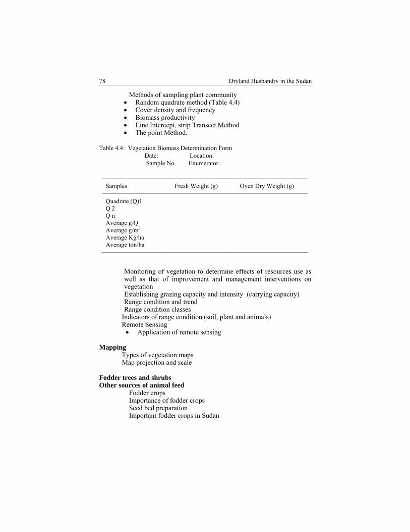
Dryland Husbandry in the Sudan
78
� Methods of sampling plant community Random quadrate method (Table 4.4) Cover density and frequency Biomass productivity Line Intercept, strip Transect Method The point Method.
Table 4.4: Vegetation Biomass Determination Form Date: Location: Sample No. Enumerator:
Samples Fresh Weight (g) Oven Dry Weight (g)
Quadrate (Q)1 Q 2 Q n Average g/Q Average g/m2 Average Kg/ha Average ton/ha
� Monitoring of vegetation to determine effects of resources use as well as that of improvement and management interventions on vegetation
� Establishing grazing capacity and intensity (carrying capacity) � Range condition and trend � Range condition classes � Indicators of range condition (soil, plant and animals) � Remote Sensing
Application of remote sensing Mapping
� Types of vegetation maps � Map projection and scale
Fodder trees and shrubs Other sources of animal feed
� Fodder crops � Importance of fodder crops � Seed bed preparation � Important fodder crops in Sudan
Idris, Ali, Ibrahim and Rahman. Project Activities
79
� Advantages of planting grass/ legume mixture Fodder Conservation Hay making Forage baling Silage making
� Agricultural by –products and crop residues Techniques of improving the nutritive value of agricultural by –
products and crop residues Physical treatments (Grinding, Ball milling, Gama or Electron
irradiation and High pressure /High temperature Steam treatment
Chemical treatments (Sodium hydroxide and Ammonia treatments)
Biological treatments (Enzymes treatments, Bacterial fermentations and Single cell protein)
� Industrial processing of the agricultural by –products and crop residues
Determination of feed value
� Sample preparation � Chemical analysis
Laboratory methods Enzyme. Use of cellulose enzymes Stomach fluids
Herbarium
� How to collect, process and store plant material in the Herbarium � Main Steps in Collecting, Processing and Storing Plant Specimens
Range improvement
� Methods of range improvement � Control of undesirable range plants
Biological control Chemical control Mechanical control.
� Burning as an oldest practice used to manipulate vegetation on grazing lands
� Fertilisation: � Protection from grazing
Hema system Mahmias (Grazing allotments).
Dryland Husbandry in the Sudan
80
� Application of soil moisture techniques Pitting Furrowing Water spreading Terraces
� Seeding Fundamental requirements for successful range seeding Management of improved stands
Range economics Range extension
� Range extension objectives � Extension Methods � Extension technologies and tools
Project cycle
� Identification and formulation. � Preparation and analysis � Appraisal � Implementation � Evaluation and follow-up
Rapid rural appraisal
� Features of participatory rapid appraisal � PRA versus other research methods � Examples of techniques:
Preference Ranking Wealth Ranking Map drawing Transect Seasonal calendar Livelihood analysis Flow diagram
Technical reporting Example of range technical report (range management and improvement form)
Idris, Ali, Ibrahim and Rahman. Project Activities
81
State:…………………………………………………………….Locality:……………………………………………………….Activities:……………………………………………………….1. Range protection information (fire grids)
Proposed length Cost /km Sites of seed collections Sites of overgrazing
2. Range improvement information Soil potentiality Soil moisture conservation practices Types of reseeding varieties Seed rate Cost / unit area Rainfall monitoring Growth rate monitoring Carrying capacity Pattern of grazing
3. Seed collection programmea. Open range
Time frame Type of seeds Methods of collection & cleaning Cost / sack Weight of sack
b. Nurseries Seeded areas Type of seeds Methods of collection & cleaning Seed rate Cost/kg Growth rate monitoring Total production
4. Plant genetic resources Information about Plant genetic resources programs.
5. Ranches and enclosures a. Promising sites of ranches establishment b. Demarcation of exclosures (areas, location, different treatment used, parameters measurements and monitoring of conditions and trend.)
Dryland Husbandry in the Sudan
82
6. Irrigated forage crops
Areas Irrigation methods Types of crops Types of seeds and its adaptability
7. Crop residues and agricultural by-products Areas Types of crops Types of residues Amounts of residues Available treatment methods
8. Livestock movements Condition of wet season grazing areas Condition of dry season grazing areas Livestock routes Water sources
9. Constraints 10. Willingness of community participation11. Suggestions for performance upgrading

CHAPTER FIVE
GENDER ISSUES Muna M.M. Ahmed Fathia Salih Musa
5.1 Women Participation
5.1.1 Background
The need to incorporate the gender component in DHP came from the strong feeling that women's contribution to natural resource management and socio-economic development. The role of pastoral women in the different ethnic groups with respect to land use and resource management is related to culture and religion. Culturally the Sudanese societies have a strong tradition of mutual self-help as well as extended family network that emphasises good share of resources. Women have the dual responsibilities of contributing to the economic resources of the family and at the same time the domestic labour. They are also involved in several land use activities such as rearing young domestic animals, gardening, weeding, harvesting, and supplying of water and wood collecting. During the rainy season, the pastoralist women are heavily engaged in milk processing to produce sour milk and ghee and in some places they practice some handicrafts like waeving rugs, bags and cushion made from leather, mats, baskets and covers over food trays. They also face full responsibilities of household income and food production when husbands move away in search of paid employment.
A multi-disciplinary team of women scientists conducted a wide survey in Butana plains in 1997. During the rainy season, many pastoral tribes occupy the Central and North Butana Plains where rich pasture and water are available. The well-known nomadic tribes are the Shukria, Hadendawa and Rashaida. They are sheep and camel herders.
The pastoralsist women accompanying their families throughout their movements with their animals become well acquainted with the different types of vegetation. They also use the natural resources rationally to secure survival.

Dryland Husbandry in the Sudan
78
An area development scheme (ADS) project in central Butana established community forest by Shukriya women in Elsubagh villages and brought a remarkable change in women’s participation in rangeland rehabilitation in Butana plains. They played a great role in Belpharis edulis (Siha) seed collection to be planted in areas of scarcity. "Siha" is the most palatable plant preferred by animals.
The continuous cycle of drought affected severely the mobile pastoral group in Butana plains. The Shukriya lost most of their animals in 1984 drought and some of them gave up nomadic livelihood and settled near El Girba irrigated scheme. Women were the most affected groups because they faced heavy responsibilities after the men migrated to urban centres. Illiteracy rate is 95% among the pastoralist women in Butana plains. They face scarcity of drinking water in summer season. Famines and diseases caused by malnutrition are spreading among the pastoral communities.
5.2 Description of the Research Area
The area of the research lies within the Sahelian zone where plant cover was greatly reduced by recurrent drought and overgrazing. The mechanised farming is practised over a wide range at the expense of natural vegetation. Livestock production is an integral part of the activities of nomads and agro-pastoralists. Nomadic life is linked to the permanent water points in the North and is limited by prevalent biting flies in the South during the rainy season. One of the most distinct areas recognised within the Eastern State (Kassala), is the Central Butana bordered by Atbara River (one of the Nile tributaries) to the East and Blue Nile to the South and southwest, an area of good pasture available to all nomads. Some of the well-known camel nomads are the Shukria, Hadendawa and Rashaida. The Objective of the Study To collect the basic information about socio-economic situation of
pastoralist women To assess women’s role in natural resources management To identify women’s participation needs and constraints
Data collection methods relied on PRA checklist and questionnaire.
Field visits were made to four localities in central and North Butana plains. Meetings were held with nomadic traditional leaders and women. Information was obtained by reviewing published and unpublished literature. Field visits were made to the nomads at Goz Rajab, semi-nomads of Kridrar village and to the settled pastoralists in Abu Talha in Kassala
Muna Ahmed and Fathia Musa. Gender Issues
79
State. Results for comparisons between settlers, semi-nomads, and nomads showed that high illiteracy rate and existence of more than one wife were the common feature among the different pastoral communities. Within the Rashaida community, transformation to sedentary life had improved the quality of living of the settlers through the provision of clean water by tankers from nearby farms. Vehicles replaced camels in transportation. Activities Recommended Were Provision of income generating activities for pastoralist women are
the best possible measure of mitigating the impact of drought and alleviating poverty.
Literacy programme for the mobile group, both men and women. Initiating of environmental conservation awareness programme.
5.3 Action Research 5.3.1 A Case Study Among the Rashaida Pastoralists Women The Rashaida tribe has been selected as one of the most important Arabic Nomads who crossed the Red Sea with their animals in 1846 and settled in the Eastern region. They became one of the most distinctive groups among nomadic tribes as their economic strategy is directed towards the promotion of sustainable socio-economic development. Camels are raised for race and export purpose while goats are kept for milk and ghee. Recently sheep became an important source of income.
Although the workload has been reduced since men are responsible for bringing water and alternative energy, women still have many duties to perform. They take care of sick, pregnant animals and their kids at the suckling age. Surplus milk is processed into sour milk and ghee. They also participate in subsistence cultivation; women and girls practice handicrafts such as car and camel decoration. Objectives
o To identify the crucial role of women in the progress of livestock production and welfare of pastoral life
o To highlight the positive attitudes and practices of the Rashaida that have become rather exemplified for others to adopt
o To assess the impact of the diversified economy of the Rashaida on women's traditional role and to investigate the socio-economic change that takes place among them

Dryland Husbandry in the Sudan
80
5.3.2 Rashaida Economic Transformation Since the Rashaida had been stricken by the drought of 1970s and lost their camels, the behaviour of keeping large numbers of animals for export changed. However, there is also a tendency of keeping large numbers of sheep, which can be sold at an age of 12-15 months to provide the best revenue.
Although the Rashaida are still dependent on herds as main means of livelihood, many pastoralists have been able to diversify their economic activities by being involved in trade, crop farming and out migration labour.
The socio-economic transformation which has taken place in Rashaida communities recently has given the women freedom to take decisions in some family affairs in the absence of husbands and heading households. Some of the women are also involved in trade activities in Kassala market.
The Rashaida social change is self-generated to empower their economic situation. Accessibility to energy devices such as buta-gas, kerosene and improved stoves to all groups have emphasized women’s role in environmental conservation.
Within the settlers and semi-nomads, health condition has improved through construction of pit latrines and bathrooms.
Women become happier to settle in villages and identify their needs for social utilities such as electricity and clean water, and social services such as adult education. Conclusion and Recommendations The transformation of Rashadia socio-economic conditions has a positive impact on women’s role in pastoral life. Provision of social services lead to reduction of women’s work-load and become more responsible for animal raising and development of milk processing and handicrafts. Recommendations Provision of adult education Training of women as community animal health care workers Capacity building in domestic industry, such as processing milk
into cheese, ghee and yogurt at commercial level Improvement of local handicrafts
5.3.3 Improved Stoves to Reduce Biomass Energy Kassala State faces an environmental degradation as a result of the overexploitation of the limited natural resources. A workshop was carried

Muna Ahmed and Fathia Musa. Gender Issues
81
out at Degen village north of the Gash Delta for women training to use improved stoves. DHP field committee member and Forestry Administration extension section executed the program. 21 women were selected from Degen and nearby villages to participate. The training programme consisted of awareness raising in environmental protection and forest conservation by using alternative energy sources and improved stoves.
A demonstration of an improved stove made of metal casing, ceramic liner was tested for cooking time, and amount of fuel-wood consumed which proved to reduce 50% of fuel-wood (Plates 14 & 15). 5.3.4 Training Women Paravet Male paravet training was conducted since the beginning of DHP in Sudan. The idea of women paravet training came from the fact that women are more inclined to look after sick and pregnant animals. Paravet training programme similar to that of males was conducted to benefit 24 females who were capable of reading and writing in Kassala town. They were subjected to a written examination. At the end of the training course they were given certificates and equipped with drugs kits. These trained women could then move to remote areas where they could deal with animal health. A revolving fund was allocated for purchasing the drugs (Plate 16). 5.3.5 Training Workshop for Pastoralist Leaders A workshop held at Gedaref State was executed by DHP in collaboration with women NGO "El Hawdag Pastoralist Women Society" and Pastoralists Union. Sixteen males and the same number of female participants were selected. The programme included lectures that addressed main issues of environmental law and conflict. The purpose of this training was to empower pastoralist women in natural resources management and to strengthen pastoral leaders on conflict resolution.
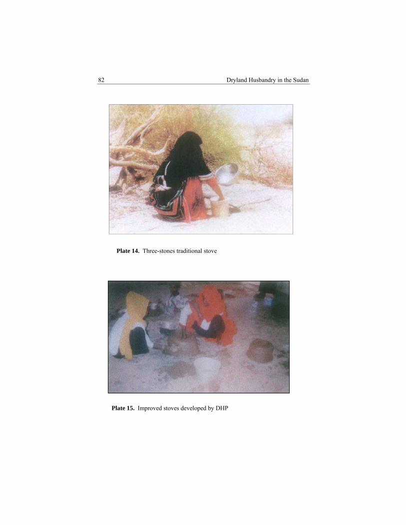
Dryland Husbandry in the Sudan
82
Plate 14. Three-stones traditional stove
Plate 15. Improved stoves developed by DHP

Muna Ahmed and Fathia Musa. Gender Issues
83
Plate 16. Female paravets during practical training 5.3.6 Income Generating Activities - Dairy Objectives
1. To train pastoralist women on milk processing (Plates 17, 18 & 19) 2. To increase family income and encourage women’s self-reliance
with the aim of poverty reduction
The Beja are cattle herders. They are transhument and settle around Kassala town during the rainy season. Surplus milk is processed into sour milk and ghee. However, due to the excessive amounts that are available at good rains, milk is poured into cracks or given to dogs. There was then a need to make use of excess milk by processing into cheese and yoghurt to improve nutrition, or to be sold so as to increase family income.
A permanent centre within the premises of a primary school was selected; two rooms were used for this purpose. Maintenance expenses were shared by DHP and the Planning and Development Administration and the Minister of Education provided the necessary equipment. Other expenses were covered by DHP. The participants consisted of 20 young women

Dryland Husbandry in the Sudan
84
selected by Awadat village peoples committee. The content of the training encompassed participatory approach and capacity building, business skill promotion, project management institution, marketing of products and sustainability of project management. Trust among the group of participants was consolidated through brainstorming, discussion, and group work. The training lasted for three weeks; the participants were divided into 5 groups, and the trainers were from the intermediate technology organisation at Kassala. The milk was processed into three types, fine cheese, dry cheese, and mozzarella. Also yoghurt and a thick type of sour milk (mish) were processed.
Plate 17. Milk collection for processing

Muna Ahmed and Fathia Musa. Gender Issues
85
Plate 19. Milk products (cheese & yoghurt)
Plate 18. Milk products processing laboratory

CHAPTER SIX
PROJECT RESULTS Mohamed Fadlelmoula Idris 6.1 Introduction The Dryland Husbandry Project (DHP) is a research and development effort in the (IGAD) countries of Eritrea, Ethiopia, Kenya, Sudan and Uganda; it has been in operation at the field level since 1996; the project strongly calls for and stresses the bottom-up approach to:
Implement action-oriented participatory activities Conduct field research, employing extension methodology that
encourages continuous dialogue between pastoralists, planners and policy makers, to work together for a sustainable development in the drylands and pastoral areas
Conduct trial research, paravets training, raise gender issues in development, survey, collect and document ethno-veterinary practices, and pastoralists knowledge of survival, in their environment
Train pastoralists and technicians in range improvement and management
Correlate pastoralists’ indigenous knowledge and formal knowledge to assure creativity and sustainability in food security and better management of their environment
Conduct research into methods of range improvement, water harvesting and management involving the beneficiaries.
6.2 Project Results 6.2.1 Local Communities Participation The consultations that took place in the dry season where pastoralists gathered around watering points paved the way for dialogue to be conducted in the open air. The results of the meetings led to good understanding and realisation of their problems and their suggestions were highly considered. Issues discussed were improvement of the degraded rangelands, provision of drinking water in the deferred dry season grazing areas and improvement of livestock production through improved disease control to be managed by them and their local institutions.
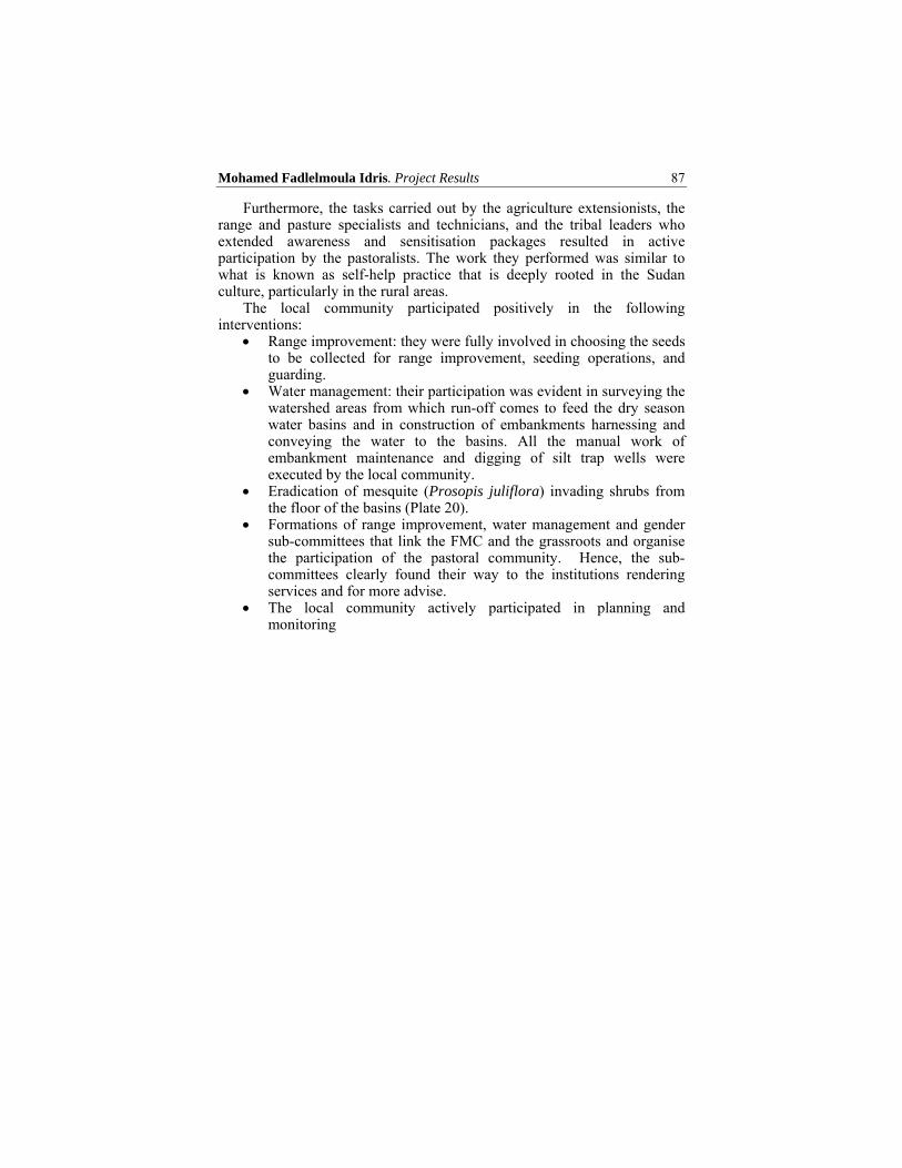
Mohamed Fadlelmoula Idris. Project Results
87
Furthermore, the tasks carried out by the agriculture extensionists, the range and pasture specialists and technicians, and the tribal leaders who extended awareness and sensitisation packages resulted in active participation by the pastoralists. The work they performed was similar to what is known as self-help practice that is deeply rooted in the Sudan culture, particularly in the rural areas.
The local community participated positively in the following interventions:
Range improvement: they were fully involved in choosing the seeds to be collected for range improvement, seeding operations, and guarding.
Water management: their participation was evident in surveying the watershed areas from which run-off comes to feed the dry season water basins and in construction of embankments harnessing and conveying the water to the basins. All the manual work of embankment maintenance and digging of silt trap wells were executed by the local community.
Eradication of mesquite (Prosopis juliflora) invading shrubs from the floor of the basins (Plate 20).
Formations of range improvement, water management and gender sub-committees that link the FMC and the grassroots and organise the participation of the pastoral community. Hence, the sub-committees clearly found their way to the institutions rendering services and for more advise.
The local community actively participated in planning and monitoring

Dryland Husbandry in the Sudan
88
Plate 20. Pastoralists during Mesquite eradication campaign
(Manual control)
The departments of the Ministry of agriculture of Kassala State (Range, Animal Health, Extension, Forestry, Soil Conservation and Water Management) are now well integrated.
The Gash rehabilitation corporation had positively helped in water management through availing the heavy duty machinery in basins floor grading and deepening and enlargement. Similar collaboration was rendered by Zakat Islamic religious chamber.
Plan Sudan International (Kassala) effectively collaborated in paravets training and gender income generating activities.
Range and Pasture Administration in particular afforded the Malawia fenced area of 600ha site for range improvement, using water harvesting, spreading and seeding. All its
Mohamed Fadlelmoula Idris. Project Results
89
vehicles, tractors and implements were availed to the project.
The Women Development Section of the Ministry of Finance.
The Environment Rehabilitation project in Kassala State, sponsored by OAU, benefited from the experience of DHP-Sudan.
Range resources improvement and management
Political collaboration has been shown by the State Governor of Kassala, the Minister of Agriculture and the local leading personnel of the Ministry in appreciating, encouraging and supporting every step towards attaining the objectives of the project.
6.2.2 Outputs During the course of the project (DHP) the following outputs were realised:
Establishment of in-situ developed visible management structure, FMC, water, range, and gender sub-committees at the grassroots level.
Establishment of seeds production centre at Malawia fenced-in area (600 ha – store and guards room). The seeds produced are supplied to Red Sea and Khartoum States having similar ecological conditions. During the course of the project 600ha were reseeded with full involvement of pastoralists in the dry season, using the seeds produced in Malawia. The results of range improvement under protection during the growing seasons tempted and induced many agro-pastoralists in the area of Malawia to eradicate Prosopis juliflora that invaded their abandoned fields. After complete clearance of the fields, they fenced them with the cut bushes and left them to regenerate naturally. The results obtained were convincing to the agro-pastoralists.
Establishment of milk products processing center for training pastoral women.
Development of a standard paravets training manual in Arabic. 104 paravets were trained, including 24 females.
A revolving fund allocated to ensure the paravets’ smooth service.
Development of range management training manual is based on the training courses delivered during the project life and the

Dryland Husbandry in the Sudan
90
working contact that the range management personnel had with the pastoralists.
Improvement of the productivity and diversity of the rangeland plants.
Development of drinking water resources, management and creation of an enabling environment.
Active participation of pastoralists in water and range development.
Production of dry land encyclopedia of the dry land of the Butana.
Production of a number of reports showing the results of the interventions (appended).
Production of documentary video films illustrating range improvement and water management. Milk products processing (income generating activity) as useful educational materials.
Development of a standard paravet training manual in English and Arabic.
6.3 Lessons Learned During its seven years of implementation, DHP-Sudan has achieved its objectives with remarkable success. The following are the lessons learned.
Dryland Husbandry Project is a catalyst for change and an enabling force. It provided support for the institutions it worked with and was responsible for the well-being and development of the pastoral areas and the pastoralists as well.
It has been learned to consider the indigenous knowledge, initiatives and aspirations of the people (target groups) with whom we are working.
It has been grasped that the involvement of the target groups in the entire project stages of planning, implementation, upkeep, monitoring and evaluation insures active participation and exchange of knowledge.
Development of collaboration, coordination and integration between government institutions working in the dry lands management and conservation (range & pasture, land use & soil conservation, water resources development, forestry, extension and animal health) and other concerned bodies (Gash Rehabilitation Corporation, NGOs, CBOs, Zakat chambers and others) created major undertakings in the fields of water harvesting, management and range improvement.
Mohamed Fadlelmoula Idris. Project Results
91
The dry land husbandry in the Sudan succeeded to revive and strengthen the self-help system, which is deeply rooted in the Sudanese culture particularly in the rural areas.
Creation of pastoralists’ community-based committees (for range, water, and gender) at intervention sites was found to be very essential to link the beneficiaries with the development workers.
We are now strongly confident that pastoralists’ response becomes positive when their actual-felt needs are addressed.
We fully realized that the project has developed a new outlook on the pastoralists and question the way they look at the utilisaton of resources by government institutions. We have also observed that development initiatives are now coming from the beneficiaries through the Field Management Committee to the Ministry of Agriculture, Kassala State.
Last but not least many vital lessons were learned from the annual workshops held by DHP regional coordinator in the sister countries (Uganda, Kenya and Ethiopia). In every annual workshop meeting the project and its activities, the progress are evaluated and exchange of experiences and advice are shared.
In the year 2000, the 6th regional workshop was held in the Sudan; whereby the participants from Ethiopia, Kenya and Uganda were exposed to our field experiences.
6.4 Project Impacts and Sustainability
There are some indications of success in project activities that would make the project sustainable. The important ones are outlined below.
In the areas of range improvement and water management, there is an increasing involvement of the beneficiaries together with the scientists, government departments/NGOs towards the implementation of the activities.
In the area of paravet training, the role of paravets is highly regarded by pastoralists and rural councils. Yet their relationship with the government has to develop to look after their follow-up and encouragement.
A long-term interest is fully developed by the policy makers, development workers as well as pastoralists to develop and use the means furnished by the project to maximise their resources management, improvement and utilisation.
Dryland Husbandry in the Sudan
92
The project facilitated strong linkages and collaboration with and among various related institutions and community-based organisations.
Following sensitisation, a new outlook has emerged by the pastoralists towards the government agents, local organisations and others who contribute in range and water management. The new outlook contradicts the previous behaviour marked by complete dependence on government initiatives in project planning, implementation and monitoring.
The Ministry of Agriculture is allocating finance for continuation.
6.5 Conclusion and Recommendations
6.5.1 Conclusion
Dryland Husbandry Project-Sudan showed a positive impact and changes of attitudes among the pastoralists. Before the advent of the project, the issues pertaining to range improvement, conservation and water management in pastoral areas was solely the responsibility of the government institutions, to carry out and up-keep. DHP Sudan introduced participation.
The approaches followed to implement the project activities are many and some of them are the following:
� Involvement of the community and their participation in
development are very important to achieve goals. Pastoralists and agro-pastoralists participated in the preparation of development plans and for subsequent implementation of bottom-up type of interventions. These helped for the success of the project.
� Co-ordination of activities of different government institutions and NGOs dealing with rangelands, forestry, animal health and extension etc. was found essential to efficiently utilise and adopt an integrated approach in the use of resources.
� Interventions that are based on popular participation and practices that are acceptable to the beneficiaries and are in harmony with local traditions are the ones that bring success and will have favourable impacts. DHP Sudan has learned that indigenous knowledge of the targeted community should not be overlooked.
� DHP Sudan worked for sustainable drylands development. This was achieved by encouraging land use and resources utilisation in a sustainable way to arrest land degradation and to alleviate poverty. Certain conditions were identified as prerequisites:
Mohamed Fadlelmoula Idris. Project Results
93
The political will which was fully secured Settled land tenure and recognition of grazing right (this is
recognised and accepted as communal) Community participation in decision making (this was fully
secured) Response to the priority needs of the community such as water
provision, range development and animal health services Creation of strong links between the pastoralists and the
institutions rendering services to them.
The project so far succeeded in achieving positive sustainable management in pastoral areas, animal health services and range conservation and improvement interventions. The project provided logistic support to the leading institutions of Range and Animal Wealth Administrations for the implementation of the project’s major activities.
DHP Sudan has developed good working and collaborative relations with the following institutions.
The Gash Rehabilitation Corporation Zakat Tax Chamber – collaborated in water management Plan Sudan International – Kassala (NGO jointly with DHP-Sudan
conducted paravet training course The environment Rehabilitation Project sponsored by OAU is
utilising the experience of DHP in its environment rehabilitation activities
Finally the considerations, support and follow-up of Kassala State Governor, the Minister of Agriculture, Animal Wealth and Irrigation were all behind the achievement made by DHP-Sudan.
6.5.2 Recommendations
The success of the project so far achieved must be tried in another area of the drylands of the Sudan. In this regard the drylands of western Sudan are suggested.
To further sustain the interventions implemented during the project life span, follow up of the activities must be made by all those who contributed and collaborated with the project.
Good relations among the natural resources personnel, the pastoralists and the Gash Delta Rehabilitation Agricultural Scheme must be strengthened and developed. The Scheme must respond to the need of providing water through the constructed conveyance canal to Tambi basin while the Field Management Committee (FMC) Kassala and the pastoral community must improve the range
Dryland Husbandry in the Sudan
94
areas in the vicinity of the scheme. This will support the pastoralists livestock after the crops harvest is completed. This becomes beneficial to the pastoralists and the farmers in the Gash delta rehabilitation flush irrigated scheme.
In the field of range improvement, as this is one of the major tasks of the Range and Pasture Administration, the work with pastoralists should continue to include the degraded areas in Kassala State particularly those in the dry season grazing areas and around watering points. RPA should continue to develop strong relations with the Gash Rehabilitation Corporation, Zakat Chamber and NGOs in water management for the pastoralists.
Production of seeds in Malawia and collection of seeds from the range areas of high potential should continue with full participation of the pastoralists.
Follow-up procedure of paravets trained should be developed and refresher courses should be given if the need arises.
The Ministry of Finance should support the women income generating activity in dairy products.
The link developed between the FMC and the pastoralists through consultation and involvement in planning, implementation and monitoring must prevail.
Further awareness is necessary by the representatives of FMC, the State Government representative, nomadic tribal representatives and pastoralists union. Whenever any development intervention is to be proposed for the State in the field of drylands, the integrated team trained in Participatory Rural Appraisal (PRA) by the project should be utilised and community indigenous knowledge must not be overlooked.
Pastoral communities in the different parts of the Kassala State must find the chance to have similar viable interventions according to their perceived needs.
REFERNCES
Abakar, A. 1995. Pastoral Sector Development. Workshop on Development of Pastoral Sector in Sudan. Kosti, Sudan.
Abdel Ati, H. A. 1985. Lower River Atbara Area. Nile Province Seminar of ETMA, Ed-Damer. Institute of Environmental Studies (IES), University of Khartoum. Khartoum.
Abusin, M.E, M.M Basheer, T. H. Mohammed and T. E. Hago. 1988. Environmental Profile in Kassala Province. Volume (1) main report- Netharland (DHV).
Agab, H. B. Abbas, and J.M. Le Horgne. 1992. Vitamin A Deficiency in Camels. Sud. J. Vet. Sci. Ani. Husb.Vol. 31(1) 9-13.
Alissoutin, R. L. 1997. Pond Management in the Odor Department, Senegal. IIED, Dryland, Issue paper No. 72. London.
Andrews, F. W. 1948. The Vegetation of the Sudan.
Babiker, M. 1997. Resources Competition and the Future of Pastoralism in the Butana. DHP Workshop Report, Khartoum, Sudan.
Badi, K. H. 1965. Afforestation in the Clay Plains of Kassala Province. Forest Department, Khartoum (In arabic).
Beck, R. et.al. 1989. Environmental Profile of Kassala Province, Eastern Region, Sudan, DHV Consultant..
Bot, K .M .M .E lHanan. E. M .El Mak, A deGier , B. Haverkort, M. A. Maglad M. I . Makki and K. Maintved. 1989. A Report of the Green Mission to Kassala. Netherlands.
Brown, L.R. 1985. State of the World. A World Watch Institute Report on Progress Toward a Sustainable Society. New York.
Caracalla, V.T. 1993. How Erosion Happened. Protect and Produce, Soil conservation for development . FAO, Roma, Italy.
Cobley, L .S. 1979. (Ed.) An Introduction to the Botany of Tropical Crops. Longman Group limited, London, Second edition.
Critchley, W. 1987. Some Lessons from Water Harvesting in Sub-Saharan Africa. A Workshop of Baringo, Kenya (13-17 October – 1986).
Dirar, H. A. 1997. Traditional Food Strategy of Dryland Communities of the Sudan. A Report on a workshop on Resources Management in the Drylands of Eastern Sudan, DHP Sudan, Khartoum.

Dryland Husbandry in the Sudan
96
ELHouri, A. et al. 1989. Man – Made Forests. The Forests of the Sudan. Khartoum.
ELKarouri, MoH. 1965. Occurrence and Distribution of the Salts in the Soils of the High Terraces. Soil Science Section Reports. Hudeiba Research Station, Sudan.
Elrasheed, A. m. 1983. Some Impact of Desertification on the Gash Delta Region, M.Sc. thesis. IES. University of Khartoum. Sudan.
Elsidig. E. A, A. A. Abdel Salam and T. D. Abdel Magid. 1998. Socio-Economic, Environmental and Management Aspects of Mesquite in Kassala State (Sudan) IES and Ford Foundation and Sudanese Social Forestry Society (SSFS).
FAO. 1989. Fuel Wood Assessment of Standing Woody Biomass. Kassala Province Fuel Wood Development Project. Khartoum, Sudan.
FAO. 1986. Nomadism, Human Influence in African Pasture Land Environment, Khartoum.
GDAC Publication. 1995. (Gash Delta Agricultural Corporation). A story on the importance of trees, a story to be told. Natural Resources Department. Aroma, Sudan.
Holechek, J. L., Herbel, C.H. and Pieper R. D. 1989. Range Management - Principles and Practices. Pentice Hall, Inc. New Jersey.
Harrison, M. N. and Jackson, J. K. 1958. Ecological Classification of the Vegetation of the Sudan. Forest Bulletin No.2.(New series) The Republic of Sudan. Ministry of Agriculture, Forest Department. Agriculture Publication Committee, Khartoum.
Hassan, H. M. 1993. Settlement of Nomadic Tribes in Eastern Sudan. Magazine of Green Revolution. Ministry of Agriculture, Kassala, Sudan.
Ibrahim, S. E. 1998. South Kassala Nomadic Survey. CARE- International, Khartoum. Sudan.
ILO. 1989. Proposal for a Labour Intensive Public Work Programme in Aroma and Kassala Districts, Eastern Region, Sudan. Project SUD/85/006.
Jamma, A. 1993. Pastoral Land Rights in Sudan. UNEP Workshop on Drylands Management. Nairobi, Kenya .
Jensen, C. H. and Ureness, P. J. 1981. Establishing Browse Utilization from Twig Diameter. Journal of Range Management 34(3).
Jones, G. 1979. Tropics in Applied Geography, Vegetation and Productivity. Longman, London.

Dryland Husbandry in the Sudan
97
Keive, W. V. and Buramah, I.W. 1976. Exploratory Soil Survey of Kassala Province. A Study of Physiography, Soils and Agriculture Potential. Survey Administration. Wad Medani Report No. 73. May 1976.
Mohammed, F.A. 1989. Ecological Changes and Production Potential of Wadi Abu Salam, Nile Province-Sudan. Msc. Thesis, University of Gezira. Sudan.
Metternicht, G. I. and J.A. Zinck. 1996. Modelling Salinity–alkalinity classes for mapping salt-affected topsoils in the semiarid valley of Cochabamba. ITC Journal.
Ndagala, D. K. 1993. National Pastoral Policies in Tanzania, Implications for the Management of Natural Resources. UNSO Sub-regional Workshop on Pastoral Policies. Arusha.
Negassa, A. E. 1993. Pastoralism in Ethiopia. Conference on Pastoralism in Ethiopia. Ministry of Agriculture, Addis Ababa.
Nyangito, M. M. 1997. Non-convention Feed Resources for Agro-Pastoral Production Systems, Workshop Report. Dryland Husbandry Project in Kenya, University of Nairobi. OSSREA, Addis Ababa.
Orr. J. B. 1984. Soil Conservation for Development. FAO Report, Khartoum.
Range and Pasture Administration (RPA). 1989-1996. Annual Reports. Kassala State. Sudan.
Saeed, E. M. 1969. Ground Water Appraisal of Gash River Basin at Kassala. Geological Survey Report. Bulletin No. 17, Sudan.
Scoones. I. C. Reij and Toulmin, C. 1996. Sustaining the Soil. Indigenous Soil and Water Conservation in Africa. IIED, Dryland Programme, Issues paper No. 67. London.
Smith, J. 1949. The Distribution of Tree Species in Relation to Rainfall and Soil Texture. Khartoum.
Suliman, M. M. 1986. Grazing and Range Management in Butana Area With special Reference to ELrawashda Forest. FAO, Khartoum.
Swallow, B. M. 1993. The Role of Mobility Within the Risk Management Strategies of Pastoralists and Agro-pastorlists. A Workshop on “New Direction in African Range Management and Policy. Common Wealth Secretarial Research. Wobrun, England.
Tageldin, A. 1983. Wood fuel in the Sudan. National Energy Administration Report. Khartoum.
Dryland Husbandry in the Sudan
98
Thibaud, B. H. and Miehe, S. 1995. Recognizing the Effectiveness of Traditional Pastoral Practices. Lesson from a Controlled Grazing Experiment in Northern Senegal, IIED. Paper No.55, London.
Toulmin, C. 1995. The Convention to Combat Desertification: Guidelines for NGO Activity. Dry land programme, IIED Paper No. 56. London.
UNDP and Ministry of Finance and Economic Planning of Sudan. Base Line Survey of Eastern Region 1992. Final Report, June 1993. Khartoum.
VanDijk, J. A. 1995. Soil and Water Conservation Among Settling Beja Nomads in Eastern Sudan. Khartoum.
Van Soest, P. J. and R. H . Wine. 1967. Use of Detergents in the Analysis of Fibrous Feeds. Determination of Plant Cell- Wall Constituents. AOAC. Vol. 50, No. 1 .
Vink, A.T. 1987. Interacted Land use Plan for Rawashda Forest. Kassala Province, Eastern Sudan. FAO, GCP/Sud/033. NET, Field Document No. 27. Khartoum.
Walker, R. D. 1980. A quick way to estimate your soil erosion losses. Universal soil loss equation. Crop and Soil Magazine.
Weber, F. R., and Stony, C. 1986. Reforestation in Arid lands. Published by Volunteers in Technical Assistance. Virginia, USA.
Woldu, H. and A. Zigta. 1997. How to Gain from Erosion: Catch the Soil. LEISA Newsletter for Low External Input and Sustainable Agriculture. Volume 31, No 2. July 1997.

Dryland Husbandry in the Sudan
99
APPENDICES Appendix I
Scientific Documents and Reports Produced by the Project:
1. Elsadig Yousif, M. Fadlelmula, Alawia A. Elawad, Elham E. Ahmed, 1996. Understanding and Measuring vegetation Changes in the Sudan.
2. Babikir Abbas, Ethno-veterinary practices of camel pastoralists in Butana (DHP publication series No. 4, December 1997.
3. Abdel Rahman M. Hamid, 1997. Water harvesting for better utilisation of range resources.
4. Aziza Aballa, 1999. Gender development: Improved stoves.
5. Fatah El Rahman A. Mohamed, 1999. Range improvement through the involvement of pastoralists.
6. Hussein M. Mohamed, 1999. Environmental adaptive knowledge of pastoralists and agro-pastoralists in the Butana plain of the Sudan.
7. Alawia A. El Awad, 2000. Plant Encyclopedia for the dry Savanna and semi-arid lands of the Sudan, 1: Butana – eastern Sudan. Progress report.
8. Fathia Salih Musa, 2000. Contribution of pastoral women to the sustenance of pastoral life. A case study among Rashaida pastoralist women in Kassala State.
9. Fathia Salih Musa, 2002. Milk processing training intervention for pastoral women.
10. Range management, a standard training manual.
11. Paravet standard training manual
12. Work shops reports:
a- Dryland husbandry in the Sudan (29-30 Nov. 1995).
b- Resource Management in the dryland of Eastern Sudan (23-24 March 1997)
c- Pastoralists, awareness workshop, 2002
d- Documentary video film showing the activity of range improvement and water management.
Dryland Husbandry in the Sudan
100
e- Documentary film reflecting the methods followed in milk production processing - training activity.
Appendix II
Local Components
Focal Institutions Support
1.0 The Institute of Environmental Studies (IES) of the University of Khartoum is the focal point of DHP in Sudan.
1.1 The director of IES is the national coordinator of DHP-Sudan.
1.2 IES provided office to DHP manager, with all facilities.
1.3 Typing, photocopying services were provided and an accountant from the University of Khartoum.
2.0 The National Steering Committee (7 members) holds its meetings in IES director's office.
3.0 Range and pasture Administration – Khartoum.
3.1 Provided equipped classroom for training the range personnel representing all the states falling in the dry areas of the country. 6 of the personnel were engaged in the preparations of the training courses; conducted specialized persons in the different range and related fields were availed.
3.2 All equipment, materials and the herbarium facilities were put under trainees' use.
3.3 For collection of plant specimens for the Encyclopedia of the
Project area two resource persons were assigned with a specialist from Al Neelain University to classify the plants collected, giving the Latin names.
3.4 Provided the administration with means of transport for the trainees’ field visits for practice.
4.0 Range and Pasture Administration in Kassala State (RPA). This is where the DHP-Sudan Interventions were conducted.
4.1 Training - Throughout the project duration, personnel of RPA were engaged in demonstration of the activities pertaining to seed
Dryland Husbandry in the Sudan
101
collection, methods of storage, broadcasting and planting. The following have contributed actively: 2 Range specialists (M.Sc.), one Senior Range Management Officer (Dip.), 4 technicians and 25 labourers including drivers.
4.2 Finance - 50,000,000 Sudanese Pounds (Ls) were spent (wages, maintenance, and spare parts of vehicles and tractors). Vehicles were used in survey, seed transport and supervision. Tractors were used in Land preparation (Ploughing and terracing).
4.3 Means of transport and Machinery used during the project implementation: 2 Toyota station Wagons, 2 Tractors, 2 disc-ploughs, 2 scrapers, 5 ton truck, one Tanker Truck and one trailer.
4.4 Land for demonstration: - Malawia enclosure (2km x 3 km) 600 hectares that belong to Kassala State (RPA) was allocated to DHP-Sudan as a demonstration activity to show the effect of rangelands improvement under controlled condition (Fencing) be it barbed wire fence or thorns of Mesquites.
After the first rainy season success of range improvement in Malawia fenced area, some agro-pastoralists in the vicinity adopted the idea through fencing their private lands with Mesquite cut bushes. This helped them in Mesquite eradication.
4.5 RPA-Kassala had provided space in the director's office for the DHP-Sudan project manager as well as cupboard for DHP-publications and reports.
4.6 To collect plant specimens for the project area the director of RPA Kassala State who is also the anchorman in range improvement and water management together with 2 Technicians conducted surveys and collections of the samples using their office facilities.
5.0 Range and Pasture Administration (RPA), Gadarif State: the director of RPA and one Technician worked for the dryland Encyclopedia of the dryland in the Butana using their office facilities, transport and equipment.
6.0 The Department of Animal Resources -Kassala State
6.1 For training males and Females as paravets, it provided a well-furnished classroom.
6.2 Provided 2 Government houses as lodging for 20 trainees of each batch of the 5 batches trained.
6.3 It availed nine VBcs & M.Sc. veterinarians as lecturers and practical demonstrators.
Dryland Husbandry in the Sudan
102
6.4 Transport: provided 2 cars for transport of trainees during field visits to slaughterhouse, livestock market, and livestock vaccination crush and veterinary laboratory.
7.0 Land Use and Soil Conservation Administration:
This provided one specialist to advise on soil conservation measures, and also provided 2 tractors, one loader, two disc ploughs and 2 scrapers as support to DHP.
8.0 Forestry National Corporation (FNC):
This has provided a hall for holding and conducting RPA workshop for ten days for participants from the different administrations of the Ministry of Agriculture, Animal Wealth and Irrigation.
9.0 Extension Administration, Kassala State:
The extension specialist and four of his personnel conducted extension packages in informal and formal gatherings as well as documentation of project field activities. They were using one vehicle belonging to the Administration and equipment worth 5,000,000 Ls.
10. Ministry of Finance of Kassala State:
Through the Planning and Development Department, Women Development Section, the Ministry had contributed in surveys for gender studies and needs and also in the conduct of PRA workshop. Also the Ministry contributed in the milk product processing activity (income generating activity).
11. Ministry of Education, Kassala State:
Provided 2 rooms for the project to be used as classrooms and laboratory with the materials for the income generating activity in dairy products at Awadat village.
12. Gash Rehabilitation Corporation, Kassala State (GRC):
Provided the following:
2 Bulldozers, 2 motor graders, one loader and 5 ton Truck to construct canal to Tambi basin, raise embankments (17 Km long), silt removal, Mesquite control in the four basins of (Tambi , Garateit N, Garateit S and Garadieb); the work in the four basins was done in 120 working days at a cost of 445,000,000 Sudanese pounds.
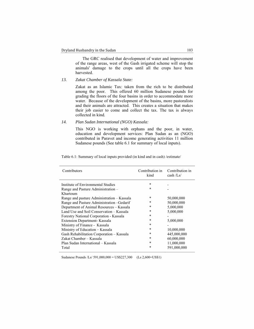
Dryland Husbandry in the Sudan
103
The GRC realised that development of water and improvement of the range areas, west of the Gash irrigated scheme will stop the animals' damage to the crops until all the crops have been harvested.
13. Zakat Chamber of Kassala State:
Zakat as an Islamic Tax: taken from the rich to be distributed among the poor. This offered 60 million Sudanese pounds for grading the floors of the four basins in order to accommodate more water. Because of the development of the basins, more pastoralists and their animals are attracted. This creates a situation that makes their job easier to come and collect the tax. The tax is always collected in kind.
14. Plan Sudan International (NGO) Kassala:
This NGO is working with orphans and the poor, in water, education and development services: Plan Sudan as an (NGO) contributed in Paravet and income generating activities 11 million Sudanese pounds (See table 6.1 for summary of local inputs).
Table 6.1: Summary of local inputs provided (in kind and in cash) /estimate/
Contributors Contribution in kind
Contribution in cash /Ls/
Institute of Environmental Studies * - Range and Pasture Administration – Khartoum
* -
Range and pasture Administration – Kassala * 50,000,000 Range and Pasture Administration –Gedarif * 50,000,000 Department of Animal Resources – Kassala * 5,000,000 Land Use and Soil Conservation – Kassala * 5,000,000 Forestry National Corporation - Kassala * - Extension Department- Kassala * 5,000,000 Ministry of Finance - Kassala * - Ministry of Education – Kassala * 10,000,000 Gash Rehabilitation Corporation – Kassala * 445,000,000 Zakat Chamber – Kassala * 60,000,000 Plan Sudan International – Kassala * 11,000,000 Total * 591,000,000
Sudanese Pounds /Ls/ 591,000,000 = US$227,300 (Ls 2,600=US$1)

Dryland Husbandry in the Sudan
104
Support from Pastoralists
1. Adoption of the project ideas and activities as well as dissemination of the outcomes among the community as a model that could be used in private and communal lands.
2. It was made easier to acquire land in private and communal lands for forage crop introduction and range improvement.
3. The number of pastoralists is ever increasing in bush control, silt removal, and embankment consolidation using simple tools.
4. The pastoralists showed the responsibility of guarding the intervention sites through patrol shifts.
5. The pastoralists warmly welcome the researchers and visitors and openly suggest their ideas and thoughts.