Embed Size (px)
Citation preview
Ecology Assessment Drury Structure Plan
30 August 2017
Eru Nathan
Ecologist, Auckland Council

Foreword
The Drury-Opaheke area has been identified by Auckland Council as suitable for future
urban growth and been zoned Future Urban under the Auckland Unitary Plan. The Drury
Structure Plan (the structure plan) will outline and guide how and where development will
occur within the greenfield Drury Future Urban Zone.
Opportunities and constraints are to be identified from a number of relevant disciplines and
incorporated into the structure plan, helping to inform the future pattern of land use,
transport and service networks.
Structure plans are an important method for establishing the pattern of land use and the
transport and services network within a defined area. They can provide a detailed
examination of the opportunities and constraints relating to the land including its suitability
for various activities, infrastructure provision, geotechnical issues and natural hazards.
Structure plans should identify, investigate and address the potential effects of
urbanisation and development on natural and physical resources in the structure plan area
and in neighbouring areas, particularly those that have been scheduled in the Unitary Plan
in relation to natural heritage, Mana Whenua, natural resources, coastal environment,
historic heritage and special character.
Structure plans should explain how any adverse effects of land use and development are
to be avoided, remedied or mitigated by proposed plan provisions. This will ensure that all
the effects of development are addressed in advance of development occurring. A
structure plan is an appropriate foundation for the plan change process required to rezone
land.

Executive summary
The Drury-Opaheke area is a highly modified landscape, with a town centre surrounded predominantly by arable horticultural, pastoral and rural lifestyle activity. Very little native vegetation remains and freshwater habitats are degraded. There is an estuarine coastal edge in the northwest of the structure plan area and the marine environment remains in good condition.
Formulation of the structure plan provides an opportunity to maintain and improve ecological values, set objectives for ecological enhancement, guide the placement of reserves and align community recreation corridors with these.
Ecological constraints for development include:
proximity of development in relation to watercourses
proximity and scale of development in relation to the coastal environment
proximity and scale of development in relation to floodplains
avoidance of watercourse loss i.e. no permanent loss with culverting
avoidance of vegetation loss, especially Significant Ecological Areas
Key ecological opportunities include:
retaining and enhancing remaining native vegetation to improve wildlife habitat
retaining and buffering natural watercourses to improve water quality and increase numbers and diversity of instream biota
aligning reserves and recreational connections with existing natural watercourse corridors to provide user integration with nature and wider buffering for wildlife movement
retaining natural topography to ensure watercourses can maintain natural form and function
reintroducing riverine wetlands to natural floodplains
restoration of modified watercourses to reinstate sinuosity and habitat heterogeneity
revegetation of the terrestrial coastal edge to buffer the marine environment and re-establish linkage between terrestrial and marine ecosystems
Implementing these opportunities will contribute to the implementation of national and regional environmental policies and strategies (such as the National Policy Statement for Freshwater Management) and implementation of the Auckland Growing Greener principles related to urban transformation, restoring nature and healthy waterways.
In the context of the wider landscape, the Drury-Opaheke area currently represents a spatial gap in native vegetation and other areas of ecological value. This means that restoration of ecological values in the Drury-Opaheke structure plan area will help bridge this gap and is thus expected to yield ecological benefits of a larger scale and across a much larger area of the Auckland region.

Table of Contents
1 Scope of report .............................................................................................................. 5
2 Site description .............................................................................................................. 6
3 Current ecological values .............................................................................................. 9
4 Outcomes sought ........................................................................................................ 22
5 Relevant policy documents ......................................................................................... 28
Ecology Assessment 5
1 Scope of report
The purpose of this report is to identify and describe the ecological values present in the
Drury-Opaheke Structure Plan area and provide guidance for development that ensures
that these values are enhanced and protected in the long term. Both constraints and
opportunities relating to the area’s ecological values are identified and discussed.
Formulation of this report has drawn on relevant historical reports, Auckland Council
databases, external databases, aerial imagery, and internal Auckland Council expertise.
The scope of works undertaken during this assessment includes:
review of historical investigation reports
review all existing Auckland Council-held ecosystem and biodiversity records
identification of ecological constraints and opportunities across the structure plan
area, including summarising ecological outcomes which could be sought via the
structure plan process and subsequent plan changes
identification of actual or potential areas of absent information
provision of recommendations for further environmental investigations required to
support future applications for resource consent for site subdivision and
redevelopment works
Sustainability initiatives and other factors which can indirectly contribute to the protection
or enhancement of ecological or biodiversity values are outside the scope of this report.

6 Ecology Assessment
2 Site description
The structure plan will provide for the urbanisation of about 1907 hectares of future urban
zoned land. The extent of the subject land is shown in lemon-yellow in Figure 1 below. The
structure plan area is centred on the existing Drury-Opaheke town centre and its current
land uses are predominantly for arable horticultural, pastoral and rural lifestyle activities.
Originally, the entire structure plan area would have been vegetated with a diverse range
of terrestrial and freshwater ecosystems present and diverse fauna communities
Figure 1: extent of the Drury-Opaheke Structure Plan area (in lemon-yellow)

Ecology Assessment 7
2.2 Original vegetation cover
Originally the entire structure plan area would have been covered in native vegetation.
Modelling suggests that predominantly three forest ecosystem types occurred across the
Drury-Opaheke landscape (figure 2); puriri forest (WF7), kahikatea, pukatea forest (WF8)
and taraire, tawa, podocarp forest (WF9). Puriri forest would have dominated most of the
flattest and most fertile volcanic or alluvial soils. Kahikatea, pukatea forest would have
formed corridors associated with the major streams and wettest lowland areas, especially
in the wider catchments of Slippery Creek, Ngakoroa Stream and Oira Creek. Slightly
more elevated or otherwise more moderately fertile areas would have featured taraire,
tawa, podocarp forest. Although not highlighted in the modelling, the landward edge of the
coastal area is also likely to have featured a belt of coastal pohutukawa, puriri,
broadleaved forest (WF4).
The coastal marine area immediately adjacent to the structure plan area would have
consisted of mangrove forest and scrub (SA1), including both mangrove dominated areas
as well as areas of various salt marsh communities. As the various creeks progress inland,
these saline ecosystems would have graded into various freshwater wetland ecosystems,
including oioi, restiad rushland (WL10) and raupo reedland (WL19) in particular.
2.2 Original native fauna
In forested areas, birds such as kereru, tui, bellbird, yellow and red-crowned kakariki,
kaka, kokako, tomtit, fantail, grey warbler, whitehead, morepork, North Island robin,
shining cuckoo, North Island brown kiwi, and weka would have been present. Arboreal
native reptiles such as forest, elegant and Pacific gecko and ground dwelling skinks such
as copper, ornate, and striped skink would have been common. In the swampy areas,
wetland birds such as banded rail, spotless crake, pukeko, pateke, and bittern would have
been common, as would fern bird, Australasian harrier and kingfishers.
2.3 Original freshwater systems
Due to the gentle topography of the structure plan area, freshwater systems were
characterised by low order, low energy watercourses connected to large wetland swamps
and fens. These wetland areas functioned to attenuate water flows and acted as slow
release storage areas preventing any downstream channel scouring, and reducing
sediment load. As stated above, these wetland areas would have harboured a variety of
native terrestrial flora and fauna. Instream and wetland biota would have included a high
diversity of native macroinvertebrates and fish species. Fish species were likely to have
included lowland galaxiid species such as banded kokopu, inanga, and giant kokopu, and
also longfin eel, short fin eel, koura, Cran's bully, red fin bully, and black mudfish.

8 Ecology Assessment
Figure 2: original vegetation cover of the Drury-Opaheke Structure Plan area

Ecology Assessment 9
3 Current ecological values
Ecological values have been severely degraded by the removal of vegetation from the
landscape. Very little remnant native vegetation still exists, consisting mostly of small and
isolated areas which are unlikely to sustain themselves long-term. Originally diverse and
abundant fauna communities have also been decimated by near-complete removal of their
habitat. Watercourses remain, but the values of these have been degraded by the
removal of vegetation cover, inputs of sediments and nutrients from surrounding land use,
channel modification, and draining or infilling of wetlands/swamps. Instream and wetland
fauna have severely declined in line with this modification and degradation. The coastal
marine area is largely intact and in good ecological health, however, the terrestrial coastal
edge has been all but cleared of native vegetation and is weedy, limiting the ecological
connections between land and sea.
3.1 Terrestrial
Very little native vegetation cover remains, a reflection of the historic and current intensive
agricultural, horticultural and pastoral activities undertaken on the fertile soils of the
structure plan area. Removal of native vegetation from the entire area has had negative
impacts on native ecosystems and functionality is all but lost. The small pockets of
remaining vegetation will be providing limited refuge for native birds, invertebrates and
possibly lizards and bats. However, these remaining vegetated pockets will be severely
compromised in function given their isolation, limited size, vulnerability to edge effects
such as wind damage and weed infestation, and likely presence of pest animals.
3.1.1 Terrestrial ecosystems
At present, the structure plan area is mainly un-vegetated (un-forested) and very few
native forest ecosystem areas remain in the structure plan area. Those that are present
are small in size and spatially isolated from other forest patches or larger areas of intact
vegetation (figure 3). As a consequence, the ecological value and long-term viability of
these areas is severely compromised for reasons such as low population sizes, low levels
of reproductive and gene flow connectivity to other areas, high exposure to the damaging
edge effects of high wind and light conditions and weed infestation, and the highly likely
presence of pest animals.
Only two small areas of mature native forest have been identified in Auckland Council
Biodiversity’s ecosystem database; both are kahikatea forest (MF4), a lowland and riparian
forest type occurring here in association with Slippery Creek and Symonds Stream, both
within the wider Slippery Creek catchment. The only other area of terrestrial native
vegetation identified in the ecosystem database is a small patch of manuka scrub (VS3) at
the very northern border of the structure plan area, but this is of low ecological significance
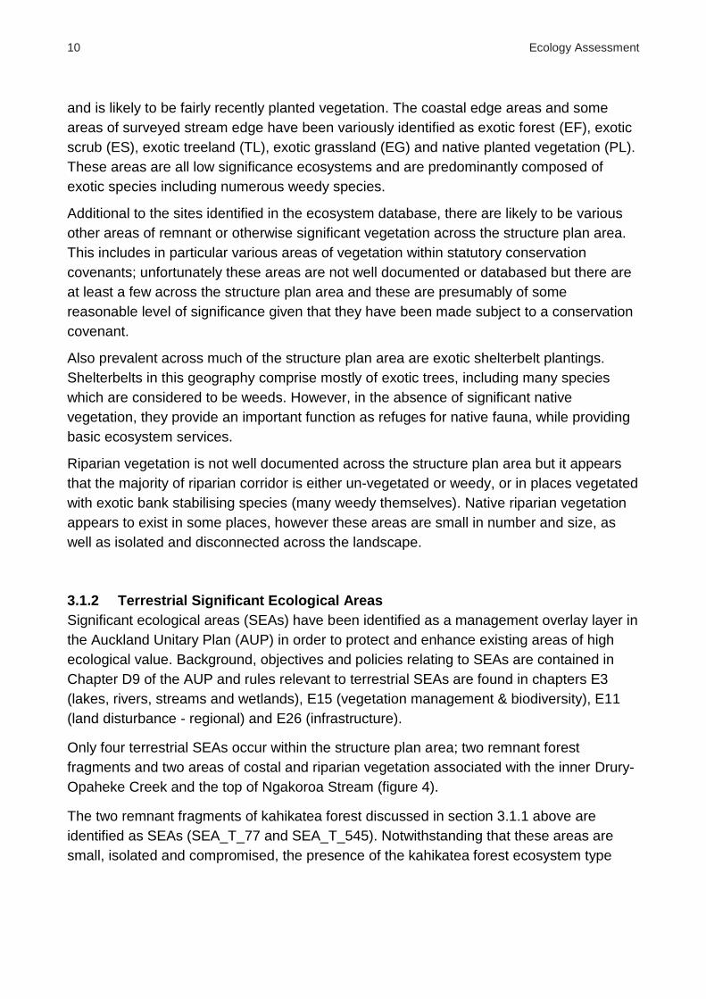
10 Ecology Assessment
and is likely to be fairly recently planted vegetation. The coastal edge areas and some
areas of surveyed stream edge have been variously identified as exotic forest (EF), exotic
scrub (ES), exotic treeland (TL), exotic grassland (EG) and native planted vegetation (PL).
These areas are all low significance ecosystems and are predominantly composed of
exotic species including numerous weedy species.
Additional to the sites identified in the ecosystem database, there are likely to be various
other areas of remnant or otherwise significant vegetation across the structure plan area.
This includes in particular various areas of vegetation within statutory conservation
covenants; unfortunately these areas are not well documented or databased but there are
at least a few across the structure plan area and these are presumably of some
reasonable level of significance given that they have been made subject to a conservation
covenant.
Also prevalent across much of the structure plan area are exotic shelterbelt plantings.
Shelterbelts in this geography comprise mostly of exotic trees, including many species
which are considered to be weeds. However, in the absence of significant native
vegetation, they provide an important function as refuges for native fauna, while providing
basic ecosystem services.
Riparian vegetation is not well documented across the structure plan area but it appears
that the majority of riparian corridor is either un-vegetated or weedy, or in places vegetated
with exotic bank stabilising species (many weedy themselves). Native riparian vegetation
appears to exist in some places, however these areas are small in number and size, as
well as isolated and disconnected across the landscape.
3.1.2 Terrestrial Significant Ecological Areas
Significant ecological areas (SEAs) have been identified as a management overlay layer in
the Auckland Unitary Plan (AUP) in order to protect and enhance existing areas of high
ecological value. Background, objectives and policies relating to SEAs are contained in
Chapter D9 of the AUP and rules relevant to terrestrial SEAs are found in chapters E3
(lakes, rivers, streams and wetlands), E15 (vegetation management & biodiversity), E11
(land disturbance - regional) and E26 (infrastructure).
Only four terrestrial SEAs occur within the structure plan area; two remnant forest
fragments and two areas of costal and riparian vegetation associated with the inner Drury-
Opaheke Creek and the top of Ngakoroa Stream (figure 4).
The two remnant fragments of kahikatea forest discussed in section 3.1.1 above are
identified as SEAs (SEA_T_77 and SEA_T_545). Notwithstanding that these areas are
small, isolated and compromised, the presence of the kahikatea forest ecosystem type

Ecology Assessment 11
Figure 3: current terrestrial vegetation cover of the Drury-Opaheke Structure Plan area
qualify these remnants as significant ecological areas, under both the ‘representativeness’
and ‘threat status and rarity’ SEA factors; kahikatea forest has been classified as a
critically endangered ecosystem type in the Auckland region. For these reasons, these two
forest fragments have also been identified as priority sites for protection and enhancement
under the Auckland Council Biodiversity Focus Area ecosystem prioritisation framework.
Several small patches of coastal edge vegetation on Drury Creek just north of the Bremner
Road bridge have been collectively identified as SEA_T_530. Most of these small patches
are adjacent to currently urban zoned land, however two patches on the eastern edge of
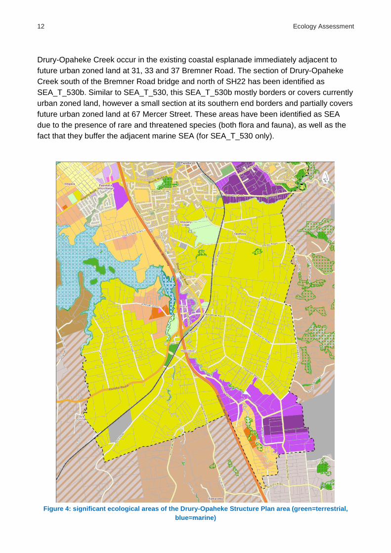
12 Ecology Assessment
Drury-Opaheke Creek occur in the existing coastal esplanade immediately adjacent to
future urban zoned land at 31, 33 and 37 Bremner Road. The section of Drury-Opaheke
Creek south of the Bremner Road bridge and north of SH22 has been identified as
SEA_T_530b. Similar to SEA_T_530, this SEA_T_530b mostly borders or covers currently
urban zoned land, however a small section at its southern end borders and partially covers
future urban zoned land at 67 Mercer Street. These areas have been identified as SEA
due to the presence of rare and threatened species (both flora and fauna), as well as the
fact that they buffer the adjacent marine SEA (for SEA_T_530 only).
Figure 4: significant ecological areas of the Drury-Opaheke Structure Plan area (green=terrestrial,
blue=marine)

Ecology Assessment 13
3.1.3 Native flora
Although little native vegetation remains, there are records of nationally or regionally
threatened plant species occurring in the structure plan area (Table 1), although all occur
in relation to the two terrestrial SEAs at the northern end of Ngakoroa Stream (SEA_T_530
and SEA_T_530b). These records are summarised in table 1 below.
Table 1: threatened plant species recorded in the Drury-Opaheke Structure Plan area
Species National threat
status (2012)
Regional threat
status (2005)
Native oxtongue
(Picris burbidgeae)
Nationally
endangered Serious decline
Kaikomako
(Pennantia corymbosa) Not threatened Sparse
Korokio
(Corokia cotoneaster) Not threatened Sparse
Mingimingi
(Coprosma propinqua var. propinqua) Not threatened
Regionally
vulnerable
Small-leaved kowhai
(Sophora microphylla) Not threatened Sparse
3.1.4 Native birds
Similar to the native flora records above, the only records of nationally or regionally
threatened bird species occurring in the structure plan area are associated with the coastal
end of Ngakoroa Stream (all records from SEA_T_530b). These records are summarised
in table 2 below.
Table 2: threatened bird species recorded in the Drury-Opaheke Structure Plan area
Species National threat
status (2008)
Regional threat
status (2015)
Caspian tern
(Sterna caspia)
Nationally
vulnerable Serious decline
South Island pied oystercatcher
(Haematopus finschi) Declining Sparse

14 Ecology Assessment
Given the small amount of native vegetation remaining and the highly modified nature of
the structure plan area, the landscape provides little in the way of habitat or connective
corridors for forest birds or many native terrestrial fauna in general. As such, numbers of
common native bird species are likely to be low across the structure plan area, especially
forest-dwelling species. Native birds which are common in modified rural landscapes in
Auckland, and therefore likely to be common across the Drury-Opaheke structure plan
area, include pukeko, Australasian harrier, silvereye, kingfisher, white-faced heron and
spur-winged plover. Common native forest birds such as tui, fantail, grey warbler and
possibly kereru are likely to be present in those few areas with remnant native vegetation,
although the small and isolated nature of these remnant fragments means numbers are
likely to be low. None of these species are classified as nationally or regionally rare or
threatened.
3.1.5 Native lizards
Due to the lack of native vegetation, it is unlikely that many native tree dwelling geckos are
present, and the Council holds no records of geckos in the structure plan area. Similarly,
there are no records of native ground dwelling skinks. However, skinks are more
adaptable in their habitat use and often inhabit rank grass and weedy areas, which are
common in the structure plan area. Areas with debris are also important so that skinks can
take refuge from native predators such as kingfishers and introduced predators such as
rats. The most common native non-threatened skink is the copper skink and it is likely that
at least this species is present in the structure plan area, albeit at low numbers. Suitable
habitat for other native skinks is present within the structure plan area, mostly along
margins of pasture and watercourses, however surveying for skinks (or geckos) is not
considered necessary given the low likelihood of detection at low presence densities.
3.1.6 Native bats
Despite the absence of large tracts of mature bush in the structure plan area, it is possible
that native long-tailed bats could be present. Bats roost in cavities in mature trees and in
the absence of suitable native trees do use exotic tree species. Long-tailed bat surveys
undertaken by Council at nearby Hunua foothills, Totara Park, Clevedon, Mauku, Puni and
Patumahoe locations have all detected small numbers of bats, the closest to the structure
plan area being only 2.5kms away. No surveys have been carried out within the structure
plan area but it is highly likely that bats are present in low numbers. Bats feed on the wing
for flying invertebrates and often forage near streams where invertebrate life is more
abundant. Long-tailed bats are listed as a ‘nationally vulnerable’ threatened species by the
Department of Conservation and so have a high ecological value.

Ecology Assessment 15
3.2 Freshwater
Freshwater systems within the structure plan area, including both streams and wetlands,
are highly modified from their original condition and freshwater ecosystem, habitat and
fauna values have all been severely compromised. Stream modifications include
channelization and straightening, removal of riparian vegetation, installation of structures
such as culverts and dams, and pollution. These changes have resulted in low habitat
diversity, low biodiversity and poor water quality. Virtually all freshwater wetlands have
been drained, filled or otherwise reclaimed, largely for agricultural purposes. These
modifications have resulted in a near complete loss of wetland ecosystem types from the
area along with the biota dependent on them. Valuable ecosystem services provided by
wetland systems have also been lost.
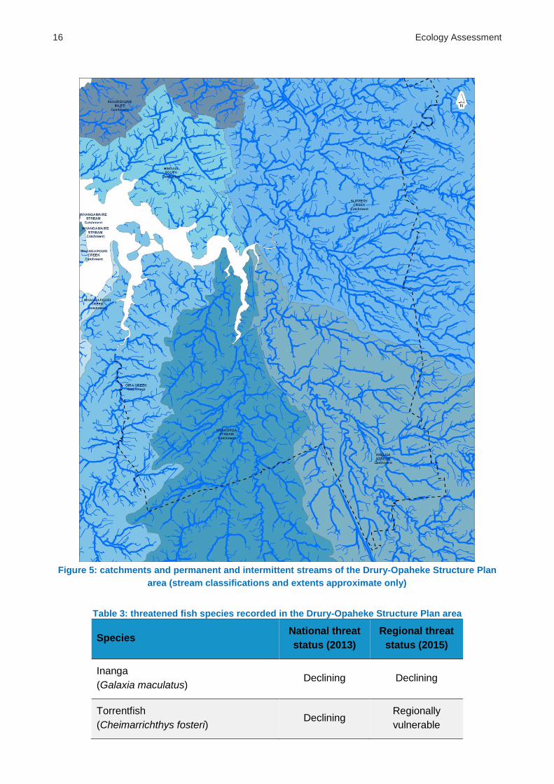
3.2.1 Streams
The structure plan area is divided between four large catchments, and each of these
catchments is drained by a number of watercourses (figure 5). The catchments are named
for their most significant watercourse; Slippery Creek, Hingaia Stream, Ngakoroa Stream
and Oira Creek. The coastal outflow of all four catchments is into Drury Creek. Slippery
Creek, Hingaia Stream and Ngakoroa all join Drury Creek in very close proximity to each
other at the far eastern end of Drury Creek, especially Slippery Creek and Hingaia Stream,
which meet at virtually the same point on the coast. Oira creek joins Drury Creek further
west in a spatially distinct area of Drury Creek from the other three catchments.
In each of these catchments a number of other permanent streams exist, as well as
numerous intermittent streams and many more ephemeral streams and overland flow
paths. Exact stream classifications and extents are not well known in these catchments
and this need to be comprehensively surveyed and mapped before the development of
detailed development plans for the structure plan area.
3.2.1 Instream fauna
It is expected that only a low diversity of native freshwater fauna exists within the structure
plan area. Due to the degraded nature of the watercourses, species present are likely to
consist predominantly of pollution tolerant and common (non-threatened) species.
However, records of fish species in the structure plan area do include two nationally or
regionally threatened species (table 3). Other non-threatened fish species known from
records to occur in structure plan area streams are shortfin eel, common smelt, common
bully and Cran’s bully.
16 Ecology Assessment
Figure 5: catchments and permanent and intermittent streams of the Drury-Opaheke Structure Plan
area (stream classifications and extents approximate only)
Table 3: threatened fish species recorded in the Drury-Opaheke Structure Plan area
Species National threat
status (2013)
Regional threat
status (2015)
Inanga
(Galaxia maculatus) Declining Declining
Torrentfish
(Cheimarrichthys fosteri) Declining
Regionally
vulnerable

Ecology Assessment 17
The most damaging ‘pollutant’ to instream fauna is usually raised water temperature,
which typically occurs due to either point source discharges from online shallow ponds or
from increases in stream temperatures due to lack of shading. Removal of riparian
vegetation not only removes shading but also the detritus input required to increase
stream form heterogeneity and provide refuges for fish species and the aquatic life stages
of various freshwater macroinvertebrates.
Channelisation will also have increased watercourse flow and affected depth in some
areas, making the habitat unsuitable for smaller species or juveniles. In other areas
watercourse flow has likely slowed and when combined with nutrient inputs from
surrounding land management practices, has decreased available oxygen levels,
increased undesirable aquatic weed growth and become unsuitable for a range of fish
species.
The presence of pest fish such as gambusia will also be reducing native fish numbers due
to predation and competition for food. Large amounts of aquatic weed species will be
contributing to the degradation of fish habitat and water quality (including dissolved oxygen
in particular).
Many impediments to fish passage and access to upper catchments are present
throughout structure plan area watercourses, including improperly designed, placed or
perched culverts and on-line dams and ponds. Impediments to fish passage can severely
impact native freshwater fish populations as many native fish species are diadromous and
juveniles migrate out to the open sea to grow before returning to their natal catchments for
their adult life phase and for breeding. Adult inanga migrate downstream to spawn in
vegetation flooded by spring high tides where stream banks are covered by tidal
freshwater at the upper limit of saltwater influence. Limitations to inanga spawning in the
structure plan area appear to include not only barriers to fish passage but also grazing of
low-lying coastal areas and riparian margins and possible water quality issues.
3.2.2 Wetlands
It appears that virtually all original wetlands within the structure plan area have been
drained or infilled for other uses. The vast floodplains across large tracts of the structure
plan area, and the Slippery Creek catchment in particular, provide an indication of
probable location and a sense of the possible scale of these historical wetlands (figure 6).
The locations, extent and condition of remaining wetlands in the structure plan area is not
well known, and this need to be comprehensively surveyed and mapped as part of the
stream survey work before the development of detailed development plans for the area.
Those small areas of freshwater wetland which do remain in the structure plan area are
likely to be highly modified by stock access (grazing and pugging), drainage or the creation
of stock ponds. Consequently, freshwater fauna and terrestrial flora and fauna associated
with wetlands is also likely to be all but absent from the structure plan area.

18 Ecology Assessment
Freshwater wetlands perform a varied and valuable set of ecosystem service functions,
including flood water attenuation, sustaining and balancing base flow rates, and filtration
and removal of sediment, nutrients and other pollutants reaching watercourses through
overland flow. These ecosystem service values are lacking in the structure plan area.
Figure 6: floodplains of the Drury-Opaheke Structure Plan area

Ecology Assessment 19
3.3 Coastal
While virtually all native vegetation has been removed from the terrestrial coastal edge, the
coastal marine area itself remains largely intact and of good ecological health. The marine
areas provide high ecological value in terms of supported ecosystems, flora and fauna
(including a diverse range of native birds in particular) and the provision of valuable
ecosystem services. However, the lack of native vegetation on the terrestrial coastal edge
provides limited buffering of the marine area and limits the ecological connectivity and
function between the terrestrial and marine ecosystems.
3.3.1 Coastal Ecosystems
The two most common coastal marine vegetation types found across the Auckland region
are mangrove forests and saltmarsh. Both of these ecosystem variants are found
extensively within the Drury Creek marine area. In terms of marine vegetation, mangrove
forest is the dominant ecosystem variant along much of the coastline, found extensively
across the shallow estuarine and coastal wetland areas. Saltmarshes form on the edge of
estuaries and in areas where there is little wave action, most commonly between the
immediate coastal edge and the mangrove forest communities. Mangrove and saltmarsh
communities function as nurseries for juvenile fish and provide important breeding and
feeding areas for birds, as well as providing valuable ecosystem services. Additionally,
large areas of mudflats exist on the intertidal plains beyond the extent of mangrove forest
cover. These areas constitute high value feeding grounds for a number of shorebird
species.
Originally, coastal forest would have existed right across the terrestrial coastal edge and
transitioned to saltmarsh and mangrove forest in the marine tidal inlets of the structure
plan area. However, the historic surrounding land uses have resulted in the removal of all
coastal forest in the area. As described in section 3.1.1 above, the entirety of the terrestrial
coastal edge now consist of various types of exotic dominated vegetation, and for the most
part the immediate coastal edge banks are dominated by weedy species.
Sedimentation associated with the historic vegetation clearance and land use change is
likely to have also resulted in increases to the extent of mangrove forest within the inlet at
the expense of the various saltmarsh communities and previously open areas of mudflats.
Notwithstanding any changes in relative cover levels, the mangrove and saltmarsh
ecosystems of the Pahurehure Inlet remain largely intact and are of high value for their
ecological and ecosystem services attributes.
3.3.2 Marine Significant Ecological Areas
Similar to terrestrial SEAs, marine SEAs have been identified in the AUP in order to
protect and enhance existing areas of high ecological value in the marine environment.
Background, objectives and policies relating to SEAs are contained in Chapter D9 of the

20 Ecology Assessment
AUP. There are also objectives and policies in E15. Rules relevant to marine SEAs are
found in chapter F (coastal). The high ecological values of the coastal marine area
adjacent to the structure plan area have been recognised in the AUP and the entirety of
these areas has been classified as various marine SEAs, including marine SEA subtypes
M1, M2 and M2w (figure 4). The M1 subtype covers those areas considered to be both
highly significant and most vulnerable to any adverse effects of inappropriate subdivision,
use and development. The M2 subtype covers similarly significant areas that are
considered to be more robust. The M2w subtype describes areas of M2 subtype that are
further identified as significant wading bird areas.
For the marine SEAs adjacent to the structure plan area, the diversity of ecosystem types
and high value as native bird habitat have been recognised as particularly significant.
Almost the entirety of the Drury Creek area, including the entire length of the structure plan
areas coastline has been classified as SEA-M2-29a. Schedule 4 of the AUP outlines the
values of this SEA as follows:
This area is comprised of a variety of intertidal habitats ranging from sandy mud intertidal
flats, to current-exposed rocky reefs and a variety of saline vegetation. Healthy and often
expanding areas of mangroves grow in the shelter of the Whangamaire Stream, and Drury
and Whangapouri Creeks and in the southern half of the Whangapouri Creek are notable
eelgrass (Zostera) beds. Drury Creek is comprised of a variety of intertidal habitats ranging
from sandy mud intertidal flats to current-exposed rocky reefs and a variety of saline
vegetation. Wading bird roosting area, including important area for pied stilt.
A subset of the SEA-M2-29a area found north of the Drury Creek Islands has been
additionally classified as SEA-M2-29w1, a classification which highlights the particularly
high importance of this area as feeding and roosting habitat for a variety of wading bird
species, including in particular pied stilt.
The inner Drury Creek area, immediately north of the Bremner Road bridge has been
classified as SEA-M1-29b. Schedule 4 of the AUP outlines the values of this SEA as
follows:
Within the upper tidal reaches of Drury Creek there are a variety of marshes, grading from
mangroves through to extensive areas of jointed rush-dominated saltmarsh, to freshwater
vegetation in response to salinity changes. This same area is a migration pathway between
marine and freshwater habitats for a number of different species of native freshwater fishes.
Most of this marine SEA is adjacent to already zoned land, however a small part is
adjacent to future urban zoned land at 31-37 Bremner Road, immediately north of the
Bremner Road bridge. The M1 subtype covers those areas considered to be both highly
significant and most vulnerable to any adverse effects of inappropriate subdivision, use
and development.

Ecology Assessment 21
3.3.3 Native birds
The marine SEAs adjacent to the structure plan area have been classified that way at least
in part due to the presence of significant bird species and habitat provision for wading bird
species in general. Pied stilt have been specifically highlighted in relation to SEA-M2-29a
and SEA-M2-2w1. Additionally, as discussed in relation to terrestrial SEAs in 3.1.4 above,
records of the nationally vulnerable Caspian tern and declining South Island pied
oystercatcher occur in relation to the coastal transition area adjacent to SEA-M1-29b.
A diverse variety of other native bird species are known to occur in or occasionally make
use of other areas of the inner Pahurehure Inlet, including royal spoonbill, paradise
shelduck, pied shag, little pied shag, white-faced heron, pukeko, variable oystercatcher,
spur-winged plover, red-billed gull, south black backed gull, white fronted tern, sacred
kingfisher, banded rail, spotless crake, wrybill, bar-tailed godwit and possibly white heron.
Some of these species are nationally or regionally threatened. The quality and variety of
habitat types within the coastal areas immediately adjacent to the structure plan area,
alongside its closely proximate location within the Pahurehure Inlet, means that most of
these species are likely to be present, at least at times, despite a lack of records on
Auckland Council databases.
Additionally, a diverse range of marine and terrestrial invertebrates will be supported by
these saline ecosystems. It is largely these species which provide the rich food source
utilised by the native birds.
3.3.4 Ecosystem services
The transition from land to sea represents a unique and sensitive environment, and
provides a very important function in connecting the functionality of both biotic and abiotic
natural. Coastal saline ecosystems, such as the mangrove forests and saltmarshes
adjacent to the structure plan area, provide valuable ecosystem services which are often
overlooked. These include buffering against coastal erosion, retention of sediment and
contaminants arriving from the catchment above and carbon sequestration, all in addition
to habitat and resource provision for a the wide variety of birds, fish, and marine and
terrestrial invertebrates these ecosystems support.
22 Ecology Assessment
4 Outcomes sought
An increase in the amount of area of native vegetation in the structure plan area is
important as the current state is notably sparse and poorly connected, providing a major
barrier at the landscape scale for flora, fauna and ecological function.
It is critical to buffer and connect existing forest fragments and also to establish additional
areas to provide habitat for native species. Protection and enhancement of watercourses
is needed to improve water quality, habitat, and function.
Opportunities exist to increase wetland areas and use riparian and wetland margins for
green ecological, recreational and active transport corridors.
Riparian areas provide a key opportunity to increase vegetation cover, connect and buffer
existing ecological areas, provide landscape level corridors for the movement of native
flora and fauna, and to restore ecological connectivity and function.
The terrestrial coastal edge environment also provides an important opportunity for
restoration to buffer the ecologically valuable marine areas, reconnect land and sea
ecosystems, and link other ecological areas such as riparian corridors to each other
across land.
All areas of open space, streams, coastal edge, forest, street trees, residential gardens,
storm water devices and any other area that could potentially support plants and animals
in this geography would combine and contribute to what is commonly referred to as a
Green Network.
4.1 Terrestrial
As seen from figures 3 and 4, the terrestrial structure plan area is depauperate in terms of
mature native vegetation and areas of significant ecological value, especially relative to the
Hunua foothills area immediately to the east and the Pahurehure Inlet to the west. As
such, it is critical that pressures of development are managed to maintain the values of all
remaining areas of native vegetation and ecological value as an absolute baseline and
also enable the enhancement and buffering of these areas as much as possible.
The current lack of native vegetation across the structure plan area means there is a lack
of habitat value for most native flora and fauna. In order to increase the abundance of
native birds, lizards and other fauna, increasing vegetation cover, and by association
available habitat and food resources, is the key requirement.
The current lack of native vegetation also means that the structure plan area constitutes a
‘gap’ in ecological connectivity and a barrier to the movement of flora and fauna at the
broader landscape scale. The creation of the structure plan and subsequent development

Ecology Assessment 23
across the structure plan area provides an invaluable ‘one-off’ opportunity for this gap to
be bridged with new areas of vegetation. This would re-establish connectivity of ecological
function and the movement of flora and fauna between the Pahurehure Inlet at the western
edge and the Hunua foothills at the eastern edge of the structure plan area. Across the
wider landscape of the Auckland region this would also provide the missing link in coast-
to-coast ecological connectivity via the Hunua Ranges and adjacent coastal areas further
to the east.
The most significant opportunity to achieve all of these outcomes is the restoration and
planting of riparian corridors. Riparian margins constitute an existing (albeit severely
degraded) corridor across the landscape and thus can act as spines around which to focus
revegetation activity. Existing mechanisms mean that riparian corridors are able to be
readily utilised as a basis for revegetation and restoration; the fact that esplanade reserves
will be required as vestments to Council provides an excellent starting point for these
purposes. However, to maximise increases in both vegetation cover and landscape level
ecological connectivity requirements for planting and restoration of riparian corridors
should extend beyond where esplanade reserves are required and across all privately held
areas as well. Most of the major streams within the structure plan area run in a roughly
west-east direction from the Hunua foothills across to the Pahurehure Inlet. As such,
riparian margins provide an ideal opportunity to reconnect these areas either side of the
structure plan area; an opportunity which can only be properly realised by including
provisions for the restoration of these corridors on private as well as public land.
Another key opportunity is promoting the use of road corridors and urban gardens for the
planting of additional native vegetation. This would provide further habitat value and green
connectivity across the intervening urban matrix which sits between the key corridors of
connectivity constituted by the restored riparian areas.
A summary of desired outcomes and possible mechanisms to achieve these outcomes
includes:
retention of all remnant native forest patches, whether identified as an SEA or not
enhancement of remnant forest patches through buffer planting, creation of green corridors to restore connectivity and pest plant and animal control
planting of watercourse margins to create a natural green corridor and allow for colonisation and/or movement of flora and fauna across the landscape. Vegetated watercourse margins will also function to filter runoff from surrounding land
retaining and encouraging native bird species is very important for continued ecological function and to enable pollination and seed dispersal in existing and future native ecosystems. New vegetated areas will provide suitable habitat for a range of bird species
new native vegetation areas should be protected in perpetuity either through covenants or vestment with Council
all new native plantings should be aligned with the original vegetation types of the relevant locations as these are most suited for local conditions such as soil type and hydrology. All native plants should be eco-sourced from Manukau Ecological District

24 Ecology Assessment
retention or creation of areas of rank grass or low growing native vegetation to provide habitat for native skinks, perhaps in alignment with areas to be vested or acquired as open space, e.g. riparian corridors and the coastal edge
mature tree species should be retained regardless of whether native or exotic to provide bat roosting habitat
encourage street trees, public amenity plantings and private garden plantings to be made up of a diverse range of native species
4.2 Freshwater
Freshwater systems within the structure plan area have been heavily modified and
degraded as a result of the surrounding land use. It is critical that no further loss of
streams or wetlands occurs in the structure plan area, and that the pressures of
development do not result in further degradation of these freshwater systems.
Furthermore, the opportunity provided by the creation of the structure plan and subsequent
development across the structure plan area should be utilised to enable the restoration of
freshwater ecosystems and habitat, thus increasing both biodiversity values and valuable
ecosystem service values.
The revegetation of stream riparian corridors outlined above will not only increase
terrestrial ecosystem values but also freshwater ecosystem values. Riparian vegetation
acts to filter and reduce the input of sediment, nutrients and contaminants such as heavy
metals. It also shades the stream and thereby reduces water temperatures – raised water
temperature is perhaps the most significant limiting factor for many native fish and other in-
stream fauna. Riparian vegetation also contributes detritus input into the stream, which
increases food availability and habitat heterogeneity for in-stream fauna.
Other specific opportunities to increase in-stream values include the removal of structures
which act as barriers to fish passage such as inappropriate culverts and online dams and
ponds. As well as blocking fish passage, online dams and ponds also contribute to raising
water temperatures and the associated negative effects on in-stream fauna.
As important as the removal of existing in-stream structures is the prevention of adding
new ones. With the large amount of construction and road building expected to occur
across the structure plan area it is important that considerations are made to limit the
effects of these activities on in-stream values. In particular, adding further structural
barriers to streams should be avoided. This includes minimising the number of new stream
crossings, and where new stream crossings are necessary ensuring they appropriately
allow fish passage, as well as ensuring they are as perpendicular as possible to the
direction of the stream to minimise their impact.
Where possible, restoring more natural sinuosity to previously straightened or channelized
streams will also slow stream flow rates, decrease stream depths, and contribute to habitat
heterogeneity for in-stream fauna, especially smaller species or juveniles

Ecology Assessment 25
disproportionately affected by high depths and flow rates. However, these factors may
conflict with utilisation of streams for stormwater management purposes.
Modified watercourses, especially in urbanised locations with large impervious surface
areas, can suffered from lack of ground water recharge. Maintaining continuity of flow
throughout the year is vital to watercourse health and function and the smaller low order
streams of the Auckland region rely on groundwater recharge to achieve this. Retaining
natural landform and avoiding development within the floodplain in the future will protect
remaining watercourses and groundwater levels.
Virtually all natural wetlands in the structure plan area are likely to have been removed. As
such, the high value of these areas for both biodiversity and ecosystem service provision
is missing from the area. Where possible, re-establishment of wetland ecosystems should
be undertaken. The most suitable locations for wetland re-establishment and restoration to
occur are the extensive floodplain areas of the structure plan area where large wetlands
would historically have occurred and present topography and hydrology lend themselves
to restoration of this ecosystem type. Contours in these areas appear to be relatively
unmodified so repatriation is likely possible. Importantly, wetland re-establishment and
restoration can be aligned with floodplain locations required to be kept free from
development for stormwater management purposes to also achieve ecological outcomes
in these areas.
Protection and retention of natural flood plains outside of the 1% annual exceedance
probability (AEP) of flooding will also contribute to maintaining and improving watercourse
form and function, and prevent scouring or erosion of downstream channels. Protection of
floodplains is also likely to have cost benefits for adjacent infrastructure. Note that while
ensuring development occurs outside the 1% AEP is likely to protect infrastructure in
general, this does not allow for natural watercourse and floodplain function and
encroachment on floodplains is likely to result in further watercourse degradation.
A summary of desired outcomes and possible mechanisms to achieve these outcomes
includes:
avoid any loss of wetted habitat, enhance and increase wetted habitat as a primary principle
retain all orders of watercourses i.e. including tributaries whether permanent or intermittent. Protect overland flow paths so that intermittent watercourses remain
retain natural topography to promote ground water recharge and natural watercourse form
introduce and integrate wetland and riverine elements into developments and use these spaces as opportunities for providing green corridors and recreational walkways and linkages
require planting of riparian margins to a minimum width of 10m on both sides of watercourses and wetlands
Any recreational or transport areas associated with riparian corridors should occur outside the 10m planted area
26 Ecology Assessment
Removal of exotic riparian species, and replace with native species; noteworthy exotic trees could be retained in incorporated
keep development footprints outside of the natural flood plain to avoid effects on hydrology
remove online ponds when subdivision provides opportunity
seek repatriation of wetlands and modified watercourse channels to their natural state during development
protect fish spawning areas from modification, provide for suitable enhancement plantings and implement long term pest animal control
remove barriers to fish passage and ensure infrastructure design allows for long term fish passage, including bridging in preference to culverts wherever feasible
ensure any watercourses that form part of the structure plan area boundary are protected as per recommendations above
any works in watercourses to adhere to hygiene protocols to avoid spreading aquatic weed species
map and delineate watercourses prior to developing any scheme plans or yield calculations to identify constraints and achieve maximum watercourse protection
restoration of lost wetland areas will increase ecosystem diversity
stormwater outflows from roads are likely to be contributing to pollutant load so opportunities to improve these during any transport corridor improvements should be taken. New roading infrastructure should be designed to avoid these inputs as much as possible
encourage roads and/or active transport routes bordering on stream esplanade areas and other planted riparian areas to effectively widen these corridors and provide connection to the public realm
stream and wetland crossings seek to avoid freshwater habitat loss, whilst ensuring that crossings are, as far as practicably possible, perpendicular to the stream and/or wetland where required
4.3 Coastal
The biodiversity and ecosystem values of the marine SEAs and general coastal marine
area adjacent to the structure plan area remain high. It is important that any adverse
impacts of development and land use change on these values are considered and avoided
or minimised as appropriate, including through avoiding the use of hard surfaces or
engineered solutions to stabilise banks or prevent coastal erosion, maximising
development setback from the coastal edge as much as possible, and zoning of land in
close proximity to the sensitive coastal edge at lower densities.
All existing saline vegetation communities, including mangroves, should be retained in the
marine coastal environment for their biodiversity and ecosystem values. Mangroves in
particular also help to protect coastal edges and banks from erosion; an important
consideration in defending the coastal esplanade and as a consideration against future
sea-level rise.
Ecology Assessment 27
Any large trees that occur in close proximity to the coastal edge should be retained,
particularly native but also exotic. These large trees are likely to provide roosting (and
potentially nesting) habitat for some bird coastal bird species such as shags and herons.
Over the long-term any undesirable exotic trees retained could be progressively removed
as native replacements mature.
Restoration and revegetation of the coastal esplanade should be prioritised to further
protect these areas from erosion, as well as buffering the marine SEAs and providing
ecological linkage between sea and land ecosystems. Furthermore a revegetated coastal
esplanade would provide ecological linkage of restored/revegetated stream corridors with
each other along the terrestrial coast as well via as the coastal marine area, which will be
of major benefit especially for terrestrial obligate flora and fauna species.
A summary of desired outcomes and possible mechanisms to achieve these outcomes
includes:
avoid intentional modification and incidental adverse effects of development on the sensitive marine environment
retain all existing vegetation in the marine environment, including mangroves
promote terrestrial coastal margin plantings as a buffer to sensitive coastal habitats, including within existing the esplanade reserve, future coastal open space areas and areas of private ownership
retain existing large trees on the terrestrial coastal edge, including both native and exotic species
removal of weedy and other exotic plant species from the terrestrial coastal edge, where necessary including progressive replacement as native replacement plantings mature to avoid causing bank instability and erosion
location of some future open space at the coastal edge in addition to the esplanade reserve. Grassy open areas in addition to coastal vegetation will provide habitat for native fauna including native skinks and roosting areas for coastal native birds feeding in the marine area
generally facilitate public access to the coast, while discouraging access to highly sensitive coastal sites of ecological significance to be protected
predator control to reduce impacts on roosting birds and potential nesting habitat, in conjunction with monitoring of coastal avifauna populations
avoid the construction of hard structures in the marine environment or coastal edge, instead relying on increased coastal setbacks and vegetative protection against erosion
encourage roads and/or active transport routes bordering on the coastal esplanade to effectively widen the setback and provide connection to the public realm
28 Ecology Assessment
5 Relevant policy documents
This section contains excerpts from relevant policy documents at both an Auckland and
national level which support the need to achieve the ecological outcomes described in this
document. This provides existing mandates that Auckland Council is responsible for
delivering and which can be enabled via the structure planning process. Where bold text
occurs this has been added for the purposes of this document to emphasise particularly
important points or concepts.
The Auckland Unitary Plan became operative (in part) in November 2016 and details new
land use policy, rules and zoning for Auckland, along with overlays which identify important
natural and historic values and characteristics which must be taken into account when
making decisions about land use. Included in the Unitary Plan are provisions to protect
and enhance ecological values across the Auckland region. In addition to the Unitary Plan,
Auckland Council has other ecological obligations and commitments it is responsible for
delivering on, including those found in policy and strategy documents at both the Auckland
and national level. These other obligations and commitments can also be incorporated into
and enabled via the structure planning process.
5.1 Auckland Council policy documents
5.1.1 Auckland Plan
C1 Auckland’s Strategic Framework
A green Auckland
63_ Our waterways and coastlines are clean and full of life. Our air is healthy and we
have sustainable rates of water consumption, greenhouse gas emissions, and waste
production. Many Aucklanders prefer to use public transport, and our energy supply is
resilient and sustainably sourced. Biodiversity is abundant on private land, in our
network of parks, and in protected areas of native bush and wetlands. We have
developed new industries in leading-edge, green technology.
…
C3 Transformational shifts to achieve the vision
2. Strongly commit to environmental action and green growth
71_ Our stunning natural environment and our ability to access it relatively easily, is one of
the reasons Auckland ranks so highly on international quality of life surveys. But the health
of that environment, and its biodiversity, is deteriorating. Air pollution, soil degradation,
the poor state of many of our waterways, and declining fish stocks are some of the

Ecology Assessment 29
pressing environmental problems we face. A fundamentally different approach to the
way Auckland will grow and develop is required. We will protect and restore our
environment, and respect its values. This Plan sets an aspirational target to make a 40%
reduction in greenhouse gas emissions (relative to 1990 levels) by 2040. Joining the global
shift towards green growth is essential to achieving our environmental and economic goals.
…
Strategic Direction 7 – Acknowledge that nature and people are inseparable
Targets:
Ensure no loss in the area of significant landscape, natural character and natural
features
Reduce the overall yield of suspended sediment to priority marine receiving
environments from 2012 levels by 15% by 2040
Ensure no regional extinctions of indigenous species and a reduction in the number of
‘threatened’ or ‘at risk’ species from 2010 levels by 50% by 2040
Environmental Principles:
Auckland’s environment must be healthy and resilient in order to support life and lifestyles.
To ensure this we must recognise that:
1. The environment supports us - the natural resources provided by our environment
have limits, and must be protected and restored to ensure our future wellbeing.
2. We need to consider environmental values in all that we do – the interaction between the
environment and people is understood and considered in our everyday behaviour and
choices.
3. Everything is connected – human activities affect the air, sea, land and freshwater
systems. Understanding the connections between environments in the way we manage
them is critical.
4. Biodiversity is everywhere – our flora and fauna, and their habitats, occur on both
public and private spaces, and in urban, rural, freshwater and coastal areas. To
maintain biodiversity values we must all work together.
5. Natural hazards can affect our well-being – we need to ensure that Auckland and its
people are resilient to the effects of natural hazards.
6. We are environmental stewards – future generations will depend on how well we
manage the natural environment.
…
Directive 7.1 – Acknowledge and account for ecosystem services when making
decisions for Auckland
…
Directive 7.2 – Recognise and promote:

30 Ecology Assessment
the contribution of natural heritage to urban character, quality, amenity and sense
of place
natural heritage as part of sustainable rural land management
opportunities for conservation of natural heritage on public open space and
private land.
439_ Protecting Auckland’s irreplaceable natural areas against poorly located or
designed development is essential to maintaining and improving the quality of the
environment. In particular, development should be carefully managed or avoided in
significant landscapes as shown in Map 7.3 and significant ecological areas as
shown in Map 7.4. As Auckland continues to develop, our challenge is to do so in
sympathy with the scale and character of existing landscapes. We must manage the
increased pressure on ecosystem services to ensure our natural heritage is protected
for future generations.
…
Directive 7.3 – Identify significant landscapes, landscape character, natural character and
natural features, and appropriately manage these to protect and enhance their biophysical
and sensory qualities, and associated values.
…
Directive 7.4 – Identify places of high natural heritage value, and where appropriate,
protect, manage and expand public open space areas so they can be enjoyed by
everyone.
442_ Maintaining biodiversity means continuing to control pest plants, fish and
animals; managing development on both public and private land; and
ensuring that this development is located away from ecological areas of high
value.
…
Directive 7.5 – Protect ecological areas, ecosystems and areas of significant
indigenous biodiversity from inappropriate use and development, and ensure
ecosystems and indigenous biodiversity on public and private land are protected
and restored.
…
Directive 7.10 – Manage land to support the values of waterbodies by protecting them
where they are high and reviving them where they are degraded.
…
Directive 7.12 – Protect coastal areas, particularly those with high values – including
special natural character, significant marine habitats and recreational importance – from the
impacts of use and development, and enhance degraded areas.
…

Ecology Assessment 31
Directive 7.14 – Take account of environmental constraints as identified on Map 7.6 and
Figure 7.1 when considering the location and nature of any future development.
…
Directive 7.15 – Avoid placing communities and critical infrastructure and lifeline
utilities in locations at risk from natural hazards, unless the risks are manageable and
acceptable.
5.1.2 Local Board Plans
Franklin Local Board Plan (2014-2017)
Outcome: Cherished natural environment
Franklin’s forests, open countryside and waterways are healthy, and local parks are
cared for and well used for a variety of leisure activities.
…
As Franklin grows, we will need more outdoor space for everyone to enjoy. In developing a
Greenways Plan, we will identify how local parks, forests, rivers, waterfronts and
streams can be linked by walking and cycling tracks and, in some places, bridleways.
…
To retain our natural environment we need to ensure animal and plant pests are
controlled. To provide leadership and a good example to private landowners, we will work
towards eliminating pests from council-owned land, including road berms and areas
of native bush.
…
We heard that you want our waterways, coastlines and harbours to be clean and full of
life, to support the Auckland Plan outcome of a green Auckland. However, the poor state
of many of our waterways and the declining fish numbers are two of the problems we
face. Mangrove growth and non-cultivated oyster beds also continue to be a problem along
our coastlines and harbours.
Papakura Local Board Plan (2014-2017)
Outcome: Treasured for its environment and heritage
We value and protect the land of our ancestors and the shores of Pāhurehure. We love our
well designed streets and buildings.
…

32 Ecology Assessment
The Auckland Plan and the Unitary Plan propose lots of population and housing growth that
will change the face of Papakura. This growth must be done in an environmentally
sensitive way, so we do not damage more of our heritage. In recent times, as the
population has grown, with new housing and industry, people have lost touch with the land
and the water has become polluted by wastewater and stormwater discharges, both
directly into the harbour and into local rivers that run into the harbour.
…
We will also champion green drainage systems such as new wetlands, which provide a
more natural way of dealing with stormwater. We will continue our work to improve
access to beaches and to the foreshore.
5.1.3 Indigenous Biodiversity Strategy (2012)
The State of the Auckland Region report (2010) describes the increasing pressures that a
growing population continues to place on the biodiversity of our natural environment
including new and existing biosecurity risks, the unsustainable use of natural resources,
habitat fragmentation, the increasing demand for infrastructure and climate change. In
order to effectively argue the threat that these pressures pose on our own survival we need
to know what level of indigenous biodiversity we think is enough to meet our statutory
obligations and to provide the ecosystem services that will sustain Auckland’s inhabitants.
The objectives in this document provide this bottom line. This is what we have decided is
essential to achieve in order to fulfil our responsibilities related to indigenous
biodiversity.
…
Biodiversity is everywhere and the Council needs to consider the impact of all its activities
and decision making everywhere. This document applies to indigenous biodiversity on both
public and private land, including people’s backyards in urban areas, parks and
schools, farms, industrial sites, and roadsides. It includes aquatic and terrestrial
biodiversity from forests, scrubland, streams, wetlands, estuaries to coastal,
intertidal, island and marine biodiversity.
…
We value and want to see:
Healthy and diverse ecosystems of plants and animals
Auckland’s ecosystems are functioning and healthy
Priority ecosystems and species managed effectively
Threatened species flourishing in natural habitats
Significant sites of indigenous biodiversity protected
Nature connected across Auckland in linkages and sequences
…

Ecology Assessment 33
Ecosystem services provided by indigenous biodiversity
Ecosystem service values are recognised and incorporated in plans and decision making
Policies in our plans that recognise the resilience that biodiversity provides to
ecosystem services and functions by protecting what we currently have and
enabling the uptake of opportunities to better manage and enhance our environments
Biodiversity maintained or enhanced to ensure that future environmental changes will
not reduce ecosystem services or functions
…
Integrated management producing biodiversity gains
Linkages and interactions between biodiversity across terrestrial, freshwater and
marine ecosystems are recognised and provided for in planning documents and
internal and external programmes
…
Objective 8: Improve implementation of council statutory responsibilities to support our
biodiversity mandate
This means:
The nature of provisions in council statutory documents, e.g.: the unitary plan, reserve
management plan, and the degree to which these provisions are implemented in
line with the strategy.
The processing of resource consents and the degree to which they implement this
strategy.
Ensure that consent conditions requiring remediation, mitigation and offsetting actions
contribute to achieving the objectives of the Strategy.
No net loss of ecosystems functions and processes resulting from consented activities
…
Principles
Manage the region as a network of protected habitats (including aquatic, terrestrial
and marine) which are buffered, and linked to other habitats. Ideally these habitats sit
in a matrix of land uses and actions which support the ecological function of
these habitats.
5.1.4 Auckland Growing Greener (2016)
Growing greener means:
making it possible to live in compact, walkable communities
changing how we move around, with more public and active transport options
sustainable use of resources – energy, water and materials

34 Ecology Assessment
treating waste as a resource
restoring and enhancing natural ecosystems to ensure their resilience and
productivity
using natural assets and green infrastructure to manage stormwater and flood
risks
finding and investing in green business opportunities, including eco-tourism and
cultural tourism, green technology, food and beverage production.
…
Greenways could enhance biodiversity by acting as wildlife corridors or restoring
ecological functions.
…
Natural habitats in urban areas act as stepping stones and corridors where
indigenous species can rest, feed, roost and move across the landscape. They can
also provide homes for rare and threatened species that prefer different types of habitat,
such as the ornate skink found in Newmarket Park.
…
City parks and open spaces, neighbourhood commons, gardens and streets provide
opportunities to bring biodiversity into the city, offering many benefits.
…
Priority initiatives include:
Tūpuna Maunga o Tāmaki Makaurau Authority’s biosecurity project for Auckland’s
volcanic cones
ecological connections programme (e.g. North-West Wildlink) linking biodiversity sites
across the region
supporting bigger and smaller-scale wetland restoration
supporting community gardens (e.g. Kai Auckland Initiative) and pā harakeke (flax
gardens)
promotion of sustainable garden practices at Auckland Botanic Gardens
continued incorporation of biodiversity outcomes in urban design and transport
infrastructure
undertaking or promoting community planting
delivering Education for Sustainability programmes
providing regional and local board grants to support environmental initiatives
supporting and encouraging best practice management of biodiversity by private
landowners and community groups
supporting citizen science initiatives where the public collect information on their local
environment for use in decision-making.
…
Ecology Assessment 35
Priority initiatives are to:
promote the use of water sensitive design in all developments
improve water quality by reducing stormwater contaminants at source and local
board driven industry pollution prevention programmes
implement, with community partners, the West Coast Lagoons Action Plan to address
the multiple sources of pollutants entering the lagoons from surrounding land
roll out improved stormwater catchpit maintenance practices which is likely to achieve
75 per cent more sediment being removed
build the Central Interceptor tunnel between Western Springs and Māngere Wastewater
Treatment Plant to reduce wastewater overflows into the Waitematā Harbour and allow
for growth
deliver a water quality monitoring, education and action programme for community
groups, individuals, businesses and schools
support community-based catchment initiatives such as Project Twin Streams, Te
Auaunga Awa, and the Whau and Weiti restoration projects
implement the Auckland Regional Water Demand Management Plan.
…
WSD [water sensitive design] principles include using green infrastructure like swales and
rain gardens, and integrating landscape and land use when designing water
management.
…
Walking the talk – ensuring we are thinking and acting green in all we do
Given our scale, we have the opportunity and responsibility to lead the way for Auckland,
using environmentally responsible practices. Walking the talk means embedding
sustainability goals into internal business practices.
…
Embracing innovation – looking for new ways to grow greener, and new methods to
fund improvements
Current approaches will not lead to the environmental outcomes required to create the
world’s most liveable city. The council will actively pursue innovative ways to shift the
focus from treating symptoms of environmental decline to making changes that
directly influence the causes.
A wider and more open exploration of root causes will encourage innovative ways of
planning, design and delivery solutions to tackle the challenges. Willingness to consider
new approaches is also an important part of stimulating the production and uptake of
sustainable goods and services.
…
Delivering environmental, social and cultural benefits through built infrastructure
and development projects
36 Ecology Assessment
The council is committed to generating multiple outcomes by investing in infrastructure.
Integrated asset planning, design and delivery requires embedding environmental values
and benefits into planning and decision-making for all forms of infrastructure.
This applies where the council or a CCO has direct influence on infrastructure as a
purchaser, owner, operator, educator or regulator.
5.1.5 Low Carbon Auckland (2014)
Our built environment is intermingled with green and open spaces which are
traditionally valued for conservation and as places for people to relax, play and interact.
These areas also help to improve community resilience to the effects of climate change and
resource scarcity − for instance, local food production. They reduce the negative
environmental effects of our built environment.
…
In becoming the world’s most liveable city, Auckland is a globally competitive, quality,
compact city accommodating high population and economic growth while living within
nature’s limits and embracing sustainability in its neighbourhoods, buildings, green
infrastructure and open spaces.
…
As a city within a forest, urban Auckland is interwoven within a network of green and
open spaces, urban garden allotments, waterways and coastal areas. Green
infrastructure provides a wide range of benefits including enhanced biodiversity and air
quality, community and infrastructure services (for instance, improved stormwater
management), connectivity (for example, walking and cycling), moderation of
temperature, carbon sequestration (carbon ‘sinks’ that remove greenhouse gas from the
atmosphere), urban food production and overall improved liveability.
…
Aucklanders are proud of their reputation as a city within a forest. The city’s lush tree
canopy cleans our air and actively sequesters carbon dioxide. Diverse native vegetation
supports healthy biodiversity with recreation, economic and cultural co-benefits. The
trees that make up our urban green spaces and rural forests contribute significantly to the
general health and well-being of Aucklanders by providing a respite for people from the
‘hard edges’ of the city and habitat for plants and animals.
…
By 2020
Significant ecological areas are identified and protected.
Areas covered by the Ecological Corridors Plan achieve a 50 per cent increase in
carbon sequestration (based on 2014 levels).
Ecology Assessment 37
Ecological ‘corridors’ are integrated into planning.
Ecosystem services are valued.
…
What we need to do in the next 10 years
Element 1: Growing the extent of urban and regional forests
This involves creating a city within a forest by protecting existing forests and planting
trees throughout Auckland, primarily natives, including on riparian/marginal land. It also
involves protecting and expanding, where appropriate, saline ecosystems and coastal
corridors.
This commitment includes our regional parks network (for instance, the Waitakere and
Hunua Ranges), private land (including riparian planting, coastal zone), urban
planting and rural forests, whether commercial or non-commercial, native or exotic. Such
programmes will contribute to a range of environmental outcomes including:
carbon sequestration
building community resilience to the effects of climate change, for example, riparian
vegetation that reduces the effects of flooding and coastal ecosystems that can
help protect against sea level rise and storm surges
resource scarcity
biodiversity protection and improved health of streams
linking up existing remnants of vegetation to create green corridors for native
animal life
resources that tangata whenua currently struggle to find for cultural practices including
arts, healing and food.
Action 1:
Integrate and consider native forestry planning when undertaking local area plans and
structure planning to expand Auckland’s ecological corridors. For example:
Engage recreation groups to enable integrated design of forest resources and
recreational opportunities.
Establish tree-based ecological corridors and plans based on existing available
land, e.g. transport routes, forest remnants, streamways, coastal zones and land
acquisitions.
Initiate public engagement programmes to promote and develop understanding of the
‘corridors’ concept and the benefits derived from Auckland’s natural assets.
Apply low-impact design to establish ecological corridors through urban and
newly developed areas.
Develop a planting programme that implements the biodiversity strategy and delivers
healthy green corridors.

38 Ecology Assessment
5.2 National policy documents
5.2.1 National Policy Statement for Freshwater Management (2014)
Objective A1
To safeguard:
a) the life-supporting capacity, ecosystem processes and indigenous species
including their associated ecosystems, of fresh water; and
b) the health of people and communities, at least as affected by secondary contact with
fresh water;
in sustainably managing the use and development of land, and of discharges of
contaminants.
…
Objective A2
The overall quality of fresh water within a region is maintained or improved while:
a) protecting the significant values of outstanding freshwater bodies;
b) protecting the significant values of wetlands; and
c) improving the quality of fresh water in water bodies that have been degraded
by human activities to the point of being over-allocated.
…
Objective B4
To protect significant values of wetlands and of outstanding freshwater bodies.
…
Objective C1
To improve integrated management of fresh water and the use and development of land in
whole catchments, including the interactions between fresh water, land, associated
ecosystems and the coastal environment.
5.2.2 New Zealand Coastal Policy Statement (2010)
Objective 1
To safeguard the integrity, form, functioning and resilience of the coastal environment and
sustain its ecosystems, including marine and intertidal areas, estuaries, dunes and land,
by:

Ecology Assessment 39
maintaining or enhancing natural biological and physical processes in the coastal environment and recognising their dynamic, complex and interdependent nature;
protecting representative or significant natural ecosystems and sites of biological importance and maintaining the diversity of New Zealand’s indigenous coastal flora and fauna; and
maintaining coastal water quality, and enhancing it where it has deteriorated from what would otherwise be its natural condition, with significant adverse effects on ecology and habitat, because of discharges associated with human activity.
…
Policy 1 Extent and characteristics of the coastal environment
(1) Recognise that the extent and characteristics of the coastal environment vary from
region to region and locality to locality; and the issues that arise may have different effects
in different localities.
(2) Recognise that the coastal environment includes:
(a) the coastal marine area;
(b) islands within the coastal marine area;
(c) areas where coastal processes, influences or qualities are significant, including
coastal lakes, lagoons, tidal estuaries, saltmarshes, coastal wetlands, and the
margins of these;
(d) areas at risk from coastal hazards;
(e) coastal vegetation and the habitat of indigenous coastal species including
migratory birds;
(f) elements and features that contribute to the natural character, landscape, visual
qualities or amenity values;
(g) items of cultural and historic heritage in the coastal marine area or on the coast;
(h) inter-related coastal marine and terrestrial systems, including the intertidal
zone; and
(i) physical resources and built facilities, including infrastructure, that have modified the
coastal environment.
…
Policy 6 Activities in the coastal environment
(1) In relation to the coastal environment:
(i) set back development from the coastal marine area and other water bodies,
where practicable and reasonable, to protect the natural character, open space, public
access and amenity values of the coastal environment; and
(j) where appropriate, buffer areas and sites of significant indigenous biological
diversity, or historic heritage value.

40 Ecology Assessment
…
Policy 14 Restoration of natural character
Promote restoration or rehabilitation of the natural character of the coastal environment,
including by:
(a) identifying areas and opportunities for restoration or rehabilitation;
(b) providing policies, rules and other methods directed at restoration or
rehabilitation in regional policy statements, and plans;
(c) where practicable, imposing or reviewing restoration or rehabilitation conditions
on resource consents and designations, including for the continuation of activities;
and recognising that where degraded areas of the coastal environment require
restoration or rehabilitation, possible approaches include:
(i) restoring indigenous habitats and ecosystems, using local genetic stock
where practicable; or
(ii) encouraging natural regeneration of indigenous species, recognising the need
for effective weed and animal pest management; or
(iii) creating or enhancing habitat for indigenous species; or
(iv) rehabilitating dunes and other natural coastal features or processes, including
saline wetlands and intertidal saltmarsh; or
(v) restoring and protecting riparian and intertidal margins; or
(vi) reducing or eliminating discharges of contaminants; or
…
Policy 22 Sedimentation
(2) Require that subdivision, use, or development will not result in a significant
increase in sedimentation in the coastal marine area, or other coastal water.
(4) Reduce sediment loadings in runoff and in stormwater systems through controls
on land use activities.
…
Policy 23 Discharge of contaminants
(1) In managing discharges to water in the coastal environment, have particular regard to:
(d) avoid significant adverse effects on ecosystems and habitats after reasonable
mixing;
(4) In managing discharges of stormwater take steps to avoid adverse effects of stormwater
discharge to water in the coastal environment, on a catchment by catchment basis, by:
(a) avoiding where practicable and otherwise remedying cross contamination of
sewage and stormwater systems;
Ecology Assessment 41
(b) reducing contaminant and sediment loadings in stormwater at source,
through contaminant treatment and by controls on land use activities;
(c) promoting integrated management of catchments and stormwater networks;
and
(d) promoting design options that reduce flows to stormwater reticulation
systems at source.
…
Policy 25 Subdivision, use, and development in areas of coastal hazard risk
In areas potentially affected by coastal hazards over at least the next 100 years:
(a) avoid increasing the risk of social, environmental and economic harm from coastal
hazards;
(b) avoid redevelopment, or change in land use, that would increase the risk of
adverse effects from coastal hazards;
(c) encourage redevelopment, or change in land use, where that would reduce the risk
of adverse effects from coastal hazards, including managed retreat by relocation or
removal of existing structures or their abandonment in extreme circumstances, and
designing for relocatability or recoverability from hazard events;
(d) encourage the location of infrastructure away from areas of hazard risk where
practicable;
(e) discourage hard protection structures and promote the use of alternatives to
them, including natural defences; and
(f) consider the potential effects of tsunami and how to avoid or mitigate them.
…
Policy 26 Natural defences against coastal hazards
(1) Provide where appropriate for the protection, restoration or enhancement of natural
defences that protect coastal land uses, or sites of significant biodiversity, cultural or
historic heritage or geological value, from coastal hazards.
(2) Recognise that such natural defences include beaches, estuaries, wetlands, intertidal
areas, coastal vegetation, dunes and barrier islands.
5.2.3 New Zealand Biodiversity Strategy (2000)
THEME 1: Biodiversity on Land
Scope

42 Ecology Assessment
New Zealand’s terrestrial ecosystems (including natural and modified habitats within
and outside of protected areas, rural production landscapes and urban environments) and
the indigenous species inhabiting these areas.
Desired outcome for 2020
A net gain has been made in the extent and condition of natural habitats and ecosystems
important for indigenous biodiversity. Scarce and fragmented habitats (such as lowland
forests and grasslands, wetlands and dunelands) have increased in area and are in
better ecological health due to improved connections and the sustainable management
of surrounding areas. Some modified habitats are restored.
A more representative range of natural habitats and ecosystems is secure in public
ownership, complemented by an increase in privately owned and managed protected
natural areas. Increased and more effective pest management, coupled with species
recovery, has restored ecological processes in these areas. No new pest species have
become established.
No further human-induced extinctions have occurred. Populations of all indigenous species
and subspecies are sustained in natural or semi-natural habitats, and their genetic diversity
is maintained. Fewer threatened species require active recovery programmes and ex situ
management.
Threats to indigenous biodiversity from the activities of people are avoided or
mitigated through sustainable use regimes and the sustainable management of production
landscapes and urban areas.
…
THEME 2: Freshwater Biodiversity
Scope
All freshwater ecosystems (such as streams, lakes, wetlands, geothermal systems and
underground aquifers) and the freshwater species within them. These waterbodies and
ecosystems are interconnected with both land and estuarine and coastal ecosystems.
Desired outcome for 2020
The extent and condition of remaining natural freshwater ecosystems and habitats are
maintained. Some degraded or scarce habitats, such as lowland river systems,
important wetlands and riparian areas, are restored or increased in area. Intact natural
freshwater areas are protected and their natural character is maintained.
Human activities in catchments are managed in an integrated way, avoiding, remedying or
mitigating the adverse effects of land and water use (including pollution and sedimentation)
on freshwater ecosystems. All freshwater ecosystems support biological communities
largely comprising indigenous species. Plant and animal pests are managed to
prevent further spread, and eradicated where necessary, to protect threatened indigenous
ecosystems and species. Introduced fish (including sports fish such as trout and bio-control
species such as grass carp) and introduced game (such as ducks) are managed so that
they do not pose threats to indigenous species of plants or animals.

Ecology Assessment 43
There have been no further human-induced extinctions of indigenous freshwater species.
Threatened species are on their way to recovery within their natural habitat, or in temporary
ex situ facilities where necessary. The harvest of indigenous and introduced freshwater
species is sustainable and does not pose a threat to freshwater biodiversity.
Land managers and communities continue to be actively involved in protecting and
restoring freshwater bodies and habitats of special value to them.
…
THEME 3: Coastal and Marine Biodiversity
Scope
Coastal and marine environments including estuaries, inshore coastal and offshore areas
within New Zealand’s territory and other jurisdiction (including the Exclusive Economic
Zone) and the resident and migratory marine species (plants, benthic organisms, fish,
marine mammals, birds and other organisms) inhabiting these areas.
Desired outcome for 2020
New Zealand’s natural marine habitats and ecosystems are maintained in a healthy
functioning state. Degraded marine habitats are recovering. A full range of marine
habitats and ecosystems representative of New Zealand’s indigenous marine biodiversity is
protected.
No human-induced extinctions of marine species within New Zealand’s marine environment
have occurred. Rare or threatened marine species are adequately protected from
harvesting and other human threats, enabling them to recover.
Marine biodiversity is appreciated, and any harvesting or marine development is done in an
informed, controlled and ecologically sustainable manner26.
No new undesirable introduced species are established, and threats to indigenous
biodiversity from established exotic organisms are being reduced and controlled.
5.2.4 National Policy Statement for Indigenous Biodiversity (proposed)
POLICY 6
To promote the maintenance of biodiversity outside of identified areas of significant
indigenous vegetation and significant habitats of indigenous fauna, and to support the
resilience and viability of populations and species assemblages within identified areas
and habitats, decision-makers should:
a. recognise the contribution that all remaining areas of indigenous vegetation make
to the maintenance of indigenous biodiversity and encourage the retention of as
many elements as possible
b. recognise the full range of potential adverse effects on indigenous biodiversity
including, but not limited to, population fragmentation, degradation of non-living

44 Ecology Assessment
components (eg, water and soil), interruption to breeding cycles and
migratory pathways, and increased exposure to invasive introduced plant and
animal species that pose a threat to indigenous biodiversity.
c. encourage the retention of existing vegetation, whether indigenous or not (but not
including recognised pest plants), that provides:
i. habitat for indigenous species
ii. seasonal food sources for indigenous species
iii. ecological linkage between areas and habitats identified in accordance
with Policy 4
iv. a buffer to indigenous vegetation for areas and habitats identified in
accordance with Policy 4 [these areas effectively equate to SEAs in the
context of the Auckland Unitary Plan]
d. when the retention of existing vegetation and habitat will not achieve sustainable
management, encourage measures that mitigate and offset adverse effects on
indigenous species during, and subsequent to, removal or modification of that
vegetation or habitat through harvest or clearance or other activity that may threaten
the survival of affected species populations
e. encourage the planting of naturally occurring, locally sourced indigenous
species and the creation of habitats for indigenous species as well as plant
and animal pest control
f. encourage the establishment of additional indigenous riparian vegetation as a
means of increasing connectivity and enhancing freshwater habitat for
indigenous species
g. ensure human-made structures do not adversely impact on indigenous
species by interfering with their natural migratory movements
h. consider both regulatory incentives (such as bonus development rights in
exchange for protection and enhancement of vegetation and habitats) and non
regulatory incentives, (such as technical advice and practical help) to support and
encourage landowners to make appropriate land management decisions.


Find out more: phone 09 301 0101 or visit shapeauckland.co.nz