Embed Size (px)
Citation preview
A U C K L A N D C O U N C I L
DECISION OF THE HEARINGS COMMISSIONERS FOR:
PROPOSED PRIVATE PLAN CHANGE 372 TO THE AUCKLAND COUNCIL DISTRICT PLAN: ISTHMUS SECTION 1999.
REQUEST FROM FLETCHER RESIDENTIAL LIMITED TO:
(A) RE-ZONE LAND AT 985 MOUNT EDEN ROAD (Three Kings Quarry), THREE KINGS, FROM BUSINESS 7 TO A MIX OF RESIDENTIAL 8b, OPEN SPACE 2 AND 3, and
(B) RE-ZONE LAND AT 1011 MOUNT EDEN ROAD, THREE KINGS, FROM BUSINESS 7 AND OPENSPACE 3 AND 4 TO A MIX OF BUSINESS 2, RESIDENTIAL 8b AND OPEN SPACE 2, and
(C) RE-ZONE LAND AT 23-25 FYVIE AVENUE, THREE KINGS FROM BUSINESS 7 AND RESIDENTIAL 6a TO A MIX OF RESIDENTIAL 8b AND OPEN SPACE 2, and
(D) INCLUDE A CONCEPT PLAN AND ASSOCIATED PROVISIONS IN APPENDIX B TO THE PLANNING MAPS, and
(E) AMEND THE TEXT OF PART 7 – RESIDENTIAL.
The Hearings Commissioners were: Les Simmons (Chair), Melean Absolum, William Kapea and Nigel Mark-Brown.
The Hearing was held over six days from19 to 26 of May 2015.
1. Summary of the Decision and Reasons
The Commissioners have decided that:
Proposed Private Plan Change 372(PC372) to the Auckland District Plan (Auckland City Isthmus Section) (ADP:ACIS) be APPROVED with modifications, as set out in the attached Plan Change document and in section 8 of our decision below.
In summary:
(A) The proposed rezoning of land at 985 Mount Eden Road, Three Kings Quarry, from Business 7 to mix of Residential 8b, Open Space 2 and Open Space 3 has been approved, with modifications. The Open Space 2 zoning has been extended in the north western corner of the site to include a 10 metre wide strip along the rear of the adjoining properties on Fyvie Avenue and Smallfield Avenue to facilitate easier public access from Fyvie Avenue to the site.
- 2 -
(B) The proposed rezoning of land at 1011 Mount Eden Road from Business 7 and Open Space 2 and 3 to a mix of Residential 8b and Open Space 2 has been approved.
(C) The proposed rezoning of land at 23 to 25 Fyvie Avenue from Business 7 to a mix of Residential 8b and Open Space 2 has been approved, with modifications. Two of the accessways from Fyvie Avenue and the widest accessway from Smallfield Avenue have been rezoned to Open Space 2. Two accessways from Smallfield Avenue and one from Barrister Avenue have been retained with a Residential 6a zoning.
(D) The Concept Plan and associated provisions in Appendix B to the Planning Maps have been approved, with modifications.
Diagram F08-85(a)
(a) Has been amended to reflect the above zoning changes.
(b) Indicative walkways/cycleways have been included within the expanded Open Space zoned land and along the accessways to identify these indicative linkages.
(c) The centreline of the view shaft from Grahame Breed Drive has been moved to the southwest to the intersection of that road and the proposed new road to maximise the opportunities for public views from the town centre area to Big King Reserve/Te Tātua a Riukiuta.
(d) The shape of the indicative residential blocks within the Plaza have been changed to accommodate the wider view shaft from Grahame Breed Drive.
(e) The active uses at street level have been applied to three sides of the indicative residential block to maximise the potential for business activity around the plaza.
(f) The primary road network has been amended to the south as access through the adjoining Antipodean Properties Limited site are beyond the scope of the plan change. This arrow merely indicates a potential primary route.
(g) Changes to the key have been made to refer to “Green stormwater infrastructure” rather than “Stormwater management area.”
Diagram F08-85(b)
(h) Has been amended to include the accessway amendments we have made.
Diagram F08-85(c)
(i) Has been amended to include the accessway amendments we have made.
(j) The sightline from Grahame Breed Drive has been widened so that its centreline is at the intersection of that road and the proposed new road to maximise the opportunities for public views from the town centre area to Big King Reserve/Te Tātua a Riukiuta.
(k) The text that supports the above diagrams has been amended as set out in the attached plan change documents. The modifications we have made to the wording that had been agreed between the Council reporting team and the applicant, include:
- 3 -
(i) Provision for retail, restaurants, cafes and other eating places within the Plaza as a permitted activity.
(ii) Provision for educational and cultural facilities (the Whare Manaaki) as indicated on the concept plan as a restricted discretionary activity.
(iii) Within the Open Space 2 and 3 zones provision for rehabilitation of land within the concept plan area and subdivision for the purpose of creating lots for infrastructure, including roading, and of different zones, consistent with the concept plan as a non-notified restricted discretionary activity. Also provision for infrastructure works consistent with the concept plan as a permitted activity.
(iv) The inclusion of a site specific Three Kings Residential Design Guide.
(E) The proposed amendments to Part 7 – Residential of the District Plan have been approved, as set out in the attached plan change documents.
Reasons for the Decision
(a) The plan change is consistent with the strategic directions and outcomes for the management of matters of significance to Maori, heritage, growth and urban form contained in the Auckland Regional Policy Statement, the Auckland Plan and the District Plan.
(b) Any actual or potential adverse effects on the environment from the plan change will be less than minor and have been appropriately managed by the modifications we have made to the plan change provisions.
(c) There will be significant positive effects on the environment from the plan change in relation to the enhancement of views and visual connections to Te Tātua a Riukiuta, the opportunity to provide for residential growth adjacent to an existing town centre in a location along major transport corridors, the provision of additional quality open space and sportsfields and the opportunity to create a quality built environment.
(d) The current Business 7 (Special Purpose Quarry) zoning of the former quarry site is no longer appropriate as quarrying activities have ceased.
(e) There are no insurmountable engineering or infrastructural constraints on the proposed redevelopment of this site.
(f) Subject to the changes we have made, the plan change will satisfy the statutory tests of the Resource Management Act 1991 and in particular,
It will be the most appropriate way of achieving the sustainable management purpose of the RMA.
It is consistent with and will give effect to the Auckland Regional Policy Statement.
There are no national policy statements that are relevant.
The New Zealand Coastal Policy Statement is not relevant.
The plan change is consistent with the relevant provisions of the District Plan and the Proposed Auckland Unitary Plan.
- 4 -
More detailed reasons relevant to the matters raised by our consideration of submissions to PC 372 are set out in section 8.3 of this decision where we have recorded our findings on the principal issues that were in contention during the hearing.
2. Delegation
The Commissioners were delegated full responsibility by the Auckland Council’s Hearings Committee to make decisions on submissions on PC 372 pursuant to section 34A of the Resource Management Act 1991 (“RMA”).
3. Summary of the Plan Change
Relevant Regional or District Plan/s of the Auckland Council
Auckland Council District Plan (Operative Auckland City - Isthmus Section 1999).
Number and name of Proposed Plan Change
Proposed Private Plan Change 372 to the Auckland Council District Plan (Operative Auckland City - Isthmus Section 1999)
Type of Change Plan Change 372 is a private plan change requested by Fletcher Residential Limited.
Date of notification of Proposed Plan Change
13 October 2014.
Closing date for submissions
14 November 2014.
Closing date for further submissions
12 December 2014
Legal effect at original notification (s 86B)
Nil – this is a private plan change and it only has legal effect when made operative
Submissions received (total numbers)
191 submissions and 9 further submitters
4. Procedural Matters
Three late submissions had been received by the Council from the Ngati Tamaoho Trust, Frederick Swallow and Celia Caughey. Mr Loutit, on behalf of the applicant, advised that there was no objection to these submissions being accepted.
We therefore extended the timeframe for the receipt of submissions from 14 November to 18 November 2014 as enabled by sections 37 and 37A of the RMA. The reasons for this decision being that the extension did not adversely affect the interests of any persons, the extension of time meets the requirements of clause 37A(2)(a) of the RMA and the applicant did not oppose the extension.
5. The Hearing and Appearances
Hearing The hearing was held on 19, 20, 21, 22, 25 and 26 of May 2015in the Council Chamber at the Auckland Town Hall 301-303 Queens Street, Auckland CBD, Auckland.
The following people appeared at the hearing
- 5 -
Council Officers: Steve Van Kampen Principal Planner and Reporting Officer
Paulina Wythes Team Leader, Central & Islands Planning
Carol Stewart Principal Policy Analyst, Parks and Recreation Policy Unit
Morgan Reeve Principal Specialist Urban Design
Leo Jew Principal Landscape Architect
Katja King-Borerro Senior Stormwater Specialist
Jamie Exeter Styles Group Acoustics & Vibration Consultants
Nathan McWalter T2 Traffic and Transportation Engineers Ltd
Phil Jaggard Stormwater Strategy and Resilience Manager
John Norman Strategic Planner, Local Economic Development
Brett Black Riley Consultants Limited
Andrea Aranha Democracy Advisor – Hearings
Applicant: Bill Loutit, Counsel for Fletcher Residential Limited
Steven Evans, Fletcher Residential Limited
Bernie Chote, Fletcher Residential Limited
Koos de Keijzer, dKO Architecture
James Lord, Surfacedesign Inc
Craig Richards, Beca Limited
Rau Hoskins, Kakariki Consulting
Roger Seyb, Pattle Delamore Partners Limited
John Tik, Harrison Grierson
Campbell McGregor, Aurecon
Graeme Twose, Tonkin & Taylor
Andrew Curtis, AECOM
Nigel Tse, Harrison Grierson
Tim Heath, Property Economics Limited
Phil Osborne, Property Economics limited
John Duthie, Tattico
Submitters: Chris Allen, Watercare Services Limited
Margaret Ting, 497 Mount Albert Road, Three Kings
Rob Enright, Counsel for South Epsom Planning Group Inc and Three Kings United Group Inc
Hugh Jarvis, Planning Consultant on behalf of South Epsom Planning Group and Three Kings United Group
Garry Bryant, Three Kings United Group, Inc
Emeritus Professor Richard Bellamy, South Epsom Planning Group Inc
Professor Michael Pender, Geotechnical Engineer on behalf of South Epsom Planning Group
Garry Law, Water and Waste Water Engineer on behalf of South Epsom Planning Group
John Maasen, on behalf of Margaret Bilsland and Anne Houghton, 932 Mount Eden Road
- 6 -
Steven Reid, Three Kings United Football Club Inc
David Blaker, 34 Scout Avenue, Three Kings
Mandy Sherring and Brendon Leggatt on behalf of Housing New Zealand Limited
Adrian Dale, on behalf of Auckland Cricket
Joanne and Iain Bremner, 942 Mount Eden Road
Rosalind Smith, 1A Bank Street, Mt Eden
Graeme Wrack, Level 1, 221 Symonds Street, Eden Terrace
Russell Bartlett, Counsel for Antipodean Properties Limited
Leo Hills, Commute Transportation Limited on behalf of Antipodean Properties Limited
Nick Roberts, Barker and Associates on behalf of Antipodean Properties Limited
Gary Marshall, 67 Duke Street, Three Kings
Greg Smith, Auckland Volcanic Cones Society Inc
Greg McKeown, 31 Landscape Road, Mt Eden
Richard Reid, Architect and Landscape Architect on behalf of South Epsom Planning Group Inc and Three Kings United Group Inc
Summary of the Evidence Heard
5.1 Evidence on behalf of the applicant was pre-circulated from the following witnesses.
(a) Mr Steven Evans, Chief Operating Officer for Fletcher Building. He provided an introduction of the applicant, Fletcher Residential Limited, described its operations, its vision for the Three Kings site and the adjacent 6.4 hectares of Crown-owned/Council-administrated land to the south and south west, provided a background/history to the proposal, the current master plan for the site, the three year filling proposal for the quarry, the proposed three stages of development over the next 10 to 12 years, the commitment to sustainable design and Te Aranga principles. He also responded to matters raised in submissions to the plan change, under the headings: Consultation and alignment with the Three Kings Plan, Appropriate fill level, Alignment with Fill Consent Maximum Level, Land Swap – private gain, involve other parties, high quality performance and Master planning the entire precinct.
(b) Mr Bernie Chote, General Manager of Developments for Fletcher Construction. He detailed the extensive engagement associated with the Three Kings Quarry Development project and outline how that engagement has helped shape the master plan for the development of the site.
(c) Mr Koos de Keijzer, Architect and Urban Designer. His evidence covered the key urban design considerations, the existing topography and conditions of the site and the adjacent land, the proposed building density and height, and the nature of the parklands, sports fields, cycleways and pedestrian walkways to and through the site.
It was his overall conclusion that “The master plan aims to create a vibrant, sustainable urban village, a revitalised former quarry site and a highly permeable open space network that would redefine the Three Kings Town Centre.”
(d) Mr James Lord, Landscape Architect and Urban Designer. He outlined his role on the project, the design intent and themes, discussed the proposed sight lines through the site to Te Tātua a Riukiuta, discussed the proposed open space and public space areas to be provided, discussed the proposed design
- 7 -
for pedestrian, bicycle and vehicle connections within the site and neighbouring sites and discussed the ways that the design of the landscape acknowledges and celebrates Te Tātua a Riukiuta. He also commented on submissions that had been received on landscape related matters and the related portions of the section 42A report.
It was his overall conclusion that “The master plan offers accessible connections for the community, dynamic public spaces, and unique landscape features that heal the current site, seamlessly integrating existing neighbourhoods, the retail shopping centre and the new development. This landscape will educate the community about the history of the site, produce engaging spaces for play and leisure, while re-imaging the potential for infrastructure to include stormwater treatment, forest restoration and habitat creation.”
(e) Mr Rau Hoskins, Specialist Maori Architect. He provided a review of the proposal in terms of Te Aranga Principles under the headings; the name of Te Tātua a Riukiuta, Mana/Rangatiratanga/Kaitiakitanga, Whakapapa/Names and Naming, Oranga, Tohu, Taiao, Mauri tu, Mahi toi, Ahi ka and the use of wetlands.
It was his overall conclusion that PC 372 “…has provided a substantial opportunity for Tamaki mana whenua to bring their histories, cultural narratives and kaitiaki aspirations to the design of this significant housing development. I commend Fletchers for their overall approach and willingness to engage with and integrate iwi aspirations into the project.”
(f) Mr Craig Richards, Transportation Engineer. He provided traffic and transport evidence in relation to the existing and future transport environment, traffic volumes, road safety and the impact of the proposed development on the local transport environment.
It was his overall conclusion that “…from a transport engineering perspective it is my opinion that the Plan Modification application should be granted.”
(g) Mr Roger Seyb, Surface Water and Stormwater Management Engineer. He provided a site overview in the context of the Meola surface water catchment, a description of the existing surface water, geology and ground water features of the site and the ground water conceptual model, an overview of the surface water and ground water modelling he had undertaken, an overview of the proposed stormwater management concept for the development with particular emphasis on flood storage, the proposed site and building floor levels and the relevant design standards, an outline of the assessment of groundwater mounding and conveyance to the wider aquifer, a discussion of the soakage capacity assessments that had been undertaken, an overview of the proposed approach to stormwater treatment, and a discussion of the potential issues associated with the operation, maintenance and monitoring of the proposed stormwater system.
It was his overall conclusion that “I am confident that stormwater from the plan change area can be appropriately managed. With respect to flood levels and building floor levels, several layers of conservative assumptions have been used to provide a high level of protection against flooding. Overall I consider that this Stormwater Management Plan provides a high level of robustness for stormwater management at the Three Kings Renewal development.”
- 8 -
(h) Mr John Tik, Land Development and Civil Infrastructure Engineer. He discussed the civil engineering components for road formation, primary piped stormwater system, primary piped wastewater system, overland flow paths, potable water and fire-fighting supply mains and utility services.
It was his overall conclusion that “Appropriate infrastructure …can be adequately provided for as part of the proposed development.”
(i) Mr Campbell McGregor, Chartered Professional Engineer. He provided a peer review of the proposed wastewater solutions for the site.
It was his overall conclusion that “…the proposed wastewater solution provides a technically feasible solution to servicing the proposed development that can be designed using standard engineering design approaches to mitigate any negative impact on the existing sewer system performance. Through our review of the wastewater system we have also identified other potentially technically feasible solutions which may provide some benefit through further assessment.”
(j) Mr Graeme Twose, Geological Engineer. He discussed the 2011 fill resource consent, the recent fill operations within the quarry, the proposed filling of the quarry floor to create the required landform for future development, the potential for ground surface settlement, ground water control, foundation conditions to support the range of structures intended and the suitability of the existing quarry faces for a residential environment.
It was his overall conclusion that “…there are no geotechnical constraints that would preclude the construction of the development as proposed for PM372. The potential geotechnical issues that are specific to the site have been addressed in general by the layout, and I expect that safe and stable building platforms can be established with more detailed work during final design.”
(k) Mr Philip Osborne, Economic Property Consultant. He provided an assessment of the general economic costs and benefits of the proposed development, the potential economic activity generation from the proposed development, the potential location specific net regional economic benefit (wealth generation) and a net economic impact summary.
It was his overall conclusion that “The proposed development at Three Kings offers the local economy a valuable economic opportunity. In terms of the local area the potential to increase employment, retail and amenity levels provides increased well-being and efficiencies that are likely to continue to grow the property, as well as community, values in the area.
The economic gains for the Auckland region, separate from local gains, include improved production and productivity, greater infrastructure efficiencies and lower costs as well as the opportunity to compete for residential and employment growth more efficiently.
From an economic viewpoint the proposed Three Kings Renewal development will undoubtedly improve the economic position of both the local economy and the Auckland community as a whole.”
(l) Mr Tim Heath, Retail Analyst and Urban Demographer. He provided an assessment of the core retail market of retail activity enabled by PC 372 to determine whether the proposed retail provision of 1,000m² gross floor area
- 9 -
would generate any significant retail distribution effects on the city’s centre network, with a particular focus on the adjacent Three Kings Town Centre.
It was his overall conclusion that “The retail activity enabled within PM372 at the Three Kings quarry … is considered appropriate in terms of scale and activity type for the market, and would not have the propensity to generate any significant adverse retail distributional effects on any existing centre in the wider centre network.”
(m) Mr Andrew Curtis, Air Quality Specialist. He provided background weather information, discussed the potential for poor air quality within the proposed development and the potential for effects on health.
It was his overall conclusion that “Based on my review there are no features of the location, or the development, which have any greater potential to result in poor health effects for residents than any other area in Auckland.”
(n) Mr John Duthie, Planner. He provided extensive and detailed resource management and planning evidence under the headings; Overview, Land subject to the plan change, Current use of the site, Special Housing Area, Existing zoning, Vision, Master Plan, Requested rezoning, Statutory tests, Effects of the plan change, Consultation, Engagement with iwi, Reserves Act, Comments on submissions and Comments on Officers report. In addition he took us through the tracked change version of the plan change document identifying the latest changes he was recommending in response to the recommendations from the Council’s reporting team that were contained in the section 42A report.
He set out his overall conclusions at paragraphs 671 to 675 of his evidence and they are not repeated in this decision. In brief he concluded that the proposal,
“…offers a unique opportunity to contribute to the Council’s growth strategy of providing for Auckland’s growth in selected areas adjacent to town centres and along major transport corridors.
If Auckland is to deliver on this growth strategy then it needs to make effective use of the scarce blocks of brownfields land like Three Kings.”
On the behalf of the Submitters
5.2 We heard evidence on behalf of submitters in the following order:
(a) Mr Chris Allen of Watercare Services Limited (Watercare) spoke the original submission lodged on behalf of Watercare and answered questions from commissioners. Watercare generally supported the plan change and did not request any specific changes to it. Mr Allen advised that Watercare was essentially signalling that there are two waste water options that are possible and which would be acceptable to Watercare.
(b) Mrs Margaret Ting of 497 Mount Albert Road presented written evidence. She spoke in support of her main concern which related to the proposed view shafts, particularly from Grahame Breed Drive and the area adjacent to the existing Town Centre. She considered that the proposed ‘cascading apartments’ on the northern side of Grahame Breed Drive would block views and have a detrimental effect on the visual connection between Three Kings Town Centre and Te Tātua a Riukiuta. She considered that this connection is
- 10 -
crucial and the land identified as ‘Parcel B’ on the northern side of Grahame Breed Drive should be retained as a reserve.
(c) Mr Rob Enright presented written legal submissions on behalf of the South Epsom Planning Group Inc and Three Kings United Group Inc.
(d) Mr Hugh Jarvis presented written planning evidence on behalf of the South Epsom Planning Group Inc and Three Kings United Group Inc. He concluded that “The Three Kings site is a significant brownfield site along with the adjoining town centre and housing NZ land and is an opportunity for significant residential intensification that integrates with a regionally significant volcanic landform around a nascent town centre.” He also concluded that in its present form PC 372 “…is not constructed from an adequate consideration of the imperatives of the operative regional policy statement requiring an integrated approach that avoids remedies mitigates and where practical enhances the values of the volcanic feature that includes the land subject to this plan change,” and that “The contents of a plan change must be informed by an investigation that develops a landform design which integrates with the surrounding topography of an outstanding natural feature and regionally significant volcanic feature as well as the Town Centre. Such an investigation should use as its starting point the Environment Court EC214 contour levels, for reasons explained by Mr Reid’s evidence.”
It was his overall conclusion that in its present form PC372 “…does not promote sustainable management and relevant Part2 RMA values nor gives effect to key objectives and policies of the ACRPS
(e) Mr Garry Bryant, President of the Three Kings United Group Inc, presented written evidence in which he outlined: the Society’s involvement concerning the operation, end use and rehabilitation proposals for the Three Kings Quarry, what he described as a lack of robust consultation by Fletchers and what he considered to be inaction on behalf of the Auckland Council in relation to breaches of resource consents and a lack of regard for the provisions of the Reserves and Other Lands Disposal and Public bodies Empowering Act 1915.
In his opinion the site should be rehabilitated to an appropriate contour before a detailed design of the development is undertaken consistent with condition 77 of the 2011 Environment Court decision and that there is a need to consider alternative rehabilitation options such as the one presented by Mr Reid and stated in the Three Kings Plan.
He requested that a decision on PC 372 be deferred until the Reserve land exchange between Fletchers and the Council is settled and an alternative development plan has been agreed to by the community, Fletchers, Auckland Council, Antipodean Properties Ltd, Housing New Zealand and the Puketapapa Local Board.
(f) Emeritus Professor Richard Bellamy, President of the South Epsom Planning Group Inc presented written evidence in which he concluded that the Council reporting team and Fletchers had not taken sufficient account of: the need to rehabilitate the site to an appropriate contour consistent with condition 77 of the 2011 Environment Court decision, the desirability of responding more positively to the aspirational goals of the community as specified in the Three Kings Plan, the need to recognise that the infrastructure constraints for the Fletchers site could be met as well, or better, by the prior rehabilitation of the contour in condition 77, and that the plan change does not meet the RMA and the relevant district and regional objectives and policies.
- 11 -
(g) Professor Michael Pender, Professor of Geotechnical Engineering in the Civil Engineering Department of Auckland University presented written evidence on behalf of the South Epsom Planning Group Inc and Three Kings United Group Inc. He commented the geotechnical aspects of the plan change and raised questions with respect to some of the engineering evidence presented on behalf of Fletchers. He concluded that there was no geotechnical reason why the fill levels in the 2011 Environment Court decision should not proceed, and also that the reduced depth of fill proposed in the plan change should not proceed. He stated that regardless of which fill option is followed there are still geotechnical issues that will need to be addressed regarding the settlement of the fill and the time taken for this to occur.
(h) Mr Garry Law, a water and wastewater Consultant Engineer, presented written evidence on behalf of the South Epsom Planning Group Inc and Three Kings United Group Inc. He concluded that, “If the quarry were to be filled to a higher level the stormwater and wastewater will still be able to be handled in broadly the same manner as in the proposal. The applicant’s proposal does create a low probability, high potential risk of contamination of the aquifer (in the event of a wastewater overflow event).”
(i) Mr John Maasen presented evidence on behalf of Margaret Bilsland and Anne Houghton who are the owners of the property at 932 Mount Eden Road. Mr Maasen’s primary concern was the lack of a clear statement on the design objectives and outcomes for proposed buildings fronting Mount Eden Road. He sought more detailed provisions that would ensure that the key urban design features contained in the master plan are embedded in the District Plan provisions.
(j) Mr Steven Reid, General Manager of the Three Kings United Football Club Inc, presented written submissions in support of the plan change. After providing background information on the club, its membership and the fields currently used by the club, it was his overall conclusion that “The comprehensive plan for the development at Three Kings Reserve will bring much needed football pitches for all of our members and families at Three Kings United. It will allow a space that is currently underutilised to be developed in a way that offers benefits to the wider community for recreation and year-round sports.”
(k) Mr David Blaker of 34 Scout Avenue, Three Kings, presented written evidence in which his primary concern related to the proposed final level. He concluded that the proposal would result in development “…close above known water-table levels” and that “Given the special nature of the site, Council should take a more precautionary approach and require greater safety margins.” He considered that “Making the development drier, sunnier, more accessible and less congested will be simple. Raise the surface a few metres…”
(l) Ms Mandy Sherring, Senior Development Planner for Housing New Zealand, provided written evidence in which she, and Housing New Zealand, supported most aspects of the plan change. She identified specific changes that were sought including; a minimum size of 0.5 hectares for Planned Unit Development (PUD) areas, a maximum building bulk rule where proposed development adjoins existing urban development and/or where it adjoins a site not included within a PUD, provisions for buildings to have an interface with public open space or adjoining residential land outside the concept plan area in order to assess and manage potential CPTED and development integration effects. In addition specific changes were requested in relation to view shafts to Te Tātua a Riukiuta to the effect that buildings of up to three storeys in
- 12 -
height within the sight lines would be a permitted activity and buildings in excess of 3 storeys would be a restricted discretionary activity, subject to assessment criteria. Subject to these amendments Housing New Zealand sought that the plan change be adopted by the Council.
(m) Mr Adrian Dale, the Club Cricket Development Manager for Auckland Cricket, presented written submissions on behalf of Auckland Cricket, who supported the plan change. It was his overall conclusion that, “The comprehensive plan for the development of a premier cricket oval and football pitches at Three Kings will bring much needed sporting facilities to the area and allow our members and the wider community to continue to enjoy the sports they love. It will allow a space that is currently underutilised to be developed in a way that offers benefits to the wider community for recreation and year-round sports.”
(n) Mrs Joanne and Mr Iain Bremner of 942 Mount Eden Road, Three Kings, presented written evidence in which they opposed the plan change. Their primary concerns related to the height and dominance of the proposed apartments fronting Mount Eden Road and the operation of the intersection of Grahame Breed Drive with Mount Eden Road. They considered that there should be greater controls over building scale and intensity along with specific design detail for buildings fronting Mount Eden Road. They also considered that traffic signals at the intersection of Grahame Breed Drive and Mount Eden Road would have a significant detrimental impact on their property because they have no off-street parking and Mount Eden Road, in their experience, is heavily parked in the vicinity of this intersection.
(o) Ms Rosalind Smith of 1A Bank Street, Mount Eden, a Registered Architect considered that in its current form the plan change would not provide the most liveable development that would be “…inclusive, permeable (not by mechanical means), easily walkable for all, (including those with prams or walking aids), and well integrated into the locale to enable this to happen.”
She suggested that prior to any approval being granted, to enable the Three Kings Town Centre, including the Fletcher Quarry site to become the best version of itself that it can be, there needed to be; “more rigorous investigation into the current site levels of quarrying, clarity over the final contour, development of process and integrated master planning over the entire area.”
(p) Mr Nigel Wrack of 18a Daily Crescent, Three Kings, a Registered Architect considered that: there had been a lack of genuine community consultation undertaken, the plan change does not represent the “best possible urban design response for the site”, that there is a lack of integration and connectivity with the surrounding community and that the plan change does not adequately restore Te Tātua a Riukiuta to compensate the community “for at least some of the commercial value that has been extracted from the natural capital and natural character of the area by Winstone Aggregates over the last 80 years.”
He opposed the plan change in its current form and sought relief that would address the matters identified in his submission.
(q) Mr Russell Bartlett presented oral legal submissions on behalf of Antipodean Properties Limited.
(r) Mr Leo Hills, traffic and transportation engineer, presented written evidence on behalf of Antipodean Properties that examined and assessed the transport planning implications of the plan change. He concluded, in section 4 of his
- 13 -
evidence that: he generally agreed with the applicant’s transportation/traffic report and with the upgrades proposed that the level of traffic generated by the proposal will have no more than minor traffic effects on the capacity of the surrounding road network. He did recommend that further detail be provided in relation to:;a roading classification diagram being included within the plan change, the overall width, general layout and function/features of each road classification should be included in the plan change text, the section of the extension of Grahame Breed Drive to the north of the Three Kings Plaza should be changed to a “Plaza Road” with emphasis on low speeds and pedestrian interaction, and that Plaza Drive through Three Kings Plaza should be monitored to ensure that additional traffic using Plaza road does not significantly exceed existing values.
(s) Mr Nick Roberts presented planning evidence on behalf of Antipodean Properties Limited. He acknowledged that the plan change is “broadly consistent with the vision and outcomes outlined in the Three Kings Plan, gives effect to the intensification goals of the RPS and achieves the purpose of the RMA” except in relation to the following matters. He was concerned about “the lack of detail around the interface between the redeveloped quarry site and the town centre. This interface is particularly important as it will influence how people ‘see’ and access the town centre from the quarry. If this interface is designed in an appropriate manner it will complement the vision set out in Antipodean’s masterplan and, in my view, provide the best chance for the Three Kings centre to become the focal point for the community, providing for their social and economic wellbeing.”
He outlined the development plans proposed by Antipodean Properties Ltd and identified specific amendments that would provide greater emphasis on achieving integration between the residential population enabled by the plan change and the town centre. These amendments included changes to some of the objectives and policies, changes to the extent of the proposed Business 2 zoning, an additional retail frontage control on the land proposed to be rezoned Business 2 adjoining Grahame Breed Drive, inclusion of the roading classification and related provisions identified by Mr Hills and changes in relation to the proposed non-residential activity provisions.
(t) Mr Gary Marshall of 67 Duke Street, Three Kings, a Registered Landscape Architect, considered that: the community consultation did not represent best practice and had generally ignored the community led process that culminated in the “Three Kings Plan”, the plan change does not represent the “best possible urban design response for the site”, that there is a lack of integration and connectivity with the surrounding community and that the plan change does not adequately restore Te Tātua a Riukiuta to compensate the community “for at least some of the commercial value that has been extracted from the natural capital and natural character of the area by Winstone Aggregates over the last 80 years.”
He opposed the plan change in its current form and sought relief that would address the matters identified in his submission.
(u) Mr Greg Smith, Executive Committee Member of the Auckland Volcanic Cones Society, presented written evidence on behalf of the society. He considered that “Generally not enough consideration has been given to the fact that the site is adjacent to an accredited Outstanding Natural Feature” and that the proposal would not give effect to the relevant regional planning provisions or the Council’s Volcanic Landscapes and Features Management Strategy 1999. It was his overall conclusion that:
- 14 -
“Contrary to policy 2.2.3 this proposal is not avoiding urban development, in fact we think it fair comment to say that it is embracing it. The Society accepts that the quarry is redundant and the land has to be put to another use, but what we object to is the scale of the development. This is far too high for a sensitive Auckland volcanic landscape. It is not appropriate.
A development that is more suburban rather than “urban” would be appropriate. For this reason the Society asks the Hearing Panel to decline this plan modification. Further we would reiterate that any plan modification in the area should be for Fletcher’s own land. We do not support any land swap. At present public open space surrounds much of the Fletcher site. With further landscaping this land in itself could enhance the physical connection to the mountain and views of it.”
(v) Mr Greg McKeown, of 31 Landscape Road, Mount Eden presented written evidence in which he opposed the plan change for similar reasons to many of the submitters in opposition, including in his words “issues relating to landscape rehabilitation, land use and transport integration and sequencing, assessments of the wider area not being completed, the narrow consideration of recreational facilities, open space provision considerations, poor connections and impermeability, land swap economics, scale and density, effects on current users and uses and urban design issues.”
(w) Mr Richard Reid, Registered Architect and Registered Landscape Architect presented written evidence on behalf of the South Epson Planning Group (Inc) and the Three Kings United Group (Inc). In his Executive Summary he stated that: the Concept Plan and the Master Plan “will both create significant adverse effects and do not remedy existing significant adverse effects in relation to Big King’s Outstanding Natural Feature and Regionally Significant Volcanic Feature’s values,” the decision to set the quarry fill level to 15-17 metres below the Mount Eden Road street level “fundamentally compromises the development’s ability to integrate with the surrounding built and natural environment, as well as provide efficient access and a walkable neighbourhood. The low fill level will also increase vehicle dependence not reduce it. The redevelopment is an inappropriate subdivision, use and development of natural resources,” the applicant has not demonstrated “the proposal is the most appropriate way to achieve the purpose of the RMA. The Applicant has not identified and tested reasonably practicable alternative options for achieving the objectives. Nor has it adequately assessed the efficiency and effectiveness of these alternatives.”
He considered that “The satisfactory resolution of the final quarry landform should precede the design of any built development on top” and that “All proposals should enhance the historic structure, unique character and sensitive environment of the Three Kings Precinct.”
On behalf of the Council
5.3 Mr Steve Van Kampen, Principal Planner, had prepared a comprehensive report as required under section 42A of the RMA. He had recommended that the plan change be approved with modifications.
5.4 He was supported in his recommendations by a number of specialist/expert reports and recommendations. In attachment C to his section 42A report are the original reports and recommendations from:
(i) Mr Morgan Reeve, Principal Specialist Urban Design
- 15 -
(ii) Mr Leo Jew, Principal Landscape Architect
(iii) Mr Reuben Fergusson, Arborist
(iv) Ms Carol Stewart, Principal Policy Analyst, Parks and Recreation
(v) Mr Phil Jaggard, Stormwater Strategy and Resilience Manager
(vi) Ms Katja King-Borrero, Senior Stormwater Specialist
(vii) Mr Brett Black, Geotechnical Engineering Review
(viii) Mr Jamie Exeter, Acoustic Engineering Review
(ix) Nathan McWalter, Transportation Review
(x) John Norman, Economic Impacts Review
5.5 In addition to his originally circulated section 42A report he presented a preliminary statement dated 19 May at the beginning of the hearing and a closing statement dated 2 June following the completion of the hearing of evidence on 26 May.
5.6 All of these documents were circulated to the parties who attended the hearing and have not been summarised in our decision. Of perhaps greatest relevance to our decision was the closing statement of Mr Van Kampen, which included input from the other members of the Council’s reporting team and the attachments that set out the final recommendations, including a tracked version of the plan change documentation. We also received final written recommendations from Ms Stewart, Ms King-Borrero, Mr Reeve, Mr Jew, Mr Exeter and Mr Black.
5.7 The final recommendations from Mr Van Kampen and the reporting team was that the plan change be approved with modifications as set out in Attachment B to his closing statement dated 2 June 2015.
6. Overview of the Plan Change
6.1 In his section 42A report Mr Van Kampen outlined the plan change request as set out below.
“The Plan Change Request
3.1 Property Details
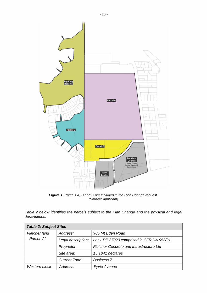
The Plan Change request is to re-zone three main areas of land. These areas include the existing Three Kings Quarry owned by the Applicant (‘Fletcher land’), land located south of the quarry (reserve land vested in trust in Auckland Council with underlying Crown ownership referred to as the ‘Southern block’) and land west of the quarry formerly quarried by the Auckland Council (referred to as the ‘Western block’).
These parcels of land are identified below in Figure 1.
- 16 -
Figure 1: Parcels A, B and C are included in the Plan Change request. (Source: Applicant)
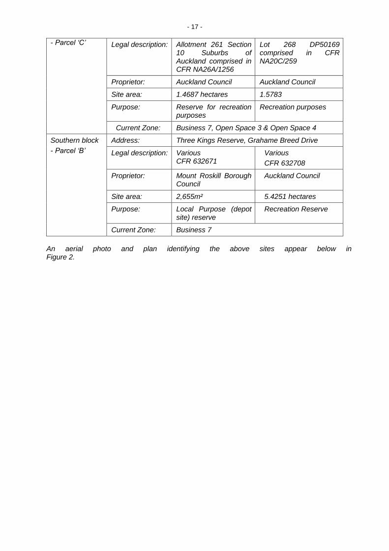
Table 2 below identifies the parcels subject to the Plan Change and the physical and legal descriptions.
Table 2: Subject Sites
Fletcher land
- Parcel ‘A’
Address: 985 Mt Eden Road
Legal description: Lot 1 DP 37020 comprised in CFR NA 953/21
Proprietor: Fletcher Concrete and Infrastructure Ltd
Site area: 15.1841 hectares
Current Zone: Business 7
Western block Address: Fyvie Avenue
- 17 -
- Parcel ‘C’
Legal description: Allotment 261 Section
10 Suburbs of Auckland comprised in CFR NA26A/1256
Lot 268 DP50169 comprised in CFR NA20C/259
Proprietor: Auckland Council Auckland Council
Site area: 1.4687 hectares 1.5783
Purpose: Reserve for recreation purposes
Recreation purposes
Current Zone: Business 7, Open Space 3 & Open Space 4
Southern block
- Parcel ‘B’
Address: Three Kings Reserve, Grahame Breed Drive
Legal description: Various CFR 632671
Various
CFR 632708
Proprietor: Mount Roskill Borough Council
Auckland Council
Site area: 2,655m² 5.4251 hectares
Purpose: Local Purpose (depot site) reserve
Recreation Reserve
Current Zone: Business 7
An aerial photo and plan identifying the above sites appear below in Figure 2.
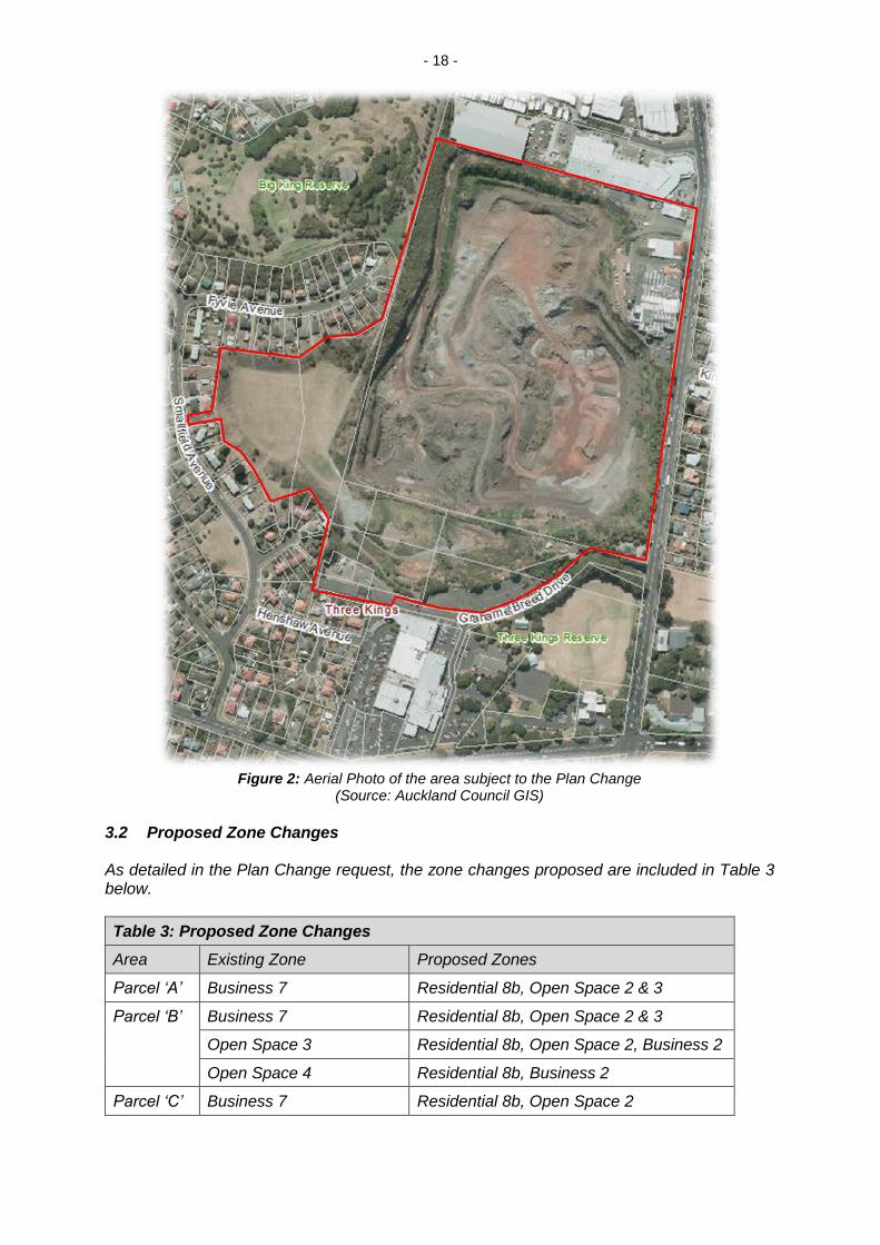
- 18 -
Figure 2: Aerial Photo of the area subject to the Plan Change
(Source: Auckland Council GIS) 3.2 Proposed Zone Changes As detailed in the Plan Change request, the zone changes proposed are included in Table 3 below.
Table 3: Proposed Zone Changes
Area Existing Zone Proposed Zones
Parcel ‘A’ Business 7 Residential 8b, Open Space 2 & 3
Parcel ‘B’ Business 7 Residential 8b, Open Space 2 & 3
Open Space 3 Residential 8b, Open Space 2, Business 2
Open Space 4 Residential 8b, Business 2
Parcel ‘C’ Business 7 Residential 8b, Open Space 2
- 19 -
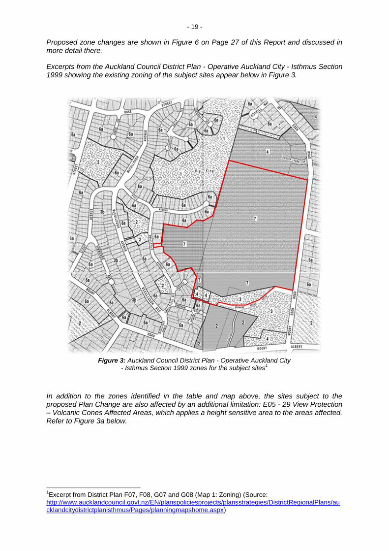
Proposed zone changes are shown in Figure 6 on Page 27 of this Report and discussed in more detail there.
Excerpts from the Auckland Council District Plan - Operative Auckland City - Isthmus Section 1999 showing the existing zoning of the subject sites appear below in Figure 3.
Figure 3: Auckland Council District Plan - Operative Auckland City
- Isthmus Section 1999 zones for the subject sites1
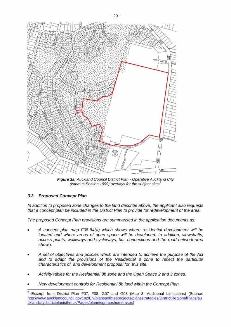
In addition to the zones identified in the table and map above, the sites subject to the proposed Plan Change are also affected by an additional limitation: E05 - 29 View Protection – Volcanic Cones Affected Areas, which applies a height sensitive area to the areas affected. Refer to Figure 3a below.
1Excerpt from District Plan F07, F08, G07 and G08 (Map 1: Zoning) (Source:
http://www.aucklandcouncil.govt.nz/EN/planspoliciesprojects/plansstrategies/DistrictRegionalPlans/aucklandcitydistrictplanisthmus/Pages/planningmapshome.aspx)
- 20 -
Figure 3a: Auckland Council District Plan - Operative Auckland City (Isthmus Section 1999) overlays for the subject sites
2
3.3 Proposed Concept Plan
In addition to proposed zone changes to the land describe above, the applicant also requests that a concept plan be included in the District Plan to provide for redevelopment of the area.
The proposed Concept Plan provisions are summarised in the application documents as:
A concept plan map F08-84(a) which shows where residential development will be located and where areas of open space will be developed. In addition, viewshafts, access points, walkways and cycleways, bus connections and the road network area shown.
A set of objectives and policies which are intended to achieve the purpose of the Act and to adapt the provisions of the Residential 8 zone to reflect the particular characteristics of, and development proposal for, this site.
Activity tables for the Residential 8b zone and the Open Space 2 and 3 zones.
New development controls for Residential 8b land within the Concept Plan 2 Excerpt from District Plan F07, F08, G07 and G08 (Map 3: Additional Limitations) (Source:
http://www.aucklandcouncil.govt.nz/EN/planspoliciesprojects/plansstrategies/DistrictRegionalPlans/aucklandcitydistrictplanisthmus/Pages/planningmapshome.aspx)
- 21 -
A density control which ensures that the number of dwellings within the concept plan area does not exceed 1500. This control reflects the development provided for in the master plan.
Subdivision provisions which promote subdivision in accordance with planned unit developments. The use of planned unit development(s) will allow work on the site to be staged according to the development of infrastructure and as the works on the quarry rehabilitation are completed.
The Applicant proposes that the concept plan and additional rule requirements ensure that development of the rezoned areas takes into account key parameters that have been identified in the master plan process.
3.4 Proposed Text Amendments
To address the proposed rule amendments and inclusion of a concept plan for the land to be re-zoned, the applicant also requests changes to the text of the District Plan.
Amendments are required to Part 7 Residential to reflect the concept plan and to ensure that there is no ambiguity as to the provisions which apply.
The following changes are requested:
The development controls of the Residential 8b zone apply except for the following controls:
7.8.2.3 Maximum Height
7.8.2.4 Height in Relation to Boundary
7.8.2.7 Maximum Building Coverage and Impermeable Surface
7.8.2.8 Minimum Stormwater Permeable Surface
7.8.2.9 Yards
7.8.2.10A Private Open Space Residential Units
7.8.2.15 Driveways and Carparking (d) amount of Road Frontage Taken Up by Accessways
7.8.2.17 Integrated Housing Developments Communal Open Space
7.8.2.5 Daylight
The above controls have been replaced with the site specific controls which are appropriate to development on this site and the concept plan framework. For example, the height controls have been amended so that they relate to the finished Reduced Levels of the quarry and the building coverage, impervious area and landscaping controls have been related to the area of the Planned Unit Development as opposed to the area of the site as a whole. The height in relation to boundary controls and the private open space controls have also been amended so as to be appropriate to the form of development promoted in the master plan.
Assessment Criteria have been included to ensure that proposals for controlled and restricted discretionary activities are assessed in a consistent and comprehensive manner. The matters contained in the assessment criteria reflect the master plan and
- 22 -
the work done by the various specialists including urban design, stormwater and the Te Aranga principles. It should also be noted that the development control rules contained in the Appendix 10 of the District Plan (which are used to assess the construction or relocation of residential units) are not applied to this development as it is considered that the development controls proposed are sufficient to ensure high quality development.
Special Information requirements have been included to ensure that the information provided with any application is appropriate to development on this site and reflects the work already undertaken. For example, information is required in respect of the integration of development into Te Tātua a Riukiuta/Big King.
Amendments are required to Part 7 Residential to reflect the concept plan and to ensure that there is no ambiguity as to the provisions which apply.
A special height limit for the purpose of calculating volcanic sightlines is included for the former Crown/Council quarry on the western sports field.
3.5 Masterplan
In order to demonstrate the full development potential of the rezoning and rule amendment request, the Applicant has provided a Masterplan for the entire site.
The applicant contends that the master plan has been developed through an extensive consultation process in order to ascertain the community’s vision for Three Kings. The comprehensive Masterplan provides a strategic direction for the proposed zone and rule amendments but does not form part of the Plan Change request.
3.6 Information to Support the Plan Change request
The Applicant has included with the Plan Change a comprehensive assessment of the proposal as required by Section 32 of the RMA. The application documents include those listed below which appear in Attachment 1.
Table 4: Supporting information
Document Author Contents
1 Certificates of Title - Legal Descriptions
2 Private Plan Change Request - Plan Change details
3 Planning Report Tattico Planning assessment
4 Project/Consultation Report Fletcher Project history and consultation background
5 Masterplan dkO Development vision
6 Urban Design Report dKO Design assessment
7 Urban Design Overview SDI Description of Landscape Architecture Elements and Process
8 Cultural Review Design Tribe
Assessment of cultural design principles
9 Transport Assessment TDG Integrated Transport Assessment and AEE
- 23 -
10 Infrastructure Assessment Harrison Grierson
Infrastructure capacity review
11 Stormwater Management Plan PDP Stormwater management
concept
12 Geotechnical Assessment T&T Geotechnical review for
safe development of residential and open space zones
13 Contaminated Land Overview PDP Actual/potential contaminated land issues
14 Economic Impact Assessment Property Economics
Economic costs and benefits
The Plan Change has been modified since lodgement and notification. These changes do not affect the sites included in the Plan Change or the extent of the zones proposed for amendment but provides additional clarification and criteria for the requested rule amendments. It is considered these changes are in keeping with the intention of the plan change and the scope of the material notified.
Additional information and addendums submitted to support the Plan Change are listed below in Table 5. The supplementary information received on 7 October 2014 (items 15-17) was included as part of the notification information was available to submitters.
Additional information received on 17 December 2014 and 21 April 2015 was information provided to further develop the contents of the Plan Change in response to workshops and assessments provided by Council technical experts. This planning report, commentary from Council experts and the assessment of effects has addressed all information provided. However, the ‘final’ version of text contained within the Plan Change itself was received on 22 April 2015.
All of the information listed above (and any other additional information not specifically listed) is considered to be a part of the Section 32 Evaluation as referred to in this report.
Table 5: Additional Supporting information
Document Author Contents
Received 7 October 2014
15 Amended Plan Change Tattico Amended wording to text following queries from Council and experts
16 Planning Report Addendum and Appendices:
Urban Design
Landscape
Transport
Stormwater
Geotechnical
Acoustic
Tattico
dKO
SDI
TDG
PDP
T&T
Marshall Day
Updated assessments and information in order to provide clarity for the purposes of notification
17 Other Additional Information Various Clarifications
Received 17 December 2014
- 24 -
18 Planning Clarifications
Town Centre Designs
Tattico
dKO
Clarifications regarding Plan Change content and draft designs for the Town Centre as discussed with Council staff
19 Amended Plan Change Tattico Amended wording to text
20 Assessment of Noise Effects Marshall Day
Additional acoustic assessment
21 A1 Cross Sections Unknown Site overview
Received 22 April 2015
22 Additional Stormwater Information
Various To ensure all information available for expert review
23 Additional Geotechnical information
T&T
24 Revised Plan Change text Tattico Minor amendments
25 Additional Acoustic Assessment
Marshall Day
Further acoustic clarifications
All of the information submitted by the Applicant, including the expert assessments to support the Plan Change, the Masterplan which demonstrates the vision for the development and any amended material provided to Council up until the time of writing this report is considered to be part of the section 32 evaluation (‘Section 32 Evaluation’) necessary to determine the Plan Change as proposed. In addition, where opinions differ to those of the Applicant and assessments have been provided or referred to in this Report; it is considered that these assessments also form part of the required evaluations under Section 32 of the Act.
While the Plan Change is limited to re-zoning of the land, its stated purpose is to facilitate a comprehensive redevelopment of land owned by the applicant and adjoining land it does not yet own (including Council and Crown owned reserve land). In this regard, the supporting assessments use, as a basis for determining suitability, a Masterplan which has been provided to demonstrate a development strategy for the site (although this does not form part of the Plan Change).”
7. Statutory Requirements
7.1 Overview
As the Plan Change was notified after 1 October 2009, it has been considered under the provisions of RMA as amended by the Resource Management (Simplifying and Streamlining) Amendment Act 2009.
The key provisions for consideration of a change to the District Plan are sections 32, 75 and 76 of the Act, Part 2 and the second Part of the First Schedule to the Act.
These are all addressed below.
The proposed plan change has been considered in light of the relevant statutory matters. These were summarised by the Environment Court in Long Bay-Okura Great Park Society Incorporated and Others v North Shore City Council (Decision A078/2008) where the Court set out the measures for evaluating objectives, policies, rules and other methods in the various planning documents. These matters were detailed in the reports supporting the plan change that had been
- 25 -
prepared on behalf of the applicant and in section 7 of Mr Van Kampen’s section 42A report and we have not repeated them here.
In addition to the matters from the Long Bay decision:
(i) The Plan must “give effect to” any national policy statement and any New Zealand Coastal Policy Statement (s75 (3) (a) and (b)).
(ii) The Plan must “give effect to” the regional policy statement (s75 (3) (c)).
(iii) The Plan must be “not inconsistent with” any regional plan (s75 (4)).
The matters above and the relevant provisions of the First Schedule have been incorporated into our decision. All submissions lodged on the plan change, the Council’s reports evaluating the plan change proposal and its potential effects, and the evidence presented at the hearing have all been taken into account and, as with the statutory provisions, while they may not necessarily be expressly referred to, they have nevertheless been taken into account when making our decision.
7.2 Section 32
Section 32 seeks to ensure that the costs and benefits of proposed plan provisions are considered and that the proposed controls are justified. Each objective that is proposed has to be examined with regard to the extent to which it is the most appropriate way to achieve the purpose of the RMA. Any rules or other methods should be aimed at achieving the objectives and policies. This assessment must take account of the benefits and costs of the proposed policies, rules or other methods and the risk of acting, or not acting, if there is uncertain or insufficient information about the subject matter of those policies, rules or other methods.
To meet the section 32 requirements, an assessment report must be prepared on the content of the proposed plan change before the change is notified. The original section 32 evaluation, prepared on behalf of the applicant has met the requirements of section 32 in relation to the proposed rezoning. We note that the hearing itself and our decision also forms part of the section 32 process.
We find that the section 32 evaluation, in addition to the analysis undertaken by Mr Van Kampen in sections 9.11 through 9.14 of his section 42A report, together with the evidence presented at the hearing satisfy sections 32 and 32AA of the RMA. We have concluded that the plan change is the most appropriate way to achieve a more efficient and appropriate use of the land covered by PC 372 and will promote the sustainable management of natural and physical resources as contemplated by Part 2 of the RMA.
The planning evidence of Mr Jarvis, supported by the legal submissions of Mr Enright, challenged the section 32 evaluation. It was not clear to us that section 32 matters were specifically identified in the original written submissions lodged on behalf of the South Epsom Planning Group Inc, or Three Kings United Group Inc, however we have considered the matters raised by Mr Jarvis and Mr Enright. They appeared to be the only witnesses, or submitters who raised section 32 matters.
Mr Jarvis’s primary concern with the section 32 analysis was that:
“The s32 analysis forming part of the applicant’s planning report only compares zoning options drawn from the operative ACPIS. The approach to the s32 analysis should have been driven by the Part 2 RMA and the ACRPs policy imperatives, particularly those contained in Chapters 2 and 6 which I have outlined in evidence, the Reserves and Other Lands Disposal and Public Bodies Empowering Act 1915
- 26 -
and the Environment Court decision ENV 214, under which the fill operations are operating and arguably form part of the existing environment. They should, in my opinion, have focussed on and compared options which considered contrasting fill levels and how they achieve integration with the surrounding landscape as well as contrasting design options. From there it would have been logical to consider which of the zoning options delivered the preferred option. The s32 has in effect got the cart before the horse.”
Mr Jarvis’s section 32 concerns are closely aligned with his, and other submitter’s, concerns that the plan change has not fully considered, assessed, or proposed on the basis of the quarry site being filled to a far greater extent. We have addressed these concerns in some detail under the heading ‘Consideration of Alternatives’ later in our decision.
We have preferred and adopt, in general terms, the planning evidence of Mr Van Kampen and Mr Duthie with respect to section 32 matters. It is our finding that their evidence is more comprehensive and balanced than that of Mr Jarvis. In any event we have carefully considered all of the relevant Part 2 matters and the relevant objectives and policies of the regional planning provisions of concern to Mr Jarvis. Mr Van Kampen, in his closing statement dated 2 June 2015, comprehensively responded to Mr Jarvis’s concerns that we have quoted above.
Overall we are doubtful that the section 32 matters have been legitimately raised in any submission lodged to the plan change. After considering the evidence of Mr Jarvis, together with that of the other submitters who were seeking a wider assessment of alternative design outcomes, it is our finding that there has been no compelling evidence presented to undermine the conclusions of Mr Van Kampen and Mr Duthie in relation to the robustness of the section 32 analysis that has been undertaken by the applicant and the Council’s reporting team. In addition we repeat that the hearing process and our decision form part of the section 32 process.
7.3 Statutory Assessment
7.3.1 The most comprehensive planning evidence that included statutory assessments was from Mr Van Kampen and Mr Duthie. They both had the benefit of extensive supporting evidence from the multidisciplinary experts who appeared either on behalf of the applicant, or on behalf of the Council’s reporting team. There was general agreement between Mr Van Kampen and Mr Duthie with respect to the relevant statutory matters that needed to be assessed. In sections 7, 8 and 9 of his section 42A report and his closing statement Mr Van Kampen specifically addressed statutory matters. In paragraphs 145 to 318 Mr Duthie set out his assessment. Apart from some differences with respect to specific provisions Mr Van Kampen and Mr Duthie agreed that the relevant statutory tests had been met and they both recommended that the proposed plan change be approved.
In particular they agreed that there are no national policy statements or New Zealand Coastal Policy Statements that are relevant to the proposed plan change, and that the proposed plan change:
(a) Is the most appropriate way to achieve a more efficient and appropriate use of the sites and will promote the sustainable management of natural and physical resources.
(b) Will give effect to the relevant regional policy statements.
- 27 -
(c) Has taken into account matters relating to the Treaty of Waitangi and in particular issues relating to the Tamaki Collective and the Auckland Settlement.
(d) Will assist the Council in achieving its function of addressing the growth needs of Auckland.
(e) Recognises and appropriately responds to the cultural and landscape importance of the surrounding environment.
(f) Will facilitate the rehabilitation of the former quarry.
7.3.2 Of the other planners we heard from, Ms Sherring and Mr Roberts generally supported the proposed plan change although they supported specific changes. Mr Jarvis did not support the proposed plan change and he specifically identified what he considered to be difficulties with the statutory assessments that supported it. He considered that considerable emphasis had been given to the “efficiency of use and development of natural and physical resources.” He considered this to be an “over emphasis” and inappropriate in the context of the two matters of national importance he identified as being particularly relevant. Those two matters being the protection of the outstanding natural features and landscape adjacent to the land to be rezoned and the relationship of Maori and their culture with Te Tātua a Riukiuta. We have specifically discussed these matters below in section 8 of our decision under the headings ‘Part 2 of the RMA and our broad overall judgment’, ‘Consideration of Alternatives,’ ‘Cultural Aspects’ and ‘Heritage Aspects.’
For the reasons we have recorded under those headings we have preferred the evidence of Mr Van Kampen and Mr Duthie to that of Mr Jarvis. In summary we considered the statutory assessment evidence in support of the proposed plan change to be more comprehensive and appropriately balanced all of the relevant matters. Mr Jarvis in contrast relied on his assessment of a few specific matters. He provided no compelling evidence as to why the cultural, heritage and landscape matters in isolation, or when considered together, were of such a concern that they outweighed the other positive outcomes identified by Mr Van Kampen and Mr Duthie. His evidence while having support from a landscape perspective, had limited support from a cultural perspective.
7.3.3 It is our overall finding on statutory matters, after considering all of the expert evidence, the recorded support for the proposed plan change from tangata whenua, and making an overall judgement taking into account all of the relevant statutory tests, that there is no basis to refuse the plan change. We have adopted and relied on the evidence of Mr Van Kampen and Mr Duthie in reaching this finding due to the fact that we did not hear directly from Iwi.
8. Submissions
This section of our decision addresses the submissions that have been received to PC 372, the evidence we heard or received in relation to submissions, our decisions on submissions, the changes we have made to PC 372 and the reasons for our decisions.
8.1 Submissions and the Submitters Requests
In section 10 of his section 42A report Mr Van Kampen grouped the submissions by the decision being requested. The submissions fell into four different groups, being those that:
- 28 -
(a) Supported the entire plan change and requested that it be approved/accepted. [101 submissions]
(b) Opposed the entire plan change and requested that it be declined/rejected. [66 submissions]
(c) Sought modifications to the plan change, including those submitters whose primary relief is to reject the plan change either in whole or part. [12 submitters] and those submitters who support provided modifications are made. [16 submitters]
(d) Did not clearly identify or request a decision. [4 submitters]
8.2 The Principal Issues That Were in Contention
(a) Part 2 of the RMA and our broad overall judgment
(b) The 2011 Environment Court Decision
(c) The proposed land swap with Auckland Council
(d) The Reserves and Other Lands Disposal Empowering Act 1915 (1915 Act)
(e) Consultation
(f) Consideration of alternatives
(g) The Three Kings Plan
(h) Cultural aspects
(i) Heritage aspects
(j) Infrastructure
(k) Integration and connectivity
(l) Wording of the Plan Change documents
8.3 Our Findings
Part 2 of the RMA and our broad overall judgement
8.3.1 We heard from three planners with respect to Part 2 matters.
8.3.2 Mr Duthie, on behalf of Fletchers concluded at his paragraphs 674 and 675 that:
“The proposal is considered to meet the relevant tests set out in the Act and is consistent with the objectives and policies of the relevant statutory documents. The primary reasons for this are:
a) The proposal provides for the efficient use of land for a residential purpose in an appropriate location (close to public transport and a town centre); and
b) The extensive design and development work undertaken will ensure that any adverse effects of the development will be effectively managed in an environmentally sensitive manner.
- 29 -
The proposed Residential 8 zoning and the associated concept plan will provide an effective and efficient basis for ensuring that the proposal will give effect to objectives of the Isthmus District Plan and the purpose of the Act. The provisions of the plan change will also ensure that the development is constructed in a planned and comprehensive manner and will give full effect to the master plan prepared by Fletcher Residential.”
In his paragraphs 671 to 673 inclusive he set out the key reasons in support of his above conclusions. These reasons included:
(i) The site offered a unique opportunity to contribute to the Council’s growth strategy of providing for Auckland’s growth in selected areas adjacent to town centres and along major transport corridors.
(ii) If Auckland is to deliver on this growth strategy it needs to make effective use of the scarce blocks of brownfields land like Three Kings.
(iii) The proposal will be respectful of the cultural and historical significance of the area and the Maunga in particular.
(iv) There would be positive benefits to the community of Three Kings through the provision of a quality open space network and the reinvigoration of the town centre.
(v) The proposal would make a significant contribution to the provision of housing in the locality and the Auckland region.
(vi) The potential effects of the development will be managed in an environmentally sensitive manner.
(vii) A high level of urban design will ensure the creation of a quality built environment and high amenity neighbourhoods.
8.3.3 Mr Van Kampen reached very similar conclusions to Mr Duthie. Subject to different recommendations to Mr Duthie with respect to some of the detailed aspects of the plan change, Mr Van Kampen agreed that in terms of Part 2 of the RMA the proposed rezoning “...is the most appropriate way to achieve a more efficient and appropriate use of the sites that achieves the stated purpose of the RMA.”
8.3.4 The only expert planner to have a contrary view to that of Mr Duthie and Mr Van Kampen was Mr Jarvis. He identified at his paragraph 10.3 that he considered that section 6 matters of national importance arise from:
“(b) The protection of outstanding natural features and landscapes from inappropriate subdivision, use, and development, and
(e) The relationship of Maori and their culture and traditions with ancestral lands, water, sites, waahi tapu and other toanga is raised in terms of section 6(e) and kaitiakitanga and the ethic of stewardship (7(a) and (aa)).
The efficiency of use and development of natural and physical resources is the section 7(b) matter. This has been given considerable emphasis by the applicant as illustrated by Mr Duthie’s evidence (paragraph 280). There is no contention that providing capacity for accommodating residential development within the MUL/RUB is the significant issue continuing to face the region. However, the pervading emphasis the applicant is giving to accommodating up to 1500 residential units would in my view over emphasise a s7 matter over a s6 matter and be inappropriate.”
- 30 -
8.3.5 Mr Jarvis concluded that in its present form the plan change does not promote the sustainable management of the “outstanding natural feature and regionally significant volcanic feature” of Te Tātua a Riukiuta, as contemplated by the key Chapter 6 objectives and policies of the Auckland Regional Policy Statement (ARPS). In addition he concluded that the provisions of Chapter 3 of the ARPS relating to Matters of Significance to Iwi would be potentially better respect the cultural significance of Te Tātua a Riukiuta, if the quarry site was filled to higher contours. He relied on Mr Reid’s evidence in this regard.
8.3.6 Dealing with the cultural aspects of concern to Mr Jarvis first, we did not receive evidence from any mana whenua group during the hearing process. We noted that submissions in support had been lodged by three groups, Ngati Tamaoho, Ngati te Ata and Te Kawerau a Maki. The only direct cultural evidence we received was from Mr Hoskins on behalf of Fletcher Residential. Mr Hoskins told us that there had been consultation and engagement with tangata whenua regarding the design elements. He set out in his evidence the Te Aranga principles that he considered are “culturally important and very appropriate as an assessment criteria for the development that will take place within the Three Kings area. These principles will also work to ensure the mana of Te Tātua a Riukiuta/Big King, the sole remaining volcanic cone, is protected and recognised through the plan change.” He also stated, when questioned, that he could not speak for mana whenua and we acknowledge and appreciate that.
8.3.7 Mr Chote advised us that seven hui that had been held with relevant iwi and that Fletcher is committed to maintaining and developing further the relationships with mana whenua “through formalised kaitiaki roles in the detailed design and construction phases, and into the future with the ongoing management of communal areas, wetlands and path networks.” He also advised of the protection of the bush area on the eastern flank of the maunga and that this land would be under the control and ownership of the Tupuna a Taonga o Tamaki Makaurau Trust and that the concept of the Whare Manaaki would create an important information and meeting place associated with Te Tātua a Riukiuta.
We note that these hui were with representatives of Iwi and that what Fletcher is offering are proposals dependant on a number of outcomes that would need to be negotiated between a number of parties, so we accept this is an on-going process based on good will.
8.3.8 Mr Duthie in his paragraphs 464 to 495 set out in some detail the engagement with Iwi and the outcomes that have been included within the plan change.
8.3.9 While Mr Jarvis raised his concerns with respect to the provisions of Chapter 3 of the ARPS and that in his opinion a better cultural response would result from additional filling of the quarry above the fill levels proposed, we have preferred the evidence presented by Mr Hoskins, Mr Chote and Mr Duthie. In addition we cannot ignore the fact that the only submissions lodged by mana whenua supported the plan change, the outcomes contemplated with respect to Te Tātua a Riukiuta, the Te Aranga principles and the proposed treatment of stormwater.
8.3.10 With respect to section 7 and 8 matters we find that the relationship of Maori with respect to Te Tātua a Riukiuta, the sustainable management of it and the land directly affected by the plan change, has been appropriately considered and is supported by those mana whenua who have been consulted and engaged with Fletcher.
8.3.11 With respect to Mr Jarvis’s primary concern, that the plan change does not promote the sustainable management of the “outstanding natural feature and regionally
- 31 -
significant volcanic feature” of Te Tātua a Riukiuta, as contemplated by the key Chapter 6 objectives and policies of the ARPS, we have carefully considered the matters he raised in his evidence. We have noted that the ARPS Map Series 2a, Sheet 3, attached to Mr Jarvis’s evidence clearly identifies the regionally significant volcanic feature under the heading “Three Kings volcano.” While the land directly affected by the plan change abuts the eastern side of the identified feature, the identified feature itself does not include any of the land proposed for rezoning under this plan change. Mr Jarvis’s concern was that activities on land surrounding, or adjacent to, the identified feature should be managed to ensure that significant adverse effects on the features values are avoided, remedied, or mitigated and where practical are enhanced. Policy 6.4.19.2 (iii) of the ARPS is worded to this effect. Policy 6.4.19.2 (ii) relates to publicly owned land and seeks to ensure that “…their open space and amenity values are maintained and where practicable enhanced and that the provision of public access and recreation is consistent with the protection of their other values.” It was Mr Jarvis’s conclusion that proposed development on the currently publicly owned land, Western Park portion, would detract from Te Tātua a Riukiuta. As we understood his evidence he also considered that better outcomes would be achieved if the existing quarry was filled to a far greater extent than is proposed, so that plan change land would integrate with the surrounding topography and in particular the volcanic landform that is identified in the ARPS. He relied on Mr Reid’s evidence and in Mr Jarvis’s opinion this would “…demonstrate that a better urban form built on an integrated landform can be realised.”
8.3.12 With respect to the publicly owned land area of Western Park we share some of Mr Jarvis’s concerns with respect to public access to and from Te Tātua a Riukiuta and public access to and from the existing residentially zoned land in Fyvie Avenue. We have included the two accesses to Fyvie Avenue and provided a 10 metre wide strip adjacent along the rear boundary of the properties in Fyvie Avenue and Smallfield Avenue to facilitate easier public access in this locality. The Council through the separate land exchange process will need to consider if the wider open space and amenity values will be maintained by enabling development to occur on all of the Western Park land. We have concluded that given the extent of residential zoning in Fyvie and Smallfield Avenues, together with the concept plan provision for open space and sportsfields within the plan change site, that there will not be significant adverse effects on Te Tātua a Riukiuta. We do find that some adverse effects could arise from the proposed apartment development in this location, more likely to be “minor” rather than “significant” in scale.
8.3.13 With respect Mr Jarvis’s preference for the quarry to be filled to a far greater extent in order to provide a more integrated landform and topography we will discuss this more fully elsewhere in our decision. In relation to our Part 2 considerations and broad overall judgement we agree with Mr Loutit that section 6(b) and the protection of outstanding natural features and landscapes from inappropriate subdivision, use and development, is one aspect of Part 2 of the RMA that we must take into account along with all the other relevant matters identified in sections 5, 6, 7 and 8 of Part 2.
8.3.14 The primary difference between Mr Jarvis’s evidence and the evidence of Mr Duthie and Mr Van Kampen was the extent to which they have assessed all of the relevant Part 2 matters and how they have balanced any competing matters. Mr Jarvis, while acknowledging the opportunity for residential intensification exists, concluded that landform integration should be a precursor to any future residential development. As we understood his evidence, along with the evidence of a number of the submitters we heard from, there was an expectation that the quarry site should be reinstated to the pre quarrying ground levels, or the Environment Court 2011 fill levels, before residential development is designed and developed. Mr Duthie and Mr Van Kampen in contrast considered that the existing quarry provided an opportunity for residential
- 32 -
development, utilising the change in topography that would arise from a partially filled quarry site.
8.3.15 We do not consider that the protection of Te Tātua a Riukiuta can only be achieved by first undertaking more extensive filling of the quarry as sought by Mr Jarvis and many other submitters. Nor do we consider that the development opportunities that would be enabled by the proposed rezoning would necessarily be inappropriate subdivision, use and development in terms of section 6(b) of the RMA. We also note that, contrary to what many submitters appeared to be suggesting, the fill diagram in the Environment Court decision does not come near to reinstating the ground to pre-quarrying levels.
8.3.16 We have overall preferred the evidence of Mr Duthie and Mr Van Kampen with respect to Part 2 matters. Their planning evidence was supported by the majority of the other expert witnesses that we heard from. The majority of witnesses concluded that the rezoning of this land could enable residential development of a design and intensity that could be appropriately serviced and accommodated within the surrounding environment. The overwhelming expert evidence was that land could be developed, generally in accordance with the concept plan and the master plan that had been prepared. While there was some debate on how some aspects of the proposed development should physically occur, there was a consensus that the land was suitable for development. There was also considerable agreement, at least between the majority of the experts who presented evidence, that the specific provisions of the plan change can be appropriately worded to ensure the intended outcomes can be achieved. The future resource consenting processes and assessment criteria were by the end of the hearing largely agreed between the applicant’s witnesses and those members of the Council’s reporting team.
8.3.17 Taking into account all of these matters, including the significant number of submitters that supported the plan change, including three from mana whenua, we have reached abroad overall judgement in terms of Part 2 matters. We do not find that the proposed rezoning will be inappropriate subdivision, use and development of land adjacent to the outstanding natural feature that is Te Tātua a Riukiuta. We do find that the proposed rezoning will protect and have minimal effect on Te Tātua a Riukiuta while at the same time will enable the efficient use and development of this valuable land resource that will make a significant contribution towards meeting the future housing needs of Auckland.
The 2011 Environment Court Decision
8.3.18 A number of submitters considered that 2011 Environment Court consent order (C214 2011) should be complied with prior to any redevelopment of the quarry site occurring. Condition 77 of that consent order states that consultation shall take place on the final fill level for the quarry and on future land uses of the quarry land. It was submitted by Mr Enright that “The consented environment is not necessarily binding on the plan change process. However, in these circumstances the assurances provided by Winstones should bind the applicant (as part of the same Fletchers’ group) and because the Environment Court’s focus on the final contour plan in [77] was to give effect to s6(b) RMA.”
8.3.19 We were informed by Mr Van Kampen that “My advice to the Commissioners is that any issues relating to the compliance of the Environment Court Consent Order are matters for Council’s Compliance and Monitoring Department. In any event, the Compliance and Monitoring Department have confirmed that the Applicant is currently complying with this consent.”
- 33 -
8.3.20 Mr Loutit in his Reply stated that:
“4.7 In relation to SEPG and TKU's claim that Fletcher has not fulfilled the consultation requirements of the condition, this is simply not true. Fletcher has carried out consultation with all relevant stakeholders. This consultation has focused on the future redevelopment of the site and the form that this redevelopment will take. This has included considering how to provide an integrated landform, including a more efficient open space network, and how the future landform and development will relate to the surrounding topography including Big King Reserve. Throughout this process Fletcher has listened to the feedback it received and has modified its plans and proposals in response. The Council has confirmed to Fletcher that they are satisfied that the consultation requirements of condition 77 have been met.
4.8 SEPG and TKU have also alleged that condition 77 imposes a minimum fill level. However, contrary to the position taken by the societies, the Fill Consent does not specify any minimum fill levels. For clarity, Figure 2, which was provided to you by the societies, indicates a series of levels that the consent holder may not fill beyond and makes no reference to a minimum fill profile.3 It is through the consultation requirements set out in condition 77, and the related process for the preparation and lodgement of a final contour plan, that Fletcher is to determine the final fill level.
4.9 Condition 77 specifies a number of factors that are to inform the consultation and contour plan process. Importantly, one of those factors is "whether the contour should rise toward Big King Reserve on the northern part of the site, and if so how this rising contour is to be provided". Use of this conditional language – "whether" and "if so" clearly implies that this is a matter requiring further analysis. Determining the final contour requires a comprehensive analysis of a whole series of design variables to ultimately achieve the appropriate urban design outcome. Fletcher has carried out the necessary consultation, and has undertaken the comprehensive analysis required to determine the most appropriate contour for the site as part of this Plan Change process. It is fully compliant with condition 77.”
8.3.21 We have accepted the legal submissions of Mr Loutit and the evidence of Mr Van Kampen. We see the Environment Court consent order as a separate matter from our considerations of this plan change. Any landowner has the right to reconsider their plans for their land and to pursue an alternative proposal. In this case Fletchers have decided to pursue a plan change that would rezone the quarry land and enable development without the need to fill the quarry site to the levels previously contemplated, (which as noted above are not back to original ground level). We consider that the earlier consent order does not prevent us from considering the merits of this plan change and we have proceeded on this basis.
8.3.22 In any event we agree with Mr Loutit that Fletchers have carried out the consultation contemplated by condition 77 and also that this condition contemplates a plan change process, or further resource consents, prior to fill being completed and development taking place.
8.3.23 While a number of submitters hold an expectation that the quarry site would be filled to the level contemplated in 2011, we have not received any compelling evidence or legal submissions that show that we cannot give consideration to the current plan change as requested by Fletchers.
3 Condition 56 states that the resource consent does not authorise any filling of the site beyond
and above the contours shown on Figure 2.
- 34 -
The Proposed Land Swap with Auckland Council
8.3.24 We were informed of the separate land swap procedures being undertaken under the Reserves Act 1977. Some submitters were concerned that this plan change process should not proceed because the Council has not completed the proposed land swap procedures under the Reserves Act.
8.3.25 We agree with Mr Loutit that the plan change under the RMA and the proposed land swap under the Reserves Act are two separate processes and that the ownership of the land that is the subject of the plan change is not a relevant consideration in resource management terms. We also agree that it is the applicant’s risk if two different outcomes arise from these processes.
8.3.26 It is our finding that there is no resource management reason for us to delay our consideration of this plan change, nor make a decision on the merits of the proposed zoning provisions until the Reserves Act land swap process has been completed.
The Reserves and other Lands Disposal Empowering Act 1915 (1915 Act)
8.3.27 An issue was raised in relation to this 1915 Act which is administered by the Department of Conservation. Mr Loutit produced a report dated 14 July 2008 from Terra Mining Consultants Limited. In his reply Mr Loutit submitted that:
“4.15 The report took cross sections across the northern part of the quarry (the part adjacent to Big King Reserve) and assessed the slope angle of the quarry pit wall. These angles were then compared to 40 degree slopes measured from both the horizontal and vertical. The 1915 Act does not specify which measurement (vertical or horizontal) should be used.4
4.16 The results of this analysis of representative sections were that the quarry pit slopes are either equal to, or less than, the 40 degree slope from the horizontal and therefore are greater than a 40 degree slope from the vertical. There has been no further cutting of this quarry slope since the report was prepared in 2008.
4.17 This report therefore establishes that the cut slopes of the quarry are in compliance with the 1915 Act. A copy of the report was provided to the Council on 18 September 2014.”
8.3.28 We have accepted Mr Loutit’s submissions in the absence of any compelling specific evidence that would undermine the report prepared by Terra Mining Consultants Limited.
8.3.29 We also accept Mr Van Kampen’s evidence in section 9.10.4 of his section 42A report that:
“Whilst this Act is relevant to the site given the quarry currently abuts one side of Te Tātua a Riu-ki-uta/Big King, the proposed Plan Change does not include works of any kind that could be considered an excavation, quarry, terrace, or cutting of any kind on the side or slope of the maunga. I note the Plan Change request proposes zone and rule amendments, but does not request any alteration of rules that relate to the slope of the maunga.
4 Paragraph 1.1 of the Report notes that a 40 degree slope when measured from the vertical
will be steeper than that measured from the horizontal, but will get flatter as that angle increases.
- 35 -
However, as the slopes of the maunga are proposed to be rezoned to Open Space 2, rehabilitation of the maunga slope is proposed as a restricted discretionary activity, with associated assessment criteria. Notwithstanding any rule change to this type of activity, compliance with this act would still be required and the Applicant has been informed of the requirements of the legislation in this regard.”
8.3.30 Mr Jarvis in his evidence stated that:
“It appears to me from the steepness of the quarry face that the quarrying activities have not been in compliance with the Act. It will require an accurate survey to identify the quarry face contours should form part of the Landform Design that is discussed later in this evidence. There may be implications for the use of the haul road.”
8.3.31 It is our finding on this matter that in the absence of any compelling evidence that contradicts the 2008 findings of the Terra Mining Consultants Limited report, there appears to be no breach of the 1915 Act. If we are wrong in this regard we note that we have no jurisdiction in any event as the Act is administered by the Department of Conservation.
Consultation
8.3.32 There was criticism from the South Epsom Planning Group Inc, the Three Kings United Group Inc and a number of other submitters, of the consultation that had been undertaken during the plan change process. Essentially these submitters considered that the obligations of the 2011 Environment Court consent order were required over and above the normal plan change consultation requirements and it was alleged that “consultation is a weak point for PC 372.”
8.3.33 In response to these allegations it was Mr Loutit’s submission in Reply that:
“6.1 It has been alleged that consultation is a "weak point" for the Plan Change. SEPG, TKU and others have presented evidence that accepts that there has been consultation, but that it was not quality consultation. In my submission this could not be further from the case. There has been enormous opportunity for the various parties to exchange their views about the post-quarrying future of the site. In addition, it should be remembered that at the Council’s request Fletcher suspended its own consultation program and participated in the Council’s process. This resulted in the Three Kings Plan, which has been widely accepted by submitters.
6.2 Mr Duthie, a planner with extensive experience, gave evidence that the consultation carried out by Fletcher has been extensive and robust and has gone well beyond that which would normally occur for a public or private plan change request. The fact remains that the submitters feel aggrieved because the outcome that would be delivered by the Plan Change is not their preferred outcome.”
8.3.34 Mr Chote in his evidence, including his Appendix A, and Mr Duthie in paragraphs 442 to 463 inclusive of his evidence, set out in detail the nature of the consultation that had occurred since 2008 in relation to the proposed development and the current plan change.
8.3.35 Mr Bryant, on behalf of the Three Kings United Group Inc, stated that discussions had begun as early as 2007, however his concern was with respect to “…the lack of robust consultation by Fletchers with both our groups (TKUG &SEPG) and the community.” He stated in his paragraphs 16 and 17 that;
- 36 -
“Fletchers approach was not to participate in discussions. When asked for their thoughts on early stages of the plan (The Three Kings Plan) they did not want to discuss or be involved in the workshops.”
“There has never been any formal consultation with my Society.”
“My Groups submission is that the claim that TKUG was consulted is untrue.”
8.3.36 Mr Bryant presented a number of documents in support of his overall conclusion that there had been a lack of robust consultation.
8.3.37 Emeritus Professor Richard Bellamy, President of the South Epsom Planning Group Inc, stated in his paragraphs 31 and 34, after earlier describing the his groups involvement with quarry operations, the 2011 Environment Court consent order decision and the Three Kings Plan, that:
“Given the above narrative, it will perhaps come as no surprise the SEPG opposes the current application that is now the subject of this hearing. The grounds for this opposition centre on a number of issues that largely stem from the current unsatisfactory ‘rehabilitation’ contour proposed. To that extent, our opposition mirrors that of many other submitters and will be supported by the expert evidence that follows my own.”
“In reaching this position, we have been disappointed by the long standing and continued lack of effort on the part of the site owner (the applicant) to prepare a plan for redevelopment that could readily have formed part of a long-term rehabilitation plan. Rather, the applicant has consistently refused to engage on such a project in any meaningful way. Having proceeded to deepen the pit without a plan, the very deepness of the pit (30 metres) is now being adduced as a prime reason for favouring but one possible rehabilitation scenario – to the exclusion of all others.”
8.3.38 It is clear to us that Fletcher is seeking an outcome from this plan change that many submitters oppose. The key differences, in the words of Emeritus Professor Bellamy, “centre on a number of issues that largely stem from the current unsatisfactory ‘rehabilitation’ contour proposed.” It is equally clear however that many other submitters support the plan change in its current form. From a numerical perspective there were in fact a greater number of submissions in support than in opposition. With respect to whether the consultation has been “adequate”, or “inadequate” however, we agree with Mr Loutit that “consultation cannot be equated with negotiation.”
8.3.39 Mr Loutit in his Reply at paragraphs 6.3 to 6.5 under the heading ‘Principles of consultation’ submitted as follows.
“The leading case on consultation is the Court of Appeal decision in Wellington International Airport Ltd v Air New Zealand.
5 This case was also alluded to by Professor Bellamy on
behalf of SEPG. In the Wellington Airport case the Court of Appeal cited with approval the High Court's earlier judgment that:
Consultation must be allowed sufficient time, and genuine effort must be made. It is to be a reality, not a charade. The concept is grasped most clearly by an approach in principle. To ‘consult’ is not merely to tell or present. Nor, at the other extreme, is it to agree. Consultation does not necessarily involve negotiation toward an agreement, although the latter not uncommonly can follow, as the tendency in consultation is to seek at least consensus. Consultation is an intermediate situation involving meaningful discussion. Despite its somewhat impromptu nature, I cannot improve on the attempt at description which I made in West Coast United Council v Prebble at p 405:
5 1 NZLR 671 (CA).
- 37 -
‘Consulting involves the statement of a proposal not yet finally decided upon, listening to what others have to say, considering their responses and then deciding what will be done.'
Implicit in the concept is a requirement that the party consulted will be (or will be made) adequately informed so as to be able to make intelligent and useful responses. It is also implicit that the party obliged to consult, while quite entitled to have a working plan already in mind, must keep its mind open and be ready to change and even start afresh.”
(emphasis added)
The key principles that can be discerned from this case are that:
The word "consultation" does not require that there be agreement, but it does require more than mere prior notification;6
Consultation cannot be equated with negotiation. The word negotiation implies a process which has as its object arriving at agreement. This is not required for consultation;7
For consultation to be meaningful sufficient information must be made available to the other party to enable it to be adequately informed so as to be able to make intelligent and useful responses;8 and
Consultation should be carried out with an open mind and a willingness to change.9
It is my submission that Fletcher has met all these key principles. It is disappointed that it has not been able to reach a consensus with all of the key stakeholders, but that is not required by the concept of consultation. Fletcher has provided extensive information to interested parties, has been willing to listen at all times, has provided multiple formal responses to the Three Kings Plan and has taken all feedback on board. The Plan Change represents the culmination of that extensive consultation process and it is of note that Fletcher made changes subsequent to the lodgement of the Plan Change application as a result of further discussions with the stakeholders on the Three Kings Plan.”
8.3.40 With respect to the consultation that has occurred in relation to this plan change we have no compelling evidence to erode or undermine the evidence of Mr Duthie and his overall conclusion that:
“This consultation has been extensive and robust. The level of consultation has gone well beyond that which would normally occur for a public or private plan change request.”
We have preferred and accept his evidence, together with the legal submissions of Mr Loutit. While it is evident that many submitters do not agree with the outcomes being sought by Fletcher in terms of this plan change, we do not agree that the dissatisfaction for these submitters can be attributed to the consultation process, or alleged lack of consultation, that has taken place. In resource management terms, we agree with Mr Duthie that extensive and robust consultation has occurred. We
6 At 674. 7 At 676. 8 At 676. 9 At 675.
- 38 -
can find no resource management reason to reject this plan change based on the alleged lack of consultation.
Consideration of Alternatives
8.3.41 A number of submitters, primarily SEPG and TKU, considered that Fletcher have not adequately considered alternatives to the outcomes proposed under this plan change. The submitters focussed on the alternative that the quarry site should be rehabilitated and filled, generally consistent with the final contours contemplated under condition 77 of the 2011 Environment Court consent order.
8.3.42 The evidence of landscape architects, architects and urban designers on behalf of submitters, including the evidence from Mr Reid, Ms Smith, Mr Wrack and Mr Marshall supported even greater levels of fill in their alternative design approach, based on increased filling of the quarry site so that the final levels would align with adjacent land and restore the contour and landform of Te Tātua a Riukiuta. Mr Jarvis in his planning evidence considered that the rehabilitation of the quarry and its integration with the regionally significant volcanic feature of Te Tātua a Riukiuta as a central issue to the hearing. He also supported the alternative design approach.
8.3.43 Mr Van Kampen in his closing statement dated 2 June 2015 stated that:
“7. Fill level and contours
7.1 In my opinion, the final ground level is a relevant consideration of this Plan Change insofar as it relates to the effects created by the resulting development that is proposed by the Applicant’s Masterplan (17H1) and enabled by the rule framework proposed. A new ground level is included in the Plan Change (as depicted on Figure F08-84(d) of the Plan Change) and this is necessary as the quarry continues to be filled and an established ground level is needed to measure heights.
7.2 Further, all expert advice from Council and the Applicant demonstrates that the proposed levels will provide good connectivity and not be a barrier to the use of public spaces or to pedestrians. Conversely, no opposing expert evidence has been presented to show that there are adverse effects from the levels proposed.
7.3 In addition, there are substantial positive effects that will provide greater densities to meet strategic growth goals and enhanced ability to secure better views and visual connections to Te Tātua a Riukiuta.”
8.3.44 Mr Loutit in his Reply under the heading ‘Consideration of Alternatives’ submitted as
follows:
5.1 SEPG and TKU have alleged that Fletcher have not adequately considered alternatives. In my submission this is simply not the case. Fletcher has undertaken an exhaustive consideration of the alternatives. SEPG and TKU's opposition arises because they are not happy with selected aspects of the alternative Fletcher has ultimately determined to proceed with.
5.2 Counsel for the societies raised the recent Supreme Court decision of Environmental Defence Society Incorporated v The New Zealand King
- 39 -
Salmon Company Limited.10 In that case the Supreme Court had to decide whether there was an obligation to consider alternative sites or methods when determining a private plan change that is located in, or results in significant adverse effects on, an outstanding landscape or feature or outstanding natural character area within the coastal environment.
5.3 The commentary in that decision predominantly relates to whether there is a requirement to consider alternative sites in the context of a private plan change that involves the use of part of the public domain for a private commercial purpose. The Supreme Court noted that the question of when consideration of alternative sites may be necessary will be determined by the nature and circumstances of the particular site-specific plan change and the reasons advanced in support of it.
5.4 Similarly, the TV3 Network Services v Waikato District Council case11 cited by counsel for the societies confirms that a consideration of viable alternative sites for a prospective activity can be of relevance.
5.5 Here it is not alleged that Fletcher should have considered alternative sites for this development, but rather alternative methods. Not only has Fletcher complied with the obligation to consider alternative options that is ingrained in section 32, the approach Fletcher has taken to considering the future of the quarry site has involved an exhaustive consideration of the various alternatives that could be pursued on this site. The design of 17H1 has been iterative and ever evolving. As Mr Bartlett, counsel for Antipodean Properties Limited, commented during the hearing "if you get two urban designers you will get two plans (and possibly three)". The Commissioners have heard from several urban designers representing submitters (or in their capacity as submitters themselves), all with different plans. Some have examined options which involve other private land which is outside the Plan Change area and is not something Fletcher can deliver.
5.6 It is important to note that none of the submitters' urban designers (or the urban designers who submitted in their own right) have had the opportunity to have input from iwi over the course of seven hui, extensive conversations with key stakeholders including surrounding landowners, the Council and Auckland Transport nor access to a multi-disciplinary team of experts with the expertise to bring together a development of this nature. Perhaps more importantly none of the submitters' urban designers have had an experienced client assisting in their design who is ready and willing to invest and appreciates the difficulties inherent in developing a site of this nature. The analysis presented by the other urban designers is one dimensional. In my submission you should prefer the evidence of Fletcher's experts, which is more balanced and has been prepared by a multi-disciplinary team. It is also significant that Fletcher's urban design experts, DKO Architecture, were given an open brief regarding the final fill level. In contrast, the expert evidence presented by submitters started with a presumption of the maximum fill contour represented in the Fill Consent.
5.7 Fletcher has considered a wide range of alternatives, received extensive advice from experts across a range of fields in relation to those alternatives, carried out long and exhaustive consultation and ultimately has selected the alternative that it thinks will achieve the best outcome. No more could be expected nor is required by the RMA and the relevant case law.
10 [2014] NZSC 38 11 High Court, AP55/97, 12 September 1997
- 40 -
5.8 The legal submissions and evidence presented on behalf of SEPG and TKU sought that the hearing on this Plan Change be adjourned, or that an interim decision made, so that the applicant could be directed to provide additional information. That additional information essentially relates to an alternative option for the site.
5.9 In my submission the information that has been provided with the application and the evidence presented during the course of the hearing is considered, thorough, robust and complete. The "information gaps" alleged by these submitters do not exist. You have all the information before you that you need to make a decision on this Plan Change.”
8.3.45 Having carefully considered all of the evidence we received on behalf of the submitters, the applicant and the Council’s reporting team we have concluded that there are a number of different approaches that could be taken to the redevelopment of the quarry site and the immediately surrounding land. The additional filling approach, supported by many submitters is one option. Fletcher’s option, which proposes lower fill levels that would enable more intensive development, utilises the change in ground level to minimise any adverse effects on the surrounding environment.
8.3.46 In reaching a determination in resource management terms, we must take into account the statutory framework of the RMA. In particular we have considered the section 32 evaluation undertaken on behalf of the applicant, the assessment of that evaluation completed by the Council reporting team and the purpose of the RMA as set out in Part 2 of the Act. We have concluded that there has been an appropriate assessment of alternative development options in resource management terms. Certainly in terms of our assessment of the plan change the submitters have presented an alternative approach that we have carefully considered and assessed alongside the approach being pursued in the plan change.
8.3.47 Overall we have preferred the evidence in support of the design outcome being sought by the proposed plan change. We have no doubt that a comprehensive and robust assessment of this proposal has been undertaken by both the witnesses for the applicant and by the Council’s reporting team. We agree with the legal submissions by Mr Loutit that the analysis on behalf of submitters has been largely one dimensional and has not been prepared by a multi-disciplinary team. However, more importantly, we have concluded that the proposed plan change approach has appropriately balanced all of the relevant resource management issues. We have not concluded that consideration of any single issue, such as the final fill level, or the intensity of any future development to meet Auckland’s future population growth, is an appropriate basis to assess the merits of a plan change.
8.3.48 It is our finding that after considering all of the evidence presented to us, including the alternative approach of undertaking additional filling of the quarry site as suggested by submitters, we have sufficient evidence to make a decision. We have preferred the comprehensive and robust assessment of alternatives undertaken on behalf of the applicant and the Council’s reporting team.
8.3.49 We also note that there has been considerable support for the proposed plan change from the community, tangata whenua, sporting clubs, and adjacent property owners Housing New Zealand and Antipodean Properties Limited.
The Three Kings Plan
8.3.50 Mr Van Kampen commented on the Three Kings Plan at section 9.7.2 of his section 42A report, and portions of his assessment are set out below.
- 41 -
“9.7.2 The Three Kings Plan
The Three Kings Plan (August 2014) is a non-statutory, strategic document that brings together aspirations of the community to provide a focus for development occurring within the area over the next 30 years. The plan provides a vision which has been developed in partnership with the community, developers and other stakeholders. The Three Kings Plan aims to focus the high level outcomes identified in the Auckland Plan at a local level.
The Puketāpapa Local Board led the development of Three Kings Plan, with significant input and assistance of local residents, community groups, other partners and stakeholders in the process. The Applicant and many members of the community which made submissions on the Plan Change were actively involved in the development of the plan.
The Three Kings Plan focuses on five key moves (or opportunities) which represent responses to the key challenges that are facing the area. The Three Kings Plan covers an area much larger than the quarry, but a number of the outcomes are applicable specifically to the land subject to the Plan Change.
The key moves identified in the plan are supported by a series of desired outcomes and supporting actions (and potentially projects) that will help achieve these outcomes. The plan identifies outcomes which are focused primarily on supporting, advocating or investigating actions.
Conclusions
In addition to the commentary provided above, the Puketāpapa Local Board has considered the outcomes identified in the Three Kings Plan in their views, which are outlined below. Furthermore, Council’s technical experts have considered the Three Kings Plan when formulating their evidence, in recognition of the community involvement that went into development of the plan.
The Three Kings Plan provides a framework for considering how the future of the area might look if the high level outcomes of the Auckland Plan were delivered at a local level. Whilst the plan is a non-statutory strategic vision for the area, it is significant in that it has been formed with substantial community input and represents a range of views about how Three Kings might look in the next 30 years. The Plan Change has demonstrated that a number of the outcomes identified in the Three Kings Plan are achievable.”
8.3.51 While not a submitter to the plan change the views of the Puketāpapa Local Board were provided to us as an attachment to Mr Van Kampen’s section 42A report. He summarized the view of the Board in section 9.7.3 of his report.
“The Puketāpapa Local Board has been heavily involved in the planning and strategic development of the Three Kings area, and was the driving force behind the development of the Three Kings Plan.
The Puketāpapa Local Board have undertaken an in-depth analysis of the Plan Change, with particular attention that the proposal pays to the outcomes identified in the Three Kings Plan. The views of the Local Board are included as Attachment H to this report. The memo was officially tabled at a Local Board meeting on Thursday 30th April 2015.

- 42 -
The Local Board is generally supportive of the Plan Change, including the provision of a range of housing typologies an increase public open space. However, the Local Board has a number of objections to the Plan Change including:
proposed fill levels
lack of landscape rehabilitation
poor connections to the town centre and to residential areas to the east and west
lack of affordable and social housing.
In particular, the Local Board are concerned with the impacts of the 15-17m ‘drop’ into the development from surrounding areas and seeks changes to the proposed Plan Change in light of its concerns. The Local Board have also raised concern with the level of consultation that the Applicant has undertaken in light of the potential impacts of the ground levels.
The Local Board has provided an extensive assessment of the Plan Change with particular recommendations it would like the Commissioners to consider when making a decision. These matters are addressed in the report from the Local Board, sections 17 to 22 (and included as Attachment H).”
8.3.52 Mr Duthie in his evidence from paragraphs 412 to 441 inclusive discussed the Three Kings Plan and the position of the Puketāpapa Local Board. He also attached a report from Beca dated 14 April 2015 titled “Planning Advice on the Three Kings Land Swap Proposal” which had been commissioned by the Council. Mr Duthie agreed with Mr Van Kampen that the Board has objections on the four grounds identified above, and it was Mr Duthie’s conclusion that in his view these matters “have been traversed extensively in the consultation that has been undertaken and are well addressed through the form of the Master Plan and plan change provisions.”
8.3.53 For some submitters concerns remained that the plan change is not fully consistent with the Three Kings Plan and that the plan change should not proceed in isolation from the wider Three Kings environment and the wider issues identified within the Three Kings Plan.
8.3.54 We acknowledge that the Three Kings Plan is a strategic, but non-statutory document. We were informed that it brings together aspirations of the community to provide a focus for development occurring in the area for the next 30 years. Although it is a non-statutory document we do not consider that it should be ignored, or not given full consideration, when assessing the proposed plan change. At the same time a proposed plan change is not required to comply with a document of this nature. We have concluded that it is document of relevance to this plan change.
8.3.55 Based on the evidence presented by Mr Duthie, the evidence of Mr Van Kampen, the views of the Puketāpapa Local Board and the independent report from Beca it is our finding that the plan change has appropriately considered and responded to the Three Kings Plan. Fletcher has modified its plan change to address many, but not all of the matters contained in the Three Kings Plan.
- 43 -
8.3.56 We find no resource management reason why the proposed plan change should not proceed on the basis that it has not considered and taken into account the wider strategic issues contained within the Three Kings Plan.
Cultural Aspects
8.3.57 Te Tātua a Riukiuta means the “belt of Riukiuta” which is the Maori name given to the original grouping of volcanic cones. The current use of the ancestral name Te Tātua a Riukiuta now refers to the last remaining peak of the original five peaks at Three Kings. Te Tātua a Riukiuta is of considerable significance to Iwi and as we understood the urban design evidence presented on behalf of Fletcher, the urban design layout is intended to evoke the symbol of the belt. The view corridors and open space connections, including water features and the proposed green stormwater treatment areas, collectively recognise the cultural importance of Te Tātua a Riukiuta within the proposed development and the wider surrounding environment
8.3.58 Mr Van Kampen in section 8.5 of his section 42A report addressed cultural matters, as set out below.
“The subject site and land proposed for re-zoning is located in close proximity to Te Tātua a Riu-ki-uta/Big King, the last remaining maunga of the Three Kings formation. The maunga, the last remaining ‘king’ of the biggest three scoria cones formed around 28,500 years ago (and also formed a number of other much smaller cones) sits within the centre of a large explosion crater, or ‘tuff ring’.
The Three Kings quarry is located within the centre of this tuff ring which has been substantially quarried since the 1920’s. Remnants of the tuff ring can be seen in the topography of the area and shows up as ridgelines along Mt Albert Road to the south, Landscape Road to the north and McCullough Ave to the west.
The area is of substantial significance to Tangata Whenua as recognised by the identification of a number of ‘sites of significance’ which have been included in the Proposed Auckland Unitary Plan.
The Applicant has demonstrated a good degree of engagement with local Iwi and as a result has included a number of provisions to provide for and to acknowledge the significance of the area to Maori. These include (as identified in the Section 32 Evaluation):
Spiritual and cultural recognition of the landscape and views
Landscape treatments throughout the site (masterplan)
Water management through a network of wetlands to treat stormwater prior to recharge to the aquifer
Incorporating Māori design into development of the site
Telling the ‘story’ of the area.
Overall, I agree with the commentary and conclusions reached in the Section 32 Evaluation, and particularly recognise the inclusion of the assessment undertaken by Design Tribe (Te Tātua a Riukiuta – Three Kings, September 2014) and included in this evaluation. I note the inclusion of Te Aranga design principles in the objectives and policies of the Concept Plan area, and the inclusion of these principles in a number of assessment criteria.
- 44 -
Furthermore, in light of the consultation the Applicant has undertaken, I note that there were three submissions received from iwi in support of the proposed Plan Change, including:
Ngati Tamaoho (support with amendments)
Ngati te Ata (support)
Te Kawerau a Maki (support)
Overall, I agree with the conclusions made in the Section 32 Evaluation and consider that any adverse cultural effects resulting from the Plan Change have been appropriately addressed in provisions contained within it. Furthermore, I note the support of iwi who have made submissions on the Plan Change.”
8.3.59 On behalf of Fletcher we heard evidence from Mr Hoskins, and from Mr Chote and Mr Duthie on the cultural aspects of the proposal and the extent of consultation and engagement that had taken place with mana whenua.
8.3.60 We received no evidence that contradicted or opposed this evidence presented on behalf of Fletcher, or the evidence presented on behalf of the Council reporting team. We acknowledge the submissions in support of the plan change from three Iwi groups, and that three submissions of support falls somewhat short of representing all the Iwi who may have association with Te Tātua a Riukiuta. We however received no evidence that contradicted or opposed the application from Iwi or any other Maori Group or individual.
8.3.61 The applicant’s cultural design expert, Mr Hoskins, covered the Te Aranga design principles noting that they can be found in the Auckland Design Manual and he also provided segments of cultural design interpretation. However when asked if he could comment on issues specific to tangata whenua he stated that he could not and that was duly accepted and appreciated.
8.3.62 We did hear evidence from Mr Chote and Mr Duthie that mana whenua have been actively involved in acquiring two parcels of land to be set aside one for education and interpretation purposes and the other for restoration. It was also stated that consultation and engagement with mana whenua has and continues to be a healthy proposition for all parties and given what has been proposed by the applicant and with no evidence to state otherwise we accept this.
8.3.63 We also note that water features, stormwater treatment and disposal, which we consider is now nicely bundled into a green stormwater treatment package by Auckland Council is a work in progress between the respective parties and we are happy with where that is at. This also applies to wastewater collection and temporary storage, if necessary, on this site and disposal from it.
8.3.64 In summary we find that the issues that appear to be of importance to Iwi; consultation, restoration, stormwater, wastewater and cultural interpretation have been appropriately incorporated within the plan change process and the specific wording proposed within the plan change documentation.
Heritage Aspects
8.3.65 We have noted Mr Van Kampen’s statement at section 8.13 of his section 42A report that “There are no noted heritage features identified within the District Plan within the subject site.”
- 45 -
8.3.66 Mr Jarvis in his evidence raised heritage issues contained within Chapter 6 of the ARPS and we addressed his specific concerns earlier in our decision from section 8.3.11. His primary concern was that the proposed plan change did not give effect to the relevant heritage provisions of the ARPS. For the reasons we discussed earlier in our Part 2 assessment we have preferred the evidence of Mr Duthie and Mr Van Kampen to that of Mr Jarvis. In addition Mr Van Kampen, in his closing statement dated 2 June, specifically responded to the issues by Mr Jarvis and by Mr Smith on behalf of the Auckland Volcanic Cones Society. Mr Van Kampen’s response in section 6 of his closing statement was comprehensive and covered six pages. We will not repeat his response in our decision. We do however prefer his evidence to that of Mr Jarvis and agree with him at his paragraph 6.20 where he states that:
“In any event, it is my opinion that the Plan Change would ensure urban intensification is consistent with the policies outlined above and would not adversely affect the integrity, heritage or landscape values of Te Tātua a Riukiuta.”
8.3.67 Overall we have preferred the evidence of Mr Lord, Mr de Keijzer, Mr Duthie, Mr Van Kampen and Mr Jew on the landscape, heritage and regional and district planning provisions. It is our finding that subject to the amendments that we have made to the wording of the plan change provisions there are no landscape/heritage reasons to reject the proposed plan change.
Infrastructure
8.3.68 We received considerable evidence on behalf of the applicant, submitters and the Council’s reporting team in relation to infrastructure. The purpose of this evidence in the context of this plan change was to enable us to determine if there were any infrastructural or servicing issues that would prevent the development of the site as proposed within the plan change. We acknowledge specific design work still needs to be undertaken, however as we understood all of the engineering related evidence that was presented to us, there are engineering options and solutions available that will enable the future development of this land as contemplated by the plan change. We summarise below under the headings stormwater, wastewater, water supply, roading, traffic and geotechnical issues the evidence that we have accepted and rely upon in reaching our finding that there are no insurmountable infrastructural constraints in relation to the planned development.
Stormwater
8.3.69 Evidence on the stormwater management concept was provided by Mr Seyb, who is Technical Director: Water Resources at Pattle Delamore Partners. He explained that the stormwater management concept has been derived with reference to a number of earlier reports on groundwater and stormwater for the site and locale and is based on the results of comprehensive groundwater and surface water modelling for the site.
The modelling results together with assessment of soakage capacity within the site demonstrates that stormwater runoff from the site can be confidently disposed of by soakage into scoria and basalt within the site. The completed ground level on the site will be above the natural groundwater levels without the need for ongoing pumping. Stormwater runoff will be managed through a combination of soakage, treatment, reticulated networks, overland flow, flood storage and further soakage.
The stormwater management concept has been refined through consultation with iwi about water quality and to include a wetland along the eastern perimeter of the site. A conservative approach has been used to calculate maximum flood levels
- 46 -
with habitable floor levels to have at least 500mm freeboard above 100 year flood levels, which meets or exceeds relevant design standards. Final design of roads will ensure they are passable in the 100 year flood. Mr Seyb advised that the stormwater system will have ongoing maintenance requirements including removal of accumulated sediment from basins and a water feed is proposed at the top of the wetland to prevent water stagnating.
Mr Seyb addressed issues raised by submitters relevant to his evidence.
This included concern about the existing water infrastructure being unable to support the proposed level of development. He confirmed that stormwater runoff can be appropriately managed through soakage and flood storage on site. He also noted there is potential in the future to divert stormwater from the combined sewer network surrounding the quarry to the proposed new soakage facilities which would improve the capacity of the combined sewer network. In response to concerns that stormwater disposal would be compromised if current groundwater pumping ceased, Mr Seyb advised that the modelling and assessment were based on cessation of pumping, i.e. they do not rely on pumping. He also advised that the base of the quarry will be raised to provide building platforms above the groundwater level, assuming no pumping.
Regarding concerns about the proposed playing fields being wet and unusable for much of the year he advised the level of the fields will be above ponding from a 10 year event and that rainfall in such an event would have already caused the cancellation of any organised sport.
Regarding concerns that the material used to fill the quarry and its absorptive capacity and maximum flow to soakage is not known and more detailed planning is required Mr Seyb disagreed, noting that conservative assumptions have been used as all the volume from the 100 year rainfall event is allowed for, the degree of surface compaction and imperviousness of fill material is irrelevant.
Mr Seyb noted that stormwater assessment and investigation should be undertaken at site level to confirm soakage facilities.
Regarding submissions that incorporation of green roof technologies and rainwater harvesting should be used Mr Seyb agreed that these could be considered during the detailed design of individual buildings but that the currently proposed stormwater management will be adequate without such measures.
Mr Seyb considered that the stormwater management plan is strongly founded on the principles of water sensitive design, for example by the proposed use of wetlands, raingardens and tree pits, with the ability at the detailed design stage to, for example, use rain tanks or green roofs.
Regarding the need for independent review of the stormwater assessment and that site testing is carried out to ensure the proposed system is resilient, Mr Seyb advised that the stormwater management plan and the groundwater modelling and assessments have been independently reviewed by experts on behalf of Auckland Council. Soakage testing has been carried out to confirm the viability of proposed stormwater disposal and further soakage testing and design of soakage will occur during subsequent consenting and detailed design.
Mr Seyb confirmed that climate change has been appropriately accounted for to 2090 in the assessments and modelling.
- 47 -
He considered that the stormwater management plan meets or exceeds the relevant design standards and a large amount of redundancy has been provided through a series of conservative assumptions.
In Mr Van Kampen’s closing statement of 2 June 2015, in paragraph 11.2 he noted that Council’s Senior Stormwater Specialist, Ms King-Borerro advised the wetland design is problematic to Council because it relies on a pump with high operational costs in perpetuity to Council, it may result in dry margins in summer and the boardwalk will prevent/inhibit plant growth beneath it due to shading. She accordingly recommended the provision of the plan change refer to green infrastructure rather than specifically a wetland and that the area currently depicted as wetland on concept plan F08-84(a) be shown instead as a “stormwater management area”. Mr Van Kampen also noted that the matter of who will vest the final stormwater treatment asset will be determined once a design has been developed which satisfies all interest in the land.
Council technical review
A technical review of the effects to groundwater from the stormwater proposal was carried out by way of a report prepared by Mr Simpson, a hydrogeologist of GWS Ltd dated 9 March 2015.
The summary of this report found that:
The assessment undertaken to assess storm water soakage capacity and its effects on groundwater has followed a normal robust analysis;
The tools used to undertake the assessment are appropriate and represents good scientific and engineering practise;
The assumptions are considered appropriate and reasonable;
An appropriate level of conservatism has been built into the work and the assumptions given the nature of the development; and
GWS generally concurs with the conclusions of the original analysis.
A specialist report prepared by Ms King-Borrero of the Auckland Council Stormwater Unit dated 10/4/15 noted the findings of the groundwater peer review by GWS as described above. Ms King-Borrero advised that the Stormwater Unit would prefer the use of a wetland swale rather than a wetland as discussed above. Her report concluded that the applicant’s stormwater management approach is supported by the Stormwater Unit in terms of flood management and stormwater quality and protection and enhancement of the receiving environment.
Wastewater
8.3.70 The written evidence of Mr Tik a Director of Harrison Grierson Consultants dated 19 May advised that development will be served by piped wastewater network designed using the current Watercare Services Ltd (WSL) Code of Practice. The gravity pipe network will discharge to a proposed pump station and rising main. His evidence advised that the proposed development can be adequately reticulated with a gravity system to fully comply with WSL and Auckland Council standards for residential development.
The written evidence of Mr McGregor an Associate Engineer at Aurecon NZ Ltd dated 17 April 2015 comprised a peer review the proposed wastewater solution. The proposed solution is to discharge to the combined network via a pumping rate of up to 33 l/s along with storage of 645 m3. The peak flow rate to WSL Branch Sewer 8, will only occur when there is capacity within the downstream network, with the pumped discharge being controlled using a Real Time control device. He also
- 48 -
discussed other options including pumped or gravity flow to the Royal Oak catchment. Mr McGregor’s evidence concludes that the proposed wastewater solution provides a technically feasible solution that can be designed to mitigate any negative impact on the existing downstream sewer performance. He also notes that he has identified other potentially technically feasible solutions which may provide some benefit through further assessment.
Evidence of Mr Tse, a Senior Principal of Harrison Grierson Consultants dated 19 May 2015 included a description of the wastewater management concept. A summary of the wastewater system is:
Conventional gravity system draining to the lowest point within the development where a new wastewater pump station will be constructed adjacent to the proposed playing fields;
The pump station will have duty and standby pumps and ability to connect to an emergency generator; in the event of a power outage affecting the pump station it is expected that the typical time taken to return power to the pump station using back-up generators will be within 4 hours;
An underground storage tank at the pump station will allow storing wastewater during periods of heavy rain and peak times during the day, with pumping occurring outside those periods;
The performance of the system is optimised by the use of Real Time control which controls the time and amount of pumping; this approach has been endorsed by WSL;
The pump station will have a relief overflow mechanism which will be utilised if all the available storage is utilise and the pumping is maximised. The overflow will be in a contained area separate to the sports fields;
The pump station will be designed and constructed to Watercare standards and vested as a public asset;
The pumped wastewater will discharge to the Edendale branch sewer which runs westward where there is a controlled overflow point (CSO) into the southern branch of the Meola Creek; and
The proposed wastewater solution ensures the overflow frequency and/or the volume from the main controlled overflow structures are not any greater than currently occurs within the catchment.
Mr Tse’s evidence addressed issues raised by submitters which are summarised as follows:
Demand on existing assets and infrastructure - this will be minimised by the use of storage and controlled pumped discharge;
Overflow of wastewater to sports fields- this is only likely to occur in extremely rare situations and is consider the absolute worst case scenario;
Concern about reliance on a mechanical pump station – sewer pump stations are used extensively in New Zealand, there being more than 500 within the Auckland region. The proposed pump station will be designed to meet WSL’s specifications and stringent requirements;
No back-up generator provided - the pump station will be continuously monitored and if a power outage occurs it is expected a generator can be arranged to be sourced through WSL’s service agreements with the generator providers;
Wastewater storage volume : concern that only 4 hours volume will be provided - the exact volume of storage will be determined and verified at the detailed design stage, it is envisaged that it will have 8 hours emergency storage volume; and
- 49 -
Need to upgrade WSL’s western interceptor before discharge is allowed. WSL’s proposed Central Interceptor project will result in the western interceptor not needing to be replaced in the near future. The proposed concept of attenuation and controlled discharge of flows will ensure the risk of adverse effects on the downstream network are able to be managed and controlled and will be independent of the completion of the Central Interceptor project.
Mr Tse’s conclusion was that the proposed wastewater system will be a robust and well-designed solution incorporating a number of state of the art safeguards and back-up systems to ensure the system is fail safe.
Mr Chris Allen on behalf of Watercare Services Ltd (WSL) provided verbal evidence at the hearing in support of Watercare’s previous written submission to the application. He advised us that there were two options: a pumped option with storage or diverting flows into nearby catchments. He preferred the second option. He noted there was no precedent in Auckland for a similar situation as overflows generally go to surface water. He noted that pump station overflows would be to a bunded area and solids would settle out and that this should be above the 100 year flood level. WSL’s submission seeks that if pumping was to be used detailed design needs to optimise the balance of pass forward peak flows and storage to remain within the capacity of the receiving network.
Mr Tik at the hearing advised us that the pump station wastewater overflow will be directed to a clay lined bunded depression. He also stated there will be odour control for the pump station which may include a vent attached to a building.
A memo from Phil Jaggard of Auckland Council dated 15 April 2015 ,(page 199 of the Council Hearing Report) advised that there are known constraints to wastewater servicing for the full development, however there are a number of options and projects (subject to further investigation) that may allow for the ultimate development scenario. He proposed an additional assessment criterion for wastewater to be incorporated with the plan change regarding capacity for the wastewater network to receive flows from the development.
8.3.71 Water supply
Evidence of Mr Tse dated 19 May 2015 advised that:
Hydrant testing of the existing water pipe in Mt Eden Road has confirmed that there is adequate flow and water pressure for the propose development, which has been confirmed by Watercare Services Ltd;
It is likely there will be an upsized main installed between the bulk supply point (at the corner of Duke Street and Mt Eden Road) and the connection to proposed Three Kings development which will provide further supply capacity to the existing local water supply;
The water supply network extension will be designed and constructed to Watercare standards.
In response to concern by a number of submitters about the demand on the existing community assets and infrastructure Mr Tse advised that the site is located adjacent to several of Watercare’s trunk transmission pipes and one of their service reservoirs. As part of the proposed development some local network upgrading will be carried out and this would improve the level of service that is currently available in the area.
- 50 -
In conclusion Mr Tse advised that the existing water supply network in the vicinity of the proposed Three Kings development will have adequate capacity to cater for the increased residential growth with some minor network upgrades.
The written evidence of Mr Tik dated 19 May described the proposed potable water and firefighting supply layout. He concluded that the proposed development can be adequately serviced by fire/water supply reticulation that will fully comply with the WSL and Auckland Council standards for residential development. In response to the concerns of submitters Mr Tik noted that the proposed new and any required upgrades of existing utility services for water will be designed for capacity to accommodate the fully developed site in conjunction with the relevant utility service providers and Auckland Council.
Watercare’s submission noted that the full Three Kings demand will bring forward the timeline for the local upgrades required to service the zone and they are currently undertaking a study investigating these servicing options.
A memo from Mr Jaggard of Auckland Council dated 15 April 2015 (page 198 of the Council Hearing Report) advised that an appropriately designed water network could be installed within the development area by the developer. Wider network upgrades by Water care Services Ltd are likely to be required and the developer is likely to contribute towards the cost of these.
8.3.72 Roading and other access infrastructure within the site
The written evidence of Mr Richards, Senior Transportation Engineer at Beca Ltd advised that the access strategy for the site was:
Dispersal of vehicles across multiple access routes and provision of appropriate facilities for pedestrians and cyclists;
Vehicle access to internal areas of the site provide via three routes to distribute traffic and avoid concentration at one entry and exit;
Apartment buildings along Mt Eden Road will frontages and driveway access directly to Mt Eden Road;
Upgrading of the intersection of Grahame Breed Drive and Mt Eden Road to traffic control with pedestrian crossings;
Internal road network to be predominantly vested Council controlled roads with parallel parking, together with some access way lots; the road network has been designed in accordance with the Auckland Transport Code of Practice (ATCOP) and the indicative road network will be subject to detailed design as part of subsequent resource consent applications;
Pedestrian routes will be provided throughout the site alongside all local roads and new pedestrian connections will be created including to the future “Town Centre “area in Three Kings. Facilities for pedestrians and cyclists are proposed to provide a good level of service for these modes;
Car parking for residents will be provided at a rate in line with the guidelines of the PAUP, within apartment buildings or on lots throughout the site. On street car parking will be provided for visitors and for users of the sports fields; and
All local roads will be suitable for on–road cycling and cycle parking will be provided in accordance with the PAUP.
The written evidence of Mr Tik dated 19 May advised that the proposed development road formation and access lots can be constructed to fully comply with Auckland Council and Auckland Transport standards.
- 51 -
8.3.73 Effects on traffic outside the site
This was addressed in the evidence of Mr Richards dated 19/5/2015. This evidence addressed traffic volumes, public transport, walking and cycling, road safety and the effect of future developments.
Mr Richards’ conclusions were:
There are no safety issues evident on the surrounding road network;
He expects the completion of the Waterview Connection project to reduce traffic volumes on the surrounding arterial road network;
The completed traffic modelling assessments and the subsequent sensitivity test requested by Auckland Transport have shown that the future road network can support the proposed development with the proposed upgrade of the Grahame Breed Drive/Mt Eden Road intersection in place;
The local pedestrian and cycle facilities are suitable for the predicted level of walking and cycling trips generated by the development; and
There is an overall benefit to road safety due to the signalisation of the Grahame Breed /Mt Eden Road intersection and the predicted crash rate at the intersection of Mt Eden and Mt Albert Roads will reduce due to the reduction in traffic volumes as a result of the Waterview connection.
Issues raised by submitters regarding roading and traffic both within and outside the site, followed by the response by Mr Richards are summarised as follows:
Lack of direct and accessible pedestrian and cycle connection – the proposed network of walking and cycling routes, including publicly accessible lifts along Mt Eden Road will support and encourage local residents to travel by non-car modes; the development will improve connectivity and permeability in the area which is currently restricted by the existing quarry operations; the proposed new pedestrian crossing at the intersection of Grahame Breed Drive and Mt Eden Road will greatly enhance the ability of pedestrians to cross Mt Eden Road.
Adverse effects on Grahame Breed Drive if it is used for access to the development – the expected future traffic volumes including from the development will be relatively low and together with proposed traffic calming features, plantings and footpaths will make pleasant walking environments. The proposed new traffic lights at the intersection of Grahame Breed Drive and Mt Eden Road footpaths on both sides of Grahame Breed Drive and the Plaza area will ensure Grahame Breed Drive accommodates and encourages pedestrian and cycle travel and is not dominated by vehicular travel.
Traffic congestion on Mt Eden Road – modelling shows reductions in traffic in the future due the effect of the Waterview connection. The signalised intersection of Grahame Breed Drive and Mt Eden Road can be operated efficiently without interfering with the operation of Mt Eden Road and Mt Albert Road signalised intersection.
Parking – the level of parking within the development accords with the standards set within the PAUP. The overall proposed resident and visitor parking is considered to be adequate. There is opportunity to provide car share spaces which could reduce car ownership and there will be a net increase in parking supply in the area. The supply of car parking can be addressed in more detail at the resource consent stage.
Public transport – the public transport accessibility of the site is good with access to high frequency bus routes on Mt Eden Road and Mt Albert Road nearby. It is difficult to implement sustainable Travel Demand management measures such as a Travel Plan at residential developments. The provision of “car share” spaces is an example of a Travel Demand Management measure
- 52 -
and the provision of high quality pedestrian and cycle facilities and sensible car parking, as proposed, are the most sustainable and viable way of encouraging travel by active modes.
In response to evidence submitted by Antipodean Properties Limited and supported by Mr Leo Hills at the hearing, requesting that road typologies be shown on the concept plan to guide roading upgrades and design expectations, in Mr Van Kampen’s closing statement dated 2 June he advised that Mr McWalter did not consider a change of road typology is necessary to achieve a good level of pedestrian interaction. Mr Van Kampen concurred with this and recommended no change to the proposed concept plan in this regard. We accept this advice.
A traffic assessment peer review was carried out by Mr N. McWalter on 13/3/15.
This included a response to submissions on traffic issues and a number of conclusions concurring with the body and conclusions of Mr Richards’ evidence, noting that a number of details regarding traffic management will be worked through in conjunction with Auckland Transport at the design stage.
He concluded that the proposed redevelopment would result in no more than minor effects assuming that the following issues can be addressed:
During the expected high demand for parking during sports events it would not be appropriate for on street parking to spill over to the adjacent local road network; this should be included in the plan change text; and
Cycle lanes should be provided on Grahame Breed Drive, the Avenue, the western most local road, Bush Road and the final connection to Mt Eden Road. There should also be a connection to Mt Albert Road.
8.3.74 Geotechnical issues
Written evidence dated 19/5/15 was prepared by Mr Twose a Senior Geotechnical Engineer at Tonkin and Taylor. This addressed the suitability of the fill in the valley floor to support the range of buildings proposed and the stability of pit slopes in the quarry being appropriate for the context of a residential development. The conclusions of his evidence were that:
There are no geotechnical restraints that would preclude construction of the development as proposed by PC 372. Safe and stable building platforms can be established with more detailed work during final design
As part of final design and future resource consent processes he would expect further geotechnical and geological investigations to be carried out to provide the basis for specific details of slope stabilisation and treatment and to confirm foundation requirements for apartments and other structures
A geotechnical review of the proposed plan change has been carried out by Riley Consultants Ltd, dated 29 April 2015. This report advised that based on their geotechnical review and cognisant of the requirements of RMA s32 they believe that sufficient geotechnical information has been provided by the applicant in support of the plan change application.
In his closing statement of 2 June Mr Van Kampen in section 18.3 noted modifications to the proposed plan change as a result of hearing the evidence of submitters and the applicant at the hearing include the addition of residential assessment criterion 14 addressing geotechnical matters.
- 53 -
8.3.75 We heard evidence on behalf of submitters in relation to infrastructure issues, including evidence from Professor Pender, Mr Law, Mr Hills and Mr Blaker. None of this evidence identified any insurmountable engineering or infrastructural issues. All the technical evidence concluded that there are practical engineering solutions that are available. We accept that all infrastructural matters can be dealt with through the specific design, consenting and construction processes that will follow from the rezoning of this land. It is our overall finding that there are no infrastructural constraints that have been identified that prevent the rezoning of this land as contemplated by the proposed plan change. Subject to the amendments that we have made to the wording of the plan change we have no doubt that all infrastructural issues can been appropriately addressed.
Integration and Connectivity
8.3.76 A number of submitters were concerned that the proposed plan change would not enable satisfactory integration and connectivity with the land surrounding the application site. These concerns were largely based on the proposed contours of the former quarry site being 15 to 17 metres below the road level of Mount Eden Road. Submitters in opposition generally considered that a more appropriate outcome in terms of integration and connectivity with the surrounding environment would be achieved from greater filling of the site to provide a more gentle grade for pedestrians, cyclists and motor vehicles.
8.3.77 Under the heading ‘Consideration of Alternatives’ earlier in our decision we discussed the evidence we received from landscape architects and urban designers who supported the greater filling of the site.
8.3.78 On behalf of the applicant it was Mr Duthie’s evidence that the grade separation proposed is consistent with the gradients residents experience in streets surrounding town centres in other parts of Auckland. The examples quoted to us included Whangaparaoa, Glenfield, Birkenhead, Mount Albert, Eastridge, Ponsonby and existing access to the Three Kings town centre. In addition the proposed development includes a staircase, ramps and public lifts to provide access to and from the town centre and Mount Eden Road.
8.3.79 We acknowledge the submitters concerns and accept that connectivity and integration may be improved if the site was filled to a greater extent than proposed by Fletchers. We also acknowledge and accept that the proposed outcomes are consistent with other parts of Auckland. In balancing these competing points of view we have carefully considered the expert evidence presented at the hearing. In particular at paragraphs 7.2 and 7.3 of his closing statement, Mr Van Kampen stated that:
“Further, all expert advice from Council and the Applicant demonstrates that the proposed levels will provide good connectivity and not be a barrier to the use of public spaces or to pedestrians. Conversely, no opposing expert evidence has been presented to show that there are adverse effects from the levels proposed.
In addition, there are substantial positive effects that will provide greater densities to meet strategic growth goals and enhanced ability to secure better views and visual connections to Te Tātua a Riukiuta.”
8.3.80 We agree with Mr Van Kampen that there are substantial positive effects that arise from the redevelopment of this land utilising the proposed fill levels. The opportunities to enhance views and visual connections to Te Tātua a Riukiuta are a direct result of the proposed fill levels, as are the opportunities to provide greater densities of development. We also agree that the overall outcomes with respect to

- 54 -
connectivity and integration are acceptable. In particular we note that the proposed development will provide improved access to and from Te Tātua a Riukiuta, the surrounding open space network and the Three Kings town centre.
8.3.81 We agree with submitters' concerns with respect to connectivity of the playing fields and town centre with residential areas to the west of the plan change area and have made changes to the zoning map accordingly. It is our overall finding that the proposed fill levels will provide for a well-connected community with a range of choices for people to move within and through the development. We have accepted the expert evidence presented on behalf of the applicant and the Council.
Wording of the Plan Change Documents
8.3.82 By the end of the hearing there was substantial agreement between the applicant and the Council reporting team on the final wording of the plan change provisions. The remaining areas of difference were clearly identified in the tracked change version attached to Mr Van Kampen’s closing statement and in the marked up version attached to Mr Loutit’s Reply. We have also carefully considered the submissions from those submitters who requested specific changes, including Antipodean Properties Limited, Housing New Zealand, Mrs Ting (who sought improved visual connection between the town centre and Te Tātua a Riukiuta) and Mr Maasen (who sought more specific design outcomes for buildings that front Mount Eden Road). We acknowledge that the applicant has agreed to many of the specific modifications requested by submitters and the Council reporting team. We will not comment further on those matters that have been agreed, other than to say we have adopted the agreed modifications where there was no submitter opposing these changes.
8.3.83 In section 1 of our decision we have summarised the modifications we have made in response to the submissions that sought specific amendments to the plan change. Subject to these modifications it is our finding that the plan change will be the most appropriate way of achieving the sustainable management purpose of the RMA, the proposed provisions will be effective in generally achieving the objectives of PC 372 while also satisfying the relevant wider regional and district planning objectives and policies and will generally maximise the benefits relative to costs, therefore being the most efficient means by which the objectives of the District plan will be achieved.
8.3.84 In particular it is our finding that:
(a) The Three Kings Residential Design Guide that we have added will provide guidance throughout the future development of this land and greater certainty that the outcome anticipated by the Masterplan prepared by the applicant will be reflected in the final design. The need for a design guide was not supported by the applicant because it was considered that because resource consents will be required for all buildings. Given the extensive work that has been undertaken by the applicant in determining the final Masterplan and the characteristics of the site and the surrounding environment, we have agreed with the Council’s reporting team that a site specific design guide should be included in the assessment criteria for all new buildings.
The design guide is not intended to ensure that the Masterplan prepared by the Applicant is an exact blueprint for the development of the site, however we consider it will assist with the understanding of the design principles detailed with the design guide. The design guide for example specifically responds to the concerns Mr Maasen had with respect to the design outcomes along the Mount Eden Road frontage.
- 55 -
In conjunction with all the assessment criteria provisions, agreed to by the applicant, we have concluded that the design guide will ensure the future development of the site will consider the context and site history when designing any buildings and will reflect the key components and outcomes contemplated by the Masterplan 17H-1 presented at the hearing. In reaching this conclusion we have accepted and relied upon the evidence of Mr Van Kampen and Mr Reeve.
It should be noted that the name 'Riu' was used by the Applicant to describe the area of residential development proposed to be undertaken on the quarry floor to the north of the playing fields. The appropriateness of using part of the Maori name of the one remaining volcanic cone was discussed during the hearing. It is our opinion that a more appropriate name for this residential area should be developed by the Applicant, in consultation with iwi, as part of the development process.
(b) With respect to those submissions seeking better connectivity and integration with the surrounding environment we have extended the area of Open Space 2 zoned land in the north western corner of the site to include a 10 metre wide strip along the rear of the adjoining residential properties on Fyvie and Smallfield Avenues. The purpose of this is to facilitate easier public access from Fyvie Avenue to the site. In addition two of the accessways from Fyvie Avenue and the widest accessway from Smallfield Avenue have been rezoned to Open Space 2 to further enhance the opportunities for pedestrian and cyclist access to, from and through the site.
(c) With respect to those submissions seeking to protect and enhance views of Te Tātua a Riukiuta we have made the following modifications:
(i) In the vicinity of the proposed Plaza on Grahame Breed Drive we have revised the location of the proposed centre line of the view shaft to maximise the opportunities for public views to Te Tātua a Riukiuta.
(ii) The indicative shape of the proposed residential building adjacent to the Plaza has been amended to also accommodate the widened view shaft.
It is our finding that these modifications have strengthened and enhanced the outcomes of the proposed plan change that sought to appropriately recognise and enhance the cultural significance of Te Tātua a Riukiuta.
(d) With respect to submission from Antipodean Properties Limited we have preferred the evidence on behalf of Fletcher and the Council’s reporting team with respect to the need for transport and road typologies sought by Mr Hills and Mr Roberts. It is our finding the plan change as we have modified it appropriately responds to this issues of concern raised by Mr Roberts in his evidence.
(e) With respect to the submission from Housing New Zealand we have generally preferred the evidence on behalf of Fletcher and the Council’s reporting team and it is our finding that the modified plan provisions provide the right balance and has appropriately responded to the issues raised by Ms Sherring in her evidence.
For all of the above reasons we have concluded that the proposed plan change is approved with modifications.
- 56 -
7.4 Determination on Findings
(a) The submissions and further submissions that requested PC 372 be approved have been ACCEPTED.
(b) The submissions and further submissions that requested PC 372 be declined have been REJECTED.
(c) The submissions and further submissions that requested PC 372 be approved with modifications have been ACCEPTED IN PART to the extent that we have made modifications as summarised in section 1 of our decision and as contained in the attached plan change documents.
Les Simmons
Chair of the Hearings Panel on behalf of Melean Absolum, William Kapea and Nigel Mark-Brown.
Dated 2 November 2015
Attachments:
Private Plan Change 372 Three Kings Residential Design Guide
Private Plan Change 372 Rules


![J1. Definitions [rps/rcp/rp/dp] - Auckland Council · J1 Definitions Auckland Unitary Plan Operative in part 2 (a) any standard in an overlay, zone, Auckland-wide or precinct for](https://img.pdfslide.us/doc/110x75/5ecf4f4292268a31f93db3a9/j1-definitions-rpsrcprpdp-auckland-council-j1-definitions-auckland-unitary.jpg)


![E3. Lakes, rivers, streams and wetlands - Auckland Council Unitary... · E3 Lakes, rivers, streams and wetlands Auckland Unitary Plan Operative in part 3 E3.3. Policies [rp] General](https://img.pdfslide.us/doc/110x75/5f0920277e708231d425598d/e3-lakes-rivers-streams-and-wetlands-auckland-council-unitary-e3-lakes.jpg)