Embed Size (px)
Citation preview
DROSSCAPES
BRIDGETTE FRITZ + SARAH NEWTON
RIGHTS-OF-WAY
+ +
+
+
[IMAGE OR IMAGES]
[IMAGE] [IMAGE] [IMAGE] [IMAGE] [IMAGE]
SUBHEADING [ROADWAY, 12PT]SUBHEADING [ROADWAY, 12PT]
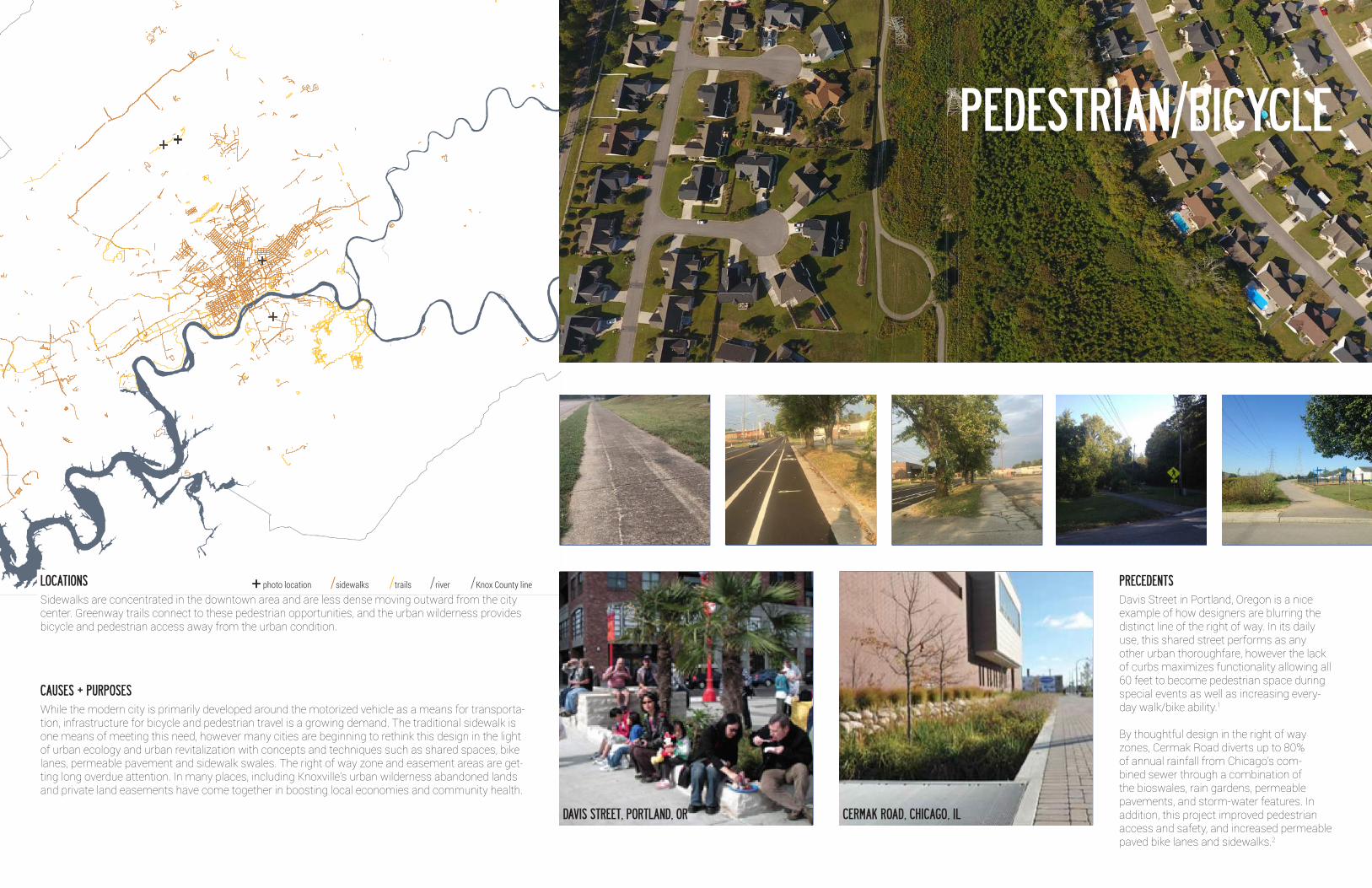
Davis Street in Portland, Oregon is a nice example of how designers are blurring the distinct line of the right of way. In its daily use, this shared street performs as any other urban thoroughfare, however the lack of curbs maximizes functionality allowing all 60 feet to become pedestrian space during special events as well as increasing every-day walk/bike ability.1
By thoughtful design in the right of way zones, Cermak Road diverts up to 80% of annual rainfall from Chicago’s com-bined sewer through a combination of the bioswales, rain gardens, permeable pavements, and storm-water features. In addition, this project improved pedestrian access and safety, and increased permeable paved bike lanes and sidewalks.2
PRECEDENTS
PEDESTRIAN/BICYCLE
CERMAK ROAD, CHICAGO, ILDAVIS STREET, PORTLAND, OR
While the modern city is primarily developed around the motorized vehicle as a means for transporta-tion, infrastructure for bicycle and pedestrian travel is a growing demand. The traditional sidewalk is one means of meeting this need, however many cities are beginning to rethink this design in the light of urban ecology and urban revitalization with concepts and techniques such as shared spaces, bike lanes, permeable pavement and sidewalk swales. The right of way zone and easement areas are get-ting long overdue attention. In many places, including Knoxville’s urban wilderness abandoned lands and private land easements have come together in boosting local economies and community health.
Sidewalks are concentrated in the downtown area and are less dense moving outward from the city center. Greenway trails connect to these pedestrian opportunities, and the urban wilderness provides bicycle and pedestrian access away from the urban condition.
CAUSES + PURPOSES
LOCATIONS + photo location /sidewalks /trails /river /Knox County line
[IMAGE OR IMAGES]
[IMAGE] [IMAGE] [IMAGE] [IMAGE] [IMAGE]
SUBHEADING [ROADWAY, 12PT]SUBHEADING [ROADWAY, 12PT]
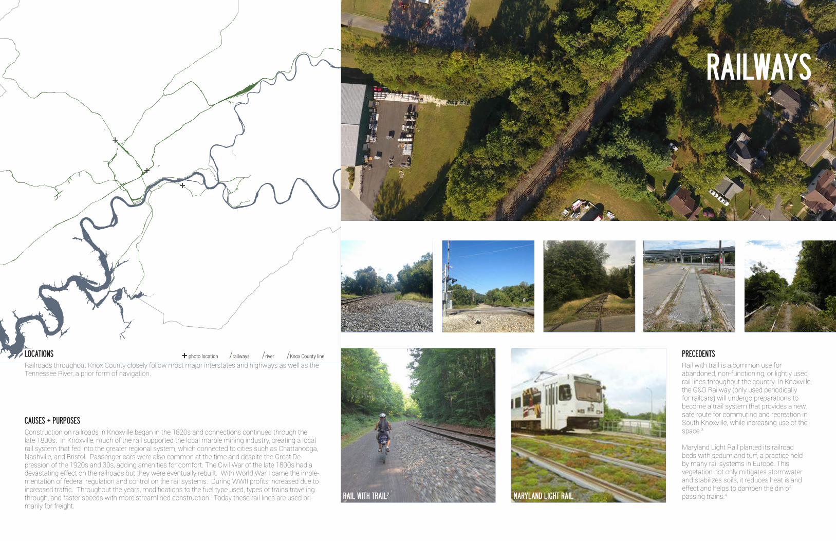
Rail with trail is a common use for abandoned, non-functioning, or lightly used rail lines throughout the country. In Knoxville, the G&O Railway (only used periodically for railcars) will undergo preparations to become a trail system that provides a new, safe route for commuting and recreation in South Knoxville, while increasing use of the space.3
Maryland Light Rail planted its railroad beds with sedum and turf, a practice held by many rail systems in Europe. This vegetation not only mitigates stormwater and stabilizes soils, it reduces heat island effect and helps to dampen the din of passing trains.4
PRECEDENTS
MARYLAND LIGHT RAILRAIL WITH TRAIL2
RAILWAYS
+
+
+
Construction on railroads in Knoxville began in the 1820s and connections continued through the late 1800s. In Knoxville, much of the rail supported the local marble mining industry, creating a local rail system that fed into the greater regional system, which connected to cities such as Chattanooga, Nashville, and Bristol. Passenger cars were also common at the time and despite the Great De-pression of the 1920s and 30s, adding amenities for comfort. The Civil War of the late 1800s had a devastating effect on the railroads but they were eventually rebuilt. With World War I came the imple-mentation of federal regulation and control on the rail systems. During WWII profits increased due to increased traffic. Throughout the years, modifications to the fuel type used, types of trains traveling through, and faster speeds with more streamlined construction.1 Today these rail lines are used pri-marily for freight.
Railroads throughout Knox County closely follow most major interstates and highways as well as the Tennessee River, a prior form of navigation.
CAUSES + PURPOSES
LOCATIONS + photo location /railways /river /Knox County line
+++
+
[IMAGE OR IMAGES]
[IMAGE] [IMAGE] [IMAGE] [IMAGE] [IMAGE]
SUBHEADING [ROADWAY, 12PT]SUBHEADING [ROADWAY, 12PT]
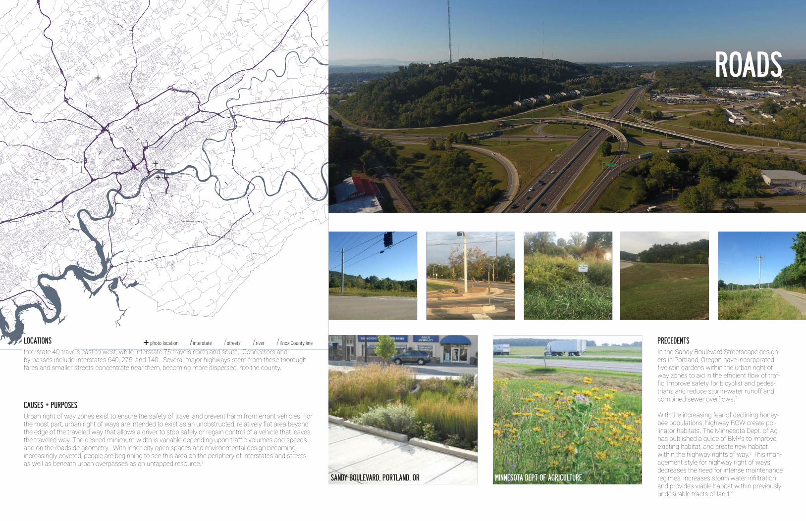
In the Sandy Boulevard Streetscape design-ers in Portland, Oregon have incorporated five rain gardens within the urban right of way zones to aid in the efficient flow of traf-fic, improve safety for bicyclist and pedes-trians and reduce storm-water runoff and combined sewer overflows.2
With the increasing fear of declining honey-bee populations, highway ROW create pol-linator habitats. The Minnesota Dept. of Ag has published a guide of BMPs to improve existing habitat, and create new habitat within the highway rights of way.2 This man-agement style for highway right of ways decreases the need for intense maintenance regimes, increases storm water infiltration and provides viable habitat within previously undesirable tracts of land.3
Urban right of way zones exist to ensure the safety of travel and prevent harm from errant vehicles. For the most part, urban right of ways are intended to exist as an unobstructed, relatively flat area beyond the edge of the traveled way that allows a driver to stop safely or regain control of a vehicle that leaves the traveled way. The desired minimum width is variable depending upon traffic volumes and speeds and on the roadside geometry . With inner-city open spaces and environmental design becoming increasingly coveted, people are beginning to see this area on the periphery of interstates and streets as well as beneath urban overpasses as an untapped resource.1
Interstate 40 travels east to west, while Interstate 75 travels north and south. Connectors and by-passes include Interstates 640, 275, and 140. Several major highways stem from these thorough-fares and smaller streets concentrate near them, becoming more dispersed into the county.
PRECEDENTS
CAUSES + PURPOSES
LOCATIONS + photo location /interstate /streets /river /Knox County line
ROADS
MINNESOTA DEPT OF AGRICULTURESANDY BOULEVARD, PORTLAND, OR
[IMAGE OR IMAGES]
[IMAGE] [IMAGE] [IMAGE] [IMAGE] [IMAGE]
SUBHEADING [ROADWAY, 12PT]SUBHEADING [ROADWAY, 12PT]
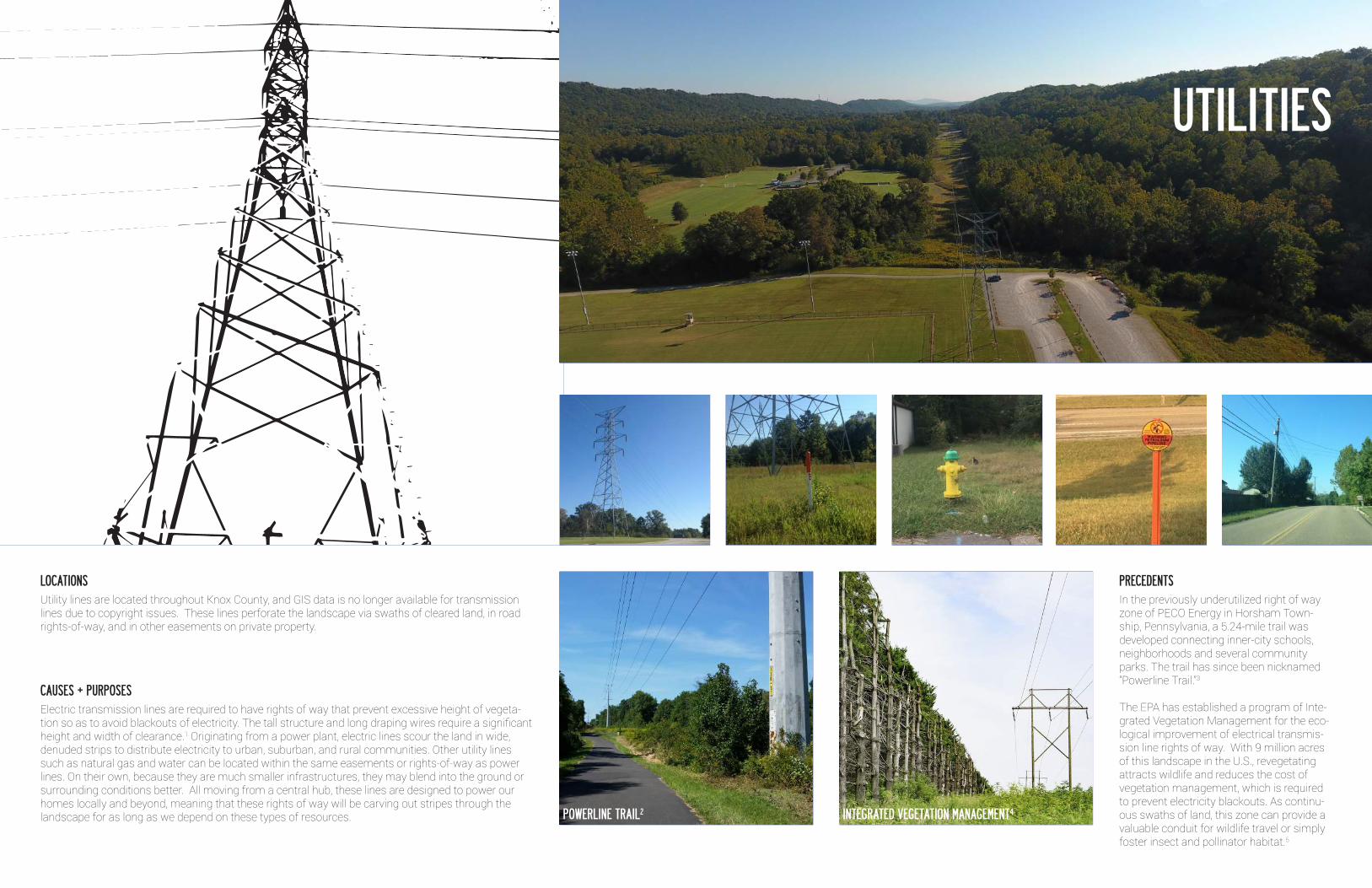
In the previously underutilized right of way zone of PECO Energy in Horsham Town-ship, Pennsylvania, a 5.24-mile trail was developed connecting inner-city schools, neighborhoods and several community parks. The trail has since been nicknamed “Powerline Trail.”3
The EPA has established a program of Inte-grated Vegetation Management for the eco-logical improvement of electrical transmis-sion line rights of way. With 9 million acres of this landscape in the U.S., revegetating attracts wildlife and reduces the cost of vegetation management, which is required to prevent electricity blackouts. As continu-ous swaths of land, this zone can provide a valuable conduit for wildlife travel or simply foster insect and pollinator habitat.5
PRECEDENTS
UTILITIES
INTEGRATED VEGETATION MANAGEMENT4POWERLINE TRAIL2
Electric transmission lines are required to have rights of way that prevent excessive height of vegeta-tion so as to avoid blackouts of electricity. The tall structure and long draping wires require a significant height and width of clearance.1 Originating from a power plant, electric lines scour the land in wide, denuded strips to distribute electricity to urban, suburban, and rural communities. Other utility lines such as natural gas and water can be located within the same easements or rights-of-way as power lines. On their own, because they are much smaller infrastructures, they may blend into the ground or surrounding conditions better. All moving from a central hub, these lines are designed to power our homes locally and beyond, meaning that these rights of way will be carving out stripes through the landscape for as long as we depend on these types of resources.
Utility lines are located throughout Knox County, and GIS data is no longer available for transmission lines due to copyright issues. These lines perforate the landscape via swaths of cleared land, in road rights-of-way, and in other easements on private property.
CAUSES + PURPOSES
LOCATIONS
1. “Where the Sidewalk Doesn’t End: What Shared Space Has to Share.” Project for Public Spaces. Accessed September 27, 2016. http://www.pps.org/reference/shared-space/.2. Taylor, Donna. “America’s “Greenest” Road.” A Blueprint for Sustainable Development. http://newatlas.com/chicago-cermak-road-greenest-street-america/25661/.
1. Johnson, Edward A. “Railroads.” January 1, 2010. The Tennessee Encyclopedia of History and Culture. http://tennesseeencyclopedia.net/entry.php?rec=1104 2. Breiding, Mike. “From 30 to 62: Senior Citizenry.” June 2012. Mike Breiding’s Epic Road Trips. http://epicroadtrips.us/2012/30to62/ 3. Legacy Parks Foundation. “G&O Rail-with-Trail.” http://www.legacyparks.org/new-go-trail- announced/ 4. Grundahl, Nancy. “Green Tracks for Maryland’s Light Rail.” December 29, 2011. EPA. https://blog.epa.gov/blog/2011/12/green-tracks-for-marylands-light-rail/
1. Mening, Bob. “What Is the Nature of a Right of Way?” January 24, 2014. http://mrsc.org/Home/ Stay-Informed/MRSC-Insight/January-2014/What-is-the-Nature-of-a-Public-Right-of-Way.aspx2. “The City of Portland, Oregon.” Completed Projects RSS. Accessed September 27, 2016. https://www.portlandoregon.gov/bes/article/490684. 3. King, Aaron. “Highways Can Help Pollinators Return to Health.” The Dirt. Last modified July 12, . https://dirt.asla.org/2016/07/13/highways-can-help-pollinators-return-to-health/.4. Welcome to the Minnesota Department of Agriculture. Accessed September 27, 2016. https://www. mda.state.mn.us/protecting/bmps/~/media/Files/protecting/bmps/pollinators/ pollinatorbmpsroad.pdf.
1. Duke Energy. “What is a Right of Way?” https://www.duke-energy.com/safety/right-of-way- management/what-is-row.asp 2. “Power Line Trail.” September 16, 2015. http://www.laellis.com/2015/09/3. MyRec.com. “Powerline Trail.” Horsham Dept. of Library & Recreation Services:. March 22, 2014. Accessed September 28, 2016. https://www.horshamrec.com/info/gallery/.4. Conniff, Richard. “How Dangerous Power Lines Could Save Wildlife.” December 4, 2015. http://www.takepart.com/article/2015/12/04/how-dangerous-power-lines-could-save-wildlife5. EPA. “Integrated Vegetation Management (IVM) Practices around Utility Rights-of-Way.” August 5, 2016. https://www.epa.gov/pesp/integrated-vegetation-management-ivm-practices-around- utility-rights-way
PEDESTRIAN + BIKING
RAIL
ROAD
UTILITY
CITATIONS