Embed Size (px)
Citation preview
7/29/2019 DRAFT_St. Louis North Side/Downtown/Midtown/CWE Streetcar Feasibility Study 2013
http://slidepdf.com/reader/full/draftst-louis-north-sidedowntownmidtowncwe-streetcar-feasibility-study 1/104
ST. LOUIS STREETCAR FEASIBILITY STUDY
The Partnership for Downtown St. LouisDraft Report
FEBRUARY 2013
7/29/2019 DRAFT_St. Louis North Side/Downtown/Midtown/CWE Streetcar Feasibility Study 2013
http://slidepdf.com/reader/full/draftst-louis-north-sidedowntownmidtowncwe-streetcar-feasibility-study 2/104
St. Louis Streetcar Feasibility Study
Building Neighborhoods, Connecting Jobs
STUDY TEAM
THE PARTNERSHIP FOR DOWNTOWN ST.
LOUIS MAGGIE CAMPBELL, PRESIDENT AND CEO
MATT SCHINDLER, PROJECT MANAGER
URS TEAM URS
KENNETH KINNEY
RENEE DUCKER
RICK NANNENGA, PE
CH2MHILLJIM GRAEBNER
CRAWFORD BUNTE BRAMMEIER
CARRIE FALKENRATH, PE, PTOE, PTP
THE LAWRENCE GROUP
MONICA CARNEY HOLMES, AICP, CNU-A
CRAIG LEWIS, AICP, LEED AP, CNU-A
PATRICE GILLESPIE SMITH
RESOURCE SYSTEMS GROUP, INC.
WILLIAM WOODFORD
VECTOR COMMUNICATIONS
LAURNA GODWIN
STEERINGCOMMITTEE
BILL BAYER, US BANK CDC
JERRY BLAIR, EAST-WEST GATEWAY
ZACK BOYERS, US BANK CDC
MAGGIE CAMPBELL, PARTNERSHIP FOR
DOWNTOWN ST. LOUIS
KIM CELLA, CITIZENS FOR MODERN TRANSIT
CLARK DAVIS
STEPHEN GREGALI, CITY OF ST. LOUIS, MAYOR’S
OFFICE
CRAIG HELLER, LOFTWORKS TISHAURA JONES, TREASURER CITY OF ST. LOUIS
JOHN LANGA, METRO
JESSICA MEFFORD-MILLER, METRO
BRIAN PHILLIPS, WASHINGTON UNIVERSITY
SCHOOL OF MEDICINE
DAVID RICHARDSON, HUSCH BLACKWELL
DON ROE, CITY OF ST. LOUIS, PLANNING AND
URBAN DESIGN AGENCY
MATT SCHINDLER, PARTNERSHIP FOR
DOWNTOWN ST. LOUIS
VINCE SCHOEMEHL, GRAND CENTER
STEVE SMITH, LAWRENCE GROUP
MARK VOGL, HOK
OTIS WILLIAMS, ST. LOUIS DEVELOPMENT
CORPORATION
ROSE WINDMILLER, WASHINGTON UNIVERSITY
FINANCECOMMITTEE
BILL BAYER, US BANK CDC
MAGGIE CAMPBELL, PARTNERSHIP FOR
DOWNTOWN ST. LOUIS
KIM CELLA, CITIZENS FOR MODERN TRANSIT
CRAIG HELLER, LOFTWORKS
PAUL HUBBMAN, EAST-WEST GATEWAY
TISHAURA JONES, TREASURER CITY OF ST. LOUIS
BOB LEWIS, DEVELOPMENT STRATEGIES
LAURA RADCLIFF, STIFEL NICOLAUS
DAVID RICHARDSON, HUSCH BLACKWELL,LLP
STEVE SMITH, LAWRENCE GROUP
MATT SCHINDLER, PARTNERSHIP FOR
DOWNTOWN ST. LOUIS
VINCE SCHOEMEHL, GRAND CENTER
7/29/2019 DRAFT_St. Louis North Side/Downtown/Midtown/CWE Streetcar Feasibility Study 2013
http://slidepdf.com/reader/full/draftst-louis-north-sidedowntownmidtowncwe-streetcar-feasibility-study 3/104
St. Louis Streetcar Feasibility Study
Building Neighborhoods, Connecting Jobs
TABLE OF CONTENTS EXECUTIVE SUMMARY....................................................................................................................................................................................... 1
INTRODUCTION ................................................................................................................................................................................................ 5
PUBLIC ENGAGEMENT ...................................................................................................................................................................................... 7
MARKET ANALYSIS ........................................................................................................................................................................................... 8
ALIGNMENT.................................................................................................................................................................................................. 13
TRAFFIC ...................................................................................................................................................................................................... 18
ENVIRONMENTAL .......................................................................................................................................................................................... 22
OPERATIONS PLAN ......................................................................................................................................................................................... 27
COSTS ......................................................................................................................................................................................................... 29
DEVELOPMENT OPPORTUNITIES......................................................................................................................................................................... 33
STREETSCAPING ............................................................................................................................................................................................. 52
GUIDEWAY................................................................................................................................................................................................... 65
STATIONS..................................................................................................................................................................................................... 67
VEHICLES ..................................................................................................................................................................................................... 68
OPERATIONS AND MAINTENANCE FACILITY .......................................................................................................................................................... 70
FINANCIAL PLAN ............................................................................................................................................................................................ 72
NEXT STEPS .................................................................................................................................................................................................. 78
7/29/2019 DRAFT_St. Louis North Side/Downtown/Midtown/CWE Streetcar Feasibility Study 2013
http://slidepdf.com/reader/full/draftst-louis-north-sidedowntownmidtowncwe-streetcar-feasibility-study 4/104
St. Louis Streetcar Feasibility Study
Building Neighborhoods, Connecting Jobs
FIGURES 1: ST. LOUIS STREETCAR STUDY CORRIDOR........................................ 9
2: EXISTING POPULATION DENSITY ................................................. 10
3: EXISTING EMPLOYMENT DENSITY ............................................... 12
4: PROPOSED ALIGNMENT OPTIONS ............................................... 15
5: CENTRAL WEST END ALIGNMENT OPTION 1 ................................ 16
6: CENTRAL WEST END ALIGHMENT OPTION 2 ................................. 16
7: DOWNTOWN ALIGNMENT......................................................... 17
8: PROPOSED CORRIDOR LANES AND EXISTING TRAFFIC ..................... 19
9: MEDIAN HOUSEHOLD INCOME................................................... 23
10: DAILY RIDERSHIP ..................................................................... 26
11: STREETCAR DEVELOPMENT CORRIDOR ........................................ 35
12: EXISTING HOT SPOTS................................................................ 36
13: POTENTIAL HOT SPOTS ............................................................. 40
14: DEVELOPMENT TYPES............................................................... 41
15: RENDERING, BIRD’S EYE, SECTION LOCATIONS............................. 55
16: OLIVE STREET AT 8TH
STREET – SECTION ...................................... 56
17: OLIVE STREET AT 18TH
STREET – SECTION .................................... 57
18: BIRD’S EYE LOOKING NORTH ON 14TH
STREET: CURRENT................ 58
19: BIRD’S EYE LOOKING NORTH ON 14TH
STREET: WITH STREETCAR ..... 59
20: CHESTNUT STREET AT 7TH
STREET: CURRENT................................. 60
21: CHESTNUT STREET AT 7TH
STREET: WITH STREETCAR ...................... 60
22: OLIVE STREET AT 9TH STREET: CURRENT....................................... 61
23: OLIVE STREET AT 9TH
STREET: WITH STREETCAR............................. 62
24: OLIVE STREET AT COMPTON STREET: CURRENT ............................. 63
25: OLIVE STREET AT COMPTON STREET: WITH STREETCAR .................. 64
TABLES 1: EXISTING POPULATION.................................................................. 8
2: EXISTING EMPLOYMENT.............................................................. 11
3: ALLOCATED CONTIGENCY PERCENTAGES FOR PLANNING ESTIMATE .... 30
4: UNALLOCATED CONTINGECY PERCENTAGES FOR ESTIMATES.............. 30
5: PROJECT COSTS WITH STREETSCAPING........................................... 31
6: PROJECT COSTS WITHOUT STREETSCAPING ..................................... 31
7: CENTERAL WEST END DEVELOPMENT POTENTIAL............................ 46
8: GRAND CENTER DEVELOPMENT POTENTIAL.................................... 47
9: GRAND CENTER TO 18TH
STREET DEVELOPMENT POTENTIAL ............. 48
10: NORTHSIDE DEVELOPMENT POTENTIAL ......................................... 49
11: DOWNTOWN DEVELOPMENT POTENTIAL ....................................... 50
12: STREETCAR ROUTE DEVELOPMENT POTENTIAL................................ 51
13: STREETCAR FINANCIAL OVERVIEW ................................................ 52
APPENDIX A: COST ESTIMATE CATEGORY DESCRIPTIONS
STREETCAR COST ESTIMATEWITH STREETSCAPING
STREETCAR COST ESTIMATE WITHOUT SREETCAPING
B: PREVIOUS PLAN DESCRIPTIONS
DEVELOPMENT CALCULATIONS
7/29/2019 DRAFT_St. Louis North Side/Downtown/Midtown/CWE Streetcar Feasibility Study 2013
http://slidepdf.com/reader/full/draftst-louis-north-sidedowntownmidtowncwe-streetcar-feasibility-study 5/104
St. Louis Streetcar Feasibility Study
Building Neighborhoods, Connecting Jobs 1
EXECUTIVE SUMMARY
Objectives. The streetcar is intended to provide convenient
connections to large numbers of jobs, residences and major
destinations. It is designed to be an important part of the region’soverall transit system. And, reflecting the impact of other modern
streetcars in the United States, it is designed to have a major impact
on economic development throughout the corridors.
Markets. Employment and residential concentrations are the keys
to transit success. The St. Louis Streetcar serves two of the greatest
employment concentrations in the St. Louis region, Downtown St.
Louis and the Central West End, and areas that are increasing in
residential density. It also serves numerous major destinations as
noted on the alignment map.
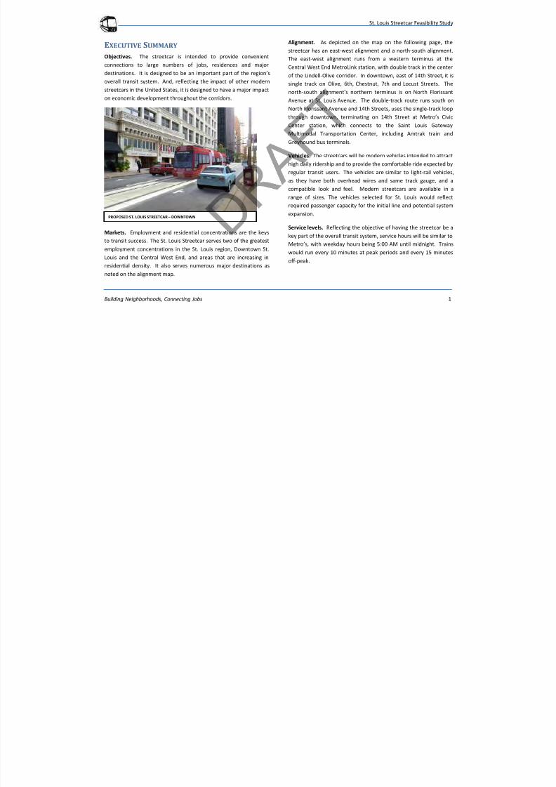
Alignment. As depicted on the map on the following page, the
streetcar has an east-west alignment and a north-south alignment.
The east-west alignment runs from a western terminus at the
Central West End MetroLink station, with double track in the center
of the Lindell-Olive corridor. In downtown, east of 14th Street, it issingle track on Olive, 6th, Chestnut, 7th and Locust Streets. The
north-south alignment’s northern terminus is on North Florissant
Avenue at St. Louis Avenue. The double-track route runs south on
North Florissant Avenue and 14th Streets, uses the single-track loop
through downtown, terminating on 14th Street at Metro’s Civic
Center station, which connects to the Saint Louis Gateway
Multimodal Transportation Center, including Amtrak train and
Greyhound bus terminals.
Vehicles. The streetcars will be modern vehicles intended to attract
high daily ridership and to provide the comfortable ride expected by
regular transit users. The vehicles are similar to light-rail vehicles,
as they have both overhead wires and same track gauge, and a
compatible look and feel. Modern streetcars are available in a
range of sizes. The vehicles selected for St. Louis would reflect
required passenger capacity for the initial line and potential system
expansion.
Service levels. Reflecting the objective of having the streetcar be a
key part of the overall transit system, service hours will be similar to
Metro’s, with weekday hours being 5:00 AM until midnight. Trains
would run every 10 minutes at peak periods and every 15 minutes
off-peak.
PROPOSED ST. LOUIS STREETCAR – DOWNTOWN
7/29/2019 DRAFT_St. Louis North Side/Downtown/Midtown/CWE Streetcar Feasibility Study 2013
http://slidepdf.com/reader/full/draftst-louis-north-sidedowntownmidtowncwe-streetcar-feasibility-study 6/104
St. Louis Streetcar Feasibility Study
Building Neighborhoods, Connecting Jobs 2
7/29/2019 DRAFT_St. Louis North Side/Downtown/Midtown/CWE Streetcar Feasibility Study 2013
http://slidepdf.com/reader/full/draftst-louis-north-sidedowntownmidtowncwe-streetcar-feasibility-study 7/104
St. Louis Streetcar Feasibility Study
Building Neighborhoods, Connecting Jobs 3
Capital cost. The total capital cost is estimated between $218
million and $271 million, depending on such elements as
streetscaping expectations. Given the alignment length, the
operating plan, and intention to serve serious transit markets, the
overall is cost is comparable with other streetcar projects aroundthe United States.
Operating cost. Assuming the aggressive operating plan noted
above and existing Metro compensation practices, the annual
operating cost is estimated at $9.7 million.
Ridership. Average weekday ridership for the streetcar is estimated
at 7,700. This is high by United States streetcar standards. It is
reflective of the strong markets served and its aggressive operating
plan. It is important to note that the streetcar is forecast to bring an
additional 2,700 riders to the overall transit system and to increase
existing MetroLink ridership. The streetcar will provide a
complementary service to the existing transit system and help to
serve the short-distance trips in the corridors.
Economic development. The streetcar, along with favorable market
conditions and a supportive policy environment, is expected to help
spur development throughout the corridors. This is consistent with
experience elsewhere in North America. Overall developmentimpact is estimated at $540 million in the first five years and $2.1
billion over 20 years. Given the development in certain areas along
the corridors, the estimate is considered to be conservative. For
example, in the last 10 years, downtown has experienced $5 billion
in investment.
Traffic impact. Although the streetcar will be operating in city
streets, and in most cases in mixed traffic (except for a separate
right-of-way on Olive Street between 14th Street and Grand
Boulevard), analysis completed for the streetcar study found that
the impact on vehicular flow will be minimal.
Environmental impact. There are no environment fatal flaws that
could prevent implementation of the streetcar project.
Funding. It is assumed that the project will require significant
federal financial support for capital costs, potentially up to 50
percent of the total. Based on current federal evaluation criteria,
the St. Louis Streetcar would be likely to score well in the
competitive funding process, especially given its strong ridership
and development performance. Given that the State of Missouri
has historically not provided funding for transit, this plan assumes
PROPOSED ST. LOUIS STREETCAR – CENTRAL WEST END
7/29/2019 DRAFT_St. Louis North Side/Downtown/Midtown/CWE Streetcar Feasibility Study 2013
http://slidepdf.com/reader/full/draftst-louis-north-sidedowntownmidtowncwe-streetcar-feasibility-study 8/104
St. Louis Streetcar Feasibility Study
Building Neighborhoods, Connecting Jobs 4
no funding at the state level. For the local match, a transportation
development district is recommended for the corridors, with a
tiered special assessment based on land use.
Conclusion: The study concluded that the streetcar would:
Serve strong transit corridors with residential density and
employment concentration,
Serve approximately 7,700 riders per weekday, a strong
performance for a new streetcar line,
Complement, not compete with, existing Metro service,
Spur an estimated $540 million in development in its first
five years of operation, and $2.1 billion over 20 years,
Have little impact on existing vehicular traffic and no serious
environmental impacts,
Have a strong likelihood of receiving federal capital funding,
and
Have strong support from stakeholders and local officials.
The benefits of the streetcar include:
Attracting new residents who want alternatives to the
automobile in the corridor,
Attracting new employers who value access to transit,
Connecting and building neighborhoods,
Creating new jobs in the city,
Providing access to jobs, institutions, schools, grocery stores
and medical services, and
Creating pedestrian-friendly urban environments.
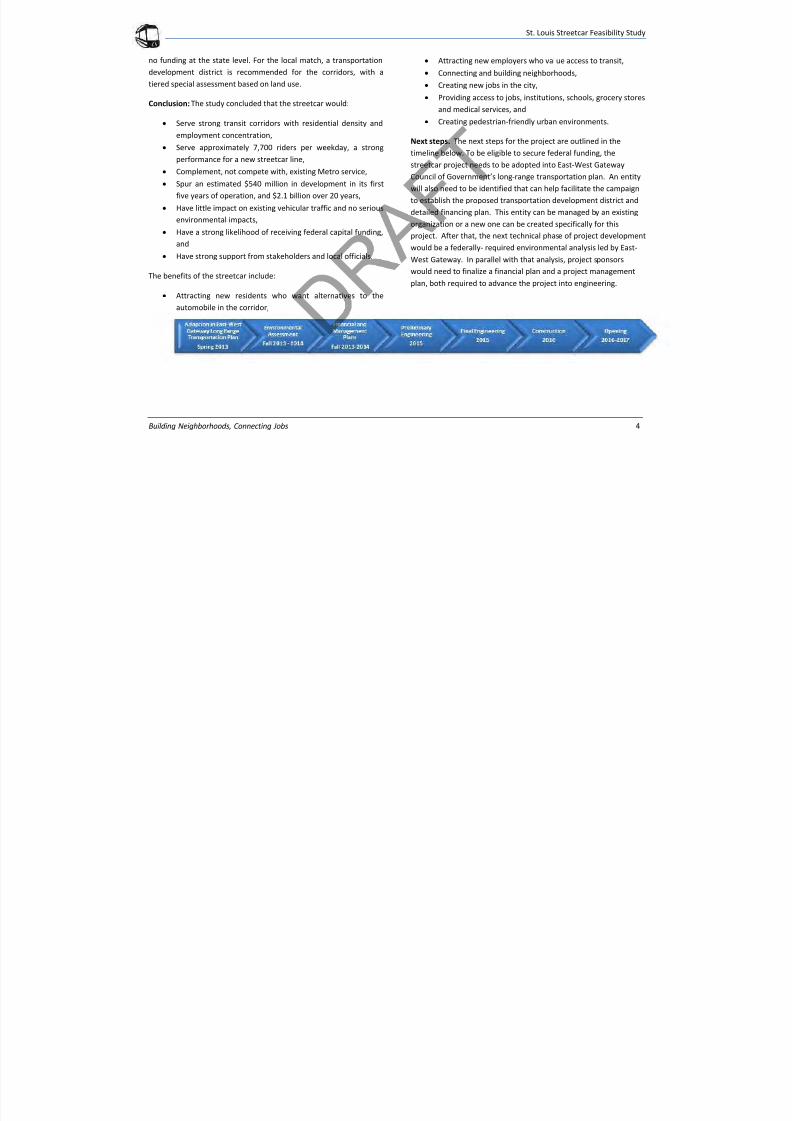
Next steps. The next steps for the project are outlined in the
timeline below. To be eligible to secure federal funding, the
streetcar project needs to be adopted into East-West Gateway
Council of Government’s long-range transportation plan. An entity
will also need to be identified that can help facilitate the campaign
to establish the proposed transportation development district and
detailed financing plan. This entity can be managed by an existingorganization or a new one can be created specifically for this
project. After that, the next technical phase of project development
would be a federally- required environmental analysis led by East-
West Gateway. In parallel with that analysis, project sponsors
would need to finalize a financial plan and a project management
plan, both required to advance the project into engineering.
7/29/2019 DRAFT_St. Louis North Side/Downtown/Midtown/CWE Streetcar Feasibility Study 2013
http://slidepdf.com/reader/full/draftst-louis-north-sidedowntownmidtowncwe-streetcar-feasibility-study 9/104
St. Louis Streetcar Feasibility Study
Building Neighborhoods, Connecting Jobs 5
INTRODUCTION
The Downtown Next 2020 Vision established ambitious goals for
Downtown St. Louis to accomplish from 2010 through 2020. One of
the goals in the Downtown Next plan is “Making Downtown
Accessible and Easy to Get Around.” The Partnership for Downtown
St. Louis and other stakeholders saw how a downtown streetcar
improves accessibility. Discussions of a downtown streetcar became
more serious when St. Louis University announced their plans to
move their law school from midtown St. Louis to downtown. This
move presented an opportunity to link the two campuses with a
streetcar. The Partnership for Downtown St. Louis led the
discussions, raised the private funds for a study. An RFQ was issued
and a consultant was hired to perform the feasibility study. The
purpose of the study was to determine the feasibility of
implementing a modern streetcar linking downtown, the near
Northside, Midtown, and the Central West End. The study area is
shown in Figure 1.
Through a competitive selection process, the Partnership for
Downtown St. Louis selected URS to conduct the feasibility study.
URS was selected for their national modern streetcar and local
transit experience. URS has been involved in the planning anddesign of the all the modern streetcar lines in operation in the
United States to date including, Portland, Seattle, Tacoma and
Tucson.
Streetcars are gaining in popularity across the country. Modern
streetcars are in operation in the cities mentioned above and in the
final planning stages or under construction in Cincinnati, Kansas
City, Milwaukee, and Atlanta. Streetcars offer the speed,
technology, service, reliability and amenities of light rail systems at
a lower cost.
The URS Team presented the study findings to the SteeringCommittee on a monthly basis. With guidance from the Steering
Committee, the following goals and objectives were established for
the study of a modern streetcar:
Increase population and employment in the Corridors
- Attract new residents and employers
- Create new jobs
- Support neighborhoods and connect jobs
Catalyze and support future development
- Increase economic vitality of downtown and the
corridor
- Increase mixed-use, transit supportive development
- Improve the built environment
- Create walkable, sustainable neighborhoods
Integrate and complement the existing transit system
- Provide seamless connectivity
- Connect with existing transit, bicycle and pedestrian
facilities
Increase ridership within the corridors and system-wide
- Attract choice riders to the system
- Provide passenger amenities, technologies
- Increase visibility of the transit system
- Reduce auto traffic and improve air quality
7/29/2019 DRAFT_St. Louis North Side/Downtown/Midtown/CWE Streetcar Feasibility Study 2013
http://slidepdf.com/reader/full/draftst-louis-north-sidedowntownmidtowncwe-streetcar-feasibility-study 10/104
St. Louis Streetcar Feasibility Study
Building Neighborhoods, Connecting Jobs 6
WHY A STREETCAR?
An often asked question, is how are streetcars different from buses?
Buses generally operate in existing city streets in mixed traffic. This
allows routes to change due to modifications in demand or
schedule. It is important to have this flexibility in elements of the
transit system. However, bus systems do not provide the catalyst
for development that rail systems have been documented to do.
This is partly due to the fact that routes can and do change. There is
not a sense of permanence.
With fixed rail, such as streetcars or light rail, the alignment and
stations do not change. Existing and new riders feel comfortable
knowing where the route is and that the train will arrive as
expected. This permanence gives developers, planners and city
officials the certainty that the alignment will not move. As a result,
rail transit can be a catalyst for development.
Building a transit does not necessarily mean the development will
happen. Transit is a part of a larger picture. If combined with
connecting concentrations of employment and residential areas,
proper zoning, policy and incentives, streetcars can help to spur
development. This has been documented in Portland and Seattle.
Cities where streetcars have not seen the expected ridership or
development, typically have not provided serious transit with
frequent headways and connections to employment
concentrations.
The key to a successful transit system including streetcars is careful
planning. This includes identifying if there is a market, will there be
ridership, will development be attracted to the corridor, will there
be impacts and can the region afford the investment. These are
some of the issues that this study will examine.
7/29/2019 DRAFT_St. Louis North Side/Downtown/Midtown/CWE Streetcar Feasibility Study 2013
http://slidepdf.com/reader/full/draftst-louis-north-sidedowntownmidtowncwe-streetcar-feasibility-study 11/104
St. Louis Streetcar Feasibility Study
Building Neighborhoods, Connecting Jobs 7
PUBLIC ENGAGEMENT
Starting in August 2012, the Partnership began a comprehensive
public engagement program to garner feedback on the St. Louis
Streetcar concept. The multi-pronged strategy targeted the
neighborhoods surrounding the proposed alignment and involved
individual stakeholder meetings, monthly Steering Committee
meetings and a final public meeting.
The Partnership established a Steering Committee made up of
experts and community leaders to review the Feasibility Study
process and findings. The Steering Committee consisted of agency
partners, technical experts and representatives of organizations
who had expressed early interest in the project. This group of
individuals reviewed the Study Team’s findings as information was
collected. Within the Steering Committee, a sub-committee, the
Finance Committee, was created to specifically address the
financing piece of the Study to gain a better understanding of the
local financing environment. These committees ultimately helped
shape the Feasibility Study outcomes.
In addition to the Steering Committee, the Partnership and Study
Team held over 70 stakeholder meetings that included over 100
stakeholders. These stakeholders included politicians and their staff
at the national, state, and local levels. Governmental offices whose
departments may oversee parts of a streetcar project were
consulted regularly. Regional, civic, community, and private
organizations with projects or services in the impacted area of a
streetcar were also consulted. These meetings were held both to
inform those about the Feasibility Study and to receive feedback
and advice. In these informal discussions, the stakeholders
overwhelmingly expressed support for the concept and could
identify how the streetcar would specifically benefit their
community. Some questions focused on the logistics of getting the
project built, while other questions focused on how the projectwould impact or connect with existing MetroLink and MetroBus
service and the Loop Trolley project. In response, the Study Team
developed a list of Talking Points and Frequently Asked Questions
for distribution.
The public engagement process will culminate on March 7 with a
public open house where residents, employees and visitors will be
encouraged to offer feedback, ask questions and voice concerns.
Display boards depicting the study results, and members of theStudy Team will be available to answer questions. Comment cards
will be available. All comments will be collected and recorded.
A project website will contain the final report along with other
project materials.
ONGOING OUTREACH
In this preliminary phase, the Study Team took a targeted approach
to introduce the concept of a streetcar. As this project moves to the
environmental analysis, the team will conduct far more intense
outreach to all of the neighborhoods along and nearby the
proposed alignment.
7/29/2019 DRAFT_St. Louis North Side/Downtown/Midtown/CWE Streetcar Feasibility Study 2013
http://slidepdf.com/reader/full/draftst-louis-north-sidedowntownmidtowncwe-streetcar-feasibility-study 12/104
St. Louis Streetcar Feasibility Study
Building Neighborhoods, Connecting Jobs 8
M ARKET ANALYSIS
The measure of success for transit is connecting major destinations
and employment centers with residential neighborhoods. Density
drives transit ridership. The market analysis identified residential
and employment centers and destinations to determine if the
corridors had the density concentrations to support additional
transit.
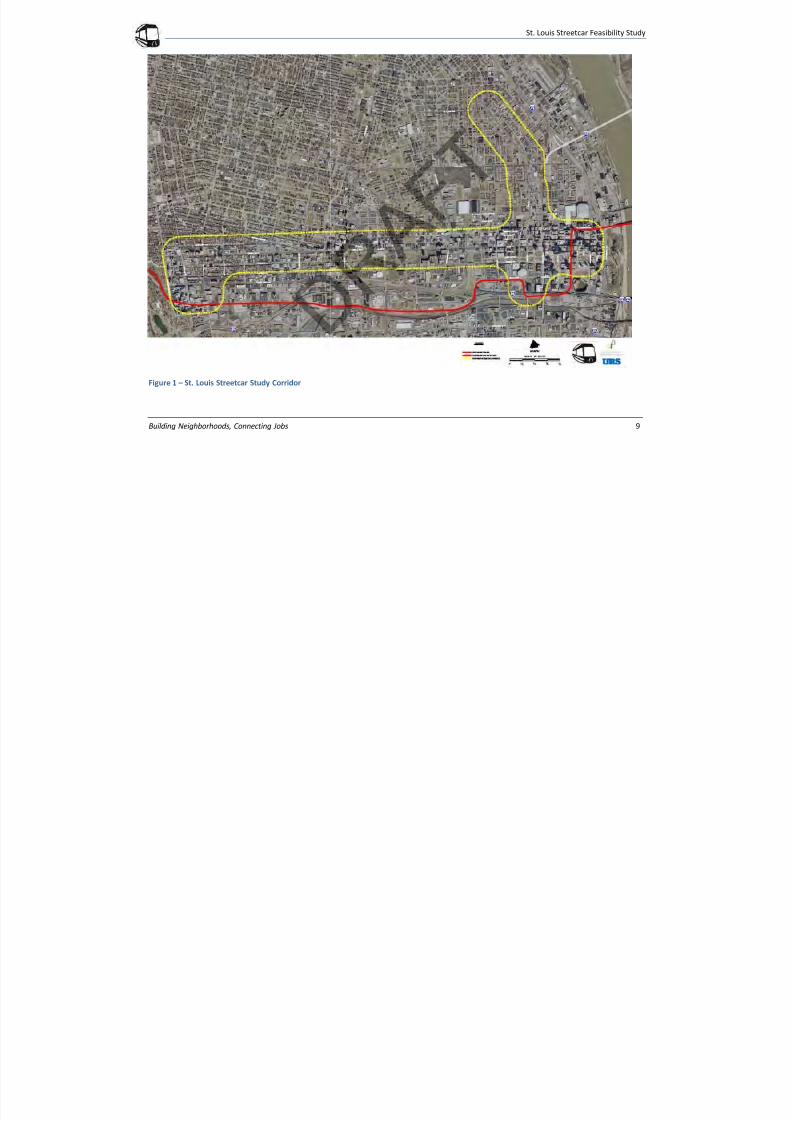
The study area consists of two corridors, an east-west segment
along Olive/Lindell and north-south segment on 14th Street-North
Florissant Avenue. The north-south corridor is approximately
bounded by Civic Center Metro Station to the south, St. Louis
Avenue to the north, 18th Street to the west and 10th Street to the
east. The east-west corridor is bounded by the Memorial Drive to
the east, Kingshighway to the west, Forest Park Avenue to the south
and Delmar Boulevard to the north, as shown in Figure 1.
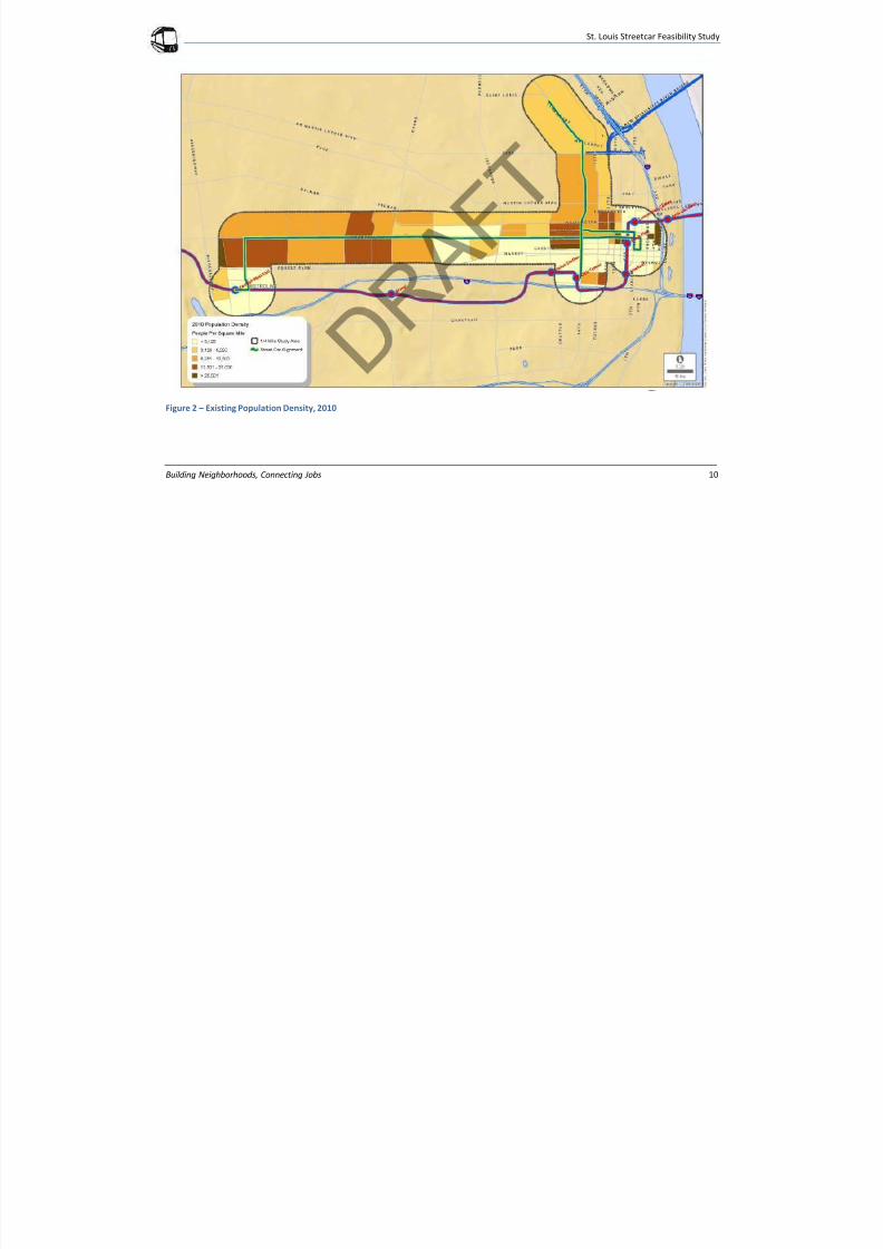
Population in the corridor is some of the region’s most dense, as
depicted in Figure 2. Downtown is one of the City’s fastest growing
and most dense neighborhoods. Since 2000, downtown residential
population has increased by 6,000 to 13,500 and in 2011 population
grew by 4 percent, according to the 2012 Downtown St. Louis
Progress Report .
Midtown is an emerging residential neighborhood, bounded by
Washington Avenue to the north, Forest Park Avenue to the south,
Spring Street to the west, and Jefferson Avenue to the east.
Population in Midtown is approximately 5,600. St. Louis University
is located in this area along with Grand Center, a major
entertainment and arts center. Housing is largely multifamily with a
few single family residences.
The Central West End is an established residential neighborhood at
the western terminus of the corridor with approximately 14,400
residents. Central West End has a mix of both single family residents
and multi-family apartments.
The Northside from Washington Avenue to St. Louis Avenue has a
mix of single, attached and multi-family residential units. The
corridor includes Carr Square, Old North St. Louis, an emerging
mixed use neighborhood with a small commercial center along 13 th
Street. This area has approximately 8,500 residents.
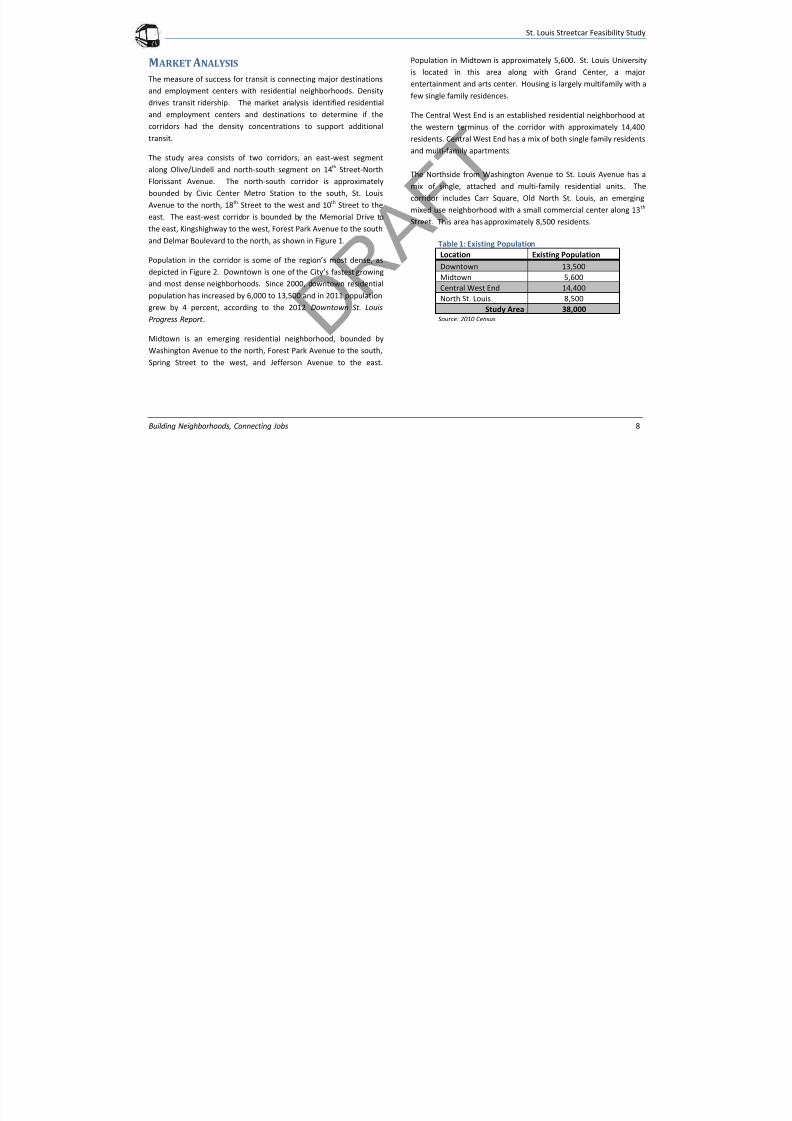
Table 1: Existing Population
Location Existing Population
Downtown 13,500
Midtown 5,600
Central West End 14,400
North St. Louis 8,500
Study Area 38,000
Source: 2010 Census
7/29/2019 DRAFT_St. Louis North Side/Downtown/Midtown/CWE Streetcar Feasibility Study 2013
http://slidepdf.com/reader/full/draftst-louis-north-sidedowntownmidtowncwe-streetcar-feasibility-study 13/104
St. Louis Streetcar Feasibility Study
Building Neighborhoods, Connecting Jobs 9
Figure 1 – St. Louis Streetcar Study Corridor
7/29/2019 DRAFT_St. Louis North Side/Downtown/Midtown/CWE Streetcar Feasibility Study 2013
http://slidepdf.com/reader/full/draftst-louis-north-sidedowntownmidtowncwe-streetcar-feasibility-study 14/104
St. Louis Streetcar Feasibility Study
Building Neighborhoods, Connecting Jobs 10
Figure 2 – Existing Population Density, 2010
7/29/2019 DRAFT_St. Louis North Side/Downtown/Midtown/CWE Streetcar Feasibility Study 2013
http://slidepdf.com/reader/full/draftst-louis-north-sidedowntownmidtowncwe-streetcar-feasibility-study 15/104
St. Louis Streetcar Feasibility Study
Building Neighborhood, Connecting Jobs 11
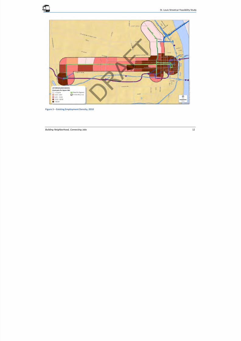
The corridors connect some of the region’s most dense employment
centers, downtown and the Central West End, as shown in Figure 3.
Downtown has approximately 88,000 employees while the Central
West End has more than 30,000 employees with BJC/Washington
University Medical School located on the southern end of theneighborhood. Midtown is also an employment center with over
9,700 employees. Midtown’s largest employer is St. Louis
University, with other employment associated with the
entertainment district including the Fox Theater, Powell Hall and
Grand Center.
The Northside contains a few employers, especially closer to
downtown, where there is a small employment concentration along
Delmar and Washington Avenues.
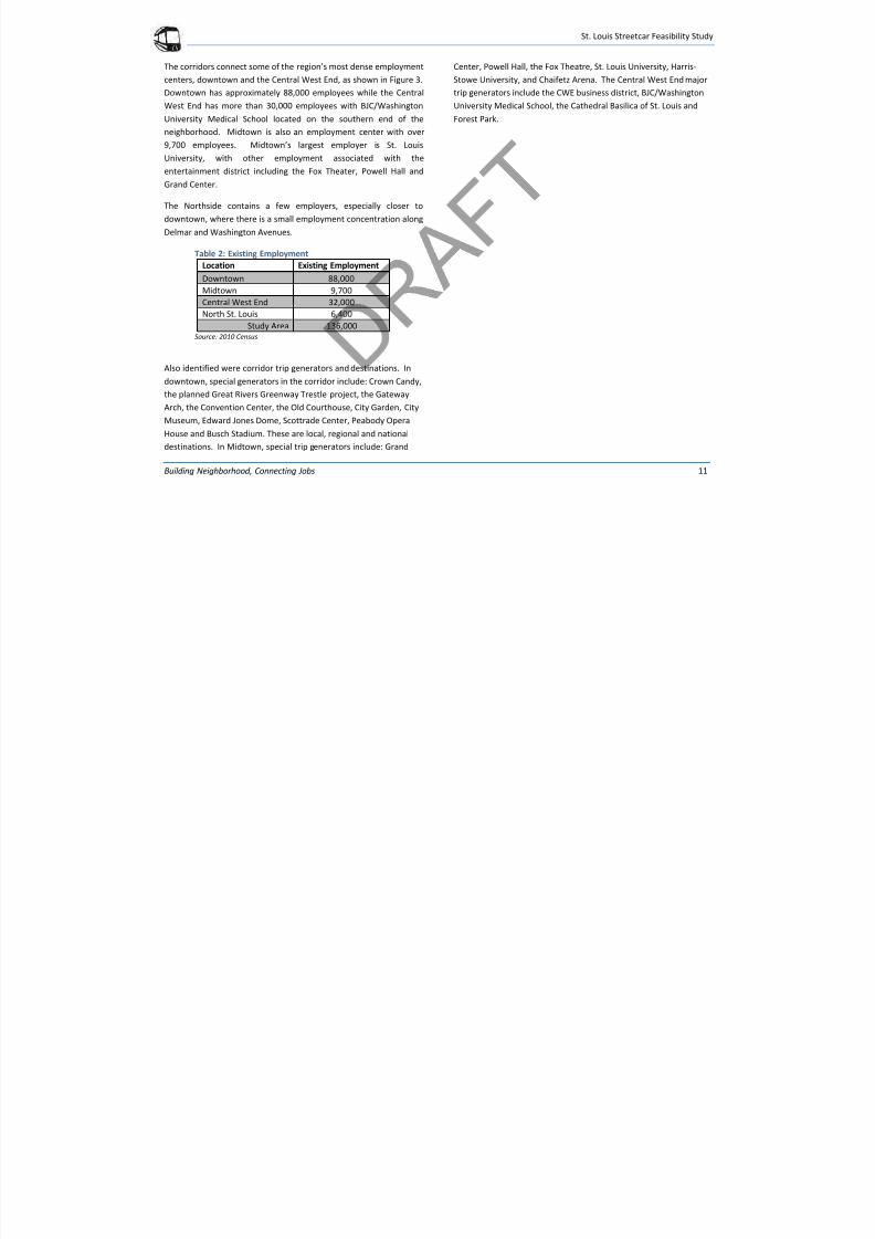
Table 2: Existing Employment
Location Existing Employment
Downtown 88,000
Midtown 9,700
Central West End 32,000
North St. Louis 6,400
Study Area 136,000Source: 2010 Census
Also identified were corridor trip generators and destinations. In
downtown, special generators in the corridor include: Crown Candy,
the planned Great Rivers Greenway Trestle project, the Gateway
Arch, the Convention Center, the Old Courthouse, City Garden, City
Museum, Edward Jones Dome, Scottrade Center, Peabody Opera
House and Busch Stadium. These are local, regional and national
destinations. In Midtown, special trip generators include: Grand
Center, Powell Hall, the Fox Theatre, St. Louis University, Harris-
Stowe University, and Chaifetz Arena. The Central West End major
trip generators include the CWE business district, BJC/Washington
University Medical School, the Cathedral Basilica of St. Louis and
Forest Park.
7/29/2019 DRAFT_St. Louis North Side/Downtown/Midtown/CWE Streetcar Feasibility Study 2013
http://slidepdf.com/reader/full/draftst-louis-north-sidedowntownmidtowncwe-streetcar-feasibility-study 16/104
St. Louis Streetcar Feasibility Study
Building Neighborhood, Connecting Jobs 12
Figure 3 – Existing Employment Density, 2010
7/29/2019 DRAFT_St. Louis North Side/Downtown/Midtown/CWE Streetcar Feasibility Study 2013
http://slidepdf.com/reader/full/draftst-louis-north-sidedowntownmidtowncwe-streetcar-feasibility-study 17/104
St. Louis Streetcar Feasibility Study
Building Neighborhoods, Connecting Jobs 13
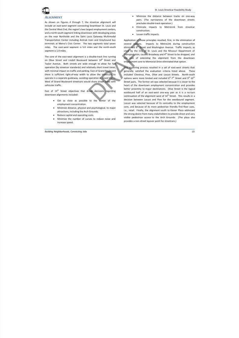
ALIGNMENT
As shown on Figures 4 through 7, the streetcar alignment will
include an east-west segment connecting Downtown St. Louis and
the Central West End, the region’s two largest employment centers,
and a north-south segment linking downtown with developing areason the near Northside and the Saint Louis Gateway Multimodal
Transportation Center including Amtrak train and Greyhound bus
terminals at Metro’s Civic Center. The two segments total seven
miles. The east-west segment is 5.0 miles and the north-south
segment is 1.9 miles.
The core of the east-west alignment is a double-track line running
on Olive Street and Lindell Boulevard between 14th Street and
Taylor Avenue. Both streets are wide enough to allow for fastoperation (by streetcar standards) and relatively short travel times,
with minimal impact on traffic and parking. East of Grand Boulevard
there is sufficient right-of-way width to allow the streetcars to
operate in a separate guideway, avoiding operation in mixed traffic.
West of Grand Boulevard streetcars would share street lanes with
vehicular traffic.
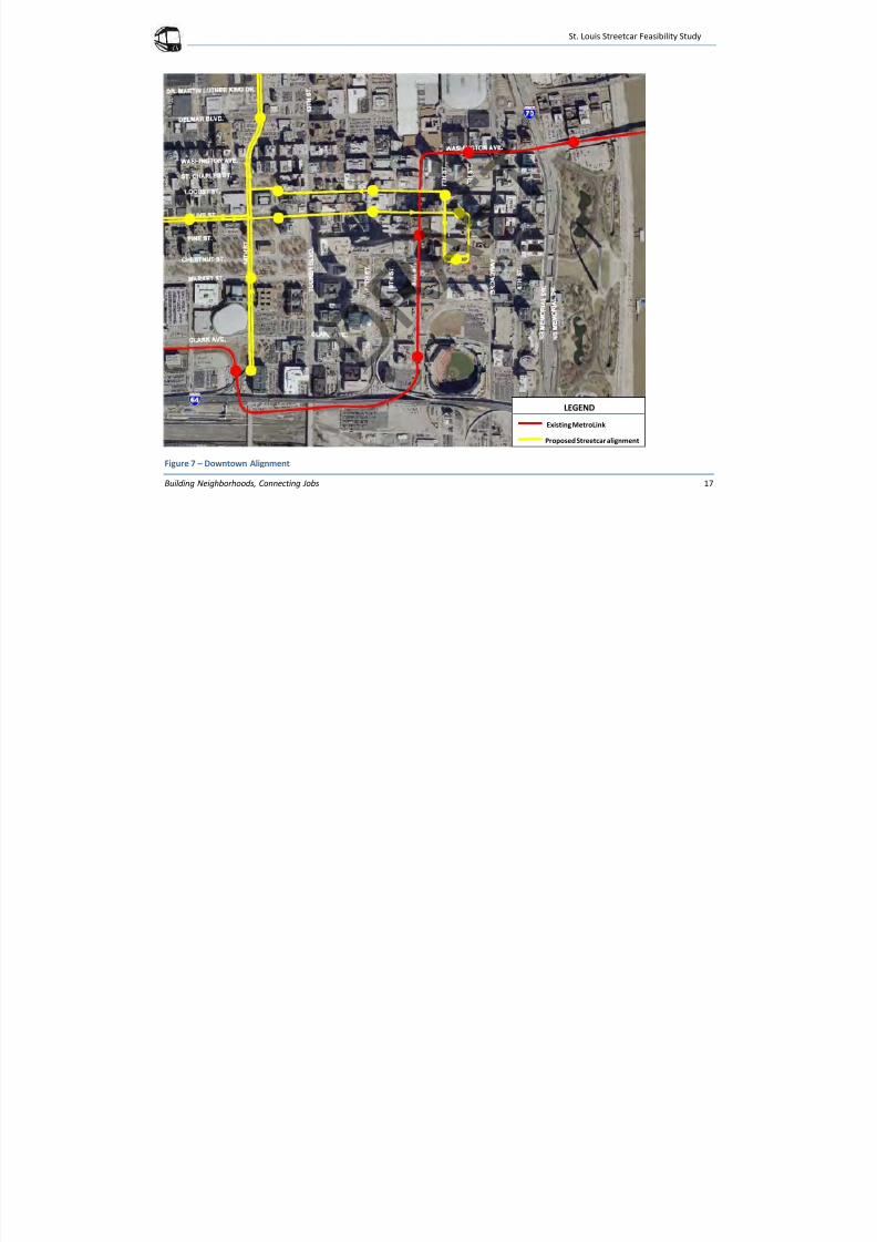
East of 14th
Street objectives that drove decisions regarding
downtown alignments included:
Get as close as possible to the center of the
employment concentration.
Minimize distance, physical and psychological, to major
attractions, including the Arch Grounds.
Reduce capital and operating costs.
Minimize the number of curves to reduce noise and
increase speed.
Minimize the distance between tracks on one-way
pairs. (The narrowness of the downtown streets
precludes double-track operation.)
Eliminate impacts to MetroLink from streetcar
construction.
Lessen traffic impacts.
Application of those principles resulted, first, in the elimination of
several options. Impacts to MetroLink during construction
eliminated 8th Street and Washington Avenue. Traffic impacts, as
cited by the City of St. Louis and the Missouri Department of
Transportation, caused Broadway and 4th Street to be dropped, and
the cost of extending the alignment from the downtown
employment core to Memorial Drive eliminated that option.
This screening process resulted in a set of east-west streets that
generally satisfied the evaluation criteria listed above. These
included Chestnut, Pine, Olive and Locust Streets. North-south
options were more limited and included 6th
-7th
Street and 9th
-10th
Street pairs. The former set was selected because it is closer to the
heart of the downtown employment concentration and provides
better proximity to major destinations. Olive Street is the logical
eastbound half of an east-west one-way pair as it is a no-turn
continuation of the alignment west of 14
th
Street. This results in adecision between Locust and Pine for the westbound segment.
Locust was selected because of its centrality to the employment
core, and because of its more pedestrian friendly first-floor uses,
i.e., retail. Finally, the alignment south to Kiener Plaza addressed
the strong desire from many stakeholders to provide direct and very
visible pedestrian access to the Arch Grounds. (The plaza also
provides a non-street layover point for streetcars.)
7/29/2019 DRAFT_St. Louis North Side/Downtown/Midtown/CWE Streetcar Feasibility Study 2013
http://slidepdf.com/reader/full/draftst-louis-north-sidedowntownmidtowncwe-streetcar-feasibility-study 18/104
St. Louis Streetcar Feasibility Study
Building Neighborhoods, Connecting Jobs 14
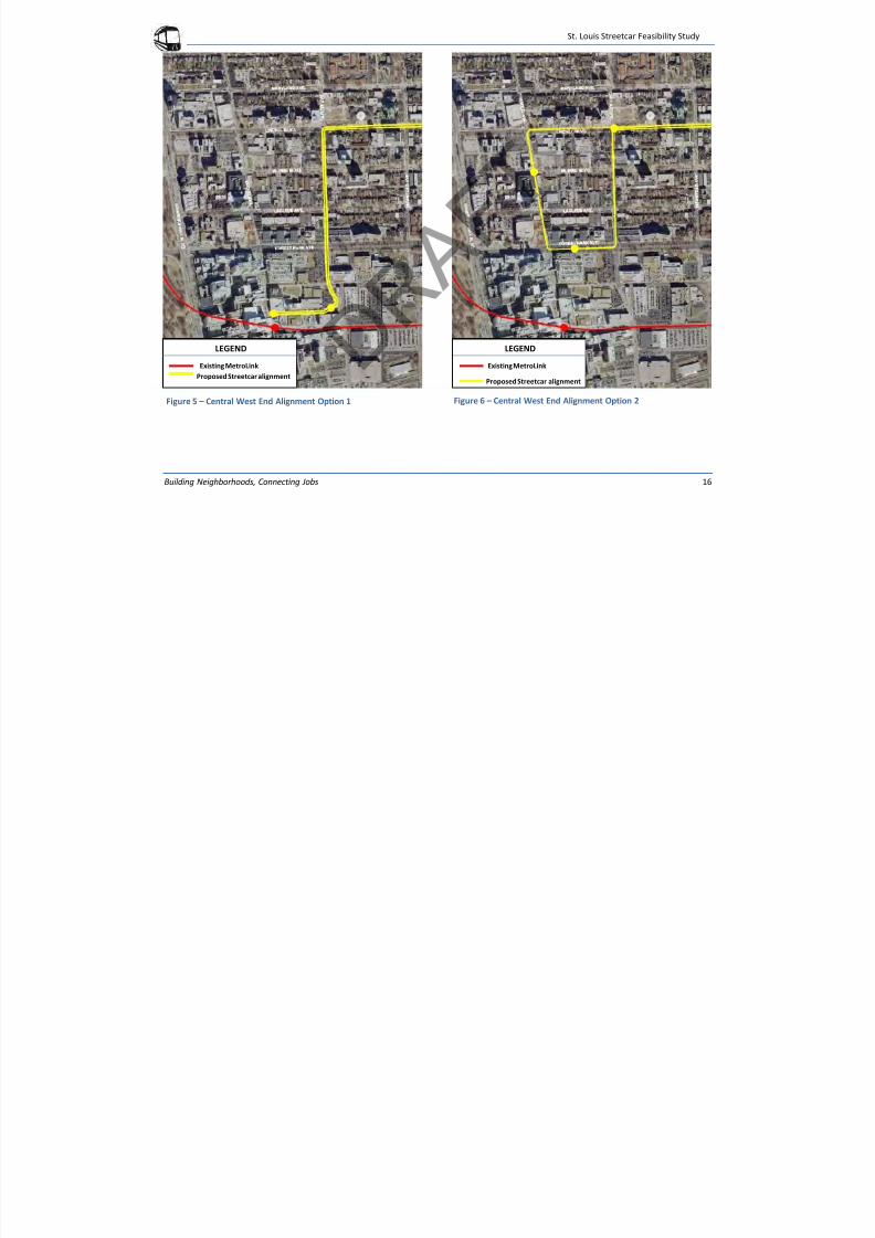
Alignment recommendations in the Central West End, west of
Taylor Avenue were driven by the goals of getting as close as
possible to the core of the medical complex and directly accessing
MetroLink’s Central West End station. This addresses a project
objective of providing an important addition to the region’s transit
network, and supporting the thriving commercial and
entertainment area centered on Euclid Avenue. Options included a
single-track one-way loop west on Lindell, south on Euclid Avenue,
east on Forest Park Avenue and north on Taylor Avenue.
Alternatively, the double track on Lindell Boulevard could continue
south on Taylor Avenue and west on Children’s Plaza, terminating at
the Central West End MetroLink station, where streetcars would
reverse direction. Further analysis in the next phase of project
development will include considerations of traffic impacts, safety
concerns, and extensive stakeholder and institutional input.
The north-south alignment, which could be a starter segment of a
longer line extending further north and south, would use the same
downtown alignment as the east-west route, thus doubling service
in the downtown. It would leave downtown heading north on 14th
Street, then northwest on North Florissant Avenue, terminating at
St. Louis Avenue. The 14th
Street-North Florissant Avenue
alignment would have double tracks running in the center of those
streets. The southern leg would be double-track on 14th
Streetbetween Olive Street and the Multi-Modal Center south of Clark
Street. Several considerations will be looked at in more detail in the
environmental analysis along 14th Street including the Great Rivers
Greenway bike path along 14th Street and the operations of the
Peabody/Scottrade Center south of Market Street along 14th Street.
The Northside-Southside Alternatives Analysis used a downtown
alignment on Convention Plaza, a 9 th Street-10th Street one-way
pair, and Clark Street to 14th Street. However, since north-south
trains can access the downtown core on the east-west alignment,
the north-south alignment has been modified to use a more direct
14th Street route, thus reducing capital cost.
7/29/2019 DRAFT_St. Louis North Side/Downtown/Midtown/CWE Streetcar Feasibility Study 2013
http://slidepdf.com/reader/full/draftst-louis-north-sidedowntownmidtowncwe-streetcar-feasibility-study 19/104
St. Louis Streetcar Feasibility Study
Building Neighborhoods, Connecting Jobs 15
Figure 4 – Proposed Alignment Options
7/29/2019 DRAFT_St. Louis North Side/Downtown/Midtown/CWE Streetcar Feasibility Study 2013
http://slidepdf.com/reader/full/draftst-louis-north-sidedowntownmidtowncwe-streetcar-feasibility-study 20/104
St. Louis Streetcar Feasibility Study
Building Neighborhoods, Connecting Jobs 16
Figure 5 – Central West End Alignment Option 1 Figure 6 – Central West End Alignment Option 2
LEGEND
Existing MetroLink
Proposed Streetcar alignment
LEGEND
Existing MetroLink
Proposed Streetcar alignment
7/29/2019 DRAFT_St. Louis North Side/Downtown/Midtown/CWE Streetcar Feasibility Study 2013
http://slidepdf.com/reader/full/draftst-louis-north-sidedowntownmidtowncwe-streetcar-feasibility-study 21/104
St. Louis Streetcar Feasibility Study
Building Neighborhoods, Connecting Jobs 17
Figure 7 – Downtown Alignment
LEGEND
Existing MetroLink
Proposed Streetcar alignment
7/29/2019 DRAFT_St. Louis North Side/Downtown/Midtown/CWE Streetcar Feasibility Study 2013
http://slidepdf.com/reader/full/draftst-louis-north-sidedowntownmidtowncwe-streetcar-feasibility-study 22/104
St. Louis Streetcar Feasibility Study
Building Neighborhoods, Connecting Jobs 18
TRAFFIC AND ENVIRONMENTAL IMPACTS
A preliminary review of traffic and environmental impacts was
conducted. The purpose of the review was to determine any fatal
environmental or traffic impacts that would prevent the project from
moving forward. The results of the analysis indicate that impacts to
traffic and environmental considerations are not fatal. A fatal flaw was
considered anything that may trigger litigation.
TRAFFIC
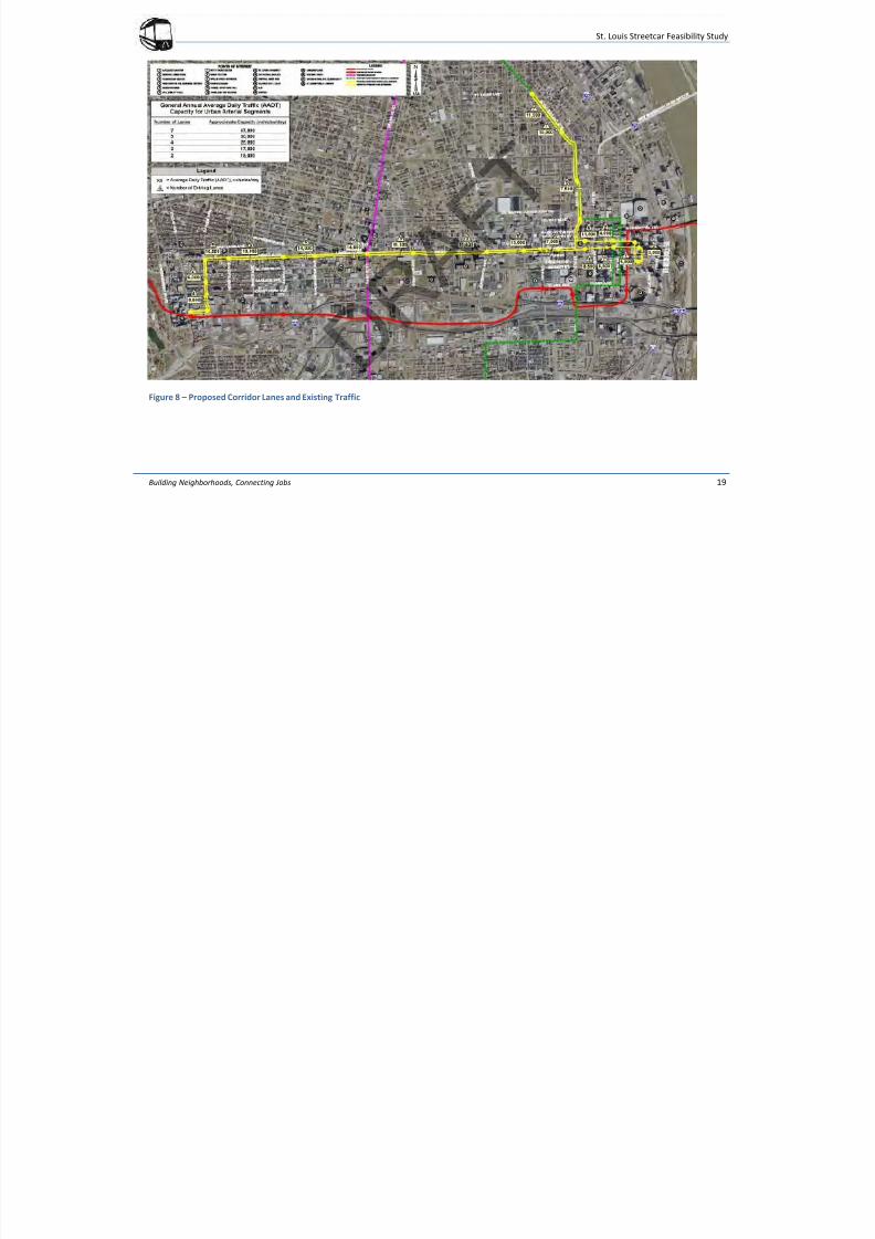
A high level traffic impact analysis evaluated capacity, signalization and
circulation patterns. Figure 8 indicates the number of travel lanes and
the annual average daily traffic (AADT) on each on each segment of
roadway within the proposed corridor.
The AADT volumes are between 3,000 and 16,500 vehicles per day on
the study segments. These volumes fall within the capacity ranges for
the roadways, which have between two and seven lanes. Based on
these volumes, the existing street segments within the study corridors
have excess capacity. The area nearest capacity is Lindell Boulevard at
the west end of the study corridor.
The street network throughout the corridor is generally a grid network,
and the area is served by bus and light-rail transit. The east-west
portion of the corridor roughly parallels I-64 to its south. The north-
south portion roughly parallels I-70 to its east.
The general character of the major streets within the corridors is
discussed below:
Lindell Boulevard/Olive Street is a two-way, five-lane major arterial
east of Tucker Boulevard. (Olive Street becomes Lindell Boulevard east
of Grand Boulevard.) Parking is permitted on both sides of the road and
there are sidewalks (typically wide) on both sides. Although it is a major
east-west arterial in downtown, traffic volumes are lower than might be
expected because of its proximity to I-64 and Forest Park Parkway,
another major arterial that accommodates slightly higher speeds and
extends further west into St. Louis County.
The five-lane cross-section allows for turning lanes at all intersections,
and most of the major intersections are signalized and managed by the
City of St. Louis. Dedicated bike lanes are planned for Lindell/Olive east
of Grand Boulevard. This portion of Lindell/Olive is utilized by three
MetroBus routes: #10 connects the Central West End MetroLink Station
and the Civic Center MetroBus Center (at the Gateway Transportation
Center), #13 travels between the Central West End MetroLink Station
and North St. Louis County, and #4 links the Civic Center MetroBus
Center with the North Hanley MetroLink Station. The Gateway Bike
Plan incorporates dedicated bike lanes on Lindell/Olive from Grand
Boulevard east to 20th Street. Development along this arterial is
relatively dense mixed uses, including the Saint Louis University
Campus, Grand Center, and the western portion of the St. Louis Central
Business District (CBD).
7/29/2019 DRAFT_St. Louis North Side/Downtown/Midtown/CWE Streetcar Feasibility Study 2013
http://slidepdf.com/reader/full/draftst-louis-north-sidedowntownmidtowncwe-streetcar-feasibility-study 23/104
St. Louis Streetcar Feasibility Study
Building Neighborhoods, Connecting Jobs 19
Figure 8 – Proposed Corridor Lanes and Existing Traffic
7/29/2019 DRAFT_St. Louis North Side/Downtown/Midtown/CWE Streetcar Feasibility Study 2013
http://slidepdf.com/reader/full/draftst-louis-north-sidedowntownmidtowncwe-streetcar-feasibility-study 24/104
St. Louis Streetcar Feasibility Study
Building Neighborhoods, Connecting Jobs 20
Taylor Avenue is a two lane, two-way road with parking lanes on both
sides throughout most of the proposed alignment. There are sidewalks
on both sides of the road. MetroBus route #18 utilizes Taylor between
the Central West End MetroLink Station and O’Fallon Park in North St
Louis City. Taylor serves dense residential and some first-floorcommercial development. Most intersections on Taylor are all-way
stop-controlled with no turning lanes with the exception of its
intersection with Forest Park Parkway. The intersection is signalized
with turning lanes and Taylor transitions to a four-lane cross-section.
The Gateway Bike Plan incorporates shared bike lanes on Taylor
throughout this segment.
Children’s Place is a local two-lane, two-way, street serving the
BJC/Washington University Medical Campus. The street only extends
one block west of Taylor Avenue. There are sidewalks on both sides of
the street leading to the cul-de-sac at the west terminus with paths
leading into the campus and to the adjacent Central West End
MetroLink Station.
East of Tucker Boulevard, Olive Street becomes a one-way eastbound,
two lane road with parking permitted on at least one side. There are
wide sidewalks fronting urban multi-story buildings on either side. All of
the cross streets east of Tucker are one-way facilities as well; all
intersections are signalized and there are no turn lanes. No MetroBus
routes utilize Olive, although multiple routes cross the street at 9th
Street and 6th
Street.
6th Street, 7th Street, Chestnut Street, and Locust Street are generally
two-lane roadways with parking lanes and wide sidewalks on both sides.
6th Street is one-way southbound, 7th Street is one-way northbound, and
Chestnut is one-way eastbound. Locust Street is one-way westbound.
Parking is restricted on one or both sides of 7th
and Locust Streets for
portions of the proposed alignment. These streets are also within the
CBD and development is similar to Olive Street east of Tucker
Boulevard. Of these routes, only 6th Street is a corridor for MetroBus
Express routes 36X, 174X, 58X, 410X, and 40X. The Gateway Bike Planproposes shared bike lanes for all of these streets with the exception of
Chestnut.
14th Street is a two-way, four-lane road. There are parking lanes and
sidewalks on both sides throughout most of the proposed alignment
with the exception of the segment south of Clark Avenue where there
are no parking lanes. The major intersections are signalized and have
dedicated turn lanes, the minor intersections are stop-controlled on the
cross-road. Because 14th Street provides access to the Civic Center
MetroBus Center, multiple MetroBus utilize 14th
Street, especially in the
CBD (south of Washington Avenue). MetroBus routes #41 and #74
continue north to Carr Street and North Florissant Avenue on their way
to North County, and route #30 continues north to St. Louis Avenue
before turning west toward the Rock Road MetroLink Station. As part of
the Gateway Bike Plan, 14th
Street is proposed to have shared bike lanes
north of Clark Avenue, dedicated bike lanes north of Washington
Avenue to Cole Street. In addition, 14th
Street north of Washington is
proposed for a multi-use corridor.
North Florissant Avenue is a six-lane divided road north of 14th
Street
through Madison Street. At Madison, the median narrows and North
Florissant becomes a seven-lane road. Parking is prohibited on the
street. There are sidewalks on both sides through the majority of the
corridor. This area also has a strong grid network of streets. The
intersections at Madison Street, North Market Street, and St. Louis
Avenue are signalized, but the majority of intersections with cross
7/29/2019 DRAFT_St. Louis North Side/Downtown/Midtown/CWE Streetcar Feasibility Study 2013
http://slidepdf.com/reader/full/draftst-louis-north-sidedowntownmidtowncwe-streetcar-feasibility-study 25/104
St. Louis Streetcar Feasibility Study
Building Neighborhoods, Connecting Jobs 21
streets have only stop control on the minor (crossing) road. MetroBus
route #74 utilizes North Florissant between the Civic Center MetroBus
Center and North County. The Gateway Bike Plan identifies North
Florissant as a portion of the Route 66 Multi-State On-Street Bike Route.
Dedicated bike lanes are proposed between 14th
Street and Palm Street,with shared bike lanes north of that segment.
Traffic Signal System
The majority of the traffic signals within the study corridors are part of a
pre-timed coordinated system controlled by the City of St. Louis. The
exception is 14th
Street, although the City is steadily adding signals to
their system as conditions permit. Signals within the coordinated
system have upgraded equipment and are interconnected. The City
utilizes an ACTRA system and various portions of the corridors fall
within different management groups.
Anticip ated Streetca r Impacts
The proposed streetcar will utilize dedicated street lanes north of Locust
Street and west of 14th
Street, and shared traffic lanes within the core of
the CBD. The existing system has excess capacity. As shown in Figure
21, the existing network has excess capacity and can be expected to
accommodate both of those uses in their proposed segments.
Next StepsTo further refine the traffic analysis, detailed data collection is
necessary. This will be part of the next phase of the project. This data
would include current traffic volumes and turning movement counts at
all intersections and major access points within the study corridors.
Volume projections for the operating timeframe will need to
incorporate the network traffic shifts expected in 2015 due to the
opening of the New Mississippi River Bridge (NMRB) and CityArchRiver
2015 (CAR 2015) projects.
Using streetcar demand forecasts, impacts to the street and signal
control network directly resulting from the proposed system can be
defined. After impacts are determined, mitigation and enhancements
to the existing system will be investigated.
The additional data will also support a detailed study of potential
circulation impacts at the block, local, and regional levels. Block level
circulation includes pedestrian concerns such as street crossings,
security, and continuity and property concerns such as access, flow, and
parking. Local circulation would look further into aspects such as the
bicycle network and how to maintain and enhance that system.
Regional circulation would focus on the maintaining and enhancing
transit connectivity within the MetroLink and MetroBus systems as well
as for commuter systems from Illinois, for example Madison County
Transit.
7/29/2019 DRAFT_St. Louis North Side/Downtown/Midtown/CWE Streetcar Feasibility Study 2013
http://slidepdf.com/reader/full/draftst-louis-north-sidedowntownmidtowncwe-streetcar-feasibility-study 26/104
St. Louis Streetcar Feasibility Study
Building Neighborhoods, Connecting Jobs 22
ENVIRONMENTAL
A review of the environmental considerations associated with the
proposed alignment was conducted. The purpose of the review was to
determine if there were any fatal flaws.
For this type of project in an existing right-of-way and within an urban
area, impacts are mostly associated with social/economic
considerations. These include environmental justice, neighborhoods
and community facility, cultural resources, Title VI compliance, and
visual and aesthetic resources. Natural impacts such as biological
resources, endangered species, wetlands and flood plains tend to have
less impact. While the review indicated no fatal flaws, parkland, noise,
environmental justices, and visual and aesthetic resources will need
further analysis to determine potential impacts during the next phase of the project.
Parkland
The proposed alignment includes a station in Kiener Plaza park located
on Chestnut Street between 6th Street and 7th Street downtown. The
Department of Transportation (DOT) Action of 1966 includes a
provision, Section 4(f) that requires DOT agencies including the FTA,
“cannot approve the use of land from publicly owned parks,
recreational areas, wildlife and waterfowl refuges, or public and privatehistorical sites unless the following conditions apply:
• There is no feasible and prudent alternative to use of the land.
• The action includes all possible planning to minimize harm to
the property resulting from use.”1
1U.S. Department of Transportation Federal Highway Administration
As Kiener Plaza is a public park, a Section 4(f) analysis would be required
in the next environmental phase. Noise
Streetcars have lower noise levels to city buses. Streetcar noise ismostly generated by curves in the alignment and the sound of the horn.
The alignment includes several turns in both the eastern and western
ends of the corridor. The downtown turns include:
• 14th Street and Olive Street
• Olive Street and 6th Street
• 6th Street and Chestnut Street
• Chestnut Street and 7th Street
• 7th Street and Locust Street
• Locust Street and 14th Street
The Central West End Option 1 turns include:
Lindell and Taylor Avenue
Taylor Avenue and Children’s Place
The Central West End Option 2 turns include:
Lindell and Euclid Avenue
Euclid Avenue and Forest Park Avenue
Forest Park Avenue and Taylor Avenue
Taylor Avenue and Lindell
During the next environmental phase of the project, these intersections
will be reviewed further for noise impacts.
Streetcars are only required to sound their horn in an emergency, not at
every grade crossing like MetroLink. This helps reduce to the noise level
as the alignment is street running with limited exclusive right-of-way.
7/29/2019 DRAFT_St. Louis North Side/Downtown/Midtown/CWE Streetcar Feasibility Study 2013
http://slidepdf.com/reader/full/draftst-louis-north-sidedowntownmidtowncwe-streetcar-feasibility-study 27/104
St. Louis Streetcar Feasibility Study
Building Neighborhoods, Connecting Jobs 23
During the next environment phase, a more detailed analysis of areas
sensitive to noise levels such as areas designated for serenity uses,
including parks, historic landmarks and concert pavilions, residential and
institutional areas will be conducted.
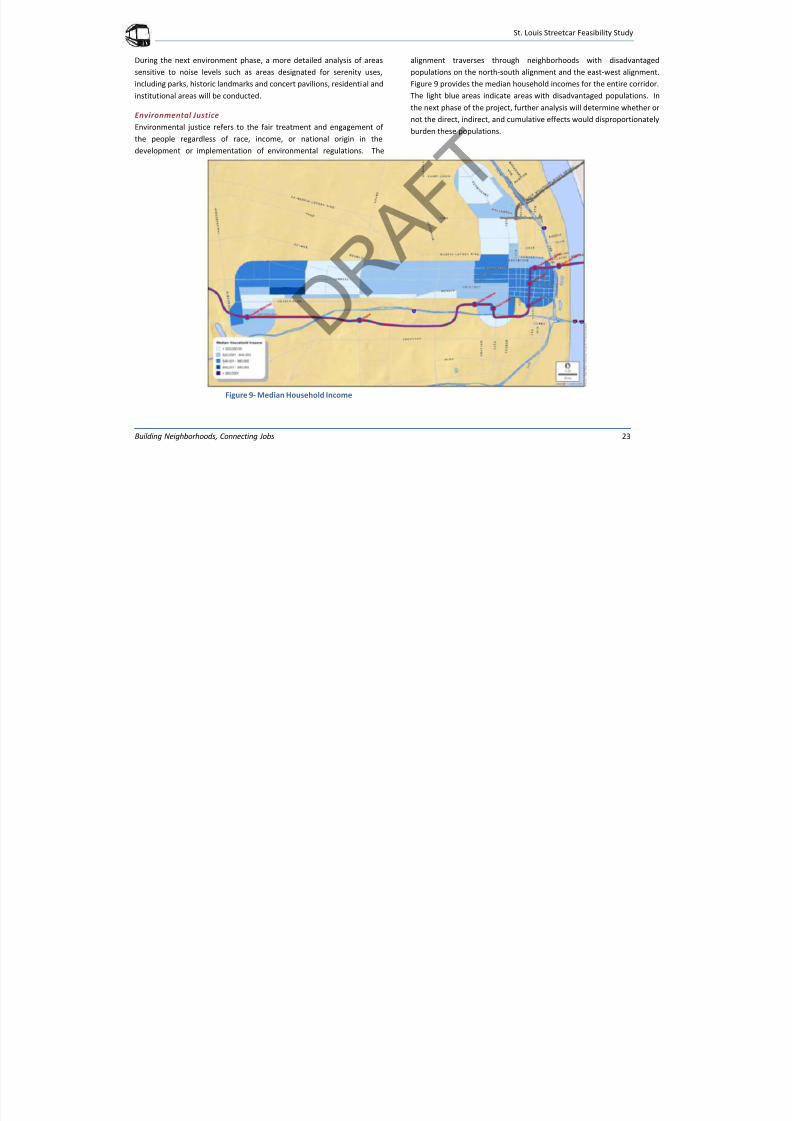
Environmental Justice
Environmental justice refers to the fair treatment and engagement of
the people regardless of race, income, or national origin in the
development or implementation of environmental regulations. The
alignment traverses through neighborhoods with disadvantaged
populations on the north-south alignment and the east-west alignment.
Figure 9 provides the median household incomes for the entire corridor.
The light blue areas indicate areas with disadvantaged populations. In
the next phase of the project, further analysis will determine whether ornot the direct, indirect, and cumulative effects would disproportionately
burden these populations.
Figure 9- Median Household Income
7/29/2019 DRAFT_St. Louis North Side/Downtown/Midtown/CWE Streetcar Feasibility Study 2013
http://slidepdf.com/reader/full/draftst-louis-north-sidedowntownmidtowncwe-streetcar-feasibility-study 28/104
St. Louis Streetcar Feasibility Study
Building Neighborhoods, Connecting Jobs 24
Visual and Aesthetics
The proposed alignment of the streetcar would be within the existing
right-of-way and share existing traffic lanes throughout the corridor.
The corridor includes established neighborhoods including the CBD, the
near Northside, Midtown and the Central West End. Each of theseneighborhoods has distinctive characteristics and aesthetic qualities. It
will be important in the next phase to determine if the overhead wires,
stations and construction impact these neighborhoods.
Next Steps
The environmental considerations that will be analyzed in more detail
during the next phase include:
• Traffic
• Transit
• Land Use
• Economic
• Neighborhoods and Community Facilities
• Environmental Justice
• Title VI Compliance
• Visual and Aesthetic Resource
• Cultural Resources
• Noise and Vibration
• Air Quality
• Energy
• Parks and Recreation
• Section 4(f)
• Public Safety
• Biological Resources and Endangered Species
• Geology and Soils
• Wetlands, Water and Floodplains
• Hazardous Materials
• Utilities
7/29/2019 DRAFT_St. Louis North Side/Downtown/Midtown/CWE Streetcar Feasibility Study 2013
http://slidepdf.com/reader/full/draftst-louis-north-sidedowntownmidtowncwe-streetcar-feasibility-study 29/104
St. Louis Streetcar Feasibility Study
Building Neighborhoods, Connecting Jobs 25
RIDERSHIP FORECAST
The purpose of ridership projections is to provide a quick, order-of-
magnitude estimate of likely ridership for the proposed St. Louis
Streetcar. An approach was employed that makes extensive use of an
existing tool developed by the Federal Transit Administration (FTA) and
its contractors. This tool is known as the Aggregate Rail Ridership
Forecasting Model Version 2 (ARRF-2).
ARRF-2 was calibrated for existing light rail and commuter rail lines that
typically operate at higher speeds over longer distances than streetcar
systems. To confirm, its applicability to streetcars, the model was tested
and adjusted to be representative of streetcar ridership observed in
Portland, Oregon. It was also tested to confirm that it properly
represents current MetroLink ridership in St. Louis.
DEFINITION OF ALTERNATIVE
The streetcar alternative consists of an east-west segment traveling
between the Central West End MetroLink station and Downtown St.
Louis and a north-south segment traveling between North Florissant/St.
Louis and 14th/Clark Streets. The east-west alignment generally follows
Lindell Boulevard and Olive Street. In Downtown St. Louis (east of 14th
Street), the eastbound track is located on Olive Street and thewestbound track is located on Locust Street. ARRF-2 requires that
paired stations (i.e., the stations on Olive and Locust Streets that
separately serve eastbound and westbound directions) be coded as a
single station. For this analysis, the Olive Street stations were coded
and assumed to be generally representative of the corresponding
stations on Locust Street.
Service frequencies on both lines are assumed as follows:
From 5 AM to 9 AM: 10 minute headways
From 9 AM to 3 PM, 15 minute headways
From 3 PM to 6 PM, 10 minute headways From 6 PM to 12 Midnight, 15 minute headways
ESTIMATES OF STREETCAR RIDERSHIP
The forecasting model was run using the same input travel demand data
used to validate current estimates of MetroLink ridership including 2000
Census, Journey to Work data. The results reported in this section do
not account for potential population and employment growth in the
corridor that may occur in the future. As such, the analysis represents
an initial order-of-magnitude estimate rather than the outcome of a full
forecasting assignment.
ARRF model results suggest that if the streetcar were operational today,
the east-west route would attract 5,900 daily riders and the north-south
route would attract 1,800 daily riders-for a total of 7,700 daily riders.
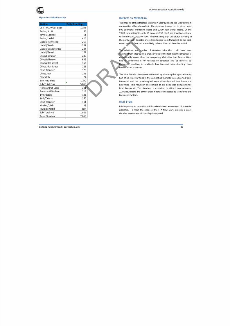
Station-by-station ridership is shown in Figure 10.
7/29/2019 DRAFT_St. Louis North Side/Downtown/Midtown/CWE Streetcar Feasibility Study 2013
http://slidepdf.com/reader/full/draftst-louis-north-sidedowntownmidtowncwe-streetcar-feasibility-study 30/104
St. Louis Streetcar Feasibility Study
Building Neighborhoods, Connecting Jobs 26
Figure 10 - Daily Ridership IMPACTS ON METROLINK
The impacts of the streetcar system on MetroLink and the Metro system
are positive although modest. The streetcar is expected to attract over
500 additional MetroLink riders and 2,700 new transit riders. Of the
7,700 total ridership, only 10 percent (750 trips) are traveling entirely
within the east-west corridor. The remaining trips are either traveling in
the north-south Corridor or are transferring from MetroLink to the east-
west streetcar line and are unlikely to have diverted from MetroLink.
The relatively low number of streetcar trips that could have been
diverted from MetroLink is probably due to the fact that the streetcar is
considerably slower than the competing MetroLink line. Central West
End to downtown is 40 minutes by streetcar and 13 minutes by
MetroLink resulting in relatively few line-haul trips diverting from
MetroLink to streetcar.
The trips that did divert were estimated by assuming that approximately
half of all streetcar trips in the competing markets were diverted from
MetroLink and the remaining half were either diverted from bus or are
new trips. This results in an estimate of 375 daily trips being diverted
from MetroLink. The streetcar is expected to attract approximately
2,700 new riders and 500 of these riders are expected to transfer to the
MetroLink system.
NEXT STEPS
It is important to note that this is a sketch-level assessment of potential
ridership. To meet the needs of the FTA New Starts process, a more
detailed assessment of ridership is required.
Station Daily Boardings
CENTRAL WEST END 1,345
Taylor/Scott 36 Taylor/Laclede 61
Taylor/Lindell 416
Lindell/Newstead 267
Lindell/Sarah 367
Lindell/Vandeventer 244
Lindell/Grand 173
Olive/Compton 280
Olive/Jefferson 635
Olive/20th Street 166 Olive/16th Street 216
Olive Transfer 120
Olive/10th 246
Olive/6th 24
8TH AND PINE 1,272
Sub-Total E-W 5,868
Florissant/St Louis 381
Florissant/Madison 114
14th/Biddle 121
14th/Delmar 260
Olive Transfer 111
Market/14th 13
CIVIC CENTER 801
Sub-Total N-S 1,801
Total Streetcar 7,669
7/29/2019 DRAFT_St. Louis North Side/Downtown/Midtown/CWE Streetcar Feasibility Study 2013
http://slidepdf.com/reader/full/draftst-louis-north-sidedowntownmidtowncwe-streetcar-feasibility-study 31/104
St. Louis Streetcar Feasibility Study
Building Neighborhoods, Connecting Jobs 27
OPERATIONS PLAN
Developing an operations plan for a streetcar line is a careful balance
between projected ridership and the service pattern to be provided.
Not only are the factors interrelated, they mutually impact one another;
better service increases ridership, and more ridership requires more
service. Ridership is sensitive to such factors as weather, time of day,
frequency, speed, economic development and the price of gas and
parking. Thus, it is important that the system be capable of adjusting
service levels to demand within a fairly broad range, in order to provide
good cost control.
In developing the operations plan, providing a seamless network to the
existing transit system is a priority. For example, it will be important
that hours of service and fare structure complement the existingsystem. While the operator of the streetcar will not be determined at
this phase of the project, the streetcar should be an integrated part of
the overall transit system, regardless of the operator.
RIDERSHIP The ridership estimate for the initial streetcar is 7,700 daily riders, the
number used for this operating plan. Likewise, the operating plan
described below has been used for ridership forecasting.
DETERMINANTS OF OPERATING PATTERN
Days of Service
Almost all rail transit lines provide service seven days per week, which is
the plan of the St. Louis Streetcar. However, as discussed below, this
does not mean that the hours of service do not vary somewhat,
depending on the day of the week.
Hours of Service
It is important that St. Louis Streetcar be an integrated part of the
existing transit system in the St. Louis area. It is recommended the
hours of operation be the same or similar to MetroLink and MetroBus.
For this study, the hours of service were assumed to be 5:00 a.m. tomidnight, Monday through Sunday.
Schedule Speed
The average schedule speed includes time at each stop, plus make-up
time and layover time at the end of each trip. The initial average
schedule speed has been set to be similar to that of MetroBus lines on
roadways similar to Olive, Lindell, the downtown area and the streets in
the vicinity of the BJC/Washington University Medical School.
Interconnections
The St. Louis Streetcar connects directly with MetroLink and MetroBus
services at the CWE Metro Station, and provides convenient transfer
with bus services along the route. It serves Civic Center station as well,
and is a short walk to the light rail station at 8th and Pine in downtown
and Convention Center Station at Washington Avenue and 6th
Street.
Frequency
Frequency of service (headway) is arguably the most important service
factor in maximizing ridership. The minimum safe headway isdetermined by schedule speed, distance between stops, and number of
vehicles. A typical headway is 10 minutes. This headway provides
service frequently enough that a printed schedule is not needed. This
service frequency range is common in peak hours in systems around the
country. A primary objective for the St. Louis Streetcar is to provide
serious and frequent service. It is recommended that peak period
7/29/2019 DRAFT_St. Louis North Side/Downtown/Midtown/CWE Streetcar Feasibility Study 2013
http://slidepdf.com/reader/full/draftst-louis-north-sidedowntownmidtowncwe-streetcar-feasibility-study 32/104
St. Louis Streetcar Feasibility Study
Building Neighborhoods, Connecting Jobs 28
service be every 10 minutes. This would provide a considerable
increase in service to the existing bus service in the corridors.
Off-peak-service for rail transit lines is generally in the 15 to 30 minute
range. For the St. Louis Streetcar, with its many connections to
MetroBus and MetroLink, a compatible headway to these lines of 15
minutes is suggested. For those times where service must be provided
as a system policy, even though ridership is minimal, headways may be
even longer.
PRELIMINARY OPERATIONS PLAN
Given the various factors that define a service level, and the desire to
provide a robust service at minimal operating cost, the following
operating plan has been developed for the east-west and north-southroutes of the St. Louis Streetcar:
Both routes operate seven days per week
Both routes operate the same headways:
- 5 AM to 9 AM – every 10 minutes
- 9 AM to 3 PM - every 15 minutes
- 3 PM to 6 PM – every 10 minutes
- 6 PM to 12 Midnight – every 15 minutes
7/29/2019 DRAFT_St. Louis North Side/Downtown/Midtown/CWE Streetcar Feasibility Study 2013
http://slidepdf.com/reader/full/draftst-louis-north-sidedowntownmidtowncwe-streetcar-feasibility-study 33/104
St. Louis Streetcar Feasibility Study
Building Neighborhoods, Connecting Jobs 29
COSTS
The methodology for developing the capital and operating costs are
detailed below. Estimates are based on FTA’s capital cost format and
used in New Starts projects. The cost estimate is designed to evolvethroughout project phases but be as accurate as possible at each stage.
CAPITAL COST METHODOLOGY
The approach used for the capital cost estimate is based on FTA’s capital
costing format, the Standard Cost Categories (SCC), established in 2005
to provide a consistent format for the reporting, estimating, and
managing of capital costs for New Starts projects. Cost estimates
produced under this methodology can be tracked and audited as the
project definition moves forward from conceptual design to final design
and construction.
Estimate Development
Conceptual alignments and typical sections formed the basis for
quantifying project improvements into units of work. Appropriate unit
pricing was developed from historical cost data, applied to the
quantities, and summed into cost categories to complete the cost
estimate.
Current Year Dollars
The capital costs were estimated in current year 2012 US dollars
(2012$).
Escalation
Escalation factors are sometimes necessary when using costs that are
older than the current year by one or more years. In this case, historical
construction cost index values can be used to calculate an escalation
factor for the period in question. Additionally, it may be necessary to
take the current year estimate and project it to a future base year or
year of expenditure. In this case, an escalation factor will be developed
using historical construction cost index values to calculate the mostrecent moving average for the time period between the current year
and the projected base year. This factor would be used to escalate cost
categories to the projected year of expenditure.
Unit Costs
Unit costs were developed from selected historical data including, 2011
contractor bid tabs for the Tucson, Portland, and Seattle Streetcar
projects currently under construction, engineers estimates, and
standard estimating practices. The unit cost prices include contractoroverhead and profit.
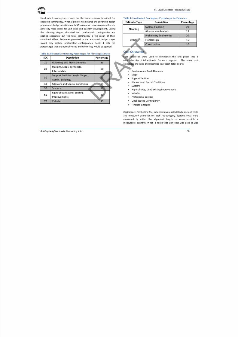
Contingencies
Contingency addresses the potential for quantity fluctuations and cost
variability when items of work are not readily apparent or unknown at
the current level of design. Contingency is assigned in two major
categories, allocated and unallocated.
Allocated contingency is used during the planning stages of a projectwhen the level of design development is usually below 30 percent
complete. Based on the level of design development a contingency
allowance of between 15 and 30 percent will be allocated by cost
categories. The percentage selected is based on professional
experience and judgment related to the potential variability of costs
within each of these cost categories. Table 3 lists the percentages that
are normally used for allocated contingencies.
7/29/2019 DRAFT_St. Louis North Side/Downtown/Midtown/CWE Streetcar Feasibility Study 2013
http://slidepdf.com/reader/full/draftst-louis-north-sidedowntownmidtowncwe-streetcar-feasibility-study 34/104
St. Louis Streetcar Feasibility Study
Building Neighborhoods, Connecting Jobs 30
Unallocated contingency is used for the same reasons described for
allocated contingency. When a project has entered the advanced design
phases and design development is 30 percent or more complete there is
generally more detail for unit price and quantity development. During
the planning stages, allocated and unallocated contingencies areapplied separately but the total contingency is the result of their
combined effect. Estimates prepared in the advanced design stages
would only include unallocated contingencies. Table 4 lists the
percentages that are normally used and when they would be applied.
Table 3: Allocated Contingency Percentages for Planning Estimate
SCC Description Percentage
10 Guideway and Track Elements 15
20Stations, Stops, Terminals,
Intermodals20
30Support Facilities: Yards, Shops,
Admin. Buildings25
40 Sitework and Special Conditions 25
50 Systems 20
60Right-of-Way, Land, Existing
Improvements
30
70 Vehicles 15
Table 4: Unallocated Contingency Percentages for Estimates
Estimate Type Description Percentage
PlanningSystem Planning 20
Alternatives Analysis 15
Design
Preliminary Engineering 20
Final Design 15
Construction 10
COST CATEGORIES
Cost categories were used to summarize the unit prices into a
comprehensive total estimate for each segment. The major cost
categories are listed and described in greater detail below:
Guideway and Track Elements
Stops
Support Facilities
Sitework and Special Conditions
Systems
Right-of-Way, Land, Existing Improvements
Vehicles
Professional Services Unallocated Contingency
Finance Charges
Capital costs for the first four categories were calculated using unit costs
and measured quantities for each sub-category. Systems costs were
calculated by either the alignment length or when possible a
measurable quantity. When a route-foot unit cost was used it was
7/29/2019 DRAFT_St. Louis North Side/Downtown/Midtown/CWE Streetcar Feasibility Study 2013
http://slidepdf.com/reader/full/draftst-louis-north-sidedowntownmidtowncwe-streetcar-feasibility-study 35/104
St. Louis Streetcar Feasibility Study
Building Neighborhoods, Connecting Jobs 31
developed using historical data that could be applied to the route
length.
The professional services categories are calculated as a percentage of
construction costs (excluding vehicle procurement). These percentagesare discussed in the Professional Services Section (Appendix A). The
sum of these ten cost categories is the total capital cost estimate. The
ten cost categories are described in detail in Appendix A.
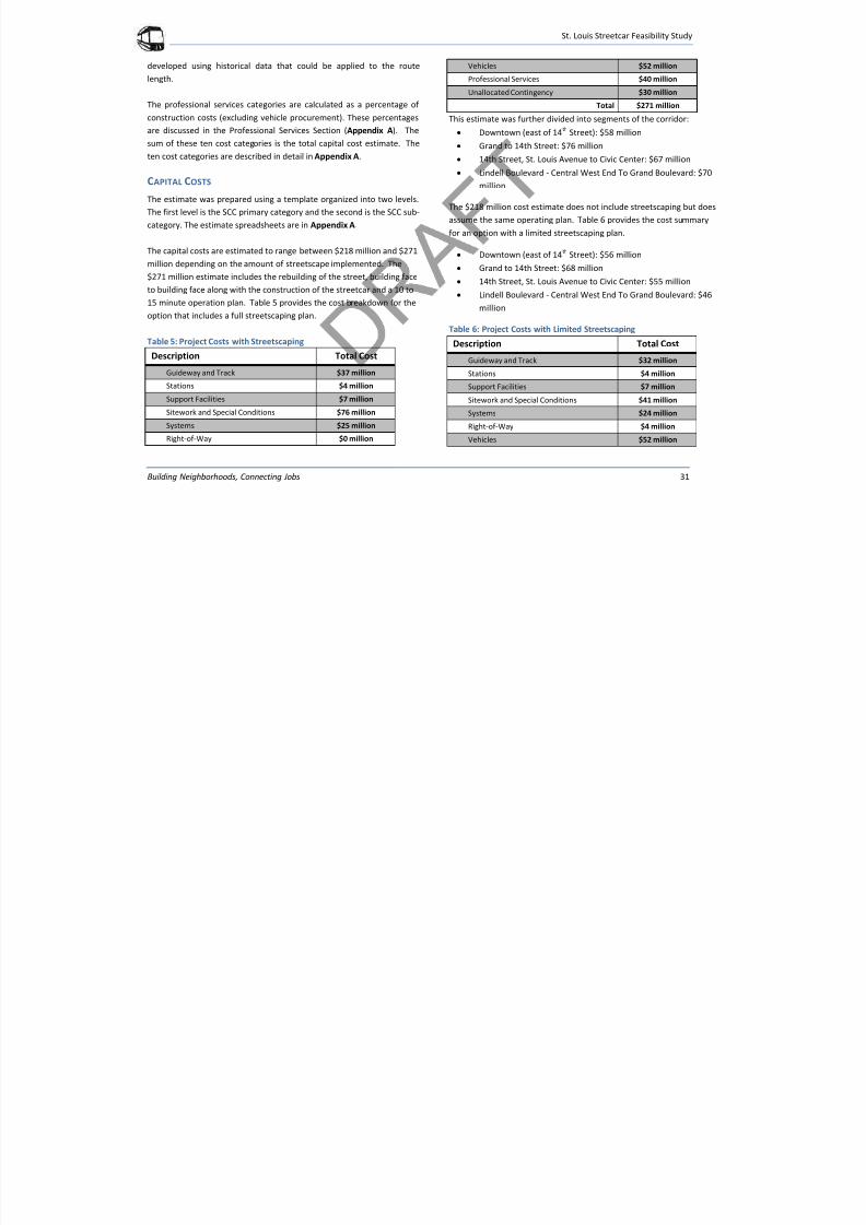
CAPITAL COSTS
The estimate was prepared using a template organized into two levels.
The first level is the SCC primary category and the second is the SCC sub-
category. The estimate spreadsheets are in Appendix A.
The capital costs are estimated to range between $218 million and $271
million depending on the amount of streetscape implemented. The
$271 million estimate includes the rebuilding of the street, building face
to building face along with the construction of the streetcar and a 10 to
15 minute operation plan. Table 5 provides the cost breakdown for the
option that includes a full streetscaping plan.
Table 5: Project Costs with Streetscaping
Description Total Cost
Guideway and Track $37 million
Stations $4 million
Support Facilities $7 million
Sitework and Special Conditions $76 million
Systems $25 million
Right-of-Way $0 million
Vehicles $52 million
Professional Services $40 million
Unallocated Contingency $30 million
Total $271 million
This estimate was further divided into segments of the corridor: Downtown (east of 14
thStreet): $58 million
Grand to 14th Street: $76 million
14th Street, St. Louis Avenue to Civic Center: $67 million
Lindell Boulevard - Central West End To Grand Boulevard: $70
million
The $218 million cost estimate does not include streetscaping but does
assume the same operating plan. Table 6 provides the cost summary
for an option with a limited streetscaping plan.
Downtown (east of 14th
Street): $56 million
Grand to 14th Street: $68 million
14th Street, St. Louis Avenue to Civic Center: $55 million
Lindell Boulevard - Central West End To Grand Boulevard: $46
million
Table 6: Project Costs with Limited Streetscaping
Description Total Cost
Guideway and Track $32 million
Stations $4 million
Support Facilities $7 million
Sitework and Special Conditions $41 million
Systems $24 million
Right-of-Way $4 million
Vehicles $52 million
7/29/2019 DRAFT_St. Louis North Side/Downtown/Midtown/CWE Streetcar Feasibility Study 2013
http://slidepdf.com/reader/full/draftst-louis-north-sidedowntownmidtowncwe-streetcar-feasibility-study 36/104
St. Louis Streetcar Feasibility Study
Building Neighborhoods, Connecting Jobs 32
Professional Services $29 million
Unallocated Contingency $24 million
Total $218 million
OPERATING COSTS Methodology
Cost Elements
In approximating the cost of a streetcar line at the early planning stage,
one common method is to calculate the annual vehicle-hours by
multiplying the cost per hour actually experienced by similar operations,
adjusted if necessary to reflect unusual or location-specific variations.
Cost per hour is a reasonable surrogate for overall costs because the
bulk of the costs incurred in a streetcar operation are directly related to
this measure. For example, operator’s wages and fringes and power,
which make up the majority of system costs, are directly related to
hours. Similarly, although vehicle maintenance is also a function of
miles, if a fairly constant schedule speed is achieved, then mileage-
related costs can be related to hours. Fixed facility costs (track and OCS)
and administrative costs do not relate perfectly to vehicle-hours, yet
these form a minor percentage of overall costs for streetcars, and can
be approximated in the cost per vehicle-hour with sufficient accuracy
for typical feasibility studies.
Range of Unit Costs
A streetcar line in mixed traffic has operating characteristics very similar
in many ways to that of a bus route. Schedule speeds are comparable,
operators have similar concerns, stop spacing is roughly the same, and
the signal systems, train operations and high speeds that characterize
light rail systems are hardly ever present. Track is rigidly set in the
structure of the street, and OCS is simple when compared to light rail,
factors which also reduce maintenance costs. Further, as mentioned,
there is no complex signal system and passenger stops are not nearly as
elaborate as light rail stations.
Thus, a base unit cost for a streetcar line in St. Louis would consider the
actual cost per vehicle hour experienced by the local transit provider,
and adjust this upward to allow for the added cost of fixed plant
inspection and maintenance. In round numbers, this would be
approximately $140 per revenue vehicle-hour in 2013 dollars.
Opinion of Probable Annual Operating Costs
The annual vehicle hours of service can be derived from the proposed
operating pattern developed in Operations Plan section of this report.
Multiplying these vehicle hours by the unit cost per revenue hour gives
a probable annual cost of $9.7 million.
Adjusti ng Cos ts to Reflect the Market
As previously described, operating costs can be adjusted to match
market demand by service adjustments to headway, hours and days of
service, and other related techniques.
7/29/2019 DRAFT_St. Louis North Side/Downtown/Midtown/CWE Streetcar Feasibility Study 2013
http://slidepdf.com/reader/full/draftst-louis-north-sidedowntownmidtowncwe-streetcar-feasibility-study 37/104
St. Louis Streetcar Feasibility Study
Building Neighborhoods, Connecting Jobs 33
DEVELOPMENT OPPORTUNITIES
The St. Louis Streetcar provides an opportunity to build investment and
capital in existing corridors and spur new private development.
Identifying development opportunities and qualitatively evaluating the
potential for growth along the corridor provides a framework to analyzethe viability of the streetcar line. The development opportunities were
guided by the existing plans including The Downtown Next 2020 Vision,
Gateway Mall Master Plan (2009), Northside Redevelopment Area
(2009), Central Business District Downtown Streetscape Design Manual
Update (2009), Grand Center Framework Plan (2012), and Cortex
Redevelopment Area (2012), which are summarized in Appendix B.
Figure 11 illustrates the development study area. The evaluation of
development opportunities in this report utilized the followingmethodology and process:
Examine development estimates from other comparable U.S.
cities that have built, or are considering building, a streetcar.
Identify previous plans that influence the St. Louis Streetcar
corridor and highlight development potential from adopted
plans.
Complete a ripe/firm analysis of development opportunitieswithin a ¼ mile of the corridor.
Identify appropriate development types for ripe parcels in the
corridor.
Apply rough estimates of building square footages and cost per
square foot to development types.
Add projected investment from approved projects.
Discuss limitations to estimates.
STREETCAR DEVELOPMENT IN OTHER CITIES
Several other cities in the United States are in the process of building
modern streetcar systems. These cities are experiencing new
investment and growth that can be attributed to their streetcar lines.
Seattle and Portland are the gold standard for illustrating development
potential along a streetcar route, having leveraged billions of dollars of
new investment along their systems. Other cities have completed
market studies to analyze and project investment along the proposed
routes. Below is a brief list of actual development investment along
existing routes and projected investments along proposed routes:
Portland (1997-2008): 4 mile route - $3.5 billion in investment,
10,000 housing units, 5.4 million square feet of commercial
space * (total new investment – “Streetcars and economic
development: The dynamic linkage between them”)
Seattle (2004-2010): 1.3 mile route - $2.4 billion in investment,
2,500 housing units, 12,500 jobs.* (total new investment -
http://downtownsac.org/streetcar/)
Tampa (2002-2011): 2.7 mile route - $1 billion in investment
(total new investment -http://www.tampasdowntown.com/the-
partnership/services-programs/urban-excellence.aspx)
Los Angeles (Projected - 2015): 4 mile route - $1.1 billion in
investment over 20 years (from 2012 Feasibility Study –
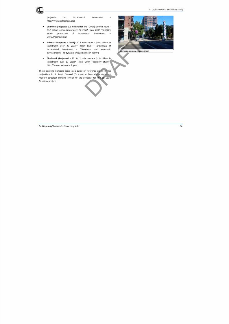
7/29/2019 DRAFT_St. Louis North Side/Downtown/Midtown/CWE Streetcar Feasibility Study 2013
http://slidepdf.com/reader/full/draftst-louis-north-sidedowntownmidtowncwe-streetcar-feasibility-study 38/104
St. Louis Streetcar Feasibility Study
Building Neighborhoods, Connecting Jobs 34
projection of incremental investment -
http://www.lastreetcar.org)
Charlotte (Projected 1.5 mile starter line - 2014): 10 mile route -
$3.5 billion in investment over 25 years* (from 2008 Feasibility
Study- projection of incremental investment –
www.charmeck.org)
• Atlanta (Projected - 2013): 10.7 mile route - $4.4 billion in
investment over 20 years* (from HDR – projection of
incremental investment - “Streetcars and economic
development: The dynamic linkage between them”)
• Cincinnati (Projected - 2013): 2 mile route - $1.9 billion in
investment over 10 years* (from 2007 Feasibility Study -http://www.cincinnati-oh.gov)
These baseline numbers serve as a guide or reference point for the
projections in St. Louis. Starred (*) streetcar lines above represent
modern streetcar systems similar to the proposal for the St. Louis
Streetcar project.
PORTLAND, OREGON – PEARL DISTRICT
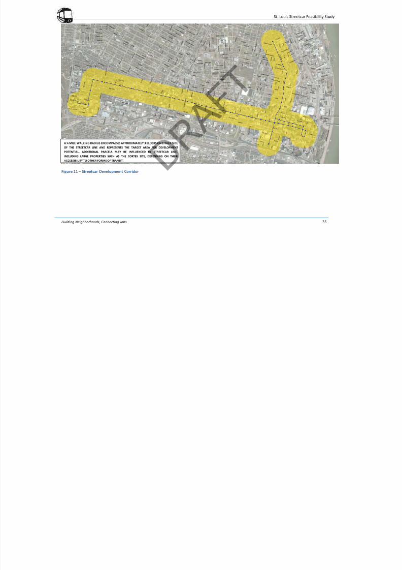
7/29/2019 DRAFT_St. Louis North Side/Downtown/Midtown/CWE Streetcar Feasibility Study 2013
http://slidepdf.com/reader/full/draftst-louis-north-sidedowntownmidtowncwe-streetcar-feasibility-study 39/104
St. Louis Streetcar Feasibility Study
Building Neighborhoods, Connecting Jobs 35
Figure 11 – Streetcar Development Corridor
A ¼ MILE WALKING RADIUS ENCOMPASSES APPROXIMATELY 3 BLOCKS ON EITHER SIDE
OF THE STREETCAR LINE AND REPRESENTS THE TARGET AREA FOR DEVELOPMENT
POTENTIAL. ADDITIONAL PARCELS MAY BE INFLUENCED BY STREETCAR LINE,
INCLUDING LARGE PROPERTIES SUCH AS THE CORTEX SITE, DEPENDING ON THEIR
ACCESSIBILITY TO OTHER FORMS OF TRANSIT.
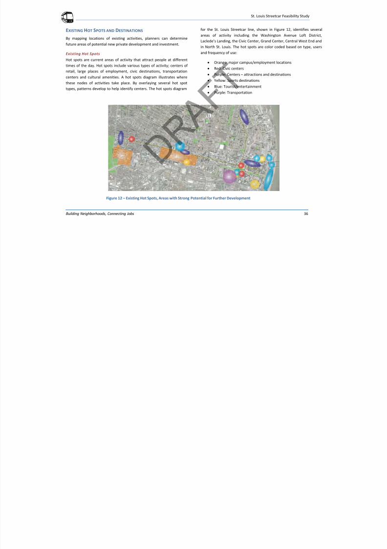
7/29/2019 DRAFT_St. Louis North Side/Downtown/Midtown/CWE Streetcar Feasibility Study 2013
http://slidepdf.com/reader/full/draftst-louis-north-sidedowntownmidtowncwe-streetcar-feasibility-study 40/104
St. Louis Streetcar Feasibility Study
Building Neighborhoods, Connecting Jobs 36
EXISTING HOT SPOTS AND DESTINATIONS
By mapping locations of existing activities, planners can determine
future areas of potential new private development and investment.
Existing Hot SpotsHot spots are current areas of activity that attract people at different
times of the day. Hot spots include various types of activity; centers of
retail, large places of employment, civic destinations, transportation
centers and cultural amenities. A hot spots diagram illustrates where
these nodes of activities take place. By overlaying several hot spot
types, patterns develop to help identify centers. The hot spots diagram
for the St. Louis Streetcar line, shown in Figure 12, identifies several
areas of activity including the Washington Avenue Loft District,
Laclede’s Landing, the Civic Center, Grand Center, Central West End and
in North St. Louis. The hot spots are color coded based on type, users
and frequency of use:
Orange: major campus/employment locations
Red: Civic centers
Purple: Centers – attractions and destinations
Yellow: Sports destinations
Blue: Tourist/entertainment
Purple: Transportation
Figure 12 – Existing Hot Spots, Areas with Strong Potential for Further Development
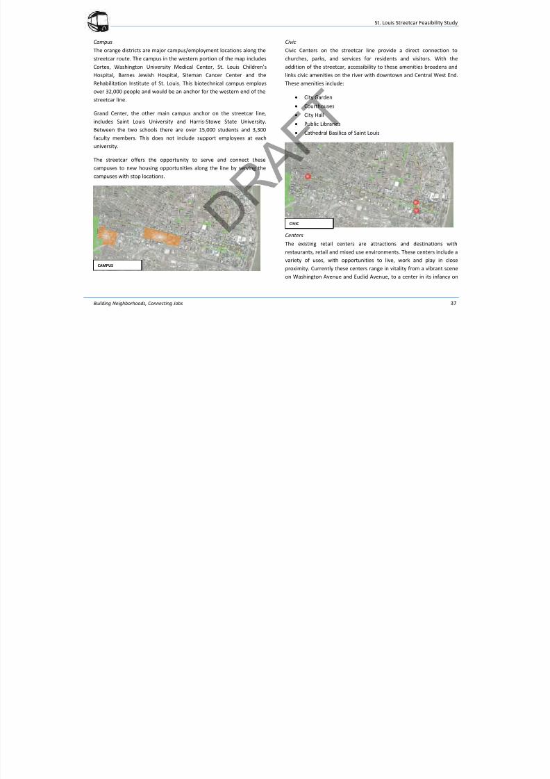
7/29/2019 DRAFT_St. Louis North Side/Downtown/Midtown/CWE Streetcar Feasibility Study 2013
http://slidepdf.com/reader/full/draftst-louis-north-sidedowntownmidtowncwe-streetcar-feasibility-study 41/104
St. Louis Streetcar Feasibility Study
Building Neighborhoods, Connecting Jobs 37
Campus
The orange districts are major campus/employment locations along the
streetcar route. The campus in the western portion of the map includes
Cortex, Washington University Medical Center, St. Louis Children’s
Hospital, Barnes Jewish Hospital, Siteman Cancer Center and theRehabilitation Institute of St. Louis. This biotechnical campus employs
over 32,000 people and would be an anchor for the western end of the
streetcar line.
Grand Center, the other main campus anchor on the streetcar line,
includes Saint Louis University and Harris-Stowe State University.
Between the two schools there are over 15,000 students and 3,300
faculty members. This does not include support employees at each
university.
The streetcar offers the opportunity to serve and connect these
campuses to new housing opportunities along the line by serving the
campuses with stop locations.
Civic
Civic Centers on the streetcar line provide a direct connection to
churches, parks, and services for residents and visitors. With the
addition of the streetcar, accessibility to these amenities broadens and
links civic amenities on the river with downtown and Central West End.These amenities include:
City Garden
Courthouses
City Hall
Public Libraries
Cathedral Basilica of Saint Louis
Centers
The existing retail centers are attractions and destinations with
restaurants, retail and mixed use environments. These centers include a
variety of uses, with opportunities to live, work and play in close
proximity. Currently these centers range in vitality from a vibrant scene
on Washington Avenue and Euclid Avenue, to a center in its infancy on
CAMPUS
CIVIC
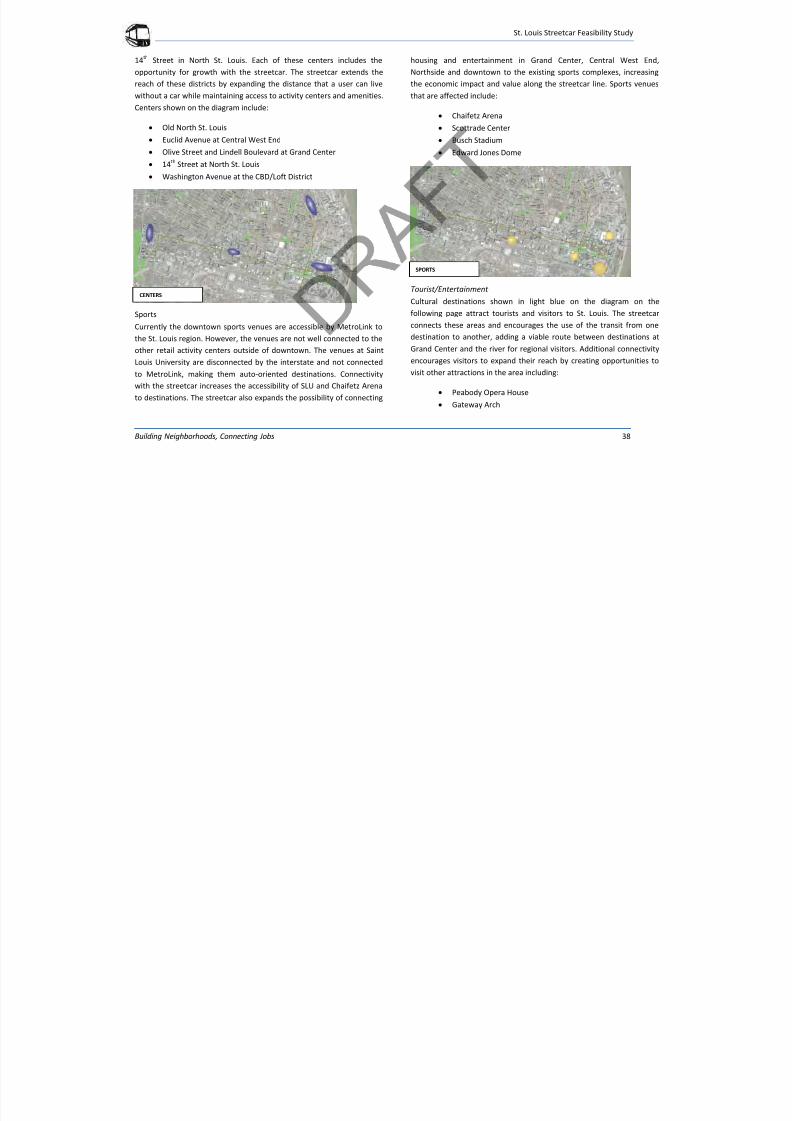
7/29/2019 DRAFT_St. Louis North Side/Downtown/Midtown/CWE Streetcar Feasibility Study 2013
http://slidepdf.com/reader/full/draftst-louis-north-sidedowntownmidtowncwe-streetcar-feasibility-study 42/104
St. Louis Streetcar Feasibility Study
Building Neighborhoods, Connecting Jobs 38
14th
Street in North St. Louis. Each of these centers includes the
opportunity for growth with the streetcar. The streetcar extends the
reach of these districts by expanding the distance that a user can live
without a car while maintaining access to activity centers and amenities.
Centers shown on the diagram include:
Old North St. Louis
Euclid Avenue at Central West End
Olive Street and Lindell Boulevard at Grand Center
14th Street at North St. Louis
Washington Avenue at the CBD/Loft District
Sports
Currently the downtown sports venues are accessible by MetroLink to
the St. Louis region. However, the venues are not well connected to the
other retail activity centers outside of downtown. The venues at Saint
Louis University are disconnected by the interstate and not connected
to MetroLink, making them auto-oriented destinations. Connectivity
with the streetcar increases the accessibility of SLU and Chaifetz Arena
to destinations. The streetcar also expands the possibility of connecting
housing and entertainment in Grand Center, Central West End,
Northside and downtown to the existing sports complexes, increasing
the economic impact and value along the streetcar line. Sports venues
that are affected include:
Chaifetz Arena
Scottrade Center
Busch Stadium
Edward Jones Dome
Tourist/Entertainment
Cultural destinations shown in light blue on the diagram on the
following page attract tourists and visitors to St. Louis. The streetcar
connects these areas and encourages the use of the transit from onedestination to another, adding a viable route between destinations at
Grand Center and the river for regional visitors. Additional connectivity
encourages visitors to expand their reach by creating opportunities to
visit other attractions in the area including:
Peabody Opera House
Gateway Arch
SPORTS
CENTERS
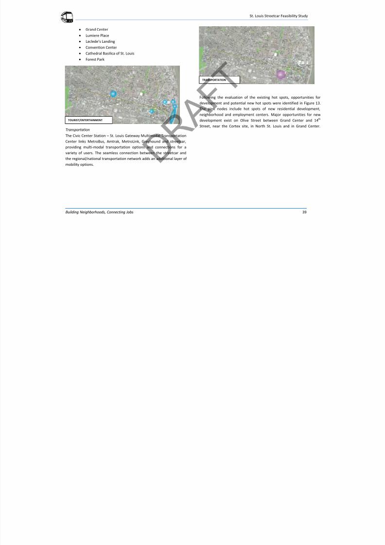
7/29/2019 DRAFT_St. Louis North Side/Downtown/Midtown/CWE Streetcar Feasibility Study 2013
http://slidepdf.com/reader/full/draftst-louis-north-sidedowntownmidtowncwe-streetcar-feasibility-study 43/104
St. Louis Streetcar Feasibility Study
Building Neighborhoods, Connecting Jobs 39
Grand Center
Lumiere Place
Laclede’s Landing
Convention Center
Cathedral Basilica of St. Louis Forest Park
Transportation
The Civic Center Station – St. Louis Gateway Multimodal Transportation
Center links MetroBus, Amtrak, MetroLink, Greyhound and streetcar,
providing multi-modal transportation options and connections for a
variety of users. The seamless connection between the streetcar and
the regional/national transportation network adds an additional layer of mobility options.
Following the evaluation of the existing hot spots, opportunities for
development and potential new hot spots were identified in Figure 13.
The pink nodes include hot spots of new residential development,
neighborhood and employment centers. Major opportunities for new
development exist on Olive Street between Grand Center and 14th
Street, near the Cortex site, in North St. Louis and in Grand Center.
TOURIST/ENTERTAINMENT
TRANSPORTATION
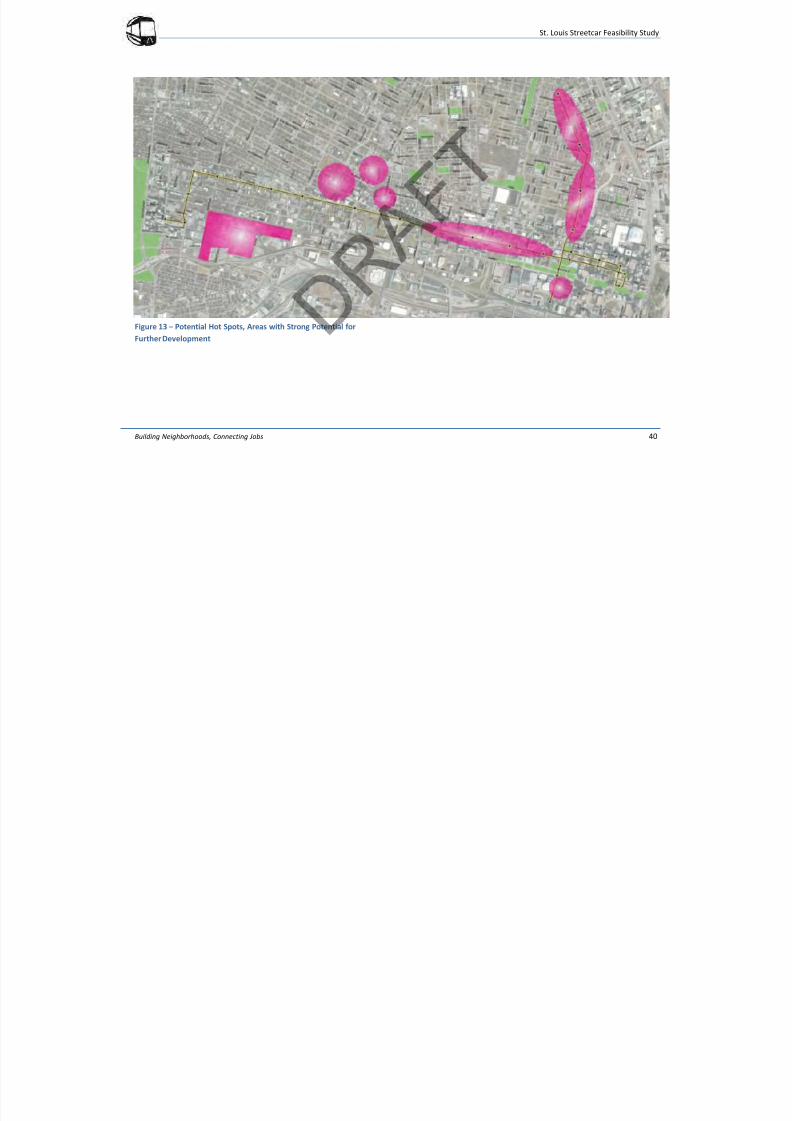
7/29/2019 DRAFT_St. Louis North Side/Downtown/Midtown/CWE Streetcar Feasibility Study 2013
http://slidepdf.com/reader/full/draftst-louis-north-sidedowntownmidtowncwe-streetcar-feasibility-study 44/104
St. Louis Streetcar Feasibility Study
Building Neighborhoods, Connecting Jobs 40
Figure 13 – Potential Hot Spots, Areas with Strong Potential forFurther Development
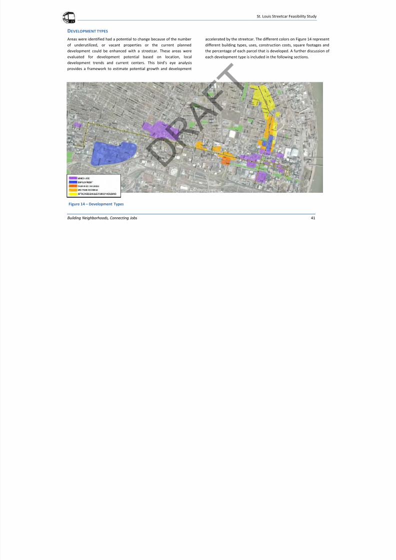
7/29/2019 DRAFT_St. Louis North Side/Downtown/Midtown/CWE Streetcar Feasibility Study 2013
http://slidepdf.com/reader/full/draftst-louis-north-sidedowntownmidtowncwe-streetcar-feasibility-study 45/104
St. Louis Streetcar Feasibility Study
Building Neighborhoods, Connecting Jobs 41
DEVELOPMENT TYPES
Areas were identified had a potential to change because of the number
of underutilized, or vacant properties or the current planned
development could be enhanced with a streetcar. These areas were
evaluated for development potential based on location, local
development trends and current centers. This bird’s eye analysis
provides a framework to estimate potential growth and development
accelerated by the streetcar. The different colors on Figure 14 represent
different building types, uses, construction costs, square footages and
the percentage of each parcel that is developed. A further discussion of
each development type is included in the following sections.
Figure 14 – Development Types
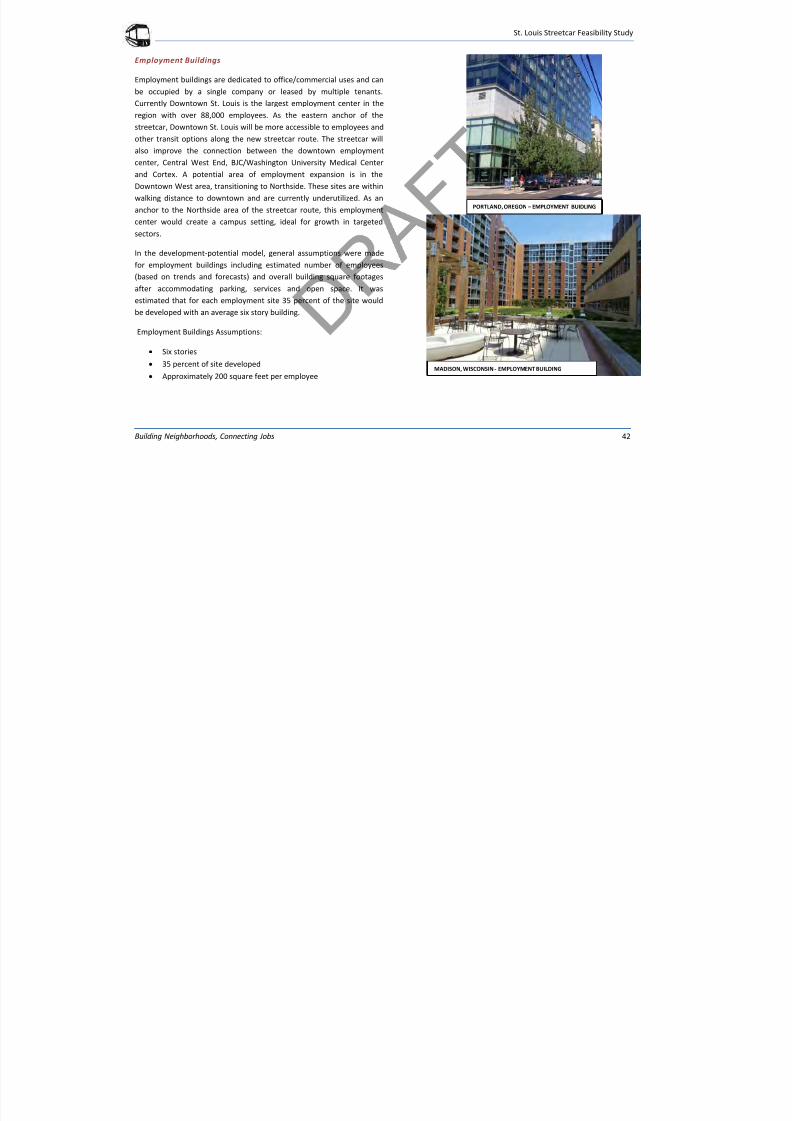
7/29/2019 DRAFT_St. Louis North Side/Downtown/Midtown/CWE Streetcar Feasibility Study 2013
http://slidepdf.com/reader/full/draftst-louis-north-sidedowntownmidtowncwe-streetcar-feasibility-study 46/104
St. Louis Streetcar Feasibility Study
Building Neighborhoods, Connecting Jobs 42
Employment Buildings
Employment buildings are dedicated to office/commercial uses and can
be occupied by a single company or leased by multiple tenants.
Currently Downtown St. Louis is the largest employment center in the
region with over 88,000 employees. As the eastern anchor of the
streetcar, Downtown St. Louis will be more accessible to employees and
other transit options along the new streetcar route. The streetcar will
also improve the connection between the downtown employment
center, Central West End, BJC/Washington University Medical Center
and Cortex. A potential area of employment expansion is in the
Downtown West area, transitioning to Northside. These sites are within
walking distance to downtown and are currently underutilized. As an
anchor to the Northside area of the streetcar route, this employment
center would create a campus setting, ideal for growth in targeted
sectors.
In the development-potential model, general assumptions were made
for employment buildings including estimated number of employees
(based on trends and forecasts) and overall building square footages
after accommodating parking, services and open space. It was
estimated that for each employment site 35 percent of the site would
be developed with an average six story building.
Employment Buildings Assumptions:
Six stories
35 percent of site developed
Approximately 200 square feet per employee
PORTLAND, OREGON – EMPLOYMENT BUIDLING
MADISON, WISCONSIN - EMPLOYMENT BUILDING
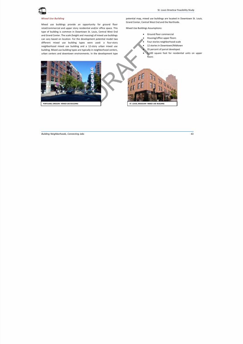
7/29/2019 DRAFT_St. Louis North Side/Downtown/Midtown/CWE Streetcar Feasibility Study 2013
http://slidepdf.com/reader/full/draftst-louis-north-sidedowntownmidtowncwe-streetcar-feasibility-study 47/104
St. Louis Streetcar Feasibility Study
Building Neighborhoods, Connecting Jobs 43
Mixed Use Building
Mixed use buildings provide an opportunity for ground floor
retail/commercial and upper story residential and/or office space. This
type of building is common in Downtown St. Louis, Central West End
and Grand Center. The scale (height and massing) of mixed use buildings
can vary based on location. For the development potential model two
different mixed use building types were used: a four-story
neighborhood mixed use building and a 12-story urban mixed use
building. Mixed use building types are typically in neighborhood centers,
urban centers and downtown environments. In the development type
potential map, mixed use buildings are located in Downtown St. Louis,
Grand Center, Central West End and the Northside.
Mixed Use Buildings Assumptions:
Ground floor commercial Housing/office upper floors
Four stories neighborhood scale
12 stories in Downtown/Midtown
35 percent of parcel developed
1,100 square foot for residential units on upper
floors
PORTLAND, OREGON - MIXED USE BUILDING ST. LOUIS, MISSOURI – MIXED USE BUILDING
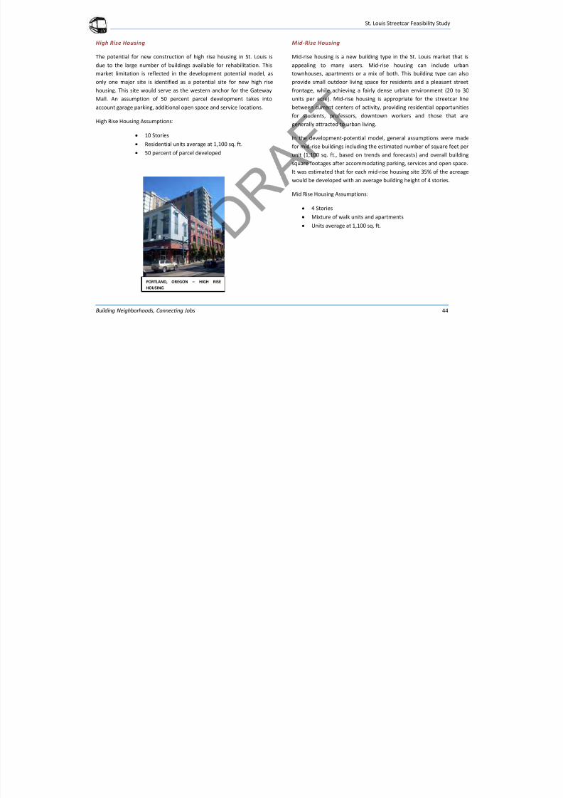
7/29/2019 DRAFT_St. Louis North Side/Downtown/Midtown/CWE Streetcar Feasibility Study 2013
http://slidepdf.com/reader/full/draftst-louis-north-sidedowntownmidtowncwe-streetcar-feasibility-study 48/104
St. Louis Streetcar Feasibility Study
Building Neighborhoods, Connecting Jobs 44
High Rise Housing
The potential for new construction of high rise housing in St. Louis is
due to the large number of buildings available for rehabilitation. This
market limitation is reflected in the development potential model, as
only one major site is identified as a potential site for new high rise
housing. This site would serve as the western anchor for the Gateway
Mall. An assumption of 50 percent parcel development takes into
account garage parking, additional open space and service locations.
High Rise Housing Assumptions:
10 Stories
Residential units average at 1,100 sq. ft.
50 percent of parcel developed
Mid-Rise Housing
Mid-rise housing is a new building type in the St. Louis market that is
appealing to many users. Mid-rise housing can include urban
townhouses, apartments or a mix of both. This building type can also
provide small outdoor living space for residents and a pleasant street
frontage, while achieving a fairly dense urban environment (20 to 30
units per acre). Mid-rise housing is appropriate for the streetcar line
between current centers of activity, providing residential opportunities
for students, professors, downtown workers and those that are
generally attracted to urban living.
In the development-potential model, general assumptions were made
for mid-rise buildings including the estimated number of square feet per
unit (1,100 sq. ft., based on trends and forecasts) and overall buildingsquare footages after accommodating parking, services and open space.
It was estimated that for each mid-rise housing site 35% of the acreage
would be developed with an average building height of 4 stories.
Mid Rise Housing Assumptions:
4 Stories
Mixture of walk units and apartments
Units average at 1,100 sq. ft.
PORTLAND, OREGON – HIGH RISE
HOUSING
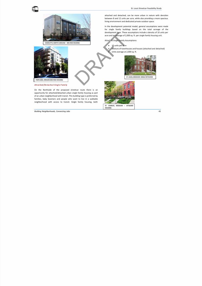
7/29/2019 DRAFT_St. Louis North Side/Downtown/Midtown/CWE Streetcar Feasibility Study 2013
http://slidepdf.com/reader/full/draftst-louis-north-sidedowntownmidtowncwe-streetcar-feasibility-study 49/104
St. Louis Streetcar Feasibility Study
Building Neighborhoods, Connecting Jobs 45
Att ached /De tached Singl e F ami ly
On the Northside of the proposed streetcar route there is an
opportunity for attached/detached urban single family housing as part
of an urban neighborhood with transit. This building type is preferred by
families, baby boomers and people who want to live in a walkable
neighborhood with access to transit. Single family housing, both
attached and detached, can be more urban in nature with densities
between 8 and 12 units per acre, while also providing a more spacious
living environment and dedicated private outdoor space.
In the development potential model, general assumptions were made
for single family buildings based on the total acreage of the
development type. These assumptions include a density of 10 units per
acre and an average of 2,000 sq. ft. per single family housing unit.
Attached Single Family Assumptions:
10 units per acre
Mixture of townhouses and houses (attached and detached)
Units average at 2,000 sq. ft.
PORTLAND, OREGON MID-RISE HOUSING
ST. CHARLES, MISSOURI – ATTACHED
HOUSING
CHARLOTTE, NORTH CAROLINA MID-RISE HOUSING
ST. LOUIS, MISSOURI- SINGLE DETACHED
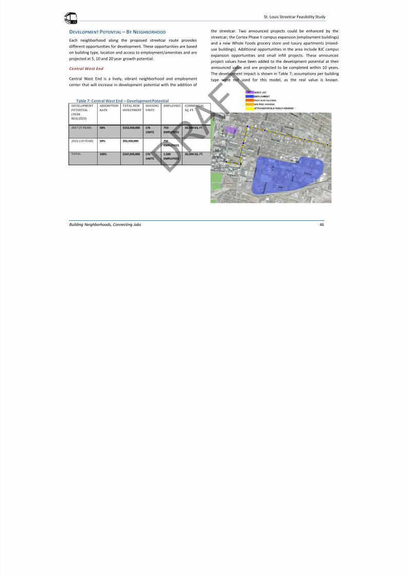
7/29/2019 DRAFT_St. Louis North Side/Downtown/Midtown/CWE Streetcar Feasibility Study 2013
http://slidepdf.com/reader/full/draftst-louis-north-sidedowntownmidtowncwe-streetcar-feasibility-study 50/104
St. Louis Streetcar Feasibility Study
Building Neighborhoods, Connecting Jobs 46
DEVELOPMENT POTENTIAL – BY NEIGHBORHOOD
Each neighborhood along the proposed streetcar route provides
different opportunities for development. These opportunities are based
on building type, location and access to employment/amenities and are
projected at 5, 10 and 20 year growth potential.
Central West End
Central West End is a lively, vibrant neighborhood and employment
center that will increase in development potential with the addition of
the streetcar. Two announced projects could be enhanced by the
streetcar; the Cortex Phase II campus expansion (employment buildings)
and a new Whole Foods grocery store and luxury apartments (mixed-
use buildings). Additional opportunities in the area include BJC campus
expansion opportunities and small infill projects. These announced
project values have been added to the development potential at their
announced value and are projected to be completed within 10 years.
The development impact is shown in Table 7; assumptions per building
type were not used for this model, as the real value is known.
Table 7: Central West End – Development Potential DEVELOPMENT
POTENTIAL
(YEAR
REALIZED)
ABSORPTION
RATE
TOTAL NEW
INVESTMENT
HOUSING
UNITS
EMPLOYEES COMMERCIAL
SQ. FT.
2017 (5 YEAR) 50% $153,500,000 176
UNITS
750
EMPLOYEES
30,000 SQ. FT.
2022 (10 YEAR) 50% $93,500,000 750
EMPLOYEES
TOTAL 100% $247,000,000 176
UNITS
1,500
EMPLOYEES
30,000 SQ. FT.
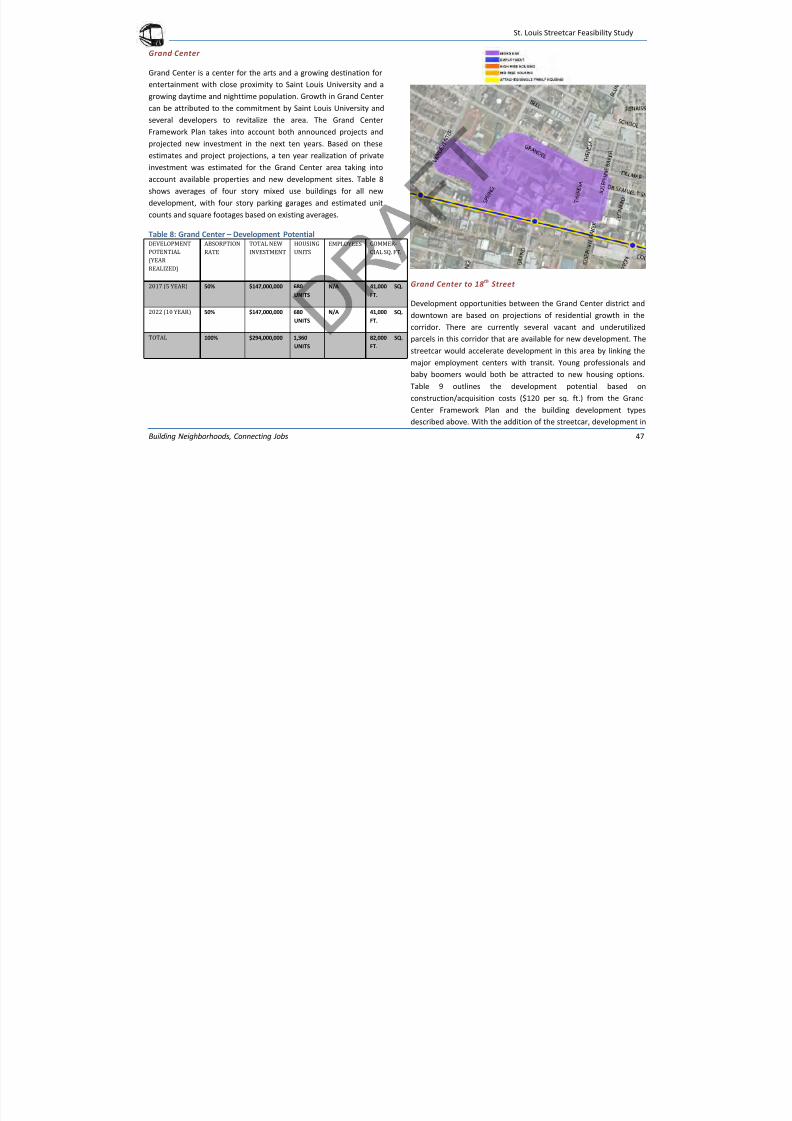
7/29/2019 DRAFT_St. Louis North Side/Downtown/Midtown/CWE Streetcar Feasibility Study 2013
http://slidepdf.com/reader/full/draftst-louis-north-sidedowntownmidtowncwe-streetcar-feasibility-study 51/104
St. Louis Streetcar Feasibility Study
Building Neighborhoods, Connecting Jobs 47
Grand Center
Grand Center is a center for the arts and a growing destination for
entertainment with close proximity to Saint Louis University and a
growing daytime and nighttime population. Growth in Grand Center
can be attributed to the commitment by Saint Louis University and
several developers to revitalize the area. The Grand Center
Framework Plan takes into account both announced projects and
projected new investment in the next ten years. Based on these
estimates and project projections, a ten year realization of private
investment was estimated for the Grand Center area taking into
account available properties and new development sites. Table 8
shows averages of four story mixed use buildings for all new
development, with four story parking garages and estimated unit
counts and square footages based on existing averages.
Table 8: Grand Center – Development PotentialDEVELOPMENT
POTENTIAL
(YEAR
REALIZED)
ABSORPTION
RATE
TOTAL NEW
INVESTMENT
HOUSING
UNITS
EMPLOYEES COMMER-
CIAL SQ. FT.
2017 (5 YEAR) 50% $147,000,000 680
UNITS
N/A 41,000 SQ.
FT.
2022 (10 YEAR) 50% $147,000,000 680
UNITS
N/A 41,000 SQ.
FT.
TOTAL 100% $294,000,000 1,360
UNITS
82,000 SQ.
FT.
Grand Center to 18 th
Street
Development opportunities between the Grand Center district and
downtown are based on projections of residential growth in the
corridor. There are currently several vacant and underutilizedparcels in this corridor that are available for new development. The
streetcar would accelerate development in this area by linking the
major employment centers with transit. Young professionals and
baby boomers would both be attracted to new housing options.
Table 9 outlines the development potential based on
construction/acquisition costs ($120 per sq. ft.) from the Grand
Center Framework Plan and the building development types
described above. With the addition of the streetcar, development in
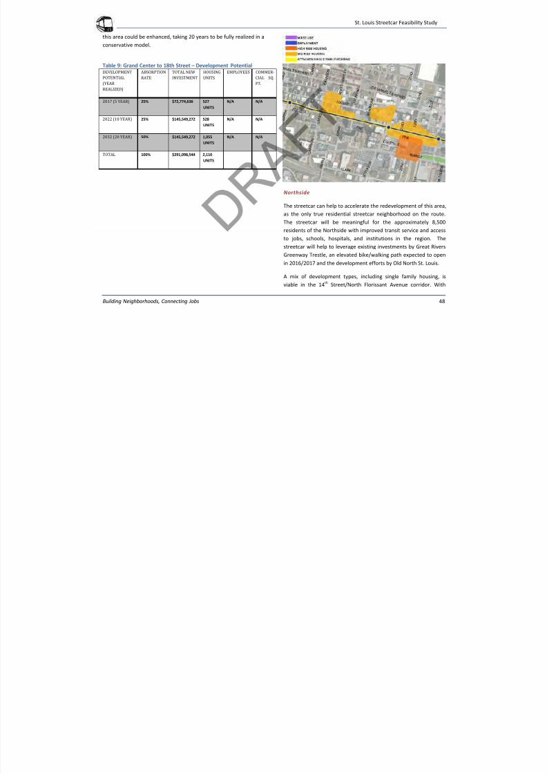
7/29/2019 DRAFT_St. Louis North Side/Downtown/Midtown/CWE Streetcar Feasibility Study 2013
http://slidepdf.com/reader/full/draftst-louis-north-sidedowntownmidtowncwe-streetcar-feasibility-study 52/104
St. Louis Streetcar Feasibility Study
Building Neighborhoods, Connecting Jobs 48
this area could be enhanced, taking 20 years to be fully realized in a
conservative model.
Table 9: Grand Center to 18th Street – Development PotentialDEVELOPMENT
POTENTIAL(YEAR
REALIZED)
ABSORPTION
RATE
TOTAL NEW
INVESTMENT
HOUSING
UNITS
EMPLOYEES COMMER-
CIAL SQ.FT.
2017 (5 YEAR) 25% $72,774,636 527
UNITS
N/A N/A
2022 (10 YEAR) 25% $145,549,272 528
UNITS
N/A N/A
2032 (20 YEAR) 50% $145,549,272 1,055
UNITS
N/A N/A
TOTAL 100% $291,098,544 2,110
UNITS
Northside
The streetcar can help to accelerate the redevelopment of this area,
as the only true residential streetcar neighborhood on the route.
The streetcar will be meaningful for the approximately 8,500
residents of the Northside with improved transit service and access
to jobs, schools, hospitals, and institutions in the region. The
streetcar will help to leverage existing investments by Great Rivers
Greenway Trestle, an elevated bike/walking path expected to open
in 2016/2017 and the development efforts by Old North St. Louis.
A mix of development types, including single family housing, is
viable in the 14th
Street/North Florissant Avenue corridor. With

7/29/2019 DRAFT_St. Louis North Side/Downtown/Midtown/CWE Streetcar Feasibility Study 2013
http://slidepdf.com/reader/full/draftst-louis-north-sidedowntownmidtowncwe-streetcar-feasibility-study 53/104
St. Louis Streetcar Feasibility Study
Building Neighborhoods, Connecting Jobs 49
stops along the north-south route, people have the opportunity to
live, work and play along the streetcar route. The line adds viability
to the redevelopment of the Northside, but it will take more time to
be realized than redevelopment along other areas of the streetcar
line. Table 10 outlines the development potential based on
construction/acquisition costs ($120 per square foot for mid-risehousing and employment buildings and $100 per square foot for 4-
story mixed use buildings and single family housing) from the Grand
Center Framework Plan, as estimated by Lawrence Group, and the
building development types described above. The development in
this area is projected to begin with incremental investment, with 5
percent taking place in the first five years, 35 percent taking place
by 2022 and the additional 60 percent of development taking place
by year 2032.
Table 10: Northside – Development PotentialDEVELOPMENT
POTENTIAL
(YEAR
REALIZED)
ABSORPTION
RATE
TOTAL NEW
INVESTMENT
HOUSING
UNITS
EMPLOYEES COMMER
CIAL SQ.
FT.
2017 (5 YEAR) 5% $31,724,942 153
UNITS
300 5,245 SQ.
FT.
2022 (10 YEAR) 35% $222,074,594 528
UNITS
2,100 36,716
SQ. FT.
2032 (20 YEAR) 60% $380,699,304 1,055
UNITS
3,600 62,942
SQ. FT.
TOTAL 100% $634,498,840 2,110
UNITS
6,000 104,903
SQ. FT.
S L i S F ibili S d
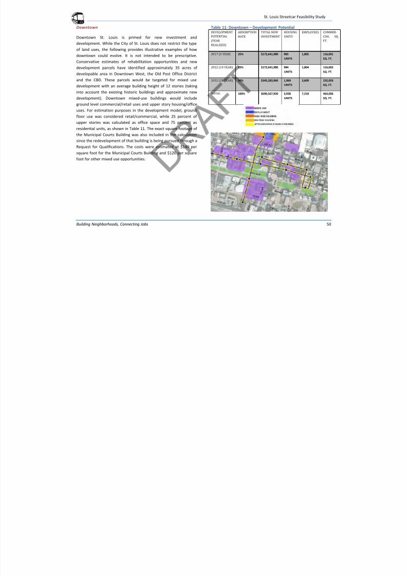
7/29/2019 DRAFT_St. Louis North Side/Downtown/Midtown/CWE Streetcar Feasibility Study 2013
http://slidepdf.com/reader/full/draftst-louis-north-sidedowntownmidtowncwe-streetcar-feasibility-study 54/104
St. Louis Streetcar Feasibility Study
Building Neighborhoods, Connecting Jobs 50
Downtown
Downtown St. Louis is primed for new investment and
development. While the City of St. Louis does not restrict the type
of land uses, the following provides illustrative examples of how
downtown could evolve. It is not intended to be prescriptive.
Conservative estimates of rehabilitation opportunities and new
development parcels have identified approximately 35 acres of
developable area in Downtown West, the Old Post Office District
and the CBD. These parcels would be targeted for mixed use
development with an average building height of 12 stories (taking
into account the existing historic buildings and approximate new
development). Downtown mixed-use buildings would include
ground level commercial/retail uses and upper story housing/office
uses. For estimation purposes in the development model, ground
floor use was considered retail/commercial, while 25 percent of
upper stories was calculated as office space and 75 percent as
residential units, as shown in Table 11. The exact square footage of
the Municipal Courts Building was also included in the calculation
since the redevelopment of that building is being pursued through a
Request for Qualifications. The costs were estimated at $140 per
square foot for the Municipal Courts Building and $120 per square
foot for other mixed use opportunities.
Table 11: Downtown – Development PotentialDEVELOPMENT
POTENTIAL
(YEAR
REALIZED)
ABSORPTION
RATE
TOTAL NEW
INVESTMENT
HOUSING
UNITS
EMPLOYEES COMMER-
CIAL SQ.
FT.
2017 (5 YEAR) 25% $172,641,980 985
UNITS
1,805 116,001
SQ. FT.
2022 (10 YEAR) 25% $172,641,980 984
UNITS
1,804 116,002
SQ. FT.
2032 (20 YEAR) 50% $345,283,960 1,969
UNITS
3,609 232,003
SQ. FT.
TOTAL 100% $690,567,920 3,938
UNITS
7,218 464,006
SQ. FT.
St L i St t F ibilit St d
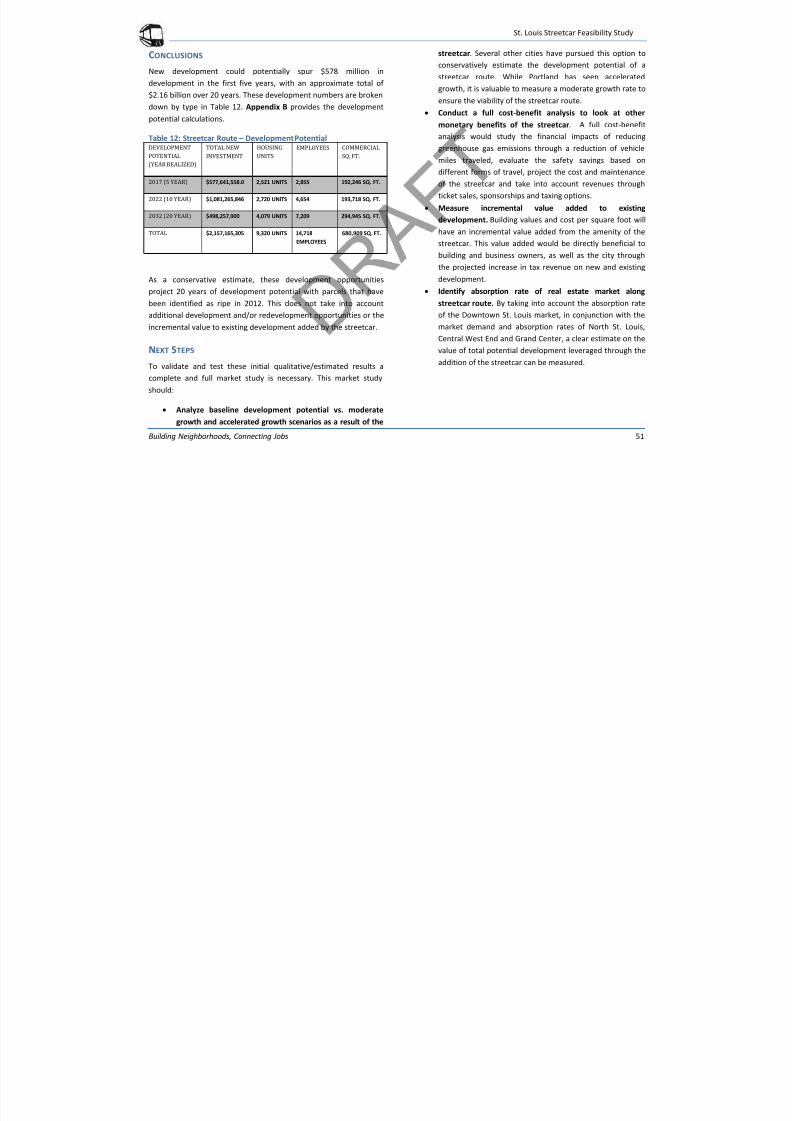
7/29/2019 DRAFT_St. Louis North Side/Downtown/Midtown/CWE Streetcar Feasibility Study 2013
http://slidepdf.com/reader/full/draftst-louis-north-sidedowntownmidtowncwe-streetcar-feasibility-study 55/104
St. Louis Streetcar Feasibility Study
Building Neighborhoods, Connecting Jobs 51
CONCLUSIONS
New development could potentially spur $578 million in
development in the first five years, with an approximate total of
$2.16 billion over 20 years. These development numbers are broken
down by type in Table 12. Appendix B provides the development
potential calculations.
Table 12: Streetcar Route – Development PotentialDEVELOPMENT
POTENTIAL
(YEAR REALIZED)
TOTAL NEW
INVESTMENT
HOUSING
UNITS
EMPLOYEES COMMERCIAL
SQ. FT.
2017 (5 YEAR) $577,641,558.0 2,521 UNITS 2,855 192,246 SQ. FT.
2022 (10 YEAR) $1,081,265,846 2,720 UNITS 4,654 193,718 SQ. FT.
2032 (20 YEAR) $498,257,900 4,079 UNITS 7,209 294,945 SQ. FT.
TOTAL $2,157,165,305 9,320 UNITS 14,718
EMPLOYEES
680,909 SQ. FT.
As a conservative estimate, these development opportunities
project 20 years of development potential with parcels that have
been identified as ripe in 2012. This does not take into account
additional development and/or redevelopment opportunities or the
incremental value to existing development added by the streetcar.
NEXT STEPS
To validate and test these initial qualitative/estimated results a
complete and full market study is necessary. This market study
should:
Analyze baseline development potential vs. moderate
growth and accelerated growth scenarios as a result of the
streetcar. Several other cities have pursued this option to
conservatively estimate the development potential of a
streetcar route. While Portland has seen accelerated
growth, it is valuable to measure a moderate growth rate to
ensure the viability of the streetcar route.
Conduct a full cost-benefit analysis to look at othermonetary benefits of the streetcar. A full cost-benefit
analysis would study the financial impacts of reducing
greenhouse gas emissions through a reduction of vehicle
miles traveled, evaluate the safety savings based on
different forms of travel, project the cost and maintenance
of the streetcar and take into account revenues through
ticket sales, sponsorships and taxing options.
Measure incremental value added to existing
development. Building values and cost per square foot willhave an incremental value added from the amenity of the
streetcar. This value added would be directly beneficial to
building and business owners, as well as the city through
the projected increase in tax revenue on new and existing
development.
Identify absorption rate of real estate market along
streetcar route. By taking into account the absorption rate
of the Downtown St. Louis market, in conjunction with the
market demand and absorption rates of North St. Louis,Central West End and Grand Center, a clear estimate on the
value of total potential development leveraged through the
addition of the streetcar can be measured.
St L i St t F ibilit St d
7/29/2019 DRAFT_St. Louis North Side/Downtown/Midtown/CWE Streetcar Feasibility Study 2013
http://slidepdf.com/reader/full/draftst-louis-north-sidedowntownmidtowncwe-streetcar-feasibility-study 56/104
St. Louis Streetcar Feasibility Study
Building Neighborhoods, Connecting Jobs 52
STREETSCAPING
The St. Louis Streetcar provides an opportunity to invest in the two
corridors and spur new private development. The streetscaping
elements are complementary to the streetcar system. While the
benefits of streetscaping can be significant, particularly in areas of
disinvestment, they may or may not be directly part of the St. Louis
Streetcar project. The level of streetscaping implementation will be
directly impacted by the funding available for the project. Form
based code is being implemented in Central West End and being
considered in downtown. This will also impact streetscaping and
development potential.
COMPONENTS OF STREETSCAPING
On-Street ParkingOn-street parking is a vital component to a successful street. On-
street parking serves several functions in addition to parking for
shoppers, visitors, and residents of the adjacent development. It
provides a buffer for pedestrians and promotes walkability along
the corridor. On a streetcar corridor, on-street parking is a
component of transforming the character of the corridor and
connecting users to the streetcar. In St. Louis, on-street parking is a
necessary amenity at the mixed-use centers along the streetcar line:
downtown, Midtown, Northside, Grand Center and Central WestEnd.
Bike Facilities
Bike facilities on the streetcar corridor help to connect users to the
streetcar and encourage a diversity of transportation modes. With
modern streetcar routes, there are several conflicts between
streetcars and bikes that have made the integration complicated
with new streetcar systems. The type of bike facility must be
integrated into the design. Whether or not there is a parallel route
or specific bike facilities is a decision that should be made during
the design process through an evaluation of priorities and
development opportunities. There are several options for bike
facilities including options for a two-way cycle track, bike lanes orsharrow markings. Considerations must also be made for streetcar
track and bike facilities conflicts. Other cities have used an
informational campaign to build awareness for the streetcar -cyclist
conflicts. St. Louis should engage the local cycling community early
in the process to build support and design an integrated network.
Sidewalks
Sidewalks are an essential component of any streetscaping project.
Sidewalks on an urban, transit corridor should be as wide as
possible to provide opportunities for outdoor dining, high
pedestrian traffic and landscaping. Buildings should be built up to
the back of sidewalk in the mixed-use centers along the streetcar
corridor. Texture changes in pavement types on sidewalks add
aesthetic value to the streetscape, therefore improving the private
investment value. Along the St. Louis Streetcar route, sidewalks
should be 10 feet wide at a minimum, including landscaping. For
outdoor dining to be successful a sidewalk should be a minimum of
16 feet wide. The sidewalks can grow on the streetcar line through
changes in setbacks and build-to lines or in changes to on-street
parking.
Street Trees and Landscaping
Street trees and landscaping serve a variety of functions in the
streetscape. Landscaping provides an aesthetic to streets, as well as
a safety benefit to pedestrians to add separation between the travel
and parking lanes and the sidewalk. Street trees provide an
St Louis Streetcar Feasibility Study
7/29/2019 DRAFT_St. Louis North Side/Downtown/Midtown/CWE Streetcar Feasibility Study 2013
http://slidepdf.com/reader/full/draftst-louis-north-sidedowntownmidtowncwe-streetcar-feasibility-study 57/104
St. Louis Streetcar Feasibility Study
Building Neighborhoods, Connecting Jobs 53
environmental benefit also by reducing the carbon dioxide and heat
island effect found in urban environments. Essential to the life of
street trees is providing adequate infrastructure and space to
support the health of trees and landscaping. Tree selection and
planter type also adds to the urban character. A grated tree well
with a continuous sidewalk is typical of an urban environment andtransit corridor. This is most appropriate for the streetcar corridor.
Fixtures and Wayfinding
Additional amenities for pedestrians, including appropriately scaled
light fixtures, benches and wayfinding signs, add value to the
streetscape by improving safety, providing wayfinding information
and spots to enjoy the street. Selecting these amenities provides an
enhancement to the streetcar line; therefore specific care should be
taken when selecting the style of fixtures and street furniture. There
are two major options for street furniture selection that can be
explored as part of the streetcar process: one option is to create a
template for the entire streetcar corridor. Another option is to work
with each community along the route to create their own aesthetic
and palette unique to each neighborhood. Either option is viable
and can be an opportunity for creativity along the streetcar route.
Convention and Visitors Commission (CVC) has started a wayfinding
program for St. Louis. These street signs could be utilized for
streetcar wayfinding.
GREEN INFRASTRUCTURE
Along the streetcar route, there is an opportunity for green
infrastructure improvements in the streetscape to enhance the
water quality in the region by increasing infiltration and incremental
remediation. Green infrastructure is simple to incorporate with
other streetscape improvements and can add additional value to
property on the streetcar line. Typical types of green infrastructure
are further discussed below. St. Louis is currently adopting a
Sustainability Plan that will be used as a guide in future phases of
the project.
Stormwater Improvements
Bioswales and Rain GardensBioswales and rain gardens can be incorporated at the block scale
and into the streetscape along the streetcar route. Typically a
bioswale is included as part of the landscaping. Native vegetation is
necessary in a bioswale, as rainwater is directed to the bioswale
with provisions provided for an overflow scenario. There are a
variety of types of bioswales ranging from urban to rural. Those
most appropriate for the St. Louis Streetcar route are more urban in
character and are typically found in tree wells. Rain gardens are
most typically block scale improvements that channel water into acentral location, allowing it to filter into the ground before entering
into the greater stormwater system.
Pervious Sidewalks and Parking
To provide additional filtration, cities are incorporating pervious
pavements and pavers into their sidewalks and parking areas. With
less constant load, parking areas and sidewalks provide additional
space for infiltration without the maintenance associated with
pervious materials on travel lanes with frequent truck traffic and
high load volumes.
Turf Streetcar Track
A turf streetcar track is the best way to provide additional filtration
opportunities for stormwater within the streetcar corridor.
Commonplace in Europe, a turf track adds environmental benefits,
as well as providing a dedicated lane to the streetcar, decreasing
St Louis Streetcar Feasibility Study
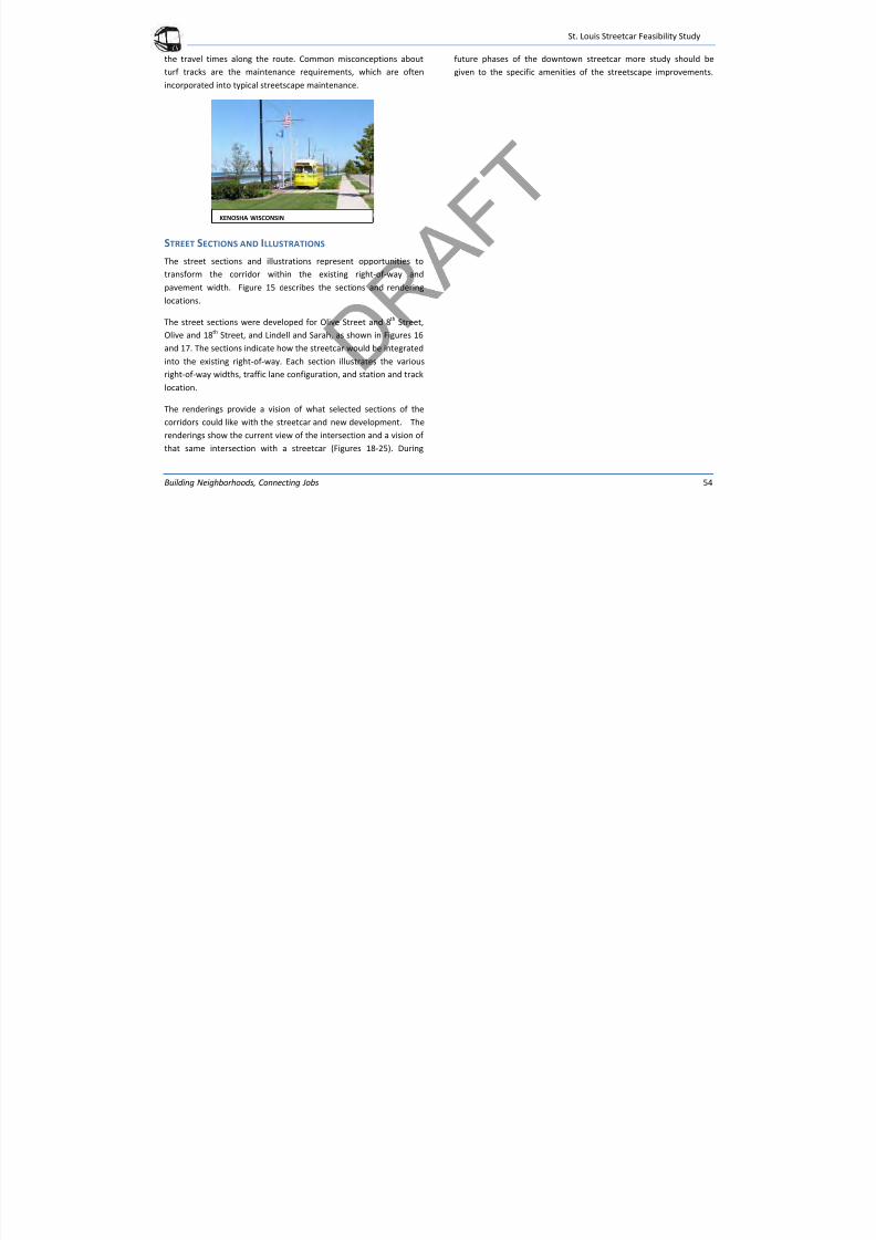
7/29/2019 DRAFT_St. Louis North Side/Downtown/Midtown/CWE Streetcar Feasibility Study 2013
http://slidepdf.com/reader/full/draftst-louis-north-sidedowntownmidtowncwe-streetcar-feasibility-study 58/104
St. Louis Streetcar Feasibility Study
Building Neighborhoods, Connecting Jobs 54
the travel times along the route. Common misconceptions about
turf tracks are the maintenance requirements, which are often
incorporated into typical streetscape maintenance.
STREET SECTIONS AND ILLUSTRATIONS
The street sections and illustrations represent opportunities to
transform the corridor within the existing right-of-way and
pavement width. Figure 15 describes the sections and rendering
locations.
The street sections were developed for Olive Street and 8th
Street,
Olive and 18th Street, and Lindell and Sarah, as shown in Figures 16
and 17. The sections indicate how the streetcar would be integrated
into the existing right-of-way. Each section illustrates the variousright-of-way widths, traffic lane configuration, and station and track
location.
The renderings provide a vision of what selected sections of the
corridors could like with the streetcar and new development. The
renderings show the current view of the intersection and a vision of
that same intersection with a streetcar (Figures 18-25). During
future phases of the downtown streetcar more study should be
given to the specific amenities of the streetscape improvements.
KENOSHA WISCONSIN
St Louis Streetcar Feasibility Study
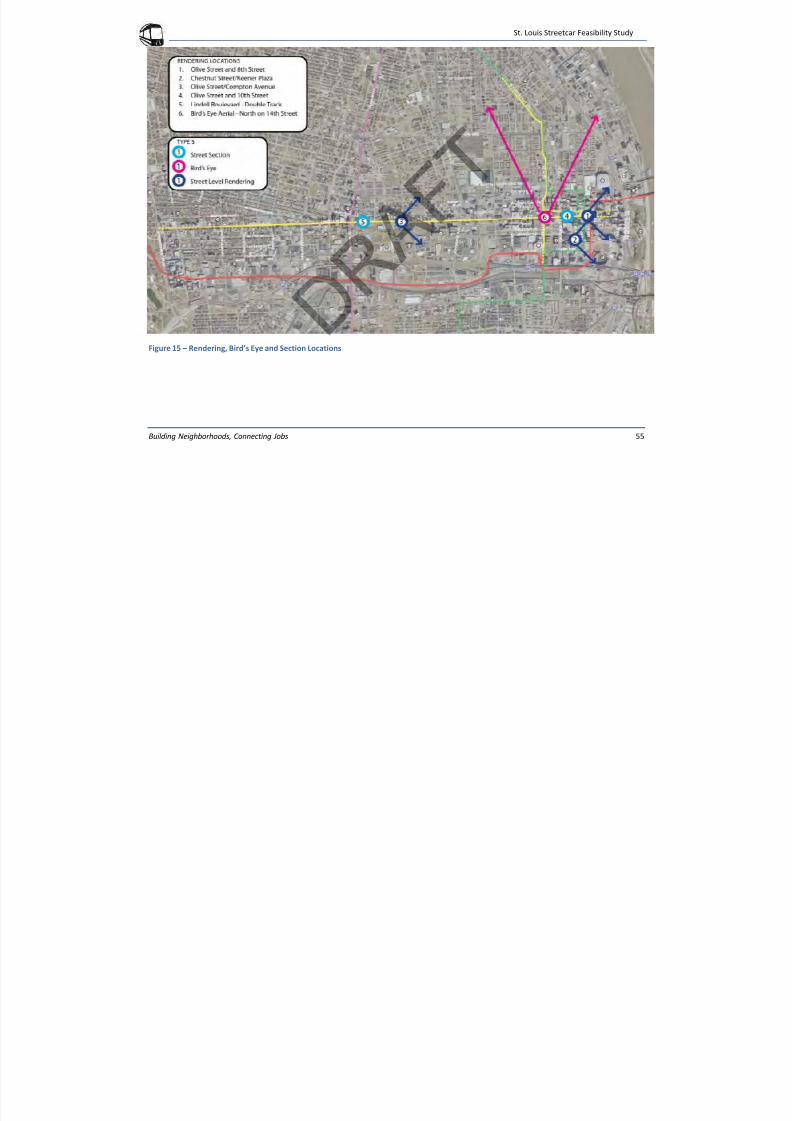
7/29/2019 DRAFT_St. Louis North Side/Downtown/Midtown/CWE Streetcar Feasibility Study 2013
http://slidepdf.com/reader/full/draftst-louis-north-sidedowntownmidtowncwe-streetcar-feasibility-study 59/104
St. Louis Streetcar Feasibility Study
Building Neighborhoods, Connecting Jobs 55
Figure 15 – Rendering, Bird’s Eye and Section Locations
St Louis Streetcar Feasibility Study
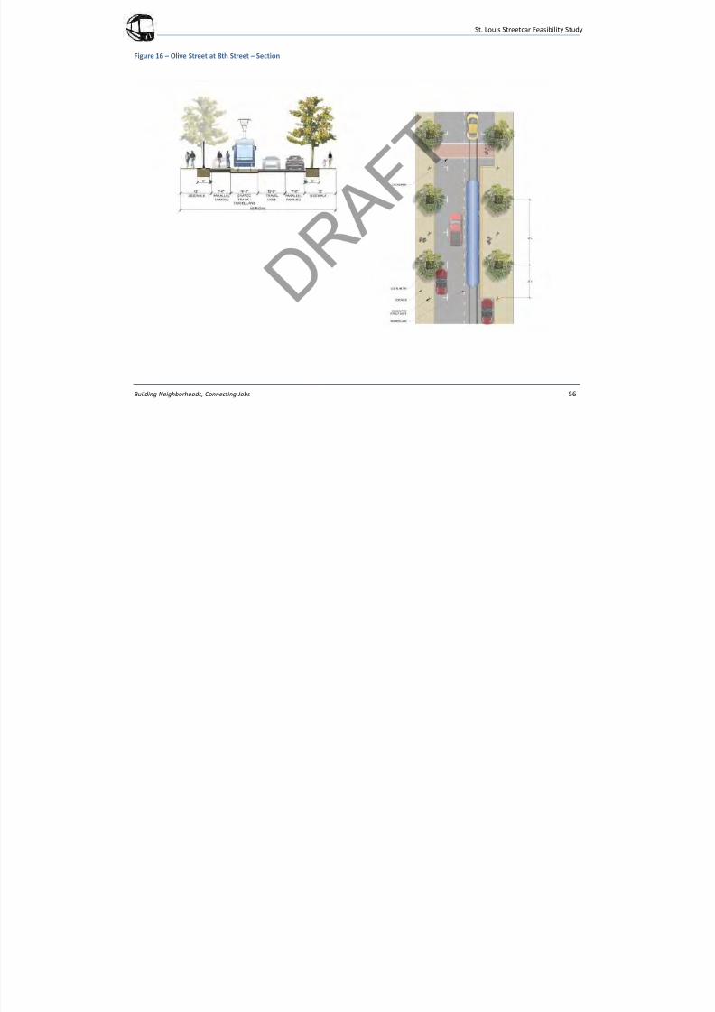
7/29/2019 DRAFT_St. Louis North Side/Downtown/Midtown/CWE Streetcar Feasibility Study 2013
http://slidepdf.com/reader/full/draftst-louis-north-sidedowntownmidtowncwe-streetcar-feasibility-study 60/104
St. Louis Streetcar Feasibility Study
Building Neighborhoods, Connecting Jobs 56
Figure 16 – Olive Street at 8th Street – Section
St Louis Streetcar Feasibility Study
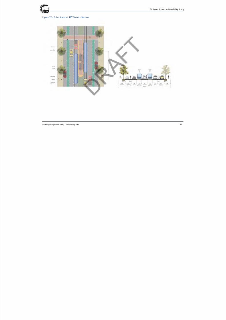
7/29/2019 DRAFT_St. Louis North Side/Downtown/Midtown/CWE Streetcar Feasibility Study 2013
http://slidepdf.com/reader/full/draftst-louis-north-sidedowntownmidtowncwe-streetcar-feasibility-study 61/104
St. Louis Streetcar Feasibility Study
Building Neighborhoods, Connecting Jobs 57
Figure 17 – Olive Street at 18th
Street – Section
St. Louis Streetcar Feasibility Study
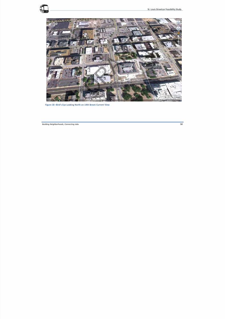
7/29/2019 DRAFT_St. Louis North Side/Downtown/Midtown/CWE Streetcar Feasibility Study 2013
http://slidepdf.com/reader/full/draftst-louis-north-sidedowntownmidtowncwe-streetcar-feasibility-study 62/104
St. Louis Streetcar Feasibility Study
Building Neighborhoods, Connecting Jobs 58
Figure 18 –Bird’s Eye Looking North on 14th Street: Current View
St. Louis Streetcar Feasibility Study
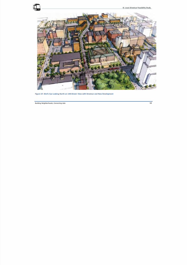
7/29/2019 DRAFT_St. Louis North Side/Downtown/Midtown/CWE Streetcar Feasibility Study 2013
http://slidepdf.com/reader/full/draftst-louis-north-sidedowntownmidtowncwe-streetcar-feasibility-study 63/104
y y
Building Neighborhoods, Connecting Jobs 59
Figure 19 –Bird’s Eye Looking North on 14th Street: View with Streetcar and New Development
St. Louis Streetcar Feasibility Study
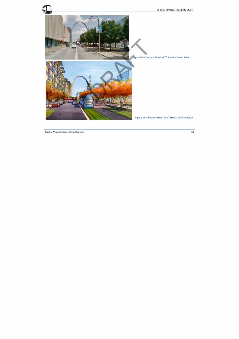
7/29/2019 DRAFT_St. Louis North Side/Downtown/Midtown/CWE Streetcar Feasibility Study 2013
http://slidepdf.com/reader/full/draftst-louis-north-sidedowntownmidtowncwe-streetcar-feasibility-study 64/104
y y
Building Neighborhoods, Connecting Jobs 60
Figure 21 –Chestnut Street at 7th Street: With Streetcar
Figure 20 –Chestnut Street at 7th
Street: Current View
St. Louis Streetcar Feasibility Study
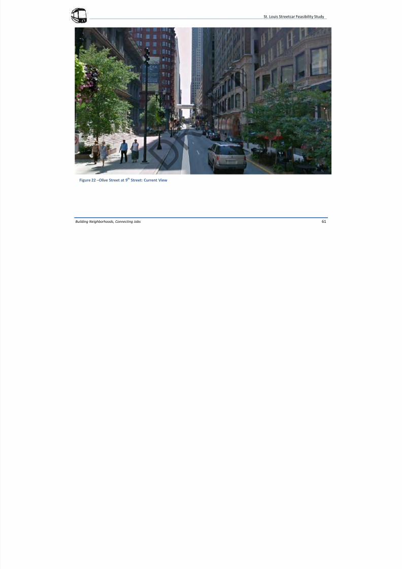
7/29/2019 DRAFT_St. Louis North Side/Downtown/Midtown/CWE Streetcar Feasibility Study 2013
http://slidepdf.com/reader/full/draftst-louis-north-sidedowntownmidtowncwe-streetcar-feasibility-study 65/104
y y
Building Neighborhoods, Connecting Jobs 61
Figure 22 –Olive Street at 9th
Street: Current View
St. Louis Streetcar Feasibility Study
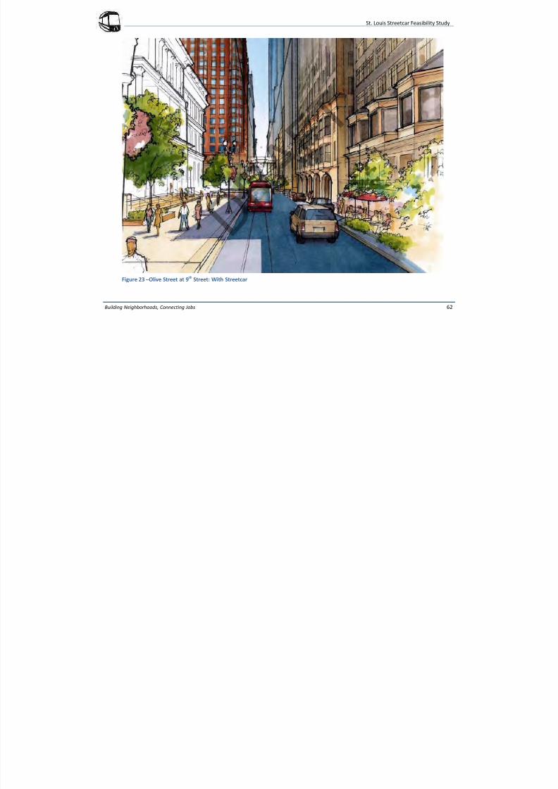
7/29/2019 DRAFT_St. Louis North Side/Downtown/Midtown/CWE Streetcar Feasibility Study 2013
http://slidepdf.com/reader/full/draftst-louis-north-sidedowntownmidtowncwe-streetcar-feasibility-study 66/104
Building Neighborhoods, Connecting Jobs 62
Figure 23 –Olive Street at 9th Street: With Streetcar
St. Louis Streetcar Feasibility Study
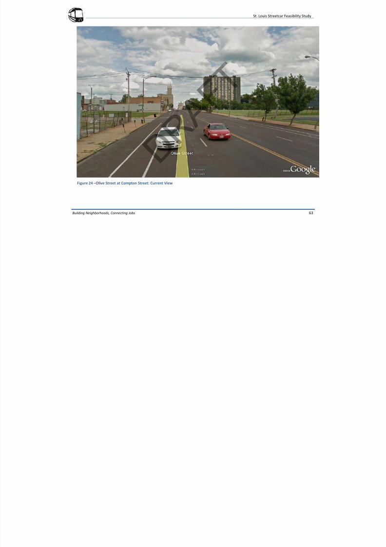
7/29/2019 DRAFT_St. Louis North Side/Downtown/Midtown/CWE Streetcar Feasibility Study 2013
http://slidepdf.com/reader/full/draftst-louis-north-sidedowntownmidtowncwe-streetcar-feasibility-study 67/104
Building Neighborhoods, Connecting Jobs 63
Figure 24 –Olive Street at Compton Street: Current View
St. Louis Streetcar Feasibility Study
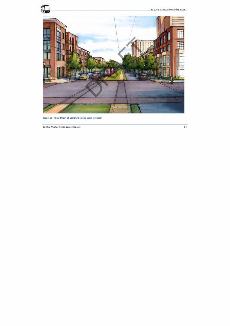
7/29/2019 DRAFT_St. Louis North Side/Downtown/Midtown/CWE Streetcar Feasibility Study 2013
http://slidepdf.com/reader/full/draftst-louis-north-sidedowntownmidtowncwe-streetcar-feasibility-study 68/104
Building Neighborhoods, Connecting Jobs 64
Figure 25 –Olive Street at Compton Street: With Streetcar
St. Louis Streetcar Feasibility Study
7/29/2019 DRAFT_St. Louis North Side/Downtown/Midtown/CWE Streetcar Feasibility Study 2013
http://slidepdf.com/reader/full/draftst-louis-north-sidedowntownmidtowncwe-streetcar-feasibility-study 69/104
Building Neighborhoods, Connecting Jobs 65
GUIDEWAY
For the purposes of this study, only the general location of the streetcar
guideway within the street right-of-way was determined. More specific
alignment geometry will be developed in the environmental analysis
phase of the project. Described below are the typical guidewayelements considered during this feasibility phase.
The guideway consists of the physical track and systems elements
needed to guide and power the streetcar vehicle. Two types of
guideway are anticipated, non-exclusive and semi-exclusive. Non-
exclusive guideway is located in a shared traffic lane used by both
streetcars and motor vehicles. Semi-exclusive guideway is located in a
transit only lane which is not to be shared with motor vehicles. Most of
the proposed streetcar system will use non-exclusive guideways except
for the portion of Olive Street from 14th Street to Grand Boulevard,
where the existing right-of-way is wide enough for a semi-exclusive
right-of-way.
Non-exclusive guideway typically consists of two tracks embedded in an
eight-foot wide concrete track slab placed flush with the roadway. Semi-
exclusive guideway typically consists of two tracks embedded in
concrete and located in the center median of the roadway. This
guideway would be approximately 24-feet wide and separated from the
roadway by continuous raised trackway curbs except throughintersections. In both cases the rails are also encased in an elastomeric
material that provides electrical isolation and vibration dampening.
SPECIAL TRACKWORK
Special trackwork (turnouts and diamond crossings) will be required at
all terminal stations to allow vehicles to reverse direction and at the
track junctions on 14th Street to allow vehicles to make the required
movements in and out of the downtown loop. All turnouts would be
powered and signalized. Tracks for the streetcar are the same gauge as
light-rail. If in the future, the region wanted to use either or both
corridors for light-rail, the existing infrastructure may be able to be
utilized.
TRAFFIC SIGNALS
Streetcars will operate on both non-exclusive and semi-exclusive
guideways. Intersections with non-exclusive guideways will be
controlled primarily by traffic signals and in certain instances four-way
stops may be used. If the streetcar must turn at an intersection with a
transit only traffic signal phase, additional train control equipment may
be required. Intersections with semi-exclusive guideways will also
require additional traffic phases. If left turns by motor vehicles are
allowed, additional train control equipment will also be required to
control the streetcar movements. It has not been determined at this
time if the streetcar movement will be given priority at semi-exclusive
intersections to maintain headways and schedules during revenue
service. A detailed traffic analysis will be performed in the next phase of
the project to determine if priority is needed.
TRACTION POWER
The streetcar vehicle will be electrically powered with the necessary
current provided by an overhead contact system (OCS) that is fed by a
series of traction power substations (TPSS) located at intervals along the
alignment. It is proposed that the streetcar system use low-power
“feeder-less” substations which are smaller and easier to site than
conventional substations. The number and spacing of the substations
St. Louis Streetcar Feasibility Study
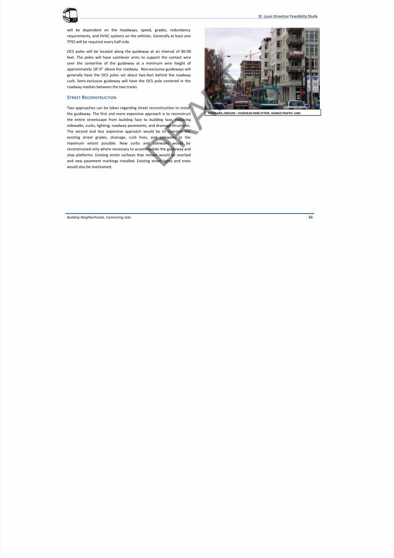
7/29/2019 DRAFT_St. Louis North Side/Downtown/Midtown/CWE Streetcar Feasibility Study 2013
http://slidepdf.com/reader/full/draftst-louis-north-sidedowntownmidtowncwe-streetcar-feasibility-study 70/104
Building Neighborhoods, Connecting Jobs 66
will be dependent on the headways, speed, grades, redundancy
requirements, and HVAC systems on the vehicles. Generally at least one
TPSS will be required every half mile.
OCS poles will be located along the guideway at an interval of 80-90
feet. The poles will have cantilever arms to support the contact wireover the centerline of the guideway at a minimum wire height of
approximately 18’-0” above the roadway. Non-exclusive guideways will
generally have the OCS poles set about two-feet behind the roadway
curb. Semi-exclusive guideway will have the OCS pole centered in the
roadway median between the two tracks.
STREET RECONSTRUCTION
Two approaches can be taken regarding street reconstruction to install
the guideway. The first and more expensive approach is to reconstruct
the entire streetscape from building face to building face, replacing
sidewalks, curbs, lighting, roadway pavements, and drainage structures.
The second and less expensive approach would be to maintain the
existing street grades, drainage, curb lines, and sidewalks to the
maximum extent possible. New curbs and sidewalks would be
reconstructed only where necessary to accommodate the guideway and
stop platforms. Existing street surfaces that remain would be overlaid
and new pavement markings installed. Existing street lights and trees
would also be maintained.
PORTLAND, OREGON – OVERHEAD WIRE SYTEM , SHARED TRAFFIC LANE
St. Louis Streetcar Feasibility Study
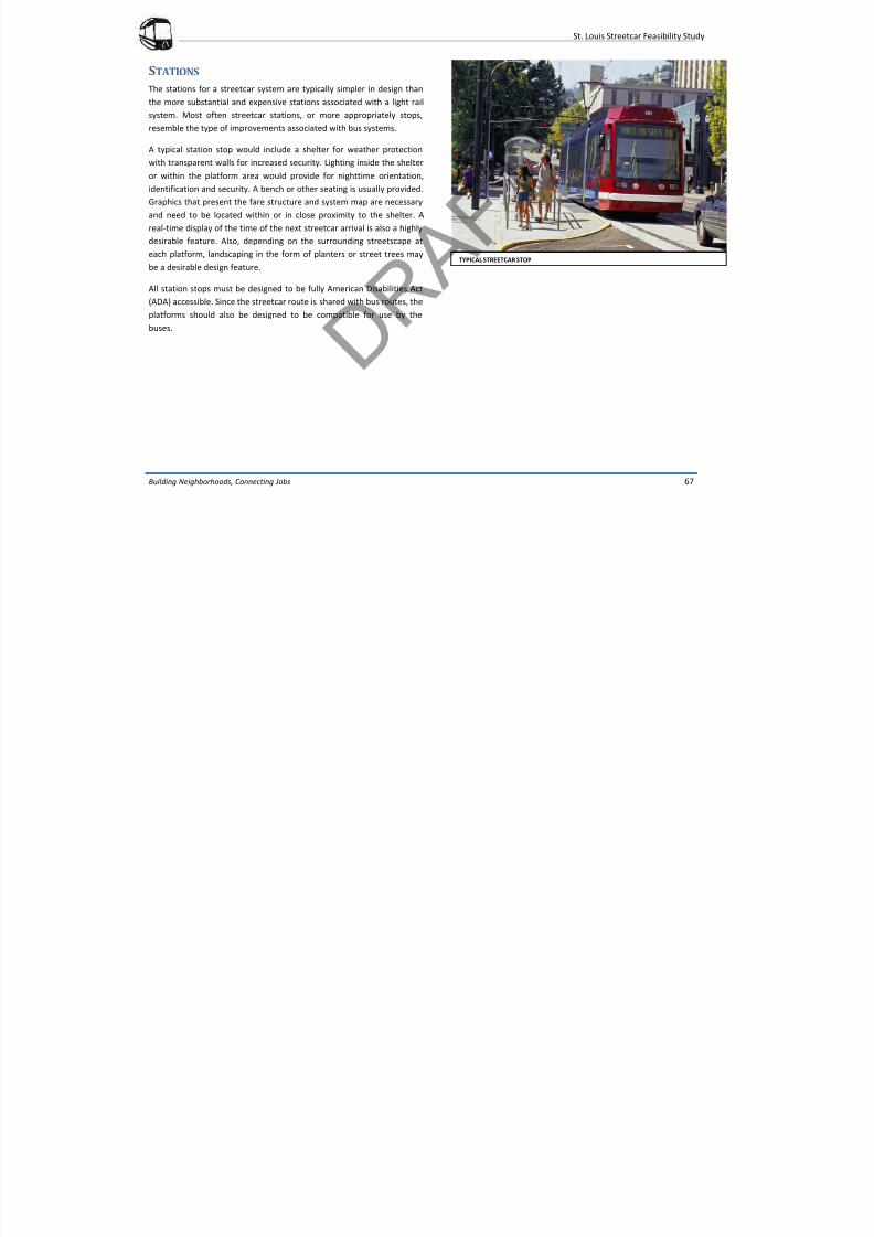
7/29/2019 DRAFT_St. Louis North Side/Downtown/Midtown/CWE Streetcar Feasibility Study 2013
http://slidepdf.com/reader/full/draftst-louis-north-sidedowntownmidtowncwe-streetcar-feasibility-study 71/104
Building Neighborhoods, Connecting Jobs 67
STATIONS
The stations for a streetcar system are typically simpler in design than
the more substantial and expensive stations associated with a light rail
system. Most often streetcar stations, or more appropriately stops,
resemble the type of improvements associated with bus systems.
A typical station stop would include a shelter for weather protection
with transparent walls for increased security. Lighting inside the shelter
or within the platform area would provide for nighttime orientation,
identification and security. A bench or other seating is usually provided.
Graphics that present the fare structure and system map are necessary
and need to be located within or in close proximity to the shelter. A
real-time display of the time of the next streetcar arrival is also a highly
desirable feature. Also, depending on the surrounding streetscape ateach platform, landscaping in the form of planters or street trees may
be a desirable design feature.
All station stops must be designed to be fully American Disabilities Act
(ADA) accessible. Since the streetcar route is shared with bus routes, the
platforms should also be designed to be compatible for use by the
buses.
TYPICAL STREETCAR STOP
St. Louis Streetcar Feasibility Study
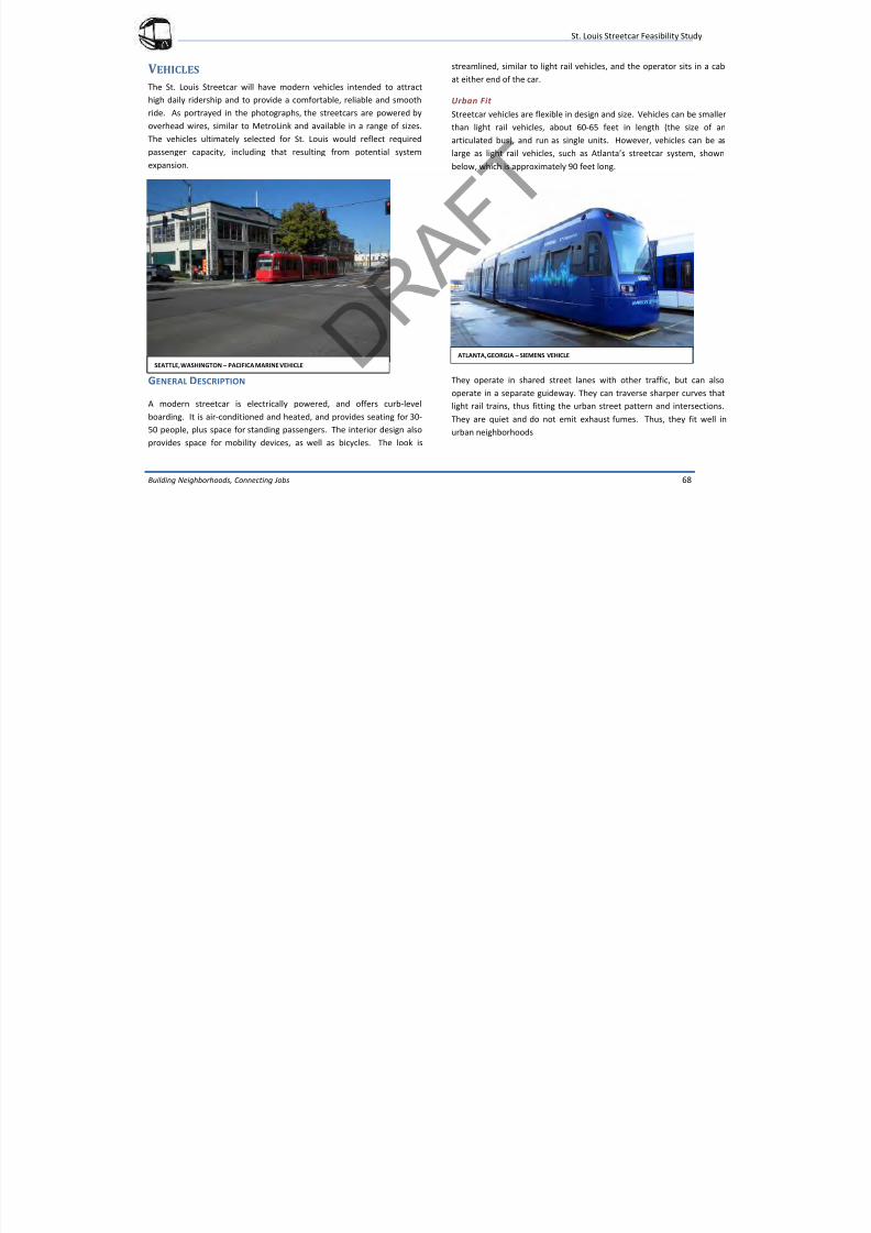
7/29/2019 DRAFT_St. Louis North Side/Downtown/Midtown/CWE Streetcar Feasibility Study 2013
http://slidepdf.com/reader/full/draftst-louis-north-sidedowntownmidtowncwe-streetcar-feasibility-study 72/104
Building Neighborhoods, Connecting Jobs 68
V EHICLES
The St. Louis Streetcar will have modern vehicles intended to attract
high daily ridership and to provide a comfortable, reliable and smooth
ride. As portrayed in the photographs, the streetcars are powered by
overhead wires, similar to MetroLink and available in a range of sizes.The vehicles ultimately selected for St. Louis would reflect required
passenger capacity, including that resulting from potential system
expansion.
GENERAL DESCRIPTION
A modern streetcar is electrically powered, and offers curb-level
boarding. It is air-conditioned and heated, and provides seating for 30-
50 people, plus space for standing passengers. The interior design also
provides space for mobility devices, as well as bicycles. The look is
streamlined, similar to light rail vehicles, and the operator sits in a cab
at either end of the car.
Urban Fit
Streetcar vehicles are flexible in design and size. Vehicles can be smaller
than light rail vehicles, about 60-65 feet in length (the size of anarticulated bus), and run as single units. However, vehicles can be as
large as light rail vehicles, such as Atlanta’s streetcar system, shown
below, which is approximately 90 feet long.
They operate in shared street lanes with other traffic, but can also
operate in a separate guideway. They can traverse sharper curves that
light rail trains, thus fitting the urban street pattern and intersections.
They are quiet and do not emit exhaust fumes. Thus, they fit well in
urban neighborhoods
SEATTLE, WASHINGTON – PACIFICA MARINE VEHICLE
ATLANTA, GEORGIA – SIEMENS VEHICLE
St. Louis Streetcar Feasibility Study
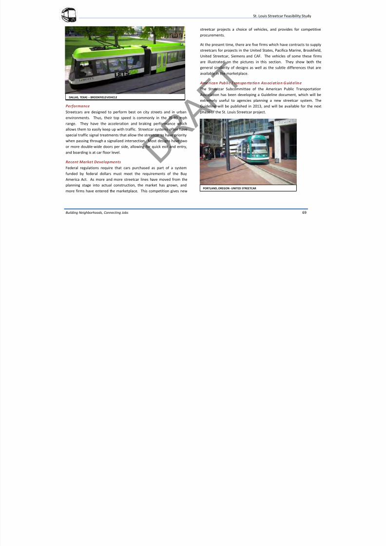
7/29/2019 DRAFT_St. Louis North Side/Downtown/Midtown/CWE Streetcar Feasibility Study 2013
http://slidepdf.com/reader/full/draftst-louis-north-sidedowntownmidtowncwe-streetcar-feasibility-study 73/104
Building Neighborhoods, Connecting Jobs 69
DALLAS, TEXAS – BROOKFIELD VEHICLE
Performance
Streetcars are designed to perform best on city streets and in urban
environments. Thus, their top speed is commonly in the 35-40 mph
range. They have the acceleration and braking performance which
allows them to easily keep up with traffic. Streetcar systems often have
special traffic signal treatments that allow the streetcar to have priority
when passing through a signalized intersection. Most designs have two
or more double-wide doors per side, allowing for quick exit and entry,
and boarding is at car floor level.
Recent Market Developments
Federal regulations require that cars purchased as part of a system
funded by federal dollars must meet the requirements of the Buy
America Act. As more and more streetcar lines have moved from the
planning stage into actual construction, the market has grown, and
more firms have entered the marketplace. This competition gives new
streetcar projects a choice of vehicles, and provides for competitive
procurements.
At the present time, there are five firms which have contracts to supply
streetcars for projects in the United States, Pacifica Marine, Brookfield,
United Streetcar, Siemens and CAF. The vehicles of some these firmsare illustrated on the pictures in this section. They show both the
general similarity of designs as well as the subtle differences that are
available in the marketplace.
Ame rican Public T ran spo rta tio n Ass oci at ion G uid eline
The Streetcar Subcommittee of the American Public Transportation
Association has been developing a Guideline document, which will be
extremely useful to agencies planning a new streetcar system. The
Guideline will be published in 2013, and will be available for the next
phase of the St. Louis Streetcar project.
PORTLAND, OREGON - UNITED STREETCAR
St. Louis Streetcar Feasibility Study
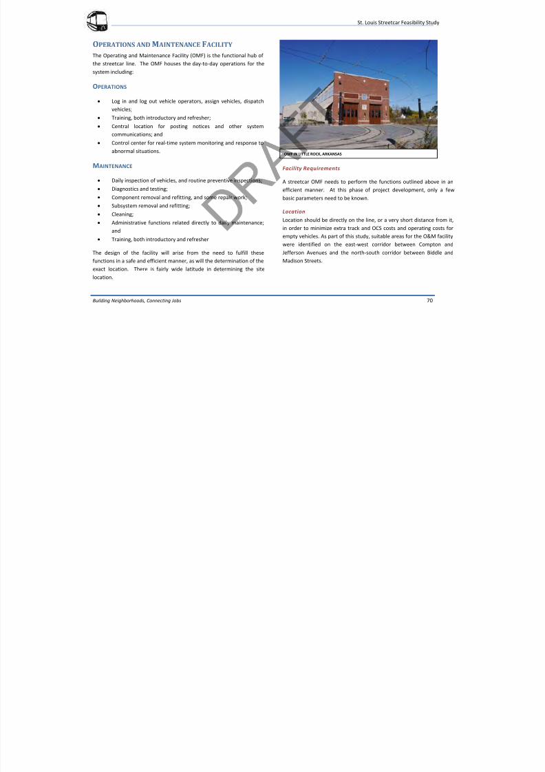
7/29/2019 DRAFT_St. Louis North Side/Downtown/Midtown/CWE Streetcar Feasibility Study 2013
http://slidepdf.com/reader/full/draftst-louis-north-sidedowntownmidtowncwe-streetcar-feasibility-study 74/104
Building Neighborhoods, Connecting Jobs 70
OPERATIONS AND M AINTENANCE F ACILITY The Operating and Maintenance Facility (OMF) is the functional hub of
the streetcar line. The OMF houses the day-to-day operations for the
system including:
OPERATIONS
Log in and log out vehicle operators, assign vehicles, dispatch
vehicles;
Training, both introductory and refresher;
Central location for posting notices and other system
communications; and
Control center for real-time system monitoring and response to
abnormal situations.
MAINTENANCE
Daily inspection of vehicles, and routine preventive inspections;
Diagnostics and testing;
Component removal and refitting, and some repair work;
Subsystem removal and refitting;
Cleaning;
Administrative functions related directly to daily maintenance;
and
Training, both introductory and refresher
The design of the facility will arise from the need to fulfill these
functions in a safe and efficient manner, as will the determination of the
exact location. There is fairly wide latitude in determining the site
location.
Facility Requirements
A streetcar OMF needs to perform the functions outlined above in an
efficient manner. At this phase of project development, only a few
basic parameters need to be known.
Location
Location should be directly on the line, or a very short distance from it,
in order to minimize extra track and OCS costs and operating costs for
empty vehicles. As part of this study, suitable areas for the O&M facility
were identified on the east-west corridor between Compton and
Jefferson Avenues and the north-south corridor between Biddle and
Madison Streets.
OMF IN LITTLE ROCK, ARKANSAS
St. Louis Streetcar Feasibility Study
7/29/2019 DRAFT_St. Louis North Side/Downtown/Midtown/CWE Streetcar Feasibility Study 2013
http://slidepdf.com/reader/full/draftst-louis-north-sidedowntownmidtowncwe-streetcar-feasibility-study 75/104
Building Neighborhoods, Connecting Jobs 71
Urban Fit
Streetcars serve urban neighborhoods. A maintenance facility
needs to be carefully designed in order to respect that fact. This
means attention to issues such as noise, light spill, and run-off
from car washing.
Landscape buffering may be considered in some applications.
The facility may also become a part of the neighborhood by
incorporating some non-traditional functions. For example, it
may provide community meeting space or a transit information
center and pass sales outlet.
Land Required
Depending on the shape of the parcel, its topography, and the need for
buffering for urban fit reasons, a site suitable for the average 60 feet
long modern streetcars and associated inspection and preventive
maintenance work will require between four and seven acres.
Preparing for Growth
It is likely that, as the study area densifies and as the north –south
corridor develops, ridership will increase and service frequency may
increase. If the St. Louis Streetcar were to expand, there are several
options for meeting the needs of the operations and maintenance:
Redevelop the facility into another urban use
Enlarge the facility by adding land
Repurpose the facility to become a central streetcar shop,
while storing vehicles at a new location
Retain the facility to serve as a satellite for one or two lines
of the enlarged system
Implementation Schedule
During the next phase, a specific location will be identified, a
preliminary environmental analysis will be undertaken and a basic
design layout made. A more detailed functional description of the
facility and a preliminary cost estimate will also be prepared.
St. Louis Streetcar Feasibility Study
7/29/2019 DRAFT_St. Louis North Side/Downtown/Midtown/CWE Streetcar Feasibility Study 2013
http://slidepdf.com/reader/full/draftst-louis-north-sidedowntownmidtowncwe-streetcar-feasibility-study 76/104
Building Neighborhoods, Connecting Jobs 72
FINANCIAL PLAN
The URS Team reviewed the federal, state and local funding sources for
the St. Louis Streetcar as well as peer city reviews in Atlanta, Cincinnati,
Seattle and Kansas City. It is assumed that the project will require
significant federal financial support for capital costs, up to 50 percent of
the total. Based on current federal evaluation criteria, the St. Louis
Streetcar would most likely score well in the competitive funding
process, especially given its strong ridership and development
performance. On the state level, no funding is assumed, given that
Missouri has historically provided little support for transit. Fundamental
to the financial plan was developing a feasible local funding strategy
that could support the annual capital and operating costs. A number of
strategies are recommended, but the critical component is the
establishment of a transportation development district (TDD) with a
tiered special assessment on property and assessed value.
PEER CITY REVIEW
Atlanta, Cincinnati, Seattle and Kansas City are building or have
constructed a modern streetcar line. Each of the cities funded their
modern streetcar projects through a combination of federal, state and
local funding sources.
Atlanta is currently constructing the first 2.6-mile segment of a larger
10-mile streetcar system. This first phase has a total cost of $70 million.
Atlanta received a $48 million federal TIGER grant for capital costs.
Local funding for the capital costs came from the City of Atlanta, $16
million, and the Atlanta Downtown Improvement District (ADIA), $6
million. The operating expenses were funded through farebox revenue,
advertising funds, an Atlanta car rental and hotel/motel tax, and the
ADIA. The project assumed that at least 20 percent of the operating
costs would come from the farebox. Advertisements are expected to
cover 4 percent of the total expenses. The car rental and hotel/motel
tax is expected to generate approximately $1 million annually for
operations over a 20-year period. The ADIA established a tax district
that assessed $0.05 per $1,000 of assessed commercial value on 200
city blocks. The ADIA will provide $1 million of funding annually over a
20-year period. The ADIA was essential for federal funding as Atlanta’s
initial federal application was rejected due to insufficient local funding.
Cincinnati is building a 2-mile modern streetcar route with a total cost
of $125 million. The line is expected to open in 2014. Cincinnati
received a total of $40 million in federal funding in three different
grants, a $25 million Urban Circulator grant, $11 million TIGER grant and
$4 million Congestion Mitigation and Air Quality (CMAQ) grant. Locally,the City funded the project through a bond package. A portion of
property taxes collected by the city funded $28 million of the bonds. A
Tax Increment Financing district funded $11 million of the project. An
additional $14 million came from the 762 Urban Redevelopment Tax
Increment Equivalent Fund. The sale of the Blue Ash Airport will
provide $11 million in construction and $15 million for utility relocation.
Duke Energy, the local energy company, has provided $6.5 million in
funding through streetlight sale proceeds and a donation.
Seattle began operating the South Lake Union 1.3-mile modern
streetcar line in 2007, with a total cost of $52.1 million. Seattle received
federal assistance totaling $14.9 million. The remaining capital
expenses were funded locally through a Local Improvement District, the
State of Washington, and a Surplus Property Fund. The Local
Improvement district created a special property tax on the property
owners within the district that reflected the benefits of the streetcar
St. Louis Streetcar Feasibility Study
7/29/2019 DRAFT_St. Louis North Side/Downtown/Midtown/CWE Streetcar Feasibility Study 2013
http://slidepdf.com/reader/full/draftst-louis-north-sidedowntownmidtowncwe-streetcar-feasibility-study 77/104
Building Neighborhoods, Connecting Jobs 73
investment. The district generated $26 million in funding. The state
contributed $3 million and the surplus property funds generated an
additional $8.5 million. The $2 million annual operating expenses were
funded through a sponsorship program, station sponsorship, farebox
recovery, bulk transit sales and existing transit funds.
Kansas City is in the final design of a 2-mile modern streetcar line
connecting Union Station to River Market. The total cost of the project
is $100 million and is expected to be complete in 2015. Kansas City
received two federal grants, a $16 million Surface Transportation
Program grant, and a $1.1 million CMAQ grant. A TDD was established
that created a $.01 sales tax within the district. There is also a special
assessment on real estate. The following assessments were applied
depending on property type:
$.48 per $100 of assessed value on commercial property
$.70 per $199 of assessed value on residential property
$1.04 per $100 of assessed value on property owned by the City
$.40 per $100 of assessed value on non-profits – (first $300,000
in value excluded)
Parking spaces in public parking lots within the district are also assessed
annually at $.15 per parking space. The TDD is expected to generate $10
million annually. Additional funds are expected from the City and utility
relocation contributions along with advertisement revenue.
FEDERAL FUNDING
There are several federal funding sources available for streetcar
funding. Federal funding may only be used for capital costs. It does not
fund the annual operation costs. Typically if a project receives federal
funding, a 50 percent local match is required to receive the federalassistance. All federal funds are administered through East-West
Gateway Council of Governments. The following federal sources have
funded streetcar projects and could be potential sources for the St.
Louis Streetcar:
New Starts – New Starts is a funding program through the FTA. New
Starts provides construction funding for new or extensions to fixed
guideway systems more than $250 million. It is a competitive funding
program with over 300 projects competing for funds under SAFETEA-LU,
the previous federal transportation act. A total of $8 billion in funding
was allocated to transit projects under SAFETEA-LU. Funding will be
available through the new federal transportation act, MAP-21.
Small Starts – This is part of the FTA funding program. The Small Starts
program funds capital projects that either a) meet the definition of a
fixed guideway for at least 50 percent of the project length in the peak
period or b) are corridor-based bus projects with 10 minute peak, 15
minute off peak headways while operating 14 hours per weekday. Total
Small Starts funding cannot exceed $75 million and the total cost of the
project must be less than $250 million.
Transportation Investment Generating Economic Investments (TIGER)
– These are competitive based grants that fund surface transportation
related projects that have significant impacts on the nation,
metropolitan area or region.
St. Louis Streetcar Feasibility Study
7/29/2019 DRAFT_St. Louis North Side/Downtown/Midtown/CWE Streetcar Feasibility Study 2013
http://slidepdf.com/reader/full/draftst-louis-north-sidedowntownmidtowncwe-streetcar-feasibility-study 78/104
Building Neighborhoods, Connecting Jobs 74
Congestion Mitigation and Air Quality (CMAQ) - This federal program
funds projects in air quality, non-attainment areas and maintenance
areas for ozone, carbon monoxide, and small particulate matter (PM2.5)
with the goal of reducing transportation-related emissions and helping
metropolitan areas comply with national ambient air quality standards.
Urban Circulator Grants – These are part of the Section 5309 funding
for exempt discretionary grants for Urban Circulator systems that
support the Department of Transportation’s Livability Initiative. Urban
Circulators include streetcars and rubber tire trolleys. Under SAFETEA-
LU, $130 million was available for streetcars nationwide. The maximum
grant was $25 million. It is not known if this funding will be available
under MAP-21.
STATE FUNDING
On the State level funding for transit is limited. The State of Missouri
has historically given a very small amount of funding for transit
operations. However, there are a few options on the state level being
considered that could provide additional funding for transit projects.
These include funding through Missouri Department of Transportation,
a Missouri Transportation Tax, a gas tax and infrastructure/education
bond package. Since all of these proposals are in the conceptual state,
no state funding was assumed for this project. However, this couldchange if some of these statewide transportation funding proposals
become a reality.
LOCAL FUNDING
Several funding options were considered on the local level, some new to
St. Louis and others that are more familiar. The sources that were
considered include:
Transportation Development Districts (TDD) – A TDD creates a new
taxing district that can have a sales or property tax or special
assessment. A vote of the registered voters within the district is
required to establish the district and a second vote is required to
approve the taxing mechanism. The Missouri Highways and
Transportation Commission reviews the TDD and it requires a circuit
court approval. Projects are funded through notes, bonds and other
debt securities. TDDs have been established in St. Louis. As mentioned
previously, a TDD was recently passed in Kansas City for their streetcarproject.
Tax Incremental Financing (TIFs) – TIFs capture net new or incremental
taxes created when vacant or underutilized property is redeveloped.
Revenues are used to finance the proposed project. The project area
must be designated as blighted, conservation or an economic
development area. Within the City of St. Louis, property taxes are
frozen up to 23 years. Property owners also have an option to make
payment in lieu of taxes to a special allocation fund. Fifty percent of activity taxes such as sales taxes are also captured. There are number
existing TIFs, mostly individual buildings directly on or near the
alignments including:
Old Post Office – 815 Olive Street
Grand Center – multi-block TIF district
St. Louis Streetcar Feasibility Study
7/29/2019 DRAFT_St. Louis North Side/Downtown/Midtown/CWE Streetcar Feasibility Study 2013
http://slidepdf.com/reader/full/draftst-louis-north-sidedowntownmidtowncwe-streetcar-feasibility-study 79/104
Building Neighborhoods, Connecting Jobs 75
Bell Lofts – 920 Olive Street
Louderman Lofts – 309 North 11th
Street
Paul Brown Building – 816 Olive Street
Printer’s Lofts – 1601 Locust Street
Security Building – 319 North 4th Street
Lindell Apartments – 3949 Lindell Blvd
MX/St. Louis Centre – 600 Washington Avenue
Park Pacific Apartments – 1226 Olive Street
Railway Exchange – 611 Olive Street
St. Louis Innovation District - Forest Park Avenue and Taylor
Avenue
100 North Euclid – Mixed Use/Whole Foods Development
Land Value Tax – This type of financing splits the tax on land and
building values. The tax rate on the land is increased while the tax rate
on the building is decreased. This creates an incentive to build on infill
lots at competitive prices and to build more densely. This requires
proper zoning and land use controls to be the most effective. This type
of tax has not been implemented widely.
Special Assessments – This type of financing is applied to commercial,
industrial or residential land uses within a defined district. There are a
variety of methodologies available for implementation.
Public Private Partnerships - Public Private Partnerships create a
contract between a public agency or agencies and a private sector
entity. This allows greater private sector participation in infrastructure
and transportation projects. Often it is used as a mechanism for
advancing a project more quickly. A public private partnership has
funded several transit projects nationwide including, the Metro Transit
Hiawatha Line in Minneapolis, Minnesota, the Air Train at JFK airport in
New York, the Portland Metropolitan Area Express (MAX) Airport
extension in Oregon, and the BART Oakland Airport Connector in
California.
New Market Tax Credits – These credits encourage investment in low-
income communities. Corporations/individuals receive a tax credit for
investing in community development entities. The available funding is
limited and very competitive. This is a source to help bridge a financing
gap, not as a significant funding source.
Parking Fees – A surcharge on parking fees at City-owned garages and
or meters. A certain percentage of the fee is allocated for the
infrastructure or transportation projects. This type of fee was recently
implemented for Kansas City streetcar project. A $.15 per space fee is
charged annually for city owned lots in the TDD. San Francisco also has a
parking fee program that helps to fund the operation of the MUNI
system. Their program has been very successful for over 20 years. This
has not been implemented in St. Louis.
Additional local funding sources could come from private donors,
sponsorships, media hub investors and advance ticket sales.
The goals of the local finance plan were:
to establish sufficient revenue to fund the annual operating and
capital costs of the project;
to be implementable;
to have support from stakeholders;
to meet federal expectations; and
to have no financial risk to Metro.
St. Louis Streetcar Feasibility Study
7/29/2019 DRAFT_St. Louis North Side/Downtown/Midtown/CWE Streetcar Feasibility Study 2013
http://slidepdf.com/reader/full/draftst-louis-north-sidedowntownmidtowncwe-streetcar-feasibility-study 80/104
Building Neighborhoods, Connecting Jobs 76
Recommendations
It is recommended that all federal sources be considered. The size and
scope of the final project will determine whether New Starts or Small
Starts funding is more appropriate. Other grant sources such as CMAQ,
Tiger and possibly Urban Circulator, if available, should be considered.Regardless the type of grant, it is important that project receive at least
50 percent in federal funding.
The Finance and Steering Committee recommended that a TDD be the
primary local funding source for the St. Louis Streetcar project. The TDD
would have a special assessment on land square footage and assessed
value. As the corridor has tremendous diversity in land uses, from
multi-story commercial, multi-and single-family residential, retail,
mixed-use, institutional, vacant land and parking lots, one type of assessment would unfairly burden certain land uses. This combined
assessment strategy will help boost the existing investment while
encourage future development in vacant and/or underutilized
properties.
A tiered assessment is also recommended. Properties directly along the
alignment would pay the highest rate, and properties on each block
beyond the alignment would pay a slightly lower rate up to four blocks
away. The rationale being properties that benefit the most from theproject should pay more for the benefit of the project.
Based on assessment data from the City of St. Louis, a TDD for the
corridor is expected to generate approximately $10 million annually.
The calculation did not include any non-profit and institutional
properties.
The alignment has the potential to eliminate one or two Metro bus
routes due to duplicative service. A certain percentage of the
operational savings from not providing these routes could be an annual
revenue source. This would have to be negotiated with Metro in future
phases of the project.
The farebox is expected to provide approximately $3.5 to $3.0 million
based on Metro’s current fare policies. Additional funding could come
from a new parking fee on meters and or garages. The details of this
plan including potential revenue estimates would have to be worked
out with City of St. Louis’ Treasurer’s office in future phases.
Table 13 provides a financial overview of the St. Louis Streetcar project.
The matrix assumes that the project receives federal funding for 50
percent of the total capital costs. The first two columns represent the
local financial share, $120 million and $100 million. The final column
represents the project overview if the east-west corridor terminated at
Grand Boulevard and included the entire north-south corridor. The
overview indicates that even without funding from the major
institutions in the corridor or parking fee revenues the project can pay
for itself, under two of the scenarios considered.
St. Louis Streetcar Feasibility Study
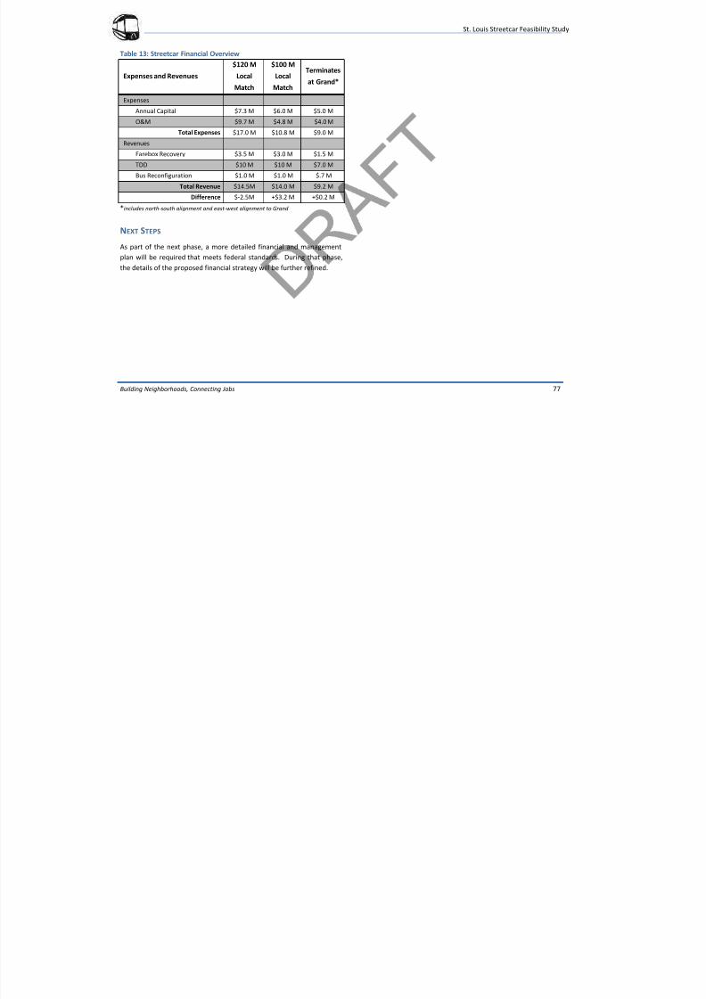
7/29/2019 DRAFT_St. Louis North Side/Downtown/Midtown/CWE Streetcar Feasibility Study 2013
http://slidepdf.com/reader/full/draftst-louis-north-sidedowntownmidtowncwe-streetcar-feasibility-study 81/104
Building Neighborhoods, Connecting Jobs 77
Table 13: Streetcar Financial Overview
Expenses and Revenues
$120 M
Local
Match
$100 M
Local
Match
Terminates
at Grand*
Expenses
Annual Capital $7.3 M $6.0 M $5.0 M
O&M $9.7 M $4.8 M $4.0 M
Total Expenses $17.0 M $10.8 M $9.0 M
Revenues
Farebox Recovery $3.5 M $3.0 M $1.5 M
TDD $10 M $10 M $7.0 M
Bus Reconfiguration $1.0 M $1.0 M $.7 M
Total Revenue $14.5M $14.0 M $9.2 M
Difference $-2.5M +$3.2 M +$0.2 M*includes north-south alignment and east-west alignment to Grand
NEXT STEPS
As part of the next phase, a more detailed financial and management
plan will be required that meets federal standards. During that phase,
the details of the proposed financial strategy will be further refined.
St. Louis Streetcar Feasibility Study
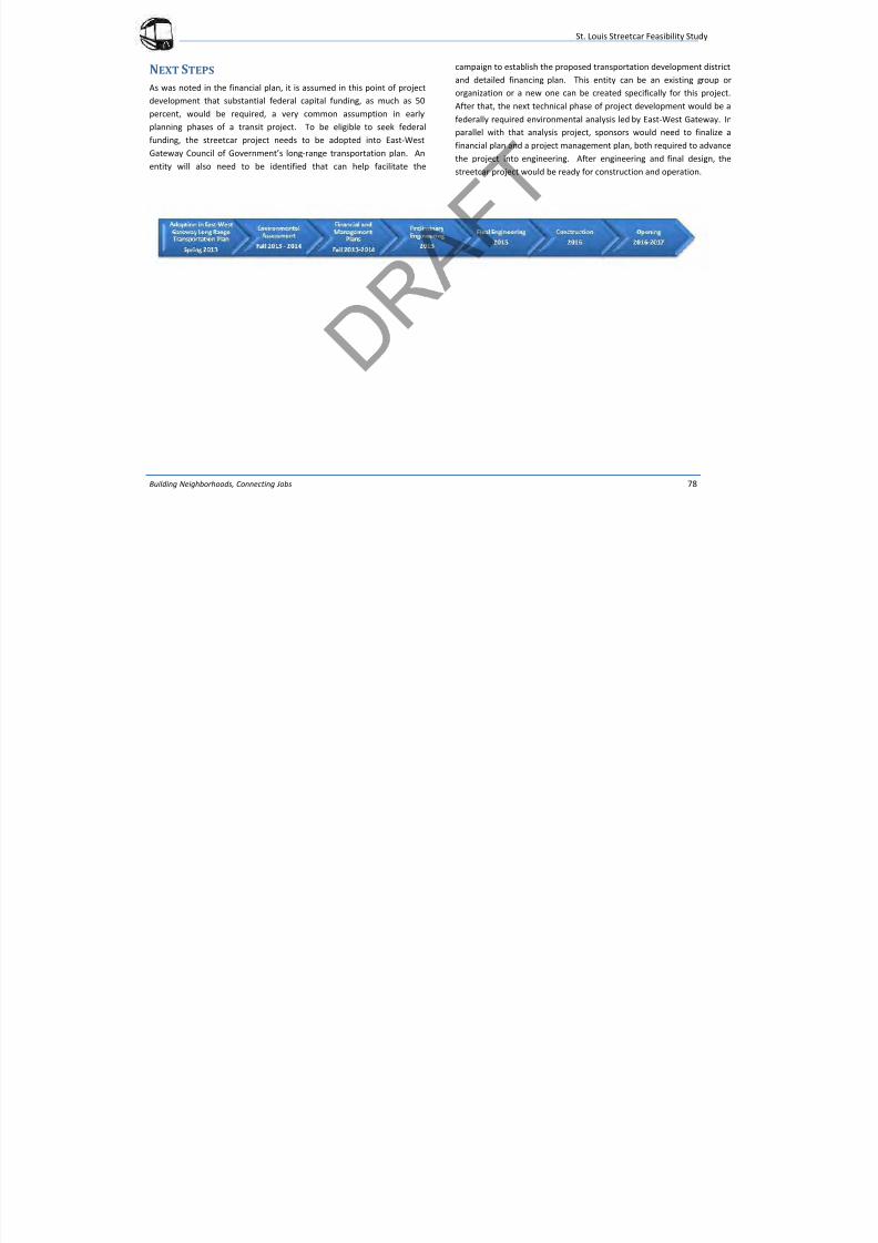
7/29/2019 DRAFT_St. Louis North Side/Downtown/Midtown/CWE Streetcar Feasibility Study 2013
http://slidepdf.com/reader/full/draftst-louis-north-sidedowntownmidtowncwe-streetcar-feasibility-study 82/104
Building Neighborhoods, Connecting Jobs 78
NEXT STEPS
As was noted in the financial plan, it is assumed in this point of project
development that substantial federal capital funding, as much as 50
percent, would be required, a very common assumption in early
planning phases of a transit project. To be eligible to seek federalfunding, the streetcar project needs to be adopted into East-West
Gateway Council of Government’s long-range transportation plan. An
entity will also need to be identified that can help facilitate the
campaign to establish the proposed transportation development district
and detailed financing plan. This entity can be an existing group or
organization or a new one can be created specifically for this project.
After that, the next technical phase of project development would be a
federally required environmental analysis led by East-West Gateway. In
parallel with that analysis project, sponsors would need to finalize a
financial plan and a project management plan, both required to advance
the project into engineering. After engineering and final design, the
streetcar project would be ready for construction and operation.
St. Louis Streetcar Feasibility Study
7/29/2019 DRAFT_St. Louis North Side/Downtown/Midtown/CWE Streetcar Feasibility Study 2013
http://slidepdf.com/reader/full/draftst-louis-north-sidedowntownmidtowncwe-streetcar-feasibility-study 83/104
Building Neighborhoods, Connecting Jobs Appendix - A
APPENDIXA
St. Louis Streetcar Feasibility Study
7/29/2019 DRAFT_St. Louis North Side/Downtown/Midtown/CWE Streetcar Feasibility Study 2013
http://slidepdf.com/reader/full/draftst-louis-north-sidedowntownmidtowncwe-streetcar-feasibility-study 84/104
Building Neighborhoods, Connecting Jobs A-1
Cost categories were used to summarize the unit prices into a
comprehensive total estimate for each segment. The major cost
categories are listed and described in greater detail below:
Guideway and Track Elements
Stops
Support Facilities
Sitework and Special Conditions
Systems
Right-of-Way, Land, Existing Improvements
Vehicles
Professional Services
Unallocated Contingency
Finance Charges
Guideway and Track Elements
This category includes capital costs for construction of the fixed
guideway and track elements including excavation, concrete work,
sub-grade preparation; procurement and installation of trackwork
including rail, fasteners, special trackwork, ties, welding, and
miscellaneous track items. Measurement may be by unit, route-
foot, or track-foot depending on the type of construction.
Stops
This category includes the capital costs for fixed facilities and
amenities for the streetcar stops including platforms, shelters,
lighting, signage, landscaping, furnishings, and sidewalks for
pedestrian access. Measurement will be by each stop.
Support Facilities
This category includes capital costs for facilities and equipment
needed to support operation and maintenance of the streetcar
system. This category includes administrative buildings,
maintenance shops, equipment, yard tracks, yard traction power,
yard signals, and civil construction as needed. Non-revenue and
maintenance vehicles are also included. Maintenance facility costs
will be built up in a separate estimate.
Sitework and Special Conditions
Sitework
This category includes the capital costs for demolition, clearing and
grading, and subgrade preparation, landscaping, sidewalks, fencing,
signage, and artwork. Measurement will be by unit or the route foot
depending on the type of civil construction.
Utility Relocation
This category includes the capital costs for the relocation, upgrade
or adjustment of all public or private utilities that may become the
responsibility of the Project during construction. Measurement is by
linear foot of utility or by allowance depending on how completely
the scope of work is defined.
Site UtilitiesThis category includes the capital costs for basic infrastructure
improvements including streetlights, storm drainage, or other new
utility service. Measurement is by unit or route-foot depending on
the type of construction
St. Louis Streetcar Feasibility Study
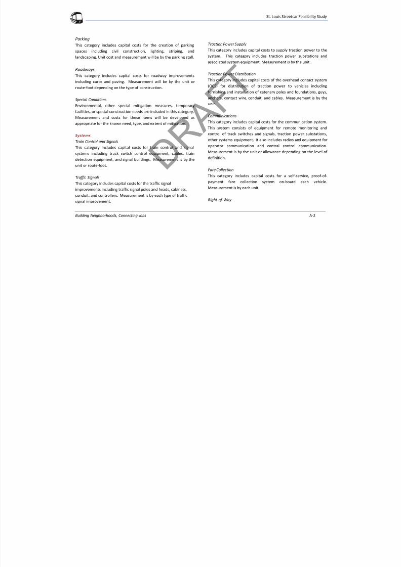
7/29/2019 DRAFT_St. Louis North Side/Downtown/Midtown/CWE Streetcar Feasibility Study 2013
http://slidepdf.com/reader/full/draftst-louis-north-sidedowntownmidtowncwe-streetcar-feasibility-study 85/104
Building Neighborhoods, Connecting Jobs A-2
Parking
This category includes capital costs for the creation of parking
spaces including civil construction, lighting, striping, and
landscaping. Unit cost and measurement will be by the parking stall.
Roadways
This category includes capital costs for roadway improvements
including curbs and paving. Measurement will be by the unit or
route-foot depending on the type of construction.
Special Conditions
Environmental, other special mitigation measures, temporary
facilities, or special construction needs are included in this category.Measurement and costs for these items will be developed as
appropriate for the known need, type, and extent of mitigation.
Systems
Train Control and Signals
This category includes capital costs for train control and signal
systems including track switch control equipment, cables, train
detection equipment, and signal buildings. Measurement is by the
unit or route-foot.
Traffic Signals
This category includes capital costs for the traffic signal
improvements including traffic signal poles and heads, cabinets,
conduit, and controllers. Measurement is by each type of traffic
signal improvement.
Traction Power Supply
This category includes capital costs to supply traction power to the
system. This category includes traction power substations and
associated system equipment. Measurement is by the unit.
Traction Power Distribution
This category includes capital costs of the overhead contact system
(OCS) for distribution of traction power to vehicles including
furnishing and installation of catenary poles and foundations, guys,
anchors, contact wire, conduit, and cables. Measurement is by the
unit.
Communications
This category includes capital costs for the communication system.
This system consists of equipment for remote monitoring and
control of track switches and signals, traction power substations,
other systems equipment. It also includes radios and equipment for
operator communication and central control communication.
Measurement is by the unit or allowance depending on the level of
definition.
Fare Collection
This category includes capital costs for a self-service, proof-of-
payment fare collection system on-board each vehicle.
Measurement is by each unit.
Right-of-Way
St. Louis Streetcar Feasibility Study
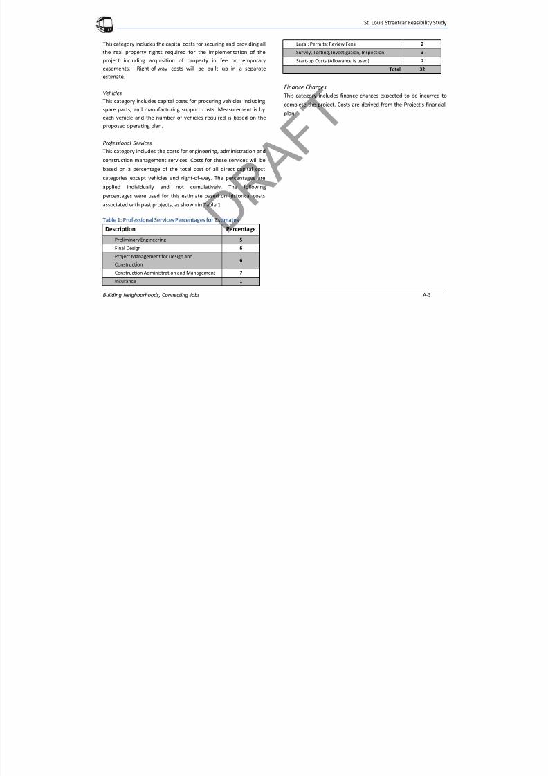
7/29/2019 DRAFT_St. Louis North Side/Downtown/Midtown/CWE Streetcar Feasibility Study 2013
http://slidepdf.com/reader/full/draftst-louis-north-sidedowntownmidtowncwe-streetcar-feasibility-study 86/104
Building Neighborhoods, Connecting Jobs A-3
This category includes the capital costs for securing and providing all
the real property rights required for the implementation of the
project including acquisition of property in fee or temporary
easements. Right-of-way costs will be built up in a separate
estimate.
Vehicles
This category includes capital costs for procuring vehicles including
spare parts, and manufacturing support costs. Measurement is by
each vehicle and the number of vehicles required is based on the
proposed operating plan.
Professional Services
This category includes the costs for engineering, administration and
construction management services. Costs for these services will be
based on a percentage of the total cost of all direct capital cost
categories except vehicles and right-of-way. The percentages are
applied individually and not cumulatively. The following
percentages were used for this estimate based on historical costs
associated with past projects, as shown in Table 1.
Table 1: Professional Services Percentages for Estimates
Description Percentage
Preliminary Engineering 5
Final Design 6
Project Management for Design and
Construction6
Construction Administration and Management 7
Insurance 1
Legal; Permits; Review Fees 2
Survey, Testing, Investigation, Inspection 3
Start-up Costs (Allowance is used) 2
Total 32
Finance Charges
This category includes finance charges expected to be incurred to
complete the project. Costs are derived from the Project’s financial
plan.
St. Louis Streetcar Feasibility Study
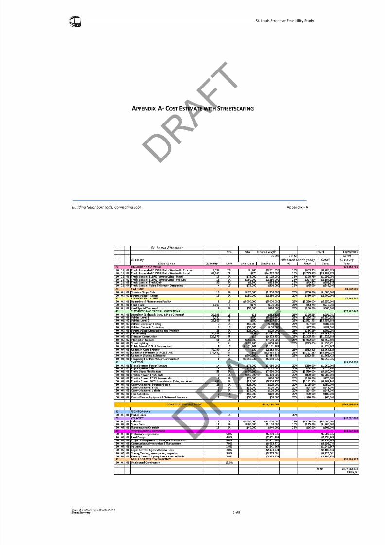
7/29/2019 DRAFT_St. Louis North Side/Downtown/Midtown/CWE Streetcar Feasibility Study 2013
http://slidepdf.com/reader/full/draftst-louis-north-sidedowntownmidtowncwe-streetcar-feasibility-study 87/104
Building Neighborhoods, Connecting Jobs Appendix - A
APPENDIX A- COST ESTIMATE WITH STREETSCAPING
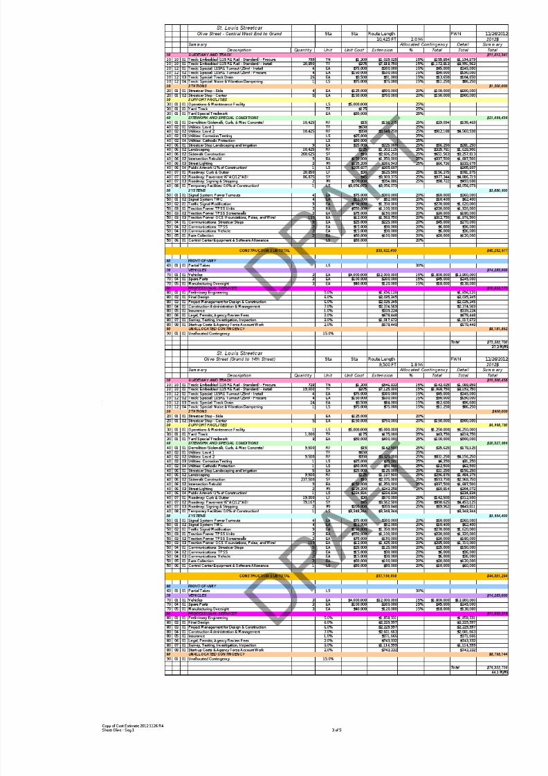
7/29/2019 DRAFT_St. Louis North Side/Downtown/Midtown/CWE Streetcar Feasibility Study 2013
http://slidepdf.com/reader/full/draftst-louis-north-sidedowntownmidtowncwe-streetcar-feasibility-study 88/104

7/29/2019 DRAFT_St. Louis North Side/Downtown/Midtown/CWE Streetcar Feasibility Study 2013
http://slidepdf.com/reader/full/draftst-louis-north-sidedowntownmidtowncwe-streetcar-feasibility-study 89/104
7/29/2019 DRAFT_St. Louis North Side/Downtown/Midtown/CWE Streetcar Feasibility Study 2013
http://slidepdf.com/reader/full/draftst-louis-north-sidedowntownmidtowncwe-streetcar-feasibility-study 90/104

7/29/2019 DRAFT_St. Louis North Side/Downtown/Midtown/CWE Streetcar Feasibility Study 2013
http://slidepdf.com/reader/full/draftst-louis-north-sidedowntownmidtowncwe-streetcar-feasibility-study 91/104
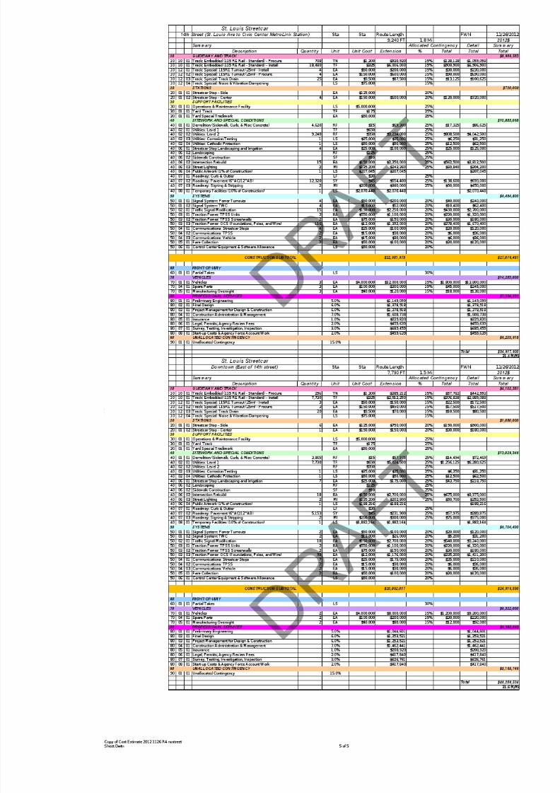
7/29/2019 DRAFT_St. Louis North Side/Downtown/Midtown/CWE Streetcar Feasibility Study 2013
http://slidepdf.com/reader/full/draftst-louis-north-sidedowntownmidtowncwe-streetcar-feasibility-study 92/104
St. Louis Streetcar Feasibility Study

7/29/2019 DRAFT_St. Louis North Side/Downtown/Midtown/CWE Streetcar Feasibility Study 2013
http://slidepdf.com/reader/full/draftst-louis-north-sidedowntownmidtowncwe-streetcar-feasibility-study 93/104
Building Neighborhoods, Connecting Jobs Appendix - A
APPENDIX A- COST ESTIMATE WITHOUT STREETSCAPING
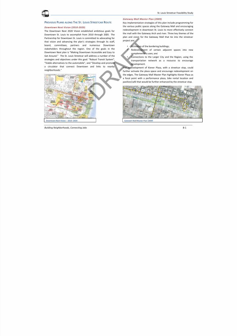
7/29/2019 DRAFT_St. Louis North Side/Downtown/Midtown/CWE Streetcar Feasibility Study 2013
http://slidepdf.com/reader/full/draftst-louis-north-sidedowntownmidtowncwe-streetcar-feasibility-study 94/104
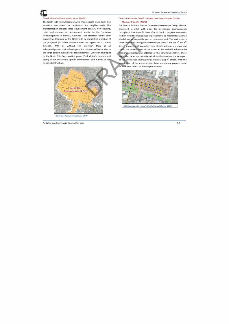
7/29/2019 DRAFT_St. Louis North Side/Downtown/Midtown/CWE Streetcar Feasibility Study 2013
http://slidepdf.com/reader/full/draftst-louis-north-sidedowntownmidtowncwe-streetcar-feasibility-study 95/104
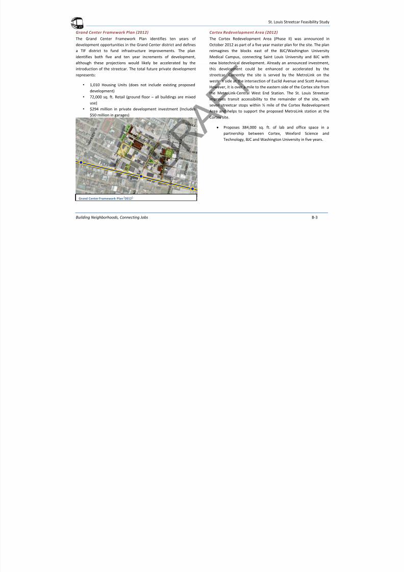
7/29/2019 DRAFT_St. Louis North Side/Downtown/Midtown/CWE Streetcar Feasibility Study 2013
http://slidepdf.com/reader/full/draftst-louis-north-sidedowntownmidtowncwe-streetcar-feasibility-study 96/104
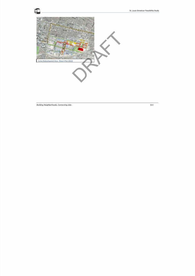
7/29/2019 DRAFT_St. Louis North Side/Downtown/Midtown/CWE Streetcar Feasibility Study 2013
http://slidepdf.com/reader/full/draftst-louis-north-sidedowntownmidtowncwe-streetcar-feasibility-study 97/104
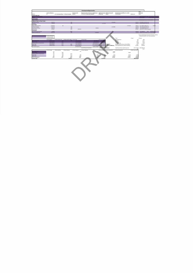
7/29/2019 DRAFT_St. Louis North Side/Downtown/Midtown/CWE Streetcar Feasibility Study 2013
http://slidepdf.com/reader/full/draftst-louis-north-sidedowntownmidtowncwe-streetcar-feasibility-study 98/104
St. Louis Streetcar Feasibility Study

7/29/2019 DRAFT_St. Louis North Side/Downtown/Midtown/CWE Streetcar Feasibility Study 2013
http://slidepdf.com/reader/full/draftst-louis-north-sidedowntownmidtowncwe-streetcar-feasibility-study 99/104
Building Neighborhoods, Connecting Jobs Appendix - B
APPENDIXB
St. Louis Streetcar Feasibility Study

7/29/2019 DRAFT_St. Louis North Side/Downtown/Midtown/CWE Streetcar Feasibility Study 2013
http://slidepdf.com/reader/full/draftst-louis-north-sidedowntownmidtowncwe-streetcar-feasibility-study 100/104
Building Neighborhoods, Connecting Jobs B-1
PREVIOUS PLANS ALONG THE ST. LOUIS STREETCAR ROUTE
Downtown Next Vision (2010-2020)
The Downtown Next 2020 Vision established ambitious goals for
Downtown St. Louis to accomplish from 2010 through 2020. ThePartnership for Downtown St. Louis is committed to advocating for
that vision and advancing the plan’s strategies through its staff,
board, committees, partners and numerous Downtown
stakeholders throughout the region. One of the goals in the
Downtown Next plan is “Making Downtown Accessible and Easy to
Get Around.” The St. Louis Streetcar will address a number of the
strategies and objectives under this goal: “Robust Transit System”,
“Viable alternatives to the automobile”, and “Develop and promote
a circulator that connect Downtown and links to nearby
neighborhoods.”
Gateway Mall Master Plan (2009)
Key implementation strategies of this plan include programming for
the various public spaces along the Gateway Mall and encouraging
redevelopment in downtown St. Louis to more effectively connect
the mall with the Gateway Arch and river. Three key themes of the
plan and vision for the Gateway Mall that tie into the streetcar
project are:
• Activation of the bordering buildings;
• Redevelopment of certain adjacent spaces into new
complementary uses; and
• Connections to the Larger City and the Region, using the
transportation network as a resource to encourage
development.
The redevelopment of Kiener Plaza, with a streetcar stop, couldfurther activate the plaza space and encourage redevelopment on
the edges. The Gateway Mall Master Plan highlights Kiener Plaza as
a focal point with a performance plaza, bike rental location and
pavilion/café that would be further enhanced by the streetcar stop.
Downtown Next Vision – 2010 -2020 Gatewa Mall Master Plan 2009
St. Louis Streetcar Feasibility Study

7/29/2019 DRAFT_St. Louis North Side/Downtown/Midtown/CWE Streetcar Feasibility Study 2013
http://slidepdf.com/reader/full/draftst-louis-north-sidedowntownmidtowncwe-streetcar-feasibility-study 101/104
Building Neighborhoods, Connecting Jobs B-2
North Side Redevelopment Area (2009)
The North Side Redevelopment Area encompasses 1,500 acres and
envisions new mixed use destination and neighborhoods. The
transformation includes large employment centers, new housing,
retail and commercial development similar to the Stapleton
Redevelopment in Denver, Colorado. The streetcar would offer
support for this plan for the North Side by stimulating a portion of
the proposed $8 billion redevelopment to happen on a shorter
timeline. With or without the streetcar, there is an
acknowledgement that redevelopment in this area will occur due to
the large parcels available for redevelopment. Whether developed
by the North Side Regeneration group (Paul McKee’s development
team) or not, the area is ripe for development and in need of new
public infrastructure.
Central Business District Downtown Streetscape Design
Manual Update (2009)
The Central Business District Downtown Streetscape Design Manual
originated in 2004 with plans for streetscape improvements
throughout downtown St. Louis. One of the first projects to come to
fruition from the manual was improvements to Washington Avenue
which have subsequently spurred redevelopment. The next projects
to be completed through the Streetscape Manual are the 7 th and 8th
Street improvement projects. These streets will play an important
role in the development of the streetcar line and will influence the
economic development potential of the downtown district. There
might also be an opportunity to include the streetcar tracks as part
of the streetscape improvement project along 7 th Street. With the
introduction of the streetcar line, these streetscape projects could
be a catalyst similar to Washington Avenue.
CBD Downtown Streetsca e Desi n Manual U date 2009
North Side Redevelo ment Area 2009
St. Louis Streetcar Feasibility Study

7/29/2019 DRAFT_St. Louis North Side/Downtown/Midtown/CWE Streetcar Feasibility Study 2013
http://slidepdf.com/reader/full/draftst-louis-north-sidedowntownmidtowncwe-streetcar-feasibility-study 102/104
Building Neighborhoods, Connecting Jobs B-3
Grand Center Framework Plan (2012)
The Grand Center Framework Plan identifies ten years of
development opportunities in the Grand Center district and defines
a TIF district to fund infrastructure improvements. The plan
identifies both five and ten year increments of development,
although these projections would likely be accelerated by the
introduction of the streetcar. The total future private development
represents:
• 1,010 Housing Units (does not include existing proposed
development)
• 72,000 sq. ft. Retail (ground floor – all buildings are mixed
use)
• $294 million in private development investment (Includes
$50 million in garages)
Cortex Redevelopment Area (2012)
The Cortex Redevelopment Area (Phase II) was announced in
October 2012 as part of a five year master plan for the site. The plan
reimagines the blocks east of the BJC/Washington University
Medical Campus, connecting Saint Louis University and BJC with
new biotechnical development. Already an announced investment,
this development could be enhanced or accelerated by the
streetcar. Currently the site is served by the MetroLink on the
western side at the intersection of Euclid Avenue and Scott Avenue.
However, it is over a mile to the eastern side of the Cortex site from
the MetroLink-Central West End Station. The St. Louis Streetcar
improves transit accessibility to the remainder of the site, with
seven streetcar stops within ½ mile of the Cortex Redevelopment
Area and helps to support the proposed MetroLink station at the
Cortex site.
Proposes 384,000 sq. ft. of lab and office space in a
partnership between Cortex, Wexford Science and
Technology, BJC and Washington University in five years.
Grand Center Framework Plan 2012
St. Louis Streetcar Feasibility Study

7/29/2019 DRAFT_St. Louis North Side/Downtown/Midtown/CWE Streetcar Feasibility Study 2013
http://slidepdf.com/reader/full/draftst-louis-north-sidedowntownmidtowncwe-streetcar-feasibility-study 103/104
Building Neighborhoods, Connecting Jobs B-4
Cortex Redevelopment Area - Phase II Plan (2012)
District
Total Area Ripe (sq.
ft.) Acres Developed/Ripe % of Ripe Developed
Employment (6
Stories)
Mixed Use (either 4 Stories in neighborhood
or 12 stories downtown/midtown)
High Rise Housing
(10 Stories)
Mid Rise Housing (4
Stories)
Attached Housing (2000 sq. ft. /unit @
10 units/acre) Price/Sq. Ft.
Total
Investment
Value
Development Opportunities

7/29/2019 DRAFT_St. Louis North Side/Downtown/Midtown/CWE Streetcar Feasibility Study 2013
http://slidepdf.com/reader/full/draftst-louis-north-sidedowntownmidtowncwe-streetcar-feasibility-study 104/104
) p p p p ) ) ( ) ) ) q
Central West End
Whole Foods Development $60,000,000176 Units *From Whole Foods Announc
Cortex $187,000,000 *From Cortex Announcement
Grand Center
Framework Plan $294,000,000*From Framework Plan
Jefferson Street to Grand Center
Mid Rise Housing 895,733 35% 1,254,026 $120.00 $150,483,144 1045 Units
High Rise 234,359 50% 1,171,795 $120.00 $140,615,400 1065 Units
North SideSingle Family Attached 3,744,645 86 1,719,304 $100.00 $171,930,441 860 Units $3,068
Mid Rise Housing 1,514,176 35% 2,119,846 $120.00 $254,381,568 1930 Units
Mixed Use (4 Stories) 299,722 35% 419,611 $100.00 $41,961,080 286 Units
Employment 659,626 35% 1,385,215 $120.00 $166,225,752 6000 employeesDowntown
Municipal Courts Building 160,000 100% $140.00 $22,400,000 1050 $690,567,920
Additional Mixed Use 1,325,730 35% 5,568,066 $120.00 $ 668,167,920 4200 Units $172,641,980.00
$2,157,165,305Total Investment Potential - 20 Year
5-10 Year Potential $539,291,32625% First 5 Year Investment
5-20 Year Potential
1 0- 20 Y ea r P ot en ti al T ot al 5 Y ea rs 2 0 Y ea rs
Total Potential Total Housing Units Employment Numbers 5 Year Total 10 Year Total 20 Year Total Attached House 213 850
Central West End $247,000,000 176 1400 $153,500,000.0 $247,000,000 $247,000,000 Mid Rise 744 2,975
Grand Center $294,000,000 1360 $147,000,000.0 $294,000,000 $294,000,000 High Rise 1,050 4,200
Jefferson Street to Grand Center $291,098,544 2110 $72,774,636.00 $145,549,272.0 $291,098,544 Total Housing 2,006 8,025
North Side $634,498,841 3076 6000 $31,724,942.04 $222,074,594.27 $634,498,841 North Side Neighborhood Commercial/Retail/Offi ce 5,245 104,903
Downtown $690,567,920 3938 7218 $172,641,980.00 $172,641,980.00 $690,567,920 Downtown/Midtown D ow nt own /Mi dt ow n C ommer ci al /R etai l 11 6, 00 1 46 4,0 06
Total Development $577,641,558.0 $1,081,265,846 $2,157,165,305
Last 10 Years of Investment $498,257,900.46 Jefferson Total Potential Housing Development $72,774,636 $291,098,544
528 2110
5 Y ea r H ou sing 10 Y ea r H ou sing 20 Y ea r H ou sing 5 Y ea r E mp loyee 10 Y ea r E mp loyee 20 Y ea r E mp loyee 5 Y ea r Com merc ia l 10 Y ea r Com merc ia l 20 Y ea r Com merc ia l
Central West End 176 750 750 30000
Grand Center 680 680 41000 41000
Jefferson Street to Grand Center 527 528 1055
North Side 153 528 1055 300 2100 3600 5245 36716 62942Downtown 985 984 1969 1805 1804 3609 116001 116002 232003
Total Development 2521 2720 4079 2855 4654 7209 192246 193718 294945
Total by Type 9,320.00 14,718.00 680,909.00