Embed Size (px)
Citation preview
DRAFT
TERMS OF REFERENCE FOR THE PREPARATION OF AN ENVIRONMENTAL IMPACT ASSESSMENT FOR THE VILLAGES OF COLBECK CASTLE DEVELOPMENT PROPOSED
BY BCR INDUSTRIES CO. LTD.
Table of Contents 1 INTRODUCTION.................................................................................................................................... 1 2 OBJECTIVE OF THE DRAFT TOR........................................................................................................ 3 3 PLANNED DEVELOPMENT .................................................................................................................. 4
3.1 Residential Land Use (Zones 5 to 9)............................................................................................ 4 3.2 Agricultural and Open Areas........................................................................................................ 6 3.3 Community and Business District (Zone 2-4)............................................................................... 6 3.4 Infrastructure................................................................................................................................ 7
3.4.1 Sewage System (Zone 10)...................................................................................................... 7 3.4.2 Access Roads ......................................................................................................................... 7 3.4.3 Drainage System..................................................................................................................... 7 3.4.4 Water Supply........................................................................................................................... 8 3.4.5 Solid Waste Collection and Disposal....................................................................................... 8 3.4.6 Electricity................................................................................................................................. 8 3.4.7 Telecommunications ............................................................................................................... 8
4 PRELIMINARY ENVIRONMENTAL SCOPING...................................................................................... 9
4.1 Environmental Overview .............................................................................................................. 9 4.1.1 Physical Environment.............................................................................................................. 9 4.1.2 Ground Cover and Ecology..................................................................................................... 9 4.1.3 Human Environment ..............................................................................................................10
4.2 Environmental Sensitivities .........................................................................................................10 4.3 Stakeholders ...............................................................................................................................11 4.4 EIA Preparation Team ................................................................................................................11
5 MINIMUM SCOPE OF WORK (TASKS TO BE COMPLETED) ............................................................12
5.1 Task 1 Conduct of a Valid EIA Process ......................................................................................12 5.2 Task 2 Conduct of a Valid Stakeholder Consultation Process ....................................................12 5.3 Task 3 Preparation of a TOR Compliant EIA Report...................................................................13
5.3.1 Project Description .................................................................................................................13 5.3.2 Analysis of Alternatives ..........................................................................................................14 5.3.3 Legal and Institutional Framework .........................................................................................14 5.3.4 Description of the Environment (Baseline) .............................................................................15 5.3.5 Summary of the Stakeholder Consultation Process ...............................................................18 5.3.6 Assessment of Impacts and Mitigation Measures ..................................................................18 5.3.7 Environmental Management Plan ..........................................................................................20
5.4 Additional Information .................................................................................................................20 Prepared by:
E N V I R O N M E N T A L M A N A G E M E N T C O N S U L T A N T S ( C A R I B B E A N ) L T D 61 Mansfield Meadows, Ocho Rios, St. Ann, Jamaica Tel/Fax: (876) 974-7423 Tel: (876) 974-9727 Email: [email protected]
Draft TOR for the EIA for the Proposed Villages of Colbeck Development, St. Catherine. May 8th 2007
1
1 INTRODUCTION
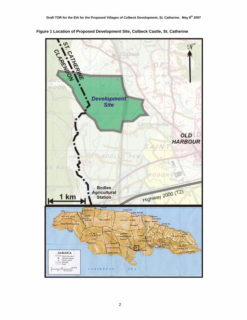
B.C.R. Industries Company Limited is seeking permission to undertake the proposed Villages of Colbeck Castle development on a 159 ha (394 acres) parcel of relatively flat land at Colbeck Pen. The site is located on the border between Clarendon and St. Catherine as shown in Figure 1. It is approximately 6.5 km north of Port Esquivel (Portland Bight) at an elevation of 38 m to 50 m above sea level. The property falls mainly within the Bowers River watershed.
The western and southern boundaries are marked by a minor parochial road leading to a licensed quarry. The eastern boundary is in the southern part defined by an estate road (which continues on to the Colbeck Castle heritage site). The southeastern boundary is marked by a segment of the Plantain River. The northern boundary is not defined by any particular geographic feature. At the widest points, the northern boundary is ~1.2 km from the southern boundary, and the eastern boundary is 1.9 km from the western limit.
The site is situated approximately 36 km from the capital city of Kingston, 16 km from Spanish Town and 10 km from May Pen. The site is also situated within a few minutes drive of Old Harbour, which is situated ~2 km west of Colbeck Castle respectively. The Jamaican Agricultural Society (JAS) farmstead at Colbeck Pen and the Bodles Agricultural Research Station are located close to the site.
The Villages of Colbeck Castle will be essentially a multi-use residential development incorporating all the necessary attributes to support a desirable life quality for an anticipated population of between 12,000 and 16,000 inhabitants when completed. Although there is some reservation of agricultural land, the proposed development primarily includes urban land uses such as residential, infrastructure, commercial, educational, and recreational. There will also be provision for preservation of the Colbeck Castle heritage.
Pursuant to the Natural Resources Conservation Authority (NRCA) Act and prescribed schedule, the proposed development will require an environmental permit for the residential and commercial sub-division and housing development as well as an environmental license for the discharge of sewage effluent associated with the proposed sewage treatment plant. The National Environment and Planning Agency (NEPA) has requested that an Environmental Impact Assessment (EIA) be submitted in support of these applications.
Draft TOR for the EIA for the Proposed Villages of Colbeck Development, St. Catherine. May 8th 2007
2
Figure 1 Location of Proposed Development Site, Colbeck Castle, St. Catherine
Draft TOR for the EIA for the Proposed Villages of Colbeck Development, St. Catherine. May 8th 2007
3
2 OBJECTIVE OF THE DRAFT TOR
This document represents the Draft Terms of Reference (TOR) for the conduct of an Environmental Impact Assessment for the Villages of Colbeck Castle development proposal. The purpose of the TOR is to set the ground rules for the conduct of the EIA process, which includes the EIA report.
The legal defensibility of the environmental permit and the EIA rests upon:
1. The validity of the project and environmental information provided, in so far as they represent the actual building plans and the host environment;
2. The verifiability of the main scientific conclusions of the report; and
3. Adherence of the process to accepted norms that promote transparency.
Therefore the TOR shall:
Be reviewed and accepted by all relevant parties as representative of the minimum requirements for an acceptable study;
Indicate the process for such consultation;
Provide sufficient information about the development proposal and the environment to allow for a preliminary scoping of environmental sensitivities;
Outline the minimum requirements for the environmental baseline, specifically in terms of the parameters (Valued Environmental Components or VECs) to be investigated, the scale area of investigation for each parameter and the acceptable sources of information;
Undertake primary surveys in accordance with the sampling regime described, having regard for international standard practice in EIA of studying environmental parameters in a sphere of influence of the project and not necessarily limited to the project site (the level of environmental investigation is commensurate with the level of concern that a receptor may be affected by the project);
Outline the basic structure of the EIA Report, outlining the purpose of each of the sections as well as the minimum required scope/content; and
Indicate any other information that is specifically required to facilitate the decision making process.
Draft TOR for the EIA for the Proposed Villages of Colbeck Development, St. Catherine. May 8th 2007
4
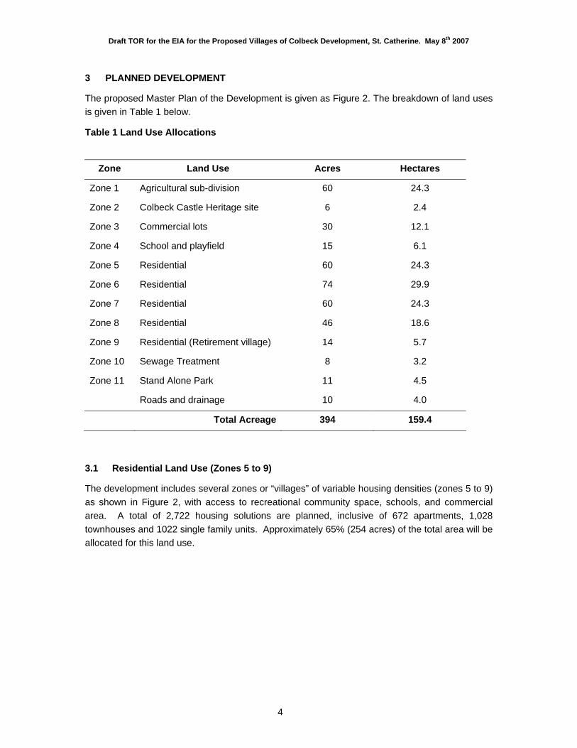
3 PLANNED DEVELOPMENT
The proposed Master Plan of the Development is given as Figure 2. The breakdown of land uses is given in Table 1 below.
Table 1 Land Use Allocations
Zone Land Use Acres Hectares
Zone 1 Agricultural sub-division 60 24.3
Zone 2 Colbeck Castle Heritage site 6 2.4
Zone 3 Commercial lots 30 12.1
Zone 4 School and playfield 15 6.1
Zone 5 Residential 60 24.3
Zone 6 Residential 74 29.9
Zone 7 Residential 60 24.3
Zone 8 Residential 46 18.6
Zone 9 Residential (Retirement village) 14 5.7
Zone 10 Sewage Treatment 8 3.2
Zone 11 Stand Alone Park 11 4.5
Roads and drainage 10 4.0
Total Acreage 394 159.4
3.1 Residential Land Use (Zones 5 to 9)
The development includes several zones or “villages” of variable housing densities (zones 5 to 9) as shown in Figure 2, with access to recreational community space, schools, and commercial area. A total of 2,722 housing solutions are planned, inclusive of 672 apartments, 1,028 townhouses and 1022 single family units. Approximately 65% (254 acres) of the total area will be allocated for this land use.
Draft TOR for the EIA for the Proposed Villages of Colbeck Development, St. Catherine. May 8th 2007
5
Figure 2 Master Plan, Villages of Colbeck Castle, St. Catherine
Draft TOR for the EIA for the Proposed Villages of Colbeck Development, St. Catherine. May 8th 2007
6
3.2 Agricultural and Open Areas
Approximately 37% of the total area (144.6 acres) will be left as open space. More than half of this will either be in agricultural lands (60 acres on the eastern side) or as the nature park (11 acres in the north western corner of the property). The agricultural allocation will be sub-divided into agricultural lots. The park will be landscaped and maintained (with public rest rooms) for community recreational use. The remaining open space reserves are distributed as given in Table 2 below.
Table 2 Open Space Allocations
Land Use Acreage Hectares
Zone 1 Agricultural sub-division 60.0 24.3
Zone 2 Colbeck Castle Heritage site (buffer) 6.0 2.4
Zone 3 Commercial lots 0.0 0.0
Zone 4 School and playfield 15.0 6.1
Zone 5-9 Residential (school reserves) 44.6 18.0
Zone 10 Sewage Treatment 8.0 3.2
Zone 11 Stand Alone Park 11.0 4.5
144.6 acres 58.5 ha
3.3 Community and Business District (Zone 2-4)
The main commercial space in the Central Business District (CBD) will be located in Zone 3 on the eastern side of the property, adjoining the farm lots (Zone 1), the main school allocation (Zone 4) and the heritage site (Zone 2). The CBD will include the following.
Table 3 Open Space Allocations
Transport and Industrial Shopping and Financial Social Services and Amenities
Gas Station Super-market Health Clinic
Garage (mechanic) Specialty Shops Postal Agency
Transportation Hub Personal Services Church
Light Industrial/Tech Park Bank Offices Community Centre/Hall Craft Village
It is envisioned that the heritage site, shopping area and education zone will serve as a buffer between the farm lands and the residential lands, and will be a community focal point.
In respect of the Colbeck Castle Historic Monument, there is on-going dialogue with the Jamaica National Heritage Trust (JNHT) to restore site to facilitate some level of heritage tourism. The land that is reserved for schools will be developed by the Ministry of Education.
Draft TOR for the EIA for the Proposed Villages of Colbeck Development, St. Catherine. May 8th 2007
7
3.4 Infrastructure
3.4.1 Sewage System (Zone 10) The Master Plan proposes the use of an oxidation ditch with facultative ponds for sewage treatment. The treatment works design capacity is 1.2 million gallons per day with an estimated flow from the development of 1 million gallons per day at the completion of the development.
Exactly 8 acres are reserved in Zone 10 of the sewage treatment plant (STP). The treatment ponds proposed occupy approximately 4 acres. This is located in the lowest elevation of the site in proximity to the dam on the property. According to the Master Plan, the STP site will be buffered from the main residential zones by chain-link fences, grassed earth mounds, landscaping, and park reserves.
The preliminary design calls for a sewer drainage system with a four (4) lift pumping stations. The sewer system is designed to gravity drain to the pumping stations in the south of each zone, and be collected and delivered to the STP. The plant and pumping stations will be equipped with standby pumping capacity and standby power supply. Wastewater effluent from the plant will meet the standards for open surface discharge as prescribed by the NRCA wastewater standards.
3.4.2 Access Roads
As shown in Figure 2, the main access road to the site will be on the eastern side, off the existing parochial road to Old Harbour. This new access road will run through the Bodles Pen (lands not associated with the development) and along the western side of the CBD, northwards to the Old Harbour Main Road. The main sub-division road will run between the CBD (Zone 1) and the Nature Park (Zone 11). Smaller residential roads will serve the village communities.
3.4.3 Drainage System
There are 2 drainage systems associated with the site: Plantain River/Bowers Gully in the East and Clarendon Gully/Bowers River (western and central tributaries). The Clarendon Gully/Bowers River system transmits significant storm flows from upstream of the property to the wetlands on the Bodles Agricultural Estate. The drain in the centre of the property is a minor tributary which drains into the Bodles wetland before joining the Bowers River. The Bowers Gully system on the eastern side appears to be the major regional storm drain. These gullies presently transmit storm flows and are generally dry.
As far as possible channels traversing the site will be straightened/re-aligned, and for the most part, they will be left as earth drains along most of their course. Gabion baskets will be constructed as recommended by the storm water engineering design. Adequate floodplain reserves/riparian buffer zones required for public safety and efficient transmission of storm water will be included as part of the storm drain design.
Draft TOR for the EIA for the Proposed Villages of Colbeck Development, St. Catherine. May 8th 2007
8
A sewer system of main collector drains combined with open curb and channel road-side drains with curb and grating inlets to the sewers is proposed for collection and disposal of storm water within the development. The main collector sewers will flow to the primary storm water drains.
3.4.4 Water Supply
A water abstraction license has been acquired for the use of the well located near Colbeck Castle on the eastern side of the property. This well was established in 1962. It is an 18-inch diameter well drilled to a depth of 68.3 m below ground level into the lower Rio Cobre Limestone aquifer. It has an estimated safe reliable yield of 600 m3 per hour. The proponents plan to use water from this well to supply the development.
Water Resources Authority (WRA) has accepted a design minimum pumping water level elevation of 1.5 m above mean sea level (amsl) as a means of preventing saline up-coning (Hydrology Consultants Ltd, 20061). The base of the well occurs 41 m above the saline groundwater. A license to abstract and use 7,703 m3/day (2.04 MGD) of water has been issued by the WRA (March 2007). A maximum of 7,200 m3/day (1.9 MGD) of water has been estimated as the demand for the development, inclusive of demands for both domestic water and irrigation water.
3.4.5 Solid Waste Collection and Disposal
Solid waste management for the development will be undertaken by North Eastern Parks and Markets Limited. An estimated total weight of 12 metric tons per day of solid waste will be generated. This was calculated assuming solid waste/capita/day of 2 lbs, and an estimated total population of 16,000.
3.4.6 Electricity
The JPSCo currently supplies the surrounding areas and is expected to provide electricity to the development. An estimate of the maximum power demand for the development will be given in the EIA.
3.4.7 Telecommunications
Telephone services will be land based and cellular telephone service to be provided by Cable and Wireless and Digicel. Cable and Wireless shall be asked to install the necessary telephone and internet infrastructure. In addition a suitable provider may be asked to provide cellular coverage. An estimate of the maximum land line demand for the development will be given in the EIA.
1 Hydrology Consultants Ltd. 2006. Evaluation Report. Colbeck Castle Well, St. Catherine. Project of BCR Industries Co. Ltd. 27 p
Draft TOR for the EIA for the Proposed Villages of Colbeck Development, St. Catherine. May 8th 2007
9
4 PRELIMINARY ENVIRONMENTAL SCOPING
4.1 Environmental Overview
4.1.1 Physical Environment The site occurs at elevations between 38 m and 50 m above mean sea level, and is generally very gently sloping to the south (~1%). The eastern side of the site falls within the floodplain of the Bowers Gully. Other smaller gullies characterise the site west of the road to Colbeck Castle. With the exception of the central channel, these are generally dry and appear to only transmit storm flows. The central channel is a part of the Clarendon Gully system, and is a tributary of the Bowers River, as the system is called below Bodles. This tributary has been dammed near the southern boundary of the site, and consequently a relatively large pond has developed.
The underlying bedrock is the Newport Formation (White Limestone). White limestone hills occur to the west of the site, where a small quarry has been established. Older rocks (Walderston Formation and Yellow limestones) outcrop to the north. The soils in the area are generally loamy alluvial soils with compact clayey layers at 15 to 25 cm.
4.1.2 Ground Cover and Ecology The area is presently classified as agricultural lands2, and has been historically used for cattle rearing and mariculture. Consequently, the vegetative cover at the site is very disturbed, comprising mainly shrubs and acacia trees on neglected farm lands. Forest vegetation occurs along gully courses. The dominant species include logwood, acacia, guango (Samaan), and Ziziphus Mauritonian.
Forty-two bird species were found on the property in a baseline survey. Of these only eleven were endemic, most of which were found along the forested gully courses. A typical avifaunal association (with disturbance) was found in a previous baseline study, including: Antillean Grackle, Smooth Billed-Ani, Common Ground Dove, White Wing Dove, American Kestrel, Black Faced Grassquit, Jamaica Euphonia and the Jamaica Oriole. In a previous baseline study of the property, water birds were observed in association with the abandoned fish ponds. These included Common Moorhen, Little Blue Heron, Cattle Egret, Great Egret and the Yellow-Crowned Night Heron. It is likely that other water birds would be associated with waterlogged areas and the dam site (central gully). The site occurs relatively close to the Bodles Wetlands, and bird populations are expected to range to this small area.
Twenty five species of butterflies were identified on the site, along with other invertebrate species. Of these, only two were endemic (Mestra dorcas and Leptotes cassius theonus). These are widespread across Jamaica. The large pond on the property (dammed channel) contains a large population of shrimp (Macrobrachium sp.), small fish (Gambusia punticulate), various insects and snails. No rare or protected species or species of ecological or taxonomic importance were found on the site. The faunal diversity was also found to be very low because of the previous land uses.
2 An application has been made for a change of use.
Draft TOR for the EIA for the Proposed Villages of Colbeck Development, St. Catherine. May 8th 2007
10
4.1.3 Human Environment The site itself is privately owned farmland, with no informal occupation. Colbeck Castle is a major heritage site located on the eastern side of the property. This is a massive stone ruin with walls standing at their original height. The Castle was built in 1680 by the English, who had occupied the island from about 1655. The developers have reserved 2 acres of lands associated with the ruins.
4.2 Environmental Sensitivities
The following is a preliminary list of environmental concerns that have been identified for more exhaustive assessment in the EIA process:
1. Environmental effects arising from the proposed physical changes and design footprint of the proposed development:
a. Concrete batching and construction of the residential units; b. Changes to hydrological conditions and flood potential arising from the proposed
drainage modifications and site run-offs; c. Modification of existing habitats including potential effects of replacement of large
dammed pond by facultative ponds; d. Effects of tertiary effluent discharges on downstream water quality in the Bodles
area, and the Bowers River system; e. The potential contribution to salinization over the coastal aquifer by the operation
of the Colbeck well; f. The effects associated with the operation of the farm plots on the eastern side; g. Micro-climate effects; and h. The effects of change of land use and proposed landscaping.
2. Potential impacts on the human environment:
a. Potential nuisances in both construction and operational phases: dust, noise, heavy traffic;
b. Creation of the CBD; c. Heritage site at Colbeck Castle; d. The creation of a major access road, and effects on traffic flows; and e. Development of a major sub-urban community, including effects on:
i. Increased availability of affordable housing stock in proximity to a major arterial road.
ii. Demographic and socio-economic profile of the communities. iii. Vulnerability to natural hazards (flooding, earthquakes, hurricanes); iv. The municipal carrying capacity: health care, education, urban burial
capacity, solid waste disposal capacity, postal services and emergency services (police, fire etc.);
v. Public health management and vector control; and vi. Increased demands for electricity.
Draft TOR for the EIA for the Proposed Villages of Colbeck Development, St. Catherine. May 8th 2007
11
3. The EIA shall also describe off-site and on-site effects on the environment arising from the implementation of this project.
This preliminary list of impacts shall be supplemented after stakeholder consultation, technical evaluation of the host environment and the project, and a review of the effects of similar projects in this type of environment.
4.3 Stakeholders
The following stakeholders shall be apprised of the proposed development, and included in the EIA consultative process:
1. Relevant government agencies:
National Environment and Planning Agency (NEPA); Water Resources Authority (WRA); National Works Agency (NWA); Office of Utilities Regulation; Ministry of Local Government; Office of Disaster Preparedness and Emergency Management (ODPEM); Environmental Health Unit (EHU) of the Ministry of Health; National Solid Waste Management Authority (NSWMA); Parish Councils: St. Catherine and Clarendon; and Ministry of Agriculture.
2. Non-Governmental Organizations and community based organizations with an interest in the area;
3. Occupiers/Owners of adjacent lands; and
4. Communities around the site.
4.4 EIA Preparation Team
Based on the fact that in depth hydrological and ecological assessments were conducted in 2006, it is proposed that the EIA team will be comprised of an Environmental Impact Assessment specialist, a social impact specialist and a geographer. The firm of Environmental Management Consultants (Caribbean) Ltd. has been retained by the developers to assist with the preparation of the EIA.
Draft TOR for the EIA for the Proposed Villages of Colbeck Development, St. Catherine. May 8th 2007
12
5 MINIMUM SCOPE OF WORK (TASKS TO BE COMPLETED)
5.1 Task 1 Conduct of a valid EIA Process
The EIA process shall be conducted as follows:
Submission of the Draft TOR for the EIA to NEPA. May 8th 2007 Posting of the 1st Public Notice of the availability of the Draft TOR for public review.
May 11th 2007
Finalization of the TOR based on comments received. May 30th 2007 Conduct of the EIA as prescribed in the TOR. April to June 2007 Submission of 11 copies of the EIA Report to NEPA for review. June 15th 2007 (subject to
change) Posting of the 2nd Public Notice advising on (1) the availability of the EIA for public review and (2) the venue and time for the public meeting.
Upon submission of the EIA.
Conduct of the Public Meeting Within 3 weeks of the 2nd Public Notice.
Submission to NEPA of the Town Meeting Report Within 7 days of the meeting.
Close of the public review period One month after the public meeting,
Review of the project application in light of the EIA by NEPA’s Internal Review Committee (IRC) and the inter-agency review panel, the Technical Review Committee (TRC).
Collation of review comments and submission of these to the Consultant by NEPA.
Further to the IRC and TRC reviews.
Submission of an Addendum Report addressing review comments by the Consultant
Within 1 week of receiving the review comments.
Review and acceptance of the review comments by specific reviewers. Further response by the Consultant if necessary. Recommendation of a decision by NEPA to the Board of the NRCA. Notice to the Applicant of the Board’s decision.
All EIA documentation may be placed online (nrca.org and eiacaribbean.com/Colbeck) to facilitate the review process).
After the submission of the EIA for review, neither the applicant nor consultant shall contact NEPA before the review report has been submitted to the consultant.
5.2 Task 2 Conduct of a Valid Stakeholder Consultation Process
The EIA process will only be considered valid if there are meaningful and valid opportunities for public scrutiny of the environmental effects of the project as proposed. These opportunities will include, but not be limited to, those which follow.
1. Direct written communication from the EIA consultant to relevant public agencies, NGOs and adjacent land owners/occupiers, will advise them of the project, and seek their concerns about potential environmental impacts.
Draft TOR for the EIA for the Proposed Villages of Colbeck Development, St. Catherine. May 8th 2007
13
2. Survey of the communities in proximity to the site will elicit comment on the following issues.
a. General acceptability of the proposed project, including consideration of the community-based stakeholders’ willingness to make trade-offs, if potential benefits to the local and national economies are perceived.
b. Fears and expectations about the specific project, including any anticipated social conflict and crime.
c. Perceptions and attitudes of present community-based resource users.
d. General health, safety and environmental concerns related to the project.
3. A Public Meeting after the EIA is made available for review. This meeting shall include presentations outlining the project, its possible environmental impacts, and proposed mitigations.
4. EIA documents will be made available for public review, inclusive of: (1) Terms of Reference; (2) the EIA report and all supporting technical appendices; (3) the Public Meeting Report (containing presentations, summary, verbatim report of question and answer session and the register of attendance); and, (4) Addendum Report (i.e. written response to EIA review comments).
5.3 Task 3 Preparation of a TOR Compliant EIA Report
The following scope and content shall be satisfied by the EIA report. This scope of work shall be accomplished by the following sub-tasks.
5.3.1 Project Description
The aim of this task is to provide a comprehensive description of the project, noting areas to be reserved for construction, areas to be preserved in their existing state as well as activities and features which will introduce risks or generate impact (negative and positive) on the environment. This shall involve the use of maps, site plans, aerial photographs and other graphic aids and images, as appropriate.
The minimum requirements of this section are:
1. Project overview (main design elements), justification and implementation schedule;
2. Definition of the Project area, including all lands subject to direct disturbance from the Project and associated infrastructure, including access and utility corridors; and a map showing the area proposed to be disturbed in relation to existing topographic features, major urban areas, other residential developments, wetlands, watercourses, water bodies and geo-physical features;
Draft TOR for the EIA for the Proposed Villages of Colbeck Development, St. Catherine. May 8th 2007
14
3. Footprint Plan showing property boundaries, project footprint, areas to be landscaped or conserved, location of access roads, sewage treatment, and any other infrastructure;
4. A Site Plan that identifies the site boundaries, housing densities, locations of all proposed development activities, and set backs;
5. Design and planning specifications showing scale and capacity of proposed operations, design concepts and proposed technologies, details of spatial allotments for various proposed land uses, and design specifications for earthworks and drainage modification;
6. Evaluation of impact-causing aspects of activities during routine and upset conditions for all phases of the project.
Activities and equipment usage. Resource usage: water, power, land space labour etc. Waste streams: air emissions, noise emissions, calculated site run-offs and
discharges, solid waste generation.
If a permit is issued, it shall be tied to what is disclosed here so the information about the project shall be as close to final-stage as possible. Where design or technology options are still being considered, the discussion of these shall be done under the “Analysis of Alternatives" Section.
5.3.2 Analysis of Alternatives
The purpose of this section of the EIA is to examine feasible alternatives to the project and, shall highlight the benefits of and general rationale for the project that need to be considered against any potential environmental cost. It shall outline, in balanced way, the wider societal benefits of the development proposal that could arise if the environmental permit is granted.
Feasible land use options shall be compared in terms of lowest costs and most benefits criteria: environmental impacts, social acceptability, economics (including productivity of land use) and engineering feasibility. The following land use options shall be considered: (1) leaving the land as is (status quo); (2) the proposed residential development; and (3) agricultural re-development/expansion
5.3.3 Legal and Institutional Framework
The objective of this task is to provide an outline the relevant environmental regulations, policies and standards/guidelines governing the construction and operation of a residential subdivision as proposed. Relevant international guidelines, conventions and protocols shall be described. This shall include a regulatory controls and institutional frameworks with jurisdiction over the following main areas as they relate specifically to this site and project:
Draft TOR for the EIA for the Proposed Villages of Colbeck Development, St. Catherine. May 8th 2007
15
1. National Planning Context
Water Resources Master Plan
National Physical Plan
Plans for road and infrastructural development
Other planned development projects for the area
Agricultural development plans
2. Development & Operational Control
Permitting: environmental permits, effluent discharge permits, water abstraction licensing (and provision of potable water), planning permission and other operational permits.
Construction: building codes, site management controls, and subsidiary inputs such as concrete, lumber, etc.
Public safety and vulnerability to natural disasters.
3. Environmental Conservation
Forestry, wildlife and biodiversity Water resources (freshwater) Heritage and cultural resources Location relative to areas declared protected under the Natural Resources
Conservation Authority, Wild Life Protection, Forestry and the Jamaica National Heritage Trust Acts.
4. Waste Management air quality, noise, water quality (wastewater effluent, irrigation, and potable), solid waste, public health issues and storm water management.
In all cases the roles of agencies with responsibility for implementing legal mechanisms will be described. Where Jamaican standards or policy are insufficient, international standards and policies will be outlined. This section shall summarize, thematically, the key regulatory controls on the project including environmental quality criteria, physical planning restrictions, building codes etc. The degree of compliance with these controls (general acceptability), is a key criterion used in determining of the relative significance of environmental impacts.
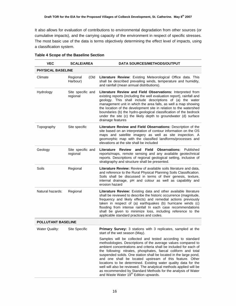
5.3.4 Description of the Environment (Baseline)
The purpose of this section is to describe sensitive environmental receptors in terms of pre-project status and trends (if the project is not implemented). This therefore provides a baseline against which future monitoring data can be compared to determine whether and how a project is actually impacting specific receptors.
Draft TOR for the EIA for the Proposed Villages of Colbeck Development, St. Catherine. May 8th 2007
16
It also allows for evaluation of contributions to environmental degradation from other sources (or cumulative impacts), and the carrying capacity of the environment in respect of specific stresses. The most basic use of the data is terms objectively determining the effect level of impacts, using a classification system.
Table 4 Scope of the Baseline Section
VEC SCALE/AREA DATA SOURCES/METHODS/OUTPUT
PHYSICAL BASELINE
Climate Regional (Old Harbour)
Literature Review: Existing Meteorological Office data. This shall be described prevailing winds, temperature and humidity, and rainfall (mean annual distributions).
Hydrology Site specific and regional
Literature Review and Field Observations: Interpreted from existing reports (including the well evaluation report), rainfall and geology. This shall include descriptions of (a) the water management unit in which the area falls, as well a map showing the location of the development site in relation to the watershed boundaries (b) the hydro-geological classification of the bedrock under the site (c) the likely depth to groundwater (d) surface drainage features
Topography Site specific Literature Review and Field Observations: Description of the site based on an interpretation of contour information on the OS maps and satellite imagery as well as site inspection. A geomorphic map with the classified landforms/processes and elevations at the site shall be included
Geology Site specific and regional
Literature Review and Field Observations: Published reports/maps, remote sensing and any available geotechnical reports. Descriptions of regional geological setting, inclusive of stratigraphy and structure shall be presented.
Soils Regional Literature Review: Review of available soils literature and data, and reference to the Rural Physical Planning Soils Classification. Soils shall be discussed in terms of their genesis, texture, internal drainage, pH and colour as well as capability and erosion hazard
Natural hazards: Regional Literature Review: Existing data and other available literature shall be reviewed to describe the historic occurrence (magnitude, frequency and likely effects) and remedial actions previously taken in respect of (a) earthquakes (b) hurricane winds (c) flooding from intense rainfall In each case recommendations shall be given to minimize loss, including reference to the applicable standard practices and codes.
POLLUTANT BASELINE
Water Quality:
Site Specific Primary Survey: 3 stations with 3 replicates, sampled at the start of the wet season (May).
Samples will be collected and tested according to standard methodologies. Descriptions of the average values compared to ambient concentrations and criteria shall be included for each of the following: nitrates, phosphates, faecal coliform and total suspended solids. One station shall be located in the large pond, and one shall be located upstream of this feature. Other locations to be determined. Existing water quality data for the well will also be reviewed. The analytical methods applied will be as recommended by Standard Methods for the analysis of Water and Waste Water 19th Edition upwards.
Draft TOR for the EIA for the Proposed Villages of Colbeck Development, St. Catherine. May 8th 2007
17
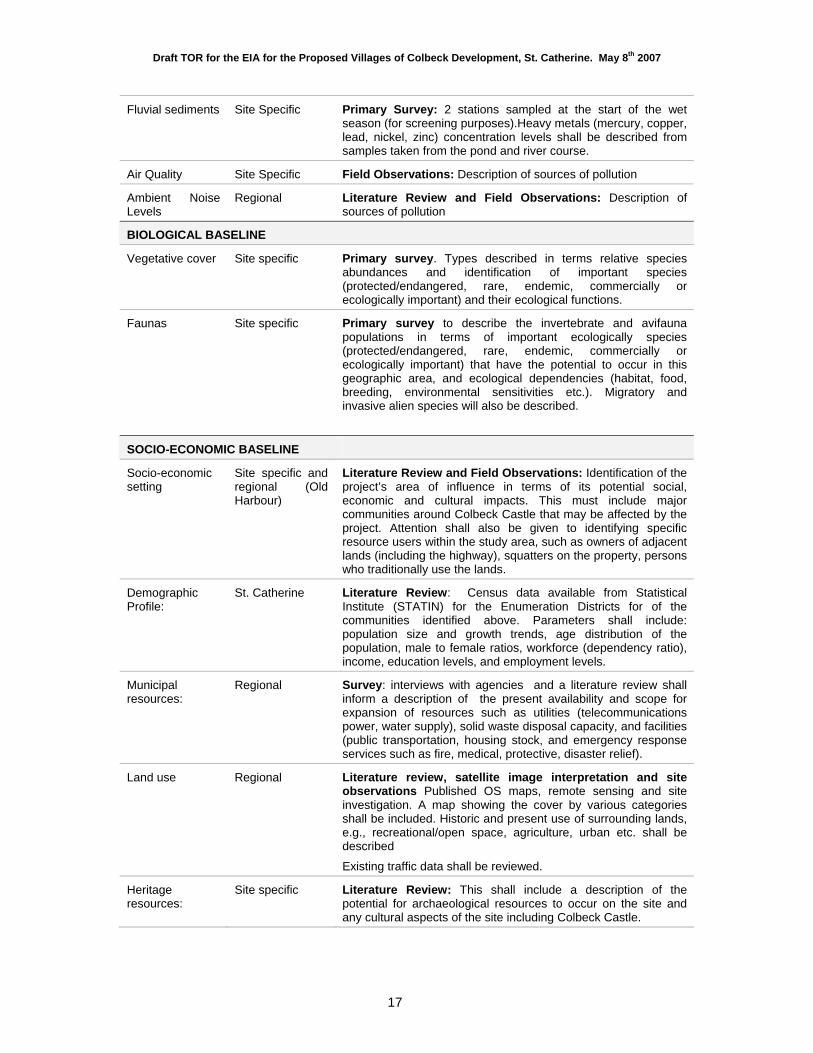
Fluvial sediments Site Specific Primary Survey: 2 stations sampled at the start of the wet season (for screening purposes).Heavy metals (mercury, copper, lead, nickel, zinc) concentration levels shall be described from samples taken from the pond and river course.
Air Quality Site Specific Field Observations: Description of sources of pollution
Ambient Noise Levels
Regional Literature Review and Field Observations: Description of sources of pollution
BIOLOGICAL BASELINE
Vegetative cover Site specific Primary survey. Types described in terms relative species abundances and identification of important species (protected/endangered, rare, endemic, commercially or ecologically important) and their ecological functions.
Faunas Site specific Primary survey to describe the invertebrate and avifauna populations in terms of important ecologically species (protected/endangered, rare, endemic, commercially or ecologically important) that have the potential to occur in this geographic area, and ecological dependencies (habitat, food, breeding, environmental sensitivities etc.). Migratory and invasive alien species will also be described.
SOCIO-ECONOMIC BASELINE
Socio-economic setting
Site specific and regional (Old Harbour)
Literature Review and Field Observations: Identification of the project’s area of influence in terms of its potential social, economic and cultural impacts. This must include major communities around Colbeck Castle that may be affected by the project. Attention shall also be given to identifying specific resource users within the study area, such as owners of adjacent lands (including the highway), squatters on the property, persons who traditionally use the lands.
Demographic Profile:
St. Catherine Literature Review: Census data available from Statistical Institute (STATIN) for the Enumeration Districts for of the communities identified above. Parameters shall include: population size and growth trends, age distribution of the population, male to female ratios, workforce (dependency ratio), income, education levels, and employment levels.
Municipal resources:
Regional Survey: interviews with agencies and a literature review shall inform a description of the present availability and scope for expansion of resources such as utilities (telecommunications power, water supply), solid waste disposal capacity, and facilities (public transportation, housing stock, and emergency response services such as fire, medical, protective, disaster relief).
Land use Regional Literature review, satellite image interpretation and site observations Published OS maps, remote sensing and site investigation. A map showing the cover by various categories shall be included. Historic and present use of surrounding lands, e.g., recreational/open space, agriculture, urban etc. shall be described
Existing traffic data shall be reviewed.
Heritage resources:
Site specific Literature Review: This shall include a description of the potential for archaeological resources to occur on the site and any cultural aspects of the site including Colbeck Castle.
Draft TOR for the EIA for the Proposed Villages of Colbeck Development, St. Catherine. May 8th 2007
18
5.3.5 Summary of the Stakeholder Consultation Process
This section shall summarize the key environmental concerns arising during the stakeholder consultations done prior to submission of the EIA. The degree of public concern with specific issues (and general acceptability of the impact given proposed mitigation) is a key criterion used in determining of the relative significance of environmental impacts.
A field survey of 100 household heads in the surrounding EDs shall be conducted. The sampling regime for administration of the questionnaire shall also be described. The following information shall be determined from the population survey:
- Basic demographic profile: age, sex, income, education, land tenure, quality of life indicators;
- Social capital: membership in voluntary organizations, churches, clubs and linkages outside of the community;
- The values that the local communities place on the area; existing nuisances and complaints about the area and services; and
- Awareness, perceived problems or fears; expectations or perceived benefits of the development proposal.
5.3.6 Assessment of Impacts and Mitigation Measures
The purpose of this task is to identify the major environmental and public health issues of concern and indicate their relative importance to the design of the project and the intended activities. Both positive and negative project impacts are identified using the following methods.
1. Stakeholder consultation. 2. Technical inputs from environmental specialists on the EIA team. 3. Review of the possible impact-causing aspects of the project. 4. Review of impact assessments done for similar projects. 5. Regulatory criteria governing aspects of the environment likely to be impacted. 6. The sensitivity of valued environmental components (VECs) likely to be impacted by the
project. 7. Review of the risks arising from the project and the range of environmental
consequences that could arise under upset conditions.
Each identified impact is classified according to the assessed effect level (no impact, minor, moderate or major). Each identified impact shall be assessed using the following criteria:
1. Scale: magnitude of the adverse effect in terms of the geographic extent of influence arising from frequency and magnitude of the causative action.
2. Affected Numbers: numbers of individuals (organisms, people etc.) from a valued population that stand to be impacted.
Draft TOR for the EIA for the Proposed Villages of Colbeck Development, St. Catherine. May 8th 2007
19
3. Secondary Effects: This parameter looks at the impact as a trigger mechanism for other effects, particularly those manifesting downstream of a pathway emanating from a project component, latent effects that could occur in the future, such as bioaccumulation of heavy metals in the food chain, or effects on future generations.
4. Resilience: Ecological resilience/sensitivity (ability of a population to cope with effect). Existing stresses and variability of sensitivity (spatial or seasonal) shall be considered.
5. Persistence: frequency and duration of effects in the environment. In general, chronic (persistent) or acute (short-term but severe) effects are regarded as more significant.
6. Reversibility: the extent to which an effected receptor can be returned to its pre-project state.
7. Baseline change: This relates to any model or prediction of the extent of change that can be expected. This shall compare predicted levels of change with normal fluctuations as well as trends in the parameter without the effect of the project.
8. Manageability: This addresses the feasibility (ease of implementation and cost-effectiveness) of measures to prevent or reduce environmental costs. It shall also consider the benefits or moderating circumstances given these environmental costs.
9. Uncertainty: This allows for disclosure of the level of scientific confidence in the predicted outcomes, and the general reliability of the data and models used to predict impacts.
10. Acceptability: This examines the willingness to make trade-offs and the degree of objection, given potential benefits of the project. This also includes planning constraints and scientific criteria (maximum allowable limits).
Using these criteria, a significant negative environmental impact is defined as one that:
Is located in proximity to any sensitive or protected areas and has been determined to impact negatively on these;
Is extensive over space or time (scales must be appropriately defined); Is intensive in concentration (i.e. exceeding recommended criteria) or in relation to
assimilative capacity (as appropriated to the affected receptor); Is not consistent with national plans for the general use of the area; Contributes to the endangerment of threatened species; Reduces the stocks of commercially important species; Permanently damages habitat quality or creates ecological barriers; Threatens cultural or heritage resources; Alters community lifestyles or requires long-term adjustments of local people in respect of
traditional values and resource use; and Represents a long-term nuisance or significant safety risk to other users.
Where the project contributes to a pre-existing environmental stress (arising from non-project related external activities), the additive or cumulative effects are taken into account in the examination of the baseline as a shifting baseline, as well as divergence from the baseline that might be expected to arise from project implementation.
Draft TOR for the EIA for the Proposed Villages of Colbeck Development, St. Catherine. May 8th 2007
20
Internal aggregations of impacts on specific VECs that may individually be assessed as having a “minor” effect, but may collectively have a significant combined effect. The net cumulative effects are evaluated where multiple project activities contribute to the same effect.
This section must conclude with the consultant’s statement on whether, based on the various investigations and assessments that were done as part of the EIA process, there is a Finding of No Negative Significant Impacts (FONSI). If the study finds that the project has the potential to result in significant negative environmental impacts that cannot be cost effectively mitigated, and which require project modification (in terms of design, site, technology use or scale/footprint), this must be clearly disclosed.
5.3.7 Environmental Management Plan
The Environmental Management Plan (EMP) shall include, at a minimum:
A description of the most appropriate environmental performance objectives for the project based on the specific impacts identified during site preparation, construction and operational stages of the proposed development.
A summary of proposed mitigation measures, identifying the best timing for implementation, responsibilities and any required commitments of resources.
General guidelines for activities during construction and operational phases of the project to improve the project’s overall environmental performance (e.g., in respect of waste management, water and energy conservation, heritage conservation, community development, etc.).
Recommended requirements for post-permit plans and approvals. An outline of a monitoring plan, which shall cover monitoring of implementation of
mitigation measures and the enforcement of the permit conditions, as well as any recommended monitoring of environmental parameters that can allow for assessment of the actual environmental effect level compared to the baseline condition and the predicted effect level.
5.4 Additional Information
The EIA preparer shall observe the following guidelines:
Professional opinions shall not be presented as statement of fact, and shall be avoided unless they can be substantiated by published references as is the norm in technical scientific writing.
All bibliographic references used to substantiate statements in the report shall be listed. The report shall include appendices with items such as the approved TOR; raw data; and
Water Quality Lab Certificates, maps, site plans, photographs, and other relevant information.
A list of EIA preparers (including analytical facilities) and their credentials must be included.


![[PPT]DEVELOPMENT PLANNING PROCESS - National ...nepa.gov.jm/ecentre/Development-Planning-Process-in... · Web viewDEVELOPMENT PLANNING PROCESS IN JAMAICA Development Order Outline](https://img.pdfslide.us/doc/110x75/5ae0bd6f7f8b9a1c248d8e7e/pptdevelopment-planning-process-national-nepagovjmecentredevelopment-planning-process-inweb.jpg)