Embed Size (px)
Citation preview
Phase Three
Development Assessment Scenarios

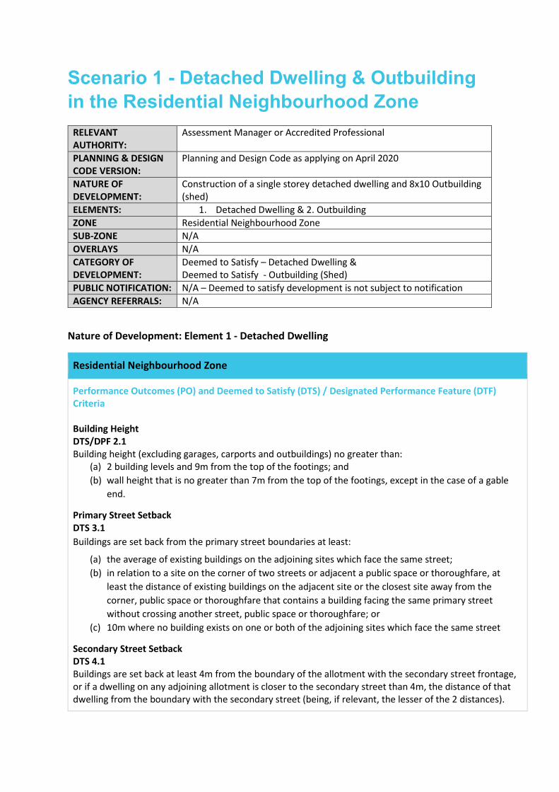
Scenario 1 - Detached Dwelling & Outbuilding in the Residential Neighbourhood Zone
RELEVANT AUTHORITY:
Assessment Manager or Accredited Professional
PLANNING & DESIGN CODE VERSION:
Planning and Design Code as applying on April 2020
NATURE OF DEVELOPMENT:
Construction of a single storey detached dwelling and 8x10 Outbuilding (shed)
ELEMENTS: 1. Detached Dwelling & 2. Outbuilding ZONE Residential Neighbourhood Zone SUB-ZONE N/A OVERLAYS N/A CATEGORY OF DEVELOPMENT:
Deemed to Satisfy – Detached Dwelling & Deemed to Satisfy - Outbuilding (Shed)
PUBLIC NOTIFICATION: N/A – Deemed to satisfy development is not subject to notification AGENCY REFERRALS: N/A
Nature of Development: Element 1 - Detached Dwelling
Residential Neighbourhood Zone
Performance Outcomes (PO) and Deemed to Satisfy (DTS) / Designated Performance Feature (DTF) Criteria Building Height DTS/DPF 2.1 Building height (excluding garages, carports and outbuildings) no greater than:
(a) 2 building levels and 9m from the top of the footings; and (b) wall height that is no greater than 7m from the top of the footings, except in the case of a gable
end.
Primary Street Setback DTS 3.1 Buildings are set back from the primary street boundaries at least:
(a) the average of existing buildings on the adjoining sites which face the same street; (b) in relation to a site on the corner of two streets or adjacent a public space or thoroughfare, at
least the distance of existing buildings on the adjacent site or the closest site away from the corner, public space or thoroughfare that contains a building facing the same primary street without crossing another street, public space or thoroughfare; or
(c) 10m where no building exists on one or both of the adjoining sites which face the same street
Secondary Street Setback DTS 4.1 Buildings are set back at least 4m from the boundary of the allotment with the secondary street frontage, or if a dwelling on any adjoining allotment is closer to the secondary street than 4m, the distance of that dwelling from the boundary with the secondary street (being, if relevant, the lesser of the 2 distances).
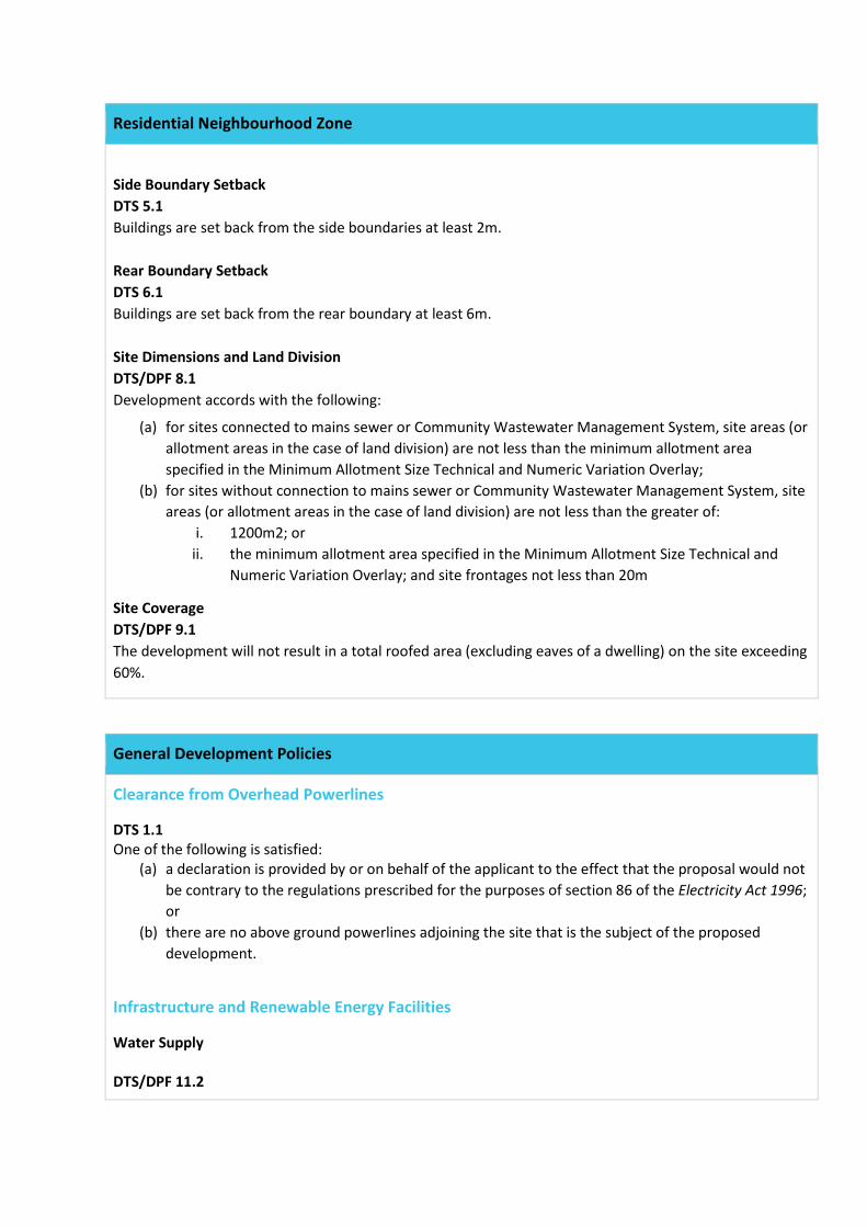
Residential Neighbourhood Zone
Side Boundary Setback DTS 5.1 Buildings are set back from the side boundaries at least 2m. Rear Boundary Setback DTS 6.1 Buildings are set back from the rear boundary at least 6m. Site Dimensions and Land Division DTS/DPF 8.1 Development accords with the following:
(a) for sites connected to mains sewer or Community Wastewater Management System, site areas (or allotment areas in the case of land division) are not less than the minimum allotment area specified in the Minimum Allotment Size Technical and Numeric Variation Overlay;
(b) for sites without connection to mains sewer or Community Wastewater Management System, site areas (or allotment areas in the case of land division) are not less than the greater of:
i. 1200m2; or ii. the minimum allotment area specified in the Minimum Allotment Size Technical and
Numeric Variation Overlay; and site frontages not less than 20m
Site Coverage DTS/DPF 9.1 The development will not result in a total roofed area (excluding eaves of a dwelling) on the site exceeding 60%.
General Development Policies
Clearance from Overhead Powerlines
DTS 1.1 One of the following is satisfied:
(a) a declaration is provided by or on behalf of the applicant to the effect that the proposal would not be contrary to the regulations prescribed for the purposes of section 86 of the Electricity Act 1996; or
(b) there are no above ground powerlines adjoining the site that is the subject of the proposed development.
Infrastructure and Renewable Energy Facilities
Water Supply DTS/DPF 11.2
General Development Policies
A dwelling is connected, or will be connected, to a reticulated water scheme or mains water supply with the capacity to meet the requirements of the development. Where this is not available it is instead serviced by a rainwater tank or tanks capable of holding at least 50,000 litres of water which is:
(a) exclusively for domestic use; and (b) connected to the roof drainage system of the dwelling.
Wastewater Services DTS 12.1 Development is connected, or will be connected, to an approved common waste water disposal service with the capacity to meet the requirements of the development. Where this is not available it is instead serviced by an on-site waste water treatment system in accordance with the following:
(a) is wholly located and contained within the allotment of development it will service; and (b) ensures no part of a septic tank effluent drainage field or any other waste water disposal system is
located: i. within 50m of a watercourse, bore, well or dam;
ii. on any land with a slope greater than 20% (1-in-5), or a depth to bedrock or seasonal or permanent water table less than 1.2m; and
iii. on land that is waterlogged, saline, part of a runway area or likely to be inundated by a 10% AEP flood event.
DTS/DPF 12.2 Development is not built on, or encroaches within, an area that is, or will be, required for a sewerage system or waste control system.
Transport, Access and Parking
Vehicle Access DTS/DPF 3.1 The access is:
(a) provided via a lawfully existing or authorised driveway or access point or an access point for which consent has been granted as part of an application for the division of land; and
(b) not located within 6m of an intersection of 2 or more roads or a pedestrian actuated crossing.
DTS/DPF 3.5 The access point does not involve the removal or relocation of mature street trees, street furniture or utility infrastructure services. DTS/DPF 3.6 Driveways and access points:
(a) for sites with a frontage to a public road of 20m or less, one access point no greater than 3.5m in width is provided.
(b) for sites with a frontage to a public road greater than 20m: i. a single access point no greater than 6m in width is provided; or
ii. not more than two access points with a width of 3.5m each are provided.
General Development Policies
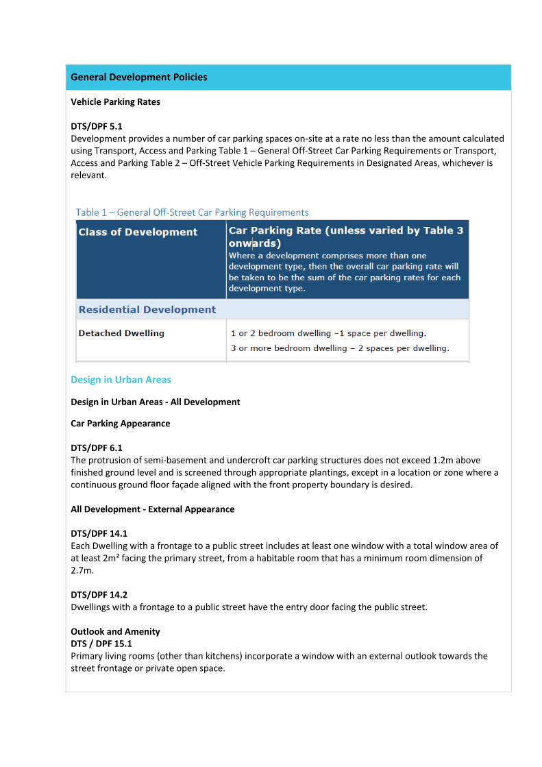
Vehicle Parking Rates DTS/DPF 5.1 Development provides a number of car parking spaces on-site at a rate no less than the amount calculated using Transport, Access and Parking Table 1 – General Off-Street Car Parking Requirements or Transport, Access and Parking Table 2 – Off-Street Vehicle Parking Requirements in Designated Areas, whichever is relevant.
Design in Urban Areas
Design in Urban Areas - All Development
Car Parking Appearance DTS/DPF 6.1 The protrusion of semi-basement and undercroft car parking structures does not exceed 1.2m above finished ground level and is screened through appropriate plantings, except in a location or zone where a continuous ground floor façade aligned with the front property boundary is desired. All Development - External Appearance DTS/DPF 14.1 Each Dwelling with a frontage to a public street includes at least one window with a total window area of at least 2m² facing the primary street, from a habitable room that has a minimum room dimension of 2.7m. DTS/DPF 14.2 Dwellings with a frontage to a public street have the entry door facing the public street. Outlook and Amenity DTS / DPF 15.1 Primary living rooms (other than kitchens) incorporate a window with an external outlook towards the street frontage or private open space.
General Development Policies
Flooding DTS/DPF 17.1 Residential accommodation has a ground finished flor level 300mm above the top of the kerb level of the primary street.
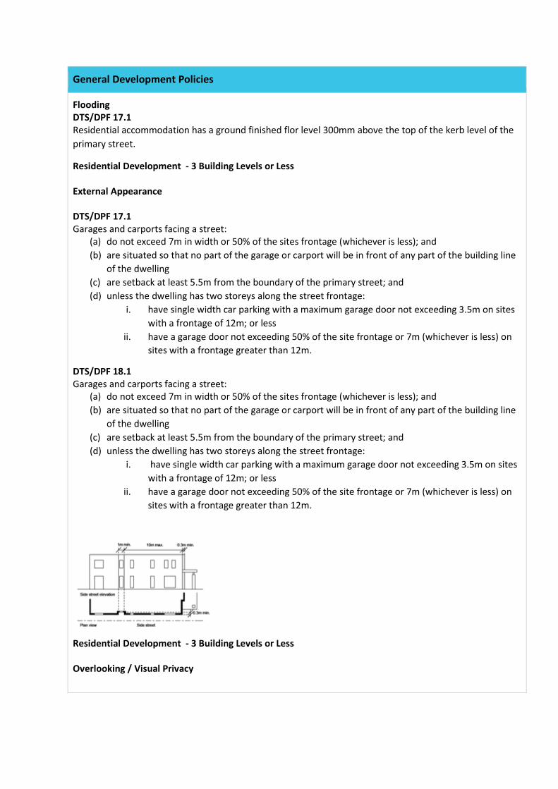
Residential Development - 3 Building Levels or Less External Appearance DTS/DPF 17.1 Garages and carports facing a street:
(a) do not exceed 7m in width or 50% of the sites frontage (whichever is less); and (b) are situated so that no part of the garage or carport will be in front of any part of the building line
of the dwelling (c) are setback at least 5.5m from the boundary of the primary street; and (d) unless the dwelling has two storeys along the street frontage:
i. have single width car parking with a maximum garage door not exceeding 3.5m on sites with a frontage of 12m; or less
ii. have a garage door not exceeding 50% of the site frontage or 7m (whichever is less) on sites with a frontage greater than 12m.
DTS/DPF 18.1 Garages and carports facing a street:
(a) do not exceed 7m in width or 50% of the sites frontage (whichever is less); and (b) are situated so that no part of the garage or carport will be in front of any part of the building line
of the dwelling (c) are setback at least 5.5m from the boundary of the primary street; and (d) unless the dwelling has two storeys along the street frontage:
i. have single width car parking with a maximum garage door not exceeding 3.5m on sites with a frontage of 12m; or less
ii. have a garage door not exceeding 50% of the site frontage or 7m (whichever is less) on sites with a frontage greater than 12m.
Residential Development - 3 Building Levels or Less Overlooking / Visual Privacy
DTS / DPF 19.1 Upper level windows facing side or rear boundaries shared with an allotment put to residential use:
(a) are permanently obscured to a height of 1.5m above finished floor level that is fixed or not capable of being opened more than 200mm;
(b) have sill heights greater than or equal to 1.5m above finished floor level; or (c) incorporate screening to a height of 1.5m above finished floor level; and (d) the building will not have a balcony or terrace on an upper building level, other than where the
longest side of that balcony or terrace will face a road (including any road reserve), or reserve (including any land held as open space), and is at least 15m from the private open space of any other dwelling.
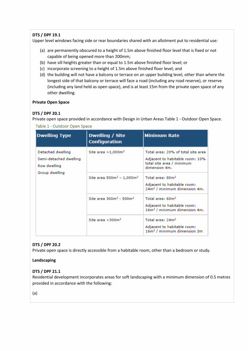
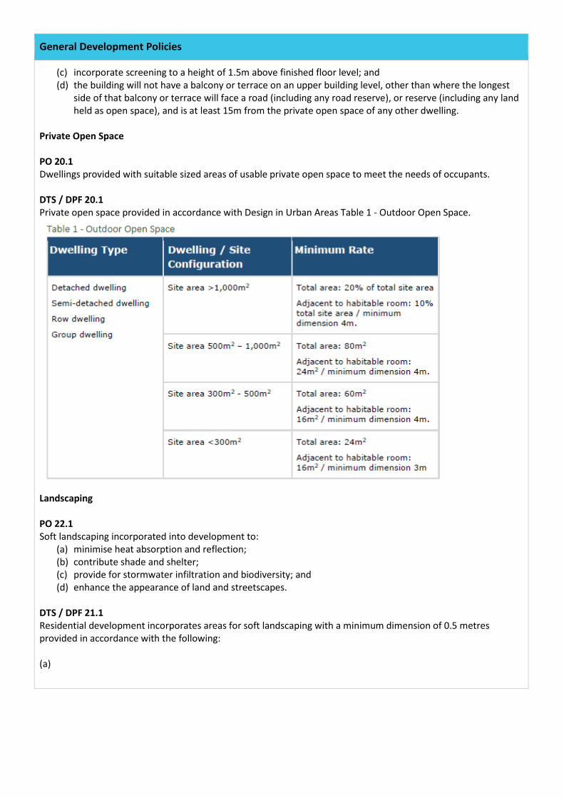
Private Open Space DTS / DPF 20.1 Private open space provided in accordance with Design in Urban Areas Table 1 - Outdoor Open Space.
DTS / DPF 20.2 Private open space is directly accessible from a habitable room, other than a bedroom or study.
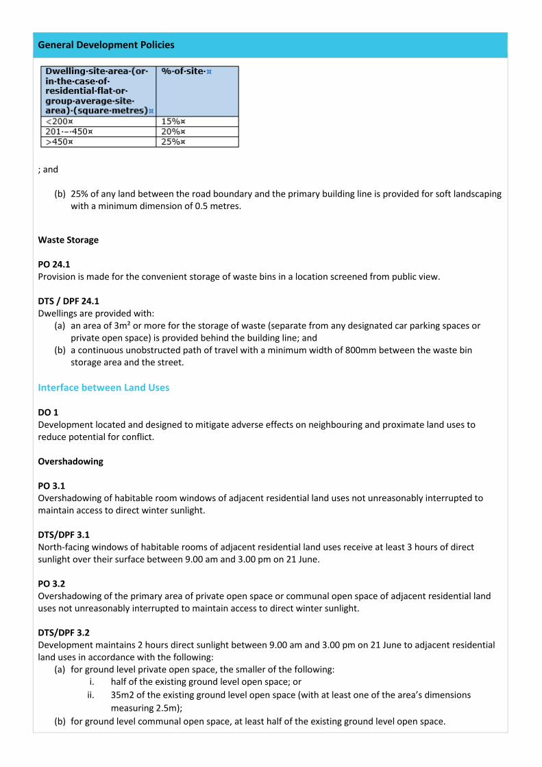
Landscaping DTS / DPF 21.1 Residential development incorporates areas for soft landscaping with a minimum dimension of 0.5 metres provided in accordance with the following:
(a)
General Development Policies
; and
(b) 25% of any land between the road boundary and the primary building line is provided for soft landscaping with a minimum dimension of 0.5 metres.
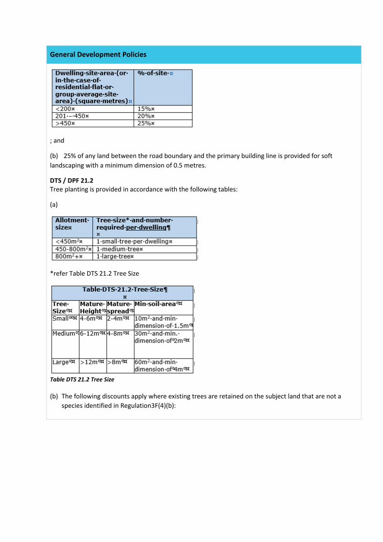
DTS / DPF 21.2 Tree planting is provided in accordance with the following tables:
(a)
*refer Table DTS 21.2 Tree Size
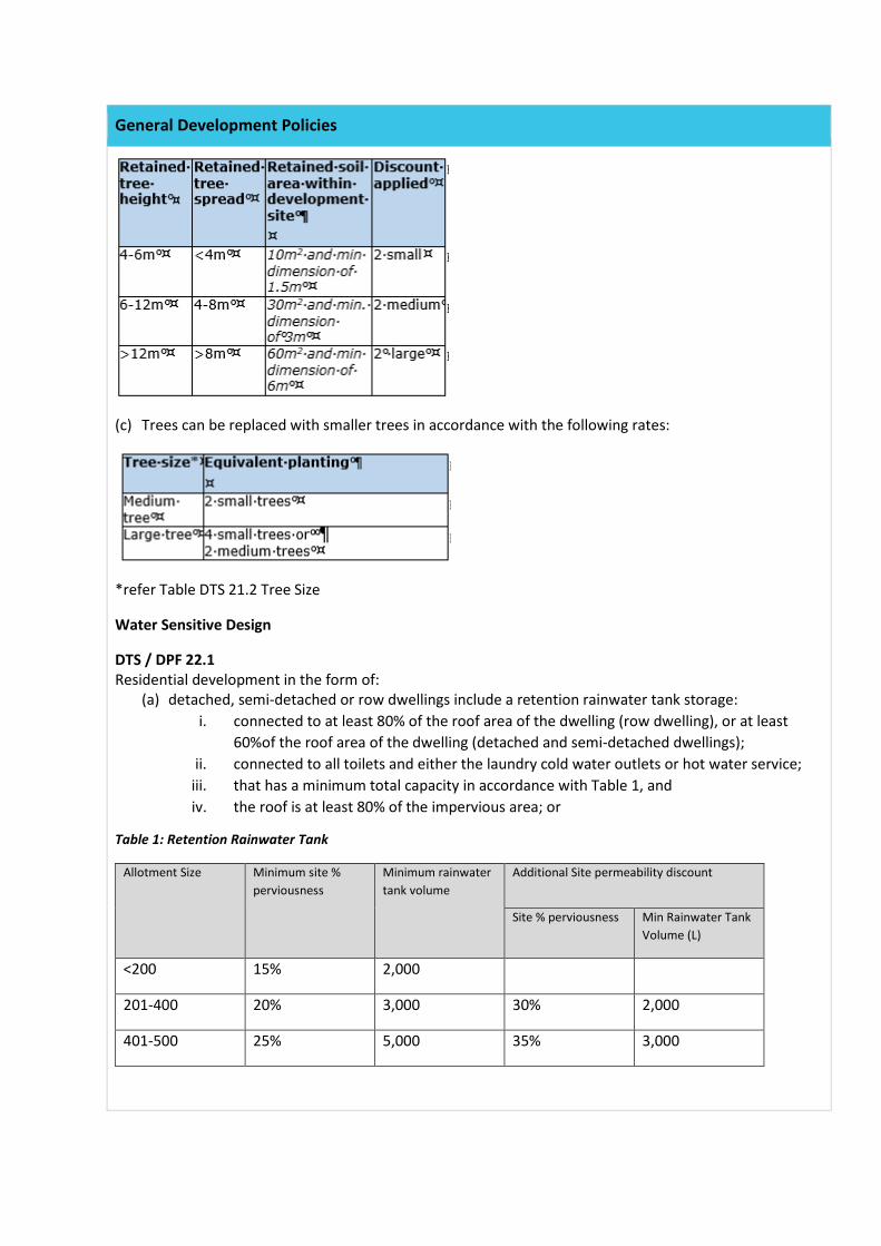
Table DTS 21.2 Tree Size (b) The following discounts apply where existing trees are retained on the subject land that are not a
species identified in Regulation3F(4)(b):
General Development Policies
(c) Trees can be replaced with smaller trees in accordance with the following rates:
*refer Table DTS 21.2 Tree Size
Water Sensitive Design
DTS / DPF 22.1 Residential development in the form of:
(a) detached, semi-detached or row dwellings include a retention rainwater tank storage: i. connected to at least 80% of the roof area of the dwelling (row dwelling), or at least
60%of the roof area of the dwelling (detached and semi-detached dwellings); ii. connected to all toilets and either the laundry cold water outlets or hot water service;
iii. that has a minimum total capacity in accordance with Table 1, and iv. the roof is at least 80% of the impervious area; or
Table 1: Retention Rainwater Tank
Allotment Size Minimum site % perviousness
Minimum rainwater tank volume
Additional Site permeability discount
Site % perviousness Min Rainwater Tank Volume (L)
<200 15% 2,000
201-400 20% 3,000 30% 2,000
401-500 25% 5,000 35% 3,000
General Development Policies
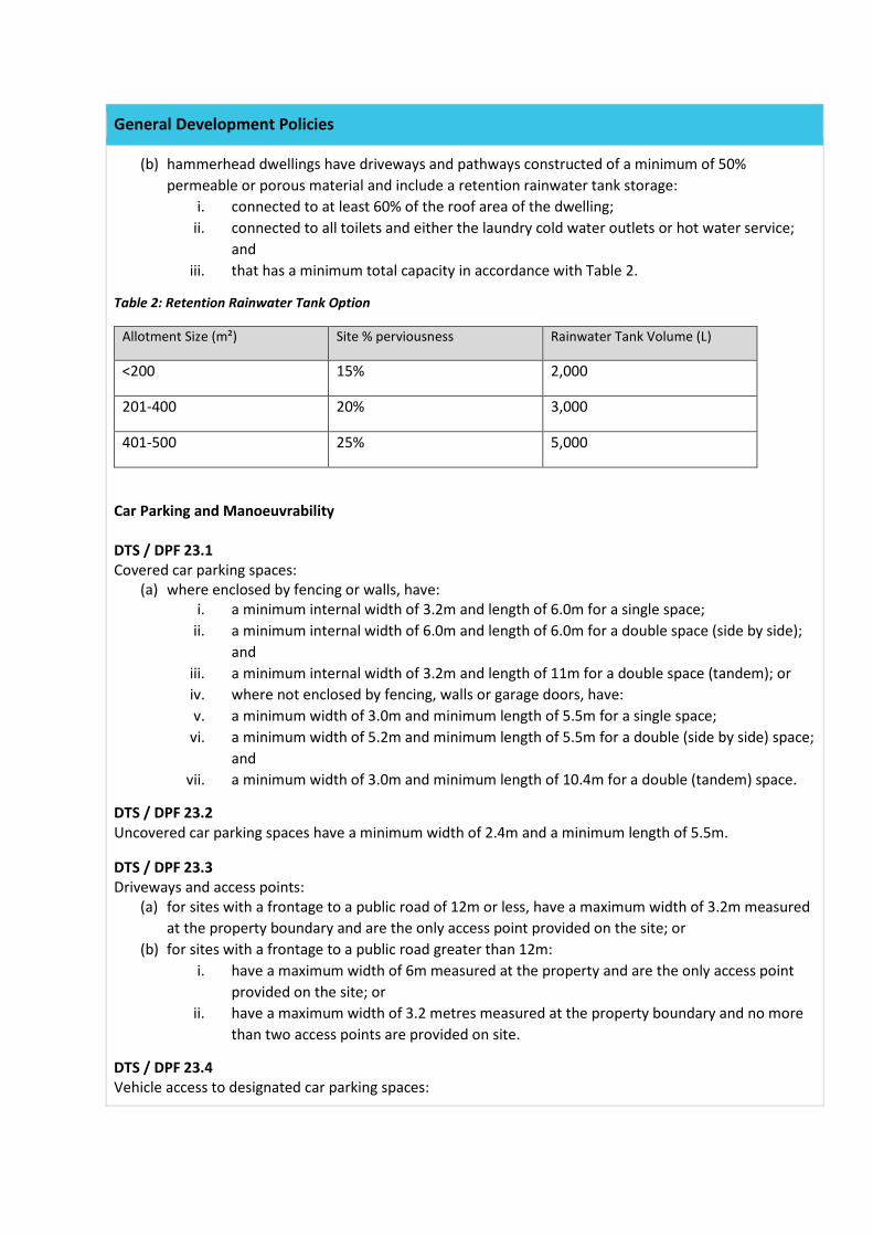
(b) hammerhead dwellings have driveways and pathways constructed of a minimum of 50% permeable or porous material and include a retention rainwater tank storage:
i. connected to at least 60% of the roof area of the dwelling; ii. connected to all toilets and either the laundry cold water outlets or hot water service;
and iii. that has a minimum total capacity in accordance with Table 2.
Table 2: Retention Rainwater Tank Option
Allotment Size (m²) Site % perviousness Rainwater Tank Volume (L)
<200 15% 2,000
201-400 20% 3,000
401-500 25% 5,000
Car Parking and Manoeuvrability DTS / DPF 23.1 Covered car parking spaces:
(a) where enclosed by fencing or walls, have: i. a minimum internal width of 3.2m and length of 6.0m for a single space;
ii. a minimum internal width of 6.0m and length of 6.0m for a double space (side by side); and
iii. a minimum internal width of 3.2m and length of 11m for a double space (tandem); or iv. where not enclosed by fencing, walls or garage doors, have: v. a minimum width of 3.0m and minimum length of 5.5m for a single space;
vi. a minimum width of 5.2m and minimum length of 5.5m for a double (side by side) space; and
vii. a minimum width of 3.0m and minimum length of 10.4m for a double (tandem) space.
DTS / DPF 23.2 Uncovered car parking spaces have a minimum width of 2.4m and a minimum length of 5.5m.
DTS / DPF 23.3 Driveways and access points:
(a) for sites with a frontage to a public road of 12m or less, have a maximum width of 3.2m measured at the property boundary and are the only access point provided on the site; or
(b) for sites with a frontage to a public road greater than 12m: i. have a maximum width of 6m measured at the property and are the only access point
provided on the site; or ii. have a maximum width of 3.2 metres measured at the property boundary and no more
than two access points are provided on site.
DTS / DPF 23.4 Vehicle access to designated car parking spaces:
General Development Policies
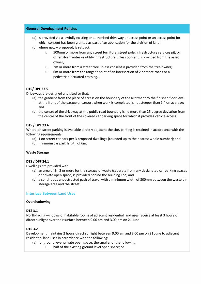
(a) is provided via a lawfully existing or authorised driveway or access point or an access point for which consent has been granted as part of an application for the division of land
(b) where newly proposed, is setback: i. 500mm or more from any street furniture, street pole, infrastructure services pit, or
other stormwater or utility infrastructure unless consent is provided from the asset owner;
ii. 2m or more from a street tree unless consent is provided from the tree owner; iii. 6m or more from the tangent point of an intersection of 2 or more roads or a
pedestrian-actuated crossing.
DTS/ DPF 23.5 Driveways are designed and sited so that:
(a) the gradient from the place of access on the boundary of the allotment to the finished floor level at the front of the garage or carport when work is completed is not steeper than 1:4 on average; and
(b) the centre of the driveway at the public road boundary is no more than 25 degree deviation from the centre of the front of the covered car parking space for which it provides vehicle access.
DTS / DPF 23.6 Where on-street parking is available directly adjacent the site, parking is retained in accordance with the following requirements:
(a) 1 on-street car park per 3 proposed dwellings (rounded up to the nearest whole number); and (b) minimum car park length of 6m.
Waste Storage DTS / DPF 24.1 Dwellings are provided with:
(a) an area of 3m2 or more for the storage of waste (separate from any designated car parking spaces or private open space) is provided behind the building line; and
(b) a continuous unobstructed path of travel with a minimum width of 800mm between the waste bin storage area and the street.
Interface Between Land Uses
Overshadowing DTS 3.1 North-facing windows of habitable rooms of adjacent residential land uses receive at least 3 hours of direct sunlight over their surface between 9.00 am and 3.00 pm on 21 June. DTS 3.2 Development maintains 2 hours direct sunlight between 9.00 am and 3.00 pm on 21 June to adjacent residential land uses in accordance with the following:
(a) for ground level private open space, the smaller of the following: i. half of the existing ground level open space; or
General Development Policies
ii. 35m2 of the existing ground level open space (with at least one of the area’s dimensions measuring 2.5m);
(b) for ground level communal open space, at least half of the existing ground level open space. Interface Between Rural Activities DTS 9.3 Sensitive receivers are located at least 200m from the boundary of a site used for land based aquaculture and associated components in other ownership. DTS/DPF 9.4 Sensitive receivers sited at least 500m from the boundary of a site used for a dairy and associated wastewater lagoon(s) and liquid/solid waste storage and disposal facilities in other ownership. DTS/DPF 9.5 Sensitive receivers are located at least 300m from the boundary of a site used for the handling, transportation and storage of bulk commodities in other ownership. Interface with Mines and Quarries (Rural and Remote Areas) DTS 10.1 Sensitive receivers are located no closer than 500m from the boundary of a Mining Production Tenement under the Mining Act 1971. Site Contamination DTS 1.1 Development:
(a) does not incorporate a change of use of land; (b) incorporates a change of use of land that is not a more sensitive use of land than previously
established uses of the land; (c) in respect of which the applicant is able to furnish, or the relevant authority is in possession of, a
site contamination audit report less than 5 years old under Part 10A of the Environment Protection Act 1993 to the effect:
i. that site contamination does not exist (or no longer exists) at the land; or ii. that any site contamination at the land has been cleared or addressed to the extent
necessary to enable the land to be suitable for sensitive use; or (d) the allotment was the subject of consent granted under the Development Act 1993 or the
Planning Development and Infrastructure Act 2016 on or after 1 September 2009 in relation the division of the land.
Element 2 - Outbuilding
Residential Neighbourhood Zone
Ancillary Buildings and Structures DTS/DPF 7.1 Ancillary buildings and structures:
(a) are ancillary to a dwelling erected on the site; (b) are not being constructed, added to or altered so that any part is situated:
i. in front of any part of the building line of the dwelling to which it is ancillary; or ii. within 4m of a boundary of the allotment with a secondary street (if the land has
boundaries on two or more roads); or iii. within 2m of a side boundary;
(c) in the case of a garage or carport, has a primary street setback that is at least as far back as the dwelling;
(d) not exceed 10m or 50% of the site frontage (whichever is the lesser) when facing a primary street or secondary street;
(e) have a wall height or post height not exceeding 4m above natural ground level; (f) have a roof height where no part of the roof is more than 5m above the natural ground level; and (g) if clad in sheet metal, is pre-colour treated or painted in a non-reflective colour.
DTS/DPF 7.2 Ancillary buildings and structures do not result in:
(a) less private open space than specified in Residential Liveability Table 1 - Private Open Space; (b) less on-site car parking than specified in Transport, Access and Parking Table 1 - Off-street Car
Parking Requirements; and (c) the total roofed floor area of all existing or proposed ancillary building(s) or structure(s) exceeding
100m2.
General Development Policies
Design in Urban Areas External Appearance DTS/DPF 18.1 Garages and carports facing a street:
(a) do not exceed 7m in width or 50% of the sites frontage (whichever is less); and (b) are situated so that no part of the garage or carport will be in front of any part of the building line
of the dwelling (c) are setback at least 5.5m from the boundary of the primary street; and (d) unless the dwelling has two storeys along the street frontage:
i. have single width car parking with a maximum garage door not exceeding 3.5m on sites with a frontage of 12m; or less
ii. have a garage door not exceeding 50% of the site frontage or 7m (whichever is less) on sites with a frontage greater than 12m.
Car parking, Access and Manoeuvrability DTS / DPF 23.1 Covered car parking spaces:
(a) where enclosed by fencing or walls, have: i. a minimum internal width of 3.2m and length of 6.0m for a single space;
ii. a minimum internal width of 6.0m and length of 6.0m for a double space (side by side); and
iii. a minimum internal width of 3.2m and length of 11m for a double space (tandem); or (b) where not enclosed by fencing, walls or garage doors, have:
i. a minimum width of 3.0m and minimum length of 5.5m for a single space; ii. a minimum width of 5.2m and minimum length of 5.5m for a double (side by side) space;
and iii. a minimum width of 3.0m and minimum length of 10.4m for a double (tandem) space.
DTS / DPF 23.2 Uncovered car parking spaces have a minimum width of 2.4m and a minimum length of 5.5m. DTS / DPF 23.3 Driveways and access points:
(a) for sites with a frontage to a public road of 12m or less, have a maximum width of 3.2m measured at the property boundary and are the only access point provided on the site; or
(b) for sites with a frontage to a public road greater than 12m: i. have a maximum width of 6m measured at the property and are the only access point
provided on the site; or ii. have a maximum width of 3.2 metres measured at the property boundary and no more
than two access points are provided on site.
DTS / DPF 23.4 Vehicle access to designated car parking spaces:
(a) is provided via a lawfully existing or authorised driveway or access point or an access point for which consent has been granted as part of an application for the division of land
(b) where newly proposed, is setback: i. 500mm or more from any street furniture, street pole, infrastructure services pit, or
other stormwater or utility infrastructure unless consent is provided from the asset owner;
ii. 2m or more from a street tree unless consent is provided from the tree owner; iii. 6m or more from the tangent point of an intersection of 2 or more roads or a
pedestrian-actuated crossing.
DTS/ DPF 23.5 Driveways are designed and sited so that:
(a) the gradient from the place of access on the boundary of the allotment to the finished floor level at the front of the garage or carport when work is completed is not steeper than 1:4 on average; and
(b) the centre of the driveway at the public road boundary is no more than 25 degree deviation from the centre of the front of the covered car parking space for which it provides vehicle access.
DTS / DPF 23.6 Where on-street parking is available directly adjacent the site, parking is retained in accordance with the following requirements:
(a) 1 on-street car park per 3 proposed dwellings (rounded up to the nearest whole number); and (b) minimum car park length of 6m.
Transport, Access and Parking Vehicle Access DTS/DPF 3.1 The access is:
(a) provided via a lawfully existing or authorised driveway or access point or an access point for which consent has been granted as part of an application for the division of land; and
(b) not located within 6m of an intersection of 2 or more roads or a pedestrian actuated crossing.
DTS/DPF 3.5 The access point does not involve the removal or relocation of mature street trees, street furniture or utility infrastructure services.
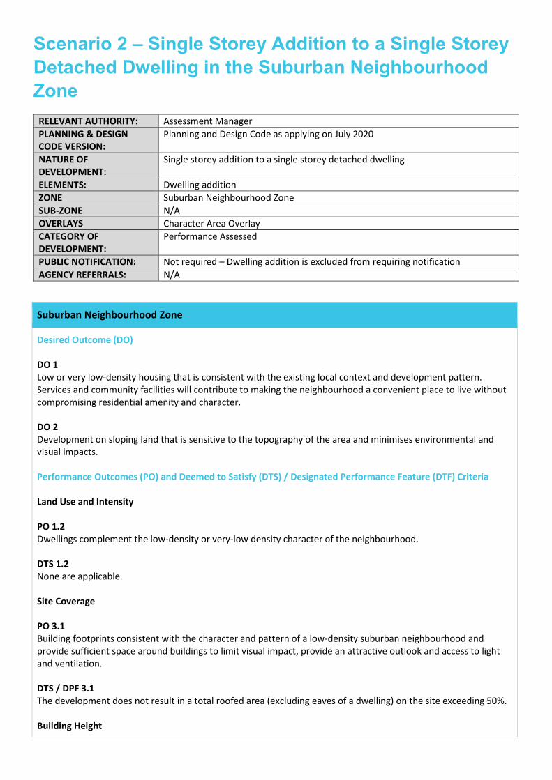
Scenario 2 – Single Storey Addition to a Single Storey Detached Dwelling in the Suburban Neighbourhood Zone
RELEVANT AUTHORITY: Assessment Manager PLANNING & DESIGN CODE VERSION:
Planning and Design Code as applying on July 2020
NATURE OF DEVELOPMENT:
Single storey addition to a single storey detached dwelling
ELEMENTS: Dwelling addition ZONE Suburban Neighbourhood Zone SUB-ZONE N/A OVERLAYS Character Area Overlay CATEGORY OF DEVELOPMENT:
Performance Assessed
PUBLIC NOTIFICATION: Not required – Dwelling addition is excluded from requiring notification AGENCY REFERRALS: N/A
Suburban Neighbourhood Zone
Desired Outcome (DO) DO 1 Low or very low-density housing that is consistent with the existing local context and development pattern. Services and community facilities will contribute to making the neighbourhood a convenient place to live without compromising residential amenity and character. DO 2 Development on sloping land that is sensitive to the topography of the area and minimises environmental and visual impacts. Performance Outcomes (PO) and Deemed to Satisfy (DTS) / Designated Performance Feature (DTF) Criteria Land Use and Intensity PO 1.2 Dwellings complement the low-density or very-low density character of the neighbourhood. DTS 1.2 None are applicable. Site Coverage PO 3.1 Building footprints consistent with the character and pattern of a low-density suburban neighbourhood and provide sufficient space around buildings to limit visual impact, provide an attractive outlook and access to light and ventilation. DTS / DPF 3.1 The development does not result in a total roofed area (excluding eaves of a dwelling) on the site exceeding 50%. Building Height
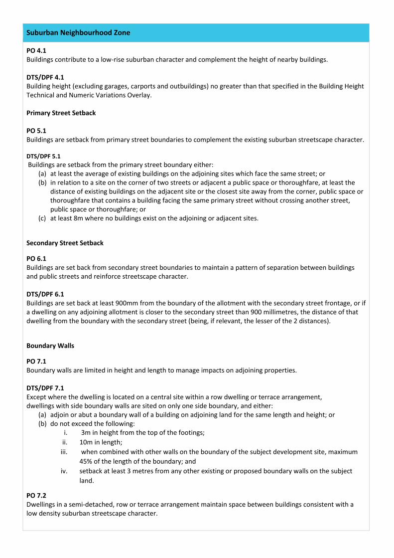
Suburban Neighbourhood Zone
PO 4.1 Buildings contribute to a low-rise suburban character and complement the height of nearby buildings. DTS/DPF 4.1 Building height (excluding garages, carports and outbuildings) no greater than that specified in the Building Height Technical and Numeric Variations Overlay. Primary Street Setback PO 5.1 Buildings are setback from primary street boundaries to complement the existing suburban streetscape character. DTS/DPF 5.1 Buildings are setback from the primary street boundary either:
(a) at least the average of existing buildings on the adjoining sites which face the same street; or (b) in relation to a site on the corner of two streets or adjacent a public space or thoroughfare, at least the
distance of existing buildings on the adjacent site or the closest site away from the corner, public space or thoroughfare that contains a building facing the same primary street without crossing another street, public space or thoroughfare; or
(c) at least 8m where no buildings exist on the adjoining or adjacent sites.
Secondary Street Setback
PO 6.1 Buildings are set back from secondary street boundaries to maintain a pattern of separation between buildings and public streets and reinforce streetscape character. DTS/DPF 6.1 Buildings are set back at least 900mm from the boundary of the allotment with the secondary street frontage, or if a dwelling on any adjoining allotment is closer to the secondary street than 900 millimetres, the distance of that dwelling from the boundary with the secondary street (being, if relevant, the lesser of the 2 distances).
Boundary Walls
PO 7.1 Boundary walls are limited in height and length to manage impacts on adjoining properties. DTS/DPF 7.1 Except where the dwelling is located on a central site within a row dwelling or terrace arrangement, dwellings with side boundary walls are sited on only one side boundary, and either:
(a) adjoin or abut a boundary wall of a building on adjoining land for the same length and height; or (b) do not exceed the following:
i. 3m in height from the top of the footings; ii. 10m in length;
iii. when combined with other walls on the boundary of the subject development site, maximum 45% of the length of the boundary; and
iv. setback at least 3 metres from any other existing or proposed boundary walls on the subject land.
PO 7.2 Dwellings in a semi-detached, row or terrace arrangement maintain space between buildings consistent with a low density suburban streetscape character.
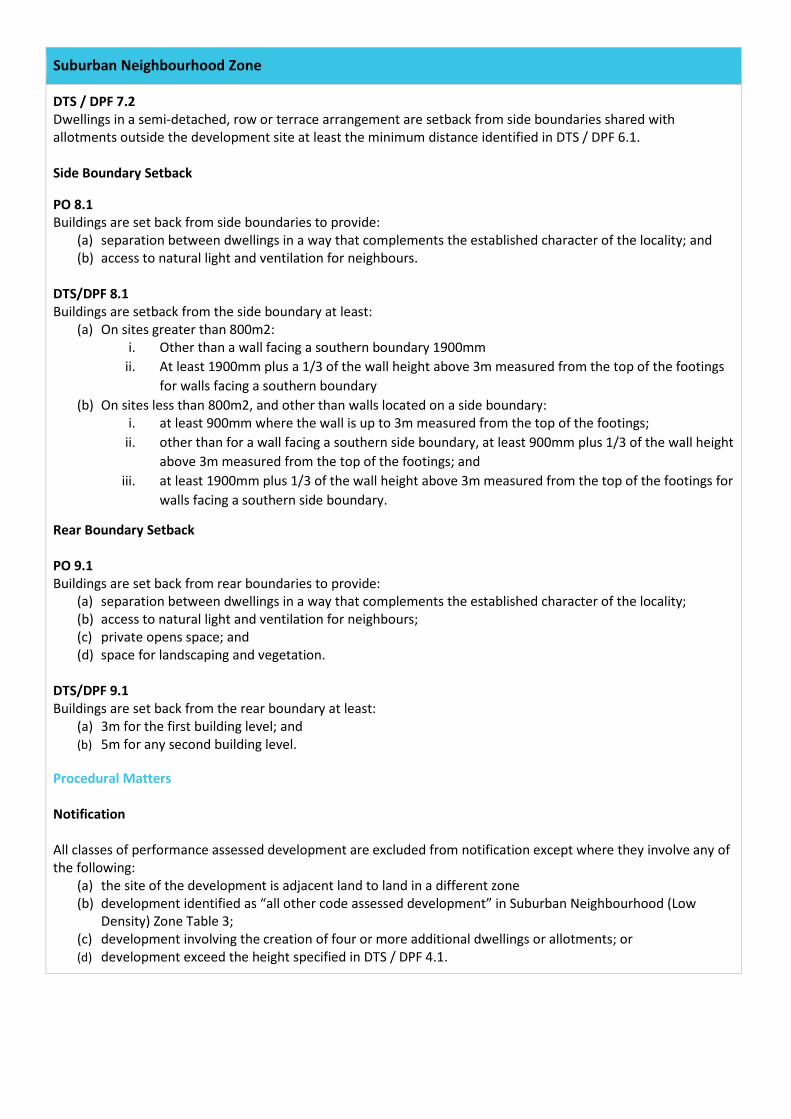
Suburban Neighbourhood Zone
DTS / DPF 7.2 Dwellings in a semi-detached, row or terrace arrangement are setback from side boundaries shared with allotments outside the development site at least the minimum distance identified in DTS / DPF 6.1. Side Boundary Setback
PO 8.1 Buildings are set back from side boundaries to provide:
(a) separation between dwellings in a way that complements the established character of the locality; and (b) access to natural light and ventilation for neighbours.
DTS/DPF 8.1 Buildings are setback from the side boundary at least:
(a) On sites greater than 800m2: i. Other than a wall facing a southern boundary 1900mm
ii. At least 1900mm plus a 1/3 of the wall height above 3m measured from the top of the footings for walls facing a southern boundary
(b) On sites less than 800m2, and other than walls located on a side boundary: i. at least 900mm where the wall is up to 3m measured from the top of the footings;
ii. other than for a wall facing a southern side boundary, at least 900mm plus 1/3 of the wall height above 3m measured from the top of the footings; and
iii. at least 1900mm plus 1/3 of the wall height above 3m measured from the top of the footings for walls facing a southern side boundary.
Rear Boundary Setback PO 9.1 Buildings are set back from rear boundaries to provide:
(a) separation between dwellings in a way that complements the established character of the locality; (b) access to natural light and ventilation for neighbours; (c) private opens space; and (d) space for landscaping and vegetation.
DTS/DPF 9.1 Buildings are set back from the rear boundary at least:
(a) 3m for the first building level; and (b) 5m for any second building level.
Procedural Matters Notification All classes of performance assessed development are excluded from notification except where they involve any of the following:
(a) the site of the development is adjacent land to land in a different zone (b) development identified as “all other code assessed development” in Suburban Neighbourhood (Low
Density) Zone Table 3; (c) development involving the creation of four or more additional dwellings or allotments; or (d) development exceed the height specified in DTS / DPF 4.1.
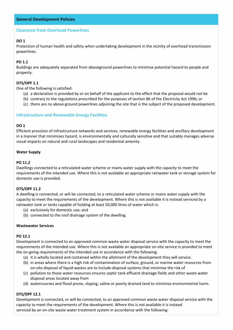
General Development Policies
Clearance from Overhead Powerlines DO 1 Protection of human health and safety when undertaking development in the vicinity of overhead transmission powerlines. PO 1.1 Buildings are adequately separated from aboveground powerlines to minimise potential hazard to people and property. DTS/DPF 1.1 One of the following is satisfied:
(a) a declaration is provided by or on behalf of the applicant to the effect that the proposal would not be (b) contrary to the regulations prescribed for the purposes of section 86 of the Electricity Act 1996; or (c) there are no above ground powerlines adjoining the site that is the subject of the proposed development.
Infrastructure and Renewable Energy Facilities DO 1 Efficient provision of infrastructure networks and services, renewable energy facilities and ancillary development in a manner that minimises hazard, is environmentally and culturally sensitive and that suitably manages adverse visual impacts on natural and rural landscapes and residential amenity. Water Supply PO 11.2 Dwellings connected to a reticulated water scheme or mains water supply with the capacity to meet the requirements of the intended use. Where this is not available an appropriate rainwater tank or storage system for domestic use is provided. DTS/DPF 11.2 A dwelling is connected, or will be connected, to a reticulated water scheme or mains water supply with the capacity to meet the requirements of the development. Where this is not available it is instead serviced by a rainwater tank or tanks capable of holding at least 50,000 litres of water which is:
(a) exclusively for domestic use; and (b) connected to the roof drainage system of the dwelling.
Wastewater Services PO 12.1 Development is connected to an approved common waste water disposal service with the capacity to meet the requirements of the intended use. Where this is not available an appropriate on-site service is provided to meet the on-going requirements of the intended use in accordance with the following:
(a) it is wholly located and contained within the allotment of the development they will service. (b) in areas where there is a high risk of contamination of surface, ground, or marine water resources from
on-site disposal of liquid wastes are to include disposal systems that minimise the risk of (c) pollution to those water resources ensures septic tank effluent drainage fields and other waste water
disposal areas located away from (d) watercourses and flood prone, sloping, saline or poorly drained land to minimise environmental harm.
DTS/DPF 12.1 Development is connected, or will be connected, to an approved common waste water disposal service with the capacity to meet the requirements of the development. Where this is not available it is instead serviced by an on-site waste water treatment system in accordance with the following:
General Development Policies
(a) is wholly located and contained within the allotment of development it will service; and (b) ensures no part of a septic tank effluent drainage field or any other waste water disposal system is
located: i. within 50m of a watercourse, bore, well or dam;
ii. on any land with a slope greater than 20% (1-in-5), or a depth to bedrock or seasonal or permanent water table less than 1.2m; and
iii. on land that is waterlogged, saline, part of a runway area or likely to be inundated by a 10% AEP flood event.
PO 12.2 Effluent drainage fields and other waste water disposal areas maintained to ensure the effective operation of waste systems and minimise risks to human health and environmental harm. DTS/DPF 12.2 Development is not built on, or encroaches within, an area that is, or will be, required for a sewerage system or waste control system. Design in Urban Areas DO 1 Development that is:
(a) contextual – by considering, recognising and carefully responding to its natural surroundings and positively contributing to the character of the immediate area;
(b) durable – fit for purpose, adaptable and long lasting; (c) inclusive – by integrating landscape design to optimise pedestrian and cyclist usability, privacy and
equitable access, and also promote the provision of quality spaces integrated with the public realm that can be used for access and recreation and help optimise security and safety both internally and within the public realm, for occupants and visitors alike; and
(d) sustainable – by integrating sustainable techniques into the design and siting of development and landscaping to improve community health, urban heat, water management, environmental performance, biodiversity and local amenity and to minimise energy consumption.
All Residential Development - External Appearance PO 14.1 Dwellings incorporate windows facing primary street frontages to encourage passive surveillance and make a positive contribution to the streetscape. DTS/DPF 14.1 Each dwelling with a frontage to a public street includes at least one window with a total window area of at least 2m2 facing the primary street, from a habitable room that has a minimum room dimension of 2.7m. Outlook and Amenity PO 15.1 Primary living rooms have an external outlook to provide a high standard of amenity for occupants. DTS / DPF 15.1 Primary living rooms (other than kitchens) incorporate a window with an external outlook towards the street frontage or private open space. All Residential Development – 3 Building Levels or Less
PO 18.1
General Development Policies
Garaging designed to not detract from the streetscape or appearance of a dwelling. DTS/DPF 18.1 Garages and carports facing a street:
(a) do not exceed 7m in width or 50% of the sites frontage (whichever is less); and (b) are situated so that no part of the garage or carport will be in front of any part of the building line of the
dwelling are setback at least 5.5m from the boundary of the primary street; and (c) unless the dwelling has two storeys along the street frontage:
i. have single width car parking with a maximum garage door not exceeding 3.5m on sites with a frontage of 12m; or less
ii. have a garage door not exceeding 50% of the site frontage or 7m (whichever is less) on sites with a frontage greater than 12m.
PO 18.2 Dwelling facades make a positive contribution to streetscapes and common areas by providing variation of light and shadow and creating a sense of depth. DTS/DPF 18.2 Each dwelling includes at least 3 of the following design features within each façade facing a public road or common driveway:
(a) a minimum of 30% of the façade is setback an additional 300mm from the primary building line; (b) a porch or portico that projects at least 1m from the building façade that is open on at least 2 sides; (c) a balcony that projects from the building façade; (d) a verandah that projects at least 1m from the building façade; (e) eaves surrounding the dwelling of a minimum 450mm width; (f) a minimum 30% of the upper level projects forward from the lower level primary building line.
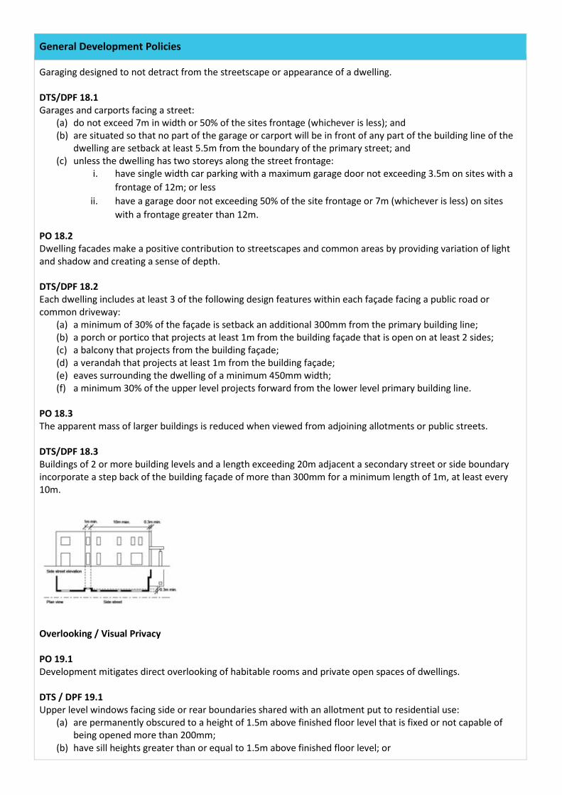
PO 18.3 The apparent mass of larger buildings is reduced when viewed from adjoining allotments or public streets. DTS/DPF 18.3 Buildings of 2 or more building levels and a length exceeding 20m adjacent a secondary street or side boundary incorporate a step back of the building façade of more than 300mm for a minimum length of 1m, at least every 10m.
Overlooking / Visual Privacy PO 19.1 Development mitigates direct overlooking of habitable rooms and private open spaces of dwellings. DTS / DPF 19.1 Upper level windows facing side or rear boundaries shared with an allotment put to residential use:
(a) are permanently obscured to a height of 1.5m above finished floor level that is fixed or not capable of being opened more than 200mm;
(b) have sill heights greater than or equal to 1.5m above finished floor level; or
General Development Policies
(c) incorporate screening to a height of 1.5m above finished floor level; and (d) the building will not have a balcony or terrace on an upper building level, other than where the longest
side of that balcony or terrace will face a road (including any road reserve), or reserve (including any land held as open space), and is at least 15m from the private open space of any other dwelling.
Private Open Space PO 20.1 Dwellings provided with suitable sized areas of usable private open space to meet the needs of occupants. DTS / DPF 20.1 Private open space provided in accordance with Design in Urban Areas Table 1 - Outdoor Open Space.
Landscaping PO 22.1 Soft landscaping incorporated into development to:
(a) minimise heat absorption and reflection; (b) contribute shade and shelter; (c) provide for stormwater infiltration and biodiversity; and (d) enhance the appearance of land and streetscapes.
DTS / DPF 21.1 Residential development incorporates areas for soft landscaping with a minimum dimension of 0.5 metres provided in accordance with the following: (a)
General Development Policies
; and
(b) 25% of any land between the road boundary and the primary building line is provided for soft landscaping with a minimum dimension of 0.5 metres.
Waste Storage PO 24.1 Provision is made for the convenient storage of waste bins in a location screened from public view. DTS / DPF 24.1 Dwellings are provided with:
(a) an area of 3m² or more for the storage of waste (separate from any designated car parking spaces or private open space) is provided behind the building line; and
(b) a continuous unobstructed path of travel with a minimum width of 800mm between the waste bin storage area and the street.
Interface between Land Uses DO 1 Development located and designed to mitigate adverse effects on neighbouring and proximate land uses to reduce potential for conflict. Overshadowing PO 3.1 Overshadowing of habitable room windows of adjacent residential land uses not unreasonably interrupted to maintain access to direct winter sunlight. DTS/DPF 3.1 North-facing windows of habitable rooms of adjacent residential land uses receive at least 3 hours of direct sunlight over their surface between 9.00 am and 3.00 pm on 21 June. PO 3.2 Overshadowing of the primary area of private open space or communal open space of adjacent residential land uses not unreasonably interrupted to maintain access to direct winter sunlight. DTS/DPF 3.2 Development maintains 2 hours direct sunlight between 9.00 am and 3.00 pm on 21 June to adjacent residential land uses in accordance with the following:
(a) for ground level private open space, the smaller of the following: i. half of the existing ground level open space; or
ii. 35m2 of the existing ground level open space (with at least one of the area’s dimensions measuring 2.5m);
(b) for ground level communal open space, at least half of the existing ground level open space.
General Development Policies
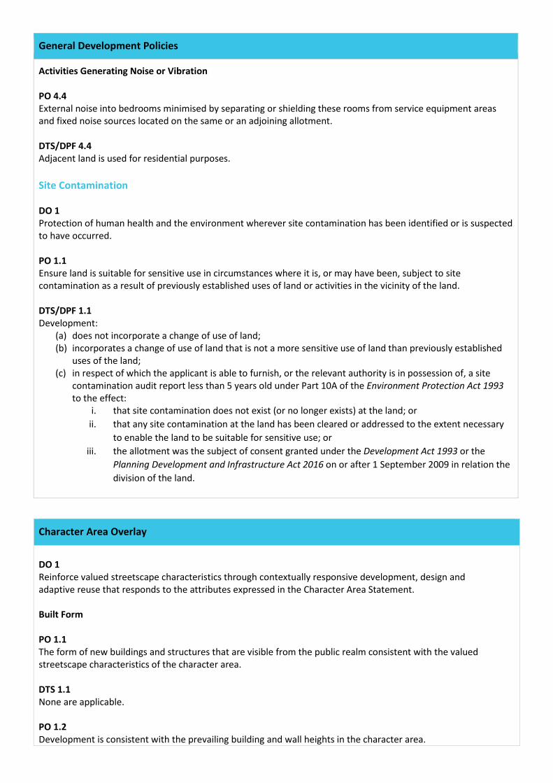
Activities Generating Noise or Vibration PO 4.4 External noise into bedrooms minimised by separating or shielding these rooms from service equipment areas and fixed noise sources located on the same or an adjoining allotment. DTS/DPF 4.4 Adjacent land is used for residential purposes. Site Contamination DO 1 Protection of human health and the environment wherever site contamination has been identified or is suspected to have occurred. PO 1.1 Ensure land is suitable for sensitive use in circumstances where it is, or may have been, subject to site contamination as a result of previously established uses of land or activities in the vicinity of the land. DTS/DPF 1.1 Development:
(a) does not incorporate a change of use of land; (b) incorporates a change of use of land that is not a more sensitive use of land than previously established
uses of the land; (c) in respect of which the applicant is able to furnish, or the relevant authority is in possession of, a site
contamination audit report less than 5 years old under Part 10A of the Environment Protection Act 1993 to the effect:
i. that site contamination does not exist (or no longer exists) at the land; or ii. that any site contamination at the land has been cleared or addressed to the extent necessary
to enable the land to be suitable for sensitive use; or iii. the allotment was the subject of consent granted under the Development Act 1993 or the
Planning Development and Infrastructure Act 2016 on or after 1 September 2009 in relation the division of the land.
Character Area Overlay
DO 1 Reinforce valued streetscape characteristics through contextually responsive development, design and adaptive reuse that responds to the attributes expressed in the Character Area Statement. Built Form PO 1.1 The form of new buildings and structures that are visible from the public realm consistent with the valued streetscape characteristics of the character area. DTS 1.1 None are applicable. PO 1.2 Development is consistent with the prevailing building and wall heights in the character area.
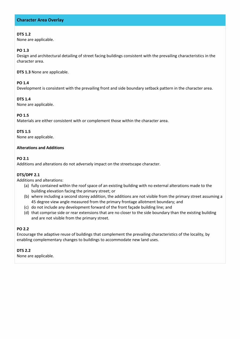
Character Area Overlay
DTS 1.2 None are applicable. PO 1.3 Design and architectural detailing of street facing buildings consistent with the prevailing characteristics in the character area. DTS 1.3 None are applicable. PO 1.4 Development is consistent with the prevailing front and side boundary setback pattern in the character area. DTS 1.4 None are applicable. PO 1.5 Materials are either consistent with or complement those within the character area. DTS 1.5 None are applicable. Alterations and Additions PO 2.1 Additions and alterations do not adversely impact on the streetscape character. DTS/DPF 2.1 Additions and alterations:
(a) fully contained within the roof space of an existing building with no external alterations made to the building elevation facing the primary street; or
(b) where including a second storey addition, the additions are not visible from the primary street assuming a 45 degree view angle measured from the primary frontage allotment boundary; and
(c) do not include any development forward of the front façade building line; and (d) that comprise side or rear extensions that are no closer to the side boundary than the existing building
and are not visible from the primary street. PO 2.2 Encourage the adaptive reuse of buildings that complement the prevailing characteristics of the locality, by enabling complementary changes to buildings to accommodate new land uses. DTS 2.2 None are applicable.
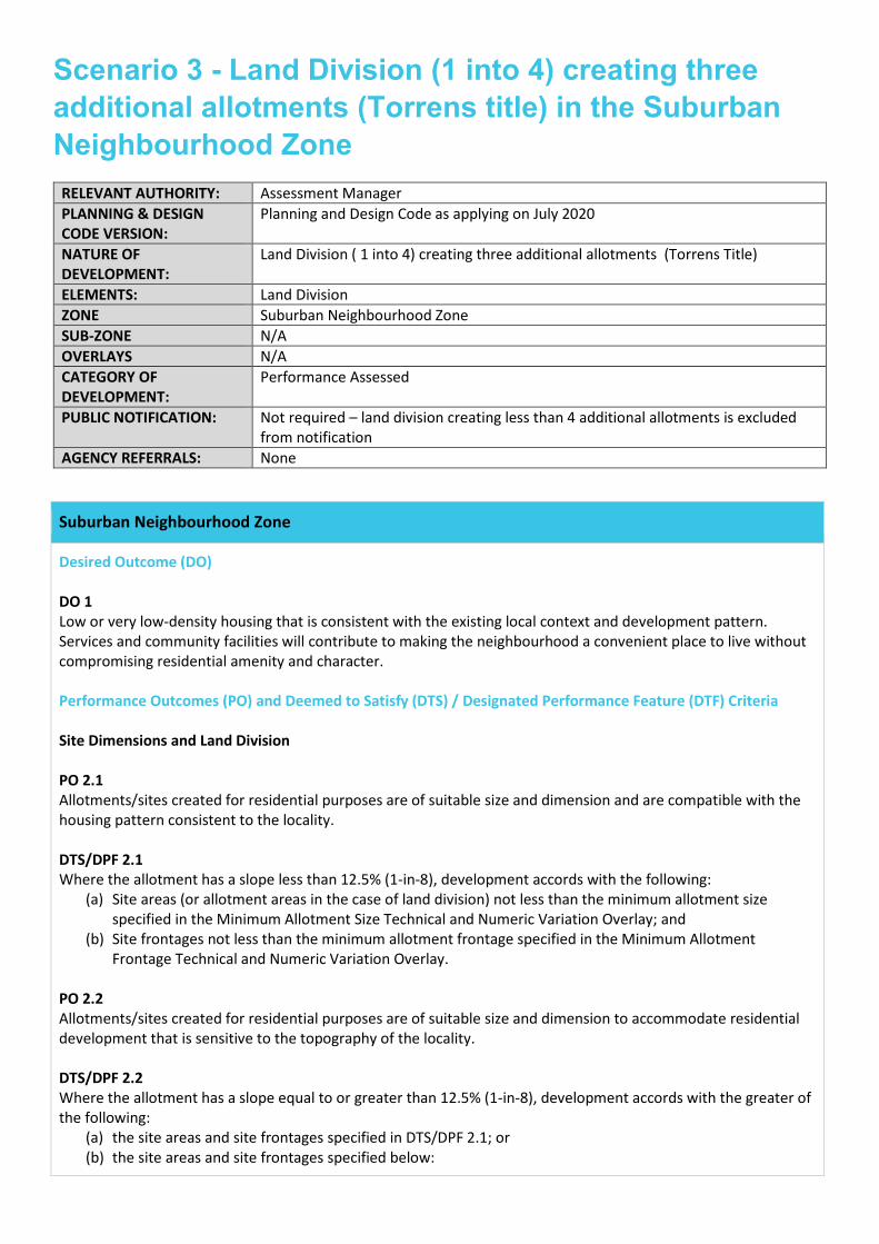
Scenario 3 - Land Division (1 into 4) creating three additional allotments (Torrens title) in the Suburban Neighbourhood Zone
RELEVANT AUTHORITY: Assessment Manager PLANNING & DESIGN CODE VERSION:
Planning and Design Code as applying on July 2020
NATURE OF DEVELOPMENT:
Land Division ( 1 into 4) creating three additional allotments (Torrens Title)
ELEMENTS: Land Division ZONE Suburban Neighbourhood Zone SUB-ZONE N/A OVERLAYS N/A CATEGORY OF DEVELOPMENT:
Performance Assessed
PUBLIC NOTIFICATION: Not required – land division creating less than 4 additional allotments is excluded from notification
AGENCY REFERRALS: None
Suburban Neighbourhood Zone
Desired Outcome (DO) DO 1 Low or very low-density housing that is consistent with the existing local context and development pattern. Services and community facilities will contribute to making the neighbourhood a convenient place to live without compromising residential amenity and character. Performance Outcomes (PO) and Deemed to Satisfy (DTS) / Designated Performance Feature (DTF) Criteria Site Dimensions and Land Division PO 2.1 Allotments/sites created for residential purposes are of suitable size and dimension and are compatible with the housing pattern consistent to the locality. DTS/DPF 2.1 Where the allotment has a slope less than 12.5% (1-in-8), development accords with the following:
(a) Site areas (or allotment areas in the case of land division) not less than the minimum allotment size specified in the Minimum Allotment Size Technical and Numeric Variation Overlay; and
(b) Site frontages not less than the minimum allotment frontage specified in the Minimum Allotment Frontage Technical and Numeric Variation Overlay.
PO 2.2 Allotments/sites created for residential purposes are of suitable size and dimension to accommodate residential development that is sensitive to the topography of the locality. DTS/DPF 2.2 Where the allotment has a slope equal to or greater than 12.5% (1-in-8), development accords with the greater of the following:
(a) the site areas and site frontages specified in DTS/DPF 2.1; or (b) the site areas and site frontages specified below:
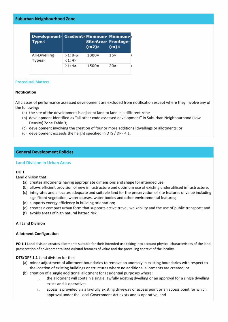
Suburban Neighbourhood Zone
Procedural Matters Notification All classes of performance assessed development are excluded from notification except where they involve any of the following:
(a) the site of the development is adjacent land to land in a different zone (b) development identified as “all other code assessed development” in Suburban Neighbourhood (Low
Density) Zone Table 3; (c) development involving the creation of four or more additional dwellings or allotments; or (d) development exceeds the height specified in DTS / DPF 4.1.
General Development Policies
Land Division in Urban Areas
DO 1 Land division that:
(a) creates allotments having appropriate dimensions and shape for intended use; (b) allows efficient provision of new infrastructure and optimum use of existing underutilised infrastructure; (c) integrates and allocates adequate and suitable land for the preservation of site features of value including
significant vegetation, watercourses, water bodies and other environmental features; (d) supports energy efficiency in building orientation; (e) creates a compact urban form that supports active travel, walkability and the use of public transport; and (f) avoids areas of high natural hazard risk.
All Land Division Allotment Configuration PO 1.1 Land division creates allotments suitable for their intended use taking into account physical characteristics of the land, preservation of environmental and cultural features of value and the prevailing context of the locality.
DTS/DPF 1.1 Land division for the: (a) minor adjustment of allotment boundaries to remove an anomaly in existing boundaries with respect to
the location of existing buildings or structures where no additional allotments are created; or (b) creation of a single additional allotment for residential purposes where:
i. the allotment will contain a single lawfully existing dwelling or an approval for a single dwelling exists and is operative;
ii. access is provided via a lawfully existing driveway or access point or an access point for which approval under the Local Government Act exists and is operative; and
General Development Policies
iii. the resulting allotment achieves any minimum site area and frontage width specified by the relevant zone or a relevant Technical and Numeric Variation Overlays.
Design and Layout PO 2.1 Land division results in a pattern of development that minimises the likelihood of future earthworks and retaining walls DTS 2.1 None are applicable. PO 2.2 Land division enables appropriate treatment of the interface between potentially conflicting land uses and/or zones. DTS 2.2 None are applicable. PO 2.3 Land division maximises the number of allotments that face public open space and public streets. DTS 2.3 None are applicable. PO 2.4 Land division integrated with site features, adjacent land uses, the existing transport network and available infrastructure. DTS 2.4 None are applicable. PO 2.5 Development and infrastructure provided and staged in a manner that supports an orderly and economic provision of land, infrastructure and services. DTS 2.5 None are applicable. PO 2.6 Land division results in watercourses being retained within open space and land subject to flooding free from development. DTS 2.6 None are applicable. PO 2.7 Land division results in street patterns that are legible and connected to the surrounding street network. DTS 2.7 None are applicable. PO 2.8
General Development Policies
Land division is designed to allocate adequate and suitable land for the preservation of existing vegetation of value including native vegetation, regulated and significant trees. DTS 2.8 None are applicable. Roads and Access PO 3.1 Land division provides allotments with access to a public road. DTS 3.1 None are applicable. PO 3.2 Street patterns and intersections designed to enable the safe and efficient movement of pedestrian, cycle and vehicular traffic. DTS 3.2 None are applicable. PO 3.3 Land division does not impede access to publicly owned open space and recreation facilities. DTS 3.3 None are applicable. PO 3.4 Road reserves provide for safe and convenient movement and parking of projected volumes of vehicles, and allow for the efficient movement of service and emergency vehicles. DTS 3.4 None are applicable. PO 3.5 Road reserves provide for footpaths, cycle lanes and shared-use paths, and accommodate street tree planting, landscaping and street furniture. DTS 3.5 None are applicable. PO 3.6 Road reserves accommodate stormwater drainage and public utilities. DTS 3.6 None are applicable. PO 3.7 Road reserves provide unobstructed vehicular access and egress to and from individual allotments and sites. DTS 3.7 None are applicable. PO 3.8 Street patterns and intersections designed to enable the safe and efficient movement of pedestrian, cycle and vehicular traffic.
General Development Policies
DTS 3.8 None are applicable. PO 3.9 Roads, open space and thoroughfares provided establish safe and convenient linkages to the surrounding open space and transport network. DTS 3.9 None are applicable. PO 3.10 Public streets include tree planting to provide shade and enhance the amenity of streetscapes. DTS 3.10 None are applicable. PO 3.11 Local streets designed to create low-speed environments that are safe for cyclists and pedestrians. DTS 3.11 None are applicable. Infrastructure PO 4.1 Land division incorporates public utility services within road reserves or within dedicated easements. DTS 4.1 None are applicable. PO 4.2 Waste water, sewage and other effluent is capable of being disposed of from each allotment without unreasonable risk to public health or the environment. DTS/DPF 4.2 Each allotment can be connected to any of the following:
(a) a waste water treatment plant that has the hydraulic volume and pollutant load treatment and disposal capacity for the maximum predicted wastewater volume generated by subsequent development of the proposed allotments; or
(b) a form of on-site waste water treatment and disposal that meets relevant public health and environmental standards.
PO 4.3 Septic tank effluent drainage fields and other waste water disposal areas maintained to ensure the effective operation of waste systems and minimise risks to human health and environmental harm. DTS / DPF 4.3 Development is not built on, or encroaches within, an area that is, or will be, required for a sewerage system or waste control system. PO 4.4
General Development Policies
Constructed wetland systems, including associated detention and retention basins, sited and designed to ensure public health and safety is protected including by minimising potential public health risks arising from the breeding of mosquitoes. DTS 4.4 None are applicable. PO 4.5 Constructed wetland systems, including associated detention and retention basins, sited and designed to allow sediments to settle prior to discharge into watercourses or the marine environment. DTS 4.5 None are applicable. PO 4.6 Constructed wetland systems, including associated detention and retention basins, sited and designed to function as a landscape feature. DTS 4.6 None are applicable. MINOR LAND DIVISION (UNDER 20 ALLOTMENTS) Open Space PO 5.1 Land division proposing an additional allotment under 1 hectare in area provides or supports the provision of open space. DTS 5.1 None are applicable. PO 5.2 Land division creating 5-19 non-residential allotments includes a stormwater management system designed to mitigate peak flows and manage the rate and duration of stormwater discharges from the site to ensure the carrying capacities of downstream systems are not overloaded. DTS 5.2 Land division creating 5-19 non-residential allotments is accompanied by an approved Stormwater Management Plan and manages up to and including the 100 –year ARI flood event (1% AEP) to avoid flooding of buildings and:
(a) maintain i. a pre-development peak flow rate from the site based upon a 0.35 runoff coefficient for the 5
year ARI (18.1% AEP) 30 minute storm; and ii. the stormwater runoff time to peak to match that of the pre-development; or
(b) capture and retain the difference in pre-development runoff volume (based upon a 0.35 runoff coefficient) vs post development runoff volume from the site for a 5-year ARI (18.1% AEP) 30 minute storm; and
(c) manage site generated stormwater runoff up to and including the 100 –year ARI flood event (1% AEP) to avoid flooding of buildings.
Solar Orientation PO 6.1 Land division for residential purposes facilitates solar access for energy efficiency through allotment orientation.
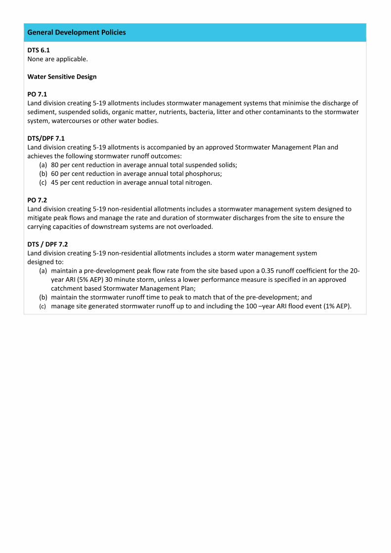
General Development Policies
DTS 6.1 None are applicable. Water Sensitive Design PO 7.1 Land division creating 5-19 allotments includes stormwater management systems that minimise the discharge of sediment, suspended solids, organic matter, nutrients, bacteria, litter and other contaminants to the stormwater system, watercourses or other water bodies. DTS/DPF 7.1 Land division creating 5-19 allotments is accompanied by an approved Stormwater Management Plan and achieves the following stormwater runoff outcomes:
(a) 80 per cent reduction in average annual total suspended solids; (b) 60 per cent reduction in average annual total phosphorus; (c) 45 per cent reduction in average annual total nitrogen.
PO 7.2 Land division creating 5-19 non-residential allotments includes a stormwater management system designed to mitigate peak flows and manage the rate and duration of stormwater discharges from the site to ensure the carrying capacities of downstream systems are not overloaded. DTS / DPF 7.2 Land division creating 5-19 non-residential allotments includes a storm water management system designed to:
(a) maintain a pre-development peak flow rate from the site based upon a 0.35 runoff coefficient for the 20-year ARI (5% AEP) 30 minute storm, unless a lower performance measure is specified in an approved catchment based Stormwater Management Plan;
(b) maintain the stormwater runoff time to peak to match that of the pre-development; and (c) manage site generated stormwater runoff up to and including the 100 –year ARI flood event (1% AEP).
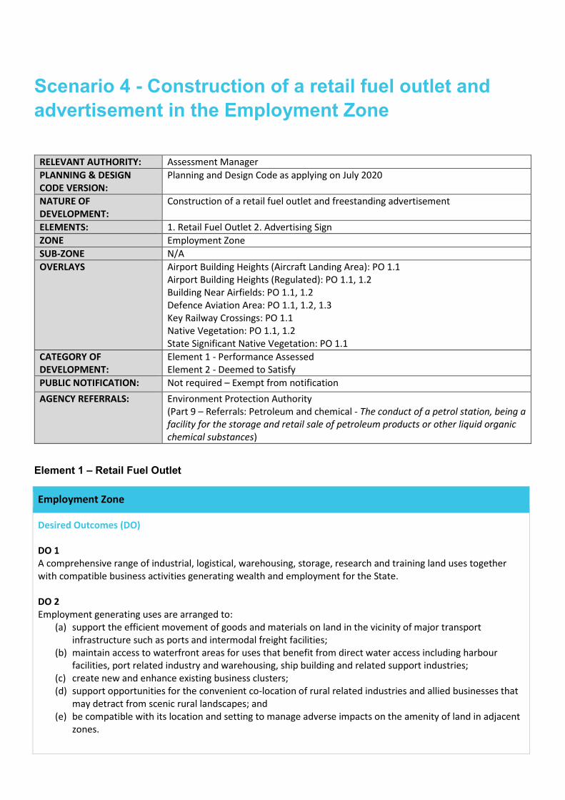
Scenario 4 - Construction of a retail fuel outlet and advertisement in the Employment Zone
RELEVANT AUTHORITY: Assessment Manager PLANNING & DESIGN CODE VERSION:
Planning and Design Code as applying on July 2020
NATURE OF DEVELOPMENT:
Construction of a retail fuel outlet and freestanding advertisement
ELEMENTS: 1. Retail Fuel Outlet 2. Advertising Sign ZONE Employment Zone SUB-ZONE N/A OVERLAYS Airport Building Heights (Aircraft Landing Area): PO 1.1
Airport Building Heights (Regulated): PO 1.1, 1.2 Building Near Airfields: PO 1.1, 1.2 Defence Aviation Area: PO 1.1, 1.2, 1.3 Key Railway Crossings: PO 1.1 Native Vegetation: PO 1.1, 1.2 State Significant Native Vegetation: PO 1.1
CATEGORY OF DEVELOPMENT:
Element 1 - Performance Assessed Element 2 - Deemed to Satisfy
PUBLIC NOTIFICATION: Not required – Exempt from notification AGENCY REFERRALS: Environment Protection Authority
(Part 9 – Referrals: Petroleum and chemical - The conduct of a petrol station, being a facility for the storage and retail sale of petroleum products or other liquid organic chemical substances)
Element 1 – Retail Fuel Outlet
Employment Zone
Desired Outcomes (DO) DO 1 A comprehensive range of industrial, logistical, warehousing, storage, research and training land uses together with compatible business activities generating wealth and employment for the State. DO 2 Employment generating uses are arranged to:
(a) support the efficient movement of goods and materials on land in the vicinity of major transport infrastructure such as ports and intermodal freight facilities;
(b) maintain access to waterfront areas for uses that benefit from direct water access including harbour facilities, port related industry and warehousing, ship building and related support industries;
(c) create new and enhance existing business clusters; (d) support opportunities for the convenient co-location of rural related industries and allied businesses that
may detract from scenic rural landscapes; and (e) be compatible with its location and setting to manage adverse impacts on the amenity of land in adjacent
zones.
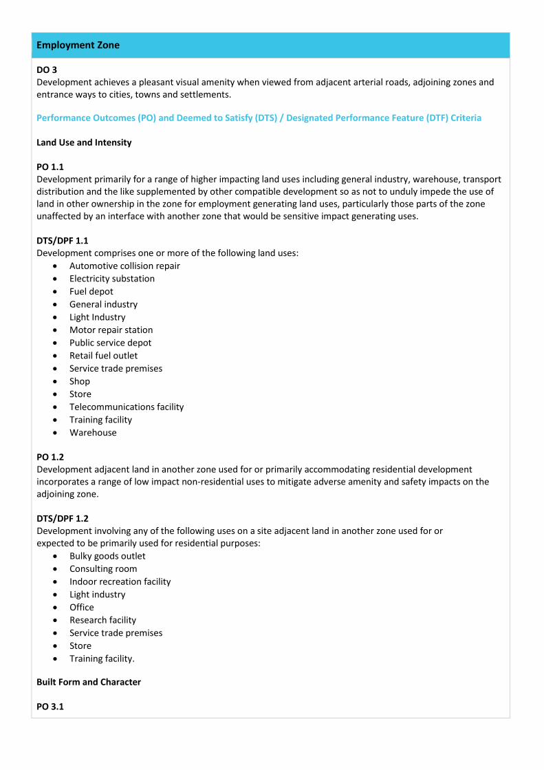
Employment Zone
DO 3 Development achieves a pleasant visual amenity when viewed from adjacent arterial roads, adjoining zones and entrance ways to cities, towns and settlements. Performance Outcomes (PO) and Deemed to Satisfy (DTS) / Designated Performance Feature (DTF) Criteria Land Use and Intensity PO 1.1 Development primarily for a range of higher impacting land uses including general industry, warehouse, transport distribution and the like supplemented by other compatible development so as not to unduly impede the use of land in other ownership in the zone for employment generating land uses, particularly those parts of the zone unaffected by an interface with another zone that would be sensitive impact generating uses. DTS/DPF 1.1 Development comprises one or more of the following land uses:
• Automotive collision repair • Electricity substation • Fuel depot • General industry • Light Industry • Motor repair station • Public service depot • Retail fuel outlet • Service trade premises • Shop • Store • Telecommunications facility • Training facility • Warehouse
PO 1.2 Development adjacent land in another zone used for or primarily accommodating residential development incorporates a range of low impact non-residential uses to mitigate adverse amenity and safety impacts on the adjoining zone. DTS/DPF 1.2 Development involving any of the following uses on a site adjacent land in another zone used for or expected to be primarily used for residential purposes:
• Bulky goods outlet • Consulting room • Indoor recreation facility • Light industry • Office • Research facility • Service trade premises • Store • Training facility.
Built Form and Character PO 3.1
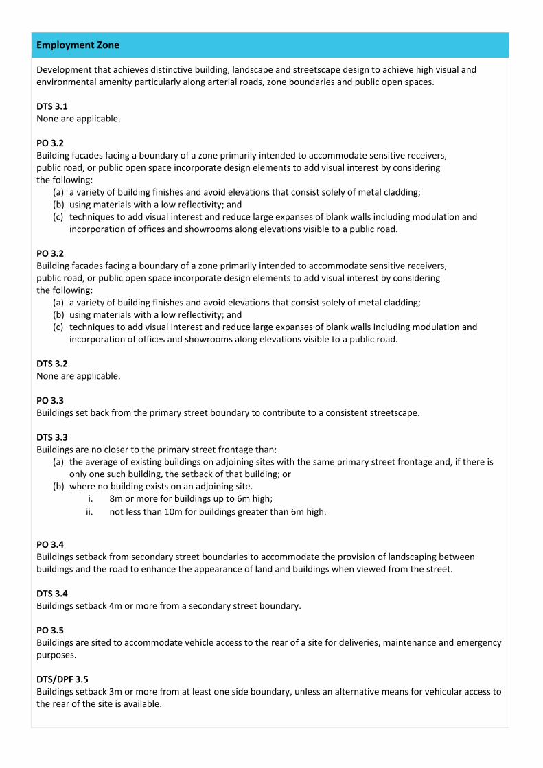
Employment Zone
Development that achieves distinctive building, landscape and streetscape design to achieve high visual and environmental amenity particularly along arterial roads, zone boundaries and public open spaces. DTS 3.1 None are applicable. PO 3.2 Building facades facing a boundary of a zone primarily intended to accommodate sensitive receivers, public road, or public open space incorporate design elements to add visual interest by considering the following:
(a) a variety of building finishes and avoid elevations that consist solely of metal cladding; (b) using materials with a low reflectivity; and (c) techniques to add visual interest and reduce large expanses of blank walls including modulation and
incorporation of offices and showrooms along elevations visible to a public road. PO 3.2 Building facades facing a boundary of a zone primarily intended to accommodate sensitive receivers, public road, or public open space incorporate design elements to add visual interest by considering the following:
(a) a variety of building finishes and avoid elevations that consist solely of metal cladding; (b) using materials with a low reflectivity; and (c) techniques to add visual interest and reduce large expanses of blank walls including modulation and
incorporation of offices and showrooms along elevations visible to a public road. DTS 3.2 None are applicable. PO 3.3 Buildings set back from the primary street boundary to contribute to a consistent streetscape. DTS 3.3 Buildings are no closer to the primary street frontage than:
(a) the average of existing buildings on adjoining sites with the same primary street frontage and, if there is only one such building, the setback of that building; or
(b) where no building exists on an adjoining site. i. 8m or more for buildings up to 6m high;
ii. not less than 10m for buildings greater than 6m high.
PO 3.4 Buildings setback from secondary street boundaries to accommodate the provision of landscaping between buildings and the road to enhance the appearance of land and buildings when viewed from the street. DTS 3.4 Buildings setback 4m or more from a secondary street boundary. PO 3.5 Buildings are sited to accommodate vehicle access to the rear of a site for deliveries, maintenance and emergency purposes. DTS/DPF 3.5 Buildings setback 3m or more from at least one side boundary, unless an alternative means for vehicular access to the rear of the site is available.
Employment Zone
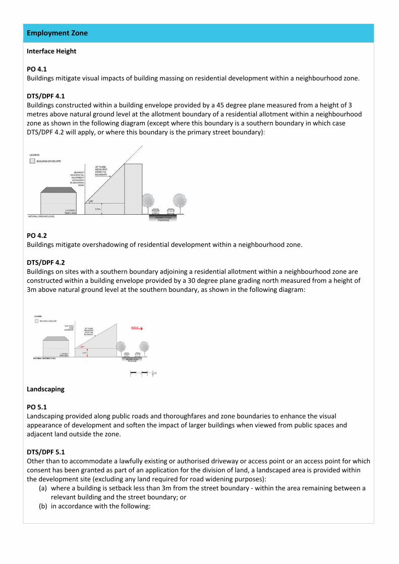
Interface Height PO 4.1 Buildings mitigate visual impacts of building massing on residential development within a neighbourhood zone. DTS/DPF 4.1 Buildings constructed within a building envelope provided by a 45 degree plane measured from a height of 3 metres above natural ground level at the allotment boundary of a residential allotment within a neighbourhood zone as shown in the following diagram (except where this boundary is a southern boundary in which case DTS/DPF 4.2 will apply, or where this boundary is the primary street boundary):
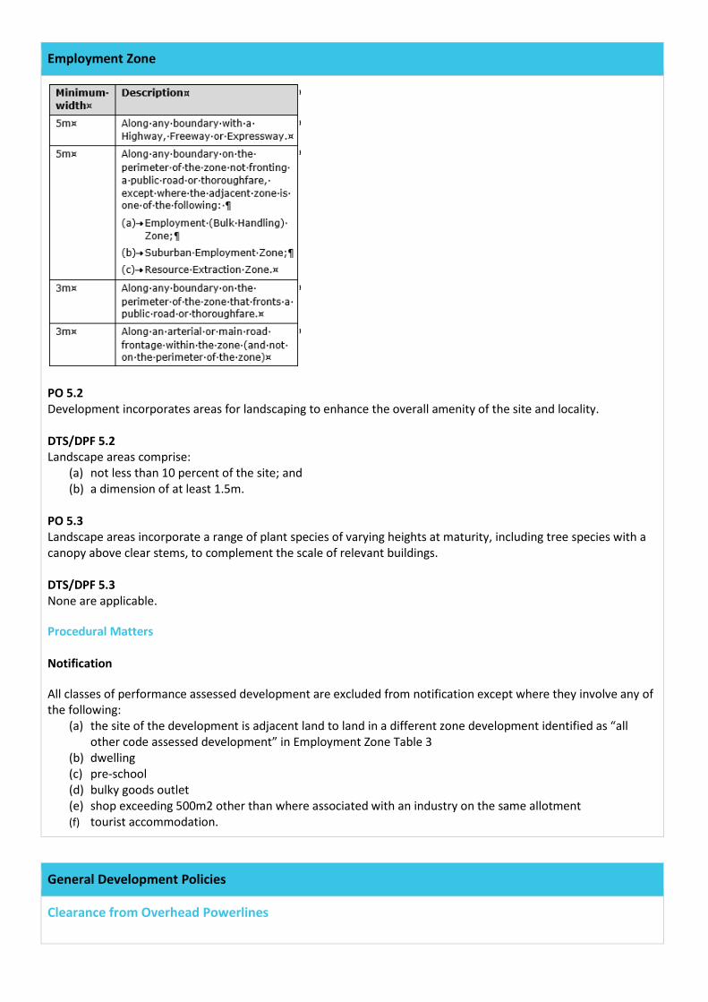
PO 4.2 Buildings mitigate overshadowing of residential development within a neighbourhood zone. DTS/DPF 4.2 Buildings on sites with a southern boundary adjoining a residential allotment within a neighbourhood zone are constructed within a building envelope provided by a 30 degree plane grading north measured from a height of 3m above natural ground level at the southern boundary, as shown in the following diagram:
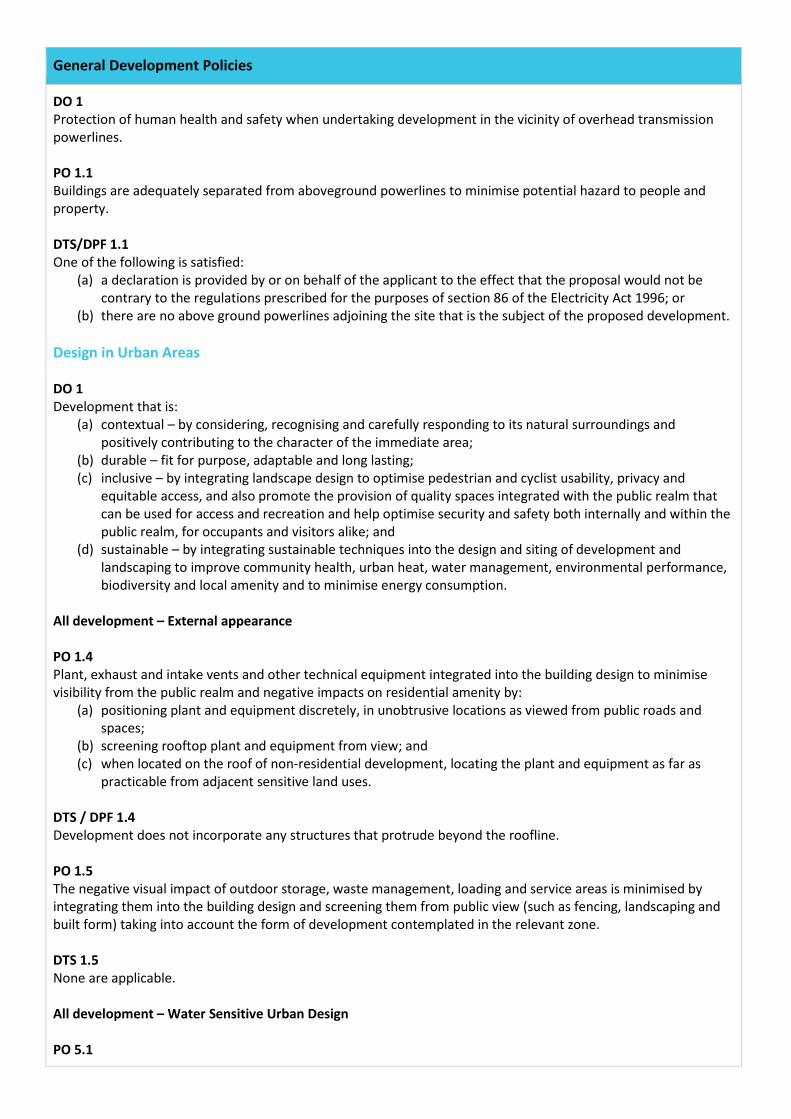
Landscaping PO 5.1 Landscaping provided along public roads and thoroughfares and zone boundaries to enhance the visual appearance of development and soften the impact of larger buildings when viewed from public spaces and adjacent land outside the zone. DTS/DPF 5.1 Other than to accommodate a lawfully existing or authorised driveway or access point or an access point for which consent has been granted as part of an application for the division of land, a landscaped area is provided within the development site (excluding any land required for road widening purposes):
(a) where a building is setback less than 3m from the street boundary - within the area remaining between a relevant building and the street boundary; or
(b) in accordance with the following:
Employment Zone
PO 5.2 Development incorporates areas for landscaping to enhance the overall amenity of the site and locality. DTS/DPF 5.2 Landscape areas comprise:
(a) not less than 10 percent of the site; and (b) a dimension of at least 1.5m.
PO 5.3 Landscape areas incorporate a range of plant species of varying heights at maturity, including tree species with a canopy above clear stems, to complement the scale of relevant buildings. DTS/DPF 5.3 None are applicable. Procedural Matters Notification All classes of performance assessed development are excluded from notification except where they involve any of the following:
(a) the site of the development is adjacent land to land in a different zone development identified as “all other code assessed development” in Employment Zone Table 3
(b) dwelling (c) pre-school (d) bulky goods outlet (e) shop exceeding 500m2 other than where associated with an industry on the same allotment (f) tourist accommodation.
General Development Policies
Clearance from Overhead Powerlines
General Development Policies
DO 1 Protection of human health and safety when undertaking development in the vicinity of overhead transmission powerlines. PO 1.1 Buildings are adequately separated from aboveground powerlines to minimise potential hazard to people and property. DTS/DPF 1.1 One of the following is satisfied:
(a) a declaration is provided by or on behalf of the applicant to the effect that the proposal would not be contrary to the regulations prescribed for the purposes of section 86 of the Electricity Act 1996; or
(b) there are no above ground powerlines adjoining the site that is the subject of the proposed development. Design in Urban Areas DO 1 Development that is:
(a) contextual – by considering, recognising and carefully responding to its natural surroundings and positively contributing to the character of the immediate area;
(b) durable – fit for purpose, adaptable and long lasting; (c) inclusive – by integrating landscape design to optimise pedestrian and cyclist usability, privacy and
equitable access, and also promote the provision of quality spaces integrated with the public realm that can be used for access and recreation and help optimise security and safety both internally and within the public realm, for occupants and visitors alike; and
(d) sustainable – by integrating sustainable techniques into the design and siting of development and landscaping to improve community health, urban heat, water management, environmental performance, biodiversity and local amenity and to minimise energy consumption.
All development – External appearance PO 1.4 Plant, exhaust and intake vents and other technical equipment integrated into the building design to minimise visibility from the public realm and negative impacts on residential amenity by:
(a) positioning plant and equipment discretely, in unobtrusive locations as viewed from public roads and spaces;
(b) screening rooftop plant and equipment from view; and (c) when located on the roof of non-residential development, locating the plant and equipment as far as
practicable from adjacent sensitive land uses. DTS / DPF 1.4 Development does not incorporate any structures that protrude beyond the roofline. PO 1.5 The negative visual impact of outdoor storage, waste management, loading and service areas is minimised by integrating them into the building design and screening them from public view (such as fencing, landscaping and built form) taking into account the form of development contemplated in the relevant zone. DTS 1.5 None are applicable. All development – Water Sensitive Urban Design PO 5.1
General Development Policies
Development sited and designed to maintain natural hydrological systems without negatively impacting: (a) the quantity and quality of surface and groundwater; (b) the depth and directional flow of surface and groundwater; or (c) the quality and function of natural springs.
DTS 5.1 None are applicable. Car Parking Appearance PO 6.2 Vehicle parking areas appropriately located, designed and constructed to minimise impacts on adjacent sensitive receivers through measures such as ensuring they are attractively developed and landscaped, screen fenced, and the like. DTS 6.2 None are applicable. All Non-Residential Development – Water Sensitive Design PO 41.1 Development likely to result in risk of export of sediment, suspended solids, organic matter, nutrients, oil and grease include stormwater management systems designed to minimise pollutants entering stormwater. DTS/DPF 41.1 Development includes stormwater management systems designed to achieve the following gross pollutant outcomes:
(a) 80 per cent reduction in average annual total suspended solids; (b) 60 per cent reduction in average annual total phosphorus; (c) 45 per cent reduction in average annual total nitrogen; (d) 90 per cent reduction of litter/gross pollutants compared to untreated stormwater runoff; and (e) no visible oils/grease for flows up to the 1-in-3 month average return interval flood peak flow.
Infrastructure and Renewable Energy Facilities DO 1 Efficient provision of infrastructure networks and services, renewable energy facilities and ancillary development in a manner that minimises hazard, is environmentally and culturally sensitive and that suitably manages adverse visual impacts on natural and rural landscapes and residential amenity. Water Supply PO 11.1 Development connected to an appropriate water supply to meet the ongoing requirements of the intended use. DTS/DPF 11.1 Development is connected, or will be connected, to a reticulated water scheme or mains water supply with the capacity to meet the on-going requirements of the development. Wastewater Services PO 12.1
General Development Policies
Development is connected to an approved common waste water disposal service with the capacity to meet the requirements of the intended use. Where this is not available an appropriate on-site service is provided to meet the on-going requirements of the intended use in accordance with the following:
(a) it is wholly located and contained within the allotment of the development they will service. (b) in areas where there is a high risk of contamination of surface, ground, or marine water resources from
on-site disposal of liquid wastes are to include disposal systems that minimise the risk of pollution to those water resources
(c) ensures septic tank effluent drainage fields and other waste water disposal areas located away from watercourses and flood prone, sloping, saline or poorly drained land to minimise environmental harm.
DTS/DPF 12.1 Development is connected, or will be connected, to an approved common waste water disposal service with the capacity to meet the requirements of the development. Where this is not available it is instead serviced by an on-site waste water treatment system in accordance with the following:
(a) is wholly located and contained within the allotment of development it will service; and (b) ensures no part of a septic tank effluent drainage field or any other waste water disposal system is
located: i. within 50m of a watercourse, bore, well or dam;
ii. on any land with a slope greater than 20% (1-in-5), or a depth to bedrock or seasonal or permanent water table less than 1.2m; and
iii. on land that is waterlogged, saline, part of a runway area or likely to be inundated by a 10% AEP flood event.
PO 12.2 Effluent drainage fields and other waste water disposal areas maintained to ensure the effective operation of waste systems and minimise risks to human health and environmental harm. DTS/DPF 12.2 Development is not built on, or encroaches within, an area that is, or will be, required for a sewerage system or waste control system. Interface Between Land Uses DO1 Development located and designed to mitigate adverse effects on neighbouring and proximate land uses to reduce potential for conflict. General Land Use Compatibility PO 1.2 Development adjacent to a site containing an existing sensitive receiver or zone primarily intended to accommodate sensitive receivers designed to minimise adverse impacts. DTS/DPF 1.2 None are applicable. Hours of Operation PO 2.1 Non-residential development does not unreasonably impact the amenity of existing sensitive receivers or an adjacent zone primarily for sensitive receivers through hours of operation having regard to:
(a) the nature of the development; (b) measures to mitigate off-site impacts;
General Development Policies
(c) the extent to which the development is desired in the zone; and (d) measures that might be taken in an adjacent zone primarily for sensitive receivers that mitigate adverse
impacts without unreasonably compromising the intended use of that land. DTS/DPF 2.1 Consulting room, office and shop hours of operation are limited to 7am – 9pm Monday to Friday and 8am – 5pm Saturday inclusive. Activities Generating Noise or Vibration PO 4.1 Development that emits noise (other than music noise) does not unreasonably impact acoustic amenity at the nearest existing sensitive receivers. DTS/DPF 4.1 Predicted noise at the nearest existing sensitive receiver achieves the relevant Environment Protection (Noise) Policy criteria. PO 4.2 Areas for the on-site manoeuvring of service and delivery vehicles, plant and equipment, outdoor work spaces (and the like) are designed and sited to not unreasonably impact the amenity of adjacent sensitive receivers and zones primarily intended to accommodate sensitive receivers due to noise and vibration by adopting techniques including:
(a) locating openings of buildings and associated services away from the interface with the adjacent sensitive receivers and zones primarily intended to accommodate sensitive receivers;
(b) when sited outdoors, locating such areas as far as practicable from adjacent sensitive receivers and zones primarily intended to accommodate sensitive receivers;
(c) housing plant and equipment within an enclosed structure or acoustic enclosure; and (d) providing a suitable acoustic barrier between the plant and / or equipment and the adjacent sensitive
receiver boundary or zone. DTS/DPF 4.2 None are applicable. PO 4.5 Outdoor areas associated with licensed premises (such as beer gardens or dining areas) designed and/or sited to not cause unreasonable noise impact on existing adjacent sensitive receivers. DTS/DPF 4.5 None are applicable. Air Quality PO 5.1 Development with the potential to emit harmful or nuisance-generating air pollution incorporates air pollution control measures to prevent harm to human health or unreasonably impact the amenity of existing sensitive receivers within the locality and zones primarily intended to accommodate sensitive receivers. DTS/DPF 5.1 None are applicable. PO 5.2 Development that includes chimneys or exhaust flues (including cafes, restaurants and fast food outlets) is designed to minimise nuisance or adverse health impacts to nearby sensitive receivers by:
General Development Policies
(a) incorporating appropriate treatment technology before exhaust emissions are released; and (b) locating and designing chimneys or exhaust flues to maximise dispersion of exhaust emissions taking into
account the location of nearby sensitive receivers. DTF/DPF 5.2 None are applicable. Light Spill PO 6.1 External lighting positioned and designed to not cause unreasonable light spill impact on adjacent sensitive receivers. DTS/DPF 6.1 None are applicable. PO 6.2 External lighting is not hazardous to motorists and cyclists. DTS/DPF 6.2 None are applicable. Transport, Access and Parking DO 1 A comprehensive, integrated and connected transport system that is safe, sustainable, efficient, convenient and accessible to all users. Movement Systems PO 1.1 Development integrated with the existing transport system and designed to minimise its potential impact on the functional performance of the transport system. DTS/DPF 1.1 None are applicable. PO 1.2 Development is designed to discourage commercial and industrial vehicle movements through residential streets and adjacent other sensitive receivers. DTS/DPF 1.2 None are applicable. PO 1.3 Industrial, commercial and service vehicle movements, loading areas and designated parking spaces are separated from passenger vehicle car parking areas to ensure efficient and safe movement and minimise potential conflict. DTS/DPF 1.2 None are applicable. PO 1.4 Development sited and designed so that loading, unloading and turning of all traffic likely to be generated avoids interrupting the operation of and queuing on public roads and pedestrian paths.
General Development Policies
Sightlines PO 2.1 Maintenance or enhancement of sightlines at intersections, pedestrian and cycle crossings, and crossovers to allotments for motorists, cyclists and pedestrians to ensure safety for all road users and pedestrians. DTS/DPF 2.1 None are applicable. PO 2.2 Walls, fencing and landscaping adjacent to driveways and corner sites are designed to provide adequate sightlines between vehicles and pedestrians. DTS/DPF 2.2 None are applicable. Vehicle Access PO 3.1 Safe and convenient access that minimises impact or interruption on the operation of public roads. DTS/DPF 3.1 The access is:
(a) provided via a lawfully existing or authorised driveway or access point or an access point for which consent has been granted as part of an application for the division of land; and
(b) not located within 6m of an intersection of 2 or more roads or a pedestrian actuated crossing. PO 3.3 Access points sited and designed to accommodate the type and volume of traffic likely to be generated by the development or land use. DTS/DPF 3.3 None are applicable. PO 3.4 Access points sited and designed to minimise any adverse impacts on neighbouring properties. DTS/DPF 3.4 None are applicable. PO 3.5 Access points located so as not to interfere with mature street trees, existing street furniture (including directional signs, lighting, seating and weather shelters) or infrastructure services to maintain the appearance of the streetscape, preserve local amenity and minimise disruption to utility infrastructure assets. DTS/DPF 3.5 The access point does not involve the removal or relocation of mature street trees, street furniture or utility infrastructure services. PO 3.6 Driveways and access points are separated and minimised in number to optimise the provision of on-street visitor parking (where on-street parking is appropriate).

General Development Policies
DTS/DPF 3.6 Driveways and access points:
(a) for sites with a frontage to a public road of 20m or less, one access point no greater than 3.5m in width is provided.
(b) for sites with a frontage to a public road greater than 20m: i. a single access point no greater than 6m in width is provided; or
ii. not more than two access points with a width of 3.5m each are provided.
PO 3.7 Access points appropriately separated from level crossings to avoid interference and ensure their safe ongoing operation. DTS/DPF 3.7 None are applicable. PO 3.8 Driveways, access points, access tracks and parking areas are designed and constructed to allow adequate movement and manoeuvrability having regard to the types of vehicles that are reasonably anticipated. DTS/DPF 3.8 None are applicable. PO 3.9 Development designed to ensure vehicle circulation between activity areas occurs within the site without the need to use public roads. DTS/DPF 3.9 None are applicable. Vehicle Parking Rates PO 5.1 The provision of sufficient on-site vehicle parking and specifically marked accessible car parking places to meet the needs of the development or land use having regard to factors that may support a reduced onsite rate such as:
(a) availability of on-street car parking (b) shared usage of other parking areas (c) in relation to a mixed-use development, where the hours of operation of commercial activities
complement the residential use of the site the provision of vehicle parking may be shared. DTS/DPF 5.1 Development provides a number of car parking spaces on-site at a rate no less than the amount calculated using Transport, Access and Parking Table 1 – General Off-Street Car Parking Requirements or Transport, Access and Parking Table 2 – Off-Street Vehicle Parking Requirements in Designated Areas, whichever is relevant. Vehicle Parking Areas PO 6.1 Vehicle parking areas that are sited and designed to minimise impact on the operation of public roads by avoiding the use of public roads when moving from one part of a parking area to another. DTS/DPF 6.1 Movement between vehicle parking areas within the site can occur without the need to use a public road.
General Development Policies
PO 6.2 Vehicle parking areas appropriately located, designed and constructed to minimise impacts on adjacent sensitive receivers through measures such as ensuring they are attractively developed and landscaped, screen fenced, and the like. DTS/DPF 6.2 None are applicable. PO 6.5 Vehicle parking areas that are likely to be used during non-daylight hours are provided with floodlit entry and exit points to ensure clear visibility to users. DTS/DPF 6.5 None are applicable. PO 6.6 Loading areas and designated parking spaces for service vehicles provided within the boundary of the site. DTS/DPF 6.6 Loading areas and designated parking spaces are wholly located within the site.
Element 2 – Advertisement
Employment Zone
DO 1 A comprehensive range of industrial, logistical, warehousing, storage, research and training land uses together with compatible business activities generating wealth and employment for the State. DO 2 Employment generating uses are arranged to:
(a) support the efficient movement of goods and materials on land in the vicinity of major transport infrastructure such as ports and intermodal freight facilities;
(b) maintain access to waterfront areas for uses that benefit from direct water access including harbour facilities, port related industry and warehousing, ship building and related support industries;
(c) create new and enhance existing business clusters; (d) support opportunities for the convenient co-location of rural related industries and allied businesses that
may detract from scenic rural landscapes; and (e) be compatible with its location and setting to manage adverse impacts on the amenity of land in adjacent
zones. DO 3 Development achieves a pleasant visual amenity when viewed from adjacent arterial roads, adjoining zones and entrance ways to cities, towns and settlements. Advertisements PO 7.1 Freestanding advertisements do not create a visually dominant element within the locality. DTS/DPF /DPF 7.1 Freestanding advertisements:
(a) do not exceed 6m in height; and (b) do not have a sign face exceeding 8m2 per side.
General Development Policies
Advertisements DO 1 Advertisements and advertising hoardings are designed appropriate to context, are efficient and effective in communicating with the public, are limited in number to avoid clutter, and do not create hazard. Appearance PO 1.1 Advertisements are compatible and integrated with the design of the building and/or land they are located on. DTS/DPF 1.1 Advertisements attached to a building:
(a) if located below canopy level, are flush with a wall; (b) if located at canopy level, are in the form of a fascia sign; (c) if located above a canopy:
i. are flush with a wall; ii. do not have any part rising above parapet height; and
iii. are not attached to the roof of the building. (d) if attached to the side of a verandah, do not exceed the width of the verandah or project from the
verandah; (e) if attached to the front of a verandah, do not exceed the length of the verandah or project from the
verandah; (f) if attached to a two storey building, have no part located above the finished floor level of the second
storey of the building; and (g) where they are flush with a wall, do not, in combination with any other existing sign, cover more than 15%
of the building facade to which they are attached. PO 1.3 Advertising located so as to not encroach on public land or the land of an adjacent allotment. DTS/DPF 1.3 Advertisements and/or advertising hoardings are:
(a) completely contained within the boundaries of the site; or (b) if a road widening is applicable, advertising and/or advertising hoarding are completely contained within
the proposed property boundary realignment. PO 1.4 Where possible advertisements on public land are integrated with existing structures and infrastructure. DTS/DPF 1.4 An advertisement on public land:
(a) achieves Advertisements DTS/DPF 1.1; or (b) is integrated with a bus shelter and it is not to be illuminated.
Proliferation of Advertisements PO 2.1 Proliferation of advertisements minimised to avoid visual clutter and untidiness. DTS/DPF 2.1 No more than one advertisement is displayed on each public road per occupancy. PO 2.2
Multiple-business or activity advertisements co-located and coordinated to avoid visual clutter and untidiness. DTS/DPF 2.2 Advertisements for multiple-business or activity complex incorporating information regarding each business or activity in a single advertisement fixture or structure. Advertising Content PO 3.1 Content of advertisements primarily limited to information relating to the lawful use of land they are located on. DTS/DPF 3.1 An advertisement does not contain third party content. Amenity Impacts PO 4.1 Light spill from advertisement illumination does not unreasonably compromise amenity of adjacent and proximate sensitive receivers. DTS/DPF 4.1 An advertisement does not incorporate any illumination. PO 5.1 Advertisements and/or advertising hoardings erected on a verandah or project from a building wall designed and located to allow for safe and convenient pedestrian access. DTS/DPF 5.1 An advertisement with a minimum clearance of 2.5m between the top of the footway and base of the underside of the sign. PO 5.2 Advertisements and/or advertising hoardings do not distract or create a hazard to drivers through excessive illumination. DTS/DPF 5.2 No advertisement illumination is proposed. PO 5.3 Advertisements and/or advertising hoardings do not create a hazard to drivers by:
(a) being liable to interpretation by drivers as an official traffic sign or signal; (b) obscuring or impairing a driver’s view of official traffic signs or signals; or (c) obscuring or impairing a driver's view of features of a road that are potentially hazardous (such as
junctions, bends, changes in width and traffic control devices) or other road or rail vehicles at/or approaching level crossings.
DTS/DPF 5.3 DTS/DPF 1.1, 1.2, 5.1, 5.2 and 5.5 are met. PO 5.4 Advertisements and/or advertising hoardings do not create a hazard by distracting drivers from the primary driving task at a location where the demands on driver concentration are high. DTS/DPF 5.4 An advertisement and/or advertising hoarding not located along or adjacent to a road having a speed limit of 80km/h or more.
PO 5.5 Advertisements and/or advertising hoardings provide sufficient clearance from the road carriageway to allow for safe and convenient movement by all road users. DTS/DPF 5.5 Where the advertisement or advertising hoarding is:
(a) on a kerbed road with a speed zone of 60km/h or less, the advertisement or advertising hoarding is located at least 0.6m from the roadside edge of the kerb;
(b) on an unkerbed road with a speed zone of 60km/h or less, the advertisement or advertising hoarding is (c) located at least 5.5m from the edge of the seal; or (d) on any other kerbed or unkerbed road, the advertisement or advertising hoarding is located a minimum of
the following distance from the roadside edge of the kerb or the seal: i. 110 km/h road – 14m
ii. 100 km/h road – 13m iii. 90 km/h road – 10m iv. 70 or 80 km/h road – 8.5m
Clearance from Overhead Powerlines DO 1 Protection of human health and safety when undertaking development in the vicinity of overhead transmission powerlines. PO 1.1 Buildings are adequately separated from aboveground powerlines to minimise potential hazard to people and property. DTS/DPF 1.1 One of the following is satisfied:
(a) a declaration is provided by or on behalf of the applicant to the effect that the proposal would not be contrary to the regulations prescribed for the purposes of section 86 of the Electricity Act 1996; or
(b) there are no above ground powerlines adjoining the site that is the subject of the proposed development.
Scenario 5 - Construction of four, two storey group dwellings in the Urban Renewal Neighbourhood Zone RELEVANT AUTHORITY:
Assessment Panel
PLANNING & DESIGN CODE VERSION:
Planning and Design Code as applying on July 2020
NATURE OF DEVELOPMENT:
Construction of four, two storey group dwellings
ELEMENTS: Four (4) two storey group dwellings ZONE Urban Renewal Neighbourhood Zone SUB-ZONE N/A OVERLAYS N/A CATEGORY OF DEVELOPMENT:
Performance Assessed – Group Dwelling
PUBLIC NOTIFICATION:
Required - the site of the development is adjacent land to land in a different zone
AGENCY REFERRALS:
None
Urban Renewal Neighbourhood Zone
Desired Outcome (DO) DO 1 Housing that no longer meets community preferences is replaced with new diverse low – medium rise housing options. Housing density increases, taking advantage of well-located urban land. Employment and community services will improve access to jobs, goods and services without compromising residential amenity. Performance Outcomes (PO) and Deemed to Satisfy (DTS) / Designated Performance Feature (DTF) Criteria Building Height PO 2.1 Buildings contribute to a low-medium rise residential character with the taller buildings located on sites that are a suitable size and dimension to manage massing and impacts on adjoining residential development. DTS/DPF 2.1 Building height (excluding garages, carports and outbuildings) not exceeding:
(a) 4 building levels and 15m where the site: i. is at least 1200m2
ii. has a frontage of at least 35m (b) 3 building levels and 12m in all other circumstances.
Primary Street Setback PO 3.1 Buildings are setback from primary street boundaries to establish a desirable urban streetscape character and integrate development with public open space. DTS/DPF 3.1 Buildings are setback from the primary street boundary:
(a) 3m or more; or
Urban Renewal Neighbourhood Zone
(b) 1.5m or more where the allotment is located adjacent to a public reserve greater than 2000m2, the dwelling faces that reserve and access is provided to the rear of the allotment.
Secondary Street Setback PO 4.1 Buildings are set back from secondary street boundaries to maintain a pattern of separation between building walls and public streets and reinforce a streetscape character. DTS/DPF 4.1 Buildings are set back at least 900mm from the boundary of the allotment with the secondary street frontage. Boundary Walls PO 5.1 Boundary walls are limited in height and length to manage impacts on adjoining properties. DTS/DPF 5.1 Dwelling walls on side boundaries either:
(a) adjoin or abut a boundary wall of a building on adjoining land for the same, or lesser length and height; or (b) do not exceed:
i. 3 metres in height; ii. 10 metres in length; and
iii. will not result in boundary walls on more than 45% of the total length of the side boundary.
Rear Boundary Setback
PO 7.1 Buildings are set back from rear boundaries to provide:
(a) separation between dwellings to minimise visual impact; (b) access to natural light and ventilation for neighbours; (c) open space recreational opportunities; and (d) space for landscaping and vegetation.
DTS/DPF 7.1 Buildings are set back from the rear boundary at least:
(a) 3m for the first building level; (b) 5m for any second building level; and (c) 5m plus any increase in wall height over 7m.
Site Dimensions and Land Division PO 8.1 Allotments created for residential purposes accommodate a diverse range of medium density housing. DTS / DPF8.1 Residential development achieves a net density of up to 70 dwellings per hectare. PO 8.2 High density housing located on sites of a suitable size and dimension to achieve a high standard of amenity for occupants and neighbours. DTS / DPF 8.2 Development with a net residential density over 70 dwellings per hectare on sites with a minimum area of 1200m2 and minimum frontage width of 35m.
Urban Renewal Neighbourhood Zone
Procedural Matters Notification All classes of performance assessed development are excluded from notification except where they involve any of the following:
(a) where the site of the development is adjacent land to land in a different zone (b) development identified as “all other code assessed development” in Suburban Renewal Zone Table 3 (c) Dwellings that do not satisfy DTS/DPF 2.1, 3.1, 4.1, 5.1, 5.2, 6.1, 7.1 and 9.1 (d) buildings with a wall height greater than 7m and total height greater than 9m.
General Development Provisions
Clearance from Overhead Powerlines DO 1 Protection of human health and safety when undertaking development in the vicinity of overhead transmission powerlines. PO 1.1 Buildings are adequately separated from aboveground powerlines to minimise potential hazard to people and property. DTS/DPF 1.1 One of the following is satisfied:
(a) a declaration is provided by or on behalf of the applicant to the effect that the proposal would not be contrary to the regulations prescribed for the purposes of section 86 of the Electricity Act 1996; or
(b) there are no above ground powerlines adjoining the site that is the subject of the proposed development. Infrastructure and Renewable Energy Facilities Water Supply PO 11.2 Dwellings connected to a reticulated water scheme or mains water supply with the capacity to meet the requirements of the intended use. Where this is not available an appropriate rainwater tank or storage system for domestic use is provided. DTS/DPF 11.2 A dwelling is connected, or will be connected, to a reticulated water scheme or mains water supply with the capacity to meet the requirements of the development. Where this is not available it is instead serviced by a rainwater tank or tanks capable of holding at least 50,000 litres of water which is:
(a) Exclusively for domestic use; and (b) Connected to the roof drainage system of the dwelling.
Wastewater Services PO 12.1 Development is connected to an approved common waste water disposal service with the capacity to meet the requirements of the intended use. Where this is not available an appropriate on-site service is provided to meet the on-going requirements of the intended use in accordance with the following:
(a) it is wholly located and contained within the allotment of the development they will service.
General Development Provisions
(b) in areas where there is a high risk of contamination of surface, ground, or marine water resources from on-site disposal of liquid wastes are to include disposal systems that minimise the risk of pollution to those water resources
(c) (c) ensures septic tank effluent drainage fields and other waste water disposal areas located away from (d) watercourses and flood prone, sloping, saline or poorly drained land to minimise environmental harm.
DTS/DPF 12.1 Development is connected, or will be connected, to an approved common waste water disposal service with the capacity to meet the requirements of the development. Where this is not available it is instead serviced by an on-site waste water treatment system in accordance with the following:
(a) is wholly located and contained within the allotment of development it will service; and (b) ensures no part of a septic tank effluent drainage field or any other waste water disposal system is
located: i. within 50m of a watercourse, bore, well or dam;
ii. on any land with a slope greater than 20% (1-in-5), or a depth to bedrock or seasonal or permanent water table less than 1.2m; and
iii. on land that is waterlogged, saline, part of a runway area or likely to be inundated by a 10% AEP flood event.
PO 12.2 Effluent drainage fields and other waste water disposal areas maintained to ensure the effective operation of waste systems and minimise risks to human health and environmental harm. DTS/DPF 12.2 Development is not built on, or encroaches within, an area that is, or will be, required for a sewerage system or waste control system. Transport, Access and Parking DO 1 A comprehensive, integrated and connected transport system that is safe, sustainable, efficient, convenient and accessible to all users. Vehicle Access PO 3.1 Safe and convenient access that minimises impact or interruption on the operation of public roads. DTS/DPF 3.1 The access is:
(a) provided via a lawfully existing or authorised driveway or access point or an access point for which consent has been granted as part of an application for the division of land; and
(b) not located within 6m of an intersection of 2 or more roads or a pedestrian actuated crossing. PO 3.2 Development incorporating vehicular access ramps ensures vehicles can enter and exit a site safely and without creating a hazard to pedestrians and other vehicular traffic. DTS/DPF 3.2 None are applicable. PO 3.3 Access points sited and designed to accommodate the type and volume of traffic likely to be generated by the development or land use.
General Development Provisions
DTS/DPF 3.3 None are applicable. PO 3.4 Access points sited and designed to minimise any adverse impacts on neighbouring properties. DTS/DPF 3.4 None are applicable. PO 3.5 Access points located so as not to interfere with mature street trees, existing street furniture (including directional signs, lighting, seating and weather shelters) or infrastructure services to maintain the appearance of the streetscape, preserve local amenity and minimise disruption to utility infrastructure assets. DTS/DPF 3.5 The access point does not involve the removal or relocation of mature street trees, street furniture or utility infrastructure services. PO 3.6 Driveways and access points are separated and minimised in number to optimise the provision of on-street visitor parking (where on-street parking is appropriate). DTS/DPF 3.6 Driveways and access points:
(a) for sites with a frontage to a public road of 20m or less, one access point no greater than 3.5m in width is provided.
(b) for sites with a frontage to a public road greater than 20m: i. a single access point no greater than 6m in width is provided; or
ii. not more than two access points with a width of 3.5m each are provided.
Vehicle Parking Rates PO 5.1 The provision of sufficient on-site vehicle parking and specifically marked accessible car parking places to meet the needs of the development or land use having regard to factors that may support a reduced onsite rate such as:
(a) availability of on-street car parking (b) shared usage of other parking areas (c) in relation to a mixed-use development, where the hours of operation of commercial activities
complement the residential use of the site the provision of vehicle parking may be shared.
DTS/DPF 5.1 Development provides a number of car parking spaces on-site at a rate no less than the amount calculated using Transport, Access and Parking Table 1 – General Off-Street Car Parking Requirements or Transport, Access and Parking Table 2 – Off-Street Vehicle Parking Requirements in Designated Areas, whichever is relevant.
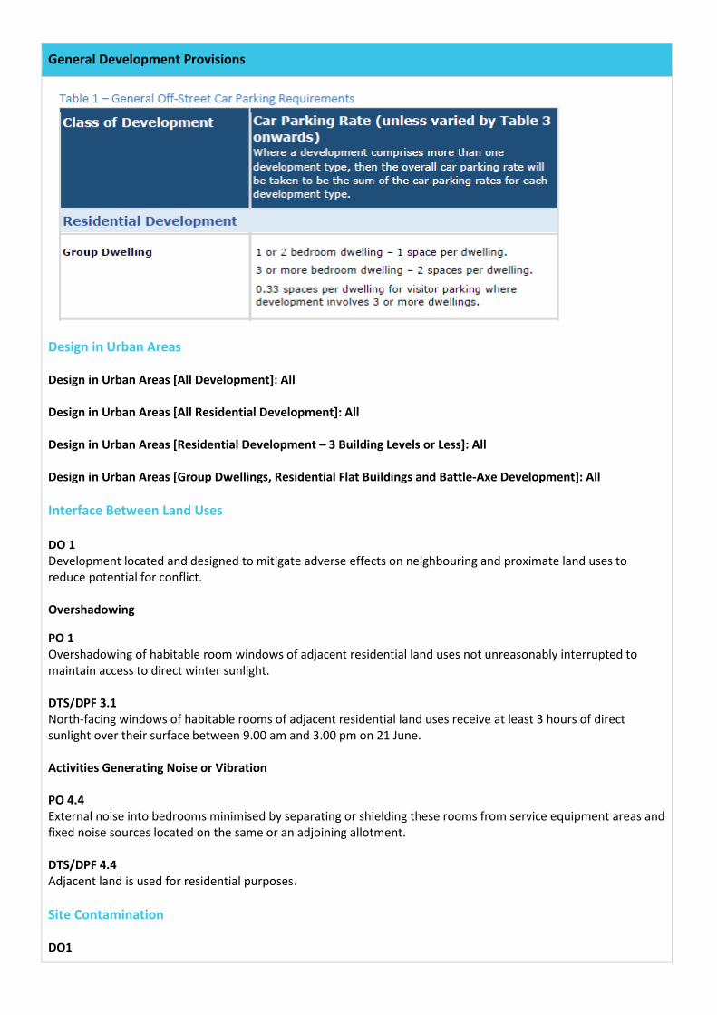
General Development Provisions
Design in Urban Areas Design in Urban Areas [All Development]: All Design in Urban Areas [All Residential Development]: All Design in Urban Areas [Residential Development – 3 Building Levels or Less]: All Design in Urban Areas [Group Dwellings, Residential Flat Buildings and Battle-Axe Development]: All Interface Between Land Uses DO 1 Development located and designed to mitigate adverse effects on neighbouring and proximate land uses to reduce potential for conflict. Overshadowing
PO 1 Overshadowing of habitable room windows of adjacent residential land uses not unreasonably interrupted to maintain access to direct winter sunlight. DTS/DPF 3.1 North-facing windows of habitable rooms of adjacent residential land uses receive at least 3 hours of direct sunlight over their surface between 9.00 am and 3.00 pm on 21 June. Activities Generating Noise or Vibration PO 4.4 External noise into bedrooms minimised by separating or shielding these rooms from service equipment areas and fixed noise sources located on the same or an adjoining allotment. DTS/DPF 4.4 Adjacent land is used for residential purposes. Site Contamination DO1
General Development Provisions
Protection of human health and the environment wherever site contamination has been identified or is suspected to have occurred. PO 1.1 Ensure land is suitable for sensitive use in circumstances where it is, or may have been, subject to site contamination as a result of previously established uses of land or activities in the vicinity of the land. DTS/DPF 1.1 Development:
(a) does not incorporate a change of use of land; (b) incorporates a change of use of land that is not a more sensitive use of land than previously established
uses of the land; (c) in respect of which the applicant is able to furnish, or the relevant authority is in possession of, a site
contamination audit report less than 5 years old under Part 10A of the Environment Protection Act 1993 to the effect:
i. that site contamination does not exist (or no longer exists) at the land; or ii. that any site contamination at the land has been cleared or addressed to the extent necessary
to enable the land to be suitable for sensitive use; or (d) the allotment was the subject of consent granted under the Development Act 1993 or the Planning
Development and Infrastructure Act 2016 on or after 1 September 2009 in relation the division of the land.
Scenario 6 – Construction of a Residential Flat Building in the Urban Corridor (Living) Zone
RELEVANT AUTHORITY:
Assessment Panel
PLANNING & DESIGN CODE VERSION:
Planning and Design Code as applying on July 2020
NATURE OF DEVELOPMENT:
Construction of a Residential Flat Building
ELEMENTS: 1. Residential Flat Building ZONE Urban Corridor (Living) Zone SUB-ZONE N/A OVERLAYS Affordable Housing Overlay
Airport Building Heights (Regulated) Overlay Design Overlay Future Road Widening Overlay Hazards (Flooding) Overlay Major Urban Transport Routes Overlay Noise and Air Emissions Overlay Traffic Generating Development Overlay Urban Transport Routes Overlay
CATEGORY OF DEVELOPMENT:
Performance Assessed – Residential Flat Building
PUBLIC NOTIFICATION: Required – development exceeding the maximum building height specified in DTS / DPF 2.2
AGENCY REFERRALS: Commissioner of Highways Government Architect
Urban Corridor (Living) Zone
Desired Outcome (DO) DO1 A mixed use area with a strong living and accommodation focus that provides a diverse range of low to medium rise medium density residential development supported by compatible non-residential land uses oriented towards a primary road corridor, high frequency public transport route, activity centre or significant open space. Performance Outcomes (PO) and Deemed to Satisfy (DTS) / Designated Performance Feature (DTF) Criteria Land Use and Intensity PO 1.1 A vibrant mix of land uses adding to the vitality of the area and extend activities outside shop hours including restaurants, educational, community and cultural facilities and visitor and residential accommodation.
Urban Corridor (Living) Zone
DTS/DPF 1.1 Development comprises one or more of the following land uses:
(a) Advertisement (b) Apartments (c) Child Care Centre (d) Consulting Room (e) Dwelling (f) Educational Establishment (g) Hotel (h) Licensed Entertainment Premises (i) Licensed Premises (j) Office (k) Restaurant (l) Shop (m) Student Accommodation (n) Supported Accommodation (o) Tourist Accommodation
PO 1.2 A range of small to medium scale non-residential uses, services and facilities such as shops, offices and consulting rooms that meet the day to day needs for the local community. DTS/DPF 1.2 Shop, office, or consulting room uses not exceeding a maximum gross leasable floor area of 500m2, or is contained within an existing building PO 1.3 Development of diverse medium density accommodation options either as part of a mixed use development or wholly residential development. DTS/DPF 1.3 Residential development (other than residential development in a mixed use building) achieves a net residential density of at least 45 dwellings per hectare. Built Form and Character PO 2.1 Buildings positively contribute to a continuous framing of the primary road / public transport corridor and public realm, and provide visual relief from building scale and massing from the ground level public realm. DTS/DPF 2.1 Buildings:
(a) include a clearly defined podium or street wall with a maximum building height of 2 building levels or 8m in height; and
(b) have levels above the defined podium or street wall setback a minimum of 2m from that wall.
Urban Corridor (Living) Zone
PO 2.2 Building height consistent with the form expressed in the Maximum Building Height Levels Technical and Numeric Variation Overlay and the Maximum Building Height Metres Technical and Numeric Variation Overlay, and positively responds to the local context including the site’s frontage, depth, and adjacent primary corridor or street width. DTS/DPF 2.2 Building height is not greater than any maximum, or less than any minimum, specified in the Maximum Building Height Levels Technical and Numeric Variation Overlay, the Maximum Building Height Metres Technical and Numeric Variation Overlay, or the Minimum Building Height Levels Technical and Numeric Variation Overlay. PO 2.3 Buildings setback from the primary street boundaries are consistent with the established streetscape. DTS/DPF 2.3 Buildings setback from the primary street frontage in accordance with either of the following (whichever is the lesser):
(a) not less than 4m where the adjoining sites do not contain a building; or (b) the average of the setback of the existing building on each adjoining site fronting the
same street. PO 2.4 Buildings set back from secondary street boundaries to contribute to a consistent established streetscape. DTS/DPF 2.4 Buildings setback from a secondary street frontage not less than 2m. PO 2.5 Buildings set back from side boundaries (other than street and zone boundaries) to provide separation between buildings in a way that complements the established character of the locality and access to natural sunlight and ventilation for neighbouring buildings. DTS/DPF 2.5 Buildings with no window/s or balcony/s fronting the boundary, setback from side boundaries as follows:
(a) no minimum on the boundary, within the first 18m from the front property boundary for any building level;
(b) no minimum for remaining length for ground level only; and (c) 2m or more for 1st level and above for building parts more than 18m from the front
property boundary.
PO 2.6 Buildings set back from rear boundaries (other than street boundaries) to:
(a) minimise negative impacts on neighbouring properties, including access to natural sunlight and ventilation;
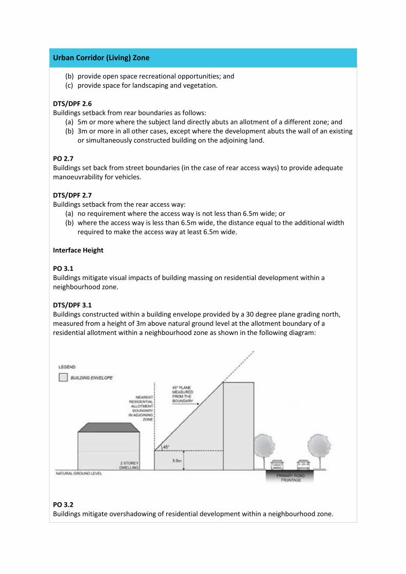
Urban Corridor (Living) Zone
(b) provide open space recreational opportunities; and (c) provide space for landscaping and vegetation.
DTS/DPF 2.6 Buildings setback from rear boundaries as follows:
(a) 5m or more where the subject land directly abuts an allotment of a different zone; and (b) 3m or more in all other cases, except where the development abuts the wall of an existing
or simultaneously constructed building on the adjoining land. PO 2.7 Buildings set back from street boundaries (in the case of rear access ways) to provide adequate manoeuvrability for vehicles. DTS/DPF 2.7 Buildings setback from the rear access way:
(a) no requirement where the access way is not less than 6.5m wide; or (b) where the access way is less than 6.5m wide, the distance equal to the additional width
required to make the access way at least 6.5m wide. Interface Height PO 3.1 Buildings mitigate visual impacts of building massing on residential development within a neighbourhood zone. DTS/DPF 3.1 Buildings constructed within a building envelope provided by a 30 degree plane grading north, measured from a height of 3m above natural ground level at the allotment boundary of a residential allotment within a neighbourhood zone as shown in the following diagram:
PO 3.2 Buildings mitigate overshadowing of residential development within a neighbourhood zone.
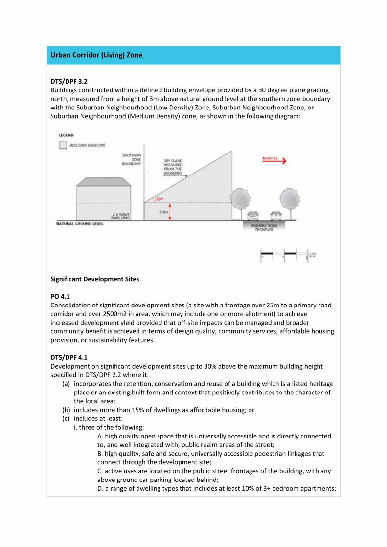
Urban Corridor (Living) Zone
DTS/DPF 3.2 Buildings constructed within a defined building envelope provided by a 30 degree plane grading north, measured from a height of 3m above natural ground level at the southern zone boundary with the Suburban Neighbourhood (Low Density) Zone, Suburban Neighbourhood Zone, or Suburban Neighbourhood (Medium Density) Zone, as shown in the following diagram:
Significant Development Sites PO 4.1 Consolidation of significant development sites (a site with a frontage over 25m to a primary road corridor and over 2500m2 in area, which may include one or more allotment) to achieve increased development yield provided that off-site impacts can be managed and broader community benefit is achieved in terms of design quality, community services, affordable housing provision, or sustainability features. DTS/DPF 4.1 Development on significant development sites up to 30% above the maximum building height specified in DTS/DPF 2.2 where it:
(a) incorporates the retention, conservation and reuse of a building which is a listed heritage place or an existing built form and context that positively contributes to the character of the local area;
(b) includes more than 15% of dwellings as affordable housing; or (c) includes at least:
i. three of the following: A. high quality open space that is universally accessible and is directly connected to, and well integrated with, public realm areas of the street; B. high quality, safe and secure, universally accessible pedestrian linkages that connect through the development site; C. active uses are located on the public street frontages of the building, with any above ground car parking located behind; D. a range of dwelling types that includes at least 10% of 3+ bedroom apartments;
Urban Corridor (Living) Zone
E. a child care centre; and ii. three of the following sustainable design measures are provided:
A. a communal useable garden integrated with the design of the building that covers the majority of a rooftop area supported by services that ensure ongoing maintenance; B. living landscaped vertical surfaces of at least 50m2 supported by services that ensure ongoing maintenance; C. passive heating and cooling design elements including solar shading integrated into the building; D. higher amenity through provision of private open space in excess of minimum requirements by 25% for at least 50% of dwellings.
PO 4.2 Development on a significant development site designed to minimise impacts on residential uses in adjacent zones with regard to intensity of use, overshadowing, massing and building proportions. DTS/DPF 4.2 Development that:
(a) is constructed within zone’s Interface Building Height provision as specified DTS/DPF 3.1 and 3.2;
(b) locates non-residential activities and higher density elements towards the primary road corridor; and
(c) locates taller building elements towards the primary road corridor. Movement, parking and access PO 5.1 Development does not result in additional crossovers on the primary street frontage, except where rationalising existing crossovers on consolidated sites and is designed to minimise conflicts with pedestrians and cyclists and minimise disruption to the continuity of built form. PO 5.1 Vehicular access to be provided:
(a) via side streets or rear lanes provided there is no negative impact on residential amenity within the zone and in adjacent zones; or
(b) where it consolidates or replaces existing crossovers. PO 5.2 Development is designed to ensure car parking is located avoid negative impacts on the primary corridor streetscape. PO 5.2 Vehicle parking garages located behind buildings away from the primary main street frontage. Concept Plans PO 6.1
Urban Corridor (Living) Zone
Development is compatible with the outcomes sought by any relevant Concept Plan contained within the Concept Plans Technical and Numeric Variation Overlay. DTS 6.1 None are applicable. Procedural Matters Notification All classes of performance assessed development is excluded from notification except where they involve any of the following:
(a) the site of the development is adjacent land to land in a different zone (b) development identified as “all other code assessed development” in Urban Corridor
(Living) Zone Table 3 (c) development exceeding the maximum building height specified in DTS / DPF 2.2 (d) development exceeding the defined building envelope specified in DTS / DPF 3.1 or 3.2 (e) shop, office or consulting room in excess of the gross leasable floor area specified in DTS /
DPF 1.2.
General Development Policies
Clearance from Overhead Powerlines DO 1 Protection of human health and safety when undertaking development in the vicinity of overhead transmission powerlines. PO 1.1 Buildings are adequately separated from aboveground powerlines to minimise potential hazard to people and property. DTS/DPF 1.1 One of the following is satisfied:
(a) (a) a declaration is provided by or on behalf of the applicant to the effect that the proposal would not be
(b) contrary to the regulations prescribed for the purposes of section 86 of the Electricity Act 1996; or
(c) there are no above ground powerlines adjoining the site that is the subject of the proposed development.
Infrastructure and Renewable Energy Facilities DO 1 Efficient provision of infrastructure networks and services, renewable energy facilities and ancillary development in a manner that minimises hazard, is environmentally and culturally
General Development Policies
sensitive and that suitably manages adverse visual impacts on natural and rural landscapes and residential amenity. Water Supply PO 11.2 Dwellings connected to a reticulated water scheme or mains water supply with the capacity to meet the requirements of the intended use. Where this is not available an appropriate rainwater tank or storage system for domestic use is provided. Wastewater Services PO 12.1 Development is connected to an approved common waste water disposal service with the capacity to meet the requirements of the intended use. Where this is not available an appropriate on-site service is provided to meet the on-going requirements of the intended use in accordance with the following:
(a) it is wholly located and contained within the allotment of the development they will service.
(b) in areas where there is a high risk of contamination of surface, ground, or marine water resources from on-site disposal of liquid wastes are to include disposal systems that minimise the risk of pollution to those water resources
(c) ensures septic tank effluent drainage fields and other waste water disposal areas located away from watercourses and flood prone, sloping, saline or poorly drained land to minimise environmental harm.
PO 12.2 Effluent drainage fields and other waste water disposal areas maintained to ensure the effective operation of waste systems and minimise risks to human health and environmental harm. Transport, Access and Parking DO 1 A comprehensive, integrated and connected transport system that is safe, sustainable, efficient, convenient and accessible to all users. Vehicle Access PO 3.1 Safe and convenient access that minimises impact or interruption on the operation of public roads. PO 3.2 Development incorporating vehicular access ramps ensures vehicles can enter and exit a site safely and without creating a hazard to pedestrians and other vehicular traffic. PO 3.3
General Development Policies
Access points sited and designed to accommodate the type and volume of traffic likely to be generated by the development or land use. PO 3.4 Access points sited and designed to minimise any adverse impacts on neighbouring properties. PO 3.5 Access points located so as not to interfere with mature street trees, existing street furniture (including directional signs, lighting, seating and weather shelters) or infrastructure services to maintain the appearance of the streetscape, preserve local amenity and minimise disruption to utility infrastructure assets. PO 3.6 Driveways and access points are separated and minimised in number to optimise the provision of on-street visitor parking (where on-street parking is appropriate). Vehicle Parking Rates PO 5.1 The provision of sufficient on-site vehicle parking and specifically marked accessible car parking places to meet the needs of the development or land use having regard to factors that may support a reduced onsite rate such as:
(a) availability of on-street car parking (b) shared usage of other parking areas (c) in relation to a mixed-use development, where the hours of operation of commercial
activities complement the residential use of the site the provision of vehicle parking may be shared.
Design in Urban Areas Design in Urban Areas [All Development]: All Design in Urban Areas [All Development – 4 or More Building Levels]: All Design in Urban Areas [All Residential Development]: All Design in Urban Areas [Residential Development – 3 Building Levels or Less]: All Design in Urban Areas [Residential Development – 4 Or More Building Levels (Including Serviced Apartments)]: All Design in Urban Areas [Group Dwellings, Residential Flat Buildings and Battle-Axe Development]: All Interface Between Land Uses DO 1
General Development Policies
Development located and designed to mitigate adverse effects on neighbouring and proximate land uses to reduce potential for conflict. General Land Use Compatibility PO 1.1 Sensitive receivers designed and sited to protect residents and occupants from adverse impacts generated by lawfully existing land uses and land uses desired in the zone. Overshadowing PO 3.1 Overshadowing of habitable room windows of adjacent residential land uses not unreasonably interrupted to maintain access to direct winter sunlight. PO 3.2 Overshadowing of the primary area of private open space or communal open space of adjacent residential land uses not unreasonably interrupted to maintain access to direct winter sunlight. Activities Generating Noise or Vibration PO 4.4 External noise into bedrooms minimised by separating or shielding these rooms from service equipment areas and fixed noise sources located on the same or an adjoining allotment. Site Contamination DO 1 Protection of human health and the environment wherever site contamination has been identified or is suspected to have occurred. PO 1.1 Ensure land is suitable for sensitive use in circumstances where it is, or may have been, subject to site contamination as a result of previously established uses of land or activities in the vicinity of the land.
Affordable Housing Overlay
DO 1 Affordable housing that includes a range of affordable dwelling types is integrated into residential and mixed use development. DO 2 Development that caters for a variety of household structures. Land Division PO 1.1
Affordable Housing Overlay
Development comprising 20 or more dwellings provides housing suited to a range of incomes including households with low – moderate incomes. DTS/DPF 1.1 Development comprising 20 or more dwellings or residential allotments includes a minimum of 15% affordable housing except where:
(a) it can be demonstrated that any shortfall in affordable housing has been provided in a previous stage of development; or
(b) it can be demonstrated that any shortfall in affordable housing will be accommodated in a subsequent stage or stages of development.
PO 1.2 Affordable housing is distributed throughout the development to avoid an overconcentration of affordable housing. DTS/DPF 1.2 None are applicable. Built Form and Character PO 2.1 Affordable housing is designed to complement the design and character of residential development within the development area. DTS/DPF 2.1 None are applicable. Affordable Housing Incentives PO 3.1 Allotments created for affordable housing are a suitable size and dimension that provide a high standard of occupant amenity and integrate with residential neighbourhoods. DTS/DPF 3.1 Where constituting affordable housing, the minimum site area specified for a dwelling can be reduced by up to 20%. PO 3.2 To support the provision of affordable housing building heights may be increased above the maximum specified in the Building Heights Technical and Numeric Variations Data Overlay. DTS/DPF 3.2 Where a mixed-use development or apartment building includes at least 15% affordable housing, the maximum building height specified can be increased by 1 storey in City Living, General Neighbourhood, Housing Diversity Neighbourhood Greenfield Neighbourhood, Master-planned Suburban Neighbourhood Zone, and up to 30% in any other zone. Movement and Car Parking
Affordable Housing Overlay
PO 4.1 Sufficient car parking is provided to meet the needs of occupants of affordable housing. DTS/DPF 4.1 Dwellings constituting affordable housing are provided with car parking in accordance with the following:
(a) 0 carparks for an apartment; and (b) 1 carpark per dwelling for any other dwelling.
Airport Building Heights (Regulated) Overlay
DO 1 Management of potential impacts of buildings on the operational and safety requirements of certified commercial and military airfields, airports, airstrips and helicopter landing sites. Built Form PO 1.1 Building height does not pose a hazard to the operation of a certified aerodrome. DTS/DPF 1.1 Building height does not exceed the Obstacle Limitations Surface (OLS) in the Airport Building Heights (Regulated) Technical and Numeric Variation Overlay. PO 1.2 Development is adequately separated from runways and other operational facilities within certified aerodromes to minimise the potential for building generated turbulence and windshear. DTS/DPF 1.2
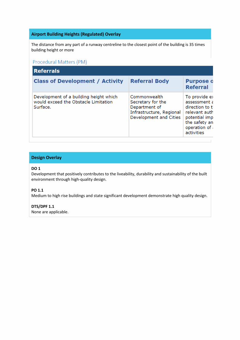
Airport Building Heights (Regulated) Overlay
The distance from any part of a runway centreline to the closest point of the building is 35 times building height or more
Design Overlay
DO 1 Development that positively contributes to the liveability, durability and sustainability of the built environment through high-quality design. PO 1.1 Medium to high rise buildings and state significant development demonstrate high quality design. DTS/DPF 1.1 None are applicable.
Design Overlay
Future Road Widening Overlay
DO 1
Future Road Widening Overlay
Development which is consistent with and will not compromise efficient delivery of future road widening requirements. PO 1.1 Development does not compromise or is located and designed to minimise its impact on future road widening requirements. DTS/DPF 1.1 Development does not involve building work, or building work is located wholly outside the land shown in the Future Road Widening Overlay.
Hazards (Flooding) Overlay
DO 1 Minimise impacts on people, property, infrastructure and the environment from exposure to flood hazard risk through limitation of development intensification. Land Division PO 1.1 Land division limited to areas where the consequences to buildings and safety are low and can be readily managed or overcome. DTS/DPF 1.1 Land division resulting in the creation of new allotments occurs outside of areas where flood depth would exceed 0.3m above natural ground level and flood velocity would exceed 0.3m per second during a 1% AEP flood event. PO 1.2
Hazards (Flooding) Overlay
Allotments can be connected to a public stormwater system capable of catering for a 1% AEP flood event. DTS/DPF 1.2 None are applicable PO 1.3 Land is not divided unless a layout is achieved whereby roads, parking areas and development sites for each allotment are at least 0.3m above the 1% AEP flood event level, unless the land is, or can be provided with flood protection measures that are appropriate and acceptable for the intended future land use. DTS/DPF 1.3 None are applicable. Land Use PO 2.1 Buildings housing vulnerable people, community services facilities and emergency services are sited away from areas of unacceptable flood risk. DTS/DPF 2.1 Pre-schools, educational establishments, retirement and supported accommodation, emergency services facilities, hospitals and prisons located outside of the 1% AEP flood area. Flood Resilience PO 3.1 Development avoids necessitating flood protection works through measures such as setbacks to protect development from the impacts of flooding. DTS/DPF 3.1 None are applicable PO 3.2 Development does not cause unacceptable impacts on any adjoining property by diversion of flood waters, increase in flood velocity or flood level, or cause an unacceptable loss of flood storage. DTS/DPF 3.2 Development is limited to:
(a) buildings, structures or earthworks required as part of flood protection works associated with a regional flood mitigation scheme; or
(b) recreation area. PO 3.3
Hazards (Flooding) Overlay
Buildings sited, designed and constructed to prevent the entry of floodwaters in a 1% AEP flood event where the entry of flood waters is likely to result in undue damage to or compromise ongoing activities within buildings. DTS/DPF 3.3 None are applicable PO 3.4 Development, including outbuildings and fences, does not impede floodwaters. DTS/DPF 3.4 None are applicable Environmental Protection PO 4.1 Buildings used either partly or wholly to contain or store hazardous materials designed to prevent spills or leaks leaving the confines of the building during a 1% AEP flood event to avoid potential environmental harm. DTS/DPF 4.1 Development involving storage or disposal of hazardous materials is wholly located outside of the 1% AEP flood level. PO 4.2 Development does not create or aggravate the potential for erosion or siltation or lead to the destruction of vegetation during a flood. DTS/DPF 4.2 None are applicable Site Earthworks PO 5.1 The depth and extent of filling required to raise the finished floor level of a building does not cause unacceptable impact on any adjoining property by diversion of flood waters, an increase in flood velocity or flood level, or cause an unacceptable loss of flood storage. DTS/DPF 5.1 None are applicable PO 5.2 Driveways, access tracks and parking areas are designed and constructed to minimise excavation and filling. DTS/DPF 5.2 Filling for ancillary purposes:
(a) does not exceed 100mm above existing ground level; and
Hazards (Flooding) Overlay
(b) is no more than 5m wide. Access PO 6.1 Development does not occur on land:
(a) from which evacuation to areas not vulnerable to flood risk is not possible during a 1% AEP flood event; or
(b) which cannot be accessed by emergency services vehicles or essential utility service vehicles during a 1% AEP flood event.
DTS/DPF 6.1 None are applicable PO 6.2 Access driveways and tracks to significant development (i.e. dwellings, places of work, etc.) consist of a safe, all-weather trafficable surface that is accessible during a 1% AEP flood event. DTS/DPF 6.2 None are applicable
Major Urban Transport Routes Overlay
DO 1 Safe and efficient operation of major urban transport routes for all road users. DO 2 Provision of safe and efficient access to and from major urban transport routes. Safe Entry and Exit (Traffic Flow) PO 1.1 Access points designed to allow safe entry and exit to and from a site to meet the needs of development, to ensure traffic flow interference associated with access movements is minimised. DTS/DPF 1.1 An access point is designed to ensure:
(a) the following for the largest vehicle expected to access the site: i. entry and exit movements are left turn only;
ii. access to and from the site is in a forward direction, with on-site manoeuvring available through circulation around the site of no more than a 3-point turn;
iii. vehicles cross the property boundary at an angle between 70 degrees and 90 degrees; and
(b) access to and from the site fully within the kerbside lane of the road; and where the access point services, or is intended to service:
Major Urban Transport Routes Overlay
i. a single dwelling, the access point has a width of between 3m and 4m (measured at the site boundary); or
ii. between 2 and 6 dwellings, the access point has a width of between 6m and 7m (measured at the site boundary); or
iii. over 6 dwellings or any other non-residential land uses, then:
A. where vehicles 6.4m or less are expected to access the site, the access point has a width of between 7m and 10m (measured at the site boundary);or B.where vehicles up to 8.8m in length are expected to access the site, the access point has a width of between 12m and 16m (measured at the site boundary); and C. the access point is located 1m or more from any roadside infrastructure or trees.
Access – On-Site Queuing PO 2.1 Sufficient accessible on-site queuing adjacent to access points is provided to meet the needs of development so that all vehicle queues are contained fully within the boundaries of the development site, to minimise interruption on the functional performance of the road and safe vehicle movement. DTS/DPF 2.1 An access point:
(a) will not service, or is not intended to service, more than 6 dwellings and there are no internal driveways, intersections, car parking spaces or gates within 6.0m of the access point; or
(b) will service development that will generate less than 60 vehicle movements per day; and i. where vehicles no greater than 6.4m in length are expected to access the site,
there are no internal driveways, intersections, car parking spaces, car park isles or any other internal obstructions within 10.5m of the access point; or
ii. where vehicles no greater than 8.8m in length are expected to access the site, there are no internal driveways, intersections, car parking spaces, car park isles or any other internal obstructions within 14.5m of the access point; or
iii. where vehicles over 8.8m in length are expected to access the site, no Deemed-to-Satisfy Criteria applies.
Access – Existing Access Points PO 3.1 Existing access points designed to accommodate the type and volume of traffic likely to be generated by the development. DTS/DPF 3.1 An existing access point:
(a) will not service and is not intended to service more than 6 dwellings; or (b) will service development that will not result in:
Major Urban Transport Routes Overlay
i. an increase in traffic using an existing access point that is greater than 10% of the traffic volumes using the existing access prior to the development or 60 vehicles per day (whichever is the lesser); or
ii. a larger class of vehicle expected to access the site using the existing access.
Access – Location (Spacing) PO 4.1 New access points are widely spaced apart from any existing access point or public road junction to not impede traffic flow and ensure safe and efficient operating conditions are maintained on the road. DTS/DPF 4.1 Where access from an alternative local road at least 25m from the Major Urban Route is not available, and the access is not located on a Controlled Access Road, a new access point is:
(a) not located on a section affected by double barrier lines between either edge of the access point; and
(b) at least the following distance from a public road junction, or terminating / merging lane on a public road: B. 110 km/h road – 325m C. 100 km/h road – 280m D. 90 km/h road – 240m E. 80 km/h road – 200m F. 70 km/h road – 165m G. 60 km/h road – 135m H. 50km/h or less road – 105m; and
(c) at least the following distance from another private (non-public road) access point: A. 110 km/h road – 190m B. 100 km/h road – 165m C. 90 km/h road – 140m D. 80 km/h road – 110m E. 70 km/h road – 90m F. 60 km/h road – 70m G. 50km/h or less road – 50m
Access – Location (Sight Lines) PO 5.1 Access points located and designed to ensure appropriate sight distances are provided so that drivers on the road approaching the access point are able to recognise the presence of the access point and/or see a vehicle turning into or out of the access point in time to slow down or stop in a safe and controlled manner; and
(a) exiting the access point onto the road can see approaching vehicles to avoid potential conflict.
DTS/DPF 5.1 Drivers approaching or exiting a new access point have an unobstructed line of sight to or from the new access point in accordance with the following distances:
Major Urban Transport Routes Overlay
(a) 110 km/h road – 325m (b) 100 km/h road – 280m (c) 90 km/h road – 240m (d) 80 km/h road – 200m (e) 70 km/h road – 165m (f) 60 km/h road – 135m; and (g) 50km/h or less road – 105m.
Access – Mud and Debris PO 6.1 Access points constructed to minimise mud or other debris being carried or transferred onto the road, to ensure safe road operating conditions. DTS/DPF 6.1 None are applicable. Access – Stormwater PO 7.1 Access points designed to minimise negative impact on roadside drainage of water. DTS/DPF 7.1 Development does not:
(a) decrease the capacity of an existing drainage point; or (b) restrict or prevent the flow of stormwater to an existing drainage point and system.
Building on Road Reserve PO 8.1 Buildings or structures that encroach onto, above or below road reserves designed and sited to minimise impact on safe movements by all road users. DTS/DPF 8.1 No encroachment of buildings or structures onto, above or below the road reserve. Public Road Junctions PO 9.1 New junctions with public roads (including the opening of unmade public road junctions) or modifications to existing road junctions located and designed to ensure safe and efficient road operating conditions. DTS/DPF 9.1 Development does not involve creation of a new junction with a public road, opening of an unmade public road junction or modification to an existing public road junction. Corner Cut-Offs PO 10.1 Development located and designed to ensure drivers can safely turn into and out of public road junctions.
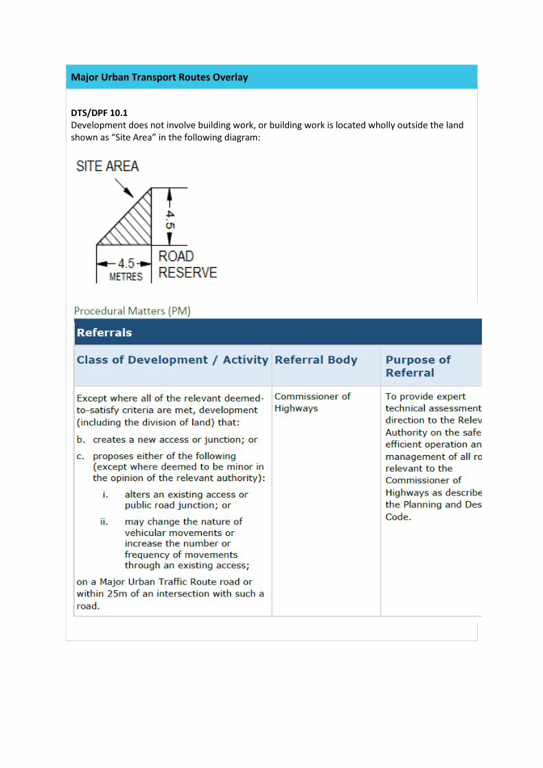
Major Urban Transport Routes Overlay
DTS/DPF 10.1 Development does not involve building work, or building work is located wholly outside the land shown as “Site Area” in the following diagram:
Noise and Air Emissions Overlay
DO 1 Protect community health and amenity from adverse impacts of noise and air emissions. Siting and Design PO 1.1 Noise and air quality sensitive development located adjacent to high noise and/or air pollution sources designed and sited to shield sensitive receivers from the emission source using measures such as:
(a) placing buildings containing non-sensitive receivers (such as retail and commercial) between the emission source and sensitive receivers;
(b) within individual buildings, placing rooms more sensitive to air quality and noise impacts (such as living rooms and bedrooms) further away from the emission source;
(c) providing appropriate separation or erecting noise attenuation barriers, provided the requirements for safety, urban design and access can be met;
(d) the use building design elements such as podiums and jutting, deep or enclosed balconies (including with solid balustrades), provided the requirements for safety, urban design and access can be met.
DTS/DPF 1.1 None are applicable PO 1.2 Air quality sensitive development located adjacent to high air pollution sources use building design elements such as varying building heights, widths, articulation, setbacks and shapes to increase wind turbulence and the dispersion of air pollutants, provided wind impacts on pedestrian amenity are acceptable. DTS/DPF 1.2 None are applicable PO 1.3 Noise and air quality sensitive development located adjacent to high noise and/or air pollution sources locate private open space (including ground level courtyards and balconies), common open space and outdoor play areas within educational establishments and pre-schools away from the emission source. DTS/DPF1.3 None are applicable
Traffic Generating Development Overlay
DO 1 Safe and efficient operation of urban transport routes and major urban transport routes for all road users. DO 2
Traffic Generating Development Overlay
Provision of safe and efficient access to and from urban transport routes and major urban transport routes. Traffic Generating Development PO 1.1 Development designed to minimise its potential impact on the safety, efficiency and functional performance of the state road network. DTS/DPF 1.1 None are applicable. PO 1.2 Access points sited and designed to accommodate the type and volume of traffic likely to be generated by development. DTS/DPF 1.2 Development only has access directly from a Key Outback and Rural Route or Urban Traffic Route. PO 1.3 Sufficient accessible on-site queuing provided to meet the needs of the development so that queues do not impact on the state road network. DTS/DPF 1.3 Development only has access directly from a Key Outback and Rural Route, Major Urban Traffic Route or Urban Traffic Route.
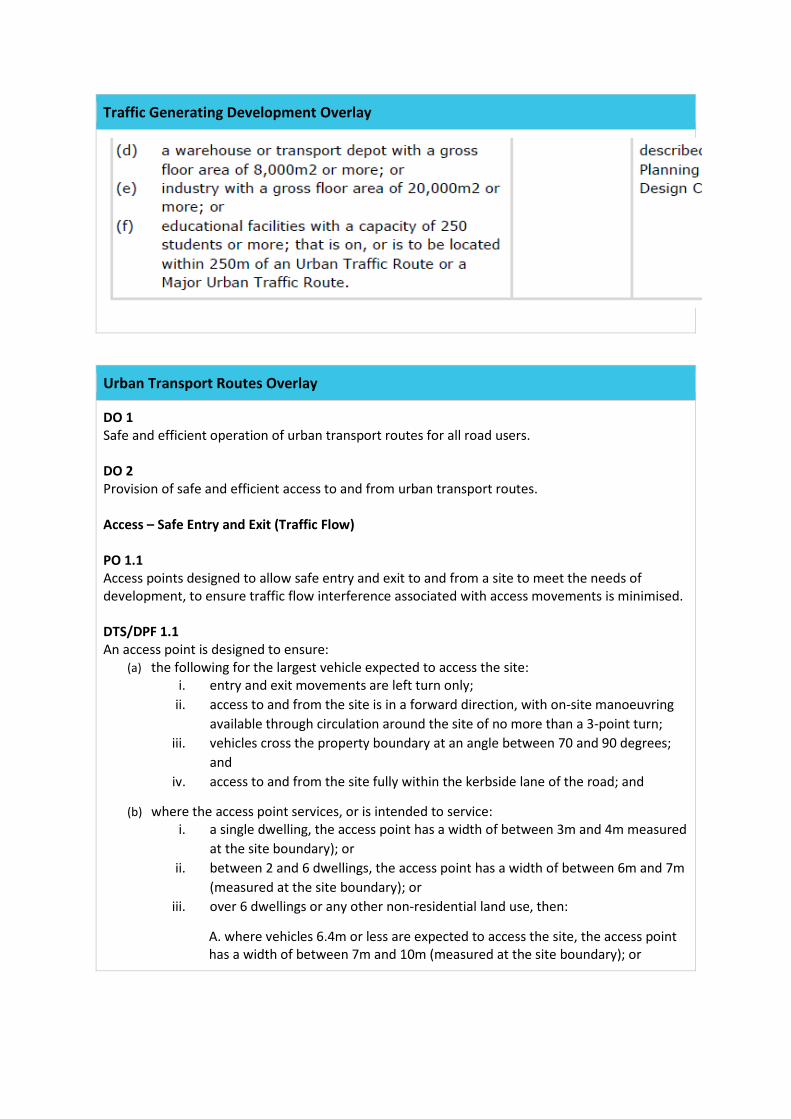
Traffic Generating Development Overlay
Urban Transport Routes Overlay
DO 1 Safe and efficient operation of urban transport routes for all road users. DO 2 Provision of safe and efficient access to and from urban transport routes. Access – Safe Entry and Exit (Traffic Flow) PO 1.1 Access points designed to allow safe entry and exit to and from a site to meet the needs of development, to ensure traffic flow interference associated with access movements is minimised. DTS/DPF 1.1 An access point is designed to ensure:
(a) the following for the largest vehicle expected to access the site: i. entry and exit movements are left turn only;
ii. access to and from the site is in a forward direction, with on-site manoeuvring available through circulation around the site of no more than a 3-point turn;
iii. vehicles cross the property boundary at an angle between 70 and 90 degrees; and
iv. access to and from the site fully within the kerbside lane of the road; and
(b) where the access point services, or is intended to service: i. a single dwelling, the access point has a width of between 3m and 4m measured
at the site boundary); or ii. between 2 and 6 dwellings, the access point has a width of between 6m and 7m
(measured at the site boundary); or iii. over 6 dwellings or any other non-residential land use, then:
A. where vehicles 6.4m or less are expected to access the site, the access point has a width of between 7m and 10m (measured at the site boundary); or
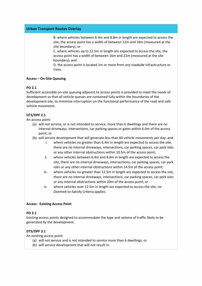
Urban Transport Routes Overlay
B. where vehicles between 6.4m and 8.8m in length are expected to access the site, the access point has a width of between 12m and 16m (measured at the site boundary); or C. where vehicles up to 12.5m in length are expected to access the site, the access point has a width of between 16m and 22m (measured at the site boundary); and D. the access point is located 1m or more from any roadside infrastructure or trees.
Access – On-Site Queuing PO 2.1 Sufficient accessible on-site queuing adjacent to access points is provided to meet the needs of development so that all vehicle queues are contained fully within the boundaries of the development site, to minimise interruption on the functional performance of the road and safe vehicle movement. DTS/DPF 2.1 An access point:
(a) will not service, or is not intended to service, more than 6 dwellings and there are no internal driveways, intersections, car parking spaces or gates within 6.0m of the access point; or
(b) will service development that will generate less than 60 vehicle movements per day; and i. where vehicles no greater than 6.4m in length are expected to access the site,
there are no internal driveways, intersections, car parking spaces, car park isles or any other internal obstructions within 10.5m of the access point;
ii. where vehicles between 6.4m and 8.8m in length are expected to access the site, there are no internal driveways, intersections, car parking spaces, car park isles or any other internal obstructions within 14.5m of the access point;
iii. where vehicles no greater than 12.5m in length are expected to access the site, there are no internal driveways, intersections, car parking spaces, car park isles or any internal obstructions within 20m of the access point; or
iv. where vehicles over 12.5m in length are expected to access the site, no Deemed-to-Satisfy Criteria applies.
Access - Existing Access Point PO 3.1 Existing access points designed to accommodate the type and volume of traffic likely to be generated by the development. DTS/DPF 3.1 An existing access point:
(a) will not service and is not intended to service more than 6 dwellings; or (b) will service development that will not result in:
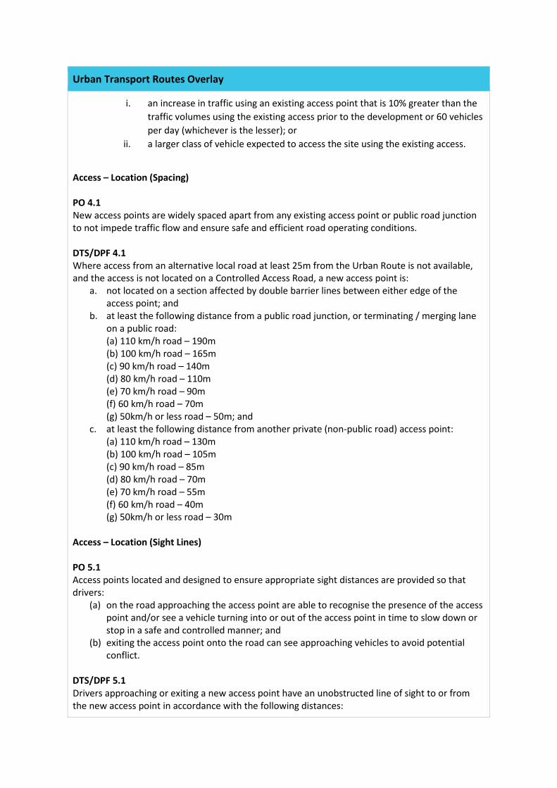
Urban Transport Routes Overlay
i. an increase in traffic using an existing access point that is 10% greater than the traffic volumes using the existing access prior to the development or 60 vehicles per day (whichever is the lesser); or
ii. a larger class of vehicle expected to access the site using the existing access.
Access – Location (Spacing) PO 4.1 New access points are widely spaced apart from any existing access point or public road junction to not impede traffic flow and ensure safe and efficient road operating conditions. DTS/DPF 4.1 Where access from an alternative local road at least 25m from the Urban Route is not available, and the access is not located on a Controlled Access Road, a new access point is:
a. not located on a section affected by double barrier lines between either edge of the access point; and
b. at least the following distance from a public road junction, or terminating / merging lane on a public road: (a) 110 km/h road – 190m (b) 100 km/h road – 165m (c) 90 km/h road – 140m (d) 80 km/h road – 110m (e) 70 km/h road – 90m (f) 60 km/h road – 70m (g) 50km/h or less road – 50m; and
c. at least the following distance from another private (non-public road) access point: (a) 110 km/h road – 130m (b) 100 km/h road – 105m (c) 90 km/h road – 85m (d) 80 km/h road – 70m (e) 70 km/h road – 55m (f) 60 km/h road – 40m (g) 50km/h or less road – 30m
Access – Location (Sight Lines) PO 5.1 Access points located and designed to ensure appropriate sight distances are provided so that drivers:
(a) on the road approaching the access point are able to recognise the presence of the access point and/or see a vehicle turning into or out of the access point in time to slow down or stop in a safe and controlled manner; and
(b) exiting the access point onto the road can see approaching vehicles to avoid potential conflict.
DTS/DPF 5.1 Drivers approaching or exiting a new access point have an unobstructed line of sight to or from the new access point in accordance with the following distances:
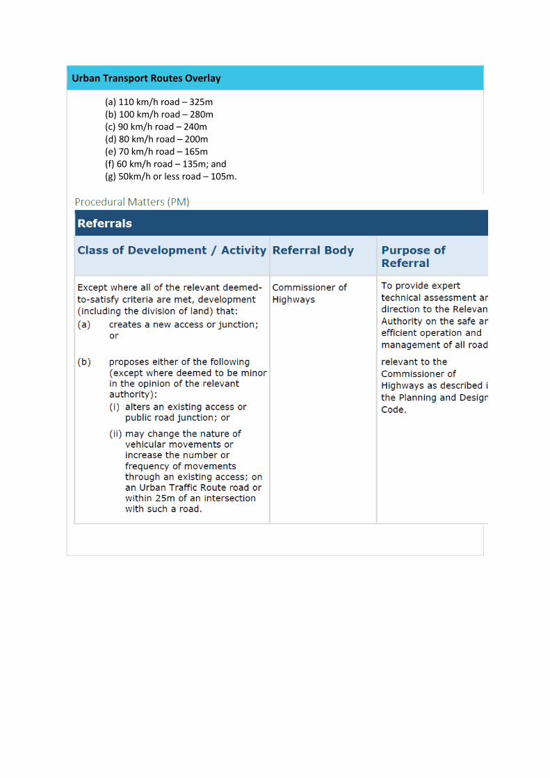
Urban Transport Routes Overlay
(a) 110 km/h road – 325m (b) 100 km/h road – 280m (c) 90 km/h road – 240m (d) 80 km/h road – 200m (e) 70 km/h road – 165m (f) 60 km/h road – 135m; and (g) 50km/h or less road – 105m.