Embed Size (px)
Citation preview

0 | Ga-Segonayana Local Municipality Draft Land Audit Report 2015
GA-SEGONYANA LOCAL MUNICIPALITY DRAFT LAND AUDIT REPORT
2015
1 | Ga-Segonayana Local Municipality Draft Land Audit Report 2015
1 INTRODUCTION AND PROJECT INCEPTION ................................................................................................................................... 5
1.1 STUDY AREA ........................................................................................................................................................................... 5
1.2 PURPOSE OF THE PROJECT ................................................................................................................................................. 6
1.3 METHODOLOGY AND PROCESS ........................................................................................................................................... 7
1.4 PROJECT IMPLEMENTATION PLAN ....................................................................................................................................... 9
1.5 POLICIES AND LEGISLATIVE PROVISIONS ......................................................................................................................... 10
2 MUNICIPAL SITUATION ANALYSIS ................................................................................................................................................. 12
2.1 MUNICIPAL OVERVIEW ......................................................................................................................................................... 13
2.2 DEMOGRAPHIC PROFILE ..................................................................................................................................................... 14
2.2.1 POPULATION COMPOSITION................................................................................................................................................. 14
2.2.2 DISTRICT CONTEXT ............................................................................................................................................................... 15
2.2.3 HOUSEHOLD SIZE .................................................................................................................................................................. 15
2.2.4 GENDER RATIO ...................................................................................................................................................................... 16
2.2.5 AGE COMPOSITION ................................................................................................................................................................ 16
2.2.6 POPULATION PROJECTIONS................................................................................................................................................. 17
2.2.7 MIGRATION ............................................................................................................................................................................. 17
2.3 HOUSEHOLD INFRASTRUCTURE ........................................................................................................................................ 18
2.3.1 HOUSING ................................................................................................................................................................................. 18
TABLE OF CONTENTS

2 | Ga-Segonayana Local Municipality Draft Land Audit Report 2015
2.3.2 ACCESS TO WATER SERVICES ............................................................................................................................................ 19
2.3.3 ACCESS TO ELECTRICITY SERVICES .................................................................................................................................. 20
2.3.4 REFUSE DISPOSAL ................................................................................................................................................................ 20
2.3.5 SANITATION FACILITIES ........................................................................................................................................................ 21
2.4 SOCIO-ECONOMIC PROFILE ................................................................................................................................................ 21
2.4.1 ECONOMIC PROFILE .............................................................................................................................................................. 21
2.5 HUMAN SETTLEMENTS PATTERN ....................................................................................................................................... 24
2.5.1 KURUMAN ............................................................................................................................................................................... 26
2.5.2 WRENCHVILLE ........................................................................................................................................................................ 30
2.5.3 MOTHIBISTADT ....................................................................................................................................................................... 31
2.5.4 BANKHARA-BODULONG......................................................................................................................................................... 33
2.5.5 BATLHAROS ............................................................................................................................................................................ 35
2.5.6 OTHER RURAL AREAS ........................................................................................................................................................... 37
2.6 HOUSING PROVISION ........................................................................................................................................................... 40
2.6.1 LAND OWNERSHIP ................................................................................................................................................................. 41
2.6.2 MINING ..................................................................................................................................................................................... 43
2.6.3 AGRICULTURE ........................................................................................................................................................................ 45
2.7 POLICIES AND LEGISLATIVE PROVISIONS ......................................................................................................................... 47
2.7.1 NATIONAL AND PROVINCIAL POLICY/ LEGISLATIVE IMPERATIVES .................................................................................. 47

3 | Ga-Segonayana Local Municipality Draft Land Audit Report 2015
2.7.2 DISTRICT AND LOCAL POLICY IMPERATIVES...................................................................................................................... 58
2.8 CONCLUSION ........................................................................................................................................................................ 64
3 STRATEGY, PROPOSAL AND RECOMMENDATIONS .................................................................................................................... 65
3.1 STRATEGY FRAMEWORK..................................................................................................................................................... 65
3.1.1 LAND AUDIT VISION AND PRINCIPLES ................................................................................................................................. 65
3.1.2 KEY PRINCIPLES TO INFORM THE LAND AUDIT .................................................................................................................. 66
3.1.3 LAND AUDIT PRINCIPLES ...................................................................................................................................................... 67
3.2 THE LAND REGISTER ........................................................................................................................................................... 68
3.3 DEFINING LAND USES .......................................................................................................................................................... 69
3.4 SETTLEMENT LAND PROPOSALS ....................................................................................................................................... 74
3.4.1 KURUMAN ............................................................................................................................................................................... 74
3.4.2 WRENCHVILLE ........................................................................................................................................................................ 75
3.4.3 GALOWE INTEGRATED HUMAN SETTLEMENT .................................................................................................................... 76
3.4.4 MOTHIBISTAT .......................................................................................................................................................................... 77
3.4.5 BANKHARA-BODULONG......................................................................................................................................................... 79
3.4.6 SEODING ................................................................................................................................................................................. 82
3.4.7 MAGOBE .................................................................................................................................................................................. 83
3.4.8 SEVEN MILES .......................................................................................................................................................................... 84

4 | Ga-Segonayana Local Municipality Draft Land Audit Report 2015
3.4.9 BATLHAROS ............................................................................................................................................................................ 85
3.4.10 MARUPING .............................................................................................................................................................................. 86
3.4.11 KAGUNG .................................................................................................................................................................................. 87
3.4.12 THIRD ORDER SETTLEMENTS .............................................................................................................................................. 88
3.4.13 FOURTH ORDER SETTLEMENTS .......................................................................................................................................... 89
3.5 LAND AUDIT PROPOSALS AND RECOMMENDATIONS ...................................................................................................... 90
3.6 IMPLEMENTATION PLAN ...................................................................................................................................................... 95
3.7 CONCLUSION .......................................................................................................................................................................103 4 REFERENCES ……………………………………………………………………………………………………………………………………. 104

5 | Ga-Segonayana Local Municipality Draft Land Audit Report 2015
1 INTRODUCTION AND PROJECT INCEPTION
1.1 STUDY AREA
Ga-Segonyana Local Municipality is located in north-eastern part of Northern Cape Province. The municipality is strategically located N14 highway (i.e. the Namaquari route between Gauteng and Namibia and Cape Town via Upington). It covers an area of 4 491km² and includes the town and townships of Kuruman, Mothibistadt and Batlharos.
Ga-Segonyana Local Municipality comprises of 13 electoral wards, and is one of the three local municipalities that fall under John Taolo Gaetsewe District Municipality, with its head offices in Kuruman (Ga-Segonyana LM 2012/2013 IDP).
Mining activity, particularly of the iron ore and manganese, is the most important economic sector. The municipal area has significant historical and natural tourist attractions which includes amongst other ‘The Eye’, Wonderwerk cave and rock paintings as well as the Robert Moffat Mission Station. Kuruman is the most active business area in the municipality. Interestingly Ga-Segonyana means a small calabash with bubbling water i.e. ‘The Eye’.
The population of Ga-Segonyana LM is 93 651, an increase of 2.85% since the 2001 Census. The municipality constitute 41.66% of the total district population which is 224 799. Its population growth is higher than that of John Taolo Gaetsewe District Municipality which is 1.6% (Census 2011).
6 | Ga-Segonayana Local Municipality Draft Land Audit Report 2015
1.2 PURPOSE OF THE PROJECT The project entails a land audit in the Ga-Segonyana Local Municipality. The main objective of the municipality commissioning the Land Audit is to establish status of all land parcels in its jurisdiction for informed decision making on land use and development. Below are Terms of Reference for this project:
• Verify each property situated within the jurisdiction of Ga-Segonyana LM against the original registered hard copy of the physical title deed and confirm existence of such title deeds and reconcile these properties with deeds and SG office. This includes also registered servitudes and lease diagrams
• Flag and report all unregistered properties • Verify through physical inspection of each property and indicate its use thereof e.g. vacant land or improved (buildings or structures) • Categorically state the nature of the improvement per property • Land ownership of developed and undeveloped land within the Ga-Segonyana LM Urban edge • Indicate land under gazette claims • Township Establishment (Settlement Formalisation)/ Land Development applications proclaimed or pending • State, Municipal, Provincial, Parastatals and Traditional/ Communal Land • Flag, record and confirm the User Department or Tenant/ Lessee in occupation for each property owned by the Municipality • Flag, record and report any illegal occupation/ invasion of each improved or vacant land
7 | Ga-Segonayana Local Municipality Draft Land Audit Report 2015
1.3 METHODOLOGY AND PROCESS
Phase One: ORIENTATION, PROJECT PLANNING & INCEPTION Orientation The purpose of this step is to finalise the project terms of reference in the terms of the goal and objectives to be achieved and deliverables to be provided with this project. Area visitation and non-structured interviews with municipal personnel and desk top information collection. Phase Two: STATUS QUO/ PROFILE Situational Analysis (Demography, Socio-Economic and Spatial Analysis, Priority Issues) The purpose of this step is to analyse the municipal demographics, socio-economic and spatial analysis, and priority issues with regard to land use and development.
Literature Review The purpose of this step is to provide practical answers to critical questions through a desktop study in order to identify solutions for land development and usage. Basic but critical questions to be answered include, inter alia, the following:
Which land parcels are most suitable for development and which once are most suitable for housing development, industrial & agricultural development and tourism enhancement and environmental projects?
Sourcing Spatial Data The purpose of this step is to identify and obtain all existing data relating to the key aspects of the project. It is assumed that existing spatial and non-spatial datasets (cadastral data, deeds information and the municipality’s Land Use Scheme and GIS) will be obtained from various data custodians including the municipality and Department of Rural Development and Land Reform.

8 | Ga-Segonayana Local Municipality Draft Land Audit Report 2015
Mapping The focus of this step is to map land suitable for development and land most suitable for all priority land uses/ development that includes housing, industries and environmental conservation, tourism and agricultural development from satellite imagery and aerial photography by means of applying remote sensing techniques.
Phase Three: DRAFT LAND AUDIT REPORT (RECOMMENDATION AND PROPOSAL)
The purpose of this step is to collate all the data and results obtained from the previous steps into a Land Audit Report and hand over its recommendations and proposals to the Project Steering committee for final inputs and comments with regard to:
Land Use and Development Proposals aligned to all municipal strategic documents i.e. IDP, LED Strategy, SDF & LUMS
Development Principles and guidelines Land Register
Step Four: FINAL LAND AUDIT REPORT
The purpose of this fourth step is to consolidate all the expert analysis, deductions and proposals with all stakeholders’ inputs into the development process of the final product. The development vision and objectives will be confirmed and subsequent to that an implementation strategy and management framework developed. Attributes will include the following:
Key recommendations outlining phasing, identifying catalytic projects and programmes Identification of roles and responsibilities of key stakeholders using flow charts
Step Five: PROJECT CLOSURE The purpose of this last step is for the Project Steering Committee to go through all the project deliverables and to ensure that each of them has been met as well as for the service provider to hand over all material used in preparation of the final product.
INCEPTION
Orientation Terms of Reference, Data Collection, Non-
Structured Interviews
STATUS QUO/ PROFILE Situational Analysis
Analysis municipal demographics, socio-economic and spatial analysis, and priority issues
Literature Review Analysis of applicable policies and legislative
provisions
DRAFT LAND AUDIT REPORT
Recommendations and Proposals Land Use & Development Proposals, Development
Principles & Land Register
FINAL LAND AUDIT REPORT
PROJECT CLOSURE
Key Recommendation Outlining phasing, identifying catalytic projects and programmes
Sourcing Spatial Data Cadastral Data, GIS, LUMS, Valuation Roll, SDF
Mapping
Mapping of existing land uses on GIS
Stak
ehol
der E
ngag
emen
t Pr
ojec
t Ste
erin
g Co
mm
ittee
, Por
tfol
io C
omm
ittee
& C
ounc
il

9 | Ga-Segonayana Local Municipality Draft Land Audit Report 2015
1.4 PROJECT IMPLEMENTATION PLAN
The project plan below is the key to the development of the Land Audit Report with clear targets/ deliverables within the given period PROJECT ACTIVITIES/ MILESTONES MONTHS
Sep 2014 Oct – Dec 2014 Jan – Mar 2015 Apr - Jun 2015 Jul 2015
Phase 1: Orientation, Project Planning & Inception Report
● Research to Determine Status Quo
● Establishment of a Project Steering Forum/ Committee
● Spatial Planning Assessment
● Data Gathering (Documents, GIS, Cadastral, Deeds, LUMS, SDF, Valuation Roll, Asset Register, LED Strategy)
● Land Use Surveys
● Surveys using Questionnaires
Presentation of Findings to Project Steering Committee (PSC)
Phase 2: Status Quo/ Profile (Analysis and Interpretation)
● Situational Analysis (Demography, Socio-Economic and Spatial Analysis, Priority Issues)
● Literature Review
● Land Data (Property Description, Ownership, Zoning, Land Use, Status on any statutory process e.g. township establishment)
● Critical Analysis on specific cases
Presentation of Findings to PSC
Phase 3: Draft Land Audit Report (Recommendations & Approval)
● Immovable Asset Register & Land Audit Report (Draft) i. Land Audit Proposal ii. A valid, accurate and complete Land Register
iii. One master copy presented in an electronic disc on Ms-Excel & Word format
● Publish Notice in Media for Public Participation
Phase 4: Final Land Audit Report
Presentation of Report to PSC, Portfolio/ Council
Phase 5: Project Closure
Stakeholder Engagements

10 | Ga-Segonayana Local Municipality Draft Land Audit Report 2015
1.5 POLICIES AND LEGISLATIVE PROVISIONS The legislative and policy provisions will be outlined on section 2 i.e. Situational Analysis to give a better understanding of the land within a South African context from colonial and apartheid perspective to now the democratic dispensation. In 2013 marked the centenary of the infamous Natives Land Act, 1913 (Act 27 of 1913) of the post-colonial and apartheid South Africa that saw massive land dispossession of the black people by the then Union of South Africa which came into rule during 1910. In 2014 the President of the Republic of South Africa in his State of the Nation Address made a pronouncement that the land claims lodgement will be opened until 2019 and significant to this will be the Restitution of Land Rights Act, 1994 (Act 22 of 1994). Below is a brief indication on pieces of legislation and policies within the three spheres of government will be discussed in section 2 to give a better understanding on their impact and implication to the land administration, ownership, development and use.
NATIONAL AND PROVINCIAL POLICY/ LEGISLATIVE IMPERATIVES
o The Constitution of the Republic of South Africa, 1996 (Act 108 of 1996) o The Natives Land Act, 1913 (Act 27 of 1913) o Interim Protection of Informal Land Rights Act, 1996 (Act 31 of 1996) o Restitution of Land Rights Act, 1994 (Act 22 of 1994) o Spatial Panning and Land Use Management Act, 2013 (Act 16 of 2013) o White Paper on Local Government 1998

11 | Ga-Segonayana Local Municipality Draft Land Audit Report 2015
o National Spatial Development Perspective Spatial Development Guidelines o Mineral and Petroleum Resources Development Act, 2002 (Act No. of 2002) o National Environmental Management Act, 2008 (Act No. 62 of 2008) o The Housing Act, 1997 (Act No. 107 of 1997) o Breaking the New Ground 2004 o The New Growth Path 2009 o The National Development Plan 2012 o Northern Cape Provincial Growth and Development Strategy (PGDS) 2004-2014
DISTRICT AND LOCAL POLICY IMPERATIVES
o Kgalagadi District Economic Growth and Development Strategy o John Taolo Gaetsewe District Economic Development (LED) Strategy 2010 o Ga-Segonyana Integrated Development Plan 2011 - 2017 o Ga-Segonyana Spatial Development Framework 2008 o Ga-Segonyana Housing Sector Plan 2008 o Municipal Policies (Land Disposal and Alienation Policy) o Municipal By-Laws
12 | Ga-Segonayana Local Municipality Draft Land Audit Report 2015
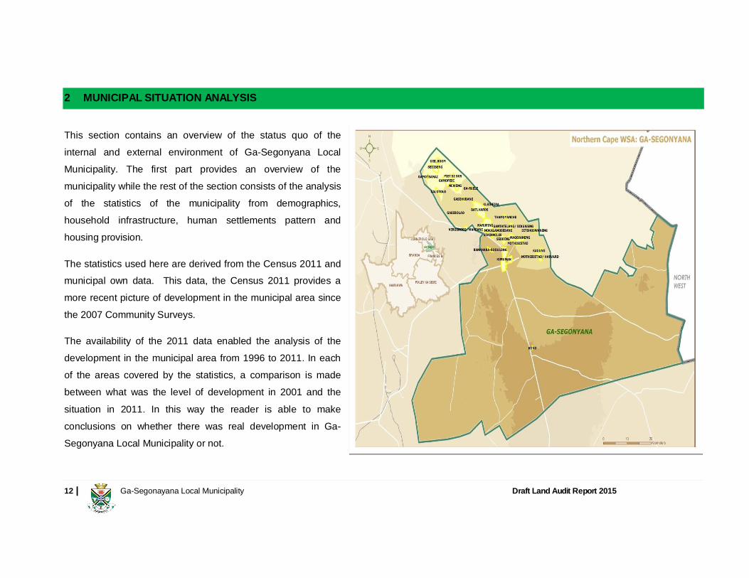
2 MUNICIPAL SITUATION ANALYSIS
This section contains an overview of the status quo of the internal and external environment of Ga-Segonyana Local Municipality. The first part provides an overview of the municipality while the rest of the section consists of the analysis of the statistics of the municipality from demographics, household infrastructure, human settlements pattern and housing provision.
The statistics used here are derived from the Census 2011 and municipal own data. This data, the Census 2011 provides a more recent picture of development in the municipal area since the 2007 Community Surveys.
The availability of the 2011 data enabled the analysis of the development in the municipal area from 1996 to 2011. In each of the areas covered by the statistics, a comparison is made between what was the level of development in 2001 and the situation in 2011. In this way the reader is able to make conclusions on whether there was real development in Ga-Segonyana Local Municipality or not.
13 | Ga-Segonayana Local Municipality Draft Land Audit Report 2015
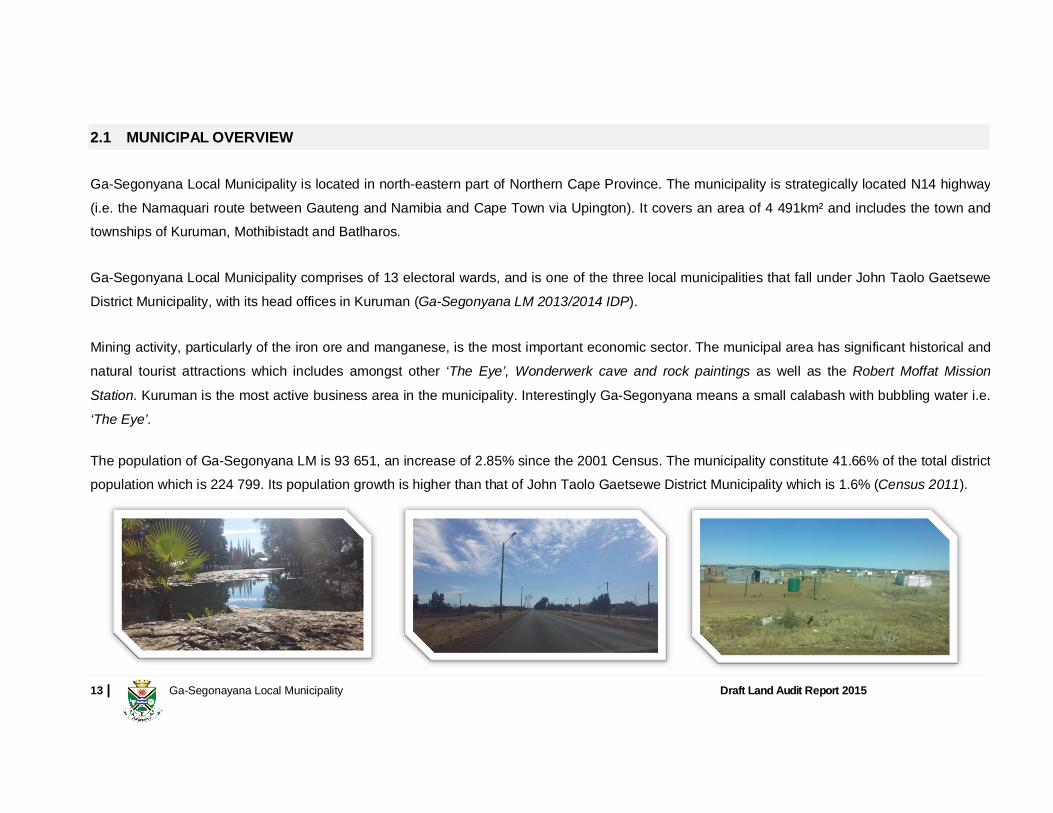
2.1 MUNICIPAL OVERVIEW
Ga-Segonyana Local Municipality is located in north-eastern part of Northern Cape Province. The municipality is strategically located N14 highway (i.e. the Namaquari route between Gauteng and Namibia and Cape Town via Upington). It covers an area of 4 491km² and includes the town and townships of Kuruman, Mothibistadt and Batlharos.
Ga-Segonyana Local Municipality comprises of 13 electoral wards, and is one of the three local municipalities that fall under John Taolo Gaetsewe District Municipality, with its head offices in Kuruman (Ga-Segonyana LM 2013/2014 IDP).
Mining activity, particularly of the iron ore and manganese, is the most important economic sector. The municipal area has significant historical and natural tourist attractions which includes amongst other ‘The Eye’, Wonderwerk cave and rock paintings as well as the Robert Moffat Mission Station. Kuruman is the most active business area in the municipality. Interestingly Ga-Segonyana means a small calabash with bubbling water i.e. ‘The Eye’.
The population of Ga-Segonyana LM is 93 651, an increase of 2.85% since the 2001 Census. The municipality constitute 41.66% of the total district population which is 224 799. Its population growth is higher than that of John Taolo Gaetsewe District Municipality which is 1.6% (Census 2011).
14 | Ga-Segonayana Local Municipality Draft Land Audit Report 2015
2.2 DEMOGRAPHIC PROFILE
A detailed discussion of the socio-economic profile of Ga-Segonyana Local Municipality is contained on the IDP Review 2014/2015. It is not the
intention to repeat the detail in this report but rather to cross reference the elements applicable to the compilation of the Land Audit Report. For the
purpose of this document, the Census 2011 figures from Statistics South Africa should be more accurate to compile the Land Audit Report.
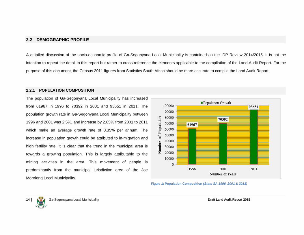
2.2.1 POPULATION COMPOSITION
The population of Ga-Segonyana Local Municipality has increased
from 61967 in 1996 to 70392 in 2001 and 93651 in 2011. The
population growth rate in Ga-Segonyana Local Municipality between
1996 and 2001 was 2.5%, and increase by 2.85% from 2001 to 2011
which make an average growth rate of 0.35% per annum. The
increase in population growth could be attributed to in-migration and
high fertility rate. It is clear that the trend in the municipal area is
towards a growing population. This is largely attributable to the
mining activities in the area. This movement of people is
predominantly from the municipal jurisdiction area of the Joe
Morolong Local Municipality. Figure 1: Population Composition (Stats SA 1996, 2001 & 2011)

15 | Ga-Segonayana Local Municipality Draft Land Audit Report 2015
2.2.2 DISTRICT CONTEXT The data indicates that the population of Ga-Segonyana Local Municipality
forms 41.66% of the total population within John Taolo Gaetsewe District
Municipality making it by far the largest municipality in terms of the number
of people.
2.2.3 HOUSEHOLD SIZE
The household size within Ga-Segonyana Local Municipality was calculated
at both urban settlement and rural settlement through Stats SA data 2011.
Figure 3 illustrates the household size within Ga-Segonyana Local
Municipality.
It is clear from the Figure 3 below that the higher household size within Ga-
Segonyana Local Municipality is 1 person per household covering 26% of the
total number of households. This may be cause by high rental status both in
urban and rural areas including the in-migration and out-migration due to
work opportunities within and outside Ga-Segonyana Local Municipality. Figure 3: Household Size (Stats SA 2011)
Figure 2: District Context (Stats SA 2011)
16 | Ga-Segonayana Local Municipality Draft Land Audit Report 2015
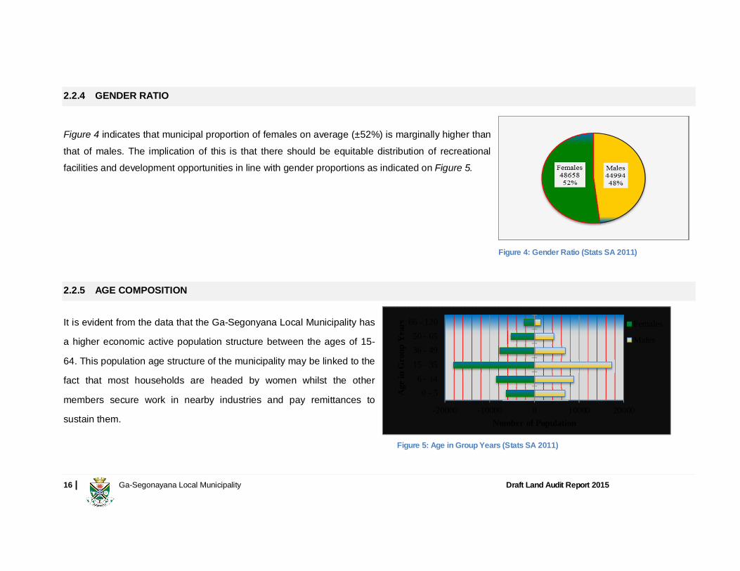
2.2.4 GENDER RATIO
Figure 4 indicates that municipal proportion of females on average (±52%) is marginally higher than that of males. The implication of this is that there should be equitable distribution of recreational facilities and development opportunities in line with gender proportions as indicated on Figure 5.
2.2.5 AGE COMPOSITION It is evident from the data that the Ga-Segonyana Local Municipality has
a higher economic active population structure between the ages of 15-
64. This population age structure of the municipality may be linked to the
fact that most households are headed by women whilst the other
members secure work in nearby industries and pay remittances to
sustain them.
Figure 4: Gender Ratio (Stats SA 2011)
-20000 -10000 0 10000 20000
0 - 56 - 14
15 - 3536 - 4950 - 65
66 - 120
Number of Population
Age
in G
roup
Yea
rs
Females
Males
Figure 5: Age in Group Years (Stats SA 2011)

17 | Ga-Segonayana Local Municipality Draft Land Audit Report 2015
2.2.6 POPULATION PROJECTIONS
The average population growth rate from 1996 to 2001 was calculated
at 2.5% for 5 years, and the year 2001 to 2011 the average growth
rate was 2.85% calculated over 10 years. The average growth rate per
year from 1996 to 2011 is 0.35%.
Figure 6 illustrates the projected population growth rate from 2011-
2018 calculated with the growth rate of 0.35% per annum.
2.2.7 MIGRATION It is clear from Figure 7 that 94% of the population living in Ga-
Segonyana Local Municipality originates from the Northern Cape
Province. According to Census 2011 there are more males than
females that have moved to Ga-Segonyana Local Municipality and this
could be attributed by job opportunities in the mining sector within the
district. Most South African rural municipalities their populations are not
influenced by foreigners residing within their areas. Foreigners are
more likely to be located at urban areas where development is at the
high level.
Figure 6: Population Projection
94%
2% 1% 1% 2%
Province of Previous Residence
Western CapeEastern capeNorthern capeFree stateKwazulu-NatalNorth westGautengMpumalangaLimpopoOutside South AfricaDo not knowUnspecified
Figure 7: Province of Previous Residence (Stats SA 2011)

18 | Ga-Segonayana Local Municipality Draft Land Audit Report 2015
2.3 HOUSEHOLD INFRASTRUCTURE
Access to basic service in the context of human settlement is very crucial when measuring sustainable development. In 1996, the total number of
households within Ga-Segonyana Local Municipality was 13157, in 2001 was captured as 17163 and in 2011 is 26816. In this section Stats SA
information in terms of housing, water, electricity, refuse removal and sanitation will be discussed.
2.3.1 HOUSING The Table 1 below illustrates the enumeration with main type of dwelling within Ga-Segonyana Local Municipality. Enumeration with Main Type of Dwelling Formal
Residential Informal
Residential Traditional Residential
Farms Industrial Vacant Commercial Total
House or brick/ concrete block structure on a separate stand or yard or on a farm 6588 - 13439 428 14 338 129 20936
Traditional dwelling/ hut/ structure made of traditional materials (mud, clay, reeds, etc.) 140 - 1592 20 - 48 8 1807
Flat or apartment in a block of flats 104 - 113 - 1 5 20 243 Cluster house in complex 24 - 81 - - 1 1 107 Townhouse (semi-detached house in a complex) 32 - 4 - - - 8 44
Semi-detached house 87 - 12 - - - - 99
House/ flat/ room in backyard 65 - 159 - - 6 7 237
Informal dwelling (shack in backyard) 698 - 628 6 3 85 - 1420
Informal dwelling (shack not in backyard, e.g. in an informal/ squatter settlement or on a farm) 396 - 871 4 3 325 6 1605
Room/ flatlet on a property or larger dwelling/ servants quarters/ granny flat 6 - 59 - - - 1 66
Caravan/tent 1 - 7 - - 1 - 10
Other 37 - 194 6 - 3 1 241
Total 8178 - 17158 465 21 812 181 26816
Table 1: Enumeration with Main Type of Dwelling (Stats SA 2011)
19 | Ga-Segonayana Local Municipality Draft Land Audit Report 2015
According to the Municipal Integrated Housing Sector Plan 2011, one of the main challenges in terms of housing projects is the availability of bulk
services. Housing Projects need to have the basic infrastructure before considering the construction of houses. Ga-Segonyana Local Municipality
IDP should be in-line with the IDP of the John Taolo Gaetsewe District Municipality. In regard to this, the municipality will align the housing projects
with the existing and proposed infrastructure. Funding used by the District in the Municipality will be aligned with the prioritised housing projects.
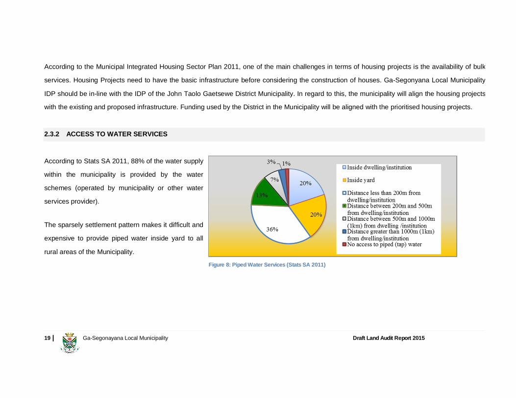
2.3.2 ACCESS TO WATER SERVICES
According to Stats SA 2011, 88% of the water supply
within the municipality is provided by the water
schemes (operated by municipality or other water
services provider).
The sparsely settlement pattern makes it difficult and
expensive to provide piped water inside yard to all
rural areas of the Municipality.
Figure 8: Piped Water Services (Stats SA 2011)

20 | Ga-Segonayana Local Municipality Draft Land Audit Report 2015
2.3.3 ACCESS TO ELECTRICITY SERVICES According to Stats SA 2011, 91% of the households within Ga-Segonyana
Local Municipality have access to electricity services. Figure 9 illustrates that
most electricity within Ga-Segonyana Local Municipality is used for lighting.
This might result in the case that cooking and heating traditionally is a measure
used to save the cost of electricity especially in rural areas. The Authority to
provide electricity is with the Department of Energy and Eskom in the case of
Ga-Segonyana Local Municipality.
2.3.4 REFUSE DISPOSAL
It is clear that 64% of the households in Ga-Segonyana Local Municipality
handle their own refuse. This may result in 80% of the households been
considered rural. In most municipalities, rural areas are not affected by the
demand for refuse removal services, in most cases you will find that the
community take care of its own refuse. Areas that are currently provided with
refuse removal services are Kuruman, Wrenchville, Mothibistadt and
Bankhara-Bodulong.
Figure 9: Electricity use services (Stats SA 2011)
Figure 10: Refuse Disposal (Stats SA 2011)

21 | Ga-Segonayana Local Municipality Draft Land Audit Report 2015
2.3.5 SANITATION FACILITIES
According to Stats SA 2011, most households within Ga-Segonyana
Local Municipality have access to pit latrine with or without
ventilation toilet facilities representing 58% of the municipal
households. This high number of pit latrine toilet facilities is mostly
found in rural areas around South Africa.
The sewage connected toilets within the Ga-Segonyana Local
Municipality are found in urban and peri-urban areas including
Kuruman, Wrenchville, Mothibistadt and Bankhara-Bodulong.
2.4 SOCIO-ECONOMIC PROFILE
2.4.1 ECONOMIC PROFILE
The economy of the municipality is reliant on mining, agriculture, tourism, commercial and the public sector in and around Kuruman town. Rapid
mining development leads to extreme pressure on resources planning and allocation in that, these developments does not allow for thorough
assessment of available resources such as water, electricity, waste management, sanitation and other municipal services.
Figure11: Toilet Facilities (Stats SA 2011)

22 | Ga-Segonayana Local Municipality Draft Land Audit Report 2015
2.4.1.1 LEVEL OF EDUCATION This section outlines the level of education with regards to number of
population presently attending schools in Ga-Segonyana Local Municipality.
Present School Attendance
It is evident that there is a high number of population attending school within
Ga-Segonyana Local Municipality between the ages 6 and 35. The higher
number is considered in Grade 1–12 between the ages 6 -24. Kuruman
houses the largest educational facilities, but most of the other peri-urban and
rural areas have a primary school with secondary schools to be found in the
larger urban and peri-urban areas. Other educational facilities are also found
in Kuruman which attracts learners and students from the whole area.
Figure 12: Present School Attendance (Stats SA 2011)
23 | Ga-Segonayana Local Municipality Draft Land Audit Report 2015
2.4.1.2 LEVEL OF EMPLOYMENT
Employment Status
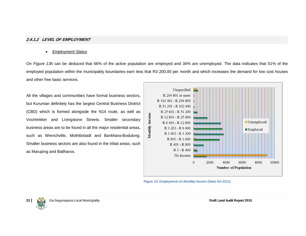
On Figure 13it can be deduced that 66% of the active population are employed and 34% are unemployed. The data indicates that 51% of the
employed population within the municipality boundaries earn less that R3 200.00 per month and which increases the demand for low cost houses
and other free basic services.
All the villages and communities have formal business sectors,
but Kuruman definitely has the largest Central Business District
(CBD) which is formed alongside the N14 route, as well as
Voortrekker and Livingstone Streets. Smaller secondary
business areas are to be found in all the major residential areas,
such as Wrenchville, Mothibistadt and Bankhara-Bodulong.
Smaller business sectors are also found in the tribal areas, such
as Maruping and Batlharos.
Figure 13: Employment v/s Monthly Income (Stats SA 2011)

24 | Ga-Segonayana Local Municipality Draft Land Audit Report 2015
2.5 HUMAN SETTLEMENTS PATTERN According to the Population Policy for South Africa (1998), settlements patterns reflect the historic experience of colonisation, process of economic space development during the 20th century and segregation and apartheid policies enforced by the former apartheid.
The above can be said about Ga-Segonyana spatial pattern in all respect. Urbanisation in Ga-Segonyana is a demographic prevalent feature which is perpetuated by rural to urban migration and the natural population increase (of a growth of 2.85%, 2011 Census) which has resulted in the increase of informal settlements, housing demand and associated needs.
In Ga-Segonyana LM notably is the strategic N14 road (i.e. the Namaquari route between Gauteng and Namibia and Cape Town via Upington) and the R31 road that links Kuruman town with Kimberly (about 200km south-east) and the mining area of Hotazel towards the north.
Ga-Segonyana consists of 33 residential areas located in thirteen (13) wards. Majority of the population resides in the rural areas (mainly informal or not planned) in the north and the south constitutes of large or extensive commercial agriculture.

25 | Ga-Segonayana Local Municipality Draft Land Audit Report 2015
The rural areas have a low density layout form that is informally planned. The layout thereof can be improved through settlement formalisation which will also make proposal for vacant areas in between the existing houses. The areas surrounding most of the villages of the tribal land have ample space for development.
The land administration by traditional authorities continues to perpetuate sprawling development in the rural areas which is not aligned to municipal
development plan i.e. Spatial Development Framework.
Development and Public Facilities Description of the Land Uses (i.e. Public Facilities)
Sport and Recreational The best sport and recreational facilities are to be found in the larger towns, such as Kuruman, Wrenchville, Mothibistadt, Bankhara-Bodulong and Batlharos. The smaller tribal settlements only house informal sport and recreational facilities that are evident throughout all the communities. Very few formal sport and recreational facilities are to be found in the tribal areas.
Central Facilities The most of the central facilities including the Municipal buildings, libraries, clinics, Police Stations, hospitals, etc. are to be found in the larger towns with a concentration thereof in Kuruman, Mothibistadt, Maruping and Batlharos. The smaller tribal settlements do not house the same central functions that are to be found in the larger towns and villages.
Cemeteries
Cemeteries are to be found throughout the Municipal area and every community has access to a facility in their immediate vicinity. Some of the older cemeteries that was initially planned to be on the outskirts of the towns and villages, have been incorporated into the towns and villages and are thus found throughout the area and even directly between the residential houses.
Education/ Schools Kuruman houses the largest educational facilities, but most of the other towns have a primary school with secondary schools to be found in the larger towns. Other educational facilities are also found in Kuruman which attracts learners and students from the entire area.
Open Spaces Open spaces and parks are to be found throughout the Municipal area with a concentration thereof in Kuruman, Wrenchville, Mothibistadt, Maruping and Batlharos. The most of these open spaces are used by the community for recreational activities and they form an important role in the functioning of the community.
Churches Churches are to be found throughout the Municipal area and every community has its own churches where the community gathers and worships.
Table 2: Development Level of Public Facilities (Ga-Segonyana SDF 2008)
26 | Ga-Segonayana Local Municipality Draft Land Audit Report 2015
It is clear from Table 2 above that the development level of public facilities is more concentrated in Kuruman, Wrenchville, Mothibistadt, Bankhara-
Bodulong and Batlharos as compared to other tribal areas found within Ga-Segonyana Local Municipality. School, Cemeteries and Churches are to
be found throughout the Municipal area in all villages, but other public facilities like public open space, sport and recreation facilities and central
facilities including the municipal buildings, libraries, clinics, Police Stations, hospitals, etc. are to be found in the larger towns with a concentration
thereof in Kuruman, Mothibistadt, Maruping and Batlharos.
The following is the spatial analysis as described on Ga-Segonyana Spatial Development Framework 2008 of key urban and rural settlements in Ga-Segonyana Local Municipality which includes Kuruman as the main economic hub, Mothibistadt, Wrenchville, Bankhara-Bodulong, Batlharos and other rural areas.
2.5.1 KURUMAN
Kuruman is the main town of Ga-Segonyana Local Municipality and it is known as the "Oasis of the Kalahari". Due to its location on the brim of the
Kalahari, the area is renowned for extreme temperatures during summer and winter. Kuruman is situated on the Namaquari route, forming part of
the main route between Gauteng and Namibia and Cape Town via Upington. This route is growing in popularity because of the unspoiled nature
and the wide variety of tourist attractions found on the route.
Residential Areas
Kuruman town houses a number of residential stands with 86% considered formal residential stands (i.e. houses or brick/ concrete block structure
on a separate stand or yard or on a farm). Kuruman has the highest number of investment apartments such as Flat or apartment in a block of flats,
Cluster house in complex and Townhouse (semi-detached house in a complex). Kuruman has the highest number of rented properties, due to high
27 | Ga-Segonayana Local Municipality Draft Land Audit Report 2015
job opportunities and access to sport and recreation facilities and central facilities including the Municipal buildings, libraries, clinics, Police Stations,
hospitals, etc. The following
Table 3 below illustrates the main type of dwelling and its tenure status within Kuruman town. Type of Main Dwelling by Tenure Status Rented Owned but
not yet paid off
Occupied rent-free
Owned and fully paid off
Other Total
House or brick/concrete block structure on a separate stand or yard or on a farm 522 387 93 402 24 1428
Traditional dwelling/hut/structure made of traditional materials 3 3 - - - 9
Flat or apartment in a block of flats 60 6 6 3 - 75
Cluster house in complex 15 - - 3 3 18
Townhouse (semi-detached house in a complex) 30 3 - 6 - 36
Semi-detached house 6 - - - - 6
House/flat/room in backyard 15 3 - 3 - 27
Informal dwelling (shack in backyard) 3 - 6 - - 12
Informal dwelling (shack not in backyard e.g. in an informal/squatter settlement or on a farm) 3 3 6 12 - 21
Room/flatlet on a property or larger dwelling/servants quarters/granny flat 3 - - - - 3
Other 3 - - - - 3
Total 672 411 117 423 24 1647
Table 3: Main Type of Dwelling by Tenure Status (Stats SA 2011)
28 | Ga-Segonayana Local Municipality Draft Land Audit Report 2015
It is clear from Table 3above that, Kuruman does not experience challenges of houses built with traditional dwelling structure made of traditional
materials. In Kuruman, 25% of the residential houses are owned and fully paid off.
Vacant Land for New Development
In Kuruman, only small portions of land exist within the boundaries of the town that can be utilized for development. This is due to the fact that most
of the land is privately owned. There are definite underutilized open spaces that could be identified for development. The largest portions of land
that are ideal for development are situated to the west and north-west of the town, the area south-west, south and south-east of the industrial
terrain, the area between Wrenchville and Kuruman, the area to the east of the agricultural plots, and to the west of the Mothibistadt road.
Business Development
Every community has a formal business sector, but Kuruman definitely has the largest Central Business District (CBD) which is formed alongside
the N14 route, as well as Voortrekker and Livingstone Streets. Kuruman is the only town that houses a large number of formal industrial activities,
which is to be found directly south of town, alongside the main road to Daniëlskuil. The industrial area of Kuruman has had a steady growth pattern
over the past 15 years and the expansion thereof for future development is necessary. The service industry has merged with businesses in the
central business area of Kuruman to form an integrated business area. The areas with the largest concentration of service industries are to be found
on the eastern periphery of the CBD alongside the N14 road to Vryburg.
29 | Ga-Segonayana Local Municipality Draft Land Audit Report 2015
Tourism
In Kuruman there are various heritage and tourism attractions areas including the Kuruman Eye, the Kuruman Moffat Mission, and the Wonderwerk
Caves. The world famous Kgalagadi Transfrontier Park is found in this region. This tourist destination attracts thousands of tourists to the region on
an annual basis and has thus a very positive influence on the smaller local tourist enterprises in the area. The bed and breakfast establishments
and guesthouses in the area provide accommodation. Adventurous tourism is an area with strong potential for growth, as are certain niche markets
(e.g. a country life experience tailored for European visitors). The trade sector in the Kuruman also serve as service centres to the rural areas, and
therefore for people living in the area and not only tourists.
30 | Ga-Segonayana Local Municipality Draft Land Audit Report 2015
2.5.2 WRENCHVILLE
Residential Areas
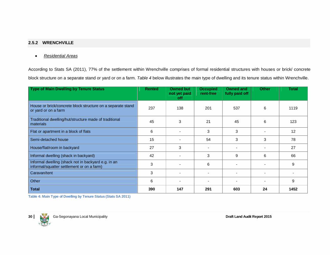
According to Stats SA (2011), 77% of the settlement within Wrenchville comprises of formal residential structures with houses or brick/ concrete
block structure on a separate stand or yard or on a farm. Table 4 below illustrates the main type of dwelling and its tenure status within Wrenchville.
Type of Main Dwelling by Tenure Status Rented Owned but not yet paid
off
Occupied rent-free
Owned and fully paid off
Other Total
House or brick/concrete block structure on a separate stand or yard or on a farm 237 138 201 537 6 1119
Traditional dwelling/hut/structure made of traditional materials 45 3 21 45 6 123
Flat or apartment in a block of flats 6 - 3 3 - 12
Semi-detached house 15 - 54 3 3 78
House/flat/room in backyard 27 3 - - - 27
Informal dwelling (shack in backyard) 42 - 3 9 6 66 Informal dwelling (shack not in backyard e.g. in an informal/squatter settlement or on a farm) 3 - 6 - - 9
Caravan/tent 3 - - - - -
Other 6 - - - - 9
Total 390 147 291 603 24 1452
Table 4: Main Type of Dwelling by Tenure Status (Stats SA 2011)
31 | Ga-Segonayana Local Municipality Draft Land Audit Report 2015
Table 4 illustrates that 41% of residential structure within Wrenchville are owned and fully paid off. In Wrenchville, most informal residential
structures are rented within residential backyards (shacks) or occupied rent-free structure.
Vacant Land for New Development The areas to the west and east of Wrenchville are available for future development, but the town itself has very few properties that can be used for
densification and development. The town is bordered in the north by the Mothibistadt road and to the south by the N14. Both of these roads have
the potential to house nodal business developments due to the large volumes of traffic that use these roads on a daily basis.
Business Development
Wrenchville is situated alongside the N14 road which provides an easy access to the CBD in Kuruman town. Wrenchville is one of the major
residential settlements where municipality rates are collected. It also consists of smaller secondary business areas including smaller section of
businesses at homes with more and more tuck shops, offices and residents working from home.
2.5.3 MOTHIBISTADT
Residential Area
Mothibistadt is one of the largest villages in Ga-Segonyana Local municipality. According to Stats SA (2011) 88% of dwelling structures are
considered formal with houses or brick/ concrete block structure on a separate stand or yard or on a farm. It is also influenced by informal squatter.
Table 5 below illustrates the main type of dwelling and its tenure status within Mothibistadt.

32 | Ga-Segonayana Local Municipality Draft Land Audit Report 2015
Type of Main Dwelling by Tenure Status Rented Owned but not yet paid
off
Occupied rent-free
Owned and fully paid off
Other Total
House or brick/concrete block structure on a separate stand or yard or on a farm 1524 93 1095 8553 1125 12393
Traditional dwelling/hut/structure made of traditional materials 138 9 72 1143 111 1473
Flat or apartment in a block of flats 39 - 12 36 6 96
Cluster house in complex 3 - 3 39 - 42
Townhouse (semi-detached house in a complex) - - 3 3 - 3
Semi-detached house - - 3 9 - 12
House/flat/room in backyard 45 - - 24 - 66
Informal dwelling (shack in backyard) 57 6 81 369 81 597
Informal dwelling (shack not in backyard; e.g. in an informal/squatter settlement or on a farm) 75 - 54 603 57 792
Room/flatlet on a property or larger dwelling/servants quarters/granny flat 54 - 3 - - 60
Caravan/tent - - - 3 - 6
Other 15 - 18 123 6 162
Total 1956 111 1347 10905 1386 15702
Table 5: Main Type of Dwelling by Tenure Status (Stats SA 2011)
Mothibistadt has a high number of residential units within a formal status that are owned and fully paid off. It is situated nearby Kuruman town which
may result in higher number of rented properties.
33 | Ga-Segonayana Local Municipality Draft Land Audit Report 2015
Vacant Land for New Development The town itself does not have much vacant land within the existing borders of the town that can be utilized for development. The areas surrounding
the town, however, have ample vacant land for future development.
Business Development
Mothibistadt consists of smaller secondary business areas including smaller sections in homes with more and more tuck shops, offices and
residents working from home. Most central facilities, including the Libraries, Clinics, and Police Stations are found in Mothibistadt which also
increase the level of employment within the area. Semi-formal industries, small, medium and micro-sized enterprises are found within Mothibistadt
with a tendency of owners to start their business from home and move to the CBD as soon as business growth adequate.
2.5.4 BANKHARA-BODULONG
Residential Areas According to Stats SA (2011), Bankhara-Bodulong has a low density residential unit layout in the old sections thereof with 56% of the dwelling
structures considered formal. It has a high number of shacks in backyards within dwellings that are owned and fully paid. The following Table 6
below illustrates the main type of dwelling and its tenure status within Bankhara-Bodulong.

34 | Ga-Segonayana Local Municipality Draft Land Audit Report 2015
Type of Main Dwelling by Tenure Status Rented Owned but not yet paid
off
Occupied rent-free
Owned and fully paid off
Other Total
House or brick/concrete block structure on a separate stand or yard or on a farm 69 54 171 1014 12 1320
Traditional dwelling/hut/structure made of traditional materials 3 - - 24 - 24
Flat or apartment in a block of flats - - 3 6 - 9 House/flat/room in backyard - 3 - 6 - 9 Informal dwelling (shack in backyard) 39 12 24 540 6 621 Informal dwelling (shack not in backyard e.g. in an informal/squatter settlement or on a farm) 18 96 48 153 12 327
Room/flatlet on a property or larger dwelling/servants quarters/granny flat 3 - - - - 3
Other - - - 6 - 9 Total 129 165 246 1749 33 2325
Table 6: Main Type of Dwelling by Tenure Status (Stats SA 2011)
Table 6 above illustrates that 75% of dwelling structure in Bankhara-Bodulong are owned and fully paid. The housing backlog within Bankhara-
Bodulong can be estimated at 400 units considering informal and squatters and informal in backyards where properties are no owned and fully paid
off.
Vacant Land for New Development
The town has a characteristically low density residential unit layout in the old sections thereof. A lot of areas are thus available for subdivision and
densification in the older parts of the town. Most of these areas, however, are privately owned and thus will have to be subdivided by the individual
owners at own initiative or will. In the areas surrounding the town there is ample vacant land for future development.

35 | Ga-Segonayana Local Municipality Draft Land Audit Report 2015
Business Development Bankhara-Bodulong consists of smaller secondary business areas including smaller section in homes with predominantly tuck shops, offices and
home enterprises. Semi-formal industries, small, medium and micro-sized enterprises are found within Bankhara-Bodulong with owners preferring to
start their business from home and later move to the CBD as soon as business flourishes or expands.
2.5.5 BATLHAROS
Residential Area
Batlharos is considered as one of the largest settlements within Ga-Segonyana Local Municipality. According to Stats SA (2011), 86% of the
residential structures within Batlharos have formal dwelling structures comprising of houses or brick/ concrete block structure on a separate stand or
yard or on a farm. The following Table 7 below illustrates the main type of dwelling and its tenure status within Batlharos.

36 | Ga-Segonayana Local Municipality Draft Land Audit Report 2015
Type of Main Dwelling by Tenure Status Rented Owned but not yet paid
off
Occupied rent-free
Owned and fully paid off
Other Total
House or brick/concrete block structure on a separate stand or yard or on a farm 51 - 252 582 69 960
Traditional dwelling/hut/structure made of traditional materials 6 - - 69 3 78
Flat or apartment in a block of flats - - - 3 - 3 Cluster house in complex - - 3 3 - 3 House/flat/room in backyard - - - 3 - - Informal dwelling (shack in backyard) - - - 6 - 9 Informal dwelling (shack not in backyard e.g. in an informal/squatter settlement or on a farm) - - 9 12 - 21
Caravan/tent 3 - - - - 3 Other - - - 24 3 30 Total 63 - 264 705 75 1110
Table 7: Main Type of Dwelling by Tenure Status (Stats SA 2011)
Batlharos has higher number of dwelling units that are owned and fully paid off. It is also clear from Table 7above that there are 78 main dwelling
units within Batlharos with traditional dwelling structure, due to its characteristics of rural settlements.
Vacant Land for New Development The town has a characteristically low density residential unit layout in the old sections thereof. A lot of areas are thus available for subdivision and
densification in the older parts of the town. Most of these areas, however, are privately owned and thus will have to be subdivided by the individual
owners themselves. In the areas surrounding the town there is ample vacant land for future development.

37 | Ga-Segonayana Local Municipality Draft Land Audit Report 2015
Business Development Smaller business sectors are also to be found in this tribal area. Batlharos consists of smaller secondary business areas including smaller sections
in homes predominantly tuck shops, offices and home enterprises. It is one of the informal villages with access to schools and other public and
private facilities.
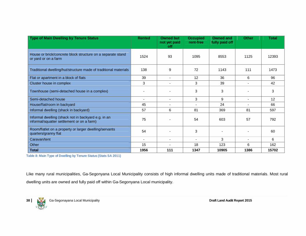
2.5.6 OTHER RURAL AREAS
Residential Areas
According to Stats SA (2011), most settlements within Ga-Segonyana Local Municipality are under traditional authorities, with 78% of the dwelling
structures considered formal, i.e. houses or brick/ concrete block structure on a separate stand or yard or on a farm. Table 8 below illustrates the
main type of dwelling and its tenure status within Batlharos.
38 | Ga-Segonayana Local Municipality Draft Land Audit Report 2015
Type of Main Dwelling by Tenure Status Rented Owned but not yet paid
off
Occupied rent-free
Owned and fully paid off
Other Total
House or brick/concrete block structure on a separate stand or yard or on a farm 1524 93 1095 8553 1125 12393
Traditional dwelling/hut/structure made of traditional materials 138 9 72 1143 111 1473
Flat or apartment in a block of flats 39 - 12 36 6 96 Cluster house in complex 3 - 3 39 - 42
Townhouse (semi-detached house in a complex) - - 3 3 - 3
Semi-detached house - - 3 9 - 12 House/flat/room in backyard 45 - - 24 - 66 Informal dwelling (shack in backyard) 57 6 81 369 81 597
Informal dwelling (shack not in backyard e.g. in an informal/squatter settlement or on a farm) 75 - 54 603 57 792
Room/flatlet on a property or larger dwelling/servants quarters/granny flat 54 - 3 - - 60
Caravan/tent - - - 3 - 6 Other 15 - 18 123 6 162 Total 1956 111 1347 10905 1386 15702
Table 8: Main Type of Dwelling by Tenure Status (Stats SA 2011)
Like many rural municipalities, Ga-Segonyana Local Municipality consists of high informal dwelling units made of traditional materials. Most rural
dwelling units are owned and fully paid off within Ga-Segonyana Local municipality.

39 | Ga-Segonayana Local Municipality Draft Land Audit Report 2015
Vacant Land for New Development The rural areas are all planned in a low density layout form and because most of these areas are informally planned, the layout thereof can be
improved. This can, however, only be done when the areas are formalized and when the vacant areas in between the existing houses can be fully
utilized for development. The areas surrounding most of the villages of the tribal land have ample space for development.
Business Development
Rural economic development in Ga-Segonyana Municipality has a large rural community with a very large extensive farming community that is
located to the south of Kuruman and a tribal area that is located to the north of Kuruman. The informal farming community that forms part of the
tribal areas accommodates most of the livestock within the boundaries of the villages, or just on the outskirts of the residential areas.
In the main streets of Maruping, Kagung and Batlharos certain elements of the informal industry are also evident. None of the typical informal
markets were found in the smaller villages due to the fact that the population was not enough for these types of business components to be
operated on a sustainable level or thrive. The larger villages such as Batlharos and Maruping have small scale light industrial sectors that are also
evident alongside the major access roads. The service industry has merged integration of businesses alongside the major roads of Batlharos and
Maruping.
40 | Ga-Segonayana Local Municipality Draft Land Audit Report 2015
2.6 HOUSING PROVISION The housing sector is central to the creation of sustainable human settlements. Ga-Segonyana Local Municipality in its quest to dealing effectively with the housing provision has developed its IDP Housing Chapter (i.e. Ga-Segonyana Integrated Housing Sector Plan, discussed at length later in the document) which outlines all critical areas in this matter. In terms of the Ga-Segonyana Integrated Housing Sector Plan 2011, there are several role players in the housing delivery sector which are outlined below:
Ga-Segonyana Local Municipality Northern Cape Provincial Government (Department of Cooperative Governance and Human Settlements) National Housing Agency (NHA) Mining Companies (Assmang, Amari Holdings, Black Rock and Kgalagadi Mine) Private Sector
The housing demand in Ga-Segonyana Local Municipalityin terms of its Integrated Housing Sector Plan was estimated at4 064in 2011 for both the urban and rural areas. This figure could have increased since 2011 due to in-migration and other factors. Mining companies are also planning for provision of housing units to their employees in Kuruman and Wrenchville. This is detailed later in the document.
41 | Ga-Segonayana Local Municipality Draft Land Audit Report 2015
2.6.1 LAND OWNERSHIP Kuruman is the only settlement with commonage land, i.e. the public land which is owned by the municipality or local authority and to which all the
residents of a town have rights. Ga-Segonyana Local Municipal area is tribal land that is being held on behalf of the tribal leaders. All rural
residential areas are administered by the Traditional Authorities. These areas do not obtain title deeds because they are not formalised. There are
two Paramount Chiefs representing the Batlharo Ba-Ga Motlhware and the Batlhaping Ba-Ga Jantjie in the municipal council. This dynamic
administration process marks the challenge in the general development and planning of the municipality.
A sample check of the ownership of the farm portions in the area have revealed that the land is at present still registered in the name of the North
West Province. This is presumed to have happened because the Ga-Segonyana Local Municipal area previously formed part of the North West
Province and it is assumed that the farm portions were transferred to the North West Province at that stage. The ownership of the land should be
rectified as soon as possible to enable the Northern Cape Province as well as the Local Municipality to attend to the development of the area. To
save transfer costs etc. it is suggested that the land be transferred to the Northern Cape in terms of Item 28 of Schedule 6 of the Constitution of the
Republic of South Africa, 1996 (Act 108 of 1996)
The rural areas are also administered through a traditional authority system with two senior Traditional leaders, chiefs and headmen. The areas are not formalised and residents therefore do not have secure tenure (i.e. title deeds). The ultimate vision of the Municipality is to achieve land formalisation of these areas to enable tenure upgrade. However it must be put on record that there is resistance from traditional leaders (Batlharo Ba-Ga Motlhware and Batlhaping Ba-Ga Jantjie) on settlement formalisation.

42 | Ga-Segonayana Local Municipality Draft Land Audit Report 2015
At present no formalisation of townships in the area is being done and the new homeowners will occupy the houses in terms of the Permission of
Occupy (PTO) issued by the traditional authority. The implication is that although a subsidy is allocated to the home owner, the North West Province
will still be the owner of the house.
According to the Stats SA 2011 data, close to 64% of the residential stands with Ga-Segonyana Local Municipality are regulated under tribal leadership. Table 9 below illustrates the tenure status within Ga-Segonyana Local Municipality households. Tenure Status Rented Owned but not
yet paid off Occupied rent-
free Owned and fully
paid off Other Total
Formal Residential 1733 941 1348 4053 104 8178 Informal Residential - - - - - - Traditional Residential 2193 112 1576 11817 1459 17158 Farms 87 7 222 102 46 465 Industrial 4 1 15 1 - 21 Vacant 27 82 221 457 25 812 Commercial 96 29 15 17 24 181 Total 4140 1172 3398 16448 1658 26816
Table 9: Tenure Status (Stats SA 2011)
It is evident from Table 9 above that 15.4% of the properties within Ga-Segonyana Local Municipality are rented mostly in traditional residential. This might result in the access to the mining industries that are found within the municipality and in Hotazel. More than 60% of the properties within Ga-Segonyana Local Municipality are owned and fully paid off.
43 | Ga-Segonayana Local Municipality Draft Land Audit Report 2015
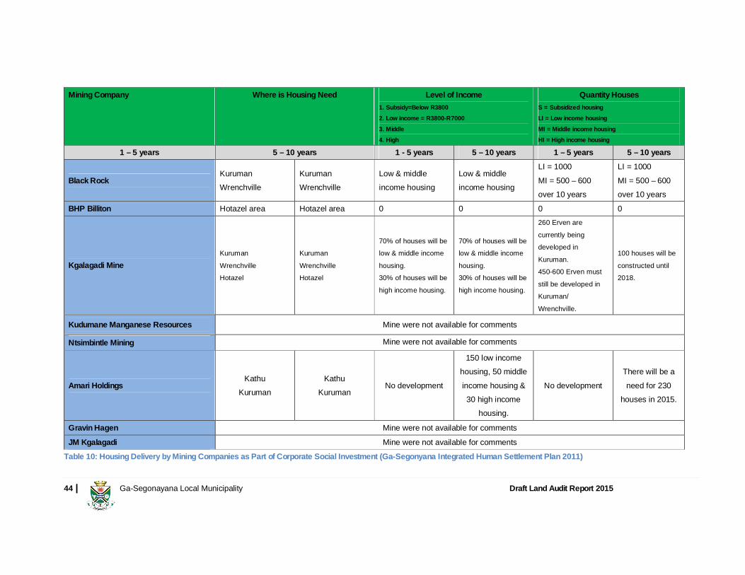
2.6.2 MINING
Mining activity within the John Taolo Gaetsewe District is the main economic contributor and impacts to a larger extend Ga-Segonyana Local Municipality particularly Kuruman town. The development of all the mines in the John Taolo Gaetsewe District area has a huge impact on housing delivery in the Ga-Segonyana Municipal area due to its urban comparative advantage of Kuruman town which has a thriving economy largely based on mining, manufacturing, wholesale and retail trade, and agriculture (both commercial and subsistence), with tourism and commercial sectors contributing strongly to a vibrant economy centred in Kuruman. Various minerals are mined in the district and particularly in Gamagara and Joe Morolong Local Municipalities and these include manganese ore, iron ore and tiger’s eye. Huge development in the surrounding mining areas is leading to extreme development in the municipal area. Mining developments that took place during the past two/ three years resulted in a housing shortage experienced in Ga-Segonyana Local Municipality.
Table below indicate the housing planned and proposed housing delivery by the mining companies operating with the district notably in the
Kuruman area.
44 | Ga-Segonayana Local Municipality Draft Land Audit Report 2015
Mining Company Where is Housing Need Level of Income 1. Subsidy=Below R3800
2. Low income = R3800-R7000
3. Middle
4. High
Quantity Houses S = Subsidized housing
LI = Low income housing
MI = Middle income housing
HI = High income housing 1 – 5 years 5 – 10 years 1 - 5 years 5 – 10 years 1 – 5 years 5 – 10 years
Black Rock Kuruman Wrenchville
Kuruman Wrenchville
Low & middle income housing
Low & middle income housing
LI = 1000 MI = 500 – 600 over 10 years
LI = 1000 MI = 500 – 600 over 10 years
BHP Billiton Hotazel area Hotazel area 0 0 0 0
Kgalagadi Mine Kuruman
Wrenchville Hotazel
Kuruman
Wrenchville Hotazel
70% of houses will be low & middle income
housing. 30% of houses will be
high income housing.
70% of houses will be low & middle income
housing. 30% of houses will be
high income housing.
260 Erven are
currently being developed in
Kuruman. 450-600 Erven must
still be developed in Kuruman/
Wrenchville.
100 houses will be
constructed until 2018.
Kudumane Manganese Resources Mine were not available for comments
Ntsimbintle Mining Mine were not available for comments
Amari Holdings Kathu
Kuruman Kathu
Kuruman No development
150 low income housing, 50 middle income housing & 30 high income
housing.
No development There will be a need for 230
houses in 2015.
Gravin Hagen Mine were not available for comments
JM Kgalagadi Mine were not available for comments
Table 10: Housing Delivery by Mining Companies as Part of Corporate Social Investment (Ga-Segonyana Integrated Human Settlement Plan 2011)
45 | Ga-Segonayana Local Municipality Draft Land Audit Report 2015
2.6.3 AGRICULTURE
Ga-Segonyana Municipality has a large rural community with a very large extensive farming community that is located to the south of Kuruman and a tribal area that is located to the north of Kuruman. The informal farming community that forms part of the tribal areas accommodates most of the livestock within the boundaries of the villages, or just on the outskirts of the residential areas.
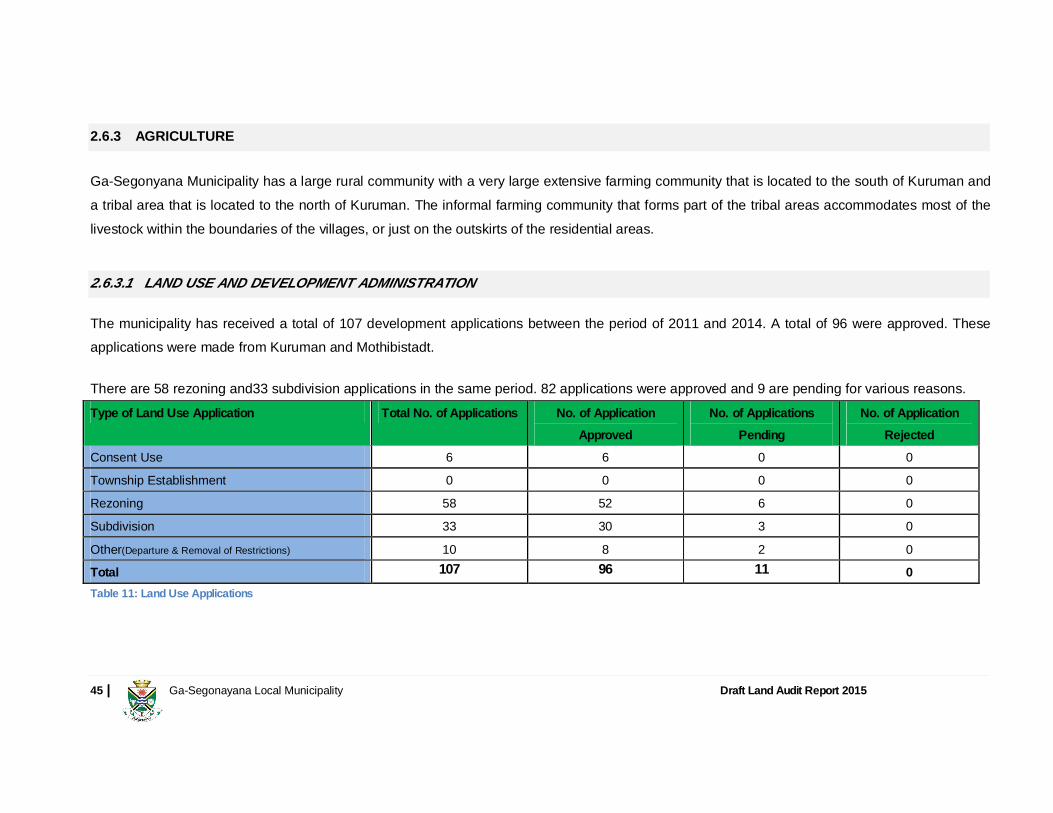
2.6.3.1 LAND USE AND DEVELOPMENT ADMINISTRATION
The municipality has received a total of 107 development applications between the period of 2011 and 2014. A total of 96 were approved. These applications were made from Kuruman and Mothibistadt.
There are 58 rezoning and33 subdivision applications in the same period. 82 applications were approved and 9 are pending for various reasons. Type of Land Use Application Total No. of Applications No. of Application
Approved No. of Applications
Pending No. of Application
Rejected
Consent Use 6 6 0 0
Township Establishment 0 0 0 0
Rezoning 58 52 6 0
Subdivision 33 30 3 0
Other(Departure & Removal of Restrictions) 10 8 2 0
Total 107 96 11 0 Table 11: Land Use Applications

46 | Ga-Segonayana Local Municipality Draft Land Audit Report 2015
The above applications are a positive development indicator implying that more and more people require land for housing development and other uses. It must be indicated that the municipality would soon be subjected to process land use applications in terms of the new provisions of the Spatial Planning and Land Use Management Act, 2013 (act No. 16 of 2013).
2.6.3.2 LAND ALIENATION BY THE MUNICIPALITY
The municipality has been alienating stands in the urban areas mainly in Kuruman and Mothibistadt for various land uses (i.e. for residential, business, industrial and agricultural purposes) and predominately for housing development. To date 77(i.e. 8 industrial and 69 residential) stands have been sold since the policy on alienation of land was adopted by the municipality. The policy is discussed at length under heading 1.13.2. It is assumed that these land disposals were done as part of actions supportive to human settlements, particularly those in need of property for investment and ownership.

47 | Ga-Segonayana Local Municipality Draft Land Audit Report 2015
2.7 POLICIES AND LEGISLATIVE PROVISIONS
This section analyses the policies that will guide the proposals for the future use of available and underutilized strategic land parcels.
2.7.1 NATIONAL AND PROVINCIAL POLICY/ LEGISLATIVE IMPERATIVES
The Native Land Act, 1913 (Act 27 of 1913)
Ga-Segonyana Land Audit comes just after the centenary of the Native (Bantu) Land Act No. 27 of 1913, a painful remainder of the colonial legacy that characterises the now Republic of South Africa.
The land question in the Republic of South Africa cannot be entertained without first reference to the infamous Native Land Act of 1913 that saw the dispossession of land by the colonist from the native’s which eventually reduced them to slaves.
The Natives Land Act (No. 27 of 1913), also known as the Black Land Act, was passed because of constant pressure by Whites to prevent the encroachment of Blacks on White areas. This law incorporated territorial segregation into legislation for the first time since Union in 1910. The law created reserves for Blacks and prohibited the sale of White territory to Blacks and vice versa. An annexure designated the territory preliminary allocated to Blacks, with a provision that a commission was to investigate the matter further for a more realistic delimitation. In effect, over 80% went to White people, who made up less than 20% of the population. The Act stipulated that Black people could live outside the reserves only if they could prove that they were in White employment. Although the law was applicable to the whole of South Africa, in practice it applied only to the Transvaal and Natal. In the Free State, such legislation was already in force since 1876, while a law forbidding Blacks to own property in the Cape would have been in conflict with the constitution of the Union of South Africa, as Cape property-ownership was one of the qualifications for Black franchise. Sharecropping on farms in the Transvaal and the Orange Free State was forbidden.

48 | Ga-Segonayana Local Municipality Draft Land Audit Report 2015
According to debates in Parliament, the Act was passed in order to limit friction between White and Black, but Blacks maintained that its aim was to meet demands from White farmers for more agricultural land and force Blacks to work as labourers. This Act did not go unchallenged. While it was being discussed in Parliament, the South African Native National Congress (SANNC) which later became the African National Congress (ANC), which was formed in 1912, rallied against the proposed law. In 1914 the SANNC submitted a petition to members of the Imperial Parliament and the British Government asking for intervention to stop the Act, but failed to achieve this. Ga-Segonyana Local Municipality also has settlement i.e. Kuruman and Mothibistadt which resembles or are the legacy of this Act and its subsequent ultimate Group Areas Act that came into force during the rule of now defunct National Party.
The Constitution of the Republic of South Africa, 1996 (Act 108 of 1996)
Section 152 outlines the following objectives of local government:
To provide democratic and accountable government to local communities To ensure the provision of services to communities in a sustainable manner To promote social and economic development To promote a safe and healthy environment To encourage the involvement of communities and community organizations in the matters of local government
Section 153 of the Constitution mandates municipalities to structure and manage their administration, budgeting and planning processes to give priority to the basic needs of the community and to promote the social and economic development of the community.
49 | Ga-Segonayana Local Municipality Draft Land Audit Report 2015
White Paper on Local Government 1998
A normative approach to spatial planning and land use management meant to ensure that problems and challenges are addressed in such a way as to promote the creation of liveable integrated cities, towns and rural areas. These problems and challenges referred to in policy documents include the following spatial and land use management issues (White Paper On Local Government, 1998):
Skewed settlement patterns which are functionally inefficient and costly Extreme concentration of taxable income resources in formerly white areas demanding redistribution between and within areas Huge backlog in service infrastructure in historically underdeveloped areas, requiring municipal expenditure far in excess of the
revenue currently available within the local government system. Great spatial separations and disparities between towns and townships and urban sprawl, which increases service provision and
transport costs enormously, and Land use management and planning problems including separated land use management systems in formerly segregated areas,
places an emphasis on control and not Indicate desired pattern of land use within the municipality Address the spatial reconstruction of the municipality Address the spatial reconstruction of the municipality; and Provide strategic guidance in respect of location and nature of development within the municipality. Set out basic guidelines for land use in a municipality Set out a capital framework for the municipality’s development framework
50 | Ga-Segonayana Local Municipality Draft Land Audit Report 2015
National Spatial Development Perspective Spatial Development Guidelines
The National Spatial Development Perspective (NSDP) is an effort by National Government to find the best way of allocating scarce resources in the various geographic regions in the country. The basic premise of the NSDP is that if there are not enough resources to satisfy all needs wherever they may occur then they should be allocated to where the benefits will be greatest. The NSDP takes the form of a spatial analysis narrative, a set of maps and strategic response. Using these tools, the NSDP objectives are to:
Provide a framework within which to discuss future development; Act as a common reference point to national provincial and local government for the analysis of development potentials; Identify areas of tensions/ priority in achieving positive spatial outcomes with government infrastructure; Provide governments response to the above mentioned for a given time period.
Spatial Planning and Land Use Management Act,2013 (Act No. 16 of 2013)
The pre-1994 settlement patterns, which resulted in uneven land allocation and service levels, segregation, extreme poverty and dependence, found accommodation in many planning laws at all levels of government. While the DFA represents a significant attempt at addressing these unacceptable settlement patterns, this piece of legislation did not repeal the pre-1994 pieces of legislation on planning. The net effect is that many pre-1994 planning laws remain in operation. The Spatial Planning and Land Use Management Act, 2013 (SPLUMA) was signed into law by the President of the Republic of South Africa on 5 August 2013. SPLUMA is a framework act for all spatial planning and land use management legislation in South Africa. It seeks to promote consistency and uniformity in procedures and decision-making in this field. The other objects include addressing historical spatial imbalances and the integration of the principles of sustainable development into land use and planning regulatory tools and legislative instruments.
51 | Ga-Segonayana Local Municipality Draft Land Audit Report 2015
The Act promotes social and economic inclusion and provides for the sustainable and efficient use of land and redressing spatial inequity. While the Act resides within the jurisdiction of the Department of Rural Development and Land Reform, provision is made for the Minister of Human Settlements - among others - to request that specific norms and standards are prescribed. This could have implications for density guidelines affecting the implementation of government's inclusionary housing policies, in terms of which low and moderate income households are targeted for inclusion in new housing developments.
Interim Protection of Informal Land Rights, 1996 (Act 31 of 1996)
The Act seeks to provide for the temporary protection of certain rights to and interests in land which are not otherwise adequately protected by lawand to provide for matters connected therewith. The Act is administered by the Department of Rural Development and Land Reform and is applied in rural areas under traditional authorities. In Ga-Segonyana it is applicable to areas administered by Batlharo Ba-Ga Motlhware and Batlhaping Ba-Ga Jantjie Traditional Authorities. Settlements Formalisation and Tenure Upgrade in the rural areas if undertaken or pursued will be done through the provisions of the Interim Protection of Informal Land Rights, 1996 (Act 31 of 1996)to formulate a Community Resolution decision in terms of interim procedures governing land development decisions which require the consent of the Minister of Rural Development and Land Reform as the nominal owner of the land.
National Environmental Management Act, 2008 (Act No. 62 of 2008)
The act makes provision for local government has to adhere to environmental principles and take environmental considerations into account in its planning process. Some of the principles are:

52 | Ga-Segonayana Local Municipality Draft Land Audit Report 2015
Local planning must take into account global/international issues as environmental sustainability is a global concern. Local actions, even those that do not seem harmful on their own can have impact on the wider region when combined with the impact other developments.
The natural environment should be seen in the context of the other dimensions of the planning process, and planning should take cognizance of the requirements of processes such as Integrated Environmental Planning. For example, the activities the of theIntegrated Environmental Planning (EIP) process are very similar to the integrated development planning process, the main difference is sharp focus on the environment specifically as opposed to development in general. By taking up the environmental dimension in activities of the IDP process, it can be ensured that the content of the IDP process is enriched.
Natural resources must be protected for the benefit of present and future generations. Resources are limited, and should be used efficiently to ensure sustainability. This principle cuts across all planning activities, from spatial planning where a sustainable, urban form is striven for the project planning where resource use can be identified and managed at a more detailed level.
The environmental impact of the entire planning/ development cycle (from planning to project and programme implementation) must be taken into account
All phases of development, including planning, implementation, reuse, recycling, and decommissioning have an impact on the environment, which should recognised from the outset during planning phase.
Environmental issues should be taken into consideration as early as possible in the planning stages, to ensure that environmental considerations are proactively incorporated into decision making.
Mineral and Petroleum Resources Development Act, 2002 (Act No. 28 of 2002)
The Act has the following preamble that it recognises that minerals and petroleum are non-renewable natural resources; acknowledging that South Africa’s mineral and petroleum resources belong to the nation and that the State is the custodian thereof. It further affirms the State’s obligation to
53 | Ga-Segonayana Local Municipality Draft Land Audit Report 2015
protect the environment for the benefit of present and future generations, to ensure ecologically sustainable development of mineral and petroleum resources and to promote economic and social development. The Act considers the State’s obligation under the Constitution to take legislative and other measures to redress the results of past racial discrimination. Reaffirming the State’s commitment to guaranteeing security of tenure in respect of prospecting and mining operations and emphasising the need to create an internationally competitive and efficient administrative and regulatory regime An application for a mining or production right in terms of the Act must be accompanied by a Social and Labour Plan (Regulation 42 of the Mineral and Petroleum Resources Development Act 2002).The required content of such a Social and Labour Plan is set out in Regulation 46 to the MPRDA.A Social and Labour Plan lodged with the Regional Manager is valid until a closure certificate has been issued in terms of Section 43 of the Act (Regulation 43). The holder of a mining right must submit to the Director General an annual report detailing the extent of the holders compliance with the provisions of Section 2(d) and (f), the charter contemplated in Section 100 and the Social and Labour Plan on the compliance with the Social and Labour Plan
The Housing Act, 1997 (Act No. 107 of 1997) This Act expands on the provisions of the Constitution, prescribes general principles for housing development and defines the housing development functions of national, provincial and local governments. Accordingly, Government, at the national, provincial and local spheres, renews its commitment to a democratic, sustainable process of housing development that:
Gives priority to the needs of the poor; Involves meaningful consultation with affected individuals and communities;
54 | Ga-Segonayana Local Municipality Draft Land Audit Report 2015
Ensures as wide a choice of housing and tenure options as is reasonably possible; Is economically, fiscally, socially and financially affordable and sustainable; Is based on integrated development planning; Is administered in a transparent, accountable and equitable manner; Upholds the practice of good governance; Encourages and supports individuals and communities in their efforts to fulfil their own housing needs by assisting them in accessing
land, services and technical assistance in a way that leads to the transfer of skills to, and empowerment of, the community
Breaking New Ground (BNG) 2004
Cabinet approved the Comprehensive Housing Plan for the Development of Integrated Sustainable Human Settlements (Breaking New Ground [BNG]) that aims, among other things, to eradicate informal settlements in South Africa in the shortest possible time. The BNG incorporates principles such as the:
integration of subsidised, rental and bonded housing provision of engineering services at a higher level than many other townships, and applied consistently throughout the township provision of ancillary facilities such as schools, clinics and commercial opportunities combination of different housing densities and types, ranging from single stand-units to double-storey units and row houses
55 | Ga-Segonayana Local Municipality Draft Land Audit Report 2015
The New Growth Path 2009
The New Growth Path which seeks to place the national economy on a production led-growth trajectory in order to tackle the country’s developmental challenges of unemployment, inequality and poverty through “a restructuring of the South African economy to improve its performance in terms of labour absorption as well as the composition and rate of growth”. Important and of practical consequence to local government, are the specific job drivers that have been identified:
Substantial public investment in infrastructure both to create employment directly, in construction, operation and maintenance as well as the production of inputs, and indirectly by improving efficiency across the economy;
Targeting more labour-absorbing activities across the main economic sectors – the agricultural and mining value chains, manufacturing and services;
Taking advantage of new opportunities in the knowledge and green economies; Leveraging social capital in the social economy and the public services; and Fostering rural development and regional integration.
The National Development Plan 2030
National Development Plan (NDP) was adopted by Cabinet in September 2012. The plan provides an undisputedly holistic approach towardsdevelopment, something which has been absent until now at national level.
The goal of the NDP is to improve the life chances of all South Africans, but particularly those young people who currently live in abject poverty.
56 | Ga-Segonayana Local Municipality Draft Land Audit Report 2015
A government that works well doesn’t just deliver more houses. It does more than that. It makes it possible for people to build or buy their own houses. This can be through earnings from work, savings, borrowing from the bank, family networks or government subsidies. Getting this right is much more difficult than building houses or schools. This means we have to look at things differently, and behave differently. The following is what the plan says:-
Create Jobs Expand Infrastructure Transition to a low carbon-economy (green economy) Transform urban and rural spaces Education and Training Fight Corruption Build a Capable State Transformation and Unity Provide quality health care
The Northern Cape Growth and Development Strategy 2009 - 2014 The vision of Northern Cape Growth and Development Strategy (NCGDS) is: “Building a prosperous, sustainable growing provincial economy to reduce poverty and improve social development.” The NCGDS seeks to achieve the effective integration, co-ordination and alignment of the activities of the three spheres of government. From a planning perspective, government has adopted an inter-governmental planning system, which includes the Medium-Term Strategic Framework (MTSF) at a national level, the Provincial Growth and Development Strategy and the municipal Integrated Development Plans.
57 | Ga-Segonayana Local Municipality Draft Land Audit Report 2015
An analysis of the socio-economic situation and indicators of the Northern Cape clearly indicates that the most significant challenge that the government and its partners in growth and development are confronted with is the reduction of poverty
It is said that the societal challenges that the Province faces emanate predominantly from the effects of poverty. Attention needs to be given to a range of societal problems in addressing poverty and includes the following:
Reducing the backlog of basic needs such as water, sanitation and housing; Improving and increasing access to health, education and social services; Decreasing the prevalence rate of HIV and AIDS; Creating opportunities for employment; Reducing crime; and Targeting vulnerable groups
The only effective means by which we can reduce poverty is through long-term sustainable economic growth and development. An analysis of the economic situation and indicators reflects opportunities for potential growth in the following sectors:
Agriculture and Agro-processing; Fishing and Mari-culture; Mining and mineral processing; Transport; Manufacturing and Tourism
58 | Ga-Segonayana Local Municipality Draft Land Audit Report 2015
2.7.2 DISTRICT AND LOCAL POLICY IMPERATIVES
John Taolo (Kgalagadi) District Growth & Development Strategy The vision of the John Taolo (Kgalagadi) District is: “The creation of a better life for all the Communities of Kgalagadi through good governance, excellent service delivery and sustainable development.” The District Growth and Development Strategy (DGDS) provide a framework for sustainable growth and economic development for the District over the next ten (10) years. The strategy establishes the basis from where the District Programme of Action is negotiated in collaboration with other stakeholders in the district. It forms a yardstick from which progress and achievements are monitored and evaluated. The DGDS is guided by the National and Provincial policy thrusts identified for the next ten years. It seeks to achieve balanced development of economic sectors and spatial localities in accordance with the needs and potentials of the people. It is also aimed at targeted investments in the district which is in the second economy with the aim of offering opportunities to the people in skills development, employment and the improved quality of life. The following are focus areas to which the strategy seeks to unleash its development potential
Agriculture- Stimulate the agricultural sector though the sustenance of commercial farming by expanding the sector though variety of value adding initiates
Infrastructure Development - Identify infrastructure backlogs to enable the district municipality to intervene decisively though the provision of infrastructure and basic services (i.e. housing, water and sanitation and telecommunications)

59 | Ga-Segonayana Local Municipality Draft Land Audit Report 2015
Manufacturing - Identifying manufacturing opportunities form other sectors, particularly mining and agriculture, linking such with the overall SMMEs strategy in the municipality. Create export markets for regionally produced goods, both at national and international levels.
Mining - Through understating of the entire mining value chain with the view to identify mining opportunities like beneficiation, opening of new mines, outsourcing and procurement, shareholding etc. All these must be approached within the context of the new mining legislative framework including the mining charter.
SMME Development - Set clear SMME development goals in financing and supporting SMMEs, targeting previously disadvantaged people, women, youth and people living with disabilities. This must find practical expressions in municipal institutional arrangements and all social partners’ outsourcing and procurement policies.
Tourism - Appraise the entire district tourism sector, including operators, products and services to enable social partners to identifycritical intervention areas.
John Taolo Gaetsewe Spatial Development Framework, 2011/2012 Review
A District Municipality Spatial Development Framework is a mid to higher-level strategic spatial development planning instrument. In terms of the current institutional and development planning framework, it occupies a unique, in-between place between (1) the Provincial SDF, and (2) the SDFs prepared by the Local Municipalities in the area of jurisdiction to which it applies.
As such it seeks to:
Give expression in the municipal sphere to the strategic objectives as set in the national and provincial spheres with regards to sustainable development, natural resource management, regional economic investment, job creation and poverty alleviation;
60 | Ga-Segonayana Local Municipality Draft Land Audit Report 2015
Provide a clear expression of the long-term sustainable economic development trajectory to be jointly pursued in the geographical area of the district by all three spheres of government, the private sector and the community;
Act as a bridge between the broader, strategic, longer-term socio-political, economic and ecological long-term analysis, thinking and strategizing in the provincial sphere and the more detailed short-to medium term land-use and infrastructure investment planning, regulation and implementation by Local Municipalities;
Act as conduit between the detailed spatial development analysis and planning done by Local Municipalities and that done in the provincial sphere, notably in the Premier’s Office and in Sector Departments when preparing sector strategies, plans, programmes and budgets;
Provide an indicative framework for (1) infrastructure investment and development spending in regionally-significant nodes and corridors, (2) integrated rural development, (3) economic sectors to be targeted, and (4) environmental management, informed by provincial and national analyses within which the more detailed spatial development planning of Local Municipalities can be located;
Harmonize, coordinate and align the spatial development planning done in and by the Local Municipalities in the area of jurisdiction
of the District Municipality;
Highlight areas of (1) real development potential, (2) dire need/poverty and (3) bottlenecks in the realization of the development potentials and alleviation and eradication of poverty, in the district; and
Provide high-level, strategic guidance with regards to desired land use patterns, intensities, densities and mixing in broad zones/categories.

61 | Ga-Segonayana Local Municipality Draft Land Audit Report 2015
Ga-Segonyana Spatial Development Framework 2008
The main purpose of a Spatial Development Framework is to guide the form and location of future physical development within a municipal area in order to address the imbalances of the past. The urban environments of South Africa are characterized by unsustainable urban forms, which have been shaped by apartheid planning that was integrally linked to blueprint or “master” planning. The purpose of Ga-Segonyana Spatial Development Framework (SDF) for its community is to:
Spatially reflect the vision of how the municipal areas (Kuruman, Wrenchville, Bankhara-Bodulong, Mothibistadt and the Tribal areas) should develop in a broad sense.
Reflect the needs of the community identified in the IDP process. Integrate the strategies of various sector plans that form part of the IDP document. Provide a legally binding spatial framework for Ga-Segonyana Municipality, which promotes sustainable economic- and social
development within the community. Set out objectives that reflect the desired spatial form of the area. Serve as an information source and guide to inform and direct land use management.
It must be emphasised that it is not possible for the SDF to deal with every part of the municipal area at the same level of detail and thus the document focuses on focal areas and identified aspects of the IDP.
Ga-Segonyana Integrated Housing Sector Plan 2011
As part of developmental local government, municipalities are required to develop Integrated Development Plans (IDPs) that are to serve as the basis for service delivery.
62 | Ga-Segonayana Local Municipality Draft Land Audit Report 2015
In terms of Section 9(1) of the National Housing Act (107 of 1997), every municipality must, as part of the municipality's process of integrated
development planning (IDP) take all reasonable and necessary steps to ensure that the inhabitants within its area of jurisdiction have access to
adequate housing on a progressive basis by setting housing delivery goals, identifying suitable land for housing development and planning,
facilitating, initiating and co-coordinating housing development in its area of jurisdiction.
It is against this background that Ga-Segonyana Local Municipality developed its Housing Sector Plan to enable it to negotiate the location of
housing supply with the aim of facilitating spatial restructuring, building linkages between housing delivery, spatial planning and infrastructure
system and supporting the integration into Municipal Integrated Development Plans as well as informing the Provincial Housing Development Plans.
Ga-Segonyana Integrated Housing Sector Plan enables the municipality to address the housing needs holistically and in an integrated fashion related to all other needs that exist and the development strategy as defined in the relevant IDP.
Specifically the output will assist the Department of Local Government and Human Settlements in distribution of National and Provincial financial resources supporting the development of human settlement in the areas.
In summary the development of the Ga-Segonyana Integrated Housing Sector Plan is to:
Prioritise the needs for development and the output to be included in the relevant HSP and Housing needs Database.
The other most important housing approach in Ga-Segonyana is Galowe Urban Development which seeks to spatially integrate Kuruman town with the township of Wrenchville by establishing an integrated human settlement that will offer a range of options from up-market bonded properties to subsidised housing, schools, sports and recreational facilities and retail opportunities that will form a new integrated town centre.

63 | Ga-Segonayana Local Municipality Draft Land Audit Report 2015
Ga-Segonyana Land Disposal and Alienation Policy 2007
The municipality developed the Land Disposal and Alienation Policy in 2007 to enable it to give direction and consistence in the alienation and disposal of municipal owned land for development purposes, to address skewed land ownership, to facilitate investment and to enable creation of integrated human settlements. The objectives of the policy are:
The policy will further advance Broad Based Black Economic Empowerment as enshrined in Act 53 of 2003 and Women
Empowerment.
Promote PDI’s participation in the property market opportunities (property development, management, and investment, employment,
commercial & residential)
To ensure equitable and fair distribution of land.
To establish a principled procedure that addresses skewed land ownership in Ga-Segonyana Local Municipality.
The need for land reform to reduce poverty and contribute to economic growth.
A system of land management that will support sustainable land use patterns and rapid release of land for development.
Further advance integrated human settlement as espoused in the Development Facilitation Act of 1995, to bridge racial distorted
settlement created by the apartheid regime.
The policy applies to municipal owned land in Kuruman, Wrenchville and Mothibistadt. It must be indicated that the policy had good intensions but it
is not clear whether it achieved its intended purposes due to limited ownership of land by the municipality.
Compliance with the provisions or adherence to the requirements of the Municipal Finance Management Act (Act 56 of 2003) and the Municipal Asset Transfer Regulations (No. 878 of 2008) regarding land disposal and alienation through the policy was not established. It must however be

64 | Ga-Segonayana Local Municipality Draft Land Audit Report 2015
indicated that the disposal and alienation would in any case or to a greater extend benefit the municipality through income generated from sales and later on rates and taxes.
2.8 CONCLUSION
Planning should be guided and informed by prevailing material conditions and the situational analysis provide a clear picture on the state of affairs with regard to population issues, level of access to services and development and policy directives.
The following issues have been noted which has implications to the Ga-Segonyana Local Municipality: Population Increase as a result of natural growth and in-migration – Urbanisation, Rural Areas Sprawl, Impact on Infrastructure Capacity,
Housing Provision and Land Availability Policy Directives – Powers and function, alignment of priorities with policy imperatives Address land ownership by creating opportunities in all land uses Threat to agricultural land on the urban edge could be abused for country or golf estate if policies on land management are not in place. This
relates to land that has been excluded from the provisions of the Subdivision of Agricultural Land Act 70 of 1970. Settlement Pattern – Addressing the Settlement Patterns through Creation of Integrated Sustainable Human Settlements. Settlement Formalisation and Tenure Upgrade in Rural Areas – Addressing the settlement sprawl, densification and tenure upgrade Land Development and Use – Implementation of the Spatial Planning and Land Use Management Mining operation within the district area must fully benefit and empower communities within the district. To ensure that this is optimally
achieved, the active participation in co-development of Social and Labour Plans with mining companies is paramount to this. Transfer alienated land parcels Migration – Land Reform for Agrarian Development N14and R31 Roads – Mitigate Economic Leakages through corridor development

65 | Ga-Segonayana Local Municipality Draft Land Audit Report 2015
3 STRATEGY, PROPOSAL AND RECOMMENDATIONS
This section contains the land audit vision and principles, the land register, the definitions on various land uses, settlement land proposals, recommendations and proposals as well as the implementation plan.
It is a consolidation of all the analysis, deductions and proposals that have been informed by municipal strategic plans such as the IDP, SDF, LED Strategy and Integrated Housing Sector Plan and aligned to government policy directives.
3.1 STRATEGY FRAMEWORK
3.1.1 LAND AUDIT VISION AND PRINCIPLES
The Ga-Segonyana Local Municipality’s Land Audit Vision must be aligned to the current municipal vision as contained in the IDP 2011-2016. It must also be in line with the principles of Integrated Sustainable Human Settlements, the National Spatial Development Perspective, Northern Cape Provincial Growth and Development Strategy, Comprehensive Rural Development Strategy, Ga-Segonyana Spatial Development Framework 2008 and the John Taolo Local Economic Development Strategy 2009.
Ga-Segonyana Local Municipality Vision The Ga-Segonyana Local Municipality’s vision is:
“An integrated municipality with a better life for all its people through sustainable development.” Key to creating an integrated sustainable municipality is the reliable and accurate spatial data to enable objective decision making for coordinated land use and development. It is on this basis that the following vision for the land audit has been coined.
66 | Ga-Segonayana Local Municipality Draft Land Audit Report 2015
Ga-Segonyana Local Municipality Land Audit Vision The Ga-Segonyana Local Municipality’s Land Audit Vision is:
“A spatial database of all land parcels to enable integrated land use and sustainable development”
3.1.2 KEY PRINCIPLES TO INFORM THE LAND AUDIT
The Municipal Systems Act, 2000 (Act No. 32 of 2000) requires municipalities to integrate the principles of the Development Facilitation Act, 1995 (Act 67 of 1995) into their planning. The latter has now been repealed by the Spatial Planning and Land Use Management Act, 2013 (No. 16 of 2013). Similar principles are contained in Chapter 2 of the Spatial Planning and Land Use Management Act, 2013 (No. 16 of 2013). Policy guidelines are also necessary to direct and steer planning and development towards achieving desired outcomes. The principles and objectives do not prescribe in black and white but they are intended to present an opportunity for proper decision making and serves as points of reference to uniform and coherent set of desired outcomes. It is paramount that the Land Audit proposals be guided by a set of principles and objectives to meet the desired outcomes of an informed land use and development for integrated sustainable human settlements. In developing these principles, a focus was made on the objectives of the Ga-Segonyana Local Municipality’s IDP 2011-2016, the Spatial Development Framework 2008, the John Taolo Local Economic Development Strategy 2009, the Revised Integrated Housing Sector Plan 2014.

67 | Ga-Segonayana Local Municipality Draft Land Audit Report 2015
3.1.3 LAND AUDIT PRINCIPLES
A reliable accurate spatial data (land register) that will enable: o Creation of integrated sustainable human settlements o Efficient and appropriate land use and development o Addressing the historical spatial imbalances o Tenure upgrade and land ownership o High density mixed-use development o Promote Investment o Rural development and agrarian reform
A spatial data with related information that:
o Forms the basis for a fair and equitable Municipal General Valuation Roll o Enhances a GRAP (Generally Recognised Accounting Principles) compliant Municipal Immovable Asset Register
68 | Ga-Segonayana Local Municipality Draft Land Audit Report 2015
3.2 THE LAND REGISTER The Land Register consist of 11 676 entries of all the land parcels, extracted from various databases, known to be in some form of private and public ownership, including the national and provincial government, municipality (which includes various predecessors of the Ga-Segonyana Local Municipality) and traditional authorities (state land under custodianship). This section will outline entries which where scrutinised to distinguish between under-utilised and vacant land, as the intention of this audit is also to make proposals for the use of vacant and under-utilised land. In total, suggestions have been made for the future use on 204 land parcels (i.e. classified as vacant, under-utilised, developable, unregistered and un-transferred) and these excludes vacant sites in recently established private estate or holding i.e. Savanna. In some instances land has already been earmarked for development through the municipality’s IDP, SDF and the Integrated Housing Sector Plan and these have been indicated as such. It should be noted that the land register also includes some unregistered, but surveyed land parcels, as these appear on the municipality’s database. The Land Register is included separately as an annexure to the Land Audit Report.
69 | Ga-Segonayana Local Municipality Draft Land Audit Report 2015
3.3 DEFINING LAND USES This section is aimed at defining the uses that may potentially be identified as appropriate for vacant land parcels and underutilised improved properties. The land use definitions mainly from the Ga-Segonyana Scheme Regulations 2003have been used for synergy and consistency.
The types of housing subsidies by government (as defined by Department of Human Settlements) are also outlined in the land use definitions as it forms a very critical part of residential land uses.
Agriculture
Land uses normally or otherwise reasonably associated with the use of land for agricultural activities, means the cultivation of crops and plants and/or the breeding of animals, as well as the operation of a game farm on an extensive basis on natural land or veld and at most one residential house and other buildings, and it includes bona-fide labourer’s residential units which are reasonably connected with the main farming activity; Associated land uses are: agriculture, agricultural buildings, agricultural housing, agricultural industries, agri-villages, commonages, farm stalls and harvesting of natural resources.
Open Space
Land uses normally or otherwise reasonably associated with or which falls under, or is intended to come under the ownership of the local authority, which is not leased or intended to be leased on a long-term basis, and which is utilised by the public as an open space, park, garden, picnic site, square, playground or recreational site, whether it appears on an approved general plan or not. Associated land uses are: private open spaces, public open spaces, sport and recreational grounds and zoological gardens.

70 | Ga-Segonayana Local Municipality Draft Land Audit Report 2015
Residential
Land uses normally or otherwise reasonably associated with the use of land primarily for human habitation, including a dwelling house, group housing, flats, boarding houses, residential clubs, hostels or rooms to let. Associated land uses are: boarding houses, dwelling houses, dwelling units, mobile dwelling units and retirement villages.
Individual Subsidy
This subsidy is for low-income households wishing to buy residential property for the first time and may be used to purchase an existing house including the land on which the house stands. This subsidy can only be used once by a successful applicant.
Consolidation Subsidy
This is for people who have previously received a subsidy, live on a serviced site and want to build a better house such as building a top structure. This money can only be used for building as services have already been provided on the site.
Institutional Subsidy
This is for non-profit organisations like churches, local authorities or housing associations (also called “social housing institutions”) that want to provide rented accommodate to people from lower income groups. It is called an institutional subsidy because it goes to the institution who can rent out the housing to different families. A family who lives in this type of rented accommodation does not jeopardise their chance to apply for their own subsidy at a later date. This is because the subsidy for rented housing is taken in the name of the organisation and not in the name of the individual.
71 | Ga-Segonayana Local Municipality Draft Land Audit Report 2015
People’s Housing Process Establishment Grants
These are special subsidies that are available to communities, or organised groups of households to enhance their housing subsidy by building or organising the building of their own homes themselves. By using their own labour rather than paying someone else, these households can make their housing subsidy and personal contribution go further by building better quality and/or larger houses for less money. In addition, the People’s Housing Process can also include the following support:
access to land that can be serviced, training opportunities, and technical assistance
Rural Subsidy
This subsidy is available to people who don’t have formal tenure rights to the land on which they live. (Such land is owned by the government and tenure granted in terms of traditional laws and customs). The rural subsidy is available only on a project basis and beneficiaries themselves may decide on how to use their subsidies. The subsidy may be used for building houses, providing services of a combination of both.
Project Linked Subsidy (same structure as individual)
This may be used towards purchasing a house, and the land on which it stands, in an approved Municipal housing. This is usually within a municipal housing project. The subsidy is paid directly to the Municipality that is building the housing.
Discount Benefit Scheme
This scheme promotes home ownership among tenants of publicly-owned rental housing (municipal and provincial). Since from April 2006, purchasers can receive a discount on the selling price of the property. In many cases, this amount is greater than the purchase price. When this happens the property is transferred free of any further costs. Some Municipalities have already transferred much of their housing stock to tenants who have utilised the Discount Benefit Scheme.

72 | Ga-Segonayana Local Municipality Draft Land Audit Report 2015
Community Residential Units
The Community Residential Units (CRU) aims to facilitate the provision of secure, rental housing accommodation for qualifying households. The
programme focuses on public rental housing stock which is managed by the municipality or outsourced.
Institutional
Land uses normally or otherwise reasonably associated with the use of land, either public or private, for community purposes, such as charitable institutions, hospitals, nursing homes, old age homes, clinics, sanatoriums, cultural activities, social meetings and non-residential clubs, educational purposes, such as crèches, schools, lecture halls, monasteries, public libraries, art galleries, museums, colleges, universities, and government purposes, including the use of land by national government, provincial government or municipalities to give effect to its governance role. Land used for services infrastructure is excluded from this category.
Associated land uses are: cemeteries, child day-care centres, crèches, government use, health centres, institution, municipal purposes, and places of education, places of public worship, social halls but excluding prisons or place of detention
Business
Land uses normally or otherwise reasonably associated with the use of land for business activities, including shops, offices, showrooms, restaurants, tourism accommodation and facilities, garages, distribution centres, wholesale trade and storage warehouses, but excludes places of instruction, builder’s yards, scrap yards or industrial activities.
Associated land uses are: camping sites, canteens, carwashes, confectioners, conference centres, dry cleaners, factory shops, funeral parlours, guest houses, gymnasiums, home occupation, hotels, informal trade, launderettes, lodges, medical suites, nurseries, offices, resorts, retail shops, take-away, telephone kiosks, tourist facilities, traditional healing practices, tuck shops, vehicle sales markets, veterinary clinics, 4x4 trails but excluding places of entertainment, casino, adult entertainment, institutional building, public garages, service stations, repairing or related replacing function, industrial buildings, offensive industries, truck stop or any wholesale business
73 | Ga-Segonayana Local Municipality Draft Land Audit Report 2015
Industrial
Land uses normally or otherwise reasonably associated with the use of land for the manufacture, altering, repairing, assembling or processing of a product, or the dismantling or breaking up of a product, or the processing of raw materials, or any activity that may have a polluting impact on surrounding uses or the environment, including a noxious activity, builder’s yard and scrap yard. Associated land uses are: abattoirs, bakeries, brickyards, builder’s yards, coal yards, crematoriums, fuelling facilities, heavy vehicle parking depots, industries, laboratories, mortuaries, noxious industries, recycling centres, sawmills, scrap-yards, truck stops, warehousing and packaging, and wood yards.
Utilities/ Authority Use
Land uses normally or otherwise reasonably associated with the use of land for the accommodation and maintenance of health, communication and sanitation infrastructure, such as water reservoirs, waterworks, sewage treatment plants, waste disposal sites, electrical sub-stations, telephone exchanges and telecommunication infrastructure. Associated land uses are: sewer purification plants, telecommunication infrastructures, utilities and waste disposal sites.
74 | Ga-Segonayana Local Municipality Draft Land Audit Report 2015
3.4 SETTLEMENT LAND PROPOSALS An analysis on the existing settlements relating to their land use demands is outlined and recommendations made to a specific land parcel. The land use demands are for various purposes which include housing, agriculture, industrial and social amenities. The land identified for either residential, social, business or industrial development is guided by the need as in the IDP 2012 – 2015, Integrated Housing Sector Plan 2014 and the Spatial Development Framework 2008 and are permitted uses in terms of the Ga-Segonyana Scheme Regulations 2003. Settlement land proposals are not only restricted to land use but also to township establishment purposes and land tenure purposes. It is clear from the analysis phase that the need for land is predominately for housing development notwithstanding other uses such as community facilities and economic development. 3.4.1 KURUMAN
Kuruman has approximately 556vacant stands (public and private) for residential development. The dominant recent residential developments have been through the rezoning of stands for high-medium density (mainly cluster housing) by private sector and mainly by mining companies. There are a number of land parcels that were alienated by the municipality through its alienation policy which has since been developed but not transferred yet. The transfer of these properties should be facilitated as a matter of priority.

75 | Ga-Segonayana Local Municipality Draft Land Audit Report 2015
ERF OWNER EXTENT (m2) CATEGORY STATUS PROPOSAL
3 GA SEGONYANA 12,45 ha MUNICIPAL VACANT HUMAN SETTLEMENT PURPOSES
1766 GA SEGONYANA 714 RESIDENTIAL VACANT REGISTER & DISPOSAL
1980 GA SEGONYANA 59,7109Ha MUNICIPAL GOLF COURSE REGISTER ERF
1984 KURUMAN LANDBOU TENTOONSTELLINGS
VERENIGING
24 5971 PRIVATE PUBLIC OPEN SPACE
SHOW GROUND LAND ACQUSITION FOR MUNICIPAL PURPOSES
2033 GA SEGONYANA 2375 MUNICIPAL VACANT (WITH SUBSTATION) CONSIDER DISPOSAL IF REDUNDANT
2364 GA SEGONYANA 3183 MUNICIPAL VACANT CONSIDER DISPOSAL IF REDUNDANT
2642 GA SEGONYANA 6,3379 Ha MUNICIPAL VACANT (PART OF GOLF COURSE) CONSOLIDATE TO THE GOLF COURSE
2648 GA SEGONYANA 6719 MUNICIPAL VCANT REGISTER & CONSIDER FOR HUMAN SETTLEMENT (CRU)
3944 GA SEGONYANA 3051 MUNICIPAL WATER RESERVOIR REGISTER ON FAVOUR ON MUNICIPALITY
3946 GA SEGONYANA 1,0657 MUNICIPAL VACANT CONSIDER DISPOSAL IF REDUNDANT
3982 GA SEGONYANA 7193 UNDETERMINED VACANT CONSIDER DISPOSAL FOR COMMERCIAL PURPOSES
4249 GA SEGONYANA 3,5014 TOURISM CHALETS/ ACCOMODATION CONSIDER CONSESSION
4590 GA SEGONYANA Unknown UNDETERMINED VACANT HUMAN SETTLEMENT PURPOSES
3.4.2 WRENCHVILLE
Wrenchville is predominately privately owned and is generally characterised by a higher density development when compared to Kuruman. Erf 5353 (now withdrawn) a portion of Erf 1, Erven 5348 and 5355 portions of Erf 3 (also withdrawn) is owned by Ga-Segonyana Local Municipality. These properties could be used for purposes of human settlements as proposed on municipal plans.
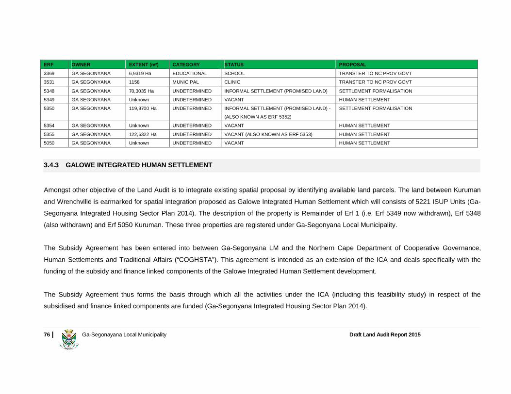
76 | Ga-Segonayana Local Municipality Draft Land Audit Report 2015
ERF OWNER EXTENT (m2) CATEGORY STATUS PROPOSAL
3369 GA SEGONYANA 6,9319 Ha EDUCATIONAL SCHOOL TRANSTER TO NC PROV GOVT
3531 GA SEGONYANA 1158 MUNICIPAL CLINIC TRANSTER TO NC PROV GOVT
5348 GA SEGONYANA 70,3035 Ha UNDETERMINED INFORMAL SETTLEMENT (PROMISED LAND) SETTLEMENT FORMALISATION
5349 GA SEGONYANA Unknown UNDETERMINED VACANT HUMAN SETTLEMENT
5350 GA SEGONYANA 119,9700 Ha UNDETERMINED INFORMAL SETTLEMENT (PROMISED LAND) -
(ALSO KNOWN AS ERF 5352)
SETTLEMENT FORMALISATION
5354 GA SEGONYANA Unknown UNDETERMINED VACANT HUMAN SETTLEMENT
5355 GA SEGONYANA 122,6322 Ha UNDETERMINED VACANT (ALSO KNOWN AS ERF 5353) HUMAN SETTLEMENT
5050 GA SEGONYANA Unknown UNDETERMINED VACANT HUMAN SETTLEMENT
3.4.3 GALOWE INTEGRATED HUMAN SETTLEMENT
Amongst other objective of the Land Audit is to integrate existing spatial proposal by identifying available land parcels. The land between Kuruman and Wrenchville is earmarked for spatial integration proposed as Galowe Integrated Human Settlement which will consists of 5221 ISUP Units (Ga-Segonyana Integrated Housing Sector Plan 2014). The description of the property is Remainder of Erf 1 (i.e. Erf 5349 now withdrawn), Erf 5348 (also withdrawn) and Erf 5050 Kuruman. These three properties are registered under Ga-Segonyana Local Municipality. The Subsidy Agreement has been entered into between Ga-Segonyana LM and the Northern Cape Department of Cooperative Governance, Human Settlements and Traditional Affairs (“COGHSTA”). This agreement is intended as an extension of the ICA and deals specifically with the funding of the subsidy and finance linked components of the Galowe Integrated Human Settlement development. The Subsidy Agreement thus forms the basis through which all the activities under the ICA (including this feasibility study) in respect of the subsidised and finance linked components are funded (Ga-Segonyana Integrated Housing Sector Plan 2014).
77 | Ga-Segonayana Local Municipality Draft Land Audit Report 2015
3.4.4 MOTHIBISTAT
There are a number of township establishments to address the housing needs and also informal settlements upgrade through various government subsidy programmes such as People’s Housing Process, Consolidated Subsidies, Project Linked Subsidies and Individual Subsidies. The 2014/2015 IDP indicates that the community needs land for housing purposes rather than need for government subsidised houses. Other government housing programs such as Community Residential Units (CRU) and Financed Linked Individual Subsidy Programme (FLISP) could also be a tool to address the housing need of the area. Availability of land is a challenge due to large parts of Ga-Segonyana being traditional land held by national government under custodianship of traditional authorities. The lack of full security of tenure prohibits the implementation of housing instruments such as CRU, FLISP, Social Housing and Full Incremental Upgrading up to Security of Tenure and does not support the vision of giving residents access to the property market. According to the Integrated Housing Sector Plan, future extensions of the area are planned in a south-westerly, westerly, easterly, south-easterly and north-easterly direction. Mothibistat is bordered by remaining extends of Portions 1, 2 and 3 of the farm Kuruman Reserve 690 HM. Several stands through the area mainly belongs to the municipality remain vacant or underutilised.
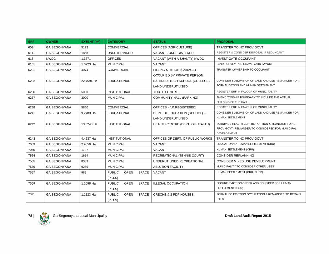
78 | Ga-Segonayana Local Municipality Draft Land Audit Report 2015
ERF OWNER EXTENT (m2) CATEGORY STATUS PROPOSAL
609 GA SEGONYANA 5123 COMMERCIAL OFFICES (AGRICULTURE) TRANSTER TO NC PROV GOVT
611 GA SEGONYANA 1858 UNDETERMINED VACANT - UNREGISTERED REGISTER & CONSIDER DISPOSAL IF REDUNDANT
615 NWDC 1,3771 OFFICES VACANT (WITH A SHANTY) NWDC INVESTIGATE OCCUPANT
6161 GA SEGONYANA 1.6723 Ha MUNICIPAL VACANT LAND SURVEY FOR GRAVE YARD LAYOUT
6231 GA SEGONYANA 4074 COMMERCIAL FILLING STATION (GARAGE) -
OCCUPIED BY PRIVATE PERSON
TRANSFER OWNERSHIP TO OCCUPANT
6232 GA SEGONYANA 22,7594 Ha EDUCATIONAL BAITIREDI TECH SCHOOL (COLLEGE) -
LAND UNDERUTILISED
CONSIDER SUBDIVISION OF LAND AND USE REMAINDER FOR FORMALISATION AND HUMAN SETTLEMENT
6236 GA SEGONYANA 5000 INSTITUTIONAL YOUTH CENTRE REGISTER ERF IN FAVOUR OF MUNICIPALITY
6237 GA SEGONYANA 3000 MUNICIPAL COMMUNITY HALL (PARKING) AMEND TONSHIP BOUNDARY TO INCLUDE THE ACTUAL
BUILDING OF THE HALL 6238 GA SEGONYANA 5850 COMMERCIAL OFFICES - (UNREGISTERED) REGISTER ERF IN FAVOUR OF MUNICIPALITY
6241 GA SEGONYANA 9,2783 Ha EDUCATIONAL DEPT. OF EDUCATION (SCHOOL) – LAND UNDERUTILISED
CONSIDER SUBDIVISION OF LAND AND USE REMAINDER FOR
HUMAN SETTLEMENT
6242 GA SEGONYANA 13,3248 Ha INSTITUTIONAL HEALTH CENTRE (DEPT. OF HEALTH) SUBDIVIDE HEALTH CENTRE PORTION & TRANSTER TO NC PROV GOVT. REMIANDER TO CONSIDERED FOR MUNICIPAL
DEVELOPMENT 6243 GA SEGONYANA 4,4237 Ha INSTITUTIONAL OFFICES OF DEPT. OF PUBLIC WORKS TRANSTER TO NC PROV GOVT 7059 GA SEGONYANA 2.9550 Ha MUNICIPAL VACANT EDUCATIONAL/ HUMAN SETTLEMENT (CRU)
7060 GA SEGONYANA 1737 MUNICIPAL VACANT HUMAN SETTLEMENT (CRU)
7554 GA SEGONYANA 1614 MUNICIPAL RECREATIONAL (TENNIS COURT) CONSIDER REPLANNING
7555 GA SEGONYANA 8333 MUNICIPAL UNDERUTILISED RECREATIONAL CONSIDER MIXED USE DEVELOPMENT
7556 GA SEGONYANA 9289 MUNICIPAL ABLUTION FACILITY MUNICIPALITY TO CONSIDER OTHER USES
7557 GA SEGONYANA 988 PUBLIC OPEN SPACE (P.O.S)
VACANT HUMAN SETTLEMENT (CRU, FLISP)
7559 GA SEGONYANA 1.2098 Ha PUBLIC OPEN SPACE
(P.O.S)
ILLEGAL OCCUPATION SECURE EVICTION ORDER AND CONSIDER FOR HUMAN
SETTLEMENT (CRU)
7560 GA SEGONYANA 1,1123 Ha PUBLIC OPEN SPACE
(P.O.S)
CRECHÉ & 2 RDP HOUSES FORMALISE EXISTING OCCUPATION & REMAINDER TO REMAIN
P.O.S
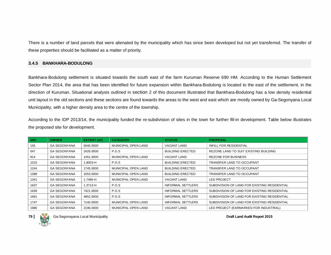
79 | Ga-Segonayana Local Municipality Draft Land Audit Report 2015
There is a number of land parcels that were alienated by the municipality which has since been developed but not yet transferred. The transfer of these properties should be facilitated as a matter of priority.
3.4.5 BANKHARA-BODULONG
Bankhara-Bodulong settlement is situated towards the south east of the farm Kuruman Reserve 690 HM. According to the Human SettlementSector Plan 2014, the area that has been identified for future expansion within Bankhara-Bodulong is located to the east of the settlement, in the direction of Kuruman. Situational analysis outlined in section 2 of this document illustrated that Bankhara-Bodulong has a low density residential unit layout in the old sections and these sections are found towards the areas to the west and east which are mostly owned by Ga-Segonyana Local Municipality, with a higher density area to the centre of the township.
According to the IDP 2013/14, the municipality funded the re-subdivision of sites in the town for further fill-in development. Table below illustrates the proposed site for development.
ERF OWNER EXTENT (m2) CATEGORY STATUS PROPOSAL
155 GA SEGONYANA 5040.0000 MUNICIPAL OPEN LAND VACANT LAND INFILL FOR RESIDENTIAL
647 GA SEGONYANA 2426.0000 P.O.S BUILDING ERECTED REZONE LAND TO SUIT EXISTING BUILDING
814 GA SEGONYANA 1451.0000 MUNICIPAL OPEN LAND VACANT LAND REZONE FOR BUSINESS
1015 GA SEGONYANA 1.8003-H P.O.S BUILDING ERECTED TRANSFER LAND TO OCCUPANT
1244 GA SEGONYANA 1745.0000 MUNICIPAL OPEN LAND BUILDING ERECTED TRANSFER LAND TO OCCUPANT 1288 GA SEGONYANA 1553.0000 MUNICIPAL OPEN LAND BUILDING ERECTED TRANSFER LAND TO OCCUPANT 1341 GA SEGONYANA 1.7486-H MUNICIPAL OPEN LAND VACANT LAND LED PROJECT
1637 GA SEGONYANA 1.3713-H P.O.S INFORMAL SETTLERS SUBDIVISION OF LAND FOR EXISTING RESIDENTIAL
1639 GA SEGONYANA 7421.0000 P.O.S INFORMAL SETTLERS SUBDIVISION OF LAND FOR EXISTING RESIDENTIAL
1681 GA SEGONYANA 4852.0000 P.O.S INFORMAL SETTLERS SUBDIVISION OF LAND FOR EXISTING RESIDENTIAL
1747 GA SEGONYANA 7140.0000 MUNICIPAL OPEN LAND INFORMAL SETTLERS SUBDIVISION OF LAND FOR EXISTING RESIDENTIAL
1980 GA SEGONYANA 2196.0000 MUNICIPAL OPEN LAND VACANT LAND LED PROJECT (EARMARKED FOR INDUSTRIAL)

80 | Ga-Segonayana Local Municipality Draft Land Audit Report 2015
ERF OWNER EXTENT (m2) CATEGORY STATUS PROPOSAL
1981 GA SEGONYANA 6988.0000 MUNICIPAL OPEN LAND VACANT LAND BUSINESS DEVELOPMENT
1984 GA SEGONYANA 2500.0000 MUNICIPAL OPEN LAND VACANT LAND LED PROJECT (EARMARKED FOR INDUSTRIAL)
1985 GA SEGONYANA 2500.0000 MUNICIPAL OPEN LAND VACANT LAND LED PROJECT (EARMARKED FOR INDUSTRIAL)
1988 GA SEGONYANA 3000.0000 MUNICIPAL OPEN LAND VACANT LAND LED PROJECT (EARMARKED FOR INDUSTRIAL)
1990 GA SEGONYANA 2100.0000 MUNICIPAL OPEN LAND VACANT LAND LED PROJECT (EARMARKED FOR INDUSTRIAL)
1991 GA SEGONYANA 20888.0000 MUNICIPAL OPEN LAND VACANT LAND LED PROJECT (EARMARKED FOR INDUSTRIAL)
1994 GA SEGONYANA 1912.0000 MUNICIPAL OPEN LAND VACANT LAND BUSINESS DEVELOPMENT
1998 GA SEGONYANA 1.0006-H BUSINESS AREA UNDERUTILISED BUSINESS DEVELOPMENT
2002 GA SEGONYANA 1961.0000 P.O.S INFORMAL SETTLERS RELOCATE SETTLERS
2033 GA SEGONYANA 4517.0000-SQM P.O.S INFORMAL SETTLERS SUBDIVISION OF LAND FOR EXISTING RESIDENTIAL
2172 GA SEGONYANA 6979.0000-SQM P.O.S BUILDING ERECTED LAND UNDERUTILISED
2173 GA SEGONYANA 1.0982-H P.O.S VACANT LAND LAND FOR DEVELOPMENT
2349 GA SEGONYANA 3505.0000-SQM P.O.S VACANT SITE REZONE FOR BUSINESS
2564 GA SEGONYANA 2486.0000-SQM MUNICIPAL OPEN LAND BUILDING ERECTED REZONE LAND TO SUIT EXISTING BUILDING
A lot of areas towards the north western side of Bankhara-Bodulong are thus available for subdivision and densification to address the existing informal settlement mostly found in registered Public Open Spaces. In the areas surrounding the township there is ample vacant land for future development. The area that has been identified for future expansion of the township, are located to the east of the town, in the direction of Kuruman. Table below illustrates areas within Bankhara-Bodulong which are restricted for any development due to current topography and needs feasibility study to be conducted to establish if they are suitable for development.

81 | Ga-Segonayana Local Municipality Draft Land Audit Report 2015
ERF OWNER EXTENT (m2) CATEGORY STATUS PROPOSAL
1495 GA SEGONYANA LM 7484.0000 MUNICIPAL OPEN LAND VACANT LAND FEASIBILITY TO ESTABLISH IF LAND IS SUITABLE FOR DEVELOPMENT
1498 GA SEGONYANA LM 1697.0000 MUNICIPAL OPEN LAND VACANT LAND FEASIBILITY TO ESTABLISH IF LAND IS SUITABLE FOR DEVELOPMENT 1595 GA SEGONYANA LM 9281.0000 MUNICIPAL OPEN LAND VACANT LAND FEASIBILITY TO ESTABLISH IF LAND IS SUITABLE FOR DEVELOPMENT 1848 GA SEGONYANA LM 1.2500-H P.O.S VACANT SITE FEASIBILITY TO ESTABLISH IF LAND IS SUITABLE FOR DEVELOPMENT 1860 GA SEGONYANA LM 3612.0000 P.O.S VACANT SITE FEASIBILITY TO ESTABLISH IF LAND IS SUITABLE FOR DEVELOPMENT 1976 GA SEGONYANA LM 8.0690-H MUNICIPAL OPEN LAND VACANT LAND FEASIBILITY TO ESTABLISH IF LAND IS SUITABLE FOR DEVELOPMENT 1978 GA SEGONYANA LM 2463.0000 MUNICIPAL OPEN LAND VACANT LAND EARMARKED FOR INDUSTRIAL
1979 GA SEGONYANA LM 2133.0000 MUNICIPAL OPEN LAND VACANT LAND EARMARKED FOR INDUSTRIAL
1982 GA SEGONYANA LM 1738.0000 MUNICIPAL OPEN LAND VACANT LAND EARMARKED FOR INDUSTRIAL
1983 GA SEGONYANA LM 1750.0000 MUNICIPAL OPEN LAND VACANT LAND EARMARKED FOR INDUSTRIAL
1997 GA SEGONYANA LM 7841.0000 MUNICIPAL OPEN LAND VACANT LAND EARMARKED FOR BUSINESS
2026 GA SEGONYANA LM 1.3505-H P.O.S BUILDING ERECTED FEASIBILITY TO ESTABLISH IF LAND IS SUITABLE FOR DEVELOPMENT 2365 GA SEGONYANA LM 8653.0000 P.O.S VACANT SITE FEASIBILITY TO ESTABLISH IF LAND IS SUITABLE FOR DEVELOPMENT 2417 GA SEGONYANA LM 3346.0000 MUNICIPAL OPEN LAND BUILDING ERECTED FEASIBILITY TO ESTABLISH IF LAND IS SUITABLE FOR DEVELOPMENT 2418 GA SEGONYANA LM 1.1468 P.O.S VACANT SITE FEASIBILITY TO ESTABLISH IF LAND IS SUITABLE FOR DEVELOPMENT 2522 GA SEGONYANA LM 5154.0000 P.O.S VACANT SITE FEASIBILITY TO ESTABLISH IF LAND IS SUITABLE FOR DEVELOPMENT 2584 GA SEGONYANA LM 2530.0000 P.O.S VACANT SITE FEASIBILITY TO ESTABLISH IF LAND IS SUITABLE FOR DEVELOPMENT 2174 GA SEGONYANA LM 10.0161-H P.O.S VACANT SITE FEASIBILITY TO ESTABLISH IF LAND IS SUITABLE FOR DEVELOPMENT
Further studies might be conducted to determine the level of nature restriction site captured in Table above. Land rehabilitation process might be considered to stabilize the land capture above to be increase a more enclosed development within the village. In addition, the municipality should consider formalizing the graveyard found towards the middle east of Bankhara-Bodulong settlement.
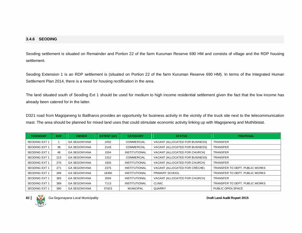
82 | Ga-Segonayana Local Municipality Draft Land Audit Report 2015
3.4.6 SEODING
Seoding settlement is situated on Remainder and Portion 22 of the farm Kuruman Reserve 690 HM and consists of village and the RDP housing settlement. Seoding Extension 1 is an RDP settlement is (situated on Portion 22 of the farm Kuruman Reserve 690 HM). In terms of the Integrated Human Settlement Plan 2014, there is a need for housing rectification in the area. The land situated south of Seoding Ext 1 should be used for medium to high income residential settlement given the fact that the low income has already been catered for in the latter. D321 road from Magojaneng to Batlharos provides an opportunity for business activity in the vicinity of the truck site next to the telecommunication mast. The area should be planned for mixed land uses that could stimulate economic activity linking up with Magojaneng and Mothibistat.
TOWNSHIP ERF OWNER EXTENT (m2) CATEGORY STATUS PROPOSAL
SEODING EXT 1 1 GA SEGONYANA 2452 COMMERCIAL VACANT (ALLOCATED FOR BUSINESS) TRANSFER
SEODING EXT 1 38 GA SEGONYANA 2143 COMMERCIAL VACANT (ALLOCATED FOR BUSINESS) TRANSFER
SEODING EXT 1 48 GA SEGONYANA 1554 INSTITUTIONAL VACANT (ALLOCATED FOR CHURCH) TRANSFER
SEODING EXT 1 213 GA SEGONYANA 1312 COMMERCIAL VACANT (ALLOCATED FOR BUSINESS) TRANSFER
SEODING EXT 1 270 GA SEGONYANA 1925 INSTITUTIONAL VACANT (ALLOCATED FOR CHURCH) TRANSFER
SEODING EXT 1 271 GA SEGONYANA 2375 INSTITUTIONAL VACANT (ALLOCATED FOR CRÈCHE) TRANSFER TO DEPT. PUBLIC WORKS
SEODING EXT 1 289 GA SEGONYANA 18390 INSTITUTIONAL PRIMARY SCHOOL TRANSFER TO DEPT. PUBLIC WORKS
SEODING EXT 1 365 GA SEGONYANA 2004 INSTITUTIONAL VACANT (ALLOCATED FOR CHURCH) TRANSFER
SEODING EXT 1 389 GA SEGONYANA 7113 INSTITUTIONAL CLINIC TRANSFER TO DEPT. PUBLIC WORKS
SEODING EXT 1 390 GA SEGONYANA 57623 MUNICIPAL QUARRY PUBLIC OPEN SPACE
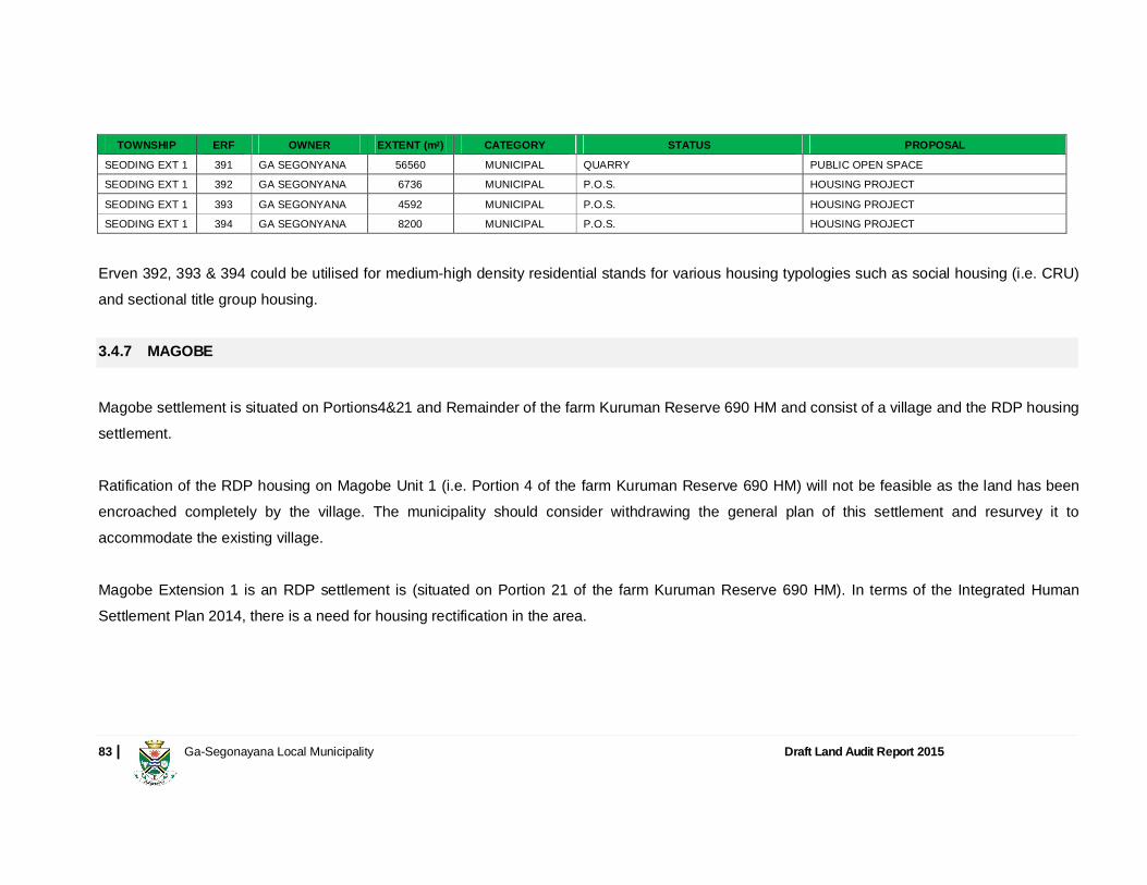
83 | Ga-Segonayana Local Municipality Draft Land Audit Report 2015
TOWNSHIP ERF OWNER EXTENT (m2) CATEGORY STATUS PROPOSAL
SEODING EXT 1 391 GA SEGONYANA 56560 MUNICIPAL QUARRY PUBLIC OPEN SPACE
SEODING EXT 1 392 GA SEGONYANA 6736 MUNICIPAL P.O.S. HOUSING PROJECT
SEODING EXT 1 393 GA SEGONYANA 4592 MUNICIPAL P.O.S. HOUSING PROJECT
SEODING EXT 1 394 GA SEGONYANA 8200 MUNICIPAL P.O.S. HOUSING PROJECT
Erven 392, 393 & 394 could be utilised for medium-high density residential stands for various housing typologies such as social housing (i.e. CRU) and sectional title group housing. 3.4.7 MAGOBE
Magobe settlement is situated on Portions4&21 and Remainder of the farm Kuruman Reserve 690 HM and consist of a village and the RDP housing settlement. Ratification of the RDP housing on Magobe Unit 1 (i.e. Portion 4 of the farm Kuruman Reserve 690 HM) will not be feasible as the land has been encroached completely by the village. The municipality should consider withdrawing the general plan of this settlement and resurvey it to accommodate the existing village. Magobe Extension 1 is an RDP settlement is (situated on Portion 21 of the farm Kuruman Reserve 690 HM). In terms of the Integrated Human Settlement Plan 2014, there is a need for housing rectification in the area.
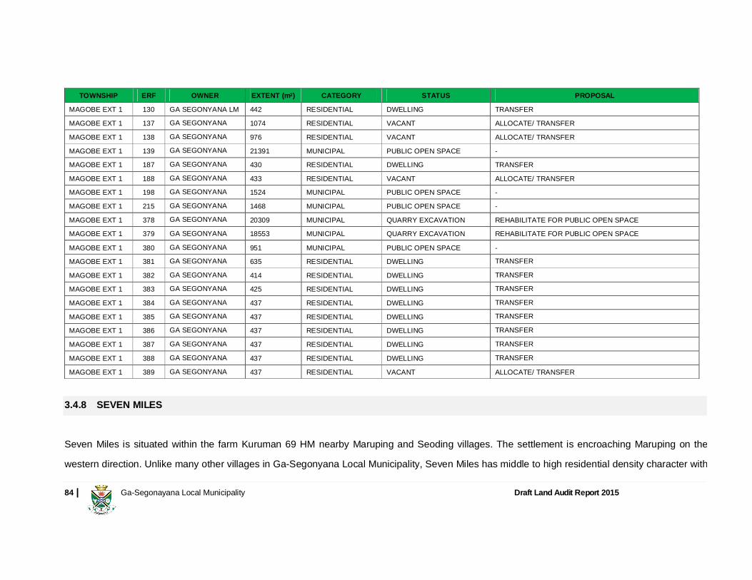
84 | Ga-Segonayana Local Municipality Draft Land Audit Report 2015
TOWNSHIP ERF OWNER EXTENT (m2) CATEGORY STATUS PROPOSAL
MAGOBE EXT 1 130 GA SEGONYANA LM 442 RESIDENTIAL DWELLING TRANSFER
MAGOBE EXT 1 137 GA SEGONYANA 1074 RESIDENTIAL VACANT ALLOCATE/ TRANSFER
MAGOBE EXT 1 138 GA SEGONYANA 976 RESIDENTIAL VACANT ALLOCATE/ TRANSFER
MAGOBE EXT 1 139 GA SEGONYANA 21391 MUNICIPAL PUBLIC OPEN SPACE -
MAGOBE EXT 1 187 GA SEGONYANA 430 RESIDENTIAL DWELLING TRANSFER
MAGOBE EXT 1 188 GA SEGONYANA 433 RESIDENTIAL VACANT ALLOCATE/ TRANSFER
MAGOBE EXT 1 198 GA SEGONYANA 1524 MUNICIPAL PUBLIC OPEN SPACE -
MAGOBE EXT 1 215 GA SEGONYANA 1468 MUNICIPAL PUBLIC OPEN SPACE -
MAGOBE EXT 1 378 GA SEGONYANA 20309 MUNICIPAL QUARRY EXCAVATION REHABILITATE FOR PUBLIC OPEN SPACE
MAGOBE EXT 1 379 GA SEGONYANA 18553 MUNICIPAL QUARRY EXCAVATION REHABILITATE FOR PUBLIC OPEN SPACE
MAGOBE EXT 1 380 GA SEGONYANA 951 MUNICIPAL PUBLIC OPEN SPACE -
MAGOBE EXT 1 381 GA SEGONYANA 635 RESIDENTIAL DWELLING TRANSFER MAGOBE EXT 1 382 GA SEGONYANA 414 RESIDENTIAL DWELLING TRANSFER MAGOBE EXT 1 383 GA SEGONYANA 425 RESIDENTIAL DWELLING TRANSFER MAGOBE EXT 1 384 GA SEGONYANA 437 RESIDENTIAL DWELLING TRANSFER MAGOBE EXT 1 385 GA SEGONYANA 437 RESIDENTIAL DWELLING TRANSFER MAGOBE EXT 1 386 GA SEGONYANA 437 RESIDENTIAL DWELLING TRANSFER MAGOBE EXT 1 387 GA SEGONYANA 437 RESIDENTIAL DWELLING TRANSFER MAGOBE EXT 1 388 GA SEGONYANA 437 RESIDENTIAL DWELLING TRANSFER MAGOBE EXT 1 389 GA SEGONYANA 437 RESIDENTIAL VACANT ALLOCATE/ TRANSFER
3.4.8 SEVEN MILES
Seven Miles is situated within the farm Kuruman 69 HM nearby Maruping and Seoding villages. The settlement is encroaching Maruping on the
western direction. Unlike many other villages in Ga-Segonyana Local Municipality, Seven Miles has middle to high residential density character with

85 | Ga-Segonayana Local Municipality Draft Land Audit Report 2015
most houses build in a modern middle class material. This shows that this settlement can be formalised to become middle class settlement. The
area which could be identified for future expansion of Seven Miles is to be found towards the Seoding Village in the South Eastern direction
3.4.9 BATLHAROS
Batlharos settlement is situated on the farm Kuruman 722 HM which is a state land held under trust. It is outlined in section 2 of this document that
Batlharos is the largest of the residential villages in Ga-Segonyana. The village is considered a second order settlement within Ga-Segonyanana
Local Municipality. The village has a medium to high residential density character of a good standard on both parts (west and east) of the R31 road
that passes through the village.
FARM NO. REG DIV PORTION REGISTERED OWNER EXTENT (HA) CURRENT LAND USE RECOMMENDATION
Kuruman 722 HM Re Republic of South Africa 5994.8675 Village & Livestock Vesting by DRDLR
According to the Ga-Segonyana Integrated Housing Sector Plan 2014, the municipality plans to formalise areas in Batlharos in future. The focus in this regard should start with the government facilities and private business areas, e.g.:
District Hospital
Primary, middle and high schools
Petrol station
Shopping Complex
Hotel
86 | Ga-Segonayana Local Municipality Draft Land Audit Report 2015
The area that has been identified for future expansion of the village is to be found on the northern, western and eastern borders of the village.
The RDP houses towards the north eastern direction should be formalised and its tenure upgraded to enable ownership for its beneficiaries.
The area has the highest population concentration (i.e. 12 822, Census 2011) compared to other villages but does not contribute to municipal revenue in terms of rates and taxes. The government services in the area and any formal business leases should be subjected to municipal rates and taxes as provided for by the Municipal Property Rates Act, 2004 (Act No. 6 of 2004). 3.4.10 MARUPING
Maruping is situated on two farm portions, namely Kuruman 722 HM and Kuruman 69 HM. Most of the settlement is situated within the same farm as Batlharos, i.e. Kuruman 722 HM towards the north eastern part of the village and the rest of the settlement is located in Kuruman 69 HM. The village can considered a second order settlement within Ga-Segonyanana Local Municipality. Maruping has a medium to high residential density character of a good standard on both parts (west and east) from Kuruman town towards Batlharos of the main internal tarred road of the village. The traditional authority should be advised to allocate land on the open spaces to encourage infills and densification. The SDF has made proposal for industrial development on the area where the D321 road links with the R31 road. Commercial development should be encouraged on this land.

87 | Ga-Segonayana Local Municipality Draft Land Audit Report 2015
3.4.11 KAGUNG
Kagung is situated along the N14 road on both side of the road. Kagung is located on two farms namely Harvard 171 HM and West Derby 164 HM which are state land held under trust. It forms the entrance village from North West province to Ga-Segonyana Local Municipality. The village could be considered a second order settlement within Ga-Segonyana Local Municipality, due to its Location along the National road and extend of the village. Kagung has a medium to high residential density character on both farm portions mostly influenced by residential stands.
FARM NO. REG DIV PORTION REGISTERED OWNER EXTENT (HA) CURRENT LAND USE RECOMMENDATION
West Derby 164 HM Re Republic of South Africa 5994.8675 Village & Livestock Vesting by DRDLR
West Derby 164 HM 1 Republic of South Africa 513.9206 Village & Livestock Vesting by DRDLR
West Derby 164 HM 2 Republic of South Africa 834.2622 Village & Livestock Vesting by DRDLR
West Derby 164 HM 3 Republic of South Africa 5464.6742 Village & Livestock Vesting by DRDLR
West Derby 164 HM 4 Republic of South Africa 909.637 Village & Livestock Vesting by DRDLR
Harvard 171 HM Re National Government of RSA 2195.5127 Village & Livestock -
Harvard 171 HM 1 Republic of Bophuthatswana 542.0329 Village & Livestock Vesting by DRDLR
The N14 and R372 roads intersection has concentration of activity for various uses. This could be formalised as a node.

88 | Ga-Segonayana Local Municipality Draft Land Audit Report 2015
3.4.12 THIRD ORDER SETTLEMENTS
Mokalamosesane, Ga-Ntatelang and Mapoteng are situation in the farm Kuruman 69 HM. These villages have a medium to high residential density character with available land for future development around the villages, including Ditshoswaneng and Thamoyanche. According to StatsSA, Mokalamosesane is the smallest recognized village within Ga-Segonyana with the minimum of 63 households, and future development of Mokalamosesane should be encouraged towards the road from Seoding to Maruping. Ga-Ntatelang village is encroaching Magojaneng village along the road going to Joe-Morolong Local Municipality, and a linear development should be encouraged there to maintain access to the road. Thamoyanche is situated on farm Thamoyanche 212 HM, and the area directly towards the north of Kuruman town. The area towards the south west of Thamoyanche across the roads restricts/limits the future development area of Thamoyanche. Mapoteng is village is adjacent to Mothibistat. Unlike many other villages Mapoteng can get access to many public facilities that are found in Mothibistat. Formalisation of Mapoteng should also be encouraged by the Municipality. Towards the north east side of Mothibistat, opportunities for agricultural products around Ditshoswaneng situated on farm Fairfield 154 HM, and which could create a market for Mothibistat and Kuruman town.
FARM NO. REG DIV PORTION REGISTERED OWNER EXTENT
(HA) CURRENT LAND USE RECOMMENDATION
Thamounche 212 HM Re Provincial Government of NW 3524.8956 Village & Livestock Consider Land Tenure Upgrade
89 | Ga-Segonayana Local Municipality Draft Land Audit Report 2015
3.4.13 FOURTH ORDER SETTLEMENTS
The villages found on the north west part of Batlharos including Sedibeng, Geelboom, Lokaleng, Pietbos, Gamopedi, Galotolo, Ncweng, Garuele, Sloja, Gasehubane, Gasebolao and Vergenoeg are located on the farm Kuruman 722 HM. It is outlined in section 2 of this document that, many rural areas in Gasegonyana Local Municipality are all planned in a low density layout form with available land for future development around the villages and because most of the abovementioned villages are informally planned, the layout thereof can be improved. This can, however, only be done when the areas are formalized and when the vacant areas in between the existing houses can be fully utilized for development. The areas surrounding most of the villages of the tribal land have ample space for development. Access roads are provided most rural areas within Ga-Segonyana Local Municipality. In terms of the social amenities, there is a need to provide more essential services for the abovementioned villages like Schools and health facilities. This can be addressed in future formalization process by making a condition that a stand for educational purpose must be provided. The villages located along the Kuruman River including Sedibeng, Gamopedi, Ncweng and Gasehubane have more agricultural potential land along its river valley for cropping and pastoral farming. Other villages including Geelboom, Lokaleng, Pietbos, Galotolo, Garuele, Sloja, Gasehubane and Vergenoeg have the opportunity for other type of farming like livestock, piggery and poultry depending on the level of rainfall and water capacity. For each village mentioned above, there is land available for future development of residential areas and business development, but market for business should be verified for establishment of any business.

90 | Ga-Segonayana Local Municipality Draft Land Audit Report 2015
3.5 LAND AUDIT PROPOSALS AND RECOMMENDATIONS Private Sector Development
Private sector housing development is mainly focused in the Kuruman area and is provided by the mining companies. The private sector development could address the middle to high-income housing market and this could take off the burden from the municipality.
Encouraging the private sector development should be done with caution to avoid exclusive sporadic development that could defeat the efforts of
integrated human settlements. Therefore the municipality should have conditions for such establishments. One pre-condition should be that ten
percent (10%) of land in these developments should address the low-income housing sector. This could be subsidised by the municipality through
government housing subsidy schemes that have been discussed in paragraph 1.4.3 so that it keeps private developers at bay with some form of
incentives.
Social and Labour Plans (SLP)
There should be a formal approach in terms of how the mining companies operating in the area are contributing back to the community as part of
social responsibility. Mining Companies (i.e. Assmang, Amari Holdings, Black Rock and Kgalagadi Mine) housing related projects should be
documented in Social Labour Plans with clear time bound targets and funding commitment. These Social and Labour Plans should be aligned to the
IDP and other supporting strategic plans of the municipality such as SDF, Housing Chapter and the LED plan.

91 | Ga-Segonayana Local Municipality Draft Land Audit Report 2015
An application for a mining or production right in terms of the Mineral and Petroleum Resources Development Act 2002 is accompanied by a Social and Labour Plan (Regulation 42 of the Mineral and Petroleum Resources Development Act 2002). The required content of such a Social and Labour Plan is set out in Regulation 46 to the MPRDA. A Social and Labour Plan lodged with the Regional Manager is valid until a closure certificate has been issued in terms of Section 43 of the Act (Regulation 43). The municipality, through the John Taolo Development Trust, should engage with the DMR Regional Manager for copies of existing Social and Labour Plan for scrutiny and alignment with the existing municipal priorities. The performance on implementation of these Social and Labour Plans should be reported in all DMR Mining Audit Meetings which the municipality with the John Taolo Development Trust should actively participate on.
Infrastructure Upgrade to Support Growth
Priority should be given to infrastructure upgrade in development pressed areas such as Mothibistat, Batlharos and Bankhara-Bodulong. A larger percentage of Municipal Infrastructure Grant (MIG) should be spent on developing capacity on the existing infrastructure. Developers should contribute significantly for high density development such as township establishment, rezoning for housing. Some projects on Social and Labour Plans should be geared towards infrastructure capacity upgrade. Property Rates Section 31 (2) of the Municipal Property Rates Act 6 of 2003 requires that the general valuation reflects a fair market value of properties determined in accordance with market conditions which applied as at date of valuation. The general assessment done on the current municipal general

92 | Ga-Segonayana Local Municipality Draft Land Audit Report 2015
valuation roll reflects low market values for areas such as Kuruman, The Oog, Wrenchville, Mothibistat and compared to recent property selling prices. The land valuation should not only rely on rand per hectare but should take into account the improvement, location and land use rights to establish a fair, equitable market valuation. Ga-Segonyana Local Municipality implemented the provisions of the MPRA i.e. Municipal Property Rates Act, 2004 (Act No. 6 of 2004), with effect
from the 1st July 2013 wherein all immovable properties within its area of jurisdiction were valued for purpose of levying of assessment rates (i.e.
rates and taxes).
Ga-Segonyana Local Municipality has, in terms of Section 229 of the Constitution of the Republic of South Africa (Act No. 108 of 1996) and Section
2 of the Municipal Property Rates Act, 2004 (Act 6 No. of 2004), powers to levy rates on immovable property.
The current valuation roll does not have government properties situated on villages that are owned by both national and provincial departments who
are the custodians/ owners of these properties situated within Ga-Segonyana Local Municipality jurisdictions in terms of the Public Finance
Management Act, 1999 (Act No. 29 of 1999) principles.
Definition of ‘ownership’ and ‘property’ in terms of the MPRA is not exclusively defined in terms of the Deeds Registries Act, 1937 (Act No. 47 of
1937) but also in terms of the land tenure right that has been allocated or granted in terms of legislation.
Levying of Rates and taxes is one of the key revenue that enables the municipality to execute its Constitutional mandate of service delivery.

93 | Ga-Segonayana Local Municipality Draft Land Audit Report 2015
Land Tenure
Land according to the Green Paper on Land Reform (2011) is a fundamental element in the resolution of the race, gender and class contradictions in South Africa and national sovereignty is defined in terms of land. During the course of the preparation of this land audit it has also emerged that significant number of municipal properties have administrative issues to be resolved (e.g. sold, but not transferred).The municipality should fast-track the land transfer process of those people who benefited through its land alienation policy. Equally government subsidy housing developments should also address the tenure issue for RDP beneficiaries through transfer of property in areas such as Batlharos. Settlement formalisation inclusive of tenure upgrade should also be considered through a phased approach in areas such as Seoding, Seven Miles, Magojaneng, Batlharos and Maruping, Kagung and other informal areas i.e. Obama Hill, Thuli Madonsela and Promised Land. Land Disposal It is regarded as particularly important that proposal call documents describe the nature of the preferred development of the site sufficiently, so that the land audit and release of public land is also used as tool to restructure the settlements in the municipal area, in addition to generating income for the municipality through sale and later rates and taxes. Land that was alienated by the municipality, particularly in Kuruman Industrial has not been improved by the purchasers. Same can also be said about Mothibistat where sold stands remain vacant.

94 | Ga-Segonayana Local Municipality Draft Land Audit Report 2015
The land parcels that were alienated through the municipal policy on land disposal (i.e. Ga-Segonyana Land Disposal and Alienation Policy 2007) have not been transferred which implies that the municipality cannot levy rates and taxes. Adherence to the requirements of the Municipal Finance Management Act (Act 56 of 2003) and the Municipal Asset Transfer Regulations (No. 878 of 2008) when releasing land, is critical to ensure that the maximum value of the land is realized and that the administrative process can be finalized is efficiently as possible, without the risk of objection and litigation from parties who may feel aggrieved.
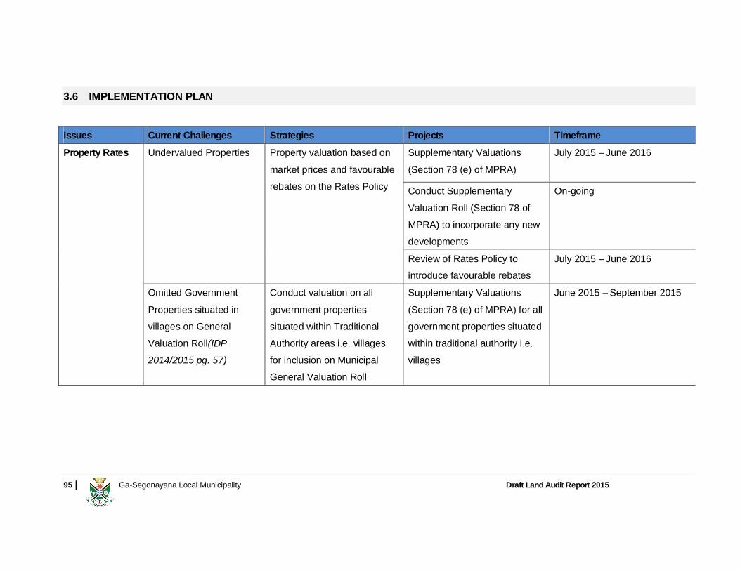
95 | Ga-Segonayana Local Municipality Draft Land Audit Report 2015
3.6 IMPLEMENTATION PLAN
Issues Current Challenges Strategies Projects Timeframe
Property Rates Undervalued Properties Property valuation based on market prices and favourable rebates on the Rates Policy
Supplementary Valuations (Section 78 (e) of MPRA)
July 2015 – June 2016
Conduct Supplementary Valuation Roll (Section 78 of MPRA) to incorporate any new developments
On-going
Review of Rates Policy to introduce favourable rebates
July 2015 – June 2016
Omitted Government Properties situated in villages on General Valuation Roll(IDP 2014/2015 pg. 57)
Conduct valuation on all government properties situated within Traditional Authority areas i.e. villages for inclusion on Municipal General Valuation Roll
Supplementary Valuations (Section 78 (e) of MPRA) for all government properties situated within traditional authority i.e. villages
June 2015 – September 2015
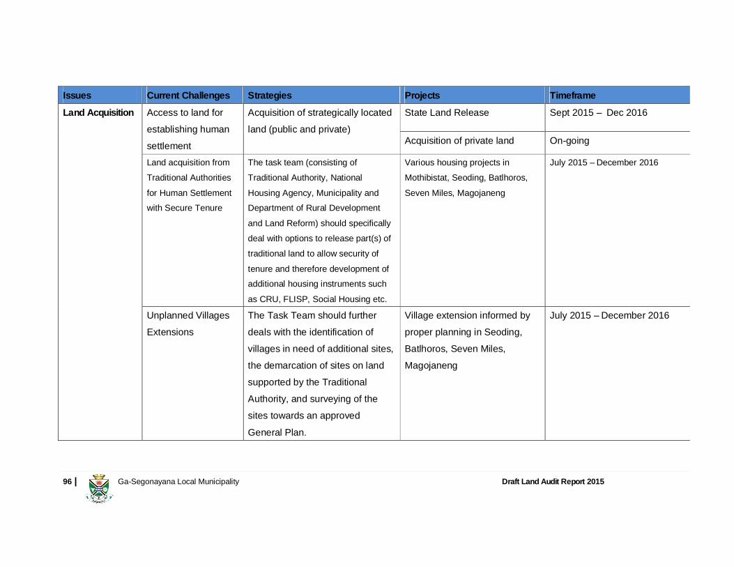
96 | Ga-Segonayana Local Municipality Draft Land Audit Report 2015
Issues Current Challenges Strategies Projects Timeframe
Land Acquisition Access to land for establishing human settlement
Acquisition of strategically located land (public and private)
State Land Release Sept 2015 – Dec 2016
Acquisition of private land On-going
Land acquisition from Traditional Authorities for Human Settlement with Secure Tenure
The task team (consisting of Traditional Authority, National Housing Agency, Municipality and Department of Rural Development and Land Reform) should specifically deal with options to release part(s) of traditional land to allow security of tenure and therefore development of additional housing instruments such as CRU, FLISP, Social Housing etc.
Various housing projects in Mothibistat, Seoding, Batlhoros, Seven Miles, Magojaneng
July 2015 – December 2016
Unplanned Villages Extensions
The Task Team should further deals with the identification of villages in need of additional sites, the demarcation of sites on land supported by the Traditional Authority, and surveying of the sites towards an approved General Plan.
Village extension informed by proper planning in Seoding, Batlhoros, Seven Miles, Magojaneng
July 2015 – December 2016
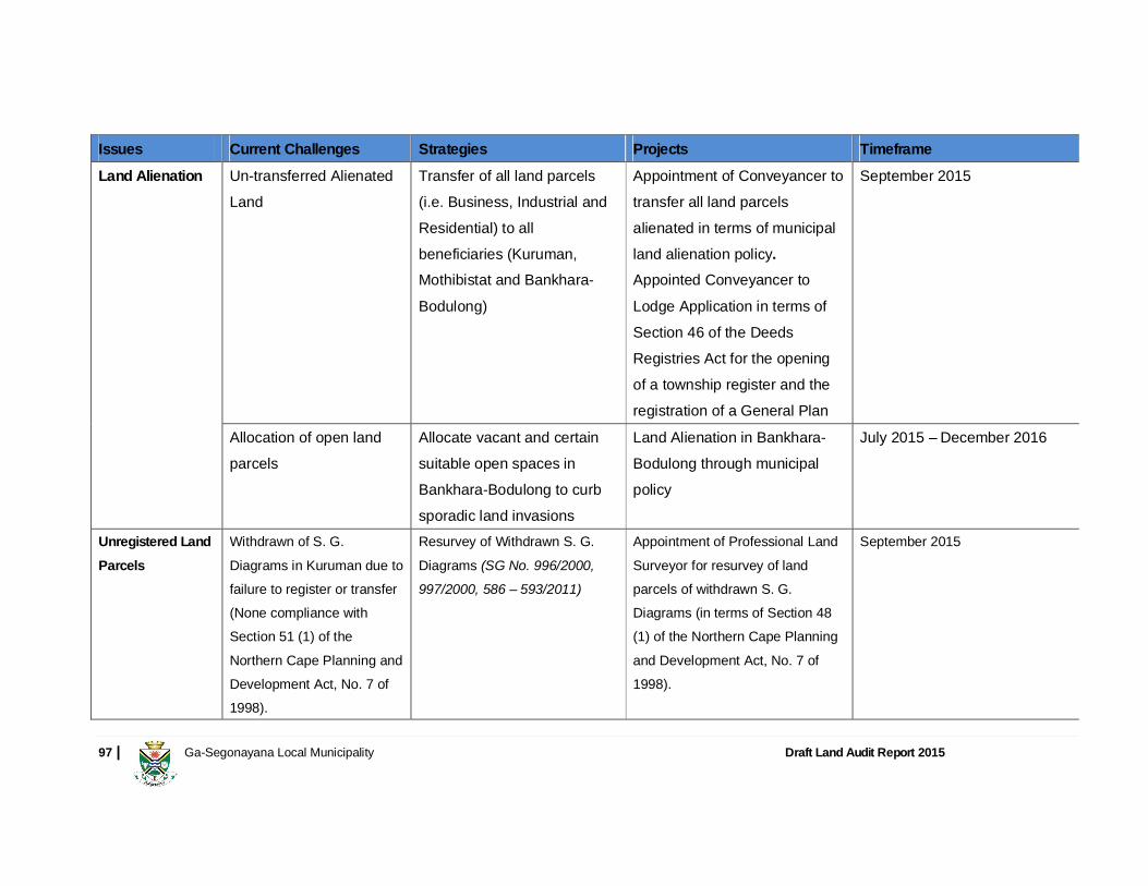
97 | Ga-Segonayana Local Municipality Draft Land Audit Report 2015
Issues Current Challenges Strategies Projects Timeframe
Land Alienation Un-transferred Alienated Land
Transfer of all land parcels (i.e. Business, Industrial and Residential) to all beneficiaries (Kuruman, Mothibistat and Bankhara-Bodulong)
Appointment of Conveyancer to transfer all land parcels alienated in terms of municipal land alienation policy. Appointed Conveyancer to Lodge Application in terms of Section 46 of the Deeds Registries Act for the opening of a township register and the registration of a General Plan
September 2015
Allocation of open land parcels
Allocate vacant and certain suitable open spaces in Bankhara-Bodulong to curb sporadic land invasions
Land Alienation in Bankhara-Bodulong through municipal policy
July 2015 – December 2016
Unregistered Land Parcels
Withdrawn of S. G. Diagrams in Kuruman due to failure to register or transfer (None compliance with Section 51 (1) of the Northern Cape Planning and Development Act, No. 7 of 1998).
Resurvey of Withdrawn S. G. Diagrams (SG No. 996/2000, 997/2000, 586 – 593/2011)
Appointment of Professional Land Surveyor for resurvey of land parcels of withdrawn S. G. Diagrams (in terms of Section 48 (1) of the Northern Cape Planning and Development Act, No. 7 of 1998).
September 2015
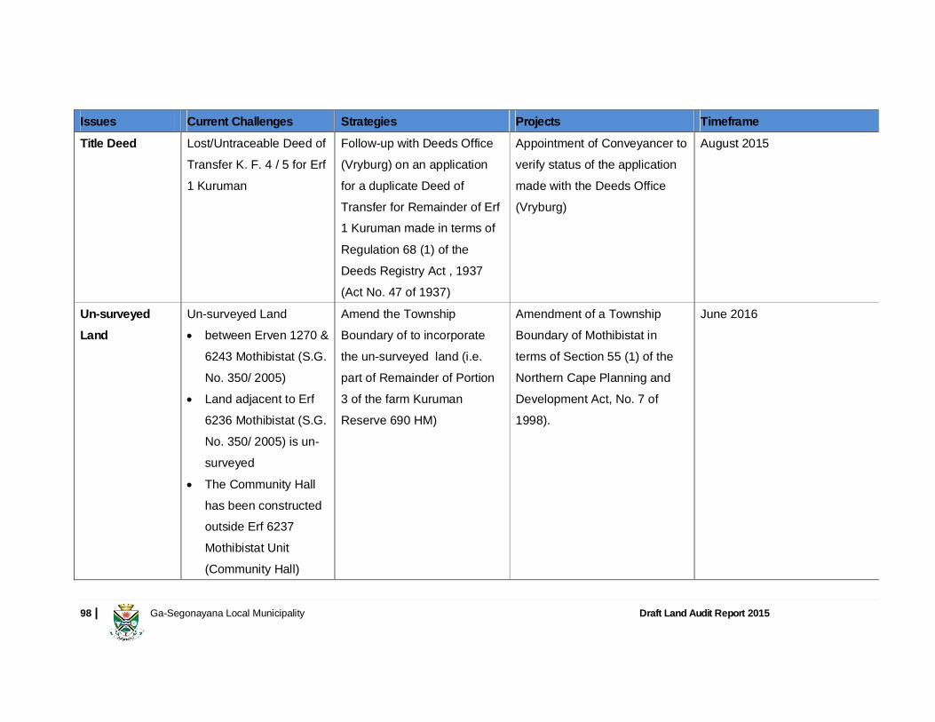
98 | Ga-Segonayana Local Municipality Draft Land Audit Report 2015
Issues Current Challenges Strategies Projects Timeframe
Title Deed Lost/Untraceable Deed of Transfer K. F. 4 / 5 for Erf 1 Kuruman
Follow-up with Deeds Office (Vryburg) on an application for a duplicate Deed of Transfer for Remainder of Erf 1 Kuruman made in terms of Regulation 68 (1) of the Deeds Registry Act , 1937 (Act No. 47 of 1937)
Appointment of Conveyancer to verify status of the application made with the Deeds Office (Vryburg)
August 2015
Un-surveyed Land
Un-surveyed Land between Erven 1270 &
6243 Mothibistat (S.G. No. 350/ 2005)
Land adjacent to Erf 6236 Mothibistat (S.G. No. 350/ 2005) is un-surveyed
The Community Hall has been constructed outside Erf 6237 Mothibistat Unit (Community Hall)
Amend the Township Boundary of to incorporate the un-surveyed land (i.e. part of Remainder of Portion 3 of the farm Kuruman Reserve 690 HM)
Amendment of a Township Boundary of Mothibistat in terms of Section 55 (1) of the Northern Cape Planning and Development Act, No. 7 of 1998).
June 2016
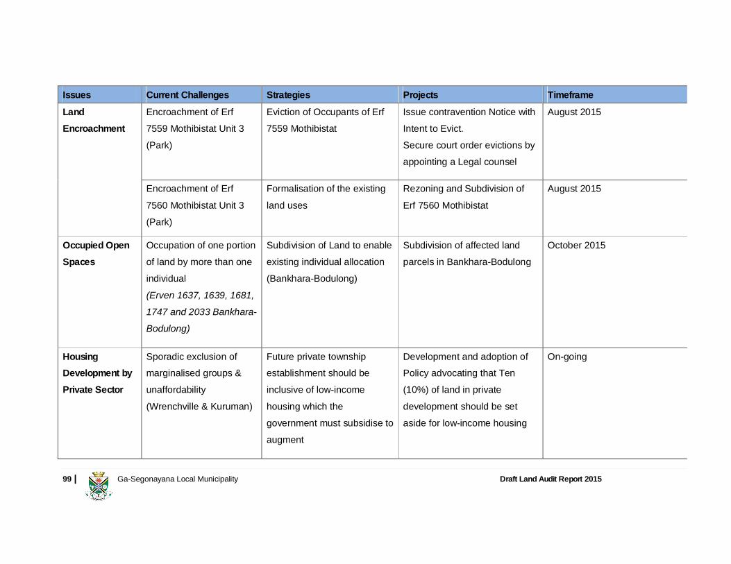
99 | Ga-Segonayana Local Municipality Draft Land Audit Report 2015
Issues Current Challenges Strategies Projects Timeframe
Land Encroachment
Encroachment of Erf 7559 Mothibistat Unit 3 (Park)
Eviction of Occupants of Erf 7559 Mothibistat
Issue contravention Notice with Intent to Evict. Secure court order evictions by appointing a Legal counsel
August 2015
Encroachment of Erf 7560 Mothibistat Unit 3 (Park)
Formalisation of the existing land uses
Rezoning and Subdivision of Erf 7560 Mothibistat
August 2015
Occupied Open Spaces
Occupation of one portion of land by more than one individual (Erven 1637, 1639, 1681, 1747 and 2033 Bankhara-Bodulong)
Subdivision of Land to enable existing individual allocation (Bankhara-Bodulong)
Subdivision of affected land parcels in Bankhara-Bodulong
October 2015
Housing Development by Private Sector
Sporadic exclusion of marginalised groups & unaffordability (Wrenchville & Kuruman)
Future private township establishment should be inclusive of low-income housing which the government must subsidise to augment
Development and adoption of Policy advocating that Ten (10%) of land in private development should be set aside for low-income housing
On-going
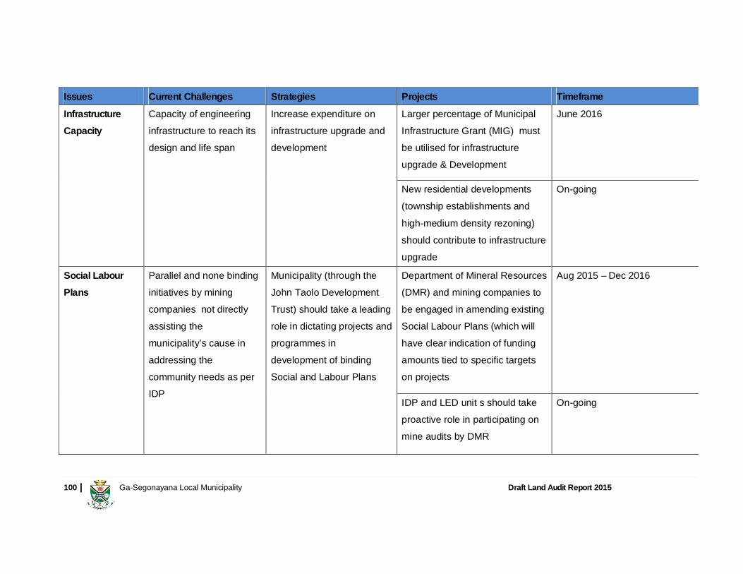
100 | Ga-Segonayana Local Municipality Draft Land Audit Report 2015
Issues Current Challenges Strategies Projects Timeframe
Infrastructure Capacity
Capacity of engineering infrastructure to reach its design and life span
Increase expenditure on infrastructure upgrade and development
Larger percentage of Municipal Infrastructure Grant (MIG) must be utilised for infrastructure upgrade & Development
June 2016
New residential developments (township establishments and high-medium density rezoning) should contribute to infrastructure upgrade
On-going
Social Labour Plans
Parallel and none binding initiatives by mining companies not directly assisting the municipality’s cause in addressing the community needs as per IDP
Municipality (through the John Taolo Development Trust) should take a leading role in dictating projects and programmes in development of binding Social and Labour Plans
Department of Mineral Resources (DMR) and mining companies to be engaged in amending existing Social Labour Plans (which will have clear indication of funding amounts tied to specific targets on projects
Aug 2015 – Dec 2016
IDP and LED unit s should take proactive role in participating on mine audits by DMR
On-going
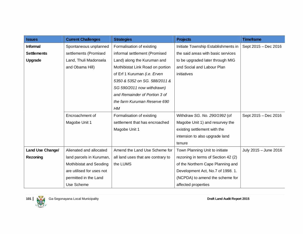
101 | Ga-Segonayana Local Municipality Draft Land Audit Report 2015
Issues Current Challenges Strategies Projects Timeframe
Informal Settlements Upgrade
Spontaneous unplanned settlements (Promised Land, Thuli Madonsela and Obama Hill)
Formalisation of existing informal settlement (Promised Land) along the Kuruman and Mothibistat Link Road on portion of Erf 1 Kuruman (i.e. Erven 5350 & 5352 on SG. 588/2011 & SG 590/2011 now withdrawn) and Remainder of Portion 3 of the farm Kuruman Reserve 690 HM
Initiate Township Establishments in the said areas with basic services to be upgraded later through MIG and Social and Labour Plan initiatives
Sept 2015 – Dec 2016
Encroachment of Magobe Unit 1
Formalisation of existing settlement that has encroached Magobe Unit 1
Withdraw SG. No. 290/1992 (of Magobe Unit 1) and resurvey the existing settlement with the intension to also upgrade land tenure
Sept 2015 – Dec 2016
Land Use Change/ Rezoning
Alienated and allocated land parcels in Kuruman, Mothibistat and Seoding are utilised for uses not permitted in the Land Use Scheme
Amend the Land Use Scheme for all land uses that are contrary to the LUMS
Town Planning Unit to initiate rezoning in terms of Section 42 (2) of the Northern Cape Planning and Development Act, No.7 of 1998. 1. (NCPDA) to amend the scheme for affected properties
July 2015 – June 2016
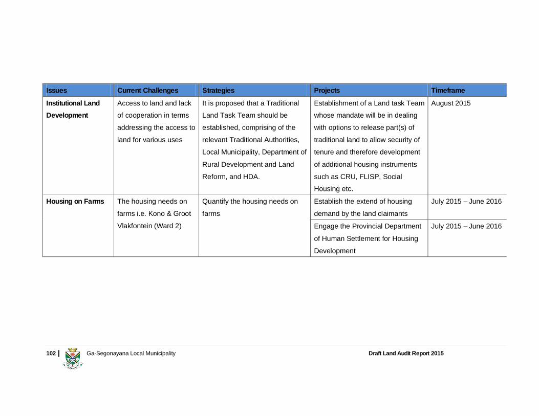
102 | Ga-Segonayana Local Municipality Draft Land Audit Report 2015
Issues Current Challenges Strategies Projects Timeframe
Institutional Land Development
Access to land and lack of cooperation in terms addressing the access to land for various uses
It is proposed that a Traditional Land Task Team should be established, comprising of the relevant Traditional Authorities, Local Municipality, Department of Rural Development and Land Reform, and HDA.
Establishment of a Land task Team whose mandate will be in dealing with options to release part(s) of traditional land to allow security of tenure and therefore development of additional housing instruments such as CRU, FLISP, Social Housing etc.
August 2015
Housing on Farms The housing needs on farms i.e. Kono & Groot Vlakfontein (Ward 2)
Quantify the housing needs on farms
Establish the extend of housing demand by the land claimants
July 2015 – June 2016
Engage the Provincial Department of Human Settlement for Housing Development
July 2015 – June 2016

103 | Ga-Segonayana Local Municipality Draft Land Audit Report 2015
3.7 CONCLUSION In conclusion it is evident, that there are land parcels that are either vacant or underutilised in the Ga-Segonyana Local Municipality that are:
Strategically located that could provide ample space for infill developed, thus promoting densification and obviating further urban sprawl. Land that could be utilised for agrarian reform
In the case of land in highly dense populated or development pressed areas, some bulk engineering solution is required in order to develop the land. In all other instances, the developer would be responsible for the cost of engineering services (i.e. bulk contribution) to develop the land. Transfer of alienated land to beneficiaries is also fundamental to land reform process. During the course of the preparation of the land audit it has also emerged that a significant number municipal properties have administrative issues to be resolved (e.g. sold, but not transferred or same property allocate to various people). The implementation plan would require role playing by all critical stakeholders and political will in ensuring that the funding is committed and that proposed actions are executed within stipulated timeframes.

104 | Ga-Segonayana Local Municipality Draft Land Audit Report 2015
4 REFERENCES
1. Breaking New Ground, 2004, Pretoria: Department of Housing 2. Constitution of the Republic of South Africa, 1996 (Act 108 of 1996) 3. Ga-Segonyana Local Municipality IDP Review 2012 - 2015, April 2012 4. Ga-Segonyana Integrated Housing Sector Plan 2014 5. Ga-Segonyana Spatial Development Framework 2008 6. Ga-Segonyana Land Disposal and Alienation Policy 2007 7. John Taolo Gaetsewe Spatial Development Framework 2012 8. John Taolo Gaetsewe Local Economic Development Strategy 2009 9. National Environmental Management Act, 2008 (Act No. 62 of 2008)
10. National Spatial Development Perspective, Policy Co-ordination and Advisory Services, The Presidency, March 2003 11. Natives Land Act, 1913 (Act 27 of 1913) 12. Northern Cape Provincial Growth and Development Strategy 2009 – 2014 13. The National Development Plan 2030, Office of the Presidency, 2012 14. Mineral and Petroleum Resources Development Act, 2002 (Act No. 28 of 2002) 15. Local Government: Municipal Property Rates Act, 2004 (Act 6 of 2004) 16. Local Government: Municipal Finance Management Act, 2003 (Act 56 of 2003) 17. Interim Protection of Informal Land Rights, 1996 (Act 31 of 1996) 18. Spatial Planning and Land Use Management Act, 2013 (Act 16 of 2013) 19. Statistics South Africa: Census 2011. Pretoria: Stats SA, 2012
20. Population Policy for South Africa, 1998
21. The Housing Act, 1997 (Act No. 107 of 1997) 22. White Paper on Local Government 1998 23. Tokafatso! For All. Bigen Africa. http://www.tokafatso.co.za. Accessed 15 October 2014