Embed Size (px)
Citation preview

DRAFT Edward Anderson
Conservation Area & DuPont Reservation Conservation Area
Ten-Year Area Management Plan FY 2017-2026
To submit a comment on this document, click on the following link: https://mdc.mo.gov/node/10013?ap=13377

June 2016 – Draft Anderson & DuPont Area Management Plan Page 2
OVERVIEW
Area Name Area Number
Year Acquired
Acreage County Administrative Responsibility
Maintenance Responsibility
Edward Anderson Conservation Area (Anderson CA)
6311 1963 1,046 Ralls, Pike
Forestry Wildlife
DuPont Reservation CA
4604 1938 1,320 Pike Forestry Wildlife
Statements of Purpose:
A. Strategic Direction Management of these areas will focus on maintaining the areas to allow for multiple public uses and conserving and managing the areas’ natural resources.
B. Desired Future Condition The desired future condition of Anderson CA and DuPont Reservation CA is a healthy forest community consisting of upland and bottomland forests with a few small, interspersed open fields comprised of grassland and old field; and to provide high quality riparian areas along the Mississippi River, its tributaries, and the associated watershed.
C. Federal Aid Statement • Anderson CA: This area, or a portion thereof, was acquired with Pittman-
Robertson Wildlife Restoration funds to restore and manage wildlife, conserve, and restore suitable wildlife habitat and provide public access for hunting or other wildlife-oriented recreation.
• DuPont Reservation CA: This area, or a portion thereof, was acquired with Land and Water Conservation Fund dollars to provide land or facilities for public outdoor recreation.
GENERAL INFORMATION AND CONDITIONS
I. Special Considerations Area Name Priority Areas Natural Areas Anderson CA DuPont Complex Terrestrial Conservation Opportunity
Area, Ted Shanks Important Bird Area None
DuPont Reservation CA
DuPont Complex Terrestrial Conservation Opportunity Area, , Ted Shanks Important Bird Area
Yes1
1 DuPont Natural Area is found east of Highway 79. This 80-acre tract includes dry-mesic and mesic loess/glacial till forest and dry-mesic chert forest communities with mature to old-second

June 2016 – Draft Anderson & DuPont Area Management Plan Page 3
growth trees. Basswood, northern red oak, white oak, chinquapin oak, and sugar maple are common overstory trees.
II. Important Natural Features and Resources Area Name Species of Conservation Concern Caves Springs Anderson CA Yes1 None None DuPont Reservation CA Yes2 None None 1 Species of conservation concern are not known from this site, but are found in the surrounding area. Area managers should consult annually with the natural history biologist. 2 Species of conservation concern are known from this area. Area managers should consult the Natural Heritage Database annually and review all management activities with the natural history biologist.
III. Existing Infrastructure Area Name Parking
Lots Concrete
Boat Ramp
Privy Other
Anderson CA 1 None None Campground (at parking lot), radio tower
DuPont Reservation CA
31 1 11 Campground (with 20 camping pads), storage shed, 1.5 miles of gravel road
open to public access 1 Americans with Disabilities Act (ADA) accessible
IV. Area Restrictions or Limitations Area Name
Deed Restrictions/ Ownership
Considerations
Federal Interest
Ease-ments
Cultural Resources
Endangered Species
Boundary Issues
Anderson CA
None Yes2 Yes5,6 None Yes8 None
DuPont Reserva-tion CA
Yes1 Yes3,4 Yes6 Yes7 None observed
None
1 The Missouri Department of Transportation (MODOT) maintains two scenic overlooks. 2 Uses of land acquired with federal funds may not interfere with the purpose for which it was acquired. Federal funds may also be used in the management of this land. Fish and wildlife agencies may not allow recreational activities and related facilities that would interfere with the purpose for which the State is managing the land. Other uses may be acceptable and must be assessed in each specific situation. 3 Federal funds were used in the development of this area, or a portion thereof. The Department must maintain the developed project throughout its useful life. Federal funds may also be used in the management of this land. Fish and wildlife agencies may not allow recreational activities and

June 2016 – Draft Anderson & DuPont Area Management Plan Page 4
related facilities that would interfere with the purpose for which the State is managing the land. Other uses may be acceptable and must be assessed in each specific situation. 4 This land must provide land/facilities for public outdoor recreation in perpetuity. Federal funds may also be used in the management of this land. Fish and wildlife agencies may not allow recreation activities and related facilities that would interfere with the purpose for which the State is managing the land. Other uses may be acceptable and must be assessed in each specific situation. 5 Public Water Supply District #1 of Ralls County for placement of the water tower. 6Railroad Right-Of-Way and Misouri Department of Transportation Right-of-Way. 7 Records are kept with Missouri Department of Conservation (the Department) environmental compliance specialist. Managers should follow Best Management Practices for Cultural Resources found in the Department Resource Policy Manual. 8 Endangered Species are not known from this site, but are found in the surrounding area. Area managers should consult annually with the natural history biologist.
MANAGEMENT CONSIDERATIONS
V. Terrestrial Resource Management Considerations
Challenges and Opportunities: 1) The 35 acres of open land on DuPont Reservation CA are comprised of open
agricultural and grassland fields that provide limited wildlife management opportunities.
2) Both areas are located along the Mississippi River, and consist of steep slopes and rough terrain. Topography limits traditional forest management opportunities in many portions of both areas.
Management Objective 1: Use agricultural techniques to provide food and cover for wildlife.
Strategy 1: Use management techniques including but not limited to mowing, disking, spraying, and prescribed fire to maintain the grassland and promote early successional vegetation. (Wildlife)
Management Objective 2: On appropriate sites, manage forest communities to provide healthy and diverse habitats for forest/woodland-dependent wildlife.
Strategy 1: Conduct a forest inventory by compartment with an estimated reentry time of 15 years or as needed. (Forestry) Strategy 2: Implement silvicultural practices as prescribed by the detailed forest inventory process including the marking and selling of trees found on accessible portions of the areas. (Forestry)

June 2016 – Draft Anderson & DuPont Area Management Plan Page 5
Strategy 3: Implement forest thinning on portions of the areas as recommended by the most recent forest inventory. (Forestry) Strategy 4: Manage inaccessible forested areas as old growth forests allowing natural processes to unfold. (Forestry) Strategy 5: Utilize Best Management Practices during timber harvest as described in the Department’s manuals: Missouri Watershed Protection Practice manual (Missouri Department of Conservation 2014) and the Missouri Forest Management Guidelines Voluntary Recommendations for Well-Managed Forests (Missouri Department of Conservation 2014.) (Forestry)
Management Objective 3: Control invasive plant species on the conservation areas. Strategy 1: Contract with aerial applicator to treat bush honeysuckle. (Forestry) Strategy 2: Monitor area treated using aerial application the following growing season to ensure success. (Forestry) Strategy 3: Annually monitor and eradicate invasive species. (Forestry)
VI. Aquatic Resource Management Considerations
Challenges and Opportunities:
1) Anderson CA has 2.3 miles of Mississippi River frontage. However, steep topography prevents constructing access roads and parking lots.
2) One first-order tributary to the Mississippi River flows through Anderson CA. 3) Three first-order tributaries to the Mississippi River and one first-order tributary
to the Salt River flow through DuPont Reservation CA. While these streams are ephemeral, they provide important ecosystem functions and seasonal habitat for aquatic organisms.
Management Objective 1: Maintain a forested corridor along all streams on the areas.
Strategy 1: Maintain a forested corridor through natural regeneration or planting. A minimum corridor width of 200 feet should be maintained along the Mississippi River. On other streams, a minimum width of 100 feet should be maintained, where not limited by area boundary or utility easement. (Forestry) Strategy 2: All management activities on Anderson CA and DuPont Reservation CA should follow the Watershed and Stream Management Guidelines for Lands Managed by the Missouri Department of Conservation (Missouri Department of Conservation, 2009). (Forestry)

June 2016 – Draft Anderson & DuPont Area Management Plan Page 6
VII. Public Use Management Considerations Challenges and Opportunities:
1) These areas offer multiple public use opportunities for outdoor recreation and education, including hunting, fishing, camping, wildlife viewing, and hiking. DuPont Reservation CA has 1.3 miles of Mississippi River frontage. A concrete boat ramp with a parking lot provides boating and bank angler access.
Management Objective 1: Provide hunting and fishing opportunities on the areas by maintaining area facilities to provide user access and safety.
Strategy 1: Maintain existing parking lots, bulletin boards, boat ramp, campground, privies, and field roads to facilitate use by area users. Strategy 2: Maintain existing mowed areas along river to facilitate bank fishing. Strategy 3: Maintian boat ramp by cleaning after flooding to facilitate boat launching.
Management Objective 2: Provide convenient and safe access for nature viewers and hikers on the conservation areas.
Strategy 1: Maintain current service roads and access paths.
Management Objective 3: Inform public about area regulations. Strategy 1: Maintain signs according to Department policy. (Wildlife) Strategy 2: Maintain accurate and timely information on the Department’s Atlas Database. Review information annually. (Forestry)
Management Objective 4: Maintain area infrastructure at current levels.
Strategy 1: Maintain area infrastructure in accordance with Department guidelines and at currently identified maintenance level (2). (Wildlife)
VIII. Administrative Considerations
Challenges and Opportunities: 1) Illegal use of all terrain vehicles on the conservation areas has been an issue from
time to time.
Management Objective 1: Discourage illegal all terrain vehicle use through enforcement and trail closures.
Strategy 1: Monitor areas for illegal all terrain vehicle use. (Protection) Strategy 2: Identify trails used by all terrain vehicles and close them by making them impassible. (Forestry)
June 2016 – Draft Anderson & DuPont Area Management Plan Page 7
Strategy 3: Regularly patrol and enforce the wildlife code, with emphasis on off-trail abuse, vandalism, littering and response to public comments. (Protection, Forestry)
Management Objective 2: Maintain clearly identified property lines. Strategy 1: Inspect and maintain boundaries on a regular cycle. (Forestry) Strategy 2: Resolve boundary issues with adjoining landowners as they arise. (Forestry)
Lands Proposed for Acquisition: When available, adjacent land may be considered for acquisition from willing sellers. Tracts that improve area access, provide public use opportunities, contain unique natural communities and/or species of conservation concern, or meet other Department priorities, as identified in the annual Department land acquisition priorities, may be considered.
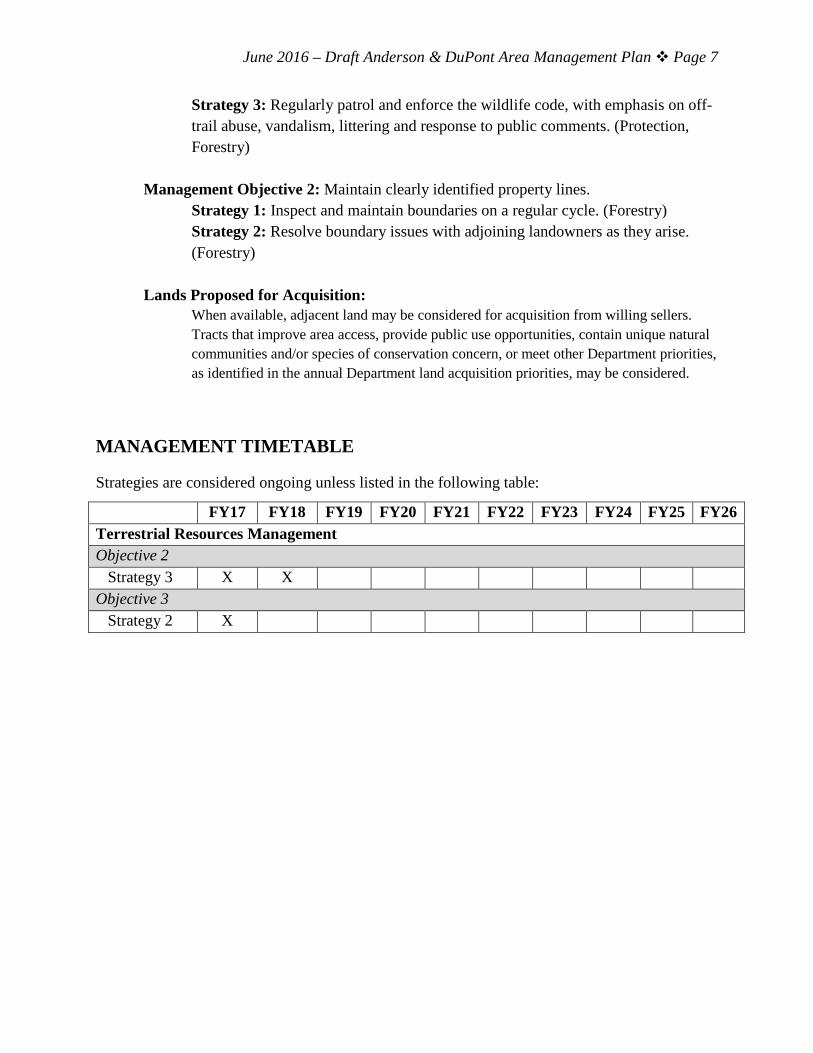
MANAGEMENT TIMETABLE
Strategies are considered ongoing unless listed in the following table:
FY17 FY18 FY19 FY20 FY21 FY22 FY23 FY24 FY25 FY26 Terrestrial Resources Management Objective 2 Strategy 3 X X Objective 3 Strategy 2 X
June 2016 – Draft Anderson & DuPont Area Management Plan Page 8
APPENDICES
Appendices: Appendix 1. Anderson CA Background Appendix 2. Anderson CA Area Map Appendix 3. Anderson CA Aerial Map Appendix 4. Anderson CA Land Cover Types and Easements Appendix 5. DuPont Reservation CA Background Appendix 6. DuPont Reservation CA Area Map Appendix 7. DuPont Reservation CA Aerial Map Appendix 8. DuPont Reservation CA Land Cover Types and Easements Appendix 9. Conservation Opportunity Area Map – Anderson CA and DuPont Reservation CA References: Missouri Department of Conservation. (2009). Watershed and stream management guidelines for lands managed by the Missouri Department of Conservation. Jefferson City, MO: Missouri Department of Conservation. Missouri Department of Conservation. (2014). Missouri Forest Management Guidelines
Voluntary Recommendations for Well-Managed Forests. Jefferson City, Missouri: Conservation Commission of the State of Missouri.
Missouri Department of Conservation. (2014). Missouri watershed protection practice recommended practices for Missouri forests: 2014 management guidelines for maintaining forested watersheds to protect streams. Jefferson City, Missouri: Conservation Commission of the State of Missouri.

2017 DRAFT Anderson & DuPont Reservation Conservation Areas Management Plan Page 9
Appendix 1. Anderson CA Background In 1963, Edward Anderson, a local landowner, donated 500 acres for this area to the Department. Later purchases by the Department brought the area to its present size of 1,046 acres. This conservation area was acquired in part through the Pittman-Robertson Wildlife Restoration Act administered by the U.S. Fish and Wildlife Service. Several small, intermittent streams traverse the hilly terrain and drain into the Mississippi River. Although the area is bordered by 2.3 miles of Mississippi River, access to the river is limited. Two large sink holes are located about 0.5 miles northeast of the tower site, which is adjacent to Highway 79, about 1 mile north of Hallows Roadside Park. The highest point in Ralls County (804 feet) is found on the area. Current Land and Water Types: Land/Water Type Acres Miles % of Area Upland Forest 1,043 100 Old Fields/Upland Fields 3 <1 Total 1,046 100 Stream Frontage (Mississippi River) 2.3

2017 DRAFT Anderson & DuPont Reservation Conservation Areas Management Plan Page 10
Appendix 2. Anderson CA Area Map

2017 DRAFT Anderson & DuPont Reservation Conservation Areas Management Plan Page 11
Appendix 3. Anderson CA Aerial Map

2017 DRAFT Anderson & DuPont Reservation Conservation Areas Management Plan Page 12
Appendix 4. Anderson CA Land Cover Types and Easements

2017 DRAFT Anderson & DuPont Reservation Conservation Areas Management Plan Page 13
Appendix 5. DuPont Reservation CA Background From 1892 through 1932, a dynamite factory on this site provided explosives for lead, zinc and coal mines in the tristate area and nitroglycerin for use in Oklahoma oil fields. Separate facilities were built in different valleys in this rough terrain to lessen the chance of a chain reaction explosion, should any one of the buildings explode. E.I. DuPont de Nemours and Company (DuPont) donated 1,122.8 acres to the Conservation Commission in 1938. Subsequent land purchases have increased the size of this area to its present 1,320 acres. The area consists of 975 acres of upland forest, 310 acres of bottomland forest and 35 acres of old fields and grassland. It also contains plantations of walnut, cottonwood, tulip poplar, pine, and bald cypress trees. A boat access and primitive campground are located along a 1.5-mile portion of Mississippi River frontage. DuPont Natural Area is found east of Highway 79. This 80-acre tract includes dry-mesic and mesic loess/glacial till forest and dry-mesic chert forest communities with mature to old-second growth trees. Basswood, northern red oak, white oak, chinquapin oak, and sugar maple are common overstory trees. Current Land and Water Types: Land/Water Type
Acres Miles % of Area
Upland Forest 975 74% Bottomland Forest 310 23% Old Fields/Grasslands 35 3% Total 1,320 100% Stream Frontage (Mississippi River) 1.5
2017 DRAFT Anderson & DuPont Reservation Conservation Areas Management Plan Page 14
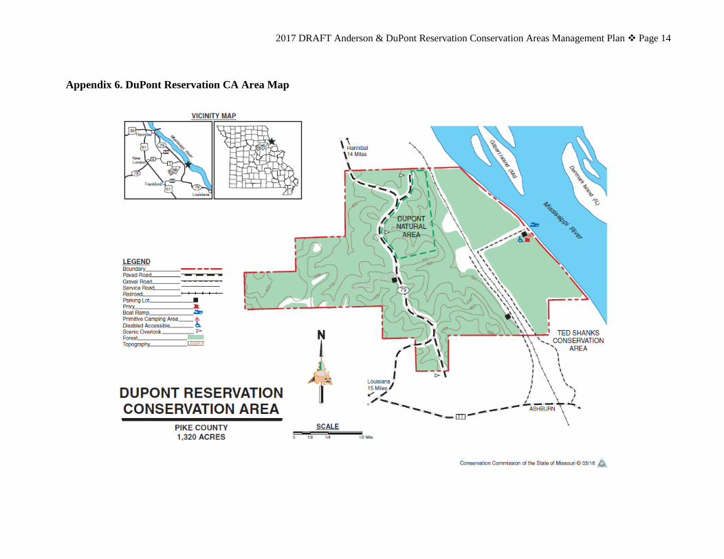
Appendix 6. DuPont Reservation CA Area Map

2017 DRAFT Anderson & DuPont Reservation Conservation Areas Management Plan Page 15
Appendix 7. DuPont Reservation CA Aerial Map

2017 DRAFT Anderson & DuPont Reservation Conservation Areas Management Plan Page 16
Appendix 8. DuPont Reservation CA Land Cover Types and Easements

2017 DRAFT Anderson & DuPont Reservation Conservation Areas Management Plan Page 17
Appendix 9. Conservation Opportunity Area Map

2017 DRAFT Anderson & DuPont Reservation Conservation Areas Management Plan Page 18
To submit a comment on this document, click on the following link: https://mdc.mo.gov/node/10013?ap=13377