Embed Size (px)
Citation preview
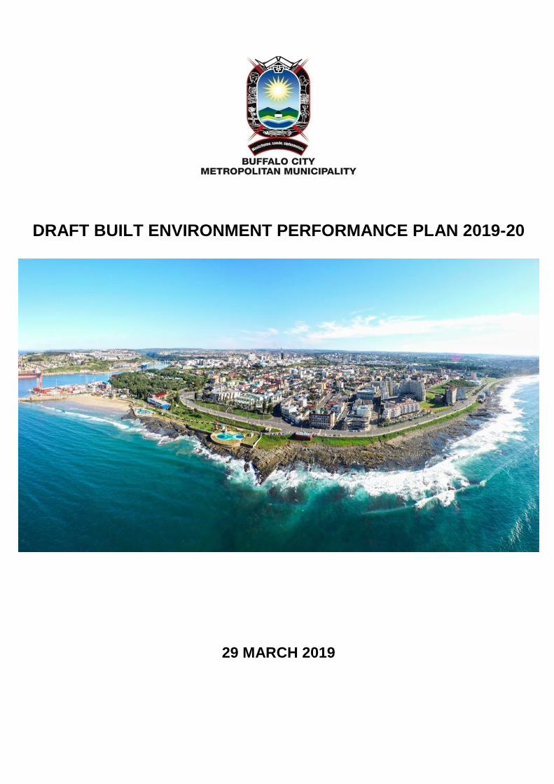
DRAFT BUILT ENVIRONMENT PERFORMANCE PLAN 2019-20
29 MARCH 2019
Page 2
ACRONYMS ACSA Airport Company South Africa
AFS Annual Financial Statements
AG Auditor General
AMEU Association of Municipal Electricity Utilities
BCMDA Buffalo City Municipal Development Agency
BCMM Buffalo City Metropolitan Municipality
BEPM Built Environment Progression Model
BEPP Built Environment Performance Plan
BEVC Built Environment Value Chain
BKCOB Boarder Kei Chamber of Business
BOD Board of Directors
CBD Central Business District
CBF City Budget Forum
CIDMS City Infrastructure Delivery Management System
CCTV Close Circuit Television
CID City Improvement District
CIF Capital Investment Framework
CS Community Survey
CSIP Capacity Support Implementation Plan
CSP Cities Support Programme
CURA Central Urban Renewal Area
DBSA Development Bank of Southern Africa
DORA Division of Revenue
DV Duncan Village
DVRI Duncan Village Re-Development Initiative
DWAF Department of Water Affairs and Forestry
EC Eastern Cape
ECSEC Eastern Cape Socio-Economic Consultative Council
EL East London
ELIDZ East London Industrial Development Zone
EPMO Enterprise Project Management Office
ERP Enterprise Resource Planning
FMG Financial Management Grant
GDP Gross Domestic Product
GIZ Deutsche Gesellschaft fur International
Zusammenarbeit
HDA Housing Development Agency
HDI Human Development Index
HIV/AIDS Human Immune Virus/Acquired Immune Deficiency
Syndrome
HRD Human Resource Development
HSDG Human Settlements Development Grant
IBC Invest Buffalo City
ICDG Integrated City Development Grant
ICR Inner-City Regeneration
ICT Information and Communications Technology
IDP Integrated Development Plan
IDZ Industrial Development Zone
IGR Inter-Governmental Relations
INEP Integrated National Electrification Grant
IPTN Integrated Public Transport Network
ISA Incremental Settlement Areas
ISDG Infrastructure Skills Development Grant
IUDF Integrated Urban Development Framework
IWMP Integrated Waste Management Plan
IZ Integration Zone
KWT King William’s Town
LED Local Economic Development
LSDF Local Spatial Development Framework
LTE Long-Term Evolution Network Coverage
LVC Land Value Capture
MELD Mdantsane-East London Development
MFMA Municipal Financial Management Act
MGDS Metro Growth and Development Strategy
MRF Material Recovery Facility
MSA Municipal Systems Act
MSDF Metropolitan Spatial Development Framework
MTREF Medium Term Revenue and Expenditure Framework
MTSF Medium-Term Strategic Framework
MUHF Mdantsane Urban Hub Framework
NDP National Development Plan
NDPG Neighbourhood Development Partnership Grant
NDPW National Department of Public Works
NMT Non-Motorised Transport
NT National Treasury
NTGN National Treasury Guidance Note
NUSP National Upgrade Support Programme
NWC North West Corridor
PBV Purpose Built Vehicle
PIU Project Implementation Unit
PMM Precinct Management Model
PPF Project Preparation Facility
PRASA Passenger Rail Agency of South Africa
PTIG Public Transport Infrastructure Grant
PTISG Public Transport Infrastructure and System Grant
SANRAL South African National Roads Agency
SDBIP Service Delivery and Budget Implementation Plans
SDF Spatial Development Framework
SOC State Owned Company
SPLUMA Spatial Planning and Land Use Management Act 2013
SPV Special Purpose Vehicle
SRA Special Rating Area
STP Science and Technology Park
TOD Transit-Oriented Development
UDZ Urban Development Zone
UID Urban Improvement District
UNS Urban Network Strategy
USDG Urban Settlements Development Grant
WTP Water Treatment Plan
WWTW Waste Water Treatment Works
TERMINOLOGY
The following terminology is taken from the National Treasury Guidance Note: BEPP Framework v.5.5 08/2017.
Catalytic Urban Development Programmes
Catalytic urban development programmes and associated projects are programmes that:
a) Enable integration, that is mixed and intensified land uses where the residential land use caters for people across various income bands
and at increased densities that better support the viability of public transport systems;
b) Are strategically located within integration zones in metropolitan municipalities; and are game changers in that the nature and scope of the
projects are likely to have significant impact on spatial form and unlock economic activity.
c) Involve major infrastructure investment;
d) Require a blend of finance where a mix of public funds is able to leverage private sector investment as well as unlock household investment;
e) Require specific skills across a number of professions and have multiple stakeholders.
Catalytic development programmes are an ensemble of related projects (public: municipal, public: non-municipal and private (Public Private
Partnerships, Special Purpose Vehicles, and pure private development projects) needed to be implemented within a specific spatial targeted
area and from which the total intergovernmental project pipeline is updated for all public-sector projects in the programme.
The catalytic programme development process delivers a series of built environment projects to be implemented by either national, provincial,
municipal or private sector which will progressively put cities on the path to achieving compact cities and transformed urban spaces and are
therefore outcomes led.
Densification
Increased use of space, both horizontally and vertically, within existing areas/properties and new developments, accompanied by an increased
number of units and/or population threshold.
Economic/Employment Node
Employment or economic nodes are localised urban agglomeration economies with the highest number of jobs per unit of area (job densities).
They are the primary urban destinations and therefore are mostly located on major transit routes and accessible via a variety of transport modes.
In terms of land use, employment nodes can either be mixed – a cluster of office, retail, industrial, community and residential land uses; or
uniform - homogenous land uses such as industrial or office complexes. Building heights and land coverage in economic nodes are much higher
compared to average urban places. In terms of life cycle stage, they can be segmented into emerging (township nodes or urban hubs),
established (decentralised commercial nodes) and declining nodes (CBDs). Size and catchment area of economic nodes are characterised into
a descending hierarchy, e.g. Regional, CBD, Metropolitan, Suburban and Neighbourhood.
Human Settlements Development
The Department of Human Settlements defines a human settlement as a developed and/or developing human community in a city, town or
village – with all the social, material, economic, organisational, spiritual and cultural elements that sustains human life. Human settlement
development refers to the establishment and maintenance of habitable, stable and sustainable public and private residential environments to
ensure viable households and communities within a space and/or areas providing for economic opportunities, health, educational and social
amenities in which all citizens and permanent residents of the Republic, within a municipal space will, on a progressive basis, have access to
permanent residential structures with secure tenure, internal and external privacy and providing adequate protection against the elements; and
potable water, adequate sanitation facilities and domestic energy supply.
Informal Settlement
The National Upgrading of Informal Settlements Programme refers to two UN Habitat definitions of Informal Settlements. An ‘Informal Settlement’
exists where housing has been created in an urban or peri-urban location without official approval. Informal settlements may contain a few
dwellings or thousands of them, and are generally characterised by inadequate infrastructure, poor access to basic services, unsuitable
environments, uncontrolled and unhealthy population densities, inadequate dwellings, poor access to health and education facilities and lack of
effective administration by the municipality. (NUSP 2013, taken from UISP Consolidation Document-2014).
Another definition in use which is similar to the above is: “Residential areas where 1) inhabitants have no security of tenure vis-à-vis the land or
dwellings they inhabit, with modalities ranging from squatting to informal rental housing,
Page 4
2). the neighbourhoods usually lack, or are cut off from, basic services and city infrastructure and 3) the housing may not comply with current
planning and building regulations, and is often situated in geographically and environmentally hazardous areas”. The UN-Habitat (2015).
Integrated Planning
Integrated planning refers to the co-operation of different sector department, different spheres of government, parastatals and the private sector
in order to achieve publicly participated and accepted development outcomes.
Intensification / Mixed Land Use
Achieving a greater spectrum of land uses (commercial, industrial, residential or social) through the increased use of space, both horizontally
and vertically, within existing areas or properties and new developments, within a TOD precinct, resulting in increased population thresholds
that support public transport ridership, walkability, economic development and inclusivity.
Integration Zone (IZ)
The Urban Network consists of a number of Integration Zones. Each zone is a part of a city or city region-wide TOD network. An integration
zone is a spatial planning element facilitating spatial targeting of investment aimed at spatial transformation. Each zone consists of a transit
spine connecting two anchors via mass public transport (rail/bus) e.g. the CBD and an ‘urban hub’ (township node with the best investment
potential). It can also comprise of the CBD and another primary metropolitan business node. Between the two Integration Zone anchors area
limited number of Integration Zone intermediate nodes that are strategically located at key intersections connecting to marginalised residential
areas (townships and informal settlements) and economic nodes (commercial and industrial nodes) via feeder routes. The Urban Hub connects
to secondary township nodes within the marginalised peripheral township. The Integration Zone includes a hierarchy of TOD precincts located
and prioritised within the structure of the nodes described above.
Intergovernmental Project Pipeline
The intergovernmental project pipeline consists of both catalytic and standard projects (not all projects, only that of a strategic/priority nature)
within the metropolitan space whether it is a project of the national, provincial or metropolitan government, or that of a public entity. The main
purpose of the pipeline is for it to incorporate projects from all spheres and entities to prioritise collective public investment in particular spaces.
Land Value Capture (LVC) / Land Based Financing
A policy and regulatory mechanism that allows a public entity to “capture” a portion of the increased value (direct or indirect) of land resulting
from either investment in infrastructure or the allocation of use rights by the public sector.
Marginalised Areas
Marginalised areas are areas, primarily residential in function with related land uses, which are in decline and/or where people are deprived.
These are areas that are typically informal settlements and dormitory residential townships in need of redress. These are areas that do not tend
to be the focus of the private sector developers and will thus require some kind of intervention from government to start with if they are to flourish
as liveable neighbourhoods with high accessibility to the broader urban network.
Mixed Land Use
A mix of land uses or achieving greater spectrum of land uses. More specifically it relates to an area of existing or proposed horizontal and/or
vertical integration of suitable and compatible residential and non-residential land uses within the same area or on the same parcel of land;
implies contextually appropriate intensity of land uses that should facilitate efficient public transport and a vibrant local urban environment.
Spatial Planning and Land Use Management
The following definitions are the same definitions used in SPLUMA Act 16 of 2013.
“Land” means any erf, agricultural holding or farm portion, and includes any improvement or building on the land and any real right in land;
“Land development” means the erection of buildings or structures on land, or the change of use of land, including township establishment, the
subdivision or consolidation of land or any deviation from the land use or uses permitted in terms of an applicable land use scheme.
Page 5
“Land use” means the purpose for which land is or may be used lawfully in terms of a land use scheme, existing scheme or in terms of any other
authorisation, permit or consent issued by a competent authority, and includes any conditions related to such land use purposes.
“Land use management system” means the system of regulating and managing land use and conferring land use rights through the use of
schemes and land development procedures;
“Spatial development framework” means a spatial development framework referred to in Chapter 4 of SPLUMA;
“Zone” means a defined category of land use which is shown on the zoning map of a land use scheme. (Not the same as Integration Zone as in
UNS)
The spatial planning system consists of the following components:
a) Spatial development frameworks to be prepared and adopted by national, provincial and municipal spheres of government;
b) Development principles, norms and standards that must guide spatial planning, land use management and land development;
c) The management and facilitation of land use contemplated in Chapter 5 of SPLUMA through the mechanism of land use schemes; and
d) Procedures and processes for the preparation, submission and consideration of land development applications and related processes
as provided for in Chapter 6 of SPLUMA and provincial legislation.
A municipal spatial development framework must assist in integrating, coordinating, aligning and expressing development policies and plans
emanating from the various sectors of the spheres of government as they apply within the municipal area. Spatial development frameworks
must outline specific arrangements for prioritising, mobilising, sequencing and implementing public and private infrastructural and land
development investment in the priority spatial structuring areas identified in spatial development frameworks.
Spatial Targeting
A built environment investment prioritisation approach where specific areas are prioritised for investment at a range of geographic scales, within
an urban system, to achieve particular development outcomes. Spatial Targeting is an approach recommended by the National Development
Plan.
Spatial Transformation:
The legacy of apartheid – communities segregated from one another based on race (and class)- as well as the impacts of the legacy of the
modernist trend of city building based on the automobile and functional separation of land uses have left South Africa with cities that are
inefficient, inequitably developed, and expensive – environmentally, socially and fiscally – to live in and to manage. The NDP states that a
national focus on the spatial transformation of our cities should, by 2030 ensure that a larger proportion of the population should live close to
places of work and travel distances and costs should be reduced, especially for poor households. Urban systems – hard (physical structures
and networks) and soft (governance systems including urban management and land use management) that facilitate and enable compact cities
and transformed urban spaces of social and economic inclusion on an equitable basis are key levers to overcome the debilitating impact of
distance and separation on the fortunes of the individual, household, business and the state, as well as the environment and the resilience of
the system as a whole. The equitable redistribution of resources within cities, as well as building systems that facilitate affordable and safe
access to the full ambit of resources that makes urban living productive are critical to spatial transformation.
Transit-Oriented Development (TOD)
TOD directs public and private investment to areas of maximum public access in a city, doing it in a way that creates liveable environments. In
the context of the BEPP, included in TOD would be spatially targeted areas. TOD is designed to maximize access to rapid/frequent public
transport and encourage ridership.
The symbiotic relationship between land use, built form and public transport lies at its core. From a transport perspective TOD is focussed on
promoting sustainable public transport while minimising the travel mode share of private motor vehicles and the negative externalities of this
mode including reduced rates of private car parking. From a spatial development perspective, the focus is on mixed land use and increased
residential densities in an improved public environment (high quality public spaces and streets, which are pedestrian and cyclist friendly) with
high pedestrian accessibility within 500 metres to transit stations/TOD precinct.
Page 6
TABLE OF CONTENTS
SECTION A: INTRODUCTION .................................................................................................. 9
PROFILE OF THE BUFFALO CITY METROPOLITAN MUNICIPALITY ................................................. 9
TRANSFORMING BCMM .................................................................................................................... 12
A1. ROLE AND PURPOSE OF THE BUILT ENVIRONMENT PERFORMANCE PLAN ........................ 13
A2. BEPP IN RELATION TO OTHER STATUTORY PLANS ................................................................ 14
A3. ALIGNING THE BEPP WITH IDP AND BUDGET .......................................................................... 17
A4. INTEGRATING CLIMATE CHANGE RESPONSIVENESS INTO THE BEPP ................................. 18
A5. INSTITUTIONALISING THE BEPP ................................................................................................ 19
A5.1 The Influence of the BEPP on the IDP and Budget ...................................................................... 19
A5.2 The Influence of the BEPP on the SDF Review ........................................................................... 19
A5.3 Institutional arrangements in place for managing transversal management priorities ................... 20
A5.4 Project Preparation for selected key catalytic land development programmes and projects ......... 23
A5.5 Technical support from CSP ........................................................................................................ 24
A5.6 Monitoring the BEPP outcomes ................................................................................................... 24
A5.7 Submission of Final 2019-20 BEPP Document to Council ............................................................ 25
SECTION B : SPATIAL PLANNING & TARGETING ............................................................ 26
SPATIAL PLANNING BACKGROUND ................................................................................................. 26
B1. SPATIAL PLANNING & SPATIAL TARGETING ............................................................................ 31
B1.1 BCMM Urban Network Strategy: Proposed Integration Zones ..................................................... 31
B1.2 BCMM Integrated Public Tranport Plan ........................................................................................ 36
B1.3 Marginalised Residential Areas .................................................................................................... 39
B1.4 Economic Nodes .......................................................................................................................... 54
B2. PLANNING FOR SPATIALLY TARGETED PRECINCTS ............................................................... 62
B2.1 Integration of Climate Risk & Vulnerability: Impact on Spatially Targeted Areas .......................... 62
B2.2 Local Area Planning / Precinct Plans for Priority Precincts: Primary Integration Zone .................. 63
B2.3 Local Area Planning / Precinct Plans for Priority Precincts: Secondary Integration Zone ............. 79
B2.4. Precinct Planning and Policy Around Economic Nodes ............................................................... 82
B3. INSTITUTIONAL ARRANGEMENTS ............................................................................................. 88
SECTION C : CATALYTIC URBAN DEVELOPMENT PROGRAMMES & PREPARATION 90
C1. CATALYTIC URBAN DEVELOPMENT PROGRAMME IDENTIFICATION .................................... 90
Page 7
C2. CATALYTIC URBAN DEVELOPMENT PROGRAMME PREPARATION ....................................... 90
C2.1 East London CBD and Inner-City Regeneration Programme ....................................................... 91
C2.2 MELD Corridor Central Programme ............................................................................................. 95
C2.3 Mdantsane Urban Hub ................................................................................................................. 96
C2.4 West Bank Economic Corridor ..................................................................................................... 97
C2.5 King Williams Town - Bhisho – Zwelitsha Corridor ....................................................................... 98
C2.6 Land Release Programme for Catalytic Urban Development Programmes .................................. 99
C3. INTERGOVERNMENTAL PROJECT PIPELINE .......................................................................... 101
C4. INSTITUTIONAL ARRANGEMENTS ........................................................................................... 101
C4.1 Project Preparation for selected key catalytic urban development projects ................................ 101
C4.2 Risk Mitigation Strategies .......................................................................................................... 105
SECTION D : CATALYTIC URBAN DEVELOPMENT PROGRAMME RESOURCING ....... 106
D1. LONG TERM FINANCIAL SUSTAINABILITY .............................................................................. 106
D1.1 Investment Strategy for Catalytic Urban Development Programmes .......................................... 106
D2. RESOURCING THE METRO’S PROJECT PIPELINE / SPATIAL BUDGET MIX ......................... 108
D3. INSTITUTIONAL ARRANGEMENTS ........................................................................................... 110
SECTION E : CATALYTIC PROGRAMME IMPLEMENTATION ......................................... 111
E1. PROGRESS WITH IMPLEMENTATION OF CATALYTIC PROGRAMMES ................................. 111
E2. PROCUREMENT APPROACH .................................................................................................... 113
E3. REGULATORY REFORM PROGRAMME ................................................................................... 113
E3.1 Registering Property .................................................................................................................. 114
E3.2 Construction Permits .................................................................................................................. 115
E3.3 Getting Electricity ....................................................................................................................... 115
E4. ENHANCING PRIVATE SECTOR INVESTMENT ........................................................................ 116
E4.1 Provincial One Stop Shop .......................................................................................................... 116
E5. INSTITUTIONAL ARRANGEMENTS AND OPERATING BUDGET ............................................. 117
SECTION F: URBAN MANAGEMENT .................................................................................. 119
F1. URBAN MANAGEMENT .............................................................................................................. 119
F1.2 Call to Action Programme .......................................................................................................... 119
F1.3 Buffalo City Knowledge and Innovation Precinct: City Improvement District ............................... 120
F1.4 Mdantsane Urban Hub Precinct Management ........................................................................... 121
Page 8
F2. INSTITUTIONAL ARRANGEMENTS AND OPERATING BUDGET .......................................... 122
SECTION G: REPORTING & EVALUATION ....................................................................... 124
G1. REPORTING ............................................................................................................................... 124
G2. CONCLUSION: THEORY OF CHANGE ...................................................................................... 125
List of Annexures ................................................................................................................. 126
Page 9
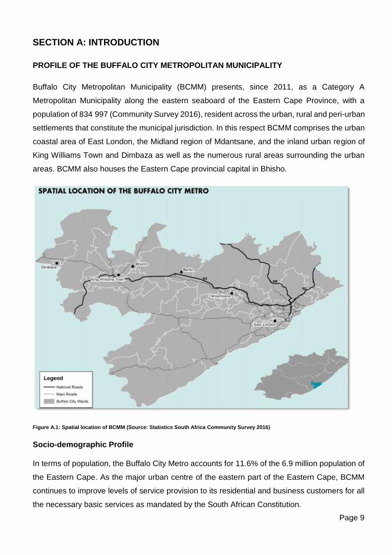
SECTION A: INTRODUCTION
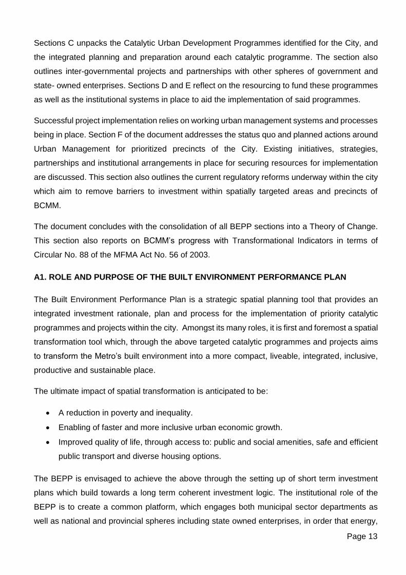
PROFILE OF THE BUFFALO CITY METROPOLITAN MUNICIPALITY
Buffalo City Metropolitan Municipality (BCMM) presents, since 2011, as a Category A
Metropolitan Municipality along the eastern seaboard of the Eastern Cape Province, with a
population of 834 997 (Community Survey 2016), resident across the urban, rural and peri-urban
settlements that constitute the municipal jurisdiction. In this respect BCMM comprises the urban
coastal area of East London, the Midland region of Mdantsane, and the inland urban region of
King Williams Town and Dimbaza as well as the numerous rural areas surrounding the urban
areas. BCMM also houses the Eastern Cape provincial capital in Bhisho.
Figure A.1: Spatial location of BCMM (Source: Statistics South Africa Community Survey 2016)
Socio-demographic Profile
In terms of population, the Buffalo City Metro accounts for 11.6% of the 6.9 million population of
the Eastern Cape. As the major urban centre of the eastern part of the Eastern Cape, BCMM
continues to improve levels of service provision to its residential and business customers for all
the necessary basic services as mandated by the South African Constitution.
Page 10
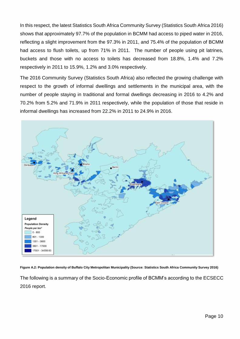
In this respect, the latest Statistics South Africa Community Survey (Statistics South Africa 2016)
shows that approximately 97.7% of the population in BCMM had access to piped water in 2016,
reflecting a slight improvement from the 97.3% in 2011, and 75.4% of the population of BCMM
had access to flush toilets, up from 71% in 2011. The number of people using pit latrines,
buckets and those with no access to toilets has decreased from 18.8%, 1.4% and 7.2%
respectively in 2011 to 15.9%, 1.2% and 3.0% respectively.
The 2016 Community Survey (Statistics South Africa) also reflected the growing challenge with
respect to the growth of informal dwellings and settlements in the municipal area, with the
number of people staying in traditional and formal dwellings decreasing in 2016 to 4.2% and
70.2% from 5.2% and 71.9% in 2011 respectively, while the population of those that reside in
informal dwellings has increased from 22.2% in 2011 to 24.9% in 2016.
Figure A.2: Population density of Buffalo City Metropolitan Municipality (Source: Statistics South Africa Community Survey 2016)
The following is a summary of the Socio-Economic profile of BCMM’s according to the ECSECC
2016 report.
Page 11
Gross Domestic Product (GDP)
BCMM contributed about 20.21% in GDP to the Eastern Cape Province GDP of R338 billion in
2016 and contributes 1.57% to the GDP of South Africa. In 2016 the growth rate of the economy
was at 0.35% for BCMM as compared to 0.28% for the whole of South Africa. For the period
2006 to 2016, the average annual growth rate of 1.9% of Buffalo City was the fourth relative to
other cities in the Eastern Cape in terms of growth in constant 2010 prices.
In 2016, the community services sector is the largest within BCMM accounting for 27.2% of the
total GVA in the metropolitan municipality’s economy. The sector that contributes the second
most to the GVA is the Finance sector at 21.3%, followed by the trade sector at 19.6%. Update:
There has been a steady decline in the manufacturing sector which contributes 13% in 2016.
This is followed by Transport at 10%, and Electricity and Construction at 4% each and Agriculture
at 1%.
Human Development Index (HDI)
The HDI is a composite statistic used for ranking by level of Human development. In 2016,
BCMM had an HDI of 0.667 compared to the Eastern Cape with HDI of 0.596 and 0.653 of
National Total. This translates to better human development for Buffalo City compared to South
Africa.
Gini Coefficient
The Gini Coefficient for BCMM stood at 0.638 as compared to 0.617 for the EC province in 2016.
This value still indicates inequality within the Metro despite the improvement as compared to
previous years. The Gini coefficient for the whole of South Africa was 0.628 in 2016.
Education level
The population within BCMM considered to be functionally illiterate stood at 19.5% at 2013, but
as at Community Survey 2016, only about 12.6% of the population is functional illiterate, i.e. with
no schooling at all.
Employment status
In 2016, the unemployment rate in BCMM was 26.30% as compared to 21.4% in 2013. BCMM
has experienced an annual increase of 0.88% in the number of unemployed people, which is
better than that of the Eastern Cape Province which had an average annual increase in
unemployment of 1.65%. The functional group constitute about 61.3% of the population for the
Metro as at Community Survey 2016 quarterly survey reports.
Page 12
Poverty
In 2016, there were 448 000 people living in poverty, using the upper poverty line definition,
across the Metro. This is 0.26% higher than the 447 000 in 2006. The percentage of people
living in poverty has declined from 58.33% in 2006 to 52.87% in 2016. Generally, the number of
people living in poverty is on the decline and for BCMM the figure stood at 47%, as compared
to 40% for the whole of South Africa and 55% for the EC province.
TRANSFORMING BCMM
In the 2019-2020 Built Environmental Performance Plan, BCMM continues to focus attention on
those areas that would drive and facilitate spatial transformation in order to alleviate the
challenges of sluggish economic growth in marginalised residential areas as well as areas of
business, trade and transport. Improved quality of life and living are addressed through its focus
on integrating transport and human settlement planning and projects.
The BEPP summarizes BCMM’s Built Environment Value Chain and associated activities which
will drive desired outcomes of compact and transformed urban spaces that are economically
and socially viable, liveable and sustainable. The 2019-2020 BEPP further introduces a key
sustainability dimension into its sphere of influence viz. that of holistic planning for and
integrating Climate Response Priorities into its strategic planning and budgeting processes. The
National Treasury Supplementary Guidance Note for the BEPP 2019/20 – 2020/22 provides a
framework for the phased integration of these priorities into each of the focus areas of the BEPP
(CSP, 2018).
Section A of the document outlines the role and purpose of the BEPP as well as its relationship
to other statutory plans and institutional systems in place to support the implementation and
monitoring of key spatial transformation interventions of the City.
Section B of the document addresses the key spatial transformational strategies and the
approach taken to spatial prioritization of areas for intervention. The section also addresses
planning initiatives in place as they relate to spatially targeted and prioritized areas. As per the
revised National Treasury Supplementary Guidance Note (2018), this section also includes the
web-link to existing Climate Change documents that have been prepared by BCMM as well as
the institutional arrangements in place for the incorporation of CR&R experts into the transversal
processes of the BEPP.
Page 13
Sections C unpacks the Catalytic Urban Development Programmes identified for the City, and
the integrated planning and preparation around each catalytic programme. The section also
outlines inter-governmental projects and partnerships with other spheres of government and
state- owned enterprises. Sections D and E reflect on the resourcing to fund these programmes
as well as the institutional systems in place to aid the implementation of said programmes.
Successful project implementation relies on working urban management systems and processes
being in place. Section F of the document addresses the status quo and planned actions around
Urban Management for prioritized precincts of the City. Existing initiatives, strategies,
partnerships and institutional arrangements in place for securing resources for implementation
are discussed. This section also outlines the current regulatory reforms underway within the city
which aim to remove barriers to investment within spatially targeted areas and precincts of
BCMM.
The document concludes with the consolidation of all BEPP sections into a Theory of Change.
This section also reports on BCMM’s progress with Transformational Indicators in terms of
Circular No. 88 of the MFMA Act No. 56 of 2003.
A1. ROLE AND PURPOSE OF THE BUILT ENVIRONMENT PERFORMANCE PLAN
The Built Environment Performance Plan is a strategic spatial planning tool that provides an
integrated investment rationale, plan and process for the implementation of priority catalytic
programmes and projects within the city. Amongst its many roles, it is first and foremost a spatial
transformation tool which, through the above targeted catalytic programmes and projects aims
to transform the Metro’s built environment into a more compact, liveable, integrated, inclusive,
productive and sustainable place.
The ultimate impact of spatial transformation is anticipated to be:
• A reduction in poverty and inequality.
• Enabling of faster and more inclusive urban economic growth.
• Improved quality of life, through access to: public and social amenities, safe and efficient
public transport and diverse housing options.
The BEPP is envisaged to achieve the above through the setting up of short term investment
plans which build towards a long term coherent investment logic. The institutional role of the
BEPP is to create a common platform, which engages both municipal sector departments as
well as national and provincial spheres including state owned enterprises, in order that energy,
Page 14
efforts and funding is pooled and aligned to create programmes and projects that are of greater
collective impact. This is achieved through an ongoing interdepartmental as well as
intergovernmental conversation. ‘The BEPP is intended to be the reference point for national
and provincial spheres and other key stakeholders to make informed decisions in the built
environment, led by municipal planning. The national and provincial departments and state-
owned entities will be able to see the impact of their investment as it relates to other sectors in
terms of cumulative local outcome and impact.’ (National Treasury Guidance Note: BEPP
Framework v.5.5, 2017).
Through the above shared platform, the BEPP provides an opportunity to align various grant
funding and is also an eligibility requirement / instrument for compliance and submission
purposes for the following infrastructure grants:
• ICDG: Integrated City Development Grant, Schedule 4B (specific purpose allocations to
municipalities);
• USDG: Urban Settlements Development Grant, Schedule 4B (supplements municipal
budgets), which will include the newly ringfenced Upgrading Informal Settlements
Programme Grant.
• HSDG: Human Settlements Development Grant, Schedule 5A (specific purpose
allocations to provinces);
• PTNG: Public Transport Network Grant, Schedule 5B (specific purpose allocations to
municipalities);
• NDPG: Neighbourhood Development Partnership Grant, Schedule 5B (Capital Grant),
Schedule 6B (Technical Assistance)
• INEP: Integrated National Electrification Grant, Schedule 5B (specific purpose
allocations to municipalities) – now to be integrated into the USDG in 2019-2020.
A2. BEPP IN RELATION TO OTHER STATUTORY PLANS
As described below, the BEPP is designed as a planning tool that will align, refine and
consolidate the metro’s existing planning instruments through a focused investment strategy and
implementation plan that will enable fast tracked and inclusive economic growth.
The BEPP is complimentary to the metro’s other strategic documents, including the Metro
Growth and Development Strategy which provides the strategic frame and vision for the city, the
Municipal Spatial Development Framework, the Integrated Public Transport Network Plan, the
Integrated Human Settlements Plan all of which align with and feed into the Integrated
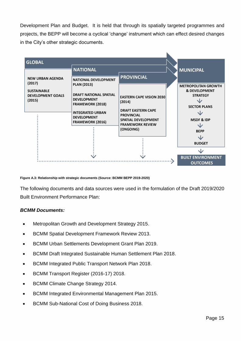
Page 15
Development Plan and Budget. It is held that through its spatially targeted programmes and
projects, the BEPP will become a cyclical ‘change’ instrument which can effect desired changes
in the City’s other strategic documents.
Figure A.3: Relationship with strategic documents (Source: BCMM BEPP 2019-2020)
The following documents and data sources were used in the formulation of the Draft 2019/2020
Built Environment Performance Plan:
BCMM Documents:
• Metropolitan Growth and Development Strategy 2015.
• BCMM Spatial Development Framework Review 2013.
• BCMM Urban Settlements Development Grant Plan 2019.
• BCMM Draft Integrated Sustainable Human Settlement Plan 2018.
• BCMM Integrated Public Transport Network Plan 2018.
• BCMM Transport Register (2016-17) 2018.
• BCMM Climate Change Strategy 2014.
• BCMM Integrated Environmental Management Plan 2015.
• BCMM Sub-National Cost of Doing Business 2018.
Page 16
• BCMM ULI Advisory Services Panel Report, 2014.
• BCMDA - A University Town in Buffalo City, Concept Note and Implementation Proposal,2019
Local Spatial Development Frameworks/Spatial Policy completed since SDF of 2003:
• Vincent Berea LSDF (2004).
• Mt Ruth Framework Plan (2005).
• Quenera LSDF (2005).
• Urban Edge Policy Framework (2008).
• Bonza Bay LSDF (2008).
• Duncan Village LSDF (2009).
• Beach Front LSDF (2010).
• Gonubie Main Road LSDF (2012).
• Bhisho KWT LSDF (2013).
• Mdantsane LSDF Review (2013).
• Vincent Berea LSDF Review (2013).
• Mdantsane Industrial Feasibility Study (2015).
• Sleeper Site Framework Plan (2016).
• Mdantsane Urban Hub Precinct Plan (2016).
• West Bank LSDF (2004).
• Mount Coke Dimbaza LSDF (2008).
• Kwelera LSDF (2013).
• Newlands LSDF (2015).
National and Provincial Documents:
• National Development Plan, 2013.
• Spatial Planning & Land Use Management Act (Act 16 of 2013).
• National Treasury Core Guidance Note for the Built Environment Performance Plan v5.5, 2017.
• National Treasury Supplementary Guidance Note for the Built Environment Performance Plan (BEPP) 2019-20 – 2020-2022: Integrating Climate Response Priorities into BEPP, 2018.
Page 17
• Mainstreaming Climate Responsiveness into City Plans, Budgets and Grant Conditions, BEPP Guidance Note, 2018.
• Concept Note for the Built Environment Value Chain and Progression Model, 23 September 2016.
• DORA 2019 including the grant frameworks of the relevant infrastructure grants.
• The Guidelines for the Implementation of the Integrated City Development Grant, May 2013 and as updated.
• Guidance Notes, toolkits and other relevant documents relating to the Neighbourhood Development Programme.
• Framework for Spatial Investment in Human Settlements prepared by CSIR, 31 March 2015 Plan, August 2014.
• Framework for the Urban Settlements Development Grant, 2019.
• National Human Settlements Spatial Plan, August 2014 and as updated.
• Eastern Cape Vision 2030, 2014.
• Draft Eastern Cape Provincial Spatial Development Plan, 2018.
A3. ALIGNING THE BEPP WITH IDP AND BUDGET
Circular No. 88 (Nov 2017) of the MFMA Act No. 56 of 2003, introduced a new set of integrated
indicators that rationalise planning and reporting requirements for the 2018/19 MTREF. The Built
Environment Performance Plan was identified as the most appropriate planning instrument to
measure transformational outcomes that focus on the extent of spatial transformation in the city.
Integration and alignment between the BEPP, broader city strategies, the IDP and budget
therefore becomes critical in ensuring that transformational outcomes are realised and delivered.
Circular No. 88 identifies City Transformational Outcomes as:
• Targeted investments in integration zones;
• Reduction in urban sprawl;
• New housing options with social diversity; and
• Affordable and efficient public transport services.
The key areas where the above four transformational outcomes align with BCMM’s other
strategic planning documents such as the Metro Growth and Development Strategy and the IDP
as well as its linkage to the 2019/20 budget is shown through the diagram below. The capital
budget amounts indicated encompass the broad outcomes contained in the aligned MGDS &
IDP outcome areas and are not indicative of BEPP outcomes alone.
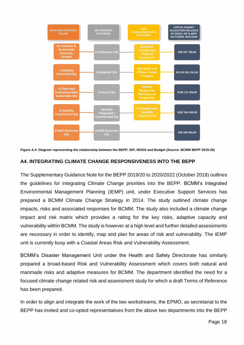
Page 18
Figure A.4: Diagram representing the relationship between the BEPP, IDP, MGDS and Budget (Source: BCMM BEPP 2019-20)
A4. INTEGRATING CLIMATE CHANGE RESPONSIVENESS INTO THE BEPP
The Supplementary Guidance Note for the BEPP 2019/20 to 2020/2022 (October 2018) outlines
the guidelines for integrating Climate Change priorities into the BEPP. BCMM’s Integrated
Environmental Management Planning (IEMP) unit, under Executive Support Services has
prepared a BCMM Climate Change Strategy in 2014. The study outlined climate change
impacts, risks and associated responses for BCMM. The study also included a climate change
impact and risk matrix which provides a rating for the key risks, adaptive capacity and
vulnerability within BCMM. The study is however at a high level and further detailed assessments
are necessary in order to identify, map and plan for areas of risk and vulnerability. The IEMP
unit is currently busy with a Coastal Areas Risk and Vulnerability Assessment.
BCMM’s Disaster Management Unit under the Health and Safety Directorate has similarly
prepared a broad-based Risk and Vulnerability Assessment which covers both natural and
manmade risks and adaptive measures for BCMM. The department identified the need for a
focused climate change related risk and assessment study for which a draft Terms of Reference
has been prepared.
In order to align and integrate the work of the two workstreams, the EPMO, as secretariat to the
BEPP has invited and co-opted representatives from the above two departments into the BEPP
MGDS 2030 STRATEGIC PILLARS
An Inclusive & Sustainable Economic Growth
A Globally Connected City
A Clean and Environmentally Sustainable City
A Spatially Transformed city
A Well Governed City
IDP STRATEGIC OUTCOMES
A Productive City
Connected City
A Green City
Spatially Integrated /
Transformed City
A Well Governed City
BEPP TRANSFORMATIONAL
OUTCOMES
Economic Growth and
Targeted Investment
Affordable and Efficient Public
Transport
Climate Responsive
Planning and Budgetting
A Compact and Spatially
Targeted City
CAPITAL BUDGET ALLOCATION INCLUSIVE OF MGDS, IDP & BEPP OUTCOMES 2019/2020
R48 337 799,00
R1 074 035 531,00
R128 121 458,00
R267 963 690,00
R96 500 000,00
Page 19
Task Team. An integrated Terms of Reference for a city-wide Climate Change Risk and
Vulnerability Assessment is currently being crafted through joint inputs from the Spatial Planning
and Asset Management Departments of the City. In order to integrate projects arising from this
study into the BEPP, the EPMO will serve as secretariat to this process and it has been agreed
that the Disaster Management Unit will manage and run with the project through a Project
Steering Committee comprising of the above-mentioned departments. The outputs from the
above study once implemented will need to further inform spatial targeting areas of the BEPP.
A5. INSTITUTIONALISING THE BEPP
A5.1 The Influence of the BEPP on the IDP and Budget
The catalytic land development programmes outlined in the BEPP have been confirmed as city
priorities in the Mayoral and Council Lekgotla’s which set priorities for the 2019/20 financial year.
In the process of formulating the 2019/20 IDP and budget, meetings have taken place between
the EPMO (as the technical driver of the BEPP within BCMM), Executive Support Services (GM
responsible for IDP) and representatives for budget planning (Finance). The IDP Strategic
Workshops for 2019/20 included a budget checklist in which Directorates were required to
prioritise projects based on Mayoral Lekgotla priorities, BEPP linkage to Catalytic Programmes
and Projects, linkage to Audit Improvement Plans and Auditor General findings.
Catalytic land development programmes identified in the BEPP have through the above
processes been incorporated into the 2019-2020 IDP and 2019-2020 Budget processes of
BCMM. The spatial targeting of areas and budgeting for catalytic projects within programmes
has been strengthening through enhanced coordination and integration of projects within
individual Catalytic Programmes.
A5.2 The Influence of the BEPP on the SDF Review
The Spatial Planning and Development Directorate, which coordinates and prepares the SDF,
has representation on the BEPP Task Team which is a team of inter-departmental
representatives from all sectors of the BCMM. The Urban Network Strategy of the BEPP, and
the Integration Zones will be integrated into the SDF as part of the SDF Review which is currently
underway and scheduled to be completed by September 2019.
Page 20
A5.3 Institutional arrangements in place for managing transversal management
priorities
Managing transversal priorities and projects within the City is achieved through the BEPP Task
Team which, as mentioned above, is an inter-departmental Task Team that meets on a regular
basis to discuss and coordinate Catalytic Land Development Programmes of the BEPP. The
EPMO convenes and serves as secretariat to the BEPP Task Team.
The 2018-19 BEPP process also initiated the formation of an Inter-Governmental Task Team
which includes representation from National Department of Public Works, Provincial Treasury,
as well as state owned enterprises such as the BCMDA, the Port Authorities, ACSA, SANRAL,
PRASA and Eskom.
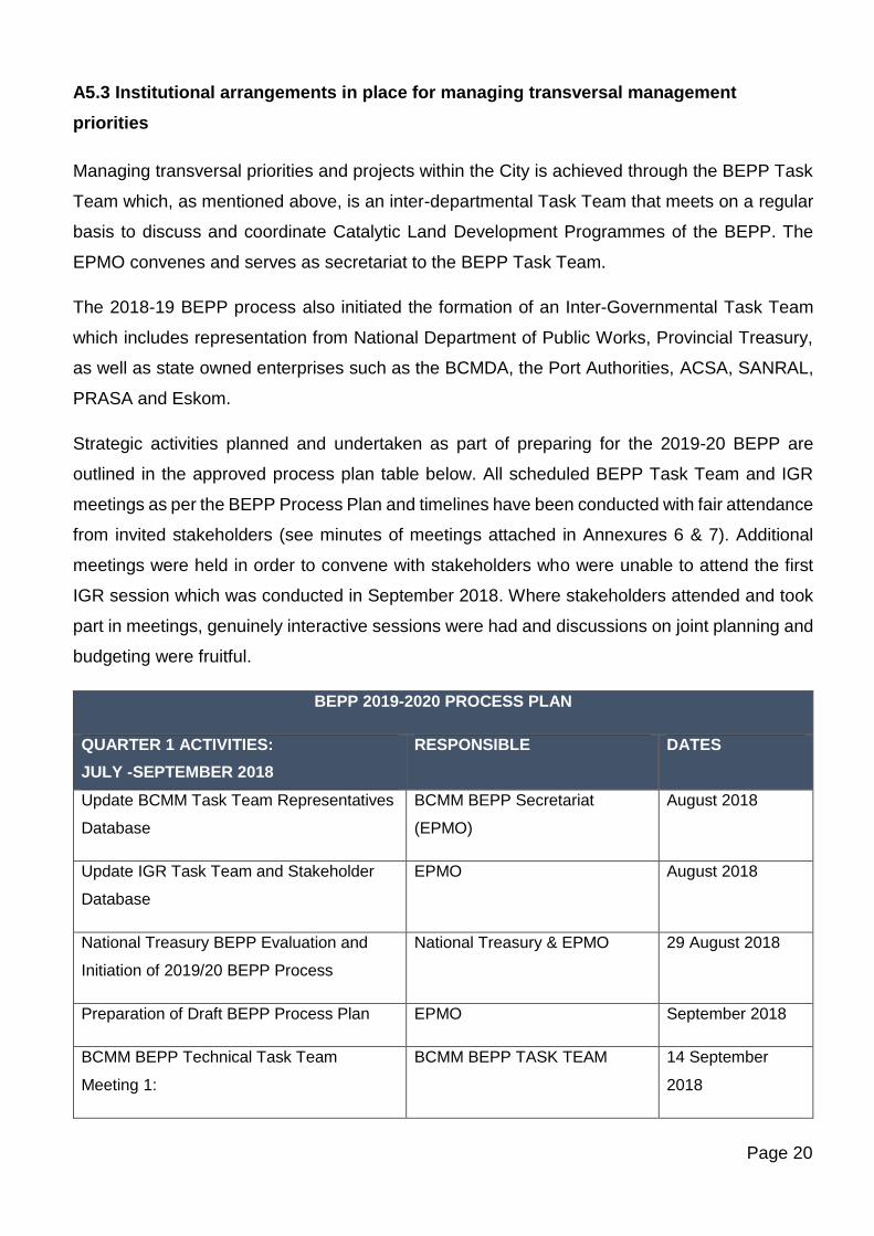
Strategic activities planned and undertaken as part of preparing for the 2019-20 BEPP are
outlined in the approved process plan table below. All scheduled BEPP Task Team and IGR
meetings as per the BEPP Process Plan and timelines have been conducted with fair attendance
from invited stakeholders (see minutes of meetings attached in Annexures 6 & 7). Additional
meetings were held in order to convene with stakeholders who were unable to attend the first
IGR session which was conducted in September 2018. Where stakeholders attended and took
part in meetings, genuinely interactive sessions were had and discussions on joint planning and
budgeting were fruitful.
BEPP 2019-2020 PROCESS PLAN
QUARTER 1 ACTIVITIES:
JULY -SEPTEMBER 2018
RESPONSIBLE DATES
Update BCMM Task Team Representatives
Database
BCMM BEPP Secretariat
(EPMO)
August 2018
Update IGR Task Team and Stakeholder
Database
EPMO August 2018
National Treasury BEPP Evaluation and
Initiation of 2019/20 BEPP Process
National Treasury & EPMO 29 August 2018
Preparation of Draft BEPP Process Plan EPMO September 2018
BCMM BEPP Technical Task Team
Meeting 1:
BCMM BEPP TASK TEAM 14 September
2018
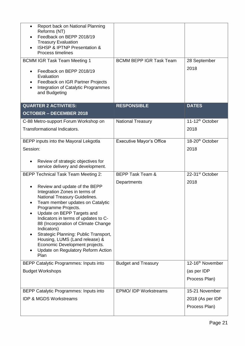
Page 21
• Report back on National Planning Reforms (NT)
• Feedback on BEPP 2018/19 Treasury Evaluation
• ISHSP & IPTNP Presentation & Process timelines
BCMM IGR Task Team Meeting 1
• Feedback on BEPP 2018/19 Evaluation
• Feedback on IGR Partner Projects
• Integration of Catalytic Programmes and Budgeting
BCMM BEPP IGR Task Team 28 September
2018
QUARTER 2 ACTIVITIES:
OCTOBER – DECEMBER 2018
RESPONSIBLE DATES
C-88 Metro-support Forum Workshop on
Transformational Indicators.
National Treasury 11-12th October
2018
BEPP inputs into the Mayoral Lekgotla
Session:
• Review of strategic objectives for service delivery and development.
Executive Mayor’s Office 18-20th October
2018
BEPP Technical Task Team Meeting 2:
• Review and update of the BEPP Integration Zones in terms of National Treasury Guidelines.
• Team member updates on Catalytic Programme Projects.
• Update on BEPP Targets and Indicators in terms of updates to C-88 (Incorporation of Climate Change Indicators)
• Strategic Planning: Public Transport, Housing, LUMS (Land release) & Economic Development projects.
• Update on Regulatory Reform Action Plan
BEPP Task Team &
Departments
22-31st October
2018
BEPP Catalytic Programmes: Inputs into
Budget Workshops
Budget and Treasury 12-16th November
(as per IDP
Process Plan)
BEPP Catalytic Programmes: Inputs into
IDP & MGDS Workstreams
EPMO/ IDP Workstreams 15-21 November
2018 (As per IDP
Process Plan)
Page 22
BEPP IGR Session 2 & bi-laterals as
required
EPMO November –
December 2018
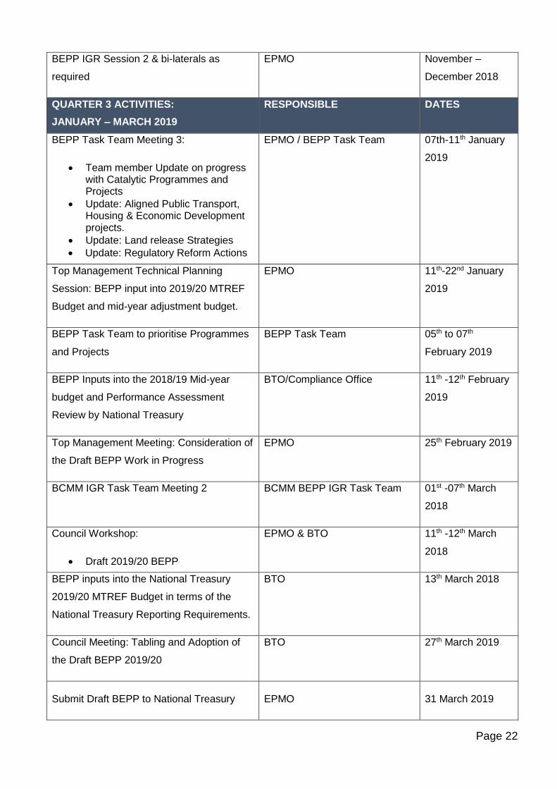
QUARTER 3 ACTIVITIES:
JANUARY – MARCH 2019
RESPONSIBLE DATES
BEPP Task Team Meeting 3:
• Team member Update on progress with Catalytic Programmes and Projects
• Update: Aligned Public Transport, Housing & Economic Development projects.
• Update: Land release Strategies
• Update: Regulatory Reform Actions
EPMO / BEPP Task Team 07th-11th January
2019
Top Management Technical Planning
Session: BEPP input into 2019/20 MTREF
Budget and mid-year adjustment budget.
EPMO 11th-22nd January
2019
BEPP Task Team to prioritise Programmes
and Projects
BEPP Task Team 05th to 07th
February 2019
BEPP Inputs into the 2018/19 Mid-year
budget and Performance Assessment
Review by National Treasury
BTO/Compliance Office 11th -12th February
2019
Top Management Meeting: Consideration of
the Draft BEPP Work in Progress
EPMO 25th February 2019
BCMM IGR Task Team Meeting 2 BCMM BEPP IGR Task Team 01st -07th March
2018
Council Workshop:
• Draft 2019/20 BEPP
EPMO & BTO 11th -12th March
2018
BEPP inputs into the National Treasury
2019/20 MTREF Budget in terms of the
National Treasury Reporting Requirements.
BTO 13th March 2018
Council Meeting: Tabling and Adoption of
the Draft BEPP 2019/20
BTO 27th March 2019
Submit Draft BEPP to National Treasury EPMO 31 March 2019
Page 23
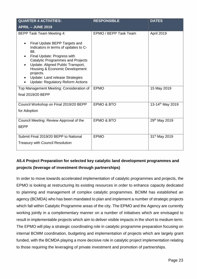
QUARTER 4 ACTIVITIES:
APRIL – JUNE 2019
RESPONSIBLE DATES
BEPP Task Team Meeting 4:
• Final Update BEPP Targets and Indicators in terms of updates to C-88.
• Final Update: Progress with Catalytic Programmes and Projects
• Update: Aligned Public Transport, Housing & Economic Development projects.
• Update: Land release Strategies
• Update: Regulatory Reform Actions
EPMO / BEPP Task Team April 2019
Top Management Meeting: Consideration of
final 2019/20 BEPP
EPMO 15 May 2019
Council Workshop on Final 2019/20 BEPP
for Adoption
EPMO & BTO 13-14th May 2019
Council Meeting: Review Approval of the
BEPP
EPMO & BTO 29th May 2019
Submit Final 2019/20 BEPP to National
Treasury with Council Resolution
EPMO 31st May 2019
A5.4 Project Preparation for selected key catalytic land development programmes and
projects (leverage of investment through partnerships)
In order to move towards accelerated implementation of catalytic programmes and projects, the
EPMO is looking at restructuring its existing resources in order to enhance capacity dedicated
to planning and management of complex catalytic programmes. BCMM has established an
agency (BCMDA) who has been mandated to plan and implement a number of strategic projects
which fall within Catalytic Programme areas of the city. The EPMO and the Agency are currently
working jointly in a complementary manner on a number of initiatives which are envisaged to
result in implementable projects which aim to deliver visible impacts in the short to medium term.
The EPMO will play a strategic coordinating role in catalytic programme preparation focusing on
internal BCMM coordination, budgeting and implementation of projects which are largely grant
funded, with the BCMDA playing a more decisive role in catalytic project implementation relating
to those requiring the leveraging of private investment and promotion of partnerships.
Page 24
A5.5 Technical support from CSP
In order to support and accelerate catalytic and strategic programme and project
implementation, strategic technical support is required to be assembled to assist the City. This
includes support around project value assessment and management; business case
development and due diligence; transaction advisory and financial structuring; as well as
governance models and framework design. In order to move catalytic projects closer to
implementation, the CSP has been approached to make such support available. This will
supplement the GTAC technical support being provided to the BCMM.
The CSP with the support of external consultants is currently busy with the preparation of a
detailed scoping report for the Sleeper Site sub-programme of the BEPP. The Sleeper Site falls
within the East London CBD and Inner-City Regeneration Programme of the City. The Buffalo
City Development Agency (BCMDA) has been mandated by BCMM to develop the Sleeper Site.
Through effective working partnerships with the City and the EPMO as convenor of Catalytic
Programmes, it is envisaged that a streamlined, aligned and integrated project pipeline and
programme for the Sleeper Site can be developed.
Further areas identified for CSP support are around the roll out of the City Infrastructure Delivery
and Management System (CIDMS) for BCMM. The CIDMS hasn’t been effectively implemented
in the city and training of project managers and other relevant officials is seen as essential in
unlocking CIDMS in the Metro.
A further proposed area of support to the metro would be to assist with undertaking a residential
property market study in order to enable the city to have a better understanding of the dynamics
of the local residential property market, as well as to map out existing supply vs need for the
different residential properties offerings in the Metro over and above fully subsidised housing.
These include the analysis of the Social Housing, CRU, BNG, and FLISP/Gap unit market. This
gap is required to be closed in order to inform the completion of the draft Integrated Human
Settlements Plan which has been prepared by the City.
A5.6 Monitoring the BEPP outcomes
Both the BEPP Task Team and the IGR Task Team will be convened quarterly and twice yearly
respectively to report on BEPP implementation, identify bottlenecks and solutions, and escalate
those issues which cannot be resolved technically to the City Manager and Council for
Page 25
resolution. Quarterly BEPP Performance Reports are prepared by the BEPP Task Team
secretariat (EPMO).
A5.7 Submission of Final 2019-20 BEPP Document to Council
The Draft BEPP 2019-2020 will be tabled together with the Draft IDP and Draft MTREF at the
Council meeting held on 27 March 2019. The Final BEPP 2019-20 will be submitted together
with the Final IDP and Final MTREF at the Council Meeting scheduled to take place on the 29th
May 2019.
Page 26
SECTION B : SPATIAL PLANNING & TARGETING
SPATIAL PLANNING BACKGROUND
The National Development Plan
The National Development Plan (NDP) advocated “a national focus on spatial transformation”.
Chapter 8 was specifically called ‘Transforming Human Settlements’. The NDP introduced five
broad normative principles to guide the formulation of a national spatial framework, to inform
urban and rural development policies, to strengthen spatial planning instruments, and to help
build institutional capabilities for spatial governance at Local, Provincial and National levels. The
principles are: spatial justice; spatial sustainability; spatial resilience; spatial quality; spatial
efficiency.
Beyond the broad principles, the NDP understood the spatial transformation of cities in terms of
three of the elements of urban structure i.e. – jobs, housing and transport. It suggested that there
were five ways in which these elements could be used to promote urban restructuring:
• To reduce travel costs and distances,
• To prevent further development of housing in marginal places,
• To increase urban densities and reduce sprawl,
• To improve public transport and the coordination between transport modes, and
• To shift jobs and investment towards dense peripheral townships.
Spatial transformation will clearly mean different things in different local contexts, depending on
the socio-economic composition and physical characteristics of the area. Nevertheless, several
general principles of urban efficiency and good design seem relevant to most situations:
• Mixed-use development instead of mono-functional settlements,
• Mixed-income residential schemes rather than exclusive housing schemes,
• Public transport-oriented projects rather than private car-oriented projects,
• Improved public spaces and opportunities for walking rather than private cars,
• Higher density developments rather than low density sprawl,
• Brownfield (re)development, renewal and retrofitting of old buildings rather than new
greenfield development,
Page 27
• An emphasis on affordable housing in well-located areas, i.e. in and around transport
nodes and corridors.
• Public consultation and popular involvement in area-based planning to ensure more of a
people-based perspective, and less of a prescriptive, top-down approach.
Integrated Urban Development Framework (IUDF)
The IUDF is the government’s policy position to guide the future growth and management of its
urban areas. It seeks to foster a shared understanding across government and society about
how best to manage urbanization and achieve goals of economic development, job creation and
improved living conditions for all.
The IUDF is a response to and builds on various chapters in the National Development Plan,
more specifically Chapter 8 which deals with “Transforming human settlements and the national
space economy”. To achieve this transformative vision, four strategic goals are introduced.
• Spatial Integration: To forge new spatial forms in settlement, transport, social and
economic areas.
• Inclusion and access: To ensure people have access to social and economic services,
opportunities and choices.
• Growth: To harness urban dynamism for inclusive, sustainable economic growth and
development.
• Governance: To enhance the capacity of the state and its citizens to work together to
achieve spatial and social integration.
The above strategic goals give rise to a series of policy levers, the implementation of which
depends on its integration into municipal development planning tools such as the SDF, IDP and
BEPP. The nine policy levers include:
• Integrated Urban Planning and Management: the prudent use of land and natural
resources to build sustainable communities.
• Integrated transport and mobility: the development of efficient urban form centred
around integrated transport, which supports economic and social development.
• Integrated and sustainable human settlements: redressing the prevailing apartheid
geography, restructuring cities, shifting ownership profiles and choices, and creating
more humane, safe living and working conditions.
Page 28
• Integrated urban infrastructure: the development of resource efficient urban
infrastructure that provides for both universal access and more inclusive economic
growth.
• Efficient land governance and management: growing investments through land and
property resulting in inclusive, multi-functional urban spaces.
• Inclusive economic development: Cities and towns that are dynamic and efficient,
foster entrepreneurial and innovation, sustain livelihoods, enable economic growth and
generates the tax base needed to sustain and expand public services and amenities.
• Empowered active communities: Cities and towns that are home to socially and
culturally diverse citizens, who are actively involved in the city.
• Effective urban governance: Managing the intergovernmental dynamics within the city.
• Sustainable finances: Cities and towns that are supported by a fiscal framework that
acknowledges the developmental potential and pressures of urban spaces and manages
finances effectively and efficiently in order to access necessary resources and
partnerships for inclusive urban growth.
BCMM given its jurisdiction within a predominantly rural development context, the IUDF’s
emphasis on the rural-urban continuum and the ability of urban areas to respond to in-migration
in a manner that optimises the urban dividend stresses the need to focus on poverty alleviation,
job creation and the creation or more liveable settlements especially for marginalised and
informal settlements within the metropolitan area.
Metropolitan Growth and Development Strategy Vision 2030 (MGDS)
The Metropolitan Growth and Development Strategy identifies five strategic pillars for the
realisation of realistic, achievable and measurable goals for the Metro:
• An inclusive and sustainable economic growth.
• A globally connected city.
• A clean and environmentally sustainable city.
• A spatially transformed city and a well governed city.
• A well governed city.
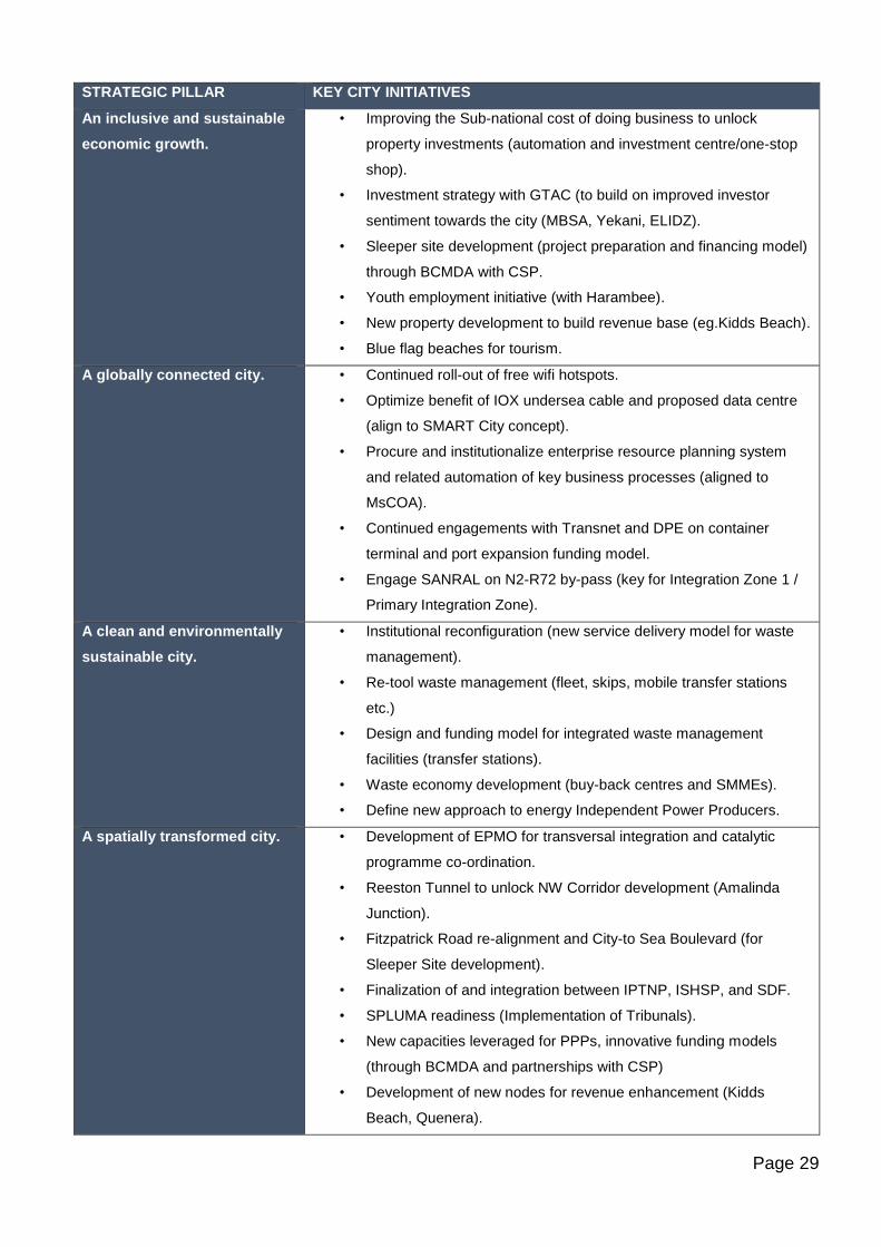
Key city initiatives pertaining to each of the above strategic pillars are summarised in the Table
below:
Page 29
STRATEGIC PILLAR KEY CITY INITIATIVES
An inclusive and sustainable
economic growth.
• Improving the Sub-national cost of doing business to unlock
property investments (automation and investment centre/one-stop
shop).
• Investment strategy with GTAC (to build on improved investor
sentiment towards the city (MBSA, Yekani, ELIDZ).
• Sleeper site development (project preparation and financing model)
through BCMDA with CSP.
• Youth employment initiative (with Harambee).
• New property development to build revenue base (eg.Kidds Beach).
• Blue flag beaches for tourism.
A globally connected city. • Continued roll-out of free wifi hotspots.
• Optimize benefit of IOX undersea cable and proposed data centre
(align to SMART City concept).
• Procure and institutionalize enterprise resource planning system
and related automation of key business processes (aligned to
MsCOA).
• Continued engagements with Transnet and DPE on container
terminal and port expansion funding model.
• Engage SANRAL on N2-R72 by-pass (key for Integration Zone 1 /
Primary Integration Zone).
A clean and environmentally
sustainable city.
• Institutional reconfiguration (new service delivery model for waste
management).
• Re-tool waste management (fleet, skips, mobile transfer stations
etc.)
• Design and funding model for integrated waste management
facilities (transfer stations).
• Waste economy development (buy-back centres and SMMEs).
• Define new approach to energy Independent Power Producers.
A spatially transformed city. • Development of EPMO for transversal integration and catalytic
programme co-ordination.
• Reeston Tunnel to unlock NW Corridor development (Amalinda
Junction).
• Fitzpatrick Road re-alignment and City-to Sea Boulevard (for
Sleeper Site development).
• Finalization of and integration between IPTNP, ISHSP, and SDF.
• SPLUMA readiness (Implementation of Tribunals).
• New capacities leveraged for PPPs, innovative funding models
(through BCMDA and partnerships with CSP)
• Development of new nodes for revenue enhancement (Kidds
Beach, Quenera).
Page 30
A well governed city. • Audit improvement plan and risk management.
• Automation (enterprise resource planning system).
• City branding and communications.
• Culture change and performance excellence (partnership with
MBSA and GTAC) including for Council.
• Roll-out of revenue enhancement strategy (including billing system
improvements, aggressive strategy to reduce municipal debt, and
cost-cutting measures).
• Integrated customer relations management system.
Source: BCMM Executive Support Services and GTAC
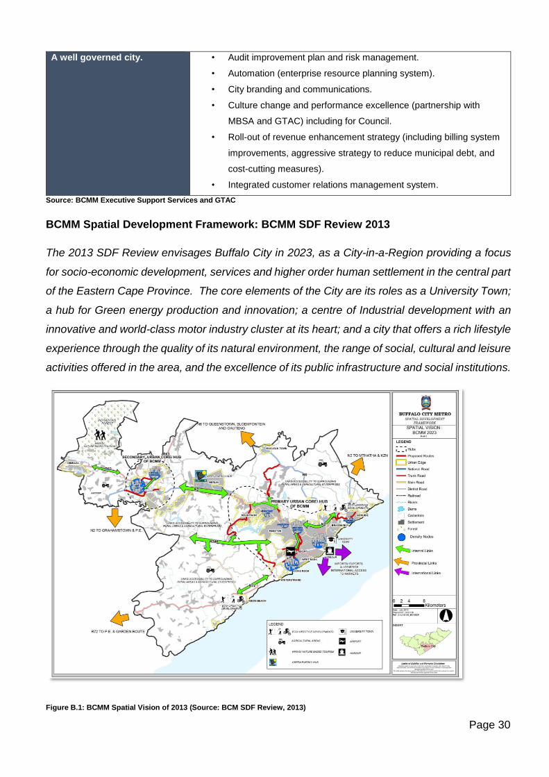
BCMM Spatial Development Framework: BCMM SDF Review 2013
The 2013 SDF Review envisages Buffalo City in 2023, as a City-in-a-Region providing a focus
for socio-economic development, services and higher order human settlement in the central part
of the Eastern Cape Province. The core elements of the City are its roles as a University Town;
a hub for Green energy production and innovation; a centre of Industrial development with an
innovative and world-class motor industry cluster at its heart; and a city that offers a rich lifestyle
experience through the quality of its natural environment, the range of social, cultural and leisure
activities offered in the area, and the excellence of its public infrastructure and social institutions.
Figure B.1: BCMM Spatial Vision of 2013 (Source: BCM SDF Review, 2013)
Page 31
The 2013 SDF vision remains relevant in the present context. The SDF is currently under review
and the updated SDF is scheduled for completion by September 2019.
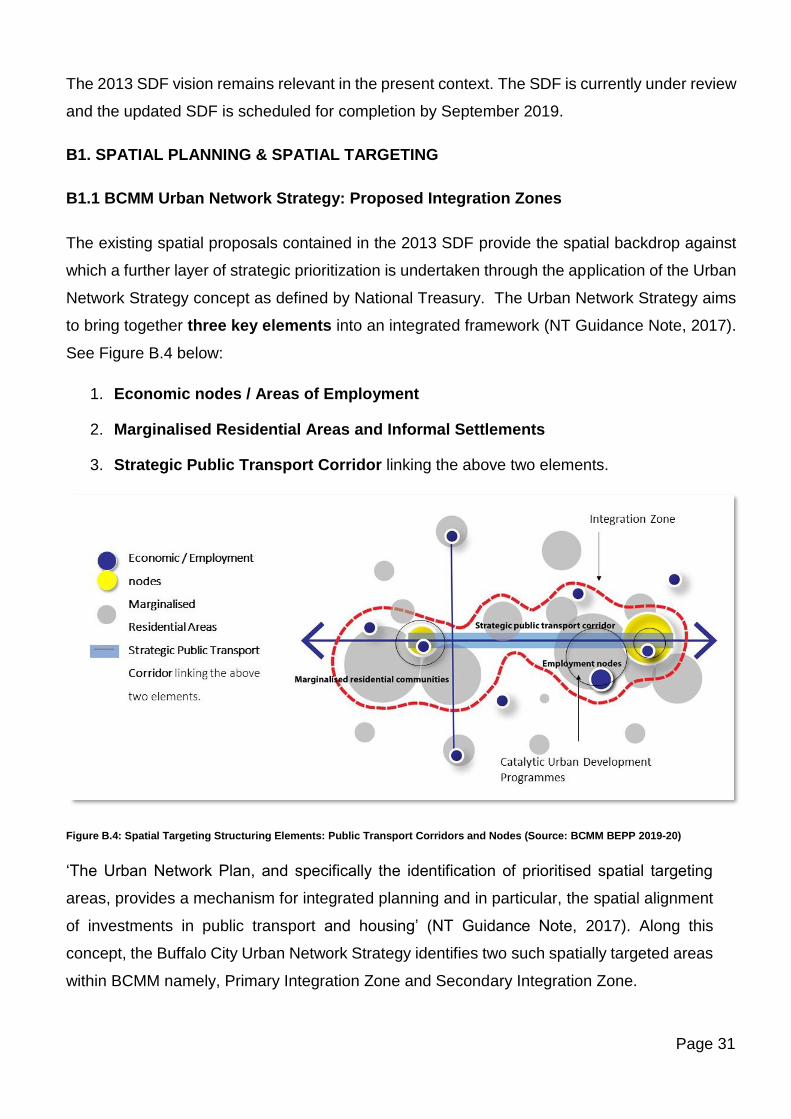
B1. SPATIAL PLANNING & SPATIAL TARGETING
B1.1 BCMM Urban Network Strategy: Proposed Integration Zones
The existing spatial proposals contained in the 2013 SDF provide the spatial backdrop against
which a further layer of strategic prioritization is undertaken through the application of the Urban
Network Strategy concept as defined by National Treasury. The Urban Network Strategy aims
to bring together three key elements into an integrated framework (NT Guidance Note, 2017).
See Figure B.4 below:
1. Economic nodes / Areas of Employment
2. Marginalised Residential Areas and Informal Settlements
3. Strategic Public Transport Corridor linking the above two elements.
Figure B.4: Spatial Targeting Structuring Elements: Public Transport Corridors and Nodes (Source: BCMM BEPP 2019-20)
‘The Urban Network Plan, and specifically the identification of prioritised spatial targeting
areas, provides a mechanism for integrated planning and in particular, the spatial alignment
of investments in public transport and housing’ (NT Guidance Note, 2017). Along this
concept, the Buffalo City Urban Network Strategy identifies two such spatially targeted areas
within BCMM namely, Primary Integration Zone and Secondary Integration Zone.
Page 32
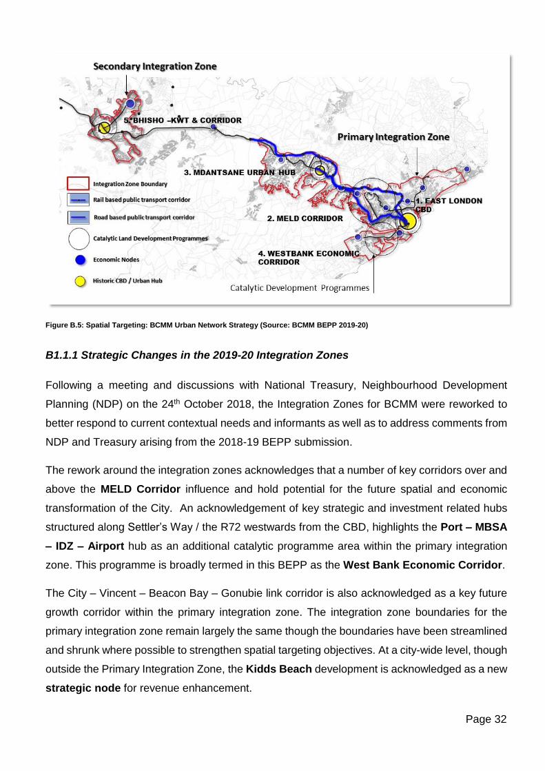
Figure B.5: Spatial Targeting: BCMM Urban Network Strategy (Source: BCMM BEPP 2019-20)
B1.1.1 Strategic Changes in the 2019-20 Integration Zones
Following a meeting and discussions with National Treasury, Neighbourhood Development
Planning (NDP) on the 24th October 2018, the Integration Zones for BCMM were reworked to
better respond to current contextual needs and informants as well as to address comments from
NDP and Treasury arising from the 2018-19 BEPP submission.
The rework around the integration zones acknowledges that a number of key corridors over and
above the MELD Corridor influence and hold potential for the future spatial and economic
transformation of the City. An acknowledgement of key strategic and investment related hubs
structured along Settler’s Way / the R72 westwards from the CBD, highlights the Port – MBSA
– IDZ – Airport hub as an additional catalytic programme area within the primary integration
zone. This programme is broadly termed in this BEPP as the West Bank Economic Corridor.
The City – Vincent – Beacon Bay – Gonubie link corridor is also acknowledged as a key future
growth corridor within the primary integration zone. The integration zone boundaries for the
primary integration zone remain largely the same though the boundaries have been streamlined
and shrunk where possible to strengthen spatial targeting objectives. At a city-wide level, though
outside the Primary Integration Zone, the Kidds Beach development is acknowledged as a new
strategic node for revenue enhancement.
Page 33
The secondary integration zone has also been amended along similar principles of that of the
primary integration zone. The boundaries now include marginalised residential areas and
townships as with the case of the primary integration zone. These were previously neglected in
the previous iteration of the Secondary Integration Zone.
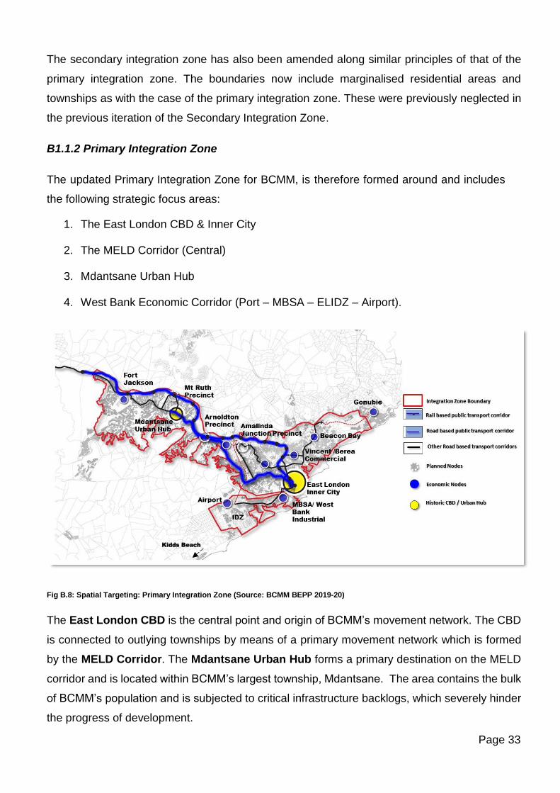
B1.1.2 Primary Integration Zone
The updated Primary Integration Zone for BCMM, is therefore formed around and includes
the following strategic focus areas:
1. The East London CBD & Inner City
2. The MELD Corridor (Central)
3. Mdantsane Urban Hub
4. West Bank Economic Corridor (Port – MBSA – ELIDZ – Airport).
Fig B.8: Spatial Targeting: Primary Integration Zone (Source: BCMM BEPP 2019-20)
The East London CBD is the central point and origin of BCMM’s movement network. The CBD
is connected to outlying townships by means of a primary movement network which is formed
by the MELD Corridor. The Mdantsane Urban Hub forms a primary destination on the MELD
corridor and is located within BCMM’s largest township, Mdantsane. The area contains the bulk
of BCMM’s population and is subjected to critical infrastructure backlogs, which severely hinder
the progress of development.
Kidds Beach
Page 34
Other Strategic Integrated Public Transport Routes identified in the recently completed (2018)
BCMM Integrated Public Transport Network Plan (IPTN) particularly of significance to the
Primary Integration Zone include the East London CBD - R72 / Settler’s Way- to Airport link
as well as the R72- Devereaux Avenue, Beaconhurst Drive link eastwards to Gonubie.
Strategic investments along the West Bank R72 / Settler’s Way corridor include Mercedes Benz
South Africa (MBSA), the East London Industrial Development Zone (ELIDZ) and the
Airport. These nodes as well as the logistics link between these and the Port of East London
form a key strategic programme within the Primary Integration Zone.
The MELD Corridor
In terms of public transport, the area termed the East London – Mdantsane Corridor (MELD)
was identified as early as 1996 as being the area straddling the main transportation routes (roads
and railway) linking the township of Mdantsane and East London’s Central Business District.
The MELD Corridor stands out as the key public transport corridor within BCMM and is the
busiest artery serving the Primary Integration Zone. This is based on the following criteria and
characteristics:
• Existing and future public transport passenger demand – this corridor has the highest
passenger demand in Buffalo City.
• Operations – this corridor also provides the most operationally efficient service within Buffalo
City and therefore the most cost effective.
• In terms of the development and planning framework proposed by Buffalo City, this corridor
is the key strategic transport corridor for the city.
The Rail system and the Bus and Taxi Route in combination with the rest of the public transport
routes result in most residents within the Integration zone being within 1km of public transport.
BCMM largest housing project being Duncan Village and Reeston are situated on the MELD
Corridor. Apart from the upgrade of the MELD Corridor itself, one of the key projects associated
with the MELD concept is the N2/R72 Road bypass and the Buffalo River Bridge. The Buffalo
River Bridge will reduce travel time for workers coming to the West Bank Industrial Area (Motor
Industry Cluster and IDZ) from Mdantsane and Duncan Village.
The total population for townships in the Metro area according to Census of 2011 was 404962.
Using the average population growth rate of 0.9 based on the Census 2011, the growth in
township population by 2018 is estimated at 434929. According to the Census 2011, the
Page 35
township population within the Primary Integration Zone was 371990, and by 2018 it is projected
to be 399517.
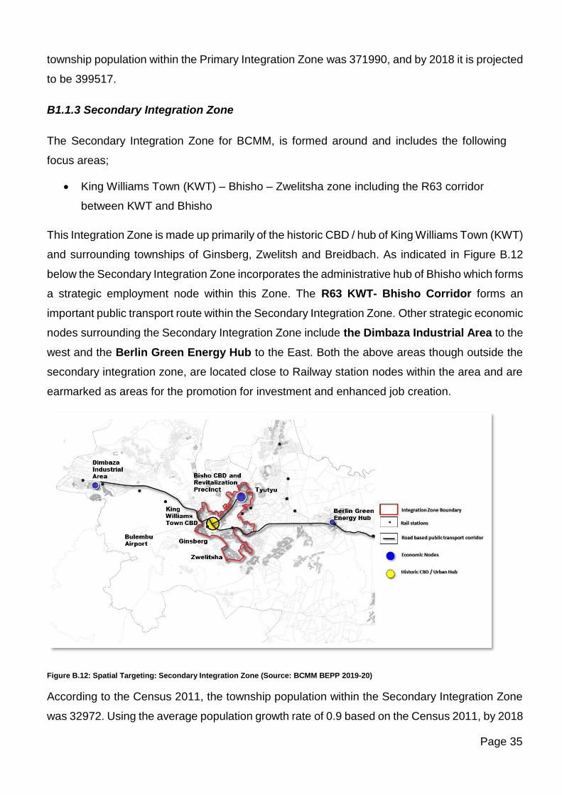
B1.1.3 Secondary Integration Zone
The Secondary Integration Zone for BCMM, is formed around and includes the following
focus areas;
• King Williams Town (KWT) – Bhisho – Zwelitsha zone including the R63 corridor
between KWT and Bhisho
This Integration Zone is made up primarily of the historic CBD / hub of King Williams Town (KWT)
and surrounding townships of Ginsberg, Zwelitsh and Breidbach. As indicated in Figure B.12
below the Secondary Integration Zone incorporates the administrative hub of Bhisho which forms
a strategic employment node within this Zone. The R63 KWT- Bhisho Corridor forms an
important public transport route within the Secondary Integration Zone. Other strategic economic
nodes surrounding the Secondary Integration Zone include the Dimbaza Industrial Area to the
west and the Berlin Green Energy Hub to the East. Both the above areas though outside the
secondary integration zone, are located close to Railway station nodes within the area and are
earmarked as areas for the promotion for investment and enhanced job creation.
Figure B.12: Spatial Targeting: Secondary Integration Zone (Source: BCMM BEPP 2019-20)
According to the Census 2011, the township population within the Secondary Integration Zone
was 32972. Using the average population growth rate of 0.9 based on the Census 2011, by 2018
Page 36
it is projected to be 35 412. This area is additionally surrounded by and serves a large rural
hinterland population therefore plays an important role and function within the rural to urban
continuum as envisaged in the IUDF.
King William’s Town has been identified as a key secondary regional service node within the
metropolitan context. As noted in the 2013 SDF, King William’s Town is a strong and vital Rural
Service Centre providing goods and services to the rural hinterland areas. Bhisho retains its
prominence as the Provincial Capital of the Eastern Cape and this status remains the main driver
of investment in the area.
The Secondary Integration Zone is subject to critical infrastructure/service backlogs, which
severely hinders progress with the development of the corridor.
The Bhisho/KWT LSDF contains the following key objectives:
• A strong focus needs to be encouraged on improving public transport and further road
linkages between the central urban areas of King William’s Town and Bhisho and the
rural hinterland
• The linking of King William’s Town and Bhisho spatially is a priority in the short-medium
term in order to attain urban coherence and functional efficiency.
• Emphasis is to be placed on the upgrading and urban renewal of existing townships and
urban environments in the area.
B1.2 BCMM Integrated Public Tranport Plan
B1.2.1 BCMM Transport Register
The BCMM Transport Register which was completed in February 2018 identified the following
trends in transport modal splits for work related trips.
• The predominant transport mode for work related trips in the BCMM area during a typical
weekday morning peak period in 2013 was by taxi (43%), followed by private car/truck
(29%), walking (21%), train (5%) and bus (2%).
• In comparison to the 2003 data, overall there has been a 5% decline in work trips via
public transport, whilst there has been a 4% increase in work trips via private transport
and walking respectively.
Page 37
• Nearly a third of all work trips were made via private transport in 2013, which corresponds
well with the provincial average of 33%.
• Considering the decline in work trips via public transport, there appears to be a modal
shift from public transport to private transport and waking in the BCMM area.
• The 2013 NHTS for work related trips consisted of approximately 65 000 more trips in
comparison to the 2003 NHTS.
The following trends were reported in transport modal splits for educational trips.
• The predominant transport mode for education related trips in the BCMM area during a
typical weekday morning peak period in 2013 was by walking (56%), followed by taxi
(25%), private car/truck (10%), bus (6%) and train (2%).
• In comparison to the 2003 data, overall there has been a 15% increase in education trips
via public transport, whilst there has been a 14% decline in education trips via walking,
with private transport remaining unchanged.
• The 56% of walk trips to educational facilities was lower than the provincial average of
75% in 2013.
• Considering the decline in education trips via walking, there appears to be a modal shift
from walking to public transport in the BCMM area, with taxi use showing the biggest
increase (+10%).
• The 2013 NHTS for education related trips consisted of approximately 53 000 more trips
in comparison to the 2003 NHTS.
B1.2.2 BCMM Integrated Public Transport Network Operations and Implementation Plan
(2018)
The BCMM IPTN Operations and Implementation Plan has undergone a series of consultative
processes from May 2018 to date. Various proposals and options have been considered for
implementation. Based on the budget implications of the various options and the non-availability
of funding for the implementation of a full-fledged IPTN system, a hybrid approach has been
favoured over the roll out of a full-fledged IPTN Network in the Metro. The hybrid approach
considers the provision of Trunk Services only with feeder routes being serviced by existing
independent operators, through the coordination of an operating company. The current proposal
looks at a 3-year transition phase and 8-year period for the roll out of IPTN services. The first
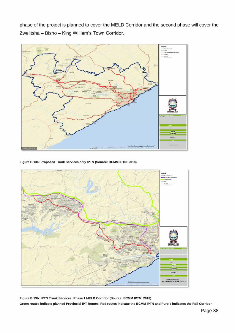
Page 38
phase of the project is planned to cover the MELD Corridor and the second phase will cover the
Zwelitsha – Bisho – King William’s Town Corridor.
Figure B.13a: Proposed Trunk Services only IPTN (Source: BCMM IPTN: 2018)
Figure B.13b: IPTN Trunk Services: Phase 1 MELD Corridor (Source: BCMM IPTN: 2018)
Green routes indicate planned Provincial IPT Routes, Red routes indicate the BCMM IPTN and Purple indicates the Rail Corridor
Page 39
B1.3 Marginalised Residential Areas
As mentioned in the National Treasury Guidance Note v.5.5, a minimum of 50% of the USDG
allocation to Metros are invested towards the upgrading of informal settlements. How this funding
is allocated within a broader integrated spatial logic, will determine the extent of transformation
possible for these settlements. In addition to informal settlements, there are other marginalised
residential areas where people are deprived and in need of opportunities. These areas are
typically not the focus of private developers and are likely to require intervention from
government, in order to flourish as neighbourhoods.
Buffalo City Metropolitan Municipality’s draft review of its Integrated Sustainable Human
Settlements Plan (ISHSP) has largely focused on the demand and needs around state
subsidised housing. It has been noted that further extensive work on the analysis of needs
around the remaining residential property market is vital in order to promote the development of
a greater mix of housing types and options within the Metro. This will align the needs of the
residential market as well as provide a holistic vision to meet desired impacts of spatial
transformation. The draft document has therefore not been finalised. In the absence of the
finalised plan, the following information is sourced from the Human Settlements Department.
The key findings of the Informal Settlement Study (2010) are as follows:
• Total of 154 informal settlements within the Urban Edge
• Total of approx. 41,238 informal dwellings (excludes backyards dwellings)
• Duncan Village – Approx. 20,000 informal dwellings
• East London KWT – 13,352 informal dwellings
• Mdantsane – 7,886 informal dwellings
• Population: ±155,080 in informal settlements (Excluding back yards dwellings)
Figures B.14a, 14b and 14c indicate the location of all the urban and inland informal settlements.
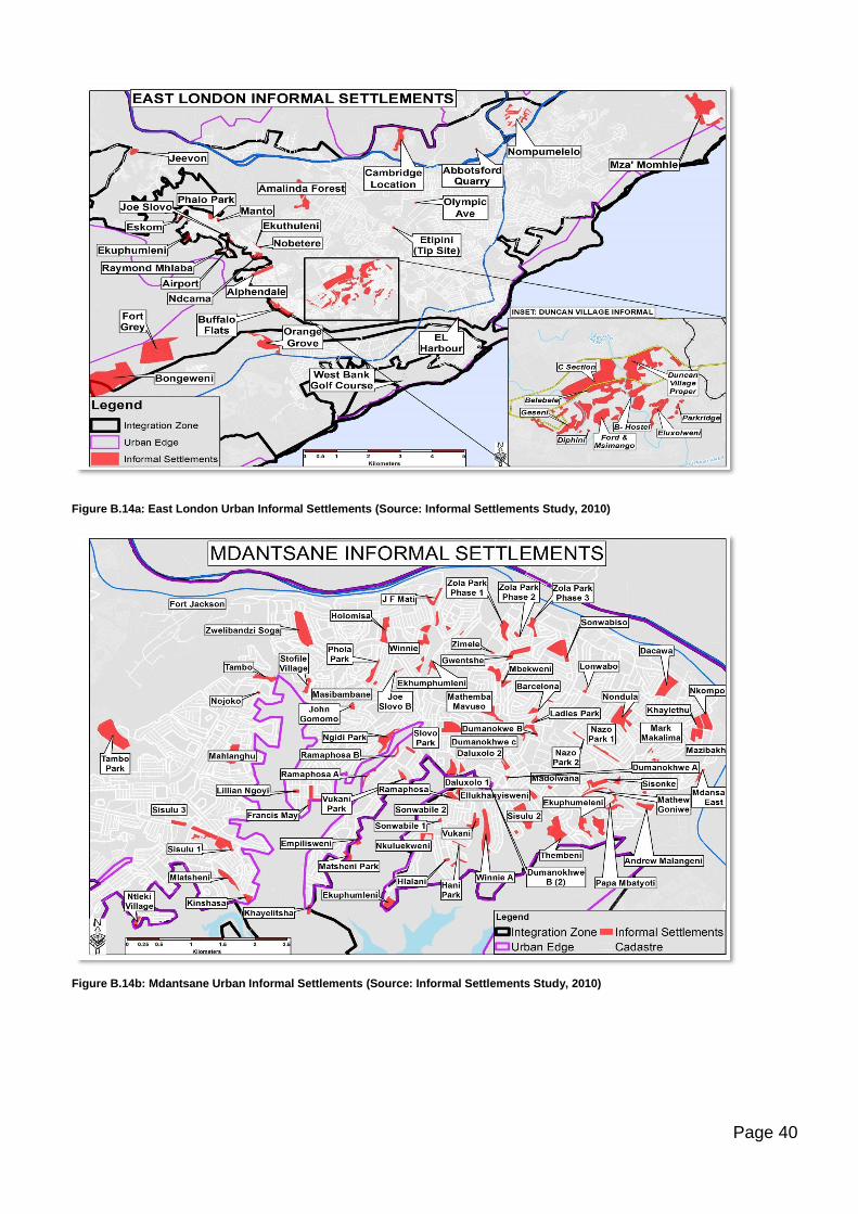
Page 40
Figure B.14a: East London Urban Informal Settlements (Source: Informal Settlements Study, 2010)
Figure B.14b: Mdantsane Urban Informal Settlements (Source: Informal Settlements Study, 2010)
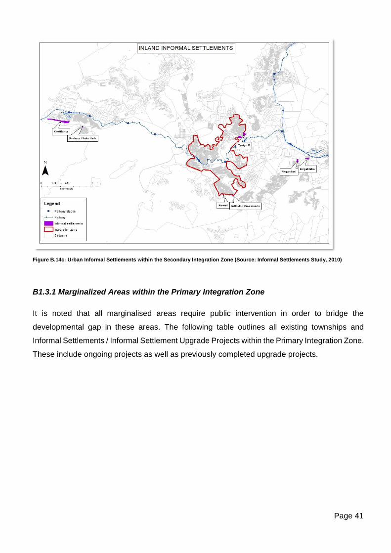
Page 41
Figure B.14c: Urban Informal Settlements within the Secondary Integration Zone (Source: Informal Settlements Study, 2010)
B1.3.1 Marginalized Areas within the Primary Integration Zone
It is noted that all marginalised areas require public intervention in order to bridge the
developmental gap in these areas. The following table outlines all existing townships and
Informal Settlements / Informal Settlement Upgrade Projects within the Primary Integration Zone.
These include ongoing projects as well as previously completed upgrade projects.
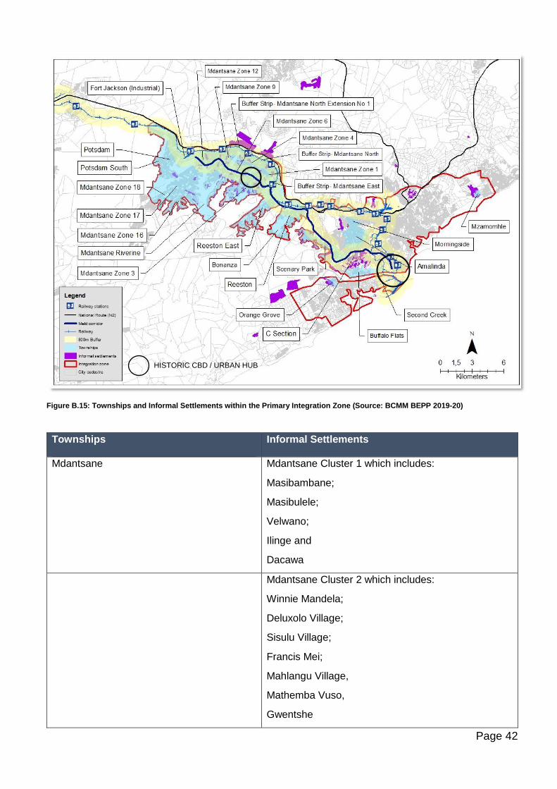
Page 42
Figure B.15: Townships and Informal Settlements within the Primary Integration Zone (Source: BCMM BEPP 2019-20)
Townships
Informal Settlements
Mdantsane Mdantsane Cluster 1 which includes:
Masibambane;
Masibulele;
Velwano;
Ilinge and
Dacawa
Mdantsane Cluster 2 which includes:
Winnie Mandela;
Deluxolo Village;
Sisulu Village;
Francis Mei;
Mahlangu Village,
Mathemba Vuso,
Gwentshe
HISTORIC CBD / URBAN HUB
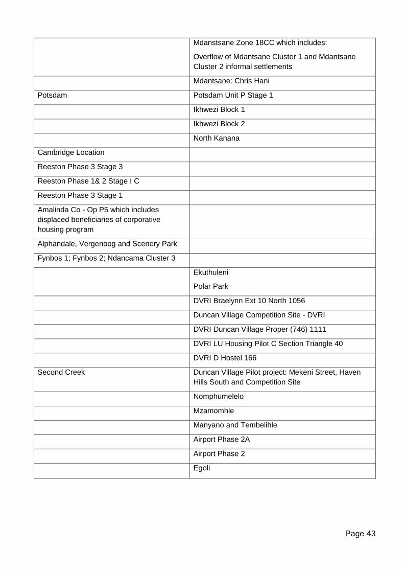
Page 43
Mdanstsane Zone 18CC which includes:
Overflow of Mdantsane Cluster 1 and Mdantsane
Cluster 2 informal settlements
Mdantsane: Chris Hani
Potsdam Potsdam Unit P Stage 1
Ikhwezi Block 1
Ikhwezi Block 2
North Kanana
Cambridge Location
Reeston Phase 3 Stage 3
Reeston Phase 1& 2 Stage I C
Reeston Phase 3 Stage 1
Amalinda Co - Op P5 which includes
displaced beneficiaries of corporative
housing program
Alphandale, Vergenoog and Scenery Park
Fynbos 1; Fynbos 2; Ndancama Cluster 3
Ekuthuleni
Polar Park
DVRI Braelynn Ext 10 North 1056
Duncan Village Competition Site - DVRI
DVRI Duncan Village Proper (746) 1111
DVRI LU Housing Pilot C Section Triangle 40
DVRI D Hostel 166
Second Creek Duncan Village Pilot project: Mekeni Street, Haven
Hills South and Competition Site
Nomphumelelo
Mzamomhle
Manyano and Tembelihle
Airport Phase 2A
Airport Phase 2
Egoli
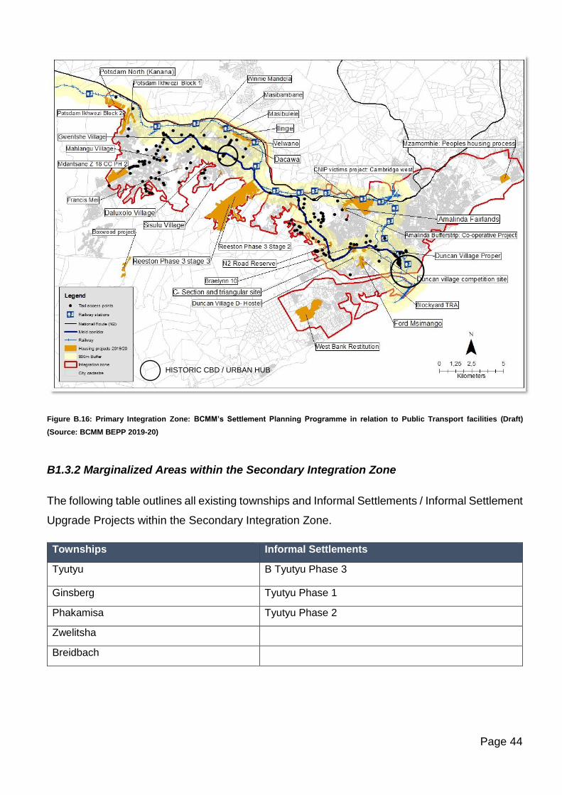
Page 44
Figure B.16: Primary Integration Zone: BCMM’s Settlement Planning Programme in relation to Public Transport facilities (Draft)
(Source: BCMM BEPP 2019-20)
B1.3.2 Marginalized Areas within the Secondary Integration Zone
The following table outlines all existing townships and Informal Settlements / Informal Settlement
Upgrade Projects within the Secondary Integration Zone.
Townships Informal Settlements
Tyutyu B Tyutyu Phase 3
Ginsberg Tyutyu Phase 1
Phakamisa Tyutyu Phase 2
Zwelitsha
Breidbach
HISTORIC CBD / URBAN HUB
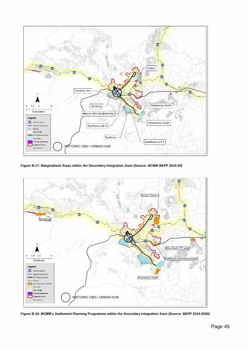
Page 45
Figure B.17: Marginalised Areas within the Secondary Integration Zone (Source: BCMM BEPP 2019-20)
Figure B.18: BCMM’s Settlement Planning Programme within the Secondary Integration Zone (Source: BEPP 2019-2020)
HISTORIC CBD / URBAN HUB
HISTORIC CBD / URBAN HUB
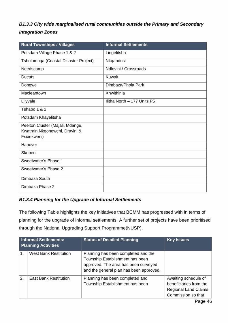
Page 46
B1.3.3 City wide marginalised rural communities outside the Primary and Secondary
Integration Zones
Rural Townships / Villages Informal Settlements
Potsdam Village Phase 1 & 2 Lingelitsha
Tsholomnqa (Coastal Disaster Project) Nkqandusi
Needscamp Ndlovini / Crossroads
Ducats Kuwait
Dongwe Dimbaza/Phola Park
Macleantown Xhwithinia
Lilyvale Ilitha North – 177 Units P5
Tshabo 1 & 2
Potsdam Khayelitsha
Peelton Cluster (Majali, Mdange,
Kwatrain,Nkqonqweni, Drayini &
Esixekweni)
Hanover
Skobeni
Sweetwater’s Phase 1
Sweetwater’s Phase 2
Dimbaza South
Dimbaza Phase 2
B1.3.4 Planning for the Upgrade of Informal Settlements
The following Table highlights the key initiatives that BCMM has progressed with in terms of
planning for the upgrade of informal settlements. A further set of projects have been prioritised
through the National Upgrading Support Programme(NUSP).
Informal Settlements:
Planning Activities
Status of Detailed Planning Key Issues
1. West Bank Restitution
Planning has been completed and the
Township Establishment has been
approved. The area has been surveyed
and the general plan has been approved.
2. East Bank Restitution Planning has been completed and
Township Establishment has been
Awaiting schedule of
beneficiaries from the
Regional Land Claims
Commission so that
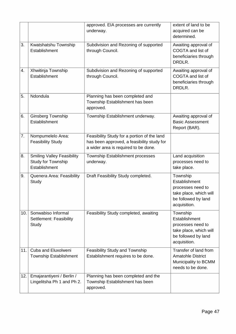
Page 47
approved. EIA processes are currently
underway.
extent of land to be
acquired can be
determined.
3. Kwatshatshu Township
Establishment
Subdivision and Rezoning of supported
through Council.
Awaiting approval of
COGTA and list of
beneficiaries through
DRDLR.
4. Xhwitinja Township
Establishment
Subdivision and Rezoning of supported
through Council.
Awaiting approval of
COGTA and list of
beneficiaries through
DRDLR.
5. Ndondula Planning has been completed and
Township Establishment has been
approved.
6. Ginsberg Township
Establishment
Township Establishment underway. Awaiting approval of
Basic Assessment
Report (BAR).
7. Nompumelelo Area:
Feasibility Study
Feasibility Study for a portion of the land
has been approved, a feasibility study for
a wider area is required to be done.
8. Smiling Valley Feasibility
Study for Township
Establishment
Township Establishment processes
underway.
Land acquisition
processes need to
take place.
9. Quenera Area: Feasibility
Study
Draft Feasibility Study completed. Township
Establishment
processes need to
take place, which will
be followed by land
acquisition.
10. Sonwabiso Informal
Settlement: Feasibility
Study
Feasibility Study completed, awaiting Township
Establishment
processes need to
take place, which will
be followed by land
acquisition.
11. Cuba and Eluxolweni
Township Establishment
Feasibility Study and Township
Establishment requires to be done.
Transfer of land from
Amatohle District
Municipality to BCMM
needs to be done.
12. Emajarantiyeni / Berlin /
Lingelitsha Ph 1 and Ph 2.
Planning has been completed and the
Township Establishment has been
approved.
Page 48
13. Mzamomhle Phase 3 Planning has been completed and the
Township Establishment has been
approved.
14. Hlahani Park Planning has been completed and the
Township Establishment has been
approved.
Source: BCMM Human Settlements and Spatial Planning Directorates
B1.3.5 Prioritised Projects from the National Department of Human Settlements
The National Department of Human Settlements (NDoHS) through the National Upgrading
Support Program (NUSP) made funds available to municipalities, including BCMM, to develop
an Informal Settlement Upgrading Policy and Strategy and to complete development plans for
the in-situ upgrading of identified informal settlements. NUSP Round 1 in BCMM covered 32
identified informal settlements and through public participation from the affected communities,
32 development plans for the in-situ upgrading were developed. BCMM Informal Settlement
Upgrading Policy and Strategy was also developed. Council approved both the Informal
Settlement Upgrading Policy and Strategy and Development plans on the 25th of November
2015. Implementation of the approved development plans has however been a challenge due
to departments indicating that the development plans are not in line with their requirements in
order to implement. Below is the list of informal settlements included in NUSP Round 1.
NUSP Round 1 Informal Settlements No. of Informal
Structures
1. Amalinda Forest 1184
2. Andrew Mlangeni 89
3. Barcelona 37
4. Bisho-Tyutyu 465
5. Cambridge Location 1341
6. Dimbaza South ext. 3 Phola Park 35
7. Duncan Village -Gesini 185
8. Duncan Village – New Rest 250
9. Eluxolweni 701
10. Holomisa 120
11. Reeston- Jevon 115
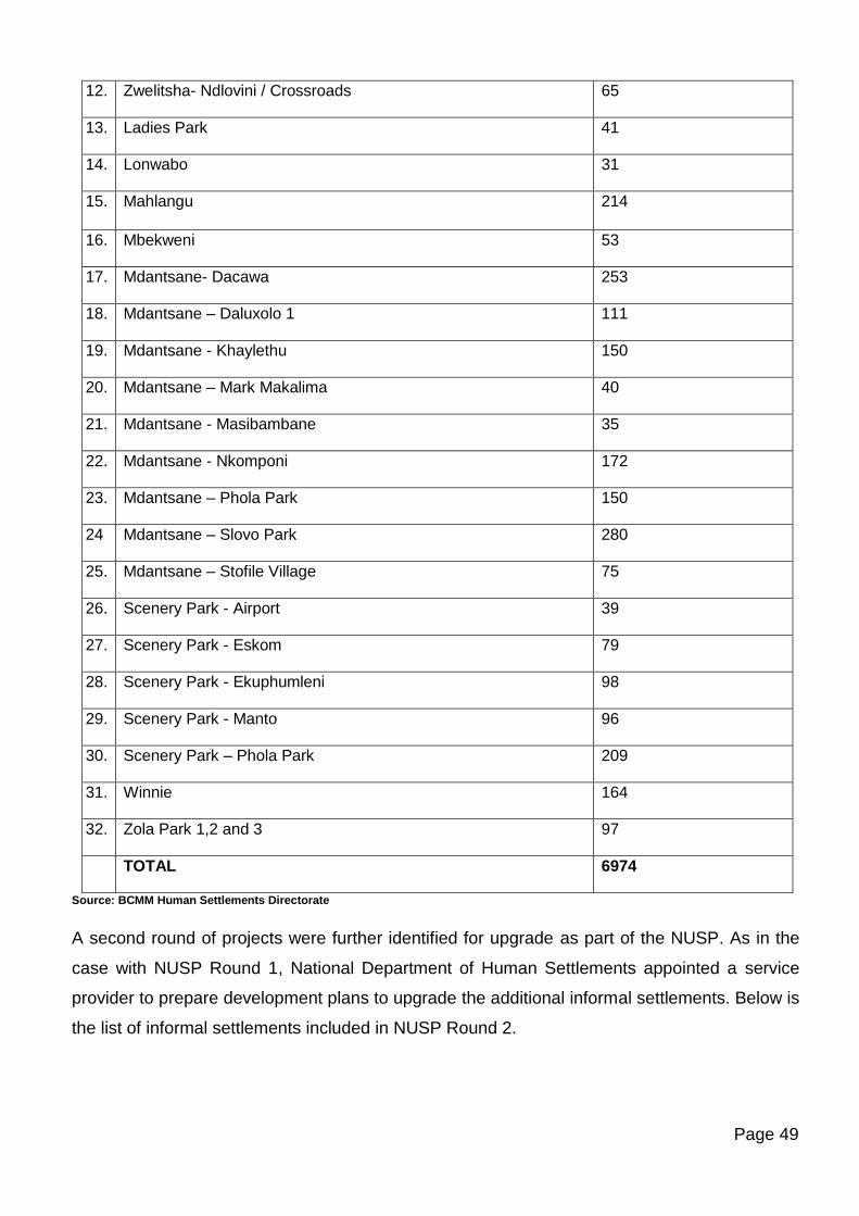
Page 49
12. Zwelitsha- Ndlovini / Crossroads 65
13. Ladies Park 41
14. Lonwabo 31
15. Mahlangu 214
16. Mbekweni 53
17. Mdantsane- Dacawa 253
18. Mdantsane – Daluxolo 1 111
19. Mdantsane - Khaylethu 150
20. Mdantsane – Mark Makalima 40
21. Mdantsane - Masibambane 35
22. Mdantsane - Nkomponi 172
23. Mdantsane – Phola Park 150
24 Mdantsane – Slovo Park 280
25. Mdantsane – Stofile Village 75
26. Scenery Park - Airport 39
27. Scenery Park - Eskom 79
28. Scenery Park - Ekuphumleni 98
29. Scenery Park - Manto 96
30. Scenery Park – Phola Park 209
31. Winnie 164
32. Zola Park 1,2 and 3 97
TOTAL 6974
Source: BCMM Human Settlements Directorate
A second round of projects were further identified for upgrade as part of the NUSP. As in the
case with NUSP Round 1, National Department of Human Settlements appointed a service
provider to prepare development plans to upgrade the additional informal settlements. Below is
the list of informal settlements included in NUSP Round 2.

Page 50
NUSP Round 2 Informal Settlements
Ownership / Property description
No. of units
Est. Population 2008
1. Diphini - Duncan Village Erf 34876; RE/32680 816 3100
2. Bebelele - Duncan Village To be confirmed 1028 3906
3. Nondula - Mdantsane Erf 3053 - 3056; 3099; 3100; 3098 445 1691
4. Nazo Park 1 & 2 - Mdantsane
(To be confirmed) - Erf 3046 33 125
5. Gwentshe - Mdantsane (BCMM) - Erf 9626 28 106
6. Ekhupumleni 2 - Mdantsane (BCMM) - Erf 3394 53 201
7. Ramaphosa A - Mdantsane (To be confirmed) - Erf 1369; 1394 60 148
8. Ramaphosa B - Mdantsane (To be verified) 90 342
9. Ramaphosa - Mdantsane POS next to erf 2542 & 2589 60 228
10. Lilian Ngoyi - Mdantsane (BCMM) - Rem erf 4976 60 228
11. Mlatsheni - Mdantsane (BCMM) - Farm 1404 96 365
12. Masibakhe - Mdantsane
(BCMM / Private) Erf 9945; 9946; 9941; 921; 10114; 907; 908; 909; 910; 911 195 741
13. Elukhanyisweni - Mdantsane (BCMM) - Erf 5102 27 102
14. Zimele - Mdantsane (BCMM) - Erf 10446 - 10448; Rem 9614; 10441; 10442 11 42
15. Mathemba Vuso-Mdantsane (BCMM) - Erf 9548; 9637; 9638; 9639 180 684
16. Ekhuphumleni - Mdantsane (To be verified) - Erf 1107; 1108; 1202 70 266
17. JF Mati - Mdantsane (BCMM/Private) - Erf 58; 79; 91; 92; 93 72 273
18.
Duma Nokhwe A -
Mdantsane (BCMM) - Erf 6169
20 76
19. Duma Nokhwe B -Mdantsane
(BCMM) - Erf 6172 89 338
20. Duma Nokhwe C -Mdantsane To be confirmed 54 205
21. Vukani Park - Mdantsane To be confirmed 32 121
TOTAL 3519 13288
Source: BCMM Human Settlements Directorate
B1.3.6 BCMM’s Prioritised Informal Settlements Programme
BCMM’s Prioritised Informal Settlements Upgrade Programme of projects for 2019-20 funded
through the USDG is outlined in the Table below.
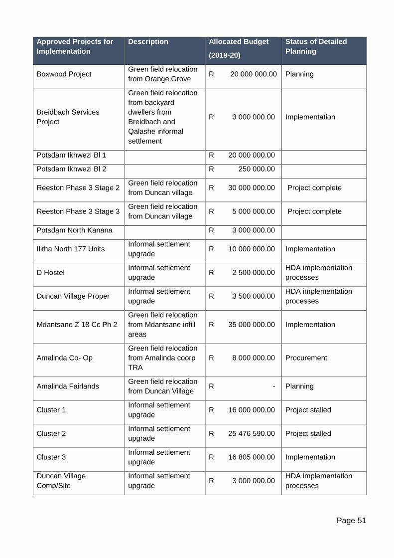
Page 51
Approved Projects for
Implementation
Description Allocated Budget
(2019-20)
Status of Detailed
Planning
Boxwood Project Green field relocation
from Orange Grove R 20 000 000.00 Planning
Breidbach Services
Project
Green field relocation
from backyard
dwellers from
Breidbach and
Qalashe informal
settlement
R 3 000 000.00 Implementation
Potsdam Ikhwezi Bl 1 R 20 000 000.00
Potsdam Ikhwezi Bl 2 R 250 000.00
Reeston Phase 3 Stage 2 Green field relocation
from Duncan village R 30 000 000.00 Project complete
Reeston Phase 3 Stage 3 Green field relocation
from Duncan village R 5 000 000.00 Project complete
Potsdam North Kanana R 3 000 000.00
Ilitha North 177 Units Informal settlement
upgrade R 10 000 000.00 Implementation
D Hostel Informal settlement
upgrade R 2 500 000.00
HDA implementation
processes
Duncan Village Proper Informal settlement
upgrade R 3 500 000.00
HDA implementation
processes
Mdantsane Z 18 Cc Ph 2
Green field relocation
from Mdantsane infill
areas
R 35 000 000.00 Implementation
Amalinda Co- Op
Green field relocation
from Amalinda coorp
TRA
R 8 000 000.00 Procurement
Amalinda Fairlands Green field relocation
from Duncan Village R - Planning
Cluster 1 Informal settlement
upgrade R 16 000 000.00 Project stalled
Cluster 2 Informal settlement
upgrade R 25 476 590.00 Project stalled
Cluster 3 Informal settlement
upgrade R 16 805 000.00 Implementation
Duncan Village
Comp/Site
Informal settlement
upgrade R 3 000 000.00
HDA implementation
processes
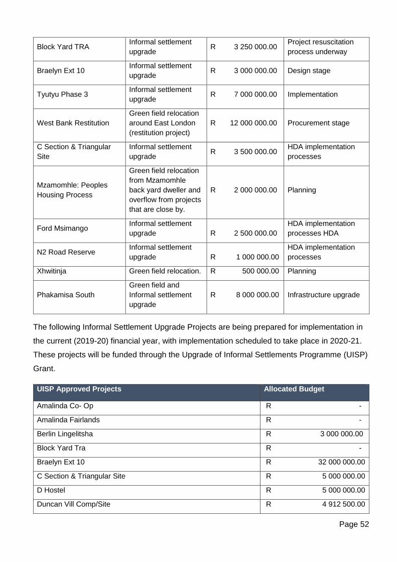
Page 52
Block Yard TRA Informal settlement
upgrade R 3 250 000.00
Project resuscitation
process underway
Braelyn Ext 10 Informal settlement
upgrade R 3 000 000.00 Design stage
Tyutyu Phase 3 Informal settlement
upgrade R 7 000 000.00 Implementation
West Bank Restitution
Green field relocation
around East London
(restitution project)
R 12 000 000.00 Procurement stage
C Section & Triangular
Site
Informal settlement
upgrade R 3 500 000.00
HDA implementation
processes
Mzamomhle: Peoples
Housing Process
Green field relocation
from Mzamomhle
back yard dweller and
overflow from projects
that are close by.
R 2 000 000.00 Planning
Ford Msimango Informal settlement
upgrade R 2 500 000.00
HDA implementation
processes HDA
N2 Road Reserve Informal settlement
upgrade R 1 000 000.00
HDA implementation
processes
Xhwitinja Green field relocation. R 500 000.00 Planning
Phakamisa South
Green field and
Informal settlement
upgrade
R 8 000 000.00 Infrastructure upgrade
The following Informal Settlement Upgrade Projects are being prepared for implementation in
the current (2019-20) financial year, with implementation scheduled to take place in 2020-21.
These projects will be funded through the Upgrade of Informal Settlements Programme (UISP)
Grant.
UISP Approved Projects Allocated Budget
Amalinda Co- Op R -
Amalinda Fairlands R -
Berlin Lingelitsha R 3 000 000.00
Block Yard Tra R -
Braelyn Ext 10 R 32 000 000.00
C Section & Triangular Site R 5 000 000.00
D Hostel R 5 000 000.00
Duncan Vill Comp/Site R 4 912 500.00
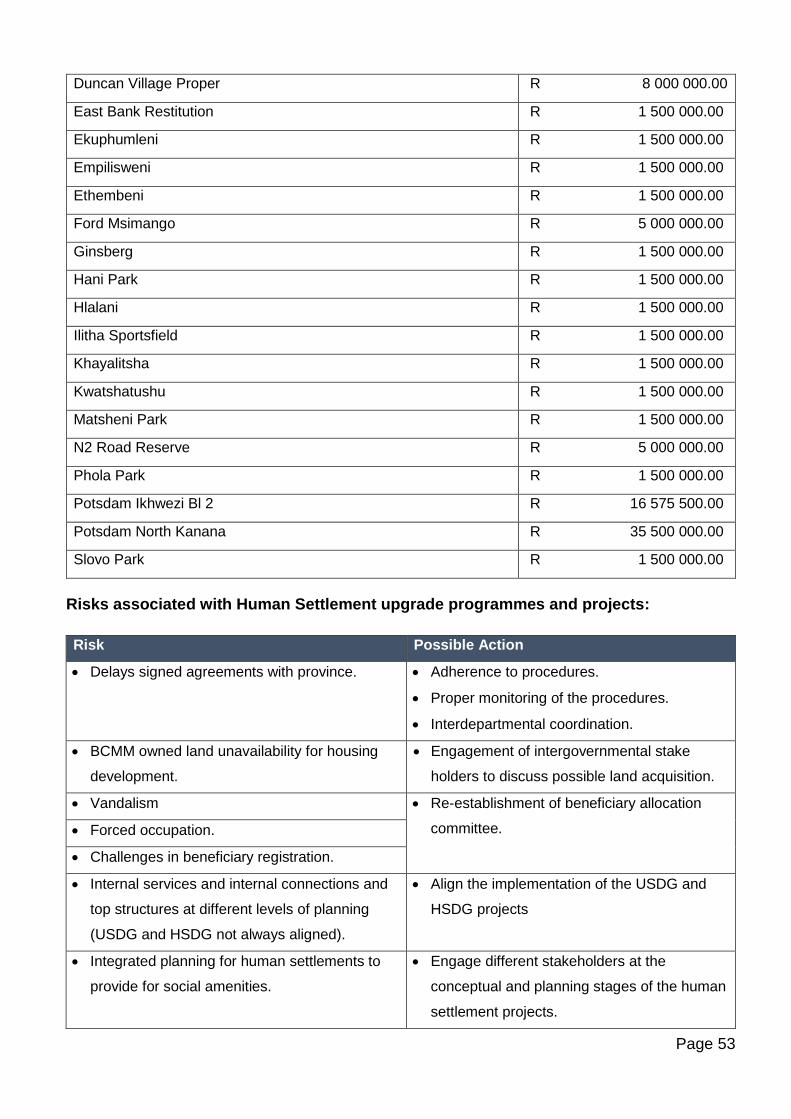
Page 53
Duncan Village Proper R 8 000 000.00
East Bank Restitution R 1 500 000.00
Ekuphumleni R 1 500 000.00
Empilisweni R 1 500 000.00
Ethembeni R 1 500 000.00
Ford Msimango R 5 000 000.00
Ginsberg R 1 500 000.00
Hani Park R 1 500 000.00
Hlalani R 1 500 000.00
Ilitha Sportsfield R 1 500 000.00
Khayalitsha R 1 500 000.00
Kwatshatushu R 1 500 000.00
Matsheni Park R 1 500 000.00
N2 Road Reserve R 5 000 000.00
Phola Park R 1 500 000.00
Potsdam Ikhwezi Bl 2 R 16 575 500.00
Potsdam North Kanana R 35 500 000.00
Slovo Park R 1 500 000.00
Risks associated with Human Settlement upgrade programmes and projects:
Risk Possible Action
• Delays signed agreements with province. • Adherence to procedures.
• Proper monitoring of the procedures.
• Interdepartmental coordination.
• BCMM owned land unavailability for housing
development.
• Engagement of intergovernmental stake
holders to discuss possible land acquisition.
• Vandalism • Re-establishment of beneficiary allocation
committee. • Forced occupation.
• Challenges in beneficiary registration.
• Internal services and internal connections and
top structures at different levels of planning
(USDG and HSDG not always aligned).
• Align the implementation of the USDG and
HSDG projects
• Integrated planning for human settlements to
provide for social amenities.
• Engage different stakeholders at the
conceptual and planning stages of the human
settlement projects.
Page 54
• Possible litigations.
• Incapacity of service providers.
• Due diligence of service providers.
• Land acquisition and release.
• Land owned by Ciskei government: release is
recommended by council and approved by
COGTA.
• RSA: Land is approved by council.
• Non-adherence to EPWP processes.
B1.4 Economic Nodes
Economic nodes are seen as vital to the functioning and performance of the urban spatial
economy as well as for maintaining sustainable livelihoods. Economic nodes should accordingly
be identified and prioritised. (NT Guidance Note, 2017). The City is currently busy with
assembling incentive schemes to promote private sector investment within strategic
economic nodes as well as within its catalytic programmes and strategic city-wide initiatives.
B1.4.1 Economic Nodes / Employment Centres within the Primary Integration Zone
The Table below classifies all key economic nodes within the city into three categories:
established nodes, emerging nodes and declining nodes. Spatial targeting implies that all
economic nodes which fall within corridors of accessibility in close proximity to marginalised
areas need to be prioritised and promoted for consolidation.
Established Nodes /
Employment Centres
Emerging Nodes Declining Nodes
CBD’s
East London CBD Mdantsane CBD
COMMERCIAL NODES
Vincent Berea Node Quenera/N2
Nahoon – Old Transkei Road Mount Ruth Station/N2
Nahoon – Beach Road Arnoldton Station/R102
Beacon Bay/N2 Brakfontein/N2
Cambridge – Queen Street
node
Amalinda Junction/R102
Amalinda Main Road
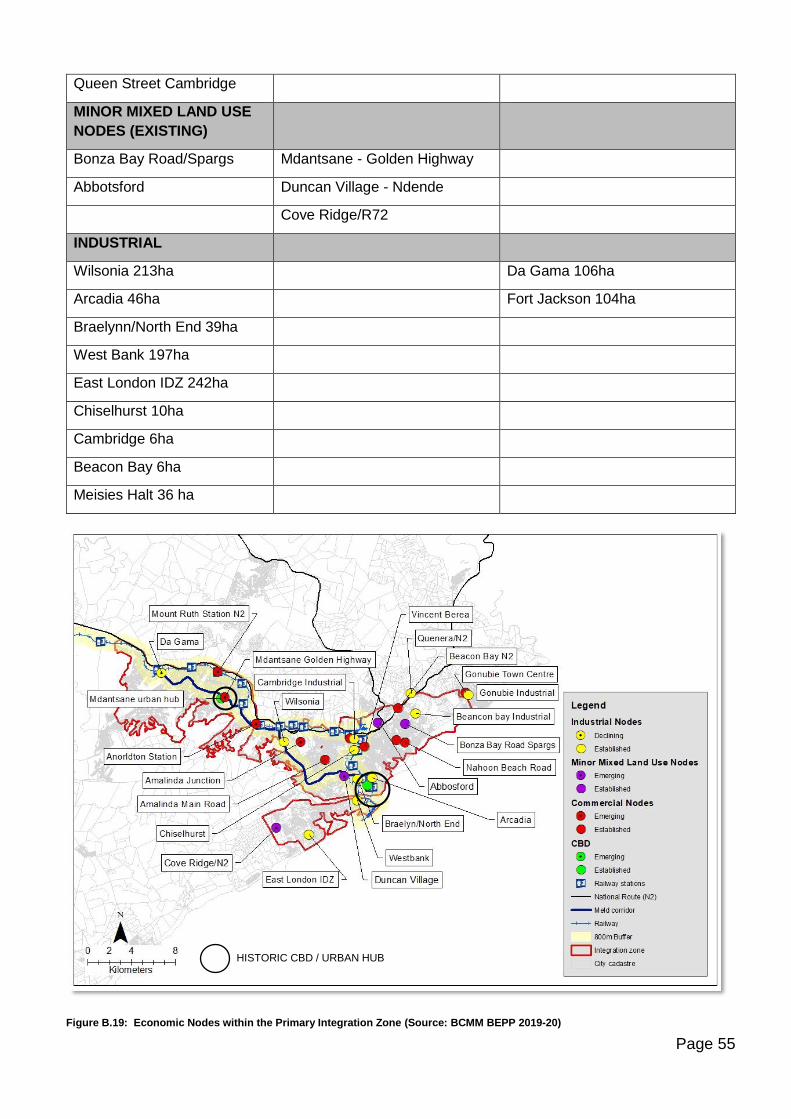
Page 55
Queen Street Cambridge
MINOR MIXED LAND USE
NODES (EXISTING)
Bonza Bay Road/Spargs Mdantsane - Golden Highway
Abbotsford Duncan Village - Ndende
Cove Ridge/R72
INDUSTRIAL
Wilsonia 213ha Da Gama 106ha
Arcadia 46ha Fort Jackson 104ha
Braelynn/North End 39ha
West Bank 197ha
East London IDZ 242ha
Chiselhurst 10ha
Cambridge 6ha
Beacon Bay 6ha
Meisies Halt 36 ha
Figure B.19: Economic Nodes within the Primary Integration Zone (Source: BCMM BEPP 2019-20)
HISTORIC CBD / URBAN HUB
Page 56
The Port, the Mercedes Benz South Africa complex, the ELIDZ and Airport together form a
strategic corridor of investment which drives the economy of East London. As such it is an area
of focus which is introduced into the 2019-20 BEPP as a catalytic programme for further
consolidation.
West Bank Industrial Cluster
The main industrial areas on the West Bank are Gately; Woodbrook and the IDZ.
MBSA is currently located in Gately and is BCMM largest employer. MBSA has made a major
contribution to industrial property take-up in East London and continues to underpin demand for
companies supplying MBSA.
The East London IDZ comprises some 1,500 ha of land, which is divided into five development
zones, located between the R72 and the Indian Ocean. The ELIDZ is located on Buffalo City’s
West Bank adjacent to the port of East London and the East London Airport. The East London
Industrial Development Zone (Pty) Ltd markets and manages the industrial land within the IDZ.
The IDZ has a number of functional zones that have been created offering different marketing
potentials.
The East London Industrial Development Zone established a Science and Technology Park
(STP). It is an innovation hub aimed at speeding up the pace of economic development in the
Eastern Cape by increasing the competitiveness, efficiency and effectiveness of local industry.
The ELIDZ STP is the only park of its kind in the country which is linked to an IDZ and was
conceived as a catalyst for growth, collaboration.
The East London Industrial Development Zone will offer significant development potential in the
medium term, which would create opportunities for the development of urban settlement
extensions in that part of the East London city area (West Bank).
Current initiatives and projects of the ELIDZ include:
Project name Project
description
Budget
allocation for
2019-20
Budget Source Phase of project
IOX
International
Sea Cable
Landing of an
international sea
cable
R63m for meet-
me-room phase 1
Provincial
Treasury/DTI
Advanced
KGI Holdings BPO Facility of
300 seats then a
Budget currently
awaited from the
DTI. To be
DTI Advanced. Pilot
already running.
Phase 2 to
Page 57
move to 3000
seats (9000 jobs)
adjudicated on
the 29th March
2019.
commence as soon
as funding is secured.
Will create 900 jobs
and there is a need
for BCMM assistance
with transport,
housing, schooling.
SMME Factory
Units
Factory units for
the SMME sector
Application with
the DTI lodged
but outcome
currently
unknown.
DTI Application
submitted.
Multi-Purpose
ICT Hub
A multi-purpose
facility for the
3000-seater BPO
facility, a 1000-
seater disaster
recovery center
and an ICT
academy
R701m is the
funding
requirement but it
has not yet been
sourced.
Funders not yet
approached.
Concept and
feasibility concluded.
Clari-Cluster Part of the
Factory Units
project with the
need for 5
SMME’s to be
created to
support raw
material supply
and off-take from
Clariter’s
processes
No funding
secured yet, but
application is in
with the DTI.
DTI Application
submitted.
Energy
Manufacturing
Cluster
Another entity to
be located in the
Factory Units
project.
Application to DTI
submitted and
DTI have already
funded the cluster
via their cluster
program.
DTI funded the
cluster and now a
request has been
submitted for them
to fund the Factory
Units.
Pilot already
established and
cluster is operational.
The ELIDZ now
needs a facility to
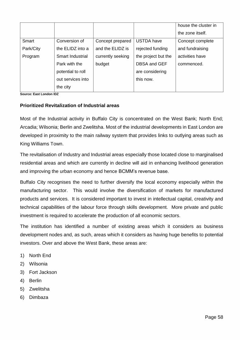
Page 58
house the cluster in
the zone itself.
Smart
Park/City
Program
Conversion of
the ELIDZ into a
Smart Industrial
Park with the
potential to roll
out services into
the city
Concept prepared
and the ELIDZ is
currently seeking
budget
USTDA have
rejected funding
the project but the
DBSA and GEF
are considering
this now.
Concept complete
and fundraising
activities have
commenced.
Source: East London IDZ
Prioritized Revitalization of Industrial areas
Most of the Industrial activity in Buffalo City is concentrated on the West Bank; North End;
Arcadia; Wilsonia; Berlin and Zwelitsha. Most of the industrial developments in East London are
developed in proximity to the main railway system that provides links to outlying areas such as
King Williams Town.
The revitalisation of Industry and Industrial areas especially those located close to marginalised
residential areas and which are currently in decline will aid in enhancing livelihood generation
and improving the urban economy and hence BCMM’s revenue base.
Buffalo City recognises the need to further diversify the local economy especially within the
manufacturing sector. This would involve the diversification of markets for manufactured
products and services. It is considered important to invest in intellectual capital, creativity and
technical capabilities of the labour force through skills development. More private and public
investment is required to accelerate the production of all economic sectors.
The institution has identified a number of existing areas which it considers as business
development nodes and, as such, areas which it considers as having huge benefits to potential
investors. Over and above the West Bank, these areas are:
1) North End
2) Wilsonia
3) Fort Jackson
4) Berlin
5) Zwelitsha
6) Dimbaza
Page 59
All these areas have existing infrastructure, some of which, with minimal investment in terms of
infrastructure upgrades, could yield significant benefits for the local economy and contribute to
the local GDP. It further needs to be recognised that these are effectively business nodes which
could be developed to be closer to areas of labour resulting in reduced travelling costs for the
labour force.
These industrial areas are the backbone of the Buffalo City Metro economy and house some of
the major manufacturers and well known international brands such as Mercedes Benz, Nestle,
Johnson & Johnson, First National Battery, Summerpride Food (Pineapple processing), Da
Gama Textiles, Pro-glove, etc.
Other Industrial nodes
Inner City Industrial Cluster
Another industrial cluster is found in the areas that are located off the East London CBD to the
North of the CBD; these are Arcadia, North End and Braelynn. The Nestle factory is located in
North End and is also a major employer. There are signs of older properties in need of
refurbishment and industrial activity typified by light manufacturing and warehousing.
Wilsonia Industrial Cluster
Wilsonia and Dawn constitutes this industrial cluster and is located north west of the CBD on
the MELD corridor. The Johnson and Johnson factory is situated in Dawn and is also a significant
contributor to the local economy. There are Council initiatives to upgrade the area
Mdantsane Industrial cluster
Fort Jackson remains attractive for industrialists seeking large spaces located in close proximity
to a semi-skilled workforce. The node has been earmarked for further investment by the Eastern
Cape Development Corporation (ECDC).
A new industrial area situated adjacent to Mount Ruth and the N2 has been identified and is
intended to cater for the growing logistics industry in the region.
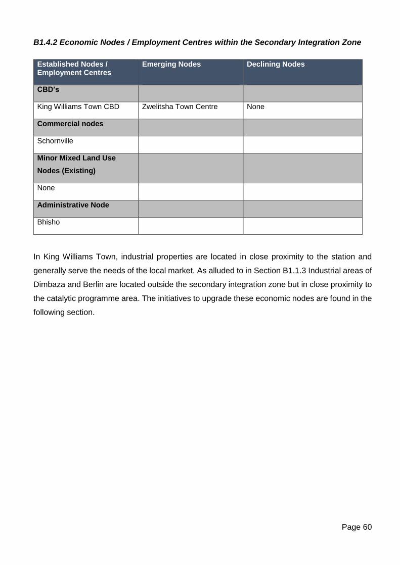
Page 60
B1.4.2 Economic Nodes / Employment Centres within the Secondary Integration Zone
Established Nodes / Employment Centres
Emerging Nodes
Declining Nodes
CBD’s
King Williams Town CBD Zwelitsha Town Centre None
Commercial nodes
Schornville
Minor Mixed Land Use
Nodes (Existing)
None
Administrative Node
Bhisho
In King Williams Town, industrial properties are located in close proximity to the station and
generally serve the needs of the local market. As alluded to in Section B1.1.3 Industrial areas of
Dimbaza and Berlin are located outside the secondary integration zone but in close proximity to
the catalytic programme area. The initiatives to upgrade these economic nodes are found in the
following section.
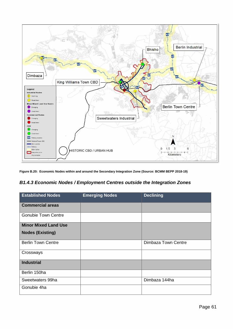
Page 61
Figure B.20: Economic Nodes within and around the Secondary Integration Zone (Source: BCMM BEPP 2018-19)
B1.4.3 Economic Nodes / Employment Centres outside the Integration Zones
Established Nodes Emerging Nodes Declining
Commercial areas
Gonubie Town Centre
Minor Mixed Land Use
Nodes (Existing)
Berlin Town Centre Dimbaza Town Centre
Crossways
Industrial
Berlin 150ha
Sweetwaters 99ha Dimbaza 144ha
Gonubie 4ha
HISTORIC CBD / URBAN HUB
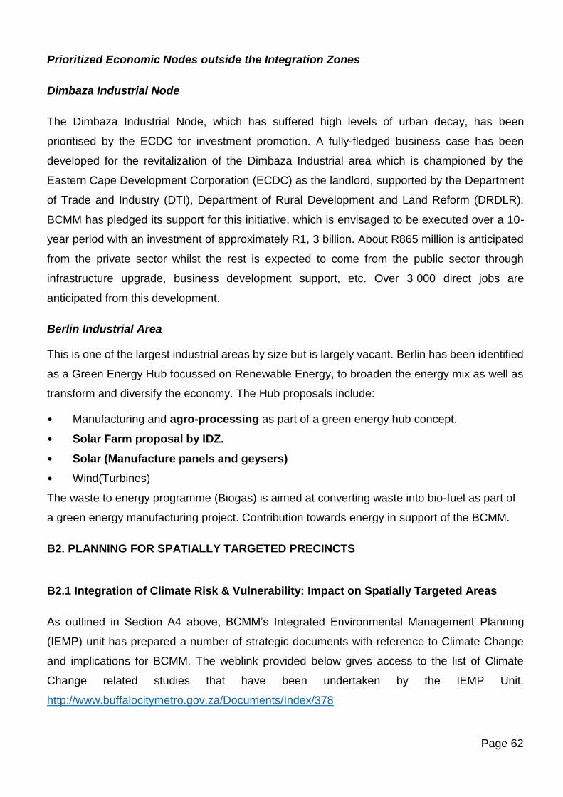
Page 62
Prioritized Economic Nodes outside the Integration Zones
Dimbaza Industrial Node
The Dimbaza Industrial Node, which has suffered high levels of urban decay, has been
prioritised by the ECDC for investment promotion. A fully-fledged business case has been
developed for the revitalization of the Dimbaza Industrial area which is championed by the
Eastern Cape Development Corporation (ECDC) as the landlord, supported by the Department
of Trade and Industry (DTI), Department of Rural Development and Land Reform (DRDLR).
BCMM has pledged its support for this initiative, which is envisaged to be executed over a 10-
year period with an investment of approximately R1, 3 billion. About R865 million is anticipated
from the private sector whilst the rest is expected to come from the public sector through
infrastructure upgrade, business development support, etc. Over 3 000 direct jobs are
anticipated from this development.
Berlin Industrial Area
This is one of the largest industrial areas by size but is largely vacant. Berlin has been identified
as a Green Energy Hub focussed on Renewable Energy, to broaden the energy mix as well as
transform and diversify the economy. The Hub proposals include:
• Manufacturing and agro-processing as part of a green energy hub concept.
• Solar Farm proposal by IDZ.
• Solar (Manufacture panels and geysers)
• Wind(Turbines)
The waste to energy programme (Biogas) is aimed at converting waste into bio-fuel as part of
a green energy manufacturing project. Contribution towards energy in support of the BCMM.
B2. PLANNING FOR SPATIALLY TARGETED PRECINCTS
B2.1 Integration of Climate Risk & Vulnerability: Impact on Spatially Targeted Areas
As outlined in Section A4 above, BCMM’s Integrated Environmental Management Planning
(IEMP) unit has prepared a number of strategic documents with reference to Climate Change
and implications for BCMM. The weblink provided below gives access to the list of Climate
Change related studies that have been undertaken by the IEMP Unit.
http://www.buffalocitymetro.gov.za/Documents/Index/378
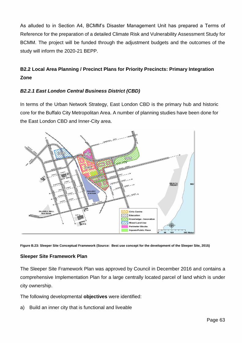
Page 63
As alluded to in Section A4, BCMM’s Disaster Management Unit has prepared a Terms of
Reference for the preparation of a detailed Climate Risk and Vulnerability Assessment Study for
BCMM. The project will be funded through the adjustment budgets and the outcomes of the
study will inform the 2020-21 BEPP.
B2.2 Local Area Planning / Precinct Plans for Priority Precincts: Primary Integration
Zone
B2.2.1 East London Central Business District (CBD)
In terms of the Urban Network Strategy, East London CBD is the primary hub and historic
core for the Buffalo City Metropolitan Area. A number of planning studies have been done for
the East London CBD and Inner-City area.
Figure B.23: Sleeper Site Conceptual Framework (Source: Best use concept for the development of the Sleeper Site, 2015)
Sleeper Site Framework Plan
The Sleeper Site Framework Plan was approved by Council in December 2016 and contains a
comprehensive Implementation Plan for a large centrally located parcel of land which is under
city ownership.
The following developmental objectives were identified:
a) Build an inner city that is functional and liveable
Page 64
b) To improve the aesthetics and the built environment i.e. through improved lighting and
landscaping, cleanliness and safety (including the perception of personal safety) and the
optimisation of the use of existing facilities by redefining their hierarchy and role within
the CBD.
c) To enable integration, accessibility and connectivity of the East London CBD to the wider
surrounding inner-city areas particularly the Sleeper Site, Beach Front and Quigney.
d) Establish a walkable network in the inner core that conveniently connects public
transportation in a legible and effective way.
e) To promote economic sustainability and high intensity activity all year round;
f) A framework for engaging the various stakeholders in the CBD along with a CBD
management model to ensure and oversee the transformation of streetscapes and to
manage maintenance activities and promotion of the CBD
The Implementation Plan includes the following projects:
Projects Actions
Initiating CBD
Revitalisation
• As a precondition to the successful implementation of the Hub it was
identified that the Establishment of an appropriate institutional
vehicle would be essential to oversee the Central EL/CBD
Revitalisation as well as the development of the Sleeper site.
• Building effective partnerships by beginning a process of ongoing
structured engagements with key stakeholders in the development
process as well as partners in the Knowledge Economy Catalytic
Project
• Back to Basics - Commence upgrade & clean-up of CBD (Oxford
Street and Environs)
• Establishment of a City Improvement District (CID)
Precinct Design Civic
Centre Complex and
ancillary uses
• A BCMM Workplace Study is needed to define the needs of BCMM
for accommodation at the Civic Centre.
• Based on the information from the Workplace study, prepare a
Precinct Plan that will locate the Civic Centre and Municipal
Library/ICT Learning Centre as well as other associated public
facilities such as open spaces. As part of the process a concept
architectural design for the Civic Centre must be completed.
• Precinct Plan must identify a suitably integrated and functional
Public Square or Memorial Square (which, conceptually, should be
Page 65
linked back to the EL City Hall to strengthen a potential Heritage
and History Theme for the Civic Heart and linkages to City)
• Subdivision of land for Civic Centre
Development of
remainder of vacant
land
• Identification of institutions aligned with the Knowledge Economy
Catalytic Project who require land in the Sleeper Site
Road/Pedestrian
Network
• Inner City Traffic Study
• Plan for Sea to City Boulevard
Infrastructure
Development
• Infrastructure Study (to be based on the Development Scenario
estimate of likely amout of building floor area to be developed.)
• Infrastructure development
East London CBD Inner City Areas
The Inner City of East London comprises of the East London CBD; Quigney; Beach Front;
Southernwood; Belgravia and the Arcadia and North End Industrial areas.
The following Spatial policy is applicable to the Inner-City Area:
Inner City Area Relevant Spatial Policy Plan
EL CBD and Sleeper site Sleeper Site Framework Plan (2016)
Quigney and Beach Front Beach Front LSDF (2010)
Southernwood and Belgravia Policy plan currently underway
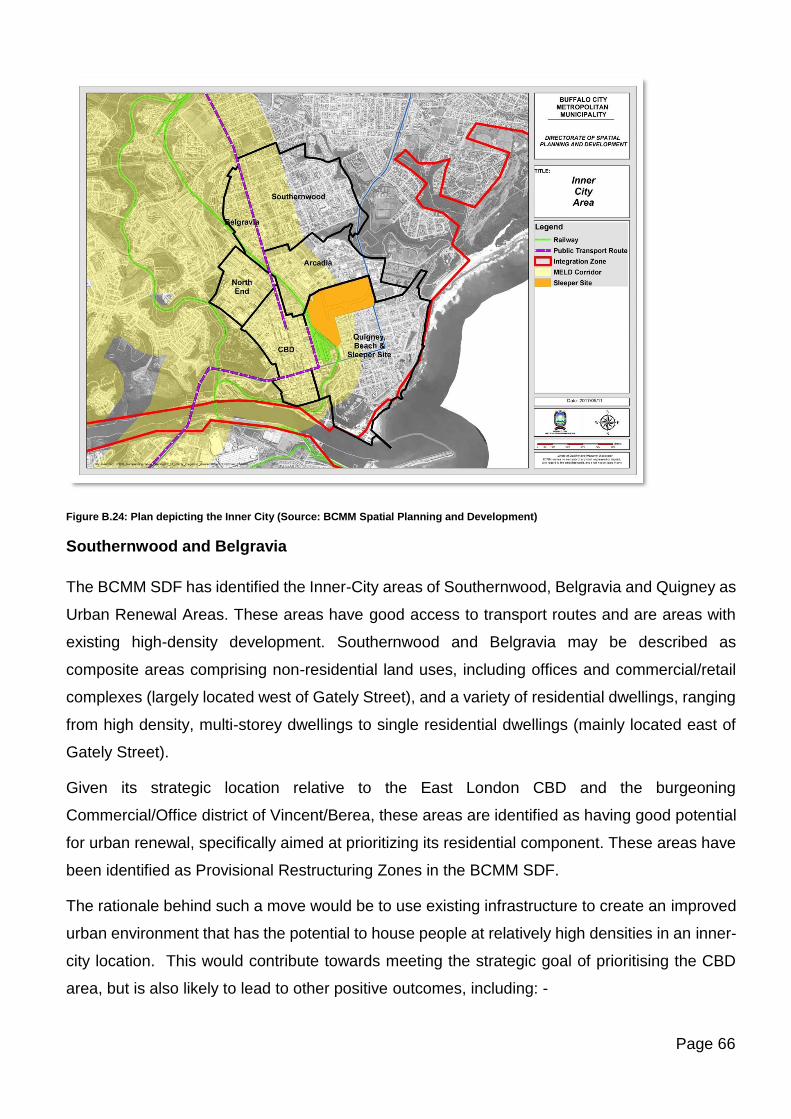
Page 66
Figure B.24: Plan depicting the Inner City (Source: BCMM Spatial Planning and Development)
Southernwood and Belgravia
The BCMM SDF has identified the Inner-City areas of Southernwood, Belgravia and Quigney as
Urban Renewal Areas. These areas have good access to transport routes and are areas with
existing high-density development. Southernwood and Belgravia may be described as
composite areas comprising non-residential land uses, including offices and commercial/retail
complexes (largely located west of Gately Street), and a variety of residential dwellings, ranging
from high density, multi-storey dwellings to single residential dwellings (mainly located east of
Gately Street).
Given its strategic location relative to the East London CBD and the burgeoning
Commercial/Office district of Vincent/Berea, these areas are identified as having good potential
for urban renewal, specifically aimed at prioritizing its residential component. These areas have
been identified as Provisional Restructuring Zones in the BCMM SDF.
The rationale behind such a move would be to use existing infrastructure to create an improved
urban environment that has the potential to house people at relatively high densities in an inner-
city location. This would contribute towards meeting the strategic goal of prioritising the CBD
area, but is also likely to lead to other positive outcomes, including: -
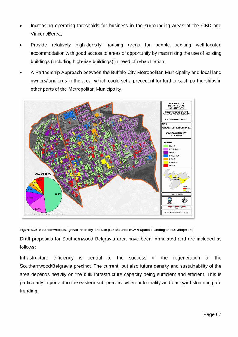
Page 67
• Increasing operating thresholds for business in the surrounding areas of the CBD and
Vincent/Berea;
• Provide relatively high-density housing areas for people seeking well-located
accommodation with good access to areas of opportunity by maximising the use of existing
buildings (including high-rise buildings) in need of rehabilitation;
• A Partnership Approach between the Buffalo City Metropolitan Municipality and local land
owners/landlords in the area, which could set a precedent for further such partnerships in
other parts of the Metropolitan Municipality.
Figure B.25: Southernwood, Belgravia Inner city land use plan (Source: BCMM Spatial Planning and Development)
Draft proposals for Southernwood Belgravia area have been formulated and are included as
follows:
Infrastructure efficiency is central to the success of the regeneration of the
Southernwood/Belgravia precinct. The current, but also future density and sustainability of the
area depends heavily on the bulk infrastructure capacity being sufficient and efficient. This is
particularly important in the eastern sub-precinct where informality and backyard slumming are
trending.
Page 68
This precinct has become a magnet for affordable student accommodation based on the
education anchor institutions found there. Research has found that the affordability factor and
economic survival also come into play when one considers the multi-cultural character of the
area. The city has an opportunity to go beyond mere policing of illegal activities to the actual
solving of the root cause issues. This reinvention strategy could go a long way in ensuring
inclusive urbanization.
The Opportunity Infrastructure Framework/ Strategy unpacked below offers opportunities to
address and manage the slumming issues in an orderly fashion.
Research has revealed how local property owners in the precinct are sub-letting poorly-
maintained residential buildings to multiple foreign-national second economy entrepreneurs at
blown-up rental prices. Two hairdressers, a laundry, a general dealer, a fish and chips shop, a
nail bar and a fashion designer would be sharing a small building with dire consequences for
refuse collection and water infrastructure capacity.
Included in the strategy could also be a Special Incentive Scheme and Special Permissions
Guidelines in targeted and strategic areas. Special tariffs for land leases and sales in strategic
places could be tied down in the framework as part of the enabling toolbox of municipal policy.
The multipurpose use of spare space is worthwhile exploring as part of a possible “tactical
urbanism” initiative between the anchor institutions and residents of the neighbourhoods. Terms
and conditions and funding mechanisms for these could be mutually negotiated and tied down
in the framework.
Other measures contained in the framework could address issues around vacant and
abandoned building with huge rates and tax account backlogs. Opportunities for regeneration
and rehabilitation of such properties could fight blight and regenerate revenue collection in the
area.
The aim is to promote a spatially enabling environment that would contribute towards the vision
of a liveable resilient city with built-in sustainability features and neighbourhoods of solid
community.
Backyard slumming and “Business slumming”, as much as they present problems, also present
opportunities for the resolution of those problems in the longer term, instead of just applying a
“Band Aid Strip approach” which does not address the root cause of the problem. Measures
Page 69
could involve amnesty periods; reduced tariffs for formalizing (e.g. building plan- and building
line departure fees, densification incentives, etc.).
The current student housing need outweighs the available supply and creates a 50% backlog in
the family unit demand according to research conducted. Former residential flats on St Marks –
and St Georges Roads have been bought and refurbished into high-end student units that are
contracted to Fort Hare University. Social Housing is therefore proposed on the Thorburn
Terrace vacant land parcel.
Crime and grime feature high on the list of urban blight in the area. Engagement with the anchor
institutions, as part of the Opportunity Infrastructure Framework could explore the possibility of
a joint entity that could address these shortcomings in a sustainable manner.
B2.2.2 Precinct Plan for the Upgrade of the East London Beachfront
The city has taken huge strides in re-establishing BCMDA, which is an entity that will, amongst
others, drive tourism infrastructure and real estate investment. This in the backdrop of the
somehow strong performance of the tourism sector in the city, its strategic location, rich heritage
and cultural assets, scenic beauty and unspoilt beaches.
The BCMDA has been allocated the following projects as part of the Beachfront Upgrade:
• Marina Glen A
• Court Crescent
• Seaview Terrace
• Heroes Acre Memorial
• Esplanade
• Water World
Preparation of detailed designs and working drawings have been completed for the Court
Crescent Precinct on the Esplanade and the Water World Precinct on the West Bank. The
drawings have been submitted to BCMM for approval and the above two mega projects are
scheduled for implementation in the short term. The focus on the Esplanade will bring about the
much-needed facelift to the city’s main beachfront area.
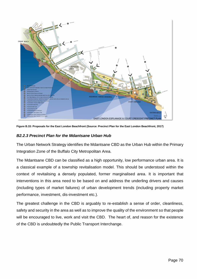
Page 70
Figure B.33: Proposals for the East London Beachfront (Source: Precinct Plan for the East London Beachfront, 2017)
B2.2.3 Precinct Plan for the Mdantsane Urban Hub
The Urban Network Strategy identifies the Mdantsane CBD as the Urban Hub within the Primary
Integration Zone of the Buffalo City Metropolitan Area.
The Mdantsane CBD can be classified as a high opportunity, low performance urban area. It is
a classical example of a township revitalisation model. This should be understood within the
context of revitalising a densely populated, former marginalised area. It is important that
interventions in this area need to be based on and address the underling drivers and causes
(including types of market failures) of urban development trends (including property market
performance, investment, dis-investment etc.).
The greatest challenge in the CBD is arguably to re-establish a sense of order, cleanliness,
safety and security in the area as well as to improve the quality of the environment so that people
will be encouraged to live, work and visit the CBD. The heart of, and reason for the existence
of the CBD is undoubtedly the Public Transport Interchange.
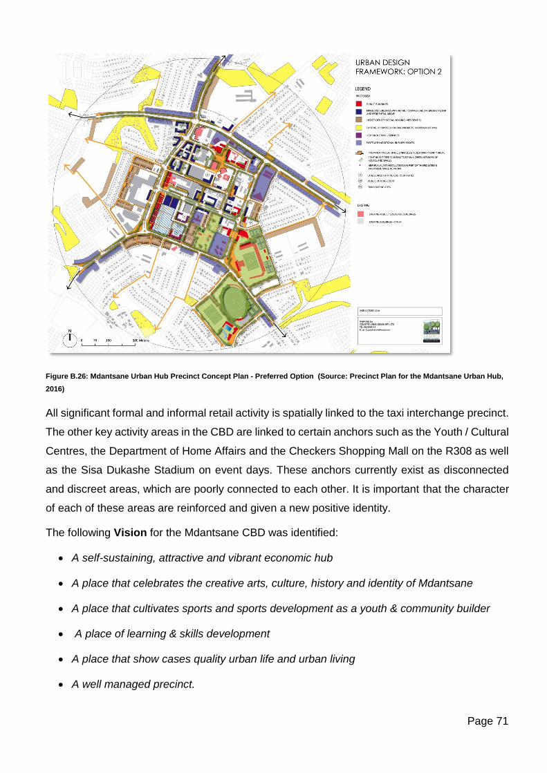
Page 71
Figure B.26: Mdantsane Urban Hub Precinct Concept Plan - Preferred Option (Source: Precinct Plan for the Mdantsane Urban Hub,
2016)
All significant formal and informal retail activity is spatially linked to the taxi interchange precinct.
The other key activity areas in the CBD are linked to certain anchors such as the Youth / Cultural
Centres, the Department of Home Affairs and the Checkers Shopping Mall on the R308 as well
as the Sisa Dukashe Stadium on event days. These anchors currently exist as disconnected
and discreet areas, which are poorly connected to each other. It is important that the character
of each of these areas are reinforced and given a new positive identity.
The following Vision for the Mdantsane CBD was identified:
• A self-sustaining, attractive and vibrant economic hub
• A place that celebrates the creative arts, culture, history and identity of Mdantsane
• A place that cultivates sports and sports development as a youth & community builder
• A place of learning & skills development
• A place that show cases quality urban life and urban living
• A well managed precinct.
Page 72
The objectives of the Urban Design Framework are therefore to:
• Reinforce and improve the CBD’s existing attractions and destinations, in particular the
Taxi Interchange Sub-Precinct, the Cultural Sub-Precinct, the Shopping Sub-Precinct well
as the Sisa Dukashe Stadium Precinct.
• To introduce new anchors and areas of activity to expand and improve the functionality of
the CBD.
• Create a clear hierarchy of public urban spaces linked through a well-connected network
of routes for pedestrians
• To improve general access and connectivity through the area.
• Upgrade and improve buildings and features of cultural / historic significance and value in
order to create a strong identity for the area.
• Encourage a high standard of urban design that places significance on the public realm
and relationships between buildings and streets.
• Create an urban form that assists in creating a safer and pedestrian friendly environment.
The study calculated that there was opportunity to develop:
• 2040 Social Housing Units
• 1279 High Density Hosing units
• 50000m2 of Retail and Commercial Space
The Implementation Plan for the Mdantsane Urban Hub includes the following Programmes
with associated Projects:
Programme Project
Institutional Support
Programme
As a precondition to the successful implementation of the Hub it was
identified that the Establishment of an appropriate institutional
vehicle would be essential to undertake Precinct Management that will
address: Engaging with local community and stakeholders; Safety and
Security; Cleansing; Management Informal traders; Management
Informal traders; Management Informal traders; Assist with fast-tracking
of building plans.
Public Transport
Programme
Upgrading and improving access and movement to and within the
CBD.
Page 73
Public Realm Upgrade
Programme
Upgrading of the Public Realm
Formulation of Urban Design Guidelines
Housing Programme Mixed Use and High-density Housing Development Projects
Local Economic
Development
Programme
Local economic development initiatives such as developing space for
Hawkers to operate
Infrastructure
Development
Programme
Infrastructure upgrading projects
Land Release
Programme
Rectifying Cadastral and Property Registration issues
B2.2.4 Precincts which form part of the MELD Corridor
The development of a mixed land use at sufficient densities in the activity corridor from
Mdantsane to East London was identified as being very important for the economic growth of
the city. In this regard several Local Spatial Development Framework Plans include proposals
for mixed use precincts located at strategic points along the MELD corridor, primarily in areas
termed ‘Development Nodes’.
The most significant of these being:
• Mdantsane Urban Hub.
• Mount Ruth Nodal Precinct.
• Arnoldton Nodal Precinct.
• The Amalinda Junction
• Vincent Commercial Node
Duncan Village Redevelopment Initiative
The redevelopment of Duncan Village is considered a high priority for the Buffalo City
Metropolitan Municipality (BCMM). The Duncan Village LSDF (2009) was formulated to provide
a spatial and developmental solution to the issues such as the overcrowding experienced in
Duncan Village.
The Duncan Village LSDF acknowledged the central location of Duncan Village and attempted
to retain as many families in Duncan Village as possible but recognised that Reeston and other
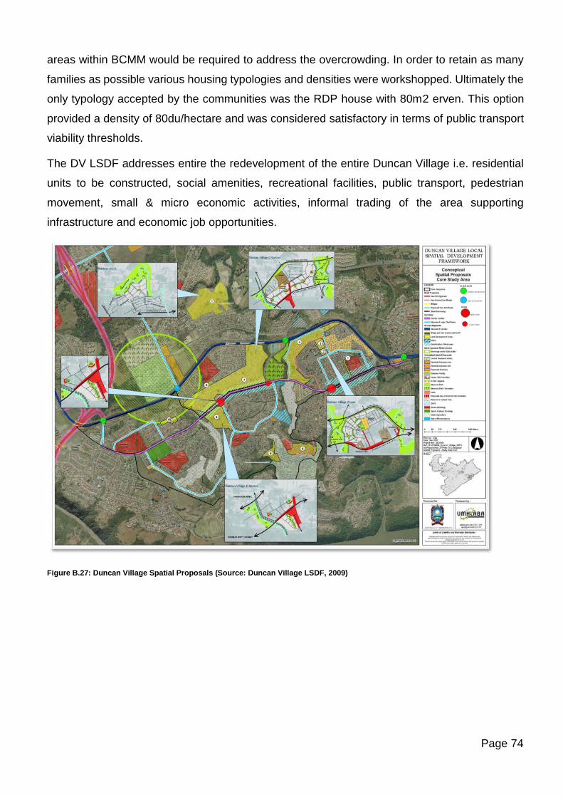
Page 74
areas within BCMM would be required to address the overcrowding. In order to retain as many
families as possible various housing typologies and densities were workshopped. Ultimately the
only typology accepted by the communities was the RDP house with 80m2 erven. This option
provided a density of 80du/hectare and was considered satisfactory in terms of public transport
viability thresholds.
The DV LSDF addresses entire the redevelopment of the entire Duncan Village i.e. residential
units to be constructed, social amenities, recreational facilities, public transport, pedestrian
movement, small & micro economic activities, informal trading of the area supporting
infrastructure and economic job opportunities.
Figure B.27: Duncan Village Spatial Proposals (Source: Duncan Village LSDF, 2009)
Page 75
The DV LSDF identified the following Projects which have subsequently been grouped into
programmes by the MDGS Township Revitalisation Work Stream:
Programme Project
Infrastructure
Development
Programme
Second Creek Catchment Water loss Management Programme
Reeston Waste Water Works Extension
Queens Park Substation
Waste Water Diversion Tunnel
Institutional Support
Programme
Precinct Management for DV
Housing Development
Programme
Duncan Village Proper; C Section; D Hostel; Braelyn 10 Ext Proper &
Reeston including layout planning; Survey; Housing.
The Ndende pilot housing project demonstrated erven that are 80m²
and the construction phase is complete.
Preparation of TRAs and remaining land parcels for development in
support of the DV de-densification process
Public Transport
Pprogramme
Public Transport Plan in support of all aspects of the DVRI
redevelopment preocess which includes Reeston’s requirements and
the issue of transporting children to school
Upgrade of Douglas Smit Highway to support public transport and new
link to Ziphunazana at Sunnyside Road
Economic
Development
Programme
Acquisition and Release of land at Ndende and Jabavu for Mixed use
development in support of the Township Economy
Small enterprises training and management support, Construction and
IT skills training, urban agriculture
Social Facilities and
Services Programme
Engaging with the Dept of Education to formulate a programme for
School development to support the all areas involved in the DVRI re
development.
Engaging with Provincial Department of Health regarding provisioning
of Clinics in support of all areas involved in the DVRI re development.
Natural Environment
and Cultural Heritage
Preservation
Programme
Training residents to preserve the ecosystem and to be water-wise.
Piloting alternative energy and recycling initiatives.
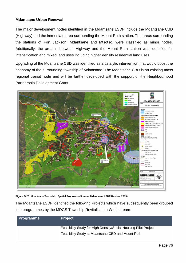
Page 76
Mdantsane Urban Renewal
The major development nodes identified in the Mdantsane LSDF include the Mdantsane CBD
(Highway) and the immediate area surrounding the Mount Ruth station. The areas surrounding
the stations of Fort Jackson, Mdantsane and Mtsotso, were classified as minor nodes.
Additionally, the area in between Highway and the Mount Ruth station was identified for
intensification and mixed land uses including higher density residential land uses.
Upgrading of the Mdantsane CBD was identified as a catalytic intervention that would boost the
economy of the surrounding township of Mdantsane. The Mdantsane CBD is an existing mass
regional transit node and will be further developed with the support of the Neighbourhood
Partnership Development Grant.
Figure B.28: Mdantsane Township: Spatial Proposals (Source: Mdantsane LSDF Review, 2013)
The Mdantsane LSDF identified the following Projects which have subsequently been grouped
into programmes by the MDGS Township Revitalisation Work stream:
Programme Project
Feasibility Study for High Density/Social Housing Pilot Project
Feasibility Study at Mdantsane CBD and Mount Ruth
Page 77
Land Acquisition and
Development
Programme
Finalise the Upgrading of Land Tenure from Deed of Grant to Freehold
Title for NU2(CBD)
Informal Settlement Upgrade
Land Acquisition Bufferstrip, Mount Ruth, Mdantsane Industrial Precinct
and CBD
Transfer of State land to State as a result of Donation of Farm 1404 to
BCMM
Infrastructure
Development
Programme
Upgrade of Water Supply Network: Mdantsane, Mt Ruth, CBD,
Mdantsane Industrial
Upgrade of Waste Water Treatment Network and Capacity: Mdantsane,
Mt Ruth, CBD, Mdantsane Industrial
Upgrade of Mount Ruth Substation and construction of Zone 17
substation: Mdantsane, Mt Ruth, CBD, Mdantsane Industrial
Institutional Support
Programme
Precinct Management for CBD/Highway and Mount Ruth
Housing Development
Programme
Bufferstrip housing And informal Settlement upgrading and NUSP
Public Transport
Programme
Feasibility study re the proposed link between the N2 and Mdantsane at
the Nahoon Dam off ramp
Upgrade of Public Transport Facilities at Mdantsane CBD with feeder
route to Mount Ruth Station
Feasibility studies for Needs Camp Potsdam bridge
Feasibility Study Station at Potsdam for WSU
Road Network Development to support public transport
Upgrade of Mt Ruth Station
Urban Agriculture
Programme
Urban Agriculture Extension services
Area to west of Potsdam to be formalised for dryland agriculture
Acquisition, release and development of land around the Mount Ruth
Station for hawker stalls and small business purposes
Page 78
Economic
Development
Programme
Acquisition, release of land at Mount Ruth for a light industrial park
Social Facilities and
Services Programme
One-stop service centre at Mdantsane CBD with Wifi
Multi purpose centre at Mt Ruth with Wifi
Sharing of public and educational recreational facilities
Extension of Fort Jackson Cemetery
Waste Management
Programme
New Cell at Roundhill Regional Waste Site
New Depots & transfer stations
Replacement of Fleet
Waste Reduction/Buy back centres
North West Corridor
The North-West Corridor (NWC) is a planned corridor which when constructed will link the East
London CBD to the Amalinda Junction situated on the MELD Rail route. The route then links
back to Duncan Village on the MELD Corridor. The NWC is thus an integral part of the MELD
Corridor as it provides critical transport linkages into the road and rail component of the MELD
Corridor. Situated along the NWC are two main precincts:
i) Chiselhurst High-Density Housing Precinct
ii) Amalinda Junction Precinct. This has been identified by Council as a Catalytic Project.
This area will contain a mix of uses and housing types.
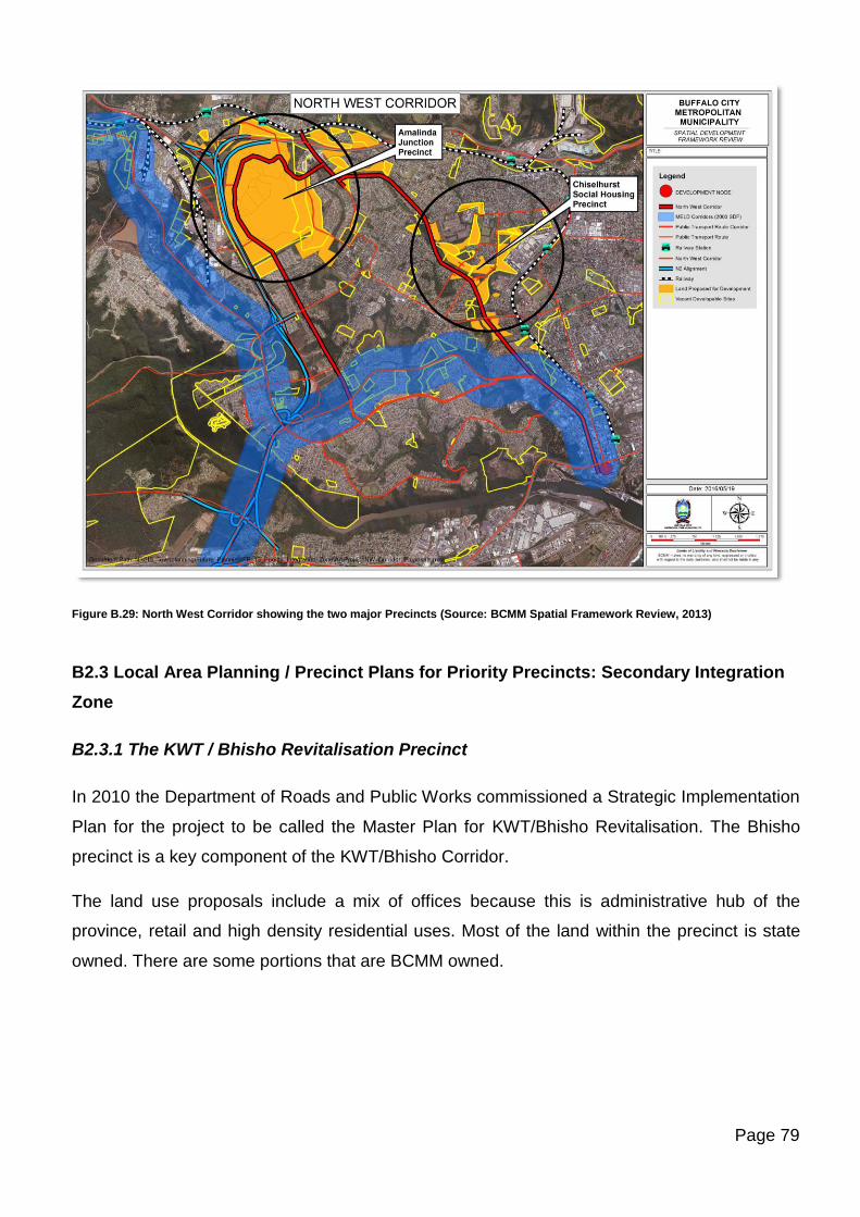
Page 79
Figure B.29: North West Corridor showing the two major Precincts (Source: BCMM Spatial Framework Review, 2013)
B2.3 Local Area Planning / Precinct Plans for Priority Precincts: Secondary Integration
Zone
B2.3.1 The KWT / Bhisho Revitalisation Precinct
In 2010 the Department of Roads and Public Works commissioned a Strategic Implementation
Plan for the project to be called the Master Plan for KWT/Bhisho Revitalisation. The Bhisho
precinct is a key component of the KWT/Bhisho Corridor.
The land use proposals include a mix of offices because this is administrative hub of the
province, retail and high density residential uses. Most of the land within the precinct is state
owned. There are some portions that are BCMM owned.
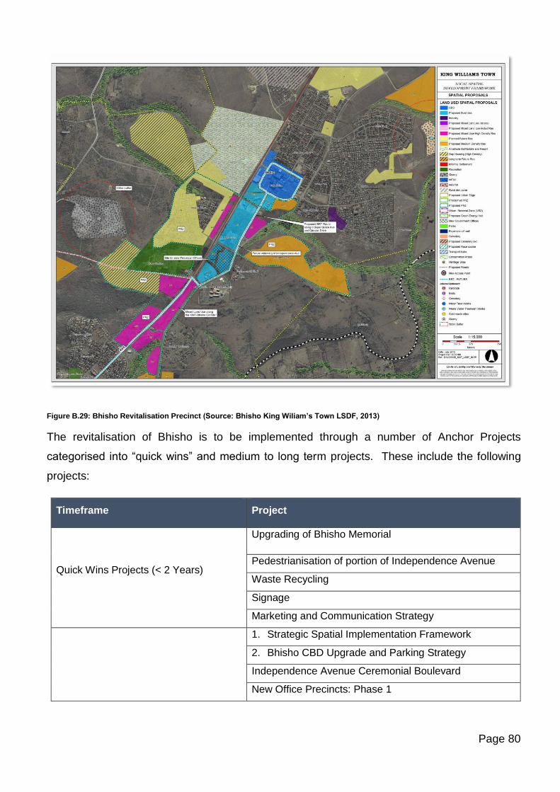
Page 80
Figure B.29: Bhisho Revitalisation Precinct (Source: Bhisho King Wiliam’s Town LSDF, 2013)
The revitalisation of Bhisho is to be implemented through a number of Anchor Projects
categorised into “quick wins” and medium to long term projects. These include the following
projects:
Timeframe Project
Quick Wins Projects (< 2 Years)
Upgrading of Bhisho Memorial
Pedestrianisation of portion of Independence Avenue
Waste Recycling
Signage
Marketing and Communication Strategy
1. Strategic Spatial Implementation Framework
2. Bhisho CBD Upgrade and Parking Strategy
Independence Avenue Ceremonial Boulevard
New Office Precincts: Phase 1
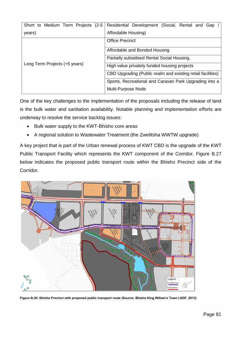
Page 81
Short to Medium Term Projects (2-5
years)
Residential Development (Social, Rental and Gap /
Affordable Housing)
Long Term Projects (+5 years)
Office Precinct
Affordable and Bonded Housing
Partially subsidised Rental Social Housing,
High value privately funded housing projects
CBD Upgrading (Public realm and existing retail facilities)
Sports, Recreational and Caravan Park Upgrading into a
Multi-Purpose Node
One of the key challenges to the implementation of the proposals including the release of land
is the bulk water and sanitation availability. Notable planning and implementation efforts are
underway to resolve the service backlog issues:
• Bulk water supply to the KWT-Bhisho core areas
• A regional solution to Wastewater Treatment (the Zwelitsha WWTW upgrade)
A key project that is part of the Urban renewal process of KWT CBD is the upgrade of the KWT
Public Transport Facility which represents the KWT component of the Corridor. Figure B.27
below indicates the proposed public transport route within the Bhisho Precinct side of the
Corridor.
Figure B.30: Bhisho Precinct with proposed public transport route (Source: Bhisho King Wiliam’s Town LSDF, 2013)
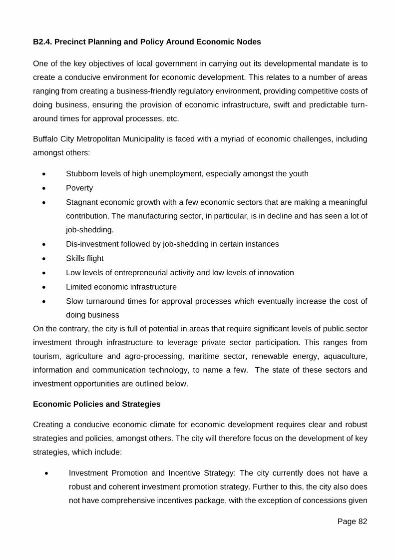
Page 82
B2.4. Precinct Planning and Policy Around Economic Nodes
One of the key objectives of local government in carrying out its developmental mandate is to
create a conducive environment for economic development. This relates to a number of areas
ranging from creating a business-friendly regulatory environment, providing competitive costs of
doing business, ensuring the provision of economic infrastructure, swift and predictable turn-
around times for approval processes, etc.
Buffalo City Metropolitan Municipality is faced with a myriad of economic challenges, including
amongst others:
• Stubborn levels of high unemployment, especially amongst the youth
• Poverty
• Stagnant economic growth with a few economic sectors that are making a meaningful
contribution. The manufacturing sector, in particular, is in decline and has seen a lot of
job-shedding.
• Dis-investment followed by job-shedding in certain instances
• Skills flight
• Low levels of entrepreneurial activity and low levels of innovation
• Limited economic infrastructure
• Slow turnaround times for approval processes which eventually increase the cost of
doing business
On the contrary, the city is full of potential in areas that require significant levels of public sector
investment through infrastructure to leverage private sector participation. This ranges from
tourism, agriculture and agro-processing, maritime sector, renewable energy, aquaculture,
information and communication technology, to name a few. The state of these sectors and
investment opportunities are outlined below.
Economic Policies and Strategies
Creating a conducive economic climate for economic development requires clear and robust
strategies and policies, amongst others. The city will therefore focus on the development of key
strategies, which include:
• Investment Promotion and Incentive Strategy: The city currently does not have a
robust and coherent investment promotion strategy. Further to this, the city also does
not have comprehensive incentives package, with the exception of concessions given
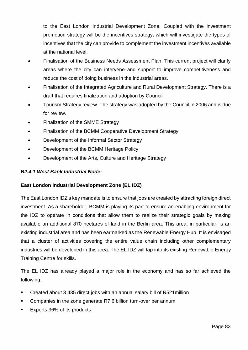
Page 83
to the East London Industrial Development Zone. Coupled with the investment
promotion strategy will be the incentives strategy, which will investigate the types of
incentives that the city can provide to complement the investment incentives available
at the national level.
• Finalisation of the Business Needs Assessment Plan. This current project will clarify
areas where the city can intervene and support to improve competitiveness and
reduce the cost of doing business in the industrial areas.
• Finalisation of the Integrated Agriculture and Rural Development Strategy. There is a
draft that requires finalization and adoption by Council.
• Tourism Strategy review. The strategy was adopted by the Council in 2006 and is due
for review.
• Finalization of the SMME Strategy
• Finalization of the BCMM Cooperative Development Strategy
• Development of the Informal Sector Strategy
• Development of the BCMM Heritage Policy
• Development of the Arts, Culture and Heritage Strategy
B2.4.1 West Bank Industrial Node:
East London Industrial Development Zone (EL IDZ)
The East London IDZ’s key mandate is to ensure that jobs are created by attracting foreign direct
investment. As a shareholder, BCMM is playing its part to ensure an enabling environment for
the IDZ to operate in conditions that allow them to realize their strategic goals by making
available an additional 870 hectares of land in the Berlin area. This area, in particular, is an
existing industrial area and has been earmarked as the Renewable Energy Hub. It is envisaged
that a cluster of activities covering the entire value chain including other complementary
industries will be developed in this area. The EL IDZ will tap into its existing Renewable Energy
Training Centre for skills.
The EL IDZ has already played a major role in the economy and has so far achieved the
following:
▪ Created about 3 435 direct jobs with an annual salary bill of R521million
▪ Companies in the zone generate R7,6 billion turn-over per annum
▪ Exports 36% of its products
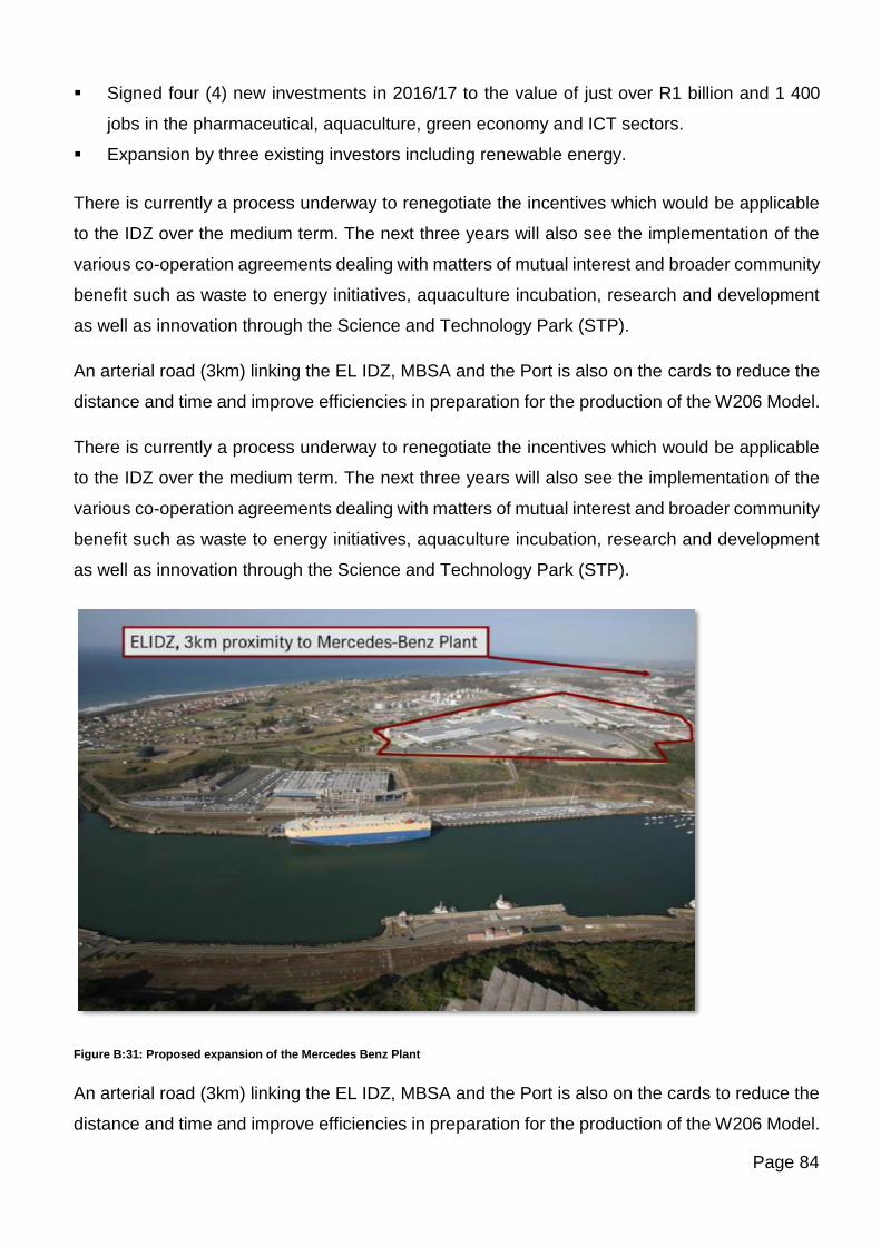
Page 84
▪ Signed four (4) new investments in 2016/17 to the value of just over R1 billion and 1 400
jobs in the pharmaceutical, aquaculture, green economy and ICT sectors.
▪ Expansion by three existing investors including renewable energy.
There is currently a process underway to renegotiate the incentives which would be applicable
to the IDZ over the medium term. The next three years will also see the implementation of the
various co-operation agreements dealing with matters of mutual interest and broader community
benefit such as waste to energy initiatives, aquaculture incubation, research and development
as well as innovation through the Science and Technology Park (STP).
An arterial road (3km) linking the EL IDZ, MBSA and the Port is also on the cards to reduce the
distance and time and improve efficiencies in preparation for the production of the W206 Model.
There is currently a process underway to renegotiate the incentives which would be applicable
to the IDZ over the medium term. The next three years will also see the implementation of the
various co-operation agreements dealing with matters of mutual interest and broader community
benefit such as waste to energy initiatives, aquaculture incubation, research and development
as well as innovation through the Science and Technology Park (STP).
Figure B:31: Proposed expansion of the Mercedes Benz Plant
An arterial road (3km) linking the EL IDZ, MBSA and the Port is also on the cards to reduce the
distance and time and improve efficiencies in preparation for the production of the W206 Model.
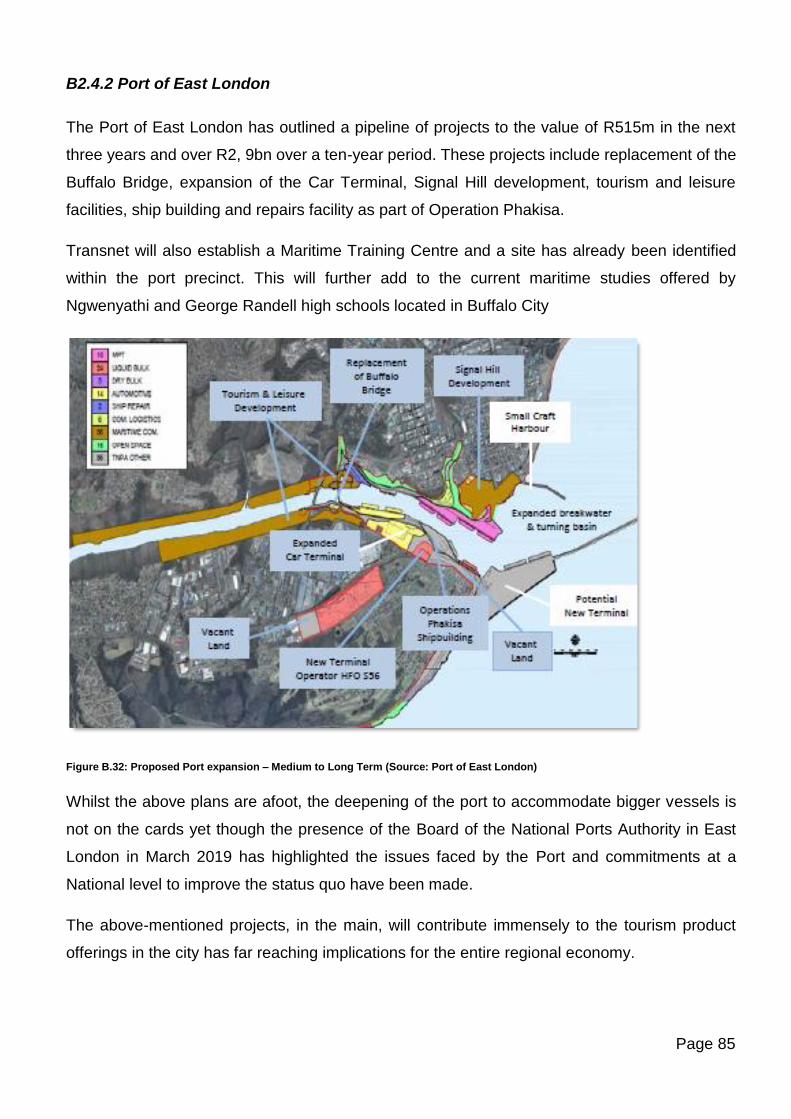
Page 85
B2.4.2 Port of East London
The Port of East London has outlined a pipeline of projects to the value of R515m in the next
three years and over R2, 9bn over a ten-year period. These projects include replacement of the
Buffalo Bridge, expansion of the Car Terminal, Signal Hill development, tourism and leisure
facilities, ship building and repairs facility as part of Operation Phakisa.
Transnet will also establish a Maritime Training Centre and a site has already been identified
within the port precinct. This will further add to the current maritime studies offered by
Ngwenyathi and George Randell high schools located in Buffalo City
Figure B.32: Proposed Port expansion – Medium to Long Term (Source: Port of East London)
Whilst the above plans are afoot, the deepening of the port to accommodate bigger vessels is
not on the cards yet though the presence of the Board of the National Ports Authority in East
London in March 2019 has highlighted the issues faced by the Port and commitments at a
National level to improve the status quo have been made.
The above-mentioned projects, in the main, will contribute immensely to the tourism product
offerings in the city has far reaching implications for the entire regional economy.
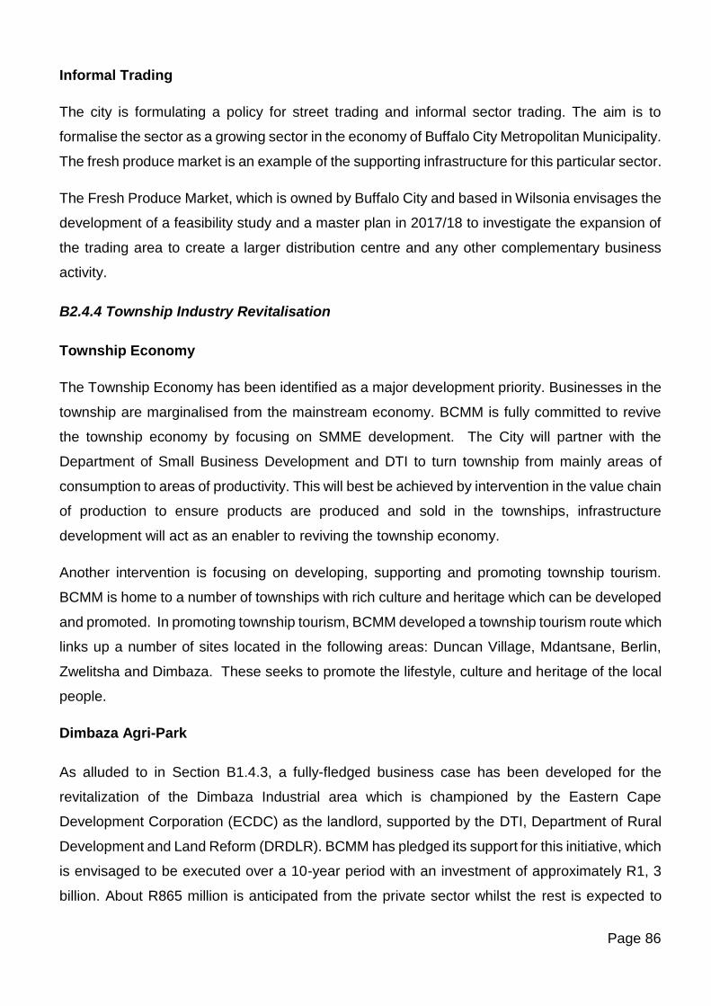
Page 86
Informal Trading
The city is formulating a policy for street trading and informal sector trading. The aim is to
formalise the sector as a growing sector in the economy of Buffalo City Metropolitan Municipality.
The fresh produce market is an example of the supporting infrastructure for this particular sector.
The Fresh Produce Market, which is owned by Buffalo City and based in Wilsonia envisages the
development of a feasibility study and a master plan in 2017/18 to investigate the expansion of
the trading area to create a larger distribution centre and any other complementary business
activity.
B2.4.4 Township Industry Revitalisation
Township Economy
The Township Economy has been identified as a major development priority. Businesses in the
township are marginalised from the mainstream economy. BCMM is fully committed to revive
the township economy by focusing on SMME development. The City will partner with the
Department of Small Business Development and DTI to turn township from mainly areas of
consumption to areas of productivity. This will best be achieved by intervention in the value chain
of production to ensure products are produced and sold in the townships, infrastructure
development will act as an enabler to reviving the township economy.
Another intervention is focusing on developing, supporting and promoting township tourism.
BCMM is home to a number of townships with rich culture and heritage which can be developed
and promoted. In promoting township tourism, BCMM developed a township tourism route which
links up a number of sites located in the following areas: Duncan Village, Mdantsane, Berlin,
Zwelitsha and Dimbaza. These seeks to promote the lifestyle, culture and heritage of the local
people.
Dimbaza Agri-Park
As alluded to in Section B1.4.3, a fully-fledged business case has been developed for the
revitalization of the Dimbaza Industrial area which is championed by the Eastern Cape
Development Corporation (ECDC) as the landlord, supported by the DTI, Department of Rural
Development and Land Reform (DRDLR). BCMM has pledged its support for this initiative, which
is envisaged to be executed over a 10-year period with an investment of approximately R1, 3
billion. About R865 million is anticipated from the private sector whilst the rest is expected to
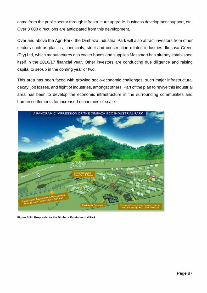
Page 87
come from the public sector through infrastructure upgrade, business development support, etc.
Over 3 000 direct jobs are anticipated from this development.
Over and above the Agri-Park, the Dimbaza Industrial Park will also attract investors from other
sectors such as plastics, chemicals, steel and construction related industries. Ikusasa Green
(Pty) Ltd, which manufactures eco cooler boxes and supplies Massmart has already established
itself in the 2016/17 financial year. Other investors are conducting due diligence and raising
capital to set-up in the coming year or two.
This area has been faced with growing socio-economic challenges, such major infrastructural
decay, job losses, and flight of industries, amongst others. Part of the plan to revive this industrial
area has been to develop the economic infrastructure in the surrounding communities and
human settlements for increased economies of scale.
Figure B.34: Proposals for the Dimbaza Eco-Industrial Park
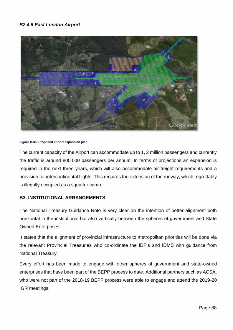
Page 88
B2.4.5 East London Airport
Figure B.35: Proposed airport expansion plan
The current capacity of the Airport can accommodate up to 1, 2 million passengers and currently
the traffic is around 800 000 passengers per annum. In terms of projections an expansion is
required in the next three years, which will also accommodate air freight requirements and a
provision for intercontinental flights. This requires the extension of the runway, which regrettably
is illegally occupied as a squatter camp.
B3. INSTITUTIONAL ARRANGEMENTS
The National Treasury Guidance Note is very clear on the intention of better alignment both
horizontal in the institutional but also vertically between the spheres of government and State
Owned Enterprises.
It states that the alignment of provincial infrastructure to metropolitan priorities will be done via
the relevant Provincial Treasuries who co-ordinate the IDP’s and IDMS with guidance from
National Treasury.
Every effort has been made to engage with other spheres of government and state-owned
enterprises that have been part of the BEPP process to date. Additional partners such as ACSA,
who were not part of the 2018-19 BEPP process were able to engage and attend the 2019-20
IGR meetings.
Page 89
As outlined in Section A4, all scheduled BEPP Task Team and IGR meetings as per the BEPP
Process Plan have been conducted with fair attendance from invited stakeholders (see minutes
of meetings attached in Annexures 6 & 7). Additional meetings were held in order to convene
with stakeholders who were unable to attend previous sessions. Where stakeholders attended
and took part in meetings, genuinely interactive sessions were had and discussions on joint
planning and budgeting were fruitful.
Organizations and representatives that formed part of the above two Task Teams are identified
in Annexure 6 and Annexure 7 of this document.
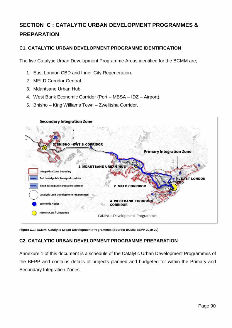
Page 90
SECTION C : CATALYTIC URBAN DEVELOPMENT PROGRAMMES &
PREPARATION
C1. CATALYTIC URBAN DEVELOPMENT PROGRAMME IDENTIFICATION
The five Catalytic Urban Development Programme Areas identified for the BCMM are;
1. East London CBD and Inner-City Regeneration.
2. MELD Corridor Central.
3. Mdantsane Urban Hub.
4. West Bank Economic Corridor (Port – MBSA – IDZ – Airport).
5. Bhisho – King Williams Town – Zwelitsha Corridor.
Figure C.1: BCMM: Catalytic Urban Development Programmes (Source: BCMM BEPP 2019-20)
C2. CATALYTIC URBAN DEVELOPMENT PROGRAMME PREPARATION
Annexure 1 of this document is a schedule of the Catalytic Urban Development Programmes of
the BEPP and contains details of projects planned and budgeted for within the Primary and
Secondary Integration Zones.
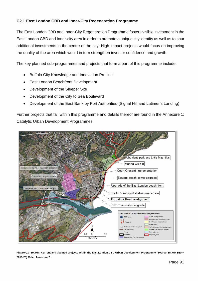
Page 91
C2.1 East London CBD and Inner-City Regeneration Programme
The East London CBD and Inner-City Regeneration Programme fosters visible investment in the
East London CBD and Inner-city area in order to promote a unique city identity as well as to spur
additional investments in the centre of the city. High impact projects would focus on improving
the quality of the area which would in turn strengthen investor confidence and growth.
The key planned sub-programmes and projects that form a part of this programme include;
• Buffalo City Knowledge and Innovation Precinct
• East London Beachfront Development
• Development of the Sleeper Site
• Development of the City to Sea Boulevard
• Development of the East Bank by Port Authorities (Signal Hill and Latimer’s Landing)
Further projects that fall within this programme and details thereof are found in the Annexure 1:
Catalytic Urban Development Programmes.
Figure C.3: BCMM: Current and planned projects within the East London CBD Urban Development Programme (Source: BCMM BEPP
2019-20) Refer Annexure 2.
Page 92
C2.1.1 Buffalo City Knowledge and Innovation Precinct
The Buffalo City Metropolitan Development Agency (BCMDA) has engaged the Human
Sciences Research Council (HSRC) to initiate a consultative process to unlock the regeneration
of the Inner-City of East London. The following concept note on the Buffalo City Knowledge and
Innovation Precinct is prepared by the HSRC (March, 2019) in collaboration with the BCMDA
and City through discussions convened by the Municipality’s Enterprise Management Office
(EPMO) and GTAC. The first phase of the project is concerned with the establishment of a City
Improvement District and will be elaborated on further in Section F of the document which
addresses urban management of key catalytic precincts.
The second phase of the project is structured around the universities and medical institutions –
so-called “eds and meds” – which are anchored in the inner city. The project is a multi-
stakeholder, multi-year initiative, which seeks to realise Buffalo City’s potential through
knowledge production and innovation, preparing it for the changes associated with the fourth
industrial revolution. The project seeks to encourage the diversification of the urban economy
through a strategy which builds on numerous small, significant interventions that seek to rebrand
the inner city, forging a number of development nodes which are then connected as a coherent
area to help to drive the city’s broader growth. The development philosophy underpinning the
initiative is predicated on a “massive small” approach which focuses on many little interventions
which will have a large cumulative impact on the city’s image and orientation. This kind of
approach also builds confidence among stakeholders over time as impacts are realised.
Key “eds and meds” stakeholders participating in the project include: the University of Fort Hare
in the south city-centre, Walter Sisulu University in the central business district (CBD), and
Buffalo City TVET college on the northern edge of the city centre in Southernwood. There are
also a number of private and provincial hospitals and medical-service businesses and practices
in the inner-city area, particularly Southernwood, which are potential nodes for science in the
city. A priority concern is to seek to retain WSU as an anchor tenant in the CBD (and conserve
the rates and other contributions to the municipality’s coffers that may otherwise be lost). In
terms of the development approach employed the project which promotes the physical clustering
of anchors in the area in order to galvanise larger knowledge development, WSU should be
wooed to stay. To this end, the project also encourages the establishment of additional high-end
educational institutions and facilities in the inner city, in particular those engaged in the
engineering, information and communications technology (ICT) and marine science sectors,
including at the post-graduate level. In addition, to the so-called “anchor” institutions in the area,
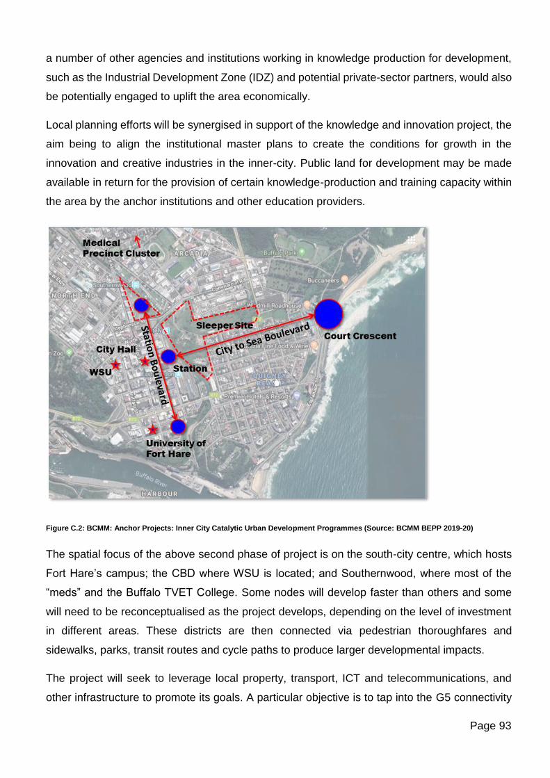
Page 93
a number of other agencies and institutions working in knowledge production for development,
such as the Industrial Development Zone (IDZ) and potential private-sector partners, would also
be potentially engaged to uplift the area economically.
Local planning efforts will be synergised in support of the knowledge and innovation project, the
aim being to align the institutional master plans to create the conditions for growth in the
innovation and creative industries in the inner-city. Public land for development may be made
available in return for the provision of certain knowledge-production and training capacity within
the area by the anchor institutions and other education providers.
Figure C.2: BCMM: Anchor Projects: Inner City Catalytic Urban Development Programmes (Source: BCMM BEPP 2019-20)
The spatial focus of the above second phase of project is on the south-city centre, which hosts
Fort Hare’s campus; the CBD where WSU is located; and Southernwood, where most of the
“meds” and the Buffalo TVET College. Some nodes will develop faster than others and some
will need to be reconceptualised as the project develops, depending on the level of investment
in different areas. These districts are then connected via pedestrian thoroughfares and
sidewalks, parks, transit routes and cycle paths to produce larger developmental impacts.
The project will seek to leverage local property, transport, ICT and telecommunications, and
other infrastructure to promote its goals. A particular objective is to tap into the G5 connectivity
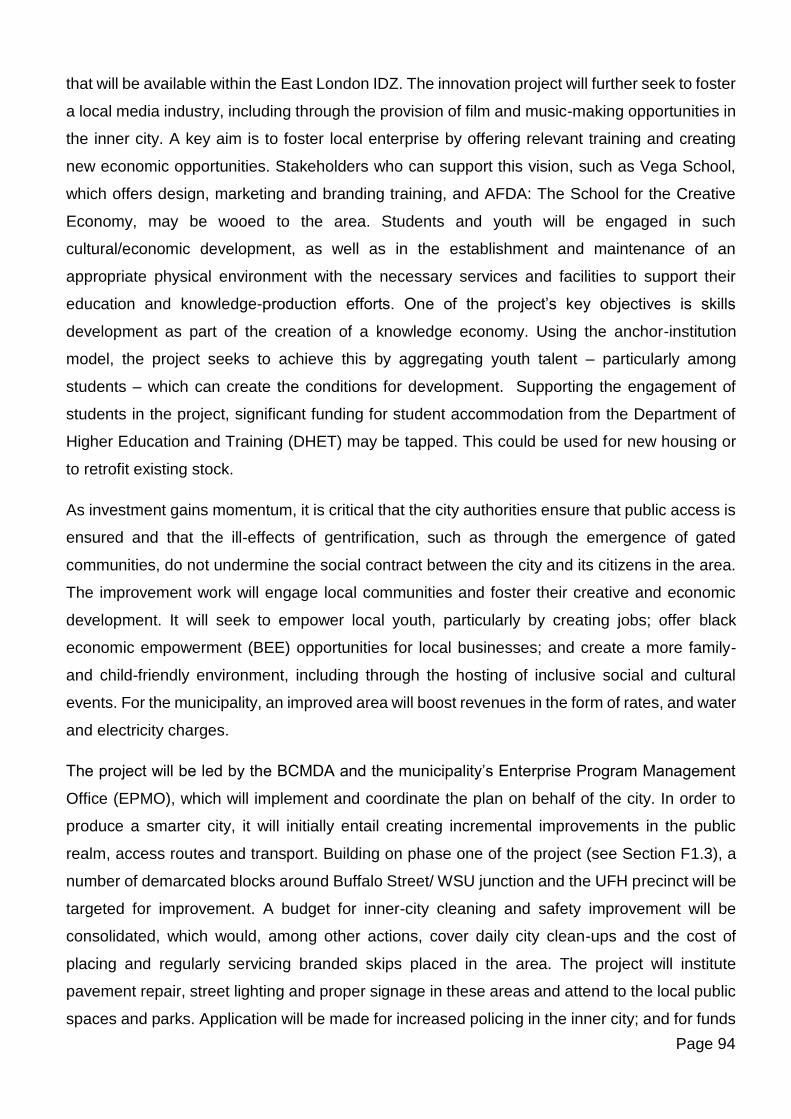
Page 94
that will be available within the East London IDZ. The innovation project will further seek to foster
a local media industry, including through the provision of film and music-making opportunities in
the inner city. A key aim is to foster local enterprise by offering relevant training and creating
new economic opportunities. Stakeholders who can support this vision, such as Vega School,
which offers design, marketing and branding training, and AFDA: The School for the Creative
Economy, may be wooed to the area. Students and youth will be engaged in such
cultural/economic development, as well as in the establishment and maintenance of an
appropriate physical environment with the necessary services and facilities to support their
education and knowledge-production efforts. One of the project’s key objectives is skills
development as part of the creation of a knowledge economy. Using the anchor-institution
model, the project seeks to achieve this by aggregating youth talent – particularly among
students – which can create the conditions for development. Supporting the engagement of
students in the project, significant funding for student accommodation from the Department of
Higher Education and Training (DHET) may be tapped. This could be used for new housing or
to retrofit existing stock.
As investment gains momentum, it is critical that the city authorities ensure that public access is
ensured and that the ill-effects of gentrification, such as through the emergence of gated
communities, do not undermine the social contract between the city and its citizens in the area.
The improvement work will engage local communities and foster their creative and economic
development. It will seek to empower local youth, particularly by creating jobs; offer black
economic empowerment (BEE) opportunities for local businesses; and create a more family-
and child-friendly environment, including through the hosting of inclusive social and cultural
events. For the municipality, an improved area will boost revenues in the form of rates, and water
and electricity charges.
The project will be led by the BCMDA and the municipality’s Enterprise Program Management
Office (EPMO), which will implement and coordinate the plan on behalf of the city. In order to
produce a smarter city, it will initially entail creating incremental improvements in the public
realm, access routes and transport. Building on phase one of the project (see Section F1.3), a
number of demarcated blocks around Buffalo Street/ WSU junction and the UFH precinct will be
targeted for improvement. A budget for inner-city cleaning and safety improvement will be
consolidated, which would, among other actions, cover daily city clean-ups and the cost of
placing and regularly servicing branded skips placed in the area. The project will institute
pavement repair, street lighting and proper signage in these areas and attend to the local public
spaces and parks. Application will be made for increased policing in the inner city; and for funds
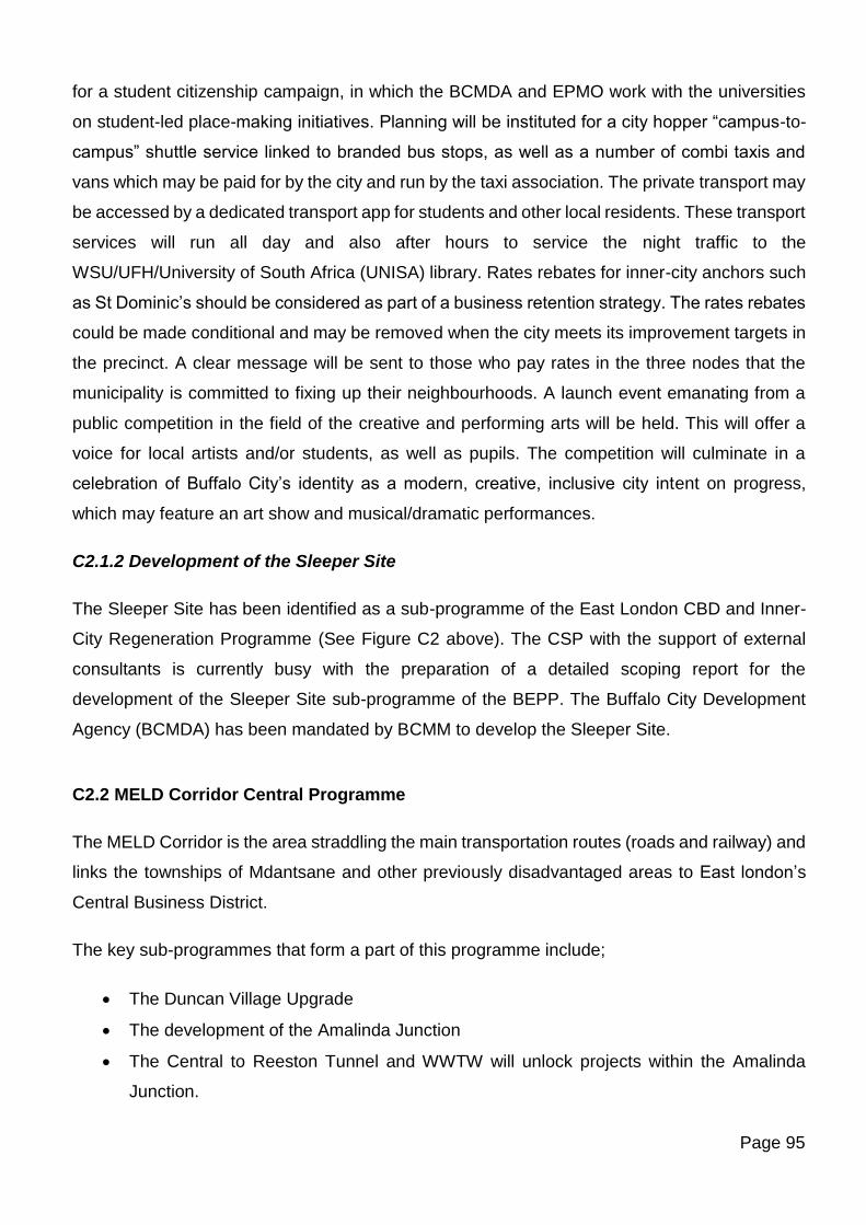
Page 95
for a student citizenship campaign, in which the BCMDA and EPMO work with the universities
on student-led place-making initiatives. Planning will be instituted for a city hopper “campus-to-
campus” shuttle service linked to branded bus stops, as well as a number of combi taxis and
vans which may be paid for by the city and run by the taxi association. The private transport may
be accessed by a dedicated transport app for students and other local residents. These transport
services will run all day and also after hours to service the night traffic to the
WSU/UFH/University of South Africa (UNISA) library. Rates rebates for inner-city anchors such
as St Dominic’s should be considered as part of a business retention strategy. The rates rebates
could be made conditional and may be removed when the city meets its improvement targets in
the precinct. A clear message will be sent to those who pay rates in the three nodes that the
municipality is committed to fixing up their neighbourhoods. A launch event emanating from a
public competition in the field of the creative and performing arts will be held. This will offer a
voice for local artists and/or students, as well as pupils. The competition will culminate in a
celebration of Buffalo City’s identity as a modern, creative, inclusive city intent on progress,
which may feature an art show and musical/dramatic performances.
C2.1.2 Development of the Sleeper Site
The Sleeper Site has been identified as a sub-programme of the East London CBD and Inner-
City Regeneration Programme (See Figure C2 above). The CSP with the support of external
consultants is currently busy with the preparation of a detailed scoping report for the
development of the Sleeper Site sub-programme of the BEPP. The Buffalo City Development
Agency (BCMDA) has been mandated by BCMM to develop the Sleeper Site.
C2.2 MELD Corridor Central Programme
The MELD Corridor is the area straddling the main transportation routes (roads and railway) and
links the townships of Mdantsane and other previously disadvantaged areas to East london’s
Central Business District.
The key sub-programmes that form a part of this programme include;
• The Duncan Village Upgrade
• The development of the Amalinda Junction
• The Central to Reeston Tunnel and WWTW will unlock projects within the Amalinda
Junction.
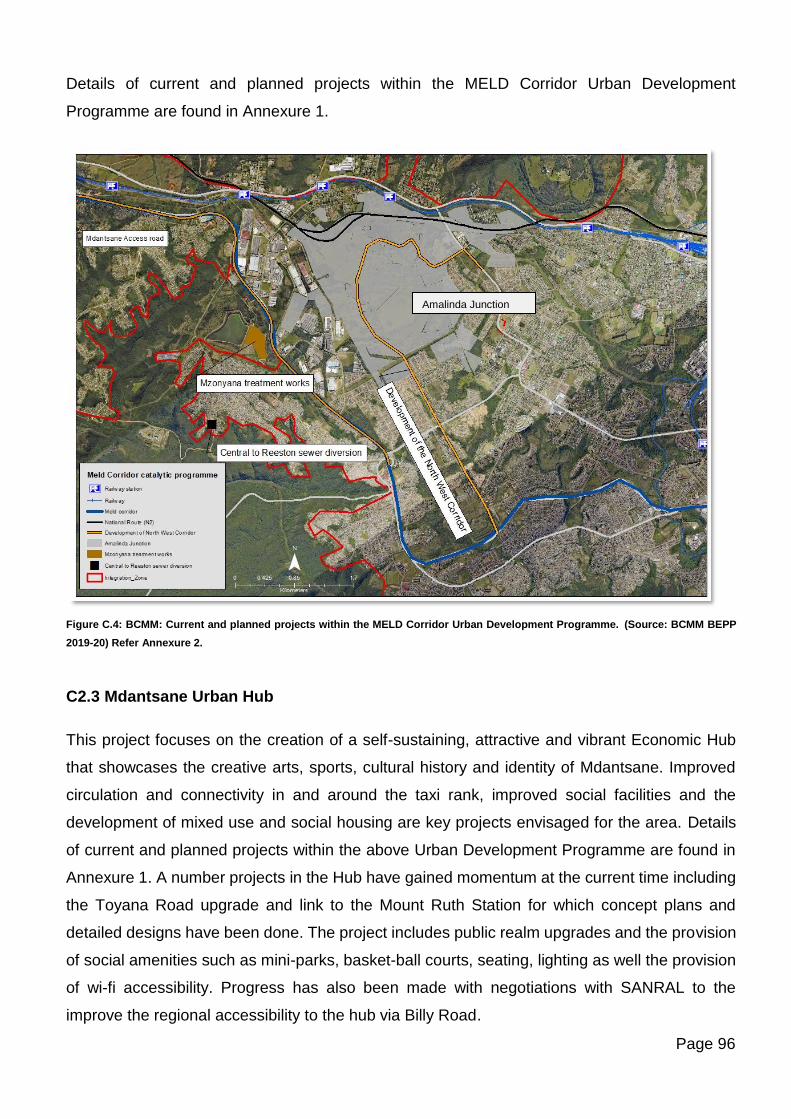
Page 96
Details of current and planned projects within the MELD Corridor Urban Development
Programme are found in Annexure 1.
Figure C.4: BCMM: Current and planned projects within the MELD Corridor Urban Development Programme. (Source: BCMM BEPP
2019-20) Refer Annexure 2.
C2.3 Mdantsane Urban Hub
This project focuses on the creation of a self-sustaining, attractive and vibrant Economic Hub
that showcases the creative arts, sports, cultural history and identity of Mdantsane. Improved
circulation and connectivity in and around the taxi rank, improved social facilities and the
development of mixed use and social housing are key projects envisaged for the area. Details
of current and planned projects within the above Urban Development Programme are found in
Annexure 1. A number projects in the Hub have gained momentum at the current time including
the Toyana Road upgrade and link to the Mount Ruth Station for which concept plans and
detailed designs have been done. The project includes public realm upgrades and the provision
of social amenities such as mini-parks, basket-ball courts, seating, lighting as well the provision
of wi-fi accessibility. Progress has also been made with negotiations with SANRAL to the
improve the regional accessibility to the hub via Billy Road.
Amalinda Junction
Page 97
Figure C.5: BCMM: Current and planned projects within the Mdantsane Urban Hub Urban Development Programme. (Source: BCMM
BEPP 2019-20) Refer Annexure 2
C2.4 West Bank Economic Corridor Programme
As described in earlier sections of the document, this is a newly established Catalytic
Programme which aims to support investment, improve logistics and thereby boost economic
performance. It includes a suite of planned and budgeted projects which will enhance the
infrastructure capacity as well as assist in unlocking planning and land related issues within the
corridor. Details of projects within this programme are found in Annexure 1 of this document.
The key sub-programmes that form a part of this programme include;
• Port of East London: Extend Main Breakwater and Deepen Entrance
• Revitalisation of the West Bank industrial area/ Motor Industry cluster
• EL Airport Expansion
• IOX International Sea Cable (ELIDZ)
• Water World (Water Park)
• Bulk infrastructure for the West Bank area
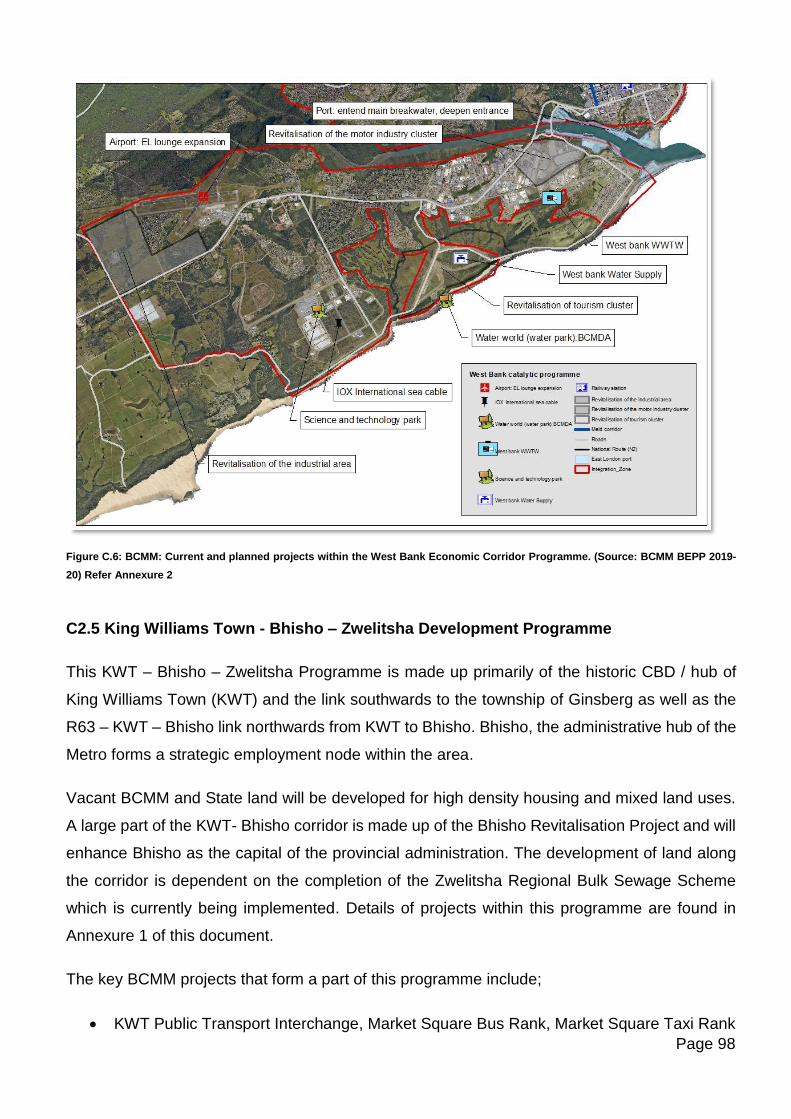
Page 98
Figure C.6: BCMM: Current and planned projects within the West Bank Economic Corridor Programme. (Source: BCMM BEPP 2019-
20) Refer Annexure 2
C2.5 King Williams Town - Bhisho – Zwelitsha Development Programme
This KWT – Bhisho – Zwelitsha Programme is made up primarily of the historic CBD / hub of
King Williams Town (KWT) and the link southwards to the township of Ginsberg as well as the
R63 – KWT – Bhisho link northwards from KWT to Bhisho. Bhisho, the administrative hub of the
Metro forms a strategic employment node within the area.
Vacant BCMM and State land will be developed for high density housing and mixed land uses.
A large part of the KWT- Bhisho corridor is made up of the Bhisho Revitalisation Project and will
enhance Bhisho as the capital of the provincial administration. The development of land along
the corridor is dependent on the completion of the Zwelitsha Regional Bulk Sewage Scheme
which is currently being implemented. Details of projects within this programme are found in
Annexure 1 of this document.
The key BCMM projects that form a part of this programme include;
• KWT Public Transport Interchange, Market Square Bus Rank, Market Square Taxi Rank
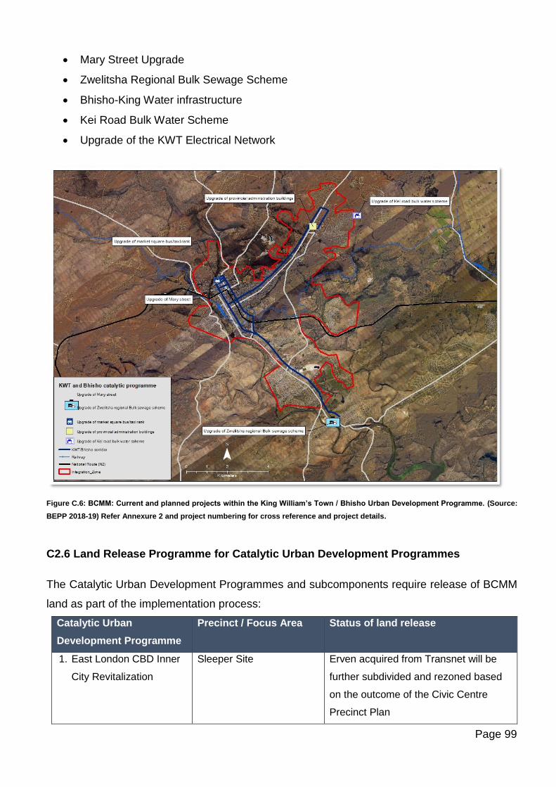
Page 99
• Mary Street Upgrade
• Zwelitsha Regional Bulk Sewage Scheme
• Bhisho-King Water infrastructure
• Kei Road Bulk Water Scheme
• Upgrade of the KWT Electrical Network
Figure C.6: BCMM: Current and planned projects within the King William’s Town / Bhisho Urban Development Programme. (Source:
BEPP 2018-19) Refer Annexure 2 and project numbering for cross reference and project details.
C2.6 Land Release Programme for Catalytic Urban Development Programmes
The Catalytic Urban Development Programmes and subcomponents require release of BCMM
land as part of the implementation process:
Catalytic Urban
Development Programme
Precinct / Focus Area Status of land release
1. East London CBD Inner
City Revitalization
Sleeper Site Erven acquired from Transnet will be
further subdivided and rezoned based
on the outcome of the Civic Centre
Precinct Plan
Page 100
East London Beachfront 4 Key land parcels will be released for
development through this process.
BCMM has signed a land availability
agreement with the BCMDA in this
regard.
2. MELD Corridor Amalinda Junction
Precinct including
Wilsonia Industrial area
BCMM land will be subdivided and
rezoned once the Sewer Tunnel project
is nearing completion.
North West Corridor
Precincts
BCMM land will be subdivided and
rezoned for release based on the
outcome of the NWC Feasibility Study.
Duncan Village
Redevelopment
Some of the land parcels identified in
the DV redevelopment are awaiting the
completion of the Sewer Tunnel project
which has budgeted for on the BCMM
2019-20 Budget.
3. Mdantsane Urban Hub
Precinct
CBD Land regularization At present there is a project underway
to deal with the registration of
unregistered land in the Hub.
This project will delay the release of
vacant land parcels.
BCMM and state-owned land is
intended to be released in phases
according to the priority zones
identified.
High density social
housing
Land for high density housing is also in
the process of being identified and is
supported by the Housing Development
Agency (HDA).
Government Precinct
Development: Mdantsane
Urban Hub:
National Department of Public Works
(NDPW) has prepared a draft MOU with
BCMM which has been submitted to the
City Manager for consideration.
4. KWT/ Bhisho Corridor Land has been released for the
development of the office hub. Erf 4785
to ECPDept Public Works. The process
of subdividing and rezoning will
Page 101
commence once the Bulk water and
sewer capacity projects near
completion.
Land Disposal and Land Management Policy
A draft Land Disposal and Management Policy has been prepared by BCMM and requires
workshopping with Councillors before it can be adotped by Council. The BCMM Land Release
Programme is governed by the Land Disposal Policy which is based on the following:
Land will only be disposed if its not required for basic service delivery needs.
o No land may be released unless it complies with the SDF.
o The BCM and/or its Municipal Entities shall only transfer ownership as a result of a sale or
other transaction or otherwise dispose of any of its immovable capital assets in compliance
with the provisions of, inter alia, Sections 14 and 90, read with Chapter 11 Part 1 of the MFMA
and this policy after the Council of the BCM, in a meeting open to the public:
▪ has decided on reasonable grounds that the asset is not needed to provide the minimum
level of basic services; and
▪ has considered the fair market value of the asset and the economic and community value
to be received in exchange for the immovable capital asset. (Section 14(2) and Section
90(2) MFMA).
C3. INTERGOVERNMENTAL PROJECT PIPELINE
Annexure 2 of this document, the Intergovernmental Project Pipeline, contains details of
projects planned and budgeted for through the IGR Pipeline.
C4. INSTITUTIONAL ARRANGEMENTS
C4.1 Project Preparation for selected key catalytic urban development projects
(leverage of investment through partnerships)
C4.1.1 East London CBD and Inner-City Regeneration: Institutional Arrangements for
the Knowledge and Innovation Precinct
An appropriate governance framework will be established to incentivise and target investment
in the two-phase “Buffalo City Knowledge and Innovation” project. The BCMDA will play a
leadership role in establishing the governance structure across the whole project and that for
phase one, providing the required deliberate, sustained, focused and visionary engagement and
Page 102
offering the capacity to work across departments in the municipality to establish the appropriate
operational and financial arrangements. The project should be established as an
entity/partnership with a steering committee/advisory group featuring the key stakeholders:
representatives from the BCMDA; the relevant municipal departments; the “eds and meds”; local
chambers of commerce and ratepayers’ associations; student bodies; and the South African
Police Service (SAPS) police and other local providers of security services. Key municipal
officials will be engaged either on the steering committee or on subsidiary project committees
that may be established in the fields of spatial planning and coordination; community safety;
communications; recreation and culture; transport; property development; skills and enterprise
development.
The roles and specialisms of the various members of the steering group would be clearly defined.
The group’s key functions will include the crucial work of consulting with, and building the
required relationships among, the key stakeholders, including within the leadership and relevant
planning departments of the anchor institutions and the municipality, and with private, ICT and
enterprise sectors. The groups’ functions will also include an ambassadorial role to promote the
project more widely within the city and beyond, wooing appropriate investment. The steering
committee/advisory group should produce an appropriate mandate, schedule and budget for the
project and oversee its branding. The legal status – responsibilities and accountability – of the
steering group should be established. A preliminary series of scheduled, bilateral meetings and
consultation will be held, including with independent, non-committed stakeholders. This will lead
to the establishment of a workshop featuring the identified key players at which the composition
of the steering committee/advisory group will be agreed.
A report and draft Memorandum of Understanding (MoU) will be produced from the meeting and
distributed for comment, feedback and agreement among the key stakeholders. A final draft of
the MoU will be signed at a special ceremony hosted by the executive mayor, the vice-
chancellors of the local universities and business leaders to symbolise the beginning of a new
partnership and era. These individuals will act as the face of the new relationship. A number of
programmes may be extracted from the MoU and other key project documents under the
guidance of the steering committee to be jointly implemented by the relevant local and national
government, private-sector and university stakeholders. These should form the basis of a
service-level agreement (SLA) or agreements, in which the parameters and benefits of the new
partnership approach are clearly outlined. Annual targets should be set for the achievement of
measurable progress on these programmes; and regular future stakeholder, and perhaps public,
meetings should be convened to consider the progress made in implementing these
Page 103
programmes, particularly those for providing student accommodation, transport and cultural
amenities; improving the safety and liveability of the inner city; and fostering economic growth.
The innovation knowledge management cluster, educational and economic resources will be
supported. An improved quality of life through the creation of vibrant city spaces, cleaning and
greening will seek to enhance city image. Public transport and connectivity will be improved,
through improvement of key pedestrian spaces and streets. Key projects in the CBD
Revitalization are the Sleeper Site development and CBD upgrades. Opportunities for transit-
oriented development (TOD) through encouraging of quality affordable infill housing and
promotion of mixed land uses, will be looked at. Linkages to the beachfront and other potential
recreational areas will be strengthened and improved.
C4.1.2 West Bank Economic Corridor: Institutional Arrangements
MOU between the Transnet National Ports Authority, BCMM and the ELIDZ
The above agreement has been signed on 12 March 2019. The purpose of the agreement is
outlined as follows:
• To provide a common platform for constructive engagement on various issues affecting
the Port, the Municipality and ELIDZ;
• To identify and disclose planning initiatives and development projects of mutual interest
as well as issues of common interest between the Authority, the Municipality and ELIDZ
especially those dealing with:
o the spatial planning land use development and infrastructure development in the
Port, the Municipality and ELIDZ;
o strategic planning for economic development and growth of the region;
o promotion, attraction and servicing of investors in the Buffalo City
o lobbying and advocacy for future development of the region
o community development and social upliftment
o collaborative research and sharing of best practices
o packaging, fundraising and implementation of strategic catalytic projects
o transportation planning in the Port, the Municipality and ELIDZ;
o traffic management in the Port, the Municipality and ELIDZ;
o planning and development of special projects initiated by any Party;
o tourism;
Page 104
o environmental matters including the Integrated Coastal Management Act; estuarine
management plans and pollution of port waters via storm-water drains;
o financing of any joint projects between two or all of the parties may agree to in
relation to the Port;
o safety and security matters in the Port, the Municipality and ELIDZ;
o provision of services which include water, rates, electricity, waste management;
o co-operation for the benefit of the citizens of the Municipality, the region and the
nation; and
o development of the industry in the region and, especially the development of the
maritime industry in the Port, the Municipality and the ELIDZ.
• To collectively identify, and, if agreed between the Parties, develop, projects and identify
sources of funding for such projects and initiatives;
• To foster and promote sound Port/Municipality/ELIDZ relationships whereby opportunities for
networking and partnerships are enhanced;
• To ensure appropriate representation in both existing and future structures;
• To act as a dispute resolution mechanism between the Parties.
C4.1.3 Mdantsane Urban Hub: Institutional Arrangements for the Government Precinct
MOU between the National Department of Public Works (NDPW) and BCMM
The above agreement has not yet been signed however a draft MOU has been submitted by
the NDPW to the City Manager, BCMM for due consideration and signature.
The intention of the MOU is to address the following specific aspects in the BCMM jurisdiction:
• Identification, funding, development and urban management of government precincts
• Development of and sharing of information regarding immovable assets and lease
agreements that will support integrated development
• The MOU is the first agreement that aims to define the input of parties with regard to input
into revision of BCMM’s MSDF, IDP, BEPP, Mdantsane Urban Hub Precinct Plan
(MUHPP) and any other approval spatial planning documents.
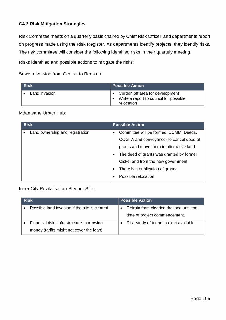
Page 105
C4.2 Risk Mitigation Strategies
Risk Commitee meets on a quarterly basis chaired by Chief Risk Officer and departments report
on progress made using the Risk Register. As departments identify projects, they identify risks.
The risk committee will consider the following identified risks in their quartely meeting.
Risks identified and possible actions to mitigate the risks:
Sewer diversion from Central to Reeston:
Risk Possible Action
• Land invasion • Cordon off area for development
• Write a report to council for possible relocation
Mdantsane Urban Hub:
Risk Possible Action
• Land ownership and registration • Committee will be formed, BCMM, Deeds,
COGTA and conveyancer to cancel deed of
grants and move them to alternative land
• The deed of grants was granted by former
Ciskei and from the new government
• There is a duplication of grants
• Possible relocation
Inner City Revitalisation-Sleeper Site:
Risk Possible Action
• Possible land invasion if the site is cleared. • Refrain from clearing the land until the
time of project commencement.
• Financial risks infrastructure: borrowing
money (tariffs might not cover the loan).
• Risk study of tunnel project available.
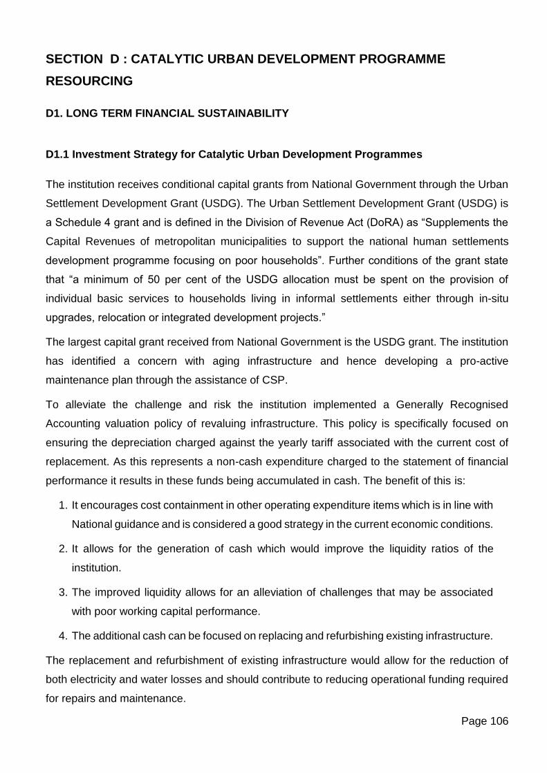
Page 106
SECTION D : CATALYTIC URBAN DEVELOPMENT PROGRAMME
RESOURCING
D1. LONG TERM FINANCIAL SUSTAINABILITY
D1.1 Investment Strategy for Catalytic Urban Development Programmes
The institution receives conditional capital grants from National Government through the Urban
Settlement Development Grant (USDG). The Urban Settlement Development Grant (USDG) is
a Schedule 4 grant and is defined in the Division of Revenue Act (DoRA) as “Supplements the
Capital Revenues of metropolitan municipalities to support the national human settlements
development programme focusing on poor households”. Further conditions of the grant state
that “a minimum of 50 per cent of the USDG allocation must be spent on the provision of
individual basic services to households living in informal settlements either through in-situ
upgrades, relocation or integrated development projects.”
The largest capital grant received from National Government is the USDG grant. The institution
has identified a concern with aging infrastructure and hence developing a pro-active
maintenance plan through the assistance of CSP.
To alleviate the challenge and risk the institution implemented a Generally Recognised
Accounting valuation policy of revaluing infrastructure. This policy is specifically focused on
ensuring the depreciation charged against the yearly tariff associated with the current cost of
replacement. As this represents a non-cash expenditure charged to the statement of financial
performance it results in these funds being accumulated in cash. The benefit of this is:
1. It encourages cost containment in other operating expenditure items which is in line with
National guidance and is considered a good strategy in the current economic conditions.
2. It allows for the generation of cash which would improve the liquidity ratios of the
institution.
3. The improved liquidity allows for an alleviation of challenges that may be associated
with poor working capital performance.
4. The additional cash can be focused on replacing and refurbishing existing infrastructure.
The replacement and refurbishment of existing infrastructure would allow for the reduction of
both electricity and water losses and should contribute to reducing operational funding required
for repairs and maintenance.
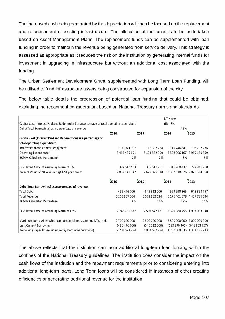
Page 107
The increased cash being generated by the depreciation will then be focused on the replacement
and refurbishment of existing infrastructure. The allocation of the funds is to be undertaken
based on Asset Management Plans. The replacement funds can be supplemented with loan
funding in order to maintain the revenue being generated from service delivery. This strategy is
assessed as appropriate as it reduces the risk on the institution by generating internal funds for
investment in upgrading in infrastructure but without an additional cost associated with the
funding.
The Urban Settlement Development Grant, supplemented with Long Term Loan Funding, will
be utilised to fund infrastructure assets being constructed for expansion of the city.
The below table details the progression of potential loan funding that could be obtained,
excluding the repayment consideration, based on National Treasury norms and standards.
The above reflects that the institution can incur additional long-term loan funding within the
confines of the National Treasury guidelines. The institution does consider the impact on the
cash flows of the institution and the repayment requirements prior to considering entering into
additional long-term loans. Long Term loans will be considered in instances of either creating
efficiencies or generating additional revenue for the institution.
NT Norm
Capital Cost (Interest Paid and Redemption) as a percentage of total operating expenditure 6% - 8%
Debt (Total Borrowings) as a percentage of revenue 45%
2016 2015 2014 2013
Capital Cost (Interest Paid and Redemption) as a percentage of
total operating expenditure
Interest Paid and Capital Repayment 100 974 907 115 307 268 115 746 841 108 792 236
Operating Expenditure 5 464 435 191 5 121 582 300 4 528 006 167 3 969 170 859
BCMM Calculated Percentage 2% 2% 3% 3%
Calculated Amount Assuming Norm of 7% 382 510 463 358 510 761 316 960 432 277 841 960
Present Value of 20 year loan @ 12% per annum 2 857 140 342 2 677 875 918 2 367 518 076 2 075 324 858
2016 2015 2014 2013
Debt (Total Borrowings) as a percentage of revenue
Total Debt 496 476 706 545 312 006 599 990 365 648 863 757
Total Revenue 6 103 957 504 5 572 982 624 5 176 401 678 4 437 786 534
BCMM Calculated Percentage 8% 10% 12% 15%
Calculated Amount Assuming Norm of 45% 2 746 780 877 2 507 842 181 2 329 380 755 1 997 003 940
Maximum Borrowings which can be considered assuming NT criteria 2 700 000 000 2 500 000 000 2 300 000 000 2 000 000 000
Less: Current Borrowings (496 476 706) (545 312 006) (599 990 365) (648 863 757)
Borrowing Capacity (excluding repayment considerations) 2 203 523 294 1 954 687 994 1 700 009 635 1 351 136 243
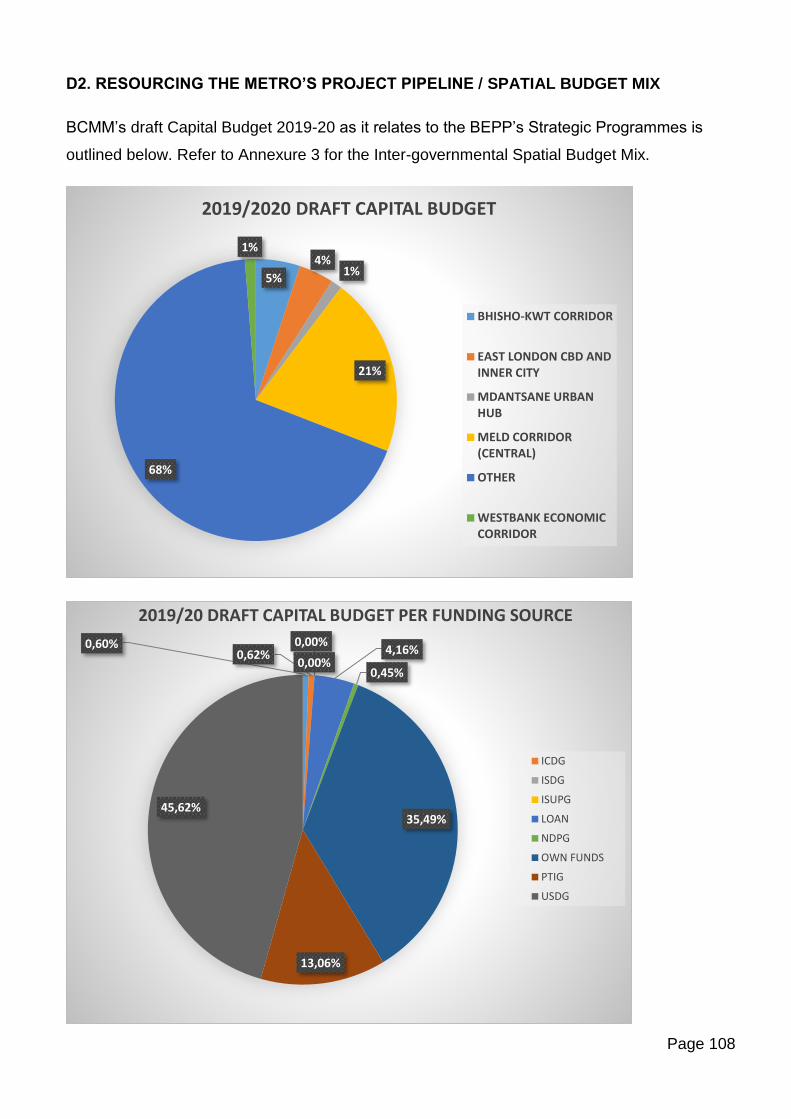
Page 108
D2. RESOURCING THE METRO’S PROJECT PIPELINE / SPATIAL BUDGET MIX
BCMM’s draft Capital Budget 2019-20 as it relates to the BEPP’s Strategic Programmes is
outlined below. Refer to Annexure 3 for the Inter-governmental Spatial Budget Mix.
5%
4%1%
21%
68%
1%
2019/2020 DRAFT CAPITAL BUDGET
BHISHO-KWT CORRIDOR
EAST LONDON CBD ANDINNER CITY
MDANTSANE URBANHUB
MELD CORRIDOR(CENTRAL)
OTHER
WESTBANK ECONOMICCORRIDOR
0,60%0,62%
0,00%
0,00%4,16%
0,45%
35,49%
13,06%
45,62%
2019/20 DRAFT CAPITAL BUDGET PER FUNDING SOURCE
ICDG
ISDG
ISUPG
LOAN
NDPG
OWN FUNDS
PTIG
USDG
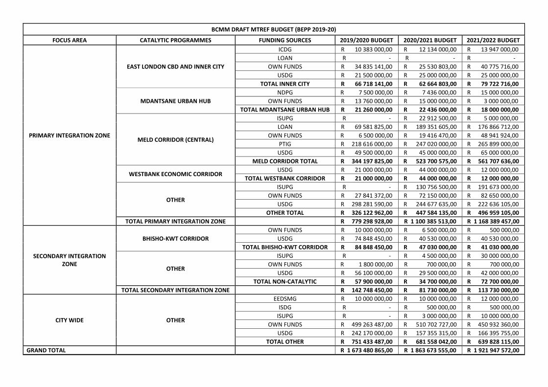
BCMM DRAFT MTREF BUDGET (BEPP 2019-20)
FOCUS AREA CATALYTIC PROGRAMMES FUNDING SOURCES 2019/2020 BUDGET 2020/2021 BUDGET 2021/2022 BUDGET
PRIMARY INTEGRATION ZONE
EAST LONDON CBD AND INNER CITY
ICDG R 10 383 000,00 R 12 134 000,00 R 13 947 000,00
LOAN R - R - R -
OWN FUNDS R 34 835 141,00 R 25 530 803,00 R 40 775 716,00
USDG R 21 500 000,00 R 25 000 000,00 R 25 000 000,00
TOTAL INNER CITY R 66 718 141,00 R 62 664 803,00 R 79 722 716,00
MDANTSANE URBAN HUB
NDPG R 7 500 000,00 R 7 436 000,00 R 15 000 000,00
OWN FUNDS R 13 760 000,00 R 15 000 000,00 R 3 000 000,00
TOTAL MDANTSANE URBAN HUB R 21 260 000,00 R 22 436 000,00 R 18 000 000,00
MELD CORRIDOR (CENTRAL)
ISUPG R - R 22 912 500,00 R 5 000 000,00
LOAN R 69 581 825,00 R 189 351 605,00 R 176 866 712,00
OWN FUNDS R 6 500 000,00 R 19 416 470,00 R 48 941 924,00
PTIG R 218 616 000,00 R 247 020 000,00 R 265 899 000,00
USDG R 49 500 000,00 R 45 000 000,00 R 65 000 000,00
MELD CORRIDOR TOTAL R 344 197 825,00 R 523 700 575,00 R 561 707 636,00
WESTBANK ECONOMIC CORRIDOR USDG R 21 000 000,00 R 44 000 000,00 R 12 000 000,00
TOTAL WESTBANK CORRIDOR R 21 000 000,00 R 44 000 000,00 R 12 000 000,00
OTHER
ISUPG R - R 130 756 500,00 R 191 673 000,00
OWN FUNDS R 27 841 372,00 R 72 150 000,00 R 82 650 000,00
USDG R 298 281 590,00 R 244 677 635,00 R 222 636 105,00
OTHER TOTAL R 326 122 962,00 R 447 584 135,00 R 496 959 105,00
TOTAL PRIMARY INTEGRATION ZONE R 779 298 928,00 R 1 100 385 513,00 R 1 168 389 457,00
SECONDARY INTEGRATION ZONE
BHISHO-KWT CORRIDOR
OWN FUNDS R 10 000 000,00 R 6 500 000,00 R 500 000,00
USDG R 74 848 450,00 R 40 530 000,00 R 40 530 000,00
TOTAL BHISHO-KWT CORRIDOR R 84 848 450,00 R 47 030 000,00 R 41 030 000,00
OTHER
ISUPG R - R 4 500 000,00 R 30 000 000,00
OWN FUNDS R 1 800 000,00 R 700 000,00 R 700 000,00
USDG R 56 100 000,00 R 29 500 000,00 R 42 000 000,00
TOTAL NON-CATALYTIC R 57 900 000,00 R 34 700 000,00 R 72 700 000,00
TOTAL SECONDARY INTEGRATION ZONE R 142 748 450,00 R 81 730 000,00 R 113 730 000,00
CITY WIDE OTHER
EEDSMG R 10 000 000,00 R 10 000 000,00 R 12 000 000,00
ISDG R - R 500 000,00 R 500 000,00
ISUPG R - R 3 000 000,00 R 10 000 000,00
OWN FUNDS R 499 263 487,00 R 510 702 727,00 R 450 932 360,00
USDG R 242 170 000,00 R 157 355 315,00 R 166 395 755,00
TOTAL OTHER R 751 433 487,00 R 681 558 042,00 R 639 828 115,00
GRAND TOTAL R 1 673 480 865,00 R 1 863 673 555,00 R 1 921 947 572,00
Page 110
D3. INSTITUTIONAL ARRANGEMENTS
Managing, planning and resourcing of catalytic programmes and projects within the City will be
coordinated through the EPMO which will serve as the secretariat to the BEPP Task Team as
well as the IGR Task Team.
The EPMO will play a lead role in identifying, coordinating and budgeting for projects of an
integrated nature, which are cross-cutting, and bring together transversal elements of urban
space, public transport and mixed / residential uses. The role of the BEPP as a ‘change’ agent
has been recognized by top management, led by the City Manager, who has proposed that the
planning and budgeting issues from the BEPP be tabled at every top management meeting as a
standing item.
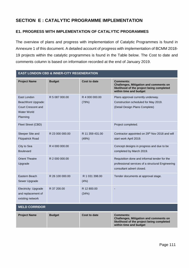
Page 111
SECTION E : CATALYTIC PROGRAMME IMPLEMENTATION
E1. PROGRESS WITH IMPLEMENTATION OF CATALYTIC PROGRAMMES
The overview of plans and progress with implementation of Catalytic Programmes is found in
Annexure 1 of this document. A detailed account of progress with implementation of BCMM 2018-
19 projects within the catalytic programmes is found in the Table below. The Cost to date and
comments column is based on information recorded at the end of January 2019.
EAST LONDON CBD & INNER-CITY REGENERATION
Project Name Budget Cost to date Comments: Challenges, Mitigation and comments on likelihood of the project being completed within time and budget
East London
Beachfront Upgrade:
Court Crescent and
Water World
Planning
R 5 087 000.00 R 4 000 000.00
(79%)
Plans approval currently underway.
Construction scheduled for May 2019.
(Detail Design Plans Complete)
Fleet Street (CBD)
Project completed.
Sleeper Site and
Fitzpatrick Road
R 23 000 000.00 R 11 359 431.00
(49%)
Contractor appointed on 29th Nov 2018 and will
start work April 2019.
City to Sea
Boulevard
R 4 000 000.00
Concept designs in progress and due to be
completed by March 2019.
Orient Theatre
Upgrade
R 2 000 000.00
Requisition done and informal tender for the
professional services of a structural Engineering
consultant advert closed.
Eastern Beach
Sewer Upgrade
R 26 100 000.00 R 1 031 398.00
(4%)
Tender documents at approval stage.
Electricity: Upgrade
and replacement of
existing network
R 37 200.00 R 12 800.00
(34%)
-
MELD CORRIDOR
Project Name Budget Cost to date Comments: Challenges, Mitigation and comments on likelihood of the project being completed within time and budget
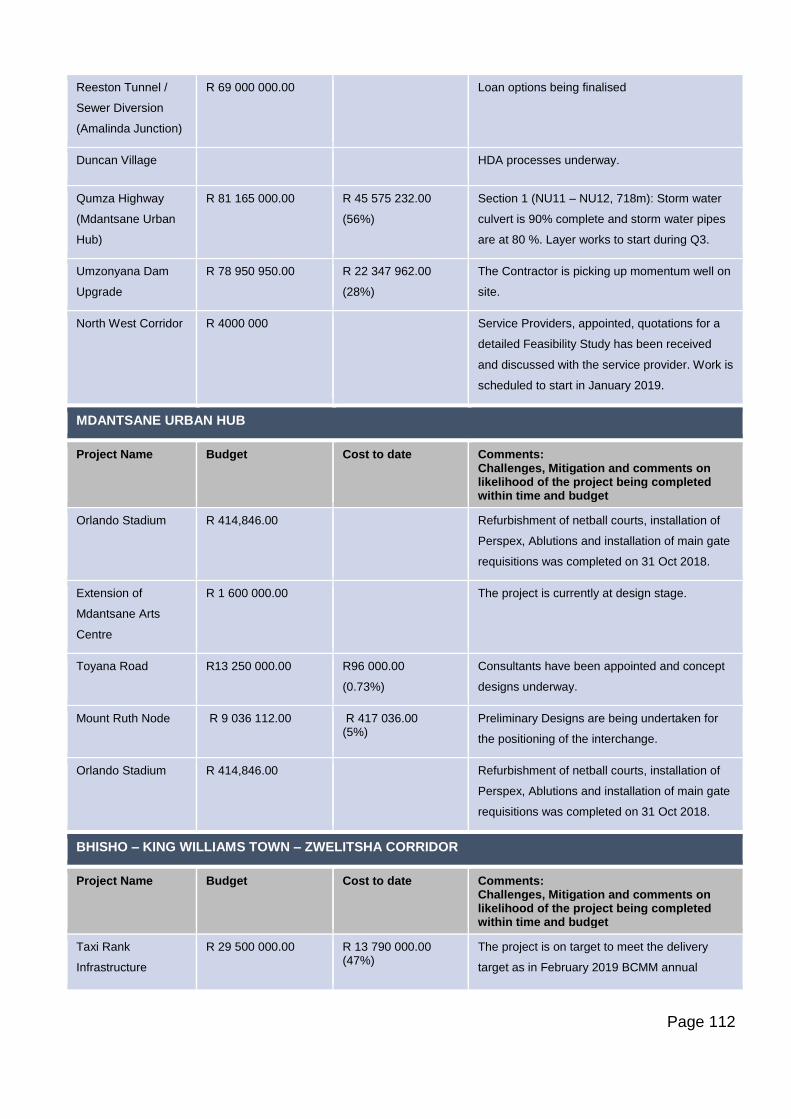
Page 112
Reeston Tunnel /
Sewer Diversion
(Amalinda Junction)
R 69 000 000.00
Loan options being finalised
Duncan Village
HDA processes underway.
Qumza Highway
(Mdantsane Urban
Hub)
R 81 165 000.00 R 45 575 232.00
(56%)
Section 1 (NU11 – NU12, 718m): Storm water
culvert is 90% complete and storm water pipes
are at 80 %. Layer works to start during Q3.
Umzonyana Dam
Upgrade
R 78 950 950.00 R 22 347 962.00
(28%)
The Contractor is picking up momentum well on
site.
North West Corridor R 4000 000
Service Providers, appointed, quotations for a
detailed Feasibility Study has been received
and discussed with the service provider. Work is
scheduled to start in January 2019.
MDANTSANE URBAN HUB
Project Name Budget Cost to date Comments: Challenges, Mitigation and comments on likelihood of the project being completed within time and budget
Orlando Stadium R 414,846.00
Refurbishment of netball courts, installation of
Perspex, Ablutions and installation of main gate
requisitions was completed on 31 Oct 2018.
Extension of
Mdantsane Arts
Centre
R 1 600 000.00
The project is currently at design stage.
Toyana Road R13 250 000.00 R96 000.00
(0.73%)
Consultants have been appointed and concept
designs underway.
Mount Ruth Node R 9 036 112.00 R 417 036.00 (5%)
Preliminary Designs are being undertaken for
the positioning of the interchange.
Orlando Stadium R 414,846.00
Refurbishment of netball courts, installation of
Perspex, Ablutions and installation of main gate
requisitions was completed on 31 Oct 2018.
BHISHO – KING WILLIAMS TOWN – ZWELITSHA CORRIDOR
Project Name Budget Cost to date Comments: Challenges, Mitigation and comments on likelihood of the project being completed within time and budget
Taxi Rank
Infrastructure
R 29 500 000.00 R 13 790 000.00 (47%)
The project is on target to meet the delivery
target as in February 2019 BCMM annual
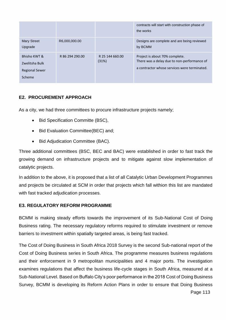
Page 113
contracts will start with construction phase of
the works
Mary Street
Upgrade
R6,000,000.00
Designs are complete and are being reviewed
by BCMM
Bhisho KWT &
Zwelitsha Bulk
Regional Sewer
Scheme
R 86 294 290.00 R 25 144 660.00 (31%)
Project is about 70% complete. There was a delay due to non-performance of
a contractor whose services were terminated.
E2. PROCUREMENT APPROACH
As a city, we had three committees to procure infrastructure projects namely;
• Bid Specification Committe (BSC),
• Bid Evaluation Committee(BEC) and;
• Bid Adjudication Committee (BAC).
Three additional committees (BSC, BEC and BAC) were established in order to fast track the
growing demand on infrastructure projects and to mitigate against slow implementation of
catalytic projects.
In addition to the above, it is proposed that a list of all Catalytic Urban Development Programmes
and projects be circulated at SCM in order that projects which fall withion this list are mandated
with fast tracked adjudication processes.
E3. REGULATORY REFORM PROGRAMME
BCMM is making steady efforts towards the improvement of its Sub-National Cost of Doing
Business rating. The necessary regulatory reforms required to stimulate investment or remove
barriers to investment within spatially targeted areas, is being fast tracked.
The Cost of Doing Business in South Africa 2018 Survey is the second Sub-national report of the
Cost of Doing Business series in South Africa. The programme measures business regulations
and their enforcement in 9 metropolitan municipalities and 4 major ports. The investigation
examines regulations that affect the business life-cycle stages in South Africa, measured at a
Sub-National Level. Based on Buffalo City’s poor performance in the 2018 Cost of Doing Business
Survey, BCMM is developing its Reform Action Plans in order to ensure that Doing Business
Page 114
progress is a priority and departments involved highlight their functions in improving or simplifying
the processes.
The Doing Business Key Reform Interventions indicators include:
E3.1 Registering Property
In the Registering Property Indicator, Buffalo City dropped from 4th to 6th place in the 2018 SNDB
survey. The key reform interventions include:
Process optimisation
The purpose of this reform is to ensure that the processes are optimised, resourced and the
information quality is high. Buffalo City can learn from its peer cities and further reduce the
process from 10 days. If BCMM reduces this by just two (2) days it will be the leading city in South
Africa for this measure.
Stakeholder Engagement
The purpose of this intervention is to meet with conveyancers on a bi-annual basis to understand
their levels of satisfaction and to elicit ways to continuously improve. The city will also provide
information to the conveyancers on the quality of information they receive and how it can be
improved.
Transparency
The purpose of this intervention is to improve the quality indicator by improving the information
on the website and also to develop a separate complaints process.
Improve the ESRI system
The purpose of this intervention is to improve the quality of data on the ESRI system and also to
integrate into SOLAR. This will provide up to date information and improve the turnaround times
to the customers.
Property Titling
The purpose of this intervention is to register properties that have not been registered at the
Deeds Office. In doing so, the rates so revenue will decrease.
Page 115
E3.2 Construction Permits
Buffalo City has dropped from 5th to 6th place in the Dealing with Construction Permits indicator
in 2018 SNDB survey. The key reform interventions include:
Capacity Building
The purpose of this reform is to ensure that the department has the required resources and
capacity to improve the turnaround times from 35 days as measured in DBSA 2018 to 30 days
by 31 December 2019 for the approval of plans and to ease the burden from the only one plans
examiner assessing plans for the whole of BCMM.
Stakeholder Engagement
The purpose of this intervention is to engage stakeholders by attending two South African Institute
of Architectural Technologists (SAIAT) meetings by 30 June 2019 and 31 December2019.
Improving on quality
The purpose of this intervention is to improving customer satisfaction by conducting a survey
through a questionnaire by 30 June 2019.
Turnaround times
The purpose of this intervention is to shorten the turnaround time of the building plans approval
process from 30 days as measured in DBSA 2018 to 28 days by 31 December 2019.
Accessibility of building plans online
The purpose of this intervention is for the Information, Communication and Technology (ICT)
division to fast-track the development of a website for building plan related information to be
accessed by the public by 31 December 2019.
E3.3 Getting Electricity
In the Getting Electricity indicator, Buffalo City has dropped from 3rd to 5th place in the 2018
SNDB survey. The key reform interventions include:
Page 116
Capacity Building
The purpose of this reform is to ensure that the department has the required resources and
capacity to improve the turnaround times from 35 days as measured in DBSA 2018 to 30 days
by 31 December 2019 for the approval of plans and to ease the burden from the only one plans
examiner assessing plans for the whole of BCMM.
Stakeholder Engagement
The purpose of this intervention is to engage stakeholders by attending two South African Institute
of Architectural Technologists (SAIAT) meetings by 30 June 2019 and 31 December2019.
Improving on quality
The purpose of this intervention is to improving customer satisfaction by conducting a survey
through a questionnaire by 30 June 2019.
Turnaround times
The purpose of this intervention is to shorten the turnaround time of the building plans approval
process from 30 days as measured in DBSA 2018 to 28 days by 31 December 2019.
Accessibility of building plans online
The purpose of this intervention is for the Information, Communication and Technology (ICT)
division to fast-track the development of a website for building plan related information to be
accessed by the public by 31 December 2019
E4. ENHANCING PRIVATE SECTOR INVESTMENT
In addition to the Sub-National Doing Business reforms, in order to ease the Cost of Doing
Business in the Metro, BCMM has introduced the following interventions to attract investment and
increase economic activity in Buffalo City.
E4.1 Provincial One Stop Shop
BCMM is collaborating with Invest SA and ECDC to fast-track the establishment of a One-Stop
to reduce the cost of doing business for investors. The One-Stop Shop will be officially opened
by President Cyril Ramaphosa in July 2019.
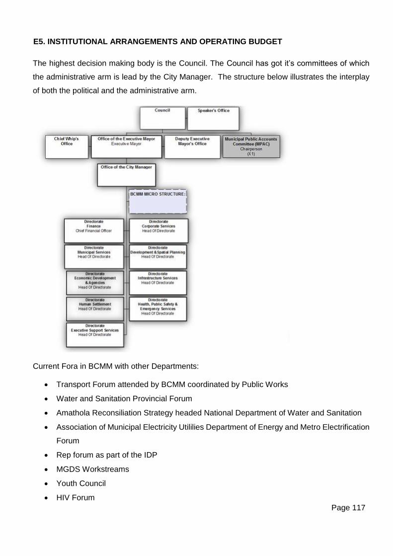
Page 117
E5. INSTITUTIONAL ARRANGEMENTS AND OPERATING BUDGET
The highest decision making body is the Council. The Council has got it’s committees of which
the administrative arm is lead by the City Manager. The structure below illustrates the interplay
of both the political and the administrative arm.
Current Fora in BCMM with other Departments:
• Transport Forum attended by BCMM coordinated by Public Works
• Water and Sanitation Provincial Forum
• Amathola Reconsiliation Strategy headed National Department of Water and Sanitation
• Association of Municipal Electricity Utililies Department of Energy and Metro Electrification
Forum
• Rep forum as part of the IDP
• MGDS Workstreams
• Youth Council
• HIV Forum
Page 118
• IGR
• Disabled Forum
• Government Communicators Forum
• Capital Spending Committee
As alluded to in Section A of the document, in addition to the above institutional arrangements
which are in place to plan and coordinate the implementation of BCMM projects, in order to move
towards accelerated implementation of catalytic programmes and projects, the EPMO is looking
at restructuring its existing resources to enhance capacity dedicated to catalytic programme
management. The role of the EPMO is to enhance transversal integration between the above
highlighted Directorates when it comes to programme management and implementation.
BCMM has established an agency (BCMDA) who has been mandated to plan and implement a
number of strategic projects which fall within Catalytic Programme areas of the city. The EPMO
and the Agency are currently working jointly in a complementary manner on a number of initiatives
around the Inner City Catalytic Programme which are envisaged to result in implementable
projects within the short to medium term. The EPMO will play a strategic transversal coordination
role within BCMM in relation to catalytic programme preparation and budgeting, with the BCMDA
playing a more decisive role in catalytic project implementation especially as these relate to
projects requiring the leveraging of private investment and promotion of partnerships.
IGR coordination and alignment will be strengthened through the IGR Task Team which will be
convened twice a year to report on BEPP implementation, identify bottlenecks and solutions, and
escalate those issues which cannot be resolved technically to the City Manager and Council for
resolution. As highlighted earlier, the EPMO forms the secretariat for IGR coordination on the
BEPP.
Page 119
SECTION F: URBAN MANAGEMENT
F1. URBAN MANAGEMENT
Urban management operates at various levels of city development. At the highest levels good
urban management at the municipal level ensures a well functioning land use management
system which is supported by regulatory frameworks such as the Local Area Spatial Development
Frameworks as well as Zoning Schemes. These assist with the demarcation and regulation of
private spaces. Urban management also includes the adequate provision of services such as
water and electricity and the consistent maintenance and upgrade of this infrastructure.
At the precinct level, urban management is mostly concerned with regulation of public spaces so
that these are free of crime and abuse. It also includes the maintenance of public spaces and
infrastructure so that these continue to be attractive and useful to people. The governance of
these spaces is also key to the successful urban management of spaces and precincts. Combined
government, private and community inputs contribute to a greater sense of ownership of spaces
(Urban Landmark, 2009).
F1.2 Call to Action Programme
Concerted precinct management efforts in BCMM are largely driven by the BCMDA who, through
the Call-2-Action Programme deliver on various modalities which rely on partnerships between
business, government and civil society. The four pilot areas covered by the above programme
are:
• Airport to Oxford Circle
• Oxford Circle and Western Avenue
• East London Beachfront
• Southernwood, St George’s Road
These initiatives largely fall within the East London CBD and surrounds catatytic programme area
(with the exception of Airport to Oxford Circle which concentrates on the N2, Settler’s Way).
Areas of focus include greening and beautification, maintenance, physical upgrading and the
creation of special rating areas (SRA’s) and urban development zones (UDZ . The Quigney
Beachfront area is identified and prioritized as an Urban Development Zone.
Page 120
Multi-funded urban management projects in the pipeline coordinated by the BCMDA include:
• Cleaning and securing the East London Beachfront: R1million
• Waste Management Systems with DEA: R15million. The sub components of this project
include the upgrading of the East London buy-back centre (BBC), development ofeight
waste collection and sorting facilities (WCSF) in eight residential areas, and street cleaning
in three strategic areas of East London including Settler’s Way, Quigney and Nomumelelo.
F1.3 Buffalo City Knowledge and Innovation Precinct: City Improvement District
The Buffalo City Metropolitan Development Agency (BCMDA) has embarked on a process of
consultation with local stakeholders to establish a city improvement district (CID) in Southernwood
as part of a larger two-phase strategy to revitalise the inner city in coordination with the private
sector and local anchor institutions, including the local universities and hospitals. Key
stakeholders in Southernwood include Frere Hospital; Life St Dominic’s Hospital; Life St James
Hospital; the Buffalo City Technical and Vocational Education and Training (TVET) College; a
Boston City Campus and Business College; a number of medical service firms and medical
practices, such as the Eye Centre and Ampath East London, as well as local pharmacies; and
university students from Walter Sisulu University (WSU), including from the Lilitha College of
Nursing, who live in residences and private rented accommodation in the area. In addition,
St Dominic’s features the Life College of Learning, which offers nursing and health sciences
courses and the University of Fort Hare trains nurses at the local hospitals through its Faculty of
Health Sciences. The proposed CID area also includes important local schools: Clarendon Girls
High School and Selborne College. Important local community organisations include the
Masimanyane Women’s Support Centre.
Situational analysis in the area has revealed serious concerns about waste management, the
maintenance of the public realm and safety among the anchor medical institutions and local
providers of medical services and practitioners, which may lead to them uprooting themselves,
depriving the area of important rates revenues and undermining its socio-economic fabric.
Student residents have also expressed discontent about community safety, the area’s upkeep,
and inadequate, overcrowded accommodation.
The CID under the aegis of the BCMDA, the municipality, the key local stakeholders listed above
and other relevant agencies such as local business representatives and the South African Police
Service (SAPS), will contribute funds to clean up the area; improve and maintain its fabric,
Page 121
including roads, pavements and verges, street furniture, streetlighting and local parks; promote
public safety; and address the socio-economic challenges through a package of incentives for
improving private accommodation.
The CID will build on the momentum created by the Call-2-Action campaign to clean and green
public spaces in the area, coordinating with the stakeholders engaged in this initiative. Slumlords
also represent a particular area of focus for economic intervention, with the municipality effectively
foregoing rates due to a lack of incentives for owners to improve their properties. In addition, as
the CID evolves, consideration may be given to establishing a partnership with Walter Sisulu
University and/or the Buffalo City TVET College to establish a student residence in the area.
Student transport issues will also be addressed. The municipality will map a plan for its
engagement in the CID, including the budgetary provision that will need to be made across a
number of departments.
The project will be branded according to appropriate design principles as a collaborative venture
established and managed by the municipality, the BCMDA and participating local anchor
institutions as the “Inner-City Revitatilisation Project: Creating Buffalo City’s Future Together”.
The area to be covered by the CID will include Wynne Street; St Mark Road; Gateley Street; and
St Peters Road. Signage marking the gateway to the CID will be erected. Promotion (and
management) of the project will also take place through the production of indicators for its impact
and the publication of these.
F1.4 Mdantsane Urban Hub Precinct Management
A precinct management model for the Mdantsane Urban Hub was developed in 2016. The
founding principles of the model are premised on the following characteristics:
• Create a catalytic precinct that is liveable, secure and provides a conducive urban
environment for its users,
• Create enabling conditions for new investments through sound urban management,
• Ensure the sustainability of existing and new public assets by supplementing the normal
municipal urban management services, and
• Contribute to “Place-making” and the creation of a strong neighbourhood identity
The model outlines a multipronged approach to the long term urban management of the CBD.
The initial stage involves the appointment of a Municipal Legislated Precinct Management
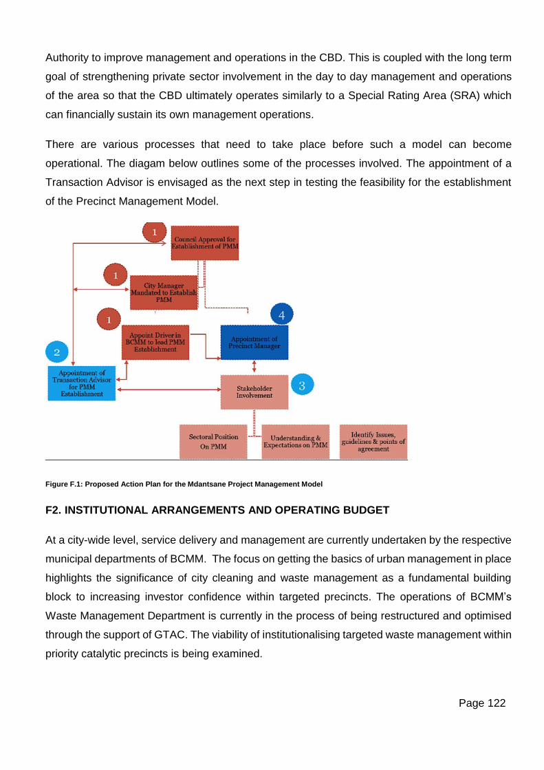
Page 122
Authority to improve management and operations in the CBD. This is coupled with the long term
goal of strengthening private sector involvement in the day to day management and operations
of the area so that the CBD ultimately operates similarly to a Special Rating Area (SRA) which
can financially sustain its own management operations.
There are various processes that need to take place before such a model can become
operational. The diagam below outlines some of the processes involved. The appointment of a
Transaction Advisor is envisaged as the next step in testing the feasibility for the establishment
of the Precinct Management Model.
Figure F.1: Proposed Action Plan for the Mdantsane Project Management Model
F2. INSTITUTIONAL ARRANGEMENTS AND OPERATING BUDGET
At a city-wide level, service delivery and management are currently undertaken by the respective
municipal departments of BCMM. The focus on getting the basics of urban management in place
highlights the significance of city cleaning and waste management as a fundamental building
block to increasing investor confidence within targeted precincts. The operations of BCMM’s
Waste Management Department is currently in the process of being restructured and optimised
through the support of GTAC. The viability of institutionalising targeted waste management within
priority catalytic precincts is being examined.
Page 123
The BCMDA currently plays a lead role in terms of precinct management initiatives for the Central
City Areas through the Call-2-Action Programme which relies on partnerships between business,
government and civil society.
The City Improvement District (CID) component of the Buffalo City Knowledge and Innovation
Precinct as described in Section F1.3 will be led by the BCMDA with the initial support of the City.
It is envisaged that the BCMDA will look into the necessary institutional arrangements for the
setting up of a self-managing entity in the longer-term comprised of a partnership of rate-payers
within this CID.
Page 124
SECTION G: REPORTING & EVALUATION
G1. REPORTING
Circular No. 88 (Nov 2017) of the MFMA Act No. 56 of 2003, introduced a new set of integrated
indicators that rationalise planning and reporting requirements for the 2018/19 MTREF. Emphasis
has been placed on measuring functional outcomes, which when delivered directly become
measurable indicators of the extent of spatial transformation in the city. The Built Environment
Performance Plan was identified as the most appropriate planning instrument to measure the
extent of spatial transformation in the city. City Transformational Outcomes were identified as:
• Targeted investments in integration zones;
• Reduction in urban sprawl;
• New housing options with social diversity; and
• Affordable and efficient public transport services.
The 2018/2019 BEPP document successfully incorporated thirteen out of the sixteen City
Transformational Indicators into the document. Baselines and targets were set for all Indicators
with the exception of 3 Indicators. Two of the three indicators are the IC3 and IC4 indicators which
fall under the New Housing Options category. IC3 & IC4 deal with the Ratio of Housing Types
and Housing Tenure Status respectively. As alluded to in Section A4.5 as well as B1.3 of this
document, further primary research work is required in order to establish the baselines for this
indicator and it is envisaged that the support of CSP could be enlisted to obtain the assistance of
an organization such as the Centre for Affordable Housing Finance (CAHF) to gather this
information for BCMM.
The third indicator which hasn’t been addressed is IC8 which falls under the Affordable and
Efficient Transport Services category. This indicator deals with the percentage share of household
income spent on transport costs. BCMM requires input from a National level to record this
indicator.
The completion of the 2019/20 Indicators schedule is affected by the change in boundaries of the
Integration Zones following discussions with CSP and the Neighbourhood Partnership
Development Units of National Treasury. The schedule is in the process of completion and will
be finalised in the Final 2019-20 BEPP. The draft schedule of indicators & targets are found in
Annexure 4 of this document.
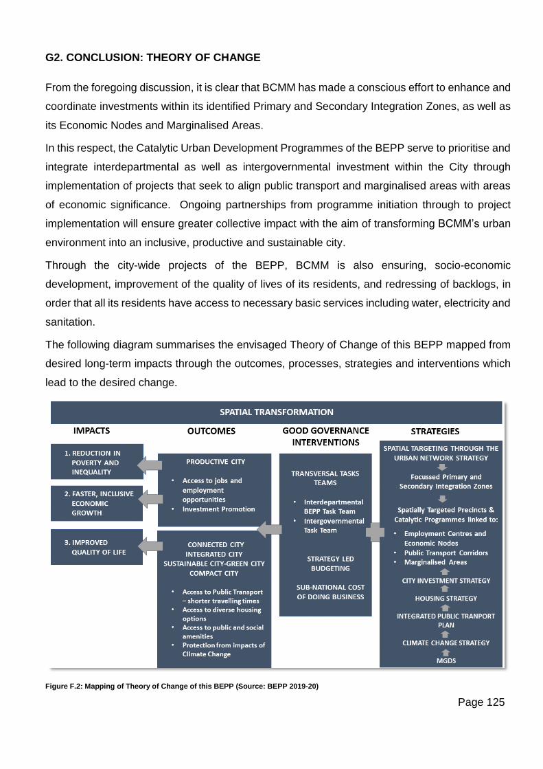
Page 125
G2. CONCLUSION: THEORY OF CHANGE
From the foregoing discussion, it is clear that BCMM has made a conscious effort to enhance and
coordinate investments within its identified Primary and Secondary Integration Zones, as well as
its Economic Nodes and Marginalised Areas.
In this respect, the Catalytic Urban Development Programmes of the BEPP serve to prioritise and
integrate interdepartmental as well as intergovernmental investment within the City through
implementation of projects that seek to align public transport and marginalised areas with areas
of economic significance. Ongoing partnerships from programme initiation through to project
implementation will ensure greater collective impact with the aim of transforming BCMM’s urban
environment into an inclusive, productive and sustainable city.
Through the city-wide projects of the BEPP, BCMM is also ensuring, socio-economic
development, improvement of the quality of lives of its residents, and redressing of backlogs, in
order that all its residents have access to necessary basic services including water, electricity and
sanitation.
The following diagram summarises the envisaged Theory of Change of this BEPP mapped from
desired long-term impacts through the outcomes, processes, strategies and interventions which
lead to the desired change.
Figure F.2: Mapping of Theory of Change of this BEPP (Source: BEPP 2019-20)
Page 126
List of Annexures
1. Annexure 1: Catalytic Urban Development Programmes
2. Annexure 2: Intergovernmental Project Pipeline
3. Annexure 3: Spatial budget Mix
4. Annexure 4: Built Environment Outcomes Indicators & Targets / Intentions
5. Annexure 5: Draft USDG Plan
6. Annexure 6: BEPP Task Team Representatives, Attendance Register and
Minutes of BEPP Task Team Meeting
7. Annexure 7: Attendance Register and Minutes of IGR Task Team Meeting
Page 127
ANNEXURE 1: Catalytic Urban Development Programmes
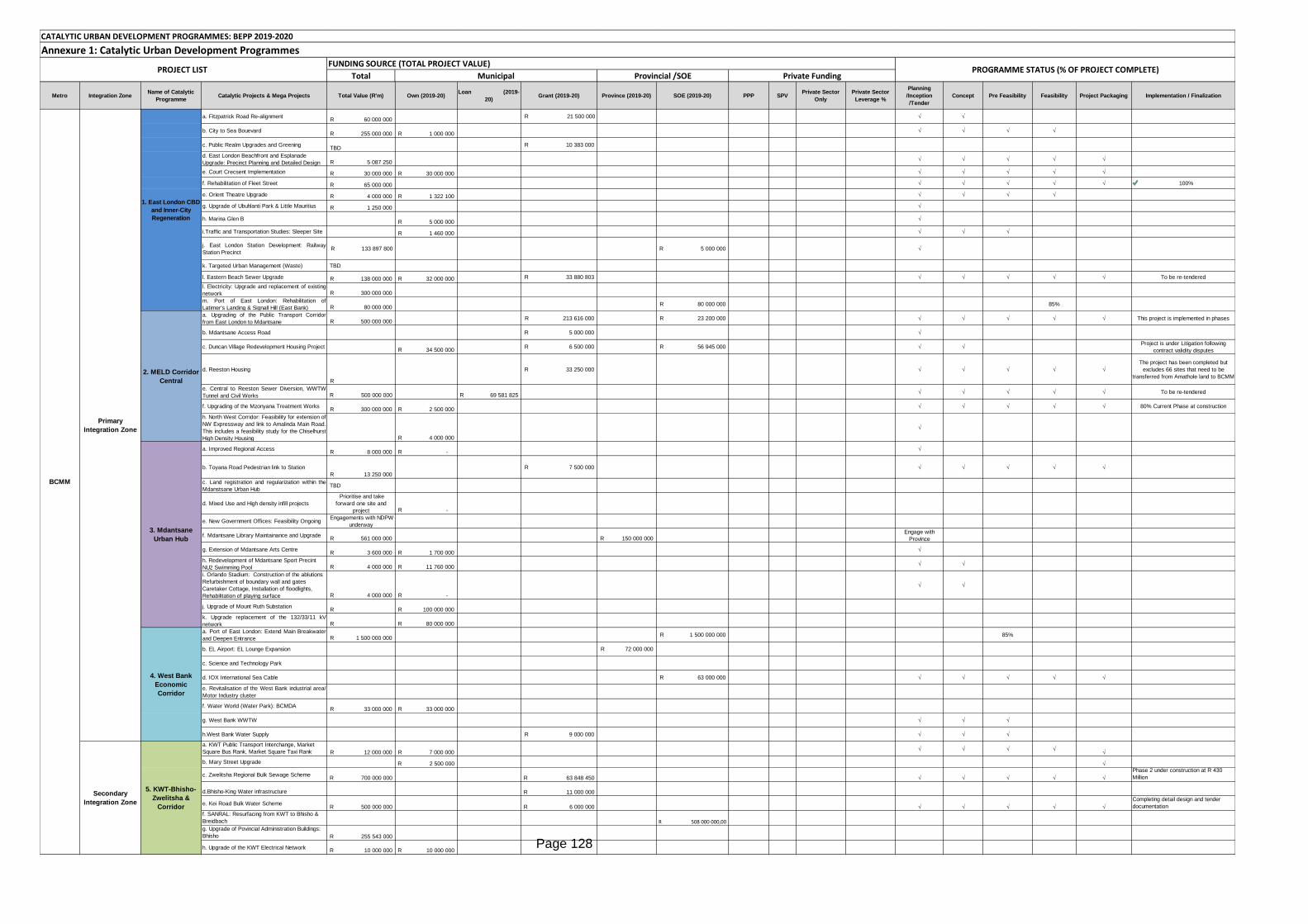
Page 128
Total
Metro Integration ZoneName of Catalytic
ProgrammeCatalytic Projects & Mega Projects Total Value (R'm) Own (2019-20)
Loan (2019-
20)Grant (2019-20) Province (2019-20) SOE (2019-20) PPP SPV
Private Sector
Only
Private Sector
Leverage %
Planning
/Inception
/Tender
Concept Pre Feasibility Feasibility Project Packaging Implementation / Finalization
a. Fitzpatrick Road Re-alignment60 000 000R
R 21 500 000 √ √
b. City to Sea Bouevard255 000 000R 1 000 000R
√ √ √ √
c. Public Realm Upgrades and GreeningTBD
10 383 000R
d. East London Beachfront and Esplanade
Upgrade: Precinct Planning and Detailed Design 5 087 250R √ √ √ √ √
e. Court Crecsent Implementation 30 000 000R 30 000 000R √ √ √ √ √
f. Rehabilitation of Fleet Street 65 000 000R √ √ √ √ √ 100%
e. Orient Theatre Upgrade 4 000 000R 1 322 100R √ √ √ √
g. Upgrade of Ubuhlanti Park & Little Mauritius 1 250 000R √
h. Marina Glen B5 000 000R
√
i.Traffic and Transportation Studies: Sleeper Site 1 460 000R √ √ √
j. East London Station Development: Railway
Station Precinct R 133 897 800 5 000 000R √
k. Targeted Urban Management (Waste) TBD
l. Eastern Beach Sewer Upgrade 138 000 000R 32 000 000R 33 880 803R √ √ √ √ √ To be re-tendered
l. Electricity: Upgrade and replacement of existing
network 300 000 000R
m. Port of East London: Rehabilitation of
Latimer's Landing & Signall Hill (East Bank) 80 000 000R 80 000 000R 85%
a. Upgrading of the Public Transport Corridor
from East London to Mdantsane 500 000 000R 213 616 000R 23 200 000R √ √ √ √ √ This project is implemented in phases
b. Mdantsane Access Road 5 000 000R √
c. Duncan Village Redevelopment Housing Project34 500 000R
6 500 000R 56 945 000R √ √Project is under Litigation following
contract validity disputes
d. Reeston Housing
R
33 250 000R √ √ √ √ √
The project has been completed but
excludes 66 sites that need to be
transferred from Amathole land to BCMM
e. Central to Reeston Sewer Diversion, WWTW
Tunnel and Civil Works 500 000 000R 69 581 825R √ √ √ √ √ To be re-tendered
f. Upgrading of the Mzonyana Treatment Works300 000 000R 2 500 000R
√ √ √ √ √ 80% Current Phase at construction
h. North West Corridor: Feasibility for extension of
NW Expressway and link to Amalinda Main Road.
This includes a feasibility study for the Chiselhurst
High Density Housing 4 000 000R
√
a. Improved Regional Access8 000 000R -R
√
b. Toyana Road Pedestrian link to Station
13 250 000R
7 500 000R √ √ √ √ √
c. Land registration and regularization within the
Mdanstsane Urban Hub TBD
d. Mixed Use and High density infill projects
Prioritise and take
forward one site and
project -R
e. New Government Offices: Feasibility Ongoing Engagements with NDPW
underway
f. Mdantsane Library Maintainance and Upgrade561 000 000R 150 000 000R
Engage with
Province
g. Extension of Mdantsane Arts Centre3 600 000R 1 700 000R
√
h. Redevelopment of Mdantsane Sport Precint
NU2 Swimming Pool 4 000 000R 11 760 000R √ √
i. Orlando Stadium: Construction of the ablutions
Refurbishment of boundary wall and gates
Caretaker Cottage, Installation of floodlights,
Rehabilitation of playing surface 4 000 000R -R
√ √
j. Upgrade of Mount Ruth SubstationR 100 000 000R
k. Upgrade replacement of the 132/33/11 kV
network R 80 000 000R
a. Port of East London: Extend Main Breakwater
and Deepen Entrance 1 500 000 000R 1 500 000 000R 85%
b. EL Airport: EL Lounge Expansion 72 000 000R
c. Science and Technology Park
d. IOX International Sea Cable 63 000 000R √ √ √ √ √
e. Revitalisation of the West Bank industrial area/
Motor Industry cluster
f. Water World (Water Park): BCMDA33 000 000R 33 000 000R
g. West Bank WWTW √ √ √
h.West Bank Water Supply 9 000 000R √ √ √
a. KWT Public Transport Interchange, Market
Square Bus Rank, Market Square Taxi Rank 12 000 000R 7 000 000R √ √ √ √
√
b. Mary Street Upgrade 2 500 000R √
c. Zwelitsha Regional Bulk Sewage Scheme700 000 000R 63 848 450R √ √ √ √ √
Phase 2 under construction at R 430
Million
d.Bhisho-King Water infrastructure 11 000 000R
e. Kei Road Bulk Water Scheme500 000 000R 6 000 000R √ √ √ √ √
Completing detail design and tender
documentation
f. SANRAL: Resurfacing from KWT to Bhisho &
Breidbach 508 000 000,00R g. Upgrade of Povincial Administration Buildings:
Bhisho 255 543 000R
h. Upgrade of the KWT Electrical Network10 000 000R 10 000 000R
CATALYTIC URBAN DEVELOPMENT PROGRAMMES: BEPP 2019-2020
Annexure 1: Catalytic Urban Development Programmes
4. West Bank
Economic
Corridor
BCMM
Secondary
Integration Zone
5. KWT-Bhisho-
Zwelitsha &
Corridor
Primary
Integration Zone
PROJECT LIST Municipal Provincial /SOE
PROGRAMME STATUS (% OF PROJECT COMPLETE)Private Funding
2. MELD Corridor
Central
1. East London CBD
and Inner-City
Regeneration
FUNDING SOURCE (TOTAL PROJECT VALUE)
3. Mdantsane
Urban Hub
Page 129
ANNEXURE 2: Intergovernmental Project Pipeline
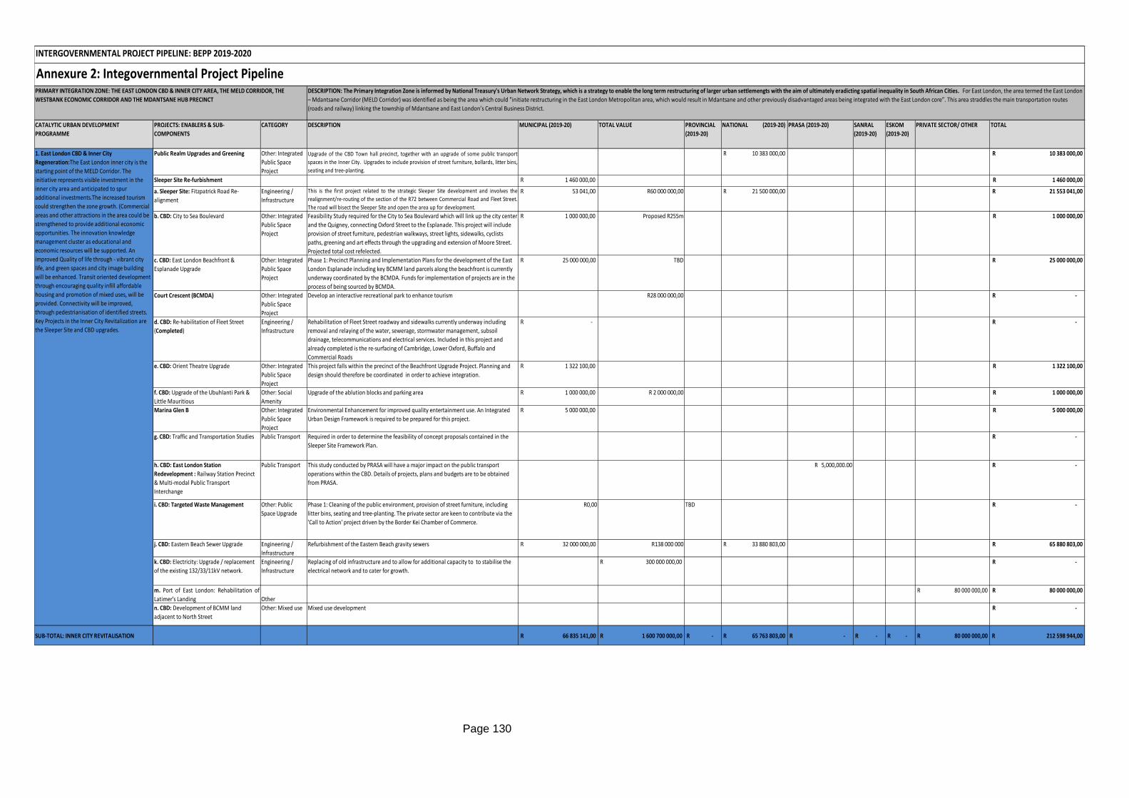
Page 130
Annexure 2: Integovernmental Project Pipeline
CATALYTIC URBAN DEVELOPMENT
PROGRAMME
PROJECTS: ENABLERS & SUB-
COMPONENTS
CATEGORY DESCRIPTION MUNICIPAL (2019-20) TOTAL VALUE PROVINCIAL
(2019-20)
NATIONAL (2019-20) PRASA (2019-20) SANRAL
(2019-20)
ESKOM
(2019-20)
PRIVATE SECTOR/ OTHER TOTAL
Public Realm Upgrades and Greening Other: Integrated
Public Space
Project
Upgrade of the CBD Town hall precinct, together with an upgrade of some public transport
spaces in the Inner City. Upgrades to include provision of street furniture, bollards, litter bins,
seating and tree-planting.
10 383 000,00R 10 383 000,00R
Sleeper Site Re-furbishment R 1 460 000,00 1 460 000,00R
a. Sleeper Site: Fitzpatrick Road Re-
alignment
Engineering /
Infrastructure
This is the first project related to the strategic Sleeper Site development and involves the
realignment/re-routing of the section of the R72 between Commercial Road and Fleet Street.
The road will bisect the Sleeper Site and open the area up for development.
R 53 041,00 R60 000 000,00 21 500 000,00R 21 553 041,00R
b. CBD: City to Sea Boulevard Other: Integrated
Public Space
Project
Feasibility Study required for the City to Sea Boulevard which will link up the city center
and the Quigney, connecting Oxford Street to the Esplanade. This project will include
provision of street furniture, pedestrian walkways, street lights, sidewalks, cyclists
paths, greening and art effects through the upgrading and extension of Moore Street.
Projected total cost refelected.
R 1 000 000,00 Proposed R255m 1 000 000,00R
c. CBD: East London Beachfront &
Esplanade Upgrade
Other: Integrated
Public Space
Project
Phase 1: Precinct Planning and Implementation Plans for the development of the East
London Esplanade including key BCMM land parcels along the beachfront is currently
underway coordinated by the BCMDA. Funds for implementation of projects are in the
process of being sourced by BCMDA.
R 25 000 000,00 TBD 25 000 000,00R
Court Crescent (BCMDA) Other: Integrated
Public Space
Project
Develop an interactive recreational park to enhance tourism R28 000 000,00 -R
d. CBD: Re-habilitation of Fleet Street
(Completed)
Engineering /
Infrastructure
Rehabilitation of Fleet Street roadway and sidewalks currently underway including
removal and relaying of the water, sewerage, stormwater management, subsoil
drainage, telecommunications and electrical services. Included in this project and
already completed is the re-surfacing of Cambridge, Lower Oxford, Buffalo and
Commercial Roads
R - -R
e. CBD: Orient Theatre Upgrade Other: Integrated
Public Space
Project
This project falls within the precinct of the Beachfront Upgrade Project. Planning and
design should therefore be coordinated in order to achieve integration.
R 1 322 100,00 1 322 100,00R
f. CBD: Upgrade of the Ubuhlanti Park &
Little Mauritious
Other: Social
Amenity
Upgrade of the ablution blocks and parking area R 1 000 000,00 R 2 000 000,00 1 000 000,00R
Marina Glen B Other: Integrated
Public Space
Project
Environmental Enhancement for improved quality entertainment use. An Integrated
Urban Design Framework is required to be prepared for this project.
R 5 000 000,00 5 000 000,00R
g. CBD: Traffic and Transportation Studies Public Transport Required in order to determine the feasibility of concept proposals contained in the
Sleeper Site Framework Plan.
-R
h. CBD: East London Station
Redevelopment : Railway Station Precinct
& Multi-modal Public Transport
Interchange
Public Transport This study conducted by PRASA will have a major impact on the public transport
operations within the CBD. Details of projects, plans and budgets are to be obtained
from PRASA.
R 5,000,000.00 -R
i. CBD: Targeted Waste Management Other: Public
Space Upgrade
Phase 1: Cleaning of the public environment, provision of street furniture, including
litter bins, seating and tree-planting. The private sector are keen to contribute via the
'Call to Action' project driven by the Border Kei Chamber of Commerce.
R0,00 TBD -R
j. CBD: Eastern Beach Sewer Upgrade Engineering /
Infrastructure
Refurbishment of the Eastern Beach gravity sewers R 32 000 000,00 R138 000 000 R 33 880 803,00 65 880 803,00R
k. CBD: Electricity: Upgrade / replacement
of the existing 132/33/11kV network.
Engineering /
Infrastructure
Replacing of old infrastructure and to allow for additional capacity to to stabilise the
electrical network and to cater for growth.
R 300 000 000,00 -R
m. Port of East London: Rehabilitation of
Latimer's Landing Other
R 80 000 000,00 80 000 000,00R
n. CBD: Development of BCMM land
adjacent to North Street
Other: Mixed use Mixed use development -R
SUB-TOTAL: INNER CITY REVITALISATION 66 835 141,00R 1 600 700 000,00R -R 65 763 803,00R -R -R -R 80 000 000,00R 212 598 944,00R
INTERGOVERNMENTAL PROJECT PIPELINE: BEPP 2019-2020
PRIMARY INTEGRATION ZONE: THE EAST LONDON CBD & INNER CITY AREA, THE MELD CORRIDOR, THE
WESTBANK ECONOMIC CORRIDOR AND THE MDANTSANE HUB PRECINCT
DESCRIPTION: The Primary Integration Zone is informed by National Treasury's Urban Network Strategy, which is a strategy to enable the long term restructuring of larger urban settlemengts with the aim of ultimately eradicting spatial inequality in South African Cities. For East London, the area termed the East London
– Mdantsane Corridor (MELD Corridor) was identified as being the area which could "initiate restructuring in the East London Metropolitan area, which would result in Mdantsane and other previously disadvantaged areas being integrated with the East London core”. This area straddles the main transportation routes
(roads and railway) linking the township of Mdantsane and East London’s Central Business District.
1. East London CBD & Inner City
Regeneration:The East London inner city is the
starting point of the MELD Corridor. The
initiative represents visible investment in the
inner city area and anticipated to spur
additional investments.The increased tourism
could strengthen the zone growth. (Commercial
areas and other attractions in the area could be
strengthened to provide additional economic
opportunities. The innovation knowledge
management cluster as educational and
economic resources will be supported. An
improved Quality of life through - vibrant city
life, and green spaces and city image building
will be enhanced. Transit oriented development
through encouraging quality infill affordable
housing and promotion of mixed uses, will be
provided. Connectivity will be improved,
through pedestrianisation of identified streets.
Key Projects in the Inner City Revitalization are
the Sleeper Site and CBD upgrades.
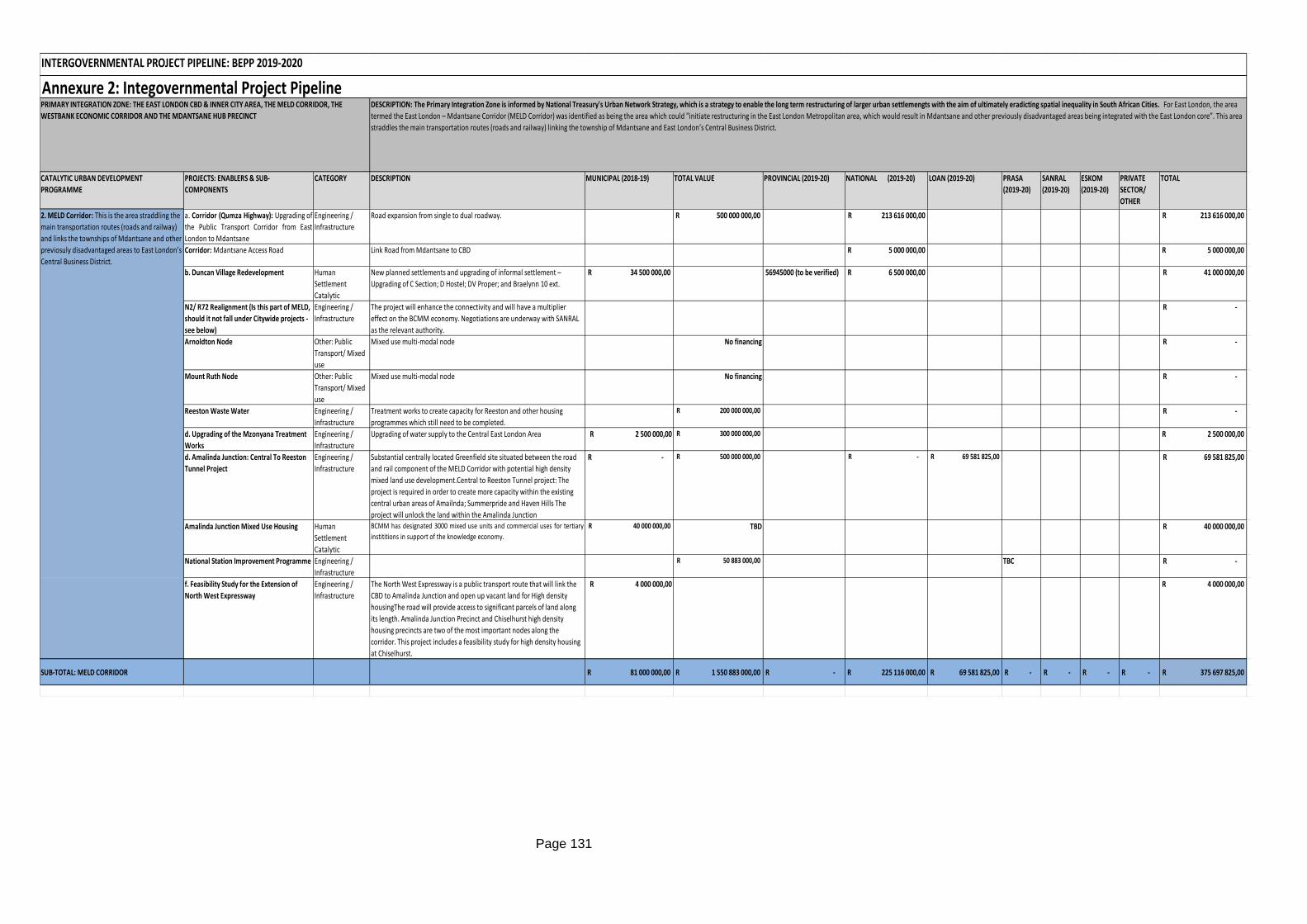
Page 131
CATALYTIC URBAN DEVELOPMENT
PROGRAMME
PROJECTS: ENABLERS & SUB-
COMPONENTS
CATEGORY DESCRIPTION MUNICIPAL (2018-19) TOTAL VALUE PROVINCIAL (2019-20) NATIONAL (2019-20) LOAN (2019-20) PRASA
(2019-20)
SANRAL
(2019-20)
ESKOM
(2019-20)
PRIVATE
SECTOR/
OTHER
TOTAL
a. Corridor (Qumza Highway): Upgrading of
the Public Transport Corridor from East
London to Mdantsane
Engineering /
Infrastructure
Road expansion from single to dual roadway. 500 000 000,00R 213 616 000,00R 213 616 000,00R
Corridor: Mdantsane Access Road Link Road from Mdantsane to CBD 5 000 000,00R 5 000 000,00R
b. Duncan Village Redevelopment Human
Settlement
Catalytic
New planned settlements and upgrading of informal settlement –
Upgrading of C Section; D Hostel; DV Proper; and Braelynn 10 ext.
34 500 000,00R 56945000 (to be verified) 6 500 000,00R 41 000 000,00R
N2/ R72 Realignment (Is this part of MELD,
should it not fall under Citywide projects -
see below)
Engineering /
Infrastructure
The project will enhance the connectivity and will have a multiplier
effect on the BCMM economy. Negotiations are underway with SANRAL
as the relevant authority.
-R
Arnoldton Node Other: Public
Transport/ Mixed
use
Mixed use multi-modal node No financing -R
Mount Ruth Node Other: Public
Transport/ Mixed
use
Mixed use multi-modal node No financing -R
Reeston Waste Water Engineering /
Infrastructure
Treatment works to create capacity for Reeston and other housing
programmes which still need to be completed.
200 000 000,00R -R
d. Upgrading of the Mzonyana Treatment
Works
Engineering /
Infrastructure
Upgrading of water supply to the Central East London Area R 2 500 000,00 300 000 000,00R 2 500 000,00R
d. Amalinda Junction: Central To Reeston
Tunnel Project
Engineering /
Infrastructure
Substantial centrally located Greenfield site situated between the road
and rail component of the MELD Corridor with potential high density
mixed land use development.Central to Reeston Tunnel project: The
project is required in order to create more capacity within the existing
central urban areas of Amailnda; Summerpride and Haven Hills The
project will unlock the land within the Amalinda Junction
-R 500 000 000,00R -R 69 581 825,00R 69 581 825,00R
Amalinda Junction Mixed Use Housing Human
Settlement
Catalytic
BCMM has designated 3000 mixed use units and commercial uses for tertiary
instititions in support of the knowledge economy.
40 000 000,00R TBD 40 000 000,00R
National Station Improvement Programme Engineering /
Infrastructure
50 883 000,00R TBC -R
f. Feasibility Study for the Extension of
North West Expressway
Engineering /
Infrastructure
The North West Expressway is a public transport route that will link the
CBD to Amalinda Junction and open up vacant land for High density
housingThe road will provide access to significant parcels of land along
its length. Amalinda Junction Precinct and Chiselhurst high density
housing precincts are two of the most important nodes along the
corridor. This project includes a feasibility study for high density housing
at Chiselhurst.
R 4 000 000,00 4 000 000,00R
SUB-TOTAL: MELD CORRIDOR 81 000 000,00R 1 550 883 000,00R -R 225 116 000,00R 69 581 825,00R -R -R -R -R 375 697 825,00R
2. MELD Corridor: This is the area straddling the
main transportation routes (roads and railway)
and links the townships of Mdantsane and other
previosuly disadvantaged areas to East London’s
Central Business District.
INTERGOVERNMENTAL PROJECT PIPELINE: BEPP 2019-2020
PRIMARY INTEGRATION ZONE: THE EAST LONDON CBD & INNER CITY AREA, THE MELD CORRIDOR, THE
WESTBANK ECONOMIC CORRIDOR AND THE MDANTSANE HUB PRECINCT
DESCRIPTION: The Primary Integration Zone is informed by National Treasury's Urban Network Strategy, which is a strategy to enable the long term restructuring of larger urban settlemengts with the aim of ultimately eradicting spatial inequality in South African Cities. For East London, the area
termed the East London – Mdantsane Corridor (MELD Corridor) was identified as being the area which could "initiate restructuring in the East London Metropolitan area, which would result in Mdantsane and other previously disadvantaged areas being integrated with the East London core”. This area
straddles the main transportation routes (roads and railway) linking the township of Mdantsane and East London’s Central Business District.
Annexure 2: Integovernmental Project Pipeline
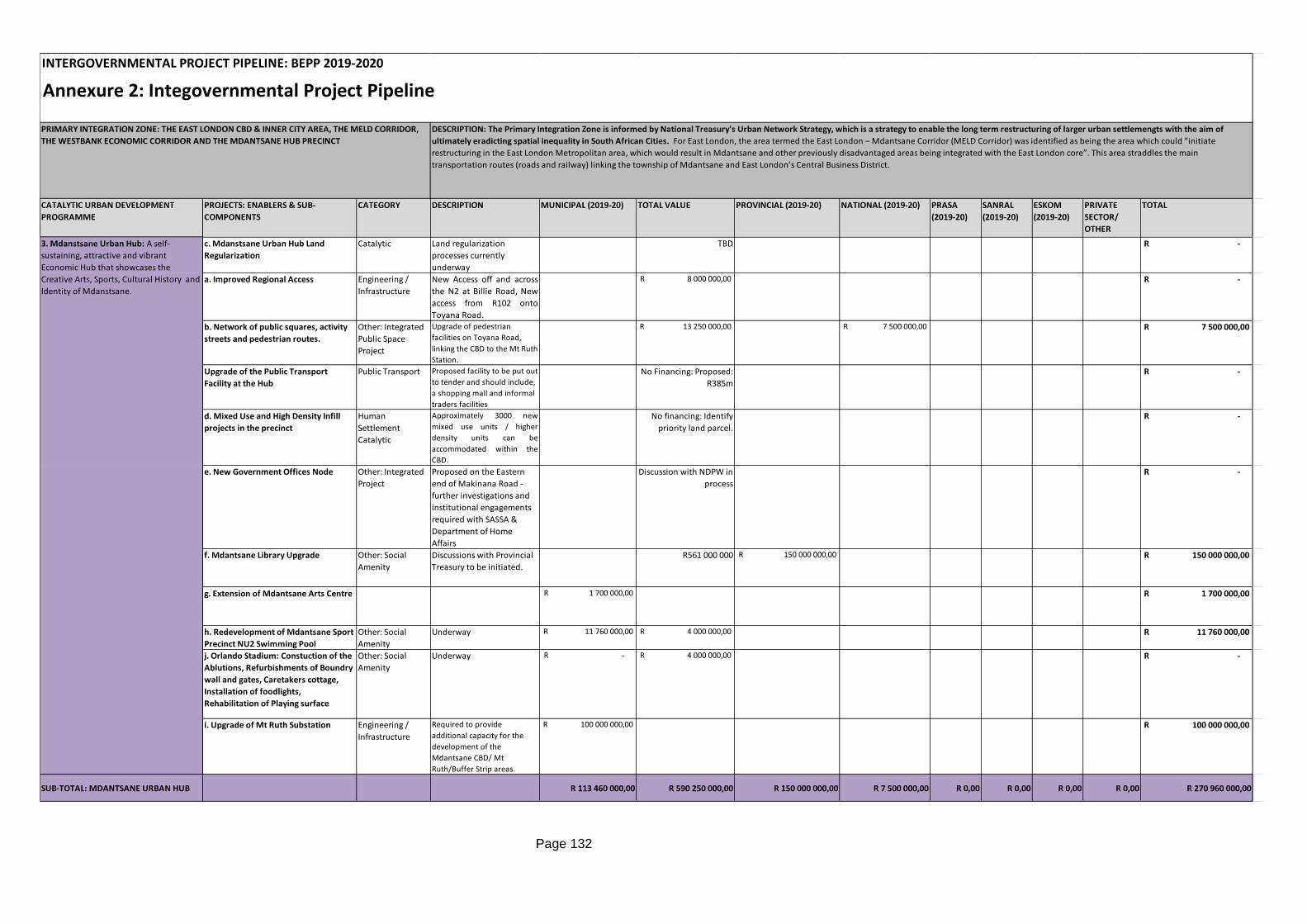
Page 132
Annexure 2: Integovernmental Project Pipeline
CATALYTIC URBAN DEVELOPMENT
PROGRAMME
PROJECTS: ENABLERS & SUB-
COMPONENTS
CATEGORY DESCRIPTION MUNICIPAL (2019-20) TOTAL VALUE PROVINCIAL (2019-20) NATIONAL (2019-20) PRASA
(2019-20)
SANRAL
(2019-20)
ESKOM
(2019-20)
PRIVATE
SECTOR/
OTHER
TOTAL
c. Mdanstsane Urban Hub Land
Regularization
Catalytic Land regularization
processes currently
underway
TBD -R
a. Improved Regional Access Engineering /
Infrastructure
New Access off and across
the N2 at Billie Road, New
access from R102 onto
Toyana Road.
8 000 000,00R -R
b. Network of public squares, activity
streets and pedestrian routes.
Other: Integrated
Public Space
Project
Upgrade of pedestrian
facilities on Toyana Road,
linking the CBD to the Mt Ruth
Station.
13 250 000,00R 7 500 000,00R 7 500 000,00R
Upgrade of the Public Transport
Facility at the Hub
Public Transport Proposed facility to be put out
to tender and should include,
a shopping mall and informal
traders facilities
No Financing: Proposed:
R385m
-R
d. Mixed Use and High Density Infill
projects in the precinct
Human
Settlement
Catalytic
Approximately 3000 new
mixed use units / higher
density units can be
accommodated within the
CBD.
No financing: Identify
priority land parcel.
-R
e. New Government Offices Node Other: Integrated
Project
Proposed on the Eastern
end of Makinana Road -
further investigations and
institutional engagements
required with SASSA &
Department of Home
Affairs
Discussion with NDPW in
process
-R
f. Mdantsane Library Upgrade Other: Social
Amenity
Discussions with Provincial
Treasury to be initiated.
R561 000 000 150 000 000,00R 150 000 000,00R
g. Extension of Mdantsane Arts Centre 1 700 000,00R 1 700 000,00R
h. Redevelopment of Mdantsane Sport
Precinct NU2 Swimming Pool
Other: Social
Amenity
Underway 11 760 000,00R 4 000 000,00R 11 760 000,00R
j. Orlando Stadium: Constuction of the
Ablutions, Refurbishments of Boundry
wall and gates, Caretakers cottage,
Installation of foodlights,
Rehabilitation of Playing surface
Other: Social
Amenity
Underway -R 4 000 000,00R -R
i. Upgrade of Mt Ruth Substation Engineering /
Infrastructure
Required to provide
additional capacity for the
development of the
Mdantsane CBD/ Mt
Ruth/Buffer Strip areas.
100 000 000,00R 100 000 000,00R
SUB-TOTAL: MDANTSANE URBAN HUB R 113 460 000,00 R 590 250 000,00 R 150 000 000,00 R 7 500 000,00 R 0,00 R 0,00 R 0,00 R 0,00 R 270 960 000,00
3. Mdanstsane Urban Hub: A self-
sustaining, attractive and vibrant
Economic Hub that showcases the
Creative Arts, Sports, Cultural History and
Identity of Mdanstsane.
INTERGOVERNMENTAL PROJECT PIPELINE: BEPP 2019-2020
PRIMARY INTEGRATION ZONE: THE EAST LONDON CBD & INNER CITY AREA, THE MELD CORRIDOR,
THE WESTBANK ECONOMIC CORRIDOR AND THE MDANTSANE HUB PRECINCT
DESCRIPTION: The Primary Integration Zone is informed by National Treasury's Urban Network Strategy, which is a strategy to enable the long term restructuring of larger urban settlemengts with the aim of
ultimately eradicting spatial inequality in South African Cities. For East London, the area termed the East London – Mdantsane Corridor (MELD Corridor) was identified as being the area which could "initiate
restructuring in the East London Metropolitan area, which would result in Mdantsane and other previously disadvantaged areas being integrated with the East London core”. This area straddles the main
transportation routes (roads and railway) linking the township of Mdantsane and East London’s Central Business District.
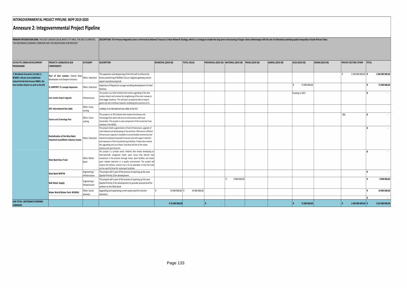
Page 133
Annexure 2: Integovernmental Project Pipeline
CATALYTIC URBAN DEVELOPMENT
PROGRAMME
PROJECTS: ENABLERS & SUB-
COMPONENTS
CATEGORY DESCRIPTION MUNICIPAL (2019-20) TOTAL VALUE PROVINCIAL (2019-20) NATIONAL (2019-20) PRASA (2019-20) SANRAL (2019-20) ACSA (2019-20) ESKOM (2019-20) PRIVATE SECTOR/ OTHER TOTAL
Port of East London: Extend Main
Breakwater and Deepen EntranceOther: Industrial
The expansion and deepening of the Port will re-inforce the
future positioning of Buffalo City as a logistics gateway and an
export manufacturing hub.
1 500 000 000,00R 1 500 000 000,00R
EL AIRPORT: EL Lounge Expansion Other: IndustrialExpansion of Departure Lounge including development of retail
facilities.
72 000 000,00R 72 000 000,00R
East London Airport Upgrade Infrastructure
The project is an ACSA initiative that entails upgrading of the East
London Airport and involves the lengthening of the main runway to
allow bigger airplanes. This will open up opportunities to export
goods and will contribute towards revitalising the economy of EL.
funding in 2021 -R
IOX International Sea CableOther: Cross-
cuttingLanding of an international sea cable at the IDZ
Science and Technology ParkOther: Cross-
cutting
This project is an IDZ initiative that involves the Science and
Technology Park which will serve to link business with local
Universities. This project is a key component of the University Town
initiative in the MGDS.
TBD -R
Revitalisation of the West Bank
Industrial area/Motor industry cluster. Other: Industrial
The project entails augmentation of bulk infrastructure, upgrade of
road network and landscaping of city entrance. Will ensure sufficient
infrastructure capacity is available to accommodate commercial and
industrial employment growth forecasts and will support retention
and expansion of the manufacturing initiatives. Project also involves
the upgrading and use of Race Track that will link to the motor
industry and sport tourism.
-R
West Bank Race TrackOther: Motor
Sport
The project is a private sector initiative that entails developing an
internationally recognised motor sport venue that attracts new
investment in the precinct through motor sport facilities and motor
sport related industries in a quality environment. The project will
require the Harbour arterial rout e to be extended so that the track
can be used full time for motorsport activities
-R
West Bank WWTW Engineering /
Infrastructure
This project will is part of the process of opening up the area
(Spatial Priority 2) for development .
-R
Bulk Water SupplyEngineering /
Infrastructure
This project will is part of the process of opening up the area
(Spatial Priority 2) for development to provide serviced land for
workers on the West Bank
9 000 000,00R 9 000 000,00R
Water World (Water Park: BCMDA)Other: Social
Amenity
Upgrading and expanding current water park for tourism
attraction
33 000 000,00R 33 000 000,00R 33 000 000,00R
-R
SUB-TOTAL: WESTBANK ECONOMIC
CORRIDORR 33 000 000,00 -R 72 000 000,00R 1 500 000 000,00R 1 614 000 000,00R
INTERGOVERNMENTAL PROJECT PIPELINE: BEPP 2019-2020
PRIMARY INTEGRATION ZONE: THE EAST LONDON CBD & INNER CITY AREA, THE MELD CORRIDOR,
THE WESTBANK ECONOMIC CORRIDOR AND THE MDANTSANE HUB PRECINCT
DESCRIPTION: The Primary Integration Zone is informed by National Treasury's Urban Network Strategy, which is a strategy to enable the long term restructuring of larger urban settlemengts with the aim of ultimately eradicting spatial inequality in South African Cities.
3. Westbank Economic Corridor is
BCMM's vibrant and established
industrial hub that houses MBSA, the
East London Airport as well as the IDZ
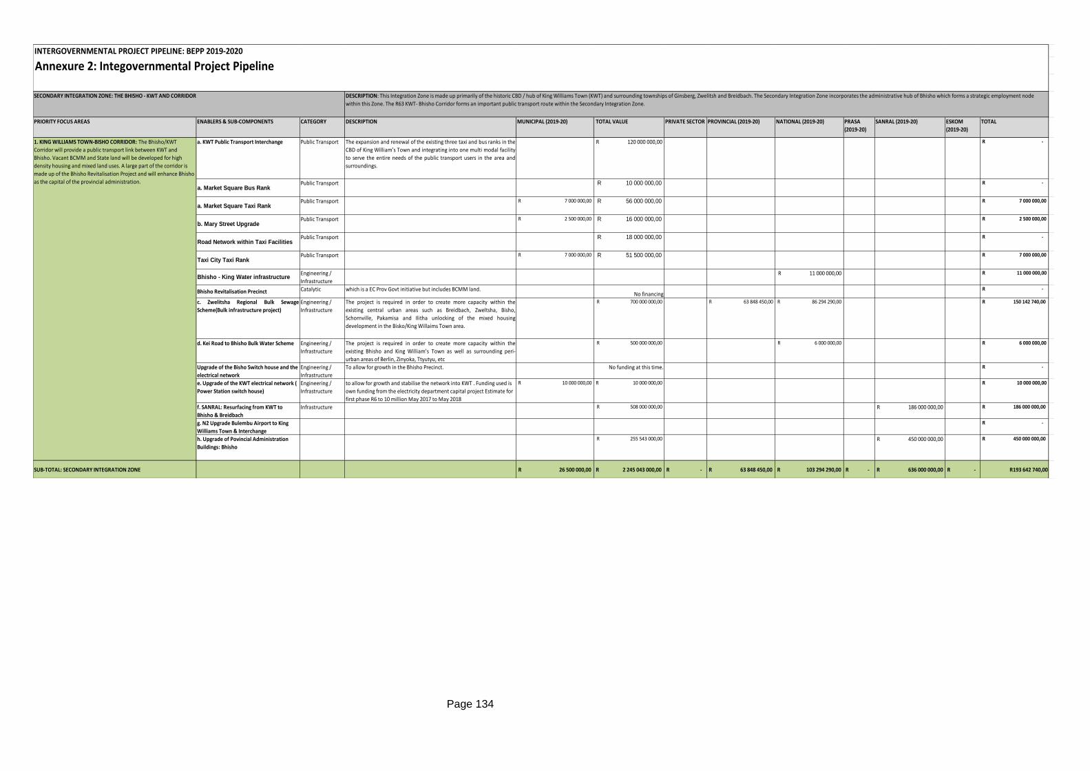
Page 134
Annexure 2: Integovernmental Project Pipeline
PRIORITY FOCUS AREAS ENABLERS & SUB-COMPONENTS CATEGORY DESCRIPTION MUNICIPAL (2019-20) TOTAL VALUE PRIVATE SECTOR PROVINCIAL (2019-20) NATIONAL (2019-20) PRASA
(2019-20)
SANRAL (2019-20) ESKOM
(2019-20)
TOTAL
a. KWT Public Transport Interchange Public Transport The expansion and renewal of the existing three taxi and bus ranks in the
CBD of King William’s Town and integrating into one multi modal facility
to serve the entire needs of the public transport users in the area and
surroundings.
120 000 000,00R R -
a. Market Square Bus RankPublic Transport 10 000 000,00R R -
a. Market Square Taxi RankPublic Transport R 7 000 000,00 56 000 000,00R R 7 000 000,00
b. Mary Street UpgradePublic Transport R 2 500 000,00 16 000 000,00R R 2 500 000,00
Road Network within Taxi FacilitiesPublic Transport 18 000 000,00R R -
Taxi City Taxi RankPublic Transport R 7 000 000,00 51 500 000,00R R 7 000 000,00
Bhisho - King Water infrastructureEngineering /
Infrastructure
11 000 000,00R R 11 000 000,00
Bhisho Revitalisation Precinct Catalytic which is a EC Prov Govt initiative but includes BCMM land.No financing
R -
c. Zwelitsha Regional Bulk Sewage
Scheme(Bulk infrastructure project)
Engineering /
Infrastructure
The project is required in order to create more capacity within the
existing central urban areas such as Breidbach, Zweltsha, Bisho,
Schornville, Pakamisa and Ilitha unlocking of the mixed housing
development in the Bisko/King Willaims Town area.
700 000 000,00R 63 848 450,00R 86 294 290,00R R 150 142 740,00
d. Kei Road to Bhisho Bulk Water Scheme Engineering /
Infrastructure
The project is required in order to create more capacity within the
existing Bhisho and King William’s Town as well as surrounding peri-
urban areas of Berlin, Zinyoka, Ttyutyu, etc
500 000 000,00R 6 000 000,00R R 6 000 000,00
Upgrade of the Bisho Switch house and the
electrical network
Engineering /
Infrastructure
To allow for growth in the Bhisho Precinct. No funding at this time. R -
e. Upgrade of the KWT electrical network (
Power Station switch house)
Engineering /
Infrastructure
to allow for growth and stabilise the network into KWT . Funding used is
own funding from the electricity department capital project Estimate for
first phase R6 to 10 million May 2017 to May 2018
R 10 000 000,00 10 000 000,00R R 10 000 000,00
f. SANRAL: Resurfacing from KWT to
Bhisho & Breidbach
Infrastructure 508 000 000,00R 186 000 000,00R R 186 000 000,00
g. N2 Upgrade Bulembu Airport to King
Williams Town & Interchange
R -
h. Upgrade of Povincial Administration
Buildings: Bhisho
255 543 000,00R 450 000 000,00R R 450 000 000,00
SUB-TOTAL: SECONDARY INTEGRATION ZONE R 26 500 000,00 R 2 245 043 000,00 R - R 63 848 450,00 R 103 294 290,00 R - R 636 000 000,00 R - R193 642 740,00
SECONDARY INTEGRATION ZONE: THE BHISHO - KWT AND CORRIDOR DESCRIPTION: This Integration Zone is made up primarily of the historic CBD / hub of King Williams Town (KWT) and surrounding townships of Ginsberg, Zwelitsh and Breidbach. The Secondary Integration Zone incorporates the administrative hub of Bhisho which forms a strategic employment node
within this Zone. The R63 KWT- Bhisho Corridor forms an important public transport route within the Secondary Integration Zone.
INTERGOVERNMENTAL PROJECT PIPELINE: BEPP 2019-2020
1. KING WILLIAMS TOWN-BISHO CORRIDOR: The Bhisho/KWT
Corridor will provide a public transport link between KWT and
Bhisho. Vacant BCMM and State land will be developed for high
density housing and mixed land uses. A large part of the corridor is
made up of the Bhisho Revitalisation Project and will enhance Bhisho
as the capital of the provincial administration.
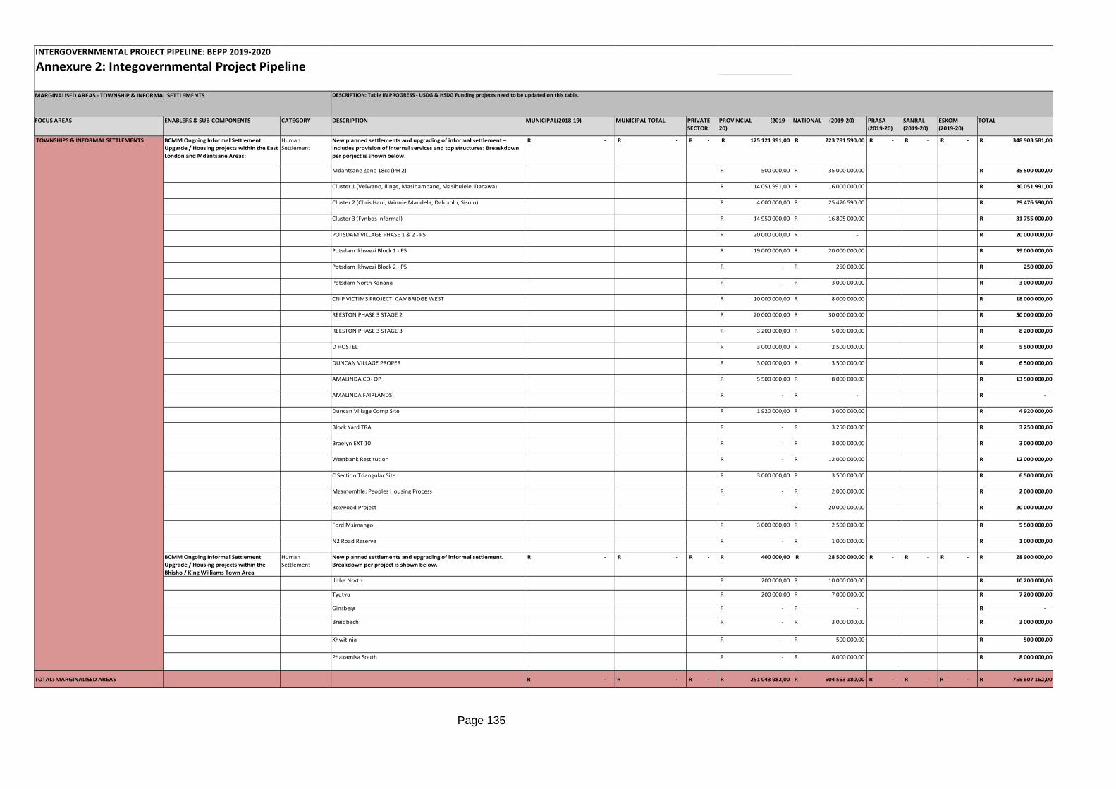
Page 135
Annexure 2: Integovernmental Project Pipeline
FOCUS AREAS ENABLERS & SUB-COMPONENTS CATEGORY DESCRIPTION MUNICIPAL(2018-19) MUNICIPAL TOTAL PRIVATE
SECTOR
PROVINCIAL (2019-
20)
NATIONAL (2019-20) PRASA
(2019-20)
SANRAL
(2019-20)
ESKOM
(2019-20)
TOTAL
BCMM Ongoing Informal Settlement
Upgarde / Housing projects within the East
London and Mdantsane Areas:
Human
Settlement
New planned settlements and upgrading of informal settlement –
Includes provision of internal services and top structures: Breaskdown
per porject is shown below.
-R -R -R 125 121 991,00R 223 781 590,00R -R -R -R 348 903 581,00R
Mdantsane Zone 18cc (PH 2) 500 000,00R 35 000 000,00R 35 500 000,00R
Cluster 1 (Velwano, Ilinge, Masibambane, Masibulele, Dacawa) 14 051 991,00R 16 000 000,00R 30 051 991,00R
Cluster 2 (Chris Hani, Winnie Mandela, Daluxolo, Sisulu) 4 000 000,00R 25 476 590,00R 29 476 590,00R
Cluster 3 (Fynbos Informal) 14 950 000,00R 16 805 000,00R 31 755 000,00R
POTSDAM VILLAGE PHASE 1 & 2 - P5 20 000 000,00R -R 20 000 000,00R
Potsdam Ikhwezi Block 1 - P5 19 000 000,00R 20 000 000,00R 39 000 000,00R
Potsdam Ikhwezi Block 2 - P5 -R 250 000,00R 250 000,00R
Potsdam North Kanana -R 3 000 000,00R 3 000 000,00R
CNIP VICTIMS PROJECT: CAMBRIDGE WEST 10 000 000,00R 8 000 000,00R 18 000 000,00R
REESTON PHASE 3 STAGE 2 20 000 000,00R 30 000 000,00R 50 000 000,00R
REESTON PHASE 3 STAGE 3 3 200 000,00R 5 000 000,00R 8 200 000,00R
D HOSTEL 3 000 000,00R 2 500 000,00R 5 500 000,00R
DUNCAN VILLAGE PROPER 3 000 000,00R 3 500 000,00R 6 500 000,00R
AMALINDA CO- OP 5 500 000,00R 8 000 000,00R 13 500 000,00R
AMALINDA FAIRLANDS -R -R -R
Duncan Village Comp Site 1 920 000,00R 3 000 000,00R 4 920 000,00R
Block Yard TRA -R 3 250 000,00R 3 250 000,00R
Braelyn EXT 10 -R 3 000 000,00R 3 000 000,00R
Westbank Restitution -R 12 000 000,00R 12 000 000,00R
C Section Triangular Site 3 000 000,00R 3 500 000,00R 6 500 000,00R
Mzamomhle: Peoples Housing Process -R 2 000 000,00R 2 000 000,00R
Boxwood Project 20 000 000,00R 20 000 000,00R
Ford Msimango 3 000 000,00R 2 500 000,00R 5 500 000,00R
N2 Road Reserve -R 1 000 000,00R 1 000 000,00R
BCMM Ongoing Informal Settlement
Upgrade / Housing projects within the
Bhisho / King Williams Town Area
Human
Settlement
New planned settlements and upgrading of informal settlement.
Breakdown per project is shown below.
-R -R -R 400 000,00R 28 500 000,00R -R -R -R 28 900 000,00R
Ilitha North 200 000,00R 10 000 000,00R 10 200 000,00R
Tyutyu 200 000,00R 7 000 000,00R 7 200 000,00R
Ginsberg -R -R -R
Breidbach -R 3 000 000,00R 3 000 000,00R
Xhwitinja -R 500 000,00R 500 000,00R
Phakamisa South -R 8 000 000,00R 8 000 000,00R
TOTAL: MARGINALISED AREAS -R -R -R 251 043 982,00R 504 563 180,00R -R -R -R 755 607 162,00R
MARGINALISED AREAS - TOWNSHIP & INFORMAL SETTLEMENTS DESCRIPTION: Table IN PROGRESS - USDG & HSDG Funding projects need to be updated on this table.
INTERGOVERNMENTAL PROJECT PIPELINE: BEPP 2019-2020
TOWNSHIPS & INFORMAL SETTLEMENTS
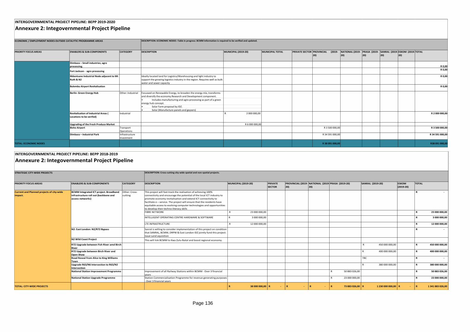
Page 136
Annexure 2: Integovernmental Project Pipeline
PRIORITY FOCUS AREAS ENABLERS & SUB-COMPONENTS CATEGORY DESCRIPTION MUNICIPAL (2019-20) MUNICIPAL TOTAL PRIVATE SECTOR PROVINCIAL (2019-
20)
NATIONAL (2019-
20)
PRASA (2019-
20)
SANRAL (2019-
20)
ESKOM (2019-
20)
TOTAL
Dimbaza – Small industries; agro
processing. R 0,00
Fort Jackson - agro processingR 0,00
Mdantsane Industrial Node adjacent to Mt
Ruth & N2
Ideally located land for Logistics/Warehousing and light industry to
support the growing logistics industry in the region. Requires well as bulk
water and sewer capacity
R 0,00
Bulembu Airport Revitalisation R 0,00
Focussed on Renewable Energy, to broaden the energy mix, transforms
and diversify the economy.Research and Development component.
• Includes manufacturing and agro-processing as part of a green
energy hub concept.
• Solar Farm proposal by IDZ.
• Solar (Manufacture panels and geysers)
Revitalisation of Industrial Areas (
Locations to be verifed)
Industrial R 2 000 000,00 R 2 000 000,00
Upgrading of the Fresh Produce Market R 6 000 000,00
Bisho Airport Transport
Operations
R 3 500 000,00 R 3 500 000,00
Dimbaza – Industrial Park Infrastructure
Investment
R 34 591 000,00 R 34 591 000,00
TOTAL: ECONOMIC NODES R 38 091 000,00 R38 091 000,00
INTERGOVERNMENTAL PROJECT PIPELINE: BEPP 2019-2020
ECONOMIC / EMPLOYMENT NODES OUTSIDE CATALYTIC PROGRAMME AREAS DESCRIPTION: ECONOMIC NODES -Table in progress: BCMM Information is required to be verified and updated.
Berlin- Green Energy Hub Other: Industrial
Annexure 2: Integovernmental Project Pipeline
PRIORITY FOCUS AREAS ENABLERS & SUB-COMPONENTS CATEGORY DESCRIPTION MUNICIPAL (2019-20) PRIVATE
SECTOR
PROVINCIAL (2019-
20)
NATIONAL (2019-
20)
PRASA (2019-20) SANRAL (2019-20) ESKOM
(2019-20)
TOTAL
This project will fast-track the realisation of achieving 100%
connectivity and encourage the potential of the local ICT industry to
promote economy revitalisation and extend ICT connectivity to
facilitate e – service. The project will ensure that the residents have
equitable access to evolving computer technologies and opportunities
to develop their techno-literacy skills
-R
FIBRE NETWORK 23 000 000,00R 23 000 000,00R
INTELLIGENT OPERATING CENTRE HARDWARE & SOFTWARE 3 000 000,00R 3 000 000,00R
LTE INFRASTRUCTURE 12 000 000,00R 12 000 000,00R
N2: East London: N2/R72 Bypass Sanral is willing to consider implementation of this project on condition
that SANRAL, BCMM, DRPW & East London IDZ jointly fund this project:
Issue Land aquisition
-R
N2 Wild Coast Project This will link BCMM to Kwa Zulu-Natal and boost regional economy.
R72 Upgrade between Fish River amd Birch
River
450 000 000,00R 450 000 000,00R
R72 Upgrade between Birch River and
Open Shaw
400 000 000,00R 400 000 000,00R
Road Reseal from Alice to King Williams
Town
TBC -R
Upgrade R63/N6 Intersection to R63/N2
Intersection
380 000 000,00R 380 000 000,00R
National Station Improvement Programme Improvement of all Railway Stations within BCMM - Over 3 financial
years
50 883 026,00R 50 883 026,00R
National Station Upgrade Programme Station Commercialisation Programme for revenue generating purposes
- Over 3 financial years
23 000 000,00R 23 000 000,00R
TOTAL: CITY-WIDE PROJECTS 38 000 000,00R -R -R -R 73 883 026,00R 1 230 000 000,00R -R 1 341 883 026,00R
STRATEGIC CITY-WIDE PROJECTS DESCRIPTION: Cross-cutting city-wide spatial and non-spatial projects.
Current and Planned projects of city-wide
impact.
INTERGOVERNMENTAL PROJECT PIPELINE: BEPP 2018-2019
Other: Cross-
cutting
BCMM Integrated ICT project. Broadband
infrastructure roll out (backbone and
access networks)
Page 137
ANNEXURE 3: Spatial Budget Mix (Draft)
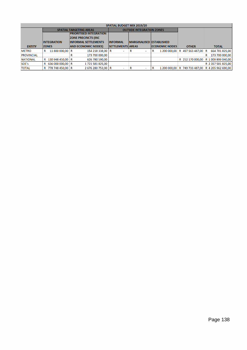
Page 138
Page 139
ANNEXURE 4: Built Environment Outcomes Indicators & Targets (Draft)
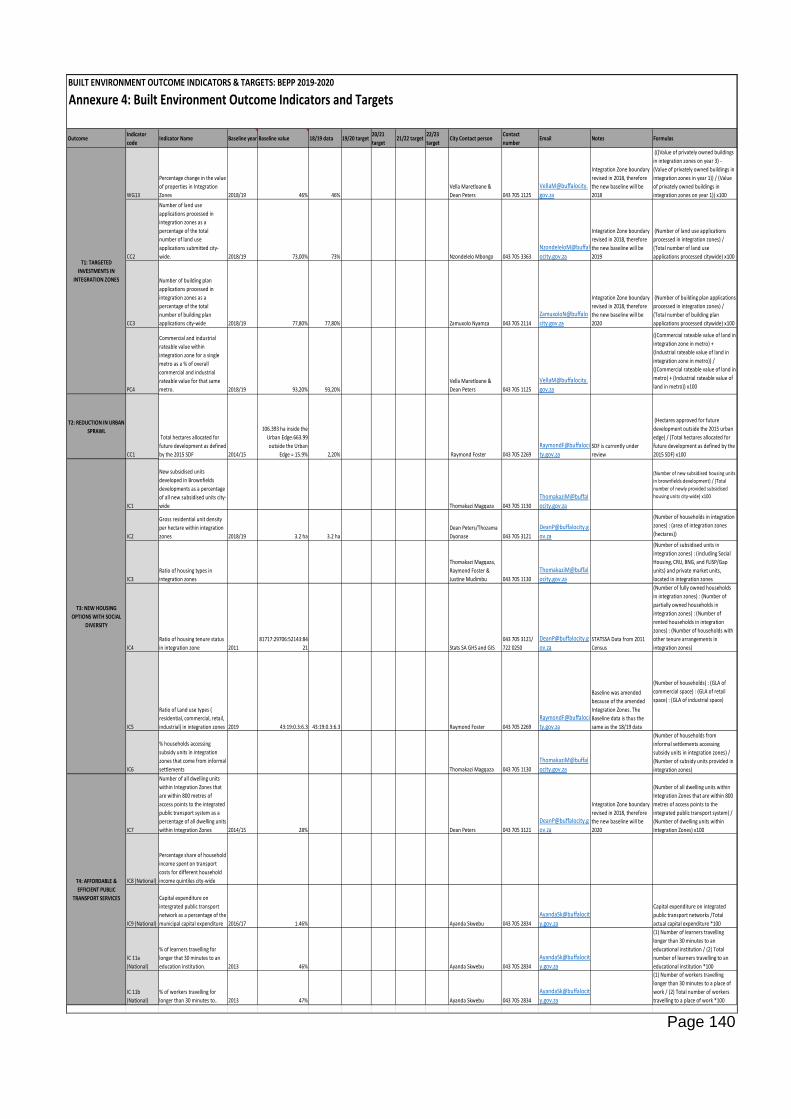
Page 140
BUILT ENVIRONMENT OUTCOME INDICATORS & TARGETS: BEPP 2019-2020
Annexure 4: Built Environment Outcome Indicators and Targets
OutcomeIndicator
codeIndicator Name Baseline year Baseline value 18/19 data 19/20 target
20/21
target21/22 target
22/23
targetCity Contact person
Contact
numberEmail Notes Formulas
WG13
Percentage change in the value
of properties in Integration
Zones 2018/19 46% 46%
Vella Maretloane &
Dean Peters 043 705 1125
VellaM@buffalocity.
gov.za
Integration Zone boundary
revised in 2018, therefore
the new baseline will be
2018
(((Value of privately owned buildings
in integration zones on year 3) -
(Value of privately owned buildings in
integration zones in year 1)) / (Value
of privately owned buildings in
integration zones on year 1)) x100
CC2
Number of land use
applications processed in
integration zones as a
percentage of the total
number of land use
applications submitted city-
wide. 2018/19 73,00% 73% Nzondelelo Mbongo 043 705 3363
NzondeleloM@buffal
ocity.gov.za
Integration Zone boundary
revised in 2018, therefore
the new baseline will be
2019
(Number of land use applications
processed in integration zones) /
(Total number of land use
applications processed citywide) x100
CC3
Number of building plan
applications processed in
integration zones as a
percentage of the total
number of building plan
applications city-wide 2018/19 77,80% 77,80% Zamuxolo Nyamza 043 705 2114
ZamuxoloN@buffalo
city.gov.za
Integration Zone boundary
revised in 2018, therefore
the new baseline will be
2020
(Number of building plan applications
processed in integration zones) /
(Total number of building plan
applications processed citywide) x100
PC4
Commercial and industrial
rateable value within
integration zone for a single
metro as a % of overall
commercial and industrial
rateable value for that same
metro. 2018/19 93,20% 93,20%
Vella Maretloane &
Dean Peters 043 705 1125
VellaM@buffalocity.
gov.za
((Commercial rateable value of land in
integration zone in metro) +
(Industrial rateable value of land in
integration zone in metro)) /
((Commercial rateable value of land in
metro) + (Industrial rateable value of
land in metro)) x100
T2: REDUCTION IN URBAN
SPRAWL
CC1
Total hectares allocated for
future development as defined
by the 2015 SDF 2014/15
106.393 ha inside the
Urban Edge.663.99
outside the Urban
Edge = 15.9% 2,20% Raymond Foster 043 705 2269
RaymondF@buffaloci
ty.gov.zaSDF is currently under
review
(Hectares approved for future
development outside the 2015 urban
edge) / (Total hectares allocated for
future development as defined by the
2015 SDF) x100
IC1
New subsidised units
developed in Brownfields
developments as a percentage
of all new subsidised units city-
wide Thomakazi Magqaza 043 705 1130
ThomakaziM@buffal
ocity.gov.za
(Number of new subsidised housing units
in brownfields development) / (Total
number of newly provided subsidised
housing units city-wide) x100
IC2
Gross residential unit density
per hectare within integration
zones 2018/19 3.2 ha 3.2 ha
Dean Peters/Thozama
Dyonase 043 705 3121
ov.za
(Number of households in integration
zones) : (area of integration zones
(hectares))
IC3
Ratio of housing types in
integration zones
Thomakazi Magqaza,
Raymond Foster &
Justine Mudimbu 043 705 1130
ThomakaziM@buffal
ocity.gov.za
(Number of subsidised units in
integration zones) : (including Social
Housing, CRU, BNG, and FLISP/Gap
units) and private market units,
located in integration zones
IC4
Ratio of housing tenure status
in integration zone 2011
81717:29706:52143:84
21 Stats SA GHS and GIS
043 705 3121/
722 0250
ov.zaSTATSSA Data from 2011
Census
(Number of fully owned households
in integration zones) : (Number of
partially owned households in
integration zones) : (Number of
rented households in integration
zones) : (Number of households with
other tenure arrangements in
integration zones)
IC5
Ratio of Land use types (
residential, commercial, retail,
industrial) in integration zones 2019 43:19:0.3:6.3 43:19:0.3:6.3 Raymond Foster 043 705 2269
RaymondF@buffaloci
ty.gov.za
Baseline was amended
because of the amended
Integration Zones. The
Baseline data is thus the
same as the 18/19 data
(Number of households) : (GLA of
commercial space) : (GLA of retail
space) : (GLA of industrial space)
IC6
% households accessing
subsidy units in integration
zones that come from informal
settlements Thomakazi Magqaza 043 705 1130
ThomakaziM@buffal
ocity.gov.za
(Number of households from
informal settlements accessing
subsidy units in integration zones) /
(Number of subsidy units provided in
integration zones)
IC7
Number of all dwelling units
within Integration Zones that
are within 800 metres of
access points to the integrated
public transport system as a
percentage of all dwelling units
within Integration Zones 2014/15 28% Dean Peters 043 705 3121
ov.za
Integration Zone boundary
revised in 2018, therefore
the new baseline will be
2020
(Number of all dwelling units within
Integration Zones that are within 800
metres of access points to the
integrated public transport system) /
(Number of dwelling units within
Integration Zones) x100
IC8 (National)
Percentage share of household
income spent on transport
costs for different household
income quintiles city-wide
IC9 (National)
Capital expenditure on
intergrated public transport
network as a percentage of the
municipal capital expenditure 2016/17 1.46% Ayanda Skwebu 043 705 2834
AyandaSk@buffalocit
y.gov.za
Capital expenditure on integrated
public transport networks /Total
actual capital expenditure *100
IC 11a
(National)
% of learners travelling for
longer that 30 minutes to an
education institution. 2013 46% Ayanda Skwebu 043 705 2834
AyandaSk@buffalocit
y.gov.za
(1) Number of learners travelling
longer than 30 minutes to an
educational institution / (2) Total
number of learners travelling to an
educational institution *100
IC 11b
(National)
% of workers travelling for
longer than 30 minutes to.. 2013 47% Ayanda Skwebu 043 705 2834
AyandaSk@buffalocit
y.gov.za
(1) Number of workers travelling
longer than 30 minutes to a place of
work / (2) Total number of workers
travelling to a place of work *100
T1: TARGETED
INVESTMENTS IN
INTEGRATION ZONES
T3: NEW HOUSING
OPTIONS WITH SOCIAL
DIVERSITY
T4: AFFORDABLE &
EFFICIENT PUBLIC
TRANSPORT SERVICES
Page 141
ANNEXURE 6: Draft USDG Plan (Draft)
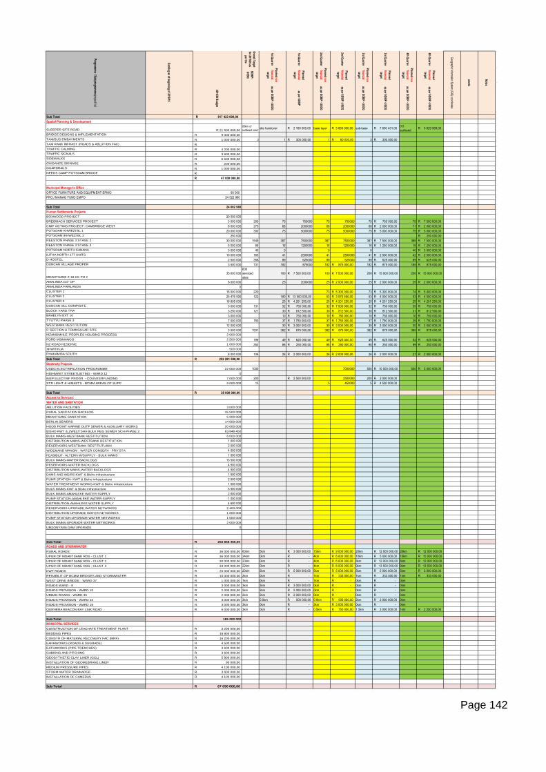
Page 142
Overall Target
for 2019/20 as
per the
1st Quarter
1st Quarter
2nd Quarter
2nd Quarter
3rd Quarter
3rd Quarter
4th Quarter
4th Quarter
SD
BIP
-
US
DG
Planned non-
financial
target
Planned
financial
target
Planned non-
financial
target
Planned
financial
target
Planned non-
financial
target
Planned
financial
target
Planned non-
financial
target
Planned
financial
target
2019/20 Budget
as per SD
BIP
- US
DG
as per SD
BIP
as per SD
BIP
- US
DG
as per SD
BIP
-US
DG
as per SD
BIP
- US
DG
as per SD
BIP
-US
DG
as per SD
BIP
- US
DG
as per SD
BIP
-US
DG
Sub Total R 817 423 000,00
Spatial Planning & Development
SLEEPER SITE ROAD 21 500 000,00R
05km of
surfaced roadsite handover R 2 160 000,00 base layer R 5 860 000,00 sub-base R 7 650 431,00
0.5
surfaced R 5 829 569,00
BRIDGE DESIGNS & IMPLEMENTATION 9 000 000,00R
TAXI/BUS EMBAYMENTS 1 000 000,00R 3 1 R 300 000,00 1 R 60 000,00 3 R 300 000,00
TAXI RANK INFRAST (ROADS & ABLUTION FAC) -R
TRAFFIC CALMING 4 200 000,00R
TRAFFIC SIGNALS 3 600 000,00R
SIDEWALKS 6 500 000,00R
GUIDANCE SIGNAGE 200 000,00R
GUARDRAILS 1 000 000,00R
NEEDS CAMP POTSDAM BRIDGE R -
R 47 000 000,00
Municipal Manager's Office
OFFICE FURNITURE AND EQUIPMENT-EPMO 80 000
PROJ MANAG FUND EMPO 24 522 960
Sub Total 24 602 960
Human Settlements Projects
BOXWOOD PROJECT 20 000 000
BREIDBACH SERVICES PROJECT 3 000 000 300 75 750000 75 750000 75 R 750 000,00 75 R 7 500 000,00
CNIP VICTIMS PROJECT: CAMBRIDGE WEST 8 000 000 275 68 2000000 68 2000000 68 R 2 000 000,00 71 R 2 000 000,00
POTSDAM KHWEZI BL 1 20 000 000 300 75 5000000 75 5000000 75 R 5 000 000,00 75 R 5 000 000,00
POTSDAM IKHWEZI BL 2 250 000 R 250 000,00
REESTON PHASE 3 STAGE 2 30 000 000 1549 387 7500000 387 7500000 387 R 7 500 000,00 388 R 7 500 000,00
REESTON PHASE 3 STAGE 3 5 000 000 66 16 1250000 16 1250000 16 R 1 250 000,00 18 R 1 250 000,00
POTSDAM NORTH KANANA 3 000 000 40 0 0 0 40 R 3 000 000,00
ILITHA NORTH 177 UNITS 10 000 000 165 41 2500000 41 2500000 41 R 2 500 000,00 42 R 2 500 000,00
D HOSTEL 2 500 000 356 89 625000 89 625000 89 R 625 000,00 89 R 625 000,00
DUNCAN VILLAGE PROPER 3 500 000 731 182 875000 182 R 875 000,00 182 R 875 000,00 185 R 875 000,00
MDANTSANE Z 18 CC PH 2
35 000 000
600
serviced
sites
100 R 7 500 000,00 100 R 7 500 000,00 200 R 15 000 000,00 200 R 15 000 000,00
AMALINDA CO- OP 8 000 000 25 2000000 25 R 2 000 000,00 25 R 2 000 000,00 25 R 2 000 000,00
AMALINDA FAIRLANDS 0
CLUSTER 1 16 000 000 220 73 R 5 300 000,00 73 R 5 300 000,00 74 R 5 400 000,00
CLUSTER 2 25 476 590 122 180 R 13 500 000,00 53 R 3 976 590,00 53 R 4 000 000,00 53 R 4 000 000,00
CLUSTER 3 16 805 000 25 R 4 201 250,00 25 R 4 201 250,00 25 R 4 201 250,00 25 R 4 201 250,00
DUNCAN VILL COMP/SITE 3 000 000 131 32 R 750 000,00 32 R 7 500 000,00 32 R 750 000,00 35 R 750 000,00
BLOCK YARD TRA 3 250 000 121 30 R 812 500,00 30 R 812 500,00 30 R 812 500,00 31 R 812 500,00
BRAELYN EXT 10 3 000 000 10 R 750 000,00 10 R 750 000,00 10 R 750 000,00 10 R 750 000,00
TYUTYU PHASE 3 7 000 000 150 37 R 1 750 000,00 37 R 1 750 000,00 37 R 1 750 000,00 39 R 1 750 000,00
WESTBANK RESTITUTION 12 000 000 30 R 3 000 000,00 30 R 3 000 000,00 30 R 3 000 000,00 30 R 3 000 000,00
C SECTION & TRIANGULAR SITE 3 500 000 1531 382 R 875 000,00 382 R 875 000,00 382 R 875 000,00 385 R 875 000,00
MZAMOMHLE: PEOPLES HOUSING PROCESS 2 000 000
FORD MSIMANGO 2 500 000 199 49 R 625 000,00 49 R 625 000,00 49 R 625 000,00 52 R 625 000,00
N2 ROAD RESERVE 1 000 000 353 88 R 250 000,00 88 R 250 000,00 88 R 250 000,00 89 R 250 000,00
XHWITINJA 500 000
PHAKAMISA SOUTH 8 000 000 106 26 R 2 000 000,00 26 R 2 000 000,00 26 R 2 000 000,00 27 R 2 000 000,00
Sub Total R 252 281 590,00
Electricity Projects
USDG ELECTRIFICATION PROGRAMME 22 000 000 1000 7000000 500 R 10 000 000,00 500 R 5 000 000,00
HIGHMAST STREETLIGTING - WARD 12 0
INEP ELECTRIF PROGR - COUNTERFUNDING 7 000 000 200 R 2 500 000,00 2500000 200 R 2 000 000,00
STR LIGHT & H/MASTS - BCMM AREAS OF SUPP 9 000 000 10 5 450000 5 R 4 500 000,00
Sub Total R 38 000 000,00
Access to Services:
WATER AND SANITATION
ABLUTION FACILITIES 3 000 000
RURAL SANITATION BACKLOG 35 500 000
MDANTSANE SANITATION 5 000 000
BERLIN SEWERS 14 000 000
HOOD POINT MARINE OUTF SEWER & AUXILLIARY WORKS 20 000 000
BISHO KWT & ZWELITSHA BULK REG SEWER SCH-PHASE 2 63 848 450
BULK MAINS-WESTBANK RESTITUTION 6 000 000
DISTRIBUTION MAINS-WESTBANK RESTITUTION 1 000 000
RESERVOIRS-WESTBANK RESTITUTUION 2 000 000
W/DEMAND MANGM - WATER CONSERV - PRV STA 4 000 000
FEASIBILIT- ALTERN W/SUPPLY - BULK MAINS 1 000 000
BULK MAINS-WATER BACKLOGS 13 500 000
RESERVOIRS-WATER BACKLOGS 4 500 000
DISTRIBUTION MAINS-WATER BACKLOGS 4 500 000
DAMS AND WEIRS-KWT & Bisho infrastructure 1 500 000
PUMP STATION- KWT & Bisho infrastructure 2 500 000
WATER TREATMENT WORKS-KWT & Bisho infrastructure 1 500 000
BULK MAINS-KWT & Bisho Infrastructure 5 500 000
BULK MAINS-AMAHLEKE WATER SUPPLY 2 000 000
PUMP STATION-AMAHLEKE WATER SUPPLY 1 000 000
DISTRIBUTION-AMAHLEKE WATER SUPPLY 4 600 000
RESERVOIRS-UPGRADE WATER NETWOKRS 2 400 000
DISTRIBUTION-UPGRADE WATER NETWORKS 1 000 000
PUMP STATION-UPGRADE WATER NETWORKS 1 000 000
BULK MAINS-UPGRADE WATER NETWORKS 2 000 000
UMZONYANA DAM UPGRADE 0
Sub Total 202 848 450,00R
ROADS AND STORMWATER
RURAL ROADS 36 000 000,00R 60km 5km R 3 000 000,00 15km R 9 000 000,00 20km R 12 000 000,00 20km R 12 000 000,00
UPGR OF MDANTSANE RDS - CLUST 1 36 000 000,00R 24km 0km R - 4km R 6 000 000,00 10km R 5 000 000,00 10km R 15 000 000,00
UPGR OF MDANTSANE RDS - CLUST 2 30 000 000,00R 20km 0km R - 4km R 6 000 000,00 8km R 12 000 000,00 8km R 12 000 000,00
UPGR OF MDANTSANE RDS - CLUST 3 33 000 000,00R 22km 0km R - 4km R 6 000 000,00 9km R 13 500 000,00 9km R 13 500 000,00
KWT ROADS 20 000 000,00R 20km 5km R 5 000 000,00 5km R 5 000 000,00 5km R 5 000 000,00 5km R 5 000 000,00
REHABILIT OF BCMM BRIDGES AND STORMWATER 10 000 000,00R 3km 0km R - 1km R 333 000,00 1km R 333 000,00 1km R 333 000,00
WEST DRIVE BRIDGE - WARD 37 1 000 000,00R 1km 0km R - 1km R - 0km R - 0km
ROADS WARD - 8 3 000 000,00R 3km 3km R 3 000 000,00 0km R - 0km R - 0km
ROADS PROVISION - WARD 10 2 000 000,00R 2km 2km R 2 000 000,00 0km R - 0km R - 0km
URBAN ROADS - WARD 35 2 000 000,00R 2km 2km R 2 000 000,00 0km R - 0km R - 0km
ROADS PROVISION - WARD 15 3 000 000,00R 3km 0.5km R 500 000,00 0.5km R 500 000,00 2km R 2 000 000,00 0km
ROADS PROVISION - WARD 16 3 000 000,00R 3km 0km R - 3km R 3 000 000,00 0km R - 0km
QUENERA BEACON BAY LINK ROAD 6 000 000,00R 3km 0km R - 0.5km R 750 000,00 1.5km R 3 000 000,00 1km R 2 250 000,00
Sub Total 185 000 000
MUNICIPAL SERVICES
CONSTRUCTION OF LEACHATE TREATMENT PLANT 3 200 000,00R
BEDDING PIPES 18 800 000,00R
CONSTR OF MATERIAL RECOVERY FAC (MRF) 16 200 000,00R
EARHWORKS (ROADS & SUGRADE) 4 500 000,00R
EATHWORKS (PIPE TRENCHES) 3 600 000,00R
GABIONS AND PITCHING 3 600 000,00R
GEOSYTHETIC CLAY LINER (GCL) 5 900 000,00R
INSTALLATION OF GEOMEBRANE LINER 90 000,00R
MEDIUM PRESSURE PIPES 4 100 000,00R
STORM WATER DRAINADGE 3 600 000,00R
INSTALLATION OF CAMERAS 4 100 000,00R
Sub Total 67 690 000,00R
Notes
Program
me / S
ubprogramm
e project list
Backlog as at beginning of 2018/19
Geographic Inform
ation System
(GIS
) coordinates
wards

Page 143
Page 144
ANNEXURE 6: Task Team Representatives, Attendance Registers, Minutes of BEPP Task Team
Meetings

Page 145
ANNEXURE 7: Attendance Registers, Minutes of IGR Task Team Meeting