Embed Size (px)
Citation preview

Dr. Ned Dwyer
Coastal and Marine Research Centre, Cork, Ireland
Practical experience in the management,
analysis and visualisation of marine data and
information

Marine Data Management
São Paulo, 11-12 April 2012 Ned Dwyer: [email protected]
Introduction Chapter 1 Marine Irish Digital Atlas
Chapter 2 The European Context
Chapter 3 The Global Context
Chapter 4 Smart visualisation
Conclusion

Marine Data Management
São Paulo, 11-12 April 2012 Ned Dwyer: [email protected]
Coastal and Marine Research Centre-CMRC
UCC CMRC
Cork
100 km

Marine Data Management
São Paulo, 11-12 April 2012 Ned Dwyer: [email protected]
Five Thematic Focus Areas
• Marine Geomatics
• Applied Remote Sensing and GIS
• Coastal Processes and Seabed Mapping
• Marine Ecology
• Coastal Governance

Marine Data Management
São Paulo, 11-12 April 2012 Ned Dwyer: [email protected]
Multi-disciplinary research approach
Disciplines represented
Computer Science
Marine Geography
Geomorphology
Hydrography
Env. Science
GIS & Remote Sensing
Marine Biology
Engineering
Numerical Modelling
Zoology
Marine Geology
April 2012 – 30 projects; 40 researchers
Funding Spread • National 37 % • International 41 % • Consultancy 22 %

Marine Data Management
São Paulo, 11-12 April 2012 Ned Dwyer: [email protected]
MIDA Vision
The Marine Irish Digital Atlas (MIDA) should
become a key on-line resource for all who are
interested in coastal and marine information
and data for Ireland
Marine Data Management
São Paulo, 11-12 April 2012 Ned Dwyer: [email protected]
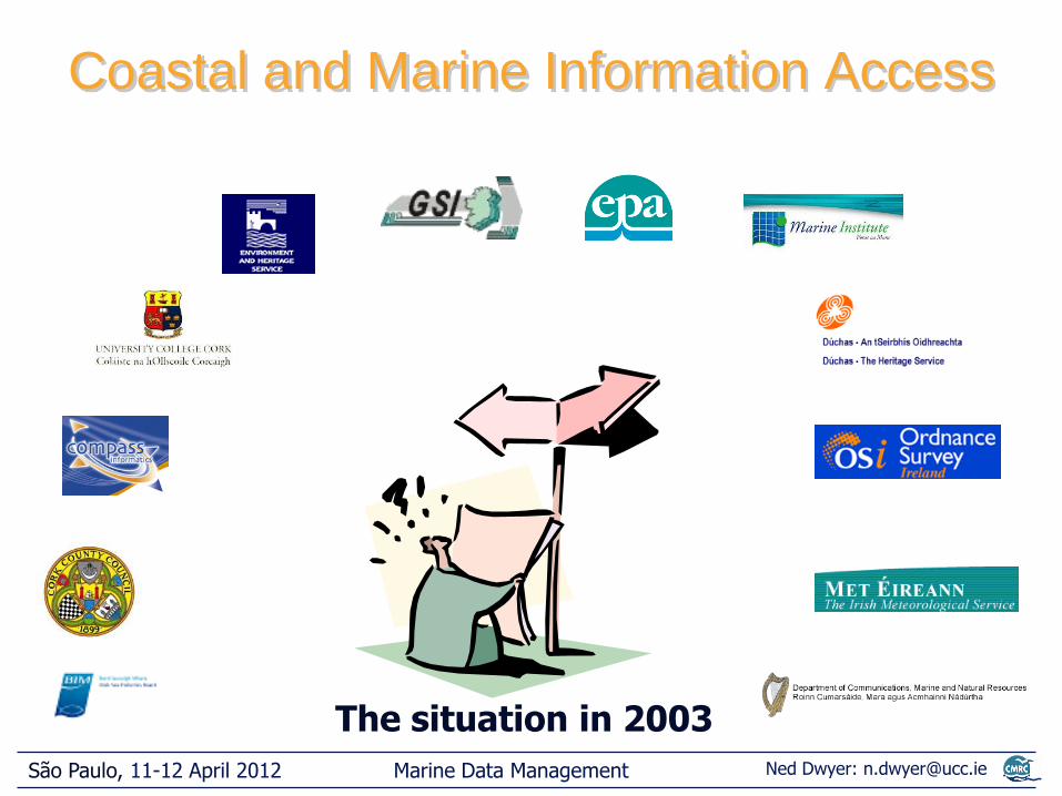
Coastal and Marine Information Access
The situation in 2003

Marine Data Management
São Paulo, 11-12 April 2012 Ned Dwyer: [email protected]
MIDA
The MIDA Solution

Marine Data Management
São Paulo, 11-12 April 2012 Ned Dwyer: [email protected]
Information
General Specialised Searchable
Metadata
Data Archive
Spatial
Data
MIDA
Web GIS
The MIDA Structure

Marine Data Management
São Paulo, 11-12 April 2012 Ned Dwyer: [email protected]
Interactive Map Layers
Information

Marine Data Management
São Paulo, 11-12 April 2012 Ned Dwyer: [email protected]
Open Source Solution
• Linux Apache Server
• Minnesota Map Server
• PostgreSQL Database
Technology: Software Used
Version 1.0

Marine Data Management
São Paulo, 11-12 April 2012 Ned Dwyer: [email protected]
Technology: System Overview

Marine Data Management
São Paulo, 11-12 April 2012 Ned Dwyer: [email protected]
Technology: System Upgrade
2012
PostGreSQL GeoNetwork
Mapserver + php + GeoExt + ExtJS
Part funded by:
Mapserver + Php
Server side Client side

Marine Data Management
São Paulo, 11-12 April 2012 Ned Dwyer: [email protected]
Metadata stored in database
• Optimises data management
• Permits efficient searching
• Facilitates catalogue sharing
• Data files are not in a database
Technology: Database Driven

Marine Data Management
São Paulo, 11-12 April 2012 Ned Dwyer: [email protected]
• Open source allows flexibility
• Requires programming capability
• Metadata management system vital
• Use standards
Technology Lessons

Marine Data Management
São Paulo, 11-12 April 2012 Ned Dwyer: [email protected]
• Discovery – Core database
– 55 elements
– Subset / Profile of ISO 19115
– ISO 19139 XML tags
• Abstract – Initial metadata access
– Taken from Discovery DB
• Full – As data owner supplies it
Metadata in MIDA

Marine Data Management
São Paulo, 11-12 April 2012 Ned Dwyer: [email protected]
Choosing a Metadata System
Some Selection Criteria •Easy to create and edit metadata •Metadata management •Metadata storage •Metadata standards compliance •Desktop or internet based tools •Automatic metadata generation, metadata harvesting and synchronisation •Access to distributed data •Reuse source code
Marine Data Management
São Paulo, 11-12 April 2012 Ned Dwyer: [email protected]
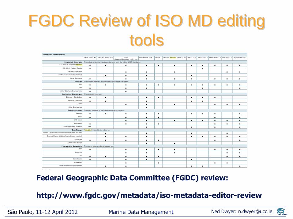
FGDC Review of ISO MD editing
tools
Federal Geographic Data Committee (FGDC) review: http://www.fgdc.gov/metadata/iso-metadata-editor-review

Marine Data Management
São Paulo, 11-12 April 2012 Ned Dwyer: [email protected]
• Proprietary
– ESRI ArcCatalog
– Intergraph’s GeoMedia Catalog
• Opensource/freeware
– CatMDedit
– GeoNetwork opensource
– ISI Metadata Editor (INTA)
– M3Cat (Intelec geomativs)
– Metalite (USGS)
– Metavist
– tkme
– xtme
CMRC Review of MD editing tools

Marine Data Management
São Paulo, 11-12 April 2012 Ned Dwyer: [email protected]
• Meets the selection criteria
• For example: supports a number of standards
– ISO 19115/19139/19119
– FGDC
– Dublin Core
– OGC Catalog Service for Web (CSW)
• Multilingual (English, French, Spanish)
Geonetwork Chosen

Marine Data Management
São Paulo, 11-12 April 2012 Ned Dwyer: [email protected]
GeoNetwork
http://geonetwork-opensource.org/

Marine Data Management
São Paulo, 11-12 April 2012 Ned Dwyer: [email protected]
• Poor metadata availability
• Creation time consuming
• Presentation should be user
friendly
• Appreciated by users
• ISO 19115/19139 facilitates
catalogue sharing
MIDA Metadata Lessons

Marine Data Management
São Paulo, 11-12 April 2012 Ned Dwyer: [email protected]
Beyond Metadata: Vocabularies
• Vocabulary [MMI]:
– set of terms (words, codes, etc.) used in a specific community
– provide a mechanism of communication as the meaning of the terms are known and agreed upon by community members
Used to define theme, place keywords, instrument names, codes, etc.
Marine Data Management
São Paulo, 11-12 April 2012 Ned Dwyer: [email protected]
• Different terms have the same definition but different
meanings and uses: altitude, height and depth
(vertical distance)
• The same term has different meanings depending on
the community or the context: e.g. an ROV may use
“altitude” for distance above ocean floor
• Different terms have the same meaning: synonyms,
abbreviations, languages, etc.: e.g. seabed, seafloor,
fondo do mar
Vocabularies- problems

Marine Data Management
São Paulo, 11-12 April 2012 Ned Dwyer: [email protected]
• Controlled Vocabulary [MMI]: list of terms that
are:
– Accepted: adhere to community practices
– Defined: rigorous definition
– Managed: periodic review, addition, modification
of terms
Controlled Vocabularies
Ensures common understanding

Marine Data Management
São Paulo, 11-12 April 2012 Ned Dwyer: [email protected]
Controlled Vocabularies: types
and categories
Flat
Relational
Multi-level
Authority File: Terms
Glossary: terms + definitions
Dictionary: Terms + definitions + additional information
Gazetteer: Location, coordinates
Code List: code + definitions
Taxonomy: terms classified into
subject-specific categories
Subject heading: terms classified into broad categories
Thesaurus: terms with relationships
Semantic Network: terms with relationships (includes
additional types of relationships)
Ontology: terms in categories, with relationships and
rules/axioms
Vocabularies

Marine Data Management
São Paulo, 11-12 April 2012 Ned Dwyer: [email protected]
Vocabularies: More Information
Good introduction to controlled vocabularies http://marinemetadata.org/guides/vocabs/
Where to find marine vocabularies • Marine Metadata Interoperability Project
http://marinemetadata.org/conventions/vocabularies
• Seadatanet vocabulary web service http://www.seadatanet.org/Standards-Software/Common-Vocabularies
• NERC vocabulary server http://www.bodc.ac.uk/products/web_services/vocab/
• Gemet thesaurus http://www.eionet.europa.eu/gemet
• NASA global change master directory http://gcmd.nasa.gov/

Marine Data Management
São Paulo, 11-12 April 2012 Ned Dwyer: [email protected]
• Map tools
• Data search
• Information
MIDA Atlas Functionality

Marine Data Management
São Paulo, 11-12 April 2012 Ned Dwyer: [email protected]
New Interface with GeoExt
Interactive Map
Layers
Information
Tools

Marine Data Management
São Paulo, 11-12 April 2012 Ned Dwyer: [email protected]
Some Benefits of GeoExt
• Based on OpenLayers platform
– De facto standard for mapping systems
• Built-in suite of mapping functions
• Easily extensible with ExtJS library
• Faster- based on AJAX (e.g. dynamic update)
• Faster – supports automatic tiling

Marine Data Management
São Paulo, 11-12 April 2012 Ned Dwyer: [email protected]
special
Data Layers – Search

Marine Data Management
São Paulo, 11-12 April 2012 Ned Dwyer: [email protected]
Data Layers – Search

Marine Data Management
São Paulo, 11-12 April 2012 Ned Dwyer: [email protected]
37 organisations
> 125 data layers
25 of 84 topics written
Data and Information Status
update and addition of layers ongoing

Marine Data Management
São Paulo, 11-12 April 2012 Ned Dwyer: [email protected]
http://mida.ucc.ie/
(2003-2006) (2005-2007)
Funded by:

Marine Data Management
São Paulo, 11-12 April 2012 Ned Dwyer: [email protected]
Chapter 2
The European Context

Marine Data Management
São Paulo, 11-12 April 2012 Ned Dwyer: [email protected]
Context
Part of a European process looking at how to follow-up on the Integrated Coastal Zone Management (ICZM) Recommendations (2002)
a study carried out by Thetis spa, Italy
Options for Coastal Information
Systems

Marine Data Management
São Paulo, 11-12 April 2012 Ned Dwyer: [email protected]
Expert workshop held
Objectives:
• to identify development requirements for coastal information systems
• assess impact of these requirements on ICZM policy
Ranked and analysed 17 requirements in relation to 11 potential impacts

Marine Data Management
São Paulo, 11-12 April 2012 Ned Dwyer: [email protected]
Options for Coastal Information
Systems Practical Example
Requirement: Improve the use of protocols facilitating geo-spatial data sharing:
Impact
• Integrated Knowledge on Coastal System ++
• Cooperation between different institutions ++
• Costs related to maintenance and updating of CIS +
• Supports an ICZM adaptive process 0
Level of impact

Marine Data Management
São Paulo, 11-12 April 2012 Ned Dwyer: [email protected]
Top 5 ranked requirements
• Ensure data and metadata availability
• Establish strict link and cooperation between the structure responsible for the CIS management and operation and the structure responsible for the implementation of the ICZM process
• Address different user expectations and needs
• Improve economic and in particular social and governance information within CIS
• Include end-users in the system design
Marine Data Management
São Paulo, 11-12 April 2012 Ned Dwyer: [email protected]
40 European Coastal Information Systems profiled
12 analysed in-depth
4 USA and 1 Australian CIS profiled
Full report available: http://ec.europa.eu/environment/iczm/ia_studies.htm
Read the full details

Marine Data Management
São Paulo, 11-12 April 2012 Ned Dwyer: [email protected]
Chapter 3
The Global Context
Marine Data Management
São Paulo, 11-12 April 2012 Ned Dwyer: [email protected]
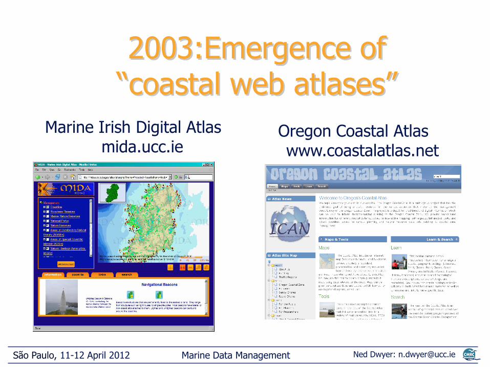
Marine Irish Digital Atlas mida.ucc.ie
Oregon Coastal Atlas www.coastalatlas.net
2003:Emergence of “coastal web atlases”

Marine Data Management
São Paulo, 11-12 April 2012 Ned Dwyer: [email protected]
Transatlantic Workshops 2006 - 2007
Shared experiences
Shared know-how
Networking
Workshop reports
Idea to establish ICAN
Marine Data Management
São Paulo, 11-12 April 2012 Ned Dwyer: [email protected]
International Coastal Atlas Network

Marine Data Management
São Paulo, 11-12 April 2012 Ned Dwyer: [email protected]
Goals of ICAN
– Ensure network has wide representation (developers/users)
– Develop technical & policy guidelines for atlas developers
– Highlight benefits of interoperability & standards based systems

Marine Data Management
São Paulo, 11-12 April 2012 Ned Dwyer: [email protected]
– Develop collaborative projects for sharing know-how, atlas implementation and demonstration
– Align atlas efforts to facilitate interoperability
– Engage with other relevant projects and developments
– Involve representatives of the user
Goals of ICAN

Marine Data Management
São Paulo, 11-12 April 2012 Ned Dwyer: [email protected]
Wide representation now over 50 members
http://ican.science.oregonstate.edu/member_dir

Marine Data Management
São Paulo, 11-12 April 2012 Ned Dwyer: [email protected]
Guidelines for Developers
• Principles of atlas design
• Case Studies around the world
• CWA Management and Governance issues
http://ican.science.oregonstate.edu/handbook

Marine Data Management
São Paulo, 11-12 April 2012 Ned Dwyer: [email protected]
Addressing Interoperability
Connect individual coastal atlases to an integrated global atlas
…
Global atlas
Local atlases
Marine Data Management
São Paulo, 11-12 April 2012 Ned Dwyer: [email protected]
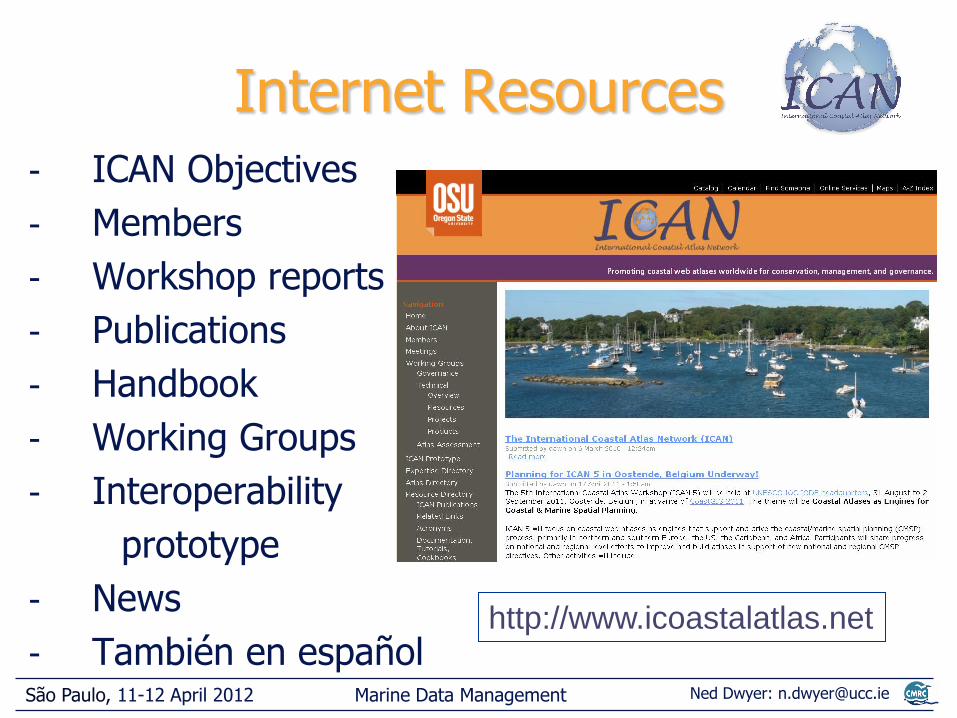
Internet Resources - ICAN Objectives
- Members
- Workshop reports
- Publications
- Handbook
- Working Groups
- Interoperability
prototype
- News
- También en español http://www.icoastalatlas.net

Marine Data Management
São Paulo, 11-12 April 2012 Ned Dwyer: [email protected]
Training Events Ocean Data and Information Networks
- Africa
African Marine Atlas Workshops
- Latin America
Carribean Marine Atlas workshops
SPINCAM – Southeast Pacific
CoastGIS 2009
- United States
West Coast Coastal Atlas workshop
Great lakes Workshop 2010

Marine Data Management
São Paulo, 11-12 April 2012 Ned Dwyer: [email protected]
Member Workshops
• Cork – 2006
• Corvallis - 2007
• Copenhagen - 2008
• Trieste - 2009
• Ostend -2011
• Victoria -2013
Meetings section of ICAN web site

Marine Data Management
São Paulo, 11-12 April 2012 Ned Dwyer: [email protected]
ICAN Governance
Currently being established as a
UNESCO IOC IODE (International Oceanographic Data and Information Exchange) project
Steering Group composed of existing members

Marine Data Management
São Paulo, 11-12 April 2012 Ned Dwyer: [email protected]
- Guidance and advice for your own local CWA development
- Potential to exchange and reuse software and technical solutions developed using Open Source solutions
- Your CWA can be part of and interoperable with a larger universe of resources
What’s in ICAN for you?

Marine Data Management
São Paulo, 11-12 April 2012 Ned Dwyer: [email protected]
What’s in ICAN for you?
- Great publicity for your individual CWA via the outreach efforts of ICAN
- Participate in teaching and learning activities organised by ICAN or other organisations in the CWA domain
- Possibility to leverage funding for collaborative projects among ICAN participants

Marine Data Management
São Paulo, 11-12 April 2012 Ned Dwyer: [email protected]
Keep up to date http://www.icoastalatlas.net

Marine Data Management
São Paulo, 11-12 April 2012 Ned Dwyer: [email protected]
Chapter 4
Smart visualisation

Marine Data Management
São Paulo, 11-12 April 2012 Ned Dwyer: [email protected]
Foundation of a web enabled visualisation system
Client –server distributed architecture

Marine Data Management
São Paulo, 11-12 April 2012 Ned Dwyer: [email protected]
Components of a visualisation pipeline
Thick Client
Medium Client
Thin Client
Example

Marine Data Management
São Paulo, 11-12 April 2012 Ned Dwyer: [email protected]
GDAL colour relief command: gdaldem color-relief inputFile colourRamp outputFile

Marine Data Management
São Paulo, 11-12 April 2012 Ned Dwyer: [email protected]
Use case: dynamic re-scaling

Marine Data Management
São Paulo, 11-12 April 2012 Ned Dwyer: [email protected]
Zoom in… dynamic rescale

Marine Data Management
São Paulo, 11-12 April 2012 Ned Dwyer: [email protected]
Zoom in… dynamic rescale

Marine Data Management
São Paulo, 11-12 April 2012 Ned Dwyer: [email protected]
GDAL hillshade command: gdaldem hillshade -s 27780 -az 45 -alt 45 inputFile outputFile

Marine Data Management
São Paulo, 11-12 April 2012 Ned Dwyer: [email protected]
Work Flow for dynamic scaling
Web-GIS WMS
WCS
wrapper (include GDAL
processing)
WCS
Data
Web Coverage Service
Web Map Service
Client-side Server-side
Marine Data Management
São Paulo, 11-12 April 2012 Ned Dwyer: [email protected]
Visualisation Architecture Design
- Use Service Oriented Architecture (SOA) principles
- Open Geospatial Consortium (OGC) standards particularly important
- Other standards to be used: -Internet Engineering Task Force (IETF), -World Wide Web Consortium (W3C), -Organization for the Advancement of Structured Information Standards (OASIS), -International Organization for Standardization/Technical Committee 211
(ISO/TC 211)

Marine Data Management
São Paulo, 11-12 April 2012 Ned Dwyer: [email protected]
Five Top Tips
- -Be clear who audience is and involve from beginning
- Good quality metadata is the backbone of your information system
- Adopt international data management standards and protocols
- Plan for the long-term sustainability of systems from the beginning
- Prioritise institutional issues - greatest challenge

Marine Data Management
São Paulo, 11-12 April 2012 Ned Dwyer: [email protected]
Acknowledgements
-
..and other CMRC colleagues
..and ICAN
Thetis spa, Italy Dawn Wright
Declan Dunne
Ali al Othman
Yassine Lassoued
Mehdi Essid
Trung Pham