Embed Size (px)
Citation preview

9 Tewantin & Doonan

2
3
Contents
9.1 FIG TREE......................................................................................................................................................... 4 9.2 GERMAN MINES IN RSL PARK ...................................................................................................................... 6 9.3 LAKE DOONELLA ........................................................................................................................................... 8 9.4 FORMER SHOP (PELICAN PLACE) .................................................................................................................. 10 9.5 POLICE PRECINCT ....................................................................................................................................... 11 9.6 TEWANTIN MASONIC LODGE ..................................................................................................................... 14 9.7 DONALDSON RESIDENCE........................................................................................................................... 16 9.8 FORMER MINERS HUT (PARKYN’S HUT) ........................................................................................................ 18 9.9 ROYAL MAIL HOTEL ..................................................................................................................................... 20 9.10 RSPCA COMPLEX ........................................................................................................................................ 23 9.11 SID ROBINSON PARK .................................................................................................................................. 25 9.12 NOOSA RIVER VEHICULAR FERRY ............................................................................................................ 27 9.13 NOOSA RIVER - FROM TEWANTIN TO LAKE COOROIBAH ....................................................................... 29 9.14 MARTIN HOUSE (PRIVATE RESIDENCE) .......................................................................................................... 32 9.15 ‘DOONELLA COTTAGE’ ................................................................................................................................ 33 9.16 ST MARY'S ANGLICAN CHURCH ................................................................................................................. 35 9.17 TAIT HOUSE .................................................................................................................................................. 38 9.18 FORMER TINBEERWAH STATE SCHOOL BUILDING (TEWANTIN-NOOSA COMMUNITY KINDERGARTEN) ......... 40 9.19 FORMER TEWANTIN POLICE LOCK UP ...................................................................................................... 42 9.20 WAR MEMORIAL ........................................................................................................................................... 45 9.21 ‘THREE-IN-ONE' TREE’ ................................................................................................................................ 47 9.22 TREE STUMP SHOWING MARKS OF TIMBER FELLING ............................................................................. 48 9.23 FORMER WAHPUNGA STATE SCHOOL (UNIVERSITY OF THE THIRD AGE) ..................................................... 50 9.24 WARD STREET COTTAGE (FORMER COACH WAITING ROOM)......................................................................... 52 9.25 FORMER NOOSA HEADS SURF LIFE SAVING CLUB ROOMS (‘BRITESIDE INDUSTRIES) .............................. 53
Further References…………………………………………………………………………………………………………….. 55

4
9.1 FIG TREE
LOCATION RSL Park, Tewantin
TENURE Reserve1. 13MCH5443
DATE The tree is dated at approximately between 200 - 400 years old. 2
DESCRIPTION The tree is a Ficus virens.3
9.1.1 BRIEF HISTORY
The tree was significant to both the indigenous people of the area and to the European settlers; the former since it was used as a burial tree, and the latter, who used it as a meeting place since the early 1870s.4
Archival photographs show the tree as having a quite magnificent spread and its value as a landmark and meeting place, particularly since its situation provides a most pleasant panorama over the Noosa River, is easily accepted. However, the tree developed rot in one side of its base and it was seen as becoming a danger to people in its vicinity. Accordingly it was examined in December 1985 and it was agreed that it would need to be very heavily pruned to allow it the opportunity to regenerate and at the same time alleviate its danger to passers by by falling on them or their motor vehicles.5
One newspaper reported that the rot in the tree was caused by a lightning strike in the early 1980s6, but it is also a possibility that the damage may have been caused by the vandalistic lighting of a fire in the area affected. In any event, the tree was lopped in May 19927 and it appears to be benefiting from this treatment, showing signs of sound regrowth.
9.1.2 HISTORICAL THEMES
This place illustrates the following historical themes in Noosa Shire based on the Environmental Protection Agency's Guidelines for Historical & Indigenous Cultural Heritage Management, dated 2001:-
1 Queensland Government Gazette, 1920, Reserve No. 734, Noted on Survey Plan of 28 Mar. 1886; Noosa News May 1992, courtesy the
collection of Vera Young.
2 Plaque on site, erected by Cooroora Historical Society Inc.
3 Noosa News, May 1992.
4 Noosa Citizen, 4 Dec. 1985.
5 The Review, 26 May 1992.
6 ibid.
7 Sunshine Coast Daily, 15 Oct. 1983.
5
2(b) Developing rural economies - displacing Aboriginal people: camping site (burial tree);
2(c) Developing rural economies - developing extractive resources: logged forest (landmark tree); and
9(d) Developing social and cultural institutions - commemorating important events or people: memorial (tree).
9.1.3 POTENTIAL SIGNIFICANCE
The Tewantin Fig Tree is virtually an icon among the local community as, indeed, it has been throughout its life. As well as meeting the spiritual needs of the Gubbi Gubbi and the communal needs of the European settlers, the tree even supplied both groups with a food source, since a newspaper reports that its fruit and the sheaths they grew in were eaten by both black and white people alike.8
A story is also told that as a child, one of the early Tewantin residents, Clarence ("Clarrie") Ross, whilst climbing among the massive branches of the tree, accidentally came upon, and dislodged, the bones of a deceased Gubbi Gubbi person which had been placed in the tree, the incident unsettling the young Ross somewhat.9
To record the significance of the fig tree, a plaque was placed beside it as a bi-centennial project by the Cooroora Historical Society Inc. in 1988.
It is recommended that Noosa Council consider assessment criteria a, b, c, d, e, g and h under the Environmental Protection Agency's Guidelines for Historical & Indigenous Cultural Heritage Management, dated 2001 as relevant to this place.
9.1.4 INTEGRITY
The integrity of the tree has suffered to a major degree through the damage done to it by the rot, which infested it. Nevertheless, it lives on and may well go to prove an even more intrinsic part of Tewantin tradition by its very recovery.
8 Tutt, Stan, Sunshine Coast Heritage Discovery Press (a division of Sunshine Coast Tourist Promotions) Sunshine Coast, 1995.
9 Gympie Times, 4 Apr. 1970.

6
9.2 GERMAN MINES IN RSL PARK
LOCATION RSL Park, Tewantin
TENURE Reserve.10 13MCH5443
DATE 1914 to present
DESCRIPTION Maritime war munitions.
9.2.1 BRIEF HISTORY
Mine warfare has been a part of military weaponry for a great many years, with naval mines having been used for at least two hundred years. Mines on the one hand are important weapons because of their great destructive power11, yet on other hand, are somewhat ineffectual in their destructive ability, since they favour neither the ships of the enemy, nor of the navy of the country that lays them. They can also drift aimlessly at sea for a great many years and cause destruction well after the termination of the hostilities for which they were laid. The latter of the two mines cited could, for example, well have been laid during World War I and drifted ever since that time, even though it was not found until the World War II was in progress.
The first of the mines found on the local coast was recovered at Teewah Beach after World War I.12 It is oval in shape with no identifying marks upon it. It is understood to be of German origin and was defused by RAN Lieutenant Patrick Keane, (who died in 1922) with the assistance of two Naval Petty Officers.13
The second mine is also said to be German.14 It is in the shape of a sphere and it was recovered and defused at Sunshine Beach during World War II. Local resident Howard Parkyn stated that another local, Bob McGarrety, found the mine.15
10 Queensland Government Gazette, 1920, Reserve No. 734. Noted on Survey Plan of 28 March 1886.
11 Field Enterprises Educational Corporation, World Book Encyclopedia, M Volume 13, Chicago: Field Enterprises Educational
Corporation, 1973, p.478
12 Plaque at the foot of the relative mine.
13 Mrs Irene Christie: Transcript of interview with John Garrick, 1993.
14 Plaque at the foot of the relative mine.
15 Pers. comm., Howard Parkyn, 2001.

7
9.2.2 HISTORICAL THEMES
This place illustrates the following historical themes in Noosa Shire based on the Environmental Protection Agency's Guidelines for Historical & Indigenous Cultural Heritage Management, dated 2001:-
9(d) Developing social and cultural institutions and way of life - commemorating important events: war memorabilia (World War 1 mines, found objects).
9.2.3 POTENTIAL SIGNIFICANCE
The significance of the mines lies more in the category of memorabilia rather than in traditional local history. Nevertheless, they associate the Noosa area with worldwide conflict.
It is recommended that Noosa Council consider assessment criterion a under Environmental Protection Agency's Guidelines for Historical & Indigenous Cultural Heritage Management, dated 2001 as relevant to this place.
9.2.4 INTEGRITY
The mines have been defused and have been repainted to preserve their outward appearance. Their overall integrity, however, appears satisfactory.

8
9.3 LAKE DOONELLA
LOCATION South of the Noosa River, joined to it by a very short inlet channel, south of the main shopping area of Tewantin, east of Noosa Outlook and west of Noosaville.
TENURE State owned up to the high water mark. Most lands around its shores are privately owned although there is a prospect of increased public tenure on the south west area.
DESCRIPTION Lake Doonella is a very shallow, saline lake fed by the Noosa River
9.3.1 BRIEF HISTORY
Lake Doonella is an extremely shallow, salt-water lake, forming part of the riverine system. It is the smallest of the main Noosa River lakes and is the one most affected by urban development in the Noosa area. The lake’s name might be derived from the Aboriginal word “Dunandella” a small green fruit, known also to Europeans as “geebung”, popular for eating with both the Indigenous people and early settlers.16
The lake is an important bird habitat, with numbers of black swans, pelicans and cormorants to be observed there from time to time. It is also an important link in the food chain for marine life locally.
Lake Doonella has been eyed earnestly at times by developers as a possible site for a canal development and some pressure has been needed to ensure that the lake has been kept untouched in this regard. Noosa Council's policy of protection of the lake, indeed, is known to have cost $600,000 in one action against developers to keep the lake's present condition intact.17
There was also a proposal put forward to have a road bypassing the Tewantin Central Business District run along the very edge of the northern perimeter of the lake. This, however, had to be abandoned due to the fact that soil testing found there to be no good foundation for the roadbed.18
16 Bull, DW. “Short cut to Gympie Gold - Short Stories of Tewantin and the Sunshine Coast, Mrs FH Watson, Yeerongilly, 1982. p.41
17 Noosa Journal, 19 Apr. 2001.
18 R.J.L. Adams: personal involvement with the Noosa Anglican Church throughout 1994 and 1995. The abandonment of the road project and the explanation which accompanied it allowed the church to purchase its present St Mary's site since this was to have been a part of the road corridor and it was no longer needed.

9
The balance between pollution from surrounding housing estates and the lake's ability to remain viable, however, is a delicate one. Lake Doonella is suffering from its proximity to urban housing complexes. It is fed mainly by Crank's Creek which takes run-off from Noosa Outlook and discharges directly into the lake. Whilst there may be cause for concern over pollutants entering the lake from this source, there is even more cause for concern over the amount of silt the creek, its tributary and even open drains pour into it. The overall situation, in fact, is that Lake Doonella is silting up. A newspaper reported that an aquatic sports day was held on Lake Doonella in 1907 but there is certainly not sufficient depth of water in the lake to hold such an event at present. Indeed, local resident Lorraine Smith has stated that in her youth the lake was only knee deep in the immediate post-war years
9.3.2 HISTORICAL THEMES
This place illustrates the following historical themes in Noosa Shire based on the Environmental Protection Agency’s Guidelines for Historical & Indigenous Cultural Heritage Management, dated 2001:-
2 (f) Developing rural economies - managing and conserving land, water, flora and fauna: fish habitat and wetland reserve.
9.3.3 POTENTIAL SIGNIFICANCE
Lake Doonella plays a large role in the general ambience of the Tewantin precinct. It maintains numbers of water birds and provides food in the marine life cycle. It is a most significant element in the Noosa River system.
It is recommended that Noosa Council considers assessment criteria b, c, e, g and h under the Environmental Protection Agency’s Guidelines for Historical & Indigenous Cultural Heritage Management, dated 2001 as relevant to this place.
9.3.4 INTEGRITY
Lake Doonella’s water quality is believed to have declined and the lake is silting up due to the effects of urban development in its Catchment.
Lake Doonella's role in the overall Noosa River system is a major one and in this regard, the proclamation of the lake as a Wetland Reserve in 199319 is a most significant decision in maintaining its integral equilibrium.
19 Elainekgreen & associates, Historical and Cultural Heritage Survey of the Noosa, Maroochy and Mooloolah Rivers for The Maroochy-
Mooloolah-Noosa Water Quality Strategy Management Committee as part of the South East South East Queensland Regional Water Quality Management Strategy: December 2000, p.81.

10
9.4 FORMER SHOP (Pelican Place)
LOCATION 3 Pelican Street, Tewantin
TENURE Freehold. 1RP7419720
DATE c. 1926 - 192721
DESCRIPTION The shop is of weatherboard construction with a corrugated iron roof. It has an extension added to its rear section, comprising living quarters. This addition is in keeping with the original construction.22
9.4.1 BRIEF HISTORY
At the time of the building of the shop, and for a time thereafter until the present Doonella Bridge was built in 1970, Pelican Street, which led directly from the old bridge, formed the main business section of Tewantin.23 The shop was located between other important early businesses in Pelican Street, such as the San Elanda guesthouse (on the site of the present Council building) and Martin’s Tewantin Hotel on the opposite side of Doonella Street, until they both burned down.
The building was constructed by Frank Bickle for the hardware business, Frank Bickle and Son, but soon thereafter became the pharmacy of James ("Jimmy") Sweet and over the years fulfilled many roles, including those of newsagency, barber and billiard saloon, real estate and a ladies' fashion shop.24 Noosa Council purchased the shop for use by community groups. It has been renamed `Pelican Place'.25 . The premises are currently used as office accommodation by Council’s Plumbing Services after extensive renovations to replace damage caused by white ants.
9.4.2 HISTORICAL THEMES
This place illustrates the following historical themes in Noosa Shire based on the Environmental Protection Agency's Guidelines for Historical & Indigenous Cultural Heritage Management, dated 2001:-
5(c) Providing commercial services: commercial and office premises (shop).
9.4.3 POTENTIAL SIGNIFICANCE
The shop is a good example of retail premises of its period, particularly with the display of verandah posts, which support its awning. It is the only retail building remaining on its side of Pelican Street, standing alone among residences and not far from the Noosa Council Chambers.
It is recommended that Noosa Council consider assessment criteria a and d under the Environmental Protection Agency's Guidelines for Historical and Indigenous Cultural Heritage Management, dated 2001 as relevant to this place.
9.4.4 INTEGRITY
The integrity of the building is excellent. It retains its original concept completely, albeit with an extension containing living quarters added to its rear section not long after its original construction. The addition is very much in keeping with the original construction methods, however, and does not detract from the overall appeal of the building.
20 Noosa Council Survey Plan.
21 Pers. comm., Howard Parkyn, 12 Mar. 2001.
22 ibid.; R.J.L. Adams, personal inspection.
23 ibid.
24 ibid.
25 ibid.

11
9.5 POLICE PRECINCT
LOCATION 87 Poinciana Ave, Tewantin
TENURE Reserve. 505-506CP9077126
DATE The police presence was originally established in Tewantin in 1873. 27
DESCRIPTION The police presence in Tewantin consists of three buildings, a recent house facing Sidoni Street, a high-set house built later in the 1930’s on the corner of Sidoni Street and Poinciana Avenue and a low-set building next to it in Poinciana Avenue.
9.5.1 BRIEF HISTORY
The original site of the police station in Tewantin
The first permanent police presence in Tewantin was in 1873, following the licentious and drunken behaviour of the previous Christmas period.28 There was a proposal in November 1874 to erect a police station at Tewantin and tenders were called for it on 16 January 1875.29 A Watch House Charge Book survived for the station showing entries for 187330, and the first officer was Constable William Swords.31 The official name of that station was Noosa Heads, even though it was located in Tewantin, but this anomaly was rectified somewhere between the dates 25 May 1898 and 20 January 1899.32
Originally the police station was situated on land adjacent to its existing premises, ie. land currently occupied by the State government department known as Transport Queensland.33 The original police station was, in fact, built on what is
26 Noosa Council Survey Plan.
27 Gympie Times, 4 Nov. 1874 and 27 Jan. 1875; Queensland Government Gazette, 16 Jan. 1875.
28 Gympie Times, 11 Jan. 1873.
29 Gympie Times, 4 Nov. 1874 and 27 Jan. 1875; Queensland Government Gazette, 16 Jan. 1875.
30 Adams, Rod, Noosa and Gubbi Gubbi, Tewantin, Ultreya Publications, 2001, pp.171-172.
31 ibid.
32 ibid.
33 Pers. comm., Olive Donaldson, 18 Apr. 2001.

12
now the department's car park area.34 However, on completion of the first of the existing police buildings during the 1930s on the corner of Poinciana Avenue and Sidoni Street, the station was incorporated into that structure.35 It was located at the top of the front stairs, on the right hand side of the building as one faces it.36 This building is now solely used as a residence. The low-set building to its right in Poinciana Avenue currently houses the police dog centre, whilst the house behind it, in Sidoni Street, is a detective's residence.37
9.5.2 HISTORICAL THEMES
This place illustrates the following historical themes in Noosa Shire based on the Environmental Protection Agency's Guidelines for Historical & Indigenous Cultural Heritage Management, dated 2001:-
6 (a) Maintaining order - policing and maintaining law and order: police station (station, residence, detention center)
The establishment of a police presence is a benchmark in the establishment of a permanent community, and this certainly was the case with Tewantin. Furthermore, with the transfer of the police station from Tewantin to Noosa Heads some 20 years ago, it is particularly important to have the involvement of the police in Tewantin recorded as part of its heritage. The only building of any note is the modest, high set house built in the 1930’s.
It is recommended that Noosa Council consider assessment criteria a, c, d, g and h under the Environmental Protection Agency's Guidelines for Historical and Indigenous Cultural Heritage Management, dated 2001 as relevant to this place.
9.5.3 INTEGRITY
All buildings are virtually as originally constructed.
34 ibid.
35 ibid.; Pers. comm., wife of a police officer on site, 16 Apr. 2001.
36 ibid.
37 ibid.

13

14
9.6 TEWANTIN MASONIC LODGE
LOCATION Corner of Toolar and Moorindil Streets, Tewantin.
TENURE Trusteeship. 105T1631
DATES c. 1953
DETAILS The Masonic lodge is a two-building complex, built of timber and fibro cement. It is set on low stumps, some wood, some concrete.
9.6.1 BRIEF HISTORY
The foundation stone for the original Lodge building was laid on 5 September 1953 by Mr Justice B.H. Mathews.38 It is single-storeyed and built on low stumps.
Added to the building is the old St Mary's Anglican Church hall. This hall was built in 1964 by D. Woodward and was officially opened on 4 November of that year. In 1967 a kitchen was added to it and toilets and storeroom completed it in 1971.39
When the Anglican Church sold its property, situated on the corner of Doonella Street and Memorial Avenue, Tewantin to the Returned Service League Club in 1995, the existing buildings on it were relocated. The old church building is now the chapel for the Fraser Coast Anglican College at Hervey Bay40 and the hall was left on the site for the discretionary use of the RSL. The RSL subsequently agreed to make the building available to the Masonic Lodge and it was moved to its present site in May 1995. It forms part of the overall lodge complex and was officially opened on 25 August 1996 by Mrs Olive Donaldson, the daughter of William J. Ross, a foundation member of the Lodge.41
9.6.2 HISTORICAL THEMES
This place illustrates the following historical themes in Noosa Shire based on the Environmental Protection Agency’s Guidelines for Historical & Indigenous Cultural Heritage Management, dated 2001:-
38 Pers. comm., Mr Roel Strouss, 2000.
39 ibid.
40 Author's personal knowledge having been on the Church Council at the time.
41 Pers. comm., Mr Roel Strouss, 2000.

15
9(b) Developing social and cultural institutions - forming secular associations, institutions, organisations and societies: hall (Masonic lodge).
9.6.3 POTENTIAL SIGNIFICANCE
The Masonic movement is a fundamental part of traditional community life throughout Australia, whether in small towns or larger cities. The lodge under discussion appears to be well attended and fulfils an integral part of Tewantin's social life.
It is recommended that Noosa Council consider assessment criteria d and g, under the Environmental Protection Agency’s Guidelines for Historical & Indigenous Cultural Heritage Management, dated 2001 as relevant to this place.
9.6.4 INTEGRITY
Both the buildings making up the Masonic Lodge complex are in virtually the condition in which they were built and then modified. The integrity of the complex is therefore sound, both from external and internal aspects.

16
9.7 DONALDSON RESIDENCE
LOCATION 76 Poinciana Ave, Tewantin
TENURE Freehold. 604RP884055
DATE c. 1900
DESCRIPTION The house is a timber-framed structure with a corrugated iron hip roof and verandahs (now enclosed) on all sides. It is low-set at the front on stumps.
9.7.1 BRIEF HISTORY
The Donaldson house was built at around the turn of the century by the uncle of the present owner. His name was Clarence Ross.
Olive Donaldson's uncle Clarence rented the house to a retired policeman just before the beginning of World War I and his wife moved to Cooroy. Mrs Donaldson's parents then bought the house after the end of the war (in 1920)42
9.7.2 HISTORICAL THEMES
This place illustrates the following historical themes in Noosa Shire based on the Environmental Protection Agency's Guidelines for Historical & Indigenous Cultural Management, dated 2001:-
4 (e) Establishing and developing towns - housing urban populations: residence (house).
9.7.3 POTENTIAL SIGNIFICANCE
Olive Donaldson has had a lifelong association with Tewantin. Born Olive Ross, she became Olive Macklin after her first marriage. During that time she served as a Councillor for the Noosa Council, with much distinction and good repute. She remarried to George Donaldson and still lives in her family home.43
The house was among the earlier ones built in Tewantin, is a good example of its type and is in excellent condition structurally.
42 ibid.
43 ibid.

17
It is recommended that Noosa Council consider assessment criteria a, d and h under the Environmental Protection Agency's Guidelines for Historical & Indigenous Cultural Heritage Management, dated 2001 as relevant to this place.
9.7.4 INTEGRITY
The house has been altered since its construction. These renovations include closing in front verandahs and addition a rear carport.

18
9.8 FORMER MINERS HUT (Parkyn’s Hut)
LOCATION The north western intersection of Poinciana Avenue and Diyan Street, Tewantin. The centre is adjacent to the Royal Mail Hotel and is immediately in front of the 'Three In One' tree.
TENURE Reserve. 2SP137442
DATE The building was originally erected early in the twentieth century, possibly in the 1920s and has been placed on its present site in 2001.
DESCRIPTION The cottage is low set, originally on wooden stumps. It is built of weatherboard timber, and has a corrugated iron roof. An entrance verandah has been added to facilitate with the hut’s present role as a tourist information centre.
9.8.1 BRIEF HISTORY
The small building making up this facility is yet another link in the relationship between Gympie and Tewantin. The cottage began its life as a miner's shed or living quarters at Gympie, having been constructed in the early 1920s.44 It was soon thereafter transported to Tewantin by Jack Hart and his wife, themselves having come from Gympie.45 The cottage, which was originally unlined, was placed on Hart's land in Tewantin. He and his wife lived in it while he built his home on that land.46 Hart's land covered all the area between Doonella, Diyan and Pelican Streets, and bounded on the north by the present Post Office.47 On the land, Hart built, firstly on the corner of Pelican and Doonella Streets, a two storeyed shop, occupied by H. and M. Born when it burnt down in 1939, then to the north progressively, a general store for the Bickle family, a pharmacy and then his house.48
The cottage originally occupied the north western corner of the property, but following the subsequent sale of the property to Howard and Iris Parkyn in 1938, it was relocated at the south western corner.49 The Harts sold the house so that they could return to Gympie and be close to their family, since Mrs Hart desired that very much.50
44 Pers. comm., John Steer, 2001. 45 ibid. 46 Pers. comm., Howard Parkyn, 12 Mar. 2001. 47 ibid. 48 ibid. 49 ibid. 50 ibid.

19
Howard Parkyn (born 1913) is the third generation of his family who pioneered boating, fishing, tourist and land development activities in Tewantin and Noosaville. Howard and Iris Parkyn retained the property containing (as well as the original Hart house) the cottage until 1998 when it was sold to the RSL Club who had need of it as an extension to meet Noosa Council requirements for additional car parking spaces when they enlarged their Club premises.51
Since buying the property, the Parkyns lived in the house built by Hart until some twenty years ago when they had their present house constructed in Memorial Drive.52 While they lived in the previous house, the cottage was used for overflow family accommodation at times such as Christmas, and it proved to be very much in demand for that use.53
At the time of the sale of the property to the RSL Club, the Club offered the cottage to the Tewantin Heritage and Historical Society as it was extraneous to Club needs. Until its present use, the building languished at the Council's works depot in Eumundi Road,54 but has now begun a new role, serving the visiting public as a tourist information centre, particularly with regard to the new Heritage Trail system.55 It has been named in honour of the Parkyns, as both a former owner of the hut and for their significant contribution to the district’s development in the twentieth century. Howard Parkyns grandfather, Richard was a former mine manager from the Gympie goldfields.
9.8.2 HISTORICAL THEMES
Not applicable
9.8.3 POTENTIAL SIGNIFICANCE
The former hut is of no cultural heritage significance.
9.8.4 INTEGRITY
The hut's original shape has been retained, although, because of its new role, a small entry verandah is being added in the traditional manner.56 It is not expected that this addition will detract from the overall concept of the modest building.57
51 ibid. 52ibid. 53 ibid. 54 ibid. 55 ibid. 56 Pers. comm., Howard Parkyn, op. cit. 57 R.J.L. Adams, personal inspection, 2001.

20
9.9 ROYAL MAIL HOTEL
LOCATION 118 Poinciana Ave, Tewantin
TENURE Freehold. 1RP845244
DATE Original building c. 188258. Present building c. 1941.
DESCRIPTION The hotel is a complex consisting of a two storeyed main building (comprising bar and accommodation facilities), with a modern liquor barn and drive-in bottle department added at the side (Diyan Street), at the rear of the main building
9.9.1 BRIEF HISTORY
As its name implies, the Royal Mail Hotel was closely associated with the mail service to Tewantin. Tenders were first called for a mail run between Gympie and Tewantin (described as Newsa) via Cootharaba and Cooloothin in May 1873.59 There was definitely an opportunity for a hotel in Tewantin and the Royal Mail Hotel had several predecessors. R.A. Richardson erected eight rooms for traveller’s accommodation in December 1874.60 By 1878 Pillow's Tivoli Hotel was in existence, by November 1883 it was known as the Club Hotel when it was burnt down.61 There was also the Commercial Hotel, which opened in 1882 and burnt down in 1889.62
Tenders (labour only) were called for the erection of a hotel on this site, The Royal Mail Hotel was built in February 1882 for Ned Murdock, the driver of Cobb & Co's coach,63 It was built by Smith, White and Saunders and was opened quietly in May 1882.64 Murdock's residence was moved to be beside the hotel.65 The Royal Mail was always a well kept and respected accommodation venue and it was renovated and extended from time to time to keep it up-to-date and of a high
58 The first Royal Mail hotel was constructed on its present site in 1882.
59 Gympie Times, 3 May 1873.
60 Gympie Times, 19 Dec. 1874.
61 Gympie Miner, 16 Aug. 1878 and 9 Nov. 1883.
62 Gympie Miner 19 Sep. 1882 and 3 Oct. 1882 quoting Brisbane Telegraph and 6 Mar. 1889.
63 Gympie Times, 25 Feb. 1882.
64 Gympie Times 17 May 1882.
65 ibid.

21
standard. Hotel transport consisting of buggies and coaches, for the use of hotel patrons, met the trains at Cooroy once the rail line had reached there in 1891, a service claimed by Monks to have been `... a first for the area.'66
John E. Kinmond, an early timber getter and bullock driver operating in the Kin Kin scrubs, was licensee by 1888.67 He then sold to Major J. Myles in 188968 who in turn sold to John Tait.69 The Tait families were quite prominent in Tewantin's local history, Mrs Tait being the widow of Jimmy Miles, a former Cobb and Co manager.70 A bathhouse was constructed in 1895 and the hotel was further enlarged in 1896.71
The hotel left the Tait’s care when it was sold to John Donovan by 1930, the father of Lionel Donovan72, who operated a cinema in Poinciana Avenue in Tewantin for many years.73 Donovan died in 1935 and his widow sold the business to the Queensland Brewery in 1936.74
The Royal Mail was totally destroyed in a spectacular fire on 11 March 1940.75 The licensee was G. Mann formerly of Home Hill.76 It was rebuilt in basically its present form by Woolloongabba master builder Stanley Samuel Garrick and was officially reopened on 9 July 1941, with its bottle department being added in approximately 1980 over the site of the then staff quarters which had been demolished specifically for that purpose.77
66 Monks, op. cit. pp.90,91.
67 Gympie Miner, 4 Apr. 1888.
68 Gympie Miner, 8 Mar. 1889 and 5 Apr. 1889 (Licensing Court hearing 3 Apr. 1889).
69 John Myles of Tewantin died in Brisbane on 24 December 1894. He was born in Yass District NSW and became well known as one of Cobb & Co's managers. He later started a line of his own. He bought the Royal Mail Hotel in Tewantin and was a member of Widgee Divisional Board for many years. He had a large family. (Gympie Times, 27 Dec. 1894); Pers. comm., Esme Tait, 2000.
70 Monks, Colin, Tewantin, Colin Monks, 2000, p.89; Mrs Irene Christie, personal interview with John Garrick, the son of Stanley Samuel Garrick, 1994.
71 Gympie Times, 17 Oct. 1895 and 27 Feb. 1896.
72 ibid.; Noosa Advocate 13 Jun. 1930.
73 Pers. comm., `Dot.' Hooper, 2000.
74 Monks, op.cit., p.90.
75 Mrs Irene Christie, personal interview with John Garrick, the son of Stanley Samuel Garrick, 1994; Home Hill Observer, 15 Mar. 1940.
76 Home Hill Observer, 15 Mar. 1940.
77 Pers. comm., Mrs Irene Christie, 2000.

22
Further renovations were added in the 1990s, all in keeping with the original style and appearance of the 1941 building so that in its present, repainted state it represents an excellent example of the traditional good quality `country hotel'.
9.9.2 HISTORICAL THEMES
This place illustrates the following historical themes in Noosa Shire based on the Environmental Protection Agency's Guidelines for Historical & Indigenous Cultural Heritage Management, dated 2001:-
5(c) Developing secondary and tertiary industry - providing hospitality services: hotel (hotel).
9.9.3 POTENTIAL SIGNIFICANCE
The Royal Mail Hotel is significant in that it firstly carries on the name of its original namesake hostelry, constructed almost 120 years ago, and secondly that it retains the ambience of a hotel of the period of its World War II rebuilding, in both its exterior appearance and in its fittings such as doors and windows. At the same time it provides modern service facilities and remains a focal point for townspeople and visitors to congregate.
It is recommended that Noosa Council consider assessment criteria a, d, g and h under the Environmental Protection Agency's Guidelines for Historical & Indigenous Cultural Heritage Management, dated 2001 as relevant to this place.
9.9.4 INTEGRITY
The Royal Mail Hotel building represents a hotel of the 1940s very well. As such its integrity is very sound and it retains the name bestowed upon it by its original builder.

23
9.10 RSPCA COMPLEX
LOCATION Cnr Old Hollett Road and Eumundi Road, Doonan78
TENURE The land on which the RSPCA complex is situated is owned by Noosa Council. The Society has been granted a 50 year `peppercorn' lease from the Council to allow them to run the complex on an area of approximately 20 hectares (50 acres) of land.79 77SP115851
DATE A steering committee was formed to inaugurate the local branch in 1989.80
DESCRIPTION The society's complex consists of a residence for the officer-in-charge, together with five animal compounds, one of which contains administrative and veterinary facilities.81
9.10.1 BRIEF HISTORY
As a result of the original meeting of the steering group, consisting of people interested in the care and well being of animals, the local branch of the Royal Society for the Prevention of Cruelty to Animals Inc., (RSPCA) was formed.82 The group initially had no concept of any overall affiliation with the RSPCA, but took their findings to Noosa Council who facilitated the liaison, believing it to have been in the best interests of the group's future.83
A state government grant was brokered for $30 000 and the well known local architect, Maurice Hurst was engaged to design and oversee the construction of the complex.84 The result is that the officer-in-charge's residence has been moved from Attunga Heights, a street running off Viewland Drive, Noosa Heads85, and the set of unique, octagonal animal compounds, consisting of two catteries, two dog kennels and an animal pound have been erected.86
78 UBD Refidex Brisbane 2001 Street Map, 45th edition, Sunshine Coast Area Map 17. 79 R.J.L. Adams, telephone conversation with RSPCA local President, Ms Joy Gilbert, 12 Mar. 2001. 80 ibid. 81 R.J.L. Adams, personal inspection, 11 Mar. 2001. 82 Telephone conversation with RSPCA local President, Ms Joy Gilbert, op. cit. 83 ibid. 84 ibid. 85 UBD Refidex Brisbane 2001 Street Map, 45th edition, Sunshine Coast Area Map 9. 86 Telephone conversation with RSPCA local President, Ms Joy Gilbert, op. cit.

24
Future aims of the society, whose day-to-day administrative needs are catered for by the society's head office in Yeronga, Brisbane, include the construction of a `state-of-the-art' veterinary clinic, an inspector's office and boarding facilities for cats, to cater for all the foreseeable needs of the near future.87
9.10.2 HISTORICAL THEMES
This place illustrates the following historical themes in Noosa Shire based on the Environmental Protection Agency's Guidelines for Historical & Indigenous Cultural Heritage Management, dated 2001:-
8(b) Providing health and welfare services - caring for the needy: community care (animal refuge).
9.10.3 POTENTIAL SIGNIFICANCE
The existence of groups of people who show concern for the welfare of animals is virtually a part of human caring. The commencement of the RSPCA in Noosa is quite a modern achievement but belonging as it does to long established principles of care, it deserves to be recognised as part of our local heritage.
Furthermore, the unique design of the compounds, the brainchild of Maurice Hurst, have been incorporated by the even-more-recently formed Dakabin branch of the society88 and this adds to the importance of the society's presence in Noosa.
It is recommended that Noosa Council consider assessment criteria b, c, d, e, f and g under the Environmental Protection Agency's Guidelines for Historical and Indigenous Cultural Heritage Management, dated 2001 as relevant to
this place.
9.10.4 INTEGRITY
The RSPCA complex is relatively new. The house, which forms the residence of the officer-in-charge, dates from the 1960s, but the animal’s houses are quite modern.89 There is, therefore, little reason to show concern over the integrity of the complex as, apart from raising the dwelling after its relocation, all buildings are as they were originally built.90
87 ibid. 88 ibid. 89 R.J.L. Adams, personal inspection. 90 ibid.

25
9.11 SID ROBINSON PARK
LOCATION The extreme north western end of Moorindil Street, Tewantin.91 The park contains the land bounded by Moorindil Street, the south bank terminal of the Noosa River vehicular ferry and Wooroi Creek.92
TENURE The land remains a road reserve, maintained by Noosa Council, but has been set aside as a park.93
371MCH4432
DATE The park was named by the Shire Mayor, Councillor Bob Abbott in October 2000.94
DESCRIPTION The park contains the usual shelter shed, seating and watering facilities to provide an amenity for users of the vehicular ferry, as well as for visitors or picnickers in the area. It has been well turfed and beautified, and has transformed a previously unkempt area into a pleasant rest area.95
9.11.1 BRIEF HISTORY
The park has been named after the recently deceased, long time resident of the local area, known affectionately as Sid Robinson. Robinson had a long association with the Noosa River vehicular ferry and it is appropriate that the park recalls that affiliation, and that the park be situated where it is.
91 Brisbane 2001 UBD Refidex, 45th Edition, Street Directory, Sunshine Coast Area Map 8.
92 R.J.L. Adams, personal inspection, 2001.
93 R.J.L. Adams, telephone conversation with Noosa Council Surveyor, Mr Leon Lascelles, 6 Mar. 2001.
94 ibid.
95 R.J.L. Adams, personal inspection, 2001.

26
The Noosa River vehicular ferry was originally conceived in 1963 by a then young Tewantin man named Herb. Woods.96 Woods began his project with no prior resources and constructed his ferry from whatever oddments he could secure.97 The ferry proved successful, but Woods was unable to carry out all the running duties alone. Sid Robinson befriended him, and having just sold his own Mary River Valley farm in the Imbil / Kandanga region98 at that time, and being without worthwhile means of filling his time, assisted on an unpaid basis, allowing Woods to have his afternoons free and thus ease his otherwise twelve hour daily work stints.99
This small beginning ultimately became a twenty five year association between Sid Robinson and all the subsequent owners of the ferry after Woods sold it, until Robinson's age and health forbade him to continue longer.100
In his later years Mr Robinson became a resident of Carramar Homes For The Aged where he was a much-loved member of the community until his death in 2000.
9.11.2 HISTORICAL THEMES
This place illustrates the following historical themes in Noosa Shire based on the Environmental Protection Agency's Guidelines for Historical & Cultural Indigenous Heritage Management, dated 2001:-
4(c) Establishing and developing towns - providing public services: public garden (park); and
9(d) Developing social and cultural institutions - commemorating important events or people: memorial (park).
9.11.3 POTENTIAL SIGNIFICANCE
The Noosa River vehicular ferry provides the only means of crossing the Noosa River at anywhere near its source. There is, in fact, only one bridge over the stream throughout the entire length of its flow, and that it a very humble affair at the extreme northern area of its headwaters.101
The ferry therefore provides a vital communications link in the land transport network of the northern end of the Sunshine Coast. Without it, access to the township of Teewah, the tourist areas of the Cooloola Landmass and the coloured sands, and the beach driving attractions opened up recently to camping and recreational fishing through the advent of four-wheel driving, would be quite impossible. Since, therefore, the name of Sid Robinson is synonymous with this ferry facility, it is entirely appropriate that the Sid Robinson Park be regarded as part of the area's cultural heritage.
It is recommended that Noosa Council consider assessment criteria a, c, d, e, and h under the Environmental Protection Agency's Guidelines for Historical and Cultural Heritage Management, dated 2001 as relevant to this place.
9.11.4 INTEGRITY
The Sid Robinson Park is only a very new public amenity. Nevertheless the area on which it has been located has been virtually unchanged since its original settlement by Europeans. The mouth of Wooroi Creek as it enters the Noosa River has never been amended by development of the area, whether by bridging or attempts to control its direction. All that has happened as a result of the Sid Robinson Park is that land that was previously unusable has been made attractive and useful.
96 Robinson, Sid, `Noosa Ferry Story', unpublished and undated manuscript, pages unnumbered.
97 ibid.
98 Pers. comm., Mr Howard Parkyn, 12 Mar. 2001.
99 Robinson, Sid, `Noosa Ferry Story', op. cit.
100 ibid.
101

27
9.12 NOOSA RIVER VEHICULAR FERRY
LOCATION The ferry crosses the Noosa River from Tewantin to the North Shore between Moorindill Street and Maximillian Road, Tewantin.102
TENURE The ferry is privately owned under Noosa Council supervision. 371MCH4432
DATE The first steps were taken to commence the ferry in September 1963.
DESCRIPTION A winch pulled motor vehicle ferry consisting of a deck and wheelhouse supported on air-tight pontoons and driven by a petrol engine.
9.12.1 BRIEF HISTORY
Herbert Woods, an unemployed young man, explored the possibility of commencing a regular vehicular ferry to link the scenic attractions of the North Shore with Tewantin and other permanent population centres, in 1963. He purchased the disused barge which proved unsatisfactory in the timber transportation venture that operated in the Harry's Hut area (see citation on Harry's Hut) and fitted it with a second hand petrol engine and a gear box, linked to a grooved drive wheel and a wire cable set across the river and adequately tensioned to provide stability. As this single cable arrangement produced a state of imbalance each time the ferry approached its docking point on the riverbank, a second, idling, cable was later added to the other side of the vessel and the problem was satisfactorily overcome.
The Noosa River vehicular ferry as it operates in 2001.
Woods initially operated the ferry twelve hours each day, for seven days per week, a workload he found impossible to maintain but income from his venture did not allow him to employ an assistant. His dilemma was solved, however, and a twenty five-year association begun, when a friend, Sid Robinson offered voluntary assistance until he could be paid.
Ramps were subsequently fitted to the landing stages of the ferry to provide quicker and safer vehicle access and egress, the whole replacing the very basic system of planks used up to that time. The ferry itself was also replaced, since, after some five years of constant operation, its timber construction was becoming waterlogged and rotten. The replacement consisted of four steel pontoons running longitudinally with metal deck supports attached to them and then with a timber deck completing the structure. This new raft proved satisfactory and longlasting, remaining in operation until the whole ferry had to be improved by replacement with a larger system in 1999-2000.
102 Sid Robinson, `The Noosa River Ferry Story', unpublished manuscript.

28
The ownership of the ferry changed hands more than once and a second vessel was added in 1986, to cope with the expansion that was enjoyed by the increase in recreational vehicles wanting to visit the North Shore and thus use the ferry service.
9.12.2 HISTORICAL THEMES
This place illustrates the following historical themes in Noosa Shire based on the Environmental Protection Agency's Guidelines for Historical & Cultural Indigenous Heritage Management, dated 2001:-
3(a) Developing transport and communication networks and infrastructure - establishing roads and transport services: river crossing (vehicle ferry)
9.12.3 POTENTIAL SIGNIFICANCE
The Noosa River vehicular ferry remains the only method of crossing the Noosa River in all but its very upper reaches and has been so for nearly forty years.
The ferry service will be retained for a long time, as Noosa Council remains firmly opposed to any bridge over the Noosa River.
It is recommended that Noosa Council consider assessment criteria a, b, d, f, and h under the Environmental Protection Agency's Guidelines for Historical & Indigenous Cultural Heritage Management, dated 2001 as relevant to this place.
9.12.4 INTEGRITY
The Noosa River vehicular ferry cannot boast of any integrity whatsoever in relation to its original construction. All of its original components have been replaced. Nonetheless the overall concept of the project remains as it was and the positioning of it, operating as it does between Tewantin's Moorindil Street and the North Shore's Maximillian Road, also remains intact.

29
9.13 NOOSA RIVER - FROM TEWANTIN TO LAKE COOROIBAH
LOCATION This is the first northerly flowing section of the Noosa River, travelling upstream from its mouth. It is some five kilometres in length.
TENURE The river is a boundary watercourse
DESCRIPTION The Noosa River is the main riverine link in the entire water resource of the Noosa Shire
Looking across the Noosa River to the Royal Mail Hotel and Tewantin from Noosa North Shore
9.13.1 BRIEF HISTORY
The Noosa River began extensive use as a form of transport since around 1863 when timber getters came into the northern part of the Noosa Hinterland.103 Furthermore, after 1869 Noosa timber was used for sawn hardwood pit props in Gympie's mines104 and the vessels, which exported local timber to Brisbane, returned with cargo and passengers for the goldfields.105
The steam vessels terminated at Tewantin, with the timber from the hinterland being rafted downstream thereto from the Mill Point sawmill on Lake Cootharaba: a laborious process, and one which could take two weeks, even if the weather was satisfactory.106 Adverse weather often meant that the rafts would break up and would then need to be re-secured before the journey could continue. The method of rafting employed, was to secure the logs by chain to a towing vessel, after first having locked them together with steel spikes. A winch was then anchored and the logs were pulled down to it, with the winch then being reset and the procedure repeated over and over until the trans-shipping wharf at Tewantin was reached.107 Clarence Ross, the grandfather of long-term Tewantin resident, Olive Donaldson, was involved in this process and in it, he was assisted by an Aborigine named Gyndier, but Anglicised to `Georgie Barth'.108
The section of the river being reviewed was thus not originally subject to usage by powered vessels. This was because existing steamers drew too much water to navigate its extremely shallow passages, although this problem was later solved as shall be noted later. The later advent of the internal combustion engine helped matters, since small vessels
103 Page, Ruth, The History of Pomona Cooran Kin Kin Cootharaba Skyring Creek, Unpublished, Compiled 1970, p.2.
104 Holthouse, Hector, Illustrated History of the Sunshine Coast, A.H. & A.W. Read, French's Forest, N.S.W., p.32.
105 ibid.
106 Pers. comm., Olive Donaldson, 18 Sep. 2000.
107 ibid.
108 ibid.
30
thus powered could cope with the movement of passengers and modest log rafts, and in so doing, cut the travelling time between the timber sources and Tewantin from fourteen days to just one.109 One of the pioneers of this more efficient method of transport was a local identity named Alex Gibson, for whom Olive Donaldson's father William ("Bill") Ross once worked110 and the son of William Gibson.
Tewantin became a minor river port with the advent of the timber industry. A visiting journalist, for example, recorded `large timber yards on each side of the river and the wharf at Colloy on the North Shore that Mc Ghie, Luya and Co. had just completed for the Culgoa'111, who selected land between Hilton Park and Keyser Island, a small steam vessel bought by the firm to transport "passengers, general cargo, and 35 000 super feet of sawn timber between Tewantin and Brisbane until she was wrecked on the Noosa bar in 1891.112
There was other activity on the North Shore as well, with a saw mill and boat loading facility owned by the firm Dath, Henderson just opposite the town centre on land owned by one of the partners, Robert Dath.113 Colloy, which also has other spelling variants, since it is a Gubbi Gubbi word meaning `shark,'114 does not actually come within the scope of this citation, since it is downstream from Tewantin, but the vessels which brought timber to it from Mill Point on Lake Cootharaba plied the section of the river now under review and in the early days of settlement, more people lived at Colloy than Tewantin.
Another variant on the Aboriginal word for ‘shark’ is ‘gooloi’, the original name for Tewantin’s main commercial street, now Poinciana Avenue, until local traders apparently wanted it changed, some old time residents say that because of the connotations for their business practices (opposite present day Noosaville Sailing Club). Sharks were plentiful in the lower reaches of the river.
Interestingly, it was this method of shipping timber, which gave Tewantin its name. The name is a corruption of two Gubbi Gubbi words `dauwa’, meaning ‘dead tree’ or ‘logs’, and ‘dhan’, meaning ‘place of.’115 The local indigenous people could not come to grips with the sudden appearance of a great many logs floating upon the surface of the river for no apparent reason.
Ultimately the river gave way to road transport for timber movement and it was then used mainly for tourist, recreational and professional fishing purposes. This remains the case up to the present time. The river has been crossed by a vehicular ferry immediately upstream from Tewantin since the original 1963 concept was put into practice shortly thereafter. This has proved to be a vital link for road transport between the north shore and the southern populations of the area, since there is no bridge over the Noosa River in the Noosa Shire. A water-skiing area is set aside to the north of the ferry.
Facilities to preserve the fish catch were established near the jetty that still services houseboats below present day RSL Park. These included an ice works and before that, apparently a smoke house used by the fishing industry’s pioneer, Joseph Keyser.116
A wooden swimming enclosure was built next to the wharves (near the present day marina) in 1915. However, due to sewerage pollution, the river was closed to bathing in 1975.117
9.13.2 HISTORICAL THEMES
This place illustrates the following historical themes in Noosa Shire based on the Environmental Protection Agency's Guidelines for Historical & Indigenous Cultural Heritage Management, dated 2001:-
1 Surveying and exploring the landscape - looking for land with economic potential: river (river);
2(c) Developing rural economies - developing extractive industries (timber, sand, fishing): sawmill, wharf, smokehouse, ice works; and
109 ibid.
110 ibid, Cato, opcit, p.41
111 Brown, Elaine, `Nineteenth Century Cooloola A History of Human Contact and Environ-mental Change', MA thesis, University of Queensland, 1995, p.348.
112 ibid. p.344.
113 QSA Index Card 62/766, microfilm Z1570, TRE/N2 p.221, card 64/724 microfilm Z7068.
114 Pers. comm., Olive Donaldson, 18 Sep. 2000.
115 F.G. Watson, `Vocabularies of Four Representative Tribes of South Eastern Queensland', supplement to Journal of the Royal
geographical Society of Australasia (Queensland), no.34, vol. XLVIII, nd., p.107.
116 Bull, DW. Shortcut to Gympie Gold - Short Stories of Tewantin and the Sunshine Coast, Mrs FH Watson, Yeerongilly, 1982, photos on page 41 showing the ice works on the water’s edge, near Lake ‘Wirin’ and page 52.
117 Elainekgreen & associates, Historical and Cultural Heritage Survey of the Noosa, Maroochy and Mooloolah Rivers for The Maroochy-Mooloolah-Noosa Water Quality Strategy Management Committee as part of the South East Queensland Regional Water Quality Management Strategy, December 2000 p 79.

31
3(b) Developing transport and communication networks - establishing ports: port and habour infrastructure (wharf, jetty marina).
9.13.3 POTENTIAL SIGNIFICANCE
The Noosa River is vital to the life of the Noosa area. It drains the entire riverine system and provides a movement corridor for aquatic life in cycles of breeding and feeding. It was a major transport route for exploiting the Shire’s timber resources, it is still a major transport link for fishing, both commercial and recreational and is a haven for bird life.
It is recommended that Noosa Council consider assessment criteria a, e, g and h under the Environmental Protection Agency's Guidelines for Historical & Indigenous Cultural Heritage Management, dated 2001 as relevant to this place.
9.13.4 INTEGRITY
The Noosa River is used very heavily in the section under review by powerboats, houseboats and jet skis as well as, to a lesser extent, by small fishing vessels. The constant use of the riverine resource poses a real threat to its integrity but to date this threat has been countered by wise and strict management.
The integrity of the Noosa River in this section therefore remains reasonably good. Furthermore, with groups such as the South East Queensland Regional Water Quality Management Strategy monitoring its situation, its future is under regular scrutiny.118
118 Elainekgreen & associates, Historical and Cultural Heritage Survey of the Noosa, Maroochy and Mooloolah Rivers for The Maroochy-
Mooloolah-Noosa Water Quality Strategy Management Committee as part of the South East Queensland Regional Water Quality Management Strategy, December 2000 pp.3,4,105.

32
9.14 MARTIN HOUSE (Private Residence)
LOCATION 67 Doonella Street, Tewantin
TENURE Freehold. 1RP50839
DATE c. 1928
DESCRIPTION The house is built of weatherboard and has a corrugated iron roof. It stands on high-set timber stumps
9.14.1 BRIEF HISTORY
The house at 67 Doonella Street, Tewantin was built in 1928 for Mrs Martin, the wife of the proprietor of Martin's Tewantin Hotel.119 She was also proprietor of the hotel which was located close by on the corner of Doonella and Pelican Streets looking over the river until it burned down in 1940. Daniel Martin120 was an astute businessman like his father William, who was the second proprietor of the Halfway House on the Tewantin/Gympie coach route. Daniel Martin, also ran a daily coach service between Tewantin and Cooran, carrying mail.121 The Martin family established hotels in both Cooran (The Railway Hotel, 1889, coinciding with the opening of the railway) and Tewantin (The Tewantin Hotel, 1910).
The Martin house was, and still remains, a very handsome example of the architecture of its period.122 However, Mrs Martin fell quite seriously ill soon after her home was constructed and sold it to Mr Jack Parkyn. He was the father of Howard, the son of Richard and a member of the well known pioneering family who were involved with the development of Tewantin and Noosaville (boating, fishing, early tourism and land development) for three generations.123
The Parkyn family ran the house as their family residence for a number of years. The home subsequently changed ownership over the years, including to owners being Alan and Lyn Clamps.124
9.14.2 HISTORICAL THEMES
This place illustrates the following historical themes in Noosa Shire based on the Environmental Protection Agency's Guidelines for Historical & Indigenous Cultural Heritage Management, dated 2001:-
4(e) Establishing and developing towns - housing urban populations: dwelling (house)
9.14.3 POTENTIAL SIGNIFICANCE
It was built by a prominent businessman of Tewantin, and soon changed ownership to just such another well respected owner in Jack Parkyn. It was, and remains, a sound example of the architecture used by such owners in its time. It is recommended that Noosa Council consider assessment criteria a, d, and h under the Environmental Protection Agency's Guidelines for Historical and Indigenous Cultural Heritage Management, dated 2001 as relevant to this place.
9.14.4 INTEGRITY
The external integrity of the house is excellent. A large carport has been added to the house's western. Internally there have been alterations to rooms.125
119 Pers. comm., Mr Howard Parkyn, 12 Mar. 2001.
120 Smoothy, Judith Guran - Cooran State School 100 years of Education, Noosaville, Cooran State School, 1990, p11
121 ibid, copy of advertisement, p.104.
122 R.J.L. Adams, personal inspection, 2001.
123 Pers. comm., Mr Howard Parkyn, 11 Jan. 2001.
124 ibid.
125 Pers. comm., Mr Howard Parkyn, 12 Mar. 2001.

33
9.15 ‘DOONELLA COTTAGE’
LOCATION 49 Doonella Street, Tewantin
TENURE Freehold. 2T16337
DATE c. 1920
DESCRIPTION A small weatherboard cottage, originally set on medium height wooden stumps. It has a corrugated iron roof.
“Doonella Cottage” 49 Doonella Street, Tewantin
9.15.1 BRIEF HISTORY
As Tewantin began to develop, the town became popular as a holiday destination especially for those visitors who enjoyed fishing.
Pelican Street and Gooloi Street, as Poinciana Avenue was known at that time, gravitated to become the commercial hub of Tewantin126, particularly prior to the construction of the present Doonella Bridge. Consequently streets nearby to it, with either access to, or with views to the water, were the next to be of interest to those meaning to have an association with the town.
Consequently, Doonella Street, running basically along the northern rim of Lake Doonella as it does was opened up soon after Tewantin began to develop, and a series of houses, ranging from substantial residences to small holiday cottages, were erected there.
The residence at 49 Doonella Street is a good example of the latter type of this building.
9.15.2 HISTORICAL THEMES
This place illustrates the following historical themes in the draft Guidelines for Historical & Indigenous Cultural Heritage Management, Environment Protection Agency, 18 August 2000:
4(e) Establishing and developing towns - housing urban populations: dwelling (cottage).
9.15.3 POTENTIAL SIGNIFICANCE
As a rare, early example of a small two-bedroom house of unpretentious but neat appearance it is significant in demonstrating the lifestyle of the era it represents.
It is recommended that Noosa Council consider assessment criteria a and b under the Environmental Protection Agency's Guidelines for Historical & Indigenous Cultural Heritage Management, dated 2001 as relevant to this place.
126 Pers. comm., Mr Howard Parkyn, 2001.

34
9.15.4 INTEGRITY
The house retains its original overall form but has had it’s front verandah partially enclosed and a new front porch added.

35
9.16 ST MARY'S ANGLICAN CHURCH
LOCATION 17 William Street, Tewantin
TENURE Freehold. 26RP202253
DATE 1995
DESCRIPTION Brick building with extensive use of glass in walls. Roof of ribbed iron. The floors of the church nave and the seminar room are of timber on galvanised iron piers, whilst the central breezeway, kitchen and office space are on a concrete slab.
9.16.1 BRIEF HISTORY
The Anglican Church, as the Church of England, was the first Christian church influence in Tewantin, having purchased 0.4 of a hectare in the heart of Tewantin in 1880, a decade after Tewantin was surveyed for a township. Certain allotments from this original parcel of land were sold off from time to time, leaving just some 2 000 m2 forming the north east corner of Diyan and Doonella Streets. Upon this site was built a weatherboard building on low wooden stumps, and with a steeply pitched corrugated iron roof, which was dedicated as a church on 31 January 1932.
A parish and community hall was added to the complex in 1964 and these two buildings served the church in Tewantin until early in the 1990s. At that time the neighbouring RSL Club was looking to expand its premises and made an offer to the church to buy its land for a price, which made it financially viable for the church to relocate.
Accordingly the land upon which the present building was erected was purchased and the new St Mary's dedicated by Archbishop Peter Hollingworth127 on 8 October 1995.
With the relocation to its new site, the church had no need for either its old church building or its hall. The church building was accordingly sold to the Fraser Coast Anglican College for a nominal sum and transferred there, where it is still used as a chapel. The hall was left on site at the time of settlement by the church to the RSL Club and it was offered by that Club to the Masonic Lodge in Tewantin, an offer which was accepted. The hall subsequently, without its brick entry section, was moved to the Lodge's site and added on to its existing building.
A plaque has been set into the RSL Club grounds, on the corner of Diyan and Doonella Streets, to commemorate the Church's association with the land and its historical ties with Tewantin.
127 Appointed Governor General of Australia from 1 July 2001.

36
9.16.2 HISTORICAL THEMES
This place illustrates the following historical themes in Noosa Shire based on the Environmental Protection Agency's Guidelines for Historical & Indigenous Cultural Heritage Management, dated 2001:-
9(a) Developing social and cultural institutions - establishing religious institutions: place of worship (church).
9.16.3 POTENTIAL SIGNIFICANCE
The Anglican Church was the first religious presence in Tewantin and, although it has changed sites, it has remained without any hiatus since its original establishment. The new building was designed by Brisbane Architect Noel Robinson and was a regional entrant in the Royal Australian Institute of Architects award finalists at the time of its construction.
It is recommended that Noosa Council consider assessment criteria a, c, under the Environmental Protection Agency's Guidelines for Historical and Indigenous Cultural Heritage Management, dated 2001 as relevant to this place.
9.16.4 INTEGRITY
The integrity of the original site has been preserved by a plaque, the integrity of the 1932 church building is good, albeit heavily restored in the traditional idiom, and the integrity of the modern building is not at issue.

37

38
9.17 TAIT HOUSE
LOCATION 84 Poinciana Avenue, Tewantin
TENURE Freehold. 1RP77499
DATE c. 1919
DESCRIPTION The building is a high-set timber and corrugated iron house with chamferboard cladding and a hip and gable roof form expressing the Federation style of design. The house is supported on timber stumps and features open verandahs with slatted balustrades and timber external blinds. A gabled entry pediment surmounts the front stairs.
9.17.1 BRIEF HISTORY
The house was built by a Mr Bowden for Charles and Emma Tait (nee Duke) before their marriage on 6 November 1920. Emma Duke was the daughter of James Duke, the Shire’s first chaiman.
Charles was related to the Tait’s who owned the Royal Mail Hotel. John Tait (Charle’s father) had married Catherine Myles, widow of John Myles128. In 1897, the hotel became Tait’s Hotel. Catherine Tait continued as licensee.129 Charles Tait was a boat proprietor. He provided boats for hire and took the hotel guests on fishing trips and pleasure cruises on the river and the lakes.130
The house has remained in the Tait family since its construction. Esme Tait (the daughter of Charles and Emma Tait) has lived in the house for her entire life.
9.17.2 HISTORICAL THEMES
This place illustrates the following historical themes in Noosa Shire based on the Environmental Protection Agency's Guidelines for Historical & Indigenous Cultural Heritage Management, dated 2001:-
4 (e) Establishing and developing towns - housing urban populations: dwelling (house).
128 John Myles of Tewantin died in Brisbane on 24 December 1894. He was born in the Yass district of NSW and became will known as one of Cobb & Co’s managers. He later started a coach line of his own. He bought the Royal Mail Hotel in Tewantin and was a member of Widgee Divisonal Board for many years. He had a large family. (Gympie Times, 27 December 1894)
129 Pers. comm. Esme Tait, 2000
130 Pers. comm. Betty Sutton, Cooroy, 2001

39
9.17.3 POTENTIAL SIGNIFICANCE
The building is a good representative example of an early Twentieth Century timber house. The house is also associated with the early residential development of Tewantin.
It is recommended that Noosa Council consider assessment criteria a and d under the Environmental Protection Agency's Guidelines for Historical and Indigenous Cultural Heritage Management, dated 2001 as relevant to this place.
9.17.4 INTEGRITY
The house is highly intact and in good physical condition.

40
9.18 FORMER TINBEERWAH STATE SCHOOL BUILDING (Tewantin-Noosa
Community Kindergarten)
LOCATION 1 Doonella Street, Tewantin
TENURE Freehold. 1RP890953
DATE 1916 original school building, redeveloped in 1965.
DESCRIPTION Child Care Centre.
9.18.1 BRIEF HISTORY
The building forming the heart of the kindergarten was originally the Tinbeerwah State School building.131 The school opened in 1914 in a rented building, but the purpose-built school building now at Tewantin opened in 1916132 after probably having been built in the same year. It appears to have been a single-roomed structure with verandahs at front and rear, although it has been extensively expanded and it is difficult to observe this situation without close examination of the building.
The building was removed to its present site in 1963,133 ready for occupation by the Tewantin-Noosa Kindergarten Association Inc., just two years later.
The Tewantin-Noosa Day Kindergarten Inc. is a community based, non-profit organisation and caters for the care of children living in the surrounding vicinity.
9.18.2 HISTORICAL THEMES
This place illustrates the following historical themes in Noosa Shire based on the Environmental Protection Agency's Guidelines for Historical & Indigenous Cultural Heritage Management, dated 2001:-
7(a) Educating a rural community - establishing schools: state school (schoolhouse); and
8(c) Providing health and welfare services - caring for the young: child care (kindergarten).
131 Tinbeerwah State School 1914-1963, 70th Anniversary Booklet, p.3.
132 Tinbeerwah State School. Historical Notes. Compiled by Mr Greg. Logan, Educational History unit: August 1983, held in the collection of Mrs Irene Christie.
133 Pers. comm., Mrs Irene Christie, 2000.

41
9.18.3 POTENTIAL SIGNIFICANCE
The Tewantin-Noosa Day Kindergarten Inc. in its own right performs a valuable service to the local community, especially, being as it is, a non-profit organisation and as such has notable significance.
The building forming the centre of the kindergarten is an example of the small one-roomed schoolhouses so widespread throughout Queensland in the early days of educational development.
It is recommended that Noosa Council consider assessment criteria a, b, d, e, f, g and h under the Environmental Protection Agency's Guidelines for Historical & Indigenous Cultural Heritage Management, dated 2001 as relevant to this place.
9.18.4 INTEGRITY
The original building has been much added to. On every side, additions have been made to provide office space and facilities for the children forming the centre's clientele. Yet the integrity of the core building itself appears sound and could be restored to its original condition with reasonable effort.
42
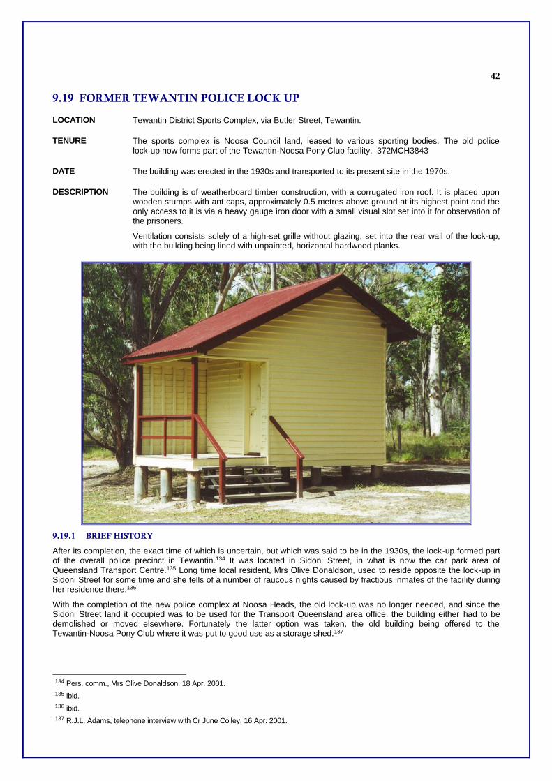
9.19 FORMER TEWANTIN POLICE LOCK UP
LOCATION Tewantin District Sports Complex, via Butler Street, Tewantin.
TENURE The sports complex is Noosa Council land, leased to various sporting bodies. The old police lock-up now forms part of the Tewantin-Noosa Pony Club facility. 372MCH3843
DATE The building was erected in the 1930s and transported to its present site in the 1970s.
DESCRIPTION The building is of weatherboard timber construction, with a corrugated iron roof. It is placed upon wooden stumps with ant caps, approximately 0.5 metres above ground at its highest point and the only access to it is via a heavy gauge iron door with a small visual slot set into it for observation of the prisoners.
Ventilation consists solely of a high-set grille without glazing, set into the rear wall of the lock-up, with the building being lined with unpainted, horizontal hardwood planks.
9.19.1 BRIEF HISTORY
After its completion, the exact time of which is uncertain, but which was said to be in the 1930s, the lock-up formed part of the overall police precinct in Tewantin.134 It was located in Sidoni Street, in what is now the car park area of Queensland Transport Centre.135 Long time local resident, Mrs Olive Donaldson, used to reside opposite the lock-up in Sidoni Street for some time and she tells of a number of raucous nights caused by fractious inmates of the facility during her residence there.136
With the completion of the new police complex at Noosa Heads, the old lock-up was no longer needed, and since the Sidoni Street land it occupied was to be used for the Transport Queensland area office, the building either had to be demolished or moved elsewhere. Fortunately the latter option was taken, the old building being offered to the Tewantin-Noosa Pony Club where it was put to good use as a storage shed.137
134 Pers. comm., Mrs Olive Donaldson, 18 Apr. 2001.
135 ibid.
136 ibid.
137 R.J.L. Adams, telephone interview with Cr June Colley, 16 Apr. 2001.

43
Since its relocation in the mid 1970s,138 the building has been renovated and repainted and continues in very good condition.
9.19.2 HISTORICAL THEMES
This place illustrates the following historical themes in Noosa Shire based on the Environmental Protection Agency's Guidelines for Historical & Indigenous Cultural Heritage Management, dated 2001:-
6(a) Maintaining order - policing and maintaining law and order: gaol (lock-up); and
9(b) Developing social and cultural institutions and ways of life - forming secular institutions: sporting facility (pony club).
9.19.3 POTENTIAL SIGNIFICANCE
The police presence in Tewantin dates back to 1873 and tenders were called on 18 January 1875 for the erection of a Police Station there.139 Although it was situated in Tewantin, the station was officially named Noosa Heads until some time between 25 May 1898 and 20 January 1899 when its name began to be recorded as Tewantin.140 The lock-up forms a valuable part of this process of law and order maintenance when the buildings were removed in the 1930’s and the retention of this small but important building is believed to be of high importance
It is therefore recommended that Noosa Council consider assessment criteria a, b, c, d, g and h under the Environmental Protection Agency's Guidelines for Historical and Indigenous Cultural Heritage Management, dated 2001 as relevant to
this place.
9.19.4 INTEGRITY
Following its relocation, the lock-up building has been faithfully restored and its original integrity has been very well carried on to its present state.
138 ibid.
139 Gympie Times, 27 Jan. 1875.
140 Adams, Rod. J.L., Noosa and Gubbi Gubbi, Tewantin, Ultreya Publications, 2000, pp.171,172.

44

45
9.20 WAR MEMORIAL
LOCATION Town Square, Tewantin
TENURE Reserve. 15MCH5443
DATE 1922.
DESCRIPTION A painted concrete monument in the standard form of a Digger at Ease. It is mounted on an engraved pedestal consisting of a plinth, four corner pilasters in the Corinthian order and moulded entablature.
The memorial also has a plaque set into its base recognising the service seen by Australian armed forces in Korean, Malayan, South East Asian and Vietnam campaigns and details of World War II fallen service persons are also inlaid in the upright section of the memorial's pedestal.
A flagpole stands behind the statue for official flag-raising ceremonies.
9.20.1 BRIEF HISTORY
The Tewantin War Memorial was constructed and funded by the citizens of the local community as a mark of respect for those of their fellow townspeople who died in the First World War.
The founding president of the Tewantin Sub-Branch of the Returned Services' League, Mr William John Ross, was largely responsible for rallying the people to create the memorial.

46
The memorial was unveiled and dedicated by Major-General Sir William Glasgow upon its completion and it remains the focal point for the regular and well-attended services, which take place around it. Such occasions recognise fallen servicemen and servicewomen in such observances as Anzac Day, Long Tan Day and the loss of the hospital ship Centaur, and recall the end of World War I on Remembrance Day each year.
The memorial states the closing year of the war as being 1919 instead of the usual 1918. The reason for this is that, although the armistice, which ended the fighting in the war, was signed on 11 November 1918, the formal Treaty of Versailles, which officially ended the conflict was not signed until 28 June 1919.141
9.20.2 HISTORICAL THEMES
This place illustrates the following historical themes in Noosa Shire based on the Environmental Protection Agency's Guidelines for Historical & Indigenous Cultural Heritage Management, dated 2001:-
9 (c) Developing social and cultural institutions - remembering the fallen: memorial (statue, flagstaff).
9.20.3 POTENTIAL SIGNIFICANCE
The War Memorial remains a focal point of war remembrance for the people of the Tewantin area.
It is recommended that Noosa Council consider assessment criteria a, d, and g under the Environmental Protection Agency's Guidelines for Historical & Indigenous Cultural Heritage Management, dated 2001 as relevant to this place.
9.20.4 INTEGRITY
Whilst the memorial remains basically in the original state of its construction, two items have been changed. Firstly, the monument was originally sited in the RSL Memorial Park (along the bank of the Noosa River, opposite the present Post Office site) and was moved to its present site (in the newly-developed Tewantin Town Square) in 1999. Secondly, it was vandalised some four years ago and the representation of the soldier's bayonet was destroyed. This has not yet been replaced.
In all other aspects, however, the monument is intact.
141 The World Book Encyclopedia, U-V, Volume 20. Chicago, U.S.A. Field Enterprises Educational Corporation, 1973, p.272.
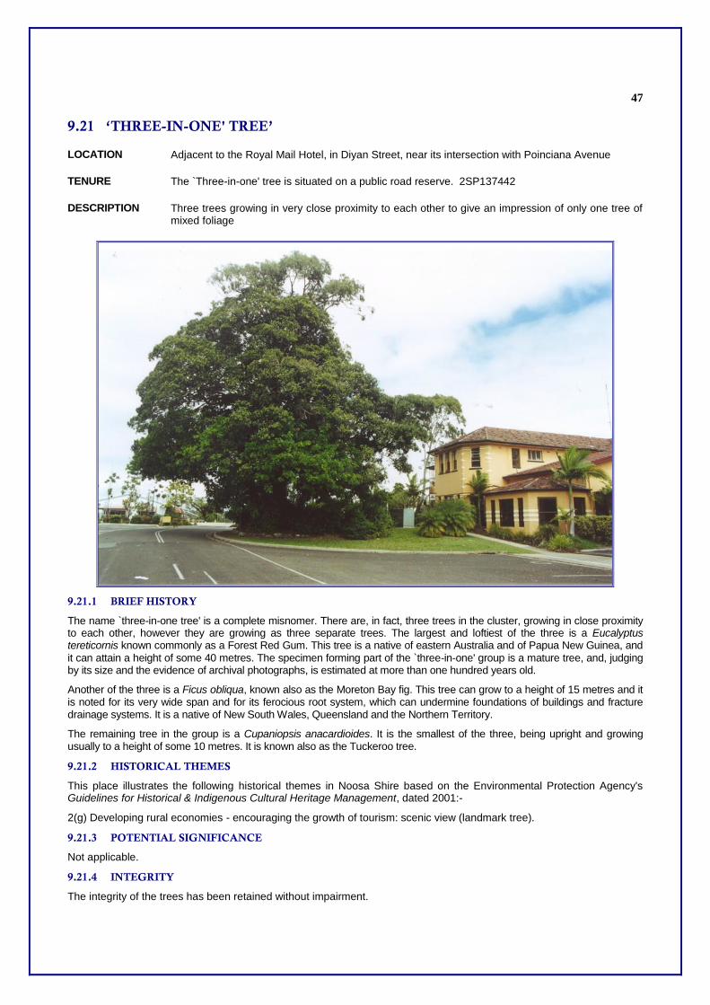
47
9.21 ‘THREE-IN-ONE' TREE’
LOCATION Adjacent to the Royal Mail Hotel, in Diyan Street, near its intersection with Poinciana Avenue
TENURE The `Three-in-one' tree is situated on a public road reserve. 2SP137442
DESCRIPTION Three trees growing in very close proximity to each other to give an impression of only one tree of mixed foliage
9.21.1 BRIEF HISTORY
The name `three-in-one tree' is a complete misnomer. There are, in fact, three trees in the cluster, growing in close proximity to each other, however they are growing as three separate trees. The largest and loftiest of the three is a Eucalyptus tereticornis known commonly as a Forest Red Gum. This tree is a native of eastern Australia and of Papua New Guinea, and
it can attain a height of some 40 metres. The specimen forming part of the `three-in-one' group is a mature tree, and, judging by its size and the evidence of archival photographs, is estimated at more than one hundred years old.
Another of the three is a Ficus obliqua, known also as the Moreton Bay fig. This tree can grow to a height of 15 metres and it is noted for its very wide span and for its ferocious root system, which can undermine foundations of buildings and fracture drainage systems. It is a native of New South Wales, Queensland and the Northern Territory.
The remaining tree in the group is a Cupaniopsis anacardioides. It is the smallest of the three, being upright and growing usually to a height of some 10 metres. It is known also as the Tuckeroo tree.
9.21.2 HISTORICAL THEMES
This place illustrates the following historical themes in Noosa Shire based on the Environmental Protection Agency's Guidelines for Historical & Indigenous Cultural Heritage Management, dated 2001:-
2(g) Developing rural economies - encouraging the growth of tourism: scenic view (landmark tree).
9.21.3 POTENTIAL SIGNIFICANCE
Not applicable.
9.21.4 INTEGRITY
The integrity of the trees has been retained without impairment.

48
9.22 TREE STUMP SHOWING MARKS OF TIMBER FELLING
LOCATION Heritage Park, Noosa Parklands, Tewantin
TENURE Reserve
DATE Unknown
DESCRIPTION A large tree stump, remnant of early timberfelling
9.22.1 BRIEF HISTORY
The timber industry throughout the second half of the nineteenth century was of the greatest importance in establishing the Noosa area. Impressive stands of rainforest trees were widespread throughout the Noosa/Cooloola area and these forests were harvested to provide timber for the construction and mining industries142 as well as for providing railway sleepers.
When the Noosa Parklands housing estate was developed in the 1980s, it was decided to leave selected areas of forest as corridors for faunal movements and as enhancements to areas of public parklands. Heritage Park is one such area and a stump of a quite sizeable tree has been left untouched as a reminder of the tree felling times of early Tewantin.
142 Monks, Colin, Noosa The Way It Was The Way It Is Now, Tewantin, Colin Monks, 2000, pp.61,62.

49
The stump features `nicks' cut into it, which allowed the timber workers to secure their springboards, thus allowing them to operate crosscut saws and axes in the tree felling process. It is in excess of three metres high and has a girth of some six metres.
The species of tree involved is unidentifiable, but it could be perhaps a satinay, one of the more popular trees of the local area and one, which was valued for its timber.
9.22.2 HISTORICAL THEMES
This place illustrates the following historical themes in Noosa Shire based on the Environmental Protection Agency's Guidelines for Historical & Indigenous Cultural Heritage Management, dated 2001:-
2(c) Developing rural economies - developing extractive resources (timber): logged forest (tree stump); and
9.22.3 POTENTIAL SIGNIFICANCE
Due to the historical importance of the early timber industry in Tewantin, this relic provides an interesting insight into earlier techniques of timber felling.
9.22.4 INTEGRITY
The stump has been subject to weathering.

50
9.23 FORMER WAHPUNGA STATE SCHOOL (University of the Third Age)
LOCATION 12 Ernest Street, Tewantin
TENURE Special Lease. 1RP152351
DATE c. 1910 Relocated 2003
DESCRIPTION The building is low set, built of timber with a corrugated iron roof.
Former Wahpunga State School building
9.23.1 BRIEF HISTORY
The single-classroom building started its life as the Wahpunga State School. As such it was opened on 15 August 1910143 and closed on 31 December 1967.144
Following its closure the building was relocated on its present site and was given to the Meals on Wheels movement as their management centre. This was the first real `home' Meals on Wheels had ever had in the Tewantin area, since the operation began in 1974 originally in the R.S.L. building in Tewantin, moving thereafter to the Anglican St James Hall in James Street, Noosaville. The move to Ernest Street took place in 1982 but the group was offered a new, larger centre in the recently developed Wallace Park complex and once more moved, this time on 18 September 1993.145
With the Ernest Street centre once more available, the University of The Third Age took it up as its local headquarters 1993 and is still in residence there.146
9.23.2 HISTORICAL THEMES
This place illustrates the following historical themes in Noosa Shire based on the Environmental Protection Agency's Guidelines for Historical & Indigenous Cultural Heritage Management, dated 2001:-
143 Ref: R W J Thompson, WSS, to Department of Primary Industries, 15 Aug. 1910, DN 18013, in Dale, John D., Kin Kin Schools: Past
and Present, 1990, pp.31,45; However, research is not complete as to whether there is any of the Pinbarren School building in the U3A building.
144 Director General of Education to Manager, Commonwealth Savings Bank, 28 Aug. 1967, DN AK 67/65217, Warpunga State School file, DE in Dale, John D., Kin Kin Schools: Past and Present, 1990, pp.31,45.
145 Pers. comm., Phillipa Grayburn, 2000.
146 ibid.

51
7(a) Educating a rural community - establishing schools: state school (schoolhouse); and
7(b) Educating a rural community - encouraging adult self-education: university of the third age.
9.23.3 POTENTIAL SIGNIFICANCE
The small, low-set building is not of any great architectural value, but does have worth as a good example of an early 20th century schoolhouse. It is functional and appears to be structurally sound. It therefore has the potential to offer good premises for modest groups for some time to come. Its retention could also, perhaps allow it to form part of any heritage `village' that may be considered within the shire in the future when it could revert to its original function by way of being a museum-type class room representative of the early twentieth century.
It is recommended that Noosa Council consider assessment criteria a, c, d, and g under the Environmental Protection Agency's Guidelines for Historical & Indigenous Cultural Heritage Management, dated 2001 as relevant to this place.
9.23.4 INTEGRITY
The building started off its life as a humble one-roomed school classroom, with front and rear verandahs. Since then its verandahs have been enclosed and an annex added to the rear to provide additional office accommodation.147 Nevertheless the basic integrity of the building remains. It could be restored to its original design without a great deal of structural amendment.
147 ibid.

52
9.24 WARD STREET COTTAGE (Former Coach Waiting Room)
LOCATION 1 Ward Street, Tewantin
TENURE Freehold. 1RP162818
DATE 1875
DESCRIPTION A low set cottage of timber construction with a corrugated iron roof. It has been extensively and unsympathetically altered.
9.24.1 BRIEF HISTORY
The core of the Ward Street cottage was the waiting room of the Cobb & Co staging post at Cooran and it was transported to Tewantin by its original owners William John Miller and his wife Mary Ellen in 1875.148
9.24.2 HISTORICAL THEMES
This place illustrates the following historical themes in Noosa Shire based on the Environmental Protection Agency's Guidelines for Historical & Indigenous Cultural Heritage Management, dated 2001:-
4(e) Establishing and developing towns – housing urban populations: dwelling
9.24.3 POTENTIAL SIGNIFICANCE
The cottage was one of the oldest residential buildings in Tewantin and is associated with the early development of the town.
It is recommended that Noosa Council consider assessment criterion a under the Environmental Protection Agency's Guidelines for Historical and Indigenous Cultural Heritage Management, dated 2001 as relevant to this place.
9.24.4 INTEGRITY
The integrity of the building has suffered with the passage of the years due to its unsympathetic additional and alterations.
148 Noosa and Gubbi Gubbi, op. cit., p.172.

53
9.25 FORMER NOOSA HEADS SURF LIFE SAVING CLUB ROOMS (‘Briteside
Industries)
LOCATION The Club Room for the Surf Lifesaving Club currently forms part of the `Brite Side' Industries facility situated at the Noosa Council's Rubbish Tip, off the Eumundi Road, Doonan.
TENURE Brite Side Industries holds a Licence to Occupy, granted by Noosa Council.149 77SP115851
DATE The Noosa Heads Surf Lifesaving Club was formed in 1928.150 Brite Side Industries began operations in 1999.151
DESCRIPTION The building is very basic, in that it is of square floor plan, is completely unlined and has a fibro cement roof. It stands upon low stumps and has a minimum number of windows for ventilation.
9.25.1 BRIEF HISTORY
T.M. Burke Pty Ltd donated the first lifesavers' shed at Noosa Heads, before 1935.152
The Noosa Heads Surf Lifesaving Club had two buildings at Noosa Heads beach from when it began in 1928. One is this building and the other was a more open one, an old photograph of which is currently hanging in the building at Brite Side Industries.153.
For many years this building sat unused by the lifesaving movement within the grounds of the Noosa Council works depot on Eumundi Road, Noosaville. When, however, the concept of Brite Side was launched, Noosa Council offered the building for the movement's use and it was gratefully accepted.154
Brite Side Industries was originally the brainchild of the officer in charge of the local office of the State government's Department of Corrective Services, Barney Kelly. The concept was seen as a way of assisting unemployed people develop skills and initiatives to help place them in gainful employment, yet at the same time, recycle wastes and turn
149 R.J.L. Adams, Hon. Secretary, Noosa Community Training Centre Inc. (NCTC), personal copies of Centre's records.
150 Pers. comm., telephone conversation with Robin Brading, spokesperson for the Noosa Heads Surf Lifesaving Club Inc., 2 Apr. 2001.
151 Adams, NCTC records.
152 Noosa Shire Council Minutes, 12 Jun. 1935, p.4.
153 RJL Adams, personal observation.
154 Robin Brading, telephone conversation, op. cit.; Adams, NCTC records, op. cit.

54
them into items of value.155 Mr Kelly approached Noosa Community Training Centre Inc., a body which evolved from SkillShare, to provide the administrative backing and funding through its government contracts, to run the venture.156 This has been done, in close liaison with Noosa Council, and the whole concept is proving both successful, productive and popular with the public.157
9.25.2 HISTORICAL THEMES
This place illustrates the following historical themes in Noosa Shire based on the Environmental Protection Agency's Guidelines for Historical & Indigenous Cultural Heritage Management, dated 2001:-
9(b) Developing social and cultural institutions - forming secular organisations: sporting facility (club house); and
4(c) Establishing and developing towns - providing public services: refuse site (recycling facility).
9.25.3 POTENTIAL SIGNIFICANCE
The surf lifesaving movement is a part of the Australian ethos. To have a very active Club in the Noosa area is a matter for great satisfaction and for such a historic, yet starkly utilitarian building as the clubroom cited is of great significance.
It is recommended that Noosa Council consider assessment criteria a, b, c, d, g and h under the Environmental Protection Agency's Guidelines for Historical and Indigenous Cultural Heritage Management, dated 2001 as relevant to this place.
9.25.4 INTEGRITY
The building has, since its resiting, been restumped upon tubular steel piers, raising it some 30 centimetres above ground level at its closest point. It has been repainted and appropriate windows fixed for better security, but generally its original integrity has not been interfered with in any way.
155 Adams, NCTC records, op. cit.
156 ibid.
157 ibid.

55
Further References

56
A Adams, Rod, Noosa and Gubbi Gubbi, Tewantin, Queensland: 2000
B Brown, Elaine ed. Remember the Days, Pomona State School Secondary Department Golden Jubilee 1945 - 1995
Brown, Elaine. Cooloola Coast: Noosa to Fraser Island - The Aboriginal and Settler Histories of a Unique Environment, University of Queensland Press, 2000
Bull, David W, Short Cut to Gympie Gold Short stories of Tewantin and the Sunshine Coast Brisbane, F H Watson, 1982.
C Cato, Nancy, The Noosa Story A Study in Unplanned Development, Milton, Q., The Jacaranda Press, 1979, 1st ed., 3rd ed., 1989.
Charlton, Peter, South Queensland WWII 1941-1945. 1991
Christie, Heather. (ed). Celebrating the Past, Sharing the Future: Pomona State School. 1997
Cohen, Kay, `Augustus Gregory - "A Biased Civil Servant?"', Royal Historical Society of Queensland Journal, vol. XIV, no. 10, Feb. 1992.
D Dale, John, Kin Kin Schools -Past and Present (Kin Kin State School 1991).
Dollison, M Sixty Years of CWA in Cooran (Unpublished Paper)
Dwyer, Barry, A History of the Noosa District Catholic Parish. 75 Years of Faith. St. Patrick’s Church 1922-1997. St. Patrick’s School 1947-1972.
E Edwards, Denise, Country and Coast the Development of Noosa Shire, 2001.
Exelby, Greg, The Federation of Federal, 1980.
F, G Gill, J.C.H. (Connal), `In Search of a River: Two Little Known Voyages to Moreton Bay', Queensland Heritage, vol.1 no.8.
Gillespie, Aline The Pages of Pomona, Issue No 2 in Historical Series on Pomona (Cooroora Historical Society, Inc. 2000.
Gillespie, Aline “The Pages of Pomona”, Pomona - The Historical Centre of Noosa Shire, Historical Series Issue No. 2, Cooroora Historical Society Inc., Pomona, June 2000.
Gillespie, Aline, ‘Cooroora Masonic Lodge’ in ‘A Special Trio’ Issue No Three of Pomona The Historical Centre of Noosa Shire. Cooroora Historical Society, 2000
Gillespie, Aline, “Trees and Sawmills”, Issue No. 4. Pomona: The Historical Centre of Noosa Shire, Pomona: Cooroora Historical Society, 2000.
H Heap, EG, ‘In the Wake of the Raftsmen A survey of early settlement in the Maroochy District’, Queensland Heritage 1,1, 1969.
Herbet, DA, `John Carne Bidwill' in Australian Dictionary of Biography, Melbourne, Melbourne University press, 1966, 1977
Hyatt Peter, Local Heroes Architects of Australia’s Sunshine Coast, Craftsman House Sydney, 2000.
Hyatt Peter, Local Heroes Architects of Australia’s Sunshine Coast, Craftsman House Sydney, 2000.

57
I, J, K Kerkhove Ray, ‘A Concise Aboriginal History of the Sunshine Coast’ 1986, unpublished, Foundation For Aboriginal and Islanders Research Action; Windolf, unpublished
Kerr, John D., Triumph of Narrow Gauge a history of Queensland Railways (Brisbane, Boolarong press, 1998).
L Lang, John Dunmore, ‘Queensland, Australia: a highly eligible for emigration, and the future cottonfield of Great Britain, London, Stanford, 1861.
M Morley, Ian, Black Sands: A history of sand mining in eastern Australia, St Lucia, University of Queensland, 1986.
N, O, P
Page, Ruth, A History of Pomona, Cooran, Kin Kin and Cootharaba, Cooroora Historical Society, 1970, 1982.
Priest Del, One Story of Just One Farm. Gympie Times, 2 September, 1992, p 12; Landcare Newsletter Summer 1998/1999 (Noosa & District Landcare Group Inc.)
Pullar, Margaret. Prefabricated WWII Structures in Queensland. A Report for the National Trust of Queensland, July 1997.
Q, R Russell, Henry Stuart, The Genesis of Queensland: an account of the first exploring journeys to and over the Darling Downs: Toowoomba, Vintage Books 1989.
S Smoothy, Judith, Guran- Cooran State School 100 Years of Education, Cooran State School, p.19-20.
Sutton, Betty `James Duke' in Missing Link Journal of the Cooroy-Noosa Genealogical and Historical Research Group Inc, issue 1, November 1997.
Sutton,Betty `Noosa Shire 90th Anniversary', Missing Link Journal of the Cooroy-Noosa Genealogical and Historical Research Group Inc, issue 6, May 2000.
T Thorne, Ebenezer, The Queen of the Colonies or Queensland I know it by an eight years’ resident, London, Sampson, Low, Marston, Searle, Rivington, 1876.
Tutt Stan, ‘Days Gone By’ Sunshine Coast Sunday Magazine 17 October 1993.
U, V, W, X, Y, Z Walker, B Gabriel Poole Space in which the soul can Play, Noosa, Visionary Press, 1998.
Windolf John and Francis, A Concise History of the Coolum District, 1986.