Embed Size (px)
Citation preview

Documenting the History of Inca Precious Metal Production Using Geochemical
Techniques from Lake Sediments in the Andahuaylas Region of Peru
by
Molly Kane
B.S. in Geology, B.A. in Environmental Studies, University of Pittsburgh, 2011
Submitted to the Graduate Faculty of
The University of Pittsburgh in partial fulfillment
of the requirements for the degree of
Bachelor of Philosophy
University of Pittsburgh
2011

UNIVERSITY OF PITTSBURGH
SCHOOL OF ARTS AND SCIENCES
This thesis was presented
by
Molly Kane
It was defended on
March 30, 2011
and approved by
Colin Cooke, PhD, Yale University
Charles Jones, PhD, University of Pittsburgh
Mark Collins, MFA, University of Pittsburgh
Thesis Director: Mark Abbott, PhD, University of Pittsburgh
ii

Copyright © by Molly Kane
2011
iii

Documenting the History of Inca Precious Metal Production Using Geochemical
Techniques from Lake Sediments in the Andahuaylas Region of Peru
Molly Kane, B.S.
University of Pittsburgh, 2011
The process of studying heavy metal concentrations in lake sediments in order to reconstruct
pollution history has been used in a variety of environments and locations. Laguna Pacucha is
one in a series of metal pollution studies from Peru and Bolivia, an area with a rich history of
metallurgy. Laguna Pacucha lies in the Andahuaylas region of Peru, 145 km west of Cuzco, the
Inca capital, and 20 km west of Curamba, a presumed ancient smelting site. The sediment record
of Laguna Pacucha reveals a metal record that dates beyond 1225 AD. A major density change
~1225 AD, concurrent with a known period of drought, inhibits the possibility of a reliable age
model below this point. Increases in Zn, As, and Cu after ~1225 AD could be indicative of local
copper smelting, which supports separate evidence of the Curamba archeological site (near
Laguna Pacucha) as a potential copper smelting site. These concentrations drop around the time
of the Spanish conquest, and then the concentrations of a number of different metals increase
after ~1600 and decrease by ~1850 AD, which could indicate smelting, but more likely indicates
a change in land use. Our results provide a complex record of a changing Andean environment,
and indicate a need for further study in the Andahuaylas region.
iv

TABLE OF CONTENTS
PREFACE ..................................................................................................................................... X
1.0 INTRODUCTION................................................................................................................ 1
1.1 BACKGROUND .......................................................................................................... 2
1.1.1 Geochemistry and Pollution History .............................................................. 2
1.1.2 South American Metallurgy History .............................................................. 3
1.1.3 South American Metal Pollution .................................................................... 4
1.2 STUDY SITE ............................................................................................................... 5
1.2.1 Laguna Pacucha ............................................................................................... 5
1.2.2 Area Resources ................................................................................................. 6
1.2.3 Area Culture ..................................................................................................... 7
1.2.4 Curamba Archeological Site ........................................................................... 9
2.0 METHODS ......................................................................................................................... 12
2.1 CORE COLLECTION AND CHRONOLOGY ..................................................... 12
2.2 SEDIMENT PROPERTIES ..................................................................................... 13
2.3 SEDIMENT GEOCHEMISTRY ............................................................................. 13
3.0 RESULTS ........................................................................................................................... 15
3.1 CORE CHRONOLOGY ........................................................................................... 15
v
3.2 SEDIMENT PROPERTIES ..................................................................................... 16
3.3 SEDIMENT GEOCHEMISTRY ............................................................................. 17
4.0 DISCUSSION ..................................................................................................................... 20
4.1 LAGUNA PACUCHA ............................................................................................... 20
4.1.1 Sediment Properties ....................................................................................... 20
4.1.2 Sediment Geochemistry ................................................................................. 21
4.2 OTHER RECORDS IN THE REGION .................................................................. 24
4.2.1 Laguna Lobato, Bolivia. (Abbott and Wolfe, 2003) .................................... 25
4.2.2 Laguna Pirhuacocha, Peru. (Cooke et al., 2007) ......................................... 25
4.2.3 Laguna Taypi Chaka, Bolivia. (Cooke et al., 2008) .................................... 26
4.2.4 Laguna Llamacocha, Peru. (Cooke et al., 2009) .......................................... 27
5.0 CONCLUSION .................................................................................................................. 28
BIBLIOGRAPHY ....................................................................................................................... 29
vi
LIST OF TABLES
Table 1. Culture, Historical Periods, and Ages (Lechtman, 1984, Bauer, 2010) ........................... 3
vii
LIST OF FIGURES
Figure 1. Wet and dry deposition of volatiles from smelting into local lakes ................................ 4
Figure 2. Catchment map of Laguna Pacucha. The black outline represents the catchment area of
the lake ............................................................................................................................................ 5
Figure 3. Hydrolab data including temperature, specific conductivity, dissolved oxygen, and pH 6
Figure 4. Regional area map with specific markers at Laguna Pacucha and the Curamba smelter.
....................................................................................................................................................... 10
Figure 5. Laguna Pacucha location and bathymetry. From Hillyer et al. 2008. The star indicates
the approximate location of coring. .............................................................................................. 12
Figure 6. 14C dates and age-depth model. ..................................................................................... 15
Figure 7. L.O.I. graphs vs. depth including calculated bulk density, % organics, % carbonate, and
% residual...................................................................................................................................... 16
Figure 8. Metal Concentration vs. Depth ...................................................................................... 18
Figure 9. Principle component analysis results............................................................................. 19
viii
Figure 10. L.O.I. graphs including calculated bulk density, % organics, % carbonate, and %
residual. Far right graph is Pumachocha δ18O levels (Bird et al. 2010). Higher δ18O levels
indicate drier periods (Bird et al. 2010). The dashed line represents a notable density change as
well as the approximate oldest determined age. ........................................................................... 20

Figure 11. Metal fluxes vs. year. Shaded area indicates Inca-Early Colonial (1400-1650 AD).
The dashed line indicates Inca and colonial periods (1532 AD) (Abbott and Wolfe, 2003). The
high density sediments older than ~1220 AD are not shown. ...................................................... 22
Figure 12. Map of study sites. Re-drawn from Cooke et al., 2009 ............................................... 26
Figure 13. Pb flux vs. Year graphs for Laguna Pirhuacocha (Cooke et al., 2007), Laguna
Llamacocha (Cooke et al., 2009), Laguna Taypi Chaka (Cooke et al., 2008), and Laguna
Pacucha. ........................................................................................................................................ 27
ix

x
PREFACE
Acknowledgements: This research was conducted at the University of Pittsburgh as part
of the author’s Bachelor of Philosophy degree. Funding was provided by the University of
Pittsburgh and the University of Pittsburgh Honors College. Thank you to M. Abbott for the
many reviews of the paper and all of the guidance along the way, to M. Collins, C. Jones, and C.
Cooke for discussing the project and serving on the thesis committee, and to D. Pompeani, A.
Hillman, M. Finkenbinder, and J. Swartz for helping with the execution and analysis of lab work
and data. Also, thank you to Guangcheng Chen of the RIF at the University of Alberta, Canada
for running samples on the ICP-MS.

1.0 INTRODUCTION
During the Spanish conquest of the Inca Empire in 1532 AD, the Spanish received an entire
room full of gold and silver as ransom for Atahualpa, the captured Inca emperor (Hemming,
1993). Additionally, the territories gained by the Spanish conquest were so rich in silver that
Spanish America became the world’s leading producer of the metal (Garner, 1988). While there
are many historical records of mining and metallurgy after the Spanish conquest, our knowledge
of pre-colonial mining and smelting remains limited (Garner, 1988). There are no written records
of pre-colonial metallurgy, and many of the artifacts have either disappeared due to pervasive
looting or were melted down by the Spanish (Abbott and Wolfe, 2003).
Measuring metal concentrations in dated lake sediment cores is a new method used to
reconstruct an area’s ancient heavy metal pollution and, consequentially, its metallurgical
history. This technique has been applied to a number of sites in Peru and Bolivia, and evidence
of silver smelting has been found as early as 400 AD (Cooke et al., 2008). Here results from
Laguna Pacucha (Peruvian Andes) are discussed and compared with previous work in the region
aimed at reconstructing the history of precious metal production.
Laguna Pacucha is an ideal lake to study for a number of reasons, including its physical
properties and its location, 145 km west of Cuzco, the Inca capital. No other lake in this area has
been studied for the purpose of developing a heavy metal pollution history, so it will be a useful
1

addition to the geochemical studies of other lakes in Peru and Bolivia (Abbott and Wolfe, 2003;
Cooke et al., 2008).
1.1 BACKGROUND
1.1.1 Geochemistry and Pollution History
The use of sediment geochemistry to study heavy metal pollution history has proven to be
effective in a number of different situations and locations. In Sweden, Ingemar Renberg and
colleagues were among the first to use lake sediments to reconstruct a lead pollution history of
much of Europe which saw clear increases in lead concentrations during the Greek and Roman
cultures as well as two peaks that match periods of historical metal production in Europe
(Renberg et al., 1994). Brannvall (2001) compared 206Pb/207Pb ratios and lead concentration
profiles in sediment cores and peat and soil samples to provide evidence that lead enrichment in
these sources is caused by anthropogenic lead pollution rather than natural processes (Brannvall
et al., 2001). In Greenland, heavy metal concentrations and 206Pb/207Pb ratios were used to
determine the sources of the lead pollution in ice cores (Rosman et al., 1994).
The method of using element concentrations in lake sediments to interpret past metal
pollution has recently been applied to lakes from multiple locations in Peru and Bolivia. These
studies, which build upon each other, have revealed a more comprehensive record of historical
South American smelting (Abbott and Wolfe, 2003; Cooke et al., 2008). Here, we are looking
specifically at element concentrations in Laguna Pacucha lake sediments in order to reconstruct
the area’s heavy metal pollution history.
2

1.1.2 South American Metallurgy History
The earliest well-dated copper and gold artifacts are hammered foils and gilded copper from
Mina Perdida, Peru, which date from 1410 to 1090 BC. (Burger and Gordon, 1998). The practice
of sheet-metal working continued to be used through the Early Intermediate Period (200 BC- 600
AD) and the Middle Horizon (600-1000 AD). Shultze and colleagues determined that the
tradition of silverworking was established further south in the Lake Titicaca basin by the first
century AD. The researchers studied and dated a stratigraphic sequence of metalworking remains
and concluded that high-temperature silver purification began before the establishment of the
Tiwanaku state, and continued after its collapse and throughout the Inca and Spanish Empires
(Shultze et al., 2009). Geochemical evidence for silver smelting has been found as early as 400
AD at Laguna Taypi Chaka in Bolivia (Abbott and Wolfe, 2003; Cooke et al., 2008). Large-scale
copper and bronze smelting is seen on the northern Peruvian coast by 1000 AD, and during the
Late Intermediate Period intensive copper working spread through the Bolivian altiplano (Abbott
and Wolfe, 2003). Demand for smelted gold and silver in order to show rank and power
increased during the Inca reign, and increased even further after the Spanish conquest
(Lechtman, 1984; Abbott and Wolfe, 2003).
Table 1. Culture, Historical Periods, and Ages (Lechtman, 1984, Bauer, 2010)
Horizons/Periods Culture Approx. Calendar Years
Late Horizon -Inca- AD 1400 - 1530
Late Intermediate -Chanka- AD 1000 - 1400
Middle Horizon -Wari- AD 600 - 1000
3

1.1.3 South American Metal Pollution
In South America, smelting was the primary source of pre-industrial heavy metal pollution.
Smelting is a process of removing a metal from its ore and involves heat and a chemical reducing
agent. During the process, volatiles are released into the atmosphere and deposited onto the
environment, including lakes, through wet or dry deposition (fig. 1). The Inca generally used
charcoal-fired, wind-drafted clay kilns (known as huyaras) for smelting, and were historically
known to use argentiferous galena [or soroche, (Pb, Ag)S] as a flux during the smelting process
(Cooke et al., 2008). The use of soroche as a flux causes excessive volatilization of lead, and the
high concentrations of the element—along with lead’s relative immobility once deposited in
sediments—makes it an ideal proxy to study the intensity of sliver production occuring during
the time of deposition (Abbott and Wolfe, 2003). Increases in copper, zinc, and arsenic can be
indicative of copper-based metallurgy; and the ultimate goal of such metallurgy would be bronze
production (Cooke et al., 2007; Brooks, 2010).
Figure 1. Wet and dry deposition of volatiles from smelting into local lakes
4

1.2 STUDY SITE
1.2.1 Laguna Pacucha
Laguna Pacucha (13°36′26′′S, 73°19′10′′W) is a large, 7.5 km2 lake with a maximum depth of 30
m and a 121.1 km2 catchment (fig. 2).
Figure 2. Catchment map of Laguna Pacucha. The black outline represents the catchment area of the lake
Laguna Pacucha, an alpine lake, is found at an elevation of 3100 m and is surrounded by
glaciers that terminate in nearby valleys (Hillyer et al, 2008). A small stream drains into the
eastern end of the lake and there is a small outflow on the northern shore, though these streams
are relatively insignificant when compared with the size of the lake (Hillyer et al., 2008). The
lake’s high elevation and little connection to other surface waters helps to ensure that much of
the metals are deposited into the lake from the atmosphere as wet or dry fallout. Laguna Pacucha
5

is a thermally stratified lake with oxygenated bottom waters and a slightly basic pH of around
8.4 (fig. 3).
Figure 3. Hydrolab data including temperature, specific conductivity, dissolved oxygen, and pH
1.2.2 Area Resources
Laguna Pacucha lies directly on the Andahuaylas-Yauri belt, which is associated with significant
copper, gold and molybdenum mineralizations (Perello et al., 2003). The area surrounding the
lake is especially rich in copper, lead, zinc and silver ores. Native silver ores in Peru were often
found in altered zones called “iron hat,” which were caused by a reaction of meteoric water with
the sulfides from the silver veins. This type of secondary mineralization, which is very common
in the Andes, made silver ores relatively easy for Peruvian miners to find and extract (Petersen,
2010). Lead ores are economically important, and were often mined for their silver content.
Galena (PbS), a common lead ore, was also referred to as soroche by the Inca. Copper, primarily
6

the As-Cu sulfide Enargite, was widely used and of great importance to the ancient Peruvians,
and its use dates to approximately 600 BC. Native copper was difficult to find in outcrop, and
ancient miners only had access to the deeper zones where it formed if erosion had removed some
of the overburden (Petersen, 2010).
1.2.3 Area Culture
The area surrounding Laguna Pacucha has a rich cultural history. The lake lies on the Peruvian
Altiplano in the Adahuaylas province. The area was primarily controlled by the Wari, the largest
pre-Inca empire in the Andes, during the Early Intermediate and Middle horizon (Stanish, 2001).
Records from Llamacocha, a lake in central Peru have shown increases in regional Pb pollution
around A.D. 600, which is thought to record increased smelting activity coinciding with the
expansion of the Wari Empire (Cooke et al., 2009). Additionally, there is evidence of mining by
the Wari State at Mina Primavera, a mine located in southern Peru (Eerkens et al., 2009).
Shifts in the settlement locations in the Andahuaylas region around AD 1000 coincide
with the decline of Wari influence as well as prolonged dry periods in Peru and Bolivia (Bauer,
2010; Binford et al., 1997). At this time, the Chanka shifted from raised-field agriculture toward
a more mixed economy with an increased role of pastoralism, and situated themselves primarily
in hilltop settlements rather than valleys. Bauer and Kellett (2010) note that the Chanka
developed as a “uniquely powerful ethnic group” during the time of Inca expansion. The site of
Luisinayoc, a known Chanka site, sits directly above the town of Pacucha (Bauer, 2010). While
there are a number of references to Chanka ceramics, there are few records of Chanka metal
artifacts (Bauer, 2010). The Chanka and the Inca developed as traditional rivals, and in 1438 AD
7

the Chanka launched the conquest of Cuzco, but the Inca in the Cuzco region united to score a
decisive military victory over the Chanka (Bauer, 2002).
Laguna Pacucha lies 145 km west of Cusco, the Inca capital city. During the Inca reign,
gold and silver was in high demand in order to show rank and power (Lechtman, 1984). Metal
production increased drastically during this time. Demand for gold and silver rose even further
after the Spanish Conquest in 1545, and has generally increased through time (Abbott and Wolfe,
2003).
Chepstow-Lusty et al. (2009) conducted a study on lake sediments from Marcacocha
(72°12'W, 13°13'S), 12 km north of the major Inca settlement of Ollantaytambo and 130 km
northeast of Laguna Pacucha. They found that the inhabitants of the area, much like the Chanka,
responded to the ~1000 AD drought by exploiting higher elevations and switching to a systems
of agro-forestry and agro-pastoralism. The Marcacocha charcoal record suggests an increase in
anthropogenic activity in the area ca. 1150 AD, likely caused by a migration of populations from
lower elevations. The warmer temperatures allowed for the exploitation of higher elevations
because melting glaciers allowed for glacial-fed irrigation of agricultural terraces. Sharp
increases in mite abundances in the mid 1400s are suggestive of a population of large herbivores,
probably llamas, using the pasture for grazing purposes. Mite frequencies drop after 1500 AD,
around the time of the collapse of the Inca Empire, and then undergo a final increase around
1600 AD, likely due to the introduction of large herbivores from the Old World (Chepstow-
Lusty, 2009). The use of the pasture as grazing at this time is supported by evidence of
significant burning events (possibly for clearing purposes). A hiatus in burning activity after the
17th century coincides with the collapse of livestock populations, and also a recorded epidemic
8

(probably smallpox) that wiped out many of the indigenous people in the valley (Chepstow-
Lusty et al., 2009).
1.2.4 Curamba Archeological Site
Laguna Pacucha is 20 km west of Curamba (73°8'W, 13°3720''S), an important yet controversial
archeological site that lies on the royal Inca road that runs north to the coast (fig. 4). The area
was most likely in Chanka possession until the Inca takeover in 1438 (Lechtman, 1976).
Curamba has generally been accepted as an ancient smelting site because of the hundreds of fire-
reddened strips of earth that may once have been wind-driven furnaces lining the terraces. Upon
excavation of the site, Lechtman found that the fire-reddened strips are the remains of
rectangular channels that were open at the top, lined with limestone, and covered with a thick
layer of mud-plaster to protect the structure from heat. The clay that built up the terraces was
brought from somewhere else, probably for its good thermal properties (Lechtman, 1976). All of
the channels were built parallel in order to take advantage of the area’s strong wind conditions.
While there is some evidence of the structures originally being built up, the weaker construction
materials do not hold up to weathering and would probably not be preserved in the archeological
record (Lechtman, 1976). A lack of colonial sherds or architecture around the terraces makes it
likely that the installations were originally Incaic or pre-Incaic (Lechtman, 1976).
Although explorers initially believed these structures to be furnaces, there is some
evidence that this scenario is unlikely. No metallurgical slags or ash were found associated with
any of the terraces. This could be from the regular occurrence of removal and re-melting of slag
from past mining sites, but given Curamba’s difficult and remote access, this is unlikely. The
construction of an open-pit channel is unusual, but not unheard of, and could be used for roasting
9

ore rather than smelting (Lechtman, 1976). Carbonized maize cobs were found with kernels still
intact, which seems unusual if the maize was used as a fuel, because the kernels would likely
have been removed first and used for other purposes (Lechtman, 1976).
Figure 4. Regional area map with specific markers at Laguna Pacucha and the Curamba smelter.
A study by Parodi et al. (2008) used X-ray diffraction and Mossbauer spectroscopy to
study the composition of the existing slag and ore and the maximum temperatures achieved by
the furnaces. Samples from two different furnaces showed no evidence of silver ore as part of its
composition, but there was some evidence of copper. Additionally, the highest temperature the
furnaces could have reached was (800±50° C). This temperature is not high enough to melt
silver, which has a melting point of 960° C, but it may have been hot enough to melt copper with
10

a 779° C fusion temperature. Lechtman notes that while ores are abundant within 18 km, the ores
are typically copper rather than silver (Lechtman, 1976). An increase in lead concentrations in
Laguna Pacucha could be indicative of silver smelting in Curamba, while increases in copper,
zinc and arsenic would suggest copper smelting, and could help to explain the history of the
Curamba site (Cooke et al., 2007; Petersen, 2010).
11

2.0 METHODS
Figure 5. Laguna Pacucha location and bathymetry. From Hillyer et al. 2008. The star indicates the approximate
location of coring.
2.1 CORE COLLECTION AND CHRONOLOGY
Lake sediments were collected from Laguna Pacucha in 2008 from the deepest part of the lake
(~30 m) using a piston corer designed to recover undisturbed sediments with an intact sediment-
water interface (fig. 5). We recovered 294 cm total, and the upper 50 cm of the core were
extruded into sample bags in the field at continuous 0.5-cm increments to eliminate possible
12

disturbance during transport. Sediment characteristics were also described and photographed in
the field to ensure accuracy.
Laguna Pacucha was dated using two Accelerator Mass Spectroscopy (AMS) 14C dates
from plant material and charcoal at 101-102 cm and 247-250 cm, respectively. Samples were
prepared for radiocarbon dating by soaking in 0.1 M HNO3 for 30 minutes, 0.1 M KOH for 60
minutes, and then 0.1 M HNO3 for another 30 minutes. The samples were neutralized by rinsing
with deionized water before and after each acid or base. Radiocarbon dates were calibrated to
calendar years BP using the Calib radiocarbon calibration program and IntCal09 calibration
Curve (Stuiver and Reimer, 1993; Reimer et al., 2009).
2.2 SEDIMENT PROPERTIES
Samples were measured for loss-on-ignition (LOI) at 5-cm intervals. 1-cc samples were weighed,
heated to 105°C overnight in ceramic crucibles, and then weighed dry in order to calculate dry
density. Samples were then heated to 550°C and 1000°C to calculate percent organic matter and
percent calcium carbonate, respectively (Heiri et al., 2001).
2.3 SEDIMENT GEOCHEMISTRY
The core was sub-sampled at 5-cm intervals and then processed and analyzed for elemental
concentrations from each level extruded in the field. Metals were extracted from 0.5 g freeze-
dried sediment with 1 M HNO3 at room temperature overnight. This weak extraction procedure
13

deliberately targets loosely bound metals absorbed to organic and inorganic surfaces, rather than
those associated with the mineralogy of inorganic constituents of sediments (Graney et al.,
1995). Metal concentrations for 23 metals in the samples were determined using the inductively
coupled plasma mass spectrometer (ICP-MS) at the University of Alberta, Canada. Principal
component analysis was executed using Canoco version 4.5 software (ter Braak and Šmilauer,
1998).
14

3.0 RESULTS
3.1 CORE CHRONOLOGY
The age model was built with two calibrated AMS 14C dates and is reported as calibrated years
AD (fig. 6). In addition, we assumed that the top of the core dated to 2008, the year the lake was
cored. The first date came from plant material at 101.5 cm (averaged) and dates to 1768 AD. The
second was from charcoal at 248.5 cm (averaged) and dates to 1227 AD. Laguna Pacucha is a
carbonate rich lake and subject to a hardwater effect, but in order to circumvent this issue we
targeted only macrofossils and charcoal, which are not likely to be subject to the effect (Abbott
and Stafford, 1996). Sediment accumulation rates for the two segments of the calibration curve
are 0.42 cm/yr since 1768 and 0.27 cm/yr before 1768.
Figure 6. 14C dates and age-depth model.
15
3.2 SEDIMENT PROPERTIES
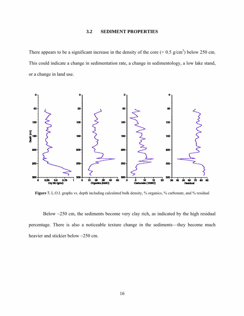
There appears to be a significant increase in the density of the core (+ 0.5 g/cm3) below 250 cm.
This could indicate a change in sedimentation rate, a change in sedimentology, a low lake stand,
or a change in land use.
Figure 7. L.O.I. graphs vs. depth including calculated bulk density, % organics, % carbonate, and % residual
Below ~250 cm, the sediments become very clay rich, as indicated by the high residual
percentage. There is also a noticeable texture change in the sediments—they become much
heavier and stickier below ~250 cm.
16
3.3 SEDIMENT GEOCHEMISTRY
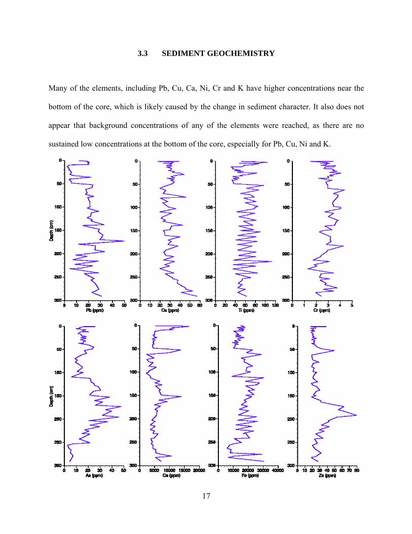
Many of the elements, including Pb, Cu, Ca, Ni, Cr and K have higher concentrations near the
bottom of the core, which is likely caused by the change in sediment character. It also does not
appear that background concentrations of any of the elements were reached, as there are no
sustained low concentrations at the bottom of the core, especially for Pb, Cu, Ni and K.
17

Figure 8. Metal Concentration vs. Depth
Arsenic concentrations increase in the lower density sediments, at a depth of 250 cm.
Arsenic reaches a peak of ~50 ppm around 175 cm, and then steadily drops until ~100 cm, where
it averages 20 ppm for the rest of the core. Fe and Zn concentrations also start rise at ~250 cm.
Iron increases markedly by 240 cm, and sustains this increase until 50 cm when the
concentration drops by almost 5,000 ppm. Zinc peaks at 191.5 cm with 80 ppm, and then steadily
decreases until 150 cm at which point it remains around 25 ppm with a slight increase at 50 cm.
Pb, Cr, and K also see increased concentrations above ~ 200 cm. Lead concentrations peak at
175 cm and then decline for the remainder of the core, until 50 cm when the concentrations drop.
Chromium has a very slow rise and fall through the core, peaking at ~4 ppm. Potassium rises
steadily above ~200 cm, peaking at 331 ppm, before quickly dropping to 84 ppm at 50 cm depth.
Nickel concentrations remain around 4 ppm, with the exception of the bottom of the core (below
250 cm).
It should be noted that the concentrations of a number of the elements (especially Pb, Ti,
Ca, Fe, and K) fall drastically at 50 cm, which marks the switch from the intact core samples to
18

the extruded sediments. This may indicate that the change has to do with a difference in how the
sediments were packaged and stored, or sediment focusing, rather than the concentrations of
metals in the lake at that time.
In the results from principle component analysis (PCA), many of the elements known to
be from weathering (Ti, K, Na) covary in quadrant II, along with Pb. This may imply that the
changes in lead concentrations are primarily due to weathering. Additionally, elements in
quadrant III (including Zn and As) are decoupled from the weathering elements in quadrant II,
meaning that the changes in concentrations of these elements are likely due to something other
than weathering, such as metallurgy.
Figure 9. Principle component analysis results.
19

4.0 DISCUSSION
4.1 LAGUNA PACUCHA
4.1.1 Sediment Properties
Figure 10. L.O.I. graphs including calculated bulk density, % organics, % carbonate, and % residual. Far right graph
is Pumachocha δ18O levels (Bird et al. 2010). Higher δ18O levels indicate drier periods (Bird et al. 2010). The
dashed line represents a notable density change as well as the approximate oldest determined age.
The change in density around 1225 AD could be due to a number of causes including a low lake
stand, or changes in land use (sediment supply/ sedimentation sources). Abbott et al. (1997)
found that water levels in Lake Titicaca drastically decreased during severe periods of drought
from 1040-1490 AD, with the lowest period around 1250 AD. Additionally, a study by Bird et al.
20

(2010) noted peaks in δ18O from AD 900- 1100, which indicates a weakened South American
Summer Monsoon (SASM) rainfall (Bird et al. 2010). This could indicate that the increased
density at the bottom of the core is due to a low stand in the lake from drier environments during
the medieval climate anomaly. The deepest section of the lake is not far from the land, and one
possibility is that during the lowstand, there was a slump of sediments into deeper parts of the
lake, explaining the high clay matter ( % residual) and high density.
4.1.2 Sediment Geochemistry
Element concentrations were converted to fluxes (accumulation rate μg/cm2 per year) and were
calculated using the metal concentration (μg/g), bulk density (g/cm3), and sedimentation rate
(cm/yr). Sedimentation rate was derived using the 14C age model. The density of the sediments
distinctly increases below 1225 AD, which also marks the lowest date on our age model. For this
reason, metal fluxes below 1227 AD will not be discussed, as the density changes below this
point indicate extrapolation of the age model is not appropriate.
21

Figure 11. Metal fluxes vs. year. The high density sediments older than ~1220 AD are not shown.
The first major increases in element fluxes outside of the high-density sediments can be
seen in As, Zn, Ni, Al, and to a lesser extent Cu, around 1350 AD. Increases in Zn, As, and Cu
can be indicative of copper smelting (Cooke et al., 2007; Petersen, 2010). This increase occurs
slightly before the rise of the Inca Empire, and while the Inca were primarily known for silver
metallurgy, copper smelting in this area is supported by two studies from the Curamba
22

archeological site, which is only ~20 km away from Laguna Pacucha (Lechtman, 1976; Parodi et
al., 2008). Copper constitutes a majority of the local ores, and the copper ores in the area are
often high in arsenic (Lechtman, 1976; Petersen, 2010). Additionally, the PCA results suggest
that the changes in As and Zn are decoupled from the changes in the concentrations of the
elements related to weathering, so it is likely Zn and As concentrations are due to something
other than weathering, such as smelting. Copper-based metallurgy typically has an ultimate goal
of bronze production, and there are significant records of bronze and copper Inca artifacts
(Petersen, 2010). As and Zn noticeably drop around 1450 AD, hitting a low point during the
Spanish conquest. This could be caused by the abandonment of regional metal production.
Pb, Cu, Ti, Cr, Fe, Ni, Al, and K all reach their highest fluxes roughly between 1650 AD
and 1850 AD. This period contrasts with many of the other studies in the area, which see high
lead fluxes during the Inca and Early Colonial periods (1400 AD -1650 AD), (Abbott and Wolfe,
2003; Cooke et al, 2007, Cooke et al., 2008).
One explanation for this phenomenon is an incorrect age model. Our current age model is
made up of only two dates, which may simply not be enough information to form a reliable age
model. The late increases in metal fluxes could also be from late colonial smelting in the area.
However, if there was late colonial smelting, it was most likely not at Curamba, as luminescence
techniques date the last use of the furnaces to around 1550 AD (Parodi et al., 2008).
It is notable that almost all of the elements, including elements not typically associated
with smelting pollution, have similar profiles. This suggests that the changes in flux, at least
from ~1600-1900 AD, may have to do with some other factor, such as erosion, rather than
smelting. Additionally, the PCA results show Pb covarying with elements that are typically
related to weathering. Heather Lechtman specifically mentions that there is considerable
23

evidence that Curamba may not have been a site of metal smelting at all, and that interpretation
may in fact be a complete misunderstanding of the purpose of the site (Lechtman, 1976). If this
is the case, then the lack of a distinct metal record in Laguna Pacucha could certainly support this
theory. Areas near Laguna Pacucha saw population increases during the low lake levels because
of the warmer temperatures and the ability to take advantage of higher elevations for agriculture
(Chepstow-Lusty et al., 2009). Sediment records from Laguna Marcacocha, 130 km northeast of
Laguna Pacucha, indicate a move towards agro-pastoralism and a number of major burning
events near the lake. There are also increases, decreases and changes in land use based on the
political climate at the time (Chepstow-Lusty et al., 2009). While this particular record may not
necessarily hold true for the area around Laguna Pacucha, it does indicate that there were major
changes in land use in the Peruvian altiplano during the time span of the core, and these changes
could help to explain the metal concentrations. More analysis of the core should be done in order
to test this theory.
4.2 OTHER RECORDS IN THE REGION
There have been a number of other studies done on this subject in various areas of Peru and
Bolivia. All of the lakes have been described in detail in previous papers (Abbott and Wolfe,
2003; Cooke et al., 2007; Cooke et al., 2008; Cooke et al., 2009) so there will be only a short
discussion of them here.
24

4.2.1 Laguna Lobato, Bolivia. (Abbott and Wolfe, 2003)
Laguna Lobato is located 6 km from Cerro Rico de Potosi, which was the largest silver deposit in
the world (Abbott and Wolfe, 2003). Metal concentrations first increased shortly after 1000 AD,
reaching a peak around 1140 AD, which coincides with the late Tiwanaku. A decrease after 1140
AD occured contemporaneously with the fall of the Tiwanaku state, suggesting that the smelting
at Cerro Rico was attached to the Tiwanaku polity. The next significant increase occurs after
1400 AD, with the rise of Inca metallurgy. The arrival of the Spanish in 1545 AD brings about
the highest peak in lead, as well as increases in Ag, Bi, and Sn because of less effective smelting
techniques. The depletion of surface ores saw a switch to the process of mercury amalgamation,
until Cerro Rico was abandoned in 1930 AD.
4.2.2 Laguna Pirhuacocha, Peru. (Cooke et al., 2007)
Laguna Pirhuacocha is situated in close proximity to the Morococha mining region, which makes
it a good location to record metal deposition from past smelting activity. The first rise in lead,
and the likely onset of smelting at Morococha, occurs between 1000 AD and 1200 AD, which is
after the fall of the Wari but significantly before the rise of the Inca civilization. Increases in Cu
and Zn relative to Pb around 1200 AD suggest that copper-based metallurgy is predominant,
until Pb levels start to increase during the rise of Inca metallurgy. Increases in Pb, Sb, and Bi
after 1600 AD are attributed to increases in colonial mining at Morococha. The development of
the Andes and the opening of the La Oroya smelting complex are the most likely causes of the
significant enrichments in all of the metals after 1925 AD.
25

Figure 12. Map of study sites. Re-drawn from Cooke et al., 2009
4.2.3 Laguna Taypi Chaka, Bolivia. (Cooke et al., 2008)
Laguna Taypi Chaka, although not located near any modern mining activities, lies ~40 east of a
Tiwanaku archaeological zone. The first major increase in lead concentrations occurs around 400
AD, which coincides with the rise of the Tiwanaku Civilization, suggesting the rise of Tiwanaku
smelting activity. Pb concentrations remain high until they start to decrease ~1040 AD,
26

coincidental with the collapse of the Tiwanaku culture. A large increase in lead concentration
occurs during the Inca conquest and the growth of Inca metallurgy, but after the Spanish
conquest, mining activities are focused on Cerro Rico and smelting activity falls in the Bolivian
Altiplano.
4.2.4 Laguna Llamacocha, Peru. (Cooke et al., 2009)
Situated in the Peruvian Andes, Laguna Llamacocha lies ~60 km southeast of Cerro de Pasco,
which became the worlds largest producer of silver in the 1700s. The initial increase of lead
concentrations around 600 AD can be attributed to the onset smelting during the Wari expansion
in Peru. Lead concentrations continue to rise over time, with little to no effect seen during the
fall of the Wari Empire and Hg increases significantly after 1600 AD, and especially during
Colonial smelting activities. This is most likely due to the switch to mercury amalgamation as
the primary metallurgical process. Considerable increases in all metal concentrations are notable
during the Industrial period.
Figure 13. Pb flux vs. Year graphs for Laguna Pirhuacocha (Cooke et al., 2007), Laguna Llamacocha (Cooke et al.,
2009), Laguna Taypi Chaka (Cooke et al., 2008), and Laguna Pacucha.
27

5.0 CONCLUSION
The sediment record from Laguna Pacucha reveals a nearly 1000 year long metal record from the
Andahuaylas region of Peru. The sediments indicate a major density change around 1225 AD,
which coincides with a regional drought (Bird et al., 2010). The changes in element
concentrations through the core provide the groundwork for a compelling story of the area.
Increases in zinc, arsenic, and copper around 1225 AD are indicative of copper smelting, and
could support the possibility that the Curamba archeological site was used primarily for smelting
copper, rather than silver. The similar profiles of a majority of the elements between 1550 and
1850 may indicate that some of the metal concentrations have less to do with smelting than
another explanation, such as land use change.
Laguna Pacucha is one in a series of studies that use metal concentrations in lake
sediments to reconstruct pollution history in Peru and Bolivia, an area where is a historical
legacy of metallurgy but little archeological work. While Laguna Pacucha does not necessarily
provide a definitive metal pollution record, it does show evidence of likely copper smelting and,
with future research, could certainly provide an interesting record of land use change and the
relationship of the indigenous people to the Andahuaylas region of Peru.
28

BIBLIOGRAPHY
Abbott, M.B., and Stafford, T.W. (1996). Radiocarbon geochemistry of modern and ancient arctic lake
systems, Baffin Island, Canada. Quaternary Research 45, 300-311.
Abbott, M.B. and Wolfe, A.P. (2003). Intensive pre-Incan metallurgy recorded by lake sediments from
the Bolivian Andes. Science 301, 1893–1895.
Abbott, M.B., Binford, M.W., Brenner, M., Kelts, K.R. (1997). A 3500 14-C yr High-Resolution Record
of Water-Level Changes in Lake Titicaca, Bolivia/Peru. Quaternary Research 47, 169-180.
Appleby, P., and F. Oldfield. (1978). The calculation of lead-210 dates assuming a constant rate of
supply of unsupported 210Pb to the sediment. Catena 5, 1-8.
Bird et al. 2010. In review. A 2300-year-long annually resolved record of the South American summer
monsoon from the Peruvian Andes. PNAS.
Bauer, B. S. and Covey, R. A. (2002). Processes of State Formation in the Inca Heartland (Cuzco, Peru).
American Anthropologist 104, 846–864.
Bauer, B.S., and Kellett, L.C.. (2010). Cultural transformations of the Chanka homeland (andahuaylas,
Peru) during the late intermediate period (A.D. 1000-1400). Latin American Antiquity 21.1 87
(25)
Branvall, M.L., Kurkkio, H., Bindler, R., Emteryd, O., and Renberg, I. (2001). The role of pollution
versus natural geological sources for lead enrichment in recent lake sediments and surface forest
soils. Environmental Geology 40, 1057-1065
29

Burger, R.L. and Gordon, R.B. (1998). Early Central Andean Metalworking from Mina Perdida, Peru.
Science 282 (5391), 1108-1111.
Chepstow-Lusty, A.J., Frogley, M.R., Bauer, B.S., Leng, M.J., Boessenkool, K.P., Carcaillet, C., Ali,
A.A., and Gioda, A. (2009). Putting the rise of the Inca Empire within a climatic and land
management context. Climate Past 5, 375-388.
Cooke, C.A., Abbott, M.B., and Wolfe, A.P. (2008). Late-Holocene atmospheric lead deposition in the
Peruvian and Bolivian Andes. The Holocene 18, 353–359.
Cooke, C.A., Abbott, M.B., Wolfe, A.P., and Kittleson, J.L. (2007). A millennium of metallurgy
recorded by lake sediments from Morococha, Peruvian Andes. Environmental Science &
Technology 41, 3469–3474.
Cooke, C.A., Wolfe, A.P., and Hobbs, W.O. (2009). Lake-sediment geochemistry reveals 1400 years of
evolving extractive metallurgy at Cerro de Pasco, Peruvian Andes. Geology 37(11), 1019-1022.
Garner, R.L. (1988). Long-Term Silver Mining Trends in Spanish America: A Comparative Analysis of
Peru and Mexico. The American Historical Review 93 (4).
Graney, J.R., Halliday, A.N., Keeler, G.J., Nriagu, J.O., Robbins, J.A., and Norton, S.A. (1995). Isotopic
record of lead pollution in lake sediments from the northeastern United States. Geochimica et
Cosmochimica Acta 59, 1715-1728.
Hemming, John. (1993). The conquest of the Incas. London: Macmillan.Schultze, C.A., Stanish, C.,
Scott, D.A., Rehren, T., Kuehner, S., and Feathers, J.K. (2009). Direct Evidence of 1,900 years
of indigenous silver production in the Lake Titicaca Basin of Southern Peru. PNAS 106 (41).
17280–17283.
30

Heiri, O., Lotter, A.F., and Lemcke, G. (2001). Loss on ignition as a method for estimating organic and
carbonate content in sediments: reproducibility and comparability of results. Journal of
Paleolimnology 25, 101–110.
Hillyer, R., Valencia, B.G., Bush, M.B., Silman, M.R., Stenitz-Kannan, M. (2009). A 24,700-yr
paleolimnological history from the Peruvian Andes. Quaternary Research 71, 71-82.
Lechtman, H. (1976). A metallurgical site survey in the Peruvian Andes. Journal of Field Archeology 3
(1), 1-42.
Lechtman, H. (1984). “Technologies of Power, the Andean Case.” From Configurations of Power by
Henderson, J. and Netherly, P. Cornell University Press. 1984.
Luisa, V.P., Casagrande, S.P., Yezena, V.H., Fulle, M.M.K. (2008). The Inca Site metallurgical furnaces
of Curamba (Peru): A study using XRD, Mossbauer spectroscopy and dating luminescence
methods. Bulletin de l'Institut Français d'Études Andinos 37 (3), 451-475
Parodi, L.V., Casagrande, S.P., Vasquez, Y.H., Fulle, M.M.K. (2008). Los hornos metalurgicos del sitio
Inca de Curamba (Peru): estudio por DRX, espectroscopia Mossbauer y datacion por metodos de
luminiscencia. Boletin del Instituto Frances de Estudios Andinos 37.
Perelló, J., Carlotto, V.,, Zárate, A., Ramos, P., Posso, H., Neyra, C., Caballero, A., Fuster, N., and
Muhr. R. (2003). Porphyry-Style Alteration and Mineralization of the Middle Eocene to Early
Oligocene Andahuaylas-Yauri Belt, Cuzco Region, Peru. Economic Geology 98, 1575 - 1605.
Petersen, G. ( 2010). “Mining and Metallurgy in Ancient Peru.” trans. Brooks, W.E. The Geological
Society of America. Special Paper 467.
Reimer et al. (2009). IntCal09 and Marine09 radiocarbon age calibration curves, 0-50,000 years cal BP.
Radiocarbon 51, 1111-1150.
31
32
Renberg, I., Persson, M.W., Emteryd, O. (1994). Pre-industrial atmospheric lead contamination detected
in Swedish lake sediments. Nature 368, 323-326.
Rosman, K.J.R., Chisholm, W., Boutron, C.F., Candelone, J.P. and Hong, S. (1994). Isotopic evidence
to account for changes in the concentration of lead in Greenland snow between 1960 and 1988.
Geochimica et Cosmochimica Acta 58, 3265–69.
Rosman, K.J.R., Chisholm, W., Hong, S., Candelone, J., and Boutron, C.F. (1997). Lead from
Carthiaginian and Roman Spanish Mines Isotopically Identified in Greenland Ice Dated from
600 B.C. to 300 A.D. Enviromental Science and Technology 31 (12), 3413-3416.
Stuiver, M. and Reimer, P.J., 1993, Extended 14C data base and revised CALIB 3.0 14C age calibration
program, Radiocarbon 35, 215-230
ter Braak, C.J.F., and Šmilauer, P., 1998, CANOCO Reference Manual and User’s Guide to Canoco for
Windows: Software for Canonical Community Ordination (version 4): Ithaca, New York,
Microcomputer Power, 352 p.