Embed Size (px)
Citation preview
Dividing Jerusalem: British Urban Planning in the Holy CityAuthor(s): Nicholas E. RobertsSource: Journal of Palestine Studies, Vol. 42, No. 4 (Summer 2013), pp. 7-26Published by: University of California Press on behalf of the Institute for Palestine StudiesStable URL: http://www.jstor.org/stable/10.1525/jps.2013.42.4.7 .
Accessed: 31/10/2014 11:37
Your use of the JSTOR archive indicates your acceptance of the Terms & Conditions of Use, available at .http://www.jstor.org/page/info/about/policies/terms.jsp
.JSTOR is a not-for-profit service that helps scholars, researchers, and students discover, use, and build upon a wide range ofcontent in a trusted digital archive. We use information technology and tools to increase productivity and facilitate new formsof scholarship. For more information about JSTOR, please contact [email protected].
.
University of California Press and Institute for Palestine Studies are collaborating with JSTOR to digitize,preserve and extend access to Journal of Palestine Studies.
http://www.jstor.org
This content downloaded from 66.134.128.11 on Fri, 31 Oct 2014 11:37:52 AMAll use subject to JSTOR Terms and Conditions
DIVIDING JERUSALEM: BRITISH URBAN
PLANNING IN THE HOLY CITY
NICHOLAS E. ROBERTS
British administrators employed urban planning broadly in British
colonies around the world, and British Mandate Palestine was no
exception. This article shows how with a unique purpose and based
on the promise of a Jewish homeland in Palestine, British urban
planning in Jerusalem was executed with a particular colonial
logic that left a lasting impact on the city. Both the discourse and
physical implementation of the planning was meant to privilege
the colonial power’s Zionist partner over the indigenous Arab
community.
ON 9 DECEMBER 1917, the city of Jerusalem surrendered to the British
Egyptian Expeditionary Forces, ‘‘liberating the city,’’ in the words of its
conquerors, from the heavy hand of Ottoman rule. But according to its
new rulers, Jerusalem’s salvation had only just begun. Covered by a ‘‘thick
pall’’ from four hundred years of Turkish rule, this ‘‘Oriental’’ space
needed to be remade if it was to once again become a universal city under
British control.1 If Britain intended to ‘‘fulfill in yet another sphere her
historic part of civilizer of the backward countries,’’2 its mission would
have to begin with the redemption of Jerusalem. This article explores one
of the most visible methods used to ‘‘redeem’’ Jerusalem: urban planning.
Urban planning projects began within months of the British occupation
and continued throughout the Mandate, leading to the promulgation of six
town-planning schemes and scores of planning ordinances and bylaws.
Like many ‘‘benefits’’ of British rule in Palestine, planning was heralded for
bringing modernity to all of the city’s inhabitants. However, it turned out
to be a conservative exercise that held back the development of the Arab
community in order to promote the interests of the colonial power and its
Zionist partner. While scholars have written about the physical transforma-
tion of Jerusalem’s urban landscape,3 the aesthetic concerns of British
planners,4 and the growth of modern Jewish neighborhoods during the
Mandate,5 the question of how urban planning fit into the colonial project
NICHOLAS E. ROBERTS is an assistant professor of history at Sewanee: University ofthe South. He is currently working on a book about the origins and rise to power ofthe Supreme Muslim Council in British Mandate Palestine. This article is based ondissertation research conducted under a Fulbright Fellowship to Israel and a LadyDavis Fellowship to Hebrew University.
Journal of Palestine Studies, Vol. XLII, No. 4 (Summer 2013), pp. 7–26, ISSN: 0377-919X; electronic ISSN: 1533-8614.© 2013 by the Institute for Palestine Studies. All rights reserved. Please direct all requests for permissionto photocopy or reproduce article content through the University of California Press’s Rights and Permissionswebsite, at http://www.ucpressjournals.com/reprintInfo.asp. DOI: jps.2013.XLII.4.7
This content downloaded from 66.134.128.11 on Fri, 31 Oct 2014 11:37:52 AMAll use subject to JSTOR Terms and Conditions
remains largely unexplored. This paper addresses that lacuna by consider-
ing the colonial logic of planning and its impact on the city.
In her groundbreaking article on late-Ottoman Jerusalem, Michelle Cam-
pos argues that urban development projects in the late-Ottoman period
brought together Jews, Christians, and Muslims to work with one another
as imperial citizens, contributing to a sense of ‘‘civic Ottomanism.’’6 This
experience strengthened their sense of the city as a shared (though con-
tested) urban space, an understanding that argues against the common
assumption that the city’s communities were hopelessly divided by religion
and ethnicity.7 As Campos rightly points out, this ‘‘omelet’’ of late-Ottoman
social relations was ultimately ‘‘unscrambled’’ during the British Mandate
when the colonial state adopted Lord Curzon’s ‘‘unmixing of peoples,’’
promoted ‘‘‘traditional’ tribal and sectarian differences,’’ and supported
a Jewish national home rather than a ‘‘shared homeland.’’8 Urban planning
also had a role to play in this unscrambling by creating new physical and
social divisions between the city’s inhabitants. Specifically, British planning
recast Jerusalem as a city divided between a religious Old City, oriented
toward the past, and a secular New City, facing the future.
Planning imposed a regimented colonial understanding of space on
a local population that saw the boundaries between communities and
neighborhoods as porous and overlapping. In intro-
ducing greater distinctions between the predomi-
nantly Arab Old City and the predominantly Jewish
New City, British planning contributed to a division
between the two communities that emerged in the
Mandate period. This division stood in sharp contrast
to the shared urban environment of late-Ottoman Jer-
usalem. By promoting modern development almost
exclusively in predominantly Jewish areas of the city,
British planning helped create unequal social and commercial conditions in
the city that favored the Zionist position in Jerusalem.
THE ‘‘FILTHY MEDIEVAL TOWN’’
Many were ‘‘disappointed’’ with Jerusalem because ‘‘it wasso different to what they had expected.’’ The roads wereeven worse than the hotels and in place of the Holy Citythey found—a smell.9
So wrote Ronald Storrs, the military governor of Jerusalem, in his mem-
oirs. Lacking the attributes of a modern (read: European) city, such as
regularly spaced roads, hotels, sporting clubs, playing fields, and open
green spaces, Jerusalem was consistently presented as backward and disor-
ganized in British accounts. C. R. Ashbee, brought in to organize the city as
the Government of Palestine’s first civic adviser, complained upon his
British planning helped
create unequal social
and commercial
conditions in the city
that favored the Zionist
position in Jerusalem.
8 JOURNAL OF PALESTINE STUDIES
This content downloaded from 66.134.128.11 on Fri, 31 Oct 2014 11:37:52 AMAll use subject to JSTOR Terms and Conditions
arrival that ‘‘Jerusalem is a picturesque but filthy medieval town with
sprawling suburbs; ill timbered, unwatered, with roads inconvenient and
leading nowhere.’’10
Though Jerusalem looked dated, it did not fit British notions of what
a holy city should look like. The occupiers carried with them an image of
the ‘‘Holy City’’ built from disparate sources: travel accounts, historical and
fictional texts, Orientalist paintings, and scriptural readings. Romantic and
ahistorical, this vision of Jerusalem focused on those elements of the city
that exuded history and sanctity: the Dome of the Rock, the Church of the
Holy Sepulchre, and the Western Wall.11 It was in the buildings, walls, and
ruins of the city—not in its inhabitants—that British writers found the
‘‘authentic’’ Jerusalem.12 But the problem that officials soon discovered
was that those monuments had been covered up by the modern construc-
tion of the late-Ottoman period.
British urban planning was therefore built around what appeared to be
two contradictory goals: (1) to make the city more modern and orderly,
in a word more ‘‘European’’; and (2) to return it to its religio-historical
roots, that is, how it appeared before the city was ruled by the ‘‘cruel
Turk.’’ The first goal entailed constructing a city that ‘‘made sense’’—
streets, buildings, public spaces, and ‘‘sights’’ would have to be named,
organized, and made to fit together as in the modern European city. The
second objective meant peeling back layers of recent local development
to uncover and preserve the city’s glorious past. Urban planners, employ-
ing the new techniques of town planning and historical preservation,
were tasked with sorting out this contradiction. Their answer was to
divide the city.
ENTER THE PLANNER
The first urban planner, William McLean, arrived before World War I
had ended, a testament to the urgency that officials felt in rebuilding Jer-
usalem. Indeed, despite the parsimony of his regime, Herbert Samuel, the
first high commissioner, regarded urban planning as crucial for bringing
modern development to Palestine: ‘‘Town-Planning is one of the most
important movements of the Modern World. . . . In all countries people are
beginning to devote themselves to plans in order to avoid the evils that
have come down from our ancestors. Environment is an important factor
and it should be the task of our days to improve environment.’’13 Urban
planning was then a relatively new practice, having emerged in the late-
nineteenth century as a scientific means for producing a more productive,
more hygienic, and politically stable city. By the turn of the twentieth cen-
tury, social reformers and government ministers in Britain14 had come to
view urban planning as the solution (alongside public health and social
work) to two of the greatest concerns of the day: urban decay and the
perceived decline of British manhood.15
DIVIDING JERUSALEM 9
This content downloaded from 66.134.128.11 on Fri, 31 Oct 2014 11:37:52 AMAll use subject to JSTOR Terms and Conditions
The term ‘‘town planning’’ was first used in Britain in 1906, and soon
became a concern of the British government with the promulgation of the
Housing, Town Planning, Etc., Act of 1909. The discipline was profession-
alized in 1914 with the establishment of the Town Planning Institute, and
shortly after the war the Housing and Town Planning Act of 1919 obligated
all towns with populations over 20,000 to prepare town planning
schemes.16 Another new discipline that was to play a role in the redevel-
opment of Jerusalem was historical preservation, which received govern-
ment support with the promulgation of the Ancient Monuments Protection
Act of 1882 and the Ancient Monuments Act of 1913.
Britain soon brought both disciplines to its colonies, particularly to
India, with town planning acts and ordinances enacted before World War
I in Calcutta (1911) and New Delhi (1912), during the war in Bombay
(1915), and after the war in Madras (1920), Palestine (1921), Malaya
(1923), Singapore (1923), Nairobi (1927), and Lagos (1928).17 This fluo-
rescence of town planning led to the circulation of experts around the
empire; many of the planners and civic advisers who arrived in Palestine
after the war came with experience either in planning or managing other
colonial spaces. William McLean arrived in Palestine having worked as the
city engineer of Alexandria. His successor Patrick Geddes, who also
worked on projects for the Zionist Commission, worked on urban plan-
ning in India before coming to Jerusalem. C. R. Ashbee, the city’s first civic
adviser, came to the city from working in Egypt. And although not a plan-
ner himself, Ronald Storrs had been a member of Cairo’s Comite pour la
Conservation des Monuments Arabes while serving in Egypt before the
war, an experience that led to his creation of the Pro-Jerusalem Society
(PJS) to advance the preservation of Jerusalem during his term as the city’s
governor.18 Although each brought a different experience and understand-
ing of space to Palestine, they shared the same expectation that planning
could serve the colonial state by bringing order to what they saw as the
chaos of ‘‘Oriental’’ living.
DIVIDING JERUSALEM
The first urban plan for Jerusalem was developed by William McLean in
1918. He divided Jerusalem into four zones: (1) the Old City, in which
a ‘‘medieval aspect’’ was to be preserved through the prohibition of all new
construction; (2) a zone of non-construction around the Old City, where
undesirable buildings would be cleared and the area left to its natural
state; (3) an area to the north and east of the Old City, where buildings
could be erected only with special approval; and (4) an area to the north
and west of the Old City that was set aside for modern development (see
figure 1).19 The plan was to set the Old City apart from the rest of Jerusa-
lem, particularly from what would become West Jerusalem, where a mod-
ern city could be built, but also from the city’s agricultural hinterland to
10 JOURNAL OF PALESTINE STUDIES
This content downloaded from 66.134.128.11 on Fri, 31 Oct 2014 11:37:52 AMAll use subject to JSTOR Terms and Conditions
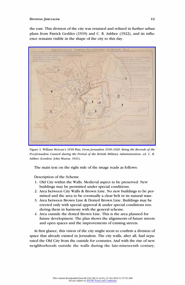
the east. This division of the city was retained and refined in further urban
plans from Patrick Geddes (1919) and C. R. Ashbee (1922), and its influ-
ence remains visible in the shape of the city to this day.
The main text on the right side of the image reads as follows:
Description of the Scheme
1. Old City within the Walls. Medieval aspect to be preserved. Newbuildings may be permitted under special conditions.
2. Area between City Walls & Brown Line. No new buildings to be per-mitted and the area to be eventually a clear belt in its natural state.
3. Area between Brown Line & Dotted Brown Line. Buildings may beerected only with special approval & under special conditions ren-dering them in harmony with the general scheme.
4. Area outside the dotted Brown Line. This is the area planned forfuture development. The plan shows the alignments of future streetsand open spaces and the improvements of existing streets.
At first glance, this vision of the city might seem to confirm a division of
space that already existed in Jerusalem. The city walls, after all, had sepa-
rated the Old City from the outside for centuries. And with the rise of new
neighborhoods outside the walls during the late-nineteenth century,
Figure 1. William McLean’s 1918 Plan. From Jerusalem 1918–1920: Being the Records of the
Pro-Jerusalem Council during the Period of the British Military Administration, ed. C. R.
Ashbee (London: John Murray, 1921).
DIVIDING JERUSALEM 11
This content downloaded from 66.134.128.11 on Fri, 31 Oct 2014 11:37:52 AMAll use subject to JSTOR Terms and Conditions
Jerusalemites may have already begun to have some concept of a ‘‘New
City.’’ However, the neighborhoods founded outside the wall in the late-
Ottoman period were established in close proximity to the Old City and
were still oriented toward Jerusalem’s holy sites. In addition, by the late-
Ottoman period, the city walls did not so sharply demarcate a separation
between the Old City and the rest of Jerusalem, for local businesses existed
directly outside the city walls with some abutting the wall itself, blurring
the lines between the Old City and the outside. McLean’s plan was quite
different. It proposed a city divided between an Old City, oriented around
holy sites, and a New City, centered on the administrative and commercial
buildings of Jaffa Street and the Russian Compound. British plans to
demarcate and police the boundaries between ‘‘old’’ and ‘‘new’’ space at
the city walls—especially the decision to create a green space around the
Old City—broke with past understandings of the urban fabric and became
the basis for the current separation between East and West Jerusalem.
This division of the city resembled colonial planning elsewhere in the
region, particularly in French North Africa. The plan for Jerusalem shared
the same bifurcated urban form promoted in Morocco under General Lyau-
tey, but there was one fundamental difference. Under French planning, the
‘‘backward’’ native medina was left to its own devices as planners concen-
trated on building a separate European ville moderne outside and separated
from native space. But in British planning, the Old City was not meant to
simply be a ‘‘conservatory of Oriental life,’’ as Nadia Abu El-Haj put it.20 With
its historical and religious sites, it was seen as the paradigmatic holy city, the
very object for which the colonial disciplines of archaeology and historical
preservation had been developed. Insisting that the Holy City needed their
love and attention, colonial experts never left the Holy City alone.
Another analog to the Palestinian situation might be found in the plan-
ning of colonial Bombay, where, as Preeti Chopra argues, British planners
intervened not only in the ‘‘white town’’ of European settlement but also
the ‘‘native town’’ or ‘‘black town’’ of Indian residence.21 But planning in
Palestine was different from planning in India or other colonies. Because
of the weight of the Balfour Declaration on British policy-making, planners
had to be cognizant of the needs not only of British settlers, but also of
Jewish settlers. For this reason, the New City was envisioned from the
beginning not so much as a space for British settlement, which was negli-
gible throughout the Mandate period, but as a space given over to Jewish
colonial settlement.
FIXING SPACE
British urban planners contended that Jerusalem could function effi-
ciently only if its modern elements (industry, commercial enterprises, and
government buildings) were separated from its traditional ones (religious
and historical sites). While the distinction between these spaces was easy
12 JOURNAL OF PALESTINE STUDIES
This content downloaded from 66.134.128.11 on Fri, 31 Oct 2014 11:37:52 AMAll use subject to JSTOR Terms and Conditions
to make on paper, it was much harder to sort out on the ground. In the
Old City, industrial and commercial enterprises mixed with religious
space, to the annoyance of British planners. Meanwhile, the presence of
monumental religious institutions, holy sites, and sectarian neighborhoods
outside the city walls was regarded as an obstacle to the establishment of
the New City. To maintain the plans’ crude distinction between the sacred
space of the Old City and the secular space of the new western neighbor-
hoods, planners, architects, and officials had to change how space was
used both within and outside the city walls.
One policy paper submitted to the Palestine government offered an
extreme proposal to fix space: transferring the Old City’s inhabitants to
neighborhoods outside the city walls, removing its industries, and destroy-
ing buildings that did not have a religious or educational purpose.22 The
actual plans adopted by the colonial government were much more
nuanced and less destructive than this proposal. But removal, demolition,
and expropriation were techniques planners advocated and government
agents carried out during the Mandate period. McLean’s 1918 plan called
for clearing buildings that abutted the walls of the Old City, removing
shops and a Turkish clock tower adjoining Jaffa Gate, and rebuilding a sec-
tion of the city wall that had been removed by the municipality in 1898.23
Geddes, who prepared the next plan, promoted the practice of ‘‘conserva-
tive surgery’’ to remove modern development from the city’s ancient
sites.24 And Ashbee, who followed, demanded ‘‘pulling down’’ all houses
and businesses abutting the ancient wall.25 These techniques of urban
planning and historic preservation destroyed autochthonous elements of
Jerusalem’s landscape: the clock tower, the businesses on top of and abut-
ting the wall, and the vegetation on the wall.
Operations to ‘‘clean-up’’ the Old City occurred mostly at its margins—
that is, at the walls and gates of the Old City or at the Citadel abutting the
Jaffa Gate—where planners saw themselves involved in a zero-sum compe-
tition between tradition and modernity. Addressing the inaugural meeting
of the PJS in French, its working language, Storrs made clear that such
measures were necessary to protect tradition in the Old City: ‘‘Est-ce qu’on
peut faire de Jerusalem (je parle toujours de Jerusalem intra muros) une
ville moderne? Oui, Messieurs, on peut; mais a une condition, qu’on la
detruise. Mais voila une tache a laquelle personne ne pourrait se livrer de
bonne conscience.’’26 What he did not add, but which was clear in his
Society’s attempts to move businesses and markets out of the Old City, was
that the Jerusalem outside the walls would be open to modern
development.
CONTROLLING ACTION
British planners strongly believed that Palestinians (both Arabs and Jews
of the old yishuv) lacked the sense of ‘‘civic consciousness’’ that Europeans
DIVIDING JERUSALEM 13
This content downloaded from 66.134.128.11 on Fri, 31 Oct 2014 11:37:52 AMAll use subject to JSTOR Terms and Conditions
(both Britons and Jewish immigrants) had. As Ashbee explained to readers
back home, ‘‘The impulse of the Moslem when he built was always dif-
ferent from ours. He never thought things out either in structure or in
policy. He picked up the beautiful fragments, botched them together,
made an exquisite patternwork that should help dreaming, then sat
down and dreamed.’’27 Ashbee’s dismissive attitude revealed a profound
ignorance of the work of the Jerusalem Municipality and the local Cham-
ber of Commerce, Industry, and Agriculture in promoting development
in the late-Ottoman period. He relied on an Orientalist belief in the
inability of non-Westerners to be agents of modernity.28 As the local
population could not be trusted with developing the city, British officials
instituted controls on local construction.
Storrs and McLean issued a proclamation on 8 April 1918 specifying that
no one could ‘‘demolish, erect, alter or repair the structure of any building
in the city or its environs within the radius of 2,500 meters of the Damas-
cus Gate until he had obtained a written permit from the authorities, the
penalty for the contravention being a fine not exceeding £P.200.’’29 Regu-
lations attached to the proclamation stated that in this area no buildings
could be constructed that would appear on the skyline of the Mount of
Olives; no building could be taller than eleven meters above ground level;
roofs could only be constructed out of stone; industrial buildings were
prohibited; and only buildings that were an extension of the small villages
would be permitted. Public notices followed that banned the use of stucco
and corrugated iron in construction, and prohibited placing advertise-
ments on the sides of buildings, all in an effort to keep the Old City look-
ing appropriately aged.
Gideon Biger has argued that these restrictions simply reflected the con-
servatism of a military authority committed to protecting the status quo, an
Ottoman policy originally adopted to protect preexisting religious arrange-
ments at the city’s holy sites but which was almost immediately used by the
colonial authorities to present Mandate rule as following ancient prece-
dent in religious and legal matters.30 Many scholars have noted how Brit-
ain’s Jewish national home policy broke its commitment to the status quo,
and the everyday proclamations and ordinances designed to control the
behavior of local residents constitute another example of Britain’s bad faith
in following Ottoman precedent. By shifting control over the entire con-
struction process from the municipality to the colonial state, British offi-
cials created a new system of oversight that consolidated the power to
rebuild the city in the hands of the planner. That power was soon extended
through the establishment of building codes to dictate how projects would
be drawn up, the introduction of permits to control which projects would
proceed, and the development of a system of fines to punish those who
ignored the government’s urban plan.31 The power of the state to control
construction was complete; the local population had no recourse to chal-
lenge the building process except through government agencies.32
14 JOURNAL OF PALESTINE STUDIES
This content downloaded from 66.134.128.11 on Fri, 31 Oct 2014 11:37:52 AMAll use subject to JSTOR Terms and Conditions
PRESERVING THE OLD CITY
With the British now in charge of the planning process, a new organiza-
tion was established in 1918 to direct the preservation of the Old City: the
Pro-Jerusalem Society. Consciously modeled on the National Trust for
Places of Historic Interest or Natural Beauty, which was founded in Britain
in 1895, the PJS brought the National Trust’s mission of preserving ‘‘places
of historic interest or natural beauty permanently for the nation to enjoy’’
to the streets of Jerusalem.33 The PJS made its understanding of urban
planning clear in its mission statement, which outlined its role in Jerusa-
lem as ‘‘saving the antiquities of the City, preserving its amenities, protect-
ing the Ancient City from industrial desecration, and laying out the
modern City with some sort of plan or dignity.’’34 Made up of leading
figures from various religious communities, it was intended to be a nongov-
ernmental organization representing all of the city’s inhabitants (though its
members also included a member of the Zionist Commission, an interna-
tional body).35 In practice, however, the PJS, with Storrs as its president
and Ashbee as its secretary, spoke for the interests of its British members
and until its dissolution in 1926 functioned as a semiofficial organ of the
government.36
Like the National Trust (founded by Ashbee’s mentor William Morris),
the PJS was primarily interested in preserving the past for public consump-
tion. Its projects almost exclusively concentrated on the Old City: rebuild-
ing the city’s suqs, reinstituting a walking path atop the city walls, cleaning
up the city gates, rehabilitating the citadel at Jaffa Gate, resuscitating
‘‘local’’37 handicraft industries, and creating schools in the Old City that
taught traditional crafts. As with the French authority’s planning efforts in
Morocco, the PJS ‘‘fell prey to the desire for stopping time and history that
is always implicit in a preservation campaign.’’38
Paradoxically, however, preservation also produced new historical fea-
tures. For example, Ashbee’s decision to recreate an old Ottoman guard
path on top of the rampart—which had been out of use for decades—led
to the removal of wild vegetation and numerous ‘‘encroachments’’ upon
the wall built by local residents, such as building extensions and secondary
walls to create private space, and ended the customary use of the wall for
family or business purposes.39 He justified these measures by arguing that
the PJS had a duty to protect such public historical spaces from private
development. But as Alan Crawford has argued, ‘‘That sharp sense of the
difference between public and private space which allowed Ashbee to
sweep away encroachments so ruthlessly was not a part of Jerusalem’s
urban traditions; and in making Jerusalem more explicitly a historical city,
Ashbee’s rampart walk also made it more modern.’’40
The re-creation of the ramparts walk was just one of a number of ways
that British planners preserved aspects of Jerusalem’s architectural and
craft history that were more relevant to them than to the local population.
DIVIDING JERUSALEM 15
This content downloaded from 66.134.128.11 on Fri, 31 Oct 2014 11:37:52 AMAll use subject to JSTOR Terms and Conditions
Such creative anachronism suggests that strict historical accuracy was not
always the most important value in preservation campaigns. The colonial
state instituted admission fees to the citadel and the ramparts walk;
erected street signs in English, Arabic, and Hebrew; showcased Jerusalem’s
history at local exhibits; and published numerous guide books to the Old
City. These decisions suggest that a more significant consideration for Brit-
ish officials was, despite their claims to the contrary, to turn the Old City
into a kind of living museum.
Repackaging the Old City in this way helped the colonial state gain
some control over the historical heritage of the city. The preservation of
the citadel, the walls, and city gates by the PJS and Palestine’s Department
of Archaeology extended British oversight to some of the city’s most visible
elements, whose images the state in turn used on Palestinian stamps and
banknotes and in fundraising campaigns back home in Britain. Moreover,
through these preservation campaigns, the state became an actor on the
ground in the Old City, establishing a presence that allowed it to control
access to and monitor the use of space.
ESTABLISHING THE NEW CITY
In contrast, the hillsides of western Jerusalem were ‘‘envisaged as a mod-
ern urban metropolis, a counterbalance to both the history-laden Old City
and the first Jewish quarters outside the walls.’’41 New buildings and
neighborhoods had been established outside the Old City during the latter
years of Ottoman rule, and at the time of the British conquest approxi-
mately 2,000–2,400 Muslims, 20,000 Jews, and 5,000–6,000 Christians
lived outside the Old City.42 A growth in population outside the city walls
in the latter part of the nineteenth century had been accompanied by the
construction of modern public features in the new neighborhoods such as
a municipal hospital (1890), a municipal park (1891), a museum of antiq-
uities (1901), a theater (1901), public toilets, and places for public leisure,
like cafes and bookstores.43
The civic-minded Jerusalem municipality had also undertaken beautifica-
tion projects, including tree-planting, erecting street lamps, street cleaning,
and paving roads. But to British planners, who used Ottoman modernity as
a foil to their superior understanding of modern development, those efforts
were amateurish at best. To Geddes, ‘‘the new town, outside the walls, has
much lacked good laying out hitherto. It has too many dull and confused
masses of buildings, even in overcrowding and slum.’’44
Before the New City could be built, land had to be made available. At
the time, most of the convenient, undeveloped land outside the city walls
was owned by religious groups and rarely sold. But the insolvency of the
Greek Orthodox Patriarchate after World War I and the Russian Revolution
allowed the Palestine government an opportunity in the early 1920s to
bring some of this land onto the market by forcing the Orthodox Church
16 JOURNAL OF PALESTINE STUDIES
This content downloaded from 66.134.128.11 on Fri, 31 Oct 2014 11:37:52 AMAll use subject to JSTOR Terms and Conditions
to sell some of its landholdings in West Jerusalem to remain solvent.45
Since this land, established as waqf (a religious endowment), was by tradi-
tion inalienable, the decision clearly went against the British pledge to
protect the status quo.46 But the sale went forward because it made sense
both for the dual-city plan and for granting Zionist immigrants, who were
demanding land in the city, a space to construct new neighborhoods.
Construction in the New City was guided by the terms of the 1921 Town
Planning Ordinance, which with its various amendments controlled all
urban planning and construction in the country.47 Based on the British
Housing and Town Planning Act of 1919, the ordinance prohibited
unplanned construction, and called for the preparation of a detailed blue-
print for every town in Palestine and the establishment of local committees
to regulate building proposals and issue permits. The ordinance made
clear what type of development would take precedence by stating that
local municipalities would be expected to expropriate lands and buildings
‘‘for the purpose of widening existing roads, or opening new roads, for
housing requirements, including garden villages, for public gardens or pub-
lic squares, public buildings, hospitals, schools, museums or cemeteries and
kindred purposes.’’48 Tellingly, allocating space for religious buildings in the
New City was not considered or promoted at all in the ordinance.
In contrast to the Ottoman custom of ruling from the Old City, the
planners established the political prominence of the New City by locating
all of the institutions of the Government of Palestine outside the city
walls.49 Unlike the French in Rabat, the parsimonious British did not insti-
tute a formal program of colonial construction. Instead, British officials
took over preexisting buildings, such as the Augusta Victoria Building on
the Mount of Olives (the first residence of the high commissioner) and the
Russian Compound on Jaffa Road (home to the colonial law courts, the
police headquarters, the prison, the municipality, the government’s sta-
tionary and printing offices, and other government offices). Although these
buildings had not been part of any religious endowment, they had been
previously owned by religious groups and used for religious purposes.
Their conversion to government space represented another example of
how space in the New City became more secular under British rule.50
The creation of a downtown commercial district also contributed to the
modernization of the New City. The government promoted commercial
zones in town planning ordinances, provided concessions to encourage
business development, and made land that had previously been part of the
Greek Orthodox waqf available to commercial businesses and Jewish land-
purchasing agencies. British policies also encouraged modern forms of
residential development. But in a break with the past, new neighborhoods
were not oriented toward the Old City but toward the commercial and
governmental institutions of the New City.
New Jewish neighborhoods—Talpiot (1922), Rehavia (1924), Beit
Hakerem (1924), Makor Hayim (1924), Kiryat Moshe (1925), and Bayit
DIVIDING JERUSALEM 17
This content downloaded from 66.134.128.11 on Fri, 31 Oct 2014 11:37:52 AMAll use subject to JSTOR Terms and Conditions
Vegan (1928)—were built according to the principles of the English Gar-
den City movement and were settled by Zionist immigrants as secular set-
tlements within the urban environment.51 Some Arab families, particularly
affluent Christians, also settled in the New City in the 1920s to be closer to
their jobs, moving to such neighborhoods as Talbiyya, Qatamun, Baqa‘a,
the German Colony, and the Greek Colony. However, Arab settlement was
not as significant to the growth of the New City, as fewer Arabs settled
there (by the end of the Mandate, the New City had 97,000 Jews versus
31,500 Arabs).52 Most Arab families remained in the Old City; when they
did move outside the city walls, they settled in these new western neigh-
borhoods but also in neighborhoods to the north and northeast of the Old
City, including the older Shaykh Jarrah and Bab al-Zahara neighborhoods,
which British planning did not consider part of the New City. Further-
more, the gerrymandered way in which the British authorities drew the
boundaries of Jerusalem included areas of Jewish settlement to the west
of the Old City, but not Arab settlements immediately adjacent to the east,
such as Silwan and Azariyya. Local Arabs also had less influence in the
planning of the New City because they lacked the same kind of cozy rela-
tionship that Zionist land purchasers and developers had with British
officials.
NEW AND OLD ROLES FOR JERUSALEMITES
In addition to controlling the construction activities of local residents,
British urban planners also worked to change their ‘‘civic consciousness’’
by giving them new roles to play in British Jerusalem. Education was one
part of this effort, with Geddes putting on the Civics and Town Planning
Exhibition in Jerusalem and Ashbee promoting craft schools and civic
guilds in order to inculcate a sense of civic pride among the local popu-
lace. But more significant was the manner in which planning itself created
new roles for Jerusalemites. In British planning, the inhabitants of the Old
and New Cities were given rather different roles to play.
Those who lived in the Old City (the majority of whom were Arab) were
cast in the passive role of guardians of the city’s religious heritage. As
a result, they were neither expected nor allowed (thanks to restrictive build-
ing ordinances) to actively participate in the planning and construction of
Jerusalem. In contrast, individuals who lived in the New City (predomi-
nantly Jews) were expected to be part of the city’s modern development and
were given a leading role in the construction effort. This replicated the
imbalance of roles crafted for Jews and Palestinian Arabs in the Balfour
Declaration and the Mandate for Palestine. Jews were recognized as hav-
ing national rights and were given a political role in British Palestine,
while Arabs, referred to in the declaration merely as ‘‘the non-Jewish
inhabitants of Palestine,’’ were granted only the protection of their civil
and religious rights.
18 JOURNAL OF PALESTINE STUDIES
This content downloaded from 66.134.128.11 on Fri, 31 Oct 2014 11:37:52 AMAll use subject to JSTOR Terms and Conditions
The limitations that these roles imposed on the Arab community
became apparent within the first few years of the British occupation. On
the one hand, Arab groups were encouraged to participate in the preser-
vation of religious sites. The Supreme Muslim Council, created by the
British in 1922, was enlisted in the mid-1920s to play the leading role in
a British-inspired project to refurbish the Haram al-Sharif. It was warmly
praised by British officials for its success in securing financial and moral
support from the wider Muslim world.53 But when Arab groups tried to
intervene in planning projects outside the Old City, officials were not so
welcoming.
As early as September 1919, members of the Muslim-Christian Associa-
tion, a nonsectarian nationalist group founded by the older generation of
the Palestinian notability, complained that Arabs were not being included
in British plans for the city. Though they accepted that Patrick Geddes was
‘‘one of the authorities in town planning,’’ they questioned his impartiality
because of his work for the Zionist Organization in drawing up plans for
the Hebrew University.54 Their criticisms show that members of the Arab
elite accepted the importance of town planning—giving lie to the British
idea that Arabs lacked an understanding of urban development—but rec-
ognized its potential to be abused for political purposes.
In a 1925 memorandum submitted to the League of Nations, the Arab
Executive pointed out this abuse by detailing how British urban planning
was promoting Zionist settlement in Jerusalem at the expense of the
city’s Arab community.55 The first of these complaints dealt with the dis-
posal of the landholdings of the insolvent Greek Orthodox Church in the
New City, which I have discussed earlier. The division of that land into
small plots by the British authorities, ostensibly to discourage land spec-
ulation, was argued to be a deliberate act of favoritism toward the Jewish
community because it allowed Zionist land purchasing agencies to buy
land at a reduced rate.
A second complaint addressed the response of the British authorities to
the overflow of waste from a sewage system (built for the Jewish neighbor-
hood of Mea Sha’arim in 1920 with outside funding from the Zionist Exec-
utive). The waste overflow caused the contamination of ‘‘the Muslim
quarters of Shaikh Jarrah, Wadil Joz and Babil Zahira [sic], and the very
sacred vicinity of St. Mary’s Tomb’’ in January 1922.56 Here, the British
revealed their favoritism toward the Jewish community through the gov-
ernment’s failure to respond to Arab petitions and their unwillingness to
reroute the sewage system away from Arab areas, despite the fact that this
measure had been recommended by a British expert brought in from
Egypt.
A final complaint was aimed at the Government of Palestine’s treat-
ment of the Mamilla Cemetery, Jerusalem’s oldest Muslim cemetery. Due
to the explosive growth of predominantly Jewish neighborhoods pro-
moted by British urban planning around the cemetery, the British urged
DIVIDING JERUSALEM 19
This content downloaded from 66.134.128.11 on Fri, 31 Oct 2014 11:37:52 AMAll use subject to JSTOR Terms and Conditions
the Muslim authorities (specifically the Supreme Muslim Council) to close
the cemetery—that is, discontinue burial there—for public health reasons.
Explaining that the medical experts of the Supreme Muslim Council had
found nothing wrong with the tombs (there is no evidence that the testi-
mony of these experts was presented to the League of Nations), the Arab
Executive accused the government of using the public health explanation as
a pretext for controlling the use of ‘‘the only Muslim Cemetery in the neigh-
borhood of Jewish quarters.’’57
These complaints of the Arab Executive, like that of the Muslim-
Christian Association earlier, did not so much criticize the practice of
urban planning, but the way that it threatened Muslim neighborhoods and
holy sites in Jerusalem. In these complaints we can see how the Arab elite
saw planning in the New City as a tool of the colonial agenda that margin-
alized their input and favored the needs of the city’s mostly secular Zionist
immigrants. This suspicion was shown in the Arab Executive’s opinion of
the British reaction to the Zionist sewage project: ‘‘On the face of it the
undertaking seemed to be [a] very plausible one, had there been any sin-
cerity in it. It was found later that the undertaking was carried on for polit-
ical propaganda rather than for Public Health.’’58
The British response was to brush all of these Arab criticisms aside,
which was not surprising because the colonial authorities never recog-
nized the Muslim-Christian Association or the Arab Executive as represen-
tatives of the Arab community. British officials boldly stated to the Muslim-
Christian Association that the issue of ‘‘the town planning of Jerusalem is
entirely one for the Administration to deal with.’’59 In response to the Arab
Executive’s complaints, officials granted that the drainage project was
problematic but was only a ‘‘temporary nuisance’’ and that the closing of
the Mamilla Cemetery would not involve any ‘‘serious hardship as Muslim
burials could still take place on the east side of the city.60 The overall tone
of the British responses was one of condescension, for while it was granted
that a few procedural mistakes had been made, their planning should not
be questioned, least of all by these Arab groups.
This treatment contrasted greatly with the role given to neighborhood
committees and building cooperatives in the New City, the bulk of which
were Jewish and overwhelmingly Zionist in orientation.61 Zionist land pur-
chasing agencies, architects, and neighborhood committees all partici-
pated closely in shaping the New City. The Palestine Land Development
Company, dedicated to the development of the Jewish community, was
particularly instrumental in purchasing land in the New City as part of the
release of Greek Orthodox lands. Its participation at a seminal stage in the
planning process was unique and met with ‘‘sharp objections from Muslim
and Christian circles resistant to the sales of church lands to Jews.’’62
Despite these protests, it was commonplace for British planners to work
with Zionist groups, a partnership that built on British support for the estab-
lishment of the Jewish national home, and the British belief that, despite
20 JOURNAL OF PALESTINE STUDIES
This content downloaded from 66.134.128.11 on Fri, 31 Oct 2014 11:37:52 AMAll use subject to JSTOR Terms and Conditions
occasional differences, Zionists were working toward the same kinds of
modernist (and colonial) goals as the British administration.63
1948 AND BEYOND
British colonial urban planning rebuilt Jerusalem as a divided city. In
the Old City, the ‘‘cleaning-up’’ of space led to the production of a more
orderly city that could easily show off its religious and historical value to
the world. Urban planning was one of a number of tools that British offi-
cials used to transform the Old City into a more traditional and religious
space. Measures such as the prohibition of prostitution, bars, cabarets, and
dance halls in the Old City; the designation of certain areas as closed
archaeological sites; and the prohibition of major industry and commerce
within the city walls were also adopted to create a cleaner and more
orderly space that fit with British prejudices about how a holy city should
look and operate.64
Meanwhile, the New City with its bourgeois neighborhoods and its
downtown commercial district became the modern face of Jerusalem. The
establishment of the seat of colonial government in the New City also
meant that Jerusalem’s political heart was located outside of the city walls
for the first time in history. That heart was now European and Christian,
hastening Jerusalem’s ‘‘transformation into a more European city both in
terms of physical appearance and in demographic composition and cul-
ture.’’65 No longer the nineteenth-century Arab-Islamic city, which had
been centered in the Old City and tied to a Jordanian hinterland, Jerusa-
lem was now a colonial capital linked to the world market and imperial
politics.
The eclipse of the Old City by West Jerusalem affected the city’s various
communities in different ways. The growth of the New City undoubtedly
represented a political and economic upswing for the Jewish community,
particularly for Zionist immigrants. A local newspaper article summed up
the pride felt by these immigrants:
The transformation of Jerusalem from the stronghold onlyof the old orthodox Yishuv into the centre of activity for allbranches of Hebrew life in Eretz Israel is gradually takingplace. The new large offices of the Zionist Commissionhave been opened, situated in the Jaffa Road opposite theGan Ha’ir and the American Zionist Medical Unit offices.The Departments, so far, include Political Committee,Relief, Finance, Agriculture and Colonization, Trade andIndustry, Secretariat . . . [T]he progressive community inJerusalem will increase as a result of the city’s becomingthe headquarters of the Zionist Administration.66
Given a role in planning by the British authorities that had previously been
denied them under the Ottomans, Zionist Jews worked closely with
DIVIDING JERUSALEM 21
This content downloaded from 66.134.128.11 on Fri, 31 Oct 2014 11:37:52 AMAll use subject to JSTOR Terms and Conditions
colonial planners (their offices were just down the road from each other)
in drawing up neighborhood plans and applied for far more building per-
mits than any other community. Indeed, the confidence of the new yishuv
was so great that there were calls within it for the creation of a separate
New City municipality that would allow it to secede from the Jerusalem
municipality, much as Tel Aviv had broken away from Jaffa.67 Zionists also
became adept at using the language of urban planning within their con-
quest of land, as shown in their calls for the removal of the Maghrebi quar-
ter adjacent to the Western Wall on the grounds that it was aesthetically
displeasing, unsanitary, and had no place in a modern city.68
The effect on the Arab community was much less positive. Around
97 percent of the nearly 100,000 Jews living in Jerusalem in 1947 lived in
the New City, whereas roughly 48 percent or 31,500 of the 65,000 Arab
inhabitants lived there, with Arab Christians settling outside the city walls
in greater numbers than Muslims.69 Movement to the New City was expen-
sive and limited to the wealthy, given the fact that Arabs, unlike Jewish
immigrants, did not receive any assistance from outside land-purchasing
agencies. Moreover, the strong symbiotic relationship that existed between
Arab neighborhoods in the old and new cities meant that there was less
pressure to build an enclosed, self-sufficient Arab community in the New
City.70 Most importantly, the British did not invite Arabs to take a promi-
nent role in the New City. As a result, most Arabs and certainly the bulk of
the Muslim community remained in the Old City, where British preserva-
tion policies prohibited them from building viable commercial, industrial,
and political institutions for the national struggle. The results were devas-
tating, as the mayor of Jerusalem, Ruhi al-Khatib, observed in 1949: ‘‘Our
heritage from the Mandate government in this part of Jerusalem was a dis-
tressed city of shaking buildings, a paralyzed commerce and industry,
devoid of any financial resources and without a government, water, or
electricity.’’71
British control over urban planning also undoubtedly had a profoundly
negative impact on how the city’s communities worked and lived together.
Not only was the city more divided under British rule, but the colonial
state’s control over planning meant that the city’s
various communities had little opportunity or incen-
tive to come together to work on development pro-
jects. Gone was the shared experience, described by
Michelle Campos, of Jews, Christians, and Muslims
coming together to work on civic projects, an expe-
rience that strengthened their sense of sharing an
identity as Jerusalemites and Ottoman citizens.72 To
be sure, conflicts over the Western Wall and other
sites in the city did the most damage in destroying
this shared sense of space. But urban planning, with its rigid demarcation
of space, also played its part. Indeed, further research on British planning
The colonial state’s control
over planning meant that
Jerusalem’s various
communities had little
opportunity or incentive to
come together to work on
development projects.
22 JOURNAL OF PALESTINE STUDIES
This content downloaded from 66.134.128.11 on Fri, 31 Oct 2014 11:37:52 AMAll use subject to JSTOR Terms and Conditions
may well reveal that it contributed directly to conflict and competition over
the city’s holy sites.
The war of 1948 all but eliminated the Arab presence in the New City
and the Jewish presence in the Old City, and policies since then, such as
renaming roads and neighborhoods, have worked to wipe out traces of
that presence. Because of this, the history of urban planning in Jerusalem
has often been written as the triumphant story of the development of Jer-
usalem as the capital of the Jewish state.73 In this teleology, the Arab pres-
ence in the New City has been consistently and comprehensively occluded,
as Rochelle Davis and Salim Tamari have pointed out.74 What is also true is
that the British colonial presence has been ignored. The colonial state’s
vision of the city and its empowerment of certain groups over others had
a profound effect on the development of Jerusalem. This should not be
forgotten and deserves further study by historians.
ENDNOTES
1. ‘‘Liberation of Jerusalem: Messagefrom General Clayton for PressPublication,’’ The National Archives ofthe UK (TNA), Public Records Office(PRO), FO 371/3383/9333.
2. Herbert Samuel, ‘‘The Future ofPalestine,’’ p. 2, Middle East Archives,St. Antony’s College, Oxford University,Samuel papers.
3. See Gideon Biger, An Empire in theHoly Land (New York: St. Martin’s Press,1994); Gideon Biger, The Role of theBritish Administration in Changing theGeography of Palestine 1918–1929(London: University College London,1981); and Rosa el-Eini, ‘‘The Impact ofBritish Imperial Rule on the Landscapeof Mandate Palestine 1929–1948’’ (PhDdiss., Hebrew University, 2000).
4. See Ron Fuchs and Gilbert Herbert,‘‘A Colonial Portrait of Jerusalem: BritishArchitecture in Mandate-Era Palestine,’’ inHybrid Urbanism: On the IdentityDiscourse and the Built Environment,ed. Nezar AlSayyad (London: Praeger,2001), pp. 83–108.
5. See Ruth Kark, JerusalemNeighborhoods: Planning and By-laws1855–1930 (Jerusalem: Magnes Press,1991); Ruth Kark and Michael Oren-Norheim, Jerusalem and Its Environs:Quarters, Neighborhoods, Villages1800–1948 (Jerusalem: HebrewUniversity, 2001); and David Kroyanker,Jerusalem Architecture (New York:Vendome Press, 1994). For Arab
neighborhood development, seeRochelle Davis, ‘‘The Growth of theWestern Communities, 1917–1948,’’ inJerusalem 1948: The Arab Neighborhoodsand Their Fate in the War, ed. SalimTamari (Jerusalem: Institute ofPalestinian Studies, 1999), pp. 32–53.
6. Michelle Campos, OttomanBrothers: Muslims, Christians, and Jewsin Early Twentieth-Century Palestine(Stanford, CA: Stanford University Press,2011).
7. The subject of interconfessionalinteraction and solidarity in late-Ottoman Jerusalem has also been cov-ered in Salim Tamari, ‘‘Jerusalem’sOttoman Modernity: The Times andLives of Wasif Jawhariyyeh,’’ JerusalemQuarterly 9 (Winter 2000), p. 27 andSalim Tamari, ‘‘Wasif Jawhariyyeh,Popular Music, and Early Modernity inJerusalem,’’ in Palestine, Israel, and thePolitics of Popular Culture, ed. RebeccaL. Stein and Ted Swedenburg (Durham,NC: Duke University Press, 2005),pp. 27-50.
8. Campos, Ottoman Brothers, pp.231, 250. The promotion of a communi-tarian approach under British rule hasalso been discussed at length in RashidKhalidi, The Iron Cage: The Story of thePalestinian Struggle for Statehood (NewYork: Beacon Press, 2006).
9. Ronald Storrs, The Memoirs of SirRonald Storrs (New York: Putnam, 1937),p. 324.
DIVIDING JERUSALEM 23
This content downloaded from 66.134.128.11 on Fri, 31 Oct 2014 11:37:52 AMAll use subject to JSTOR Terms and Conditions
10. C. R. Ashbee, A PalestineNotebook 1918–1923 (New York:Doubleday, 1923), p. 3.
11. For example, British officers inPalestine were encouraged to emphasizethe city’s holy sites in their reportingback to London. TNA, PRO, FO 371/3383/9333.
12. The idea that authenticity wasfound in material objects had earlierbeen part of the British PalestineExploration Fund’s assessment ofPalestine. See Nadia Abu El-Haj, Facts onthe Ground: Archaeological Practice andTerritorial Self-Fashioning in IsraeliSociety (Chicago: University of ChicagoPress, 2001), p. 27.
13. Palestine Weekly, 8 October 1920,p. 597, accessed in Jerusalem CityArchives, Box 361.
14. Social reformers and adminis-trators were influenced by the successesof Hausmann’s redevelopment of Paris,the Garden City movement in Britain,and the City Beautiful movement in theUnited States.
15. Such tools of reform were deemedparticularly necessary following Britain’sabject performance in the South Africanwars. See Anna Davin, ‘‘Imperialism andMotherhood,’’ in Tensions of Empire:Colonial Cultures in a Bourgeois World,ed. Ann Laura Stoler and FrederickCooper (Berkeley: University ofCalifornia Press, 1997), pp. 87–151.
16. Royal Town Planning Institute,Planning for Town and Country: Contextand Achievement 1914–1989 (London:Royal Town Planning Institute, 1989),p. 10.
17. For an overview of planningthroughout the empire, see RobertHome, Of Planting and Planning: TheMaking of British Colonial Cities (NewYork: Routledge, 2013).
18. Storrs, Memoirs, p. 106.19. Henry Kendall, Jerusalem, the City
Plan: Preservation and Developmentduring the British Mandate 1918–1948(London: His Majesty’s Stationary Office,1948), p. 6. Kendall himself was a govern-ment town planner in Palestine duringthe 1940s.
20. Abu El-Haj, Facts on the Ground,p. 67.
21. Preeti Chopra, ‘‘Refiguring theColonial City: Recovering the Role ofLocal Inhabitants in the Construction of
Colonial Bombay,’’ Buildings &Landscapes 14 (2007), pp. 109–25.
22. Shlomo Fonaroff, ‘‘A ReconstructionScheme for the Old City of Jerusalem,’’Jerusalem City Archives, Box 3593, File33. A footnote on the proposal indicatesthat the paper was initially read ata meeting of architects and engineerson 23 July 1943, and was later pub-lished in the Journal of the Associationof Engineers, although I could find noadditional information on the article.
23. The Ottomans had removed partof the city wall near Jaffa Gate to accom-modate the entrance of Kaiser Wilhelm IIinto Jerusalem in 1898.
24. Patrick Geddes, Cities in Evolution:An Introduction to the Town PlanningMovement and to the Study of Civics(New York: Harper and Row, 1971), p. 601.
25. C. R. Ashbee, ‘‘Report by C. R.Ashbee on the Arts and Crafts ofJerusalem District,’’ p. 45, Jerusalem CityArchives, Ashbee Files, Box 361.
26. ‘‘Is it possible to make ofJerusalem—and I’m speaking here ofJerusalem intra-muros—a modern city?Yes, good sirs, it is, on one condition:that we destroy it. But this is a task thatno one could undertake in good con-science.’’ Jerusalem City Archives, AshbeeFiles, Box 362.
27. Ashbee, Palestine Notebook, p. 52.28. For more information on their
efforts, see Campos, Ottoman Brothers,pp. 166–82.
29. Kendall, Jerusalem, the City Plan,p. 4.
30. Biger, Empire, pp. 198–200,248–252.
31. Alan Crawford, C. R. Ashbee:Architect, Designer & Romantic Socialist(New Haven: Yale University Press, 1985),p. 179.
32. The Town Planning Ordinance of1921 stated that objections to town plan-ning could be brought only to the officesof the Local Town Planning Commission.
33. This information is taken from theNational Trust’s website: http:/www.nationaltrust.org.uk. Information on theNational Trust had been requested by theGovernment of Palestine, and in hismemoir, Ashbee noted that the PJS hadbeen modeled after the National Trust.See Israel State Archives (ISA), RG 1/M/570/9 and Ashbee, Palestine Notebook,p. 139.
24 JOURNAL OF PALESTINE STUDIES
This content downloaded from 66.134.128.11 on Fri, 31 Oct 2014 11:37:52 AMAll use subject to JSTOR Terms and Conditions
34. Pro-Jerusalem Society QuarterlyBulletin, no. 1, accessed in JerusalemCity Archives, Ashbee Files, Box 361.
35. Members included the mayor andmufti of Jerusalem, the Franciscan custo-dian of the Holy Land, the Greek andArmenian patriarchs, the chief rabbi, thechairman of the Zionist Commission, andthe Anglican bishop of Jerusalem.
36. The PJS was the sole authority inurban planning until the establishment ofthe Central Town Planning Commissionunder the Town Planning Ordinance of1921. Even then, the PJS continued tohave a major influence, not least becausesome of its members also served on thenew commission. The PJS was dissolvedin 1926 when Storrs became the gover-nor and commander in chief of Cyprus.
37. An example of creative anachro-nism was the PJS’s revival of ‘‘local’’ crafttraditions. The revival of tile-making inJersualem, for example, combined theworkmanship of potters from Kutahya,Anatolia, with Persian pottery techniquesoriginally popularized in Britain byWilliam de Morgan. See Inbal Ben-AsherGitler, ‘‘C. R. Ashbee’s Jerusalem Years,’’Assaph Studies in the Arts 5 (2000), p. 36.
38. Gwendolyn Wright, ‘‘Tradition inthe Service of Modernity,’’ in Stoler andCooper, Tensions of Empire, p. 331.
39. One business use of the wall thatwas stopped was the baking of dungcakes on top of the wall. Crawford, C. R.Ashbee, p. 182.
40. Crawford, C. R. Ashbee, p. 182.41. Kroyanker, Jerusalem
Architecture, p. 145.42. The figures for the Jewish and
Muslim populations are taken from esti-mates provided by Yehoshua Ben-Ariehbased on Ottoman census data from theearly-twentieth century. The Ottomansonly counted households, and the figuresused to compare populations are takenfrom different years, so Ben-Arieh’s figurescan be treated only as rough estimates.See Yehoshua Ben-Arieh, Jerusalem in the19th Century: Emergence of the New City(Jerusalem: Yad Izhak Ben-Zvi, 1986), pp.240, 354. The figures for the Christiancommunity come from Rochelle Davis,‘‘Ottoman Jerusalem,’’ in Tamari,Jerusalem 1948, p. 17.
43. Ben-Arieh, Jerusalem, pp. 349–60;Davis, ‘‘Ottoman Jerusalem’’; and Kark,Jerusalem and Its Environs.
44. Geddes, ‘‘Town Planning inPalestine,’’ p. 601.
45. The land sales were undertaken byThe Commission Appointed by theGovernment of Palestine to Inquire intothe Affairs of the Orthodox Patriarchate ofJerusalem, which British officials estab-lished in 1921 to fix the financial pro-blems in the church.
46. The commitment to protecting thestatus quo began with General Allenbypledging in the very first speech of theoccupation that ‘‘every sacred building,monument, holy spot, shrine, traditionalsite, endowment, pious bequest, or cus-tomary place of prayer, of whatsoeverform of these three religions, will bemaintained and protected according tothe existing customs and beliefs of thoseto whose faiths they are sacred.’’ Kendall,Jerusalem City Plan, p. 8.
47. Biger, Empire, p. 198.48. Biger, Empire, p. 7.49. Some administrative buildings had
been built shortly before the British con-quest, such as the municipality buildingat the junction of the Jaffa and MamillaRoads and the law courts built nearHerod’s Gate. These were exceptions tothe Ottoman practice of housing govern-ment institutions in the Old City.
50. The Augusta Victoria Hospital wasthe original residence of the high com-missioner in Palestine. A new purpose-built Government House was opened in1933 in southern Jerusalem. The RussianCompound was originally established inthe nineteenth century to house the greatnumber of Russian pilgrims that wouldvisit Jerusalem every year but fell intofinancial difficulty after the RussianRevolution and was rented out to theBritish.
51. In the words of David Kroyanker,they ‘‘represented a clean break, concep-tually and physically, from the crampedghettolike traditional neighborhoods.’’Kroyanker, Jerusalem Architecture,p. 157.
52. Davis, ‘‘Growth of the WesternCommunities,’’ p. 40. Davis uses ‘Arifal-‘Arif’s statistics from al-Mufassal fiTarikh al-Quds.
53. Ernest Richmond, director ofantiquities and head of the renovationproject, wrote in his report that ‘‘a moreappreciative outlook’’ toward the monu-ments had developed not only by the
DIVIDING JERUSALEM 25
This content downloaded from 66.134.128.11 on Fri, 31 Oct 2014 11:37:52 AMAll use subject to JSTOR Terms and Conditions
Supreme Muslim Council, but, among‘‘educated Moslems’’ more generally. TNA,PRO, CO 733/160/12.
54. Muslim-Christian Society to chiefadministrator of Occupied EnemyTerritory Administration (South), 18September 1919, ISA, RG 2/M/4/140.
55. Executive Committee of thePalestine Arab Congress to League ofNations, 8 April 1925, ISA, RG 2/6/176.
56. ISA, RG 2/6/176.57. ISA, RG 2/6/176.58. ISA, RG 2/6/176.59. Chief Administrator’s Office to the
president of the Moslem-ChristianSociety, undated, ISA, RG 2/M/4/140.
60. The British response is found ina short paper, ‘‘Comments by HisMajesty’s Government on the petitions ofthe Executive Committee of the PalestineArab Congress; April 1925,’’ ISA, RG 2/M/4/140. Interestingly the British view ofthe drainage problem was strongly con-tested by Ashbee, whose own house hadbeen destroyed. See ISA, RG 1/574/4, 574/7. The episode is further discussed inAshbee’s Palestine Notebook.
61. Traditional Jewish neighborhoodsin the New City were looked upon witha certain amount of contempt by Britishand Zionist officials and were not inten-ded to have a role in the modernizationof the New City.
62. Kroyanker, JerusalemArchitecture, p. 145.
63. This belief also reflected a stereo-typical idea that ‘‘innumerable benefitswill accrue to the country by the applica-tion of Jewish money and brains.’’ Cox toHaifa military governor, 28 November1919, ISA, RG 2/M/4/140.
64. Storrs, Memoirs, p. 416.65. Michael Dumper, The Politics of
Jerusalem Since 1967 (New York:Columbia, 1997), p. 18.
66. Elias Epstein, JerusalemCorrespondent (Jerusalem: JerusalemPost Press, 1964), p. 35.
67. This turning away fromJerusalem was criticized heavily by
Zionist leaders. See Kark, Jerusalemand Its Environs.
68. During his aborted attempt tobuy the Western Wall in 1918, ChaimWeizmann made his case by arguingin a letter to Arthur Balfour that theWall was
surrounded by a group of miserable,dirty cottages and derelict buildings,which makes the whole place fromthe hygienic point of view a sourceof constant humiliation to the Jewsof the world. Our most sacred mon-ument, in our most sacred city, is inthe hands of some doubtful Mogh-reb religious community, whichkeeps these cottages as a source ofincome. We are willing to compen-sate this community very liberally,but we should like the place to becleaned up; we should like to give ita dignified and respectableappearance.
See Weizmann to Balfour, 30 May 1918,Central Zionist Archives (CZA), L3/310.The erasure of the Maghrebi neighbor-hood would ultimately be achieved bythe Israeli government in the wake of itsvictory in the 1967 war.
69. Davis, ‘‘Growth of the WesternCommunities,’’ p. 40. Davis uses ‘Arifal-‘Arif’s statistics from al-Mufassal fiTarikh al-Quds.
70. The social and economic interde-pendence of the Arab sections of the cityinside and outside the city walls isdetailed in Davis, ‘‘Growth of the WesternCommunities.’’
71. Quoted in Davis, ‘‘Growth ofWestern Communities,’’ p. 54.
72. See ‘‘Sharing Urban Space’’ inCampos, Ottoman Brothers.
73. See for instance Kark, JerusalemNeighborhoods and Ben-Arieh,Jerusalem.
74. See Rochelle Davis, ‘‘WestJerusalem and the Politics of Refugees,’’Jerusalem Quarterly File 4 (Spring1999).
26 JOURNAL OF PALESTINE STUDIES
This content downloaded from 66.134.128.11 on Fri, 31 Oct 2014 11:37:52 AMAll use subject to JSTOR Terms and Conditions