Embed Size (px)
Citation preview
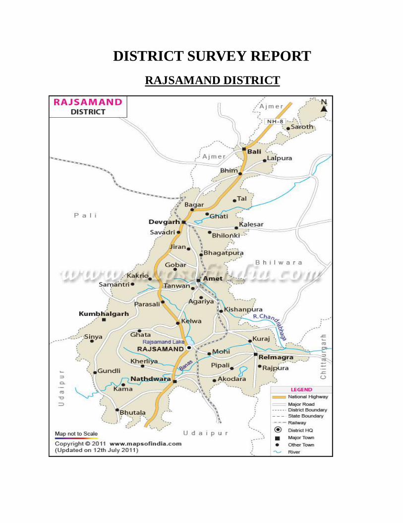
DISTRICT SURVEY REPORT
RAJSAMAND DISTRICT
2
CONTENT
Introduction
General profile of the district
Physiography of the district
Rainfall and climate
Land utilization pattern in the district
Geology and mineral wealth
Process of deposition of sediments in the rivers of the district
Overview of mining activity in rajsamand
Details of the royalty or revenue received in year 2015 -16
Details of production (in ton.) of mineral in the last three years
Annexure list of flora and fauna
3
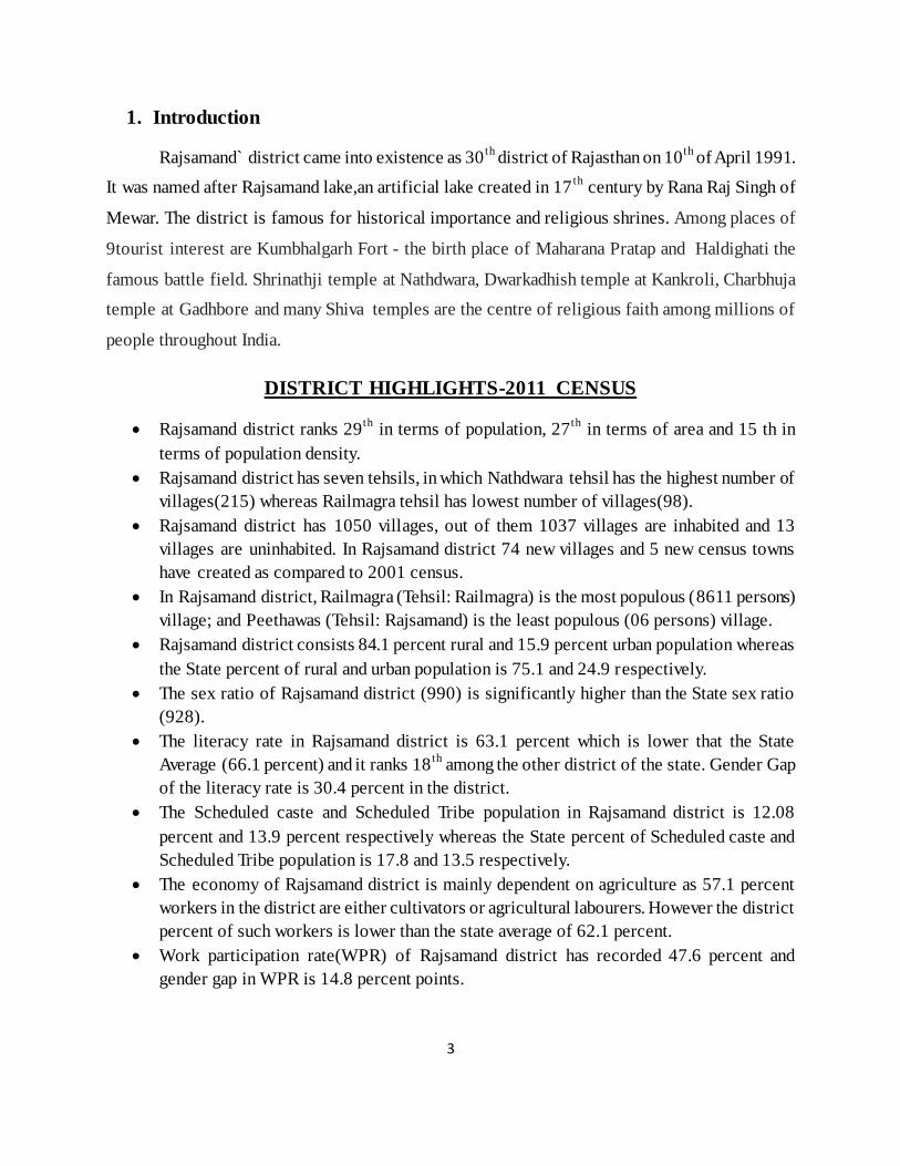
1. Introduction
Rajsamand` district came into existence as 30th
district of Rajasthan on 10th
of April 1991.
It was named after Rajsamand lake,an artificial lake created in 17th
century by Rana Raj Singh of
Mewar. The district is famous for historical importance and religious shrines. Among places of
9tourist interest are Kumbhalgarh Fort - the birth place of Maharana Pratap and Haldighati the
famous battle field. Shrinathji temple at Nathdwara, Dwarkadhish temple at Kankroli, Charbhuja
temple at Gadhbore and many Shiva temples are the centre of religious faith among millions of
people throughout India.
DISTRICT HIGHLIGHTS-2011 CENSUS
Rajsamand district ranks 29th
in terms of population, 27th
in terms of area and 15 th in
terms of population density.
Rajsamand district has seven tehsils, in which Nathdwara tehsil has the highest number of
villages(215) whereas Railmagra tehsil has lowest number of villages(98).
Rajsamand district has 1050 villages, out of them 1037 villages are inhabited and 13
villages are uninhabited. In Rajsamand district 74 new villages and 5 new census towns
have created as compared to 2001 census.
In Rajsamand district, Railmagra (Tehsil: Railmagra) is the most populous (8611 persons)
village; and Peethawas (Tehsil: Rajsamand) is the least populous (06 persons) village.
Rajsamand district consists 84.1 percent rural and 15.9 percent urban population whereas
the State percent of rural and urban population is 75.1 and 24.9 respectively.
The sex ratio of Rajsamand district (990) is significantly higher than the State sex ratio
(928).
The literacy rate in Rajsamand district is 63.1 percent which is lower that the State
Average (66.1 percent) and it ranks 18th
among the other district of the state. Gender Gap
of the literacy rate is 30.4 percent in the district.
The Scheduled caste and Scheduled Tribe population in Rajsamand district is 12.08
percent and 13.9 percent respectively whereas the State percent of Scheduled caste and
Scheduled Tribe population is 17.8 and 13.5 respectively.
The economy of Rajsamand district is mainly dependent on agriculture as 57.1 percent
workers in the district are either cultivators or agricultural labourers. However the district
percent of such workers is lower than the state average of 62.1 percent.
Work participation rate(WPR) of Rajsamand district has recorded 47.6 percent and
gender gap in WPR is 14.8 percent points.
4
In Rajsamand district among the workers the percentage of cultivators, agricultural
labourers, workers in household industry and other workers (category of workers) are
37.7,19.4, 2.5 and 40.5 percent respectively.
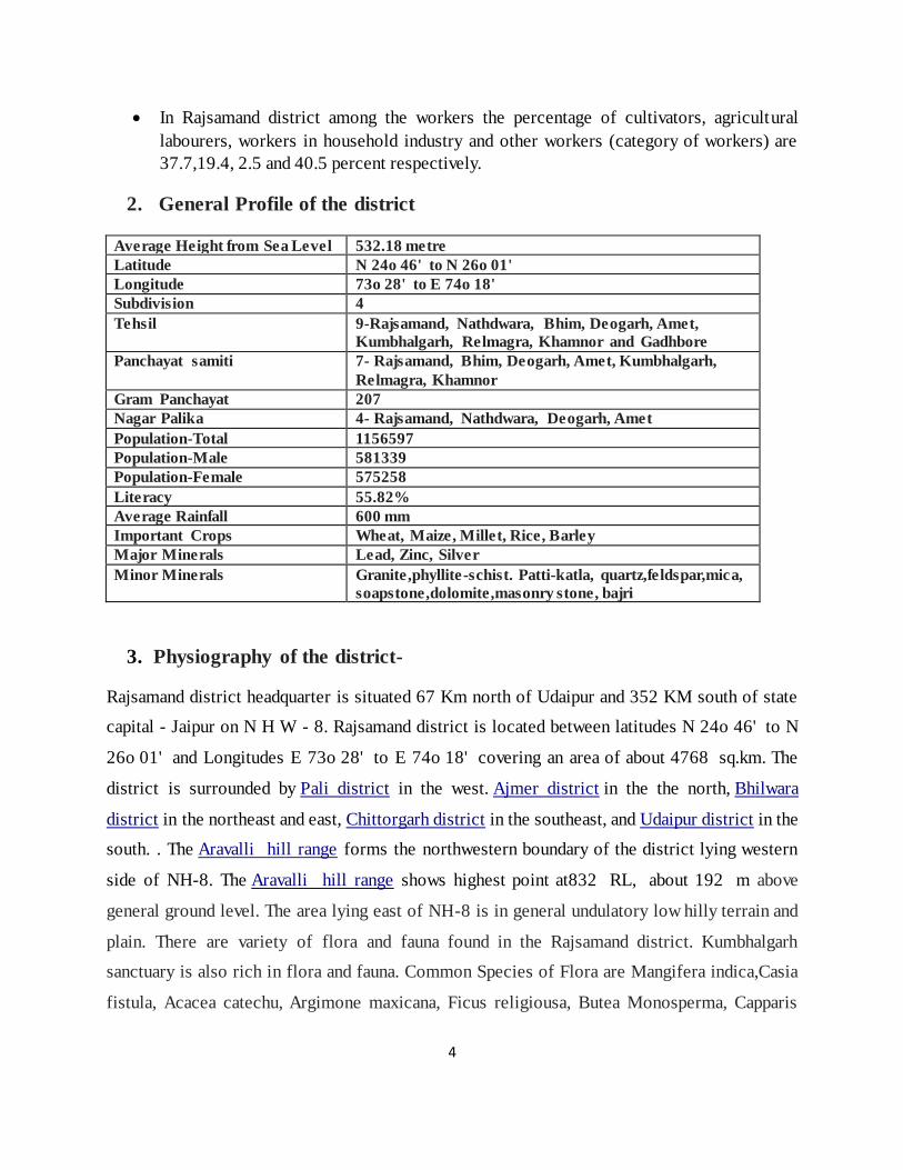
2. General Profile of the district
Average Height from Sea Level 532.18 metre Latitude N 24o 46' to N 26o 01' Longitude 73o 28' to E 74o 18' Subdivision 4
Tehsil 9-Rajsamand, Nathdwara, Bhim, Deogarh, Amet,
Kumbhalgarh, Relmagra, Khamnor and Gadhbore Panchayat samiti 7- Rajsamand, Bhim, Deogarh, Amet, Kumbhalgarh,
Relmagra, Khamnor Gram Panchayat 207 Nagar Palika 4- Rajsamand, Nathdwara, Deogarh, Amet
Population-Total 1156597 Population-Male 581339 Population-Female 575258
Literacy 55.82% Average Rainfall 600 mm Important Crops Wheat, Maize, Millet, Rice, Barley Major Minerals Lead, Zinc, Silver
Minor Minerals Granite,phyllite-schist. Patti-katla, quartz,feldspar,mica,
soapstone,dolomite,masonry stone, bajri
3. Physiography of the district-
Rajsamand district headquarter is situated 67 Km north of Udaipur and 352 KM south of state
capital - Jaipur on N H W - 8. Rajsamand district is located between latitudes N 24o 46' to N
26o 01' and Longitudes E 73o 28' to E 74o 18' covering an area of about 4768 sq.km. The
district is surrounded by Pali district in the west. Ajmer district in the the north, Bhilwara
district in the northeast and east, Chittorgarh district in the southeast, and Udaipur district in the
south. . The Aravalli hill range forms the northwestern boundary of the district lying western
side of NH-8. The Aravalli hill range shows highest point at832 RL, about 192 m above
general ground level. The area lying east of NH-8 is in general undulatory low hilly terrain and
plain. There are variety of flora and fauna found in the Rajsamand district. Kumbhalgarh
sanctuary is also rich in flora and fauna. Common Species of Flora are Mangifera indica,Casia
fistula, Acacea catechu, Argimone maxicana, Ficus religiousa, Butea Monosperma, Capparis
5
deciduas etc. Common Species of funa in the district are Panthera parades,Striped hyara, Jackal,
Lepus nigricollis, etc. Common Species of birds are Bulbul, Pigion, Koel Myna, House crow.
Flora Fauna of core and Buffer zone of the district as per forest department is annexed as
annexure no. 1
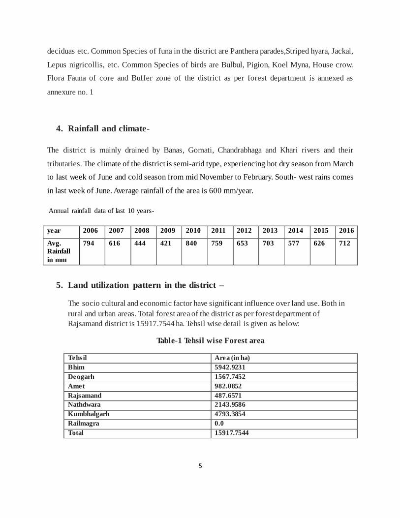
4. Rainfall and climate-
The district is mainly drained by Banas, Gomati, Chandrabhaga and Khari rivers and their
tributaries. The climate of the district is semi-arid type, experiencing hot dry season from March
to last week of June and cold season from mid November to February. South- west rains comes
in last week of June. Average rainfall of the area is 600 mm/year.
Annual rainfall data of last 10 years-
year 2006 2007 2008 2009 2010 2011 2012 2013 2014 2015 2016
Avg.
Rainfall
in mm
794 616 444 421 840 759 653 703 577 626 712
5. Land utilization pattern in the district –
The socio cultural and economic factor have significant influence over land use. Both in
rural and urban areas. Total forest area of the district as per forest department of
Rajsamand district is 15917.7544 ha. Tehsil wise detail is given as below:
Table-1 Tehsil wise Forest area
Tehsil Area (in ha)
Bhim 5942.9231
Deogarh 1567.7452
Amet 982.0852
Rajsamand 487.6571
Nathdwara 2143.9586
Kumbhalgarh 4793.3854
Railmagra 0.0
Total 15917.7544
6
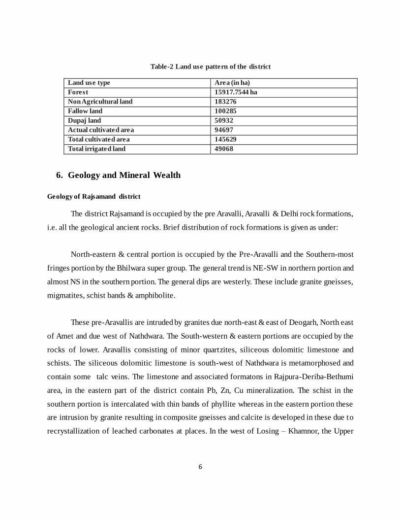
Table-2 Land use pattern of the district
Land use type Area (in ha)
Forest 15917.7544 ha
Non Agricultural land 183276
Fallow land 100285
Dupaj land 50932
Actual cultivated area 94697
Total cultivated area 145629
Total irrigated land 49068
6. Geology and Mineral Wealth
Geology of Rajsamand district
The district Rajsamand is occupied by the pre Aravalli, Aravalli & Delhi rock formations,
i.e. all the geological ancient rocks. Brief distribution of rock formations is given as under:
North-eastern & central portion is occupied by the Pre-Aravalli and the Southern-most
fringes portion by the Bhilwara super group. The general trend is NE-SW in northern portion and
almost NS in the southern portion. The general dips are westerly. These include granite gneisses,
migmatites, schist bands & amphibolite.
These pre-Aravallis are intruded by granites due north-east & east of Deogarh, North east
of Amet and due west of Nathdwara. The South-western & eastern portions are occupied by the
rocks of lower. Aravallis consisting of minor quartzites, siliceous dolomitic limestone and
schists. The siliceous dolomitic limestone is south-west of Nathdwara is metamorphosed and
contain some talc veins. The limestone and associated formatons in Rajpura-Deriba-Bethumi
area, in the eastern part of the district contain Pb, Zn, Cu mineralization. The schist in the
southern portion is intercalated with thin bands of phyllite whereas in the eastern portion these
are intrusion by granite resulting in composite gneisses and calcite is developed in these due to
recrystallization of leached carbonates at places. In the west of Losing – Khamnor, the Upper
7
Aravalli schist is exposed in acute angled triangle shaped area. These are deep water facies and
are intercalated with thin quartzite bands with no carbonate rocks.
Both the pre-Aravallis and Aravallis on their western margin are intruded by ultra-basics
right from south-west of Kathar to Kaliguman and south-west of Deogarh forming a prominent
lineament along which asbestos and emerald are developed. Near Bhuala, south-west of Kathar
some serpentine rock is developed which may be used as green marble. The granite gneisses and
schist in eastern part are intruded by pegmatite which affords mica, feldspar and quartz mining to
some extent.
The central portion around Rajnagar is occupied by garnet-ferrous schist and dolomitic
limestone which were considered to be overlying Aravalli rocks and underlying Delhis,
metamorphosed into marble, devoid of soapstone or any other mineral developed in it, and is
being extensively quarried as white marble. This marble is famous in the market as Rajnagar
Marble.
The western most boundary of the district all along is occupied by the rocks of Delhi
Super Group represented mainly by quartzite, calc-genesses and calc-schist. Though no
mineralization of economic importance is seen in these but that of wollastonite and calcite cannot
be denied. Occasionally these are intruded by younger granites of Erinpura age.
Mineral Wealth of Rajsamand district
The Rajsamand district is well known for its extensive deposits of various minerals. The
main mineral deposits described in brief are as follows:
Major Minerals 1. Lead, Zinc, Copper : Mineral lead and zinc are found in nature in the form of its
sulphide ores such as galena and sphalerite. M/s Hindustan Zinc ltd. is the main
producer of lead and zinc from its mines situated near villages Rajpura, Dariba
8
Sindesar-kalan and Mokhampura (North), tehsil Railmangra. GSI has also crried out
investigation work for lead and zinc near village Gopakura, Karauli, Majera, Katar
etc.
2. Asbestos: It is fibrous mineral and is found in the form of veins in ultra-basic rocks. In
Rajsamand district Anthophyllite/tremolite variety of asbestos is found which is used
in pipe industries. The main occurrences are near village Bhudan Dipti, Mokhampura,
Jawad of Rajsamand tehsil, near village Lalji ka khera, Daula ji ka Khera, Tikhi,
Halia Khera, Sulia, Samarnaka, Tegi etc. of Deogarh tesil, near village Devaji ka
Gura, Uda ka Khera, Achiawa, Dhelana of Amet tehsil, near village Thiriya, Antalia,
Sunkar, Khakha Ka gura etc. of Kumbhalgarh tehsil.
3. Emerald: Emerald is green variety of transparent beryl and is found in metamorphosed ultra-
basic rocks. The major reported occurences are near village Kalaguman, Tikhi of
tehsil Bhim, near village Nimri, Bargulla of Kumbhalgarh tehsil. Limestone: As per
concession rules, limestone used for making cement and used as flux in steel melting
shoppe was considered as major mineral. The main constituent is calcium carbonate.
The major reported occurrences are near village Kothariya of Nathdwara tehsil and
near village Lassaria, Jaswantpura, Hatun of Bhim tehsil.
4. Limestone i) Limestone deposit near Hathun-Jaswantpura: The limestone deposit near
Hathun-Jaswantpura in Bhim tehsil is the southern continuity of Sheopura-Lulwa
limestone belt in Beawar tehsil of Ajmer district. The nearest railway station
Beawar is 12 km from the deposit. Limestone occurs near village Hathun,
Jaswantpura and Borwa trending NE-SW and dipping at 700 to 80
0 towards NW.
It runs for a strike length of 8 to 9 Km and its width varies from 0.80 km to 2 km.
It is fine to medium grained, grey to brown in color. Intercalating bands of
calcgneiss are found associated with limestone. There by making it micaceous in
nature. Department has carried out detailed investigation and put 21 boreholes
totaling 1041.85 mts drilling The deposit has been applied by various concerns
9
for cement manufacture. A reserve of 30 mt have been assessed containing 40%
to 50% CaO with low magnesia and silica.
ii) Limestone deposit near Lassaria – Bhim: Limestone bands of width varying
from 10 m to 200 m are exposed intermittently form village lassaria in the west
to Biliyawas in the east for about 6000 m. The area is about 135 km from
Rajsamand and can be approached via Bhim. Lassaria is about 20 Km north-east
of Bhim. The department has carried out prospecting in the area. The limestone
is fine-grained, crystalline, light grey, buff, banded and micaceous in nature. Spot
samples analyzed CaO varying from 44.80% to 49.46%. Most of the area fall in
forest. Two limestone bands falling outside forest near village Dand and Lassaria
have been prospected by means of detailed mapping and drilling. 137 m of
drilling has been carried out spread over in three bore holes, intersecting about
20 to 25 m thickness of apparently cement grade limestone. Probable reserves of
order of more than 20 million ton of cement grade limestone may be available in
the area.
Minor Minerals
1. Quartz and Feldspar: Quartz is silicon oxide whereas feldspar is alumino silicate of
sodium, potassium and calcium. These are found naturally with each other in
pegmatite rocks and find its use in ceramic and abrasive industry. The major
occurrences are near village Devariya, Hira Khera, Anjan, Tikhi, Bachheraria, Paniya
of Deogarh tehsil, near village Mundkosia, Tiar, Gaudrola of Amet tehsil, near village
Dhoran, Kankariya, Khaka ka gura, Dipti etc. of Kumbhalgarh tehsil.
2 Pyrophyllite: It is hydrous aluminium silicate and mostly resembles with soapstone
and is found as thin bands and veins in the rocks of banded gneissic complex.
3 Soapstone: It is hydrous magnesium silicate and is found in the siliceous dolomitic
limestone rocks of Aravali super group of rocks near village Sisavi, Kagmadar,
10
Rabcha, Unwas, Semal, Odan, Kaurali, Kathar, Godach, Machind etc. and near
village Sunarkudi tehsil Bhim.
4 Barytes: It is sulphur ore of mineral barium and is found with quartz, feldspar,
calcite, fluorite as fracture filling element. The reported occurrences are near village
Kesuli, Karauli of Nathdwara tehsil.
5 Red Ochre: It is the disintegrated loose earthy part of oxidized ore of iron such as
hematite and limonite. The major reported occurrences are near village Negariya,
Sardarpura, Lalmadri of Nathdwara tehsil.
6 Marble: It is the crystalline, compact and metamorphosed form of limestone. The
main constituent is calcium and magnesium carbonate. The dolomitic marble bands
are exposed in form of hammer head syncline. The important marble deposita are
located near villages Sanwar, Sardul Kheda, Kelwa, Morwad, Jhanjar, Agria, Parwati,
Umti etc.
7 Granite: It is an igneous rock found as intrusive and metamorphosed to gneisses .
They are mainly consisted of quartz, feldspar, mica , amphiboles. Important deposits
are found near villages Tal, Lasani, Kakrod, Malkot, Isarmand, Pushalon ka Khera
etc. in Deogarh tehsil, near village Bikawas in Amet tehsil, near viallge Bherukhera in
Bhim tehsil and near village Madka, Chikalwas, etc. in Nathdwara tehsil.
8 Masonrystone: Rock types such as calc silicate, ferruginous quartzites, amphibolites,
meta-volcanics/meta basalt etc. are being used as masonry stone and for making
ballast/gitti of different sizes. It is mostly available in almost all parts of Rajsamand
district.
9. Bajri: It is the main constituent of building industry and chiefly found in almost all
rivers of Rajsamand district as river sands. The main rivers for potential of bajri are
Banas, Gomati, Chanderbhaga, khari.
11
7. Process of Deposition of Sediments in the Rivers of the district
The major rivers of the district originate and cut across hilly terrain disintegrating and
weathering hard rocks such as quartzite, migmatite, granite into rock fragments by the process of
saltaion. These rock fragments are further transported along river course during rainy season,
there by producing boulders, cobbles, gravels, pebbles and sand and depositing them in the river
section at suitable place to place.
8. Overview of Mining activity in Rajsamand
Ancient mining for metal lead-zinc is known in Dariba-Rajpura area where indications
of underground mining were observed up to 100 m below ground level. Now Rajsamand is very
well known for marble block mining as the largest producing district in the whole country.
Moreover R K Marble is the largest single marble producing unit in the world. Besides marble
and ore of lead-zinc, mining of other minerals such as granite,phyllite-schist. Patti-katla,
quartz,feldspar,mica, soapstone,dolomite,masonry stone, bajri are also going on.
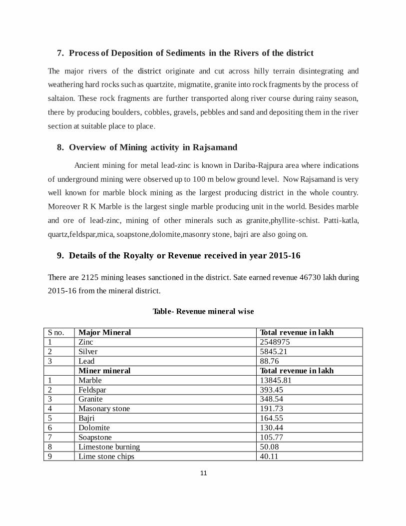
9. Details of the Royalty or Revenue received in year 2015-16
There are 2125 mining leases sanctioned in the district. Sate earned revenue 46730 lakh during
2015-16 from the mineral district.
Table- Revenue mineral wise
S no. Major Mineral Total revenue in lakh
1 Zinc 2548975
2 Silver 5845.21
3 Lead 88.76
Miner mineral Total revenue in lakh
1 Marble 13845.81
2 Feldspar 393.45 3 Granite 348.54
4 Masonary stone 191.73
5 Bajri 164.55
6 Dolomite 130.44
7 Soapstone 105.77
8 Limestone burning 50.08
9 Lime stone chips 40.11
12
10 Quartz 11.73
11 Silica sand 2.67 12 Limestone ld grade 1.52
13 Marble khanda 1.20
14 Barytes 1.02
15 Calcite 0.79
16 Phyllite 0.47
17 Limestone crusher 0.32
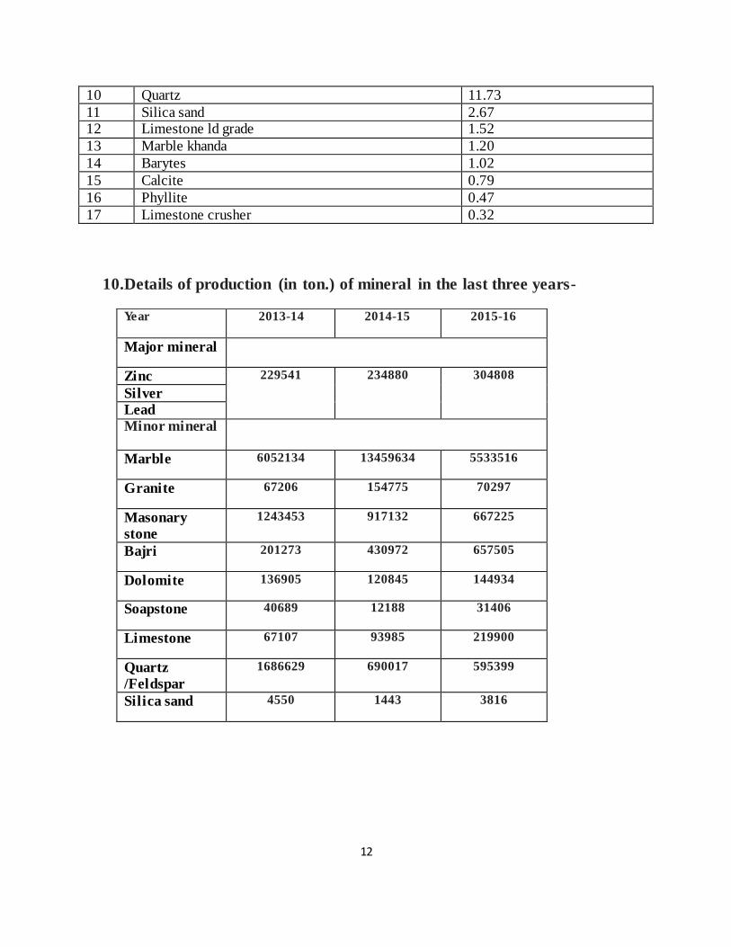
10. Details of production (in ton.) of mineral in the last three years-
Year 2013-14 2014-15 2015-16
Major mineral
Zinc 229541 234880 304808
Silver
Lead
Minor mineral
Marble 6052134 13459634 5533516
Granite 67206 154775 70297
Masonary
stone
1243453 917132 667225
Bajri 201273 430972 657505
Dolomite 136905 120845 144934
Soapstone 40689 12188 31406
Limestone 67107 93985 219900
Quartz
/Feldspar
1686629 690017 595399
Silica sand 4550 1443 3816
13
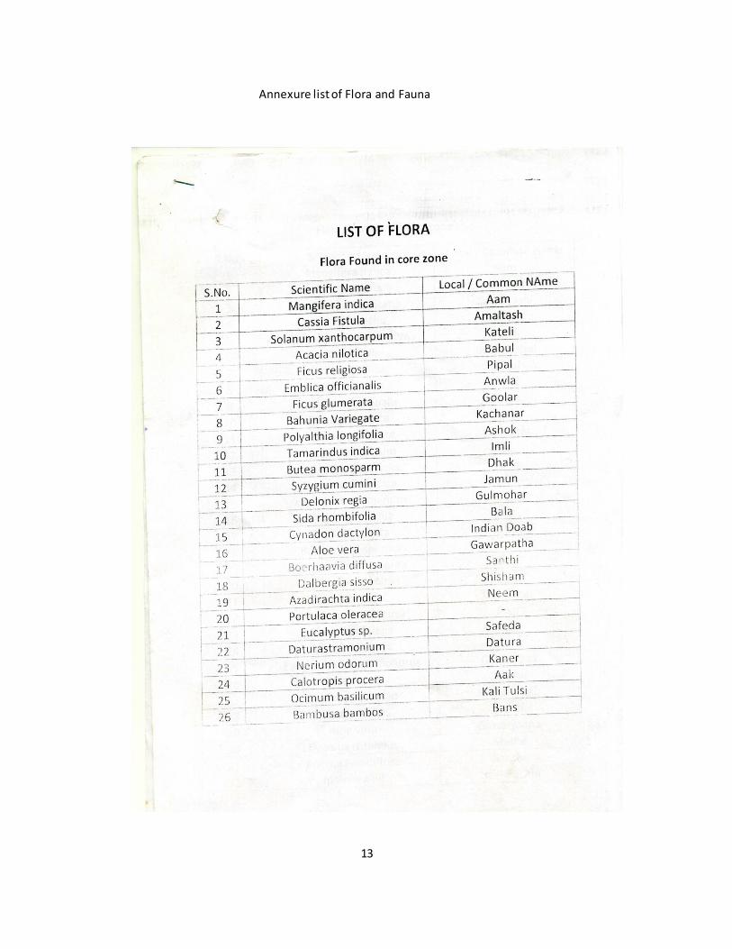
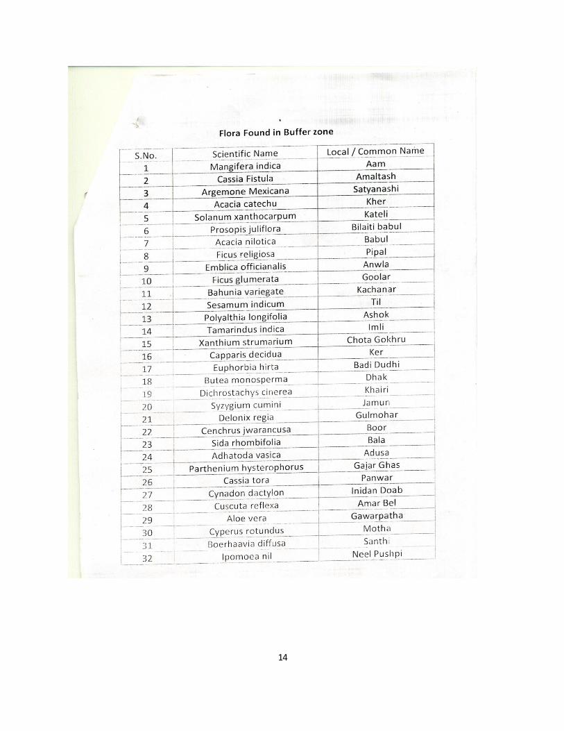
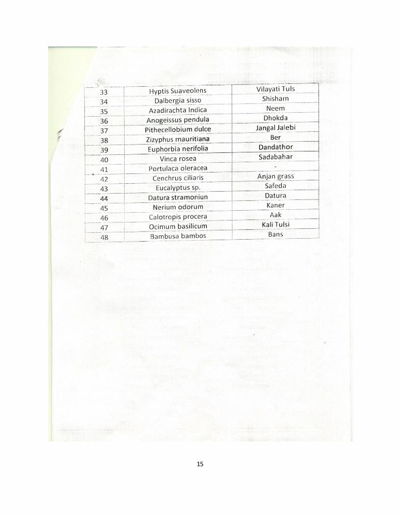
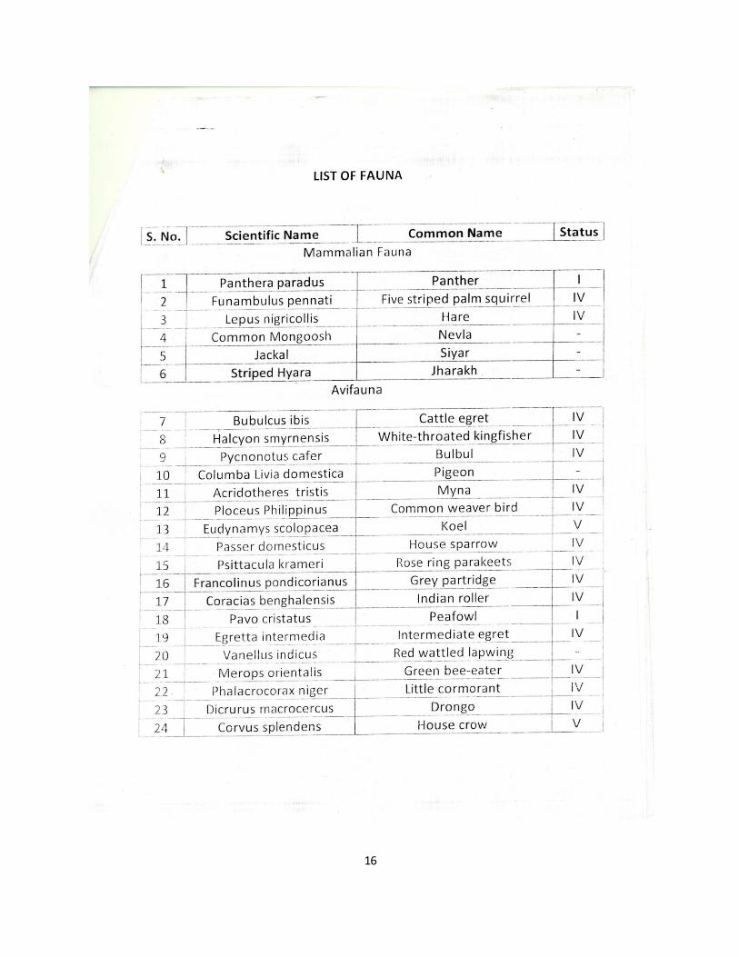
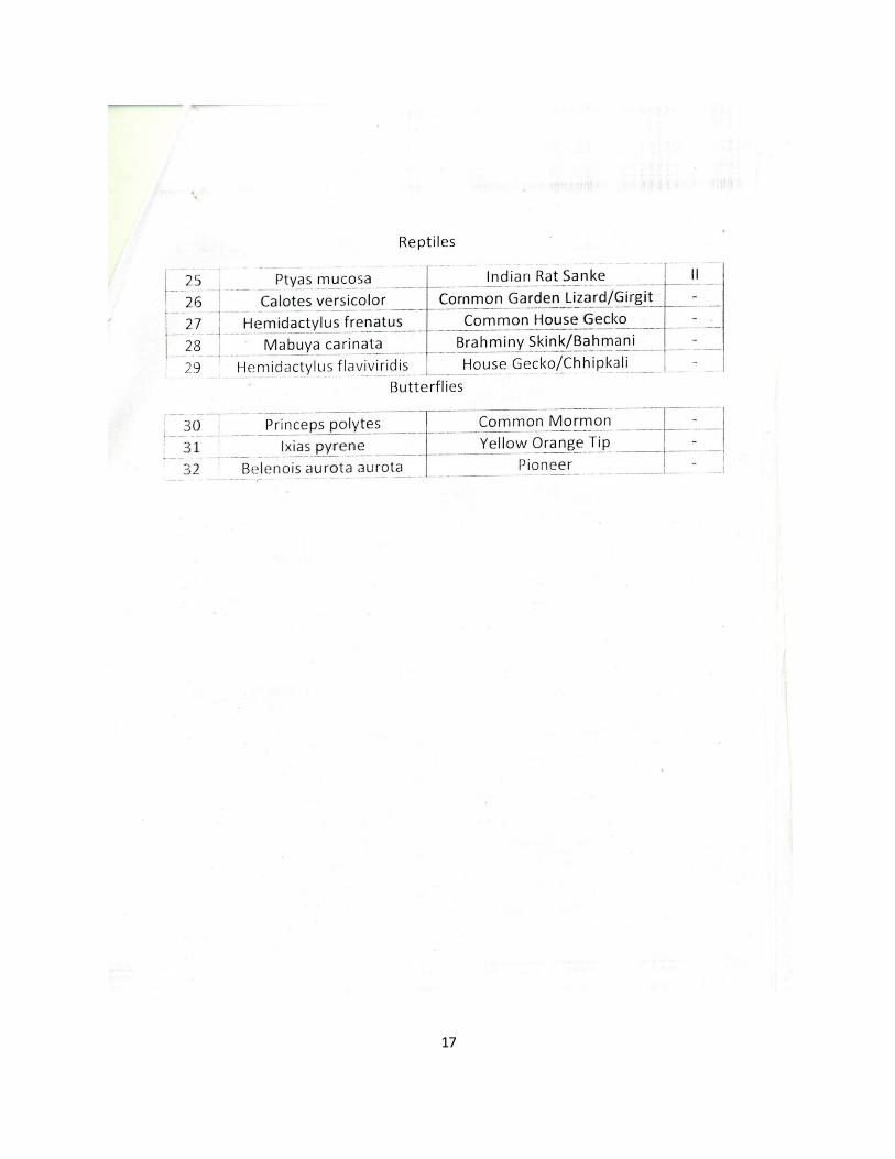
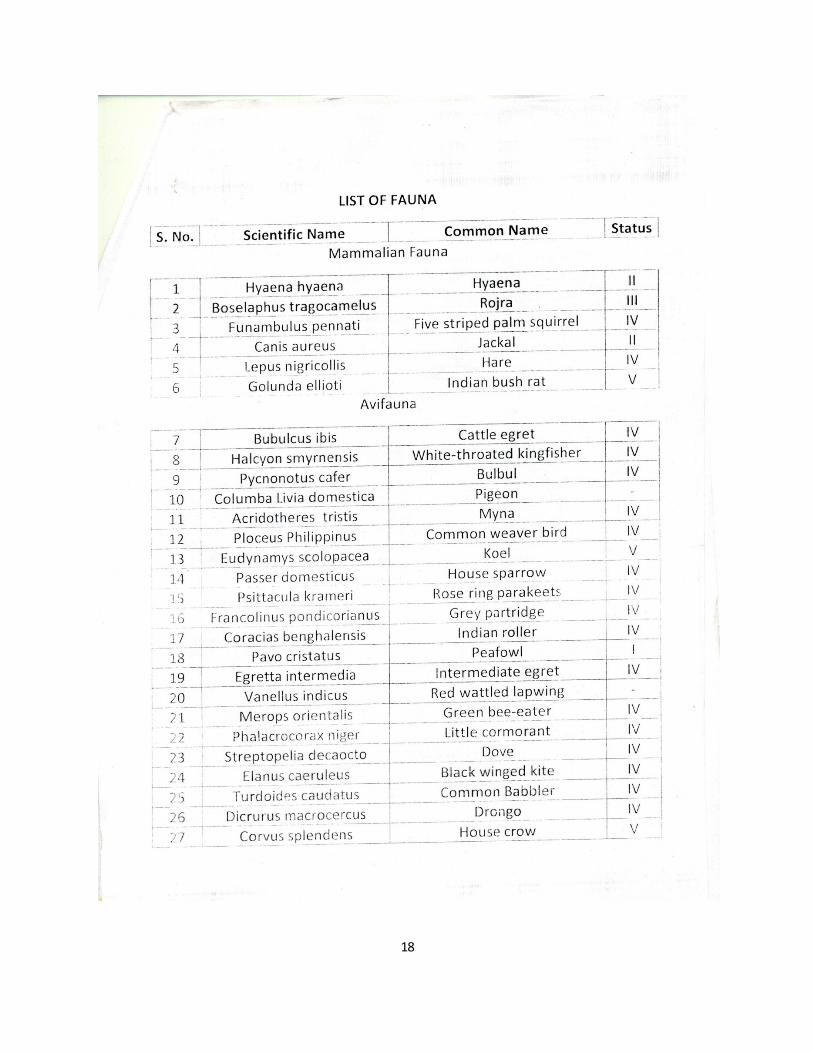
Annexure list of Flora and Fauna
14
15
16
17
18
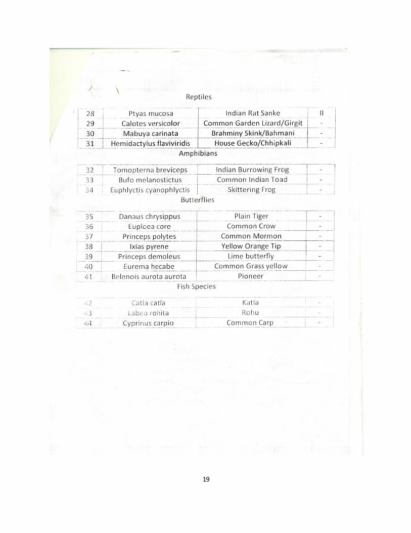
19