Embed Size (px)
Citation preview
Distributed Acquisition in Electrical Geophysical Systems
Kingman, J. E. E. [1], Donohue, J. G. [2], Ritchie, T. J. [3] _________________________ 1. Consultant – Terrigena Ltd. 2. Quantec Geoscience Ltd. 3. Geophysical Resources & Services Pty. Ltd.
ABSTRACT
Limited channel capacities in electrical geophysical receivers have crippled the minerals exploration industry for decades. These small channel capacity systems prevent gathering data sets with a large number of source-sensor combinations, an essential foundation for accurate interpretations of controlled source surveys. Distributed acquisition designs solve this problem by addressing the need to measure the output of many sensors simultaneously. Distributed acquisition uses a large number of small channel capacity receivers deployed close to the sensor outputs they measure while all the sensors and receivers acquire data simultaneously. Presently, only three commercial distributed acquisition systems exist that have over a 100-channel capacity and that can handle all standard electrical geophysical methods. Distributed acquisition in electrical geophysics did not emerge until about the turn of the 21st century and lags some 20 years behind its use in the seismic industry. Consequently, distributed acquisition and supporting technologies in electrical geophysics are still relatively young but have the potential to grow rapidly. While the ability to gather data sets with far greater source-sensor multiplicity is the most important advantage of a distributed acquisition design, this approach also has several other important advantages. These include greater depth of investigation, better productivity by reducing the cost per cubic kilometer evaluated, improved noise-reduction options, and seamless collection of multiple data types such as induced polarization, resistivity, magnetotellurics, and grounded-line EM coupling gathered almost simultaneously. New systems currently under development will enjoy greatly expanded channel capacities, measure both electric and magnetic fields at all stations simultaneously along multiple lines, and employ wireless telemetry to a much greater degree. These systems will soften the boundaries between the classical techniques while utilising all standard electrical prospecting methods in a single survey data set rather than collecting just one data type or another
INTRODUCTION
Most present day electrical geophysical surveys lack the number of source-sensor combinations required to afford accurate interpretations because they employ single receivers with 12 or less channels. These receivers inherently limit the level of source-sensor multiplicity that can be gathered in a survey data set. In contrast, the seismic exploration industry has long recognized the fundamental importance of a large number of source-sensor combinations and the benefits they provide in producing accurate subsurface images. Based on their confidence in this premise, seismic system designers built data acquisition systems with large channel capacities to provide data sets with large source-sensor multiplicities. These efforts have rewarded the seismic exploration industry with a sustained history of providing value and spectacular exploration success.
Meanwhile, the electrical geophysics industry has ignored the importance of source-sensor multiplicity and its reputation in the minerals exploration sector has languished as a result, especially among geologists. This has led to the common
practice in minerals exploration of awarding survey contracts to the lowest bidder without sufficient consideration for data quality and the benefits of source-sensor multiplicity.
Awarding survey contracts based primarily on cost rather than data quality has had several negative consequences. Perhaps the most destructive has been to stymie research and development of new and improved survey technologies, especially if using those technologies requires an increase in daily cost rates. This lack of research has led to inadequacies that hinder cost-effective exploration for orebodies at increasing depths and/or under thick cover using today’s electrical exploration systems.
The key to changing the course of this history lies in distributed acquisition. The same advantages gained by the seismic exploration industry are also available to the minerals exploration industry. To enjoy commensurate increases in value provided and exploration success, the minerals exploration industry must support geophysical system designs that focus on source-sensor multiplicity and large channel capacity. This can only be achieved using distributed acquisition systems.
The phrase “distributed acquisition” in the context of exploration geophysics refers to a measurement system whereby
Advances in Ground and Borehole Geophysics________________________________________________________________________________________
Paper 26
___________________________________________________________________________
In "Proceedings of Exploration 07: Fifth Decennial International Conference on Mineral Exploration" edited by B. Milkereit, 2007, p. 425-432
sensor signals are measured (digitized) near the sensors and those digital data are then telemetered via cable or wireless connection back to a central recording or data harvesting site. Distributed acquisition is contrasted with the only alternative: bulky and distortion-prone, multi-conductor cables carrying signals back to a central digitization site. Rather than deal with distributed acquisition designs or the multi-conductor alternative, the established trend in electrical geophysics is to repeat a lengthy sequence of moving a small channel capacity receiver and reading from a small number of local sensors. Distributed acquisition systems eliminate these inefficiencies and their limitations.
HISTORY
The seismic exploration industry immediately recognized the value of large source-sensor multiplicity at its inception over six decades ago, coining the phrase that for many years would come to serve as the standard measure of seismic data quality: “number of fold”. By the mid-to-late 1970’s, seismic crews were muscling around horrifically large cables carrying over two-hundred twisted-pair conductors. This represented a brick wall in their pursuit of more fold or greater source-sensor multiplicity. Thus the need was born for distributed acquisition to meet the seismic exploration industry’s apparently insatiable desire for more channels. The first such system of any note was named “GUS-BUS”, which arrived around 1977. It used standard twin-lead wire for data telemetry. [ This was the standard twin-lead wire used to carry signals from TV antennae to television sets.]
In stark contrast, the electrical geophysical exploration industry has not recognized the huge leap in performance gained by large source-sensor multiplicities and large channel capacities. While the seismic industry pressed ahead to 1000-plus channel capacities in the late 1970’s using systems such as GUS-BUS, electrical geophysical receivers were still predominantly one- and two-channel devices. Even today centralized receivers with small channel capacity continue to predominate in electrical geophysical surveys. Many minerals exploration geophysicists seem overly preoccupied with attempting to glean increasingly subtle information from a small number of measured responses. This diverts attention from the more important need to increase the basic information content in a survey data set. It also conflicts with the axiom that greater source-sensor multiplicity equates to more useful information and yields more accurate interpretations. Recognizing the need for more channels is the exception rather than the rule among electrical geophysics practitioners.
This disparity between the seismic and electrical geophysical industries shows up most dramatically as a vast difference in the value and quality of services delivered. Seismic geophysicists have steadfastly pursued increasing source-sensor multiplicity and have enjoyed great success while electrical exploration technology has stagnated in comparison. After years of minimal progress in data acquisition system design, mining geophysicists suffer a poor but well-deserved reputation among their geologist teammates.
One notable exception to this ongoing tragedy was the geophysical group at Anaconda Copper Company who were pioneering increasing channel capacities in the 1960’s as part of their induced polarization (IP) research and development efforts under the leadership of E.O. “Mac” McAlister and Mark Halverson. [There were undoubtedly other efforts and interest in larger channel capacities but those at Anaconda spawned the most fruit, eventually leading to the first full-blown commercial distributed systems in the industry: MIMDAS and its follower TITAN-24.] By the mid-1970’s, Anaconda had developed a proprietary 16-channel broadband IP system dubbed McBIP. When GUS-BUS arrived on the seismic scene, Mark Halverson immediately began exploring the possibility of using similar equipment in IP surveys (Halverson, M.O., 1978, GUS-BUS telemetry applications, Anaconda internal memo). By 1985 his group had built the first distributed electrical geophysical system prototype. That system was suitable for both galvanic (IP) and inductive prospecting methods. [ ARCO bought Anaconda in 1977. By 1985, Mark Halverson managed a large electrical and potential fields geophysics research group at ARCO’s facility in Plano, Texas. ARCO contracted Refraction Technology (RefTek) to build the distributed acquisition system. Interestingly, in 1978 Anaconda bought Gus Manufacturing, who patented and built GUS-BUS seismic systems, to better serve ARCO’s petroleum exploration efforts.]
Here is a brief history of distributed acquisition in exploration geophysics:
· 1977: the first distributed seismic system of any note, GUS-BUS, is built and successfully commercialized (1977, The Gus-Bus digital seismic telemetry system – system specifications, GUS Manufacturing, Inc.) (Joosten, 1982)
· 1985: Atlantic Richfield Company (ARCO) builds and tests a prototype distributed electrical geophysical system to complement their 24-channel broadband electrical mapping system (BEMS); the distributed system is used only briefly before ARCO abandons its research efforts in electrical geophysics (Tripp et al., 1990)
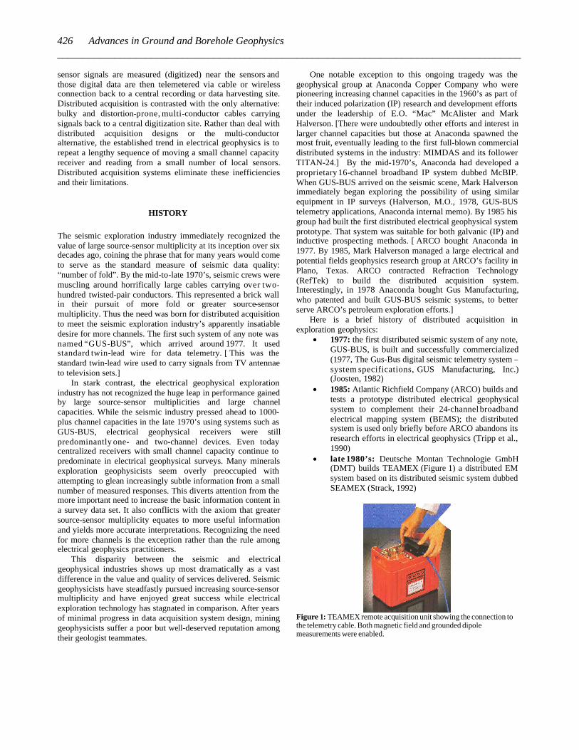
· late 1980’s: Deutsche Montan Technologie GmbH (DMT) builds TEAMEX (Figure 1) a distributed EM system based on its distributed seismic system dubbed SEAMEX (Strack, 1992)
Figure 1: TEAMEX remote acquisition unit showing the connection to the telemetry cable. Both magnetic field and grounded dipole measurements were enabled.
426 Advances in Ground and Borehole Geophysics_________________________________________________________________________________________
· early 1990’s: seismic equipment manufacturers universally abandon their optical fiber telemetry designs then in widespread use due to poor reliability
· mid 1990’s: three-dimensional (3D) seismic comes to the forefront and channel capacities soar
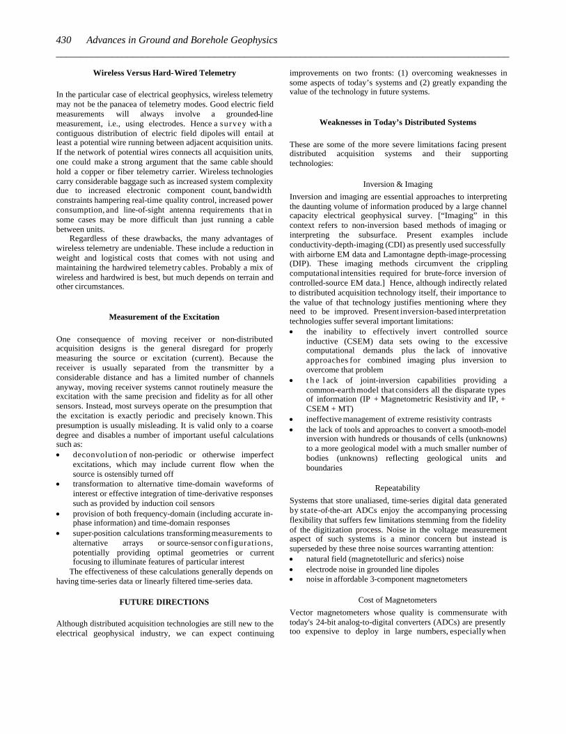
· 1997: Mount Isa Mines Exploration (MIMEX) completes MIMDAS Mark 1, a 100-channel capacity distributed acquisition system designed to serve all electrical geophysical methods (Figure 2) (Garner, 1998), (Sheard, 1998, 2001) [S.N. “Nick” Sheard, then chief geophysicist at MIMEX commissioned MIMDAS in mid-1995. This reflected his belief that market-driven research and development efforts on new systems were inadequate and that if substantial progress were to be made it would have to be sponsored internally. This mirrors the policies and environments at Anaconda, ARCO, and presumably later at WMC. It also supports the claim that incentives are lacking for equipment and service providers in the electrical geophysical industry to sustain substantial research and development costs (TEAMEX and Titan-24 are exceptions to that claim).]
Figure 2: MIMDAS Mark1 single channel distributed acquisition units (DAUs). High power-to-weight lithium-ion batteries inside the DAUs powered the electronics.
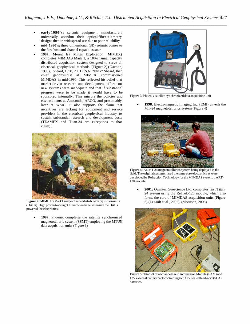
· 1997: Phoenix completes the satellite synchronized magnetotelluric system (SSMT) employing the MTU5 data acquisition units (Figure 3)
Figure 3: Phoenix satellite synchronized data acquisition unit
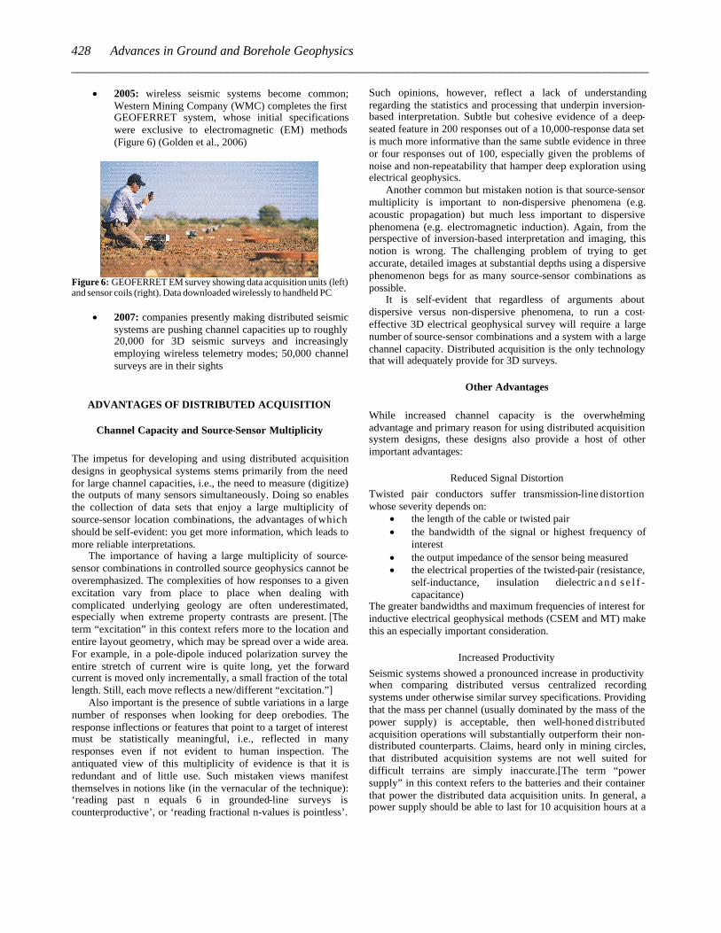
· 1998: Electromagnetic Imaging Inc. (EMI) unveils the MT-24 magnetotellurics system (Figure 4)
Figure 4: An MT-24 magnetotellurics system being deployed in the field. The original system shared the same core electronics as were developed by Refraction Technology for the MIMDAS system, the RT-120 module.
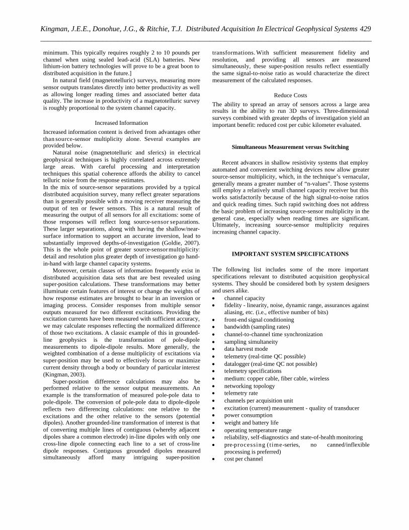
· 2001: Quantec Geoscience Ltd. completes first Titan-24 system using the RefTek-120 module, which also forms the core of MIMDAS acquisition units (Figure 5) (Legault et al., 2002), (Morrison, 2003)
Figure 5: Titan 24 dual channel Field Acquisition Module (FAM) and 12V external battery pack containing two 12V sealed lead-acid (SLA) batteries.
427Kingman, J.E.E., Donohue, J.G., & Ritchie, T.J. Distributed Acquisition In Electrical Geophysical Systems__________________________________________________________________________________________
· 2005: wireless seismic systems become common; Western Mining Company (WMC) completes the first GEOFERRET system, whose initial specifications were exclusive to electromagnetic (EM) methods (Figure 6) (Golden et al., 2006)
Figure 6: GEOFERRET EM survey showing data acquisition units (left) and sensor coils (right). Data downloaded wirelessly to handheld PC
· 2007: companies presently making distributed seismic systems are pushing channel capacities up to roughly 20,000 for 3D seismic surveys and increasingly employing wireless telemetry modes; 50,000 channel surveys are in their sights
ADVANTAGES OF DISTRIBUTED ACQUISITION
Channel Capacity and Source-Sensor Multiplicity
The impetus for developing and using distributed acquisition designs in geophysical systems stems primarily from the need for large channel capacities, i.e., the need to measure (digitize) the outputs of many sensors simultaneously. Doing so enables the collection of data sets that enjoy a large multiplicity of source-sensor location combinations, the advantages of which should be self-evident: you get more information, which leads to more reliable interpretations.
The importance of having a large multiplicity of source-sensor combinations in controlled source geophysics cannot be overemphasized. The complexities of how responses to a given excitation vary from place to place when dealing with complicated underlying geology are often underestimated, especially when extreme property contrasts are present. [The term “excitation” in this context refers more to the location and entire layout geometry, which may be spread over a wide area. For example, in a pole-dipole induced polarization survey the entire stretch of current wire is quite long, yet the forward current is moved only incrementally, a small fraction of the total length. Still, each move reflects a new/different “excitation.”]
Also important is the presence of subtle variations in a large number of responses when looking for deep orebodies. The response inflections or features that point to a target of interest must be statistically meaningful, i.e., reflected in many responses even if not evident to human inspection. The antiquated view of this multiplicity of evidence is that it is redundant and of little use. Such mistaken views manifest themselves in notions like (in the vernacular of the technique): ‘reading past n equals 6 in grounded-line surveys is counterproductive’, or ‘reading fractional n-values is pointless’.
Such opinions, however, reflect a lack of understanding regarding the statistics and processing that underpin inversion-based interpretation. Subtle but cohesive evidence of a deep-seated feature in 200 responses out of a 10,000-response data set is much more informative than the same subtle evidence in three or four responses out of 100, especially given the problems of noise and non-repeatability that hamper deep exploration using electrical geophysics.
Another common but mistaken notion is that source-sensor multiplicity is important to non-dispersive phenomena (e.g. acoustic propagation) but much less important to dispersive phenomena (e.g. electromagnetic induction). Again, from the perspective of inversion-based interpretation and imaging, this notion is wrong. The challenging problem of trying to get accurate, detailed images at substantial depths using a dispersive phenomenon begs for as many source-sensor combinations as possible.
It is self-evident that regardless of arguments about dispersive versus non-dispersive phenomena, to run a cost-effective 3D electrical geophysical survey will require a large number of source-sensor combinations and a system with a large channel capacity. Distributed acquisition is the only technology that will adequately provide for 3D surveys.
Other Advantages
While increased channel capacity is the overwhelming advantage and primary reason for using distributed acquisition system designs, these designs also provide a host of other important advantages:
Reduced Signal Distortion
Twisted pair conductors suffer transmission-line distortion whose severity depends on:
· the length of the cable or twisted pair · the bandwidth of the signal or highest frequency of
interest · the output impedance of the sensor being measured · the electrical properties of the twisted-pair (resistance,
self-inductance, insulation dielectric a n d s e l f -capacitance)
The greater bandwidths and maximum frequencies of interest for inductive electrical geophysical methods (CSEM and MT) make this an especially important consideration.
Increased Productivity
Seismic systems showed a pronounced increase in productivity when comparing distributed versus centralized recording systems under otherwise similar survey specifications. Providing that the mass per channel (usually dominated by the mass of the power supply) is acceptable, then well-honed distributed acquisition operations will substantially outperform their non-distributed counterparts. Claims, heard only in mining circles, that distributed acquisition systems are not well suited for difficult terrains are simply inaccurate.[The term “power supply” in this context refers to the batteries and their container that power the distributed data acquisition units. In general, a power supply should be able to last for 10 acquisition hours at a
428 Advances in Ground and Borehole Geophysics_________________________________________________________________________________________
minimum. This typically requires roughly 2 to 10 pounds per channel when using sealed lead-acid (SLA) batteries. New lithium-ion battery technologies will prove to be a great boon to distributed acquisition in the future.]
In natural field (magnetotelluric) surveys, measuring more sensor outputs translates directly into better productivity as well as allowing longer reading times and associated better data quality. The increase in productivity of a magnetotelluric survey is roughly proportional to the system channel capacity.
Increased Information
Increased information content is derived from advantages other than source-sensor multiplicity alone. Several examples are provided below.
Natural noise (magnetotelluric and sferics) in electrical geophysical techniques is highly correlated across extremely large areas. With careful processing and interpretation techniques this spatial coherence affords the ability to cancel telluric noise from the response estimates. In the mix of source-sensor separations provided by a typical distributed acquisition survey, many reflect greater separations than is generally possible with a moving receiver measuring the output of ten or fewer sensors. This is a natural result of measuring the output of all sensors for all excitations: some of those responses will reflect long source-sensor separations. These larger separations, along with having the shallow/near-surface information to support an accurate inversion, lead to substantially improved depths-of-investigation (Goldie, 2007). This is the whole point of greater source-sensor multiplicity: detail and resolution plus greater depth of investigation go hand-in-hand with large channel capacity systems.
Moreover, certain classes of information frequently exist in distributed acquisition data sets that are best revealed using super-position calculations. These transformations may better illuminate certain features of interest or change the weights of how response estimates are brought to bear in an inversion or imaging process. Consider responses from multiple sensor outputs measured for two different excitations. Providing the excitation currents have been measured with sufficient accuracy, we may calculate responses reflecting the normalized difference of those two excitations. A classic example of this in grounded-line geophysics is the transformation of pole-dipole measurements to dipole-dipole results. More generally, the weighted combination of a dense multiplicity of excitations via super-position may be used to effectively focus or maximize current density through a body or boundary of particular interest (Kingman, 2003).
Super-position difference calculations may also be performed relative to the sensor output measurements. An example is the transformation of measured pole-pole data to pole-dipole. The conversion of pole-pole data to dipole-dipole reflects two differencing calculations: one relative to the excitations and the other relative to the sensors (potential dipoles). Another grounded-line transformation of interest is that of converting multiple lines of contiguous (whereby adjacent dipoles share a common electrode) in-line dipoles with only one cross-line dipole connecting each line to a set of cross-line dipole responses. Contiguous grounded dipoles measured simultaneously afford many intriguing super-position
transformations. With sufficient measurement fidelity and resolution, and providing all sensors are measured simultaneously, these super-position results reflect essentially the same signal-to-noise ratio as would characterize the direct measurement of the calculated responses.
Reduce Costs
The ability to spread an array of sensors across a large area results in the ability to run 3D surveys. Three-dimensional surveys combined with greater depths of investigation yield an important benefit: reduced cost per cubic kilometer evaluated.
Simultaneous Measurement versus Switching
Recent advances in shallow resistivity systems that employ
automated and convenient switching devices now allow greater source-sensor multiplicity, which, in the technique’s vernacular, generally means a greater number of “n-values”. Those systems still employ a relatively small channel capacity receiver but this works satisfactorily because of the high signal-to-noise ratios and quick reading times. Such rapid switching does not address the basic problem of increasing source-sensor multiplicity in the general case, especially when reading times are significant. Ultimately, increasing source-sensor multiplicity requires increasing channel capacity.
IMPORTANT SYSTEM SPECIFICATIONS
The following list includes some of the more important specifications relevant to distributed acquisition geophysical systems. They should be considered both by system designers and users alike. · channel capacity · fidelity - linearity, noise, dynamic range, assurances against
aliasing, etc. (i.e., effective number of bits) · front-end signal conditioning · bandwidth (sampling rates) · channel-to-channel time synchronization · sampling simultaneity · data harvest mode · telemetry (real-time QC possible) · datalogger (real-time QC not possible) · telemetry specifications · medium: copper cable, fiber cable, wireless · networking topology · telemetry rate · channels per acquisition unit · excitation (current) measurement - quality of transducer · power consumption · weight and battery life · operating temperature range · reliability, self-diagnostics and state-of-health monitoring · pre-processing ( t ime-series, no canned/inflexible
processing is preferred) · cost per channel
429Kingman, J.E.E., Donohue, J.G., & Ritchie, T.J. Distributed Acquisition In Electrical Geophysical Systems__________________________________________________________________________________________
Wireless Versus Hard-Wired Telemetry
In the particular case of electrical geophysics, wireless telemetry may not be the panacea of telemetry modes. Good electric field measurements will always involve a grounded-line measurement, i.e., using electrodes. Hence a survey with a contiguous distribution of electric field dipoles will entail at least a potential wire running between adjacent acquisition units. If the network of potential wires connects all acquisition units, one could make a strong argument that the same cable should hold a copper or fiber telemetry carrier. Wireless technologies carry considerable baggage such as increased system complexity due to increased electronic component count, bandwidth constraints hampering real-time quality control, increased power consumption, and line-of-sight antenna requirements that in some cases may be more difficult than just running a cable between units.
Regardless of these drawbacks, the many advantages of wireless telemetry are undeniable. These include a reduction in weight and logistical costs that comes with not using and maintaining the hardwired telemetry cables. Probably a mix of wireless and hardwired is best, but much depends on terrain and other circumstances.
Measurement of the Excitation
One consequence of moving receiver or non-distributed acquisition designs is the general disregard for properly measuring the source or excitation (current). Because the receiver is usually separated from the transmitter by a considerable distance and has a limited number of channels anyway, moving receiver systems cannot routinely measure the excitation with the same precision and fidelity as for all other sensors. Instead, most surveys operate on the presumption that the excitation is exactly periodic and precisely known. This presumption is usually misleading. It is valid only to a coarse degree and disables a number of important useful calculations such as: · deconvolution of non-periodic or otherwise imperfect
excitations, which may include current flow when the source is ostensibly turned off
· transformation to alternative time-domain waveforms of interest or effective integration of time-derivative responses such as provided by induction coil sensors
· provision of both frequency-domain (including accurate in-phase information) and time-domain responses
· super-position calculations transforming measurements to alternative arrays or source-sensor configurations, potentially providing optimal geometries or current focusing to illuminate features of particular interest
The effectiveness of these calculations generally depends on having time-series data or linearly filtered time-series data.
FUTURE DIRECTIONS
Although distributed acquisition technologies are still new to the electrical geophysical industry, we can expect continuing
improvements on two fronts: (1) overcoming weaknesses in some aspects of today’s systems and (2) greatly expanding the value of the technology in future systems.
Weaknesses in Today’s Distributed Systems
These are some of the more severe limitations facing present distributed acquisition systems and their supporting technologies:
Inversion & Imaging
Inversion and imaging are essential approaches to interpreting the daunting volume of information produced by a large channel capacity electrical geophysical survey. [“Imaging” in this context refers to non-inversion based methods of imaging or interpreting the subsurface. Present examples include conductivity-depth-imaging (CDI) as presently used successfully with airborne EM data and Lamontagne depth-image-processing (DIP). These imaging methods circumvent the crippling computational intensities required for brute-force inversion of controlled-source EM data.] Hence, although indirectly related to distributed acquisition technology itself, their importance to the value of that technology justifies mentioning where they need to be improved. Present inversion-based interpretation technologies suffer several important limitations: · the inability to effectively invert controlled source
inductive (CSEM) data sets owing to the excessive computational demands plus the lack of innovative approaches for combined imaging plus inversion to overcome that problem
· t h e l ack of joint-inversion capabilities providing a common-earth model that considers all the disparate types of information (IP + Magnetometric Resistivity and IP, + CSEM + MT)
· ineffective management of extreme resistivity contrasts · the lack of tools and approaches to convert a smooth-model
inversion with hundreds or thousands of cells (unknowns) to a more geological model with a much smaller number of bodies (unknowns) reflecting geological units and boundaries
Repeatability
Systems that store unaliased, time-series digital data generated by state-of-the-art ADCs enjoy the accompanying processing flexibility that suffers few limitations stemming from the fidelity of the digitization process. Noise in the voltage measurement aspect of such systems is a minor concern but instead is superseded by these three noise sources warranting attention: · natural field (magnetotelluric and sferics) noise · electrode noise in grounded line dipoles · noise in affordable 3-component magnetometers
Cost of Magnetometers
Vector magnetometers whose quality is commensurate with today's 24-bit analog-to-digital converters (ADCs) are presently too expensive to deploy in large numbers, especially when
430 Advances in Ground and Borehole Geophysics_________________________________________________________________________________________
considering the prospect of deploying hundreds of three-component assemblies. Compounding the problem is the need for accurate DC or low-frequency magnetometers to complement standard grounded-line galvanic measurements with magnetometric resistivity and IP information. We need new high-quality magnetometers whose costs do not overwhelm the other costs of a large channel capacity system.
Field Operations
As a relatively novel approach, distributed acquisition surveys in electrical geophysics do not yet enjoy fully optimized field operations. This is in sharp contrast with distributed seismic surveys whose strong and sustained market has led to well-honed field practices and supporting peripheral equipment. Aspects deserving special focus include: · the cost and expediency of deployment · costs o f injecting a high spatial density of excitations –
especially for grounded-line (galvanic) excitations · equipment reliability and convenience · equipment cost per channel · noise in potential electrodes · cost of deploying cross-line electric field sensors (dipoles) · management of the larger crew sizes required
Next Generation Systems
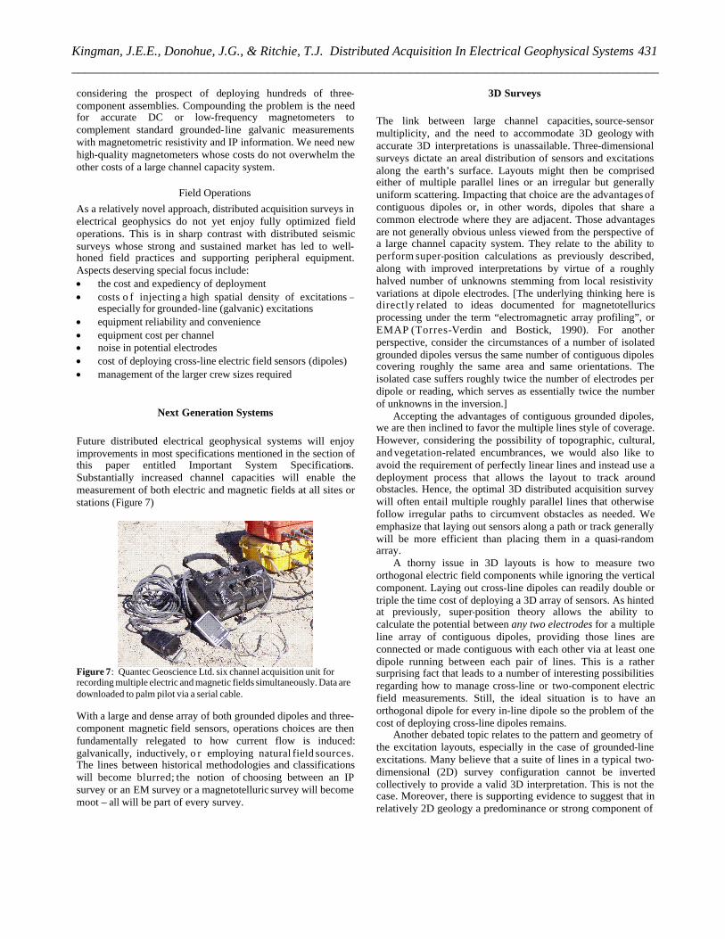
Future distributed electrical geophysical systems will enjoy improvements in most specifications mentioned in the section of this paper entitled Important System Specifications. Substantially increased channel capacities will enable the measurement of both electric and magnetic fields at all sites or stations (Figure 7)
Figure 7: Quantec Geoscience Ltd. six channel acquisition unit for recording multiple electric and magnetic fields simultaneously. Data are downloaded to palm pilot via a serial cable.
With a large and dense array of both grounded dipoles and three-component magnetic field sensors, operations choices are then fundamentally relegated to how current flow is induced: galvanically, inductively, o r employing natural field sources. The lines between historical methodologies and classifications will become blurred; the notion of choosing between an IP survey or an EM survey or a magnetotelluric survey will become moot – all will be part of every survey.
3D Surveys
The link between large channel capacities, source-sensor multiplicity, and the need to accommodate 3D geology with accurate 3D interpretations is unassailable. Three-dimensional surveys dictate an areal distribution of sensors and excitations along the earth’s surface. Layouts might then be comprised either of multiple parallel lines or an irregular but generally uniform scattering. Impacting that choice are the advantages of contiguous dipoles or, in other words, dipoles that share a common electrode where they are adjacent. Those advantages are not generally obvious unless viewed from the perspective of a large channel capacity system. They relate to the ability to perform super-position calculations as previously described, along with improved interpretations by virtue of a roughly halved number of unknowns stemming from local resistivity variations at dipole electrodes. [The underlying thinking here is directly related to ideas documented for magnetotellurics processing under the term “electromagnetic array profiling”, or EMAP (Torres-Verdin and Bostick, 1990). For another perspective, consider the circumstances of a number of isolated grounded dipoles versus the same number of contiguous dipoles covering roughly the same area and same orientations. The isolated case suffers roughly twice the number of electrodes per dipole or reading, which serves as essentially twice the number of unknowns in the inversion.]
Accepting the advantages of contiguous grounded dipoles, we are then inclined to favor the multiple lines style of coverage. However, considering the possibility of topographic, cultural, and vegetation-related encumbrances, we would also like to avoid the requirement of perfectly linear lines and instead use a deployment process that allows the layout to track around obstacles. Hence, the optimal 3D distributed acquisition survey will often entail multiple roughly parallel lines that otherwise follow irregular paths to circumvent obstacles as needed. We emphasize that laying out sensors along a path or track generally will be more efficient than placing them in a quasi-random array.
A thorny issue in 3D layouts is how to measure two orthogonal electric field components while ignoring the vertical component. Laying out cross-line dipoles can readily double or triple the time cost of deploying a 3D array of sensors. As hinted at previously, super-position theory allows the ability to calculate the potential between any two electrodes for a multiple line array of contiguous dipoles, providing those lines are connected or made contiguous with each other via at least one dipole running between each pair of lines. This is a rather surprising fact that leads to a number of interesting possibilities regarding how to manage cross-line or two-component electric field measurements. Still, the ideal situation is to have an orthogonal dipole for every in-line dipole so the problem of the cost of deploying cross-line dipoles remains.
Another debated topic relates to the pattern and geometry of the excitation layouts, especially in the case of grounded-line excitations. Many believe that a suite of lines in a typical two-dimensional (2D) survey configuration cannot be inverted collectively to provide a valid 3D interpretation. This is not the case. Moreover, there is supporting evidence to suggest that in relatively 2D geology a predominance or strong component of
431Kingman, J.E.E., Donohue, J.G., & Ritchie, T.J. Distributed Acquisition In Electrical Geophysical Systems__________________________________________________________________________________________
2D survey geometries is helpful to the inversion process (Ritchie, T.R., personal communication, 2006). At the very least it aids the ability to monitor and control data quality since other geometries often lead to quite irregular responses that defy human insight. Regardless, it is axiomatic that in the general case (i.e. arbitrary geology) the goal is to gather repeatable and clean responses that reflect strong coupling for more than one direction of current flow.
CONCLUSIONS
Distributed acquisition technologies are long overdue to replace centralized designs in electrical geophysical systems. This delay has greatly hampered progress in electrical geophysics, but the recent emergence of commercial distributed acquisition systems will lead the way to major advances in the near future. Among the many advantages of distributed acquisition, the most important is enabling the cost-effective acquisition of data sets that enjoy a greater multiplicity of source-sensor combinations. Other advantages include: · much better interpretation accuracy · greater depth-of-penetration · greater productivity, especially in terms of cost per cubic
kilometer evaluated Future distributed acquisition systems will provide greatly
expanded channel capacities, ideally in the thousands, and thus allow a greater degree of measuring both electric and magnetic fields at many stations spread across the survey area. To translate the additional information into a more accurate 3D image of the subsurface, greatly improved inversion and interpretation tools are needed. A consistent and robust approach to 3D surveys and interpretations will prevail.
Productivity increases are needed to enhance the value of the technology to minerals exploration. These increases will come from reduced reading times (by reducing measurement noise) and improved field operations.
The electrical geophysical industry needs a renaissance, which can only be spurred by a fundamental change in the market forces driving it. Practices that overly emphasize cost to the detriment of quality must be replaced by practices that emphasize the value of the final product: the interpretation. If the predominant concern among explorationists is interpretation accuracy and value rather than raw survey cost, service and equipment providers will be motivated to accommodate these concerns. Finally, a predominant focus on the accuracy and value of interpreted subsurface images can only be satisfied by a shift to distributed acquisition system designs and ever-increasing channel capacities.
ACKNOWLEDGEMENTS
The authors acknowledge the pioneering contributions of E.O. (Mac) McAlister and Mark Halverson to geophysics in general, including their early recognition of the importance of large channel capacity systems. Their services to the geophysical industry cannot be overstated. S.N.(Nick) Sheard and Ross Fardon at Mount Isa Mines Exploration were the first to accept great risk to their own careers by diverting a portion of their
exploration funds to build a widely used distributed acquisition electrical geophysical system (MIMDAS). Their unwavering support during the development of that system were important components of its ultimate success. Mitch Whatley spent many hours editing and improving this document as a courtesy to the authors and his never-ending interest in good science and engineering.
REFERENCES
Garner, S.J., 1998, Broadband surface impedance measurements using VLF spherics and artificial HF: Ph.D. dissertation, Griffith University.
Golden, H., T. Herbert, and A. Duncan, 2006, GEOFERRET: A new distributed system for deep-probing TEM surveys: 76th Annual International Meeting, Uranium Exploration Workshop, Society of Exploration Geophysicists.
Goldie, M., 2007, A comparison between conventional and distributed acquisition induced polarization surveys for gold exploration in Nevada: The Leading Edge, 26, No.2, 180-183.
Joosten, W.L., 1982, Seismic Telemetry: The Future of Geophysics: 52nd Annual International Meeting, SEG, Expanded Abstracts, 1, 47-48.
Kingman, J.E.E., Garner, S.J., February 2003, Benefits of large channel capacity systems in electrical geophysics: 16th Geophysical Conference and Exhibition Abstracts, Australian Society of Exploration Geophysicists, 64.
Legault, J.M., Gordon, R., Reddig, M., and Slama E., 2002, Geophysical survey interpretation report regarding the Quantec Titan-24 distributed array system tensor magnetotelluric and DCIP resistivity surveys over the Kidd Creek mine project, Kidd Twp., near Timmins, ON, on behalf of Ontario Ministry of Northern Development and Mines and Falconbridge Ltd (OMET project 13-2001a, open file). Toronto: Quantec Geoscience Inc. internal company report, 99p, QG-215.
Morrison, K.M., March 2003., Advancements in integrated exploration technology applied to late stage mine life: Prospectors and Developers Association of Canada 2003 Convention Publication, Prospectors and Developers Association of Canada.
Sheard, N., 1998, MIMDAS: A new direction in geophysics: proceedings of the ASEG 13th International Conference.
Sheard, N., 2001, The value of advanced geophysical technology in modern exploration: Bulletin of the Australian Institute of Geoscientists, 35, 53-56.
Strack, K.M., 1992, Exploration with deep transient electromagnetics: Elsevier (reprinted 1999).
Torres-Verdin, C., Bostick, F.X. Jr., April 1990, Principles of spatial surface electric field filtering in magnetotellurics: Electromagnetic array profiling (EMAP): Geophysics, 57, 603-622.
Tripp, A.C., J.D. Klein, M.O. Halverson, J. Kingman, and T.W. Grant, 1990, Induced-Polarization Spectral Interpretation Including Electromagnetic Coupling Data – A Field Example, in J.B. Fink, E.O. McAlister, B.K. Sternberg, W.G. Wieduwilt, and S.H. Ward, eds., Induced Polarization – Applications and Case Histories: Investigations in Geophysics No. 4, Society of Exploration Geophysics, 179-198.
432 Advances in Ground and Borehole Geophysics_________________________________________________________________________________________