Embed Size (px)
Citation preview

UN
IT
ED
NA
TIO
NS
EN
VIR
ON
ME
NT
PR
OG
RA
MM
E
DISASTER RISK REDUCTION
A Toolkit for Tourism Destinations
Practical examples from coastal settlements in Asia

Copyright © United Nations Environment Programme, 2008
This publication may be reproduced in whole or in part and in any form for educational or non-profi t purposes without special permission from the copyright holder, provided acknowledgement of the source is made. UNEP would appreciate receiving a copy of any publication that uses this publication as a source.
No use of this publication may be made for resale or for any other commercial purpose whatsoever without prior permission in writing from the United Nations Environment Programme.
DisclaimerThe designations employed and the presentation of the material in this publication do not imply the expression of any opinion whatsoever on the part of the United Nations Environment Programme concerning the legal status of any country, territory, city or area or of its authorities, or concerning delimitation of its frontiers or boundaries. Moreover, the views expressed do not necessarily represent the decision or the stated policy of the United Nations Environment Programme, nor does citing of trade names or commercial processes constitute endorsement.
This publication has been produced with the assistance of the European Union. The contents of this publication are the sole responsibility of the implementing project partners and can in no way be taken to refl ect the views of the European Union.
UNEP promotes environ-
mentally sound practices globally and in its own activities.
This publication is printed on 100% recycled paper and other eco-friendly practices. Our distribution policy aims
to reduce UNEP’s carbon footprint.

DISASTER RISK REDUCTION
A TOOLKIT FOR TOURISM DESTINATIONS
Practical examples from coastal settlements in Asia
United Nations Environment ProgrammeDivision of Technology, Industry & Economics
15, rue de Milan, 75441 Paris CEDEX 09,
France

DISASTER RISK REDUCTION - A toolkit for Tourism Destinations
2
AcknowledgementsThis publication was made possible through funding from the EU-Asia Pro Eco II B Post-Tsunami Programme and is part of the project on Disaster Reduction through Awareness, Preparedness and Prevention Mechanisms in Coastal Settlements in Asia – Demonstrations in Tourism Destinations.
The project was coordinated by the United Nations Environment Programme, Division of Technology, Industry and Economics (UNEP-DTIE) and the Swedish Rescue Services Agency (SRSA) Sweden. In Thailand, local partners included Patong Municipality of Phuket (PMP) and Ao Nang Sub-district Administration Organisation (ANSAO) in Phi Phi Islands, supported by the Department of Disaster Prevention and Mitigation (DDPM). In India, the National Safety Council of India (NSCI) was a project partner and supported the District Collector of Kanniyakumari. Finally, the International Hotel and Restaurant Association (IH&RA) provided expertise from the tourism industry.
The Disaster Risk Reduction Toolkit for Tourism Destinations is based on the project’s successful implementation in three demonstrations sites: Kanniyakumari Town Panchayat in Tamil Nadu State, India; Patong in Phuket; and Phi Phi Islands in Krabi, Thailand.
The authors would like to take this opportunity to thank all those who by their efforts and dedication contributed to the project’s success.
Project Coordinators
Ruth Coutto and Stefanos Fotiou of United Nations Environment ProgrammeBjörn Hedskog and Lars Hillerström of Swedish Rescue Services AgencySrisuda Rakphao of Patong Municipality of Phuket Wanchai Chaovanapanja of ANSAO / Phi Phi IslandsA.Y. Sundkar of National Safety Council of IndiaAbraham Rosental and Thalis Papadopoulos of International Hotel and Restaurant Association
United Nations Environment Programme
Leo HeilemanWei Zhao Helena Rey Sandra AverousTomas MarquesErica AllisSophie DunkerleyMelissa Bonneton

3
Swedish Rescue Services Agency
Mette Lindahl-Olsson, Accident Prevention Department, Head of Planning, Construction and Environment sectionBarbro Näslund-Landenmark, Accident Prevention Department, Planning, Construction and Environment sectionJosefi n Gullstrand, Accident Prevention Department, Planning, Construction and Environment sectionMikael Eriksson Accident Prevention Department, Planning, Construction and Environment sectionRainar All, Research DepartmentMartin Gustafsson, GIS EngineerJanet Edwards International Programme Offi cer, EU and International Affairs Department
Fredrik Ryber, Municipal Fire Brigade of Attunda
Thailand
Patong Municipality of Phuket (PMP)
Chairat Sukkhaban, Deputy Mayor Phunsuk Naksena, City Clerk Supat Rattanasamahan, Deputy Clerk
Members of the Coordinating Group
ANSAO / Phi Phi Islands
Phunkham Kittithornkul, Chief Executive Wichet Kwankhao, City Clerk
Key members of the Coordinating group: Werapas Juntaro, Manager of Phi Phi Hotel Wuttisak Tongkerd, Manager of Chao Koh Phi Phi Lodge Hotel Samran Wiriya, crew of Princess Hotel Somkiet Kittithornkul, Manager of Phi Phi Islands Cabana Puangkaew Uksornsawan, Manager of Madam Resto Restaurant Prakorbsak Praditjaroen, Manager of Phi Phi Electricity Plant Weerawat Chaokaew, Ban Koh Phi Phi School Sommai Juntin, Phi Phi Sea Frog Diving Shop
Department of Disaster Prevention and Mitigation (DDPM)
Anucha Mokkhavesa, Director-General Adthaporn Singhawichai, Director of Research and International Cooperation Bureau
India
K.C. Gupta, Director General, NSCI and Project DirectorR.P. Bhanushali, Adviser (Technical), NSCIP.M. Rao, Adviser, NSCI

DISASTER RISK REDUCTION - A toolkit for Tourism Destinations
4
M.M. Kulkarni, Director, NSCIV.B. Patil, Director, NSCIDr. Arun Bapat, Seismic Expert, IndiaW.A. Balakumaran, Member Expert Panel, NSCIThe District Collector, Kanniyakumari
P. Gunasekaran, Safety Offi cer, Heavy Water Plant, Tuticorin and Project ManagerP. Thomas, Project Assistant, Kanniyakumari
Members of the coordinating Group
International Hotel and Restaurant Association (IH&RA)
Kjell Arvidsson, Radisson SAS Scandinavia HotelAngélique Berduraz
The main drafters of the report were Janet Edwards (SRSA) and Sophie Dunkerley (UNEP-DTIE).
5
Executive Summary
From October 2006 to the end of 2008, the United Nations Environmental Programme (UNEP) worked with a number of partners to help build capacity for disaster risk reduction in three tsunami-hit tourist destinations. The project, entitled “Disaster Reduction through Awareness, Preparedness and Prevention Mechanisms in Coastal Settlements in Asia: Demonstration in Tourism Destinations” was made possible thanks to funding from the European Union through the EU-Asia Pro Eco II B Post-Tsunami Programme.
The three sites involved in the project were: Kanniyakumari Town Panchayat in Tamil Nadu State, India; Patong Municipality of Phuket (PMP); and Phi Phi Islands in Krabi, Thailand. The United Nation’s APELL process (Awareness and Preparedness for Emergencies at the Local Level) was used as the methodology for the project. A number of workshops and exercises guided the three destination sites through a step by step process for improving local disaster prevention and preparedness. As a result of the project, integrated local disaster preparedness plans were developed in the three sites.
This toolkit for tourist destinations has been developed to disseminate the project experience and to allow its replication in other tourist destinations. It is designed for local municipalities and for the various actors involved in emergency planning and response in tourism destinations. The toolkit includes information relating to the various steps that need to be undertaken, from the preliminary assessment, to capacity building, disaster prevention and preparedness planning, to communicating and disseminating key information.
For each step in the process, the toolkit provides an explanation of what should be done and a reference to the project experience. All key project documents are mentioned in the annex and are included in the CD-rom attached to this toolkit.

DISASTER RISK REDUCTION - A toolkit for Tourism Destinations
6
User’s guide
This toolkit summarises the objectives, methods, experiences and recommendations for disaster risk reduction acquired during the EU fi nanced project. The toolkit is intended for use by authorities at the national, regional and local level and the private sector, including businesses that provide tourist services. Universities and research institutes studying disaster risk management will fi nd descriptions of the methods used during the project. Potential local project managers can use the tools to replicate the project’s aims and activities in their own municipality. The toolkit can be disseminated to the various actors who assist in preparing or responding to a disaster such as fi re and rescue departments, environmental departments, technical departments, hospitals, school administrators, hotel owners, as well as volunteer organisations.
The toolkit provides disaster managers, local and municipal and community planners, as well as other stakeholders in the tourism sector with practical guidance on how to better prepare for disasters in tourist destinations. The information and resources contained are based on the project experience in the three demonstration sites. The toolkit outlines the necessary steps to be undertaken, from the preliminary assessment, to capacity building, disaster prevention and preparedness planning, to communication and dissemination of the key information. Key success factors for implementing the project include good project planning, involvement of key stakeholders at all levels and effective coordination between players.
The toolkit is divided into 6 sections. Section 1 provides an overview of the project, including background information on the three demonstration sites and on the APELL methodology followed in the project. Section 2 describes the preparatory work for disaster management and planning including the establishment of local coordinating groups and the initial preliminary assessment of local preparedness. Section 3 focuses on capacity building and implementation for disaster prevention and preparedness and covers the following themes: risk assessment, shelter assessment and environmental awareness. Section 4 provides information on developing a local disaster preparedness plan as a key component of disaster prevention efforts. Section 5 describes training requirements and communication of key information. Finally, section 6 highlights key success factors that may serve as useful guidance for toolkit users.
A CD-rom supports the toolkit and contains all the annex documents that are mentioned in the toolkit. CD-Rom

7
Contents 2Acknowledgements 4Executive Summary 5User’s guide 6
1. Project overview 8
1.1 Background 8 1.2 Project objectives 9 1.3 Demonstration sites 10 1.4 The APELL process 12
2. Preparatory work 15
2.1 Establishment of local coordinating groups 15 2.1.1 Description and objectives 15 2.1.2 Project experience 16 2.1.3 Guidance and resources 17 2.2 Preliminary assessment 19 2.2.1 Description and objectives 19 2.2.2 Project experience 19 2.2.3 Guidance and resources 20
3. Capacity Building and Implementation for Disaster Prevention and Preparedness 21
3.1 APELL training 21 3.2 Risk assessment: hazard and vulnerability mapping 23 3.2.1 Description and objectives 23 3.2.2 Project examples 23 3.2.3 Vulnerability maps 25 3.2.4 Guidance and resources 27 3.3 Shelter Assessments 28 3.3.1 Description and objectives 28 3.3.2 Project examples of Local Shelter Assessments 28 3.4 Environmental awareness 30 3.4.1 Description and objectives 30 3.4.2 Project experience 30
4. Disaster Prevention and Preparedness Planning 32
4.1 Description and objectives 32 4.2 Project examples 34 4.3 Guidance and resources 35
5. Information Communication and Dissemination 38
5.1 Description and objectives 38 5.2 Project example of an awareness raising drill 39 5.3 Project examples of awareness raising brochures 47
6. Success factors 49

DISASTER RISK REDUCTION - A toolkit for Tourism Destinations
8
Project overview11.1 Background
Every year, more than 200 million people are affected by droughts, fl oods, cyclones, tsunamis, earthquakes, wildfi res and other disasters associated with natural hazards. Growing populations, environmental degradation and global warming are making the impacts worse, creating greater disasters and making the need to fi nd better ways to protect people more urgent.
Tourism is dependent on an intact ecosystem and on institutional structures that can respond to the needs of local people and visitors. Therefore, disaster preparedness and management (for natural and man-made hazards) should be an essential part of any destinations’ integrated management plan. Heat waves (such as that experienced in the European summer of 2003), the Southeast Asia tsunami of December 2004, changes in tropical storm intensity (such as Hurricane Katrina in August 2005) and forest fi res (such as those experienced in Portugal and Greece in 2005) are all examples of how disasters and environmental emergencies can impact tourist destinations and holiday experiences.
There have always been, and always will be disasters. The patterns of modern life are exposing more communities to danger then ever before. Tourist areas will be more and more exposed to rising sea levels, and meteorological-related disasters due to climate change. Disaster risk reduction linked with efforts to climate change adaptation and improvement of living conditions are undoubtedly today’s major global challenges.
Disasters inevitably bring about crises. It is the degree to which people are prepared for disaster that determines how vulnerable or resilient their community will be.

Chapter 1 : Project Overview 9
The “Disaster Reduction through Awareness, Preparedness and Prevention Mechanisms in Coastal Settlements in Asia - Demonstration in Tourism Destinations” project aimed at increasing the disaster management capacity of the main stakeholders in three tsunami-hit tourism destinations: 1) Kanniyakumari in Tamil Nadu State, India; 2) Patong Municipality of Phuket (PMP); and 3) Phi Phi Islands in Krabi, Thailand, part of the Ao Nang Sub-District Administration Organisation (ANSAO) and from onwards referred to ANSAO / Phi Phi Islands.
The project ran from October 2006 to December 2008 and covered the following phases: preliminary assessment, capacity building, disaster prevention and preparedness planning, communication and dissemination of the key information.
1.2 Project objectives
The project aimed at the following:
Improving disaster preparedness capabilities of the communities (local 1. authorities, local tourism industry and residents) of disaster-prone tourism destinations for effective emergency response through the adaptation of the existing APELL process to tourism destinations, taking into account the challenges inherent to tourism destinations;
Raising awareness of local authorities, local residents and tourists, and of 2. the local tourism industry about the importance of natural and man-made disaster prevention and preparedness (through awareness raising events and brochures production and distribution) and about the importance of environmental management and conservation, and its relationship with disaster reduction;
Improving local environmental management and planning capabilities of 3. local authorities through the identifi cation of local hazards, assessment of local vulnerabilities, suggestion of preventive measures and production of vulnerability maps with high risk zones that will allow proper risk communication, and land use planning that will in turn promote disaster reduction and environmental conservation;
Improving risk communication between the local authorities, the private 4. sector (tourism and other private business) and the exposed community (tourists and local population) on local disaster issues to allow better and effective response in crisis situations leading to less loss of life and less environmental damage; and
Increasing the trust of tourists in the tourism destinations by 5. disseminating the project results and by promoting the application of this proposed project approach to other disaster-exposed tourism destinations in Asia.
DISASTER RISK REDUCTION - A toolkit for Tourism Destinations
10
1.3 Demonstration sites
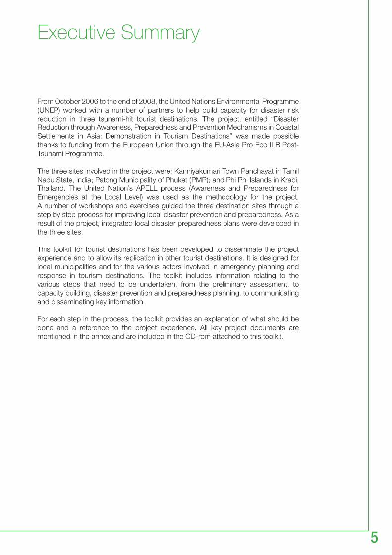
Kanniyakumari in India, Patong and Phi Phi Islands in Thailand were chosen as demonstrations sites for the project. All three were affected by the tsunami of December 2004 and are popular tourist destinations.
Beach in Kanniyakumari
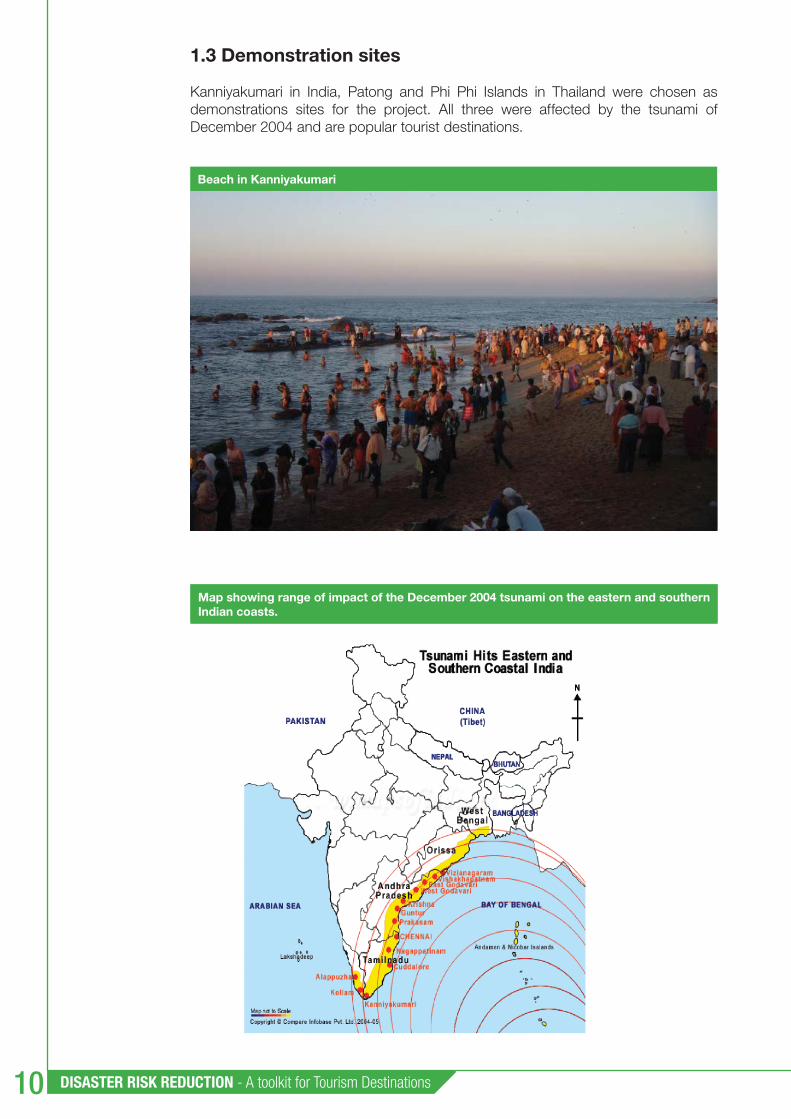
Map showing range of impact of the December 2004 tsunami on the eastern and southern Indian coasts.
Chapter 1 : Project Overview 11
Kanniyakumari is a small town of 20,000 inhabitants located at the southern-most tip of India, surrounded by the Bay of Bengal on the east, the Arabian Sea on the west and the Indian Ocean on the south. Kanniyakumari has an area of 26 km2 and attracts about 1.8 million tourists per year of which approximate 1,735,000 are domestic tourists and 64,000 international. The livelihood of local people in Kanniyakumari depends mainly on tourism. Man-made disasters are not likely in the town but there is a strong probability for natural disasters. The tsunami that struck in December 2004 affected 33 coastal villages and claimed 798 lives. Thousands of people were injured and signifi cant property was also damaged under the impact of the tsunami. Thed-sa-baan Muang Patong or Patong Municipality also participated in the project.
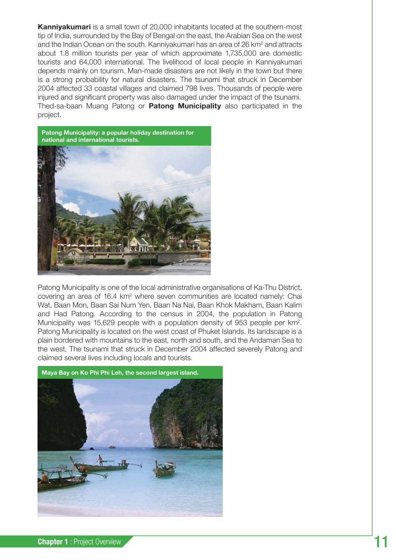
Patong Municipality is one of the local administrative organisations of Ka-Thu District, covering an area of 16.4 km2 where seven communities are located namely: Chai Wat, Baan Mon, Baan Sai Num Yen, Baan Na Nai, Baan Khok Makham, Baan Kalim and Had Patong. According to the census in 2004, the population in Patong Municipality was 15,629 people with a population density of 953 people per km2. Patong Municipality is located on the west coast of Phuket Islands. Its landscape is a plain bordered with mountains to the east, north and south, and the Andaman Sea to the west. The tsunami that struck in December 2004 affected severely Patong and claimed several lives including locals and tourists.
Patong Municipality: a popular holiday destination for national and international tourists.
Maya Bay on Ko Phi Phi Leh, the second largest island.

DISASTER RISK REDUCTION - A toolkit for Tourism Destinations
12
ANSAO / Phi Phi Islands are located in Thailand between the large islands of Phuket and the western Andaman Sea coast of the mainland. There are six islands in all. The two main islands are administratively part of Krabi province, most of which is on the mainland. Only one of the islands has permanent residents and the villages on the island are under administration of ANSAO. ANSAO / Phi Phi Islands are a popular tourist destination. The islands were devastated by the Indian Ocean tsunami of December 2004 when practically the entire island’s infrastructure was wiped out. Redevelopment has however been swift.
The table bellow summarises the relevance of tourism in the local economies.
1.4 The APELL process
The APELL programme (Awareness and Preparedness for Emergencies at Local Level) was born in the 1980s following various chemical accidents. UNEP suggested a series of measures to help governments, particularly in developing countries, reduce the occurrence and harmful effects of technological accidents and emergencies. One of these measures was to institute a programme – the APELL programme – enabling governments, in cooperation with industry to work with local leaders to identify the potential hazards in their communities. This programme also developed procedures to respond to and control emergencies that threaten public health and safety and the environment.
As an international initiative, the APELL programme was developed in full cooperation with partners in industry e.g. NGO’s, governments and other international organisations. In particular, direct support for the APELL programme was received from the International Council of Chemical Associations (ICCA) representing numerous national associations, multinational corporations, the Governments of Canada, France, Germany, Sweden, Switzerland and the USA; and from international organisations such as the Organization for Economic Cooperation and Development (OECD) and the European Commission of the European Union (EU) among others.
During the last two decades, the APELL Programme has made efforts to raise awareness worldwide of the APELL Process, to establish long-lasting stakeholder partnerships and to implement capacity-building initiatives for support of local partners, thus strengthening preparedness and response systems in selected industries and communities throughout the developed and developing world. The APELL process has been implemented successfully in a number of countries around the world.
Overview of key data in three tourism demonstration sites
Destination Total area sq km
Population Number of hotels
Number of tourism related companies
Tourists arrivals
Tourism % of the GDP
Kanniyakumari, India 25,89 19,678 75 166 domestic: 1.500.000international:60.000
N/A
Phi Phi Islands Thailand 11,12 6,333 51 144 547,000 24.1%
Patong, Thailand 16,4 16,987 104 191 841,000 58.8%

Chapter 1 : Project Overview 13
Since 1994, emphasis has been placed on using APELL as an international programme for accident prevention and preparedness in conjunction with other international organisations. This approach included improving communication with the public and developing tools for transport and port areas. “APELL for Port Areas” was released in 1996 and “TransAPELL, Guidance for Dangerous Goods Transport: Emergency Planning in a Local Community” was published in 2000. Since 2001, closer cooperation with particular industry sectors has resulted in the development of specifi c guidelines and tools like “APELL for Mining” released jointly with the International Council on Mining and Metals (ICMM) in 2001 and translated into Spanish jointly with the programme for Science and Technology for Development (CYTED) in 2004 as “APELL para Mineria”, the “Good practice in emergency preparedness and response”, a joint UNEP/ICMM publication in 2005 and the “Community Risk Profi le Tool”, developed in 2006 in partnership with the French Institute INERIS.
Since 2001, a focus on capacity-building and local demonstration was further emphasised, and several on-site applications took place. Most projects in the last fi ve years were aimed at training and capacity development to allow a more sustained application of the APELL principles by local partners. After recent natural disasters like the earthquakes in Iran and Algeria (in 2003), the Indian Ocean tsunami (2004) and the Pakistan earthquake (in 2005), the APELL programme extended its scope from industrial and technological disasters to a multi-hazard approach, resulting in current project demonstrations and capacity building initiatives in India, Thailand, Sri Lanka and Morocco.
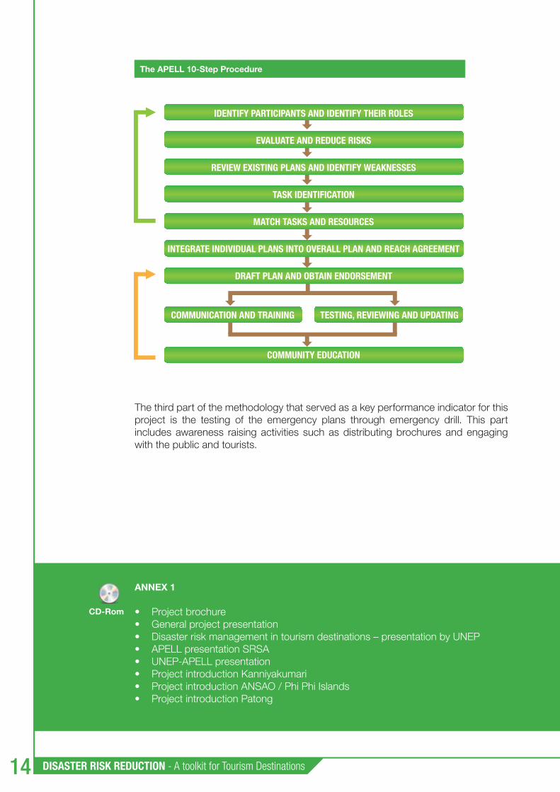
The APELL process helps local people develop information and decision-making procedures for addressing the hazards affecting their community. APELL can be useful in any situation that requires joint planning for local disasters by multiple stakeholders. By engaging stakeholders in a process of structured dialogue and coordination, APELL’s sequential 10-step approach (see fi gure below) leads to the development of a single, unifi ed emergency response plan for the community. Implementing the process not only develops the emergency plan; it also fosters awareness-raising, collaboration and feedback within the community.
APELL’s 10-step-wise approach to community-focused disaster planning is particularly suited to building awareness and capacity in communities that have not traditionally been involved in national contingency planning and early warning systems. The 10-step approach bears similarities to the classic strategic planning and disaster management cycles, i.e. is systematic in approach. The 10 steps are shown in the fi gure below.
Although APELL is designed as a stand-alone process, it does not eliminate the necessity for effective disaster management and risk reduction to be undertaken in the context of national or sub-national frameworks. This is the underlying premise of the toolkit: that government has primary responsibility for establishing the national disaster management organisation and for ensuring disaster risk reduction at tourism destinations.
The method of implementation of APELL is to fi rst establish a coordinating group and then proceed with an assessment of the local disaster management situation of a location. The next steps are hazard identifi cation, risk assessment, vulnerability mapping, revision of existing emergency plans and resources and development of a new integrated and agreed emergency plan.
The second part of APELL implementation is to raise awareness of the public exposed to risk, to train local authorities and emergency services on the new plan and to educate and involve the public on the outcomes of the plan.
DISASTER RISK REDUCTION - A toolkit for Tourism Destinations
14
The third part of the methodology that served as a key performance indicator for this project is the testing of the emergency plans through emergency drill. This part includes awareness raising activities such as distributing brochures and engaging with the public and tourists.
IDENTIFY PARTICIPANTS AND IDENTIFY THEIR ROLES
EVALUATE AND REDUCE RISKS
REVIEW EXISTING PLANS AND IDENTIFY WEAKNESSES
TASK IDENTIFICATION
MATCH TASKS AND RESOURCES
INTEGRATE INDIVIDUAL PLANS INTO OVERALL PLAN AND REACH AGREEMENT
DRAFT PLAN AND OBTAIN ENDORSEMENT
COMMUNITY EDUCATION
COMMUNICATION AND TRAINING TESTING, REVIEWING AND UPDATING
ANNEX 1
Project brochure • General project presentation• Disaster risk management in tourism destinations – presentation by UNEP• APELL presentation SRSA• UNEP-APELL presentation• Project introduction Kanniyakumari• Project introduction ANSAO / Phi Phi Islands• Project introduction Patong•
The APELL 10-Step Procedure
CD-Rom

Chapter 2 : Preparatory Work 15
Preparatory work22.1 Establishment of local coordinating groups
2.1.1 Description and objectives
Establishing a coordinating group at the local community level is the fi rst task to be undertaken by the tourism destination. The local disaster management agency or the local municipality could initiate the establishment of this group.
Establishing a formal coordinating group is a key part of the implementation of the APELL process. The coordinating group provides a mechanism for interaction and cooperation between the many players (APELL partners) involved in preventing or responding to emergencies - management, local authorities, and community leaders. It provides a means to achieve a coordinated approach to emergency response planning and to communications within the community. It can gather facts and opinions, assess risks, establish priorities, identify resources for emergency response, evaluate approaches and enhance communication. It can draw in the right people and resources to make sure that following the APELL steps will produce good results.
The cordinating group does not have a direct operational role during an emergency. It has a key role in building and maintaining motivation, communication, commitment, cooperation and momentum during the project.

DISASTER RISK REDUCTION - A toolkit for Tourism Destinations
16
More specifi cally, the group’s roles include:
ensuring open lines of communication between all parties;• identifying key people and organisations to involve;• setting objectives and a timeline for the process;• overseeing development of the coordinated emergency action plan • (10 steps);identifying available expertise;• establishing working groups for specifi c tasks;• ensuring clear risk communication occurs to vulnerable communities;• preparing the various parties involved to know their tasks should an accident • occur; and remaining as a central forum for dialogue and review after the planning process • is complete.
This is a process that normally lasts one year and requires the members of the coordinating group to meet once or twice a month.
The coordinating group ensures that the appropriate people (i.e. stakeholders), expertise and resources are brought together to collaboratively develop a participatory and responsive process. The group should function in parallel with other groups, committees or sub-committees within the national disaster management organisation. The advantage lies in the organisation of a multi-stakeholder collaborative group with resources and networks that are essential to the response phase of any disaster. Stakeholders include the full range of public, private and non-profi t representatives who have responsibility or interest in managing disaster risks at the tourism destination.
2.1.2 Project experience
In each location, the Asian project partners identifi ed representatives from the local agencies (fi re department, police, etc.), from the community and from the private sector (tourism) to take part in the local coordinating groups. The members of the groups were selected so as to refl ect their institutional and professional responsibilities, as well as their personal interest in promoting and maintaining good emergency awareness and preparedness in their community, so as to ensure their long-term commitment.
The coordinating group provides a mechanism for interaction and cooperation between the many players involved in disaster prevention and preparedness. During the course of the project, members of the coordinating groups in the three locations met on a regular basis to steer project implementation.

Chapter 2 : Preparatory Work 17
Members of the Kanniyakumari Coordinating Group
Government Sector
District Collector, Kanniyakumari as the Chairman of the CGDistrict Project Offi cer (Disaster Risk Management Programme) as a Convener District Public Relation Offi cerKanniyakumari Town Panchayat - 2 Tashildar, AgasthiswaramDy Superdient of PoliceDistrict Fire Offi cerDistrict Health ServicesRegional Transport Offi cerTamilnadu Electricity BoardPublic Works DepartmentFisheries Department, Govt of Tamil NaduTourism Offi ceer, Tamil NaduWater Administration & DrainageDivisional Engineer (Highways)Tamil Nadu State Transport Corpn.Poompuhar Shipping Corp. Ltd. (Ferry Service Operator)State Minor Port AuthorityMeteorological Observatory at KanniyakumariAll India RadioBharat Sanchar Nigam Ltd. (BSNL)Life Insurance Corporation of India
Private Sector
Hotel Association Mechanised Boat Owners AssociationMerchants’ Associationn Representative of TourOperatorAuto Rikshaw AssociationTourist Guides AssociationRepresentative of Restaurants
Community
Representative of St. Anthony’s SchoolNGO – Mahalir Association for Literacy, Awareness & Rights (Women forum of self-help Group)
National Service Scheme (Student volunteers organisation)
2.1.3 Guidance and resources
For the benefi t of community disaster planning, the following categories of representatives should be considered for membership in the coordinating group:
An interdisciplinary team of experts most familiar with local hazards, exposure • and vulnerability. They should have knowledge of data collection and natural processes e.g. from the meteorological service, geological and earth science institutes, academia, and other professional organisations such as planning, engineering, environmental and architect associations. These persons may already be part of the national disaster management network.
Local authorities, police, fi re and local emergency management personnel (i.e. • the fi rst responders) who have been involved with past natural disasters and emergencies and are familiar with community profi les and logistics.
Representatives from the tourism sector (e.g. hotel managers, tour operators, • tourism boards, travel agencies, transportation providers, restaurant owners), worker and trades unions and from other related operators in the community.
Resident community organisations, women’s organisations, NGOs and other • relevant civil society groups should also be involved.

DISASTER RISK REDUCTION - A toolkit for Tourism Destinations
18
Potential Members of the Coordinating Group
Potential Members of the Coordinating Group
The private sector Community Leaders
Fire department, police, civil defence Hotel managers NGOs
Health services (including hospitals) Restaurant managers Civil servants, university professors
Environmental Agency, Provincial Government
Tour operator companies Industry – fi shermen workers/union
Land use – coastal zone planners Local industries with special attention to the fi sheries
Hotel union representatives
Weather forecast services School directors, media representatives
Public works/transportation Religious leaders
Port authorities/fi shing authorities Tourist associations
ANNEX 2.1List of coordinating group members Patong• List of coordinating group members ANSAO / Phi Phi Islands• List of coordinating group members Kanniyakumari•
CD-Rom

Chapter 2 : Preparatory Work 19
2.2 Preliminary assessment
2.2.1 Description and objectives
This task aims to assess current mechanisms and existing resources to identify needs and untapped opportunities for effective disaster management. A preliminary assessment considers available resources, existing capacities, operational plans and procedures, as well as communication systems linking the preparedness and response community to higher levels of government decision-making.
A preliminary assessment of local disaster management is important for identifying major defi ciencies in existing plans. For tourism destinations without an existing preparedness plan, the capability assessment is an essential tool for evaluating the prevailing physical, institutional, social and economic conditions at destinations. Even if this institutional assessment is undertaken by the local disaster management offi ce, the coordinating group should be aware of the fi ndings and be willing to close the gaps and supplement any defi ciencies with its own resources, networks and personnel.
Specifi c challenges facing tourism destinations should be considered at this stage. These include:
Managing growth and development while preserving the quality and longevity of • a destination’s natural attractions and other heritage resources;
Spreading wealth and opportunity to host communities through responsible • tourism operations;
The highly fragmented nature of the local tourism industry and especially a lack of • cohesiveness between policy-makers, suppliers, buyers and other supporting services;
Signs of stress at the destination e.g. urban decay, excessive building massing • along coasts, overcrowding during cruise ship visits, traffi c congestion, high levels of pollution in coastal areas, confl ict between visitors and locals and between traditional occupations and tourist-based activities;
Deteriorating utility, health and social services and amenities; this often translates • into limited or poor quality services to residents and visitors; and,
Recurring disaster events disproportionately affecting the more vulnerable • members of the community and with extended recovery times for the destination as a whole.
The preliminary assessment phase is an important part of the process as it provides the baseline information for creating and / or reviewing the disaster management plan.
2.2.2 Project experience
The assessment was conducted by using on-site research in the three tourist destination areas chosen for the project. A questionnaire prepared by UNEP, SRSA and NSCI based on Annex 3 of the APELL handbook1 was used to help local partners carry out the assessment.
1 APELL: Awareness and Preparedness for Emergencies at Local Level, A Process for Responding to Technological Accidents. UNEP, 1988. ISBN 92-807-1183-0.

DISASTER RISK REDUCTION - A toolkit for Tourism Destinations20
During the process several authorities were involved including district revenue authorities, police offi cials at the district level and the local level, district health offi cials, executive offi cers from the municipalities, fi re offi cials, and business managers for enterprises such as hotels, ferries and shipping services. Volunteer organisations also participated.
Partners in the three locations prepared reports on the assessment of local current disaster management and plans which provided the necessary baseline information for the next steps in the project.
2.2.3 Guidance and resources
The assessment of local disaster preparedness was aimed at determining local capabilities for responding to potential disasters in seven areas: 1) risk identifi cation and assessment, 2) legal authority, 3) organisational structure, 4) early warning systems, 5) communication, 6) resources and emergency planning, and 7) tourism related issues.
A questionnaire prompting a number of questions in relation to each of the above topic was developed for the project to assist with the preliminary assessment. It is contained in the annex together with the examples of the local disaster management assessments of the three demonstration sites.
ANNEX 2.2Criteria for assessing local preparedness• Local disaster preparedness Kanniyakumari• Local disaster preparedness ANSAO / Phi Phi Islands• Local disaster preparedness Patong• Fire safety audit at Hotel Singaar International, Kanniyakumari•
CD-Rom
Chapter 3 : Capacity Building and Implementation for Disaster Prevention and Preparedness 21
Capacity Building and Implementation
for Disaster Prevention and Preparedness 3
Capacity building programmes for disaster prevention and preparedness, according to the three major theme areas in the APELL process include risk assessment, emergency planning and emergency drills. In addition, training in the APELL process is a useful initial capacity building exercise.
3.1 APELL training
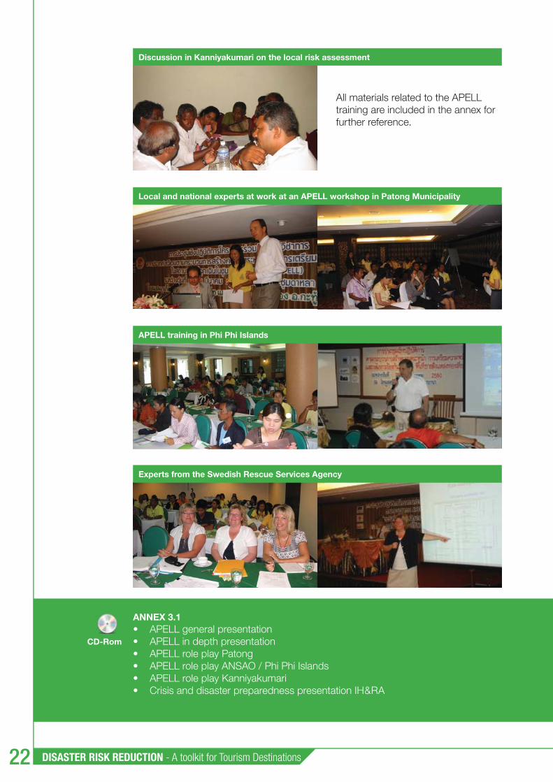
The purpose of the APELL demonstration was to show how APELL could be implemented under local conditions, while also providing hands-on training to stakeholders on local cooperative action to improve community awareness and emergency preparedness.
The APELL demonstration consists of the local community following the APELL 10-step process and implementing it through the coordinating group. This process normally takes a year and is supported by APELL workshops.
The workshops start with a presentation on risk management from a community perspective. The fundaments of APELL are described and each participant receives a comprehensive folder with APELL handbooks, brochures and reports from UNEP.
To obtain an understanding of how to work and use the APELL process, a role play exercise is carried out. The participants are divided into groups each with a task to perform such as:
Group 1: Identify participants, roles, resources and concerns for • emergency responseGroup 2: Evaluate the hazards and risks that might occur from natural • disastersGroup 3: Discuss the content of emergency response plans• Group 4: Identify all the required response tasks that are not covered by • existing plans
The APELL approach workshop was applied and implemented for raising public awareness, developing an emergency response system and assigning roles and responsibility for the incident command system.
DISASTER RISK REDUCTION - A toolkit for Tourism Destinations22
All materials related to the APELL training are included in the annex for further reference.
ANNEX 3.1APELL general presentation • APELL in depth presentation • APELL role play Patong• APELL role play ANSAO / Phi Phi Islands• APELL role play Kanniyakumari• Crisis and disaster preparedness presentation IH&RA•
Experts from the Swedish Rescue Services Agency
Discussion in Kanniyakumari on the local risk assessment
APELL training in Phi Phi Islands
Local and national experts at work at an APELL workshop in Patong Municipality
CD-Rom
Chapter 3 : Capacity Building and Implementation for Disaster Prevention and Preparedness 23
3.2 Risk assessment: hazard and vulnerability mapping
3.2.1 Description and objectives
Risk identifi cation and assessment is a process of measuring the potential for loss of life, personal injury, economic impact and property damages resulting from hazards. Risk assessment also involves an evaluation of the vulnerability of people, buildings and infrastructure and answers the question: “What would happen if a natural disaster occurred at the tourism destination?” A starting point for the coordinating group should therefore be an assessment of the current understanding of the community’s overall risks and capability to respond to future disaster events.
The assessment should include examination of risks to tourism resources (e.g. biodiversity, water supply), plant and infrastructure (e.g. coastal resorts), business risks (e.g. supply disruptions, changes in insurance coverage), or market risks (e.g. changes in competitiveness through increased transportation costs). Analysing the impacts of hazards and identifying the most vulnerable destination and community locations and assets are essential for establishing the local context. This will allow the coordinating group to better focus their activities when overseeing the development of the disaster preparedness plan.
To complete a hazard and vulnerability mapping, in a fi rst step the coordinating group or its designated risk assessment committee should identify all categories of events that might affect the community and then prioritise the list according to the most serious hazards impacting the community. It is important to take a systematic approach because a hazard not identifi ed at this stage could potentially be excluded from further analysis. The analysis should review the full range of potential hazards and assess the signifi cant impacts upon the community and the environment.
The next step involves determining the level of exposure or the vulnerability to the identifi ed hazards. Vulnerability mapping depicts areas that are at risk from a potentially disastrous event, which could result in death, injury or damage to property and tourism infrastructure. Assessing exposure levels is essential for preparedness planning as it directly affects the destination’s vulnerability and ability to respond and recover from natural disasters. There will be differing levels of exposure due to demographic, topographic, geologic and environmental considerations, in addition to the infl uence that the type and quality of the built environment has on the anticipated consequences of hazard events.
3.2.2 Project examples
The risk assessment for Kanniyakumari identifi ed four main sources of risks: tsunamis, cyclones, fi res and stampedes. While Kanniyakumari does not fall within an earthquake prone area, it can be affected by earthquakes occurring in the following zones: the Indonesian Sea, the Socotra Island Region near African Coast, the Andaman and Nicobar Island Region, the Arakan Coast Region of Myanmar, the Gulf of Aden, the Diego Garcia Island Region in the Indian Ocean and the Makaran coastal region near Pakistan. In addition to earthquakes, occurrences of volcanoes can also generate tsunamis. Moreover, cyclones on the east coast are a frequent phenomenon while on the west coast the frequency of cyclones is somewhat less. However, the available cyclone data from the India Meteorological Department (IMD) for the last two hundred years does not indicate the occurrence of a strong cyclone at Kanniyakumari.
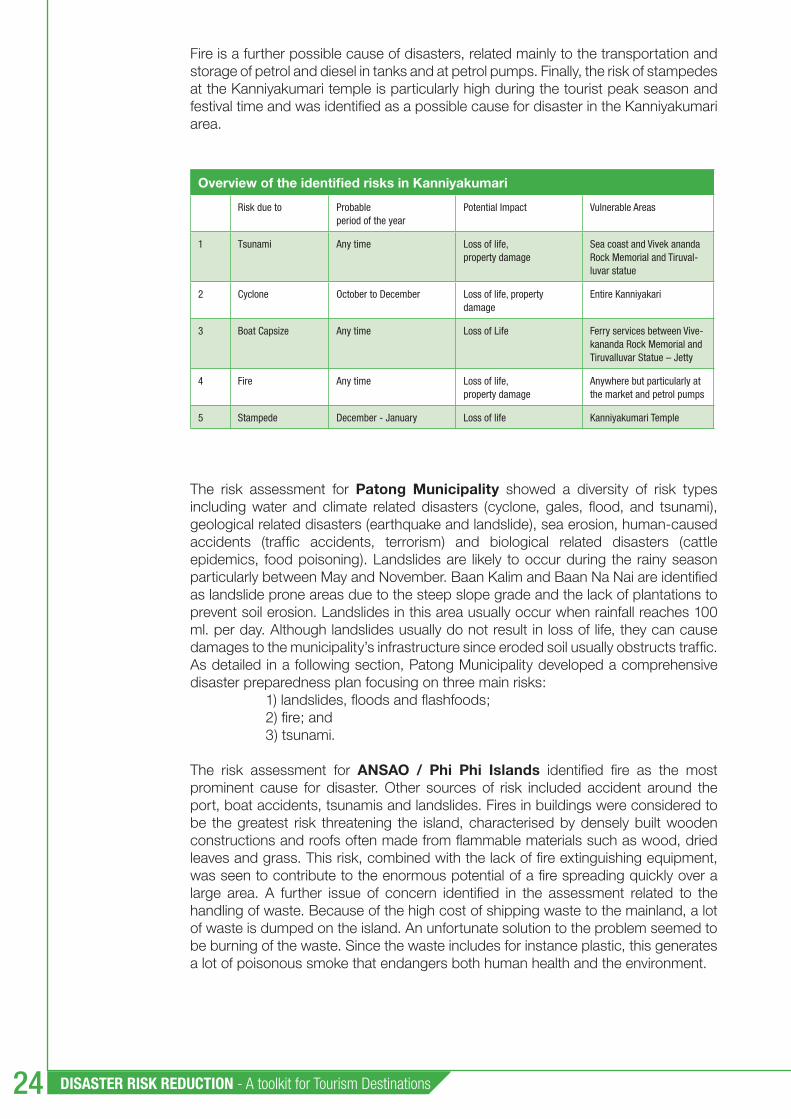
DISASTER RISK REDUCTION - A toolkit for Tourism Destinations24
Fire is a further possible cause of disasters, related mainly to the transportation and storage of petrol and diesel in tanks and at petrol pumps. Finally, the risk of stampedes at the Kanniyakumari temple is particularly high during the tourist peak season and festival time and was identifi ed as a possible cause for disaster in the Kanniyakumari area.
Overview of the identifi ed risks in Kanniyakumari
Risk due to Probable period of the year
Potential Impact Vulnerable Areas
1 Tsunami Any time Loss of life, property damage
Sea coast and Vivek ananda Rock Memorial and Tiruval-luvar statue
2 Cyclone October to December Loss of life, property damage
Entire Kanniyakari
3 Boat Capsize Any time Loss of Life Ferry services between Vive-kananda Rock Memorial and Tiruvalluvar Statue – Jetty
4 Fire Any time Loss of life, property damage
Anywhere but particularly at the market and petrol pumps
5 Stampede December - January Loss of life Kanniyakumari Temple
The risk assessment for Patong Municipality showed a diversity of risk types including water and climate related disasters (cyclone, gales, fl ood, and tsunami), geological related disasters (earthquake and landslide), sea erosion, human-caused accidents (traffi c accidents, terrorism) and biological related disasters (cattle epidemics, food poisoning). Landslides are likely to occur during the rainy season particularly between May and November. Baan Kalim and Baan Na Nai are identifi ed as landslide prone areas due to the steep slope grade and the lack of plantations to prevent soil erosion. Landslides in this area usually occur when rainfall reaches 100 ml. per day. Although landslides usually do not result in loss of life, they can cause damages to the municipality’s infrastructure since eroded soil usually obstructs traffi c. As detailed in a following section, Patong Municipality developed a comprehensive disaster preparedness plan focusing on three main risks:
1) landslides, fl oods and fl ashfoods; 2) fi re; and 3) tsunami.
The risk assessment for ANSAO / Phi Phi Islands identifi ed fi re as the most prominent cause for disaster. Other sources of risk included accident around the port, boat accidents, tsunamis and landslides. Fires in buildings were considered to be the greatest risk threatening the island, characterised by densely built wooden constructions and roofs often made from fl ammable materials such as wood, dried leaves and grass. This risk, combined with the lack of fi re extinguishing equipment, was seen to contribute to the enormous potential of a fi re spreading quickly over a large area. A further issue of concern identifi ed in the assessment related to the handling of waste. Because of the high cost of shipping waste to the mainland, a lot of waste is dumped on the island. An unfortunate solution to the problem seemed to be burning of the waste. Since the waste includes for instance plastic, this generates a lot of poisonous smoke that endangers both human health and the environment.
Chapter 3 : Capacity Building and Implementation for Disaster Prevention and Preparedness 25
3.2.3 Vulnerability maps
A vulnerability map gives the precise location of sites where people, the natural environment or property are at risk due to a potentially catastrophic event that could result in death, injury, pollution or other destruction. Such maps are made in conjunction with information about different types of risks. A vulnerability map can show the housing areas that are vulnerable to a chemical spill at a nearby factory. They can also delineate the commercial, tourist and residential zones that would be damaged in case of a fl ood or a tsunami.
Vulnerability maps are most often created with the assistance of computer technology called geographic information systems (GIS) and digital land survey equipment designed for use in the fi eld. However, vulnerability maps can also be created manually using background maps such as satellite imagery, property boundaries, road maps, or topographic maps. In such cases the municipality’s planning offi ce should be involved in order to take advantage of the base maps that have already been made for other purposes.
If it is not possible to develop a vulnerability map using a GIS system or to employ a cartographer to prepare the map, a risk group can nevertheless prepare a risk and vulnerability map for the local area. A detailed analogue map should be used as the base map. Several plastic sheets each one representing a different theme can then be used and superposed on the base map. For example, one sheet can highlight the various types of vulnerable sites such as hotels, schools, day care centres, public places and critical infrastructure. Another plastic layer can illustrate for risk sources such as industrial sites, storage dangerous chemicals etc. A third layer can show depots for emergency response equipment. Another sheet can pinpoint the location of fi re stations and rescue units etc. The overlays can be used together to locate very vulnerable areas, or they can be used one theme at a time.
Vulnerability mapping can facilitate improved communication about risks and what is threatened. Such maps can be used for visual presentations and provide for a better understanding of the risks and vulnerabilities. Decision-makers can see where resources are needed in order to protect these areas. Vulnerability maps will allow them to decide on mitigating measures to prevent or reduce loss of life, injury and environmental consequences before a disaster occurs. An interdisciplinary risk group considers where mitigating measures should be taken before, for example, a fl ood occurs. Those preparing the maps can overlap fl ood inundation and slope stability zones with property maps in order to determine which properties and buildings are at risk. They can then notify the landowners and inform them of government subsidies or other support available for undertaking a measure that would protect their homes from potential damage by, for example, fl oods or slope failure.
During the course of the project, three vulnerability maps were completed one for each of the tourist destinations. As part of this work, a tsunami survey was undertaken for Kanniyakumari. A closer look at the penetration of tsunami waves inside the shore is an indication of the level of destruction. Collection of such data helps in planning of future mitigating measures. For this purpose, the entire coast of Kanniyakumari was surveyed. A team of three postgraduate students studied the entire coastline of about 4.8 km in length. The locations were selected at 50m intervals. The locations of the survey points were noted by a GPS and these locations were recorded in a table. At each location, whenever possible some persons were interviewed and information from them was recorded. The data was analysed and presented in graphs. One graph shows the heights of the tsunami at different locations and another graph shows the extent of the inundation.

DISASTER RISK REDUCTION - A toolkit for Tourism Destinations26
Kanniyakumari’s land use planning map including zones prone to inundation as a result of a tsunami.
Tsunamis
A tsunami is a series of destructive waves affecting shorelines Tsunamis are usually generated by earthquakes. A natural indication of Tsunami can be detected by the fast and unexpected retreat of the sea.
What should I do ?
Before disaster:
• Locate tsunami prone areas and evacuation routes and shelters in the map based on the zone you are in.
• Know well in advance what your safest evacuation route will be. • Follow the news for a tsunami forecast.
During a disaster:
• Follow warning signs and indication evacuation routes to higher ground and to shelters. • Move to higher ground or inland. • If no higher ground is near, go to upper levels of reinforced buildings.
After a disaster: • Continue to monitor your local radio for further information and instructions. • Once you are notified the emergency is over, go back to the hotel.
How can I be informed? Warning sirens and warning towers located along Patong beach. • Warning information via radio and warning towers in communities. • Vans will disseminate tsunami warning messages and advice to evacuate.
Patong Municipality Vulnerability Map
Chapter 3 : Capacity Building and Implementation for Disaster Prevention and Preparedness 27
3.2.4 Guidance and resources
During the course of the project, the theory and practice of risk assessment was discussed during a specifi c workshop, focusing on hazard and vulnerability mapping. All documents relating to the workshop are included in the annex for reference.
In addition, a vulnerability mapping handbook was created for the project. It describes the importance of various stages including identifi cation of local hazards, assessment of local vulnerabilities and production of maps showing risk zones as well as threatened sites within those zones. It is also included in the annex.
ANNEX 3.2 Handbook for vulnerability mapping• Introduction to emergency planning presentation SRSA• Risk management presentation SRSA• Riskmatrix SRSA • Fires in public buildings and hotels presentation SRSA• Scenario fi re in discotheque presentation SRSA• Tourism and risk management presentation UNEP• Tourism risk management for Asia-Pacifi c region – checklist• Tsunami survey report Kanniyakumari • Agenda for Risk Assessment and Emergency Planning – Patong• Agenda for Risk Assessment and Emergency Planning - Phi Phi Islands• Agenda for Risk Assessment and Emergency Planning - Kanniyakumari• Natual Hazard risk mapping in Sweden presentation SRSA•
CD-Rom
DISASTER RISK REDUCTION - A toolkit for Tourism Destinations28
3.3 Shelter Assessments
3.3.1 Description and objectives
A shelter assessment can be an important aspect of disaster prevention and preparedness efforts. The objective of the shelter assessment is primarily to determine the requirements for designated shelters. Potential shelter sites should be investigated and then assessed for suitability. Local authorities have the responsibility for determining shelter sites. During the EU project, recommendations were made to the authorities in the three tourism destination sites, allowing them to create shelter plans or review existing ones.
Studies show that survivors from disasters often prioritise shelter in the following order: 1) to remain as close as possible to their damaged or ruined homes; 2) to move temporarily into the homes of families or friends; 3) to improvise temporary shelters as close as possible to the site of their ruined homes; 4) to occupy buildings which have been temporarily requisitioned; 5) to occupy tents erected in, or next to, their ruined homes; 6) to occupy tents on campsites; and 7) to be evacuated to distant locations.
The assessment focuses on situations where people are evacuated to occupy temporarily requisitioned buildings or constructions. In order to decide what buildings or constructions are suitable for temporary shelter, there are many factors that have to be evaluated. For example, depending on the type of disaster or number of affected people, preference might be given to a specifi c type of shelter. Other factors such as target group or time constraints will also affect the choice of shelter.
3.3.2 Project examples of Local Shelter Assessments
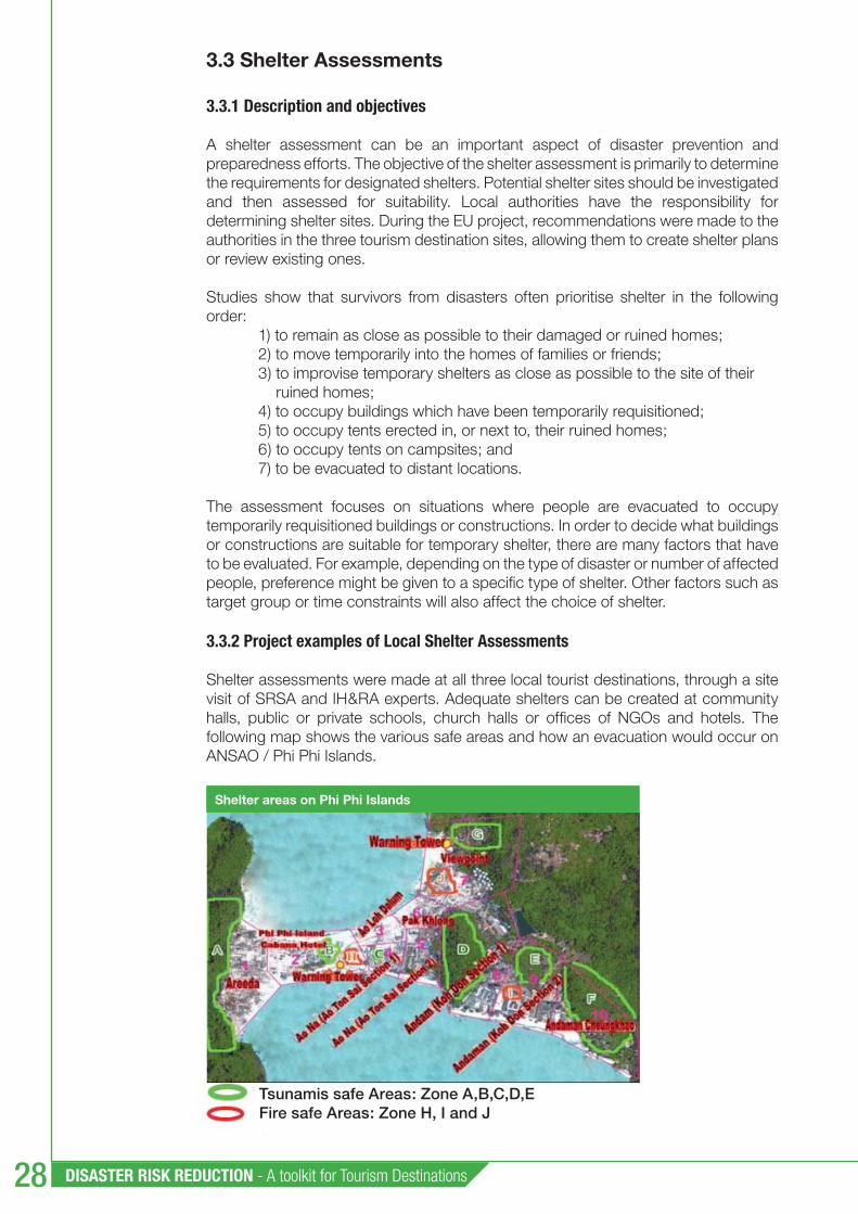
Shelter assessments were made at all three local tourist destinations, through a site visit of SRSA and IH&RA experts. Adequate shelters can be created at community halls, public or private schools, church halls or offi ces of NGOs and hotels. The following map shows the various safe areas and how an evacuation would occur on ANSAO / Phi Phi Islands.
Shelter areas on Phi Phi Islands
Tsunamis safe Areas: Zone A,B,C,D,EFire safe Areas: Zone H, I and J
Chapter 3 : Capacity Building and Implementation for Disaster Prevention and Preparedness 29
3.3.3 Guidance and resources
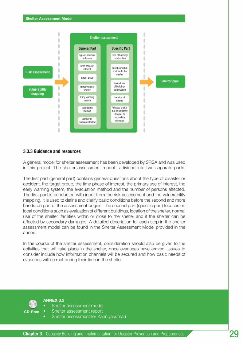
A general model for shelter assessment has been developed by SRSA and was used in this project. The shelter assessment model is divided into two separate parts.
The fi rst part (general part) contains general questions about the type of disaster or accident, the target group, the time phase of interest, the primary use of interest, the early warning system, the evacuation method and the number of persons affected. The fi rst part is conducted with input from the risk assessment and the vulnerability mapping. It is used to defi ne and clarify basic conditions before the second and more hands-on part of the assessment begins. The second part (specifi c part) focuses on local conditions such as evaluation of different buildings, location of the shelter, normal use of the shelter, facilities within or close to the shelter and if the shelter can be affected by secondary damages. A detailed description for each step in the shelter assessment model can be found in the Shelter Assessment Model provided in the annex.
In the course of the shelter assessment, consideration should also be given to the activities that will take place in the shelter, once evacuees have arrived. Issues to consider include how information channels will be secured and how basic needs of evacuees will be met during their time in the shelter.
General Part
Risk assessment
Shelter assessment
Shelter plan
Vulnerabilitymapping
Specific Part
Type of accidentor disaster
Type of building/construction
Time phase ofinterest
Target group
Primary use ofshelter
Early warningsystem
Location of shelter
Evacuationmethod
Number of persons affected
Affected shelterdue to accident/
disaster orsecondarydamages
Facilities withinor close to the
shelter
Normal use of building/ construction
ANNEX 3.3 Shelter assessment model• Shelter assessment report• Shelter assessment for Kanniyakumari•
Shelter Assessment Model
CD-Rom

DISASTER RISK REDUCTION - A toolkit for Tourism Destinations30
3.4 Environmental awareness
3.4.1 Description and objectives
Environmental management has an important role to play in reducing many of the risks posed by natural disasters. Healthy ecosystems and well planned environmental management have the greatest capacity to mitigate at least certain categories and scales of natural hazards. Several governments have already recognised the important social and economic benefi ts of maintaining healthy environments. The protection role of mangrove and alpine forests for example are highlighted in the legislation of Malaysia and Switzerland respectively.
Ecosystems need to be appropriately managed to provide a substantial buffering effect to potential natural disasters. Many cases demonstrate that when natural barriers – such as coastal vegetation, coral reefs and sand dunes – are removed or degraded, these areas become highly vulnerable to natural hazards. However, natural buffers cannot protect against all hazards, or offer complete protection. Instead, they must be used in integration with other risk management components, such as early warning systems and awareness raising mechanisms.
3.4.2 Project experience
To raise awareness of the public and of the tourism sector on the relationship between environmental conservation and disaster impact reduction, a capacity building event in the form of a workshop was organised in the three pilot destinations. The events focused on potential actions to minimise disaster impacts through environmentally-friendly actions and considerations to be included in the integrated emergency plan.
Participants at the Sustainable Tourism Management seminar in Patong Municipality
Environmental management workshop in Phi Phi Islands

Chapter 3 : Capacity Building and Implementation for Disaster Prevention and Preparedness 31
3.4.3 Guidance and resources
During the workshop, participants discussed the following questions: 1) what are the major environmental, social and economics threats facing our destination or business?; 2) What control and monitoring measures could we implement to address these threats?; and 3) What can you do in your hotels, resorts, and communities to improve environmental awareness and social performance that will minimise negative impacts?
Documents related to the workshop are included in the annex for reference.
ANNEX 3.4 A manual for water and waste management• A practical guide marine recreation• A practical guide marine recreation –self evaluation checklist• Climate change adaptation and mitigation in the tourism sector • Climate change and tourism - advanced Summary• Industry as a partner for tourism• Integrating sustainability: a guide for tourism coordinators • Managing environmental and social issues in the accommodation sector• Marketing sustainable tourism products• Environmental management systems in hotels• Environmental issues related to disaster and accidents presentation SRSA• Environmental awareness workshop agenda Kanniyakumari• Environmental awareness workshop report ANSAO / Phi Phi Islands• Environmental awareness workshop report Patong•
CD-Rom

DISASTER RISK REDUCTION - A toolkit for Tourism Destinations32
Disaster Prevention and Preparedness
Planning44.1 Description and objectives
The objective of emergency preparedness planning is to decide who does what, where and when and to provide knowledge for everyone responsible for emergency preparedness. This information is compiled in a disaster preparedness plan. Its main purpose is to assist victims in the immediate aftermath of the disaster and to set the destination on a path of recovery and business continuity in accordance with the plan. The disaster preparedness plan must be relevant to the size and complexity of the tourism destination and community and consider all relevant hazards. It should also be clear and concise, delineating the roles and responsibilities of all collaborating local governmental agencies, groups and emergency support functions for all phases of the disaster management cycle (prevention, preparedness, response, and recovery).
Among other procedures, it should explain warning systems and triggers for activating or deactivating emergency actions, evacuation and sheltering including critical access and exit routes, and the procedures for mobilising emergency personnel and resources. Procedures for activating and operating national, regional or local emergency operations centres and the incident command system should also be clearly specifi ed.
The following points illustrate the essential components of local disaster preparedness plans:
Early Warning Systems: 1. Warnings should be timely, authoritative, and precise. Whether a disaster or emergency comes with little or no warning, or whether, as in the case of a tropical cyclone, they are preceded by advance notice, mechanisms need to be in place.

Chapter 4 : Disaster Prevention and Preparedness Planning 33
Evacuation and Sheltering:2. These are critical concerns for tourism destinations because of their vulnerability to storms, cyclones, storm surges, and fl ooding. Evacuation planning should consider the vulnerability mapping and risk scenarios developed previously. Specifi c shelter assessments (described in section 4.3) can be conducted ahead of time. Depending upon the intensity of the hazard, protective actions could involve sheltering in place or evacuation inland to congregate emergency shelters, e.g. such as pre-designated schools or other public facilities. Mobilising Emergency Personnel and Resources: 3. Procedures need to be specifi ed for the process of mobilising emergency personnel and others with secondary emergency management roles when a threat is detected or notifi cation of an impeding threat is issued.
Command and Control Functions: 4. The plan should match the preparedness and response activities to the resources of the identifi ed stakeholders. A clear defi nition of responsibility is a key element for emergency plans: the writer should make sure that the roles of each stakeholder are defi ned and that gathering locations are indicated, in addition to names, function and telephone. Responsibilities for initiating evacuation and for rescue operations should be clearly defi ned. The plan should defi ne a clear line of command, taking into account hierarchy, in particular for the communication system and for operational safety.
Communications Plan, Coordination and Informing the Public:5. Communication provides the critical links among stakeholders active in the fi eld and disaster managers operating from an existing or makeshift Emergency Operations Centre. The stakeholders include not only those responders internal to the emergency management organisational structure but also the network of tourism industry personnel, volunteers, NGOs, tourists and the general public. The plan should have procedures in place for a designated spokesperson to inform the general public with clear and consistent messages on preparedness, response and recovery issues, with specifi c attention paid to languages as foreign visitors may not be fl uent in the prevalent local language.
Risk Scenarios and Contingency Planning: 6. Risk scenarios are the tools for contingency planning. They are normally included as annexes to the core preparedness plan (the core document is generally applicable to all hazards). Contingency plans address the operational requirements necessary to effectively respond to a specifi c hazard by delineating roles, responsibilities and procedures for essential management functions.
Restoring Public Services: 7. The plan should anticipate the need for temporary and permanent restoration of critical facilities, infrastructure, and essential public services following a disaster event. The destination’s risk assessment provides valuable information on the vulnerability of these critical facilities that must be addressed through contingency planning for each priority hazard. This recovery function is normally discussed in a “functional annex” to the preparedness plan.
Records Management:8. Often ignored during the chaos of disaster response and recovery, records management is important and should be addressed in the preparedness plan.
Planning for Recovery:9. Preparedness plans have traditionally focused solely on preparedness and emergency response functions. However, there has been an emerging trend in recent years to incorporate a long-term recovery element in

DISASTER RISK REDUCTION - A toolkit for Tourism Destinations34
these plans. This innovative approach can help achieve long term disaster resilience in tourism destinations.
Plan Revision and Updating: 10. The plan must be viewed as a living document, one that must be monitored over time, evaluated for its continued relevance and updated periodically to address growth in the destination, along with changes in key personnel and institutional structures.
4.2 Project examples
The three locations developed integrated disaster preparedness plans as a result of the project.
In the case of Kanniyakumari, a very detailed document was drawn-up, covering the following areas:
hazard and vulnerability analysis and identifi cation of disaster scenarios;• mitigation measures;• disaster management organisation;• trigger mechanisms and operational directions at the district levels; and• procedures for testing and up-dating the plan. •
The stated purpose of Kanniyakumari’s plan is to develop, implement and maintain an integrated emergency management system for the protection of people, property and the environment in the event of natural events such as a cyclone or tsunami, fi res in congested areas and to avoid a stampede in Kanniyakumari Temple. The ultimate goal is to reduce the vulnerability of the area, to save lives and protect property and environment by developing capabilities that mitigate the effects of, prepare for, respond to and recover from any emergency that could affect the area. For developing the plan, the historical data about cyclones, fi res and other accidents was used. Vulnerability assessments carried out by the National Safety Council of India (NSCI) team in December 2007 were also used. The Kanniyakumari Town Panchayat Disaster Management Committee was responsible for the plan.
Patong Municipality also developed a very comprehensive disaster preparedness plan, focusing on three main risks: 1) landslides, inundations and fl ashfl oods; 2) fi re; and 3) tsunami.
For each risk category, the plan provides the following information: procedures for emergency management, related operation units, line of command, communication system and budget. The stated objectives of the overall plan are:
to provide the prevention measures and coordinate among concerned • agencies including the main responsibility agencies and operation units; to reduce losses of lives and properties; and• to evacuate the victims to safety areas systematically without panic.•
A directing center of Patong Municipality is set-up for each risk category, under the responsibility of the Mayor of Patong Municipality as the Incident Commander.
The disaster preparedness plan developed by ANSAO / Phi Phi Islands covers the following areas: principles of practice, implementation procedures, incident command

Chapter 4 : Disaster Prevention and Preparedness Planning 35
and resources, communication and operational procedures. The plan focuses on the following risks: fi re, accident around the port, boat accident, tsunamis and landslide.
The stated objectives of the plan are:
to save lives and properties of people in the risk area;• to ensure the safety evacuation;• to ensure the local disaster preparedness before, during and after • emergency;to support the systematic coordination and cooperation of • multi-organisations; andto promote the participation of all stakeholders, including private sectors, • NGOs, and local people.
The Chief Executive of ANSAO is responsible for the plan.
4.3 Guidance and resources
The disaster management plans prepared by the three project locations can be used as guiding examples. They are included in the annex for reference. The following table also summarises the steps involved in the preparation of a disaster preparedness plan, specifi cally for coastal tourist destinations.
ANNEX 4.3 Disaster management plan for Patong• Disaster management plan for ANSAO / Phi Phi Islands• Disaster management plan for Kanniyakumari•
CD-Rom

DISASTER RISK REDUCTION - A toolkit for Tourism Destinations36
15 A
CT
ION
S T
O D
EV
ELO
P A
DIS
AS
TE
R P
RE
PAR
ED
NE
SS
PLA
N F
OR
A C
OA
STA
L T
OU
RIS
M D
ES
TIN
AT
ION
Actio
nsSu
b-ac
tions
Tips
1Id
entif
y an
d en
gage
key
st
akeh
olde
rsId
entif
y al
l rel
evan
t sta
keho
lder
s in
the
dest
inat
ion
that
are
invo
lved
in d
isas
ter r
elat
ed is
sues
– fr
om th
e pr
ivat
e se
ctor
(in
clud
ing
the
tour
ism
sec
tor),
the
loca
l aut
horit
ies
(incl
udin
g em
erge
ncy
serv
ices
, pla
nnin
g se
rvic
es a
nd m
eteo
rolo
gica
l se
rvic
es) a
nd fr
om th
e lo
cal p
opul
atio
n.
Esta
blis
h co
mm
unic
atio
ns w
ith th
e ab
ove
men
tione
d st
akeh
olde
rs.
Sele
ct a
lead
ing
agen
cy, d
efi n
e th
e pr
oble
m a
nd o
bjec
tives
. The
se w
ill b
e fra
min
g th
e pr
oces
s th
at w
ill b
e fo
llow
ed b
y th
e de
velo
pmen
t of t
he D
isas
ter P
repa
redn
ess
Plan
.
Reac
h co
mm
on u
nder
stan
ding
on
the
proc
ess.
Stak
ehol
ders
sho
uld
have
resp
onsi
bilit
y or
inte
rest
in m
anag
ing
disa
ster
risk
at
the
coas
tal t
ouris
m d
estin
atio
n.
Rem
embe
r to
inte
grat
e va
rious
pro
duct
ive
and
serv
ice
sect
ors
at th
e de
stin
atio
n th
at in
terfa
ce w
ith th
e to
uris
m s
ecto
r.
Incl
ude
the
med
ia a
s ke
y pa
rtner
.
2Ra
ise
awar
enes
sOr
gani
se a
war
enes
s ra
isin
g w
orks
hops
and
invo
lve
the
abov
e m
entio
ned
acto
rs –
pro
pose
an
appr
oach
for a
par
ticip
ator
y pr
oces
s fo
r the
dev
elop
men
t of a
n in
tegr
ated
Dis
aste
r Pre
pare
dnes
s Pl
an fo
r the
coa
stal
tour
ism
des
tinat
ion.
Esta
blis
h an
aw
aren
ess
plat
form
that
will
last
at l
east
dur
ing
the
timef
ram
e of
the
proc
ess.
The
med
ia w
ill b
e a
key
partn
er th
roug
hout
the
proc
ess
to c
onve
y m
essa
ges.
In
volv
ing
the
med
ia a
llow
s th
em to
bet
ter u
nder
stan
d a
nd c
omm
unic
ate
the
issu
es.
Wor
ksho
ps w
ill a
llow
for p
rese
ntat
ion
of th
e pr
oces
s, a
nd to
cre
ate
awar
enes
s on
ris
ks a
nd d
isas
ter p
repa
redn
ess.
3Es
tabl
ish
a co
ordi
natin
g gr
oup
(CG)
Amon
g th
e id
entifi
ed
grou
p of
sta
keho
lder
s, e
stab
lish
a co
ordi
natin
g gr
oup
to le
ad a
nd s
uppo
rt th
e pa
rtici
pato
ry p
roce
ss,
with
sel
ecte
d re
pres
enta
tives
of a
ll st
akeh
olde
r gro
ups.
Activ
ities
and
prio
ritie
s of
the
CG:
- To
brin
g lo
cal i
ndus
try
focu
s ; a
nd- T
o en
sure
that
the
right
peo
ple
(i.e.
sta
keho
lder
s), e
xper
tise
and
reso
urce
s ar
e br
ough
t tog
ethe
r to
colla
bora
tivel
y de
velo
p a
parti
cipa
tory
and
resp
onsi
ve
proc
ess.
4De
fi ne
a w
ork
plan
to th
e pr
oces
s (b
oth
for t
he C
G an
d ta
king
into
acc
ount
ex
tern
al a
ssis
tanc
e ne
eded
)
The
CG s
houl
d es
tabl
ish
an o
bjec
tive,
a w
ork
plan
with
tim
elin
e an
d ac
tiviti
es, d
eadl
ines
, and
key
role
s an
d re
spon
sibi
litie
s.
Iden
tify
stak
ehol
ders
out
side
the
CG th
at w
ill h
ave
to b
e re
gula
rly c
onta
cted
.
Set-
up a
con
sulta
tion
phas
e to
ens
ure
that
the
wor
k pl
an a
ddre
sses
the
diffe
rent
sta
keho
lder
s’ n
eeds
.
Do n
ot fo
rget
to in
form
the
natio
nal /
regi
onal
/loc
al a
utho
ritie
s, e
spec
ially
the
ones
that
will
offi
cial
ly a
ppro
ve th
e pl
an.
5Un
derta
ke a
loca
l ca
paci
ty a
sses
smen
tUn
derta
ke a
legi
slat
ive
chec
k.
Unde
rtake
a c
apac
ity a
sses
smen
t in
term
s of
hum
an, fi
nan
cial
and
resp
onse
reso
urce
s.
Revi
ew e
xist
ing
plan
s, a
nd c
onsi
der i
nfor
mat
ion
incl
uded
.
You
certa
inly
hav
e id
entifi
ed
gaps
, and
may
be h
ave
solu
tions
/ id
eas
to im
prov
e it.
Put
the
solu
tion
into
pra
ctic
e no
w if
pos
sibl
e, o
r tak
e th
e ga
ps in
to a
ccou
nt
whe
n de
velo
ping
the
plan
.
The
CG m
ust l
iais
e w
ith th
e lo
cal d
isas
ter m
anag
emen
t offi
ce (i
f con
duct
ing
the
asse
ssm
ent)
to e
xcha
nge
the
info
rmat
ion.
6As
sess
the
curr
ent s
itua-
tion
of th
e lo
catio
n As
sess
:Ge
ogra
phic
loca
tion,
wea
ther
, sea
sons
.To
uris
m a
nd lo
cal p
opul
atio
n fl o
ws,
and
sea
sona
lity
in th
e de
stin
atio
n.
Cons
ider
som
e of
the
uniq
ue a
spec
ts o
f coa
stal
tour
ism
des
tinat
ions
.
7Ev
alua
te a
nd a
sses
s th
e ris
ks:
Iden
tify
all c
limat
e ch
ange
-rel
ated
haz
ards
in th
e co
asta
l tou
rism
des
tinat
ion
(map
them
if p
ossi
ble)
and
prio
ritiz
e th
em
taki
ng in
to a
ccou
nt th
e lik
elih
ood
of a
dis
aste
r.
Iden
tify
pote
ntia
lly th
reat
ened
ass
ets,
faci
litie
s an
d in
frast
ruct
ure,
and
net
wor
ks.
Dete
rmin
e th
e de
stin
atio
n’s
leve
l of e
xpos
ure/
vuln
erab
ility
(inc
ludi
ng e
xpos
ure
of to
uris
m s
uppl
y ch
ain
netw
orks
).
Asse
ss th
e co
asta
l tou
rism
des
tinat
ion’
s ris
ks.
Eval
uate
risk
redu
ctio
n op
tions
.
Take
an
All H
azar
ds a
ppro
ach
by a
lso
eval
uatin
g th
e hu
man
-indu
ced
inci
dent
s th
at m
ay b
e a
key
risk.
Whe
n id
entif
ying
pot
entia
l thr
eate
ned
asse
ts…
con
side
r: To
uris
t res
orts
, hot
els
and
amen
ities
; hos
pita
ls a
nd c
linic
s; p
ort f
acili
ties,
airp
orts
and
road
net
wor
ks;
etc.

Chapter 4 : Disaster Prevention and Preparedness Planning 37
15 A
CT
ION
S T
O D
EV
ELO
P A
DIS
AS
TE
R P
RE
PAR
ED
NE
SS
PLA
N F
OR
A C
OA
STA
L T
OU
RIS
M D
ES
TIN
AT
ION
8De
velo
p vu
lner
abili
ty
map
s
Use
outp
ut fr
om th
e ris
k as
sess
men
t.Co
llect
info
rmat
ion
(a s
urve
y m
ay b
e ne
cess
ary)
.Id
entif
y on
the
map
, the
vul
nera
ble
area
s re
late
d to
the
loca
l com
mun
ity, t
ouris
m in
frast
ruct
ures
and
faci
litie
s, to
pro
perty
an
d to
the
envi
ronm
ent.
Deve
lop
the
vuln
erab
ility
map
.
Cons
ider
tour
ism
fl ow
s.M
ap k
ey a
sset
s, c
ritic
al fa
cilit
ies
and
netw
orks
(i.e
. life
line
ser
vice
s an
d to
uris
m
supp
ly n
etw
orks
).
9Un
derta
ke a
she
lter
asse
ssm
ent:
Base
d on
the
risk
asse
ssm
ent a
nd th
e vu
lner
abili
ty m
ap.
Sele
ct s
helte
rs b
y lo
catio
n (re
view
the
defi n
ed k
ey c
omm
unity
ass
ets
and
for e
ach
build
ing,
i.e.
hot
els,
or u
pper
land
are
as
the
pote
ntia
l for
bei
ng a
she
lter).
Iden
tify
evac
uatio
n ro
utes
.
Whe
n re
view
ing
the
pote
ntia
l she
lters
and
thei
r loc
atio
n, k
eep
in m
ind
the
natu
re
of th
e di
sast
er, t
he a
cces
sibi
lity
of th
e ev
acua
tion
rout
es to
the
shel
ters
and
the
tour
ism
fl ow
s.Co
nsid
er v
ulne
rabl
e po
pula
tion
grou
ps.
10De
fi ne
spec
ifi c
scen
ario
s Co
me
up w
ith a
set
of r
epre
sent
ativ
e sc
enar
ios
– m
ake
sure
to in
clud
e sc
enar
ios
for d
iffer
ent w
eath
er s
easo
ns a
nd
tour
ism
sea
sons
.Us
e ha
zard
and
vul
nera
bilit
y m
aps
to e
stim
ate
dam
ages
and
sec
onda
ry e
ffect
s.Co
nsid
er th
e di
sast
er m
anag
emen
t im
plic
atio
ns c
onsi
derin
g th
e lo
cal t
ouris
m
spec
ifi ci
ties.
11Dr
aft t
he d
isas
ter
prep
ared
ness
pla
nRe
view
and
com
pare
exi
stin
g pl
ans,
in li
ght o
f the
pre
viou
s ac
tions
.Dr
aft t
he p
lan
taki
ng in
to a
ccou
nt p
revi
ous
actio
ns –
vul
nera
bilit
y m
ap, s
helte
r ass
essm
ent,
spec
ifi c
scen
ario
s.Cl
early
defi
ne:
line
s of
com
man
d, a
nd re
spon
sibi
litie
sEn
sure
that
em
erge
ncy
mee
ting
poin
ts a
re in
dica
ted
and
resc
ue o
pera
tions
are
ou
tline
d.
12Su
bmit
the
plan
to lo
cal
auth
oriti
esOf
fi cia
l app
rova
l of t
he D
isas
ter P
repa
redn
ess
Plan
.
13Bu
ild c
apac
ities
/ Tr
ain
resp
onde
rs a
nd lo
cal
auth
oriti
es o
n th
e pl
an
Obje
ctiv
e: to
rein
forc
e ab
ility
to re
spon
d ef
fect
ivel
y to
dis
aste
r eve
nts.
Orga
nize
cap
acity
bui
ldin
g se
min
ars
on th
e Di
sast
er P
repa
redn
ess
Plan
, to
train
resp
onde
rs, l
ocal
aut
horit
ies
and
mem
bers
of t
he C
G.Pr
epar
e dr
ills,
exe
rcis
es a
nd tr
aini
ng o
n w
hat t
o ex
pect
dur
ing
impl
emen
tatio
n.
Emph
asiz
e ta
sks
and
resp
onsi
bilit
ies
of e
ach
of th
e re
spon
ders
and
aut
horit
ies.
14Ed
ucat
e an
d ou
treac
hDe
velo
p aw
aren
ess
rais
ing
docu
men
ts.
The
obje
ctiv
e is
to e
duca
te a
ll st
akeh
olde
rs (t
ouris
ts, w
orke
rs a
nd lo
cal p
opul
atio
ns) o
n pl
an o
bjec
tives
and
requ
irem
ents
Deve
lop
broc
hure
s, R
adio
/TV
broa
dcas
ts e
tc. f
or lo
cal p
opul
atio
n an
d to
uris
ts.
If ne
eds
be, d
evel
op p
icto
rial s
igns
indi
catin
g vu
lner
able
are
as a
nd e
vacu
atio
n ro
utes
to s
helte
rs.
Build
a d
isse
min
atio
n st
rate
gy o
f aw
aren
ess
rais
ing
docu
men
ts.
Orga
nize
aw
aren
ess
rais
ing
even
ts:
Appl
y th
e di
ssem
inat
ion
stra
tegy
.Or
gani
se a
war
enes
s ra
isin
g w
orks
hops
and
cam
paig
ns, i
nvol
ving
tour
ism
sec
tor r
epre
sent
ativ
es, m
edia
, pub
lic a
nd
tour
ists
.Pr
epar
e a
drill
, sel
ectin
g a
spec
ifi c
disa
ster
sce
nario
bef
ore
hand
.Es
tabl
ish
an o
bser
vatio
n te
am to
iden
tify
the
plan
wea
knes
ses
and
shor
tfalls
.
Use
pict
ures
and
dra
win
gsUs
e si
mpl
e an
d cl
ear l
angu
age,
“ca
tchy
” or
con
cise
phr
ases
.
Tour
ism
sec
tor r
epre
sent
ativ
es c
an c
onve
y re
leva
nt a
nd a
ppro
pria
te m
essa
ges
to
the
tour
ists
.Th
e dr
ill w
ill h
elp
to te
st a
nd e
valu
ate
com
pone
nts
of th
e pl
an.
The
drill
obs
erva
tion
team
sho
uld
incl
ude
key
acto
rs fr
om th
e to
uris
m s
ecto
r, lo
cal d
isas
ter m
anag
emen
t and
oth
er c
olla
bora
tion
agen
cies
.
15Up
date
and
revi
ew th
e pl
an
Shar
e ob
serv
atio
n te
am fi
ndin
gs.
Iden
tify
the
corr
ectiv
e ac
tions
nee
ded.
Amen
d th
e pl
an a
ccor
ding
ly.As
sign
follo
w-u
p ac
tions
to e
nsur
e th
at a
ll ch
ange
s ar
e m
ade.
Desi
gnat
e so
meo
ne to
be
resp
onsi
ble
for r
evie
win
g th
e pl
an, a
s w
ell a
s a
timel
ine
for r
evis
ion.
Cons
ider
the
legi
slat
ive
cons
eque
nces
if m
ajor
cha
nges
hav
e be
en m
ade
to th
e pl
an.
DISASTER RISK REDUCTION - A toolkit for Tourism Destinations38
Information Communication
and Dissemination5
5.1 Description and objectives
The training of relevant players that are involved in disaster management and response is an essential exercise to ensure that the disaster management plan can be effectively implemented in practice. Training should target agencies represented in the coordinating group, including the fi re brigade, police, health services, civil defence, etc. so that all emergency responders (services) know what to do in case of an emergency. During the course of the project, training sessions with emergency respondents were organised in the three locations. The sessions focused on all the potential scenarios identifi ed in the emergency plans.
The public should also be kept informed on the formulation and implementation of the emergency plans. Too often, disaster management planners underestimate the importance of public education and outreach. Tourism communities need to be educated about plan objectives and requirements. It is especially important to educate the participating groups and their membership regarding the integrated plan.
A public outreach programme for the disaster preparedness plan should consider the following points:
Develop a public outreach objective and strategy:1. This should be a clearly enunciated policy and strategy informed by a specifi c goal and objective aligned with the overall community-based disaster management strategy. The purpose is to ensure that the outreach efforts are effective and can be digested and transformed into concerted action by the community for all phases of the disaster management cycle.
Identify target audiences: 2. The tourism industry is multi-stakeholder and multi-sectoral based. There is therefore a variety of potential target recipients who will need to be informed and educated on the disaster preparedness plan. Some of these targets include: hotel and resort owners, managers and workers; cruise ship, terminal and pleasure craft operators and workers; Industry contract carriage

Chapter 5 : Information Communication and Dissemination 39
and other operators e.g. tours, attractions, transportation (air, sea, land), diving, entertainment, food and beverage etc.; tourists; local population; hospitals, emergency rooms/triage and other primary care facilities etc. Each target group may require differently structured information and messages. Be alert to their particular communication needs in order to focus the outreach exercise. For example, ensure where necessary that the messages are gender sensitive and multi-lingual for the spectrum of visitors at the destination. Use also an appropriate combination of signage and pictures for the messages to be conveyed to the illiterate or to those who do not speak the native language.
Media as Key Partner: 3. The media should be considered partners in public outreach and education rather than as merely targeted recipients and hence should be involved in the development and implementation of the communications strategy for all disaster management phases.
Develop the message:4. The message content and delivery mechanisms are important elements of the outreach strategy. Communication specialists are especially relevant to this task. Consistency, relevance, accuracy, conciseness and timeliness are important considerations. Depending upon the target group, maintain interest and engagement through the use of varied styles of narrative and story telling.
Communication Tools:5. Dissemination of the targeted messages should utilise tools such as electronic and print media e.g. brochures, websites, email, community message boards, annual reports, newsletters, periodic updates, advertising, radio and TV, as well as awareness raising events. Some communities also have periodic meetings and annual festivals which provide good opportunities for sharing information, distributing printed matter and hosting themed events and activities on disaster preparedness.
To communicate with the broader community the fi ndings and changed implemented during the project, small-scale drills were planned and implemented and information was distributed in leafl ets.
5.2 Project example of an awareness raising drill
The objective of a small scale drill is to test the disaster management plan and ensure that all concerned emergency services are aware of what needs to be done. When planning the drill, it is useful to set up a comprehensive working group on each local destination and then assign local coordinators. Representatives from authorities and organisations concerned with emergency planning should be invited to participate. The working group should include the district administration, the national agency for fi re and rescue services, police, public health services and the local hospital, the media, transport authorities and project partners. The municipal disaster management plan should form the basis for the drill. A number of preparations need to be completed ahead of carrying out a drill. Consideration should be given to who will take part in the drill, for example the municipal fi re and rescue department, emergency care centre employees, the police, transportation department, railway station employees, the municipal environmental department, the fi sheries department, reporters from the media, managers of hotels and lodges, automobile and taxi drivers. Tourists, businesses and authorities need to be informed in advance. The local media including newspaper and local TV channel can relay the message. Information can also be provided through leafl ets at key points in the city, for example the railway station.

DISASTER RISK REDUCTION - A toolkit for Tourism Destinations40
Observation points need to be identifi ed in advance. These will depend on the selected scenario. Some observation points that are common to many scenarios are the accident site of the emergency, boat docks, railway station, hospital, transportation centre, main road or a popular tourist site.
Steps to follow for organising and implementing a drill include the following: chose a chairman for the drill; 1. decide on the members of the planning group; 2. agree on the date and time for the drill; 3. inform the public about the drill; 4. write the emergency scenario; 5. determine how the objectives of the drill will be met; 6. assign the players; 7. fi nd controllers; 8. determine observer points and select observers; 9. arrange for a video shooting and; 10. equip the emergency control centre. 11.
The preparation and execution of a small scale drill should be followed by an evaluation. Hold a follow-up meeting after the drill to discuss the procedures and fi nd areas for improvement. Then the fi nal step is to revise the emergency plan if necessary.
Example drill in Kanniyakumari
The scenario was modelled after the disaster management plan for Kanni-yakumari town. An earthquake occurs near Anandman Sea that poses the
threat of a tsunami. Early warning of a tsunami is received from the Emer-gency Operations Centre (EOC) at Nagercoil informing that there is an earthquake near Andaman Islands
region and a tsunami warning has been received from the state government. The tourists from the Vivekananda Rock Memorial are to be evacuated to the shelter at the Kanniyakumari Railways Station.
The objectives of the drill are to test the following: 1) effectiveness of commu-nication, 2) procedure of evacuation of tourists, 3) medical preparedness 4) effectiveness of rescue operations and 5) transportation of tourists to shelter. An orientation seminar was organised to discuss the scenario and clarify the roles of every organisation as per the pre-decided objectives. It was attended by 45 persons from vari-ous organisations. They also decided who would be the observers and their locations. There were 10 observers selected for 8 locations as follows the 1) manager’s cabin of Poompuhar Shipping Corporation (PSC), 2) ticket counter at the shipping corporation, 3) jetty, 4)Vivekananda Rock Memorial, 5) all women police station, 6) railway sta-tion (identifi ed as a shelter for tourists), 7) government hospital, and 8) the road between the PSC Gate and the jetty.
The rescue
team

Chapter 5 : Information Communication and Dissemination 41
The drill exercise started at 11.00 am. The district collector, through emer-gency operations centre at Nagercoil, communicated the receipt of the tsunami warning through the wireless system to the village administrative of-fi cer (VAO) at Kanniyakumari. Simulta-neously, the warning went to all the 32 locations along the sea coast of Kan-niyakumari District. The VAO, in turn, informed the PSC manager, police sta-tion, fi re and rescue services and the government hospital by telephone.At 11.00 am the Manager, PSC receives a call from VAO about the receipt of a tsunami early warning. Immediately, he informs the staff at the ticket counters and at the jetty through walkie-talkie and over the telephone to the supervisor of the Vivekananda Rock Memorial (VRM) at the Rock about warning and evacuation of tour-ists. He also informs the State Trans-port Corporation that organises buses to take the tourists from the jetty to the railway station that serves as a shelter for the tourists. Immediately, he makes an announcement on public address system about tsunami and requested tourists to keep calm. The supervisor closes the ticket counters. About 150 tourists are in queue to buy tickets and they are sent back. At the Rock Memo-rial a siren is blown at 11.00 am. At 11.01 am the police arrive at the ticket counter in two jeeps and asked people to go back. They close the main gate. One police jeep drives to the jetty. At 11.03 am all the ticket counter area was completely evacuated by the police. At 11.03 a.m. two ambulances from the health department arrive. The director of the health department ar-rives at the gate and then proceeds to the jetty. At 11.04 the fi re and rescue team arrived at the gate and proceed to the jetty.
The tourists at the jetty who are waiting to board the ferry are sent back by the police. The police, medical and fi re and rescue teams boarded the ferry and walk towards the Rock Memo-rial to rescue the tourists and victims. The police, medical and rescue teams reached the VRM by 11.07 am. The fi rst evacuation ferry arrives at Rock Memorial at 11.11 am. All tourists including the injured are put in the ferry and sent back to the jetty at shore.
A total six services of three ferries are used to evacuate all the tourists from the VRM and two ferries are used to take rock memorial staff and responsepersonnel. The entire VRM is evacu-ated within 36 minutes and at 11.37 hours the siren is blown to inform everyone that the drill is over.
The rescue team bring all the injured at ferry point where medical team provide fi rst-aid and send them to the hospital. At the hospital, the patients are treated and categorised as follows: a black band for the dead, a red band for those who need urgent treatment and a green band for those with light injuries who can be treated later.
At the jetty, the PSC supervisors are receiving the tourists and guiding them to board the buses. The State Transport Corporation provides four buses to take the tourists from the jetty and to the Kanniyakumari railway station.
Distribution of leafl ets by the Collector (Mayor)
Victims being attended to

DISASTER RISK REDUCTION - A toolkit for Tourism Destinations42
All the tourists are taken in six buses. The medical team along with ambu-lances and nurses and doctors provide the fi rst-aid to the victims and send them to the hospital.
The entire drill was completed within 55 minutes. About 760 tourists were evacuated from the Rock Memorial. The coordinator arrives at jetty at 12 noon and visits the VRM. Thereafter, the coordinator goes to the govern-ment hospital, met and enquired the injured persons. The coordinator also visits the shelter place (Railway Station) and listens to the grievances of the tourists.
The debriefi ng meeting is held by the coordinator at the Hotel Singaar International at 1.30 pm wherein all the observers, other offi cials and role players participate. The coordinator thanks all and congratulates them for the success of the drill.
The observers present their observa-tions. Everybody decides to use all these recommendations for further improvement.
After the drill recommendations are made to improved future emergency actions. For this particular drill, the fol-lowing suggestions were presented
1) Consider the physical terrain and assure that the emergency siren is audible throughout the risk area. It might be necessary to relocate or provide a new siren with a higher range so that it can be heard easily.
2) Consider increasing the number of transport vehicles, rescue ferry etc. in order to facilitate a rapid evacuation.
3) Assure that there is an adequate means for people to enter and exit aircraft, vehicles and boats so that no one is injured in the process of evacuation.
4) Assure that no vehicles park and obstruct the free movement of rescue buses and ambulances.
5) Determine where road blockages occur and initial measures for improve-ment before an emergency occurs.
Drill de-brief
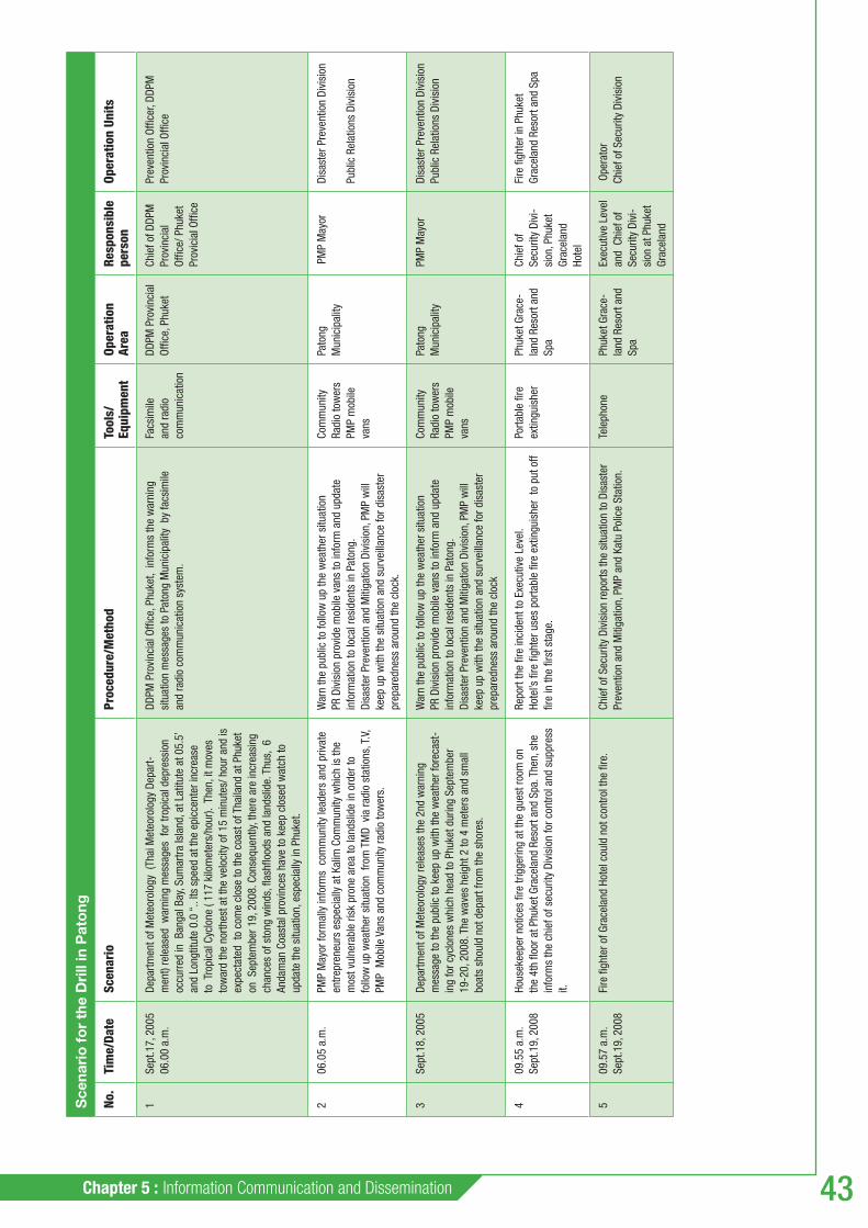
Chapter 5 : Information Communication and Dissemination 43
Sce
nari
o f
or
the
Dri
ll in
Pat
ong
No.
Tim
e/Da
teSc
enar
ioPr
oced
ure/
Met
hod
Tool
s/Eq
uipm
ent
Oper
atio
n Ar
eaRe
spon
sibl
e pe
rson
Oper
atio
n Un
its
1Se
pt.1
7, 2
005
06
.00
a.m
.
Depa
rtmen
t of M
eteo
rolo
gy (
Thai
Met
eoro
logy
Dep
art-
men
t) re
leas
ed w
arni
ng m
essa
ges
for t
ropi
cal d
epre
ssio
n oc
curr
ed in
Ban
gal B
ay, S
umar
tra Is
land
, at L
atitu
te a
t 05.
5’
and
Long
titut
e 0.
0 “.
. Its
spe
ed a
t the
epi
ccen
ter i
ncre
ase
to T
ropi
cal C
yclo
ne (
117
kilo
met
ers/
hour
). T
hen,
it m
oves
to
war
d th
e no
rthes
t at t
he v
eloc
ity o
f 15
min
utes
/ hou
r and
is
expe
ctat
ed t
o co
me
clos
e to
the
coas
t of T
haila
nd a
t Phu
ket
on S
epte
mbe
r 19,
200
8. C
onse
quen
tly, t
here
are
incr
easi
ng
chan
ces
of s
tong
win
ds, fl
ash
fl ood
s an
d la
ndsl
ide.
Thu
s, 6
An
dam
an C
oast
al p
rovi
nces
hav
e to
kee
p cl
osed
wat
ch to
up
date
the
situ
atio
n, e
spec
ially
in P
huke
t.
DDPM
Pro
vinc
ial O
ffi ce
, Phu
ket,
info
rms
the
war
ning
si
tuat
ion
mes
sage
s to
Pat
ong
Mun
icip
ality
by
facs
imile
an
d ra
dio
com
mun
icat
ion
syst
em.
Facs
imile
an
d ra
dio
com
mun
icat
ion
DDPM
Pro
vinc
ial
Offi c
e, P
huke
tCh
ief o
f DDP
M
Prov
inci
al
Offi c
e/ P
huke
t Pr
ovic
ial O
ffi ce
Prev
entio
n Of
fi cer
, DDP
M
Prov
inci
al O
ffi ce
206
.05
a.m
.PM
P M
ayor
form
ally
info
rms
com
mun
ity le
ader
s an
d pr
ivat
e
entre
pren
eurs
esp
ecia
lly a
t Kal
im C
omm
unity
whi
ch is
the
mos
t vul
nera
ble
risk
pron
e ar
ea to
land
slid
e in
ord
er to
fo
llow
up
wea
ther
situ
atio
n fr
om T
MD
via
radi
o st
atio
ns, T
.V,
PMP
Mob
ile V
ans
and
com
mun
ity ra
dio
tow
ers.
War
n th
e pu
blic
to fo
llow
up
the
wea
ther
situ
atio
n PR
Div
isio
n pr
ovid
e m
obile
van
s to
info
rm a
nd u
pdat
e in
form
atio
n to
loca
l res
iden
ts in
Pat
ong.
Disa
ster
Pre
vent
ion
and
Miti
gatio
n Di
visi
on, P
MP
will
ke
ep u
p w
ith th
e si
tuat
ion
and
surv
eilla
nce
for d
isas
ter
prep
ared
ness
aro
und
the
cloc
k.
Com
mun
ity
Radi
o to
wer
s
PMP
mob
ile
vans
Pato
ng
Mun
icip
ality
PM
P M
ayor
Disa
ster
Pre
vent
ion
Divi
sion
Publ
ic R
elat
ions
Div
isio
n
3Se
pt.1
8, 2
005
De
partm
ent o
f Met
eoro
logy
rele
ases
the
2nd
war
ning
m
essa
ge to
the
publ
ic to
kee
p up
with
the
wea
ther
fore
cast
-in
g fo
r cyc
lone
s w
hich
hea
d to
Phu
ket d
urin
g Se
ptem
ber
19-2
0, 2
008.
The
wav
es h
eigh
t 2 to
4 m
eter
s an
d sm
all
boat
s sh
ould
not
dep
art f
rom
the
shor
es.
War
n th
e pu
blic
to fo
llow
up
the
wea
ther
situ
atio
nPR
Div
isio
n pr
ovid
e m
obile
van
s to
info
rm a
nd u
pdat
e in
form
atio
n to
loca
l res
iden
ts in
Pat
ong.
Disa
ster
Pre
vent
ion
and
Miti
gatio
n Di
visi
on, P
MP
will
ke
ep u
p w
ith th
e si
tuat
ion
and
surv
eilla
nce
for d
isas
ter
prep
ared
ness
aro
und
the
cloc
k
Com
mun
ity
Radi
o to
wer
s
PMP
mob
ile
vans
Pato
ng
Mun
icip
ality
PMP
May
or
Di
sast
er P
reve
ntio
n Di
visi
on
Publ
ic R
elat
ions
Div
isio
n
409
.55
a.m
.
Se
pt.1
9, 2
008
Hous
ekee
per n
otic
es fi
re tr
igge
ring
at th
e gu
est r
oom
on
the
4th
fl oor
at P
huke
t Gra
cela
nd R
esor
t and
Spa
. The
n, s
he
info
rms
the
chie
f of s
ecur
ity D
ivis
ion
for c
ontro
l and
sup
pres
s it.
Repo
rt th
e fi r
e in
cide
nt to
Exe
cutiv
e Le
vel.
Ho
tel’s
fi re
fi gh
ter u
ses
porta
ble
fi re
extin
guis
her
to p
ut o
ff fi r
e in
the
fi rst
sta
ge.
Porta
ble
fi re
extin
guis
her
Phuk
et G
race
-la
nd R
esor
t and
Sp
a
Chie
f of
Secu
rity
Divi
-si
on, P
huke
t Gr
acel
and
Hote
l
Fire
fi gh
ter i
n Ph
uket
Gr
acel
and
Reso
rt an
d Sp
a
509
.57
a.m
.
Se
pt.1
9, 2
008
Fire
fi gh
ter o
f Gra
cela
nd H
otel
cou
ld n
ot c
ontro
l the
fi re
.Ch
ief o
f Sec
urity
Div
isio
n re
ports
the
situ
atio
n to
Dis
aste
r Pr
even
tion
and
Miti
gatio
n, P
MP
and
Katu
Pol
ice
Stat
ion.
Tele
phon
ePh
uket
Gra
ce-
land
Res
ort a
nd
Spa
Exec
utiv
e Le
vel
and
Chi
ef o
f Se
curit
y Di
vi-
sion
at P
huke
t Gr
acel
and
Ope
rato
r
Chie
f of S
ecur
ity D
ivis
ion

DISASTER RISK REDUCTION - A toolkit for Tourism Destinations44
Sce
nari
o f
or
the
Dri
ll in
Pat
ong
609
.58
a.m
.
Se
pt.1
9, 2
008
Radi
o co
mm
unic
atio
n of
fi cer
, PM
P, re
ceiv
es th
e em
erge
ncy
call
of fi
re in
cide
nt a
t the
4th
fl oo
r of G
race
land
Hot
el.
Radi
o Co
mm
unic
atio
n of
fi cer
repo
rts to
Chi
ef o
f Di
sast
er P
reve
ntio
n an
d M
itiga
tion
Divi
sion
and
sup
ervi
sor
Ch
ief o
f Dis
aste
r Pre
vent
ion
and
Miti
gatio
n Di
visi
on o
rder
s fi r
e fi g
hter
Tea
m A
to s
uppr
es th
e fi r
e at
the
Hote
l.
Radi
o Co
mm
unic
a-tio
n Eq
uipm
ent
Mob
ile V
an
Fire
Eng
ines
Wat
er T
ruck
s
Phu
ket G
race
-la
nd R
esor
t and
Sp
a
Chie
f of D
isas
-te
r Pre
vent
ion
and
Miti
gatio
n Di
visi
on, P
MP
Disa
ster
Pre
vent
ion
and
Miti
gatio
n Di
visi
on
Mob
ile V
an O
ffi ce
rsFi
re fi
ghte
rs
Wat
er T
ruck
Offi
cers
El
ectri
cian
s/ w
ater
wor
ks
offi c
ers/
Pol
icem
en/C
ivil
Defe
nce
Vol
unte
ers
710
.01
a.m
.
Se
pt.1
9, 2
008
Mob
ile V
an a
nd fi
re e
ngin
es a
rriv
e th
e ho
tel w
ith fi
re fi
ghte
r Te
am A
Chie
f of D
isas
ter P
reve
ntio
n an
d M
itiga
tion,
PM
P ha
s be
en
repo
rted
fi re
inci
dent
and
rece
ived
Hot
el M
ap fr
om C
hief
of
Secu
rity
Divi
sion
, Gra
cela
nd H
otel
Ch
ief o
f Dis
aste
r Pre
vent
ion
and
Miti
gatio
n or
ders
his
fi re
fi g
ther
Tea
m A
to o
pera
te a
nd c
ondu
ct S
AR v
ictim
s
- Ra
dio
Com
mun
ica-
tion
Equi
pmen
t -
Mob
ile V
an
-
Fire
Eng
ines
- W
ater
Tru
cks
-
Rope
s
Phuk
et G
race
-la
nd R
esor
t and
Sp
a
Chie
f of D
isas
-te
r Pre
vent
ion
and
Miti
gatio
n Di
visi
on, P
MP
- Di
sast
er P
reve
ntio
n a
nd M
itiga
tion
Divi
sion
-
Mob
ile V
an O
ffi ce
rs
- Di
sast
er P
reve
ntio
n an
d
Miti
gatio
n, P
MP
- M
obile
Van
Offi
cers
-
Fire
fi gh
ters
810
.05
a.m
.
Se
pt.1
9, 2
008
PMP
May
or a
rriv
es P
huke
t Gra
cela
nd H
otel
Chie
f of D
isas
ter P
reve
ntio
n an
d M
itiga
tion,
PM
P re
ports
si
tuat
ion
to th
e M
ayor
Phuk
et G
race
-la
nd R
esor
t and
Sp
a
PMP
May
orDi
sast
er P
reve
ntio
n an
d M
itiga
tion
Divi
sion
, PM
P
910
.21
a.m
.
Se
pt.1
9, 2
008
Fire
fi gh
ter T
eam
A is
abl
e to
con
trol a
nd e
xtin
guis
h fi r
eHo
tel O
ffi ce
rs v
erifi
es th
e gu
est l
ist a
nd in
form
Chi
ef o
f Di
sast
er P
reve
ntio
n an
d M
itiga
tion,
PM
P Ch
ief o
f Dis
aste
r Pre
vent
ion
and
Miti
gatio
n, P
MP
verifi
es
the
fi re
fi ght
er li
st
- Gu
est l
ist
-
fi re
fi ght
er l
ist
Phu
ket G
race
-la
nd R
esor
t and
Sp
a
PMP
May
or-
Disa
ster
Pre
vent
ion
an
d M
itiga
tion
Divi
sion
-
Mob
ile V
an O
ffi ce
rs
- Fi
re fi
ghte
rs
- W
ater
Tru
ck O
ffi ce
rs
-
Elec
trici
ans/
wat
er w
orks
offi
cers
/ Pol
icem
en/C
ivil
Def
ence
Vol
unte
ers
1010
.18
a.m
.
Se
pt.1
9, 2
008
Acco
rdin
g to
the
stro
ng w
ind,
the
wav
e he
ight
abo
ut 3
met
ers
caus
ing
the
caps
ized
(ove
rturn
) boa
t in
the
front
of B
an k
alim
Be
ach.
Con
curr
ently
, th
e el
ectri
city
pol
e co
llasp
es to
bui
ldin
g at
Ban
Kal
im S
choo
l
Dire
ctor
of B
an K
alim
Sch
ool n
otic
e th
is in
cide
nt in
his
sc
hool
and
fi sh
erm
an s
ees
the
sea
acci
dent
Bo
th o
f the
m in
form
s Di
sas-
ter P
reve
ntio
n Di
visi
on (F
ire B
rigad
e)
Th
en, t
he D
irect
or o
rder
s to
eva
cuat
e sc
hool
chi
ldre
n ac
cord
ing
to th
e sc
hool
em
erge
ncy
Plan
Ban
Kalim
Sc
hool
Dire
ctor
of B
an
Kalim
Sch
ool

Chapter 5 : Information Communication and Dissemination 45
Sce
nari
o f
or
the
Dri
ll in
Pat
ong
1110
.19
a.m
.
Se
pt.1
9, 2
008
A ra
dio
offi c
er is
info
rmed
that
ele
ctrii
ty p
ole
colla
sped
to
the
Bui
ldin
g at
Ban
Kal
im S
choo
l an
d ov
ertu
rn b
oat f
ron
of B
an K
alim
Sch
ool
Th
eref
ore,
the
requ
est f
or v
ictim
ass
ista
nce
from
SAR
Uni
t, Ro
yal T
hai N
avy
Radi
oCom
mun
icat
ion
offi c
er re
ports
this
situ
atio
n to
Ch
ief o
f Dis
aste
r Pre
vent
ion
and
Miti
gatio
n, P
MP
and
his
supe
rvis
or.
SAR
Team
Ope
ratio
n
Ka
tu P
olic
emen
and
Civ
il De
fenc
e Vo
lunt
eers
con
trol
and
faci
litat
e tra
ffi c
syst
em
Pa
tong
Ele
ctric
ity A
utho
rity
will
cut
off
elec
trici
ty c
ircui
t, di
spat
ch e
quip
men
t and
tool
s fo
r vic
tim a
ssis
tanc
e
SAR
Unit,
Roy
al T
hai N
avy
carr
y ou
t vic
tim a
ssis
tanc
e op
erat
ion
in th
e se
a
- SA
R Tr
uck
- El
ectri
city
A
utho
rity
Truc
k -
Rubb
er
din
ghie
s
Ban
Kalim
Sc
hool
-
Chie
f of
Disa
ster
Pr
even
tion
an
d M
itiga
tion,
PM
P
-
Chie
f of S
A Te
am, R
oyal
Th
ai N
avy
- Di
sast
er P
reve
ntio
n an
d
Miti
gatio
n Di
visi
on
(SA
R te
am)
- El
ectri
city
Aut
horit
y O
ffi ce
rs /P
olic
emen
/Civ
il D
efen
ce V
olun
teer
s
-
EMS
from
Pat
ong
Hosp
ital
- SA
R te
am, R
oyal
Thi
Nav
y
1210
.23
a.m
.
Se
pt.1
9, 2
008
PMP
May
or a
rriv
es th
e in
cide
nt a
rea
at B
an K
alim
with
SAR
Tr
ucks
and
offi
cial
sDi
rect
or o
f Ban
Kal
im S
choo
l re
ports
the
situ
atio
n to
the
May
or
PM
P M
ayor
is s
et u
p Ad
Hoc
Dire
ctin
g Ce
nter
and
pr
emin
ary
repo
rt th
e si
tuat
ion
to C
hief
of K
atu
Dist
rict a
nd
Phuk
et G
over
nor r
espe
ctiv
ely
Ban
Kalim
Sc
hool
Chie
f of S
AR
Team
, PM
PSA
R Te
am
Kalim
Sch
ool D
irect
or a
nd
teac
hers
1310
.24
a.m
.
Se
pt.1
9, 2
008
Stud
ents
in B
an K
alim
Sch
ool g
et s
tuck
in B
uild
ing
at B
an
Kalim
Sch
ool a
nd v
ictim
s fro
m o
vertu
rned
boa
t in
the
sea,
fro
nt o
f Kal
im B
each
Dire
ctor
of B
an K
alim
ver
ifi es
that
som
e s
tude
nts
get
stuc
k in
the
build
ing
so h
e re
ports
the
situ
atio
n to
PM
P M
ayor
PM
P M
ayor
ord
ers
SAR
team
to c
arry
out
SAR
ope
ratio
n th
e vi
ctim
s an
d pe
rform
the
fi rst
aid
In
cas
e of
sev
erel
y in
jure
d, tr
ansf
erin
g vi
ctim
s to
Pat
ong
Hosp
ital
SAR
Team
, Roy
al T
hai N
avy
also
car
ries
out t
he v
ictim
as
sist
ance
ope
ratio
n, p
erfo
rms
fi rst
aid
and
tran
sfer
sev
ere
inju
red
to th
e ho
spita
l
Stud
ent L
ist
Map
of
Build
ing
SAR
Truc
ks
Ambu
lanc
e
Rubb
er
ding
hies
Scho
ol
Build
ing
at B
an
Kalim
Sch
ool
Fron
t of K
alim
Bea
ch
PMP
May
or
Chie
f of S
AR
Team
, Roy
al
Thai
Nav
y
Dire
ctor
of B
an K
alim
Sho
ol
and
teac
hers
SA
R Te
am
Doct
ors
and
Nurs
es
(Em
erge
ncy
Med
ical
Se
rvic
es, E
MS)
1410
.34
a.m
.
Se
pt.1
9, 2
008
The
bad
wea
ther
is re
cove
ry to
nor
mal
wea
ther
Al
l pa
rtici
pant
s an
d or
gani
zatio
ns g
et to
geth
er a
t Ad
Hoc
Dire
ctin
g Ce
nter
Chi
ef o
f Dis
aste
r Pre
ven-
tion
and
Miti
gatio
n, P
MP
repo
rts th
e op
ratio
n re
sult.
Ch
ief o
f SAR
Tea
m re
ports
the
oper
atio
n re
sult
Th
e In
cide
nt C
omm
and
orde
r to
end
the
drill
Vict
im L
ist
Da
mag
e As
sess
men
t Li
st
Ad H
ocDi
rect
ing
Cent
erPM
P M
ayor
All c
once
rned
age
ncie
s

DISASTER RISK REDUCTION - A toolkit for Tourism Destinations46
ANNEX 5.2 Drill scenario for ANSAO / Phi Phi Islands• Drill scenario for Patong • Drill scenario for Kanniyakumari• Report of the Drill at Vivekananda Rock Memorial Kanniyakumari• Training for the agencies report Patong•
Illustrations of the drill in Patong
Illustrations of the drill in Phi Phi Islands
CD-Rom

Chapter 5 : Information Communication and Dissemination 47
5.3 Project examples of awareness raising brochures
Awareness raising brochures were created in all three of the destination sites. They describe the risk, locate vulnerable areas on maps and provide information that a tourist and the public need to know about disaster preparedness.
The municipalities used different approaches in order to get the message across to residents, business owners, and tourists. One brochure uses simple drawings showing how people should behave during an emergency. A checklist of do’s and don’ts allows the reader to easily understand what he or she needs to do during an emergency.
Risk information brochure for tourists, Kanniyakumari, India
Disaster Awareness brochure, Kanniyakumari, India

DISASTER RISK REDUCTION - A toolkit for Tourism Destinations48
For ANSAO / Phi Phi Islands and Patong Municipality, the risk information brochure describes a range of risks and what tourists should do to be safe. It includes detailed information about where the shelters are and how to reach them. A picture of the warning signs and the warning towers are shown so that the tourists can acquaint themselves with these before an emergency occurs.
TOURIST EMERGENCYRESOURCE GUIDE
Information for tourists Phi Phi Islands
The Phi Phi Islands are an important tourist destination in the Krabi province. Their natural scenic beauty, particularly the white beaches have attracted tourists from all over the world to travel to and invest their resources in. Due to their location in the Andaman Sea and urbanization and development process of the area together with the climate change effect, Phi Phi Islands are unavoidably prone to various types of natural and man-made hazards. Tsunamis, flooding and landslides, building fires, and boat accidents are the most common hazards which tourists and people might encounter.
In order to enjoy your stay in the Phi Phi Islands, you are advised to study the necessary emergency information and be prepared for any events.
More Information
Ao Nang Sub-District Administrative Organization (ANSAO) is the main actor in Phi Phi Islands, safeguarding its residents, visitors and communities. Here are important contact numbers in case of an emergency:
Warning and Tel: (66) 08 1894 4304 Communication Team Emergency Response and Tel: (66) 08 1894 0345 Search & Rescue team Evacuation and Relief Team Tel: (66) 08 1978 9635 First Aid Team Tel: (66) 08 1894 9204 Tel: (66) 075 660 719 Security Team Tel: (66) 08 1894 2306
This brochure was developed under the project “Disaster Reduction through Awareness, Preparedness and Prevention Mechanisms in Coastal Settlements in Asia – Demonstration in Tourism Destinations”, funded by the European Commission, under the Asia Pro Eco Programme. Implementing partners are:United Nations Environment Programme (UNEP), Swedish Rescue Service Agency (SRSA), International Hotels and Restaurants Association (IH&RA), the Department of Disaster-Prevention and Mitigation (DDPM), National Safety Council of India (NSCI), Patong Municipality of Phuket (PMP), and the Ao nang Sub-District Administrative Organization (ANSAO).
European Union Disclaimer: This document has been produced with the financial assistance of the European Union. The view expressed herein can in no way be taken to reflect the officia opinion of the European Union or the Government of Thailand
August 2008 – Phi Phi Islands, Thailand
Flooding and Landslide
ooding is a fast stream of water with variable heights.andslide is the ground movement of rocks, soil or other debris down slope that can devastate anything in its path. Landslides may
appen after heavy rain.
What should I do ?
efore disaster: Locate evacuation routes and shelters in case of flooding and/or landslide in the map. Place objects away from water.
uring disaster: Once alerted, follow hotel manager instructions. Listen to the radio and announcements. In the case of a landslide:inside a building: Stay inside. Take cover under a table.outdoors: Run to the nearest high ground in a direction away from the path. If rocks and other debris are approaching, run for the nearest shelter such as a group of trees or a building. In the case of flooding: Do not walk in flood water. Stay away from power lines and electrical wires.
fter disaster : Once you are notified the emergency is over, go back to the hotel and try to find your belongings.
Fire:
Please study the emergency plan located on the door of the hotel room, or contact the hotel management for information. Locate the fire extinguishers and find out how they work. If there is a fire alarm, leave immediately your room thought the emergency exit. Always take your room key with you. Walk to the nearest emergency exit. Do not use the elevators If the smoke is thick, crawl along the floor where the air and visibility is better. If you are unable to leave your room, shut off the ventilation and put wet towels in the door gaps. Protect your face with a wet towel. The towel can be used as breathing protection.
0. Stay at the windows where the emergency crew can see you. Attract attention.
TOURIST EMERGENCYRESOURCE GUIDE
Information for tourists Patong Beach, Phuket
In order to enjoy your stay in Patong, you are advised to study the necessary emergency information and beprepared for any events.
Patong Municipality of Phuket province (PMP),is located in Katu district. Its natural scenic beauty, particularly the white beaches have attracted tourists from all over the world to travel to and invest their resources in. Due to its location in the Andaman Sea and urbanization and development process of thearea together with the climate change effect,PMP is unavoidably prone to various types of natural and man - made hazards. Tsunamis, Flooding and Landslide and building fires are the most common hazards which tourists andpeople might encounter.
More Information
Patong Municipality of Phuket (PMP) is the main actor, safeguarding its residents, visitors and communities. Here are important contact numbers in case of an emergency
Patong Municipality Tel: (66) 076 342600 (24 hrs.)Katu Police Station Tel: (66) 076 342719Patong Hospital Tel: (66) 076 342633Royal Thai Navy Security Tel: (66) 076 341197Tourism Authority Tel: (66) 076 212213Civil Defence Volunteer Tel: (66) 076 342600DDPM Office Phuket Tel: (66) 076 273019Hotline 1784
This brochure was developed under the project “Disaster Reduction through Awareness, Preparedness and Prevention Mechanisms in Coastal Settlements in Asia – Demonstration in Tourism Destinations”, funded by the European Commissionunder the Asia Pro Eco Programme. Implementing partners are: United Nations Environment Programme (UNEP), SweishRescue Service Agency (SRSA), International Hotels and Restaurants Association (IH&RA), the Department of Disaster Prevention and Mitigation (DDPM), National Safety Council of India (NSCI), Patong Municipality of Phuket (PMP), and the Aonang Subdistrict Administrative Organization (ANSAO).
European Union Disclaimer: This document has been produced with the financial assistance of the European Union. The view expressed herein can in no way be taken to reflect the official opinion of the European Union or the Government of Thailand.
Flooding and Landslide
Flooding is a fast stream of water with variable heights. Landslide is the ground movement of rocks, soil or other debris down slope that can devastate anything in its path.
What should I do ?
Before disaster:
Locate evacuation routes and shelters in case of flooding and/or landslide in the map. • Place objects away from water.
During disaster:
• Once alerted, follow the hotel manager instructions. • Listen to the radio and announcements • In the case of a landslide: If inside a building: • Stay inside. • Take cover under a table. If outdoors: • Run to the nearest high ground in a direction away from the path. • If rocks and other debris are approaching, run for the nearest shelter such as a group of trees or a building. • In the case of flooding: • Do not walk in flood water. • Stay away from power lines and electrical wires.
After disaster :
• Once you are notified the emergency is over, go back to the hotel, and try to find your belongings.
Fire:
1. Please study the emergency plan located on the door of the hotel room, or contact the hotel management for information. 2. Locate the fire extinguishers and find out how they work. 3. If there is a fire alarm, leave immediately your room thought the emergency exit. 4. Always take your room key with you. 5. Walk to the nearest emergency exit. 6. Do not use the elevators 7. If the smoke is thick, crawl along the floor where the air and visibility is better. 8. If you are unable to leave your room, shut off the ventilation and put wet towels in the door gaps. 9. Protect your face with a wet towel. The towel can be used as breathing protection.10.Stay at the windows where the emergency crew can see you. Attract attention.
ANNEX 5.3 Leafl ets for locals Kanniyakumari• Leafl ets for tourists Kanniyakumari• Tourist emergency response guide ANSAO / Phi Phi Islands• Tourist emergency response guide Patong•
Brochure developed for ANSAO / Phi Phi Islands
Brochure developed for Patong
CD-Rom

Chapter 6 : Success factors 49
Success factors6A number of success factors were identifi ed following the project implementation in the three destination sites. They are mentioned here as tips for users of the toolkit.
The involvement of all stakeholders: an inclusive and participatory process involving all key stakeholders from the local authorities, the emergency services, the private sector, NGOs, the supporting tourist services etc. will raise the chances of a successful implementation of the project.
The establishment of local coordinating groups: this is an essential step in the process and it is important to ensure an effective coordination group is set-up. The Group should have knowledge of local issues, be representative of all stakeholder groups mentioned above and should form a cohesive group with good personal connections between members.
Expertise and international / national support: the expertise brought by international organisations such as UNEP and SRSA was considered highly valuable in the project. A recommendation for future projects would be to seek support from international organisations or relevant national organisations to ensure the right expertise is brought to the project.
Management structure and local project leaders: it is important to have a clear management structure and a central command to oversee project implementation. Project leaders selected locally will have a better understanding of the issues and will have easier access to local stakeholders.
Financial aspects: fi nancial discipline is an important aspect of good project planning and management. Flexibility should however allow for changes or additions to the initial plan of action.

DISASTER RISK REDUCTION - A toolkit for Tourism Destinations
Notes
50

About the UNEP Division of Technology,Industry and Economics
The UNEP Division of Technology, Industry and Economics (DTIE) helps
governments, local authorities and decision-makers in business and
industry to develop and implement policies and practices focusing on
sustainable development.
The Division works to promote:
> sustainable consumption and production,
> the effi cient use of renewable energy,
> adequate management of chemicals,
> the integration of environmental costs in development policies.
The Offi ce of the Director, located in Paris, coordinates activities
through:
> The International Environmental Technology Centre - IETC (Osaka, Shiga),
which implements integrated waste, water and disaster management programmes,
focusing in particular on Asia.
> Production and Consumption (Paris), which promotes sustainable consumption
and production patterns as a contribution to human development through global
markets.
> Chemicals (Geneva), which catalyzes global actions to bring about the sound
management of chemicals and the improvement of chemical safety worldwide.
> Energy (Paris), which fosters energy and transport policies for sustainable
development and encourages investment in renewable energy and energy effi ciency.
> OzonAction (Paris), which supports the phase-out of ozone depleting substances
in developing countries and countries with economies in transition to ensure
implementation of the Montreal Protocol.
> Economics and Trade (Geneva), which helps countries to integrate environmental
considerations into economic and trade policies, and works with the fi nance sector
to incorporate sustainable development policies.
UNEP DTIE activities focus on raising awareness,
improving the transfer of knowledge and information,
fostering technological cooperation and partnerships, and
implementing international conventions and agreements.
For more information, see www.unep.fr/scp

This publication was made possible through funding from the EU-Asia Pro Eco II B Post-Tsunami Programme and is part of the project on Disaster Reduction through Awareness, Preparedness and Prevention Mechanisms in Coastal Settlements in Asia – Demonstrations in Tourism Destinations. The project was implemented over a two year period and aimed to build capacity for disaster risk reduction in three tsunami-affected tourism destinations in India and Thailand. The toolkit provides information and resources based on the project experience in the three demonstration sites. It is destined to local municipalities and to the various actors involved in emergency planning and response. Users will fi nd information relating to the various steps that need to be undertaken, from the preliminary assessment, to capacity building, disaster prevention and preparedness planning, to communicating and disseminating key information. A CD-Rom containing all the relevant documents is attached to the publication.
DTI/1116/PA
For more information, contact:UNEP DTIESustainable Consumption and Production Branch15 rue de Milan75441 Paris CEDEX 09FranceTel: +33 1 4437 1450Fax: +33 1 4437 1474E-mail: [email protected]/scp