Embed Size (px)
Citation preview

Die Nüw Welt #381
1
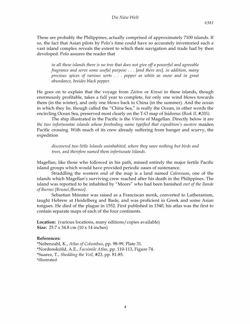
Title: Die Nüw Welt [The New Islands]/ Nova Insulae, XVII Nova Tabula Date: 1546 Author: Sebastian Münster Description: Sebastian Münster was professor of Hebrew at the University of Basel and a prominent German mathematician, cartographer, and cosmographer. Among his publications was an edition of Ptolemy’s Geography in 1540, followed in 1544 by his Cosmography, the influential first German description of the world. Both works were illustrated by a series of woodcut maps that included this delineation. It was the first printed map devoted to the Western Hemisphere. Its innovative continuous through North Central and South America emphasized a definite separation of the New World from Asia. The publications were so popular that together they appeared in forty editions, making them best sellers of the 16th century. As a result, this woodcut of America was more widely circulated than any map of the New World of the time. An important characteristic of Münster’s map is the enormous Sea of Verrazano and northeasterly trend of North America. This resulted originally from Verrazano’s exploration of the east coast, when he convinced himself that he was seeing the South Sea [Pacific] just west of the Carolina Banks (#347). That misconception, which this map helped to perpetuate, encouraged the French and later the British to believe that a passage could be found through North America. At the same time Münster kept alive many earlier traditions. While not actually locating the papal Line of Demarcation between Spain and Portugal’s overseas domains, the flags of those two nations appear on their respective sides of where the line would cross Brazil. The language differences in South America today originated with this deployment. Columbus’ reports of “abundant gold and pearls at Paria” on South America’s north coast and the Vespuccian reference to cannibals in Brazil are retold. Knowledge of the possible cannibalism in South America is demonstrated with the cartouche drawn in Brazil and there is a fine rendering of a carvel in the Pacific. Magellan’s first circumnavigation of the globe is celebrated by a depiction of his ship Victoria, the only survivor of his five-ship fleet. Münster also labeled the strait with the name of its discoverer and followed Magellan in calling Patagonia, Land of Giants. Even medieval Marco Polo is remembered: off the China coast is a note on Polo’s archipelago of 7448 islands, and a depiction of Zipangri [Japan], strikingly reminiscent of Pizzigano’s Antilia, of over a century earlier; it is positioned very close to the new discoveries. In showing North and South America as continents separate from the Old World, Münster improved upon previously published maps. On the other hand, such distinguished cartographers as Giacomo Gastaldi and the Italian School continued to link America to Asia for another twenty-five years. This charming woodcut with its geographic advances and retrogressions is one of the best-known images from the period. Closely following the New World’s debut as a single, unbroken and fully-formed independent continent by Mercator, this coarsely executed woodcut work is the first map of the Western Hemisphere as such. A more elementary hemisphere is found on the right inset of the 1507 world map of Waldseemüller (#310), and the 1512 copy by Stobnicza (#319). In that earlier configuration, however, North America is not fully developed, is nearly but ambiguously contiguous with South America, and the southern extent of America is left to the viewer’s imagination. Significantly, Münster has brandished the telling term NOVUS ORBIS over the entirety of America, rather than just
Die Nüw Welt #381
2
South America, thus finally freeing North America from its obsolete role as a new land on an old world. 203. A subsequent (and more common) state of the map deletes NOVUS ORBIS covering North and South and substitutes Die Nüw Welt and Novus orbis, both confined to South America alone. But despite this milestone, the map’s title, “New Islands” - separately set and not an integral part of the woodblock - still clutches to the stubborn notion that America is an oceanic archipelago, in effect that the “old world” comprised the world’s only continents. Another attempt to regiment the New World into the Procrustian bed of ancient beliefs is found in the map proper, where the phrase Insula Atlantica quam vocant Brasilii & Americam [Island of Atlantis and America as it is called in Brazil] identifies America as the lost Platonic island/continent of Atlantis. With the voyage of Magellan (1519-22), the southerly extent and magnitude of the New World was fully realized, and America had proven itself to be a formidable impediment to those hoping to reach the Orient. Although no serious hope remained of finding a shorter route around South America than that found by Magellan, some sought a more practical passage through North America. In was in the hope of finding such a route that in 1524 Francis I sent the Florentine explorer Giovanni di Verrazano to sail up the eastern seaboard in a vessel named Dauphine. Verrazano, it seems, was overly eager to believe he had succeeded in his mission: when he passed along the Outer Banks between Capes Lookout and Henry, he mistook those banks to be an isthmus of North America tenuously separating the Atlantic and Pacific Oceans. Verrazano related that he
found an isthmus a mile in width and about 200 long in which, from the ship, was seen the oriental sea between the west and north. Which is the one, without doubt, which goes about the extremity of India, China and Cathay. We navigated along the said isthmus with the continual hope of finding some strait or true promontory at which the land would end toward the north in order to be able to penetrate to those blessed shores of Cathay.
Verrazano’s oriental sea was nothing more than the Pamlico and Albemarle Sounds. While history has been sympathetic to this colossal error, it has failed to explain Verrazano’s bizarre response to it. After claiming to have unearthed the “holy grail” of navigators, Verrazano apparently made no attempt to cross the “isthmus,” either on land or through any of the inlets he reported, inlets through which one of his longboats would have had little difficulty maneuvering. Nor does Verrazano appear to have made an attempt to return to his promising isthmus. What can be explained is the failure of Francis I to follow up Verrazano’s supposed gateway to the Orient. By the time Verrazano returned, Francis I was a prisoner of the Emperor, Charles V, a long-time rival who apparently defeated Francis’ own bid to be Holy Roman Emperor through vote-buying. Although Francis I was released from prison upon signing the Treaty of Madrid (1526), he was obliged to give two of his sons as hostages to insure his compliance with its terms; once free he declared the treaty void, but it would clearly have been foolish for him to send yet another expedition to the Southeast, as those shores were “legitimately” claimed by Spain. By the end of that decade some cartographers had adopted the bogus isthmus, and it was popularized through the printed book with this map of Münster. A Verrazanian passageway through the mid-Atlantic coast was sought as late as the Jamestown settlement of 1607 (see also #347). Münster chokes the mid-Atlantic coast of North America to accommodate the isthmus, creating a huge sea cutting through Canada. The upper terrace of this two-

Die Nüw Welt #381
3
tiered continent, which includes all of the eastern seaboard from Virginia and above, is named Francisca for France and Francis I. Britain’s early expeditions out of Bristol are acknowledged by C. Britonum. The island of Corterati is the Newfoundland of the Corte-Reals, and Spanish dominance in the southeast is evident from Terra florida, the only North American place name south of the isthmus. The Iberian superpowers’ real sphere of influence lies further south. A Portuguese standard off the coast of Brazil and a Spanish standard planted in Puerto Rico tag the New World according to papal decree and signal the beginning of the colonial epic. In the Caribbean, above the “island” of Yucatan (generally believed to be an island throughout the first half of the century), are two islands marked ins. Tortucaru, the Tortuga Islands. These islands, found by Ponce de Leon while attempting to return to Puerto Rico from Florida, are so named because de Leon’s men claim to have captured 170 tortoises there in a single evening. Due west of the Tortugas, just off the coast of Mexico, lies Panuco, which like the Yucatan is mistakenly shown by Münster as an island. Pánuco was a coastal settlement on the Mexican mainland which had marked the Gulf threshold of Montezuma’s empire, and became a pivotal point in rival Spanish claims. In 1521 it was cited in a royal cédula as the southwestern limit of a territory granted to Francisco de Garay which extended to Ponce de Leon’s Florida, and so became the site of decisive confrontation between Garay’s men and his rival, Cortes. To the southeast of the Yucatan is Cozumela, an early mapping of Cozumel Island, whose people goe naked [and] knew not to what use war serves . . . They are poore people, but very charitable and loving in their false religion and beliefe. Catigara, a realm from the Africa-Asia land bridge of Ptolemy, lies along the coast of Münster’s Peru. Assuming that the northern segment of the land bridge was Indochina, Cattigara occupied the approximate spot of what is now Hanoi. It probably migrated to Münster’s Peru via an earlier map depicting South America as an Asian promontory, where use of that nomenclature was a natural transition, such as the maps of Finaeus. In Brazil is a macabre vignette captioned Canibali. South of this cannibalism reference lies Regio Gigantum, purported kingdom of giant “Patagonian” people reported by Pigafetta from Magellan’s voyage. Some literate member of Magellan’s crew appears to have been reading the then-popular story Primaleon of Greece, published in Castile in 1512, in which a giant, the Grand Patagon, was brought home by the hero as a trophy (Magellan attempted to do the same, but his patagon did not survive the return voyage). To the west of Magellan’s strait appears the name Mare pacificum. This is the first time that a printed map referred to the great ocean by its modern name, the name that Magellan had christened it. The dominant influence in the Pacific, however, is still Marco Polo. Most prominent is Polo’s Zipangri [Japan], still two or three years before its earliest known contact with Europeans, and hence mapped arbitrarily as a rectangular, north-south oriented single island. Because an extensive archipelago has been placed between it and the Asian mainland, and because the Pacific itself is so undersized, Japan hovers just off the “California” coast. The island complex between Japan and Asia is Polo’s Archipelagus 7448 insuaru. Marco Polo related that
according to the testimony of experienced pilots and seamen that sail upon [the China Sea] and are well acquainted with the truth it contains 7,448 islands, most of them inhabited.
Die Nüw Welt #381
4
These are probably the Philippines, actually comprised of approximately 7100 islands. If so, the fact that Asian pilots by Polo’s time could have so accurately inventoried such a vast island complex reveals the extent to which their navigation and trade had by then developed. Polo assures the reader that
in all these islands there is no tree that does not give off a powerful and agreeable fragrance and serve some useful purpose . . . [and there are], in addition, many precious spices of various sorts . . . pepper as white as snow and in great abundance, besides black pepper.
He goes on to explain that the voyage from Zaiton or Kinsai to these islands, though enormously profitable, takes a full year to complete, for only one wind blows towards them (in the winter), and only one blows back to China (in the summer). And the ocean in which they lie, though called the “China Sea,” is really the Ocean, in other words the encircling Ocean Sea, preserved most clearly on the T-O map of Isidorus (Book II, #205). The ship illustrated in the Pacific is the Vitoria of Magellan. Directly below it are the two infortunatae islands whose foreboding name typified that expedition’s austere maiden Pacific crossing. With much of its crew already suffering from hunger and scurvy, the expedition
discovered two little Islands uninhabited, where they sawe nothing but birds and trees, and therefore named them infortunate Islands.
Magellan, like those who followed in his path, missed entirely the major fertile Pacific island groups which would have provided periodic oases of sustenance. Straddling the western end of the map is a land named Calensuan, one of the islands which Magellan’s surviving crew reached after his death in the Philippines. The island was reported to be inhabited by “Moors” who had been banished owt of the Ilande of Burnei [Brunei /Borneo]. Sebastian Münster was raised as a Franciscan monk, converted to Lutheranism, taught Hebrew at Heidelberg and Basle, and was proficient in Greek and some Asian tongues. He died of the plague in 1552. First published in 1540, his atlas was the first to contain separate maps of each of the four continents. Location: (various locations, many editions/copies available) Size: 25.7 x 34.8 cm (10 x 14 inches) References: *Nebenzahl, K., Atlas of Columbus, pp. 98-99, Plate 31. *Nordenskiöld, A.E., Facsimile Atlas, pp. 110-113, Figure 74. *Suarez, T., Shedding the Veil, #23, pp. 81-85. *illustrated

Die Nüw Welt #381
5
Die Nüw Welt #381
6

Die Nüw Welt #381
7

Die Nüw Welt #381
8

Die Nüw Welt #381
9