Embed Size (px)
Citation preview

Development of Land−Title Registration Systems − A DevelopedCountry Experience Australia

Table of ContentsDevelopment of Land−Title Registration Systems − A Developed Country Experience Australia............1
FOREWORD..........................................................................................................................................1EXECUTIVE SUMMARY........................................................................................................................2INTRODUCTION....................................................................................................................................3I. NEW SOUTH WALES BEGINNINGS..................................................................................................4
A. Allocation of land.........................................................................................................................5B. Registration of deeds...................................................................................................................5Sources............................................................................................................................................6
II. THE SYSTEM OF SURVEYS.............................................................................................................6A. The functions of the system.........................................................................................................6B. Creation of parcels by the Crown................................................................................................6C. Creation of parcels after alienation and lodgement of plans.......................................................7D. Land identifiers..........................................................................................................................11E. General boundaries...................................................................................................................15F. Accurate surveys defining boundaries.......................................................................................15G. Isolated surveys........................................................................................................................21H. To end the isolation?.................................................................................................................21I. Boundary disputes resolution......................................................................................................21J. Identification surveys..................................................................................................................22
III. THE COMMON LAW TITLE SYSTEM............................................................................................23A. General......................................................................................................................................23B. What is a deed?.........................................................................................................................23C. The chain of title........................................................................................................................24D. Description of land.....................................................................................................................24E. Registration................................................................................................................................25F. Covenants..................................................................................................................................25G. Exceptions, reservations and easements..................................................................................26H. Indexing of deeds......................................................................................................................26I. Duties of the Registrar−General..................................................................................................26J. Searching Common Law titles....................................................................................................27K. The Common Law system and the cadastre.............................................................................28L. Current status of the General Register......................................................................................28
IV. THE REAL PROPERTY ACT SYSTEM..........................................................................................29A. Torrens, the originator...............................................................................................................30B. The Registrar−General’s powers...............................................................................................31C. The Register..............................................................................................................................32D. The survey base........................................................................................................................45E. The Assurance Fund.................................................................................................................47F. The certificate of title..................................................................................................................48G. Land descriptions/categories.....................................................................................................49H. Title Diagrams...........................................................................................................................51I. Registration of dealings and plans..............................................................................................53J. The lodgement system...............................................................................................................54K. The processing system..............................................................................................................55L. Quality review.............................................................................................................................64M. Total Quality Commitment (TQC)..............................................................................................64N. Public records............................................................................................................................65O. Lodgement statistics..................................................................................................................67P. Training......................................................................................................................................68Q. Problem areas...........................................................................................................................69R. Making a transfer.......................................................................................................................70S. Management of the system.......................................................................................................71T. Customary rights and tenures....................................................................................................72Sources..........................................................................................................................................74
V. THE MAPPING AND CHARTING SYSTEMS..................................................................................78A. The Mapping System.................................................................................................................78B. The charting system..................................................................................................................82C. Real Property Act searching......................................................................................................84
VI. THE CADASTRE.............................................................................................................................95A. Title conversion procedures.......................................................................................................96
i
Table of ContentsDevelopment of Land−Title Registration Systems − A Developed Country Experience Australia
B. Primary Applications..................................................................................................................97C. Issue of qualified titles.............................................................................................................101D. Issue of limited titles................................................................................................................105E. Issue of “non−qualified” titles...................................................................................................107F. Raising of essential records on conversion.............................................................................107G. Funding of conversion actions.................................................................................................108H. Options for the future...............................................................................................................108I. Total results of conversions......................................................................................................112
VII. ASSOCIATED LEGISLATION......................................................................................................112A. The Registration of Deeds Act, 1844.......................................................................................112B. The Real Property Act, 1862...................................................................................................113C. The Conveyancing Act, 1919..................................................................................................113D. The Local Government Act, 1919............................................................................................114E. The Environmental Planning and Assessment Act, 1979........................................................114F. Conveyancing Act regulations.................................................................................................115G. Real Property Act regulations..................................................................................................115H. Survey Practice regulations.....................................................................................................116I. Land Titles − a commercial operation.......................................................................................116
VIII. COMPARISON OF THE COMMON LAW AND REAL PROPERTY ACT SYSTEMS.................117GLOSSARY........................................................................................................................................118
ii
Development of Land−Title Registration Systems − A DevelopedCountry Experience Australia
United Nations Centre for Human Settlements (Habitat)
Nairobi, 1993
Land Management Series
The designations employed and the presentation of the material in this publication do not imply the expressionof any opinion whatsoever on the part of the secretariat of the United Nations concerning the legal status ofany country, territory, city or area or of its authorities, or concerning the delimitation of its frontiers orboundaries.
HS/280/93 EISBN 92−1.131−204−3
FOREWORD
The need to improve and expand both the quantity and quality of land information through adequateland−registration systems is being increasingly recognized in developing countries. Improving this processmay require new administrative and institutional structures and procedures and new legislation, as well asnew technologies. In this regard, some lessons could be learned from the experiences of developed countrieswhich have had long practice in developing and maintaining land−title registration systems. Their experiencescould enable developing countries, with necessary adaptation to suit their particular circumstances, toanticipate better and therefore deal more effectively with some of the problems that may he encountered inthe development of their land−title registration system, in particular, and land information system, in general. Itis with a view to the benefits of these lessons of experience that this Australian case study is being presented.
This report highlights the necessary requirements for development of a viable land−title registration system −the institutional set−up or framework, the place and role of survey and mapping, training andhuman−resources development for the system, the need for assurance funds etc. It reflects the successfulexperience of a country that has initiated and established a successful land−title registration system, theproblems encountered and how these problems were resolved.
The expectation is that interested developing countries, which are still largely at the initial stages of setting uptheir land−title registration systems, could learn from this case experience and with appropriate modifications,profitably apply the lessons learned in the development of their own systems. It is hoped that notwithstandingthe obvious differences in systems, and in stages of development, land managers and administrators indeveloping countries will find this publication useful in the development and updating of their respective landinformation systems.
I wish to acknowledge with gratitude the contribution of Mr. K.W. Amey, who as UNCHS (Habitat) consultantprepared the original case study from which this publication has been prepared.
Ms E. DowdeswellUnder−Secretary−General
Executive Director
1
EXECUTIVE SUMMARY
1. Beginnings
New South Wales began in 1788 as a remote British colony in which early hardships were followed byexploration and rapid expansion, with land settlement outrunning Government and land administration. Allrights in land derived from the Crown and grants were based on sporadic and isolated surveys, without surveycontrol Freehold land titles were based on the English Common Law model and, over time, a system of deedsregistration was developed.
2. From Common Law to the Real Property Act
The Common Law system fell into disfavour because of its complexity, lack of certainty and high cost ofconveyancing and the Torrens system of land−title registration was introduced in 1863, based on accuratesurveys on public record and driven initially by grants from the Crown from that date and by voluntaryconversions from the Common Law system. While new grants were numerous, voluntary conversions werefew, expensive and generally slow and laborious. Processing of these conversions is now more streamlined.
The Torrens system, as implemented under the Real Property Act, provides for:
• Certified indefeasible title upon registration of a transaction, supported by an AssuranceFund;
• The use of simple standard forms for conveyancing instead of complex repetitive deeds;
• A single certificate of title instead of a series of separate deeds evidencing the title of theproprietor;
• Protection against fraud for purchasers relying on the Registrar in good faith and for value;
• Cheaper conveyancing;
• Protection of equitable interests in land by the lodgement of caveats.
The system is based on land parcels, whereas the Common Law system is based on the names of owners.
The Real Property Act system grew very slowly at first but soon flourished and now dominates the land titlesfield, covering at least 95 per cent of the freehold land in the State.
3. Cadastral Reform
In the last 25 years or so, there has been much interest in cadastral reform with emphasis on the developmentof land information systems, and in particular the State Land Information Systems (SLIS) in which the coreelement is the Graphic Data Base (GDB), a continuous computer map intended to show every land parcel inthe State, the object being to provide for:
• Better access to land−related information;• Better land management and administration;• More sensitive land use and development;• Better revenue collection.
The Common Law system fails to assist in the development of these systems because it is not parcel−basedand often refers to surveys which are not on public record. For the purpose of these systems, the completecadastre needs to be identified, all land in the State needs to be brought under the Real Property Act and asingle series of unique land−parcel identifiers needs to be established. Such a series of land identifiers is alsothe key to automation of the Real Property Act Register.
4. Title conversion
Conversion of Common Law title land to the Real Property Act system by voluntary applications has not beenvery successful and the introduction of compulsory conversion has become necessary, action being takenwhen deeds or plans of subdivision are lodged for registration. For the purpose, special titles are issued,
2
which are:
• “Qualified” where the Registrar General has not investigated the title;
• “Limited” where the Registrar General has not investigated the boundaries.
Compulsory conversion has been very successful but perhaps 50,000 parcels remain to be converted.
5. Problems to be overcome
The Real Property Act system has been a resounding success, and the register is now about 75 per centautomated and 25 per cent in paper form. However, certain administrative problems have had to be overcometo enable the register to be automated and to provide the level of service required in a modern highlydeveloped society. The solution of these problems has also been vital to the development of SLIS and GDB.The main problems have been:
• A complex system of parcel identifiers resulting from the many different plan seriesintroduced through the years − these have been reduced to a single plan series byrecataloguing plans, creating a single series of unique land identifiers which are also the titleidentifiers in the automated register;
• Difficulty in meeting community need for new titles upon transfer − this has been overcomeby mass production;
• Accumulation of partially cancelled titles following the transfer of part − this has been haltedby a regulation requiring plans excising part of a parcel to show also the residue of the parcelas a lot. The existing partially cancelled titles will eventually need the preparation of plansdefining the residues, but in the meantime are workable, if inconvenient, in the paper register;
• Multiple parcel titles, which while reasonably satisfactory in the paper register are difficult toconvert to the automated register;
• Vast stocks of bound records − this problem has largely been resolved by microfilming anddestroying the source documents.
6. Requirements for new systems
Any new land−registration system should:
• Provide for a single series of unique parcel identifiers which are at the same time titleidentifiers;
• Prohibit partial cancellation of titles;
• Avoid multiple parcel titles wherever possible;
• Introduce microfilming of records as early as practicable;
• Develop a mapping system which shows all current parcels as a single layer of information.
Such a system is practicable without dependence on high technology and will facilitate automation and theenhancement of land information systems in the longer term.
INTRODUCTION
This report is essentially a study of the introduction of the Real Property Act system of land−title registration,its principles and its development to the present day prefaced by a brief account of the origins of the State ofNew South Wales and of the Common Law system of title adopted originally, with a comprehensive accountof its progressive conversion to the Real Property Act system.
3
Neither system can be studied in isolation or without reference to the associated system of surveys, themapping system, the Automated Land Titles System and the State Land Information System. There are manyaspects of land titles which are not covered in this study, or are covered only briefly, and some readers maywish to study some matters in more detail.
The Land Titles Office in Sydney, New South Wales, is a large and busy centralized land registry. It is stronglycommitted to the use of modern technology because this enables it to provide the best service possible withlimited resources and because it provides the key to a good land−information system. However, the objectivehere is not to promote the use of modern technology as an essential prerequisite to the establishment of anynew land−registration system, but rather to show how the introduction of the Real Property Act System in1863 and recent initiatives in title conversion have been achieved at moderate cost, and, by drawing onexperience, to suggest features any new land−registration system might incorporate to facilitate its ultimateenhancement by the application of modern technology.
The Real Property Act system (based on the Torrens model) has been an outstanding success in New SouthWales and has never been seriously challenged. The system now dominates the land−titles field throughoutAustralasia and is well entrenched elsewhere. In New South Wales, however, it has not been withoutproblems. Major machinery changes were introduced in 1961 to overcome most of these, prompting the thenRegistrar General, Mr. J. H. Watson, to observe that “the Department was endeavouring to travel at 80 m.p.h.in a horse and buggy1”. Those problems have been highlighted here rather than conceal them, since theywere impediments to progress and ought to be avoided in any new system of title registration. It is hoped thatothers might benefit from the New South Wales experience.
1 See Public Administration Journal of the Australian Regional Groups of the Royal Institute ofPublic Administration, vol XX (1961) p. 80.
I. NEW SOUTH WALES BEGINNINGS
Captain James Cook, R.N., in the barque “Endeavour”, made landfall on the south−east coast in 1770 duringone of his voyages. Cook claimed the whole of eastern “New Holland” for the British Crown, renaming it NewSouth Wales. Subsequently, Victoria, Queensland, South Australia and Tasmania were separated from it asseparate states and the Northern Territory and Australian Capital Territory as territories administered by theCommonwealth.
Having spent seven days at Botany Bay in May 1770, Cook took home glowing reports of the area as suitablefor agriculture and having ample timber and fuel.
It was on the basis of Cook’s claim to New South Wales on behalf of the Crown and on the authority of asubsequent (Phillip’s) Commission that a Crown grant passed to the grantee a perfect title in fee simple,subject to any reservations and the paramount rights of the Crown. Such grants are the secure basis of allland titles in New South Wales.
Under this authority and other instructions, including an instruction to have all the lands in the Territorysurveyed, the first registered grant (hut not necessarily the first made) was to James Ruse, an emancipatedconvict, by an instrument dated 22 February 1792 and comprising 30 acres at Parramatta, to be known as“Experiment Farm”. The grant was first received by Ruse in March 1791 under the ordinary wax seal bearingthe impression of Phillip’s personal signet ring, since the official Territorial Seal had not arrived, and did notarrive until September 1791. Grants so signed were subsequently re−registered.
Ruse’s grant was subject to his residing on the property and proceeding with improvement and cultivation,and included a reservation of all timber deemed fit for naval purposes. It was also subject to the payment(after 10 years) of an annual quit rent of one shilling. Thus the paramount rights of the Crown, and a patternfor future grants, were established.
By the end of 1791, 85 grants had been made. Phillip saw the need for proper recording of these, and in 1792he charged the Secretary of the Colony with the responsibility of registering Crown grants. Thus there is forNew South Wales a complete record of all Crown grants.
4
A. Allocation of land
While at times there were policy constraints against the granting of land, and periods of recession, the overallpicture was one of rapid expansion, not only across the Blue Mountains but also north and south along thecoastal belt.
Settlement proceeded so rapidly that it outran government, and, through lapse of control and sheer neglect,the survey and land branches of government were in chaos. In 1820, Commissioner Bigge found thatthousands of blocks and four fifths of the houses at Parramatta and Sydney were without title. The discoveryof gold at Bathurst caused a rapid increase in population, and by 1861 almost 3 million hectares had beenformally disposed of and vast areas were occupied by squatters, illegally or otherwise.
The Crown Land Alienation Act of 1861 introduced the concepts of “conditional purchase” and “free selectionbefore survey” and a period of uncontrolled disposal of land followed, with the result that by 1884 a total of 10million hectares had been formally alienated or sold conditionally. Following a Royal Commission the CrownLands Act of 1884 was passed to provide for orderly alienation of Crown land, and this Act remains as thebasis for the current procedures for disposal.
B. Registration of deeds
Owing to the informality of dealings with land, the first step was taken in 1800 to introduce some control andregularity into conveyancing. A general order was made providing that “no claim of property he admitted bythe Civil Court of Judicature unless the parties enter into written agreements between each other or enterthem in books which will be kept for that purpose”.
Since this order failed to produce satisfactory results, a series of general orders called upon settlers toproduce their grants for recording of particulars. These orders too failed to produce an adequate response,and a further order was made threatening that all grants and leases of lands, houses etc. that had not beenaccounted for were to revert to the Crown and be erased from the records.
A further order soon appeared stating that “no assignment of property will henceforth be considered legalunless regularly drawn up ... and duly registered ...”.
Apparently even this attempt was not entirely successful for in the Sydney Gazette of 10 July 1803 thefollowing notice appeared:
“Notwithstanding the order of 13th November, 1800, frequent complaints (arising from anon−compliance with it) are made to the Governor, Magistrates and Civil Courts by thosewho, from idleness, ignorance or design, neglect the advantage of so salutary a regulationwhich shelters the ignorant and unlearned from the designs of the artful and litigious ...”.
Particulars of deeds registered under the arrangements described above, and indexes to them, are stillavailable for public inspection.
In 1817, the concept was introduced of registration of deeds and conveyances relating to land by lodging forpublic record a “memorial” or brief statement of the contents of a deed, and this provision was really thebeginning of deeds registration as known today. This mode of registration continued until 1844 when theRegistration of Deeds Act introduced the current requirement for “entry at full length”, i.e., by tiling a full copyrather than by listing particulars or filing a memorial.
So the securing of the cooperation of settlers and the establishment of a workable system of deedsregistration was not quick or easy. Nor was the level of activity high; by 1849 only 11 deeds per day werebeing registered, on average.
After several years in which the office of registration varied, the registration function was finally settled on theRegistrar General in 1857.
5
Sources
Allan Frost, Frontier Country, (Willoughby, NSW, Weldon Hardie Pty, Ltd., n.d.).
Russell Ward, Australia Since the Coming of Man, (South Melbourne, The Macmillan Company of AustraliaPty. Ltd., n.d.)
Encyclopaedia Brittanica (Chicago, n.d.).
Land Titles Office, Sydney, NSW
II. THE SYSTEM OF SURVEYS
A. The functions of the system
There are many aspects and functions of land surveying in New South Wales, as there are in any otherjurisdiction. However, in this Chapter, except where a contrary intention appears, the survey system is thatsystem which, by means of plans of survey;
• Creates and identifies land parcels for separate occupation or disposition, as parts of thecadastre;
• Locates those land parcels within the cadastre in relation to other land parcels;
• Establishes or re−establishes the boundaries of those land parcels on the ground byreference to appropriate monuments;
• Provides land descriptions for conveyancing, land−title and land information purposes;
• Defines the sites of easements, whether existing or proposed, applicable to those landparcels.
As will be seen, the system began simply enough, but, with the passage of time and changes in legislation, itbecame very complex so that radical remedial action, as described in section II.C.3 and II.D.2, ultimatelybecame necessary.
B. Creation of parcels by the Crown
For administrative purposes the State of New South Wales is divided into 141 counties which are furtherdivided into a total of 7515 parishes. Each parish is divided into legal parcels called portions, each of which isdefined by a plan of survey, commonly separately but sometimes in groups. Other small portions known assuburban portions are sometimes found within the boundaries of towns and villages. These portions andsuburban portions are the subject of Crown grants (after 1981 land is first brought under the Real Property Actin the name of the State of New South Wales and then transferred rather than granted) and remain legalparcels for the purposes of conveyancing unless they are subdivided by a later plan. Currently, however, new“portions” take the form of lots in deposited plans registered in the Land Titles Office.
In addition to parishes, there are 1140 government towns and villages. These are distinct from towns andvillages that develop in the course of private subdivision. Towns and villages are each usually, but notnecessarily, located within a single parish and are divided into sections, which in turn are further divided intoallotments each being defined by a plan of survey, usually embracing the whole of one or more sections. Notinfrequently, land which is not within a town or village, but is in a built−up area is designated as a suburbanallotment in a section at a specified locality. Each allotment or suburban allotment may be the subject of agrant (or a transfer after 1981) from the Crown and remains a legal parcel for conveyancing purposes unless itis subdivided by a later plan. Currently however new “allotments” take the form of lots in deposited plansregistered in the Land Titles Office.
6
There are no government cities remaining in original form. Most cities are towns that have outgrown theiroriginal boundaries, have been extensively re−subdivided and have achieved city status on a population basisby proclamation under the Local Government Act.
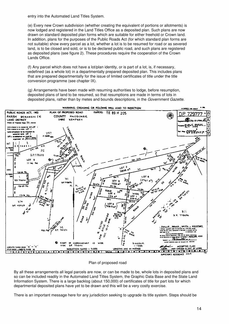
Other plans creating Crown parcels are road plans (for actions pursuant to the Public Roads Act),miscellaneous plans (for early resumptions), and acquisition plans (for compulsory acquisition by theCommonwealth or by the State or statutory authorities with resumption powers).
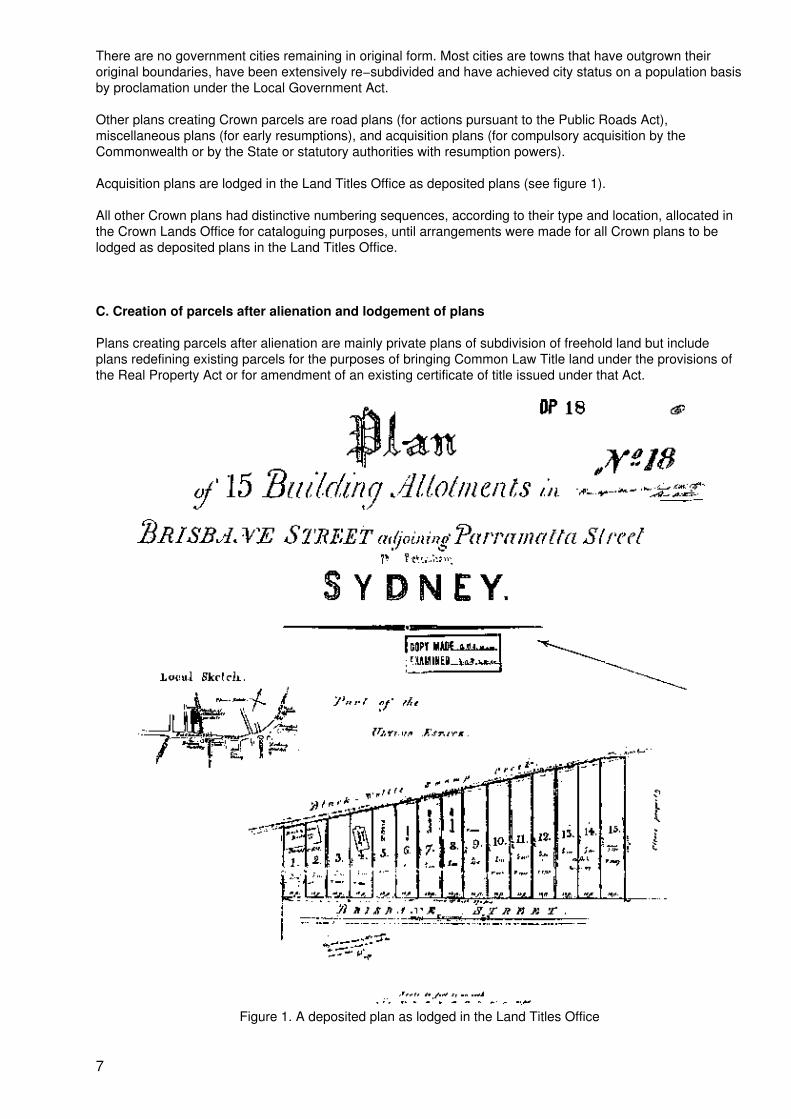
Acquisition plans are lodged in the Land Titles Office as deposited plans (see figure 1).
All other Crown plans had distinctive numbering sequences, according to their type and location, allocated inthe Crown Lands Office for cataloguing purposes, until arrangements were made for all Crown plans to belodged as deposited plans in the Land Titles Office.
C. Creation of parcels after alienation and lodgement of plans
Plans creating parcels after alienation are mainly private plans of subdivision of freehold land but includeplans redefining existing parcels for the purposes of bringing Common Law Title land under the provisions ofthe Real Property Act or for amendment of an existing certificate of title issued under that Act.
Figure 1. A deposited plan as lodged in the Land Titles Office
7
1. Lodgement of plans of Common Law title Land
There were no effective requirements or provisions for public filing of plans of Common Law title land until thecommencement of the Conveyancing Act, 1919 and the Local Government Act, 1919. Both before and afterthat date land in conveyances has usually been described by metes and bounds descriptions and the plan orsurvey of the land in a deed is usually not on public record unless it is a Crown plan referred to in section II.Bor a plan registered as described hereunder. A substantial number of “estate plans” and “sale lithos” preparedfor sale purposes became available for reference but these were generally not plans of survey and had noofficial status. Other plans became available from private sources through the years but these, too, had noofficial status. The best any of these plans did was to illustrate a subdivisional pattern, with some dimensionsand sometimes some unofficial survey information. The plans so obtained were usually filed as “lithos” orunder the name of the private supplier. Many of these plans were used for the charting of deeds referencesand for general charting purposes.
The Conveyancing Act of 1919 for the first time required the Registrar General to establish official registers ofplans of subdivision. At the same time, the Local Government Act, 1919 required such plans to be approvedby the local council, except (until 1945) as regards lots of more than 20 acres, and further provided that suchplans of subdivision had no effect until registered by the Registrar General. Until 1961 a plan of subdivision ofCommon Law title land was registered as a “Registered Plan” if it was a plan of survey and it contained fivelots or more. Otherwise, it was registered as a “Miscellaneous Plan of Subdivision (Old System)” and chartedas “M.P.S. (O.S.)”. Such plans could be compiled from existing information (see section II.F.7) or, if theRegistrar General so required, plans of survey but could contain no more than four lots. Since 1961, all plansregistered under the Conveyancing Act are recorded as “deposited plans”.
A plan lodged for the purpose of bringing Common Law title land under the provisions of the Real Property Actwas, until 1961, filed under the number of the Primary Application with which it was lodged, and was chartedas “P. A. ...”.
2. Lodgement of plans of Real Property Act Land
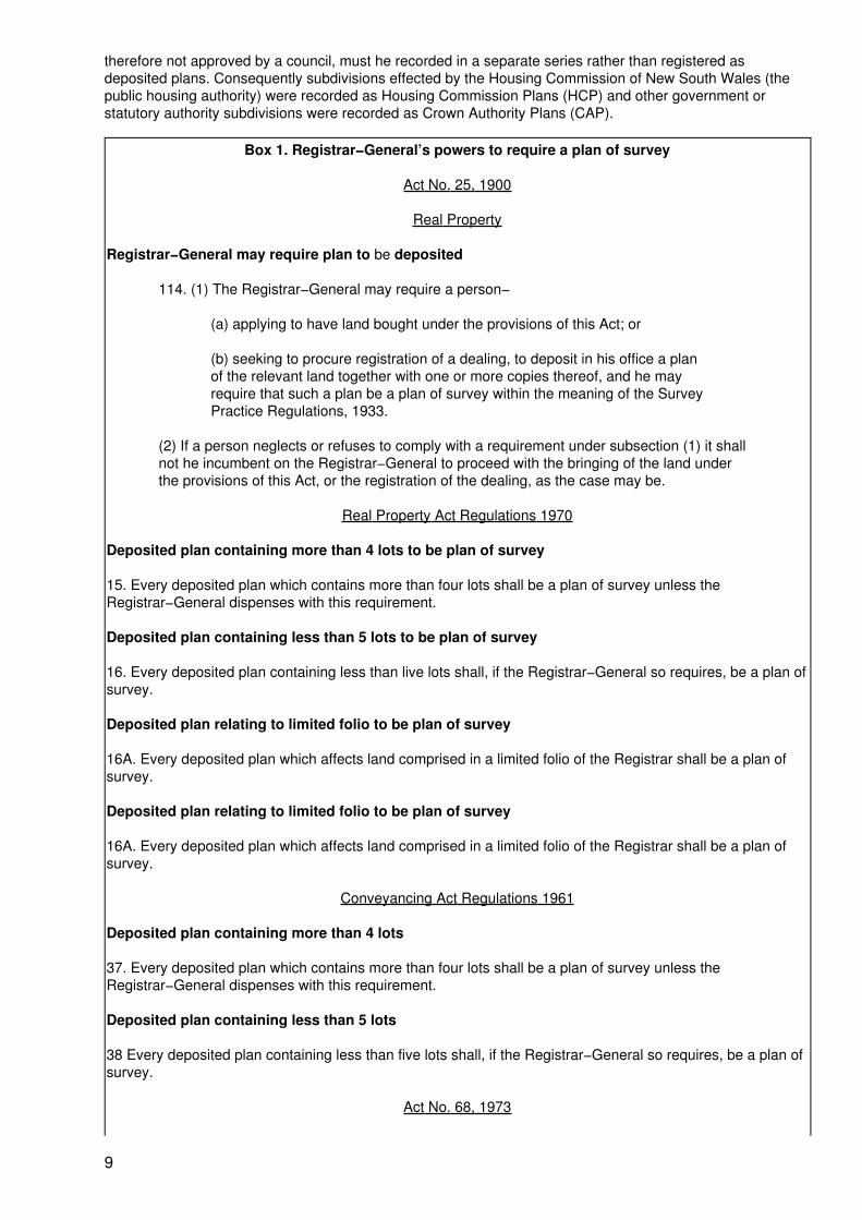
The Real Property Act, 1862, which commenced the Real Property Act system in New South Wales,prescribed lodgement of a plan of survey of any subdivision, any land included in a transfer not alreadydefined in such a plan, or any land sought to be brought under the provisions of that Act. Specifically the planwas to be “deposited” in the office of the Registrar General, and so the term “deposited plan” was instituted.The Registrar General’s powers to require a plan of survey is now comprised in several provisions (see box1):
• s. 114 Real Property Act, (as amended), as regards transfers and Primary Applications;
• Nos. 15, 16 and 16A of the Real Property Act Regulations and Nos. 37 and 38 of theConveyancing Act Regulations as regards plans of subdivision;
• P s. 8(2) Strata Titles Act for parcels comprised in Strata Plans.
Early deposited plans were drawn on cartridge paper and lodged in duplicate. Later they were drawn ontracing linen (not in duplicate) facilitating the making of copies, and currently on polyester drafting film. Whatbegan thus in 1863 as a straightforward system of deposited plans soon became increasingly complex. Anyjurisdiction contemplating a new title system should seek to avoid the complications now to be described.
From the outset and until 1961 the Registrar General permitted minor plans (no more than four lots) to be“deposited” as annexures to or endorsed on transfers of land in those plans and various applications lodged inthe form of dealings. Frequently, where only one lot was shown, the lot was not numbered, but normally lotswere given numerical or alpha identities.
Following the commencement of the Conveyancing Act, 1919 and the Local Government Act, 1919 (asreferred to in section II.C.1) plans of subdivision annexed to transfers were registered as “MiscellaneousPlans of Subdivision (R.P.) and charted as “M.P.S. (R.P.) ...” Plans in this category were normally plans ofsurvey but, if the Registrar General so permitted, could be compiled from existing information.
The register of plans constituted under the Conveyancing Act came to be considered, on legal opinion, to berestricted to plans of subdivision approved by local councils under the Local Government Act. Accordingly, itwas considered that plans showing subdivisions effected by Crown authorities not bound by that Act, and
8
therefore not approved by a council, must he recorded in a separate series rather than registered asdeposited plans. Consequently subdivisions effected by the Housing Commission of New South Wales (thepublic housing authority) were recorded as Housing Commission Plans (HCP) and other government orstatutory authority subdivisions were recorded as Crown Authority Plans (CAP).
Box 1. Registrar−General’s powers to require a plan of survey
Act No. 25, 1900
Real Property
Registrar−General may require plan to be deposited
114. (1) The Registrar−General may require a person−
(a) applying to have land bought under the provisions of this Act; or
(b) seeking to procure registration of a dealing, to deposit in his office a planof the relevant land together with one or more copies thereof, and he mayrequire that such a plan be a plan of survey within the meaning of the SurveyPractice Regulations, 1933.
(2) If a person neglects or refuses to comply with a requirement under subsection (1) it shallnot he incumbent on the Registrar−General to proceed with the bringing of the land underthe provisions of this Act, or the registration of the dealing, as the case may be.
Real Property Act Regulations 1970
Deposited plan containing more than 4 lots to be plan of survey
15. Every deposited plan which contains more than four lots shall be a plan of survey unless theRegistrar−General dispenses with this requirement.
Deposited plan containing less than 5 lots to be plan of survey
16. Every deposited plan containing less than live lots shall, if the Registrar−General so requires, be a plan ofsurvey.
Deposited plan relating to limited folio to be plan of survey
16A. Every deposited plan which affects land comprised in a limited folio of the Registrar shall be a plan ofsurvey.
Deposited plan relating to limited folio to be plan of survey
16A. Every deposited plan which affects land comprised in a limited folio of the Registrar shall be a plan ofsurvey.
Conveyancing Act Regulations 1961
Deposited plan containing more than 4 lots
37. Every deposited plan which contains more than four lots shall be a plan of survey unless theRegistrar−General dispenses with this requirement.
Deposited plan containing less than 5 lots
38 Every deposited plan containing less than five lots shall, if the Registrar−General so requires, be a plan ofsurvey.
Act No. 68, 1973
9
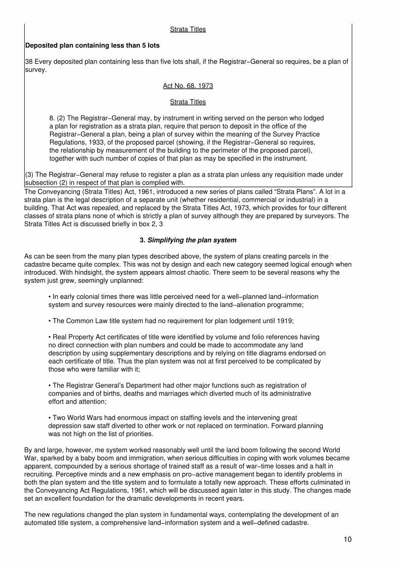
Strata Titles
Deposited plan containing less than 5 lots
38 Every deposited plan containing less than five lots shall, if the Registrar−General so requires, be a plan ofsurvey.
Act No. 68, 1973
Strata Titles
8. (2) The Registrar−General may, by instrument in writing served on the person who lodgeda plan for registration as a strata plan, require that person to deposit in the office of theRegistrar−General a plan, being a plan of survey within the meaning of the Survey PracticeRegulations, 1933, of the proposed parcel (showing, if the Registrar−General so requires,the relationship by measurement of the building to the perimeter of the proposed parcel),together with such number of copies of that plan as may be specified in the instrument.
(3) The Registrar−General may refuse to register a plan as a strata plan unless any requisition made undersubsection (2) in respect of that plan is complied with.The Conveyancing (Strata Titles) Act, 1961, introduced a new series of plans called “Strata Plans”. A lot in astrata plan is the legal description of a separate unit (whether residential, commercial or industrial) in abuilding. That Act was repealed, and replaced by the Strata Titles Act, 1973, which provides for four differentclasses of strata plans none of which is strictly a plan of survey although they are prepared by surveyors. TheStrata Titles Act is discussed briefly in box 2, 3
3. Simplifying the plan system
As can be seen from the many plan types described above, the system of plans creating parcels in thecadastre became quite complex. This was not by design and each new category seemed logical enough whenintroduced. With hindsight, the system appears almost chaotic. There seem to be several reasons why thesystem just grew, seemingly unplanned:
• In early colonial times there was little perceived need for a well−planned land−informationsystem and survey resources were mainly directed to the land−alienation programme;
• The Common Law title system had no requirement for plan lodgement until 1919;
• Real Property Act certificates of title were identified by volume and folio references havingno direct connection with plan numbers and could be made to accommodate any landdescription by using supplementary descriptions and by relying on title diagrams endorsed oneach certificate of title. Thus the plan system was not at first perceived to be complicated bythose who were familiar with it;
• The Registrar General’s Department had other major functions such as registration ofcompanies and of births, deaths and marriages which diverted much of its administrativeeffort and attention;
• Two World Wars had enormous impact on staffing levels and the intervening greatdepression saw staff diverted to other work or not replaced on termination. Forward planningwas not high on the list of priorities.
By and large, however, me system worked reasonably well until the land boom following the second WorldWar, sparked by a baby boom and immigration, when serious difficulties in coping with work volumes becameapparent, compounded by a serious shortage of trained staff as a result of war−time losses and a halt inrecruiting. Perceptive minds and a new emphasis on pro−active management began to identify problems inboth the plan system and the title system and to formulate a totally new approach. These efforts culminated inthe Conveyancing Act Regulations, 1961, which will be discussed again later in this study. The changes madeset an excellent foundation for the dramatic developments in recent years.
The new regulations changed the plan system in fundamental ways, contemplating the development of anautomated title system, a comprehensive land−information system and a well−defined cadastre.
10
On 23 January, 1961 all then existing plan registers were closed and all new cadastral plans (other than strataplans) began to enter a new system of deposited plans numbered in the 200000 series if they had more thanfour lots and were plans of survey, or in the 500000 series otherwise. These rules applied alike to land underCommon Law title and land under Real Property Act title. More recently all subdivisions of Crown land havebeen registered as deposited plans. Since the commencement of the Automated Land Titles System all newdeposited plans have been lodged in the series commencing at 700000.
In 1970 separate regulations generally similar to the Conveyancing Act Regulations, 1961, but with someappropriate differences, were made under the Real Property Act, so that separate regulations now apply toeach title system.
D. Land identifiers
Typical examples of land descriptions which might be found in certificates of title under the Real Property Act(other than in the Automated Land Titles System) are listed below. This list is not exhaustive and is largelyfictional:
• Portion 16, Parish of Boree, County of Clarendon;
• Suburban Portion 58, Parish of Trigalong, County of Bland at Temora;
• Allotment 1, Section 5, Town of Brunswick Heads;
• Allotment 5, Section 31, Village of Heathcote;
• Suburban Allotment 3, Section 4 at Matraville;
• 3r. 20p. Grant, Parish of Findon County of Rous; (an un−numbered section of closed publicroad no longer required and granted to an adjoining owner in compensation for another panresumed under the Public Roads Act for a road deviation);
• Part of lot 6, Deposited Plan 2659;
• Lot 12, Section 1, Deposited Plan 12309;
• Lot 1, Miscellaneous Plan of Subdivision (O.S.) 14938;
• Lot 2, Miscellaneous Plan of Subdivision (R.P.) 16924;
• Lot 10, Registered Plan 1132;
• The land in Primary Application 13046;
• Lot 6, Deposited Plan 200007;
• Lot 2, Deposited Plan 513024;
• The part of Lot 6 in Deposited Plan 364 shown in plan annexed to Transfer No. B601427;
• Lot B in plan annexed to Transfer G 123098;
• Lot 21, Housing Commission Plan 1064;
• Lot 4, Crown Authority Plan 74;
• The part of Portion 20, Parish of Thule, County of Cadell shown in plan annexed to TransferC542751.
Box 2. Shared use of land in the Strata Titles Act, 1973
11
Provisions exist in New South Wales for the use of certain lands to be shared in various ways. This is distinctfrom the holding of land as:
(a) Tenants in common, which is a means by which two or more persons hold land togetherin unity of possession but in separate shares whether equal or unequal, or
(b) As joint tenants with survivorship.
The need for sharing land arises from modern life styles and from the trend towards medium−density andhigh−density living in cities. Sydney is a prime example of a rapidly growing city with urban sprawl, having atotal population exceeding 3.6 million. The cost of providing goods and services to this large metropolitanarea, the problems of commuting great distances and high land values have created pressures for separatetitles for residential flat buildings, factory units, commercial suites and other units in a single development.
These needs are met in three ways:
(a) The Strata Titles Act provides for separate units in a building or buildings with sharedcommon areas and with separate Real Property Act titles for each unit and for the commonproperty. The common property is vested in a body corporate as agent for the severalproprietors, and that corporation is responsible for the management of the common propertyin accordance with a code of management embodied in the Act. The Act provides a means ofdisputes settlement through a Strata Titles Commissioner, keeping most disputes out of theCourts. Separate units are held and dealt with in exactly the same way as any other RealProperty Act title, but with the added requirement that a proprietor’s interest in the commonproperty and his/her contributions to the body corporate need also to be taken into account.The Strata Titles Act applies only to land in an ordinary (full) certificate of title and does notapply to land held under Common Law Title or land in a “qualified” or “limited” certificate oftitle. Provision is made for resubdivision of lots, consolidation of lots and subdivision ofcommon property, as well for readjustment of the strata scheme in the event of damage ordestruction to a building or resumption of part. The legislation is quite complex but extremelyflexible and is widely accepted in the community, some 302,000 titles existing as at 30 June1990 in addition to 31,000 titles for common property.
(b) Community titles legislation is a new initiative which lies between conventional landsubdivision and Strata Titles subdivision. It incorporates the principles of common propertyinto conventional land subdivision and provides an extremely flexible management structure.It allows for virtually any land subdivision where part of the land is shared and provides for arange of developments from free−standing cluster houses to resort developments, anddevelopments based on any theme such as agriculture, sport, retirement villages, industrialcomplexes and the like. The legislation allows for up to three−tiered management and isespecially suited to development in stages. The Land Titles Office is aware that manydevelopments are planned using this model, and the legislation is a response to sustainedpublic pressure over several years, due to the fact that conventional land subdivision andStrata Titles subdivision do not (either separately or together) provide a framework for themany innovative developments for which a need exists. The first plan registered under thislegislation relates to separately owned rice farms and the shared land is the water supplysystem.
(c) There are many examples, especially in the City of Sydney, where separate titles arerequired for “air space” parcels, such as elevated roadways, residential and commercialdevelopments above railway stations, escalator shafts, railway tunnels, pedestrian subwaysand the like. These are treated similarly to conventional land subdivisions except that the lotscreated are limited in height and/or depth to regular planes (horizontal or inclined) defined byreference to reduced levels on Australian Height Datum. This procedure is not specificallyprovided for in legislation but is well established, if not well understood. It is applicable toboth Common Law title and Real Property Act title.
1. Land identity problems
The great variety of land descriptions created problems:
• The system could only be understood by experts;
12
• The associated mapping system became very complicated and reference maps becamecluttered with the variety of information;
• The complexities were spread through the systems of government departments, localcouncils, the valuing authorities, service supply authorities, the financial institutions and theconveyancing community;
• The system provided a very poor base for a land−information system, many descriptions notbeing definitive without supplementary descriptions, e.g., descriptions of parts of lots, oftenrelying on the title diagrams on certificates of title;
• The filing of copies of so many types of plans for public inspection became very complex;
• The system was unsuited to a parcels−based computerized titles system because of thelack of uniqueness in land descriptions and the great variety of plan types.
2. The solutions
The problems have been resolved as follows:
(a) The deposited plan (D.P.) numerical series was adopted as the basic series and all otherplans have been recatalogued or refiled into that series, utilizing gaps in the deposited planseries. To achieve this, major plan series which were not already deposited plans wererecatalogued thus:
RegisteredPlan 1
became D.P. 32,501;
HousingCommissionPlan 1
>
became D.P. 35,001;
PrimaryApplicationPlan 1
became D.P. 50,001;
M.P.S. (O.S.)1
became D.P. 150,001;
M.P.S. (R.P.)1
became D.P. 300,001;
There are some cases where these constants could not be applied.
Other plans of miscellaneous types, including plans annexed to dealings and matters lodgedas dealings have been recatalogued more randomly as deposited plans, and their newnumbers can be ascertained from the Plan Cross Reference Index described in (c) below.
(b) Unnumbered lots in plans annexed to transfers and complete but unnumbered parcelsshown in other plans have been numbered as lots by the Registrar General under anauthority provided by regulations, which authority also permits the renumbering of lots. Wherelots were numbered or renumbered under this authority a notification of the changed landdescription was entered on the Registrar General’s copy (the Register copy) of any affectedcertificate of tide.
(c) A Plan Cross Reference Index was produced by computer, in which all lodgementnumbers, registration numbers and recatalogued numbers of all affected plans werecross−referenced so that any plan can be linked to its deposited plan equivalent or from thatnumber to its original lodgment or registration number. This index is a major publicationconsisting of four large volumes. A set of these volumes is available for public inspection andseveral sets have been sold.
(d) Every parish map and every government town or village map has been numbered as adeposited plan, so that every portion or allotment becomes a lot in a deposited plan permitting
13
entry into the Automated Land Titles System.
(e) Every new Crown subdivision (whether creating the equivalent of portions or allotments) isnow lodged and registered in the Land Titles Office as a deposited plan. Such plans are nowdrawn on standard deposited plan forms which are suitable for either freehold or Crown land.In addition, plans for the purposes of the Public Roads Act (for which standard plan forms arenot suitable) show every parcel as a lot, whether a lot is to be resumed for road or as severedland, is to be closed and sold, or is to be declared public road, and such plans are registeredas deposited plans (see figure 2). These procedures require the cooperation of the CrownLands Office.
(f) Any parcel which does not have a lot/plan identity, or is part of a lot, is, if necessary,redefined (as a whole lot) in a departmentally prepared deposited plan. This includes plansthat are prepared departmentally for the issue of limited certificates of title under the titleconversion programme (see chapter IX).
(g) Arrangements have been made with resuming authorities to lodge, before resumption,deposited plans of land to be resumed, so that resumptions are made in terms of lots indeposited plans, rather than by metes and bounds descriptions, in the Government Gazette.
Plan of proposed road
By all these arrangements all legal parcels are now, or can be made to be, whole lots in deposited plans andso can be included readily in the Automated Land Titles System, the Graphic Data Base and the State LandInformation System. There is a large backlog (about 150,000) of certificates of title for part lots for whichdepartmental deposited plans have yet to be drawn and this will be a very costly exercise.
There is an important message here for any jurisdiction seeking to upgrade its title system. Steps should be
14
taken as soon as possible to simplify the land identifier system to a single plan system, and part lotdescriptions should be avoided at all costs. The longer this is left the more difficult, and the more costly, it willbe. If procedures introduced in 1961 had been introduced with the Real Property Act in 1863, New SouthWales could have reached most of its present objectives perhaps two decades ago, subject to availability ofthe necessary technology.
E. General boundaries
New South Wales has no equivalent of the “general boundaries” concept applicable in the United Kingdomand perhaps elsewhere. There has never been a survey of the State comparable with that carried out in theUnited Kingdom under the authority of the Ordinance Survey Act of 1841, and probably never will be. NewSouth Wales began as virgin land with no permanent structures, or artificial features and, in some places, fewnatural features, to define boundaries. From the outset, boundaries were defined by reference to surveymarking on the ground rather than by general reference to boundary features such as walls, fences, hedgesand ditches. Thus, in New South Wales, boundaries are intended to be precise, rather than general, in thesense that they can be re−established from marking on the ground. This is not to say that walls and fencesare not used to define boundaries; indeed it is very common to find, in built−up areas, that “face of brick wall”has been adopted as a boundary monument (see figure 3). But unlike a “general boundary” feature, thisdefines the boundary precisely and determines ownership of the wall. Very commonly, as in the case ofsemi−detached houses or row−type (terrace) houses, the boundary between lots is specifically the “centre of0.23m brick party wall” (there are legal consequences in terms of ownership of walls and easements forsupport where a wall is described as a “party wall”). There are also cases, such as in agricultural areas, wherean existing fence is adopted as a boundary at the time of subdivision, and in that case the centre of the fencewould be the boundary and the fence would be a dividing fence for the purposes of the Dividing Fences Act.
It is fair to say, though, that in the absence of clear evidence of undisturbed marking on the ground, along−standing undisputed occupation (by a substantial building or the like) intended to correspond with a legalboundary, is unlikely to be upset by the Courts except for the most cogent reasons.
It has been said that boundaries under the Strata Titles Act, 1973 are “general” boundaries because a unit ina building is, under that Act, defined by reference to its surrounding walls, floors and ceilings without the useof measurements. However, the location of the boundaries is precise, and not “general”, because the Actprovides that, unless otherwise specified, the boundaries of a lot are the inner surfaces of those features, withthe result that ownership of those features clearly vests in the body corporate established under the Act ascommon property.
This writing is not intended to be in any sense a criticism of the general boundary concept, but simply astatement that in the current state of the law in New South Wales, that concept has no application. Some haveproposed, however, that greater significance should be attached to occupations, and some have seen this asproposing general boundaries.
F. Accurate surveys defining boundaries
As stated in section II.E, practice in New South Wales has been, from the outset, to rely on surveys fixingboundaries by reference to marking on the ground or, less commonly, by reference to artificial features, wherenatural boundaries are not available. It was always intended that the surveys should be accurate. However,accuracy is a relative term and is a function of the equipment available at the time and of environmentalfactors.
Accuracy of surveys has progressively improved from the era of the measuring wheel (or perambulator),Gunter’s chain, the circumferentor and the magnetic compass, to introduction of the long wire, or steel riband,for measuring distances, and the theodolite for measuring angles. Later improvements were micrometertheodolites and the early electronic distance measuring equipment (EDM) suitable for lung distances.Methods of calculations were refined and traverse and logarithmic tables were introduced, with early portablemechanical calculators appearing a little later.
15
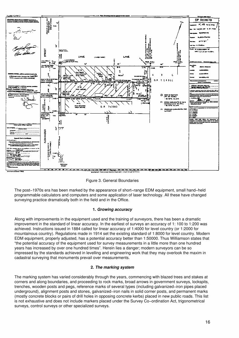
Figure 3. General Boundaries
The post−1970s era has been marked by the appearance of short−range EDM equipment, small hand−heldprogrammable calculators and computers and some application of laser technology. All these have changedsurveying practice dramatically both in the field and in the Office.
1. Growing accuracy
Along with improvements in the equipment used and the training of surveyors, there has been a dramaticimprovement in the standard of linear accuracy. In the earliest of surveys an accuracy of 1: 100 to 1:200 wasachieved. Instructions issued in 1884 called for linear accuracy of 1:4000 for level country (or 1:2000 formountainous country). Regulations made in 1914 set the existing standard of 1:8000 for level country. ModernEDM equipment, properly adjusted, has a potential accuracy better than 1:50000. Thus Williamson states that“the potential accuracy of the equipment used for survey measurements in a little more than one hundredyears has increased by over one hundred times”. Herein lies a danger; modern surveyors can be soimpressed by the standards achieved in levelling and engineering work that they may overlook the maxim incadastral surveying that monuments prevail over measurements.
2. The marking system
The marking system has varied considerably through the years, commencing with blazed trees and stakes atcorners and along boundaries, and proceeding to rock marks, broad arrows in government surveys, lockspits,trenches, wooden posts and pegs, reference marks of several types (including galvanized−iron pipes placedunderground), alignment posts and stones, galvanized−iron nails in solid corner posts, and permanent marks(mostly concrete blocks or pairs of drill holes in opposing concrete kerbs) placed in new public roads. This listis not exhaustive and does not include markers placed under the Survey Co−ordination Act, trigonometricalsurveys, control surveys or other specialized surveys.
16
Some of these marks are very durable, notably drill holes in stable outcrops of hard rock, but others aresusceptible to loss, disturbance or destruction. For example blazed trees can be destroyed by bush fires orland clearing, fence posts can be burnt out or eaten by termites (fortunately, post holes often remain visible),pegs are usually disturbed or removed in fencing operations, permanent marks are often disturbed by roadconstruction (there is no adequate provision for deterring the placement of concrete blocks until after roadconstruction) and reference marks are frequently destroyed or disturbed in the laying of service pipes andcables.
The loss of marks remains a weakness in the cadastral surveying system and adds significantly to thedifficulty and cost of boundary retracement. Some have suggested that a review of the marking system, theuse of some new form of durable lightweight metal markers, easily visible, and education of the public and thepublic authorities, would resolve many problems. Others have claimed that retracement problems would bereduced if all cadastral surveys were connected to a larger accurate state survey with more permanentmonumentation.
3. Compiled plans and partial surveys
Notwithstanding that accurate plans of survey form the basis of certification of title, the Registrar General hasover the years accepted certain plans compiled from existing plans of survey on public record, provided thatthe new boundaries created are not intended to relate to or represent a physical occupation or other featureon the ground and are determined solely on a simple mathematical basis.
Plans in this category are mainly limited to older plans in imperial measurements and might, for example, befor a subdivision of a rectangular lot of 100 feet frontage into two rectangular lots each of 50 feet frontage. Inmany cases the cost of survey might, if the land is remote and of low value, exceed the value of the land.Provided it was shown that the subdivision line did not represent a physical occupation or feature on theground, such a plan was thought to be adequate and safe if the prior base survey was accurate yet, as wehave seen, many early surveys allowed excess measurement and the positions of nearby roads may havebeen changed by altering the alignment.) In such cases the Common Law rule of construction against thegrantor would apply i.e., the rule that every man’s grant is construed most strongly against himself. Under thisrule, if a 50−foot lot was sold, that lot must be satisfied first and any shortage would be suffered by theremaining lot. On the other hand any excess would accrue to the remaining lot.
Plans of this type have been accepted for many years subject to conditions and published guidelines. Manyplans annexed to transfers were of this type. However, because of increasing survey costs there was, in the1970s and early 1980s, an increase in the lodgement of such plans and breaches of the guidelines were notalways detected (due in part to the inexperience of some Land Titles Office staff) and at one time about onethird of plans lodged were compiled. Surveyors began reporting problems in re−establishing the position ofboundaries created in such plans because of features or occupations found on the ground and underlyingsurvey problems. They became increasingly critical of other surveyors who prepared such plans, knowing thatthere were survey problems in the area and fearing that if they quoted for a full survey they might not get thejob. There have also been problems when compiled plans for easement purposes have been registered,especially where the easement is for laying electrical cables or gas lines. There is a perception that adangerous situation could arise if electrical cables or gas lines are laid in positions other than as shown in therelevant plan, due to underlying survey errors.
Also for reasons of economy some plans of “partial” survey have been accepted. These are cases where thesurvey is limited to the subdivision line only, and are accepted subject to the provision that each terminal ofthe subdivision line is connected by survey to satisfactory redefinitions of corners of the land subdivided.
In all compiled plans and partial surveys there are some inherent dangers and risks to the cadastre and itsrecently restated guidelines−review is being more rigidly enforced, so that the incidence of those plans hasdecreased significantly. A copy of the current guidelines−review is attached as given in box 3. A plan ofsurvey will be insisted on if the guidelines have not been complied with. The surveying profession wouldprefer that every plan should be a plan of survey but concedes that there is a case for compiled plans in somecircumstances.
4. Plan examination
All plans affecting freehold land lodged in the Land Titles Office are carefully investigated to ensure that theyare an accurate and secure base for certification of title. Similarly, plans affecting Crown land (but not planslodged in the Crown Lands Office for action under the Public Roads Act), are examined in that Office to
17
ensure that they are to alienation standard.
The purpose of investigation of plans in the Land Titles office is to ensure that:
• All existing boundaries are correctly defined, having regard to the intention and reliability ofprior plans;
• Common boundaries with adjoining land parcels have been adopted;
• The plan is mathematically correct within allowable limits (this check is now limited to the“surround” of the plan);
• The land in the plan is within the subdivider’s title and that the plan does not include land inanother title;
• In the case of land under the Real Property Act, the plan includes the whole of the legalparcel subdivided, and that hiatuses between adjoining parcels have not been left;
• In the case of land under Common Law title, title to land in the plan has not been lost bypossession adverse to the documentary owner (here the age of any fences, walls etc. is mostimportant);
• All survey marking required by relevant regulations, specifically reference marks andpermanent marks, are shown to have been placed;
• In a proclaimed survey area, the prescribed connections to marks placed under the SurveyCo−ordination Act have been made;
• All proposed or existing easements have been correctly and sufficiently defined;
• All statutory requirements for approval of local councils, statements re−road dedications andthe creation of easements and restrictions on use and the signatures or consents of persons(owners, mortgagees, lessees, caveators etc) having interests recorded in the Real PropertyAct Register have been complied with (the Registrar General has power to dispense withcertain signatures and consents);
• Frontage to roads as shown in the plan may properly be claimed (some roads are not publicroads);
• Any new public roads provided in the plan are legally accessible to the public;
• The plan is accurate for the purpose of certifying title under the Real Property Act.
From time to time, usually for financial reasons, questions are raised as to why these examinations need to bemade, especially since the plans have been prepared by professionals, and duplication of effort is perceived.
Box 3. Guidelines for the preparation of compiled plans
Guidelines for the preparation of compiled and partially surveyed plans for illustration of residue lots.
Compiled plans of subdivision
1. These are ACCEPTABLE ONLY where any new subdivision line:−
1.1 is fixed at a stated distance from existing boundaries established by a plan of survey onpublic record;
1.2 is placed without regard to natural features or occupations or improvements on theground;
1.3 contains no angles or steps, except where the line is parallel to an existing surveyedboundary containing equivalent angles or steps.
18
1.4 has an obvious intention, e.g.,
• dividing a lot mathematically into equal parts;
• creation of lots having rounded off frontages, square widths or areas e.g.20m; 5 ha;
• projecting existing boundaries established by a plan of survey;
• providing a cut−off corner formed by a triangular splay, a curve or a seriesof regular chords;
1.5 is a determined by any combination of the above.
2. These are NOT ACCEPTABLE:−
2.1 when the plan of survey used as the basis of the compilation is shown by other plans onpublic record to be unreliable or is believed to be unreliable;
2.2 if the lengths and bearings of the surround are not in agreement with the plan(s) on whichthe certificate of title or deed is based, except in the circumstances referred to in item 2.6;
2.3 if it contains more than four lots, including any residue lot;
2.4 where it is known or believed (whether from the design of the subdivision or from otherinformation) that there are natural features, occupations or improvements on the ground nearthe subdivision line;
2.5 to determine the residue of a parcel following alignment, re−alignment, road action or thelike;
2.6 when based on adjoining plans unless these are plans of survey which interconnect insuch a way as to confirm the accuracy of the information used;
2.7 when the land in the plan is in a closely built−up locality such as a central business area,in which the survey information on public record is not up−to−date or is inadequate or surveymarks or monuments have been lost or destroyed due to development work being carriedout;
2.8 when based on more than one plan on public record unless those plans are in completeagreement;
2.9 when the external boundaries were created by a prior compiled plan;
2.10 unless bearings are shown for all boundaries and are derived from plans of survey onpublic record;
2.11 to define a proposed road or an extension of an existing road;
2.12 to subdivide land into strata defined by Australian Height Datum.
3. Area
Areas should be calculated correctly from the information in the plan and should not in any case be derivedfrom an approximate or rounded out imperial area shown in a prior plan.
4. Monuments − existing gross easements
Monuments such as “centre of 0.23 brick party wall” or “face of wall” where related to the boundary orboundaries of the certificate of title or deed being subdivided should be excluded from the compiled plan andthose boundaries defined by right lines only. However, the sites of any existing cross easements created inrespect of party wall whether by s. 181B of the Conveyancing Act, 1919, or by transfer and grant of easement
19
should be shown on the plan and the origins of such easements indicated.
5. Partial surveys
Where the subdividing line or lines are such that they cannot be compiled − e.g., an irregular fence dividing aportion −a partial survey may be accepted (this type of survey is not to be confused with the survey of theland in a document of title referred to in Regulation 14 of the Survey Practice Regulations, 1933). The partialsurvey will embrace the subdividing lines together with the definition between acceptable terminals of theexisting boundaries at which the subdividing boundaries terminate and the intercept of boundaries on thoseexisting boundaries measured. The remainder of the boundaries may then be compiled provided all criteriafor compiled plans are satisfied.
6. Residue lots after subdivision
The aim of the Office to maintain the highest possible standards of boundary definition is reflected inRegulations 27 and 28 of the Real Property Act Regulations, 1970, which require the complete dimensionsbe shown of all parcels in a deposited plan whether it be one of survey or compilation or a combination ofboth. However, those Regulations must be read in conjunction with Regulation 26 which allows to becompiled without bearings a residue, the boundaries of which are extensive (and which has been included inthe plan solely for the purpose of meeting the requirements of this Office for the elimination of partlycancelled certificates of title), regardless of whether the remainder of the plan is compiled or surveyed.
As a consequence, the following rules apply to the presentation of residues in all deposited plans −
6.1 Where the residue parcel is substantially larger than the other lot(s) in the plan, it may inall cases be compiled and bearings may be omitted if necessary. All lengths shown shouldbe in agreement with the plan(s) on which the certificate of title is based. The area should, ifpossible, be calculated from the information shown in the plan, but where it can beascertained only by deduction it should be shown thus: ...
6.2.1 It may be compiled only when
• the remainder of the plan is compiled and• there are no more than three other lots therein;
6.2.2 It will be required to show bearings in respect of all right lineboundaries.
Please note: The acceptance of any compiled plan is a concession only.
The Registrar General is authorized to require lodgement of plan of survey.
7. Survey
While practitioners may be assured that plans complying with the guidelines will be accepted, it is expectedthat surveyors will exercise professional judgement and refrain from submitting a compiled plan where theyhave personal knowledge that the basic survey information is unreliable or that such a plan would be contraryto good survey practice.
It can be shown that the strict adherence to the above−mentioned rules would cause undue hardship orunwarranted cost, a request to dispense with a survey will be considered on its merits.
LAND TITLES OFFICEOriginally issued August 1983The plain tact is that plans are liable to errors which escape notice until lodged for registration, and failure tocheck would place at risk the integrity of the Real Property Act Register and create an unnecessary burden onthe community. Removal of the investigation would certainly result in an increase in errors in plans asregistered and a corresponding increase in amendment activity. Most errors of a clerical nature can berectified readily when discovered, provided the surveyor cooperates, but since they are commonly discoveredduring the course of a conveyancing transaction and sometimes delay settlement, they create an adversepublic reaction. Errors in boundary definition in a plan of subdivision would, if undetected, proliferatedisputation. Errors of a mathematical nature are usually detected in the course of undertaking identification
20
surveys for building purposes.
Removal of the existing checks would result in increased survey costs because of the need for additionalfieldwork and the cost of surveyors’ professional indemnity insurance, and this would be reflected in the costof conveyancing and litigation or action as described in section II. I to resolve boundary definition problemsand disputes. It is pertinent to note that the surveying profession itself considers that the checks shouldcontinue. It should also be noted that only about 30 per cent of the investigator’s time is spent on boundarydefinition checks, on average.
Where, as a result of the investigation, a plan is found not to be in order for either survey or legal reasons,requisitions are forwarded to the surveyor or the lodging party as appropriate and failure to comply within eightweeks leads to rejection of the plan after expiration of a final 28 days notice.
G. Isolated surveys
The survey system is sometimes referred to as a system of “isolated” surveys. Certainly the early Crownsurveys for alienation were frequently isolated from each other. With the passage of time, surveys wereincreasingly related to adjoining surveys, from which they became less and less isolated. With the alienationof Crown land nearly at an end, and with resubdivision of parcels, there is a network of individual butinterrelated and generally compatible surveys together comprising the cadastre (except for an unknownCommon Law title component), in which most of the inaccuracies in early surveys have been resolved.However there remains a fundamental isolation in the sense that each survey is unrelated to, or “isolated”from, any common State control or coordinate system. There is no single “total map” of the cadastre and, asyet, no State−wide survey control. Efforts to end this “isolation” have, so far, not been very successful, assection II.H shows. However, it must be very clearly stated that, isolated or not, and in spite of its faults, thecurrent system works well to provide a solid base for a very secure conveyancing system and it is wellaccepted, if poorly understood, by the community. Whether a system based on coordinates instead ofmonumentation would be cheaper and more efficient is currently a matter of debate in the surveying industry.
H. To end the isolation?
For well over a century many people (principally cartographers, Surveyors−General and academics) havesought ways of relating the system of isolated cadastral surveys to a very accurate survey of the whole of theState. The first major reason seems to have been problems of fitting together individual surveys of varyinglevels of accuracy to produce satisfactory administration maps. More recently efforts to produce a first classland− information system based on an accurate graphic data−base have served to highlight general overallinaccuracies in the survey system. The survey system of itself operates as a sound basis for definingindividual land parcels and to support a very secure conveyancing system, but while it is sound and wellaccepted for what it sets out to do, it is considered to he inefficient in the way it does it and, moreover, it doesnot adequately support the wider objectives of computer mapping and land information.
The survey system or method has progressed from the trigonometrical survey (1855) through the coordinatesurvey system (1949) to the integrated survey (1972).
Any government contemplating an upgrading of its land titling and land−management systems shouldconsider adopting a coordinate survey system. It has the potential to produce better maps and perhapscheaper surveys in the long run, as well as to facilitate a good land− information system, but the longer thechange is delayed the more expensive it will he, and the more difficult it will he, politically, to introduce.
I. Boundary disputes resolution
The examination of cadastral plans, as described in section II.F.4, has generally been very effective inensuring that boundaries of land parcels are correctly defined as at the time of registration, and thecommunity generally accepts and relies on that examination. Very little disputation arises at that point in time.Occasionally during the course of investigating plans of Real Property Act land notice may be given to anadjoining owner if a boundary has become lost or confused. In processing primary applications to bring
21
Common Law title land under the Real Property Act it is usual to serve notice upon owners of adjoiningCommon Law Title land. Notice, as described, usually results in agreement on the common boundary andavoids later disputation. Sometimes, of course, it causes disputes to materialize.
It is one thing to register a plan in the confidence that the boundaries are correctly defined in the plan. Theposition on the ground can however be another thing again: the marks on the ground could be wronglyplaced, disturbed or removed, or may not have been placed at all. There may be mathematical errors in a planthat cannot be detected in an Office investigation. Such errors and disputes generally become noticed when,in the course of a sale, a surveyor is called upon to prepare a survey report, or, after a sale, to set out abuilding.
Other disputes may arise long after a boundary is first established, due to loss or disturbance of marks, theerection of buildings, the renewal of fences or other reasons.
Some disputes come to the attention of the Land Titles Office when separate surveyors for adjoining ownerscannot reach agreement. In the past, the Land Titles Office has had no authority to mediate or determinethese matters, and could only consider plans of subdivision or redefinition formally lodged for registration. Theonly recourse an owner has had has been to the Courts, but this has become, for most, prohibitivelyexpensive.
Following representations and in the light of experience, legislation was recently enacted to enable theRegistrar General to determine the positions of certain disputed boundaries outside the Court system.
J. Identification surveys
It is normal practice for solicitors acting for purchasers and for mortgages to require an identification survey inthe course of a conveyancing transaction. This is a precautionary measure, rather than a statutoryrequirement, and identification surveys often constitute a significant part of a surveyor’s practice. Proponentsof change in the surveying profession often point to these surveys as an indication that the overall surveysystem has a fundamental weakness if every time a property is sold or mortgaged a fresh survey is requiredand unnecessary costs are incurred. It has been suggested that a cadastre based on coordinates wouldreduce costs in this regard hut it is very difficult to see how this could be so. While coordinates would certainlyaid in re−establishing boundaries, the real problem is not the location of boundaries hut the location ofimprovement in relation to the boundaries and relation of the property sold to the title offered.
Identification surveys had their origins in the days of monotonous rectangular subdivisions when it was veryeasy to misidentify a lot. A selling agent might, in the case of a large new subdivision of vacant lots show apurchaser lot 1 of Section 3 when the draft contract is for lot 1 of Section 4. If a house is for sale, thepurchaser knows he has seen a particular one at a particular address, and that is what he decides to buy. Butthe title system knows nothing of street addresses, and even if it did, street addresses are not sufficientlystable or unique in NSW for title purposes. House numbers are not always available when new residentialsubdivisions are registered. Many country roads are unnamed, and mailing addresses are commonly“Roadside Mail Boxes” (RMB). A main function of an identification survey is to link the property sold with thetitle offered.
Building requirements set out in Ordinance 71 of the Local Government Act require certain setbacks fromboundaries to walls and gutters. If these are not observed, the local council may require rectification, and soan identification report acts as insurance. Similarly a report on the fencing may highlight the possibility ofdispute with neighbours.
There have been cases where land is being used in a way which contravenes a restrictive covenant, or wherefor some reason, say road reconstruction, access to the property has been impeded. These might heevidence on the ground of some sort of use by another person which could lead to a prescriptive claim for aright of way, except where the land is under the Real Property Act.
All these and similar matters are, or should he, addressed in the identification report.
22
III. THE COMMON LAW TITLE SYSTEM
A. General
The Common Law title system in New South Wales is based on the English Common Law system which wasadopted on the establishment of the colony. It is that system by which an interest in land is created and/orconveyed to another person by the execution and delivery of a deed. This chapter is not intended to representa detailed study of the Common Law title system but rather to present an overview sufficient to show how itoperates and to allow a comparison with the Real Property Act system. Since the commencement of the RealProperty Act system (commonly called the Torrens system) the Common Law system has commonly beenreferred to as the “old system”.
The early development of the deeds registration system has been described in section I.B. In 1985 theRegistration of Deeds Act (as amended) was repealed and its major provisions were re−enacted as Division 1of Part XXIII of the Conveyancing Act. Although registration is not mandatory, there are powerful incentives toregister, as set out in section III.E, and in practice deeds are usually registered. Only occasionally are “old”deeds lodged for registration. Registration does not create a system of “registered land” as in England andWales; it merely constitutes a public record of deeds and confers priority.
B. What is a deed?
The execution and delivery of a deed has been described as the most solemn act a person may perform inrelation to land. A deed is that document in writing that passes the legal estate, or a lesser interest, in land toanother person. A deed might be said to consist of 10 components:
• The commencement (“This conveyance made on the 2nd day of April 1979”);
• The parties to the deed, including all persons whose execution is necessary to give effect tothe deed;
• The recitals (commencing “Whereas”) explaining:
(a) How the vendor is entitled to convey the land; and(b) The agreement which gives rise to the deed;
• The testatum (“Now this deed witnesseth”) which identifies the beginning of the operativepart of the deed;
• The consideration (usually a sum of money);
• The receipt clause recording payment and receipt of the consideration (no other receipt isnecessary);
• The operative clause (“the said vendor as beneficial owner doth hereby convey to thepurchaser ......”);
• The parcels clause (the description of the land conveyed);
• The habendum (“to hold ......”) showing how the estate passed will be held by the purchaser,whether for his or her own benefit or as a trustee for others, and specifying the estate (feesimple or other estate) the purchaser takes;
• The testimonium (“In witness whereof.....”) and the attestation (“Signed, sealed anddelivered by ...”).
There are a great variety of deeds known to the law, but the most common are conveyances, mortgages (atCommon Law a mortgage is a conveyance subject to an “equity of redemption” or right to buy back),reconveyances (after a mortgage is paid in full), discharges of mortgage; leases; appointments of new
23
trustees; deeds of confirmation; deeds of acknowledgement and conveyances of equity of redemption.
C. The chain of title
No single deed operates of itself to give a better title than was held by the predecessor in title. A person’sentitlement to land under the Common Law system depends on an unbroken chain of title normallycommencing from a Crown grant or a “good root of title” (see below) and comprising every successive deedby which title was passed step by step to the present owner without defect. No defect in title or break in thechain is rectified by the latest deed unless all outstanding interests have been got in. Thus a person’s title isnot evidenced by a single deed but by many, sometimes a very large bundle. Included in the bundle would beany mortgages, reconveyances or statutory discharges, or, if a mortgagor was in default, the conveyance bywhich the mortgagee exercised a power of sale or foreclosure. In like manner every incident of title should beaccounted for by either a deed or a recital (e.g., a change of name by marriage, or a death and grant ofprobate). On completion of a purchase all the deeds comprising the chain of title are normally passed to thepurchaser (or the solicitor or the purchaser) or any mortgagee.
Where the land conveyed is part only of the prior title (i.e., a subdivision has occurred or one of severalseparate parcels is sold) the vendor will retain all the prior deeds as evidence of his or her own title to the landhe retains, or may deposit them permanently with the Registrar General as “deposited deeds”. Unless theyare so deposited the conveyance should, for the benefit of the purchaser, include a “covenant to produce”those deeds for inspection.
“Deposited deeds” can he inspected at the Land Titles Office. Where a vendor no longer retains an interest ina deed affected by such a covenant the related deeds must be deposited with the Registrar General asrequired by the Conveyancing Act.
Land held under Common Law title is subject to loss of title by possession adverse to the documentary owner.For possessions commencing prior to 1 January 1971 the period that must run to gain title is 20 years, and forpossessions commencing after that date the period to run is 12 years. Where title is claimed by adversepossession the chain of title will commence from the time the possessory title is established and not from aCrown grant.
Where land has been resumed at some time in the past by a government or statutory authority havingresumption powers, the subsequent chain of title would begin with that event. It is the responsibility of thepurchaser’s solicitor to investigate every aspect of the vendor’s title fully to ensure that he is able to give aclear title, and the investigation should include an examination of the chain of title and every deed in thatchain. Although a chain of title commences usually with a Crown grant the Conveyancing Act provides that avendor is only required to establish title from a “good root of title” (a conveyance or mortgage for valuableconsideration 30 years old). This provision relies on the expectation that the 30−year−old conveyance wasaccepted following a full investigation of the title at that time as well as the fact that the present documentaryowner remains in possession and has not suffered ejectment.
To enable the purchaser’s solicitor to carry out his investigation, the vendor is required to provide an abstractof title. This consists first of an epitome of title listing all the documents of title and secondly a recital of allincidents such as deaths and grants of probate affecting the title.
D. Description of land
In early days land was usually described by a metes and bounds description or as a Crown portion orallotment. Since the commencement of the Conveyancing Act, 1919, a description could be in terms of a lot ina plan registered by the Registrar General but metes and bounds descriptions are still common. While it wouldhave been possible, before 1919, to describe land by reference to a plan annexed to a deed, this has beenuncommon in practice.
Metes and hounds descriptions were commonly long and complex, and prone to error. Moreover, since theywere usually based on surveys or plans not on public record, any errors were not apparent and came to lightonly when an attempt was made to draw up a sketch from the description or to fit the description to existingmaps or plans. Often an error in a description was carried forward in successive deeds. Sometimes a
24
resurvey of the land was made for a conveyance and to link the new description with the chain of title, boththe old description and the re−description were included.
E. Registration
On completion of a transaction the deed is presented to the Registrar General for registration. Registration isnot mandatory; however registration establishes priority over a competing unregistered deed, whatever itsdate. Further, a deed executed under a power of attorney has no effect unless the power of attorney is itselfregistered. Similarly a judgment does not create a charge on land unless it is registered. These provisions inthe Conveyancing Act ensure that deeds are usually registered. There is the added advantage in registrationthat in the event of the loss or destruction of an original deed the registration copy becomes prima facieevidence of the original.
The Registrar General however will not register a deed unless:
• It is marked by the Stamp Duties Office indicating that ad valorem stamp duty has been paidor the deed is exempt from duty;
• Any “registration copy” supplied has been prepared in accordance with Conveyancing ActRegulations requirements as regards size, margins, ink/typing density etc.;
• If it is not accompanied by a registration copy complying with the regulations, a tee has beenpaid for the preparation of a registration copy by the Registrar General;
• Any registration copy lodged with the deed is endorsed with a statutory declaration that “thewriting contained above and on the (specify number of pages) preceding pages has beencompared by me with the original instrument and is a true copy thereof” (this form ofdeclaration was introduced in 1985 in place of the oath previously required);
• The deed and any registration copy bears the name, address and delivery box number ofthe lodging party;
• It is accompanied by a “Statement of Title Particulars” form, duly completed, to enableconversion to the Real Property Act system.
Registration is effected by endorsing on the deed a unique consecutive book and number reference, e.g.,Book 2999 No. 996 (under which the registration copy will be filed in the General Register of Deeds), bymachine stamping of the time and date of registration and by endorsing a statement evidencing registrationunder the seal of the Registrar General.
A photocopy of the registration copy is normally made at the Lodgment Counter and the deed is immediatelyreturned to the lodging party. This photocopy and the “Statement of Title Particulars” form provide sourcedocuments for title conversion action.
F. Covenants
A variety of covenants may be created in a conveyance:
• The vendor may covenant to produce prior deeds for inspection;
• The purchaser may covenant not to use the land in a certain way; this covenant is termed a“restriction on the use of land” and if properly framed (i.e. in the negative) it will continue tobind the land in the hands of successors in title. This type of restriction is used to controlmany things, such as the type of building which may be erected or to prohibit noisome oroffensive activities on the land;
• A vendor may, for the benefit of the purchaser and successors in title, covenant not to docertain things on other land of the vendor, such as not erecting, on his land, a building
25
exceeding a certain height. These restrictions on use of land are uncommon, often relate tothe preservation of a view or outlook, and have sometimes been called “negative easements”;
• Four covenants implied by operation of the Conveyancing Act and not required to beexpressed, are: (a) that the vendor has the right to convey the land; (b) for quiet enjoyment;(c) that the land is unencumbered except as stated in the deed; and (d) to execute any furtherconveyance or document necessary to perfect the title.
G. Exceptions, reservations and easements
A conveyance may contain exceptions or reservations or may create easements. For example, the land belowa certain depth from the surface may be excepted (perhaps for the minerals it may contain) or some particularmineral may be reserved, together with rights to mine. Easements of any type known to the law may bereserved in favour of a specified dominant tenement or may be granted over other land of the vendor (as theservient tenement) in favour of the land conveyed (the dominant tenement). The most common easementsare rights of way and easements for drainage, of various types. The terms “right of carriageway”, “right offootway”, “easement to drain water” and “easement to drain sewage” have specific meanings in theConveyancing Act and the use of those terms in a deed imports the extended statutory meanings, making itunnecessary to set out those specific meanings in the deed. For an example of a deed reserving minerals andcreating easements.
H. Indexing of deeds
The Registrar General is required by the Conveyancing Act to maintain indexes of all matters registered byhim. In the case of deeds registered in the General Register two indexes are maintained, the Vendors Indexand the Purchasers Index. These indexes are vital to searching of the General Register. For the indexes tofunction as they should it is imperative that they follow strict and consistent indexing rules and “place order”rules.
Many conditional purchases (a form of purchase from the Crown, referred to in section I.F above) aretransferred before completion of the purchase, and such dealings were registered originally in the Departmentof Lands. Due to a legal decision casting doubt on the effectiveness of such registrations, a practice of alsoregistering those dealings in the General Register of Deeds arose. A separate and quite large index ofdealings with conditional purchases up to 1969 is kept by the Registrar−General;
Bills of sale in respect of mortgages of goods and chattels, including motor vehicles and furniture, have beenregistered by the Registrar−General. However, since 1986, encumbrances relating to motor vehicles havebeen registered elsewhere than in the Land Titles Office, although a secondary registration in that Office ispermitted;
The Registrar−General holds many original deeds lodged with him as “deposited deeds” to satisfy “covenantsto produce” as referred to in sections 3.3. and 3.6 or where a vendor retains no interest in a deed affected bysuch a covenant. A large index of deposited deeds is maintained;
I. Duties of the Registrar−General
The duties of the Registrar−General in relation to the Common Law system are specific and limited and are asprovided in the Conveyancing Act and regulations. They may be summarized as follows:
• Registration of deeds in the General Register as described in section III.E and of othermatters as outlined in section III.I;
• Correct indexing of deeds in the Vendors and Purchasers Indexes, as described in sectionIII.H, and of matters registered in registers other than the General Register;
26
• Ensuring the safekeeping of, and providing public access to, the registers and indexes keptby him;
• Carrying out official searches as described in section III.K.
The Registrar−General has no responsibility for checking any deed or its contents or for interpretation of adeed. He is responsible for the accuracy of any official search but provides no guarantee of title to the land towhich an official search relates.
J. Searching Common Law titles
Searching in the Common Law system is generally a complex, painstaking and often tedious task, usually leftto professionals. Many of the early deeds are manuscripted on parchment or vellum, show some fading, andrequire great concentration in reading, but overall the records are in excellent preservation due, no doubt, tothe heavy binding, the quality of paper etc. used, and care in use encouraged by the Registrar−General.
Searches in the General Register are based on the Vendors and Purchasers Indexes, hut may be begun indifferent ways, according to circumstances. If, for example, an old deed reference (book and number) for aproperty is known, the deed may he inspected to ascertain the purchaser’s name and then the chain of titlecould be followed through the Vendors Index. Or if one knew that Harold John Smith purchased a particularparcel of land in 1972 from an unknown vendor, one could inspect the Purchasers Index for that year to findthe transaction and the deed reference. The search would then continue up to date through the VendorsIndex. It should be remembered that there are many Smiths, and perhaps more than one Harold JamesSmith, so all possibly affecting deeds detected in the index should be examined and deeds found to he “notaffecting” may be disregarded. The land description in the index and the location of the land will limit thesearch.
To take another example, one could, by search of the Purchasers Index, identify all the Common Law titleland purchased by “Port Jackson Trading Company Proprietary Limited” since 1 January 1980. To ascertainwhether the company still owns those lands, each parcel would then he the subject of a search in the VendorsIndex against the company. These searches would not establish whether the company had acquired a goodtitle to each parcel in the first place; that would require a search back through the Purchasers Index step bystep to a good root of title, perhaps even to the Crown grant.
Most title searches are based on the abstract of title supplied by the vendor. From the abstract a searchinstruction would normally be compiled by the purchaser’s solicitor and passed to a professional searcher.This would specify the period to he searched, against each name, for each link in the chain of title. The objectof the search is not merely to confirm the abstract of title but to detect any undisclosed transactions such asundischarged mortgages, unexpired leases or any undisclosed exceptions, easements benefiting orburdening the land or any affecting covenants. If an undischarged mortgage is found it would be necessary tohave the legal estate reconveyed to the mortgagor prior to, or in conjunction with settlement. If an unexpiredlease is found, the vendor could not give vacant possession on settlement unless a surrender of the lease isgiven at or before settlement.
From the above it is obvious that the Common Law System of title is essentially a names−based system,unlike the Real Property Act system which is parcels based.
In addition to the search of the General Register, searches should also be made in Register of Causes Writsand Orders against the vendor, and in the Register of Resumptions. If any deed in the chain of title has beenexecuted by an attorney, the registered power of attorney should be found for examination, to ensure theattorney had the necessary power. The Crown grant should be inspected for any exceptions, reservations orconditions in favour of the Crown. For this purpose it is usually necessary to inspect the parish map ortown/village map for grant particulars to enable use of the grant index to find the grant. A prudent searcher willalso inspect the Land Titles Office reference map since unregistered deposited plans, resumptions (actual orproposed) or other proposed matters, e.g., a proposed gas pipeline, may be charted. The purchaser’s solicitorhas the responsibility of checking the chain of title, using the completed search, and must consider all recitals,trust deeds, probate or letters of administration etc. to establish a clear title.
The Conveyancing Act provides for official searches to be made by the Registrar−General upon application bythe public. The Registrar−General must certify to the correctness of an official search and errors may result in
27
claims for compensation under the Claims against the Government and Crown Suits Act.
K. The Common Law system and the cadastre
The Common Law system fails dismally in the identification and defining of the cadastre, for the followingreasons:
• It is a names−based system, not a parcels−based system.
• Most deeds before 1919 contained only a metes and bounds description based on a plan orsurvey not on public record. Even if an attempt were made to sketch these descriptions to fitthem into the mapping system (assuming the staff were available to do this) there is no way,except perhaps by laborious searching, of establishing whether a deed is the current deed.The land could be redescribed in a later deed anyway.
• Even where a deed is for a lot in a plan registered by the Registrar−General, anyinvestigation of the plan by the Registrar−General was necessarily restricted in its scope. Asregards title and boundaries, the Registrar−General can only check that the land in the plan iscomprised in the subdivider’s deed. There is no way of knowing, without a full examination ofthe title, that the subdivider has a good title or whether title to any land in the plan has beenlost by adverse possession. Further the subdivider’s deed may overlap another priorregistered deed. The only way these matters can be resolved is by a full examination of titleand service of notice on adjoining owners on lodgement of a primary applicationaccompanied by a fresh plan of survey in which the ages of all occupations are stated.
• There are many cases where common boundaries with adjoining deeds have not beenadopted, the likely reason being that the line of an old occupation may have been adopted onthe assumption that title to the land outside that occupation has been lost by adversepossession. Yet the adjoining owner, even though he may have gained title to that land bypossession may not have formalized a claim thereto. Consequently, even if the many deeddescriptions could he translated into plan form many hiatuses and overlaps would becomeapparent. In the absence of a possessory primary application supported by a fresh plan ofsurvey, the land so possessed would be outstanding in a prior deed.
As more and more land comes under the Real Property Act by conversion action, and as the mapping systemis refined, the must significant contribution being made by the Common Law system to the cadastre is a betterdefined series of gaps in the cadastral maps.
It may be possible to build a “fiscal” cadastre for Common Law Title land, since reputed ownership of theselands is known to the valuing, land tax, and rating authorities, and these authorities have rolls and maps foradministrative purposes. However, these records are scattered, uncoordinated and unreliable for titlepurposes. The various local fiscal cadastres generally do not communicate with each other or with a centralcadastre, fiscal or legal.
The title conversion programme is sometimes referred to as “completing the cadastre”, and is the path chosenin New South Wales for filling in the gaps in the legal cadastre.
L. Current status of the General Register
Deeds are numbered in “books”, each containing 1000 deeds, bound in separate colour coded volumes eachof 100. Since there are now in excess of 3800 “Books”, each of 1000 deeds, it follows that there are now inexcess of 3.8 million deeds in the General Register.
No one knows how many parcels of Common Law title land remain since “compulsory” conversion began in1967 with the issue of qualified certificates of title and, from 1984, limited certificates of title. The best methodof estimating the number of parcels remaining is generally thought to be by comparing deeds−lodgementrates with those of dealings under the Real Property Act, for which the number of parcels is fairly accuratelyknown. But this is probably an invalid means of assessment for several reasons. Some have estimated this at
28
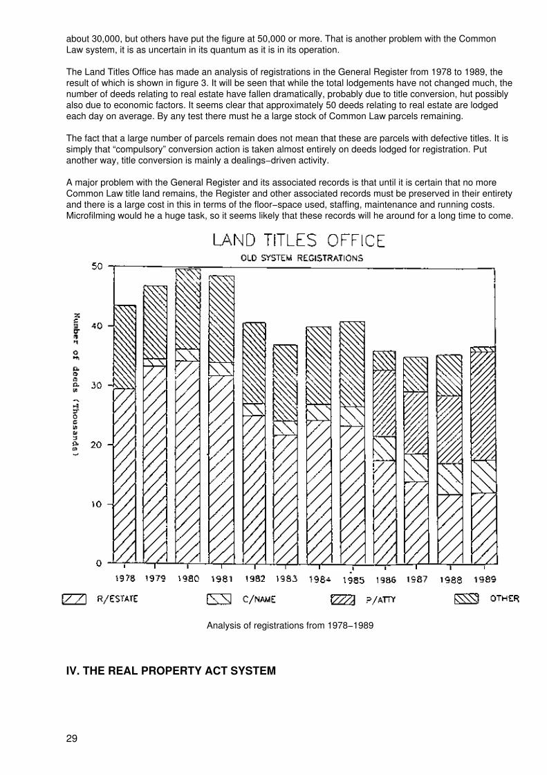
about 30,000, but others have put the figure at 50,000 or more. That is another problem with the CommonLaw system, it is as uncertain in its quantum as it is in its operation.
The Land Titles Office has made an analysis of registrations in the General Register from 1978 to 1989, theresult of which is shown in figure 3. It will be seen that while the total lodgements have not changed much, thenumber of deeds relating to real estate have fallen dramatically, probably due to title conversion, hut possiblyalso due to economic factors. It seems clear that approximately 50 deeds relating to real estate are lodgedeach day on average. By any test there must he a large stock of Common Law parcels remaining.
The fact that a large number of parcels remain does not mean that these are parcels with defective titles. It issimply that “compulsory” conversion action is taken almost entirely on deeds lodged for registration. Putanother way, title conversion is mainly a dealings−driven activity.
A major problem with the General Register and its associated records is that until it is certain that no moreCommon Law title land remains, the Register and other associated records must be preserved in their entiretyand there is a large cost in this in terms of the floor−space used, staffing, maintenance and running costs.Microfilming would he a huge task, so it seems likely that these records will he around for a long time to come.
Analysis of registrations from 1978−1989
IV. THE REAL PROPERTY ACT SYSTEM
29
A. Torrens, the originator
The Real Property Act system described in this study is the New South Wales version of the system ofland−title registration devised by Robert Richard Torrens in South Australia and generally known as theTorrens system. All Australian states operate Torrens systems (some in conjunction with a deeds−registrationsystem) and although each jurisdiction has minor variations according to their particular circumstances, themain fundamental principles are preserved in each. Torrens type systems occur in many countries around theworld also.
Torrens arrived in South Australia in 1840 to become Collector of Customs, a position he held for some 13years, during which time he had direct experience with the system of registering transactions with British shipsunder the Merchant Shipping Acts. He was impressed by the simplicity of the system and the certainty of titleit afforded.
Torrens conceived that the system applying to shipping could be applied to land parcels, hut without directpersonal experience in conveyancing he could not be sure of this, nor could he demonstrate his ideas.Fortunately, and perhaps due to influence, he was appointed Registrar−General of Deeds in 1853 and beganto acquire the knowledge and experience he needed to develop his ideas. He had assistance from a DrHubbe who had experience with land−title registration in some of the German States.
The fundamental principles adopted by Torrens for his legislation may be summarized as follows:
• The act of registration in an official Register alone should affect or encumber property;
• Simple prescribed forms should he used in conveyancing transactions instead of deeds orother instruments in writing;
• Title should he indefeasible upon registration except in the case of fraud to which the persontaking title is a party;
• Persons deprived of an inheritance or other right in land by the operation of the systemshould receive compensation to the extent of the value of the property of which they weredeprived.
The beneficiaries of the new system are all its users and the community at large. It has removed the mystiqueof the Common Law system with its long complex deeds and uncertainty and made the title system muchmore accessible and comprehensible to the people, even to the point where many are able to do their ownconveyancing. Through its benefits it has aided economic growth and development and has been a majorfactor in the legendary “Australian dream” of home−ownership. Its specific benefits are:
• Certainty of title;
• Reduced conveyancing costs (although this is difficulty to quantify);
• More readily available finance for land development, building construction and investment;
• Protection of bona fide purchasers against fraud;
• Facility for protecting equitable interests in land by lodging caveats;
• Better land administration through better land information and better identification of thecadastre;
• In recent times, forms of development meeting modern community needs, such as stratatitles and community titles (see box) which were not practicable with the complexities anduncertainty of the Common Law system.
30
B. The Registrar−General’s powers
The Real Property Act of 1862 conferred certain powers on the Registrar−General:
(a) To require the production of instruments of title relating to land under the provisions of theAct or land sought to he brought under those provisions;
(b) To summon and examine witnesses;
(c) To administer oaths or to take a statutory declaration in lieu thereof;
(d) To correct errors in certificates of title or in the Register Book and to supply entriesomitted;
(e) To enter caveats on behalf of persons under certain disabilities or absent from the colonyor on behalf of the Crown to prohibit the transfer or dealing with land belonging to orsupposed to belong to, such persons; or to prohibit the dealing with land where it appeared tohim that an error had been made by misdescription of such land or otherwise in a certificateof title or other instruments; or for the prevention of any fraud or improper dealing.
These general powers have been restated and widened progressively and now include thepowers:
(f) For the protection of any person interested in land under the provisions of the Act, to entera caveat or otherwise record that interest in the Register;
(g) To note the change of name of a registered proprietor;
(h) To dispense with any advertisement, the supply of any information or the production ofany instrument, and the power to give notice by advertisement or by personal service, of theintended exercise of any power authority duty or function conferred or imposed by the Act;
(i) Where he is satisfied that an estate or interest has been extinguished by merger, to makea recording relating thereto in the Register.
These general powers have frequently been described as “discretionary”. They vary considerably in theirnature and to seek to describe them comprehensively by one adjective may he misleading.
There are now many other powers accorded to the Registrar−General, particularly by recent amendments,which may he seen as discretionary but which operate as enabling provisions to permit the exercise of theoverall policies of the Registrar−General. These powers give the Registrar−General great flexibility in theadministration of the Act. For example he may maintain the Register in any medium, say as a computerrecord or on paper, and since update of the computer section of the Register is currently by overnight batchprocess only he could, in an emergency, reconstitute a computer folio to a manual folio and immediately makethe registration therein manually, reinstating the computer folio in updated form later. It is this sort of flexibilitythat allows the system to respond to user needs and unusual circumstances. Some of these will be apparentin this study.
1. A slow beginning
The statistics from the early years show that the Real Property Act system began very slowly. The Registerwas built from titles issuing on primary applications, of which there were few, and from Crown grants, of whichthere were many. While in the first 10 years a total of only 10,928 dealings and 919 plans were lodged, 42,940folios were created. The preponderance of these were Crown grants issued by the Department of Lands, thisbeing the period of great activity described in section I. A. The Crown grants would have been issued anyway,whether or not the Real Property Act had been introduced, and were in respect of parish portions andallotments which tended to remain unsubdivided. In the NSW system there was no need for adjudication asdiscussed by Professor Dale.
The following were appointed on 1 January 1863 to form the Land Titles Branch, administering the RealProperty Act:
31
2 land titles commissioners2 examiners of titles1 deputy registrar general1 principal draftsman1 assistant draftsman1 clerk to the examiners1 clerk
In addition the Registrar−General was appointed as Chairman of Land Titles Commissioners. It is obvious thatthe emphasis would be on converting old titles to the Real Property Act. For further information on staffing seesection IV.P.
C. The Register
1. What is it?
The Real Property Act, 1862, provided:
“The Registrar General shall keep a book to be called the ‘Register Book’ and shall bind up therein theduplicates of all grants and certificates of title ...”
The concept of the Register has been progressively widened and its form made flexible to meet currentcommunity needs. The current provisions are:
“31B (1) The Registrar General shall cause a Register to be maintained for thepurposes of this Act.(2) The Register shall be comprised of:
(a) folios;(b) dealings registered therein under this or any other Act;(c) the record required to be kept pursuant to section 32(7);(d) instruments of a prescribed class; and(e) records required by the regulations to be kept as part of the Register
(3) The Register may be maintained in or upon any medium or combinationof mediums capable of having information recorded in or upon it or them.(4) The Registrar General may, from time to time, vary the manner or formin which the whole or any part of the Register is maintained.”
Subsection (3) permits progressive computerization of the Register. In the Automated Land Titles System(ALTS) every transaction affecting a folio results in a fresh edition of that folio, not a new folio, and each newedition omits matters no longer effective, e.g., discharged mortgages, and thus reflects only the current stateof the title. However all matters that have affected a folio since the creation of its first edition are recorded in acomputer file called the “historical file” which is available for search. Subsection(2)(c) above relates to that“historical file”.
So, for the purposes of this study, the Register may be generalized as folios and registered dealings.“Dealing” however is defined broadly and includes instruments (other than a grant or caveat) which result in arecording in the Register. This includes, therefore, those subdivision plans which include provisions for vestingof public roads in the local council upon registration or the creation of easements and restrictions on the useof land, since these result in recordings in the Register.
It might be noted that originally recordings were made on the Register; in modern day they are made in theRegister, since the Register is now principally in the form of electronic signals in a magnetic disk rather thanon paper, and recordings can scarcely be made on it.
The Register is a public Register. This does not mean only that it is kept and maintained by a public official,the Registrar General, but also that the information it contains is available to the public without restriction.Official searches may be requested, but these are relatively rare except as regards computer folios. TheRegister is so open that 40 per cent of searches made against the automated part of the Register (which isitself about 75 per cent of the total) are made through remote terminals in clients’ offices. These, however, are
32
not official as they do not carry the certification of the Registrar General.
To generalize, the Register is kept in three basic forms, the time frames of which overlap somewhat:
(a) From 1863 to 1961 folios were manually and individually prepared and each given anartificial unique identifier, viz. a volume and folio reference, and bound in books of 50 folios,five such sections, each of 50, together comprising a volume. Each set of 50 is bound with adistinctively coloured spine (white, blue, maroon, red and green in sequence) to facilitateaccurate filing and location around the Office. These folios were originally hand−engrossed,and more recently typed, using tandem typewriters, on pre−printed forms of several types.Endorsements on these were made by means of large rubber stamps completed withhandwriting and sealed (see figure 5).
(b) From 1961 until the introduction of ALTS most folios were loose−filed under high securityand were prepared by mass production methods using a combination of typed masters,photography and offset printing, controlled manually according to a “programme” devised by asurvey drafting officer. By this means separate titles were mass produced for lots in everynew plan of subdivision of land under the Act, including strata plans. Endorsements on loosefolios are entered in schedule form to save space. There is a First Schedule for RegisteredProprietors and a Second Schedule for Encumbrances (see figure 6). This style of massproduction was at the time extremely important in restructuring the procedures of the LandTitles Office and may be of great interest to users of this study because it permitted massproduction without high−tech electronic data processing. Folios produced by this methodwere, again, given artificial volume and folio identifiers.
(c) Folios in ALTS are held in electronic form as a computer record and are styled “computerfolios” (see figure 7 for a certificate of title representing a computer folio). ALTS was firstapplied to new subdivisions (since this did not require data conversion and was directed tofolios which could be expected to be active) and later extended to new strata plans. It hassince been extended by data conversion of manual folios and about 75 per cent of theRegister is now held in this form; about 95 per cent of the business of the Office is in ALTS.
Computer folios are identified by a natural (rather than artificial) reference. The land identity, e.g., lot 6 in DP234567 becomes folio identifier 6/234567. It is quite as unique as a volume and folio reference and is thedirect link between the mapping system and the title system. If one can locate the land on the reference map,one knows the title reference. A volume and folio reference would only add a further step in the search andwould serve no purpose.
33

34
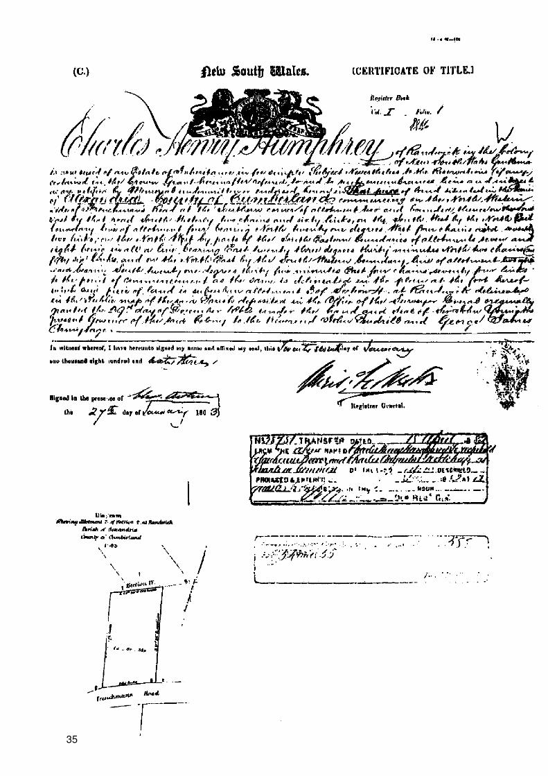
35

Figure 5. Initial form of keeping the register
36

37
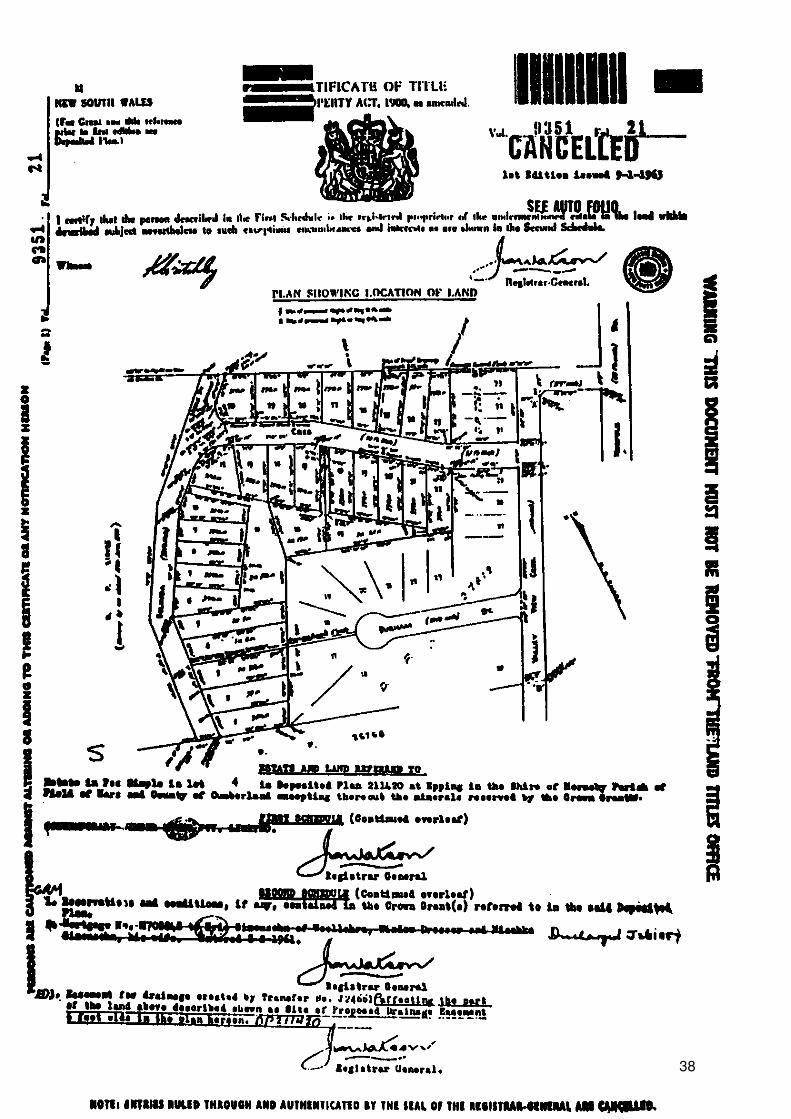
38
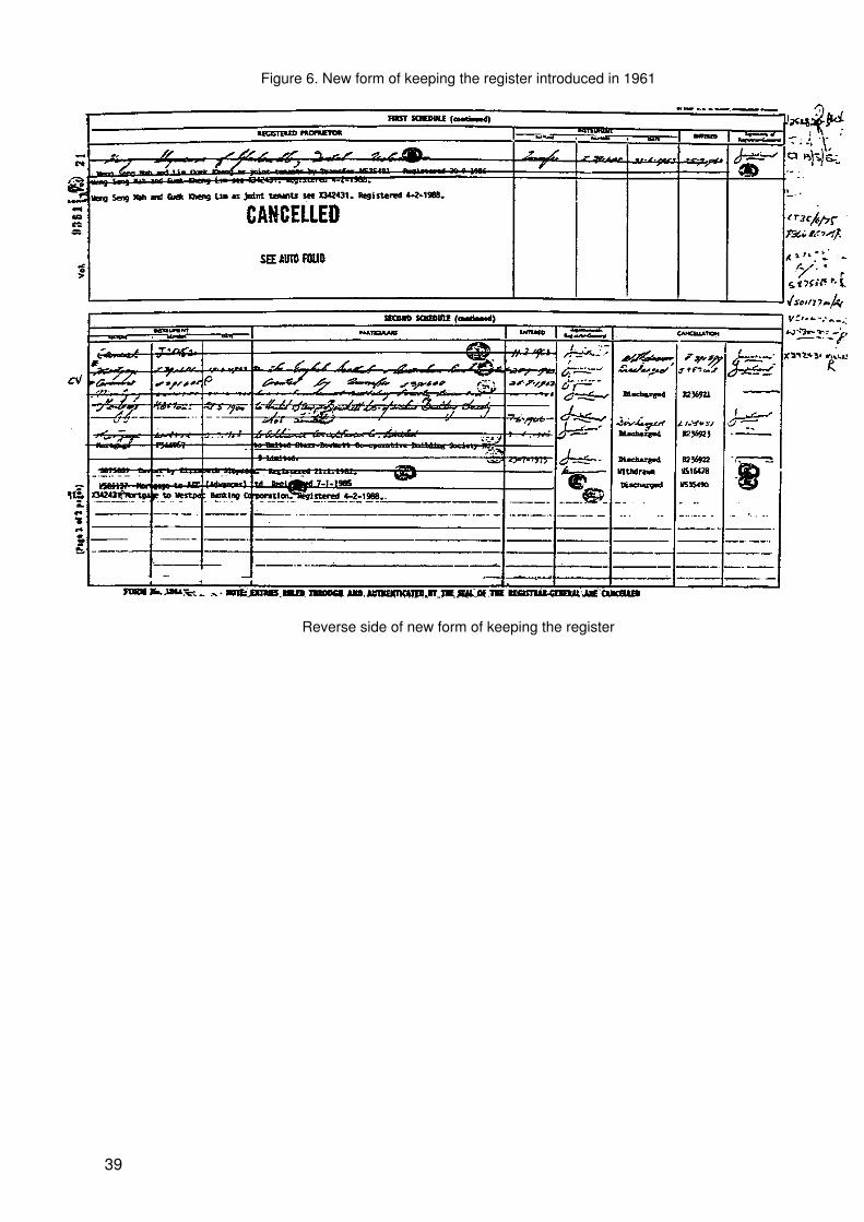
Figure 6. New form of keeping the register introduced in 1961
Reverse side of new form of keeping the register
39
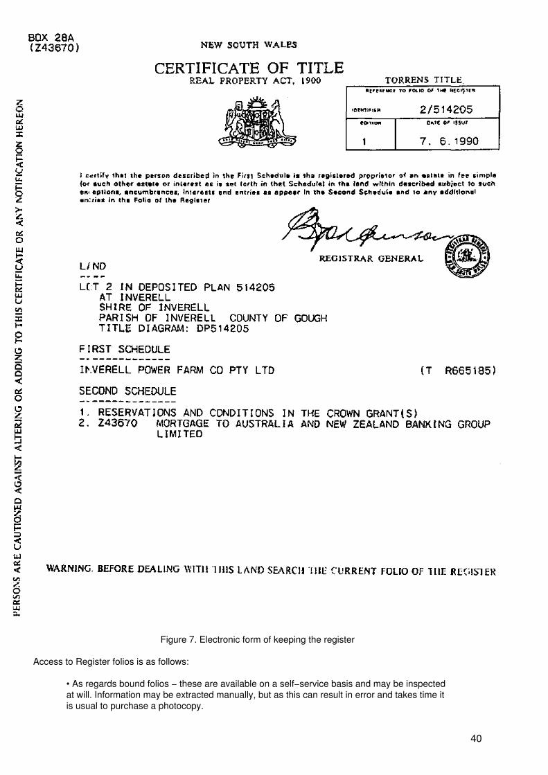
Figure 7. Electronic form of keeping the register
Access to Register folios is as follows:
• As regards bound folios − these are available on a self−service basis and may be inspectedat will. Information may be extracted manually, but as this can result in error and takes time itis usual to purchase a photocopy.
40
• As regards loose folios − these are available only by purchase of a photocopy. The folioleaves the security area only to register an incoming dealing or for office notation and asecurity copy is made before release.
• Computer folios are searched only by way of a computer output called a “computer folioSearch” certified by the Registrar General (see figure 8) or, by arrangement, through remoteterminals. The system provides also for a choice of “final searches” and for “historicalsearches”. A Computer Folio Search contains the same information as a certificate of title butis printed on special stationery (see figure?) for a historical search).
Access to all registered dealings and subdivision plans is by purchase of a copy from microfilm records.
2. What does it do?
The Real Property Act of 1862 was entitled “An Act for the Declaration of Titles to Land and to facilitate itstransfer”. The Register does just that; it declares, by virtue of the registrations made therein, the title of theregistered proprietor named in each folio and provides the simple means of transferring title to another.Section 42 confers upon the registered proprietor a paramount interest against all comers, subject only tospecified exceptions:
“42.(1) Notwithstanding the existence in any other person of any estate or interest which butfor this Act might be held to be paramount or to have priority, the registered proprietor for thetime being of any estate or interest in land recorded in a folio of the Register shall, except incase of fraud, hold the same, subject to such other estates and interests and such entries, ifany, as are recorded in that folio, but absolutely free from all other estates and interests thatare not so recorded except −
(a) the estate or interest recorded in a prior folio of the Register by reason ofwhich another proprietor claims the same land;
(b) in the case of the omission or misdescription of any easement or profit aprendre created in or existing upon any land;
(c) as to any portion of land that may by wrong description of parcels or ofboundaries be included in the folio of me Register or registered dealingevidencing the title of such registered proprietor, not being a purchaser ormortgagee thereof for value or deriving from or through a purchaser ormortgagee thereof, for value; and
(d) a tenancy whereunder the tenant is in possession or entitled to immediatepossession, and an agreement or option for the acquisition by such a tenantof a further term to commence at the expiration of such a tenancy, of which ineither case the registered proprietor before he become registered asproprietor had notice against which he was not protected:
Provided that −
(i) The term for which the tenancy was created does not exceed three years;and
(ii) in the case of such an agreement or option, the additional term for which itprovides would not, when added to the original term, exceed three years.
(iii) ...
42. (2) In subsection (1), a reference to an estate or interest in land recorded in a folio of theRegister includes a reference to an estate or interest recorded in a registered mortgage,charge or lease that may be directly or indirectly identified from a distinctive reference in thatfolio.”
“The cardinal principle of the (New Zealand) statute is that the Register is everything, andthat, except in cases of actual fraud on the part of the person dealing with the registered
41

proprietor, such person upon registration of the title under which he takes from the registeredproprietor has an indefeasible title against the world ...:
The object (of the Act) is to save persons dealing with registered proprietors from the troubleand expense of going behind the register, in order to investigate the history of their author’stitle, and to satisfy themselves as to its validity”.
The Act has to a large extent achieved that object, but it cannot be denied that it is necessary, on occasions,to go behind the Register, for example in relation to easements, statutory charges, estates or interests, andshort term tenancies(3).
42
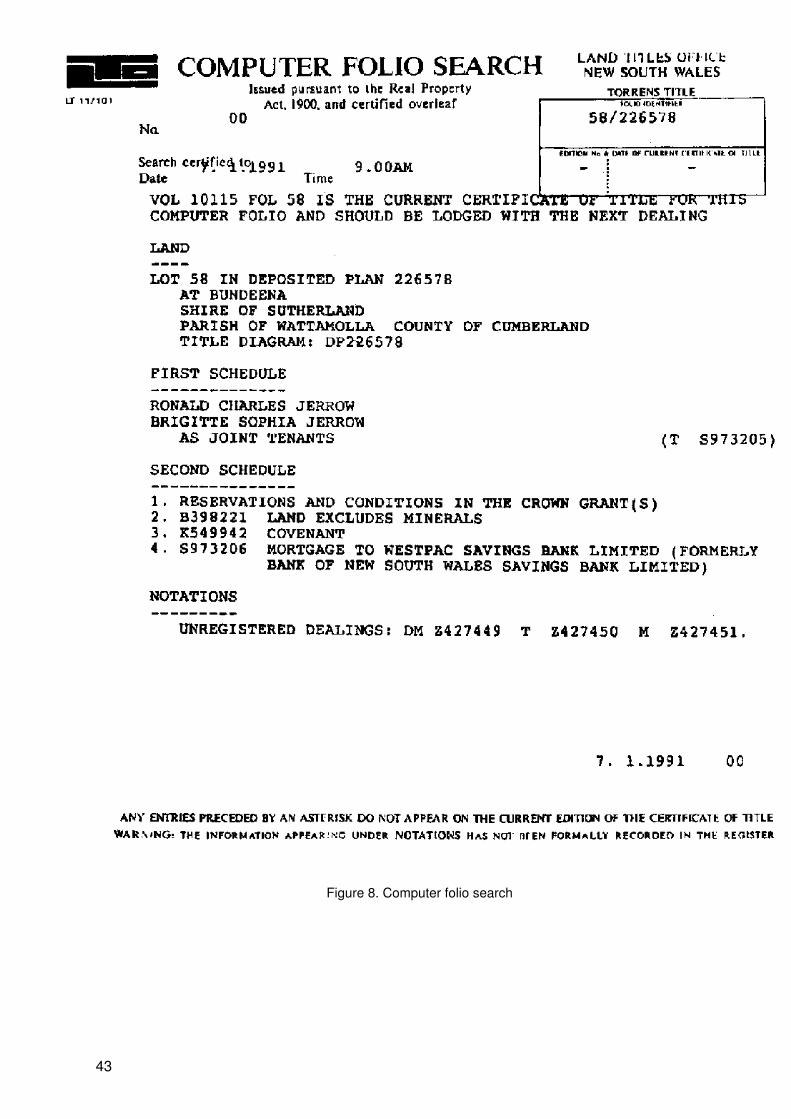
Figure 8. Computer folio search
43
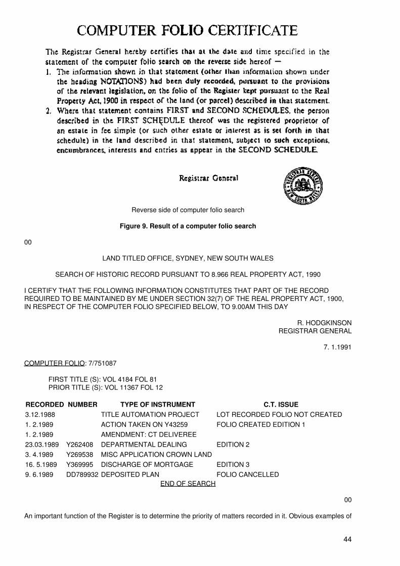
Reverse side of computer folio search
Figure 9. Result of a computer folio search
00
LAND TITLED OFFICE, SYDNEY, NEW SOUTH WALES
SEARCH OF HISTORIC RECORD PURSUANT TO 8.966 REAL PROPERTY ACT, 1990
I CERTIFY THAT THE FOLLOWING INFORMATION CONSTITUTES THAT PART OF THE RECORDREQUIRED TO BE MAINTAINED BY ME UNDER SECTION 32(7) OF THE REAL PROPERTY ACT, 1900,IN RESPECT OF THE COMPUTER FOLIO SPECIFIED BELOW, TO 9.00AM THIS DAY
R. HODGKINSONREGISTRAR GENERAL
7. 1.1991
COMPUTER FOLIO: 7/751087
FIRST TITLE (S): VOL 4184 FOL 81PRIOR TITLE (S): VOL 11367 FOL 12
RECORDED NUMBER TYPE OF INSTRUMENT C.T. ISSUE3.12.1988 TITLE AUTOMATION PROJECT LOT RECORDED FOLIO NOT CREATED1. 2.1989 ACTION TAKEN ON Y43259 FOLIO CREATED EDITION 11. 2.1989 AMENDMENT: CT DELIVEREE23.03.1989 Y262408 DEPARTMENTAL DEALING EDITION 23. 4.1989 Y269538 MISC APPLICATION CROWN LAND16. 5.1989 Y369995 DISCHARGE OF MORTGAGE EDITION 39. 6.1989 DD789932 DEPOSITED PLAN FOLIO CANCELLED
END OF SEARCH
00
An important function of the Register is to determine the priority of matters recorded in it. Obvious examples of
44
the need to establish priority are:
• The existence of first and second mortgages;
• A transfer taken subject to an existing lease;
• A transfer taken subject to a restrictive covenant in a prior transfer or to a right ofcarriageway previously created.
Dealing forms make provision for noting the prior encumbrances to which a dealing is intended to be subject,and the examination of dealings by the Registrar General polices this question, giving rise to requisitions asnecessary. When finally registered, priority of matters is determined by s.33(9):
“Dealings registered with respect to, or affecting the same estate or interest shall,notwithstanding any notice (whether express, implied or constructive), he entitled in prioritythe one over the other according to the order of registration thereof and not according to thedates of the dealings.”
3. Indefeasibility − immediate or deferred?
Registration confers an indefeasible title, subject to specified exceptions. In considering those exceptions onemust take into account the Registrar General’s power to correct errors and supply omissions, and in practicethis power is exercised extensively. For example, if a newly created folio misquotes the number of amortgage, or quotes a wrong mortgage, or omits a restrictive covenant, the Registrar General may of his owninitiative or otherwise, correct the Register. But if in the meantime, acting on the faith of the Register (in itserroneous state), a person acquires the land for value from the registered proprietor, that person could sufferloss from a subsequent correction of the Register and a claim would lie against the State. So the time errorsare safely corrected is before there is a subsequent dealing for value.
There has been a long running debate as to whether indefeasibility is “deferred” or “immediate”. The positionis now summarized in Woodman and Nettle (3) at 328 thus:
“The title of the registered proprietor is conclusive against all comers unless:
1. There is a specific basis under the statute rendering him open tochallenge; for example, there may be actual fraud on his part or on the part ofhis agent;
2. He is subject to a personal obligation by which he may be bound in personto deal with his registered title in some particular manner; or
3. The Registrar General is able to exercise the extensive powers ofcorrection given him by the statute.”
4. Adverse possession
Title to land held under Common Law title may be lost by possession adverse to the documentary owner.However title to land under the Real Property Act cannot be so lost except as regards whole parcels orparcels which are whole parcels except that an “occupational boundary” is within the parcel and represents orreplaces an original boundary of a whole parcel. This provision does not represent an erosion of the generalprinciple of indefeasible title, or a shift to general boundaries. It simply meets those unusual cases where, fora variety of reasons, a person in undisturbed possession of a whole parcel is unable to obtain a transfer.
D. The survey base
The Real Property Act of 1862 laid down a requirement for a plan of survey of any subdivision, any landincluded in a transfer not already defined in such a plan or any land sought to be brought under the provisionsof the Act. Thus from the beginning surveys have been the basis for certification of title. The presentprovisions are shown in box 1. It is plain that the system is parcel−based. In the NSW system certainty of titleis inseparably linked with certainty of boundaries. Similarly indefeasibility of title is linked with certainty of
45
boundaries.
The person named in a certificate of title holds a paramount estate or interest in the land described therein,except in the case of fraud, subject to certain exceptions, including:
• “the estate or interest recorded in a prior folio of the Register by reason of which anotherproprietor claims the same land”;
• “as to any portion of land that may by wrong description of parcels or of boundaries beincluded in the folio of the Register or registered dealing evidencing the title of suchregistered proprietor, not being a purchaser or mortgagee thereof for value ...”.
Courts are required to accept register folios as prima facie evidence that the person named therein is theregistered proprietor, and registered proprietors are protected from ejectment.
It is clear then that the Registrar General has a duty of care to preserve the integrity of the Register byensuring that the same land is not included in more than one folio of the Register by inadvertent issue of twocertificates of title for the time land or by including land in a second certificate of title by misdescribing itsboundaries by reference to any incorrect plan.
It has been said that no Torrens system expressly guarantees the boundaries of land, although it guaranteesthe title, and that may well be a fair statement.
In NSW there are now statutory provisions which have such a strong bearing on this question and on thematter of relating the title to the ground that it is difficult to believe that the position of boundaries, if not theiractual measurements, are not, at least, officially supervised if not guaranteed.
This led to the passing of the following unanimous resolution at the Biennial Conference of Registrars of Titleheld in Sydney in 1978:
1. An ideal Torrens system guarantees not only the proprietor’s interest in land but the titleboundaries of the land to which that interest relates.
2. As it is the duty of the Registrar “to prevent instruments from being registered, which in law,as well as in fact, ought not to be placed on the register”, a plan, which is used to define aparcel on the Register, having a similar effect to an instrument, must be subjected to thesame standard of scrutiny by the Registrar as any instrument.
3. Any plan used to define a parcel on the Torrens Register necessarily forms an integral partof the Torrens Registry records.
Thus, if the boundaries of parcels are not actually “guaranteed” by the Registrar General, they are in factclosely scrutinized to ensure their correctness. This comment refers in particular to the redefinition of existingboundaries, such as the external boundaries of new subdivisions and boundaries of parcels in plans foramendment of titles. The situation as regards internal boundaries in new subdivisions, i.e., new boundaries, israther different and the private surveyor who prepares the plan is particularly responsible. Correct definition ofboundaries is now regarded so highly as a means of ensuring accurate and reliable certification of title, that itis specifically included as an objective in the corporate plan.
But is this high standard of survey really necessary?
It is certainly the basis of the Real Property Act system and of a very secure conveyancing system and willremain so. If a coordinated cadastre is introduced a similar level of accuracy is to be expected. A veryaccurate graphic database is seen as the basis of the State Land Information System and as the key to bettermaps, and a coordinated cadastre may be the key to cheaper surveys in the long run.
Yet just as many have claimed that the survey system has merely supported the conveyancing system andnot the wider objectives of land information, accurate surveys tend to be seen by cartographers as servingtheir dreams of very accurate maps. There is a danger of making accurate maps the ultimate goal for theirown sake. A good case can be made for less accurate surveys and maps, relying more on plotting accuracyrather than mathematical precision, at least in the short to medium term, provided that:
46
• All adjoining parcels have agreed monumented common boundaries, without overlaps andhiatuses, which can be determined on the ground if need he, and with some reliance onabuttals;
• All parcels in the cadastre are identified and included in the mapping system.
It ought to be possible to guarantee title to a lot known to the cadastre and plotted therein if its limits in termsof abuttals, but not its actual dimensions, are on record, and its dimensions are capable of being determinedfrom monuments if need be.
E. The Assurance Fund
A fundamental aim of the Real Property Act is to save persons dealing with land from the trouble and expenseof “going behind the Register” to investigate the history of the proprietor’s title and its validity. This is achievedby:
• Providing the Register as a “mirror” of the relevant facts;
• Providing a guarantee of title (with limitations);
• Ensuring that a person who, in good faith, and for value, takes from a registered proprietorand registers his/her dealing, acquires an indefeasible title, notwithstanding any defect in thatproprietor’s title.
A person who is wrongly deprived of land by the operation of the system, or a person who suffers loss byrelying on the Register, is entitled to have that deprivation or loss made good, so far as money can do it. Tomeet such claims the 1862 Act provided for an Assurance Fund, and in general the current legislation has notonly continued those provisions, but they have been widened considerably.
1. Status
In principle, the Fund is a fund of last resort, and in fact Court action is usually necessary. There are verygood reasons for this and it would be wrong to conclude that the Fund is unduly protected. Many of the claimsmade have been grossly excessive and have been reduced significantly by the Courts or by settlementbetween the parties, and where fraud has been involved, it has been necessary to have fraud proved.However, in some cases ex gratia payments have been made without court action. The Courts have held thatcontributory negligence on the part of a claimant against the Fund is not a defence for the Registrar General.
2. Basis of Claims
Far and way the main basis of claim is fraud, with 18 cases since 1978. Predominantly the fraud has been onthe part of solicitors purporting to act for registered proprietors and many such have been struck off. TheNorthside case involved the alleged unauthorized use of the company seal. Arising from this case, it is likelythat amendment of the relevant statute relating to the custody and use of company seals will follow.
The next most common basis of claim is departmental error, mostly relating to the omission of easements andrestrictions on use of land: 11 cases of error have been the subject of claim since 1978.
There has been one claim based on a surveyor’s error in that time.
Fraud on the part of the vendor or his agent is the main concern and is extremely difficult for the RegistrarGeneral to detect. Fraud on the part of a purchaser is similarly difficult to detect but if proved the Fund is notliable unless there has been a further dealing for value without fraud. Departmental error is attributable tosystems failure or human failure and is a management issue. The low incidence of survey problems speaksvolumes for the checks performed by the Registrar General and the professionalism of surveyors.
It must be noted, however, that many errors, both surveying and departmental, are reported or detected andput right before a transfer for value is registered, pursuant to the Registrar General’s powers to correct theRegister.
47
F. The certificate of title
A certificate of title might best be regarded as the proprietor’s copy of the related folio of the Register. Therehas been from the outset some confusion between certificates of title and folios of the “Register Book”. The1862 Act specified that Crown grants should be in duplicate. It also provided that land under Common Lawwas brought under the Real Property Act by issuing to the applicant a certificate of title. It further provided thatcertificates of title should be in duplicate and that duplicates of grants and certificates of title should be boundup to form the “Register Book”. This could suggest, erroneously, that the proprietor’s copy, being the original,might take precedence. Other provisions have referred to “duplicate originals”, adding to the confusion interms. However the original section 40 (now section 42) makes it clear that, whatever it may be called, it is thecopy forming a folio of the Register that provides the source of indefeasibility of title. As previously cited, “theRegister is everything”.
The confusing drafting has been resolved by the Real Property (Computer Register) Amendment Act, 1979which introduced the term “folio of the Register” and this is the term now referred to in s.42 which is thesource of indefeasibility. Land is no longer brought under the Real Property Act by issuing a certificate of titlebut by creating a folio of the Register.
1. Functions of the certificate of title
If, “the Register is everything” one might well ask, “what is the purpose of the certificate of title?”
In the course of planning the Automated Land Titles System, the Land Titles Office seriously consideredwhether there was in fact a need for a certificate of title. Most people do not know what it is like to handle theircertificate of title; it is more likely to be filed in the mortgagee’s security vaults or held by their solicitor. Thereinlies the answer. The Real Property Act provides that a dealing will not be registered unless the certificate oftitle is produced for that purpose in the Land Titles Office. Thus the person who holds the certificate of titleusually controls the activities in the Register. So it can be observed that the certificate of title constitutes a“right to deal” with the land described therein. The Land Titles Office concluded that the certificate of titleserved such a purpose in the conveyancing process that the community at large and the conveyancingcommunity in particular could not function without the certificate of title or some equivalent.
However, the foregoing is a generalization, perhaps excessively so. There is no question that the certificate oftitle is evidence of ownership of the land described therein or of an interest in that land, but it is not conclusiveevidence, for there are some matters which are recorded only in the Register, such as caveats, writs andresumptions (a registered proprietor will not normally hand over a certificate of title willingly to an authority thattakes the land compulsorily). Further, the Registrar General may have amended the Register to correct anerror. So the guiding principle is that anyone dealing with the registered proprietor must not at his peril,neglect to search the Register and must not rely on the certificate of title.
It is known that some financial institutions do not register many of their mortgages, hoping thereby to saveregistration fees. They reason that provided they hold the certificate of title they have adequate security. Butthere are risks − their title security is no better than their document security. Moreover it would be possible fora registered proprietor to apply fraudulently to the Registrar General for a new certificate of title falselydeclaring that the certificate of title was destroyed by fire or lost in a flood. Other scenarios could be devisedwhich could put unregistered mortgagees at risk.
A solicitor who has acted for a cash purchaser often holds the certificate of title, usually for safekeeping, but itcould also be that legal fees are outstanding and the solicitor may have an equitable lien on the titledocument.
There are provisions authorizing local councils to sell at auction properties for which the rates have beenoverdue for five years or more, and although there are safeguards and publicity attending such sales, theresulting transfers are registered without production of the certificate of title. At least one case is known wherein this context fraudulent activity occurred, involving the application for a new certificate of title to enable afraudulent transfer to be registered.
All of the foregoing indicates that a certificate of title is a very important document which should be kept undersecurity.
48
2. Loss or destruction of certificates of title
As indicated in section IV.H.2, there are provisions in the Act for replacement of certificates of title which arelost or destroyed. Solicitors’ offices can get burnt down and people can inadvertently throw a certificate of titleaway with their waste paper. And sometimes after a replacement title has been issued the “lost” one turns up.
Although there are safeguards attending the issue of a replacement title, such as statutory declarations, publicadvertisement and waiting periods, there will always be a risk involved for the Land Titles Office. The greatestrisk is fraud, but fortunately, although this study has mentioned fraud several times, the overwhelming majorityof Australians, like other people, are fundamentally honest. Like most institutions in society, the Real PropertyAct system relies very largely on trust.
Where a replacement certificate of title has been issued a recording to that effect is made in the Register andin that certificate of title, so that should the “lost” certificate of title be lodged with a dealing, or should anyonesighting it search the Register, the existence of a replacement certificate becomes apparent. The “lost”certificate should then he discounted. In the case of ALTS any replacement certificate hears the next lateredition number and the computer will accept only that later edition number. In the ALTS system an editionearlier than the latest is “invalid”. Because of the provisions described above, it is highly improbable that asettlement will occur on the basis of the “lost” certificate and if that did occur the chances of the RegistrarGeneral registering a dealing are negligible.
G. Land descriptions/categories
The many types of land descriptions found in the Register are mentioned in section II.D. This sectionconsiders land descriptions in a different way, under specific categories, with the objects of identifying theideal model for an automated title system and a land information system and of highlighting problems nowexisting.
1. Crown grants
Most Crown grants (these ceased in 1981) were for single numbered parish portions or town/villageallotments. Section 12 of the 1862 Act provided that when land was alienated in fee (fee simple) it was to besubject to the provisions of the Real Property Act, and that Crown grants “in addition to proper words ofdescription shall contain a diagram of the land thereby granted ...”. It is difficult to see why a metes andbounds description was necessary and this appears to be a carry−over from past practices. If the portion andallotment numbers were stable (and they were) and there is a diagram, there seems no need for a descriptionin words and indeed such descriptions only created extra work and were a possible source of error. Thediagrams were the forerunners of what are now generally referred to as “title diagrams” and served somepurpose, by providing a locality sketch, measurements and area, abuttals and an illustration of any reservedroad within the boundaries of the parcel. Every Crown grant for a single parish portion or town/villageallotment has a unique description and because parish maps, town maps and village maps have beennumbered as deposited plans now fits readily into ALTS.
2. Single parcels
This item refers to whole single parcels in plans of subdivision of freehold land. In this category are single lotsin deposited plans and (before 1961) single numbered lots in miscellaneous plans of subdivision and plansannexed to or endorsed on dealings. These descriptions are in every case unique and fit readily into ALTS, allplans now being numbered as deposited plans.
3. Multiple descriptions
Not all certificates of title are for a single parcel, or for a single part of parcel; there are many cases of multipledescriptions in the bound section of the Register, and these take many forms. This category constitutes themost difficult group of titles to convert to the Automated Land Titles System (ALTS).
Some examples of multiple descriptions are:
• Groups of lots in one plan, or groups of portions or allotments;
49
• Groups of lots in different plans;
• Combinations of lots, portions and parts of lots and portions;
• Lots in plans and “land adjoining” (for which no distinctive plan exists);
• First, secondly (and so on) descriptions such as first land and secondly minerals under otherland; or first a group of lots in a deposited plan and secondly a series of portions described ina “schedule of grants” format.
4. Consolidations
This section considers two types of consolidation, which here means the combining of two or more titles intoone. The first type is that sort of consolidation whereby upon the request of the registered proprietor two ormore current parcels are included in the one certificate of title but retain their existing identities. For examplethe owner of two adjoining lots which are each capable of separate disposition are in common ownership butone may be the site of a house and the other used as a garden. The owner seeks consolidation hoping toavoid separate rating of each lot. The Registrar General has acceded to such requests in the past, but inrecent years has required an assurance that the consolidated title will not be broken up. In thesecircumstances, these consolidations can more strictly be classified as multiple descriptions.
The second class of consolidations arises from an application to a local council for building approval. Where aproposed building is to be erected across the common boundary of two lots, or where if it were erected whollyon a lot which is below the minimum area and the registered proprietor also owns an adjoining lot, the councilmay require lodgement of a consolidation plan which combines both lots to form a single new lot whichsatisfies minimum area. Such consolidations (pursuant to s.314B of the Local Government Act) are readilyentered into ALTS and cannot be broken up later except by a fresh plan of subdivision approved by thecouncil.
5. Descriptions in ALTS
The Automated Land Titles System (ALTS) accepts only a very limited range of descriptions, correspondingwith the Graphic Data Base parcels which are key elements in the State Land Information System. The onlyordinarily acceptable descriptions are lots in deposited plans (sections in deposited plans are provided for),lots in strata plans and the common property in strata plans. Those land descriptions become folio identifiersthus, for example:
• Lot 1, DP 700002 − 1/700002• Lot 1, Section 6, DP 12695 − 1/6/12695• Lot 1, Strata Plan 20396 − 1/SP20396• Common Property in SP 20396 − CP/SP20396
All other descriptions must be made to fit these criteria before they can be entered to ALTS and this is thereason for the procedures described in section II.D.2. It will be seen then that multiple descriptions have so farnot been able to be entered in ALTS. However, there is some scope for flexibility, and there is a currentproposal for entering multiple description titles in ALTS by attributing to them the artificial identifier “AutoConsol” followed by the previous manual volume and folio reference. While this will enable conversion toALTS, it is less than ideal because the direct connection between the plan system and the title systemafforded by a lot/plan folio identifier is not present. Moreover, if one of the separate parcels therein is severedby transfer, the significance of the volume/folio reference is lost. However, the proposal is to retain the artificialidentifier unchanged in a replacement edition after severance of part so long as the replacement editionincludes two or more of the parcels in the original consolidation. The artificial folio identifier is merely asystems device to achieve an end. It is argued that the lack of a direct link from the plan system to the titlesystem does not matter because the computer is programmed to respond to an inquiry against an individualparcel in the title by producing a search of the “Auto Consol” of which it is part. If a parcel has been severed,the computer will automatically refer to its new natural identifier. This is fine, but it this does not seem to help auser who does not have access to an ALTS terminal.
The above proposal does not apply to a multiple description title which includes a part of a lot or other land forwhich no plan exists. The project will be a large mass programme involving inspection of every manual folioone by one to determine:
50
• Whether it has been cancelled, and, if it has not,• Whether it is truly still “live”, and if it is,• Whether it is suitable for conversion.
In the meantime these titles are satisfactory in the manual system.
The alternative of breaking up multiple−description titles and issuing separate titles (described by ProfessorDale as “only a partial solution”) is administratively impracticable and politically unacceptable. Anotheralternative of requiring consolidation into a single lot by registering a new plan is equally unthinkable since itwould take away existing rights to dispose of individual legal parcels and would be prohibitively expensive toland−owners.
From the point of view of ALTS it would have been better if consolidations (other than by a plan) andmultiple−description titles had not been permitted in the first place. But should the preferences of a systemoverride the rights of an individual citizen to acquire several parcels and include them in one title forconvenience, even though the system has obvious public benefits? Probably the proposal outlined above isthe only reasonable compromise.
6. Summary
It will be seen that the ideal situation for ALTS is that each house, each farm, each school, each high risebuilding etc should be a single lot in a deposited plan and the subject of one certificate of title. This ideal hasalready largely been achieved, since all lots created by new subdivisions since October 1983 have individuallyentered ALTS and virtually all earlier titles for single lots have been converted to ALTS.
This concept is compatible with the reference map system, the Graphic Data Base and the proposed StateLand Information System.
A big advantage of the above concept is that, in the future, the vast majority of dealings lodged for registrationwill be for the whole of the land in the related certificate of title. This could soon mean that about 98 per centof dealings lodged (that is, dealings with the whole) can be checked from a computer terminal at thelodgement counter, registered overnight by the computer and a new edition of the title placed in the deliverybox the next day.
A transfer of part of the land in a certificate of title invariably must be taken off line for a check of thedescription (a subdivision or partial break−up of the title is usually involved) and creation of new folios for theland transferred and for the residue.
H. Title Diagrams
Title diagrams in some form have been from 1863 an important feature of every certificate of title, with a fewexceptions. This section identifies the changes in such diagrams from 1863 to the present in the light ofadministrative and technological change, and explains the purpose of the diagrams.
1. Purpose of title diagrams
A title diagram provides a graphic representation of the land described in a certificate of title and of mattersreferred to in that certificate affecting part of the land or appurtenant thereto, including the following:
(a) It identifies, locates and confirms the description of, the land;
(b) It identifies and locates any land or road excluded by general words of description in thecertificate of title;
(c) It shows the measurements and area of the land as set out in the relevant plan and theabutting lands which limit its extent;
(d) It shows any road to which the land has a right of frontage and sufficient information tolocate the land in relation to contiguous or adjacent parcels;
51
(e) It identifies and locates by essential measurements any easement or restriction on the useof land affecting part of the parcel, as referred to in the certificate of title;
(f) It identifies and locates any easement benefiting the parcel as referred to in the certificateof title.
2. Title diagrams in ALTS
In the current state of technology, the ALTS system is not able to produce a (graphic) diagram on a certificateof title as a computer output, although it is conceivable that the computer could access the microfilm file ofdeposited plans and generate a copy of the plan automatically, to be matched up with the output of certificatesof title. Consequently every ALTS certificate of title refers to the related deposited plan (or a particular sheet ofa multi−sheet plan) as the title diagram and where necessary any notifications refer to sites designated in thetitle diagram (see figure 10 for designation of sites). Since all plans are now readily available on microfilm, thisprocedure has met with public acceptance.
3. Creation of folios of the Register
Under the 1862 Act, the Registrar General created folios of the Register by enrolling Crown grants and issuingcertificates of title, copies being bound in the Register Book, and by allocating to them distinctive numbers, vizvolume and folio references. Certificates of title were issued when:
(a) Common Law title land was brought under the Real Property Act;
(b) Part of the land in any existing certificate of title or Crown grant was transferred followingsubdivision;
(c) A fresh title was required to replace a partially cancelled one; or
(d) The whole of the land in a title was transferred.
As a result of the 1873 amendment, replacement certificates of title with a new volume and folio referencewere issued for any that became incapable of further endorsement.
The above procedures were generally followed until fundamental changes were introduced to facilitatecomputerization of the Register. The Real Property Act now gives the Registrar General powers to createfolios of the Register, and in ALTS the land identifier (e.g., lot/deposited plan) becomes the folio identifier inlieu of a volume and folio reference. Although the Registrar General usually issues a certificate of title for eachfolio of the Register created, he is not obliged to do so unless requested by the person entitled to beregistered as proprietor or by a registered mortgagee. However it is administratively convenient to create afolio in some circumstances without issuing a certificate of title.
52
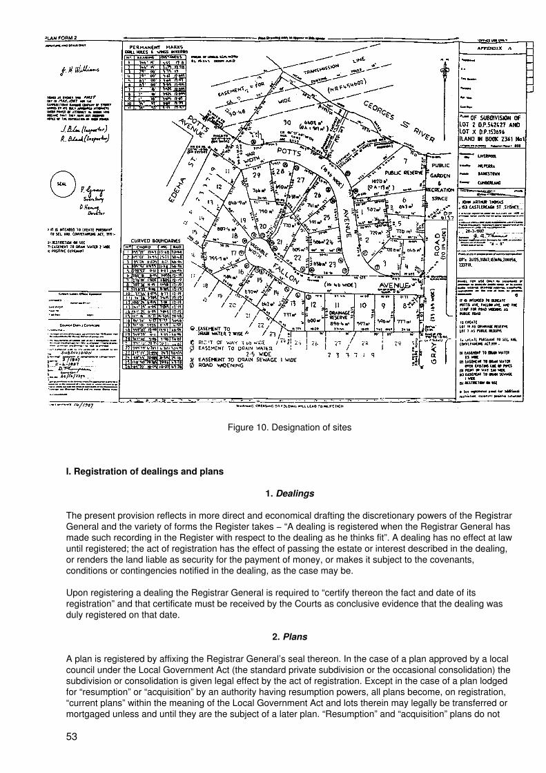
Figure 10. Designation of sites
I. Registration of dealings and plans
1. Dealings
The present provision reflects in more direct and economical drafting the discretionary powers of the RegistrarGeneral and the variety of forms the Register takes − “A dealing is registered when the Registrar General hasmade such recording in the Register with respect to the dealing as he thinks fit”. A dealing has no effect at lawuntil registered; the act of registration has the effect of passing the estate or interest described in the dealing,or renders the land liable as security for the payment of money, or makes it subject to the covenants,conditions or contingencies notified in the dealing, as the case may be.
Upon registering a dealing the Registrar General is required to “certify thereon the fact and date of itsregistration” and that certificate must be received by the Courts as conclusive evidence that the dealing wasduly registered on that date.
2. Plans
A plan is registered by affixing the Registrar General’s seal thereon. In the case of a plan approved by a localcouncil under the Local Government Act (the standard private subdivision or the occasional consolidation) thesubdivision or consolidation is given legal effect by the act of registration. Except in the case of a plan lodgedfor “resumption” or “acquisition” by an authority having resumption powers, all plans become, on registration,“current plans” within the meaning of the Local Government Act and lots therein may legally be transferred ormortgaged unless and until they are the subject of a later plan. “Resumption” and “acquisition” plans do not
53
require approval by the council, and do not become “current plans” until gazettal of the resumption; theirpurpose until then is only to provide a land description for gazettal and to give notice of an intended futureresumption.
Any plan (other than a “resumption” or “acquisition” plan) may be accompanied by an instrument pursuant tos.88B of the Conveyancing Act for the purpose of creating easements or restrictions on the use of land. Plansapproved by a local council may provide for the dedication of public roads or the creation of public reservesand drainage reserves. In all these cases the easements, restrictions, roads or reserves are created uponregistration of the plan without further assurance (see section IV.N.3). In consequence, appropriate recordingsare made in the Register.
J. The lodgement system
1. The production press
The importance of the certificate of title in the conveyancing process has already been discussed. There areoccasions when the person holding the certificate of title is unable to hand it over at settlement of atransaction, for example where the transaction is for part only of the land in the certificate of title, or the titledocument is held by a mortgagee and the transaction is a second mortgage. To meet cases like these theRegistrar General, acting as an independent party, maintains a production press where, for a fee, the personhaving custody of the document may lodge it in anticipation of a transaction. A production slip is attached tothe certificate of title, and this specifies the matter for which it was produced. When the matter is presented forregistration the certificate of title is extracted from the production press and connected to the lodged matter.Documents are culled from the production press and redelivered if within two months the matter for which theywere produced has not been lodged.
2. Check of dealings at lodgement counter
Clerks at the lodgement counter carry out such preliminary checks of each dealing as are practicable withoutinspecting the Register, before accepting the dealing for lodgement. The certificate of title must be producedwith the dealing, or filed in the production press or shown to be partially cancelled or with another matteralready in the Land Titles Office. Where the certificate of title is available at the lodgement counter the nameof the registered proprietor is checked against the name of the transferor (or mortgagor etc., as the case maybe) in the dealing and if they are not the same (or any change of name is not accounted for by properevidence) the dealing will not be accepted. The dealing is checked for compliance with regulations (correctapproved form, density of ink used in signatures), correct execution and acceptance, payment of stamp duty,notation as to prior encumbrances affecting the land and obvious defects, and may be refused lodgement ifnot in order. If apparently in order lodgement fees are assessed and the dealing accepted. Where a set ofdealings is presented the correct sequence of registration is established. On acceptance the dealings are sentin batches for numbering. Until the commencement of the Filmex system (see section IV.N.1) the lodgementnumbers were impressed by numbering machine, but under Filmex the numbers are attached in the form ofadhesive labels in dual form, that is, in numeric form and in barcode form (see figure 11) and added to thedealing Lodgement form previously completed by the lodging party. This form is then used for payment of feesand becomes a receipt for the documents, and the dealings are forwarded to data entry.
3. Data entry
A computer job called RG Book 70 has operated since 1971 and has served the Office very well.
Under RG Book 70 data are collected to produce several computer outputs:
(a) The dealings lodgement record − a listing of every dealing lodged in the previous 20business days affecting manual folios of the Register. Entries are listed in numerical orderwithin each folio reference from 1 to 250 (there being 250 “folios” to each “volume”). Thisrecord is produced in consolidated form every day and is a most important record forsearching purposes: from this record any dealing affecting any manual folio lodged in the last20 business days can be identified within seconds (see figure 12);
(b) Allocation sheets − from the dealing types identified by the computer, dealings are sortedinto categories for processing by clerks at different levels according to their difficulty, and title
54
references are listed as an aid to assembling the required folios of the Register in anticipationof the full check of dealings. Dealings are allocated to individual clerks on these lists;
(c) Reconciliation sheets − to enable the Finance Branch to reconcile money received withdealings lodged;
(d) Purchasers index − a listing of purchasers and title references, to enable the progressiveproduction of the purchasers index (Real Property Act only);
(e) Statistics of lodgements;
(f) Delivery sheets − for marking off the delivery of certificates of title and other documentsafter registration.
4. Caveats
Although caveats are not dealings (and are “entered” rather than registered) they are numbered in the samemanner as dealings and are listed in the dealings lodgement record. However, to enable final searchesimmediately before settlement, caveats received during each day’s business are recorded promptly andprogressively in a manual card system. This manual system will become unnecessary under BOS.
5. Plans
Plans are received at the lodgement facility in a manner similar to dealings and are subjected to preliminarychecks by a survey drafting officer. The certificate(s) of title must be accounted for (as in dealings). The“purpose” of each plan (subdivision, resumption, easement, lease etc) is established and evidence of council’sapproval identified where required. Where possible, checks of signatures of necessary parties are made, andany accompanying section 88B instruments and statements on the plan are inspected generally. Fees areassessed and plans are numbered as deposited plans then forwarded for processing.
K. The processing system
1. Noting the Register
As soon as practicable after lodgement, each dealing or plan is noted on the affected folio of the Register forpublic information. In the case of the manual part of the Register this is done manually when the dealing ischecked or as the first step in processing the plan. In the case of computer folios notation is entered directlyfrom an on−line terminal shortly after the dealing or plan is lodged. In the meantime, all dealings affectingmanual folios can be found in the dealings lodgement record.
2. Dealings processing
All dealings are checked against the Register, taking into account any other matter noted in the Register. Thechecks consider whether the transferor (or mortgagor etc) is the registered proprietor, whether the certificateof title is available and its use for the particular dealing has been authorized, whether the dealing has beencorrectly executed and accepted, and is nut in breach of any law, whether the land has been correctlydescribed and matters of a like nature. The check of execution and acceptance includes the correct affixing ofcompany seals and proper attestation. Where a dealing creates restrictions on the use of land the terms arechecked to ensure that they are capable of binding the land in the hands of successors in title. In the case of alease a check is made to ensure that there is a definite beginning time and finishing time determining the termof the lease. In all cases, a check is made to ensure that the dealing has been marked by the Stamp DutiesOffice to the effect that duty has been paid or the matter is exempt of duty.
55
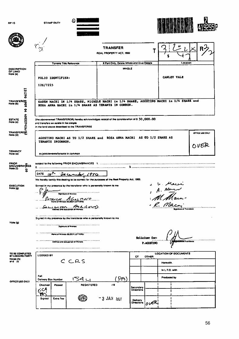
56
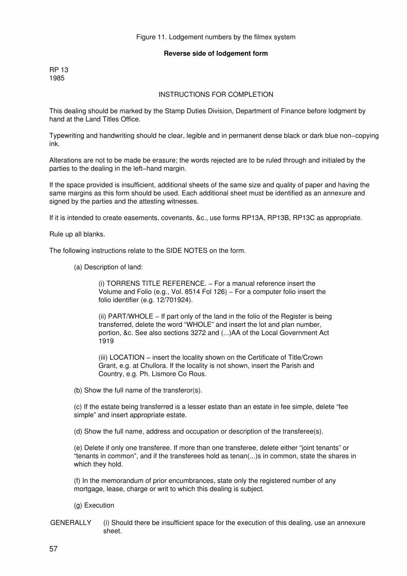
Figure 11. Lodgement numbers by the filmex system
Reverse side of lodgement form
RP 131985
INSTRUCTIONS FOR COMPLETION
This dealing should be marked by the Stamp Duties Division, Department of Finance before lodgment byhand at the Land Titles Office.
Typewriting and handwriting should he clear, legible and in permanent dense black or dark blue non−copyingink.
Alterations are not to be made be erasure; the words rejected are to be ruled through and initialed by theparties to the dealing in the left−hand margin.
If the space provided is insufficient, additional sheets of the same size and quality of paper and having thesame margins as this form should be used. Each additional sheet must be identified as an annexure andsigned by the parties and the attesting witnesses.
If it is intended to create easements, covenants, &c., use forms RP13A, RP13B, RP13C as appropriate.
Rule up all blanks.
The following instructions relate to the SIDE NOTES on the form.
(a) Description of land:
(i) TORRENS TITLE REFERENCE. − For a manual reference insert theVolume and Folio (e.g., Vol. 8514 Fol 126) − For a computer folio insert thefolio identifier (e.g. 12/701924).
(ii) PART/WHOLE − If part only of the land in the folio of the Register is beingtransferred, delete the word “WHOLE” and insert the lot and plan number,portion, &c. See also sections 3272 and (...)AA of the Local Government Act1919
(iii) LOCATION − insert the locality shown on the Certificate of Title/CrownGrant, e.g. at Chullora. If the locality is not shown, insert the Parish andCountry, e.g. Ph. Lismore Co Rous.
(b) Show the full name of the transferor(s).
(c) If the estate being transferred is a lesser estate than an estate in fee simple, delete “feesimple” and insert appropriate estate.
(d) Show the full name, address and occupation or description of the transferee(s).
(e) Delete if only one transferee. If more than one transferee, delete either “joint tenants” or“tenants in common”, and if the transferees hold as tenan(...)s in common, state the shares inwhich they hold.
(f) In the memorandum of prior encumbrances, state only the registered number of anymortgage, lease, charge or writ to which this dealing is subject.
(g) Execution
GENERALLY (i) Should there be insufficient space for the execution of this dealing, use an annexuresheet.
57
The certificate of correctness under the Real Property Act, 1900, must be signed by allparties to the transfer, each party to execute the dealing in the presence of an adult(...)ness, not being a party to the dealing, to whom he/she is personally known.
The solicitor for the transferee may sign the certificate on behalf of the transferee. Thesolicitor’s name (not that of his/her firm), to be typewritten or printed adjacent to thesignature. Any person falsely or negligently certifying is liable to the penalties provided bysection 117 of the Real Property Act, 1900.
ATTORNEY (iii) If the transfer is executed by an attorney for the transferor/transferee pursuant to aregistered power of attorney, the form of attestation must set out the full name of theattorney registered Book (...) No.
AUTHORITY (iv) If the transfer is executed pursuant to an attorney (other than specified in (iii)) the formof execution must indicate the statutory, judicial or another authority pursuant to which thetransfer has been executed.
CORPORATION If the transfer is executed by a corporation under seal, the form of execution should includea statement that the seal has been properly affixed, e.g. in accordance with the Articles ofAssociation of the corporation. Each person attesting the affixed of the seal must statehis/her position (e.g., director, secretary) in the corporation.
(h) Insert the name, postal address. Document Exchange reference, telephone number anddelivery box number of the lodging party.
(i) The lodging party is to complete the LOCATION OF DOCUMENTS panel. Place a tick inthe appropriate box to indicate the whereabout of the Certificate of Title. List, in anabbreviated form, other documents lodged, e.g., stat. dec. for statutory declaration, pbte forprobate. L/A for letters of administration, &c.
58
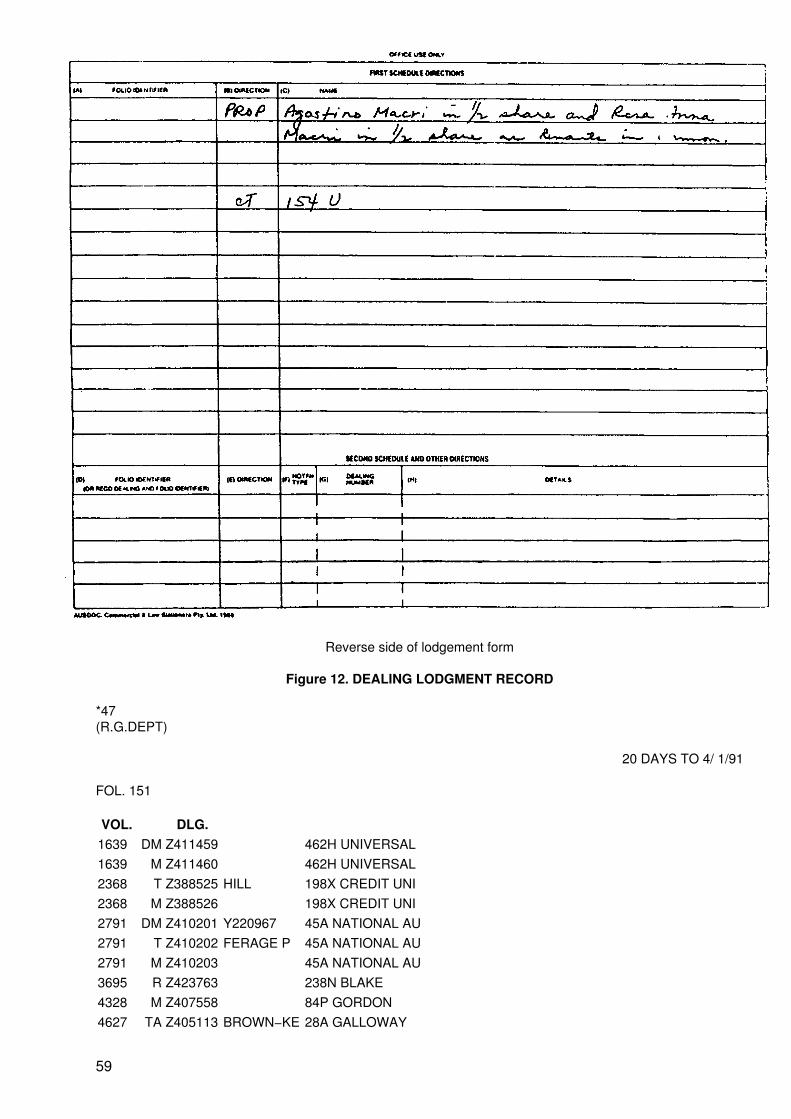
Reverse side of lodgement form
Figure 12. DEALING LODGMENT RECORD
*47(R.G.DEPT)
20 DAYS TO 4/ 1/91
FOL. 151
VOL. DLG.1639 DM Z411459 462H UNIVERSAL1639 M Z411460 462H UNIVERSAL2368 T Z388525 HILL 198X CREDIT UNI2368 M Z388526 198X CREDIT UNI2791 DM Z410201 Y220967 45A NATIONAL AU2791 T Z410202 FERAGE P 45A NATIONAL AU2791 M Z410203 45A NATIONAL AU3695 R Z423763 238N BLAKE4328 M Z407558 84P GORDON4627 TA Z405113 BROWN−KE 28A GALLOWAY
59
5216 T Z439342 CULARS N 256L CITY AGENT5899 T Z421369 PARKER 33H THOMAS KENY6156 DM Z401058 F806311 46X M J ARMSTRO6156 TA Z401059 ROONEY 46X M J ARMSTRO6363 DM Z410224 N587484 45A NATIONAL AU6863 DM Z410225 W37498 45A NATIONAL AU6888 T Z435539 HILL 39U REED7033 DM Z397017 Y333334 23L COMMONWEALT7033 T Z397018 GIBBONS 23L COMMONWEALT7033 M Z397019 23L COMMONWEALT9703 DM Z431943 N409940 45A NAT AUST BA9703 M Z431944 45A NAT AUST BA11013 DM Z426205 V680430 855M THURLOW FI11013 T Z426206 HARRINGT 855M THURLOW FI11871 VM Z423708 879W PRICE12244 R Z418807 898S WESTGARTH12244 R Z418808 898S WESTGARTH12244 DL Z418809 898S WESTGARTH12244 DL Z418810 898S WESTGARTH12244 SL Z418811 DEBNEY M 898S WESTGARTH12244 SL Z418812 LONE RAN 898S WESTGARTH12510 DM Z423723 W485121 40 RANKIN12510 T Z423724 WYKEHAM− 40 RANKIN13033 T Z389241 AGNEW 350 MORRIS HAYE14612 L Z392578 J T GLEE 39U REED HANIGA14797 TL Z395450 MALTEZOS 40 G & R PROPER14797 VM Z430911 871P TRUST COMP15257 DM Z403629 Y626019 1W WHITE (POST)15257 T Z403630 TELFORD 1W WHITE (POST)15466 X Z422814 246P J P LEGALFOL. 152
VOL. DLG.84 X Z427376 134B BOWEN902 ND Z416317 1W L C JACKSON978 DM Z434407 W317851 45A NATIONAL AU978 M Z434408 45A NATIONAL AU1272 DM Z417791 C786105 35D MORRIS HAYE1272 TA Z417792 STAMM 35D MORRIS HAYE1383 RA 2389904 ELECTRIC 813E STATE CROW1483 TA Z415464 KELLY 38W V J RALPH1685 DM Z422394 X218918 45A NATIONAL AU1685 M Z422395 45A NATIONAL AU2598 TA Z425316 HARRISON 1W P CHAMBERLAI4627 TA Z405113 BROWN−KE 28A GALLOWAY5101 TA Z396593 706F PUBLIC TRU5101 PV Z396594 706F PUBLIC TRU6747 DM Z413064 X946452 358C J P GROGAN6747 T Z413065 KONEFAL 358C J P GROGAN7645 T Z421815 OLIVER 265K PROCTOR
60

7777 DM Z414049 W454630 28A GALLOWAY8378 TR Z411876 4160 NSW LAND9703 DM Z431943 N409940 45A NAT AUST 8A9703 M Z431944 45A NAT AUST BA10639 M Z425179 328M COHEN12027 DM Z410580 S971785 24J C’WEALTH BA12882 VM Z421993 802K MACEDONE13284 DL Z415963 574V MARSHALL M13284 L Z415964 BUTT 574V MARSHALL M13766 DM Z404693 R307561 62A PAUL PRITCH13888 T Z399385 GUTHRIE 37Y WESTPAC BAN13888 T Z399386 GUTHRIE 37Y WESTPAC BAN14978 T Z408951 MCCALL 38W V J RALPH14978 M Z408952 38W V J RALPH15287 M Z441053 24J C’WEALTH BA15354 TL Z393248 GEORGE B 701R KEKATOSFOL. 153
VOL. DLG.1243 T Z394523 TEACHER 864L TRESS COCK1592 X Z421251 84P GORDON1936 DM Z391376 T857080 767J SYDNEY CRE1936 M Z391377 767J SYDNEY CRE2757 TA Z408686 HELLMERS 28A GALLOWAY4066 X Z433265 61C ABBOTT TOUT4107 M Z397672 20S A N Z BANK4217 L Z437090 GKN KWIK 37Y WESTPAC4217 T Z437092 BORDAN D 37Y WESTPAC4217 M Z437093 37Y WESTPAC4388 DM Z432088 P885566 1W W C H HARRIS4588 DM Z429039 X945455 23L C S B5044 T Z430660 MITCHELL 23L C S B5044 M Z430661 23L C S B5217 DM Z437091 X846934 37Y WESTPAC5974 T Z403070 LAI MAN5974 M Z440265 24J C’WEALTH BA6203 DM Z402101 W603679 24J C’WEALTH BA6974 VM Z429856 853R THORNTONS7378 M Z438211 24J C’WEALTH BA8236 T Z404311 NEW SOUT 416Q NSW LAND &8340 DM Z422828 H951193 721K REDMOND8340 NO Z422829 721K REDMOND9991 NO Z410947 28A GALLOWAY10009 DM Z409044 Y738965 155S BURKHART10009 M Z409045 155S BURKHART10009 X Z426138 381H R HAZLETT10641 T Z409041 DONALD 356G PATRICK GR11092 M Z397457 37Y WESTPAC BAN11105 L Z426630 HADONASH 2680 DYNON12027 DM Z432909 Q907914 39U REED HANIGA
61
12027 T Z432910 PHILLIPS 39U REED HANIGA12882 VM Z421993 802K MACEDONE13552 R Z394758 406T HOLMAN WEB13552 L Z406751 MR WHIPP 406T HOLMAN WEB15142 KR Z402099 24J C’WEALTH BA15142 T Z402100 LANGE 24J C’WEALTH BA15352 M Z402111 24J C’WEALTH BA15452 M Z401626 1038R SWAAB15464 DM Z439451 Y101648 544F MACLARENS15464 T Z439452 CHAN CHE 544F MACLARENS15464 M Z439453 544F MACLARENS15522 ND Z414007 28A GALLOWAYFOL. 154
VOL. DLG.1878 M Z397753 395V HEIDTMAN1878 R Z411652 155S BURKHART1945 DM Z429818 T795467 23L C S B2188 DM Z408334 W9782132356 WX Z397550 X63544 28A GALLOWAY2356 DM Z397551 T76058 28A GALLOWAY2356 T Z397552 BEARD 28A GALLOWAY2356 M Z397553 28A GALLOWAY2853 VM Z419485 415S HOUSTON DE2938 AP Z397254 BALDWIN 250Y JOHN DICK2938 M Z397255 250Y JOHN DICK3076 DM Z423296 Y807548 189Y COLEMAN4127 DM Z429408 03066914127 DM Z429409 R4442304127 T Z429410 MOTT4127 M Z4294114484 VM Z407493 33H THOMAS KENY5450 T Z390947 KOLONG P 878Y J P SAAD5450 M Z390948 878Y J P SAAD5450 X Z419334 94L BALDWIN OATWhere the land is the whole of the land in the current title it is safe to assume that the dealing is not one whichis prohibited by the Local Government Act. However any dealing which refers to a plan or is for part of theland in the current title is referred off line for check of description by a survey drafting officer, as this usuallymeans that a subdivision is involved or steps are necessary to create a folio for the residue after the part isdealt with. Some such dealings may be found to be in breach of the Local Government Act and in that caseregistration is refused.
When a dealing is found to be in order for registration and passed, directions for registration are given. Inearly days registration was performed by affixing large rubber stamps duly filled in by “writers” and checkedand sealed by “signers”. In later times, particularly in the case of the new form titles (since 1961) typedendorsements have been used (see figure 6). In the case of ALTS, registration directions are in the form ofcoded data entry instructions.
Where a dealing is found to be not in registrable form requisitions are forwarded to the lodging party,commonly in the form of a pre−printed letter placed in the lodging party’s delivery box. Failure to respondadequately to the requisitions within two months leads to rejection. A final 28 days’ notice may be given ifsome attempt has been made to satisfy the requisitions.
3. Plan processing
62
Following lodgement and notation of the Register, all documents, prior plans, searches and other informationnecessary for investigation of a plan are assembled and cases are allocated in order of lodgement to aninvestigating drafting officer. In addition, availability of the certificate of title is checked, along with authority touse it for the registration of the plan.
When in order for registration, the plan is forwarded for registration and all interested parties are notified,including the lodging party, the surveyor, the local council, the Land Tax office and the Valuer General, so asa result all valuing, rating and taxing authorities are made aware of the subdivision. The Valuer General andsome authorities receive a copy of the plan and, by arrangement, some councils are supplied with microfilmaperture cards of the plan. After filming, the public may purchase copies of the plan. Arrangements are alsomade to up−date the Graphic Data Base and the reference maps.
On registration of a plan which thereby becomes a “current plan” within the meaning of the Local GovernmentAct, a new folio of the Register is created in ALTS for each new lot and the prior folio is cancelled asappropriate. A new folio is also created for any residue not included in the plan. Where a lot in the plan isdesignated as a public reserve or a drainage reserve a certificate of title is issued in the name of the localcouncil and posted to that council.
Where a plan is accompanied by an instrument pursuant to section 88B of the Conveyancing Act to createeasements positive covenants and/or restrictions on the use of land, these are notified in the respective foliosof the Register created as above.
It should be noted that subdivisions of private land are all effected by surveyors in the private sector at thecost of the developer. Although the Crown Lands Office has staff surveyors, who carry out inspections, controlsurveys and geodetic work etc, many private surveyors are also contracted to carry out Crown surveys.
4. De facto subdivisions
(This item is included in response to the matter of informal land developments on public lands. While NSWdoes not have a direct equivalent of this problem there are many instances of de facto developments onprivate land, which may be of interest and perhaps suggest a way ahead.)
Prior to the commencement of the Local Government Act in 1920 there was little control over subdivisionactivity and town planning hardly existed. Nevertheless there is now recognition that certain de factosubdivisions made before that date were “lawfully made”. The main example was the erection of row type(terrace) houses for separate occupation without the formality of subdivision, and individual houses wererented or leased. In cases dealing with these “de facto” subdivisions the courts have held that a lawfulsubdivision was made and that separate certificates of title should be issued for each house as constructedand fenced before 1920. The Registrar General has registered plans showing such subdivisions without theformal approval of the council provided that it was shown that the buildings were erected before 1920, wereseparately occupied in accordance with dividing fences erected before that date, the existing fences are in thesame positions as the original fences and the properties are separately rated by the council. In general it hasto be established that the subdivision as now existing on the ground is the same as that made (by the erectionof the buildings and fences) before the commencement of the Local Government Act. The evidence furnishedhas usually been in the form of a statutory declaration by some person having the necessary knowledge andseparate rate notices evidencing, in effect, acknowledgement of the subdivision by the council. After 70 yearshowever, it is now virtually impossible to get a statutory declaration, and reliance is now usually on theprofessional opinion of a registered surveyor having regard to architectural style and the nature of the dividingfencing, which usually is on a line which is a projection of the dividing “party wall”. Following the passing of theEnvironmental Planning and Assessment Act (EPA Act), all divisions of land are controlled by that Act and theRegistrar General now also requires a certificate by the council that the subdivision is not in breach of that Actor any environmental planning instrument thereunder, and councils are usually able to issue such a certificate.
Since the commencement of the Local Government Act there have been many cases of councils approvingthe erection of semi−detached cottages for separate occupation. These de facto subdivisions are alsoregistered (without formal approval of the council) on the basis of separate rating and evidence that thebuildings and dividing fences were erected in accordance with plans and specifications approved by thecouncil and the certificate under the EPA Act, and also evidence of separate occupation.
There has occurred a case where a coal mining company allowed its employees to erect dwellings oncompany land. Mostly these were rough “humpies” which through the years have been improved somewhatand an informal market for these developed, although title could not be given, and boundaries were never
63
established. In recent years a squatters’ Residents Action Group developed seeking to regularize thesituation, and this was supported by the local Member of Parliament and the Trade Union movement, and themining company was prepared to cooperate. However, because of the zoning (not residential) and the factthat the site is subject to land slip, the council could not legally approve the subdivision and was not preparedto seek rezoning of the land for housing. It had, however, rated the properties separately and after somehouses were further upgraded the council was prepared to issue a certificate of compliance under the LocalGovernment Act in respect of each house. Following negotiations, a survey was made, boundaries were setout and agreed by all as representing their long−term occupations (a form of adjudication) and a plan finallyregistered and separate titles issued to the mining company which will transfer title to the residents. This hadto be achieved before the commencement of the Environmental Planning and Assessment Act however, sinceit would have been a breach of that Act.
The foregoing is an adaption of the procedures for dealing with terrace houses and semi−detached cottages.Interestingly, one of the roads in the subdivision has since been subject to land slip, and since the subdivisionwas not formally approved by council and the roads are not public roads, the council will not repair the road.
5. Business risk
Traditionally the work performed in the Land Titles Office has been characterized by check and double−check.Almost everything done was checked by a more senior officer, partly as on the job training but also to ensureaccuracy, no doubt with the Assurance Fund in mind. In recent years however there has been a big moveaway from work revision to the adoption of a business risk approach. Very little work is now double−checkedand other methods of training are used. There can be little doubt that more errors are made, and massproduction of new folios spreads the effect of errors; departmental error is next to fraud as a basis of claimson the Assurance Fund and is, of course, a matter of concern. But there can be no turning back, and theobvious course is to identify the reasons for error, to enhance the quality of work submitted to the Office andto improve the quality of office processing.
L. Quality review
The section in which the Registrar General exercises his power to correct the Register had long been calledthe Amendment Section. Since the removal of work revision, proliferation of mass production and the adoptionof business risk, this section has, of course, been busy. Clients are encouraged to report errors as soon asnoticed and matters are corrected promptly. The section is now called the Quality Review Section, and this isnot merely a euphemism but a change in emphasis from merely correcting errors to analysing the types oferrors made and reasons for them, which could be data−entry errors, procedural inefficiencies, trainingdeficiencies, poor form design, or perhaps carelessness. Feed−back is provided to the “work face” andstrategies are being developed to minimize errors; it is thought that continuing training in data−entryprocedures is needed. Efforts are being made to identify and recognize staff whose work is of consistent highquality.
M. Total Quality Commitment (TQC)
The Land Titles Office has embraced a methodology called “total quality commitment” as part of the “Australiafor Quality” programme. Simply put, TQC involves the commitment of everyone in the organization (i.e., total)to achieving and maintaining a good standard of quality in every process, product and service. TQC as aconcept has been successful wherever it has been adopted. It is not a way of getting more work out of peoplebut requires people to work “smarter” rather than “harder”. Quality cannot be “inspected in”, but it can be “builtin” during design and production.
TQC is not merely an in−house operation but extends out to suppliers and in the case of the Land TitlesOffice, that means the people who lodge dealings and plans. In this regard, the banking industry isresponsible for about 40 per cent of lodgments and with this in mind the Office has invited some major banksto participate in TQC. A large bank, which had an error rate of 7.5 per cent in matters lodged, had staff join atraining programme conducted by Land Titles Office, following which there was a dramatic downturn in errorrate, and other banks have sought to join the programme.
The Land Titles Office is a leader in TQC and is in demand as a facilitator to interested organizations.
64
N. Public records
The records of the Land Titles Office available to the public are, to say the least, extensive, comprising inexcess of 30 million basic items. Aside from normal office files, the dealings, bound and loose folios of theRegister, reference maps, index maps, subdivision plans, deeds, Purchasers and Vendors Indexes andvarious registers that accumulated through the years eventually caused severe administrative difficulties.Considering that all these had to be kept available for public inspection and in good order, it will beappreciated that a large book−binding and map−mounting section was necessary. This section was staffed byhighly skilled tradespeople who became adept at special jobs in addition to routine work.
All the bound records relating to the Common Law title system remain in use in bound form. The recordsrelating to the Real Property Act system included over 200,000 bound dealing books, 40,000 bound Registersections, 7,515 parish maps, 1,140 town and village maps, 30,000 office copies of deposited plans andextensive ancillary records. In spite of the addition of the northern wing and a modern records wing, the LandTitles Office building became grossly overcrowded.
It was not merely the bulk of the records that created problems, but also the small army of staff needed to file,retrieve and transport records around the building when needed and to service the public, for whom publicsearching space had to be provided.
There was, however, a less visible and perhaps worse problem, that of availability. Since dealings were boundin books of 100 (access to these was needed to ascertain the terms of easements and restrictive covenants,the details of mortgages, covenants in leases and the like) and Register folios were bound in sets of 50,competition for books became common, and in some cases fierce, and it was frequently found that a bookwas “out” when needed. Large card systems were necessary to record movement of books, and staff were setaside to do nothing else but patrol the building searching for missing books. There were urgent searches forbooks subpoenaed for the Courts. The then− prevailing system of double− checking of work meant that bookswere held by a processing officer until a revising officer was ready to check the work, delaying return of thebooks to file. Often, when the revising officer came to do the “revising”, a book that was needed had beentaken for the public or some other case in the Office. Similar problems occurred when dealings were sent forregistration: the officer directing registration gave instructions on the bound folio of the Register and the casethen proceeded to a writer and finally to a signer, usually in stacks representing perhaps half a day’s work.
Binding of records in large sets may be a good way of preserving records, but it is not the ideal way of makingthem available to users, and has resulted in much frustration and delay, which translate into costs.
1. Dealing books
The cessation of work revision and the adoption of business risk removed some of the demand for books, butthe main solution to the problems described above has been microfilming of records and the destruction of thesource documents. More than 20 million dealings totalling about 80 millions pages are on film. While the thenexisting bound volumes presented no special filming problems, other than logistics, current dealings were areal challenge.
After removal of the binding by guillotine, dealings were filmed in strict sequence on roll film with “blip codes”to mark the end of each document. Subsequent location of any dealing on the roll of microfilm was thussimple. However, since dealings are not all registered in the same order in which they were lodged (some aredelayed under requisition, some are withdrawn and some are rejected) large numbers of recent dealings werefiled loose or in temporary binders until all dealings in each set of 100 were accounted for or finalized. Thesecould not be filmed until completion of the set, because it otherwise would be impracticable to locate aparticular dealing on the roll of film later. In addition a sizeable staff was needed to service loose dealings, tokeep records of their whereabouts and to account for those awaiting finalization.
These problems were solved by a highly innovative procedure, the Filmex programme, for which the LandTitles Office received from Kodak the prestigious International Award for Excellence of Microfilm Application.Under Filmex dealings are numbered at lodgement by affixing an adhesive label (from a pre−printed roll)showing the number in both numeric and barcode form. On registration dealings are microfilmed immediatelyin random order; the microfilm camera is coupled to a high speed laser scanner which reads the barcodednumber directly to a computer in sequence with the filming and the computer records, the allocated filmaddress and number of sheets for each dealing. From the system the computer can subsequently locate the
65
film address for each dealing image for printing of copies on demand, even though the dealings are filmed inrandom order and may have multiple sheets.
There are many advantages in Filmex, including:−
• Immediate securing of dealings after registration;
• Immediate creation of a duplicate archival file;
• The dealing may be destroyed immediately and there is no need for filing and preservationof dealings in bound form or otherwise, thereby releasing extremely valuable floor space andallowing re−allocation of staff to other duties;
• Since the dealing is destroyed upon registration and need last only until filming, it can beprepared on cheaper, less durable paper. This has facilitated the use of word processors insolicitors’ offices for dealing preparation.
Compared with previous methods, Filmex is saving $150,000 per annum (at 1986 salary levels) after allowingfor establishment and running costs.
2. Register books
A small number of the earliest bound Register books have been microfilmed and all have been retained so farbut those that have been filmed will soon go to Archives. Although most are now “dead” records, they may stillbe referred to occasionally for grant reservations and conditions or for historical reasons. The introduction ofloose folios in new form in 1961 and, more recently, ALTS, has so reduced the demand for bound folios thatthe problems previously described have largely been reduced to that of storage, and the valuable space theyoccupy. Many bound folios have been cancelled upon subdivision to become separate titles for individual lots,either as loose folios from 1961 or as computer folios from 1983, or, in the case of single lots, have beenconverted to ALTS directly, notwithstanding that the manual certificate of title is still out in the community andwill remain so until the next dealing is lodged. For these cases there is, in the meantime, a “linking index” inALTS to link each outstanding volume and folio reference with its ALTS folio identifier counterpart and viceversa. A search in ALTS carries a message referring to the subsisting manual certificate of title.
There still remain many live bound folios for undefined residues some of which are extremely complex, partsof lots, multiple parcels, roads left in subdivisions, and minerals, none of which can be converted to ALTSwithout special programmes or projects. Fortunately the level of business in this area is now low.
One area of concern worth special mention is that there was once a practice of breaking the binding ofRegister books to insert additional sheets for further endorsements of transfers of parts (and rebinding thebook) rather than “biting the bullet” and finding a way of defining residues and issuing new titles. It would bebetter to avoid permitting titles to become partially cancelled in the first place.
3. Maps and plans
The file of maps and plans developed in a somewhat sporadic manner and is discussed in chapter V. Thebasic maps were parish, town and village maps representing subdivision of Crown land for sale or lease.Although intended for use in the Department of Lands as administrative maps, they have been used in LandTitles Office as charting maps and as indexes to more recent large scale reference maps. They carryparticulars of Crown grants and references to catalogue numbers of Crown surveys and are thus stillimportant for searching purposes. They have mostly been supplanted however (for other purposes) by CentralMapping Authority (CMA) urban and rural cadastral maps. All subdivision plans of freehold land and Crownsurveys are now on microfilm. Office copies of all deposited plans lodged from 1863 to 1961 were kept in thePlan Room and used for charting of transfers, other related information and later subdivisions, and as suchformed part of the “pyramidal” reference map system described in chapter VI; as CMA maps have been putinto use the affected deposited plans have been withdrawn. Other plans of a miscellaneous nature used forcharting purposes have also been progressively withdrawn and microfilmed. What was until some 20 yearsago a large and busy Plan Room with more than a dozen staff has now become a self−service area housingmostly parish, town and village maps, CMA reference maps and other reference maps; all survey informationis now accessed from microfilm.
66
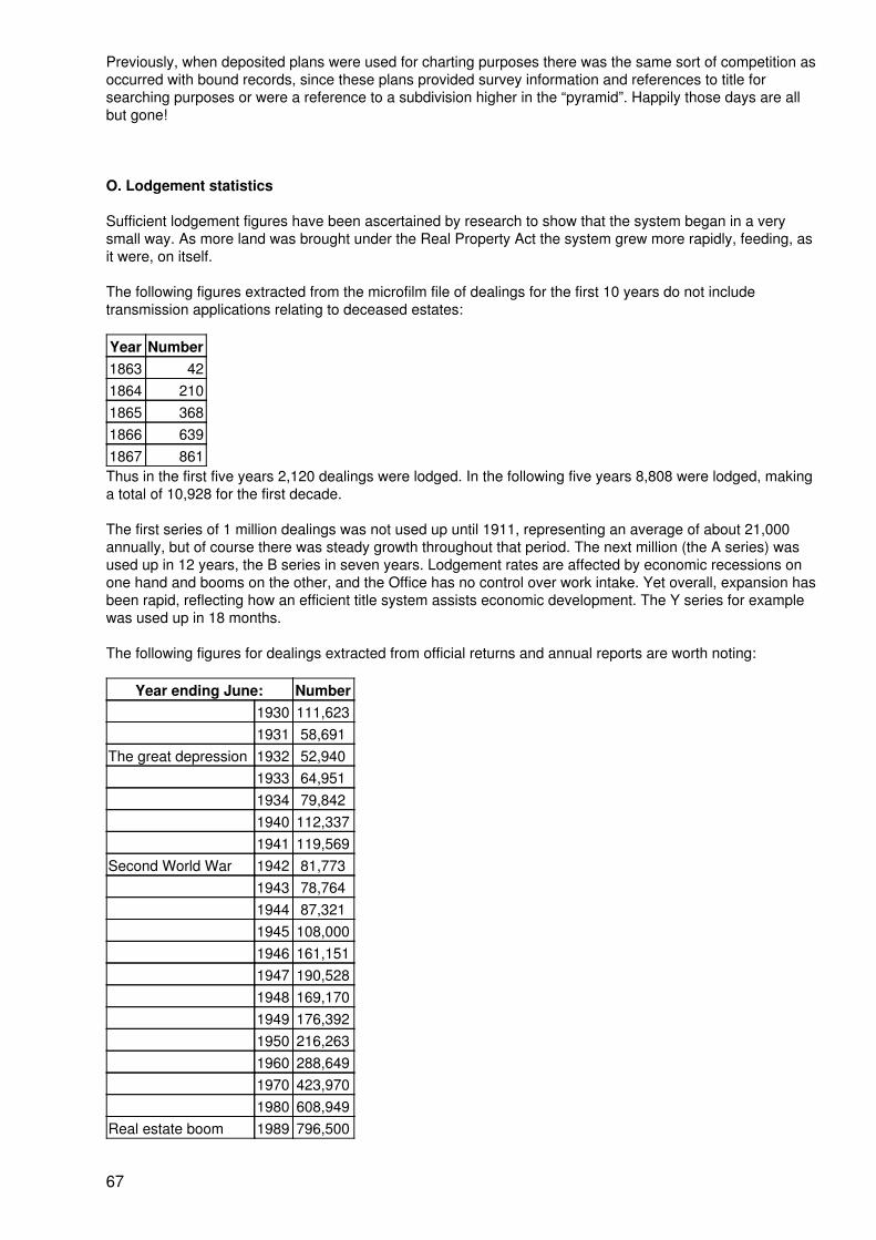
Previously, when deposited plans were used for charting purposes there was the same sort of competition asoccurred with bound records, since these plans provided survey information and references to title forsearching purposes or were a reference to a subdivision higher in the “pyramid”. Happily those days are allbut gone!
O. Lodgement statistics
Sufficient lodgement figures have been ascertained by research to show that the system began in a verysmall way. As more land was brought under the Real Property Act the system grew more rapidly, feeding, asit were, on itself.
The following figures extracted from the microfilm file of dealings for the first 10 years do not includetransmission applications relating to deceased estates:
Year Number1863 421864 2101865 3681866 6391867 861Thus in the first five years 2,120 dealings were lodged. In the following five years 8,808 were lodged, makinga total of 10,928 for the first decade.
The first series of 1 million dealings was not used up until 1911, representing an average of about 21,000annually, but of course there was steady growth throughout that period. The next million (the A series) wasused up in 12 years, the B series in seven years. Lodgement rates are affected by economic recessions onone hand and booms on the other, and the Office has no control over work intake. Yet overall, expansion hasbeen rapid, reflecting how an efficient title system assists economic development. The Y series for examplewas used up in 18 months.
The following figures for dealings extracted from official returns and annual reports are worth noting:
Year ending June: Number1930 111,6231931 58,691
The great depression 1932 52,9401933 64,9511934 79,8421940 112,3371941 119,569
Second World War 1942 81,7731943 78,7641944 87,3211945 108,0001946 161,1511947 190,5281948 169,1701949 176,3921950 216,2631960 288,6491970 423,9701980 608,949
Real estate boom 1989 796,500
67
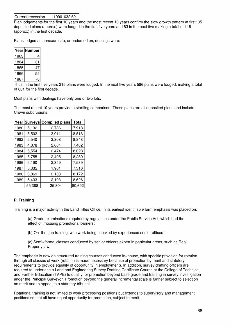
Current recession 1990 632,621Plan lodgements for the first 10 years and the most recent 10 years confirm the slow growth pattern at first: 35deposited plans (approx.) were lodged in the first five years and 83 in the next five making a total of 118(approx.) in the first decade.
Plans lodged as annexures to, or endorsed on, dealings were:
Year Number1863 41864 311865 471866 551867 78Thus in the first five years 215 plans were lodged. In the next five years 586 plans were lodged, making a totalof 801 for the first decade.
Most plans with dealings have only one or two lots.
The most recent 10 years provide a startling comparison. These plans are all deposited plans and includeCrown subdivisions:
Year Surveys Compiled plans Total1980 5,132 2,786 7,9181981 5,502 3,011 8,5131982 5,540 3,308 8,8481983 4,878 2,604 7,4821984 5,554 2,474 8,0281985 5,755 2,495 8,2501986 5,190 2,349 7,5391987 5,335 1,981 7,3161988 6,069 2,103 8,1721989 6,433 2,193 8,626
55,388 25,304 80,692
P. Training
Training is a major activity in the Land Titles Office. In its earliest identifiable form emphasis was placed on:
(a) Grade examinations required by regulations under the Public Service Act, which had theeffect of imposing promotional barriers;
(b) On−the−job training, with work being checked by experienced senior officers;
(c) Semi−formal classes conducted by senior officers expert in particular areas, such as RealProperty law.
The emphasis is now on structured training courses conducted in−house, with specific provision for rotationthrough all classes of work (rotation is made necessary because of promotion by merit and statutoryrequirements to provide equality of opportunity in employment). In addition, survey drafting officers arerequired to undertake a Land and Engineering Survey Drafting Certificate Course at the College of Technicaland Further Education (TAPE) to qualify for promotion beyond base grade and training in survey investigationunder the Principal Surveyor. Promotion beyond the general incremental scale is further subject to selectionon merit and to appeal to a statutory tribunal.
Rotational training is not limited to work processing positions but extends to supervisory and managementpositions so that all have equal opportunity for promotion, subject to merit.
68
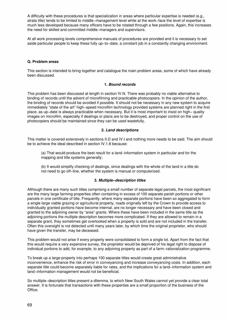
A difficulty with these procedures is that specialization in areas where particular expertise is needed (e.g.,strata title) tends to be limited to middle−management level while at the work−face the level of expertise ismuch less developed because many officers have to be rotated through a few positions. Again, this increasesthe need for skilled and committed middle−managers and supervisors.
At all work processing levels comprehensive manuals of procedures are provided and it is necessary to setaside particular people to keep these fully up−to−date, a constant job in a constantly changing environment.
Q. Problem areas
This section is intended to bring together and catalogue the main problem areas, some of which have alreadybeen discussed.
1. Bound records
This problem has been discussed at length in section IV.N. There was probably no viable alternative tobinding of records until the advent of microfilming and practicable photocopiers. In the opinion of the author,the binding of records should be avoided if possible. It should not be necessary in any new system to acquireimmediately “state of the art” high−speed microfilm technology provided systems are planned right in the firstplace, as up−date is always practicable when necessary. But it is most important to insist on high− qualityimages on microfilm, especially if dealings or plans are to be destroyed, and proper control on the use ofphotocopiers should be maintained since they can be used wastefully.
2. Land descriptions
This matter is covered extensively in sections II.D and IV.I and nothing more needs to be said. The aim shouldbe to achieve the ideal described in section IV.1.8 because:
(a) That would produce the best result for a land−information system in particular and for themapping and title systems generally;
(b) It would simplify checking of dealings, since dealings with the whole of the land in a title donot need to go off−line, whether the system is manual or computerized.
3. Multiple−description titles
Although there are many such titles comprising a small number of separate legal parcels, the most significantare the many large farming properties often containing in excess of 100 separate parish portions or otherparcels in one certificate of title. Frequently, where many separate portions have been so aggregated to forma single large viable grazing or agricultural property, roads originally left by the Crown to provide access toindividually granted portions have become internal, are no longer necessary and have been closed andgranted to the adjoining owner by “area” grants. Where these have been included in the same title as theadjoining portions the multiple description becomes more complicated. If they are allowed to remain in aseparate grant, they sometimes get overlooked when a property is sold and are not included in the transfer.Often this oversight is not detected until many years later, by which time the original proprietor, who shouldhave given the transfer, may be deceased.
This problem would not arise if every property were consolidated to form a single lot. Apart from the fact thatthis would require a very expensive survey, the proprietor would be deprived of his legal right to dispose ofindividual portions to add, for example, to any adjoining property as part of a farm−rationalization programme.
To break up a large property into perhaps 100 separate titles would create great administrativeinconvenience, enhance the risk of error in conveyancing and increase conveyancing costs. In addition, eachseparate title could become separately liable for rates, and the implications for a land−information system andland−information management would not be beneficial.
So multiple−description titles present a dilemma, to which New South Wales cannot yet provide a clear totalanswer. It is fortunate that transactions with these properties are a small proportion of the business of theOffice.
69
It is possible to see the present problems, so far as large grazing and agricultural properties are concerned,as a legacy of the land−allocation procedures described in sections 1.6 and 2.2. There have been someattempts to restructure some of the Crown subdivisional pattern by means of the Closer Settlement Act and byalienating land with due regard to “home maintenance areas” sufficient to support a family. But changingagricultural practices, economic problems and the state of the world market are tending to drive the smallerfarmer off the land in favour of corporations.
4. Fraud and malpractice
Fraud has been mentioned in section IV.E in relation to the Assurance Fund and that aspect needs no furthercomment. Beyond that, it should be observed that it must be a responsibility of the Registrar General toprovide an environment in which the processes of title and subdivision registration are above reproach andfree of bias or any suggestion of malpractice, and it needs to be said that where arrears of work are allowed tobuild up or delays add a cost factor in terms of holding charges a dangerous climate can be created in which“favours” may be sought and rewarded. Happily, in a recent hearing into certain land developments by theState Government’s anti−corruption watchdog, the Land Titles Office was found to be beyond reproach,although there have been some difficulties in the past.
5. Gazumping
“Gazumping” is the practice whereby a party to a transaction repudiates a “gentleman’s agreement” before abinding contract is made. In a “sellers’ market” a vendor may, after reaching a non−binding agreement, obtaina higher price for a property. In the meantime the first purchaser has been put to considerable legal costs,only to be “gazumped” just before formally exchanging contracts. In a “buyers’ market” a person who hasagreed to buy a property may find a better property at a better price and “gazump” the vendor.
In neither case was this practice illegal, but it led to much disappointment and added to costs. Of course it hadno direct effect on land titles, but delays in subdivision registration, for example, could be a factor in therepudiation of a “gentleman’s agreement”. The Land Titles Office has the responsibility of the administration ofthe Conveyancing Act which controls such matters, and it has been very difficult to reach agreement with theReal Estate Institute, the Law Society and other interested groups on mutually acceptable legislation to controlgazumping. The present legislation refers to residential land, including vacant land up to 2.5 ha, andconcentrates on shortening the time from “gentleman’s agreement” to binding contract (and thus the total timeto settlement).
R. Making a transfer
This section is intended to describe how a transfer is effected. It is assumed that the land is a lot in aregistered subdivision with a house on it, is the whole of the land in the title, is subject to a mortgage whichwill be discharged on settlement and that the purchase will be financed by a fresh mortgage. Thus there willbe four parties at the settlement.
The first step is usually the advertising of the property. While most transactions begin with a visit to a licensedreal estate agent it is quite common for new estates to be advertised in newspapers or on radio or televisionby the developer. After deciding on a property, ensuring that finance will be available and (if desired)instructing a solicitor, the purchaser, through his solicitor, pays the deposit (usually 10 per cent) andexchanges contracts. The five−day cooling−off period then begins during which the contract may be rescindedby the purchaser, subject to penalty.
At this stage, a prudent purchaser will arrange insurance on the property since he would be forced tocomplete the purchase even if the property is destroyed or damaged.
The purchaser’s solicitor then commences inquiries for any affecting charges and interests not recorded in theregister such as a notification of unhealthy building land, proposals for road widening, proposed easementsfor electricity transmission lines, any proposals for resumption for a school, public housing etc, and obtainscertificates from the council and water/sewerage authority as to payment of rates. The land titles office nowoperates a Property Inquiry Service that can assist in respect of most of these matters. Inquiry should also bemade for any liability for payment of land tax which would be a charge on the land. It pays to check with theincoming mortgagee for its requirements for inquiries for possible affecting interests, as it will need to besatisfied before it provides finance, and it usually requires an up−to−date survey. Responsibility for rates
70
usually commences on exchange of contracts and an adjustment is made at settlement.
The purchaser’s solicitor forwards requisitions on title to the vendor’s solicitor and unsatisfactory responses tothese or adverse replies to other inquiries may give rise to rescission of the contract. The purchaser’s solicitorinstructs a surveyor to make a survey (unless the vendor holds an up−to−date one and is prepared to make itavailable) and in anticipation of satisfactory survey and replies to requisitions, has stamp duty paid on thecontract, prepares the transfer document, has it accepted by the purchaser and marked by the stamp dutiesoffice, and forwards it to the vendor for execution; the vendor’s solicitor holds it until settlement.
In the meantime, after application for finance, the new mortgagee forwards requisitions on title to thepurchaser’s solicitor and on receipt of satisfactory replies forwards the mortgage document in duplicate forexecution by the purchaser and return. The solicitor arranges for payment of any stamp duty on the mortgage.
The vendor’s solicitor arranges with the existing mortgagee to discharge the mortgage, wholly or partially asrequired, at settlement, ascertains the payout figure to be allowed for at settlement and arranges for thecertificate of title and the discharge of mortgage to be available at settlement.
When all parties are satisfied, settlement is arranged (usually the location is determined by the party holdingthe certificate of title), the rates are adjusted by agreement and bank cheques ordered according to thevendor’s solicitor’s requirements. An allowance is made in favour of the incoming mortgagee for the fees forregistration of all documents. A final search is made to satisfy the purchaser’s solicitor and the incomingmortgagee. At settlement the purchaser’s solicitor supplies the settlement cheques and an authority to the realestate agent to account to the vendor for the deposit moneys, sights the certificate of title, checking it againstthe final search, and inspects the discharge of mortgage and the transfer for correct execution. The vendor’ssolicitor receives the settlement cheques, passes the now completed transfer to the incoming mortgagee’srepresentative and a pay−out cheque to the outgoing mortgagee and receives in return the discharge ofmortgage and the certificate of title. These are passed to the incoming mortgagee’s representative whochecks all documents for correct execution and satisfies himself that all are in order for registration.
Out of all of this, the purchaser finishes up with a key to the door and a mortgage debt requiring regularpayments; the vendor ends up with what is left of the purchase money after his mortgage is paid out, theagent has got his commission and his solicitor has recovered his costs; the purchaser’s solicitor gets paid forhis fees and all costs; the new mortgagee gets the certificate of title and all documents for registration, whichare then dated. The Government receives a healthy revenue from stamp duty and the land titles office getsregistration fees.
When all documents are registered, the mortgagee holds the duplicate mortgage and a new edition of thecertificate of title on which are recorded the transfer and the fresh mortgage; the discharged mortgage hasdisappeared to the historical file.
It is the duty of the purchaser’s solicitor to inform the Valuer General, the local council and the water authorityof the change of ownership. This arrangement tends to break down and is often overlooked or regarded as anincidental afterthought. A new procedure is planned whereby the necessary information is to be included inthe transfer form − see figure 13 − picked up by the Land Titles Office and passed through interconnectingcomputer systems to all authorities concerned.
S. Management of the system
The New South Wales titles system has always been centralized and is now the largest centralized Torrenstitle land registry in the world. At one stage, through association with a decentralized Crown landadministration, decentralization through regional Crown lands offices was being considered, but did notproceed. Taking into account the conveyancing infrastructure that has developed and the advances incommunications technology, there is now no need in NSW for regionalized land−titles registries. It seems thatadvances in technology would facilitate communication with any central coordinating body.
71

T. Customary rights and tenures
It is a sad fact of history that when the colony of NSW was established all land was presumed to vest in theCrown to the exclusion of the indigenous aboriginal population. While the various tribes and clans hadrecognized boundaries of a very general nature, no individual owned land in the sense that Western societyowns land. It would be closer to the truth to say that the land owned the people, who were its caretakersrather than its masters. To the aboriginal mind, land has a spiritual dimension that is still not understood bywesterners. Aborigines tended to move with the periodic food supply and had no permanent houses, orstructures, and few possessions, and the colonists therefore, not understanding their culture and values,disregarded their rights in land, as did the law. It is not surprising that clashes occurred and terrible injusticewas inflicted.
72
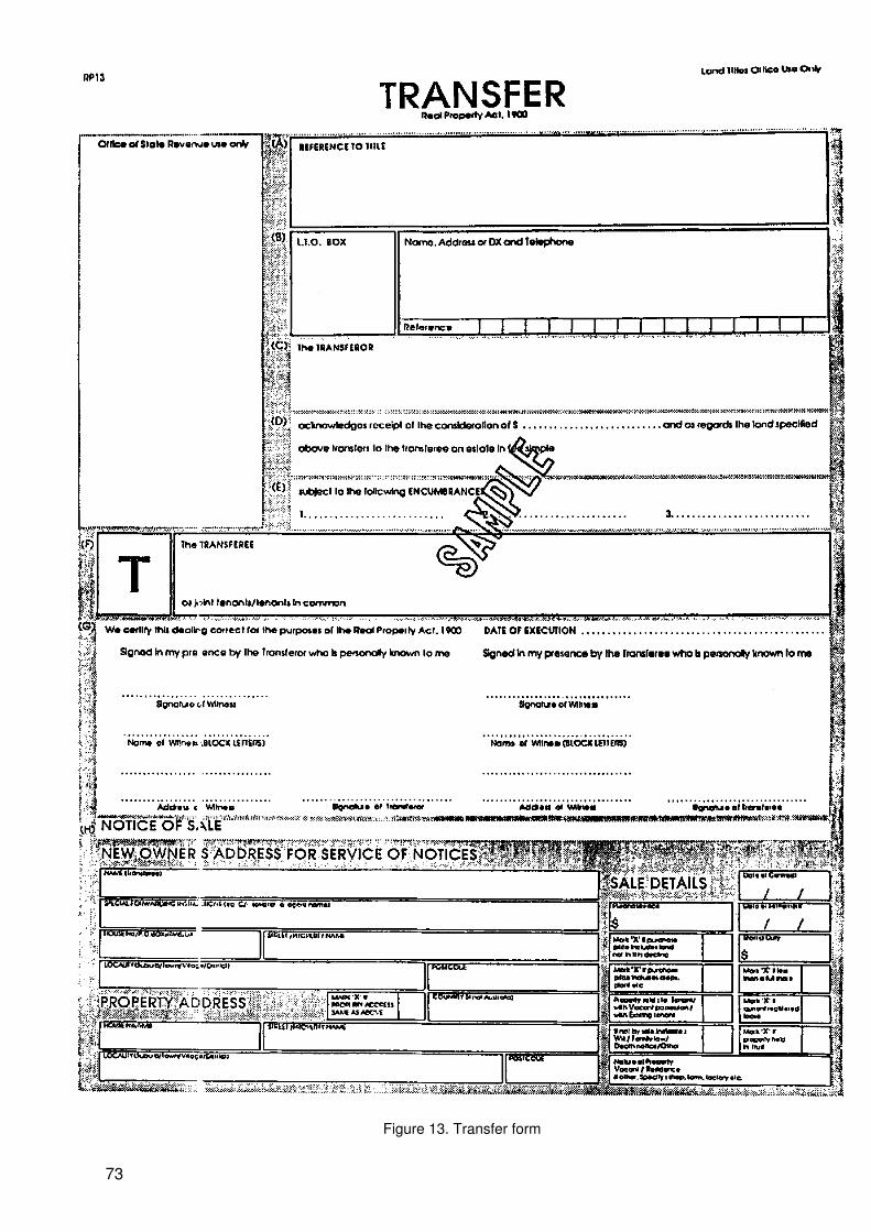
Figure 13. Transfer form
73
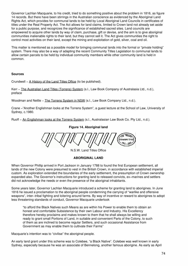
Governor Lachlan Macquarie, to his credit, tried to do something positive about the problem in 1816, as figure14 records. But there have been stirrings in the Australian conscience as evidenced by the Aboriginal LandRights Act, which provides for communal lands to be held by Local Aboriginal Land Councils in certificates oftitles under the Real Property Act. The Act allows for land claims, limited to Crown land not already set asidefor a public purpose, and recognizes the significance of established sacred sites. Land councils areempowered to acquire other lands by way of claim, purchase, gift or devise, and the aim is to give aboriginalcommunities inalienable rights to their land, but they cannot sell it. The Act gives communities the right tocontrol most activities on their land, except the mining and exploitation of gold, silver, coal and oil.
This matter is mentioned as a possible model for bringing communal lands into the formal or “private holding”system. There may also be a way of adapting the recent Community Titles Legislation to communal lands toallow certain parcels to be held by individual community members while other community land is held incommon.
Sources
Crundwell − A History of the Land Titles Office (to be published).
Kerr − The Australian Land Titles (Torrens) System (s.l., Law Book Company of Australasia Ltd., n.d.),preface
Woodman and Nettle − The Torrens System in NSW (s.l., Law Book Company Ltd., n.d.).
Crane −”Another Englishman looks at the Torrens System”, a guest lecture at the School of Law, University ofSydney, c.1980.
Ruoff − An Englishman looks at the Torrens System (s.l., Australasian Law Book Co. Pty Ltd., n.d.).
Figure 14. Aboriginal land
N.S.W. Land Titles Office
ABORIGINAL LAND
When Governor Phillip arrived in Port Jackson in January 1788 to found the first European settlement, alllands of the new Colony were presumed to vest in the British Crown, in accordance with established imperialcustom. As exploration extended the boundaries of the early settlement, the presumption of Crown ownershipexpanded also. The Governor’s instructions for granting land to released convicts, ex−marines and settlersdid not acknowledge the needs or even the presence of the aboriginal inhabitants.
Some years later, Governor Lachlan Macquarie introduced a scheme for granting land to aborigines. In June1816 he issued a proclamation to the aboriginal people condemning the carrying of “warlike and offensiveweapons”, inter−tribal fighting and loitering around farms. By way of incentive or reward to aborigines to adoptless threatening standards of conduct, Governor Macquarie undertook
“to afford the Black Natives such Means as are within his Power to enable them to obtain anhonest and comfortable Subsistence by their own Labour and Industry. His Excellencytherefore hereby proclaims and makes known to them that he shall always be willing andready to grant small Portions of Land, in suitable and convenient Parts of the Colony, to suchof them as are inclined to become regular Settlers, and such occasional Assistance fromGovernment as may enable them to cultivate their Farms”
Macquarie’s intention was to “civilise” the aboriginal people.
An early land grant under this scheme was to Colebee, “a Black Native”. Colebee was well known in earlySydney, especially because he was an associate of Bennelong, another famous aborigine. As early as April
74
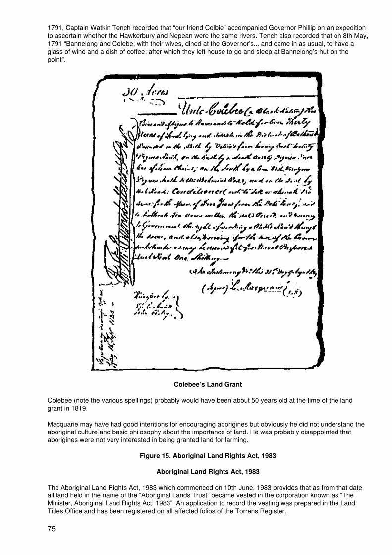
1791, Captain Watkin Tench recorded that “our friend Colbie” accompanied Governor Phillip on an expeditionto ascertain whether the Hawkerbury and Nepean were the same rivers. Tench also recorded that on 8th May,1791 “Bannelong and Colebe, with their wives, dined at the Governor’s... and came in as usual, to have aglass of wine and a dish of coffee; after which they left house to go and sleep at Bannelong’s hut on thepoint”.
Colebee’s Land Grant
Colebee (note the various spellings) probably would have been about 50 years old at the time of the landgrant in 1819.
Macquarie may have had good intentions for encouraging aborigines but obviously he did not understand theaboriginal culture and basic philosophy about the importance of land. He was probably disappointed thataborigines were not very interested in being granted land for farming.
Figure 15. Aboriginal Land Rights Act, 1983
Aboriginal Land Rights Act, 1983
The Aboriginal Land Rights Act, 1983 which commenced on 10th June, 1983 provides that as from that dateall land held in the name of the “Aboriginal Lands Trust” became vested in the corporation known as “TheMinister, Aboriginal Land Rights Act, 1983”. An application to record the vesting was prepared in the LandTitles Office and has been registered on all affected folios of the Torrens Register.
75
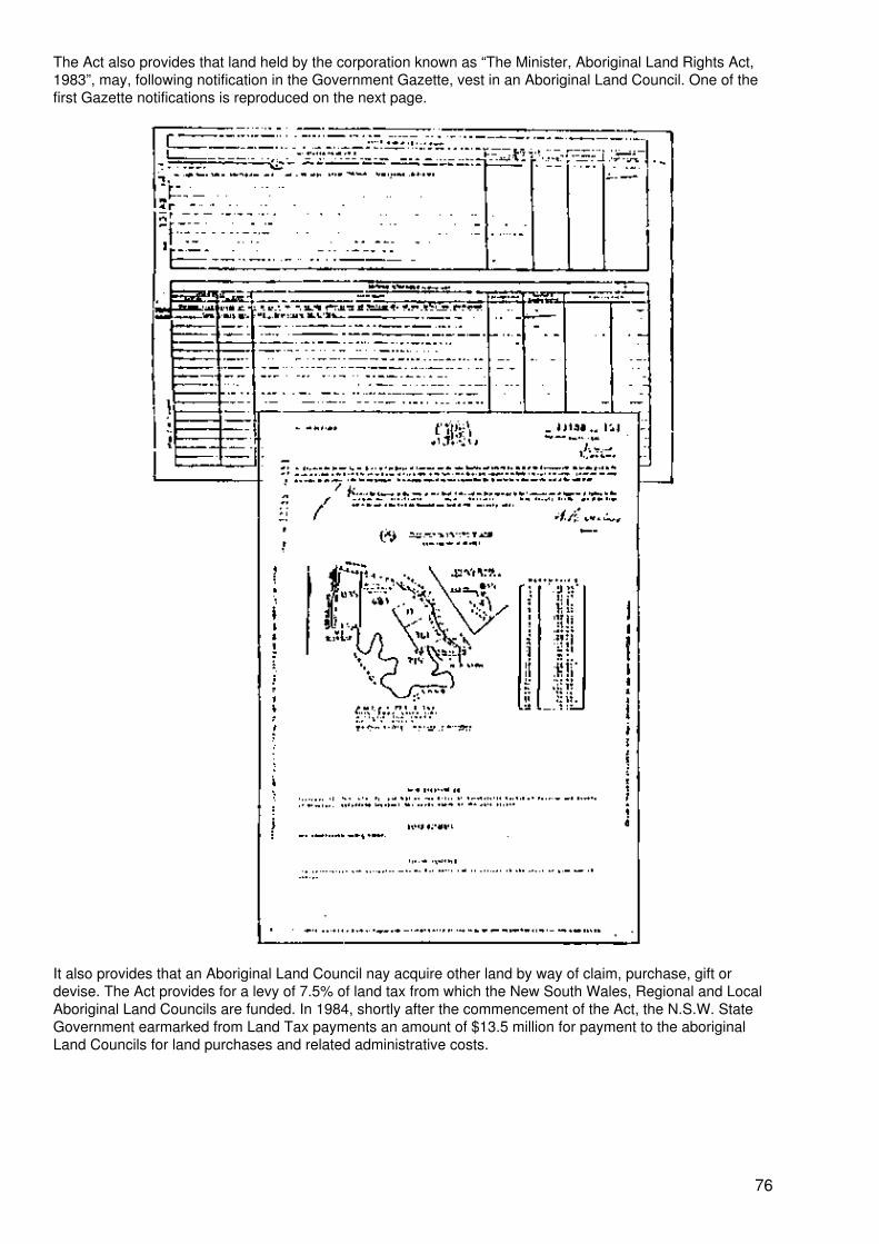
The Act also provides that land held by the corporation known as “The Minister, Aboriginal Land Rights Act,1983”, may, following notification in the Government Gazette, vest in an Aboriginal Land Council. One of thefirst Gazette notifications is reproduced on the next page.
It also provides that an Aboriginal Land Council nay acquire other land by way of claim, purchase, gift ordevise. The Act provides for a levy of 7.5% of land tax from which the New South Wales, Regional and LocalAboriginal Land Councils are funded. In 1984, shortly after the commencement of the Act, the N.S.W. StateGovernment earmarked from Land Tax payments an amount of $13.5 million for payment to the aboriginalLand Councils for land purchases and related administrative costs.
76
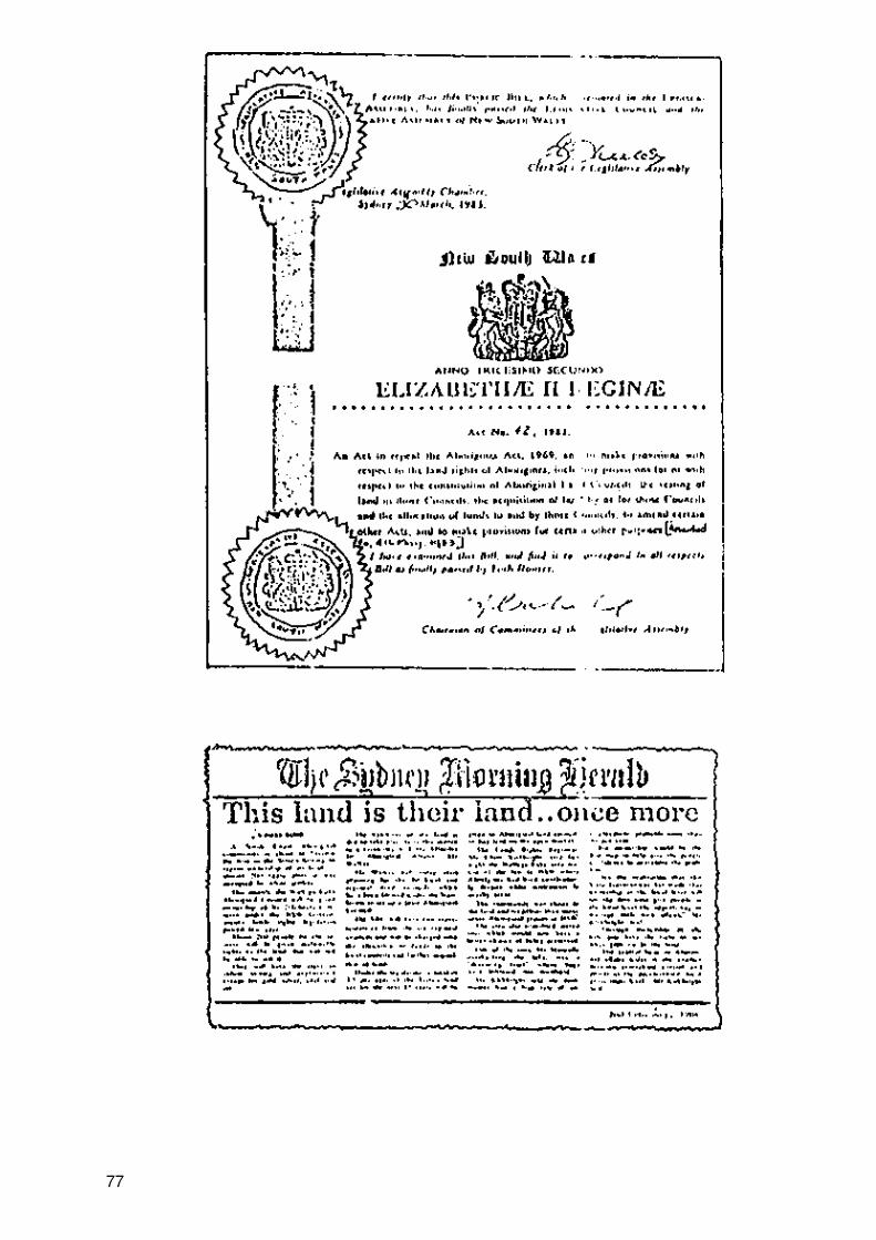
77
V. THE MAPPING AND CHARTING SYSTEMS
This chapter is intended to describe the development of the mapping and charting systems, the problems thatarose and the introduction of Central Mapping Authority cadastral maps as the prime index to the title systemand as a core component of the State Land Information System.
A. The Mapping System
1. Beginning mapping
New South Wales, as a colony, began with nothing but virgin land, no tenures of any kind, customary, tribal orotherwise, no survey control and a system of sporadic isolated surveys of indifferent and variable accuracy.The production of map coverage awaited exploration and settlement and, fortunately, cadastral mapping waslittle needed at first. When mapping became necessary problems emerged, as described in section II.H.
The laying out of Government towns and villages resulted in good administrative maps of these, but parishmaps had to be compiled from the individual isolated surveys within their boundaries, which were determinedlargely by geographical features. After the beginning of primary control in 1869, whenever a survey of a newparish portion was made, it was connected to any available trigonometrical station by hearing and thereby theoverall accuracy of parish maps began to improve and a spatial framework began to develop. Essentiallythough, because of limited primary control, parish maps remained “compiled”, working more “from the part tothe whole” rather than the reverse. Nevertheless, as more and more portions were surveyed and interrelated,the maps became more reliable with each revision and overall they became sufficient for administrativepurposes, able to record grant information, the nature of Crown tenures (of which there were many types), thestatus of each portion, road closure and opening actions and acquisitions by Government authorities forvarious public works, and to indicate vacant Crown land.
Parish maps, town maps and village maps were essentially intended for administration of Crown land and toshow land being disposed of.
2. Mapping freehold land
Initially these maps provided the mapping coverage for the Eastern and Central Divisions of the State. Theremote Western Division is predominantly the subject of Crown leases and is not covered in this study.
With the commencement of the Real Property Act there was a need to record Crown grants and grantreferences (volume and folio) as the commencing point in title searches, and it was convenient to use a copyof the parish, town or village map for the purpose. Granted parcels were edged in green ink. Similarly, primaryapplications were charted by green edging. Thus it was always easy to tell what land was under the RealProperty Act, and the maps became a ready index to the title system as then existing.
Parish maps were drawn to a small scale, mostly 40 chains to 1 inch (1:31680) while town and village mapswere mostly at 4 chains to 1 inch (1:3168).
3. The Pyramid reference map system
Later it was found preferable to introduce extensive large−scale maps where possible rather than the morelimited deposited plans, as this allowed more scope for expansion and reduced the demand for the base mapfor charting purposes. In some cases such large−scale maps could be obtained from local councils orGovernment authorities but the main source was the Valuer General’s Department which compiled them forland valuation purposes and these showed individual land parcels liable to separate valuation. For the mostpart they covered the more extensively developed areas and were drawn to scales of 1 chain to an inch(1:792) −or 2 chains to an inch (1:1584).
Having obtained a large−scale map all prior charting within its limits was transferred thereto and the baseparish map became an index only to the extent that it was covered by the Valuer General’s sheet, butremained the charting map otherwise (see example 2 in figure 16).
Any deposited plan (with five lots or more) was charted on the Valuer General’s sheet and became thecharting plan for its area. If a deposited plan was further subdivided by a later deposited plan, the later one
78
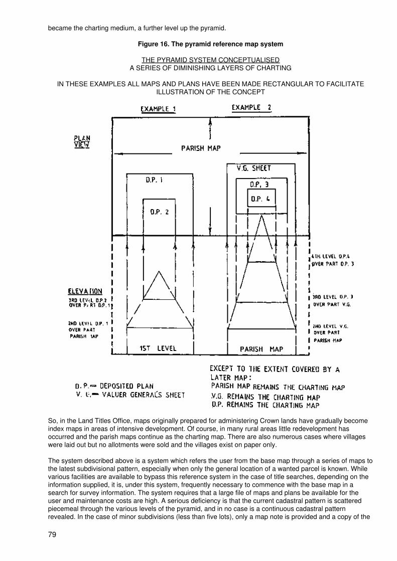
became the charting medium, a further level up the pyramid.
Figure 16. The pyramid reference map system
THE PYRAMID SYSTEM CONCEPTUALISEDA SERIES OF DIMINISHING LAYERS OF CHARTING
IN THESE EXAMPLES ALL MAPS AND PLANS HAVE BEEN MADE RECTANGULAR TO FACILITATEILLUSTRATION OF THE CONCEPT
So, in the Land Titles Office, maps originally prepared for administering Crown lands have gradually becomeindex maps in areas of intensive development. Of course, in many rural areas little redevelopment hasoccurred and the parish maps continue as the charting map. There are also numerous cases where villageswere laid out but no allotments were sold and the villages exist on paper only.
The system described above is a system which refers the user from the base map through a series of maps tothe latest subdivisional pattern, especially when only the general location of a wanted parcel is known. Whilevarious facilities are available to bypass this reference system in the case of title searches, depending on theinformation supplied, it is, under this system, frequently necessary to commence with the base map in asearch for survey information. The system requires that a large file of maps and plans be available for theuser and maintenance costs are high. A serious deficiency is that the current cadastral pattern is scatteredpiecemeal through the various levels of the pyramid, and in no case is a continuous cadastral patternrevealed. In the case of minor subdivisions (less than five lots), only a map note is provided and a copy of the
79
plan must be obtained for the subdivisional pattern and survey information. The system does not of itselfprovide a direct reference to current titles in the manual section of the Register except where an originalCrown grant reference remains current although starting points are provided by the charting system. So,overall the pyramid system must be seen as inefficient.
4. Central Mapping Authority Maps
The Central Mapping Authority was established to centralize the State’s mapping functions and to producemaps for all the needs of Government. It is located at Bathurst, a large regional centre on the western slopesof the Blue Mountains and provides a substantial Government presence in the area, as part of the Departmentof Lands, under the control of the Director of Mapping and Surveyor−General.
Amongst its many products are its urban and rural cadastral maps which constitute a graphic representationof every current land parcel known to the cadastre with a textual overlay and showing a variety of parish,town, village, municipal, grant and primary application boundaries etc. necessary for land−titling andland−information purposes.
CMA maps are prepared by photogrammetry and are in fact maps of the cadastre at single−parcel level; sinceall plans have now been made deposited plans lot numbers and any section numbers appear in distinctivestyle and since these, together with the plan number, constitute the folio identifier for land under the RealProperty Act, they provide also the reference to title directly. In these maps, when the parcel has been found,the title reference has been found.
CMA urban cadastral maps are based on the Integrated Survey Grid (ISG) without regard to natural features,and are prepared to appropriate scales, commonly 1:2000 and 1:4000, although maps at larger scales areproduced as required in areas of intense development. These maps have been introduced to replace thepyramid reference map system and this programme is well advanced. These have been retained becausethey provide an index to CMA maps as well as Crown grant and historical information.
A computer file has been constructed as part of ALTS providing a reference from withdrawn deposited plansto their related CMA map.
CMA rural cadastral 1:25000 maps have had a lower priority since in rural areas the cadastre is relativelystable and in those areas parish maps are more able to meet Land Titles Office needs. Where CMA ruralmaps are in use they are not as comprehensively charted as the urban series and should be used inconjunction with the existing parish maps.
CMA maps are intended to be constantly updated to reflect all subdivision activity and cadastral changes, andso always show the current cadastral pattern. Pending the supply of new updated versions by CMA all newsubdivisions are plotted on the office copy in use. In addition a replacement programme is necessary due tothe wear and tear resulting from public and staff use.
Whereas in the pyramid reference map system it was necessary to work through the various levels of maps toobtain historical and current survey information, in the CMA series historical information is provided bynotation with the suffix (H) − for “historical” − and since all current subdivisions appear on the map, it is theindex to both the title system and survey information.
5. The Graphic Data Base and land information
Important as the CMA mapping system is, it is not now an end in itself. The information it holds, in so far as itrepresents the cadastre, is being constantly translated into digital form as the Graphic Data Base (GDB) −referred to by some as the Digital Cadastral Data Base − as the core element of the State Land InformationSystems (SLIS). This is effected by use of digitizers and digital scanners.
The introduction of further CMA maps in the Land Titles Office has been halted to divert resources into thedevelopment of the GDB as a computer map because of its importance to SLIS.
The information to be held by SLIS includes:
• Property data;• Ownership;• Valuation and sales details;
80
• Zoning;• Plans of subdivision;• Topography;• Census data;• Vegetation and wild−life distribution;• Services (water, sewer, electricity etc).
All these would be in the form of layers of information which could be called up individually over the GDB onterminals connected to the system and as hard−copy output.
In this system all land−title information needed for conveyancing and land development would be in thesystem, tagged to individual land parcels. The system is yet in its early stages but has already begun toproduce significant benefits. The system will not be a single monolithic centralized data−bank but a network ofcompatible locally−based information systems developed by individual local councils and governmentauthorities to meet their own particular needs. It is the role of the State Land Information Council (SLIC) toplan the system and to link and integrate the land−related data systems of these agencies. SLIC is expectedto change its name to State Land Information Systems Agency to reflect its role better.
Although the Graphic Data Base is of prime importance, the integration of property information has proceededin parallel with construction of the GDB and has resulted in increased and more equitable collection of LandTax. The NSW Government has estimated that improved land administration will generate $80 million ofadditional revenue. There will be many other benefits including savings by minimizing duplication of effort andconsequential staff savings.
The GDB and the CMA map coverage is not limited to land under the Real Property Act, but is intended tocover all land, and this fact has implications in two particular areas:
(a) There is still a significant amount of land held under Common Law title for which mappingrecords are poor or non−existent and there is no accurate knowledge of how many parcelsremain. While some ownership, valuation and sales information is held by rating, valuing andtaxing authorities, and is being collected by SLIS, much of it is unrelated to the propertyboundaries component of SLIS represented by the GDB. While development of the GDBdoes not of itself solve this problem, it is at least beginning to identify the gaps in the cadastrewhich represent Common Law title land, and these will become target areas for futuretitle−conversion projects.
(b) There is much Crown Land in NSW, some held under the Real Property Act. Much issubject to leases or locked up in national parks, reserves and State forests and some isunallocated and unmeasured. While generally it is fair to say that the Crown Lands Office iswell aware of all Crown land through its regional lands offices, a programme called the CrownLands Assessment and Status System (CLASS) is operating in conjunction with SLIS and theGDB, which will undoubtedly lead to better administration of the Crown estate and revenuecollection.
It has been said that “the techniques of modern cadastral survey... remain almost always two dimensional,that is height is ignored.” There are exceptions to this in North South Wales:
(a) Strata Titles for units in multi−level buildings and single−storey villas, the lots being limitedin height and depth.
(b) Deposited plans showing parcels limited in height and/or depth by regular horizontal orinclined planes.
In addition to these it is sometimes necessary to issue titles for veins or strata of minerals below the surface.
Each of the above pose some difficulty in mapping and the GDB because the parcels created do notcorrespond with the surface cadastral framework. In the current state of development of the GDB, thesesituations can only be handled by a note, and the same applies to the mapping system. It is proposed,however, to make provision for height to be taken into account in the GDB; the author has been advised thatthe problem is the complex software required to align the alphanumeric data with the graphic data.
81
B. The charting system
For the purposes of this study “charting” is defined as the procedures in the Land Titles Office by whichland−related information affecting land titles is placed on public record and made usable by personsinterested in that information.
1. Charting of Real Property Act boundaries
Probably the earliest form of charting was the recording of Crown grants and primary applications. Thischarting provided the starting point for searching title to land under the Real Property Act, and continues to thepresent with modifications necessary as a result of:
(a) The cessation of Crown grants and the creation of folios of the Register for some Crownland;
(b) The introduction of CMA maps.
As to (a), the creation of folios now follows the registration of deposited plans which take their place in CMAmaps and the GDB and in those maps the affected lands are shown by the standard “stippling” as being underthe Real Property Act.
As to (b), no coloured ink or other colour is used for boundaries. Any other charting is, however, effected byred−ink note until incorporation in the next edition of the map. This includes deposited plans lodged withprimary applications.
2. Charting of deposited plans
Shortly after the commencement of the Real Property Act the first deposited plans of subdivisions werelodged, followed by transfers of individual lots therein. The practice was instituted of charting such transferson the office copy of the plan within the lot affected. This enabled a searcher to identify the transfer of aparticular lot in the plan and either:
(a) Inspect the related registration endorsement in the affected folio of the Register and therelated cancellation notation indicating the new title issued which could then be inspected. If itremained current it would be the title sought, but if it had been cancelled by later issue of atitle, a searcher would work forward through the Register to the current reference; or
(b) Inspect the particular transfer and note the new reference to title sometimes recorded onthe back and then work forward through the Register as in (a). There has not been, howevera consistent practice of noting reference to titles on the back of transfers.
By these means a searcher could find current references to title by working through the Register andregistered dealings. It will be noted that in those days references to title were not stabilized, fresh volume andfolio references being allocated whenever a title was replaced.
Charting on office copies of deposited plans was further developed, along with development of the pyramidreference map system, to include the origins of the Real Property Act title, i.e., particulars of the grant, theCrown grant reference if any, any grant reservations, the primary application if any, the current title reference,any exceptions of minerals, any restrictive covenants etc, by a prominent note on the plan in the form:
APPN 321 PT POR 49 GT TO THOMAS HOLT 31/12/1862 0 VOL 6243 FOL 59 −Exceptionof minerals D369431 − Covenant in D369431 (0 indicates no grant reservations).
This information served two purposes:
(a) It provided members of the public and staff with basic information needed for titlesearching,
(b) It provided basic information for staff preparing new certificates of title for individual lots inthe subdivision when transferred.
82
If the subdivision included land in more than one grant, or in more than one certificate of title, then the grantboundaries and the certificate of title boundaries would be plotted on the face of the plan by red or blue linesrespectively.
The systems described allowed searchers to work back to the original grant or primary application, ifnecessary, or forward to find the current reference to title. However, location of the current title by thosemeans was seen as too indirect and cumbersome, and the practice was instituted of noting new titlereferences for individual lots by a schedule on the face of the plan, and this was a big step forward. However,a far better procedure, in conjunction with the mass production of new certificates of title, was the introductionof the Land Index.
3. The Land Index
This is a computer−produced index originally generated from “punch instructions” given at the time of foliocreation by mass production and listing sequentially every deposited plan, its lots and their title references(see figure 17). This index has been extremely successful in simplifying title searching. It provided the titlereference for every certificate of title mass produced from plans of subdivision as described in section IV.C.1(b), and eliminated the need to work through the Register to ascertain title references.
The Land Index has since been extended to include references to title for all lots in deposited plans registeredprior to mass production of titles (1961) and for portions in parishes and allotments in towns and villages. Thiswas achieved by mass examination of the bound section of the Register; this programme did not includecomplex, partially cancelled titles, and these remain a small but difficult group of titles yet to be converted toALTS and difficult to search.
The Land Index and its extension were kept updated until the commencement of ALTS, which now, becausethe land identifier is the folio identifier and therefore the title reference, bypasses the Land Index which is nowuseful only for titles not converted to ALTS. Although the Land Index has lost much of its purpose because ofALTS, it has been a most useful aid to title−searching. Even so, the adoption of lot/plan identities as folioidentifiers, and therefore the title reference, is by far the better option, whether the title system is manual orcomputerised.
4. Charting of resumptions
Resumptions of land or easements by Government and statutory authorities are compulsory acquisitionsunder the reserved and paramount rights of the state supported by statutes. As a matter of politics, authoritiesprefer to acquire land by private treaty, and resumption tends to be used as a last resort. Resumptions,therefore, are not usually made without the foreknowledge of registered proprietors. They are notified in theNew South Wales Government Gazette published weekly and the Commonwealth Gazette and take effect atlaw immediately without being recorded in the Register. The Registrar General therefore cannot register adealing with land if it is affected by a resumption. Accordingly his officers regularly peruse the Gazette and:
(a) Chart all resumptions of land on the relevant charting map, by note;
(b) Enter a notation in every affected folio of the Register in respect of resumptions of land oreasements. This notation is informative only and is not a recording in the Register. Theresuming authority is required by the Conveyancing Act to lodge a “resumption application”forthwith this being in effect a request to the Registrar General to record the resumingauthority as registered proprietor. The Registrar General has a general power to act on theauthority of the Gazette notification alone, but has not yet used that power as a generalpractice. Unfortunately there are often long delays in lodging resumption applications.
5. Charting of easements
Easements, whether created by resumption or otherwise, are not normally charted on maps and are recordedonly in the Register and certificates of title. However, exceptions are made in the case of major works such asgas and petroleum pipelines (under the Pipelines Act) and electricity supply grid transmission lines crossingprivate land, since being major works generally known to the public, they are useful in parcel location andmapping, and in some cases are identifiable in aerial photographs.
83
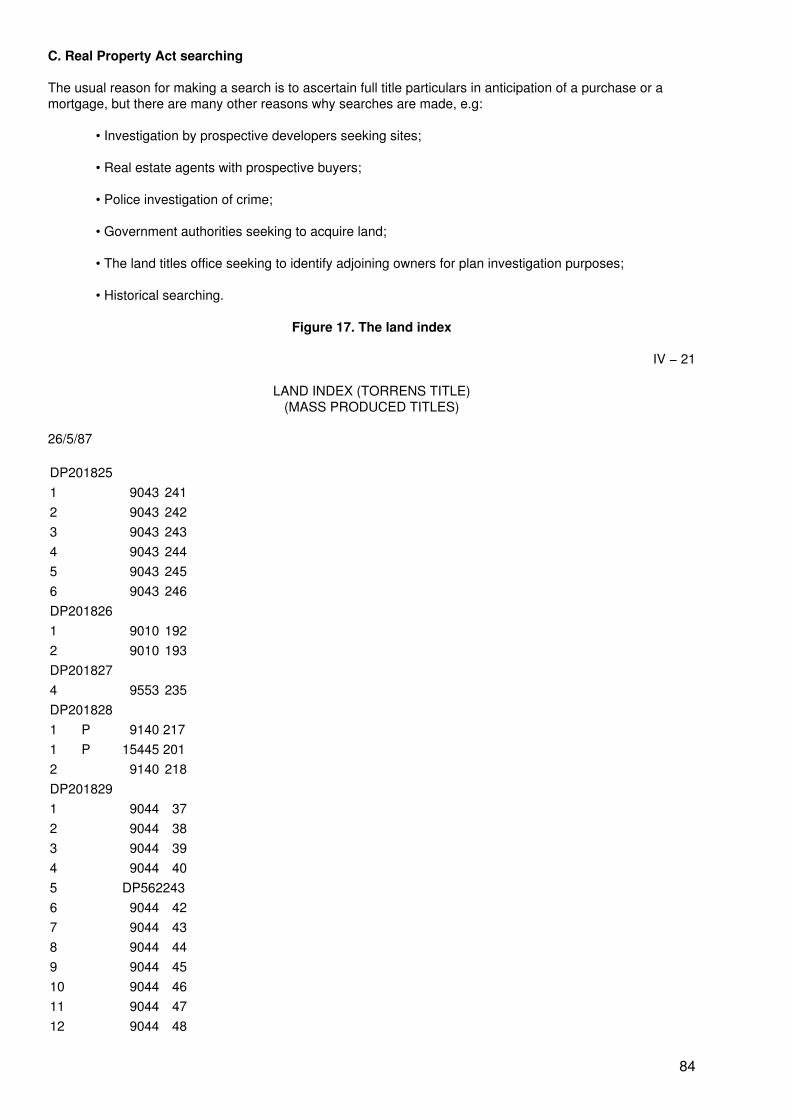
C. Real Property Act searching
The usual reason for making a search is to ascertain full title particulars in anticipation of a purchase or amortgage, but there are many other reasons why searches are made, e.g:
• Investigation by prospective developers seeking sites;
• Real estate agents with prospective buyers;
• Police investigation of crime;
• Government authorities seeking to acquire land;
• The land titles office seeking to identify adjoining owners for plan investigation purposes;
• Historical searching.
Figure 17. The land index
IV − 21
LAND INDEX (TORRENS TITLE)(MASS PRODUCED TITLES)
26/5/87
DP2018251 9043 2412 9043 2423 9043 2434 9043 2445 9043 2456 9043 246DP2018261 9010 1922 9010 193DP2018274 9553 235DP2018281 P 9140 2171 P 15445 2012 9140 218DP2018291 9044 372 9044 383 9044 394 9044 405 DP5622436 9044 427 9044 438 9044 449 9044 4510 9044 4611 9044 4712 9044 48
84
13 9044 4914 9044 5015 9044 5116 9044 5217 9044 5318 9044 5419 9044 55DP2018311 9016 1342 DP262656DP2018321 9630 159DP201833620 9561 184621 9561 185622 9561 186623 9561 187624 9561 188625 9561 189626 9561 190627 9561 191628 9561 192629 9561 193630 9561 194631 9561 195632 9561 196633 9561 197634 9561 198635 9561 199636 9561 200637 9561 201638 9561 202648 9561 203649 9561 204650 9561 205651 9561 206652 9561 207660 9561 208661 9561 209662 9561 210663 9561 211664 9561 212670 9561 213671 9561 214672 9561 215673 9561 216674 9561 217675 9561 218676 9561 219677 9561 220
85
678 9561 221679 9561 222680 9561 223681 9561 224682 9561 225683 9561 226684 9561 227685 9561 228686 9561 229687 9561 230688 9561 231689 9561 232690 9561 233691 9561 234692 9561 235693 9561 236694 9561 237695 9561 238696 9561 239697 9561 240698 9561 241699 9561 242700 9561 243701 9561 244702 9561 245703 9561 246704 9561 247705 9561 248706 9561 249707 9561 250DP2018351 9092 302 9092 313 9092 304 9092 31DP2018361 9222 12 9222 23 9222 34 9222 45 9222 56 9222 67 9222 78 9222 89 9222 910 9222 1011 9222 1112 9222 1213 9222 1314 9222 14
86
15 9222 1516 9222 1617 9222 1718 9222 1819 9222 1920 9222 2021 9222 2122 9222 2223 9222 2324 9222 2425 9222 2526 9222 2627 9222 2728 9222 2829 9222 2930 9222 3031 9222 3132 9222 3233 9222 3334 9222 3435 9222 3536 9222 3637 9222 3738 9222 3839 9222 3940 9222 4041 9222 4142 9222 4243 9222 4344 9222 4445 9222 4546 9222 4647 9222 4748 9222 4849 9222 4950 9222 5051 9222 5152 9222 5253 9222 5354 9222 5455 9222 5556 9222 5657 9222 5758 9222 5868 9222 5969 9222 6070 9222 6171 9222 6272 9222 6373 9222 64
87
74 9222 6575 9222 6676 9222 6777 9222 6878 9222 6979 9222 7080 9222 7181 9222 7282 9222 7383 9222 7484 9222 7585 9222 7686 9222 7787 9222 7888 9222 7989 9222 8090 9222 8191 9222 8292 9222 8393 9222 8494 9222 8595 9222 8696 9222 8797 9222 8898 9222 8999 9222 90100 9222 91101 9222 92102 9222 93103 9222 94104 9222 95105 9222 96106 9222 97107 9222 98108 9222 99109 9222 100110 9222 101111 9222 102112 9222 103113 9222 104114 9222 105115 9222 106116 9222 107117 9222 108118 9222 109119 9222 110120 9222 111121 9222 112122 9222 113123 9222 114
88
124 9222 115125 9222 116126 9222 117127 9222 118128 9222 119129 9222 120130 9222 121131 9222 122132 9222 123133 9222 124134 9222 125135 9222 126136 9222 127137 9222 128138 9222 129DP20183823 9003 21124 9003 21225 9003 21326 9003 214DP2018401 9678 78DP2018421 DP2172531 R 9162 229DP2018431 P DP2026601 P DP2047691 P DP2122561 R 9116 63DP2018441 9661 182 9661 193 9661 22DP2018451 DP602518DP2018461 9014 1292 9014 130DP2018481 DP7073392 DP707339DP2018491 9430 200DP2018501 9120 322 9120 333 9120 341 9120 35DP201851
89
A 14826 111B 10926 245DP2018524 9406 905 14374 246DP2018531 9027 1132 9027 1143 9027 1154 9027 116DP2018541 9015 2392 DP243704DP2018561 9002 1622 9002 1623 9002 164DP2018581 9001 2242 9001 225DP2018601 DP5555731 R 9033 1912 DP2275823 DP227582DP2018611 9012 42 9012 53 9012 64 9012 75 9012 86 9012 97 9012 108 9012 119 9012 1210 9012 1311 9012 1412 9012 1513 9012 1614 9012 1715 9012 18P − (...)% − (...)R − (...)CP − Common PropertyA − (...)SP − Strata PlanDP − Deposited PlanSearching procedures have changed a great deal from 1863 to the present, the changes resulting from publicneed, the changes in the format of the Register, changes in mapping and charting, changes in the plan
90
system, and, most significantly, the adoption of land identifiers as folio identifiers.
Searches on behalf of purchasers and mortgagees normally are required to identify and obtain the following:
• A copy of the current folio of the Register showing the registered proprietor and allencumbrances;
• A copy of the plan of the land in the title;
• Copies of instruments creating any restrictions on the use of land, positive covenants andeasements including any instrument lodged with a plan;
• Details of any reservations in the Crown grant, any conditions imposed by the Crown andany exceptions or reservations of minerals;
• Copies of any caveat or writ.
Normally on purchase any mortgage is discharged and detailed information about that mortgage is notrequired. However, if a purchaser is taking title subject to the existing mortgage a copy should be obtained.
1. The period 1863 to 1961
This is the period when all Register folios were in bound form. For this period, searches could only made byusing the mapping and charting system and by working through the Register and registered dealings, unlessthe current reference to title was supplied. The nature of the search depended on the information provided.
In the case of searching where reference to title supplied all that was needed was to confirm the currency ofthe title and, where possible, check the name of the registered proprietor and locality, if known, and thenextract by hand from the Register folio the required particulars including reservations, conditions andexceptions, in effect making a precis of the title and sketching the title diagram. It was then necessary toidentify all the encumbrances, restrictions and easements notified on the title, inspect the dealings thatcreated them and make a precis or abstract of the details. It was also necessary to check for notes on theRegister relating to any unregistered dealings, caveats, writs and gazetted resumptions. In this periodphotocopying was generally unavailable, and the search was entirely a manual procedure. It will beappreciated that care had to be taken as transcription errors could be made.
Where only the land description was supplied it was necessary to use the mapping and charting system tofind the title reference.
2. The period 1961 to 1983
This was the period of the loose filed, mass−produced new form folios and searching became very mucheasier. From 1961 all plans lodged were registered as deposited plans and titles were mass−producedfollowing plan registration instead of one by one when transferred (as in the previous period). The aids tosearching introduced in this period were:
• Loose filing of the Register eliminated competition for bound records;
• The Land Index was introduced, listing all new references to title.
• Almost all new titles were for the whole of a lot;
• Title references were stabilized; if a title had to be replaced a new edition with the samereference was issued;
• Schedule style typed endorsements meant titles could carry more dealings before the titlewas full;
• Photocopying of records was introduced.
Also in this period the Land Index was extended to cover the bound Register also, and this greatly simplifiedsearching in that area as well.
91
The Land Index and its extension are discussed in section V.B.3 and their benefits in simplifying searchingcannot be overstated.
In the case of searching where reference to title supplied, all that was needed was to order a photocopy of thetitle and of any dealings creating encumbrances, restrictions and easements notified on it. It was alsonecessary to check for notes on the Register relating to any unregistered dealings, caveats, writs andgazetted resumptions. After 1971 the dealings lodgment record should be inspected for dealings lodged in theprevious 20 business days.
In the case of searching where land description supplied, the first step was to check the Land Index toascertain the title reference, and most current titles are listed in the main index (plans lodged after 1961) orthe extension index.
3. The period 1983 to the present
This is the period of the automated Register, now comprising about 75 per cent of the total Register.Consequently very little searching of hound and loose folios of the Register is now necessary. Titles for singlelots in deposited plans and single parish portions and town or village allotments have been converted to theautomated system and basically only titles for parts of lots for which no plans are available, groups of lots,portions and allotments, partially canceled titles, complex residues and titles for minerals remain in the manualsystem.
Factors affecting searching in the automated system are:
• The adoption of the land identifier as the folio identifier;
• Dominance of CMA reference maps which have supplanted the Land Index;
• The Register, being computerized, can only be inspected by way of print out as a computerfolio search, a historical search or a final search, all certified by the Registrar General wherethe search was applied for at the Land Titles Office;
• Availability of remote searching by on−line terminals in Client’s Offices.
Since in this system the land identifier is the folio reference, making a search is simply ordering a computerfolio search, and if needed a historical or final search, or if a remote terminal is used, simply keying in the folioidentifier and the type of search required. Billing for these is automated within the system. At this stage theRegistrar General’s certification, being pre−printed on accountable official stationery, cannot be provided onsearches made on remote terminals. A computer folio Search includes under “Notations” unregistereddealings or plans and gazetted resumption, if any.
By separate action, a copy should be ordered of the dealing creating any encumbrance, restriction oreasement notified in the folio. Further, since no computer folio carries a title diagram, a copy of the relevantplan (referred to in the folio as the title diagram) must be ordered. All registered dealings and plans are nowavailable only on microfilm, except strata plans, which are now held on optical disk.
4. Searching where only the location of land is known
Generally speaking, if only the location of the land is known it has always been necessary to use the mappingsystem to identify the land and then work through the charting system and bound Register folios to find thetitle reference, and this sort of searching has been rather difficult. Fortunately, it is not normally part ofconveyancing practice and could be classified as “research” rather than “search”. It is used more by historicalresearchers and investigative searchers than by conveyancing practitioners who nearly always start with agiven title reference and a land description. The title system does not record street or property addresses, andbeing parcel−based can usually be accessed only from the land description or the title reference.
However, some help is now at hand! First the CMA reference map system is far more direct than thepyramidal system and moreover shows every current parcel. Secondly, many parcels may now be identifiedby their street addresses through microfiche copies of the Valuer General’s valuation records, several copiesof which are available in the Land Titles Office. These are listed under first the municipal area name, thenunder the street name (alphabetically) and finally the house number, and they provide the owners’ name anda land description. For the Sydney Metropolitan Area a similar set of records prepared by the Sydney Water
92
Board is available for public use.
5. The Purchasers Index
This index applies only to Real Property Act land and is not to be confused with the Purchasers Index forCommon Law title land. The Real Property Act Purchasers Index began in 1863 and has continued withoutinterruption to date. It was compiled in book form until 1971 and has since been kept on microfiche. From1983 a computer data−base has been maintained allowing regular consolidated output, still presented onmicrofiche. Searches may be made against a given name, and the data is collected from dealings immediatelyafter lodgement, being:
• The person becoming registered as proprietor;• Locality of the land;• The reference to title;• The dealing number.
This Index is used in searching when only a name is known, and it helps to know the approximate date ofpurchase. Searches may be made either backwards or forwards from a given year, and from this record a listcould be compiled of all properties acquired by a particular person or company for any given period, or the titleto a particular property purchased in a given year could be ascertained.
The Purchasers Index has a very limited role in ordinary conveyancing but is very useful for special purposeand investigative searching.
6. The reference map indexes
As indicated earlier, the base maps, parish, town and village maps, are used as an index to large−scalereference maps and charting maps which cover or partly cover them. However, this is not satisfactory in areasof intense development and much more direct indexes to the reference map are needed. To this end standardstreet directories are in use as indexes in the following areas:
• Sydney, Newcastle and Wollongong;• The Central Coast;• The Blue Mountains;• Major country towns.
Reference map boundaries are superimposed on the face of these. An example of a search using part of theSydney Street Directory (Gregory’s) is as follows. The property to be searched is at the corner of MiddletonRoad and Miller Road, Villawood. The street index in the directory gives a map reference of B9 on Map 49and that map through the overlaid Key G refers to CMA Map U9145−34. On that map the property is shownas lot 124 in deposited plan 35844, which means that the folio identifier is 124/35844. A copy of that title isincluded as a computer folio search.
7. Other searching aids
Other searching aids comprise indexes as follows:
• The dealings Lodgement Record, applicable to the small part of the manual Register notconverted to ALTS;
• Parish, town and village/deposited plan, cross reference indexes listing the DP numbersallocated to parishes, towns and villages;
• The Plan Cross Reference Index;
• The volume and folio to ALTS index, a computer file in ALTS which records whether acomputer folio has been created for the land in a manual title (Volume and Folio) even thoughthe manual certificate of title is still “in circulation”.
• The CMA/DP index, which provides the CMA map number for charted deposited planstransferred to a CMA map and withdrawn.
93
8. Checking the charting map
Although one suspects it is not always done, it is prudent to inspect the relevant charting map in every search.This could reveal a matter, such as an unregistered subdivision or a resumption not yet noted in the Register,or perhaps a matter of interest affecting adjoining land, e.g., resumption for public housing, a telephoneexchange or transmission line which might influence the desirability of a transaction.
9. Supplying a copy of the plan
A copy of the title diagram should be supplied with every search. In the case of a manual folio the title diagramendorsed on the title may suffice and the photocopy of the title will provide this automatically. In the case of amass−produced loose−filed folio the title diagram is usually a copy of the relevant sheet of the plan and actsas a plan showing the detailed location of the land and is usually extensive. However, there is always thepossibility that the Registrar General may have amended the plan pursuant to his specific powers to correcterrors and so it is prudent to obtain a fresh copy of the plan in every case.
In the case of an ALTS folio, a copy of the plan must be obtained in every case, since there is no diagram ofany kind on the title document.
10. Final search
It is necessary to make a final search immediately before settlement of a transfer or other dealing to ensurethat no new matters since the first search are missed. This consists of obtaining a fresh copy of the title in thecase of a manual folio or an official final search in the case of a computer folio. Such an official final searchcovers the period of three months prior to the date of the search and shows all unregistered dealings andplans and all transactions in that time that have caused changes in the Register folio.
In addition the caveat card file should be checked for any caveats lodged that day, and for mannual folios theDealings Lodgement Record should be checked for recently lodged dealings that have not yet been noted inthe Register.
11. Copy Services
Copy services of various types are provided at all appropriate locations:
• Conventional photocopiers are provided to make copies of registered deeds and of thevarious deeds indexes;
• The Document Copy Service provides from microfilm reader/printers copies of registereddealings and cancelled or converted (to ALTS) loose filed folios of the Register. It alsoprovides computer folio Searches and final searches from ALTS);
• A conventional photocopier provides copies of current loose−filed folios of the Register;
• A large format photocopier provides copies of bound Register folios (19 1/2” x 13 1/2”);
• Copies of plans are provided at the Plan Copy Service from microfilm by way of Quantimatichigh−speed aperture card (35 mm) printers (up to 600 prints per hour) up to A2 size and also16 mm microfilm reader/printers. Tenders are being evaluated for conversion of the 35 mmaperture card file to optical disk storage/retrieval;
• Copies of strata plans previously held on microfilm are now provided by high−tech opticaldisk equipment.
Copies are paid for by means of tickets purchased from a cashier, singly or in books, at a cost of $3 perdocument.
Aside from computer searches, the output of all the above services and of the many “convenience” copiersservicing staff requirements totals upwards of 25,000 copies daily. The number of copies ordered daily by thepublic has been found to be a very good barometer of lodgements to come in the following weeks, and thusprovides valuable management information, reflecting the current state of the real−estate market.
94
VI. THE CADASTRE
The general view of the cadastre in the Land Titles Office seems to closely correspond to a description of acadastral system − which might be summarized as: (a) a register or record of parcels, their owners and rightsin, and values of, those parcels; and (b) the description of the parcels. The title system corresponded with (a),except that land values were not a function of the Land Titles Office, and therefore not perceived as part of thecadastre, and (b) corresponded with the related system of surveys.
Land values were not ignored however, and there has been an awareness of the importance of land valuationfostered by:
• The use of Valuer General’s maps as reference maps;
• The use of Valuer General’s records on microfiche as a searching aid;
• The regular supply of cadastral information to the Valuer General in the form of copies ofnewly registered deposited plans and strata plans;
• The role of land valuation in the fixing of rates, land tax and compensation payable uponcompulsory acquisition (resumption).
Thus, in the writer’s opinion, the view of the cadastre held in the Land Titles Office has, in the past, been toonarrow, and the expression “completing the cadastre” as applied to the elimination of the Common Law titlesystem by compulsory conversion to the Real Property Act reflects that narrow view.
In recent years however, a much wider view of the cadastre has emerged, due to:
• The use of CMA maps as the mapping base;• The development of the Graphic Data Base;• The growing emphasis on land−information management;• The work of the State Land Information Council.
This is part of the cadastral reform process taking place in Australia and New Zealand.
An editorial appearing in The Australian Surveyor in 1970 presented a view of the cadastre which is well worthconsideration and which is more in line with current thinking and rather in harmony with the longer−termstrategies advocated for the issue. The editorial defined a cadastre as:
“a fivefold operation, wholly integrated in its parts: firstly, the definition of parcels of lands;secondly, the statement of title, tenure, privileges and responsibilities; thirdly, the record ofland uses; fourthly, the valuation of parcels; and fifthly, some aspects of the propermanagement of the whole as a policy originating in the residual control vested in the state.”
The editorial took the view that there were no cadastres operating as such in Australia. In particular it statedthat the combination of the Torrens Title system and Australia’s boundary surveys did not constitute acadastre, primarily because no “total map” was produced in any of the Australian systems.
However, the current corporate objectives of the Department of Lands and the Land Titles Office for thedevelopment of the State Land Information System incorporating the Graphic Data Base (the “total map”)referable to the plan file, with title aspects (by reference to the Automated Land Titles System) and layersdealing with valuations and sales data, zoning, geophysical matters such as topography, vegetation, wild−lifedistribution, services and census data will result in the creation of a true working cadastre consisting ofseveral separate but interdependent and interactive parts, fully integrated.
It remains a corporate objective of the Land Titles Office to complete the task of eliminating the residualCommon Law title system by identifying all remaining parcels and converting them to the Real Property Act,and to bring all land in the State under that Act. When that is done, all parcels are correctly fitted into thespatial framework and the Graphic Data Base is fully operational and fully maintained, then the “total map” willexist but it will not be, of itself, the cadastre. Only when all the “fivefold operations” are in place will theconcept suggested in The Australian Surveyor have been achieved.
95
All the Australian States and Territories and New Zealand are now working along similar lines in respect ofland information systems, along with the Commonwealth Government and the Australian Defence Force.
A. Title conversion procedures
1. General
In this chapter “title conversion” means conversion of land from the Common Law system of title to the RealProperty Act System, and does not include conversion from Crown land, whether by the issue of Crown grantsor by conversion of Crown tenures; such tenures are outside the scope of this study.
The first certificate of title issued under the Real Property Act (volume 1, folio 1 − see figure 18) was aconversion from Common Law title of land granted by the Crown three days before that Act commenced, andthe conversion was by way of a “primary application”. The staffing provisions for the commencement of theAct emphasised title conversion, and there has never been a time when title conversion has not beencontinued. There have been times of trouble, but in general there was little change in title conversionprocedures in the first 100 years, and in that time the emphasis shifted gradually towards the processing ofdealings with, and subdivisions of, land already under the Act as a result of the large numbers of Crowngrants and the small number of primary applications. Little was done in that time to streamline the processingof primary applications, then the only means of title conversion.
However change began to come in the 1960s, as interest in cadastral reform gathered momentum, and it wasseen that not only should processing of primary applications be streamlined but other strategies and methodsof title conversion were needed, since it was obvious that the Common Law system could never be liquidatedby voluntary primary applications alone. Moreover, the further proliferation of Common Law title parcels bysubdivision should be halted.
Part 4 of the Real Property Act deals with voluntary primary applications, which produce what are now called“ordinary” certificates of title. The first steps towards accelerating title conversion by compulsory process atthe discretion of the Registrar General were taken in 1967 with the introduction of Part 4A of the Act, providingfor the creation of “qualified” folios of the Register, that is, folios qualified as to the legal incidents of title.
The provisions of Part 4A for qualified titles were satisfactory for the 48,000 parcels which were adequatelydefined by survey or which were created in new subdivisions, and issue of qualified titles continued as before.However as the pool of suitably defined parcels began to dry up, and the 1967 legislation was not being used,a further review of title conversion was undertaken resulting in the 1984 provisions for the issue of “limited”titles, referred to in the 1975 report as folios qualified as to the survey incidents of title.
The 1975 review emphasised that qualifications and limitations on title should not remain indefinitely andadequate provision should be made for their removal. In the interests of maintaining the value and repute ofthe Real Property Act system, “qualified” and “limited” titles should become “ordinary” as soon as possible.
At the same time it had to be kept in mind that resources were limited and always depended on governmentbudgetary priorities. Although title conversion was government policy, it had to suffer constraints whennecessary in favour of the essential registration activities of the Titles Office. Consequently any strategies forcompulsory conversion had to be such that conversion remained at the discretion of the Registrar General, sothat work intake could be regulated or turned off, when resources were limited or unavailable.
Moreover, it was recognized that the further you go down the title conversion road, the harder it gets.Eventually you must get to the stage where the work will not come to you − you must go out and find it. Thedevelopment of the Graphic Data Base is beginning to identify target areas for new title conversion activities.
In a new initiative, the Registrar General has announced that consideration will be given to the creation of“non−qualified” folios of the Register based on a satisfactory official search.
96

B. Primary Applications
A primary application is by definition an application to bring under the provisions of the Real Property Act landthat is not subject to those provisions.
There are two types of applications commonly referred to as, and charted as, primary applications. The first isthat in which a person qualified to apply lodges an application under Section 14 for the issue of an ordinarycertificate of title in his name or in the name of a nominee. The second class of application, while being strictlyby definition a primary application, is more correctly a “resumption application” and is made under Section31A by a Government or statutory authority following a compulsory acquisition notified in the GovernmentGazette (State or Commonwealth).
97
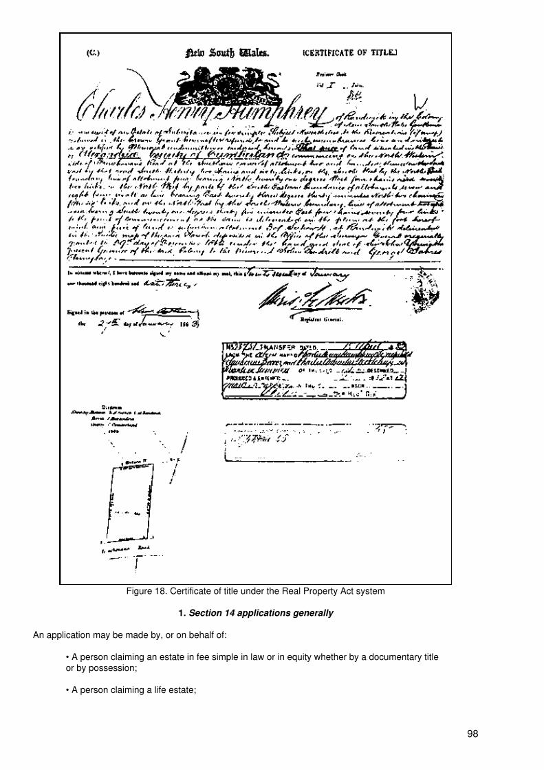
Figure 18. Certificate of title under the Real Property Act system
1. Section 14 applications generally
An application may be made by, or on behalf of:
• A person claiming an estate in fee simple in law or in equity whether by a documentary titleor by possession;
• A person claiming a life estate;
98
• A person claiming an estate in fee simple in remainder expectant upon the determination ofa life estate;
• A person claiming a leasehold estate with not less than 25 years to run;
• A person claiming the reversion in such a lease;
• A person who has contracted to purchase land, provided the vendor consents and thepurchase price has been paid in full;
• A mortgagee, provided the mortgagor consents or is shown to he in default;
• A person having the power to appoint an estate or interest described above, provided heobtains the consent of any other person required under the power and directs the object ofthe power to be named as the proprietor.
However an application may NOT be made:
• By a mortgagor unless the mortgagee consents;
• Where the land is affected by a covenant charge unless the covenant chargee consents;
• By an execution debtor named in a writ registered in the Register of Causes, Writs andOrder (see section III.I) unless the execution creditor consents;
• By a person claiming a share or interest in land unless the person(s) claiming the othershare(s) or any other interest in the land joins in the application, so that the application relatesto the entirety; or
• For an easement or profit a prendre alone.
The application must be made in the approved form which clearly specifies all the requirements, and must bemade by a natural person (as distinct from a corporation).
From the outset in 1863 a plan of survey has been required for a primary application. The type and standardof such surveys varied until current standards were determined by the Survey Practice Regulations introducedin 1933, from which time most applications have been supported by a fresh survey. However the RegistrarGeneral has been prepared to modify his requirements for survey in an endeavour to reduce the cost ofprimary applications and departmental processing in some circumstances.
2. Investigation of Section 14 applications
The investigation of s.14 applications is in two inter−related parts, being (a) the title and (b) the survey.
As regards (a), the documentary title chain was, for the first 100 years or so, fully examined from the currentdeed right back to the Crown grant. To enable this to be done a complete title search was made, based on theabstract supplied by the applicant. The search clerk identified in the search any deeds disclosed by the searchwhich could affect the title in addition to those which clearly did affect it. Where the search disclosed theexistence of a subdivision, a conveyance of a lot therein made before the conveyance of the land comprisedin the application was included in the search, and such deeds were noted later on the relevant charting map.These deed references became useful in processing later primary applications for other lots in thatsubdivision. If the primary application succeeded, the title of the subdivider so disclosed became an “acceptedtitle” for processing applications for other lots in that subdivision. The searches made over the years wereretained and bound in search books, providing a bank of search information which was very valuable inprocessing later primary applications.
To enable the Examiner of Titles to consider the chain of title (and the search) in detail, a survey draftingofficer worked through the search, eliminating any “not affecting” deeds and sketching the affecting deeds,that is, presenting the metes and bounds descriptions in diagrammatic form. By using different coloured inkssubdivisional patterns were disclosed, re−descriptions of boundaries were compared with prior descriptionsand individual links in the chain of title were illustrated.
99
By these means comprehensive “search sketches” accompanied by particulars of the chain of title, werecompiled, and these, in conjunction with search books (see previous paragraph), provided valuableinformation for future primary applications and starting points for other searches as well as summarizing therelevant information for the assistance of the Examiner of Titles. An example of a search sketch is provided asfigure 19.
As regards (b), the survey − the survey drafting officer considered the search in conjunction with the surveysupplied, investigated the survey and the definition of boundaries therein and prepared a report for the benefitof the Examiner of Titles which:
• Indicated whether or not the land in the application as shown in the survey was included inthe applicant’s deeds;
• Drew attention to any land in the plan outside the occupations disclosed (walls, fences etc);
• Indicated whether the application included land outside the applicant’s deeds but within theoccupied boundaries, being land which might be the subject of a claim by possession;
• Identified any easements, covenants or exceptions of minerals etc disclosed by the search,and whether any such easements were correctly shownin the plan;
• Reported generally on the survey, the ages of fences and walls etc and any surveyrequisitions raised;
• Stated whether the land in the application comprised part of a title accepted in a previousapplication;
• and reported generally on matters relevant to the application.
When the survey drafting officer had completed his report, it was considered by an Examiner of Titles alongwith the search and the application. If necessary the officer forwarded “qualifications” to the applicant andwhen these were satisfied he passed the application subject to:
• Any caveat lodged to dispute the application;
• Any notice served upon any adjoining owner or other person;
• Review by the Land Titles Commissioners (later referred to as the Board);
• Any advertisement directed by the Commissioners;
and directed the form and detail of the title to issue including the particulars of easements, covenants andexceptions and any special notifications to be entered.
The 1863 Act provided that where the applicant was not the original grantee from the Crown, transactionsaffecting the land had been registered, and the applicant had not required notice of the application to beserved on any person, then the Land Titles Commissioners could direct that the application be advertisedonce in the Government Gazette and three times in a Sydney daily newspaper for a period of at least a monthand not more than 12 months. If the title of the applicant was found to be imperfect or the applicant hadrequired notice of the application to be served on any person, then the application could be rejected or beeven more widely advertised in the Gazettes of other colonies and New Zealand and even in the LondonGazette for not less than two months and not more than two years.
In recent years the processing of primary applications has been greatly simplified and adopts business riskprinciples. First it is now only necessary to establish title from a “good root of title” being a conveyance ormortgage for valuable consideration at least 30 years old or from a later deed already accepted by theRegistrar General in another application. Secondly, the applicant’s or a predecessor’s own searches made foracquisition of title, and brought up to date, are used by the Registrar General. Thirdly, the positions ofExaminers of Title have not been filled; applications are now considered by experienced survey draftingofficers working to carefully prepared guidelines, except for certain cases (essentially possessory title cases −about 25 per cent) which are referred to a designated legal officer. Fourthly, the advertising of the intendedissue of a title has been made much more discretionary in favour of the Registrar General. Currently, primary
100
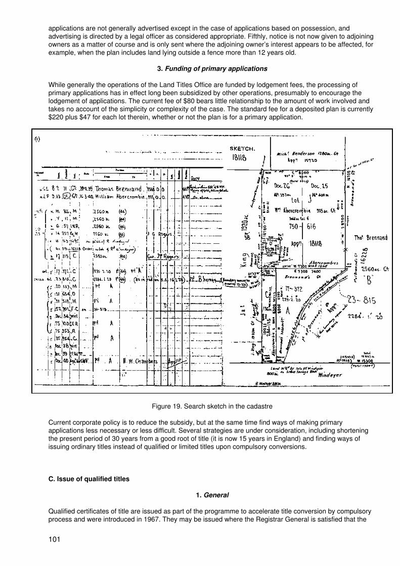
applications are not generally advertised except in the case of applications based on possession, andadvertising is directed by a legal officer as considered appropriate. Fifthly, notice is not now given to adjoiningowners as a matter of course and is only sent where the adjoining owner’s interest appears to be affected, forexample, when the plan includes land lying outside a fence more than 12 years old.
3. Funding of primary applications
While generally the operations of the Land Titles Office are funded by lodgement fees, the processing ofprimary applications has in effect long been subsidized by other operations, presumably to encourage thelodgement of applications. The current fee of $80 bears little relationship to the amount of work involved andtakes no account of the simplicity or complexity of the case. The standard fee for a deposited plan is currently$220 plus $47 for each lot therein, whether or not the plan is for a primary application.
Figure 19. Search sketch in the cadastre
Current corporate policy is to reduce the subsidy, but at the same time find ways of making primaryapplications less necessary or less difficult. Several strategies are under consideration, including shorteningthe present period of 30 years from a good root of title (it is now 15 years in England) and finding ways ofissuing ordinary titles instead of qualified or limited titles upon compulsory conversions.
C. Issue of qualified titles
1. General
Qualified certificates of title are issued as part of the programme to accelerate title conversion by compulsoryprocess and were introduced in 1967. They may be issued where the Registrar General is satisfied that the
101
boundaries of a Common Law title parcel are adequately defined by a plan on public record and no furthersurvey definition is required, but he has not investigated the title. This programme was possible because ofthe large stock of registered plans of Common Law title land lodged since 1920 as a result of theConveyancing Act and the Local Government Act (and which continue now to be lodged as deposited plans)and also Crown plans of parish portions and town or village allotments.
A qualified folio of the Register is a folio in which is recorded a “caution” that has not been cancelled.
A “caution” is a recording warning persons dealing with the registered proprietor that the land in the folio isheld subject to any “subsisting interest”, whether recorded therein or not.
“Subsisting interest” means:
“(a) any contingent or vested estate or interest in that land that was in existence at the dateon which the qualified folio of the Register was created and would have been enforceableagainst the person for the time being registered in that qualified folio as the proprietor hadthat qualified folio not been created and had any dealing registered therein been effected by acorresponding instrument duly registered under Division I of Part 23 of the Conveyancing Act1919 at the same time as the dealing became registered in the Register; and
(b) any estate or interest in that land, arising by prescription or under any statute oflimitations, that was in existence or in the course of being acquired at the date on which thequalified folio of the Register was created.”
The creation of qualified folios of the Register (and the issue of qualified certificates of title) is an efficientmeans of compulsory conversion to the Real Property Act with minimal administrative expense. It representsa business risk approach to title conversion by relying on the expectation that the title of the proprietor wasexamined in detail by a legal practitioner prior to the acquisition of the land and before good money wasparted with. Although there is some risk for the Registrar General, it is greatly minimized by the entry of a“caution” in the qualified folio adverting to subsisting interests, which:
• Protects subsisting interests under Common Law title existing at the time the qualified foliowas created which would have been enforceable against the registered proprietor had thatfolio not been created, and also any subsisting interests subsequently recorded in that folio;
• Warns persons dealing with the registered proprietor that the land in the folio is subject toany subsisting interests, whether or not recorded in the folio;
• while the caution remains recorded and uncancelled in the folio.
The definition of “subsisting interest” contemplates two distinct types of interest capable of overriding theregistered proprietor’s interest:
(a) Interests arising by possession or prescription: should a qualified folio created in the nameof A comprise land of which B has been in possession for the prescribed period, B’s right willprevail over that of A or anyone dealing with A;
(b) Any contingent or vested estate or interest in existence at the time of creation of thequalified folio which would have been enforceable against such registered proprietor had thequalified folio not been created and had any dealing registered therein been effected by acorresponding instrument registered in the General Register of Deals at the same time as thedealing became registered in the Real Property Act Register.
It will he seen then that a qualified folio of the Register has some features of Common Law title and some ofthe advantages of Real Property Act title. While the qualified folio remains subject to subsisting interests (andthe caution has not been cancelled or removed) those interests should be the subject of proper Common Lawtitle search and inquiry up to the date of the qualified folio before acquiring the land in the folio. However:
• The boundaries of the land as described in a qualified folio by reference to a plan are as“guaranteed” as those in an ordinary folio of the Register;
102
• The standard Real Property Act forms and procedures are used for subsequenttransactions, and any instrument purporting to deal with the land which cannot he registeredunder the Real Property Act has no force or effect;
• The normal indefeasibility provisions of the Real Property Act apply to a qualified folio of theregister except that the folio is subject to every subsisting interest in the land therein, whetherrecorded in the folio or not;
• The usual Real Property Act searches and inquiries should he made before acquiring theland in the folio.
When creating a qualified folio of the Register, the Registrar General may, if applicable, include in the cautionnotation to the effect that:
(a) The deed evidencing the title of the registered proprietor was not for valuableconsideration; or
(b) The title of the registered proprietor depends on the operation of a statute of limitationse.g., a possessory claim.
Cautions including such notations are referred to as “special cautions”.
Further, the Registrar General may indicate in a caution that for the purpose of creating an ordinary folio forother land, the chain of title evidencing the title to the land in the qualified folio has been accepted up to aspecified registered deed. In this case, the qualified title is not subject to any interest arising under aregistered deed prior to the registration of that specified deed, other than any subsisting interests recorded inthe folio, or preserved by Section 42. This power has rarely been used, however. The preferred course,usually followed, is to invite the owner to bring the search up to date from the accepted title and, where this issatisfactory, to offer an ordinary title without the formality and expense of a primary application.
2. Land subject to a mortgage
A Common Law mortgage operates as a conveyance of the legal estate, subject to an equity of redemption infavour of the mortgagor. Originally the Registrar General was required, when issuing a qualified title, to namethe mortgagee as the registered proprietor and to enter a caveat forbidding dealings other than as mortgageeexercising power of sale in accordance with the Real Property Act. The practice usually adopted was to entera general caveat (numbered as Q1) in all such cases rather than the more administratively inconvenient oneof raising individual caveats for each case. This general practice had the disadvantage that the name of themortgagor was not recorded in the Register − an example where the Register is not a perfect “mirror” of title. Itwas necessary to “go behind the Register” to find out the name of the mortgagor.
The Real Property Act has been amended to give the Registrar General the option of either proceeding asabove or naming the mortgagor as the registered proprietor and recording the mortgage in the folio as thoughit were a Real Property Act mortgage, and this is the option now regularly exercised. This brings the practiceinto line with normal Real Property Act procedures and makes the Register a better mirror of title.
3. Entry in General Register of Deeds
The Registrar General is required to make an entry in the Index to the General Register of Deeds recordingthe creation of a qualified folio. This entry warns searchers that the legal estate is now under the RealProperty Act, that any later entry in the General Register may be disregarded and that the chain of titleevidenced by the qualified folio should be followed. The entry is made in the vendors index. There is also acomputer listing, called CONACT, of all conversion actions, listing folio identifiers for completed conversions,or NPW if the action cannot be proceeded with.
4. Charting of conversion action
The Registrar General is required to chart on the appropriate charting map, or otherwise record, the creationof a qualified folio. Through this action, no person making a title search should fail to be aware of theconversion and disregard any subsequent invalid deeds registered in the General Register of Deeds.
5. Creation of qualified folios upon primary application
103
Qualified folios may be created under Section 28B upon withdrawal of a primary application. This practice wascommon in the 1970s and early 1980s, but as the requirements for primary applications have become lessstringent, the facility is not now used.
6. Creation of qualified folios upon subdivision
Section 28C provides the machinery that stops the proliferation of Common Law title parcels by subdivision.Under the Local Government Act a subdivision has no effect at law, and lots therein may not be separatelydisposed of lawfully unless the subdivision is registered by the Registrar General. Under Section 28C, theRegistrar General may (and does) refuse to register a subdivision of Common Law title land unless there islodged with the plan:
(a) The registered deed evidencing the subdivider’s title to the land; or
(b) Where the subdivider acquired title by devolution of law, the registered deeds evidencingthe title of the person from whom the land devolved, together with any registered deedvesting the legal estate in a mortgagee.
When the Registrar General registers a plan of subdivision of Common Law title land, he may create folios ofthe Register for each Common Law title lot in the plan without making an investigation of the subdivider’s title.He does however require a statement of title particulars form to be lodged with the plan.
This strategy has the effect of preventing proliferation of Common Law title parcels by subdivision andprovides an opportunity to mass produce titles where there are two or more lots in the plan. Issue of allqualified titles is discretionary, so that in times of staff shortages or budgetary constraints the RegistrarGeneral may elect not to issue qualified titles, although he could not refuse to register the plan if it is inregistrable form. Except in the case of a plan lodged with a primary application, investigation of plans ofCommon Law title land cannot be as exhaustive as in those affecting Real Property Act land since thesubdivider’s title cannot be checked (as in a primary application) and claims to title by adverse possession, orthe possible loss of title by adverse possession, cannot be tested. Similarly, overlapping deeds, hiatuses andthe existence of easements, restrictions, exceptions etc. not mentioned in the subdivider’s deed cannot bedetected, as no search of title is made unless there is an obvious problem. If a qualified title is issued, allthese matters are “subsisting interests” to which the title is subject. Provided the land in the plan is comprisedin the subdivider’s deed, as recited in the plan lodgement form, or the subdivider claims to be entitled to theland in the plan (or such part as is not comprised in the subdivider’s deed) by adverse possession, or wherethe deed recited is for “right, title and interest” (indicating that the title chain depends at some point onpossession) then the Registrar General must register the plan if it is otherwise in order.
Although the Registrar General has a general power to create qualified folios upon registering a plan, hispolicy is to limit creation of such to lots that are defined by survey. He may, however, create a limited folio forany lot in the plan that is not defined by survey.
7. Creation of qualified folios upon registration of deed
Section 28D authorizes the Registrar General to create a qualified folio of the Register for the land in aregistered deed if in his opinion no further survey definition is necessary to define the boundaries of that landadequately and for that purpose he may retain any relevant deed in his custody. Under this authority, deedslodged for registration in the General Register can be retained for conversion action. Under currentprocedures, deeds are no longer actually retained but are prominently marked near the registration numberwith a “conversion action” number, photocopied and returned to the lodging party. A deed will not beregistered unless it is accompanied by a statement of title particulars form, duly completed.
Retention of deeds lodged for registration provides a very convenient method of allowing the RegistrarGeneral to control the work intake according to the resources available for processing that work at any giventime. He is authorized to retain any deed but is not obliged to do so. In the earlier years of the programme heelected to retain only those deeds that referred to a plan of survey by its registered number, and from time totime varied the criteria to particular classes of plan registered between particular dates, knowing that theparticular group of plans had been more carefully checked than others before registration and thereforerequired less expertise in conversion action.
Since the introduction of limited titles, virtually all deeds are retained, resources permitting, because almostany deed can now be converted provided it can be plotted in the cadastre. If the deed refers to a satisfactory
104
plan of survey (either directly or by a metes and bounds description) it can be converted as a qualified folio. Ifthere is no satisfactory survey base it can be converted as a folio of the Register qualified as to title andlimited as to boundaries at the discretion of the Registrar General. For the purpose, the Registrar General nowprepares plans for the land in deeds for which no plan exists and this occurs in just under half of theconversion actions.
8. Creation of qualified folios upon investigation by the Registrar General
Section 28E gives the Registrar General power to give notice to any person, requiring that person to:
• Supply particulars in respect of land under Common Law title, being land the boundaries ofwhich, in the opinion of the Registrar General, are adequately defined without furtherdefinition;
• Indicate whether the claim is to a proprietary interest in that land; and if so, to supplyparticulars of title and if the title claimed is based on possession, such evidence supportingthe claim as the person possesses; and
• Produce relevant instruments in the possession of, or under the control of, that person.
Where such notice has been given the Registrar General may create a qualified folio of the Register for landdescribed in the notice.
This rather sweeping provision was originally used in conjunction with action under sections 28C and 28D butmore recently has been used in special project work in areas selected on the basis of the amount of CommonLaw title land in a particular locality known to be lots in survey plans registered in the Land Titles Office.
Project work is generally regarded as inefficient and cumbersome. It requires identification of suitable parcelsand their owners and their addresses, despatch of questionnaires and consideration of the responses,correspondence and sometimes telephone contact and general publicity in the target area. To be successful itrequires the cooperation of the owners and their mortgagees and initially less than 50 per cent of thesecooperate adequately. There have been some successful projects however, notably by following up on largeCommon Law system subdivisions registered before 1967. Searching of these has been simple because theycome from a common chain of title, and current ownership can be identified at the local council or from ValuerGeneral’s records. In some such projects economy of scale can be achieved. A significant proportion ofconversions has been achieved by mass conversion based on a particular subdivision plan series. But asconversion by other methods gradually diminishes and few deeds are lodged for registration or fewsubdivisions lodged, projects based on gaps in the cadastre will assume greater significance unless newmethods of conversion are introduced.
There has been some special project work however that has been efficient and accurate. This work has beenthe conversion of the Common Law title component of the property registers of some churches andgovernment bodies and a local council and the lending registers of some banks. Except perhaps in the caseof banks, these lands are not likely to be subdivided or sold, and thus would not otherwise come to theRegistrar General’s attention. In these projects the clients are cooperative, and in some cases it has beenpossible to combine title conversion with revenue raising activities that subsidize the conversion programme.However, these activities can only be undertaken when other work is scarce or additional resources areavailable.
D. Issue of limited titles
One of the main impediments to the conversion of Common Law title land is the lack of survey definition (onpublic record) of parcels, estimated in 1975 at about 100,000 in number. Part 4B, originally introduced in 1976and extensively superceded by the 1984 legislation, deals with this problem.
Initially (1976) the principal features of the scheme were:
(a) The recording of a limitation caveat in the folio: this caveat specified the matters whichmust be complied with as regards boundary definition before the caveat could be withdrawn.Transfers for value were precluded from registration by the caveat unless those matters were
105
complied with or an exemption granted by the Registrar General;
(b) The certification of title was not to be conclusive as regards boundary definition; and
(c) Most limited folios were to be qualified folios as well.
Ultimately, these features were found to be too onerous in requiring a registered proprietor to undertake anexpensive survey prior to any transfer for value.
In 1984, amendments were introduced which considerably simplified these provisions with the effect that alimited folio may now remain in that form indefinitely at the discretion of the owner. There is no longer acompulsion to undertake a survey except when the land is subdivided. However, so long as the title is limited(and it may remain limited although no longer qualified), the title is not conclusive as regards boundarydefinition. A recording is made in the folio pursuant to section 28T(4) that the description has not beeninvestigated by the Registrar General. In other respects, the title will ultimately be cleared of any legalimpediments by the process of lapse and removal of cautions. “Limited folio” is not specifically defined butmay be described as a folio in which there is a recording to the effect that the description of the landcomprised therein has not been investigated by the Registrar General.
1. Defeasibility of limited titles
If fresh survey information is disclosed to the Registrar General (e.g. a survey of adjoining land) which showsthat the boundaries of the land in a limited folio are erroneous, the Registrar General may correct the errorunder his general powers of correction and any such correction is binding on all persons having an interest inthe land notwithstanding that they may have bona fide and in reliance on the Register, and for value, becomeregistered proprietors and that if the folio had not been limited, they had rights that would have beenpreserved by indefeasibility provisions. The new provisions operate to negate the effect of Section 42(1)(c) −indefeasibility of title boundary definition.
Thus, regardless of any corrective action by the Registrar General, the interest of a registered proprietor inland included in a limited folio by virtue of wrong description of parcels and boundaries may not prevail againstother interests not recorded in the folio. The Act specifically provides that certification of title is not conclusiveas regards the definition of boundaries in a limited folio.
It might be noted that most limited folios are, when created, also qualified, and this is simply a function of themanner in which deeds come before the Registrar General. As a generalization one could say that:
(a) Since the bulk of the parcels having a satisfactory survey base have been alreadyconverted to qualified folios (beginning in I967) most deeds now being lodged for registrationhave no such survey base and, on conversion, the folios created must be both qualified andlimited, although there are exceptions;
(b) Most subdivisions of Common Law title land are wholly or partially surveyed and, onconversion, the folios created are mostly qualified and relatively few need to be limited.
2. Removal of limitations
The only way in which a limitation can he removed is by lodging in the Office of the Registrar General a planof survey, styled a delimitation plan, or by lodging a plan of subdivision, defining the boundaries of the land ina limited folio to the satisfaction of the Registrar General, together with such evidence as he may requirerelating to any adverse possession of the whole or part of the land in the folio and any other evidence theRegistrar General may require. When the Registrar General is satisfied that the plan of survey adequatelydefines the boundaries of the land, having regard to the evidence received, he may register the plan andcancel the limitation, unless:
• Where he has given optional notice of his intention to do so, the period stated in the notice(not less than one month), has not expired;
• Any caveat forbidding registration of the plan remains in force (such caveats are lodged,dealt with and lapsed in a similar manner to those forbidding the bringing of land under theReal Property Act).
106
Where a limited folio is also a qualified folio, cancellation of the limitation has no effect upon the cautionrecorded therein and the folio remains qualified.
E. Issue of “non−qualified” titles
The Land titles office has announced that it will consider the creation of what it calls “non−qualified” folios ofthe Register for land that is the subject of a satisfactory official search. This initiative is intended to provide analternative to the lodgement of a primary application and is authorized by a general power (Section 28EA) toissue an ordinary title if the Registrar General is satisfied that there are no subsisting interests, and Part 4B ifthe boundaries are not adequately defined.
A “non−qualified” title may be an ordinary title or a limited title, depending on the survey base available.Where a satisfactory survey plan already exists or is supplied by the applicant, the title would be ordinary, butotherwise a plan will be prepared departmentally from the metes and bounds description in the relevant deedand the title would be limited.
This method of title conversion will be at the discretion of the Registrar General and will be restricted in itsapplication. In all cases, the search must extend to a good root of title, and would be unsatisfactory if adocument in the chain of title purports to create, or refers to, an affecting or appurtenant easement or to partywalls (under the Conveyancing Act a reference in an assurance of land to “party wall” operates to create crosseasements for support where the assurance of land severs the party wall into separately owned parts, i.e., asubdivision has occurred in which the new boundary passes through the party wall).
Further, this method of conversion will not apply where ownership is based on possession.
F. Raising of essential records on conversion
The essential records required on bringing land under the Real Property Act, by any method, are the folio ofthe Register; the plan describing the land in the folio; and the record of the parcel in the mapping system.
In all forms of conversion the raising of the folio of the Register is a routine matter. In the past, when the foliowas to be a bound folio or a loose folio, a handwritten draft or programme needed to be prepared, in which allparticulars were set out in detail and in the final form. Currently all new folios are created as a computerrecord in ALTS and a folio is raised by keyed entries according to instructions given by the modern equivalentof a draft writer. It will be seen that much of the information is in coded form. For example, JT2 permits therecording of 2 persons as joint tenants, ON QG and ON QL are coded instructions to the computer to enterboth a qualified title recording and a limited title recording in standard form, and ON MS Bk 3808 No. 827 is aninstruction to the computer to enter a recording of a mortgage to the State Bank of New South Wales Limited.Use of PROP would permit the entry of multiple proprietorship details.
Recording the parcel in the mapping system is simply a matter of charting the conversion action on thereference map and arranging any necessary update of a CMA map.
Raising the plan describing the land is also a routine matter except in the case of limited folios. In the case ofprimary applications, a fresh plan of survey is supplied for registration as a deposited plan or the applicationrefers to an existing plan already registered. In the case of qualified (but not limited) titles an existingregistered plan is normally used. In the case of limited titles however it is usually necessary to prepare a plandepartmentally from the metes and bounds description in the relevant deed. This is not always easy, anderrors occur in the metes and bounds descriptions. If the description is materially defective, so that it cannotbe translated into a viable graphic representation, it may be necessary to abandon the conversion action.Similarly if the description, when translated to plan format, cannot be fitted into the existing cadastral patternas shown in the mapping system, it will result in the conversion action being abandoned and noted NPW (notproceeded with).
An example of a deposited plan prepared departmentally is supplied as figure 20 and the metes and boundsdescription from which it was prepared is found in Deed Book 3800 No. 713, a copy of which is supplied asfigure 21. It will be noticed that the plan bears the notation “This plan was prepared solely to identify the landin the above deed and the boundaries have not been investigated by the Registrar General”. A computer folio
107
search of the related folio of the Register 1/194002 is supplied as figure 22.
So it becomes immediately apparent that when the land in a deed is converted to the Real Property Act byway of a limited title, the registered proprietor gets no more and no less than he had under the deed, exceptthat from the date of issue he gets some of the benefits of the Real Property Act system. If he chooses, thetitle may remain limited indefinitely unless he subdivides the land, in which case a survey will be required andthe limitation will be cancelled. If, as is probable, the title is also qualified, the caution will lapse by the effluxion of time and/or the registration of dealings for value or in certain cases be removed on application and thushe can, in time, have a (full) ordinary Real Property Act title.
G. Funding of conversion actions
Processing of compulsory conversions is completely free to the owners and mortgagees, except for anyincidental costs they may incur in responding to notices, producing documents and, occasionally, writingletters or, if they choose to do so, lodging a plan of survey. Prima facie it is free because of an electionpromise by an incoming government, but all subsequent governments have adhered to that concept. It wouldbe politically unwise to do otherwise, especially since owners can neither request or refuse conversion andcan take no action against the Registrar General for converting the title or not converting it.
Overall, compulsory conversion is funded by the other operations of the Land Titles Office. This fact, alongwith the fact that primary applications are subsidized by other operations of the Land Titles Office, indicate theimportance attached to title conversion by government and the corporate plan of the Titles Office.
H. Options for the future
Most of the compulsory conversion work done in the past has been driven by lodgement of deeds forregistration and subdivisions of Common Law title land. This has generally worked very well because the workhas been there for the taking. Because of the discretion in favour of the Registrar General, the work intakehas been adjustable to the resources available; when work has slowed in some other areas staff was divertedto title conversion and the intake stepped up. Yet just as the issue of qualified titles decreased as the pool ofsuitable parcels defined by survey dried up, the issue of limited titles will slow down as there are fewer parcelsremaining to be dealt with and less deeds lodged for registration. Eventually there will remain an unidentifiedhard core of Common Law title land not being conveyed, mortgaged or subdivided. While in one sense thereis still enough work coming in to maintain a viable conversion programme in the short to medium term,corporate objectives and the building of the Graphic Data Base and the State Land Information Systemdemand the development of new conversion methods, and perhaps new legislation, with the aim of liquidatingthe Common Law system as soon as possible.
1. Primary applications
Future strategies include shortening the period required to establish title from 30 years from a good root of titleto, say, 15 years (this would require legislative change and prior consultation with the legal profession at thelevel of the Law Society and perhaps the Law Reform Commission) and simplifying the title issue processthrough the Business Operations System.
But the present direction of thought is rather to reduce the need for primary applications. Strategies underconsideration are:
(a) Find ways to restrict the number of limitation notifications entered in folios in conversionactions, because experience is showing that owners are seeking to have limitations removedby lodging primary applications. A high proportion of primary applications are for existingqualified/limited folios. This would certainly increase the initial cost of conversion but mayproduce cost savings in the longer term. Perhaps owners might be willing to contribute to thecost if they get a qualified title rather than a qualified/limited one.
(b) A pilot project has been running for some time looking at the issue of ordinary titles onCommon Law title subdivisions if accompanied by an official search.
108
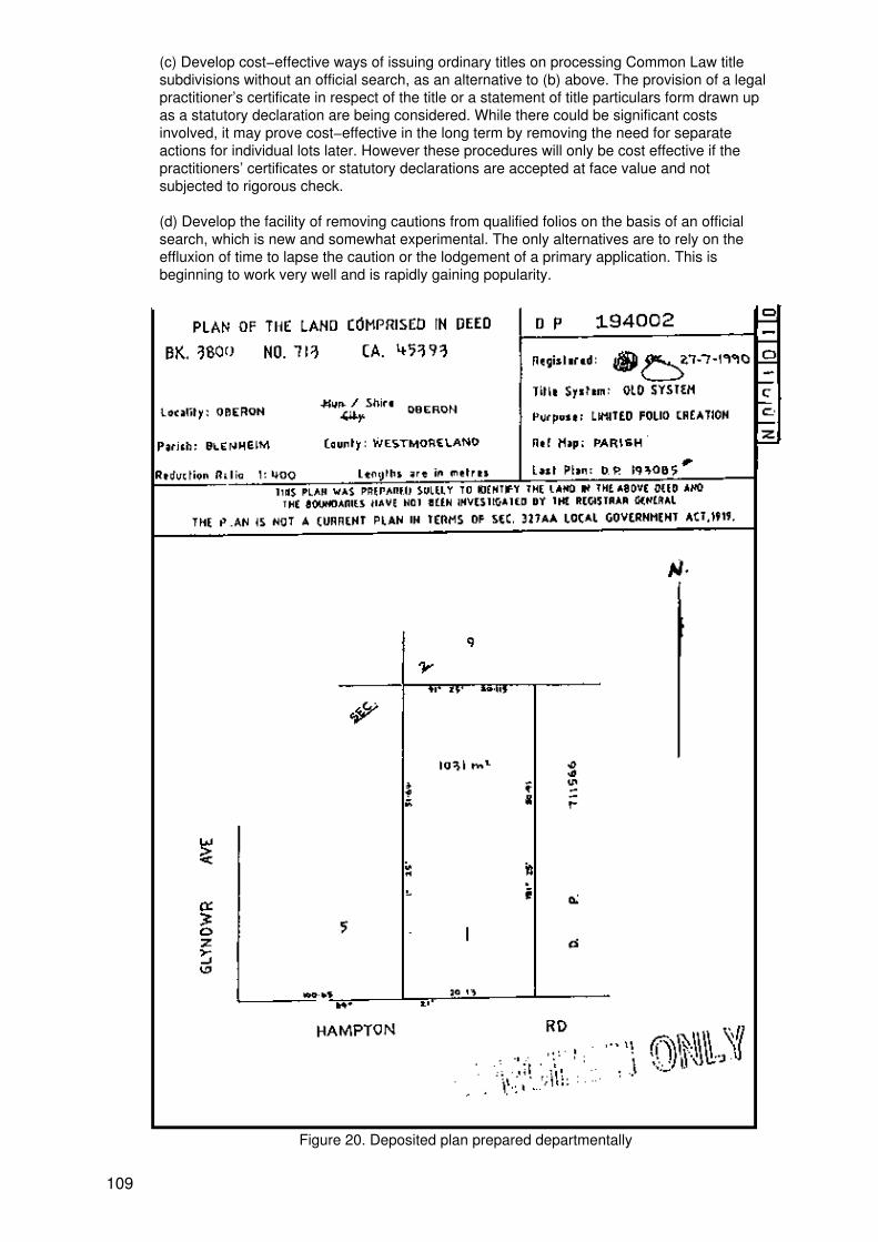
(c) Develop cost−effective ways of issuing ordinary titles on processing Common Law titlesubdivisions without an official search, as an alternative to (b) above. The provision of a legalpractitioner’s certificate in respect of the title or a statement of title particulars form drawn upas a statutory declaration are being considered. While there could be significant costsinvolved, it may prove cost−effective in the long term by removing the need for separateactions for individual lots later. However these procedures will only be cost effective if thepractitioners’ certificates or statutory declarations are accepted at face value and notsubjected to rigorous check.
(d) Develop the facility of removing cautions from qualified folios on the basis of an officialsearch, which is new and somewhat experimental. The only alternatives are to rely on theeffluxion of time to lapse the caution or the lodgement of a primary application. This isbeginning to work very well and is rapidly gaining popularity.
Figure 20. Deposited plan prepared departmentally
109
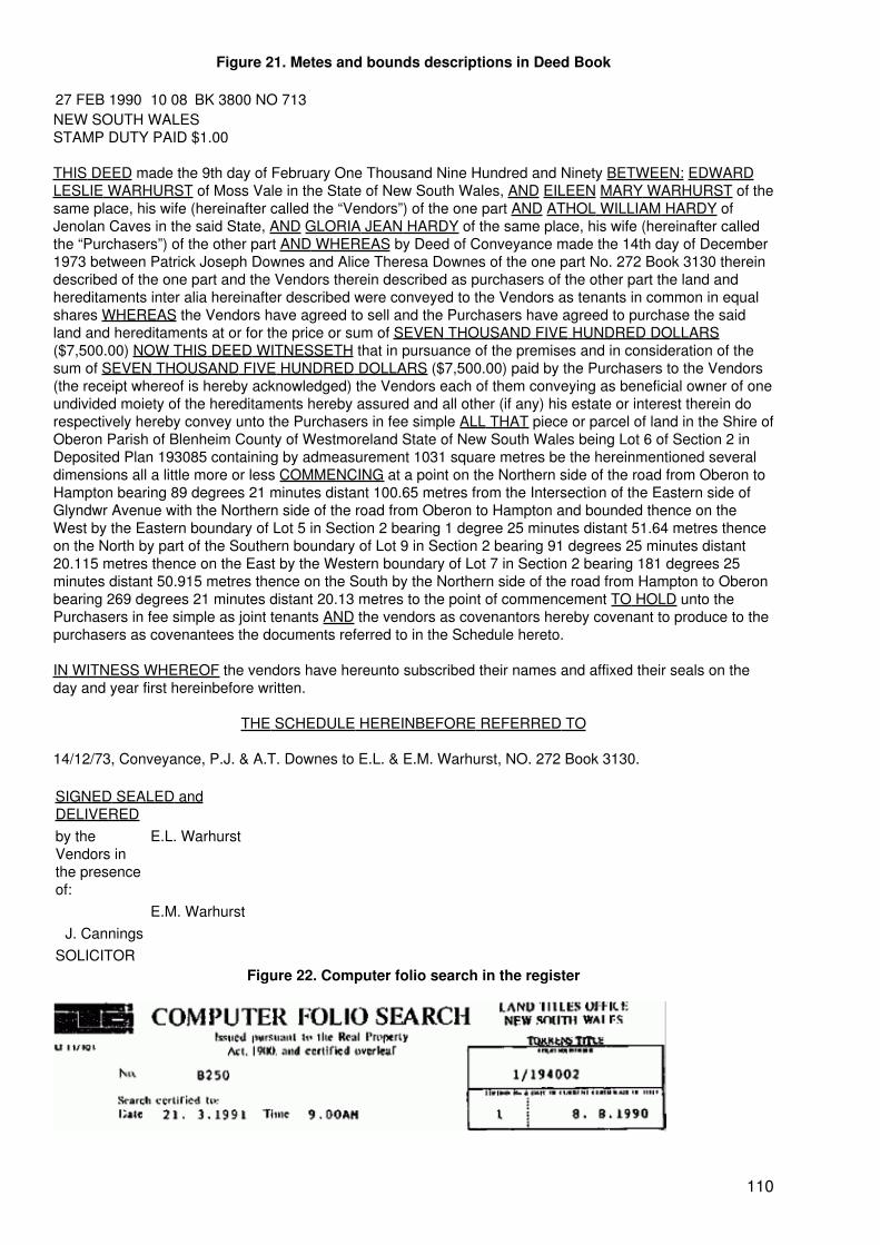
Figure 21. Metes and bounds descriptions in Deed Book
27 FEB 1990 10 08 BK 3800 NO 713NEW SOUTH WALESSTAMP DUTY PAID $1.00
THIS DEED made the 9th day of February One Thousand Nine Hundred and Ninety BETWEEN: EDWARDLESLIE WARHURST of Moss Vale in the State of New South Wales, AND EILEEN MARY WARHURST of thesame place, his wife (hereinafter called the “Vendors”) of the one part AND ATHOL WILLIAM HARDY ofJenolan Caves in the said State, AND GLORIA JEAN HARDY of the same place, his wife (hereinafter calledthe “Purchasers”) of the other part AND WHEREAS by Deed of Conveyance made the 14th day of December1973 between Patrick Joseph Downes and Alice Theresa Downes of the one part No. 272 Book 3130 thereindescribed of the one part and the Vendors therein described as purchasers of the other part the land andhereditaments inter alia hereinafter described were conveyed to the Vendors as tenants in common in equalshares WHEREAS the Vendors have agreed to sell and the Purchasers have agreed to purchase the saidland and hereditaments at or for the price or sum of SEVEN THOUSAND FIVE HUNDRED DOLLARS($7,500.00) NOW THIS DEED WITNESSETH that in pursuance of the premises and in consideration of thesum of SEVEN THOUSAND FIVE HUNDRED DOLLARS ($7,500.00) paid by the Purchasers to the Vendors(the receipt whereof is hereby acknowledged) the Vendors each of them conveying as beneficial owner of oneundivided moiety of the hereditaments hereby assured and all other (if any) his estate or interest therein dorespectively hereby convey unto the Purchasers in fee simple ALL THAT piece or parcel of land in the Shire ofOberon Parish of Blenheim County of Westmoreland State of New South Wales being Lot 6 of Section 2 inDeposited Plan 193085 containing by admeasurement 1031 square metres be the hereinmentioned severaldimensions all a little more or less COMMENCING at a point on the Northern side of the road from Oberon toHampton bearing 89 degrees 21 minutes distant 100.65 metres from the Intersection of the Eastern side ofGlyndwr Avenue with the Northern side of the road from Oberon to Hampton and bounded thence on theWest by the Eastern boundary of Lot 5 in Section 2 bearing 1 degree 25 minutes distant 51.64 metres thenceon the North by part of the Southern boundary of Lot 9 in Section 2 bearing 91 degrees 25 minutes distant20.115 metres thence on the East by the Western boundary of Lot 7 in Section 2 bearing 181 degrees 25minutes distant 50.915 metres thence on the South by the Northern side of the road from Hampton to Oberonbearing 269 degrees 21 minutes distant 20.13 metres to the point of commencement TO HOLD unto thePurchasers in fee simple as joint tenants AND the vendors as covenantors hereby covenant to produce to thepurchasers as covenantees the documents referred to in the Schedule hereto.
IN WITNESS WHEREOF the vendors have hereunto subscribed their names and affixed their seals on theday and year first hereinbefore written.
THE SCHEDULE HEREINBEFORE REFERRED TO
14/12/73, Conveyance, P.J. & A.T. Downes to E.L. & E.M. Warhurst, NO. 272 Book 3130.
SIGNED SEALED andDELIVEREDby theVendors inthe presenceof:
E.L. Warhurst
E.M. WarhurstJ. Cannings
SOLICITORFigure 22. Computer folio search in the register
110
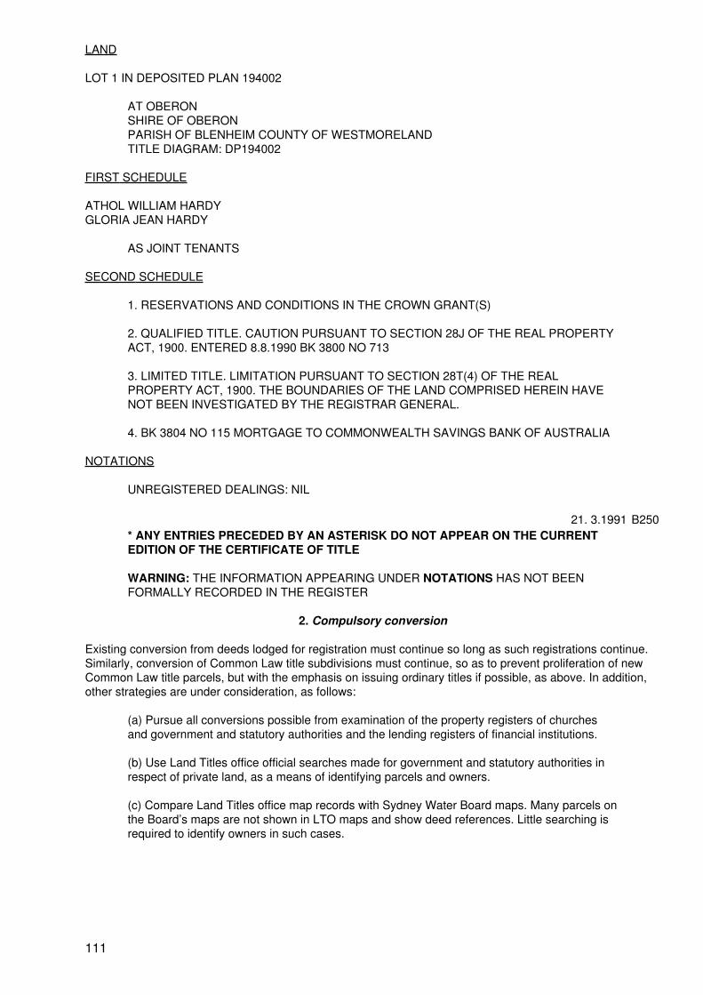
LAND
LOT 1 IN DEPOSITED PLAN 194002
AT OBERONSHIRE OF OBERONPARISH OF BLENHEIM COUNTY OF WESTMORELANDTITLE DIAGRAM: DP194002
FIRST SCHEDULE
ATHOL WILLIAM HARDYGLORIA JEAN HARDY
AS JOINT TENANTS
SECOND SCHEDULE
1. RESERVATIONS AND CONDITIONS IN THE CROWN GRANT(S)
2. QUALIFIED TITLE. CAUTION PURSUANT TO SECTION 28J OF THE REAL PROPERTYACT, 1900. ENTERED 8.8.1990 BK 3800 NO 713
3. LIMITED TITLE. LIMITATION PURSUANT TO SECTION 28T(4) OF THE REALPROPERTY ACT, 1900. THE BOUNDARIES OF THE LAND COMPRISED HEREIN HAVENOT BEEN INVESTIGATED BY THE REGISTRAR GENERAL.
4. BK 3804 NO 115 MORTGAGE TO COMMONWEALTH SAVINGS BANK OF AUSTRALIA
NOTATIONS
UNREGISTERED DEALINGS: NIL
21. 3.1991 B250* ANY ENTRIES PRECEDED BY AN ASTERISK DO NOT APPEAR ON THE CURRENTEDITION OF THE CERTIFICATE OF TITLE
WARNING: THE INFORMATION APPEARING UNDER NOTATIONS HAS NOT BEENFORMALLY RECORDED IN THE REGISTER
2. Compulsory conversion
Existing conversion from deeds lodged for registration must continue so long as such registrations continue.Similarly, conversion of Common Law title subdivisions must continue, so as to prevent proliferation of newCommon Law title parcels, but with the emphasis on issuing ordinary titles if possible, as above. In addition,other strategies are under consideration, as follows:
(a) Pursue all conversions possible from examination of the property registers of churchesand government and statutory authorities and the lending registers of financial institutions.
(b) Use Land Titles office official searches made for government and statutory authorities inrespect of private land, as a means of identifying parcels and owners.
(c) Compare Land Titles office map records with Sydney Water Board maps. Many parcels onthe Board’s maps are not shown in LTO maps and show deed references. Little searching isrequired to identify owners in such cases.
111
I. Total results of conversions
What has all this activity produced?
It has taken 127 years to process 62,400 primary applications, resulting in some 80,000 ordinary titles.
Under the 1967 legislation for compulsory conversion by qualified folios approximately 62,000 folios werecreated. And under the 1984 legislation for compulsory conversion by limited folios (usually also qualified)45,000 folios approximately have been created. So, in all, compulsory conversion has produced about107,000 folios in 23 years, or about 4,652 per annum on average compared with 630 per annum by voluntaryconversion. This represents an effectiveness ratio of better than 7:1 in favour of compulsory conversion(discounting the differences in staff levels and qualifications).
Overturning of qualified/limited titles is so rare as to be negligible, suggesting that there is still room for greaterrisk taking and more radical procedures to liquidate Common Law title.
VII. ASSOCIATED LEGISLATION
There is no single item of legislation providing for land titles, land use, town and country planning, landinformation, land rating, land taxing, land valuation and the like, but many separate Acts, references to someof which have already been made, often indirectly or by inference. They may appear disparate anduncoordinated but in reality they work together to create a total system, each having its own input to thatsystem, within which everyone must work. An amendment to one Act may produce a series of cognateamendments to several other Acts to ensure their consistency.
The sequence in which the main items of legislation appeared reflects the development of the State of NewSouth Wales from its earliest colonial days to its present highly developed status, and its current concern withenvironmental issues and the effects of bad land−use practices of the past, often due to the early rapidexpansion.
This chapter does not set out to comment further on Acts which, while important in their own way, are notfundamental to this study. Rather, the intention is to describe the relevant objects of the Acts which arefundamental to this study, to show their implications for title conversion and to indicate how they inter−relate.
A. The Registration of Deeds Act, 1844
This Act was the culmination of more than 50 years of effort to regulate some aspects of conveyancingpractice in general and deeds registration in particular. Considering the origins of the State as a penalsettlement, the mistrust of, and lack of respect for, the symbols of authority on the part of convicts and earlysettlers, the rapid expansion and the rush for land, it is remarkable that the early records are as good as theyare. The registration of deeds has been at the heart of the Common Law system of title. But by the time thisAct was introduced pressures for reform were developing in the United Kingdom and the colonies, due to thefailings of the Common Law system.
Deeds registration continues however, although now under the Conveyancing Act, and will continue until theCommon Law system is liquidated.
All title conversions from Common Law titles depend on the deeds registration system and its indexes for anysearching, either as the evidence of the chain of title in the case of primary applications, or, in the case ofcompulsory conversions, in the expectation that the chain of title was searched, and the title examined, beforeexecution of the deed on which the conversion is based.
The Act has now been repealed and its major provisions re−enacted as part of the Conveyancing Act.
112
B. The Real Property Act, 1862
This Act was the expression in New South Wales of the reforms introduced by Torrens in South Australia.
Extensively reviewed and re−enacted as the Real Property Act, 1900, it has been the subject of manyamendments aimed at keeping it relevant and suited to contemporary needs. Yet in spite of the amendments,all the principles of the original Act have been preserved, having stood the test of time, and the long title of theAct remains virtually as it was in 1862, “An Act to consolidate the Acts relating to the declaration of titles toland and the facilitation of its transfer”.
The Act may be summarized as the machinery provisions for the administration of the Torrens system of titleregistration. Its principal provisions relevant to this study relate to:
• General powers of the Registrar General;• Bringing land under its provisions;• Certification of title to resumed land;• The Register and registration;• Possessory title for whole parcels;• Dealings;• Caveats;• Transmissions (deceased estates and on bankruptcy);• Searches;• Boundary determinations.
The Act is primarily concerned with the operation of the Torrens system of title registration and the bringing ofland under its provisions and not with conveyancing practice as such, although it obviously affectsconveyancing. It makes very specific provisions for bringing both Common Law title land and Crown landunder the Act, with the ultimate aim of having all land in the State under one system. About 22 per cent of thetext of the Act is devoted to title conversion in some form.
C. The Conveyancing Act, 1919
In addition to the Registration of Deeds Act there were many laws relating to property, including Acts of theImperial Parliament, all of which affected conveyancing practice. The Conveyancing Act is, according to itslong title, “An Act to amend and consolidate the law of property and to simplify and improve the practice ofconveyancing; and for such purposes to amend certain Acts relating thereto”. The Acts repealed includedseveral Imperial Acts (some ancient) either wholly or in part, so far as they applied to New South Wales. Atotal of 16 New South Wales Acts were also repealed, wholly or in part.
The principal provisions of the Act relevant to this study relate to:
• General rules affecting property;
• General rules relating to deeds;
• Sales and other transactions;
• Covenants and powers;
• Mortgages and charges;
• Leases;
• Executors and administrators;
• Powers of attorney;
• Registration of deeds, causes, writs, orders and resumptions affecting Common Law titleland, and all plans of subdivision (including those affecting Real Property Act land but notstrata plans, which are registered under the Strata Titles Act);
113
• Easements, profits a prendre, restrictions on the use of land and positive covenants.
The Act is primarily concerned with conveyancing practice and the nature, effect and registration ofinstruments affecting land under Common Law title.
The comments relating to title conversion now apply to the Conveyancing Act. In addition, that Act hasimportance in interpreting instruments and their effects. The costs, both to the Land Titles office and thecommunity generally, of running the Common Law system as well as the Real Property Act system is a factorin the overall policy of converting all land to the one system.
D. The Local Government Act, 1919
Local government came of age with the commencement of this Act on 1 July, 1920. All the Australian Statesoperate under a three−tiered system of government, federal, state and local, and local government plays amajor role in community life through elected councils. There are currently about 175 councils.
The Act’s long title begins − “An Act to make better provision for the government of areas; to extend thepowers and functions of local governing bodies; to establish bodies to take common action on behalf ofareas...”.
Local councils have very wide powers in providing local services, including − libraries and sporting facilities;public health, safety and convenience; building regulations; waste removal; and provision of services such aswater supply and sewerage where these are not provided by specialised authorities. Electricity is usuallysupplied by county councils from the State supply grid.
The areas of law particularly relevant to this study are:
• The opening, ownership, control and use of public roads;
• Creation, ownership and control of public reserves and drainage reserves;
• Subdivision control and approval in accordance with planning policies and environmentalplans determined under the Environmental Planning and Assessment Act, which designateslocal councils as the “consent authority”. Appeals against decisions of local councils inrespect of building applications and development consents are to the Land and EnvironmentCourt;
• Prohibition of dealings not in terms of a lot in the current plan.
The Local Government Act is a very large and complex provision accompanied by numerous ordinances, and,together with the Environmental Planning and Assessment Act, is an area of legal specialty.
Section 4.9.5(b) records that the Registrar General is authorized by the Local Government Act to refuse toregister a transfer or mortgage of land that is not the whole of a lot in the current plan, and that it is an offenceto execute such a dealing. The Registrar General can police this effectively for land under the Real PropertyAct − but cannot do so in the case of land under Common Law title. Deeds must be registered on the spotwhen presented, whether they be good or bad, and cannot be investigated. The Local Government Actrecognizes this by providing that while execution of a prohibited deed remains an offence for which a penaltymay be imposed, the deed itself is not invalid.
E. The Environmental Planning and Assessment Act, 1979
This relatively modern Act is far−reaching in effect in that it controls all land and building development, farmore so than is immediately suggested by its long title − “An Act to institute a system of environmentalplanning and assessment for the State of New South Wales”.
Its principal provisions relate to:
114
• Environmental planning instruments, of which there are three types − local environmentalplans (local councils have a major input to these), regional environmental plans, both of whichrequire approval of the Minister, and State environmental planning policies, which require theapproval of the Governor;
• Environmental planning control;
• Environmental assessment, providing for public participation;
• Implementation and enforcement.
So far as the activities of the Land Titles Office are concerned, the key provision (s.76) is the restriction orprohibition of development other than in accordance with the relevant environmental planning instrument inforce. What makes this significant is the very wide definition of development.
“Development”, in relation to land, means:
• The erection of a building on that land;
• The carrying out of a work in, on, over or under that land;
• The use of that land or a building or work on that land;
• The subdivision of that land, but does not include any development of a class or descriptionprescribed by the regulations for the purposes of this definition.
The definition, along with s.76 referred to above, effectively controls all activity in respect of land use, buildingand subdivision. Ordinarily the Registrar General is little concerned about this Act, since the local council isthe designated consent authority and its approval on a plan of subdivision submitted for registration absolvesthe Registrar General from inquiry. The Act also binds the Crown, and the Registrar General is entitled toassume that any Crown plans submitted for registration comply with the Act. However in the case of “de facto”subdivisions not approved by a council the Registrar General requires a certificate from the council clerk thatthe subdivision is not in breach of the Act or any environmental planning instrument in force. This is a policyrequirement not specifically authorized by the statute, and has been the cause of some objection andcomplaint, and occasionally a council clerk refuses to issue the certificate sought, on a matter of principle.However, unless and until there is an amendment to indemnify the Registrar General and/or make it theresponsibility of the council, he will continue to require the certificate, and if it is not forthcoming an affectedplan will be rejected on the grounds that it has not been shown that the subdivision is not in breach of the Act.
This requirement would apply to a “de facto” subdivision of Common Law title land (as well as to RealProperty Act land) and might cause the plan to be rejected. If any conveyance or mortgage of a lot in that planwere lodged for registration it could not be converted to the Real Property Act in terms of that plan, and anyconversion action would probably be halted.
F. Conveyancing Act regulations
Regulations under the Conveyancing Act provide the rules for preparation, lodgement, and registration ofinstruments in the General Register of Deeds, the Register of Resumptions, the Register of Causes, Writs andOrders and other registers and plans affecting land under Common Law title, for official searches, payment ofa fee for a search permit and lodgement fees generally. Particulars of plan forms and the matter to be shownin plans is covered in great detail.
G. Real Property Act regulations
The Real Property Act regulations perform for land under that Act, a similar function to that performed by theConveyancing Act Regulations for land under Common Law title. Among the comprehensive requirements forplan preparation is Regulation 26, introduced originally in 1961 for the avoidance of partially cancelledcertificates of title. Other regulations relating to survey requirements are shown in Annexure 2.
115
H. Survey Practice regulations
These regulations, made under the Surveyors Act, set out the requirements for survey practice in the field,including:
• The making of surveys under supervision of a registered surveyor;
• Equipment used and its adjustment for accuracy;
• The required standard of accuracy;
• Placement of marks;
• Boundary location and relocation;
• Area calculation;
• Keeping of field notes;
• Certification of the survey.
The regulations permit measurement by photogrammetic methods if appropriate. However this method israrely used; the only instance the author can recall is for the measurement of the top water level of a dam.
I. Land Titles − a commercial operation
On 1 July 1988 the Land Titles Office ceased to be a sub−department and became a separate administrativeoffice and a fully commercial operation. Commercialization does not mean privatization; rather it meansoperating with more flexibility on a business basis and producing a dividend for the Government while beingfully self−funding.
Being a separate administrative office has many organizational benefits, including:
• A simpler, flatter organizational structure and increased delegation;
• More direct accountability for performance;
• Greater flexibility and speedier decision−making;
• Small discrete corporate personnel and finance services, integrated with the Office andcommitted to its corporate goals, able to respond quickly to personnel and finance problemsand needs;
• More flexibility in staffing according to business and client service needs (this is particularlyimportant where business levels can change rapidly due to changes in the economy);
• Enhanced ability to change and to respond to new situations.
The Office has engaged in information seminars as a commercial venture and the sale of its own publications.It has also turned its attention to maximizing the return on its assets, including office space made available bythe application of advanced technology, and it has continued unabated its commitment to the development ofthe State Land Information System.
116
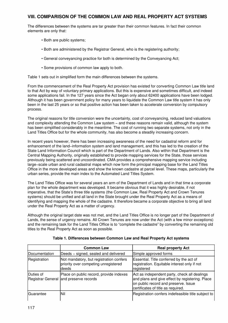
VIII. COMPARISON OF THE COMMON LAW AND REAL PROPERTY ACT SYSTEMS
The differences between the systems are tar greater than their common features. In fact their commonelements are only that:
• Both are public systems;
• Both are administered by the Registrar General, who is the registering authority;
• General conveyancing practice for both is determined by the Conveyancing Act;
• Some provisions of common law apply to both.
Table 1 sets out in simplified form the main differences between the systems.
From the commencement of the Real Property Act provision has existed for converting Common Law title landto that Act by way of voluntary primary applications. But this is expensive and sometimes difficult, and indeedsome applications fail. In the 127 years since the Act began only about 62400 applications have been lodged.Although it has been government policy for many years to liquidate the Common Law title system it has onlybeen in the last 25 years or so that positive action has been taken to accelerate conversion by compulsoryprocess.
The original reasons for title conversion were the uncertainty, cost of conveyancing, reduced land valuationsand complexity attending the Common Law system − and these reasons remain valid, although the systemhas been simplified considerably in the meantime. The cost of running two separate systems, not only in theLand Titles Office but for the whole community, has also become a steadily increasing concern.
In recent years however, there has been increasing awareness of the need for cadastral reform and forenhancement of the land−information system and land management, and this has led to the creation of theState Land Information Council which is part of the Department of Lands. Also within that Department is theCentral Mapping Authority, originally established to provide mapping services for the State, those servicespreviously being scattered and uncoordinated. CMA provides a comprehensive mapping service includinglarge−scale urban and rural cadastral maps which now form the principal mapping base for the Land TitlesOffice in the more developed areas and show the known cadastre at parcel level. These maps, particularly theurban series, provide the main index to the Automated Land Titles System.
The Land Titles Office was for several years an arm of the Department of Lands and in that time a corporateplan for the whole department was developed. It became obvious that it was highly desirable, if notimperative, that the State’s three title systems (the Common Law, Real Property Act and Crown Tenuressystems) should be unified and all land in the State brought under the Real Property Act as a means ofidentifying and mapping the whole of the cadastre. It therefore became a corporate objective to bring all landunder the Real Property Act as a matter of urgency.
Although the original target date was not met, and the Land Titles Office is no longer part of the Department ofLands, the sense of urgency remains. All Crown Tenures are now under the Act (with a few minor exceptions)and the remaining task for the Land Titles Office is to “complete the cadastre” by converting the remaining oldtitles to the Real Property Act as soon as possible.
Table 1. Differences between Common Law and Real Property Act systems
Common Law Real property ActDocumentation Deeds − signed, sealed and delivered Simple approved formsRegistration Not mandatory, but registration confers
priority over competing unregistereddeeds
Essential. Title conferred by the act ofregistration. Equitable interest only if notregistered
Duties ofRegistrar General
Place on public record, provide indexesand preserve records
Act as independent party, check all dealingsand plans and give effect by registering. Placeon public record and preserve. Issuecertificates of title as required.
Guarantee Nil Registration confers indefeasible title subject to
117
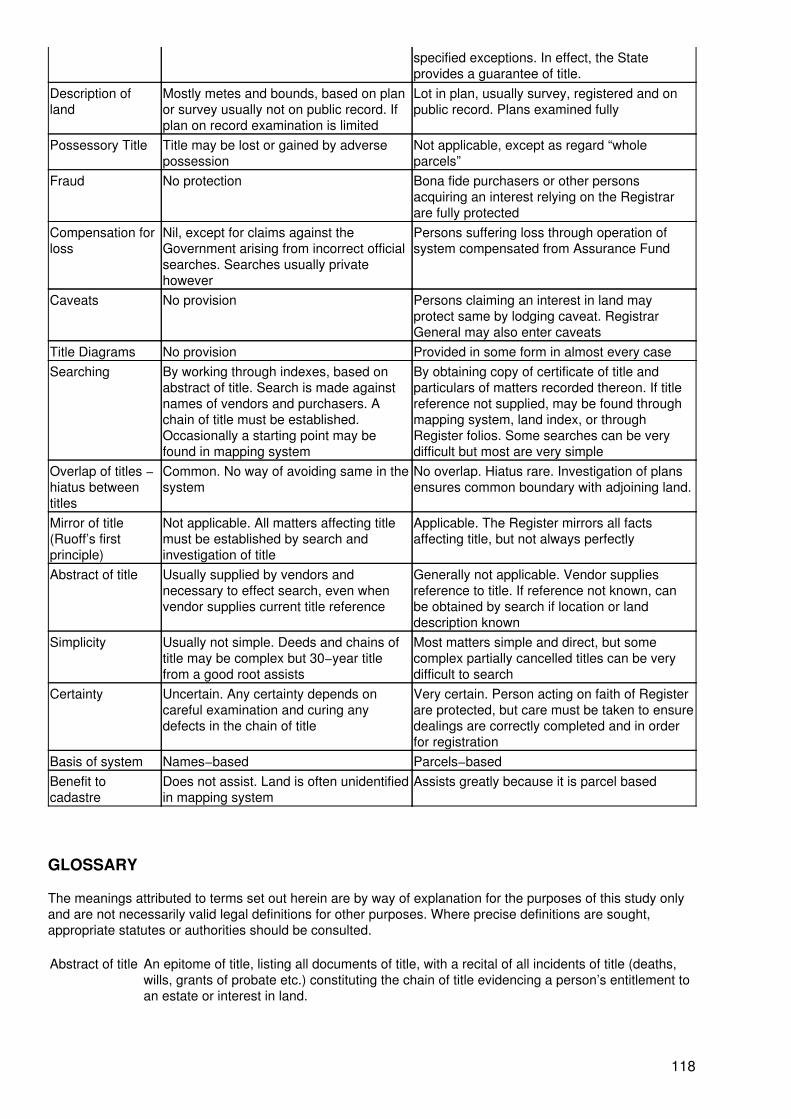
specified exceptions. In effect, the Stateprovides a guarantee of title.
Description ofland
Mostly metes and bounds, based on planor survey usually not on public record. Ifplan on record examination is limited
Lot in plan, usually survey, registered and onpublic record. Plans examined fully
Possessory Title Title may be lost or gained by adversepossession
Not applicable, except as regard “wholeparcels”
Fraud No protection Bona fide purchasers or other personsacquiring an interest relying on the Registrarare fully protected
Compensation forloss
Nil, except for claims against theGovernment arising from incorrect officialsearches. Searches usually privatehowever
Persons suffering loss through operation ofsystem compensated from Assurance Fund
Caveats No provision Persons claiming an interest in land mayprotect same by lodging caveat. RegistrarGeneral may also enter caveats
Title Diagrams No provision Provided in some form in almost every caseSearching By working through indexes, based on
abstract of title. Search is made againstnames of vendors and purchasers. Achain of title must be established.Occasionally a starting point may befound in mapping system
By obtaining copy of certificate of title andparticulars of matters recorded thereon. If titlereference not supplied, may be found throughmapping system, land index, or throughRegister folios. Some searches can be verydifficult but most are very simple
Overlap of titles −hiatus betweentitles
Common. No way of avoiding same in thesystem
No overlap. Hiatus rare. Investigation of plansensures common boundary with adjoining land.
Mirror of title(Ruoff’s firstprinciple)
Not applicable. All matters affecting titlemust be established by search andinvestigation of title
Applicable. The Register mirrors all factsaffecting title, but not always perfectly
Abstract of title Usually supplied by vendors andnecessary to effect search, even whenvendor supplies current title reference
Generally not applicable. Vendor suppliesreference to title. If reference not known, canbe obtained by search if location or landdescription known
Simplicity Usually not simple. Deeds and chains oftitle may be complex but 30−year titlefrom a good root assists
Most matters simple and direct, but somecomplex partially cancelled titles can be verydifficult to search
Certainty Uncertain. Any certainty depends oncareful examination and curing anydefects in the chain of title
Very certain. Person acting on faith of Registerare protected, but care must be taken to ensuredealings are correctly completed and in orderfor registration
Basis of system Names−based Parcels−basedBenefit tocadastre
Does not assist. Land is often unidentifiedin mapping system
Assists greatly because it is parcel based
GLOSSARY
The meanings attributed to terms set out herein are by way of explanation for the purposes of this study onlyand are not necessarily valid legal definitions for other purposes. Where precise definitions are sought,appropriate statutes or authorities should be consulted.
Abstract of title An epitome of title, listing all documents of title, with a recital of all incidents of title (deaths,wills, grants of probate etc.) constituting the chain of title evidencing a person’s entitlement toan estate or interest in land.
118
Acquisition Except in relation to private action − the compulsory acquisition of land or an easement bythe Commonwealth of Australia under the (Commonwealth) Land Acquisition Act bynotification in the Commonwealth of Australia Gazette.
Alienation The passing of Crown lands into private ownership.
ALTS The Automated Land Titles System based on the computerized Real Property Act Register.
Appropriation In relation to land, the taking of Crown land by a Crown authority for the purpose of a publicwork, not effective against land or an easement held by the Commonwealth of Australia.
Approved form A form approved by the Registrar General for the purposes of a provision of the RealProperty Act or another Act.
Assurancefund
The Fund established under the Real Property Act to compensate persons deprived of land,or an interest in land, by the operation of that Act.
Azimuth The datum line specially determined from established survey monuments on public recordand its bearing or direction, adopted by a surveyor as the base line for a survey. Alternativelythe bearing used may be taken from astronomical observations.
Bill of sale A mortgage of goods and chattels (personal property) given in security for money borrowed −does not affect land.
Blaze A prominent survey mark cut into a tree.
Bounds The limits of a parcel of land, especially by reference to those lands and features by which itis bounded − see also Metes, hence metes and bounds descriptions of land.
Cadastre See chapter 8 − “Cadastral” has a corresponding meaning.
Caveat A document legally forbidding certain action pending judicial determination.
Certificate oftitle
The registered proprietor’s copy of the related folio of the Register for land under theprovisions of the Real Property Act certifying title to an estate or interest in land.
Chain of title The series of deeds and documents evidencing title to land held under Common Law title −like any chain, it is no stronger than its weakest link.
CMA The Central Mapping Authority.
Compiled plan A plan of land compiled mathematically from existing survey information without furthersurvey on the ground.
Consolidation In relation to land, the combining of two or more land parcels into one parcel.
Conveyance An assurance of property, by deed, passing an estate or interest in land held under CommonLaw title, but can have a wider application to land transactions generally, henceconveyancing.
County One of 141 basic divisions of the State of New South Wales, further divided into parishes, foradministrative purposes, especially for management and disposal of Crown lands.
119
Covenant Generally a mutual agreement between two or more parties to do or to refrain from doingcertain acts in relation to land − often contained in lease agreements, but in this studyparticularly refers to a restrictive covenant (now a restriction on the use of land) or a positivecovenant binding a proprietor to perform a specified action.
Covenantcharge
A charge imposed on land (resulting from a failure to perform a positive covenant) forsecuring the payment of money.
Crown grant The instrument under the hand of the Governor representing the Crown whereby the Crownpassed an estate in fee simple to the grantee.
Current plan Generally the most recently registered plan of subdivision including a particular parcel of land− with some exceptions, land may not be dealt with except as a lot in the current plan.
Dealing Strictly, an instrument which is registrable or capable of being made registrable under theReal Property Act, in respect of which a recording in the Register is required or permitted tobe made. When used generally, refers to a transaction affecting land under the Real PropertyAct evidenced by a transference mortgage, lease etc.
Deposited plan Strictly, a plan of land deposited in the Office of the Registrar General, but the RegistrarGeneral may, for convenience, number or re−number other plans as deposited plans orprepare deposited plans of his own motion.
Devolution oflaw
The passing of title to land by the operation of law, e.g., by a will or by the laws of distributionout of an intestate estate.
Dominanttenement
The land to which the benefit of an easement is appurtenant.
Easement A right, attached to land (the dominant tenement), to use other land (the servient tenement)for a specified non−exclusive purpose known to the law, e.g., right of carriageway, easementto drain water − however the law recognizes an easement in favour of a statutory authoritywithout a dominant tenement, described as an “easement in gross”.
Epitome oftitlep
A summary of title, listing the documents comprising a Common Law chain of title.
Equity of lawredemption
The right of a mortgagor at Common Law to redeem the land conveyed by way of mortgageand so obtain a re−conveyance.
Fee simple The greatest estate in land that can be held against the Crown, characterized by inheritability,that is, capable of being passed to heirs and/or assigns for ever or for so long as an ownercan be found − the estate may be passed by a grant from the Crown, a deed, a transfer or bywill or devolution of law etc.
Folio of theregister
The record of title and interests in respect of a parcel of land, kept by the Registrar Generalas part of the Register − it may be either a “manual” folio or a “computer” folio.
Freehold The status of land held under an estate in fee simple following alienation from the Crown.
GDB The Graphic Data Base, which see.
Good root oftitle
A conveyance or mortgage for valuable consideration at least 30 years old.
120
Graphic database
The cadastral pattern of land parcels in the State held in digital form, in effect a continuouscomputer map of the boundaries of all known land parcels.
Hiatus An unintended gap left between two adjoining current deeds.
Joint tenancy A form of co−ownership of a parcel of land by two or more persons jointly, with vesting of theinterest of a deceased proprietor in the survivor(s).
Land Is separately defined in various statutes but where these definitions are not applicable orthere is nothing evident in rebuttal, the Common Law definition applies − land extends fromthe centre of the earth to the sky, including not only the surface but also the soil beneath itand the air above it and all things growing on it or attached to it, but does not include mineralsbelonging to the Crown.
Lien In relation to a document, a right to retain the document until a debt is satisfied.
Limitation A recording in a folio of the Register to the effect that the description of the land in the foliohas not been investigated by the Registrar General.
Limited folio A folio of the Register in which is recorded a limitation.
Local council The council for a city, municipality or shire elected by property owners for the purpose of localgovernment.
Medium filum The “middle thread” of a non−tidal stream or road − there is a rebuttable rule of construction(not applicable to a public road) that the title to land abutting a non−tidal stream or roadextends to the middle thread of the stream or road unless the rule of construction has beenrebutted − known as the “ad medium filum rule”.
Metes Measurements of the boundaries of land − see also Bounds.
Moiety An archaic term used in law to mean “half”
Monument In surveying, means a natural or artificial object or point thereon or mark, which object, pointor mark is used for the purpose of locating a boundary or a point thereon.
Mortgage In relation to Common Law title land, a conveyance of land subject to an equity of redemption(which see) − in relation to Real Property Act land, a charge on the land created merely forsecuring payment of a debt.
MPS Miscellaneous Plan of Subdivision − These plans were discontinued in 1961.
Occupational As applied to adverse possession of Rest Property Act land, an occupation that represents orreplaces an original boundary of a whole parcel.
Occupations Physical features such as walls and fences associated with boundaries limiting the extent towhich a parcel of land is occupied.
Ordinary folio A folio of the Register that is not a qualified folio or a limited folio.
Overlap ofdeeds
The situation arising where the metes and bounds descriptions of two parcels of land whichnominally adjoin are in conflict, so that the deed for each includes land comprised in the
121
other.
Parish One of 7515 areas formed by the division of 141 counties (which see). Counties and parishesare administrative divisions of the State and are not separately disposable land parcels.Parishes are divided into separately disposable parcels called “portions”, these being thecommon basic units of land disposed of by the Crown. Other basic units are allotments inGovernment Towns and Villages.
Party wall Has different meanings according to the relevant statute or provision. As used in this study aparty wall is a wall severed vertically and longitudinally by an assurance of land with separateownership of the severed portions and with cross easements (created by the operation of theConveyancing Act) entitling each of the persons entitled to a portion of the wall to have thewhole wall continued in such manner that each building supported thereby shall have thesupport of the whole wall.
Portion When referring to a parcel of land means the basic land unit capable of separate dispositioncreated by the Crown within the boundaries of a parish. A typical description of such a landunit would be Portion 6, Parish of Sutherland, County of Cumberland. A portion may befurther subdivided after alienation from the Crown, in which case that portion ceases to be aseparately disposable parcel.
Positivecovenant
A condition imposed by, or for the benefit of statutory bodies or local councils binding theowner of land to perform a specified act, e.g., to maintain a building and its foundations toensure the safe working of a railway passing below it, or to erect a habitable dwelling uponthe land within a specified period of time.
Prescription The acquisition of an easement by immemorial use (taken to be at least 12 years). Whilerecognized by the Courts such easements are not certifiable under the Real Property Act.
Primaryapplication
An application to bring under the provisions of the Real Property Act land that is not subjectto those provisions.
Produced Means produced in the Office of the Registrar General, and production has a correspondingmeaning.
Profit aprendre
A right to enter the land of another and to remove therefrom part of the soil or its produce,e.g., gravel or timber.
Qualified folio A folio of the Register in which is recorded a “caution” that has not been cancelled. A cautionwarns persons dealing with the registered proprietor that the land is held subject to“subsisting interests”.
Register The Register required by the Real Property Act to be kept for the purposes of that Act.
Registeredplan
A category of plan of subdivision being a plan of survey containing five or more lots of landheld under Common Law title, and registered by the Registrar General. This plan series wasdiscontinued in 1961.
Restrictivecovenant
Originally a covenant by the purchaser with the vendor not to use the land for a specifiedpurpose or in a specified manner. To be enforceable against the purchaser and successors intitle it must be restrictive in nature and may not impose a duty to do any positive act, whetheror not it involves spending money. Now called a “restriction on the use of land”, it is usuallycreated by a Section 88B Instrument, which see.
Resumption The compulsory taking of land or an easement by the State of New South Wales or a
122
statutory authority under an Act of the State by a notification in the New South WalesGovernment Gazette. For the purposes of bringing land under the Real Property Act includesa compulsory acquisition by the Commonwealth of Australia.
Resumptionapplication
An application to the Registrar General by a resuming authority to be recorded as theregistered proprietor of land.
Section 88binstrument
An instrument under the Conveyancing Act lodged with a deposited plan to createeasements, restrictions on the use of land and positive covenants upon registration of theplan.
Servienttenement
The land burdened by an easement.
SLIC The State Land Information Council.
SLIS The State Land Information System.
Stamp duty In this study, an ad valorem State tax on real estate transactions with a sliding scalecommencing at 1.25 per cent of the consideration sum.
Subdivision The division of land into parts for separate occupation and/or disposition.
Tenancy incommon
A form of co−ownership of a parcel of land by two or more persons in unity of possession buteach as to an undivided share, whether equal or unequal, each undivided share beingcapable of separate disposition.
Title diagram A diagram or plan endorsed on or referred to in a folio of the Register, illustrating the land inthat folio.
Torrens title A term used to describe the system of title (or land) registration devised by Robert RichardTorrens, expressed in N.S.W. in the Real Property Act.
Writ In this study means a writ of execution emanating from a Court, which when registered in theRegister of Causes, Writs and Orders creates a charge on the property of the executiondebtor where the land is held under Common Law title. Where the land is held under the RealProperty Act the writ must be registered under that Act to have effect − it does not create aninterest in land but generally operates to prevent the registration of dealings for a period ofthree months. However there are exceptions, and this area of law is complex, requiringdetailed study.
UNITED NATIONS CENTRE FOR HUMAN SETTLEMENTS (Habitat)P.O. Box 30030, Nairobi, KENYA. Telephone: 621234Cable: UNHABITAT; Fax: (254 2)−624266, 624267; Telex: 22996 UNHAB KE
123

124