Embed Size (px)
Citation preview
TS01J - Land Registration, 4966 Agnes Addai, Joseph Owusu, Daniel Asenso-Gyambibi and Yaw Opoku-Gyamfi Systematic Land Title Registration: A Dynamic Approach to Land Registration FIG Working Week 2011 Bridging the Gap between Cultures Marrakech, Morocco, 18-22 May 2011
1/13
Systematic Land Title Registration: A Dynamic Approach to Land Registration Using GIS
Agnes Addai, Joseph Owusu, Yaw Poku – Gyamfi, Daniel Asenso Gyambibi,
Kumasi Ghana Keywords: Land registration, documents, land owners or building owners, government buildings SUMMARY Land Title Registration has suffered a number of setbacks, such as delays in preparation of site plans, lease documents, filling of title registration forms, and the like. These have become a disincentive to land lords. Danyame, Nhyiaeso and Ahodwo areas in Kumasi, Ashanti region of Ghana under the Land Administrative Project (LAP). Public announcements were made to create awareness to the people, followed by questionnaire administration, spatial data capturing using the Geographical Information System (GIS) and the Global Positioning System (GPS) and the collection of photocopies of existing documents on parcels of land by trained personnel. The study covered 674 buildings, out of which 266 (40%) and 408 (60%) were Government and Private Buildings respectively. It was observed that, Government buildings had no documents covering them except for the recent ones which had only site plans. Out of the total number of 408 private buildings only 59 documents from land owners representing 13% were collected Under the Project, a database has been created with the application of GIS Programme. The system can be easily queried for data manipulation, visualization and report writing for decision making for a sustainable Land Administration purposes. This has helped to expedite action on the registration process at a reduced fee devoid of any instringent or hassling. The land lords or property owners can now hold on to their certificates within a short period of time.
TS01J - Land Registration, 4966 Agnes Addai, Joseph Owusu, Daniel Asenso-Gyambibi and Yaw Opoku-Gyamfi Systematic Land Title Registration: A Dynamic Approach to Land Registration FIG Working Week 2011 Bridging the Gap between Cultures Marrakech, Morocco, 18-22 May 2011
2/13
Systematic Land Title Registration: A Dynamic Approach to Land
Registration Using GIS
Agnes Addai, Joseph Owusu, Yaw Poku – Gyamfi, Daniel Asenso Gyambibi, Kumasi Ghana
1. INTRODUCTION Land is the most fundamental and an important economic asset that carries religious and political connotations in the world and especially in the continent of Africa. A lot of countries have experienced land disputes in one way or the other which have impeded their progress and developments. Countries around the globe like Austria, Germany Netherlands, Sweden and Switzerland are few of these countries. They have not been able to benefit from the land beyond its physical existence. Also, ownership rights and holding of lands are not properly documented and because of the inadequate documentation of ownership right in land property, the enormous assets cannot be turned into capital, which create the wealth of nations (Peter Kuntun – Mensah, 2006), (De Soto, 2000). Land registration is the process of official recording of rights in the land through deeds or title (on properties). It means that there is an official record (the land register) of right on land or deed concerning changes in the legal situation or defined units of land. It gives an answer to the question “who” and “how” Jaap Zevenbergen, 2004. The situation is worst in the continent of Africa. Most countries could have gone beyond developing into developed if there has been a better mechanism to handle issues governing Land. African economies continue to rely heavily on agriculture and natural resources for a significant share of GDP, national food needs, employment, and export revenue. At the same time agriculture, natural resource use and other land-based activities are keys to livelihoods, income and employment of the majority of Africans, and land is the basis of shelter in urban and rural areas. African governments continue to pursue to achieving a structural economic transformation that not only provides employment and reduces poverty, but also ensures good governance of natural resources to ensure peace and security, and overall sustainability over time. They are increasingly aware that land policies and tenure reforms must be taken, since political interests are at stake and this always create problems. The government of Ghana in 1986 introduced the Land Title Registration Law with the following objectives, to give certainty and facilitate the proof of title. Secondly, to render dealings in land safe, simple, cheap, prevent frauds on purchase and mortgages. (PNDC Law 152). Although this was not the first time Ghana was registering lands. There were the Land Registration Enactment of 1883 of the Queen’s advocate, the Land Registry Act of 1897, the Land Development Act of 1960, the Farm Lands Protection Act of 1962 and the (PNDC Law 152, memorandum) through title registration. But the implementation was very slow. Two types of land registration systems operate in the country: the Deed Registry System and
TS01J - Land Registration, 4966 Agnes Addai, Joseph Owusu, Daniel Asenso-Gyambibi and Yaw Opoku-Gyamfi Systematic Land Title Registration: A Dynamic Approach to Land Registration FIG Working Week 2011 Bridging the Gap between Cultures Marrakech, Morocco, 18-22 May 2011
3/13
the Land Title Registration System. Whereas the Land Title Registration System operates in all areas which have been declared as compulsory land registration districts the Deed Registry System operates in all areas which have not been declared as compulsory land title registration districts. Currently, only Greater Accra (comprising 20 districts and Kumasi, have been declared as compulsory districts, LAP technical report, BRRI, 2009. In June1999, the government of Ghana launched the national Land Policy. The objectives of the policy, among others, include facilitating equitable access to land, ensuring security of tenure to land, based on registered titles and maintaining the required levels of institutional capacity at all levels of the system. The policy is being implemented through a long – term Land Administration Program (LAP) which seeks to stimulate economic development, reduce poverty and promote social stability by improving security of land tenure, simplifying the process for accessing land and making it fair, transparent and efficient and developing the land market and fostering prudent land management. An essential element of the Program is to establish an accountable and autonomous institutional set up able of making policy reforms and recommendations. The first phase of the long term program is the 5 – year phase 1 of the Land Administration Project (LAP 1) whose objective is to lay a foundation for a sustainable and well functioning land administration system that is fair, efficient, cost effective, decentralized and that enhances land tenure security. Danyame, Ahodwo and Nhyiaeso areas were the selected scope for this project. And was thus to first to harmonize land policies and the legislative framework with customary law for sustainable land administration; undertake institutional reform and capacity building for comprehensive improvement in land administration system; establish an efficient and transparent system of land titling, registration, land use planning and valuation and land information in these areas. Finally, to issue and register land titles in these selected urban areas as pilots to test (2) and (3) above and innovate methodologies, including community level land dispute resolution mechanisms. 2. APPROACH
- Reconnaissance survey - Public announcement - Questionnaire administration, - Spatial data capturing using the Global Positioning System (GPS) and digital camera - Collection of photocopies of existing documents on parcels of land
1. The field team carried out a reconnaissance survey to help familiarized themselves with
the study area. 2. Public Announcement: the various FM stations were task to carry out this
Basically, the sensitization was to inform landowners to provide photocopies of any document covering their lands and this was successfully carried out.
3. Various forms of questionnaires were provided to meet the every type of documents that the land owners have. For instance documents like conveyance, lease, assignments, had an appropriate forms. Below are typical examples of the design forms:
TS01J - Land Registration, 4966 Agnes Addai, Joseph Owusu, Daniel Asenso-Gyambibi and Yaw Opoku-Gyamfi Systematic Land Title Registration: A Dynamic Approach to Land Registration FIG Working Week 2011 Bridging the Gap between Cultures Marrakech, Morocco, 18-22 May 2011
4/13
- Form 12: This is for application who applies for first registration (general) with statutory declaration in support thereof.
- Form 12A: This is for applicants who have full documentation of their land. Example lease
- Form 53: This applied for applicants who for first registration where no documents are produced with statutory declaration in support thereof.
- Form 13: This is also for applicants who for the first time register their leasehold lands with statutory declaration in support thereof.
4. Land owners were interviewed to help elicit information needed for the software.
3. DATA ENTRY/ PROCESSING:
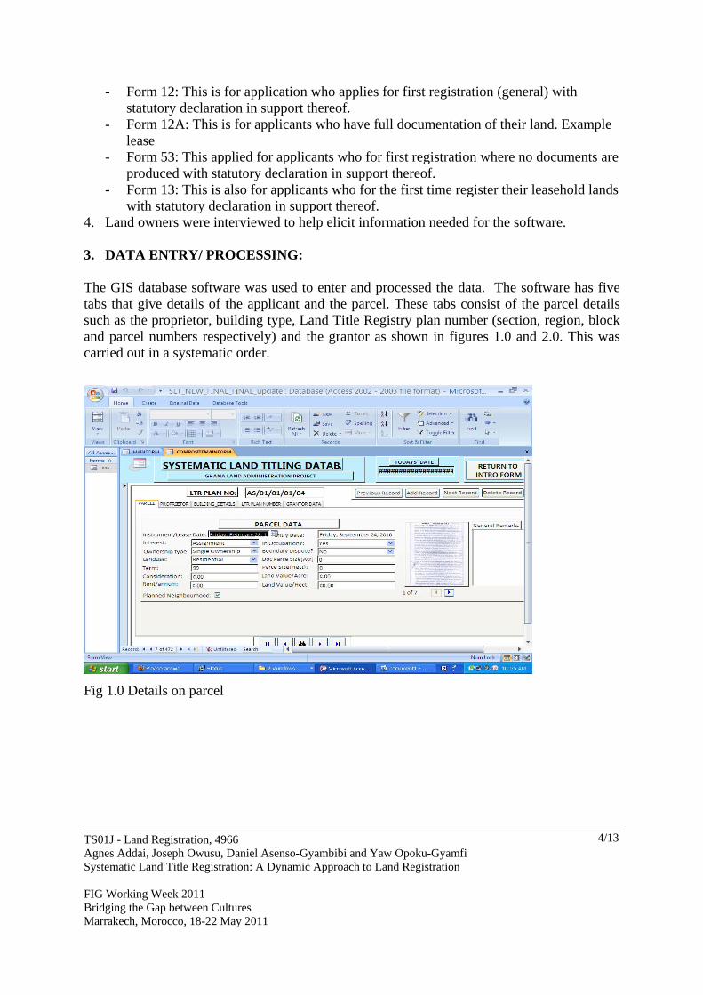
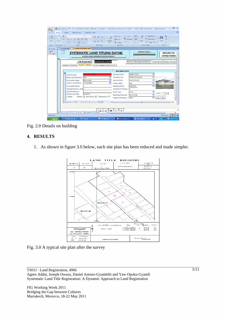
The GIS database software was used to enter and processed the data. The software has five tabs that give details of the applicant and the parcel. These tabs consist of the parcel details such as the proprietor, building type, Land Title Registry plan number (section, region, block and parcel numbers respectively) and the grantor as shown in figures 1.0 and 2.0. This was carried out in a systematic order.
Fig 1.0 Details on parcel
TS01J - Land Registration, 4966 Agnes Addai, Joseph Owusu, Daniel Asenso-Gyambibi and Yaw Opoku-Gyamfi Systematic Land Title Registration: A Dynamic Approach to Land Registration FIG Working Week 2011 Bridging the Gap between Cultures Marrakech, Morocco, 18-22 May 2011
5/13
Fig. 2.0 Details on building 4. RESULTS
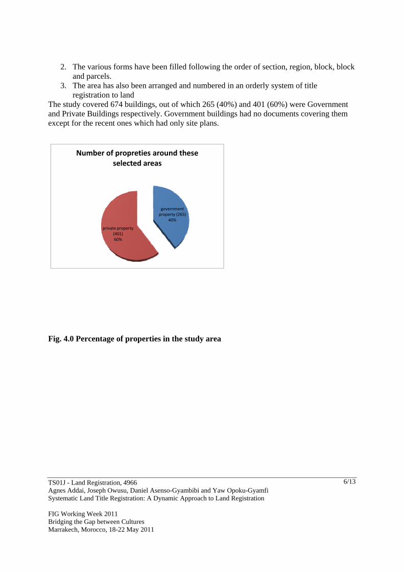
1. As shown in figure 3.0 below, each site plan has been reduced and made simpler.
Fig. 3.0 A typical site plan after the survey
TS01J - Land Registration, 4966 Agnes Addai, Joseph Owusu, Daniel Asenso-Gyambibi and Yaw Opoku-Gyamfi Systematic Land Title Registration: A Dynamic Approach to Land Registration FIG Working Week 2011 Bridging the Gap between Cultures Marrakech, Morocco, 18-22 May 2011
6/13
2. The various forms have been filled following the order of section, region, block, block and parcels.
3. The area has also been arranged and numbered in an orderly system of title registration to land
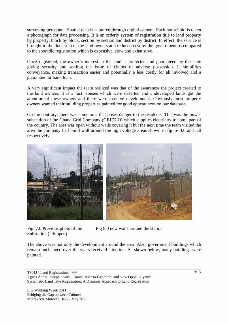
The study covered 674 buildings, out of which 265 (40%) and 401 (60%) were Government and Private Buildings respectively. Government buildings had no documents covering them except for the recent ones which had only site plans.
government property (265)
40%
private property (401)60%
Number of propreties around these selected areas
Fig. 4.0 Percentage of properties in the study area

TS01J - Land Registration, 4966 Agnes Addai, Joseph Owusu, Daniel Asenso-Gyambibi and Yaw Opoku-Gyamfi Systematic Land Title Registration: A Dynamic Approach to Land Registration FIG Working Week 2011 Bridging the Gap between Cultures Marrakech, Morocco, 18-22 May 2011
7/13
Uncompleted buildings(38)
41%
Schools(5)6%
Hotels/Guest house(26)
28%
Undevelop land(23)25%
Composition of develpment in the study area
Fig. 5.0 Composition of development in the study area Out of the total number of 408 private buildings only 59 documents from land owners representing 13% were collected. Out of the total number of fifty – nine (59) documents collected within the period, only five (5) had the land title certificate. This indicates that with the deed system of registration which had been there for so many years, only five people had registered. What the system did was to give titles to interested applicants it can be deduced 59 applicants would be registered at the end of the project. The assertion being made here is that, if 59 applicants should register out of 408 private properties, then in the intension of Land Administrative Project would be fulfilled.

TS01J - Land Registration, 4966 Agnes Addai, Joseph Owusu, Daniel Asenso-Gyambibi and Yaw Opoku-Gyamfi Systematic Land Title Registration: A Dynamic Approach to Land Registration FIG Working Week 2011 Bridging the Gap between Cultures Marrakech, Morocco, 18-22 May 2011
8/13
0
10
20
30
40
50
60
certificate(5) new applicants(59) awaiting certificates(0)
LAND CERTIFICATES
Fig. 6.0
5. DISCUSSION
An applicant obtains appropriate registration forms from the Land Title Registry, completes and submits them together with copies of all relevant documents and receipt of acknowledgment (yellow card) and a letter of request addressed to the Survey Department for the preparation of parcel plans. Applicant then pays and collects parcel plans from the Survey Department whenever it’s ready and then submits them to the Land Title Registry to assist them in the application processing. Applicant at this point is issued a photocopy of the parcel plan together with a Request Form to be sent to the Lands Commission for a search report, and satisfying itself that there are no objections or adverse findings in it, the Registry then proceeds to publish the application in the media to notify the general public of such application. It therefore last for fourteen days to receive objections from interested parties who may wish to challenge the application. If no objections are received within this period the Registry then continues with the process of registration. The Land Title Registry prints and sign certificates, records a particular on sectional plans and notifies applicants of completion of registration exercise. The Land Title certificates are finally issued out to become frustrated after going through all these process and most of them become stacked along the way. However, with this new introduction of land registration owners will comfortably register their lands without any distressing. Information is generated through a house to house system of parcels registration by questionnaire administrators followed by systematic survey by
TS01J - Land Registration, 4966 Agnes Addai, Joseph Owusu, Daniel Asenso-Gyambibi and Yaw Opoku-Gyamfi Systematic Land Title Registration: A Dynamic Approach to Land Registration FIG Working Week 2011 Bridging the Gap between Cultures Marrakech, Morocco, 18-22 May 2011
9/13
surveying personnel. Spatial data is captured through digital camera. Each household is taken a photograph for data processing. It is an orderly system of registration title to land property by property, block by block, section by section and district by district. In effect, the service is brought to the door step of the land owners at a reduced cost by the government as compared to the sporadic registration which is expensive, slow and exhaustive. Once registered, the owner’s interest in the land is protected and guaranteed by the state giving security and settling the issue of claims of adverse possession. It simplifies conveyance, making transaction easier and potentially a less costly for all involved and a guarantee for bank loan. A very significant impact the team realized was that of the awareness the project created to the land owners. It is a fact Houses which were deserted and undeveloped lands got the attention of these owners and there were massive development. Obviously most property owners wanted their building properties painted for good appearances on our database. On the contrary, there was some area that poses danger to the residents. This was the power substation of the Ghana Grid Company (GRIDCO) which supplies electricity to some part of the country. The area was open without walls covering it but the next time the team visited the area the company had build wall around the high voltage areas shown in figure 4.0 and 5.0 respectively.
Fig. 7.0 Previous photo of the Fig 8.0 new walls around the station Substation (left open) The above was not only the development around the area. Also, government buildings which remain unchanged over the years received attention. As shown below, many buildings were painted.

TS01J - Land Registration, 4966 Agnes Addai, Joseph Owusu, Daniel Asenso-Gyambibi and Yaw Opoku-Gyamfi Systematic Land Title Registration: A Dynamic Approach to Land Registration FIG Working Week 2011 Bridging the Gap between Cultures Marrakech, Morocco, 18-22 May 2011
10/13
Fig. 9.0 previous view Fig. 10.0 A recent government building outlook
Fig. 11.0 An on – going development Fig. 12.0 Demonstration of some of the recent in the area developments 6. CONCLUSION
To conclude, the project was a triumph despite all the challenges the team encountered. However, the team observed that house numbering around the area and in Ghana as a whole is a problem. It is a fact that each house had two (2) house numbers: the old plot number and the Kumasi Metropolitan Assembly (KMA) number aside the new street names by KMA. House owners therefore are in a dilemma of addressing their properties as the old or the new names. In this regard, the team in order not to commit themselves used the old numbers for the project.

TS01J - Land Registration, 4966 Agnes Addai, Joseph Owusu, Daniel Asenso-Gyambibi and Yaw Opoku-Gyamfi Systematic Land Title Registration: A Dynamic Approach to Land Registration FIG Working Week 2011 Bridging the Gap between Cultures Marrakech, Morocco, 18-22 May 2011
11/13
7. RECOMMENDATIONS
The ineffectiveness of the land registration means the system lacks the following points and they must exist before such systems are likely to meet with success. Firstly, Government must appreciate the expense and duration of the operation. Land registration is essentially a long-term investment; therefore, policy makers must understand that there are few immediate benefits. Although the government's costs are reduced after the initial compilation stage, subsequent maintenance of the register is a permanent commitment. A policy vacillating between Luke-warm support and neglect will prove more costly in the long run. If land registration cannot be conducted efficiently and continuously, it is probably better left al Secondly, landowners must generally understand and support the system's introduction. The demand for land registration should be generated from within and outsiders should not impose the system on a reluctant landholding community. To this extent, it is important land registration both facilitates and supports an understanding of the system. Not only the above but also, property rights and boundaries must be clearly recognizable and definable. Property rights vested in claimants and the boundaries delimiting the extent of their holdings must be quickly recognizable and clearly definable if the introduction of a land registration system is not to be frustrated by endless dispute. Land registration should not be employed to create interests, but to record and confirm existing interests and definable future interests. Physical demarcation of boundaries by hedges, fences, dikes, etc. can greatly assist the process and reduce the costs. Another point is that a developed system of property rights must exist. Before land registration can be successful, there must be a developed system of property rights. Land registration systems register legal rights in land. If such rights are ambiguous, non-existent, or poorly defined by law, registration of those rights is likely to be an expensive and wasteful exercise. Such countries should focus their initial efforts on defining property rights, perhaps in a comprehensive manner. Last but not the least; qualified survey and registry staff must be available. Compilation and maintenance of a land registration system depends heavily on competent staff. Although education and training can fulfill a significant portion of this need, an existing core of qualified professionals is vital to begin the process and to assist in the training effort. In developing countries, where there is usually a shortage of professional and technical staff to meet the day-to-day needs of most government departments, it must be realized that the land registration system competes with other government departments for the inadequate supply of educated personnel. Therefore, personnel’s who go the field must be well trained.
TS01J - Land Registration, 4966 Agnes Addai, Joseph Owusu, Daniel Asenso-Gyambibi and Yaw Opoku-Gyamfi Systematic Land Title Registration: A Dynamic Approach to Land Registration FIG Working Week 2011 Bridging the Gap between Cultures Marrakech, Morocco, 18-22 May 2011
12/13
REFERENCES Anthony Arko-Adjei, 1996, Customary Lands-Emerging challenges facing the Land Administration Society in the New Millennium: Case from Ghana, Ghana. Zevenbergen, Jaap and Bogaets, Theo, 2000, Alternative Approach for Successful Cadastral Systems, Delft University of Technology, Department of Geodesy, the Netherlands. Rebecca SITTIE, 2006, Land Title Registration. The Ghanaian Experience, Ghana. Technical Report for Services for Systematic Surveying, Inventory and Systematic Title Registration of Properties in Selected Urban Registration Districts – Lot 7: Danyame /Ridge – Kumasi, BRRI, pg 26 – 34. Peter Kuntun – Mensah
World Bank , 2003, Ghana - Land Administration Project,
Arko – Adjei Anthony, 2005, Titling Customary Lands – Emerging challenges facing the Land Administrative Society in the New Millennium: case from Ghana. BIOGRAPHICAL NOTES 1. Agnes Addai is a social scientist (B.A Political Studies, KNUST) and work at the Building and Road Research Institute (BRRI) of the Council for Scientific and Industrial Research (CSIR), Ghana. She has been working on the Systematic Land Titling Registration for more than one year. Currently, she is part of the on – going Land Administrative Project of the Ministry of Land and Natural Resources, Ghana. She has also been attending a number of seminars and workshops in the area of Land Administrative Project. 2. Joseph Owusu is a Research Scientist at the Building and Road Research Institute (BRRI) of the Council for Scientific and Industrial Research (CSIR), Ghana and is currently a Geomatics Engineer. He has been involving in projects covering land titles and disputed parcels of land. He has been attending and presenting a lot of conference papers both local and international. Examples are 1. FIG regional conference in Accra-Ghana in 2006 and 2. XXIII International FIG Congress in Germany (2006). www.fig2006.de. 3. Joint CIG/ISPRs conference on Geomatics for Disaster and Risk Management in 2007 in Toronto. 4. FIG Congress in Sydney, 2010. He has B.Sc. in Geodetic Engineering and Mphil in Geomatics Engineering from the Kwame University of Science and Technology, Kumasi- Ghana

TS01J - Land Registration, 4966 Agnes Addai, Joseph Owusu, Daniel Asenso-Gyambibi and Yaw Opoku-Gyamfi Systematic Land Title Registration: A Dynamic Approach to Land Registration FIG Working Week 2011 Bridging the Gap between Cultures Marrakech, Morocco, 18-22 May 2011
13/13
CONTACTS Ms Agnes Addai Building and Road Research Institute, P. O. Box UP40, Kumasi, Ghana Mobile number: +233 20 878 584 9 Email: [email protected] . Joseph Owusu Building and Road research Institute, Box 40, UST. Kumasi – Ghana, Mobile: +233-244-274114 E-mail: [email protected]..