Embed Size (px)
Citation preview

DEVELOPMENT OF INTEGRATED HIGHWAY MANAGEMENT SYSTEM IN KOREA
Chunjoo YOON Researcher Highway Research Department Korea Institute of Construction Technology 2311, Daehwa-Dong, Ilsan-Gu, Goyang-Si, Gyeonggi-Do, 411-712, Korea Fax : +81-31-9100-746 E-mail : [email protected]
Junggon SUNG Research Fellow Highway Research Department Korea Institute of Construction Technology 2311, Daehwa-Dong, Ilsan-Gu, Goyang-Si, Gyeonggi-Do, 411-712, Korea Fax : +81-31-9100-746 E-mail : [email protected]
Abstract : The integrated highway management system (hereafter, HMS) is a system which is capable of generating and providing comprehensive highway data through introducing and operating a unified location reference system in connection with existing highway-related systems and establishing a linkage between the highway digital maps and a variety of highway-related data. In this study, first, a new location reference system for the National Highways were introduced by installing kilometer posts; second, an integrated database were established by applying a unified location reference system to relevant data; third, the national highway digital maps were utilized in order to provide highway information in a visual format; fourth, the application softwares were developed to accommodate needs and requirements of computer system engineers, highway decision makers, and highway engineers. The HMS is an operating stage. Key Words : Highway Management, GIS, Location Reference System, Photologging
1. INTRODUCTION With the growth of economy and national land development, the role of national highway as national infrastructure has become more important by the increase of exchange of goods and transportation. As a result, the total expenditure of maintenance management is continuously increasing. Therefore, more comprehensive and systematic highway management plan is needed to ensure the convenience of highway users and improvement of road safety. The Korean Ministry of Construction and Transportation has operated various management systems according to the highway structural components such as pavement and bridges, and also some other systems which are needed for highway management. The highway systems include pavement management system(PMS), bridge management system(BMS), traffic monitoring system(TMS), CAD drawings and registers management system(NAHMIS), cut-slope management system(CSMS), and so on(KICT, 2003). However, the highway systems were separately developed and operated making it hard to share information. Furthermore, most systems were developed a decade ago, and they are non-GIS(Geographic Information System) based systems. The total length of target highways for the HMS is about 12,000 km in the end of 2004. The Integrated Highway Management System (hereafter, HMS) has been developed to solve these problems. The HMS is a system which is capable of generating and providing comprehensive highway data through introducing and operating a unified location reference system in connection with existing highway systems, and establishing a linkage between the digital map for highway management and a variety of highway-related data. The development of the HMS has begun in 1997. The current status of the HMS is an operating stage.
Proceedings of the Eastern Asia Society for Transportation Studies, Vol. 5, pp. 783 - 790, 2005
783

2. DEVELOPMENT OF HMS 2.1 Location Reference System for the National Highway Before the development of the HMS, the methods of expression of locational information for each highway system were different depending on the system. For some systems, a location was expressed by the reference point method, and for some other systems, a location was expressed by their own section numbers or their own ID numbers. For the same location, each system used its own location expression method. These made it difficult to share highway data and to match the locational information for a certain location.
Figure 1. Location Expression
For the location expression, the kilometer posts were installed every 1km for the upper and lower bound of national highway. The location reference system was defined to express all the highway information based on the kilometer posts. The goal is to ensure efficient locational information management of the national highway data which has been characterized by frequent route changes. The contents of kilometer post are: route numbers for the national highways, the closest destination ahead, remaining distance to the destination, and upper bound marking. The backside of a kilometer post holds the management tag which includes ID number and other information.
Figure 2. Kilometer Post
Proceedings of the Eastern Asia Society for Transportation Studies, Vol. 5, pp. 783 - 790, 2005
784

All kilometer posts were installed based on the management section. The highway sectioning was carried out on the basis of the jurisdiction of highway management such as a local government or a MOCT highway construction and management office. The highway section was defined by the jurisdiction of highway management and also the highway sections were divided into sub-sections based on the destinations along the national highways. Figure 3 shows the highway sectioning methods.
Figure 3. Sectioning Method
The HMS location reference system was designed to satisfy the needs of highway managers, highway users and system engineers. The kilometer posts installed every 1km in each section helps the driver to figure out where he/she is while driving. The location of highway facility is expressed based on the kilometer post name, direction, and offsets from the kilometer post. By utilizing and adopting a unified location reference system, highway locational information can be easily expressed based on the kilometer post name, direction, and offsets. Also, system engineers can utilize location reference system efficiently and accurately for updating the highway related data in case of frequent highway alignment changes and the locational changes of highway facilities. 2.2 Digital Maps for Highway Management Expressing highway information on the digital map makes it easy to understand the information and lots of overlaid information can be analyzed by the GIS techniques. Before the development of the HMS, it was impossible to connect various information into the highway digital map because each individual system did not have digital map to share. Through the highway digital map, it became possible to give visual information by expressing the highway related information on highway digital map. Understanding for the highway management became easier through easy location finding, and spatial queries made it possible to conduct various analysis. By updating the digital map of Transportation DB project, 1:5,000 scale map, HMS digital map was made for the 12,000 km national highways. The HMS digital maps were produced for an entire nation wide map for the MOCT central office and other various maps prepared for the local highway maintenance management offices. The HMS digital maps include various layers such as highway centerlines, administrative boundaries, bridges, rivers, and so on. Highway related information is expressed by linear referencing system based on kilometer post. A dynamic segmentation technique was used to connect spatial information and
Proceedings of the Eastern Asia Society for Transportation Studies, Vol. 5, pp. 783 - 790, 2005
785

attributes. In many cases, highway links can have one-to-many relationships. For the pavement management, a link may have more than one attribute. For example, at a certain location of one link, pavement data can be changed. In this case, highway link in the digital map should be divided according to the number of changes. If links should be divided depending on the changes of attributes, the number of links and the volume of information will increase and the same information should be duplicated as a result of the link division. In order to solve these problems, a multi-attribute dynamic segmentation data model was designed and implemented in the HMS application software. 2.3 Integrated Database An integrated DB was designed and established by applying a unified location reference system to relevant data. The goal was to enhance efficiency of management of highway-related data through a common location reference system. Integrated DB includes CAD drawings and registers, pavement condition and management data, bridge structures and management data, traffic volume data, and cut slope management data. All These data were transformed based on the location reference system and matched with the highway digital map. Table 1 shows the data by the system types.
Table 1. Integrated DB Management Information
Classification Data Description
CAD drawings Plane Drawing, Land Drawing, Underground Drawing Highway
Drawings and Registers
(NAHMIS) Registers Highway Centerline, Intersection, Vertical Grade, Roadside Facilities etc.
Pavement (PMS)
Maintenance History, Maintenance, Pavement Condition (QI, VI etc.) Pavement Maintenance Management History(Surface treatment etc.)
Bridge (BMS)
Bridge Information & Structure, Tunnel Information & Structure, Maintenance History etc
Traffic (TMS) Traffic Volumes by Vehicle Types, ADT etc.
Cut Slope (CSMS) Cut Slope Site Data, Maintenance History, Site Photo etc.
2.4 Development of Application Software The application software were developed to accommodate needs and requirements of computer system engineers, highway decision makers, and highway engineers taking in account the system operation environment. Two types of application software were development, one is a Client/Server-based application software and the other one is a Web-based application software. The comparison of these two application softwares were shown in Table 2.
Proceedings of the Eastern Asia Society for Transportation Studies, Vol. 5, pp. 783 - 790, 2005
786
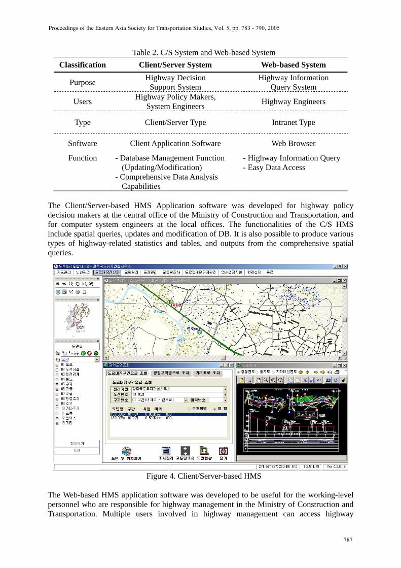
Table 2. C/S System and Web-based System Classification Client/Server System Web-based System
Purpose Highway Decision Support System
Highway Information Query System
Users Highway Policy Makers, System Engineers Highway Engineers
Type Client/Server Type Intranet Type
Software Client Application Software Web Browser
Function - Database Management Function (Updating/Modification)
- Comprehensive Data Analysis Capabilities
- Highway Information Query - Easy Data Access
The Client/Server-based HMS Application software was developed for highway policy decision makers at the central office of the Ministry of Construction and Transportation, and for computer system engineers at the local offices. The functionalities of the C/S HMS include spatial queries, updates and modification of DB. It is also possible to produce various types of highway-related statistics and tables, and outputs from the comprehensive spatial queries.
Figure 4. Client/Server-based HMS
The Web-based HMS application software was developed to be useful for the working-level personnel who are responsible for highway management in the Ministry of Construction and Transportation. Multiple users involved in highway management can access highway
Proceedings of the Eastern Asia Society for Transportation Studies, Vol. 5, pp. 783 - 790, 2005
787

information via a web browser through intranet system. This system provides a variety of highway-related information through the simple query function. Figure 5 show the Web-based HMS application software and Figure 6 shows software architecture of HMS.
Figure 5. Web-based HMS
Figure 6. Software Architecture of Highway Management System
Proceedings of the Eastern Asia Society for Transportation Studies, Vol. 5, pp. 783 - 790, 2005
788

2.5 Highway Digital Photologging Database In order to enhance efficiency and utilization of the HMS, a highway photologging system was developed. A highway visual image shows highway alignment information, roadside safety facilities, and road signs at the same times. Visual image database will be added and integrated into the HMS. To collect highway visual images, highway photologging vehicle was developed. Highway photologging vehicle takes a visual image every 10 m along the national highway. The photologging system will also be integrated into the HMS to provide highway visual images to the highway management offices. The primary uses of this system are to provide a visual inventory of highway such as roadway, roadside facilities and pavement conditions, to improve frequent vehicle crash locations, and to quickly view the site in case of emergency such as land side, severe accident, etc. In order to integrate these visual images into the HMS, highway photologging vehicle and image data collection software should be developed to collect data and highway image management software need to be developed in order to integrate with the HMS application software. The highway photologging vehicle and image data collection software were already developed. The highway photologging vehicle is currently operating to collect national highway image data. The highway image management software is being developed. In highway photologging vehicle, two progressive-scan CCD cameras, 2 GPS(Global Positioning System) receivers, INS(Inertial Navigation System), DMI(Distance Measurement Instrument), and signal synchronization device were installed. Figure 7 shows the highway photologging vehicle.
Figure 7. Highway Photologging Vehicle
Currently, highway image database design and application program is under development, and highway image data is being collected for both directions of the National Highways. Figure 8 shows a proto-type highway photologging application software which has functionalities to simulate the highway driving on different driving speeds, and to enlarge or reduce view scale and bright control, etc.
Proceedings of the Eastern Asia Society for Transportation Studies, Vol. 5, pp. 783 - 790, 2005
789

Figure 8. Application Software for Highway Photologging
3. CONCLUSION Before the development of HMS, there existed many problems in utilizing the highway data efficiently. First, it was difficult to indicate the same location among the highway management systems since each individual highway management system has its own location expression with its own location ID or location name. Second, it was hard to share highway data such as traffic volumes and highway drawings among the systems since there was no integrated database system and this caused overlapping data storage and overlapping data input efforts. Third, since most systems were developed a decade ago, they are non-GIS(Geographic Information System) based systems. In order to solve theses problems, first, new location reference system for the National Highways was introduced by installing kilometer posts which were designed to have flexible adjustments to route changes; second, an integrated database was established by applying a unified location reference system to relevant data; third, the national highway digital maps were utilized and reproduced in order to provide highway information in a visual format by presenting each system’s highway analysis data in common digital map; fourth two HMS application softwares were developed separately to accommodate needs and requirements of computer system engineers, highway decision makers, and highway engineers taking into account the system operation environment. The client/server-based HMS application software and Web-based HMS application software were developed. The development of the HMS has brought; first, consistency of highway management and user convenience are guaranteed by the adoption of a unified location reference system; second, more accurate data on highway is available by the provision of locational information; and third, integrated DB made it possible to share data resulting in better utilization of comprehensive data on highway.
REFERENCE Korea Institute of Construction Technology, (2003) Development of Highway Management System: Final Report, Ministry of Construction and Transportation, Korea.
Proceedings of the Eastern Asia Society for Transportation Studies, Vol. 5, pp. 783 - 790, 2005
790