Embed Size (px)
Citation preview
DEVELOPMENT CONTROL AND REGULATORY BOARD
26TH MAY 2011
REPORT OF THE CHIEF EXECUTIVE
COUNTY MATTER
PART A – SUMMARY REPORT
APP.NO. & DATE: 2010/0076/07 & 2010/0041/04 – 18th January 2010. PROPOSAL: Extraction of 132Mt of mineral from an area adjacent to
Bardon Hill Quarry, to use the overlying clay/overburden to complete the eastern tip (18), create perimeter landscaped embankments and partially infill the current quarry, to link the new operation to the existing operation/added value businesses using conveyors.
LOCATION: Land comprising the existing Bardon Hill Quarry and the
adjoining Bardon Estate between Coalville, Copt Oak, Stanton under Bardon and the A511 Shaw Lane.
APPLICANT: Aggregate Industries UK Ltd. MAIN ISSUES: Need and supply situation, protected species, habitat
loss, landscape impact, rights of way, noise, dust and blasting impacts, residential amenity and restoration.
RECOMMENDATION: Permit subject to the conditions included in the
Appendix and the prior completion of a legal agreement.
Circulation Under Local Issues Alert Procedure Mr. M. B. Wyatt CC Mr. D. A. Sprason CC Mr. G. Partner CC Mr. R. Blunt CC Officer to Contact Mr. S.R. Marriott Email: [email protected]
D
DC®. BOARD 26/05/2011
2
2010/0076/07 & 2010/0041/04 - continued
PART B – MAIN REPORT
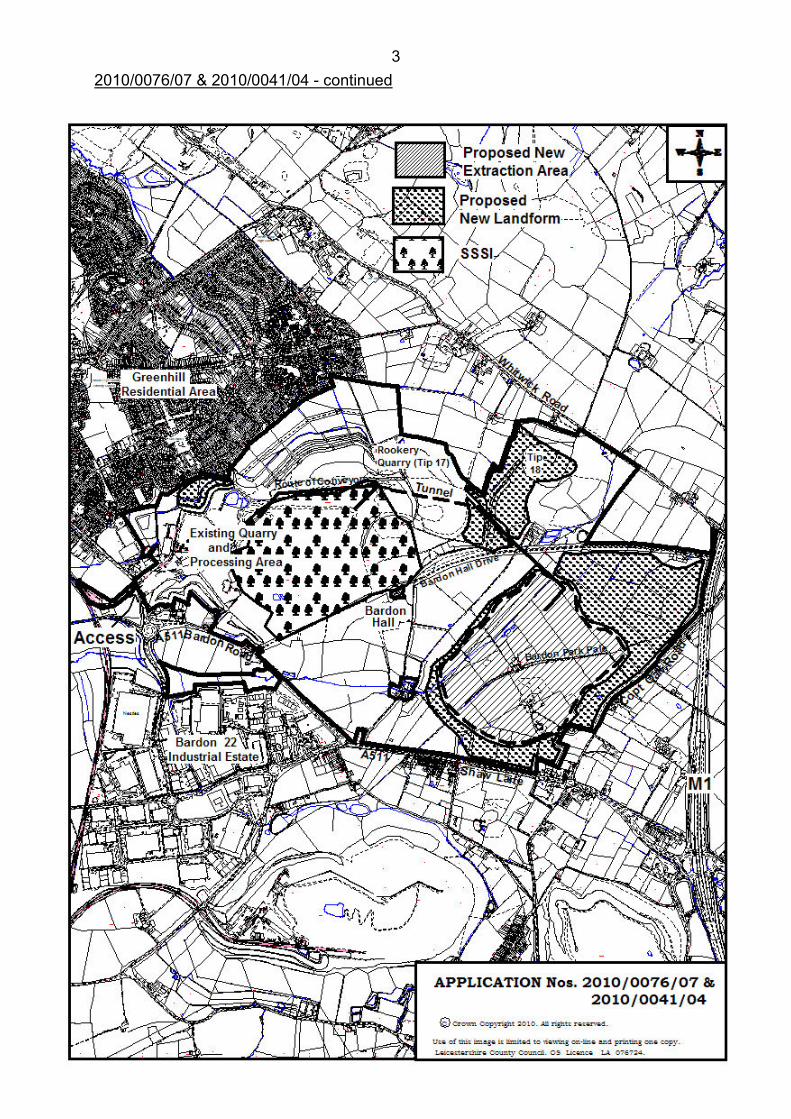
Location and Setting of Proposed Development 1. The application site covers an area of approximately 500 hectares (ha), mainly
within the Bardon Estate. To the north of Bardon Hall Drive, it comprises the existing Bardon Hill Quarry, associated processing plant site and stocking areas, lorry park, access to the A511 and rail link, existing landscaped screening mounds, Tip 18 area and Bardon Hill. The Estate to the south of Bardon Hall Drive is predominantly in agricultural use, being farmed primarily for arable and dairy uses. This area contains the proposed new extraction area, and new landforms, which cover approximately 66 and 58ha respectively. The new extraction footprint takes in land around Rise Rocks, and includes the boundary between North West Leicestershire District (to the north) and Hinckley and Bosworth Borough Council (to the south).
2. The site is bounded by the A511 Bardon Road and Shaw Lane to the south,
Copt Oak Road and the M1 to the east, and Whitwick Road and adjoining open farmland to the north east. The Greenhill residential area lies to the north of the existing quarry immediately beyond the perimeter screening embankments, and a new housing estate is similarly located to the north west of the site boundary. These areas lie approximately 150 – 200m from the existing plant site and approximately 350 – 500+m from the existing quarry. There are a few residential properties along Bardon Road, located some 100 – 150m from mineral stocking areas, and 250 – 300m from the existing quarry.
3. Several clusters of residential properties front Shaw Lane to the south and Copt
Oak Road to the east of the proposed site, and these range in approximate distance of between 165 – 350m from the proposed extraction area, and 45 – 250m from the toe of the proposed new landform. To the north east, on the eastern side of the M1 lie the settlement of Copt Oak, and a few scattered farm and residential properties along Whitwick Road. The proposed extraction area would be some 800 – 900m away, and the new landform some 150 – 350m distant from these properties. Two properties off Whitwick Road border the Tip 18 area. There are Company owned dwellings at Bardon Drive Farm, Rise Rocks, and Old Hall Farm situated within the Estate.
4. The application site contains a Geological SSSI, which covers the existing
quarry and Bardon Hill summit, and a Biological SSSI, which also covers Bardon Hill summit and its southern slope down towards Bardon Hall. Mature treed hedgerows, stone walls and ditch features form field boundaries within the Estate, and small woodland/copse features and parkland planting exists in the vicinity of Bardon Hall. A corridor of trees lines the drive to the Hall from the east, and a recently planted tree belt exists around the eastern portion of the site. A North West Leicestershire District Council Tree Preservation Order exists along the driveway to Old Rise Rocks.
DC®. BOARD 26/05/2011
3
2010/0076/07 & 2010/0041/04 - continued
DC®. BOARD 26/05/2011
4
2010/0076/07 & 2010/0041/04 - continued 5. A small watercourse, which forms part of the headwater of the River Sence,
flows through the shallow valley in the centre of the site. There are areas of unimproved wet meadow grassland adjacent to the stream, and areas of rough grassland around the rock outcrops at Rise Rocks. An area of unimproved grassland to the north of Bardon 22 Industrial Estate (situated to the west of Bardon Road), also forms part of the application site. A network of public rights of way crosses the site.
6. The Bardon Park boundary (pale) runs north east – south west across the site,
and exists as an earthen bank for approximately 75% of this length. Bardon Church, Bardon Hall Lodge and Bardon Park Chapel are three Grade II listed buildings situated along Bardon Road/Shaw Lane adjacent to the application site boundary. Kelham’s Farmhouse, Office & Range (the estate Farm) and Bardon Hall Grade II listed buildings, are situated within the estate, although the Hall is excluded from the application area. To the east of Kelham’s Farm lies a moated site, which is a Scheduled Monument.
7. The landscape character of the application site falls within the Charnwood
Forest designations. At the National level, it is located within Character Area 73 Charnwood. A broadly similar area is identified at the local level, by the Charnwood Forest character area in the County Council’s Landscape and Woodland Strategy. The application site is located on the western edges of these designations, adjoining coalfield character area designations at both the National and local levels. The southern part of the site is designated as Charnwood Fringe character area within the Hinckley and Bosworth landscape character assessment. The application site and surrounding area is located in the National Forest, and The Strategy for The National Forest 2004-2014, identifies further landscape character areas: the majority of the application site being located in the Charnwood character area, (enclosed farmlands and urban/urban fringe landscape types). The western fringe is located in the coalfield character area designation.
Description of Proposal
Context 8. Permitted reserves at the existing Quarry (as at 01/01/2009) were 45Mt. Of this
amount, 5Mt are located beneath the primary crusher with a further 9Mt beneath the Charcon products factory. The reserves that are accessible without incurring major disruption to operations are 31Mt, which at current and projected demand, gives a remaining life for the operation in the order of 9 years.
9. To provide for continued quarrying of igneous rock at present rates, further
permitted reserves are required. The Company has investigated the practicability of extending operations through current faces as well as carrying out drilling over the entire Bardon Estate to confirm the presence of mineral.
DC®. BOARD 26/05/2011
5
2010/0076/07 & 2010/0041/04 - continued 10. The existing operation is constrained as follows: eastwards due to the presence
of Bardon Hill and the biological SSSI; westwards by the Charcon factory, processing plant, and +80m of overlying clay; northwards because of the existence of an established landscape feature as well as approaching the Greenhill housing estate; southwards due to +70m of overlying clay.
11. The implications of a direct extension are considered in the Environmental
Statement. This concludes that the environmental impact would be minimised by not extending directly, but by leaving an undisturbed section of land and linking the extension to the plant site by conveyor.
12. Drilling operations undertaken across the Bardon Estate have proved a large
reserve of pre-Cambrian rocks overlain by a commercially manageable volume of overburden. The "footprint" of the area is situated in the south east quadrant of the Bardon Estate contained by Shaw Lane to the south, Copt Oak Road to the east, a private road to Bardon Hall to the north and the course of a tributary of the River Sence to the west.
13. The site investigation and subsequent quarry design has proven a saleable
mineral reserve of 132 million tonnes which is overlain by approximately 16.4 million cubic metres of clay. The proposal is to develop the quarry in phases with environmental screening embankments being formed adjacent to the southern, northern and eastern extraction boundaries.
Summary of Development Proposals 14. The proposed operations can be summarised as follows:
• Setting up a site compound next to the proposed extension area;
• The removal in four stages of the overburden and its use for, i. Completion of the landform being created by the existing Tip 18, ii. Construction of new landforms around the extension area, and iii. Infilling of the existing quarry to a level of 75 metres AOD;
• Installation of two conveyors from the extension area to the existing quarry - one for rock and one for overburden;
• Creation of a cut and cover tunnel for the conveyors from the extension area and under the Bardon Hall access road;
• Boring of a tunnel for the conveyors through the previously infilled part of the existing quarry;
• Diversion of the overhead power cables and supporting towers to the outside of the new extraction area;
• Diversion of the watercourse (that forms the headwaters of the River Sence) to the outside of the extraction area;
• Development and working of the new extraction area;
• The creation of new wildlife habitats on the new landforms and within the Bardon Estate;
• Continued use of the existing plant site for the processing and distribution of the crushed rock.
DC®. BOARD 26/05/2011
6
2010/0076/07 & 2010/0041/04 - continued
Proposed Operations
Setting up
15. The first operations would be the establishment of the site offices, welfare facilities, small workshop and associated mobile plant/car parking areas. These would be located in a compound to the south of Kelham’s Farm, off Bardon Hall Drive. All top-soils and sub-soils from the compound area would be stripped and placed in temporary storage mounds for subsequent reuse.
16. To manage surface water run-off from the new landforms, a series of catch
ponds linked by open channels would be excavated. Surface water runoff would enter the channel and ponds and any sediment settled out, before clean water is allowed to discharge into the tributary of the River Sence. To deal with any suspended solids in water pumped out of the extraction area, settling lagoons would be excavated adjacent to Tip 18, and connected to the existing settling lagoon system for final cleansing before discharge.
Stage 1 (years 1 – 4)
17. The 132kv overhead cables, which cross the western part of the extraction area
would be diverted. The three towers, which presently support the cables, would be removed and replaced by new towers and cables located to the west of the extraction footprint.
18. Conveyors would be used to transport crushed stone from the new extraction
area to the surge pile of the existing processing plant, to minimise emissions and for greatest energy efficiency. The proposed conveyor route is through a cut and cover tunnel from the north of the extraction area, underneath Bardon Hall Drive, and then via a cutting heading north east to a tunnel portal on the eastern slope of Tip 17 (the infilled Rookery Quarry). The tunnel would be bored through the infill material for 580 metres, exiting within the existing quarry. The excavated material would be deposited within the remaining void of Tip 18.
19. It is expected that the tunnelling operation would take approximately 12 months
to complete. The tunnel has been designed such that the rock and overburden conveyors are 'piggy backed' one on top of the other with a maintenance corridor to one side.
20. From the western exit portal, the rock conveyor would run along the inside of
the northern quarry face to the existing surge pile. Rock would be drawn from the surge pile into the existing processing plant. The overburden conveyor would run into the north east corner of the existing quarry.
21. Before tipping of overburden on Tip 18 resumes it would be necessary to install
a drainage blanket, to ensure tip stability and to allow ground water to flow unimpeded beneath. A concrete culvert would also be constructed beneath the tip to ensure free drainage from the low lying land on the western side of the tip. It is estimated that Tip 18 has a remaining capacity of approximately 900,000 cubic metres.
DC®. BOARD 26/05/2011
7
2010/0076/07 & 2010/0041/04 - continued 22. Topsoils and sub-soils would be removed separately from within Phase I of the
extraction footprint and from beneath those areas, which would support perimeter bunding. The soils would be placed in temporary storage mounds and used for landscaping the finished landforms.
23. The new perimeter landforms would involve a progressive sequence of soil
stripping and storage, drainage blanket installation, overburden deposition and soils replacement. Approximately 4 million cubic metres of overburden would remain to be removed, and used in the construction of the new embankments. It is expected that this process would take 4 years, with soil placement being completed within 12 months of the final overburden being deposited.
24. The soils and clay would be excavated by two backactor units feeding material
into two fleets of dump trucks. A fleet of five rigid dump trucks would be used to carry material to finish off Tip 18 and to construct the bulk of the northern landform, whilst smaller articulated trucks would be used to construct the eastern and southern landforms, as well as performing finishing off works. A bulldozer would be used for the final placement of the material, and a motor grader and water bowser would be used to maintain access routes and damp down respectively.
25. Once the landform has reached its formation profile, the surface would be
ripped to relieve compaction before sub-soils are recovered from storage and spread to achieve a thickness of not less than 0.5 m. Areas, which are to be planted with trees, would be subjected to further ripping before topsoils are recovered from storage mounds and re-spread.
26. The landforms adjacent to Shaw Lane and Copt Oak Road would be given
priority and formed within the first 12 months of landscaping commencing. 27. The landscaping works include establishing an acid heathland habitat on the
upper slopes of the new landforms, (using the lower fertility sub and top soils), whilst the lower flanks would be planted with trees. The landscaping would be undertaken in front of all residential properties before any stone extraction commences.
28. Following the removal of the overburden, the operations would have exposed
the contact with the underlying bedrock. It is likely that the rock interface would be very irregular, and a limited amount of blasting/development work to create a level floor would be necessary. Subsequent quarrying operations would develop in a conventional manner with 15m high faces and intervening 10m wide horizontal benches.
29. The initial mobile plant would include a blast hole drilling rig, face shovel, back
actor, grader, tractor and water bowser, a mobile crusher and a 4 vehicle fleet of articulated dump trucks. From time to time, there may be a requirement to mobilise a rock breaker if any of the blasted material is too large to fit into the mobile crusher. Oversized material would be allowed to build up, and campaign breaking would take place with the unit located deep within the quarry void to minimise noise.
DC®. BOARD 26/05/2011
8
2010/0076/07 & 2010/0041/04 - continued 30. A new primary crusher (housed within a building) would be sited in the northern
corner of the extraction footprint. The crusher would be at a level of 145m AOD, which is more than 50 metres below the existing ground level.
31. Once the primary crusher conveyors are installed rock would be taken back to
the existing surge pile at the processing plant. Electrically powered motors would drive each conveyor section. The conveyors would have troughed belts, totally enclosed with tightly fitting pre fabricated steel sheet covers. The conveyor covers themselves would be pre coloured Moorland Green or such other colour as may be specified.
32. The initial mobile plant would be taken off site and replaced with larger plant
items to enable a throughput of 3.5Mt+/p.a. The plant would be similar to the existing quarrying operation (3 blast hole drilling rigs, 1 large face shovel, 1 large excavator, 2 medium sized loading shovels, 4 large rigid dump trucks, a grader and a tractor equipped with water bowser).
33. Conventional quarrying practices would be employed as follows:
• Drilling and Blasting: Typically 30 boreholes would be drilled to a pre-determined grid pattern. Each hole would be drilled to a depth of 15m equivalent to the final face height, and charged with up to 150kgs of a gel explosive mixture. This would be initiated by high-energy detonators, allied to non-electronic delays (some 25,000 tonnes of fragmented rock would result from a typical production blast). During the first 3 years or so, the blasting would be more frequent, sometimes twice a day. As the working area expands, and faces reach their optimum working length and height, then the frequency of blasting would reduce. All blasts would be managed such that the vibration value as measured at the nearest habited dwelling would not exceed the existing permitted blasting limit of 6 mm per second. Water bowser/cannon would be used to reduce potential dust emissions.
• Loading and Hauling: Blasted rock would be loaded using a large capacity hydraulic excavator feeding a small fleet of 100 tonne payload dump trucks. Loaded dump trucks would drive out of the mineral extraction area to the primary crusher building, where they would tip their load into the receiving hopper. The hopper design would accommodate up to 250 tonnes i.e. approximately 2.5 dump truck loads. To optimise crushing efficiency the building would allow rock to be tipped from either side.
• Crushing and Conveying: A gyratory crusher (similar to the existing) consisting of a slowly rotating central mantle set inside a concave chamber below the hopper is proposed. A pre set gap between the inside of the chamber and face of the mantle determines the size of the crushed material passing through. Rock tipped into the crusher hopper would range in size from large lumps up to 1.5m across through to very small stone fragments and dust. All crushed material would be reduced to a maximum size of 350 mm. and exit the primary crusher building via an inclined conveyor en route to the existing processing plant.
DC®. BOARD 26/05/2011
9
2010/0076/07 & 2010/0041/04 - continued 34. No rock would be available to extract within the initial 2-year period. During this
time, the existing quarry would continue operating to its current throughput (in the order of 3MT p.a.). During year 3, stone reserves in the extension would have been exposed and it is expected that up to 0.5MT would be produced. By the end of the Stage, (year 4) throughput is expected to increase to c 2.5MT p.a. At this point reserves within the existing quarry would be depleting and contribute 0.5MT p.a. towards the site's total of 3MT p.a. production.
35. A tributary of the River Sence flows in a north to south direction through the
western section of the proposed extraction footprint. An alternative course for the stream, complete with ponds, meanders and scrapes, has been identified to the west of the extraction footprint to avoid sterilisation of a significant tonnage of rock. A new stream channel would be excavated during Stage 1.
36. Footpaths N49, O22 and O35 would be affected by the proposed works.
Temporary diversions would need to be sought and agreed with the Highways Authority and temporary alternative routes provided. Towards the end of the stage, i.e. by the start of Year 4, the alternative routes for the footpaths would be in place. The reinstatement of Footpath O35 across Tip 18 would be completed.
Stage 2 (years 5 – 7)
37. The receptor channel to accommodate the diverted tributary of the River Sence
would have sections of the bed of the existing stream transferred into it so that the new channel would have an element of maturity from the outset. The overall conservation interest would be improved, including construction of a meandering route, in-channel riffles, ponds, wet areas and scrapes constructed within its corridor with seeding and planting using local provenance stock. Once the new stream course has been created, a connection and return would be made back into the undisturbed sections of the original watercourse.
38. The 4 properties at Rise Rocks would be demolished, and any salvageable
construction materials recycled. The proposals include the recovery of a number of the large, lichen-covered boulders that are situated close to the buildings, and their relocation onto the highest parts of the proposed perimeter landforms.
39. It is proposed to establish 2,300 metres of hedgerow on top of the perimeter
embankments, of which over 1,000 metres would be translocated hedgerow (the translocation of hedgerows is a well-practiced operation by the Applicant with a 100% success rate).
40. Top soils and sub-soils would be stripped to their full depth from the footprint of
Stage 2 and these would be placed in storage. All soils needed for covering Tip 18 and the perimeter landforms would have been applied during Stage 1. As there would be no other areas needing landscape/restoration treatment at that time, it is proposed that the soil resources should be retained for reclamation of the worked out areas. The soils would be placed in the two large fields located to the east of Bardon Hall and cultivated (this is later referred to as the soil storage area).
DC®. BOARD 26/05/2011
10
2010/0076/07 & 2010/0041/04 - continued 41. Almost 11 million cubic metres of overburden would need to be excavated and
placed into what would by then have become the exhausted part of Bardon Hill Quarry. Some 7 million cubic metres of this would be removed from Stage 2.
42. Overburden would be removed using a hydraulic excavator matched to a small
fleet of articulated dump trucks, a clay shredder and a new conveyor system, which would run parallel with the stone conveyor installed in stage 1. The shredding process would produce a material of a uniform consistency and size, which can be carried by conveyor.
43. Once the material has been processed through the shredder, it would be
transported out of the quarry using conveyors. The rock and overburden conveyors would share the same corridor up to the point where they emerge from the western portal of the tunnel beneath Rookery Quarry. The conveyor carrying overburden would deposit material into a hopper situated on the floor of what is currently the existing quarry. Dump trucks would be used to move the overburden to pre-notified locations, where it would be levelled and compacted.
44. By this time, Tip 18 and all of the perimeter screening embankments to the
north, south and east would have been formed and soiled. A variety of different landscaping types are proposed including an acid heathland on the northern landform, areas of grazing as well as planting largely deciduous trees on the eastern and southern landscape bunds and the lower slopes of the large northern landform. All of these works would be put in hand during Stage 1 and would be completed by the end of Stage 2.
45. New cycle routes and permissive footpaths and bridleways would provide
additional links with the Rights of Way network providing increased public access to and across the Bardon Estate.
46. Rock extraction continues using the same techniques and plant to that
described in Stage 1. By this time, the new quarry would be able to produce its design throughput of 3MT+/p.a. and operations within the existing quarry would cease.
Stage 3 (years 7 – 10)
47. Top soils and sub-soils would be stripped to their full depth from the footprint of
Stage 3 and these would be placed in the soil storage area. The extraction of approximately 2.5 million cubic metres of overburden overlying the bedrock would continue using the same techniques and mobile plant as in Stages 1 and 2. There may be a need from time to time to relocate the clay shredder and with it, the conveyor to maintain overburden removal as the footprint extends.
48. As final overburden face positions are achieved, they would be hydro-seeded
with a recipe including a low maintenance grass seed with some ryegrass and local provenance tree seeds such as birch. Hydro-seeding would afford additional stabilisation as the vegetation roots penetrate through the clay surface and the appearance of the surface itself would be improved.
DC®. BOARD 26/05/2011
11
2010/0076/07 & 2010/0041/04 - continued 49. Overburden deposition within the existing Bardon Hill Quarry would continue
using the same techniques and mobile plant as deployed in Stage 2. Rock extraction using the same techniques and plant as described in Stages 1 and 2 would enable continuation of extraction at around 3MT/pa.
Stage 4 (year 11 onwards)
50. Top soils and sub-soils would be stripped to their full depth from the footprint of
Stage 4 and these would be placed in the soil storage area. The remaining 1.5 million cubic metres of overburden would be removed using the same techniques and with the same mobile plant as detailed for working Stages 1, 2 and 3.
51. Following completion of the overburden removal, the clay shredder and its
attendant conveyors, and the hopper located within the existing quarry, would be de-commissioned, and taken off site. The mobile plant used for the overburden extraction (and deposition) would also be taken off site.
52. Rock extraction would continue with the techniques and plant used in Stages 1,
2 and 3 with a throughput of 3MT+/p.a. Extraction would then continue over the full area of the excavation footprint and gradually descend into the mineral using 15m deep benches to a depth of approximately 20 metres BOD (Below Ordnance Datum). In so doing over an extraction period of some 40+ years (at current output), the full 132M tonnes of rock would be worked. The number of (15m) benches in the worked out quarry would range between 0 - 5/6 for overburden and 12 – 16 for rock, due to the variance in the ground levels and geological conditions across the site.
53. Once the dewatering pumps have been turned off the quarry void would begin
to fill. This would be mainly from rainwater as there would be little water ingress through the sides of the new quarry. Based upon information obtained from pumping operations at the existing Bardon Hill Quarry and taking account of rainfall and evaporation, it is estimated that the new extraction area would take around 50 years to fill with water to level 8 (85mAOD). The ultimate water level is projected to rest at 145mAOD, many years later, and this would be between 53 – 80m below surrounding ground levels.
Mineral Processing and Despatch
54. Additional screening of the processing plant area is proposed (during stage 1)
by raising the existing northern embankment, by between 3 – 8m. Less steep outer facing slopes would be created by using an adjacent area of land (owned by North West Leicestershire District Council). The landform would be created using clay from the new extraction area, and all works completed within 6 months. The new embankment would be soiled, and any compaction alleviated, before being replanted with deciduous trees. New footpaths would also be constructed.
DC®. BOARD 26/05/2011
12
2010/0076/07 & 2010/0041/04 - continued 55. Future mineral processing would be as the existing operations, utilising the
primary surge pile, reclaim tunnel and conveyor link to the secondary crushing, and feed to the tertiary crusher house for single sized products (ranging from 6mm to 20mm). All graded products would then be conveyed to the lorry load out facility, and either directly conveyed into the toast rack building to feed the rail load out building or put directly into an awaiting HGV or dump truck. The dump trucks are used to haul the stone to the quarry stockyard or to the 2 asphalt plants and the Charcon concrete products factory.
56. In the first 2 years, no stone would be released from the extension area but
output would rise to full production of around 3Mt/p.a. by year 5. Once full production is achieved within the new extraction area the existing primary crusher and building would be dismantled and removed from site.
57. Customer vehicles collecting materials would continue to use the existing HGV
access and egress points situated near to the rail crossing on the A511. The existing access into the quarry is to be improved, including the construction of a right hand turn lane, under a scheme agreed with the County Council.
Restoration
Existing quarry, processing area and associated infra structure
58. The existing quarry would be partially infilled with clay to create a plateau at a
level of between 60 and 75m AOD (i.e. at an approximate level of the current workings) within 15 years of the development starting. The plateau would be substantial (around 23ha) and the Company proposes to examine opportunities to use it for the relocation of all or part of the processing plant (and/or concrete products factory and stock yard) or alternative uses. Rain water would be directed into a collecting sump, and pumped to the existing settling lagoons. The geological SSSI would be left fully exposed.
59. The overburden face that would remain from ground level to the top of the
rockhead would be hydro-seeded with a low maintenance grass seed. This would incorporate local provenance tree seed to provide extra stability and an improved appearance. Sections of the face would be left untreated to reveal the geological sequence, and where final quarry benches are accessible, soils would be placed and trees planted.
60. Once the new quarrying operation has been completed all the
crushing/screening plant and buildings would be removed. All foundations and hard surfaces would be broken up or ripped and the resulting materials either recycled or taken off site. The areas would then be soiled, and the quarry sides planted to reflect the existing perimeter embankments.
61. All operations would be linked to the life of the quarry and would cease once
quarrying finishes. Any uses beyond this point would be subject to the grant of further planning permissions (e.g. the option to retain the rail link to supply the continued operation of the asphalt plants and concrete factory with imported aggregates). The continued use of the quarry floor would be dependant upon dewatering being maintained.

DC®. BOARD 26/05/2011
13
2010/0076/07 & 2010/0041/04 - continued
The extension area including associated conveyors and compound area 62. All mobile plant and buildings, the primary crusher and all link conveyors would
be dismantled and removed from site. The tunnel beneath Tip 17, Rookery quarry would be sealed at either end to prevent public access, retaining access for bats. The internal access road linking the extension back to the existing operation, including the concreted and fenced section passing through the SSSI, would be restored to an agricultural track approximately 3m wide.
63. The top five quarry benches would be progressively landscaped as they reach
their final position, with a soil bund at the foot of the final quarry face (a trap for any rock spoiling from the face), and a bund along the front edge of the bench to prevent maintenance vehicles going over the edge. The bunds would be planted with trees to provide vegetation cover and to soften the appearance of the quarry. The benches would be soiled and seeded with grass and maintained with the same grass and local provenance tree seed where any surfaces become eroded.
64. The quarry void would fill naturally with rainwater, once the pumps in the
excavation area are turned off, and it is estimated that it would take up to 50 years to reach level 8 (85m AOD). The combined area of the landscaping and water body would cover some 115ha, and include key restoration themes of acid heathland and grassland, local provenance woodland and agricultural restoration, to complement the Bardon Hill SSSI and the Billa Barra Nature Reserve. The diverse water based habitats associated with diversion of the tributary to the River Sence would also contribute towards establishing more varied habitats than those that the existing river course supports. The aftercare and management of the restored areas would be crucial to the development of the new habitats, and a draft Biodiversity Action Plan (BAP) for the whole Estate has been prepared.
65. The creation of new footpaths and bridle routes which link in with those off site,
and purpose built tracks for off road cycling would provide wider access to the Estate and new landforms. The landscaping works would include the relocation of some of the large lichen clad boulders from Rise Rocks to the summit of the new landform. New drystone walls would be built using salvaged materials from existing walling sections.
66. When mature, the water body and surrounding landforms would be available for
the local community to enjoy as a local amenity site. Subject to further planning permission being granted, the site would provide an attractive water/leisure related facility.
The Bardon Estate (other areas)
67. The application area includes the entire Bardon Estate, parts of which are
currently given over to intensive agricultural farming operations - primarily arable and dairy - with a few sheep grazing the biological SSSI area as part of a management plan agreed through the current BAP. The agricultural operations are undertaken by employees of the Company.
DC®. BOARD 26/05/2011
14
2010/0076/07 & 2010/0041/04 - continued 68. The principles of nature conservation and biodiversity would be applied as part
of an all embracing management plan for the entire 510ha Estate with the emphasis moving away from that of an intensive agricultural farming enterprise to one whose key objectives are dictated by a BAP. This plan is included with the application, and would be the vehicle for agreeing the detailed land management practices under the new principles, including the development of habitats in mitigation for those lost through the proposed development.
69. The habitat enhancement includes a 7.5ha block of land owned by the
Company situated behind Whitwick Quarry on a site referred to as Ratchett Hill, an area of derelict lowland heathland, which has never been subjected to any type of quarrying activity, or intensive farming practices. It is currently characterised by secondary birch woodland and bracken but with careful management, including selected clearance of trees and an alteration in grazing management, there would be a significant increase in the extent and quality of the heathland present.
70. The Company also owns an area (approximately 2.2ha) situated adjacent to the
southern bank of the River Sence as it passes through the northern section of the Bardon 22 industrial estate. At present this area is given over to rough pony grazing but the proposals are for the area to be returned to lowland wet grassland as part of an ecologically driven management plan. Once completed a linked corridor of floodplain grassland habitats from Old Hall Farm in the centre of the Bardon Estate to the rail crossing west of Bardon 22 would have been created. This would bring in almost 2 kilometres of connected floodplain, hay meadow and pasture under positive conservation management.
71. The proposed measures would strengthen the link between the Bardon Estate
and the surrounding Charnwood Forest. In order to facilitate both this and the ongoing management of the estate itself, the Company would create a study centre facility to include a meeting room, lecture theatre and welfare facility. This could be a new building or the use of an existing building but would be the subject of consultation on this and the extended BAP.
72. Discussion with organisations such as the Leicestershire and Rutland Wildlife
Trust have shown the desirability of extending the proposed new biodiversity focus and management practices for the Bardon Estate over a much wider area of the Charnwood Forest to the West of the M1 motorway. A "Living Landscape" approach would enhance the best sites for wildlife and create new habitats that improve habitat connectivity and complexity. This would be achieved through a partnership project that works to:
• safeguard, enhance and extend key habitats and species;
• advise and support local landowners;
• survey and monitor wildlife;
• promote and publicise the special nature of the area.
Aggregate Industries would commit to contributing long-term funding support towards such a project.
DC®. BOARD 26/05/2011
15
2010/0076/07 & 2010/0041/04 - continued 73. Public consultation has also demonstrated the current difficulty of pedestrian
access across the A511 at Shaw Lane. This would be an issue for linking with the extended rights of way network within the Bardon Estate. Whilst not within the planning application area, Aggregate Industries nevertheless, subject to the agreement of Leicestershire Highways Authority, undertakes to fund measures to place a speed limit along Shaw Lane, to fund a pedestrian crossing for access across the road and to resurface a section of Shaw Lane with a low noise road surface. An agreement covering these works would be entered into.
Hours of Operation
74. The proposed hours of operation would be the same as existing: Eastern Tip
operations 07.00 – 19.00 weekdays, 07.00 – 14.00 Saturdays; Stone extraction, movement, processing and stocking 06.00 – 22.00; Asphalt plants, train servicing, works within concrete products factory and use of offices at any time. No working on any Sunday or bank/public holiday except for the use of the asphalt plants, train servicing, works within concrete products factory and use of the offices.
Access & Transport
75. Access would be via the existing quarry access off the A511 Bardon Road.
Output levels are expected to remain at current rates, subject to market fluctuations. Data for 2008 indicated an average of 432 HGV departures per weekday, with 544 on the busiest day, and around 520 for 85% of the time. The existing rail link would also be retained, and this currently accounts for around 25% of material exports from the site.
Employment
76. The application indicates that the main quarrying functions employ 70 persons,
supplemented by 15 external contractors. The concrete products works and asphalt plants employ 55 and 15 persons respectively. Of the 85 quarry employees, around 87% live locally. The proposals would create 3 new jobs, and safeguard the existing quarry workforce into the future. The quarry spends around £5.M per year (2005 – 2008) on the supply of goods and services. The Company also has a substantial administrative and sales office base at Bardon Hill Quarry employing 346 persons. The office blocks are outside the current application area (although the main office complex off the A511 is within the area covered by the current mineral consent).
Environmental Statement
77. The planning application is accompanied by an Environmental Statement (ES)
which provides detailed assessments of: soil resources; hydrogeology and hydrology; geology; landscape and visual impact; ecology; archaeology; air quality; noise; blasting and vibration; public rights of way; transport; carbon management; restoration and after-use; and, socio economic factors. A community engagement statement is also included. A summary of the impacts of the proposed quarry development identified in the ES, together with proposed mitigation and any compensation measures is set out below.
DC®. BOARD 26/05/2011
16
2010/0076/07 & 2010/0041/04 - continued
Soil Resources 78. Agricultural Land - the main effect would be the loss of 14.4ha of Subgrade 3a
land, which occurs in isolated patches and could not be separately exploited. Such a loss would be regarded as having a “Moderate Adverse” impact. As no agricultural restoration is proposed, the residual effects would remain for agricultural land quality. However, this would be offset by the creation of 68ha of woodland/grassland, 21ha of ecologically rich Charnwood Forest grassland and the translocation of 1ha of valuable wet grassland. Soils - The resource objectives for the soils are to re-use all the soil resources and to minimise any degradation through best practice handling techniques. All the topsoil resources and the best subsoils would be used for the creation of the landscaped areas on the perimeter landforms. The residual effects on the soil resource are therefore rated as “Moderate Adverse”.
Hydrology and Hydrogeology
79. Groundwater - The survey work has shown that there are no specific protected
users or beneficial users of groundwater in the vicinity of the proposed development. The hydrogeological model together with the analogy with the existing quarry, demonstrates that groundwater inflows are small, and that there would be no material impact on the groundwater system - due primarily to the very low permeability of the surrounding strata. Surface Water - The development would have no significant impact on the River Sence catchment. The water management system has been designed to release water at a rate, which would ensure settlement of suspended solids. The flood risk assessment has shown there to be no risk to the development, and subject to mitigation, no increase in the risk of flooding downstream. The existing stream would be diverted causing significant local impact, including the disruption of a locally important wetland area. Mitigation measures include: design characteristics to manage flows; provision of interceptor ditches and runoff areas during earth moving; and the relocation of an important wetland area.
Geology
80. Additional boreholes have been drilled to supplement information from previous
exploration boreholes and geophysics. This work has enabled a more detailed model of the rock head contour to be devised. From the rock outcrops at Rise Rocks, and the shallow overburden depths in the east, the overburden increases significantly westwards and northwards across the area of investigation. In particular a deep “wadi” feature running north – south has been identified, where overburden levels reach 90m compared to less than 50m elsewhere within the targeted potential extraction area. The rock types encountered are similar to those within the southern areas of Bardon Quarry, and belong to the Bradgate Tuff Formation. In the northern parts of the area of investigation, some altered very coarse-grained tuffs and angular material has been identified. Guided by these constraints and the maintenance of a 200m standoff from adjacent properties, a rectangular extraction area has been identified.
DC®. BOARD 26/05/2011
17
2010/0076/07 & 2010/0041/04 - continued
Landscape and Visual Impact 81. The extensive nature of the site ensures that it is highly visible from a number of
locations, with different parts of the site being visible from different viewpoints. No location gives a view of the site in its entirety, and apart from the upper levels of Bardon Hill, views into the site are local. The proposal has the potential to cause substantial visual intrusion due to its scale and the changes to the landscape that would occur. To minimize these, design decisions such as starting the development from the less visible northern end, the form of the screening landforms that are to be built before quarrying takes place, and the use and routeing of a conveyor system have been incorporated.
82. Mitigation measures to reduce potential impacts upon the landscape include the
relocation of features of landscape importance, and the re-creation of a more typical Charnwood landscape on the new landforms. New areas of acid grassland with dry stone walling are proposed to enhance the existing character, and the whole Estate would be managed in a less intensive regime to allow elements of the local landscape character to develop. The new landforms would provide visual interest and opportunities for different public access routes to help mitigate disturbance caused by the development. The scheme would result in permanent changes to the landscape of the Bardon Estate and it would not be possible to hide these completely. The mitigation measures would significantly reduce the potential for the creation of adverse landscape and visual impacts, whilst the changes can provide opportunities for improvements to the existing landscape and for public access in the longer term. Consequently, it is concluded that there would be limited adverse impacts during the initial site development, and in the medium to longer term, there would be significant beneficial impacts to the wider landscape and local residents.
Ecology
83. The proposals have the potential to have an adverse effect on the flora and fauna present at the site. Extensive surveys have been carried out on the Bardon Hill landholding and parcels of adjacent land, to provide a detailed ecological baseline, and identify a wide range of important ecological receptors. Potential impacts upon each important receptor have been identified, and an outline of mitigation, compensation and enhancement measures provided.
84. No statutory designated nature conservation sites would be significantly
adversely affected by the proposals. A total of five non-statutory designated potential Local Wildlife Sites and five parish-designated sites would be lost because of the proposals. In the absence of mitigation, there is potential for legally protected species, including bats, great crested newts, breeding birds and badgers to be adversely affected by the proposals. The mitigation proposed minimises these effects to a level not considered significant. With mitigation in place, and appropriate derogation licences from Natural England implemented, the favourable conservation status of protected species is not considered to be at risk.
DC®. BOARD 26/05/2011
18
2010/0076/07 & 2010/0041/04 - continued 85. Residual impacts of habitat loss and fragmentation upon semi-natural grassland
of national ecological value, and hedgerows of county ecological value have been identified, and are aimed to be offset through measures to create and enhance net biodiversity gains for local and national BAP habitats. These include bringing approximately 14ha of damp neutral grassland into long-term favourable management, creating a connected corridor of floodplain habitats along the River Sence, restoring 7.5ha of lowland heathland at Ratchett Hill and creating 21ha of heathland on restored screening mounds. The proposed restoration, habitat enhancement and creation would bring the whole Bardon Estate into biodiversity-led management. The long-term effects of the proposals are predicted to provide a net gain to biodiversity.
Archaeology
86. The assessment of direct impacts on archaeology and cultural heritage features
within the proposed development boundary shows that the only significant impact would be to the farm buildings of Old Rise Rocks, but that this impact can be appropriately mitigated by the undertaking of an historic building record prior to development. There are no other identified significant effects on the archaeological and heritage resource. There would be an impact to Bardon Park Pale, the site of some undated ditches, the site of two flint scatters and potentially to other unidentified remains. The assessed sensitivity of these receptors, together with the proposed mitigation has identified all impacts as being minor. The assessment of indirect impacts on all cultural heritage features shows there would be no significant effects on the architectural or historic resource.
Dust and Air Quality
87. The assessment of dust and air quality impacts concludes that the potential for
dust emissions from stone extraction within the new area should be minimal as these operations would take place at depth. However, construction of the perimeter screening bunds would require a rigorous mitigation regime to control any impact at receptors along Copt Oak Road and Shaw Lane. Vehicle movements along internal haul roads and access roads also have the potential to generate dust during dry weather. The impact from this source would be minimised by the use of a covered conveyor system to transport primary processed stone and overburden. A water bowser would be used for suppression along internal roadways, in conjunction with road maintenance, and a speed restriction to limit dust from vehicle movements.
88. Results from the PM10 study demonstrate that values were well within the
objectives set within the National Air Quality Strategy, and whilst, there was a measurable impact associated with the current plant and stocking area, major influences on PM10 was from regional and trans-boundary particles. Subject to appropriate mitigation, including an enhanced regime for the continued use of the stocking area and processing plant in the form of a Dust Action Plan, and given the stand-off of at least 200metres to any receptors, it is concluded that there should not be an excessive impact from PM10.

DC®. BOARD 26/05/2011
19
2010/0076/07 & 2010/0041/04 - continued
Noise 89. It is recognised that the quarrying and earth moving operations should be
constrained in terms of days and working hours, and in creating suitable separation distances and noise attenuation between dwellings and the workings (including the landscaped screening embankments). Calculated site noise levels have been determined and used to test whether noise levels from the proposed development would meet currently permitted limits. The calculated site noise levels for the existing plant site operations and rock extraction in the extension area are at or below suggested limits, based on the advice in MPS2, and the magnitude of the impact is taken to be low.
90. Some of the works would require earth moving plant to be closer to dwellings
when working on the proposed screening embankments. The calculated site noise levels for these works are at or below the noise limit of 70 dB LAeq, 1 hour, free field suggested in MPS2 for temporary works. The impact of these works is taken to be low.
Blasting
91. A criterion of 6mm/s for 95% of events is recommended, in order to minimise
the vibration impact of blasting operations to nearby residents and structures. This would reflect guidance included in MPG9 and MPG14 and relevant British Standards. It is also recommended that agreed measures to minimise air overpressure would be more appropriate rather than set limits, due to the unpredictably resulting from variable weather conditions. A programme of blast monitoring should be implemented to monitor results, and be used to update the regression analysis for future blast design.
92. Using data gathered from existing blasts, it is calculated that it would be
necessary to alter the blast design details from those presently used, in order to meet the recommended criterion when blasting within 365m from a property. Typically, this would involve in-hole decking techniques to reduce the maximum instantaneous charge, in order to meet the recommended criterion for blasts within 365m of properties on Billa Barra Lane and Shaw Lane and at Hobby Hall.
Transport
93. Production from the current quarry would continue up to and beyond the time
when production from the proposed quarry area commences. Overall, the operational production of stone would remain at present levels, and aggregate tonnage sold from the quarry would remain unchanged, in terms of volume, export mode and export destination. The site is well placed with regards to rail export and road-based haulage, with exports immediately accessing onto the strategic highway network. The transport implications of the proposal are not therefore considered significant. Road improvements are approved under the current planning permission to ease the traffic congestion and road safety issues at the site access. A travel plan would also be produced aimed at reducing car-borne trips to and from the site.
DC®. BOARD 26/05/2011
20
2010/0076/07 & 2010/0041/04 - continued
Carbon Management 94. In line with national drivers that seek to reduce the levels of CO2 and other
‘greenhouse gas’ emissions, Aggregate Industries has a commitment to reduce its Carbon Footprint associated with UK operations by 20% before 2012, and the new quarry design and layout has been modelled to minimise energy consumption. It is proposed that all product extracted (and excess overburden) would be transported to the processing area by means of conveyor. Where load and haul is necessary, haul routes have been designed to provide the lowest gradient possible, and the use of bio-diesel would be kept under review. These measures would offer the potential for reducing the carbon footprint of the proposed quarry by some 45%, making it the lowest emitting facility across the Company’s group.
Restoration and After-use
95. The proposals for restoration have been incorporated into a wider land use plan
for the Bardon Estate as a whole. They would reflect the policy requirements for the Charnwood and National Forests, and extend the management principles of the site’s BAP. The BAP would incorporate aftercare provisions for newly restored areas and steer management of existing habitats to enhance the biodiversity value of the estate. It is acknowledged that in the short term, there would be loss of habitats of local significance but through the BAP and ecologically led management, long-term opportunities for significant benefits would be achieved.
Socio-Economic Factors
96. Although very few new jobs are likely to be generated, either directly or
indirectly by the proposal, it would enable employment to be maintained across a range of industries, many of which depend upon quarrying. Consequently, the average level of expenditure, some £5million/year, on the supply of critical goods and services for the running of the existing operation would be maintained. The proposal would reinforce a locally and nationally important facility in an area with pockets of social deprivation, the most challenged of which provide the majority of the workforce, the 85 quarrying related jobs at the site, which would also be maintained.
Planning History
97. Mineral working has taken place at Bardon Hill for many years, with references
dating back to 1622. In 1859 the first (steam driven) processing plant was installed, and aided by the proximity of the new railway, quarrying began in earnest. Steady growth was experienced, until the demand for stone increased to supply road building and development needs following World War II. The first mineral extraction permissions were granted in 1947, under the provisions of two Interim Development Orders (IDO), and these were followed by permissions to extend the workings in 1957 and 1981. Two planning applications, made in 1948 and 1958 by Bradgate Quarry Companies, for quarrying at Rise Rocks were refused (the later one at appeal).
DC®. BOARD 26/05/2011
21
2010/0076/07 & 2010/0041/04 - continued 98. The first large-scale planning permission for the extraction of stone was granted
in 1989, which effectively consolidated the IDO consents and the 1957 and 1981 permissions. This permission released around 70Mt, secured the restoration of Rookery Quarry and included the formation of screening embankments and overburden tips. A legal agreement accompanied the permission and this provides additional controls at the site today. In 1999, permission was granted for the replacement of the secondary and tertiary processing plant, and in 2004, permission was granted for an extension to the eastern tip (Tip 18).
99. Under the requirements of the Environment Act 1995, all extraction permissions
and associated tipping activities at the site were reviewed, and a new set of consolidated conditions was issued in 2006. These currently provide the main planning controls at the site. There are also several temporary consents for minor developments at the concrete products works, which expire in 2015. The main permissions for the concrete products works were granted by North West Leicestershire District Council in the 1970’s. The District Council also granted permission in the late 1990’s for the extension of the Company’s offices.
Planning Policy
National Policy Statements and Guidance Notes
100. Planning Policy Statement 1: Delivering Sustainable Development (PPS1)
provides the overarching policies for the delivery of sustainable development through the planning system. These aim to provide protection and enhancement of the natural and historic environment, ensuring that development supports existing communities with good access to jobs and key services, and that reliance on private car journeys is limited.
101. Planning Policy Statement 5: Planning for the Historic Environment (PPS5) sets
out planning policies on the conservation of the historic environment. It advises that the particular significance of any element of the historic environment that may be affected by the relevant proposal (including by development affecting the setting of a heritage asset) should be identified and assessed. The historic environment and its heritage assets should be conserved and enjoyed for the quality of life they bring to this and future generations.
102. Planning Policy Statement 9: Biodiversity and Geological Conservation (PPS9)
includes the broad aim that planning projects should have minimal impacts on biodiversity, and enhance it wherever possible. Opportunities for the incorporation of beneficial biodiversity and geological features within the design of development should be promoted. Where a development proposal is likely to have an adverse effect on a Site of Special Scientific Interest (SSSI) it advises that planning permission should not normally be granted. PPS9 also covers conservation of species protected by law and provides that planning authorities should ensure that these species are protected from the adverse effects of development, where appropriate, by using planning conditions or obligations. Planning authorities should refuse permission where harm to the species or their habitats would result unless the need for, and benefits of, the development clearly outweigh that harm.
DC®. BOARD 26/05/2011
22
2010/0076/07 & 2010/0041/04 - continued 103. Government Circular 06/2005: Biodiversity and Geological Conservation -
Statutory obligations and their impact in the planning system. This circular sets out in detail the practice planning authorities should follow where development is likely to have an impact on ecology. It makes specific reference to protected species, including the need to establish the presence or otherwise of protected species and the extent that they may be affected by the proposed development, before planning permission is granted. In considering a planning proposal which affects a protected species, the Circular requires the local planning authority (as a competent authority) to also have regard to the requirements of the Habitats Directive.
104. Where a development affects a species protected under the Conservation of
Habitats and Species Regulations 2010, a licence from Natural England would be required in order to allow certain activities to proceed. One of the purposes for which a licence may be granted under Regulation 53 (e) is for “preserving public health or public safety or other imperative reasons of overriding public interest including those of a social or economic nature and beneficial consequences of primary importance for the environment” Where the ‘purpose’ conditions are met, the licensing body must not grant a licence unless they are satisfied (a) that there is no satisfactory alternative and (b) that the action authorised will not be detrimental to the maintenance of the population of the species concerned at a favourable conservation status in their natural range
105. Planning Policy Guidance Note 13: Transport (PPG13) includes objectives to
integrate planning and transport at all levels, and to promote more sustainable transport choices, both for carrying people and for moving freight.
106. Minerals Policy Statement 1: Planning and Minerals (MPS1) sets out the
National objectives for mineral planning. The objectives are to be achieved through the implementation of National policies for mineral planning, which aim to ensure that the principles of sustainable development and environmental consideration are balanced against the need to maintain an adequate supply of minerals. Annex 1: Aggregates to MPS 1 provides ancillary policy objectives for the supply of aggregates, and guidance on how to maintain an adequate and steady supply of material to the construction industry at the best balance of social, environmental and economic costs (including the apportionment of national supply requirements via the Regional Aggregate Working Parties).
107. Minerals Policy Statement 2: Controlling and Mitigating the Environmental
Effects of Minerals Extraction (MPS2) sets out environmental policies and considerations that should be taken into account when assessing mineral extraction. MPS2 includes two annexes in respect of dust and noise. Annex 1: Dust, sets out general and development control considerations, and provides information on the nature of dust, methods for reducing and controlling dust and the need for a dust assessment. Annex 2: Noise, provides development control considerations, including the key planning principle that noise emission should as far as possible be controlled, mitigated or removed at source. It indicates maximum limits for site-generated noise during day, evening and night-time periods, relative to existing background noise levels, at noise-sensitive dwellings.
DC®. BOARD 26/05/2011
23
2010/0076/07 & 2010/0041/04 - continued 108. National and Regional Guidelines for Aggregates Provision in England, 2005–
2020 (June 2009) replace those published in June 2003, and take account of a revised target of 65Mt/pa by 2015 for alternative materials, an increase of 5Mt/pa. In overall terms, the guidelines provide for an 8% reduction in crushed rock provision compared to the 2003 guidelines. However, Leicestershire’s requirement would rise by 0.5Mt/pa, to 16.6Mt/pa if the apportionment exercise for the new figures is based on recent sales trends. The guidelines were apportioned by the East Midlands Regional Aggregates Working Party, but have not been adopted by individual MPA’s in the East Midlands.
Development Plan Policies
109. The Development Plan for the application site comprises the Regional Spatial
Strategy for the East Midlands (2009), the Leicestershire Minerals Core Strategy and Development Control Policies (2009), the North West Leicestershire Local Plan (2003), the Hinckley & Bosworth Local Development Framework Core Strategy (2009), and the saved policies of the Hinckley & Bosworth Local Plan (2001). The relevant principal policy considerations are set out below.
110. The Regional Spatial Strategy (2009) highlights the need for sufficient
environmentally acceptable sources to maintain an appropriate supply of aggregate and other minerals of regional or national significance. Policy 37 deals with regional priorities for minerals, and states that Development Plans should identify sufficient environmentally acceptable sources to maintain an appropriate supply of aggregates and other minerals of regional or national significance.
111. Leicestershire Minerals Core Strategy and Development Control Policies (2009)
at Policy MCS1 aims to ensure an adequate and steady supply of minerals in a sustainable manner. The strategy for aggregates (crushed rock and sand & gravel) contained in MCS2 is to meet the sub-regional apportionment and maintain a landbank of reserves in line with national policy. This is to be achieved either by releasing reserves of crushed rock, worked as extensions to existing extraction sites to ensure a sustainable supply, or by allowing new aggregate extraction sites only where it can be demonstrated that the landbank and production capacity cannot be maintained from existing sites and extensions to existing sites. MCS2 also seeks to allow proposals for aggregate extraction only where they would not cause unacceptable harm to the environment or communities. The Strategy also contains policies concerned with, the protection of the environment (MCS11), measures to protect and enhance Charnwood Forest (MCS13), transportation of minerals (MCS16), and the reclamation and after-use of mineral sites (MCS17).
112. The Development Control Policies contain a number of policies for use in
determining planning applications for minerals developments. These include the following: MDC1 sustainable mineral development, MDC2 sustainable design, MDC3 sites of national historic importance, MDC4 sites of regional and local importance, MDC5 countryside, MDC6 landscaping and woodland, MDC7 archaeology, MDC11 the water environment, MDC12 health and amenity,
DC®. BOARD 26/05/2011
24
2010/0076/07 & 2010/0041/04 - continued MDC13 cumulative impact, MDC14 transportation of minerals, MDC15 public
rights of way, MDC18 planning conditions, MDC19 planning obligations, MDC20 reclamation and after care, and MDC21 after-use.
113. The North West Leicestershire Local Plan (2003) covers the majority of the
application site and identifies it as being largely within an area of particularly countryside to which Policy E22 refers. Policy E 7 covers landscaping,
114. The Hinckley & Bosworth Core Strategy (2009) covers the southern corner of
the site lying within Markfield Parish. Policy 8 sets out measures to support local services, Policy 20 provides for green infrastructure, Policy 21 and 22 cover the National Forest and Charnwood Forest respectively.
115. The Hinckley & Bosworth Local Plan (2001) contains saved policies as from
September 2007, and identifies the site within the countryside to which Policy NE5 relates. Policy NE12 covers existing and proposed landscape features.
Consultations
North West Leicestershire District Council - Planning
116. No objections subject to:
i) The development complying with the Minerals Development Framework in terms of mineral supply, or, if not, that the benefits associated with the scheme would outweigh any non-compliance with those provisions.
ii) Following consultation with professional advisors, the conclusions of the
potential impacts of the development outlined in the submitted environmental statement are technically sound.
iii) Following consultation with professional advisors, the mitigation measures
and restoration plans outlined in the submitted environmental statement are satisfactory and the most effective that could reasonably be achieved on the site.
North West Leicestershire District Council – Environmental Health
117. Initial comments relate to a consideration of the potential impact on the District
of North West Leicestershire and its residents, and seek clarification and further information in respect of lighting. Monitoring schemes for air quality, noise and blast vibration and air over pressure are required, which apply the recommendations contained within the noise, blasting and air quality assessments.
118. Air Quality - The use of the primary crusher and any mobile crushing would be
covered by Permits issued under the Environmental Permitting (England and Wales) Regulations 2010. A dust action plan should be drawn up and agreed, (including the use of Frisbee gauges and gravimetric monitoring device). Dust limits are regulated by the permits. However, as a safeguard, a standard for both air quality and nuisance purposes should be used. As stated within the

DC®. BOARD 26/05/2011
25
2010/0076/07 & 2010/0041/04 - continued Environmental Statement, unofficial guideline values suggest a mean average
rate of 200 milligrams per day per square meter for nuisance. In addition, the National Air Quality Strategy limit could be used for PM10. The apparent lack of bunding adjacent to Poplar Farm should be justified.
Hinckley and Bosworth Borough Council - Planning
119. No objections subject to the development being in accordance with the Leicestershire County Council minerals policies, and the addition of appropriate conditions to any approval to control noise, hours of operation, dust, vibration, vehicle movements etc to continue to prevent nuisance from the operation affecting local residents
Hinckley and Bosworth Borough Council – Environmental Health
120. Initial comments relate to a consideration of the potential impact on the Borough of Hinckley and Bosworth and its residents, and seek clarification and further information in respect of lighting. Monitoring schemes for air quality, noise and blast vibration and air over pressure are required, which apply the recommendations contained within the noise, blasting and air quality assessments. The conditions of the existing planning permission should be applied to any permission granted, subject to further consideration based on the responses to the above.
121. Air Quality - it is assumed that the extension would form part of the Permit
issued by North West Leicestershire District Council under the Environmental Permitting Regulations 2010. The Permit should cover the use of mobile crushing plant on site. The perimeter bunds would reduce dust from operations, but their construction would require detailed mitigation. Seeding should be undertaken as soon as possible, and mitigation proposed to control dust whilst the seed is establishing having regard to weather conditions. In addition to the use of Frisbee gauges in any dust monitoring scheme, it is recommended that the use of a gravimetric monitoring device is considered. Dust limits should be set for both air quality and nuisance purposes, which relate to (unofficial) guideline values of a mean average rate of 200 milligrams per day per square meter for nuisance. The National Air Quality Strategy limit could also be used for PM10. The apparent lack of bunding adjacent to Poplar Farm should be justified.
Noise - The proposed hours are 06:00 - 22:00. Currently the 06:00 – 07:00
period is regarded as daytime, and this is the intention for the current application. The noise calculations predict that the proposed 55dB noise limit can be met between 06:00 and 07:00, and the monitoring indicated that generally the noise levels at that time are around or above 55dB. The monitoring results also indicate that the proposed limit of 55dB would be more appropriate during 19:00-22:00. However, the potential to restrict operations after 19:00 hours should be considered, to reflect the recorded levels, (i.e. background plus 10dB limits ). The applicant needs to detail how the proposed 70dB limit for temporary works (up to 8 weeks per year) can be met during bund construction. If exposure at this level is to go on for longer periods then a lower level, for longer would need to be considered
DC®. BOARD 26/05/2011
26
2010/0076/07 & 2010/0041/04 - continued Details of the health and safety alarms used on vehicles should be confirmed,
and whether hydraulic breakers used post blasting have been considered in the noise report.
Markfield Parish Council
122. No reply received.
Ellistown and Battleflat Parish Council 123. No reply received.
Environment Agency 124. The proposed development would only be acceptable if the measures detailed
in the submitted Flood Risk Assessment (FRA) are implemented and secured by way of planning conditions covering: implementation of the submitted FRA and mitigation measures to limit run-off and secure the provision of a watercourse diversion; submission of a surface water drainage scheme; foul drainage disposal scheme; provision of interceptors; oil and fuel storage tanks; a design scheme to enhance the bio-diversity of the stream diversion; and groundwater monitoring and supply investigation.
English Heritage
125. No comments.
Highways Agency 126. The principle of the development is acceptable, since the proposed
development does not constitute an intensification of the site over and above that currently permitted. A Travel Plan should be conditional of any approval.
Natural England
127. Natural England objects due to insufficient information regarding the impacts of
the proposed developments, how the impacts would be mitigated and compensated for, the delivery mechanism for mitigation and compensation and the impacts upon the Bardon Hill SSSI (biological).
128. Natural England commends Aggregate Industries on the production of a
comprehensive and detailed EIA, which has allowed an assessment of both the direct and indirect impacts upon the local environment and landscape. There are some significant environmental assets which would be destroyed or are likely to be lost if the development is granted planning permission and is implemented. Aggregate Industries has provided an outline of compensation and mitigation, which it could implement to offset the negative environmental impacts that are likely to accrue should the development proceed. Natural England welcomes this approach but wishes to see firm guarantees to ensure that the promised vision is fully resourced, and delivered during the lifetime of this development. It is on this basis that Natural England objects.
DC®. BOARD 26/05/2011
27
2010/0076/07 & 2010/0041/04 - continued 129. Natural England’s objection remains until a satisfactory programme of mitigation
and compensation that can be delivered as part of the proposed development has been agreed. This would require methodologies and a timetable of implementation to be agreed prior to determination so that appropriate conditions can be imposed and/or obligations entered into, to give certainty that the identified environmental impacts would be fully ameliorated.
130. Detailed comments have been provided in respect of key environmental factors
and assets at the site. These are summarised as follows:
• Compensation and mitigation – it is considered that all mitigation, compensation and other environmental enhancements undertaken as part of this proposed development must remain strictly under the full control of the applicant. This must include any mitigation or compensation undertaken outside the application area on land owned by the applicant.
• Bardon Hill SSSI - Natural England is satisfied that there would be no direct impacts from the proposed new development upon the SSSI. Controls are sought for the future management of the Hill, in the form of an amended BAP.
• Bardon Quarry SSSI – The proposal to infill the existing quarry void with over-burden up to 75m AOD would affect this SSSI, by potentially obscuring some of the geological interest. However, the proposed level of infilling would only be up to the existing quarry floor, and in this case Natural England would have no objection to the proposed infilling.
• Grassland Impacts - The loss of unimproved grassland would be the most significant direct environmental impact. In particular, the species rich neutral grassland within field no. 30 is, as a minimum, of regional importance and potentially of national importance based. Natural England requests that the applicant reviews its compensatory package regarding the grassland losses; this should be submitted to the MPA before determination of the application.
• Heathland Creation/Restoration - The proposed heathland creation on Tip 18, on the new screening bund and at Rachett Hill is very much welcomed by Natural England as part of the habitat and biodiversity compensation proposals. In order for the restoration to be implemented, a management plan setting out the restoration for heathland habitat should be submitted.
• Watercourses and Wetlands - The relocation of the small stream would provide opportunities for habitat enhancement on a feature with declining biodiversity, where the existing land management has possibly exacerbated its condition. Clarification of the locations for the wetland habitats which are to be created with details of species composition and how they would be managed sustainably for both biodiversity and recreation should be provided.
DC®. BOARD 26/05/2011
28
2010/0076/07 & 2010/0041/04 - continued
• Hedgerows and Stonewalls - Some of the hedgerow and mature tree losses would be mitigated through the enhancement and translocation of some existing hedgerows, the creation of new hedgerows and areas of scrub and woodland. These measures would go some way to offsetting the negative impacts, although opportunities to compensate fully for hedgerow loss remain under exploited. It is unclear if the loss of stonewalls has been compensated for, and this needs to be addressed.
• Protected Species - The proposed measures to mitigate for the disturbance to and displacement of protected species are accepted in principle by Natural England. The surveys and methodologies regarding Bats, Badger, Otter, Water Vole, Great Crested Newts, Reptiles and Birds are satisfactory. The proposed mitigation details are also satisfactory, and should not result in impacts, which are significant to a level, which would not be acceptable.
• Landscape - The methodologies contained within the ‘Bardon Landscape and Visual Impact Assessment’, and the conclusion made regarding the landscape impact is supported.
• Soils and Agricultural Land - The agricultural land classification survey shows that the site comprises 14.4ha of subgrade 3a, 124.8ha of subgrade 3b and 5.6ha of grade 4 with additional areas of non-agricultural land. The agricultural areas comprise 5 soil types ranging from free draining medium to light textured soils to clayey glacial till. The importance of soil is recognised by Government in Safeguarding our Soils – A Strategy for England, and it is important that the soil resources are used sustainably, and handled in a way that minimises damage to their structure. Controls covering soil handling should be based on the following: a closed season and definition of ‘dry and friable’, soil tests and weather and ground conditions.
Health Protection Agency
130. The main public health concerns regarding this type of operation are associated
with nuisance from noise and dust. All plant should be compliant with Best Available Techniques (BAT), for example, conveyors, hoppers, and process buildings etc. should be required to be covered and/or fitted with dust suppression equipment, thus minimising any dust emitted by the process. The application details mitigation measures to control and minimise dust and noise emissions from the site. To ensure that sufficient mitigation measures are incorporated to minimise off-site dust impacts a condition should be included.
NHS – Primary Care Trust
131. No reply received.
DC®. BOARD 26/05/2011
29
2010/0076/07 & 2010/0041/04 - continued
Central Networks 132. Central Networks do not object in principle to the proposals provided that
statutory safety clearances to our conductors and towers are maintained and our proximity safety requirements are met.
Severn Trent Water
133. Sewerage – No objection subject to a condition, which protects public sewers,
which cross the site. The applicant may wish to divert the sewers in accordance with the Water Industry Act 1991.
134. Clean Water – The concerns for STW are for the security of the Hobby Hall
Reservoir and booster. The close proximity of the blasting and the resulting vibrational impacts on the integrity of the reservoir may require the reservoir to be relocated or abandoned. The reservoir and booster supplies the village of Copt Oak and surrounding farms and houses, Bardon (including the Quarry), and also provides security of supply to Stanton under Bardon, Markfield, and Fieldhead. The reservoir is strategically important and significant diversion works would be required should it need to be abandoned or relocated. Information should be provided relating to predicted vibration at the reservoir, and water mains bordering the site.
East Midlands Airport
135. No objections as the application does not conflict with safeguarding criteria.
The National Forest Company 136. The National Forest Company’s (NFC) comments cover the following matters in
so far as they relate to the site’s setting in The National Forest.
• Landscape – The NFC regrets the loss of local landscape features that would occur, including rocky outcrops, field patterns defined by stone walls and hedgerows and a range of related wildlife habitats.
• Ecology – The NFC is concerned about the loss of habitats and biodiversity value across the site, including impacts upon protected wildlife species.
• Recreation/Tourism – The development would result in disruption to the Rights of Way network and potentially the appeal of nearby recreational sites, affecting the visitor economy of the area.
• Biodiversity proposals – The long-term restoration and shorter term landscaping proposals are broadly supported. The NFC considers that additional biodiversity gains should be secured, including: habitat creation of greater value across the estate; specialist mitigation in respect of protected species; replacement habitat creation for any failed translocation proposals; long-term funding for a Charnwood Living Landscapes project; funding of a part-time project officer and provision of a study centre.
DC®. BOARD 26/05/2011
30
2010/0076/07 & 2010/0041/04 - continued
• Landform proposals – The creation of new landforms with heathland on the summits and woodland on the lower slopes is supported. The shapes of the new landforms should blend with the surrounding landscape, with more natural irregular final contours. The new landform, woodland planting and habitat creation works should be put in place as soon as possible.
• Recreation proposals – The intention to create additional public access across the site is welcomed but this should be improved by upgrading routes to bridleways, to increase access for cyclists and horse riders. The proposed Greenhill Park needs more detailing, and the potential for more active sports within the site should be investigated.
Highway Authority Advice
137. On the basis that extraction rates would continue as per the existing
arrangement, the Highway Authority are not in a position to demonstrate that the proposal would result in highway safety or capacity issues on the surrounding road network.
138. The existing internal routing, lorry parking and wheel washing should be
continued and access by traffic should continue only by the existing access arrangement from the A511 just to the south of the rail crossing (albeit improved by current requirements).
139. The Local Transport Plan seeks to improve air quality, and there is an issue
with air quality just to the west of the site. The use of a conveyor system within the site instead of dumper trucks and the replacement of HGVs with more modern efficient lorries should be encouraged and if possible required of the consent.
140. The applicant has put forward various measures to the A511 Shaw Lane in the
vicinity of numbers 145-231, to improve the amenity and safety of residents. These include resurfacing of the A511, reduction of the speed limit and improvement of crossing facilities. Given the road at this point is a dual carriageway and subject only to the maximum for dual carriageways of 70 mile per hour speed limit, these matters need further careful consideration and detailed design. For instance, the reduction in the national maximum speed limit of 70 miles per hour to 50 miles per hour needs to be covered by a Traffic Regulation Order (TRO) with all the necessary legal and consultation processes. All costs of the design and implementation of the measures should be borne by the Applicant. These measures could be covered by a S106 Agreement.
141. A travel plan would be required to encourage less car use and should be
accompanied by measures such as secure cycle parking in the site and bus shelter provision to the nearest bus stops.
DC®. BOARD 26/05/2011
31
2010/0076/07 & 2010/0041/04 - continued
Public Rights of Way Advice 142. Proposed rights of way – The strategic public rights of way network would be
enhanced if the linear route linking footpaths O22 and N87 along the northern edge of the site was formally dedicated. It would be appropriate for the remaining routes located within the landscaped areas to remain permissive.
143. Year 1 works - To compensate for the closure of affected lengths of footpaths
N49 and O35, it is suggested that alternative links to Copt Oak Road and Whitwick Road could be provided, as temporary alternative routes.
144. Year 2 works – The proposed link between O22 and the reinstated O35, if
formally dedicated would provide a valuable strategic link between Agar Nook and the open access areas to the north east of Whitwick Road. Clarification is required of the full affects on routes O22, O35 and N49, with a view to retaining as much of the network open as is practicable.
145. Years 3 and 4 works – Consideration should be given to the dedication of a
footpath commencing at Whitwick Road (west of the M1 Motorway overbridge), running adjacent to Bardon Hall drive and then across the restored land to the north east of the quarry, to join footpath N49. Clarification is required regarding the future of the permissive path, which is shown commencing opposite Old House Lane and running in a north-westerly direction to Bardon Hall, and consideration should be given to a route across the area to the south of the site compound, for the benefit of pedestrians wishing to walk between Copt Oak and Bardon Hill.
146. General Issues – Clarification is sought regarding the long term status of the
restored areas in relation to maintenance and management responsibilities, and the use of routes by mountain bikes. Future dedication of any of the land, which forms part of the planning application, for the purpose of open access is an option that could be pursued. The timetable for constructing the proposed off-road cycle path should be provided.
Landscape Advice
147. There are a number of matters relating to the visual impact assessment and
assessment of the significance of the landscape impacts that need clarification, in order for these effects to be properly assessed (including the proposed landform to the rear of the Greenhill Estate; seasonal variations; photomontages; the new landforms; residual and end of life impacts on the present landscape). The discussion of the future landscape impact tends to downplay the loss of existing landscape features, components and views. It is suggested that a photographic record of the local landscape and its features should be made prior to the commencement of any works.
DC®. BOARD 26/05/2011
32
2010/0076/07 & 2010/0041/04 - continued 148. The proposals for restoration are broadly acceptable subject to approval of
details by condition. The creation of some areas of small pasture fields to provide integration with retained farmland would be welcomed. It is unclear where the proposed 1000m of translocated hedgerow is to go, and clarification is also required for the locations of the 2300m of new hedgerow - the pattern of translocated and new hedgerows should reflect local field boundary patterns.
149. The revised land management proposals are also acceptable. There is a strong
focus on biodiversity and habitat creation, but it is pleasing to see that landscape management elements such as drystone wall restoration, hedgerow management and parkland tree planting and management are also proposed.
Archaeology Advice
150. The applicant has commissioned the completion of a number of agreed phases
of archaeological investigation. The results of these have been assessed, and the intrusive trial-trenching element monitored. The initial investigation has included a base line desk-based assessment, a subsequent non-intrusive evaluation comprising fieldwalking of available fields and geophysical survey of the development area (all 2008), followed by targeted trial trenching of anomalies, a finds scatter identified during the fieldwalking and cropmarks recorded on the Leicestershire Historic Environment Record.
151. In response to the identified and potential heritage assets and the impact of
development, the applicant has proposed a staged programme of archaeological mitigation. It is recommended that subject to the provision of an adequate mitigation programme, a conditioned approval of the current extraction scheme would adequately address the impact of the scheme upon the archaeological resource, and safeguard any important archaeological remains potentially present.
Ecological Advice
152. The adverse impacts of the development are severe, and are significant on a
Countywide and Regional level. The impact on grassland is significant on a National level. Further survey work should be done on terrestrial invertebrates, especially of habitats that would be lost as a result of the development.
153. Very few of the impacts can be mitigated. The mitigation proposed for direct
disturbance to protected species is agreed. The proposed construction of silt trap ponds as mitigation for impacts on the R. Sence downstream is agreed. The impact of the indirect disturbance to fauna caused by loss and fragmentation of habitats, foraging areas and severance of foraging routes etc. would not be adequately mitigated by the proposed Bardon Estate BAP. To provide mitigation the BAP should include a significant reduction in the use of inorganic fertilisers, pesticides and herbicides.
DC®. BOARD 26/05/2011
33
2010/0076/07 & 2010/0041/04 - continued 154. The compensatory measures outlined in the Environmental Statement would
not adequately compensate for the loss of grassland habitat, although it is accepted that the proposals would go some way towards compensation. There are reservations due to the fact that habitat translocation and habitat creation exercises are frequently unsuccessful and cannot be guaranteed.
155. The proposal to restore grassland and heathland habitats is supported.
However, it is considered that this is something that the Company should be doing anyway as part of their biodiversity benchmark accreditation, and therefore it cannot be used as compensation for direct loss of habitat elsewhere on the Estate.
156. It is considered that the Company’s proposal to invest in the Charnwood Forest
‘Living Landscape’ offers greater potential for effective compensation. This approach is justified because of the scale of the impact of the proposal. However, very little detail is given on the nature and scope of the investment for the ‘Living Landscape’ proposal, and it is recommended that further information is provided.
Geological Advice
157. The present Bardon quarry is a geological SSSI and a RIGS (Regionally Important Geological Site). It is important that the features outlined in the notifications are protected during the proposed development and the restoration phase of the present quarry. It is also essential that all the Geodiversity features identified by Aggregates Industries in their ‘Quarry Geodiversity Action Plan, Bardon Hill Quarry’ are protected during the proposed development and restoration phase. The Company’s Geodiversity Action Plan (cGAP) is thorough and welcomed.
158. The RIGS Group should be involved with the restoration plans to keep the key
features identified in the SSSI, RIGS and cGAP. Whilst some aspects of geology can be illustrated in movable rock outcrops as suggested in the cGAP (as part of the proposed Geo Trail); not all relationships of features can be shown in this way and therefore it is recommended that a small working group could help identify the main features that need to be preserved in-situ. Aggregate Industries should provide access to record transiently exposed features and the permanent retention of others where possible, the interpretation of RIGS and permanent access to them. The company should consider underground mining of rock as the landscape is currently untouched and has great ecological value.
Leicestershire & Rutland Wildlife Trust
159. Several good wildlife sites would be destroyed, and Field 30/TN 31 is especially
notable. The translocation of habitats such as old meadows is controversial, and there is little evidence of success. Any new grasslands created in this way are unlikely to be considered to hold significant nature conservation value, compared e.g. to natural re-colonization.
DC®. BOARD 26/05/2011
34
2010/0076/07 & 2010/0041/04 - continued 160. Good new habitats can be created on quarried land as demonstrated elsewhere
on the Bardon Estate. The trust has worked with the Company to enhance the Estate’s biodiversity, and welcomes the commitment to do more. It is believed that the Bardon Estate should be an exemplar in environmental management, and that all areas should be managed to maximize their nature conservation potential.
161. The application indicates that a deep water-filled hole would result, which would
have very limited wildlife value. Substantial habitat creation and enhancement work would be needed outside of the Estate to provide compensation. It is therefore pleasing that the Company has committed to support a Living Landscape scheme in the area of Charnwood Forest surrounding the Estate. It is considered that the detail of this commitment should be included as a legal agreement requirement in any planning permission. It is not considered that the long-term effects of the proposals would provide a net gain to biodiversity without the Living Landscape approach.
162. The Living Landscape approach would depend upon co-operation and support
from other landowners and communities. A key element of such an approach is strategic land acquisition focussed on linking existing good sites and improving habitat connectivity. Land could be secured and maintained in perpetuity for nature conservation, providing compensation for lost habitats, the purchase of old grasslands would be particularly desirable. The Trust believes that the Company should provide a fund for land purchase to achieve this.
163. The Bardon Estate BAP should be revised to take account of the Trust’s
comments.
Supplementary Information – May 2010. 164. Following discussions with interested parties and in the light of representations,
the Company has confirmed the following additional measures:
• To support in principle the establishment of a green corridor between the Company’s land at Ratchet Hill and the site, and to consider support for land purchase within the corridor. To consult with the Friends of Charnwood Forest on the arrangements for the proposed study centre.
• To complete the proposed BAP for the wider Bardon Estate in consultation with the Leicestershire & Rutland Wildlife Trust, who would be represented on a group to oversee the management of the Estate.
• The Company would support the Charnwood Forest Living Landscape initiative by funding a project officer for three days per week, underwriting project costs of £3250 pa and funding small scale conservation work up to £6000 pa.
DC®. BOARD 26/05/2011
35
2010/0076/07 & 2010/0041/04 - continued
• Proposals to establish a community fund of £400,000 built up as a royalty from the rock extracted over the first five years of extraction within the extension area, to be used for wider community benefit as well as for land purchase. The fund would be held for 10 years and its continuation reviewed beyond this, based upon operational effectiveness. It is proposed that the fund be administered with local Councillor representation, and be subject to final agreement with the County Council. It could also have charitable status.
• The need for secondary glazing for properties along Shaw Lane should be assessed after the landscaping proposals and proposed resurfacing measures have been implemented. Consideration could then be given to the allocation of money from the proposed community fund.
Comments Received on May 2010 Supplementary Information Ecological Advice
165. Concern relates to ensuring that an appropriate amount of the Community Fund money would be spent on biodiversity, as it is considered that this is the most significant measure that can be taken to compensate for the severe losses of habitat caused by the development. The terms of reference and the aims of the fund, and the amount of money apportioned to each aim, should be established at this stage (presumably, it would be part of a S106 Agreement?). The aims and funds apportioned to them could then be subject to a (5-yearly) review.
166. One simple aim would be for applicants for funding to demonstrate that the aims
of the local BAP would be advanced by their project. However, it is considered that it would be more appropriate to concentrate on conserving, restoring or creating habitats and conserving species that are characteristic of the Charnwood Forest area. In particular, it should be ensured that the Fund would be available for land purchase by suitable organisations with conservation objectives. This is considered the best way of ensuring that a project is sustainable.
167. It is also considered that the membership of the board overseeing the
Community Fund could be established now, and that there should be a biodiversity representative - suggest the Director of the Leicestershire and Rutland Wildlife Trust, as well as biodiversity support from County Council officers to the elected members representing the County Council.
Leicestershire & Rutland Wildlife Trust
168. The Leicestershire and Rutland Wildlife Trust is pleased to note the
commitments from Aggregate Industries. As stated in our original submission, the Trust is very pleased that Aggregate Industries has committed to support a Charnwood Forest Living Landscape initiative in the area surrounding the Bardon Estate, and believes that this support needs to be over the long term i.e. 30 years or the life of the quarry, whichever is longer.
DC®. BOARD 26/05/2011
36
2010/0076/07 & 2010/0041/04 - continued 169. A key element of a Living Landscape approach is strategic land acquisition
focussed on linking existing good sites for wildlife and improving habitat connectivity. Land in the Charnwood Forest generally commands high prices and the Trust is concerned that the establishment of any community fund, as outlined by Aggregate Industries, has sufficient resources to fund strategic land acquisition adequately. In addition, it is important to note that appropriate land acquisition opportunities may not occur in the short term i.e. they may arise periodically over a number of years and any fund established for this purpose would need to take this into account.
Supplementary Information – December 2010
170. As a result of issues raised during the consultation process, the Company has
provided additional information and clarification on a number of matters, as follows:
Landscape and Visual Impact
• Revised details covering viewpoint photographs, photomontage locations, the existing and final visual impacts and the methodology used for the viewpoint photography.
• An assessment of the impacts of the proposed remodelling works, for the landform adjacent to the processing plant and the Greenhill Estate.
• A consideration of the sensitivity, magnitude and significance of the landscape affects resulting from the existing and proposed operations.
Footpaths and Rights of Way Advice
• Northern footpath details indicating a proposed new right of way linking paths O22 and N87.
• Detailed footpath works drawings for Years 1, 2, 3 and 4 of the proposed development, showing the impacts of the works on the rights of way network and proposals to enhance the network through improved and new routes.
Ecological Concerns
• A further survey of terrestrial invertebrates from within a targeted area of the site has been supplied.
• Detailed proposals for the management of lowland grassland areas including necessary mitigation, compensation and enhancement measures have been included in a report.
• Restoration management details of the species rich grassland fields, including enhancement and translocation of turfs.
DC®. BOARD 26/05/2011
37
2010/0076/07 & 2010/0041/04 - continued
• A detailed report providing a breakdown of proposed mitigation measures and compensatory works in respect of the impacts of the development to be implemented on an annual basis.
• A grassland monitoring report to supplement data from initial survey work has also been compiled.
• Detailed management proposals in respect of Bardon Hill SSSI, grassland impacts, heathland creation, water courses and wetlands, hedgerows and stone walls, to address queries raised by Natural England.
Environmental Issues
• The submitted information relates to queries raised in respect of: lighting; monitoring; air quality; noise; and blasting.
Soils and Land Quality
• The submitted information clarifies the Company’s intention to comply with the best practice advice in relation to soil handling, including loose tipping techniques. Surplus soils are proposed to be used for sustainable projects, off site.
Archaeology
• Details of the suggested sequential investigative programme are acceptable in relation to the complementary timings of the phased programme of stripping. The implementation of the recording procedures after fieldwork has been completed in a particular phase need to be agreed.
Blasting
• Proposals for the control of blasting around the Hobby Hall reservoir are discussed and proposed vibration limits suggested.
Comments Received on December 2010 Supplementary Information
Landscape Advice
171. The supplementary information now submitted reflects discussions with the
Company and their landscape consultant and is satisfactory, subject to matters relating to the making of a photographic record of the local landscape and its features prior to the commencement of any works, and details of hedgerow translocation timing, methodology and locations being controlled by conditions.
DC®. BOARD 26/05/2011
38
2010/0076/07 & 2010/0041/04 - continued
Archaeology Advice
172. Recommends conditions for the phasing of archaeological work, post-excavation assessment and analysis, reporting, publication and archive deposition.
Rights of Way Advice
173. All the specific issues raised previously have been addressed satisfactorily and incorporated into the revised series of drawings, with the exception of the establishment of a temporary alternative route during Year 1 across the area immediately to the south of Irish Farm and Upper Greenhill Farm. It is acknowledged that the Company has made all reasonable efforts to address this particular concern, and that further progress is not possible at the present time owing to the imminent sale of the land concerned.
174. The future management of the green areas shown on the plans for Years 3 and
4, the maintenance of the routes and potential access over the whole area of land should be clarified - the Company may be interested in dedicating some of the land for the purpose of open access.
Natural England – Ecology
175. On the basis of the information now provided, Natural England can formally
withdraw its objection. However, it is very important that planning conditions are attached to a future planning permission to ensure appropriate mitigation and compensation is delivered to remediate the impacts of this development proposal.
176. Natural England recommends that conditions are attached to cover the detailed
mitigation and compensation measures cited in: The Lowland Grassland Compensation and Implementation Plan (ref: 403-00275-00089/LGIP) and the Mitigation and compensation implementation plan (ref: 403-00275-00089/MCIP).
177. The planning conditions should cover a time period to adequately set up and
implement the proposed mitigation and compensation. Once the habitats, etc have established, the applicant should then be allowed to manage them as proposed under their Bardon Estate BAP. This provision is accepted by Natural England, as it would allow the applicant to take advantage of agri-environment and forestry schemes to help maintain the areas created and restored, after the legal requirement to manage habitats under a planning condition has ceased.
178. Natural England has already confirmed that it accepts the mitigation and
compensation proposals for the protected species within the application area. Specific requirements are detailed in the letter dated 23 June 2010 and it is requested that these are enforced by planning conditions and advisory note.
DC®. BOARD 26/05/2011
39
2010/0076/07 & 2010/0041/04 - continued
Natural England – Soils and Agricultural Land 179. The Company’s proposals relating to the sustainable use of surplus best and
most versatile soils; soil handling; storage bunds and a restoration manual are acceptable, subject to the appropriate conditions.
Severn Trent Water Limited
180. The additional information has answered the Company’s concerns.
North West Leicestershire District Council - Environmental Health 181. No comments with regards to noise and air quality provided the conclusions of
the reports are followed. However, between the hours of 06.00am and 07.00am, night time noise limits must apply.
North West Leicestershire District Council - Planning
182. Given the nature of the supplementary information, from a planning point of
view, North West Leicestershire District Council would not wish to add to the comments previously forwarded.
Hinckley and Bosworth Borough Council – Environmental Health
183. Blasting should be undertaken in accordance with schemes that are satisfactory
to the MPA. The conditions of the existing planning permission should be applied to any permission granted, and in addition, the following matters should be conditioned: Dust limits should be set for both air quality and nuisance purposes i.e. a mean average rate of 200 milligrams per day per square meter for nuisance to reflect unofficial guideline values; a limit of 50µg.m-3 not to be exceeded more than 35 times a year as a 24 hour mean/40µg.m-3 as an annual mean for PM10 to reflect the National Air Quality Strategy (for which gravimetric or TEOM data would be required); Hours of Operation; All audible warning devices fitted to mobile plant, vehicles and machinery whilst affording the required safety protection shall be designed and operated so as to minimise disturbance to nearby residents.
Hinckley and Bosworth Borough Council – Planning
184. No objections subject to the development being in accordance with the
Leicestershire County Council’s minerals policies and the addition of appropriate conditions to any approval to control noise, hours of operation, dust, vibration, vehicle movements etc, to continue to prevent nuisance from the operation affecting local residents.
DC®. BOARD 26/05/2011
40
2010/0076/07 & 2010/0041/04 - continued
Publicity
185. The planning application and accompanying environmental statement has been publicised by press notices in the Coalville Times (22/01/2010) and Hinckley Times (21/01/2010), and by site notices dated 21st January 2010. A total of 1,473 neighbour notification letters were also sent, including all postal addresses within 250m of the application boundary, on 20th January 2010.
186. A public Drop in Session was held on 25th May 2010 at Copt Oak Memorial Hall, attended by approximately 35 members of the public, representatives of local parish councils and local interest groups and local County Councillors. Comments received during the day highlighted several key issues, including:
• Concern over dust emissions; continuation of impacts from the processing plant; and concerns over blasting;
• Effects on the Rights of Way network;
• Loss of habitats and wildlife;
• Effects on the landscape and Charnwood Forest;
• Designation of application as an extension;
• Clarification of road improvements;
• Benefits for employment in the area.
As a follow-up to the Drop in Session, the issues raised were discussed with the Company to ensure that where appropriate, they were taken into account in subsequent submissions. Given the strength of feeling in relation to dust nuisance that transpired from the Session, a meeting was held with the Company, their environmental consultants and the Environmental Health Officers. It was agreed that improved dust monitoring, recording and analysis of data would be carried out under existing controls (i.e. the ROMP permission).
Representations Received
187. A total of 61 representations (1 in support) have been received, as follows: 21 from residents in the immediate locality of the site, 22 from residents in other parts of Leicestershire and Leicester City, and 18 from other parts of the Country. An analysis of the representations has identified some 235 issues/areas of concern, which are presented in the following chart. The analysis involved some grouping of similarly natured concerns, in order to identify the main issues – these are: ecological impacts; effects on Charnwood Forest; landscape impacts and heritage loss; sensory and pollution concerns due to operational matters; and HGV and road safety concerns. The ecological concerns related primarily to the loss of habitats to the quarrying operations and the consequences that the loss would have for the wildlife, particularly birds and other protected species. The Charnwood Forest concerns related to the impacts of the proposal on the special nature of the Forest, primarily covering effects on the landscape, the natural beauty and heritage assets of the area.
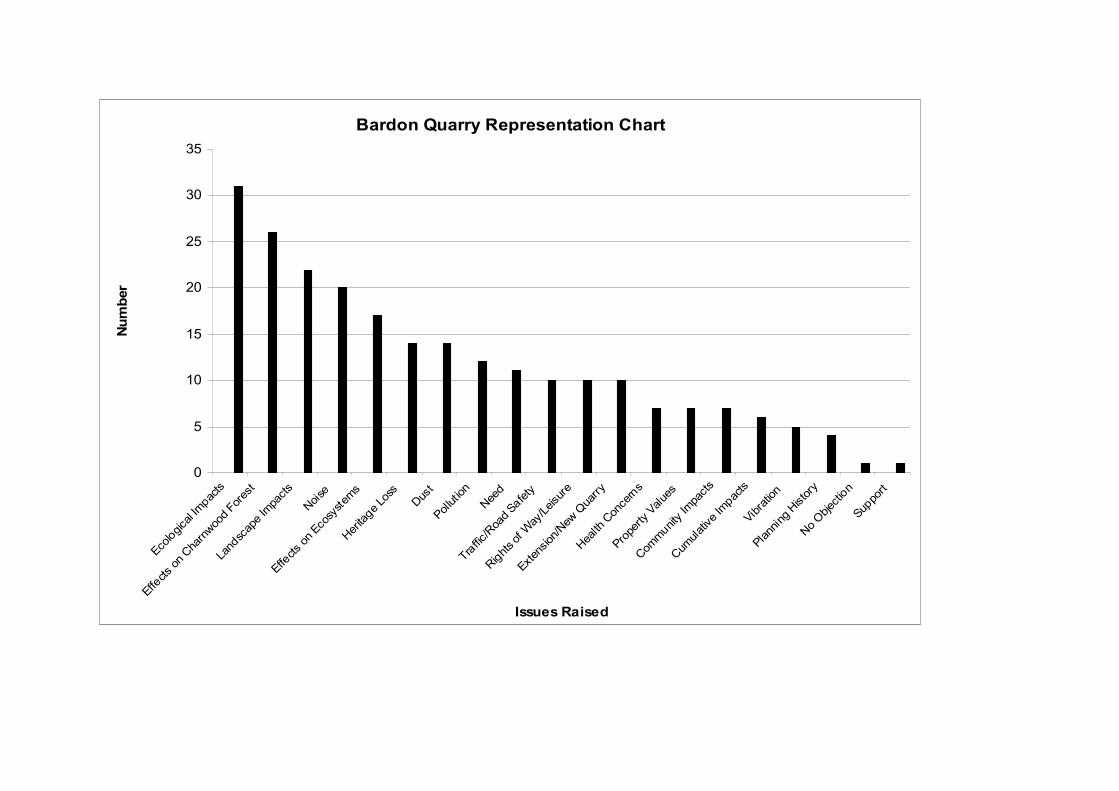
Bardon Quarry Representation Chart
0
5
10
15
20
25
30
35
Eco
logica
l Im
pacts
Effe
cts
on C
harn
woo
d Fo
rest
Land
scap
e Im
pacts
Noise
Effe
cts
on E
cosy
stem
sHer
itage
Los
s
Dus
tPollutio
n
Nee
d
Traf
fic/R
oad
Safe
ty
Right
s of
Way
/Leisu
re
Exte
nsion/
New
Qua
rry
Hea
lth C
once
rns
Prop
erty V
alue
s
Com
mun
ity Im
pacts
Cum
ulative
Impa
cts
Vibr
ation
Plan
ning
History
No
Objec
tion
Supp
ort
Issues Raised
Num
ber
2010/0076/07 & 2010/0041/04 – continued
188. A petition containing 400 signatures was presented to the 17th June 2010 meeting of the Development Control and Regulatory Board - "Petition to save the Rise Rocks, Charnwood Forest, Leicestershire. We, the undersigned, oppose proposals by Bardon Aggregates to open a new quarry on land between Coalville and Copt Oak, including the Rise Rocks. We call upon Leicestershire County Council to refuse planning permission. If this quarry goes ahead:· The proposed quarry would create a vast hole 600 feet deep and 3/5 mile by ½ mile wide. ·The wildlife in the vicinity would be destroyed. Local people would suffer air and noise pollution. The historic landscape, our heritage, would be lost.” A copy of a petition sent to Aggregate Industries in July 2008 containing 55 signatures has also been received. Assessment of Proposal
189. This proposal, like any other application, must be determined in accordance with the development plan unless material considerations indicate otherwise. In this case, it is appropriate to consider the following key matters: national policy background; Leicestershire Minerals Development Framework; the nature of and need for the development; environmental impacts and other effects; and economic and other benefits.
Planning History and Context
190. Mineral working has taken place at Bardon Hill for many years, with references dating back hundreds of years. The first mineral extraction permissions were granted in 1947, these were followed by permissions to extend the workings in 1957 and 1981, and then in 1989, permission was granted to enlarge the Quarry to its present size. Recent permissions have allowed the replacement of the processing plant and an extension to Tip 18. The ROMP consolidated all previous permissions, and a new set of planning conditions was issued in 2006, which now provide the main planning controls at the site.
191. Two planning applications, made in 1948 and 1958 by Bradgate Quarry Companies, for quarrying at Rise Rocks were previously refused. The main reasons for refusal related to the impacts on Charnwood Forest and the quality and need for the release of further reserves at that time. Representations have referred to these refusals on the grounds that the concerns regarding the Charnwood Forest still apply and the quality of the stone has not changed. Whilst some regard should be taken of the previous planning history, the current proposal should be determined on its own merits and in the light of the planning circumstances pertaining at the time. Given the age of the previous planning applications it is not considered that significant weight should be attached to the refusals per se, but it is important that the main issues concerned are considered in relation to the present proposal. Matters relating to need, stone quality and impacts on Charnwood Forest are covered in the Environmental Statement, and form part of the assessment below.
DC®. BOARD 26/05/2011
43
2010/0076/07 & 2010/0041/04 – continued
192. In terms of the scale of the reserves covered by the application, the current proposal is one of the largest (it is understood to be the largest in England) to be considered in the UK. In relation to previous applications within Leicestershire, it is larger than the New Cliffe Hill proposal of the 1980’s and the Mountsorrel proposal from the early 1990’s, which was for around 100Mt. Leicestershire is recognised as a strategically important mineral producing area at a national level by way of its igneous rock resources, and its contribution to meeting a recognised need for crushed rock aggregate products.
National Policy Background
193. Minerals Policy Statement 1 (MPS1) is the overarching planning policy
document for all minerals in England. It recognises that minerals development is different from other forms of development because minerals can only be worked where they naturally occur, and that potential conflict can therefore arise between the benefits to society that minerals bring and the impacts arising from their extraction and supply.
194. In order to secure the long-term conservation of minerals, MPS1 seeks to
facilitate their best use by adopting a hierarchical approach to minerals supply. This aims firstly to reduce as far as practicable the quantity of material used and waste generated, then to use as much recycled and secondary material as possible, before finally securing the remainder of material needed through new primary extraction. This approach is realised through the provision of national targets for the supply of primary and secondary minerals, and through the Government’s objectives for mineral planning. These include:
• to conserve mineral resources through appropriate domestic provision and timing of supply;
• to secure working practices which prevent or reduce as far as possible, impacts on the environment and human health arising from the extraction, processing, management or transportation of minerals;
• to protect internationally and nationally designated areas of landscape value and nature conservation importance from minerals development, other than in exceptional circumstances;
• to secure adequate and steady supplies of minerals needed by society and the economy within the limits set by the environment, assessed through sustainability appraisal, without irreversible damage;
• to maximise the benefits and minimise the impacts of minerals operations over their full life cycle;
• to promote the sustainable transport of minerals;
• to protect and seek to enhance the overall quality of the environment once extraction has ceased, through high standards of restoration, and to safeguard the long-term potential of land for a wide range of after-uses.
195. Annex 1 to MPS1 provides policy on the provision of construction aggregates,
and includes ancillary policy objectives covering supply. These seek to encourage the use of alternative aggregate supplies, with the remainder of supply to be met from land-won sources.
DC®. BOARD 26/05/2011
44
2010/0076/07 & 2010/0041/04 – continued
196. In February 2004, the East Midlands Regional Assembly approved sub-regional apportionments for each of the MPA’s across the region, based on National and Regional guidelines published by Government in 2003. Leicestershire is required to provide some 257 million tonnes of crushed rock in the period between 2001 and 2016. In addition, 80 million tonnes are required for the period of 2017 to 2021.
197. In June 2009, revised National and Regional guidelines for aggregates
provision in England 2005 – 2020 were issued by Government. Overall, these figures introduced a reduction in the total crushed rock provision of 8%, and although work was undertaken by the Aggregates Working Party to revise apportionments at County level, the figures remain to be formally adopted (due to changes at the Regional planning level). Notwithstanding the overall reduction, Leicestershire’s crushed rock provision was planned to increase by 0.5Mt pa in line with recent sales trends across the East Midlands Region.
198. Following the announcements made in support of the budget in March of this
year, concerning the Growth Review, planning reform and planning support for sustainable development, the Minister for Decentralisation issued a Written Statement on 31st March 2011. The statement aims to emphasise these points and ensure that they are informing the decisions being taken by planning authorities. The Statement promotes sustainable economic growth and jobs in advance of the planning reforms taking effect, and is capable of being regarded as a material planning consideration.
Leicestershire Minerals Development Framework Policy
199. A key function of the Minerals Development Framework (MDF) is to ensure an
appropriate contribution to local, regional and national needs in line with the sustainable objectives for mineral development. The maintenance of a landbank is used for aggregates, in order to ensure continuity of supply and make appropriate provision to address an identified need. Calculations published in the MDF Core Strategy indicate that, taking into account permitted crushed rock reserves, there would be a surplus of approximately 147Mt over the period to 2021. Given the level of permitted reserves, it was not considered necessary to make specific new provision for future crushed rock extraction up to 2021.
200. The Minerals Core Strategy also states that there is a variety of circumstances,
under which proposals to extend existing sites may nevertheless come forward during the MDF period. These include: operational reasons in terms of efficient use and recovery of resources; as a means to address any unforeseen circumstances affecting the landbank provision or production capacity; to enable the industry to maintain or secure productivity growth and levels of employment or to justify investment in associated infrastructure, and to reflect the different types of crushed rock aggregates required.
DC®. BOARD 26/05/2011
45
2010/0076/07 & 2010/0041/04 – continued
201. The strategy for the supply of minerals in the Minerals Core Strategy (MCS1) is to release land for extraction where it is necessary to maintain an adequate supply of minerals and it can be shown that demand could not be met from existing permitted reserves, having regard to the sub-regional apportionment figures for aggregate minerals. The strategy also seeks to: give priority to the extension of existing sites; allocate specific sites to meet anticipated need; and allow minerals development outside of allocated areas subject to certain criteria. In all cases, proposals will only be acceptable where they will not cause unacceptable harm to the environment or communities.
202. The strategy for aggregates (crushed rock and sand and gravel) (MCS2) is to:
make provision for sufficient supplies to meet the sub-regional apportionment; maintain landbanks in line with national policy; release reserves of crushed rock to be worked as extensions to existing extraction sites where they are required to ensure sustainable supply; allow new aggregate extraction sites only where it can be demonstrated that the landbank and production capacity cannot be maintained; and to allow proposals only where they will not cause unacceptable harm to the environment or communities.
Need for and Nature of Development
203. The County Council needs to be satisfied that a steady supply of mineral can be
produced throughout the plan period, and that its contribution to regional/national aggregates provision can be met. MPS1 advises MPAs to use the length of the landbank of permitted reserves in its area as an indicator of when new permissions for aggregates extraction are likely to be needed. It states that the landbank indicator in the case of crushed rock is at least 10 years, although a longer period may be appropriate to take account of supply requirements, location of sites and productive capacity of permitted sites.
Landbank
204. Following sub-regional apportionment work undertaken by the East Midlands
Regional Aggregate Working Party (RAWP) during 2009, it was established that as at 31st December 2008, the crushed rock landbank for Leicestershire was some 22 years (354MT). However, the spread of reserves is not equally split across the sites, as the reserve position (at that time) at Leicestershire’s four main, rail linked quarries, varied between 24 and 11 years remaining life. The overall reserve picture is further complicated by the fact that around 100Mt is situated at inactive sites (one in particular), none of which are rail linked. Further reserve reassessments, including at Bardon Quarry (as outlined in paragraph 8) has reduced the amount of unconstrained reserves further. As a consequence, two of the four quarries now have around 9/10 years reserves remaining.
205. It is within a current and developing reserve position that the Bardon proposal
should be considered. The RAWP work establishes that the four active igneous rock quarries together produce 13-14Mtpa, accounting for a contribution of almost 65% of the igneous rock output in England. In addition, whilst this constitutes a particularly high concentration of activity for the County, the quality
DC®. BOARD 26/05/2011
46
2010/0076/07 & 2010/0041/04 – continued
of the rock makes it well suited for a High Specification Aggregate, and there are relatively few alternative sources, particularly in England.
206. Considering the above reserve position, therefore, in the short term (i.e. the
next 10 years) the reserve position is satisfactory. However, in the medium to long term (i.e. beyond the next 10 years) Leicestershire’s reserve situation will become depleted to the extent that it will not have a sufficiently even spread of reserves across active sites to continue to meet sub-regional apportionment requirements. In overall terms the landbank may still be at or around 10 years at this time but it is likely that production capacity would be affected and output requirements not met. This would particularly be the case in relation to serving distant markets via rail.
207. It is considered therefore that in terms of need there is a requirement for
additional reserves to be released in the medium to long term. Bardon Quarry, which has the lowest life expectancy of the four main igneous rock quarries, would through its current proposal, be able to address in part the reserve deficit. The Bardon proposal would be capable of meeting this need following the exhaustion of reserves in the existing quarry, and lengthy lead in time associated with the setting up of a hard rock extraction operation.
Extension v New Quarry 208. Concerns have been raised about the description of the proposal, i.e. whether it
constitutes an extension to the existing Bardon Hill Quarry or whether it is a new operation and the respective policy assessments that follow. In this respect, neither the MDF, National Guidance nor known case law provides a definition of an extension to a mineral working. Previously, in Leicestershire, it has been taken that if an extraction proposal utilises site infrastructure, such as processing plant, preparation areas, site loading facilities and access and transport arrangements, and the working follows on from the exhaustion of reserves then the proposal can be considered an extension. It is acknowledged that the description of the proposal as an extension could appear to be misleading due to it not being physically adjoined to the current extraction area. However, in mineral planning terms it is important to consider the site as a whole, including the workable mineral resources that are available to the existing Quarry unit, which may comprise several working areas, together with the infrastructure required to process the mineral.
209. The current Bardon Hill Quarry proposal clearly demonstrates all of the above
characteristics. However, the fact that the new proposal would be linked primarily to the existing Quarry and site infrastructure by a conveyor system and internal roadway has understandably raised concern for opponents to the scheme. In this respect the operation would be more akin to a sand and gravel operation, where extension areas are commonly accessed only by roadway and conveyor and can be distanced from the original site workings and processing area. Where this proposal differs from that similarity, is that some initial processing, i.e. primary crushing of material would be carried out at or near to the point of winning and working the mineral. This would be a necessary operation, given the nature of the proposed operation and type of mineral involved. The current proposal demonstrates elements, therefore, of both an
DC®. BOARD 26/05/2011
47
2010/0076/07 & 2010/0041/04 – continued
extension site and a new site, although probably more so in respect of an extension - particularly as the proposal would be incapable of being worked as a stand-alone operation in its own right.
210. The Environmental Statement explored the potential for extending the current
working area laterally, in all directions. However, the stone resources in these areas, including some permitted reserves, are significantly constrained. Alternative options to work the proposed extraction area (including significant physical works to provide continuation of working) have also been discussed but discounted due to potential impacts on recognised interests within the site. Consequently, the current proposal involving conveyor links and an internal access roadway have evolved as the preferred option with least environmental impact, including transportation emission effects.
211. In the light of the above, the proposal should be considered on its own merits,
and subject to the requirements of Policies MCS1 and MCS2 of the MDF. Policy MCS1 covers the overall strategy for the supply of minerals, and Policy MCS2 covers the strategy for aggregate minerals. In this respect it is considered that the proposal meets the release of land requirements of the policies, which are aimed at maintaining an adequate supply of mineral in order to meet the sub-regional apportionment.
212. The timing, release and working of reserves to ensure continuity of supply and
production capacity through a deliverable landbank are a critical consideration, and it is proposed that commencement towards the end of the current MDF period would be needed to satisfy these policy criteria. Given the remaining unconstrained reserves in the existing quarry, and the potential lead-in time of this proposal, approximately 9 years and 4 years respectively, and allowing for an overlap period to transfer production between extraction areas the proposed timescales would accord with the need to address any shortfall towards the end of the MDF period.
213. Policy MCS2 does allow a new site to be used to meet deficiencies in the
landbank and production capacity. As discussed above, there are significant constraints envisaged in maintaining a deliverable landbank and in maintaining the required production capacity towards the end of the MDF period, and consequently a need for additional reserves emerges. Notwithstanding the arguments concerning the Bardon Quarry proposal being recognised as an extension, it is considered that in the light of the demonstrated need, the release of the reserves under the status of a new site would accord with policy.
214. Policies MCS1 and MCS2 also require the consideration of proposals for
aggregate extraction in terms of any unacceptable harm that may be caused to the environment or communities. This is a key consideration and is often at the crux of mineral development decision-making, where the need for the development including any mitigation and compensation has to be balanced against the impacts the proposal is likely to generate. Given the nature of this proposal these matters are considered more widely below under Environmental and Other Effects.
DC®. BOARD 26/05/2011
48
2010/0076/07 & 2010/0041/04 – continued
215. In terms of meeting the requirements of Policies MCS1 and MCS2, it is considered that the demonstrated need for additional reserves in terms of the landbank and production capacity deficiencies has been established sufficiently in this case to satisfy these policy requirements. The additional resources would assist in meeting County apportionment requirements to address National, Regional and Local needs, and it is considered that significant weight should be given to this requirement, subject to controls covering the timing of the release of additional reserves, and a full consideration of the Environmental and Other Effects of the proposal.
Environmental and Other Effects
Traffic, Transportation and Access
216. Both the Highways Agency and the County Highway Authority consider that as
the proposed development does not constitute an intensification of the site over and above that currently permitted, and is therefore unlikely to pose demonstrable highway safety or capacity issues on the surrounding road network, the principle of the development is acceptable on technical grounds. A travel plan for the site would nonetheless be required to encourage less car use to and from the site, and this could be controlled to include measures for secure cycle parking within the site and bus shelter provision to the nearest bus stops.
217. In addition, the existing internal routeing, lorry parking, wheel washing,
weighbridge and associated infrastructure are considered satisfactory, and should be continued to be improved in line with the latest proposals. Site related traffic should be controlled to continue only to use the existing access arrangement from the A511, to ensure direct access to the County’s main lorry route network in line with Policy MCS16 requirements.
218. The Transport Assessment submitted in the Environmental Statement contains
data on HGV movements for 2008 (a period of ‘normal’ productivity). This states that an average of 432 HGV departures from the site occurred per weekday, with an 85%ile daily rate of 522, and the busiest day generating 544 exports. Approximately 25% to 30% of the sales from Bardon Quarry (around 0.75Mt pa) are transported from site via rail. Given the nature of the historic and present ROMP planning controls at the site, HGV movements are unrestricted. An approved scheme for access improvements including a right hand turn on the A511 is, however, due to be implemented under the ROMP. Under the present proposal, controls could be imposed to set a limit on future HGV movements having regard to the presented data, and to encourage further the transportation of stone via rail. Such controls would be in accordance with the aims of Policies MCS16 and MDC14 of the Minerals Core Strategy in order to maximise the potential to use alternative modes of transport to road borne freight. Given the proposed timescales of the development, and the associated prolonging of the HGV movements, it is considered that controls would be appropriate in this instance.
DC®. BOARD 26/05/2011
49
2010/0076/07 & 2010/0041/04 – continued
219. There are presently concerns with air quality to the north west and to the east of the site, and Air Quality Management Areas have been designated, primarily due to traffic emissions in these areas. The Local Transport Plan seeks to improve air quality by reducing traffic generated emissions, and in this respect, the use of a conveyor system within the site instead of dumper trucks as the main method of stone and overburden transportaion would go someway to meeting these aims. It is also proposed that the Company would endeavour to ensure that road borne HGV’s are compliant with Euro 4 specification within five years of the development commencing. It is considered that these proposals would assist in reducing the amount of vehicle emissions in and around the site, and that appropriate controls should be imposed to secure their implementation to accord with Policy MDC14 (iii) requirements.
220. The applicant has put forward various measures to the A511 Shaw Lane
adjacent to the south of the site. These aim to improve the amenity and safety of residents living along Shaw Lane, and include resurfacing, reduction of the speed limit and of crossing facilities. The Highway Authority considers that these matters should be subject to further detailed design, including the necessary legal and consultation processes involved in making a Traffic Regulation Order. Representations have been received about the extent and coverage of the proposed resurfacing and speed limit by some residents of Shaw Lane, and others have raised the increased environmental effects of traffic accelerating and decelerating in front of properties as an issue. The details of the scheme would need careful consideration therefore, and the Highway Authority would be a key contributor to the final design of the proposals.
221. Overall, it is considered that the proposed measures would provide a benefit to
the local amenity along Shaw Lane, to offset the continuation of HGV’s associated with the site using that section of highway. Consequently, it is considered that appropriate weight should be attached to the A511 improvement measures being offered, in consideration of the application, and that together with all the costs of the design and implementation of the measures, which should be borne by the Company, they could be controlled accordingly.
222. Subject to the control of the matters outlined above by planning condition, and
where appropriate planning obligation, it is considered that the traffic, transportation and access issues are capable of being satisfactorily resolved in conjunction with the Highway Authority’s comments and the provisions of Policies MCS16, and MDC12, 14 and 19 of the Minerals Core Strategy and PPG13 Transport.
Landscape and Visual Impact
223. The majority of the application area is located within various Charnwood Forest
designations, (the north western corner falls within the locally designated Coalfield character area). The landscape of the Charnwood Forest has historically been recognised as distinctive and valued, and the County Council and other partners have undertaken work to help define boundaries and
DC®. BOARD 26/05/2011
50
2010/0076/07 & 2010/0041/04 – continued
preserve its unique characteristics. The landscape of the Coalfield character area is less sensitive, and is identified as being suitable for large scale landscape change, e.g. tree planting.
224. The impacts of the existing and proposed operations, in relation to changes in
landscape sensitivity, magnitude and significance have been assessed in the Environmental Statement, and are considered in relation to the framework of landscape character assessments detailed below.
225. The national level landscape character assessment includes the site within the
Charnwood character area, which covers a broadly similar area and provides similar characteristic features, to the Charnwood Forest designation within the County Council’s Landscape and Woodland Strategy. The characteristic features include: upland landscape; rocky outcrops; frequent woodlands; stone walls and hedges; and a mixture of woodland, farmland, heathland and parkland.
226. Given that the whole of the application site is within the National Forest, the
local landscape assessment included in the National Forest Strategy (NFS) is also a relevant consideration. This defines broadly similar areas and characteristics for the Charnwood Forest and Coalfield character areas, but sub-divides these into more detailed landscape types. The majority of the application site is located within the Charley landscape type (enclosed farmlands), the key characteristics of which differ from those of the main Charnwood character area, and depict a farmland setting typical of the majority of the agricultural area of the site.
227. In the light of the varied nature of the landscape within the site and that of the
surrounding area, the Environmental Statement concluded that it would be appropriate to consider the site as several distinct areas, i.e. the existing quarry, Bardon Hill and the agricultural land. These areas contribute different features and varying compatibility with the characteristics of the landscape types, and larger character areas within which they fall, e.g. the agricultural area contains a number of key Charnwood character features such as rocky outcrops, stone walls and hedges, (considered to be the most valuable landscape assets), whereas the landscape around Bardon Hill is generally more typical of the main Charnwood character area.
228. In terms of sensitivity to change, the existing quarry is assessed to be of low
sensitivity, Bardon Hill (and the adjacent parkland and wooded drives) to be highly sensitive, and the agricultural land to be of medium sensitivity.
229. In relation to the magnitude of the impacts, the changes on the existing quarry
are assessed as being low to medium and neutral in effect. Bardon Hill would be the least affected area of the site, and changes during the construction of the tunnel and the completion of Tip 18 are assessed as being of medium and adverse, and negligible and neutral once the works are completed. The agricultural land would be the most extensively changed area, and these are assessed as being high. The scheme includes a wide range of mitigation measures, although they would only affect the perception of the change not its scale.
DC®. BOARD 26/05/2011
51
2010/0076/07 & 2010/0041/04 – continued
230. Taking account of the sensitivity and magnitude assessments, an assessment of the significance of the changes to the landscape character identified a range of impacts. For the existing quarry the proposals are assessed as having a slight to moderately significant impact. On Bardon Hill, a moderate to substantially significant impact is predicted to arise, although this would be expected to reduce to a slight to moderately significant impact, with the potential for a resultant beneficial effect, following works and subject to the implementation of detailed heathland management proposals. The medium sensitivity of the agricultural land and the high magnitude of change over it would result in a moderate to substantially significant impact.
231. It is considered that the above assessment provides a useful methodology for
assessing the landscape and visual impacts of the proposed development within the context of the landscape character areas and sub types covering the site. In addition, the proposed measures to minimise and mitigate landscape impact or loss have played a key role in reaching the predicted residual impacts identified in the Environmental Statement. The weight to be given to these measures is a key consideration in deciding the acceptability of the landscaping proposals, the main aims of which seek to create a landscape closer in character, to the main Charnwood Forest character type. The intention to protect the key features and enhance the Forest’s character accords with the requirements of Policies MCS13(i) and MDC6 of the Minerals Core Strategy.
232. The landscape of the Charnwood Forest is highly sensitive to change, and it is
considered that any losses of key features would be detrimental to the value of the landscape, although it is recognised that the Charley landscape type is less sensitive to change than the more characteristic Charnwood landscapes, particularly in respect of the main agricultural area of the site. Whilst this part of the site contains fewer of the primary characteristics of the Charnwood Forest area than sites within the central core of the Charnwood Forest area, it would be subjected to the most significant changes (i.e. the quarry development and construction of the screening mounds). The loss of the characteristic features, such as Rise Rocks, stone walls, and hedgerows from the agricultural area would be of particular significance to the wider landscape.
233. The proposals include mitigation measures to offset the above losses and aim
to relocate or replicate the key landscape features, and reduce overall impacts, by addressing the landscaping of the proposed new landforms as a priority. The new landforms would be substantial new features in the landscape, particularly the northern mound which would be some 32m in height. The new landforms would be successful in providing screening to the quarrying operations and have benefits in reducing environmental impacts. They would also be used to contribute towards bio-diversity through the creation of new habitats, supporting heathland on the summits and upper slopes and native woodland planting on the lower slopes. Replacement and new rights of way would be created along the new landforms to enhance public access, and traditional field patterns with hedgerows and stone walls would be created. The relocated stream would also provide opportunities for habitat enhancement along a feature which is currently in bio-diversity decline.
DC®. BOARD 26/05/2011
52
2010/0076/07 & 2010/0041/04 – continued
234. In principle the landscaping and restoration proposals accord with the objectives of the National Forest Strategy (and are supported by the National Forest Company), and are not considered to conflict with the intentions of the Regional Spatial Strategy which includes a proposed Charnwood Forest Regional Park as a strategic priority. In effect, the Company’s proposals for supporting a ‘living landscape project’ could provide linkages and assistance to help further the Regional Park aspirations. The landscaping proposals within the existing quarry would have longer term benefits, by providing improved screening to the processing plant area for properties to the north of the site, and by providing a potential amenity area on the outer slopes for residents of the Greenhill residential area. It is considered that some weight should be given to these initiatives in offsetting the landscape impacts, and that appropriate benefits could be secured through relevant controls.
235. As indicated in the Proposed Operations section the formation of the new
landforms would be commenced following the initial setting–up operations, and created by the end of Stage 1 (year 4). Landscaping (soiling, planting, habitat creation and feature placement) of the new landforms should then follow during the next 12 months, in order to ensure a speedy establishment of the new landscape features. It is considered essential that the new landforms are created and treated as a priority and within these timescales, and that quarrying within the new extraction area is limited until the new landforms are complete. It is considered that controls could be imposed to achieve the desired timing of the landscaping works.
236. In overall terms, the landscaping proposals are considered acceptable, although
their benefit in offsetting the recognised impacts would be dependant on the successful implementation, maintenance and retention of the proposed bio-diversity led after-uses. The main thrust of these should be to create a new landscape, more in keeping with the traditional character of the Charnwood Forest than exists at present. However, it is considered that replicating and replacing the key existing characteristic features is a key element and should form an integral part of the design of the new landscaping proposals. Appropriate controls covering the content, design, timing and management (to cover the life of the site operations) of the landscaping works could be secured by condition and where appropriate legal agreement. Other controls should also be imposed to satisfy requirements for the making of a photographic record of the local landscape and its features prior to the commencement of any works, and the provision of details of hedgerow translocation timing, methodology and locations.
237. Subject to the control of the matters outlined above by planning condition and
where appropriate planning obligation, it is considered that the issues relating to landscape and visual amenity are capable of being satisfactorily resolved in accordance with the requirements of policies MCS13(i) and MDC6 of the Minerals Core Strategy.
DC®. BOARD 26/05/2011
53
2010/0076/07 & 2010/0041/04 – continued
Ecology 238. The impacts of the existing and proposed operations, in relation to ecological
interests within the Bardon Estate have been assessed in the Environmental Statement and supplementary information, and a suite of mitigation and compensation measures proposed. These have been updated in the light of consultees’ responses, and are now embodied in a Detailed Mitigation and Compensation Implementation Plan, which includes a summary of potential impacts, mitigation, compensation and enhancement measures, BAP habitat condition monitoring targets, and monitoring and review proposals for each of the identified valued ecological receptors. A Lowland Grassland Compensation and Implementation Plan which covers the restoration and enhancement of semi-natural grassland, and a methodology for turf removal and relocation, and a Grassland Monitoring Report that sets out a monitoring regime for the lowland wet grassland resource have also been prepared.
239. The impacts on ecological interests are considered below in relation to valued
ecological receptors that have been identified in the Ecological Impact Assessment, and highlighted by Natural England, as requiring specific attention.
240. The valued ecological receptors are:
• Bardon Hill SSSI
• Bardon Hill Quarry SSSI
• Woodland Habitats
• Grassland Habitats
• Heathland and Acidic Grassland Habitats
• Watercourses and Wetlands
• Hedgerows and Stone Walls
241. No direct impacts to Bardon Hill (Biological) SSSI have been identified but the indirect impacts are the spread of non-native tree species into ancient woodland areas and potentially, a shift in agreed management principles. To mitigate the indirect impacts, it is proposed that all non-native tree species from within the SSSI would be removed, including the control and eradication of rhododendron, within the first five years of the development. All trees planted within the Bardon Estate would also only comprise of native tree species from UK grown stock.
242. Given the level of potential impact on the Bardon Hill (Biological) SSSI, it is
considered that the proposed mitigation is appropriate, and that future management of the SSSI should be in accordance with the recognised conservation objectives.
243. Bardon Hill Quarry (Geological) SSSI would be directly impacted by the
proposed development as a result of the infilling of some of the quarry void, which would obscure some of the geological features. To mitigate the impacts it is proposed to prepare and implement a geodiversity plan for the quarry in conjunction with appropriate advisors. Key aspects of the plan would be protection of and access to the key features (see Geology section below for further discussion of the geological interests).
DC®. BOARD 26/05/2011
54
2010/0076/07 & 2010/0041/04 – continued 244. Given the level of potential impact on the Bardon Hill Quarry (Geological) SSSI,
it is considered that the proposed mitigation is appropriate, and that future management of the SSSI should be in accordance with the recognised conservation objectives.
245. Woodland habitats beyond Bardon Hill SSSI would be directly impacted upon
by the proposed scheme, and a loss of 1.3ha of broadleaved semi-natural woodland, 1ha of dense scrub and 0.5 ha of wet woodland scrub would occur (approximately 2% of total woodland within the site). A 30m section of the avenue of trees along Bardon Hall Drive would be removed to allow for the conveyor, and 3.6ha of ancient, replanted woodland would be lost through the completion of the approved Tip 18 works.
246. Compensation measures for the loss of woodland are proposed through the
restoration of 5.98ha of Ancient Semi Natural Woodland elsewhere on the Bardon Estate (compartments 12 and 13). These works comprise clearance of non-native species and restocking, and would be incorporated within the proposed Bardon Hill Woodland Management Plan. To compensate for the loss of the 3.6ha of ancient, replanted woodland, up to 300mm of woodland soils would be recovered from the cleared area, and directly respread at the same depth over areas designated as new plantation woodland before new native trees are planted. The restoration proposals also provide for the additional planting of 64ha of new woodland around the lower slopes of the proposed screening mounds.
247. Although mitigation for the woodland loss is limited to design parameters, it is
considered that the proposed compensation measures would be satisfactory and lead to an overall enhancement of the woodland resource across the site. The proposed Woodland Management Plan linked to BAP targets would provide an appropriate method of implementing and maintaining the proposed compensatory measures.
248. Grassland habitats would be directly affected by the proposed development.
The site supports a total of approximately 10ha of important semi-natural grassland habitats, including approximately 3.8ha of damp neutral grassland habitats of high conservation value (National Vegetation Classification Mesotrophic Grassland 4) (MG4). These meadows are associated with the headwaters of the River Sence. The Ecological Impact Assessment has identified that a total of 1.8ha of unimproved grassland would be lost, including approximately 1ha (26%) of the total area of MG4 grassland, covering the second largest (0.8ha), most intact and botanically-rich stand of this habitat type within the site. Due to the scarcity of this habitat these grasslands are reported to be a resource of at least Regional value and possibly of national value, and although currently in an unfavourable declining condition, they are considered to be restorable. Approximately 2ha of the remaining MG4 habitat is of moderate conservation value, and whilst in poor condition is also considered restorable. In addition, there would be a loss of approximately 0.36ha of other meadow grassland and small areas of species-poor acidic grassland.
DC®. BOARD 26/05/2011
55
2010/0076/07 & 2010/0041/04 – continued
249. The scheme design has sought to minimise the area of grassland habitat that would be lost through the proposed development. No other mitigation for the habitat loss is possible. A range of compensation measures are therefore proposed to offset the loss, including habitat creation, translocation and the restoration management of existing habitats. These measures have been updated in the light of consultees’ responses, and provide for a total of 12.61ha of compensatory grassland habitat, comprising: 7ha of semi-natural grassland being entered into positive conservation management and restored over a 10-year period; 4ha of newly created floodplain grassland, formed along the diverted stream corridor and surface water drainage system; and 1.61ha of grassland would be translocated to a new donor site.
250. The mitigation for the loss of grassland habitat is limited due to the nature of the
proposed development. It is considered that the proposed compensation measures relating to the grassland habitats are satisfactory. They now provide replacement and restored habitat at a ratio of greater than 8:1, (i.e. more than 8 times the area of key grassland lost would be provided through compensation) which is considered to be adequate to address concerns relating to reduced habitat quality through translocation and habitat creation (Natural England recommended at least a 5:1 ratio). All translocated grassland would also be monitored and managed with the restored grassland habitats over a 10-year period, through the proposed Lowland Grassland Compensation and Enhancement Implementation Plan and the methodology detailed in the Grassland Monitoring Report. This is considered to be an appropriate method of implementing the proposed grassland habitat compensatory measures.
251. No significant adverse impacts upon heathland and acidic grassland habitats
have been identified, (an area of 0.2ha would be lost). No specific mitigation measures are therefore proposed, although The Ecological Impact Assessment has identified positive impacts through the creation and restoration of heathland habitats.
252. Compensation measures proposed include the creation of 21.2ha of acid
grassland and heathland on the summit of Tip18 and on the top of the proposed screening mounds. These habitats would extend and buffer similar habitats at Bardon Hill SSSI and provide new areas for colonisation by notable species from the SSSI. It is also proposed to bring 7.5ha of derelict lowland heathland into active management on land owned by the Company at Ratchett Hill, near Whitwick. Management plans would seek to implement the habitat creation and restoration proposals, and these areas would then be managed in accordance with the Bardon Estate BAP.
253. It is considered that the proposed compensation measures for acid grassland
and heathland are satisfactory, and that they should be managed in accordance with BAP targets.
DC®. BOARD 26/05/2011
56
2010/0076/07 & 2010/0041/04 – continued
254. Over 1km of watercourse would be diverted (approximately 60% of the total flowing water resource within the study area). The stream, a tributary of the headwaters of the River Sence, has been modified over much of its length and supports a relatively impoverished in-stream invertebrate fauna. The proposal would also lead to the loss of seven ponds from the 36 present during 2009. These features are identified as a parish level resource.
255. Proposed mitigation includes minimising the length of water course that would
be lost and avoiding impacts to Sphagnum pools through the development design. A surface water attenuation system is also proposed to minimise downstream impacts from the development.
256. A range of compensation measures are proposed which aim to re-create in-
stream and riparian habitats within a 5-10 year period, within a new stream corridor. An additional 12 ponds would also be created, and whilst most of these would be functional waterbodies, their design and planting would also be informed by biodiversity. It is proposed to undertake the long-term management of the wetland areas by grazing stock or mowing, to ensure they are maintained as grassland habitats. Public access to the new watercourse would be limited to the northern bank, with the majority of the biodiversity habitats created along the southern bank to ensure separation and limit disturbance.
257. The new stream corridor (including adjoining bankside vegetation strips) would
be managed in accordance with BAP targets that seek to improve the diversity along this habitat in comparison to the existing stream course. The new ponds proposed would also increase the number of water bodies within the study area. It is considered that the mitigation and compensation proposed for the watercourses and wetland areas included in the Detailed Implementation Plan are now satisfactory and would enhance the local water environment in the longer term.
258. The proposed development would lead to a significant loss of the hedgerow
resource. Some 73 hedges would be affected by the development, with 51 (11,719m) being completely lost. These include the loss of 38 mature hedgerow trees, 21 important hedgerows (which meet the ecological criteria under the Hedgerow Regulations 1994), and 15 hedgerows which satisfy similar criteria for local wildlife site designation. It is estimated that approximately half of the total length of dry-stone would also be lost. Unmitigated the proposed development would lead to an impact upon hedgerows and stone walls that is identified as being significant on a resource of county value.
259. Proposed mitigation includes minimising the length of hedgerow that would be
lost and consequently 64 hedges totalling 8,610m are to be retained, 42 of these would be completely unaffected. A total of 330m of dry stone wall associated with hedgerow no. 37, and a further 6 hedgerows with walls would be retained and undisturbed.
DC®. BOARD 26/05/2011
57
2010/0076/07 & 2010/0041/04 – continued
260. Compensation measures include the planting of some 2,300m of hedgerow, including the translocation of approximately 1,000m, to replace historic field boundaries marked on the 1865 Estate Map. The translocation methodology would also allow for a proportion of associated ground flora to be moved and replicate operations undertaken elsewhere by the Company. New dry stone walls with a total length of approximately 1,740m are proposed to be built on the restored Tip18, using stone from the existing walls to be removed, and supplemented by stone from the quarry.
261. The retained and new hedgerow environs (including hedgerow trees and stone
walls) would be managed in accordance with BAP targets that seek to maintain and improve species diversity. Traditional field pattern boundaries would also be recreated on restored areas. These measures are predicted in the Ecological Impact Assessment to ultimately offset the negative impacts on the hedgerow and stone wall resource and lead to an enhancement of these features.
262. It is considered that the mitigation and compensation measures included in the
Detailed Implementation Plan for the stone wall resource are satisfactory. However, in respect of the hedgerows, it is not considered that the specific measures proposed would adequately offset the loss and provide the predicted positive outcome. Due to the significant net loss of hedgerows (around 10,000m) and the resultant loss and severing of habitat connectivity, it is considered that a residual impact specific to this valued ecological receptor would arise. Further compensatory measures would therefore be required through the imposition of appropriate controls to secure additional hedgerow planting, as opportunities to fully compensate for hedgerow loss remain under exploited.
263. The proposed suite of measures to mitigate and compensate for ecological
impact or loss have played a key role in reaching the predicted residual impacts identified in the Environmental Statement, and the weight to be given to these measures is the key consideration in deciding the acceptability of the ecological proposals. In overall terms therefore it is considered that the effects of the proposed development on the valued ecological receptors which extend to both short and long term impacts, would only be acceptable subject to: the provisions of the Detailed Mitigation and Compensation Implementation Plan being strictly followed in accordance with the indicated timetable; the establishment of the biodiversity led restoration proposals to provide enhanced local habitats being fully implemented; and the imposition of additional controls to supplement the hedgerow resource and associated habitat through the provision of additional hedgerow planting within the site.
264. In addition, the impacts of the existing and proposed operations on protected
and notable fauna and flora present within the Bardon Estate have been assessed, following specific species surveys. A suite of mitigation and compensation measures are proposed in respect of the protected and notable species to be affected, and these are considered below, having regard to relevant legislative requirements.
DC®. BOARD 26/05/2011
58
2010/0076/07 & 2010/0041/04 – continued
265. The protected and notable fauna and flora affected are:
• Bats
• Great Crested Newts
• Badgers
• Birds
• Lichens 266. Bat activity surveys to provide an overall assessment of bat usage and species
across the whole site were undertaken, and these led to specific bat surveys focussing on the roost features and key habitats within and close to the proposed landscaping and extraction areas. Six species of bat were found to be using the site and a total of 33 roosts were identified during the survey.
267. With the exception of a maternity roost, bat roosts of high conservation
significance within the study area would be retained undisturbed in buildings and trees unaffected by the proposed development. Nevertheless, four of the roosts identified would be lost to the proposed development (three within properties at Rise Rocks and another in tree no. 22), and there would also be loss and fragmentation of foraging habitat and flight lines.
268. In England all bat species are fully protected under the Wildlife and Countryside
Act 1981, as amended by the Countryside and Rights of Way Act 2000. All bats are also included in Schedule 2 of The Conservation of Habitats and Species Regulations 2010. The impacts of the proposed development are identified as being significant at a parish level for Common Pipistrelle bats, through the loss of roosts and foraging areas if left unmitigated. Proposed mitigation measures therefore aim to minimise the identified impacts to conform to European conservation requirements.
269. The proposed mitigation is detailed in the Environmental Statement, and would
in principle seek to ensure no net loss of roosts or other critical habitats. Measures include creating new roosts and the replacement of the lost maternity roost in a retained building at Bardon Drive Farm, a minimum of 20 bat boxes erected on trees throughout the Estate, and restoration proposals to enhance existing habitats and create new foraging habitat.
270. Pond habitat and amphibian surveys undertaken between 2005 and 2009 have
established that the great crested newt population has grown and migrated from one pond (Pond P which includes a breeding population) to five ponds within the application site. Populations of smooth newt, common frog and common toad were also recorded across the site.
271. The site supports 38 water-bodies comprising an assortment of open water
habitats such as settlement lagoons, ephemeral field ponds and fishing ponds. With the exception of Pond Y (nr. Rise Rocks) the other four ponds hosting great crested newts would be retained and largely unaffected by the proposed development, although there would be a loss and fragmentation of existing habitat through the creation of the new surface water management system.
DC®. BOARD 26/05/2011
59
2010/0076/07 & 2010/0041/04 – continued
272. Great crested newts are fully protected under the Wildlife and Countryside Act 1981, as amended by the Countryside and Rights of Way Act 2000, and are also included in Schedule 2 of The Conservation of Habitats and Species Regulations 2010. The impacts of the proposed development are identified as being significant at a local level for great crested newts, through the loss of a pond and habitat if left unmitigated. Proposed mitigation measures therefore aim to minimise the identified impacts to conform to European conservation requirements.
273. The proposed mitigation is detailed in the Environmental Statement, and would
in principle seek to ensure no net loss of water bodies or other critical habitats. Measures include creating 12 new ponds, habitat enhancement, the creation of new hibernacula and restoration proposals to enhance existing habitats and create new foraging habitat.
274. Given the protection of bats and great crested newts under the provisions of
The Conservation of Habitats and Species Regulations 2010, it is necessary to consider the implications of the proposed development on their conservation status. Recent case law clarified a legal duty on planning authorities to apply the same tests as Natural England (i.e. the licensing regime) when considering a planning application where species or their habitats that are protected by European Law may be harmed. Regulation 53 sets out the derogation tests to be applied. The first of these covers specified purposes, which the proposed activity must fall within, and the final two tests relate to reasons for the proposed activity.
275. It is considered that the proposal is covered by purpose 53(2)(e) which is for
“preserving public health or public safety or other imperative reasons of overriding public interest including those of a social or economic nature and beneficial consequences of primary importance for the environment”, having regard to the need for the development and the proposed biodiversity led restoration and after-use proposals. In terms of the reasons for the proposal, “53(9)(a) that there is no satisfactory alternative; and 53(9)(b) that the action authorised will not be detrimental to the maintenance of the population of the species concerned at a favourable conservation status in their natural range” it is considered that these requirements are also met, taking into account the impacts on the protected species and the mitigation and compensation measures proposed in the timetable (Table 9) of the Detailed Mitigation and Compensation Implementation Plan (ref.403-00275-00089/MCIP dated October 2010). However, the mitigation measures should be controlled to include the retention of tree no. 22 as identified in the bat survey, which contains a roost.
276. Badger surveys covering the application site have established the presence of a
number of setts and a concentration of badger activity, including one multi-entranced main sett. The survey results provide a recognised sett class hierarchy based on size and frequency of use, together with a ranking of the setts based on activity levels.
DC®. BOARD 26/05/2011
60
2010/0076/07 & 2010/0041/04 – continued
277. The proposed development would lead to the loss of a significant number of the setts within the study area, and although the majority of these are outlier or subsidiary setts with usage ranging from inactive to moderate, one main sett that was highly active at the time of the survey would be lost. The local badger population, considered to consist of one clan (social group), would also be affected by fragmentation of habitat, loss of territory and important foraging areas.
278. Badgers and their setts are afforded protection under the protection of Badgers
Act (1992 and amendments). The impacts of the proposed development are identified as being significant at a local level for badgers, through the loss of a main sett, clan territory and habitat if left unmitigated. Proposed mitigation measures therefore aim to minimise the identified impacts to conform to legislative requirements.
279. The proposed mitigation is detailed in the Environmental Statement, and
suggests a strategy covering the lifecycle of the quarry to ensure that badgers would be accommodated during the phasing of the proposed development. The strategy would include the creation of some five new artificial setts prior to the loss of existing ones, habitat creation, restoration and enhancement throughout the Bardon Estate, including pasture and woodland linkages to minimise habitat fragmentation.
280. The site supports a bird assemblage that is typical of the habitats present, i.e. a
farmland landscape of grassland, arable crops, hedgerows, mature trees, woodland and scrub areas, and surveys undertaken during 2007 to 2009 recorded a total of 53 species. Almost half of the species are of conservation concern according to UKBAP and RSPB lists, 17 of which are noted as possibly breeding within the site.
281. Scrub, hedgerow, woodland and cliff habitats within the study area are the most
important habitats for breeding birds, and these support many of the species of conservation concern. The proposed development would lead to direct impacts upon bird populations through land take/habitat loss and indirect effects through habitat change, isolation and fragmentation.
282. Birds, their nests and eggs are protected under the Wildlife and Countryside Act
1981, (as amended). The impacts of the proposed development if left unmitigated are identified as being significant at a local level for breeding birds, through the loss of habitats that are important, particularly to conservation species. Proposed mitigation measures therefore aim to minimise the identified impacts to conform to legislative requirements.
283. The detailed mitigation proposals are included in the Environmental Statement,
and aim to minimise the impacts of the proposed development. To prevent direct impacts all suitable habitat would only be removed outside of the breeding season, or in other cases, under supervised works. The recreation of lost habitats within the restoration proposals and enhancement throughout the Bardon Estate seeks to ensure suitable replacement breeding opportunities, particularly in respect of scrub-nesting species. It is considered that heathland
DC®. BOARD 26/05/2011
61
2010/0076/07 & 2010/0041/04 – continued
habitat should also be seen as a priority, and specialist advice sought (from e.g. the RSPB) to maximise the potential of habitat creation and future management through the proposed Bardon Estate BAP.
284. Having regard to the above assessment of the disturbance to and displacement
of protected species it is considered that there would be short term impacts which would only be acceptable subject to the proposed mitigation and compensation measures being implemented and controlled. The proposed longer term mitigation and compensation, to be achieved through the establishment of biodiversity led restoration aims, would potentially provide enhanced local habitats.
285. Taken as a whole, it is considered that the proposed mitigation and
compensation measures are satisfactory, and should not result in impacts which are significant to a level which would not be acceptable. Natural England supports this view, and considers that the survey effort and methodologies regarding protected species are satisfactory but highlights that details of the mitigation and compensation measures would be a requirement of any mandatory European Protected Species licence application.
286. The lichen survey of rock exposures and stone walls around Rise Rocks
recorded 55 species, including two new county records and several rare and scarce species. The lichen assemblage is recognised as being of regional value, and unmitigated the proposed development would lead to the total loss of the lichen colonies.
287. Mitigation measures incorporated within the proposed development include the
translocation of key blocks of exposed lichen-covered rock from Rise Rocks to a new location within the site (an existing rock outcrop further to the east). This would include all the uncommon species within the site, and aim to create new rock outcrop features, and a potential resource for geological study. The orientation and exposure of lichen-covered rocks would be controlled to maximise the chances of successful translocation through a lichen translocation implementation plan. Selected clearance of trees from Ratchett Hill to expose rocks and encourage colonisation by lichens would also be undertaken. It is considered that controls could be imposed to facilitate the proposed lichen translocation and clearance works (at Ratchett Hill), and that in addition the section of stone wall (adjacent to hedgerow 64) should also be included in the translocation implementation plan.
288. Subject to the control of the matters outlined above by planning condition, and
where appropriate planning obligation, it is considered that the issues relating to the protection of notable flora and fauna and legally protected species are capable of being satisfactorily resolved within the Bardon Estate in conjunction with the advice of Natural England and the provisions of policies MCS11(iii), MCS13(i) and MDC4 of the Minerals Core Strategy.
DC®. BOARD 26/05/2011
62
2010/0076/07 & 2010/0041/04 – continued
289. Concerns have been expressed by local residents and organisations about the need to look outside of the site to address the ecological impacts of the proposal on the wider landscape. It is considered (a view supported by Natural England) that all mitigation, compensation and other environmental enhancements relating to the proposed development must remain under the full control of the Company. The information provided within the Environmental Statement would support the view that the Company has more than adequate scope to deliver the required mitigation and compensation from the area under their control. Funding to third party initiatives for off-site works would potentially have deliverability issues and related concerns in connection with the quantification and future control of any benefits. It is considered, therefore, that whilst material to the consideration of the application, the proposed community fund should not be given significant weight as a means of compensating or mitigating for the environmental impacts.
Rights of Way
290. Proposals relating to the network of public rights of way which will be affected
by the proposed development are included in the Environmental Statement, and have been the subject of detailed discussion with rights of way officers. The affects on the rights of way are set out in a series of working plans covering the first four years of the proposed development, during which time most disruption would be caused to the paths, and after which, the new path alignments would be in place.
291. The working plans have evolved through discussions and address, the stopping
up of routes, temporary closures, diverted routes, new permissive and dedicated routes and proposed cycle path. The proposals are now considered to be acceptable, as the rights of way network would be significantly enhanced by the additional public access.
292. In particular, the proposals provide for two new public rights of way across the proposed northern screening mound that would link with an existing right of way on Whitwick Road, a new public right of way across the restored Tip 18, new dedicated links near to Bardon Hall, and a new public footpath to be dedicated to the north of the existing quarry, linking footpaths N87 and O22. Further permissive paths are also proposed on the northern and southern screening mounds, with the potential for open access to be declared across the site (following completion of the new landforms). The proposed cycle path adjacent to the A511 would also provide a beneficial traffic-free route.
293. Subject to the control of the matters outlined above by planning condition and where appropriate planning obligation, it is considered that the issues relating to the rights of way network are capable of being satisfactorily resolved in conjunction the provisions of policies MDC15 and MDC19 of the Minerals Core Strategy (a scheme of orders to facilitate the diversion, stopping up and dedication of the rights of way would also be required under the appropriate legislative powers).
DC®. BOARD 26/05/2011
63
2010/0076/07 & 2010/0041/04 – continued
Water Environment
294. In terms of the effects of the proposal on groundwater in and around the site, the Environmental Statement reviews the available site-specific information and proposes a conceptual model based upon the existing quarry operation, due to significant physical similarities. Therefore, it appears unlikely that physical dewatering of groundwater will be necessary to facilitate the quarry operation.
295. The Environmental Statement does not identify any major groundwater dependent or linked features that are likely to be significantly affected by the proposal, although the Environment Agency advises that the nature and status of a private water supply located at Birch Hill Cottage (to the north of the site) should be clarified for completeness. The potential for the proposal to impact on this source is however considered to be low, it could be included within the groundwater monitoring scheme having regard to Policy MDC11(i).
296. The proposed groundwater monitoring and mitigation measures are considered acceptable in principle. The Environment Agency advises that the detail of the scheme of monitoring should be clarified, including the maintenance of the existing six monitoring boreholes, which are proposed to be used for routine monitoring of groundwater during the pre operational and operational phases.
297. The proposed management system for surface water would involve the capture and diversion of runoff to settlement lagoons, and subsequent controlled release to the diverted watercourse. The surface water run-off generated would be required to be limited to all rainfall events up to a 100 year plus 20% (for climate change) critical rain storm, so that the run-off from the undeveloped site would not be exceeded and the risk of flooding off-site not increased. The provision of approximately 1km of watercourse diversion forms an integral part of the scheme, to facilitate the continuity of the stream flow within the site, which would otherwise be lost. The Environment Agency advises that the development would be acceptable if the measures detailed in the Environmental Statement are implemented. These would accord with the flood protection measures of Policy MDC11(ii).
298. To implement the site drainage provision, the Environment Agency
recommends that a scheme based on sustainable drainage principles and an assessment of the hydrological and hydrogeological context of the development, should be required and managed and maintained at the site. It is considered that the drainage implications of the development would be met if a sustainable drainage scheme was implemented and controlled in this manner, to satisfy the requirements of Policy MDC11(i).
299. To safeguard water quality and protect the water environment, the Agency also
recommends that environmental management schemes covering foul drainage, oil and petrol separators, and oil and fuel storage tanks are required. It is considered that the schemes recommended by the Environment Agency would provide appropriate safeguards and controls for the water environment.
DC®. BOARD 26/05/2011
64
2010/0076/07 & 2010/0041/04 – continued
300. The existing stream forming the headwater of the River Sence would be diverted causing significant local impact. Although sections of the stream are in a poor condition due to the influence of adjacent land uses, including severe poaching by cattle, the most notable impact would involve the disruption of a locally important wetland area. Following consultation with the Environment Agency, it is considered that the proposed diversion would only be acceptable if it is designed, constructed and managed in such a way as to positively contribute to the nature conservation value of the site. A scheme would therefore be required to achieve these requirements in accordance with the Water Framework Directive objectives, and national planning policy for providing suitable habitats for wildlife. It is considered that suitable biodiversity controls, including longer-term management, to meet these aims could be imposed prior to any diversion works taking place.
301. Subject to the control of the matters outlined above by planning condition, and
where appropriate planning obligation, it is considered that the issues relating to the water environment are capable of being satisfactorily resolved in conjunction with the Environment Agency’s comments and the provisions of policies MCS11 and MDC11 of the Minerals Core Strategy and PPS25 Development and Flood Risk.
Soils and Agricultural Land
302. The additional information clarified the Company’s proposals in respect of the
overall approach to soil handling during the working of the site, and took account of comments raised by Natural England in respect of the sustainable use of surplus best and most versatile soil; handling and tipping techniques; storage bund construction and the provision of a restoration manual. A detailed soil handling strategy covering these matters, and based on DEFRA’s Good Practice Guide for Handling Soils, would be appropriate to control the proposed soil handling activities. The strategy should also include the requirement for the two staged Examination and Consistency Tests, to assess the soil’s condition and suitability for handling.
303. Subject to the control of the matters outlined above by planning condition, it is
considered that the issues relating to soils and agricultural land are capable of being satisfactorily resolved in conjunction with Natural England’s comments and the provisions of policies MCS11 and MDC10 of the Minerals Core Strategy and PPS7 Sustainable Development in Rural Areas.
Archaeology and Heritage Assets
304. A number of agreed phases of archaeological investigation have been completed, and form the basis of the archaeological assessment included in the Environmental Statement. The assessment concluded that there were a limited number of recorded heritage assets within the development area, i.e. cropmarks, the south-eastern extent of Bardon Park, and the scheduled earthwork remains of a moated site near Kelham’s Farm. Further investigation of these assets has been undertaken, including non-intrusive evaluation (field-walking and geo-physical surveys) and trial trenching in accordance with Policy MDC7(i) of the Minerals Core Strategy.
DC®. BOARD 26/05/2011
65
2010/0076/07 & 2010/0041/04 – continued
305. Two light scatters of worked flint (of probable Bronze Age, and Late Mesolithic period) were located in close proximity to the cropmarks to the south–east of the extraction area. A cluster of prehistoric pottery was also recovered in this area. Remains of these periods are uncommon and defined as a research priority in the current draft East Midlands Historic Environment Research Strategy. It is considered that provision for an appropriate programme of archaeological investigation and recording of any affected remains is required, in the light of the above investigations and finds.
306. Much of the proposed extraction area lies within the pale of Bardon Park, a deer
park during the 13th to 17th centuries. The pale or boundary bank of the Park roughly bisects the proposed extraction area from south-west to north-east, and survives as a substantial bank for some of this length, although the northern third has been removed. The Park and Park pale are significant landscape features, and it is considered that an appropriate programme of archaeological investigation of the earthwork should be undertaken, followed by targeted archaeological excavation and monitoring during any groundworks.
307. Surveys of the scheduled circular moat adjacent to Kelham’s Farm, (which
would be unaffected by the proposed development) and surrounding area point to a scatter of potential archaeological anomalies of uncertain date. As in the above two cases, it is considered that the archaeological interest can be adequately addressed through the provision of an appropriate programme of archaeological recording to meet the terms of Policy MDC7(ii) of the Minerals Core Strategy.
308. The remaining development area demonstrates a relatively low level of
archaeological potential, although, it is possible that unrecognised remains may survive. However, the evidence indicates that these are unlikely to be of such significance to warrant further pre-determination investigation, and provision for a two-stage programme of post-determination mitigation is therefore considered appropriate.
309. The proposed development would potentially affect the built historic
environment, specifically the settings of nearby listed structures: Kelham’s Farmhouse; Bardon Hall and Lodge; Bardon Park Chapel; and Bardon Church. Whilst none of these heritage assets would be lost or physically affected by the proposal, their wider settings would potentially be affected by the proposed landscaping works. However, it is not considered that the associated affects would be significant.
310. The most noticeable affect would occur in respect of Bardon Hall (which has
been restored by the Company and is used by them as a prestige office facility), in terms of distant views that would potentially be impeded from certain points to the south/south east, along the A511 and existing rights of way. The views from the A511 would mainly be obstructed by maturing trees in existing and proposed tree planting areas, and by the new landforms. The parkland setting immediately to the south of the Hall and the wooded backdrop of Bardon Hill would however, be unaffected. The proposed new rights of way network would also open up new viewpoints of the Hall, particularly from the tops of the new
DC®. BOARD 26/05/2011
66
2010/0076/07 & 2010/0041/04 – continued landforms. Given that English Heritage has not raised concerns about the proposal, and in the light of the above factors, it is considered that the adverse impacts on the setting of the Hall would not be significant having regard to Policy MDC3 (iii) of the Minerals Core Strategy.
311. The proposal would lead to the demolition of Old Rise Rocks, a former
farmstead, located adjacent to the Park pale. The complex is recorded on 19th century maps and, an assessment has suggested that in advance of any demolition, provision should be made for an appropriate programme of historic building recording.
312. Subject to the control of the matters outlined above by planning condition, it is
considered that the issues relating to archaeology and heritage assets are capable of being satisfactorily resolved in conjunction with specialist advice and the provisions of policies MCS11, MDC3 and MDC7 of the Minerals Core Strategy and PPS5 Planning for the Historic Environment.
Geology
313. The present Bardon Quarry is a geological SSSI and a RIGS (Regionally
Important Geological Site). It is important that the features outlined in the asset’s notifications are protected during the proposed development and the restoration phase of the present quarry, having regard to the requirements of PPS9 and the accompanying Circular (06/2005). These promote a general duty to conserve and enhance SSSI’s by sustaining and where possible improving the quality and extent of geological and geomorphological sites.
314. The Environmental Statement provides for the retention of these assets and
seeks to identify all relevant features in a Geodiversity Action Plan (GAP) for the site. Whilst the GAP is welcomed, it is considered that it should be subject to wider consultation, including input from the RIGS Group and the East Midlands Geodiversity Partnership. The provision of a GAP in these terms would aim to protect the geological value of the site in accordance with the requirements of Policy MDC4(vi). The GAP should also be linked to any overall restoration for the quarry restoration plan, with the intention of conserving key geodiversity features, and provide arrangements for access to record transiently exposed features and the permanent retention of others where possible.
315. A key aspect of the GAP is the proposed Geo Trail, which would identify and
link the main geological features, including some rock outcrops, which are proposed to be relocated. Although the provision of the Geo Trail is welcomed, and some aspects of geology can be illustrated in movable rock outcrops, not all relationships of features can be shown in this way. It is considered that further consultation and input should be undertaken to ensure that preservation in-situ of the main features is fully addressed in accordance with Policy MDC4(vi), having regard to appropriate mitigation or compensation.
DC®. BOARD 26/05/2011
67
2010/0076/07 & 2010/0041/04 – continued 316. Subject to the control of the matters outlined above by planning condition, it is
considered that the issues relating to geological interest are capable of being satisfactorily resolved in conjunction with specialist advice and the provisions of policies MCS11 and MDC4 of the Minerals Core Strategy and PPS9 Biodiversity and Geological Conservation.
Stone Quality
317. Concerns have been raised about the quality of the stone resource to be
extracted, in view of the previous planning history noted above. The Mineral Planning Authority (MPA) should be satisfied that the stone quality is appropriate to continue to meet market requirements served by the existing quarry, but in this respect must rely on the geological investigation work undertaken and included in the Environmental Statement.
318. The Environmental Statement contains details relating to the geological
exploration and testing of core samples - in 1996, 18 boreholes were drilled to define the overburden depths across the site, and a further three boreholes were drilled to examine the nature and quality of the stone (Bradgate Tuff Formation). In 2005/06 a further 19 boreholes were drilled, five to investigate overburden levels and the remaining 14 to obtain core samples for testing. Analysis of the borehole data helped to define the proposed extraction area, taking account of stone quality and overburden depths. The stone quality from the majority of the southern and central cores has qualities similar to the stone worked in the existing quarry, whereas the stone from the northern cores was less suitable. The samples have been subjected to a series of strength and durability tests, and the Company confirms that the resource would be suitable for the current range of products sold from the existing Quarry. Given the above information, there are no grounds to consider that stone quality is a significant issue.
Noise
319. Noise surveys were carried out at 12 locations around the application site
during July to October 2008. The surveys included daytime and night-time events on weekdays and over the weekend. An assessment of noise, including an impact identification of likely noise sources and working scenarios (i.e. different combinations of extraction and processing plant activities occurring) forms part of the Environmental Statement, together with extensive noise modelling to reflect the various stages of the proposed development. Daytime calculated noise levels at the selected dwellings during the different working scenarios proposed, range between 41 to 55 dB(A) LAeq1h. Similarly calculated night-time noise levels range between 19 to 45 dB(A) LAeq1h, and for daytime temporary works range between 55 to 70 dB(A) LAeq1h.
320. Under the ROMP planning controls at the site, standard noise limits of 55 dB(A)
LAeq1h and 42 dB(A) LAeq1h are in force for daytime and night-time respectively, and 70 dB(A) LAeq1h for temporary operations (although a relaxation of the night-time limit for the period 06.00 – 07.00 is currently in place). The ambient noise climate around the site is dominated by road traffic noise from the M1 and surrounding roads, and monitoring exercises undertaken are consistently
DC®. BOARD 26/05/2011
68
2010/0076/07 & 2010/0041/04 – continued
influenced by these extraneous noise sources. Having regard to the calculated noise levels and the monitoring experiences it is considered that similar noise level limits to those existing under the ROMP scheme detailed above would be appropriate for the proposed development.
321. However, regard should be taken of the measurement locations where the
nominal 55 dB(A) LAeq1h daytime limit would be more than 10 db(A) above the average daytime background noise level recommended in Annex 2 of MPS 2. To reflect this advice, it is considered that any proposed limits at these locations should be adjusted accordingly. In addition it is considered that the proposed 70 dB(A) LAeq1h for temporary operations would potentially need to be adjusted, given the proposed construction period for the landscaping mounds, which would exceed the temporary (8 weeks) criterion in MPS2. In such cases, provision is made in MPS2 for a lower limit over a longer period to be considered.
322. It is also considered that the 42 dB(A) LAeq1h night-time limit should cover the
period 22.00 – 07.00 hrs in respect of quarrying operations in the new extraction area to further reflect MPS2 advice, and the same limit also be imposed in respect of any operations on Sundays as suggested in the Environmental Statement.
323. The Environmental Statement concludes that the impact of noise generated by
the proposed development is not significant, and that the residual impact is low. Consultation with the Environmental Health Officers (EHO) confirms that these findings are reasonable, and it is considered that the proposed mitigation relating to plant operation, working practices and provision of the new landforms would be appropriate. However, it is considered that the proposed (secondary) rock breaking should not be undertaken at the surface of the new extraction area, due to potential nuisance impacts and conflicts with the proposed noise limits.
324. Subject to the control of the matters outlined above by planning condition,
including the provision of a monitoring regime, it is considered that the issues relating to noise are capable of being satisfactorily resolved having regard to specialist advice and the provisions of policies MCS11 and MDC12 of the Minerals Core Strategy and MPS2 Controlling and Mitigating the Environmental Effects of Mineral Working (Annex2).
Dust and Air Quality
325. An assessment of dust has been undertaken, including a PM10, PM2.5 and dust
deposition survey during 2008/09, at a number of locations in the vicinity of the current mineral operations. PM10 and PM2.5 sampling was used to ascertain existing impacts and establish baseline conditions and the deposition survey to examine the impact of potential nuisance. The dust and air quality assessment, including an impact identification of likely sources and working scenarios (i.e. phases of bund construction, extraction and processing activities) forms part of the Environmental Statement, together with extensive air quality modelling to reflect the various stages of the proposed development.
DC®. BOARD 26/05/2011
69
2010/0076/07 & 2010/0041/04 – continued 326. The present ROMP planning conditions seek to monitor and control dust
emissions from the site. Permits issued under the Environmental Permitting (England and Wales) Regulations 2010 by the North West Leicestershire District Council, specifically cover the mineral processing elements of the operation. Notwithstanding these controls, issues relating to dust nuisance are probably the main cause for concern for residents living to the north of the site. Representations relating to dust nuisance also figured highly at the public drop in session. As a consequence, and following a joint meeting with Environmental Health Officers, the Company has agreed to additional monitoring being employed to establish the extent and nature of any dust nuisance. Additional dust suppression measures are also being deployed within the site.
327. The PM10 sampling data in the Environmental Statement demonstrates that the
baseline environment at surrounding receptors and in the vicinity of the current workings complies with the objectives set within the National Air Quality Strategy. Subject to appropriate mitigation measures being employed, extrapolation of the data indicates that the proposed development would not have a significant effect on PM10. The baseline monitoring of nuisance dust indicates a high degree of variation between the survey locations. Two on-site monitoring locations within the existing Quarry recorded levels above the unofficial guideline value used for dust nuisance purposes, but all other locations with the exception of one monitoring point just to the north of the processing plant site, recorded levels within the unofficial guideline value. Subject to appropriate mitigation measures being employed, extrapolation of the data indicates that the proposed development would not have a significant effect in terms of nuisance dust.
328. Notwithstanding the above, there are elements of the proposed development
that have a greater potential to generate dust impact. It is considered that these are the quarry processing plant (including the asphalt plants) and stocking area, and the construction of the proposed new landforms. The Environmental Statement proposes a suite of mitigation measures to address potential dust generation at various stages of the proposed development (including the above elements) to ensure that the required policy and standards are met. Additional landscaping is also proposed to enhance the screening of the existing processing plant site, which would be retained to serve the new extraction area. The Environmental Health Officers at both District Councils advise that the existing Permit could be extended to cover the proposed development and regulate dust limits. However, it is also considered that a dust action plan as recommended in the Environmental Statement is required to address potential dust and air quality issues.
329. As a safeguard, a standard for both air quality and nuisance purposes should
be included in any dust action plan, including limits stated within the Environmental Statement. In respect of dust, the unofficial guideline values suggest a mean average rate of 200 milligrams per day per square meter for nuisance, and for PM10, the National Air Quality Strategy limit could be used. A proposed monitoring regime in this manner would accord with the requirements of MPS2 Annex1, which requires the consideration of deposited dust and PM10.
DC®. BOARD 26/05/2011
70
2010/0076/07 & 2010/0041/04 – continued 330. In terms of potential nitrogen dioxide impacts, the Environmental Statement
states that there would not be a significant impact on local air quality, given that the proposed development would not generate additional vehicle movements and considering the use of the conveyor system, and over time, a replacement vehicle fleet. However, the proposed development would continue for a significant time, and in the light of the existing Air Quality Management Areas (AQMA) designated by the District Councils around the site, the contribution of site generated emissions to any reassessment of the AQMA’s should be kept under review.
331. Subject to the control of the matters outlined above by planning condition,
including the provision of a new monitoring regime in the form of a Dust Action Plan (which should be informed by the current phase of monitoring), it is considered that the issues relating to dust and air quality are capable of being satisfactorily resolved having regard to specialist advice and the provisions of policies MCS11 and MDC12 of the Minerals Core Strategy and MPS2 (Annex1).
Blasting
332. An assessment of the potential impacts of ground borne vibration and air
overpressure from quarry blasting in the proposed extraction area has been undertaken, and forms part of the Environmental Statement. The predictions for these impacts are based on measurement data obtained from monitoring representative production blasts at the existing quarry during 2008/09 (i.e. a regression line analysis). The blasting report sets out calculated levels of ground borne vibration, and air overpressure, and discusses mitigation measures aimed at reducing the impact on neighbouring dwellings to ensure that recognised limits are met.
333. The present ROMP planning conditions seek to monitor and control blasting
impacts from the site, in accordance with County Council guidance and national policy requirements. Notwithstanding these controls, issues relating to blasting impacts also figure highly as a cause for concern for residents living in the vicinity of the site, particularly those people living closer to the proposed extraction area. Routine monitoring by the Company and specific monitoring events by the County Council, at dwellings around the existing operation has not recorded any events in breach of the existing limits. This is largely due to separation distances involved between the point of blasting and the monitoring point at the dwelling. However, the separation distances in respect of the proposed extraction area would be considerably less for several properties along Copt Oak Road (including Severn Trent Water infrastructure), Shaw Lane and Old Hall Farm complex. For these properties, mitigation in the form of changes to the standard blast design parameters is proposed to meet the recognised blasting limits.
334. The mitigation proposed recommends reducing the existing maximum
instantaneous charge (MIC) weight for all blasts within a separation distance ranging from 200m to 365m from dwellings. No blasting is proposed within 200m of any properties. It is predicted in the Environmental Statement that these mitigation measures would limit the impacts of blasting to within recognised levels (i.e. 6mm/s upper limit).
DC®. BOARD 26/05/2011
71
2010/0076/07 & 2010/0041/04 – continued 335. However, it is considered that whilst the prediction is based on sound technical
reasoning, it relates to a regression analysis for blasts (at depth) in the existing quarry. Although the geological conditions are predicted to be similar in the proposed extraction area to those currently encountered, there is no certainty that blasting activities would perform in the same manner. Consequently, it is considered that blasting activities should be limited to an area beyond the indicated 365m line, i.e. to a 400m stand-off, as an additional precautionary measure, until a new regression analysis based on blasting experiences within the proposed extraction area has been satisfactorily concluded. A detailed scheme of monitoring is also required, to include amongst other matters, the provision of agreed fixed monitoring locations and predicted vibration levels at the nearest residential properties. This would also allow appropriate levels to be imposed to protect the integrity of the Hobby Hall reservoir.
336. Subject to the control of the matters outlined above by planning condition,
including the provision of a new monitoring regime in the form of a Blasting Action Plan, it is considered that issues relating to ground borne vibration and air overpressure are capable of being satisfactorily resolved having regard to the provisions of policies MCS11 and MDC12 of the Minerals Core Strategy and the County Council’s blasting guidance.
Illumination
337. The illumination of the site/operations would need to be controlled to ensure
that there is no significant light spill beyond the site boundary that gives rise to nuisance at nearby residential properties. It is considered that this matter could be controlled in consultation with the Environmental Health Officer to recognise best practice and ensure that a satisfactory lighting scheme is implemented.
338. Subject to the control of the matters outlined above by planning condition, it is
considered that issues relating to illumination are capable of being satisfactorily resolved having regard to the provisions of policies MCS11 and MDC12 of the Minerals Core Strategy.
Carbon Management
339. The Environmental Statement provides details of the carbon abatement
measures that have been identified to minimise carbon dioxide (CO2) and other emissions. In 2009 Aggregate Industries became the first heavy construction materials business to achieve the Carbon Trust Standard and is further committed to reducing emissions across its UK operations. Emissions from the present Bardon Hill quarry, associated with primary and secondary energy use, give a performance of 3.9kg CO2/T, which is within the upper quartile for the extraction and processing of igneous rock.
340. The proposed quarry design has been modelled to minimise energy
consumption, including the use of the proposed conveyor system to transport stone for processing and overburden removal. The conveyor system would be of a design to give the lowest energy requirements per tonne of material conveyed. Where load and haul is necessary, the routes have been designed with the lowest possible gradients to limit energy use and emissions.
DC®. BOARD 26/05/2011
72
2010/0076/07 & 2010/0041/04 – continued 341. The above measures together with the potential use of bio-diesel and Natural
Gas for mobile plant, and alternative energy supplies to serve some of the fixed plant operations, would comply with the general thrust of international and national drivers to reduce carbon emissions. It is considered that these measures, together with those in respect of road borne HGV replacement, should be included within a Carbon Management Plan for the site, aimed at reducing the carbon footprint of the proposed operation and as a consequence the CO2/T figure for mineral production at the site.
342. Subject to the imposition of the above measures by planning condition, and
where appropriate planning obligation, it is considered that the carbon management issues are capable of being satisfactorily resolved in accordance with the resource and energy provisions of MPS1 and the Planning and Climate change supplement to PPS1, and the aims of Policies MDC12 and MDC14 (iii) of the Minerals Core Strategy.
Working Programme
343. The Environmental Statement includes a proposed scheme of working covering
the various stages of the proposed operation through to site restoration, as outlined earlier in the report. Notwithstanding this, it is considered that a detailed programme with clearly identified phases of working and timescales would be required to provide additional certainty in guiding the operations, and to provide clarity to interested parties. This is particularly the case for the sensitive, initial stages of the proposed development involving the earth moving operations around the site periphery, and in respect of the potential overlap of quarrying activities in the existing and proposed extraction areas.
344. The working programme should take account of the proximity to occupied
properties, as well as legitimate operational considerations, and aim to guide the operations on an annual basis, over a five-year rolling period. The working programme should also be subject to review, to incorporate any necessary changes.
345. It is also considered that a working plan for the remainder of the site, i.e. the
existing quarry and associated plant and processing areas should be prepared with operations and infrastructure clearly labelled. Details of the stockpiles including extent and height dimensions should also be included, and these should accord with previously agreed limits. The plan should be updated on an annual basis.
346. Subject to the control of the method of working and site operations by planning
condition, it is considered that an appropriate level of control and certainty would be provided to assist in the overall monitoring of the proposal, having regard to Policies MDC12 and MDC18 of the Minerals Core Strategy.
DC®. BOARD 26/05/2011
73
2010/0076/07 & 2010/0041/04 – continued Hours of Operation
347. The ROMP contains the current hours of working controls for the site. Whilst
these have evolved historically, and within the constraints of the ROMP legislation, they are comparable to the other main quarries within Leicestershire. It is considered that the existing hours of operation are generally satisfactory, and would be appropriate for the proposed development, subject to a minor adjustment of the start time from 06.00 – 07.00hrs for quarrying, primary crushing and related activities. The minor amendment would relate to the proposed noise limit covering this period as discussed above, and would accord with MPS2 in terms of the recognised normal working hours (07.00-19.00 hrs).
348. Subject to the imposition of the above measures by planning condition, it is
considered that the hours of operation are capable of being satisfactorily controlled in accordance with MPS2, and the aims of Policies MDC12 and MDC18 of the Minerals Core Strategy.
Restriction of Permitted Development Rights
349. Under the terms of Part 19 of the Town and Country Planning (General
Permitted Development) Order 1995, certain rights are granted for a range of operations, including the erection, installation and replacement of buildings, structures and plant. Whilst these are subject to a 15m height restriction and in other cases, the prior approval of the MPA, it would be accepted practice to make all the rights granted subject to prior approval given the nature of the Bardon operation and the sensitivity of nearby land-uses. The current ROMP permission includes such a condition, and it is considered that a similar control could be imposed in respect of the current proposal.
350. Subject to the imposition of the above measures by planning condition, it is
considered that the permitted development rights are capable of being satisfactorily controlled in accordance with MPS2, and the aims of Policies MDC12 and MDC18 of the Minerals Core Strategy.
Plant Operation and Imported Materials
351. Elements of the processing plant and the associated business uses plant rely
upon relatively small quantities of imported materials to produce required blends of materials and final products. However, the existing primary crushing plant is specifically controlled to process on site stone resources only, and it is considered that a similar control should apply to the provision of any new primary crusher. This would control any potential importation of unprocessed rock to the site, as the existing ROMP Controls.
352. Subject to the imposition of the above measures by planning condition, it is
considered that the importation and processing of materials are capable of being satisfactorily controlled in accordance with MPS2, and the aims of Policies MDC12 and MDC18 of the Minerals Core Strategy.
DC®. BOARD 26/05/2011
74
2010/0076/07 & 2010/0041/04 – continued Economic and Socio/Economic Factors
353. The Environmental Statement contains an assessment of the economic and
socio-economic impacts of the proposal on the area surrounding the site, which are to some degree influenced by the site’s history. They reflect that mineral extraction has been a substantial feature of the local economy, and this has left a legacy both on the landscape and on the pattern of employment and skills to be found locally. The economic importance of the Bardon Hill Quarry, and the implications for future economic and social conditions relating to the proposed development are summarised below.
354. Total employment within the existing quarry is 85 (including external
contractors). Of these a large majority (60) live in or near to Coalville, Markfield and Ibstock, and another 14 have LE postcodes, whilst most of the remainder live in or near to Swadlincote. A similar pattern can be observed for the other employees on site in the manufacturing plants and company’s offices.
355. The major items of capital equipment at the site are the crushing and screening
equipment, the concrete products factory, coated roadstone plants and rail connection. Average annual operating costs for the Quarry between 2005 and 2008 were £5.7M, and average annual aggregate sales values were around £36M prior to the fall in sales experienced in 2008.
356. Although very few additional jobs would be created by the proposed
development, the main direct effects would be the protection of the 85 existing jobs. Indirect effects would also occur and permeate down the supply chain as a result of the Company’s expenditure, allowing suppliers to sustain their production to meet the Company’s needs. Induced effects would be a further benefit, whereby earnings of the workforce are spent within the local economy.
357. Taking account of guidance prepared by English Partnerships the overall local
employment significance of the quarrying proposals is estimated to be 136 jobs, taking into account the direct, indirect and induced effects mentioned above. There is also the potential for knock-on impacts on the construction sector further afield, e.g. in London where the need for new investment in alternative rail infrastructure may arise.
358. In the light of the above assessment of the economic and socio-economic
factors, it is considered that the implications of the quarrying proposal would have a considerable beneficial impact on the local economy and potentially on wider construction related activities. It is considered that these implications are material to the determination of the application and should be given significant weight, particularly in the light of the written Ministerial Statement: Planning for Growth (23 March 2011).
Associated Business Uses on Site
359. The site contains several businesses associated with the main quarrying
activities, namely, the concrete products works and roadstone coating plants. There are also offices at Bardon Hall, Old Hall Farm, and the complex off the A511, all of which relate to various aspects of the Company’s business. The
DC®. BOARD 26/05/2011
75
2010/0076/07 & 2010/0041/04 – continued
offices operate under various planning permissions granted by the North West Leicestershire District Council and are separate uses not covered by this proposal. The offices do not have any significant impacts on the restoration of the mineral workings.
360. It is the Company’s desire to have the associated uses i.e. the concrete
products works brought under a single set of controls with the present quarrying proposals, and it is therefore proposed that any new planning permission for the quarrying activities should also cover this operation.
361. It is considered that this would be a practicable approach and assist monitoring
activities by consolidating several old and time-limited planning permissions relating to the concrete products works. These could be incorporated within a new planning permission covering the site, and be conditioned such that their continuance beyond quarrying activities at the site is subject to separate approval. The coating plants are covered separately under the provisions of the Town and Country Planning (General Permitted development) Order 1995 (as amended), and would continue to be subject to these controls.
362. For clarity a schedule of Planning Permissions to be superseded and no longer
relied upon for controlling the development could be included within a planning obligation. Similarly, the previous legal agreements covering the site could be dealt with in this way. Subject to the imposition of the above measures by planning condition and planning obligation, it is considered that the associated business uses are capable of being satisfactorily controlled in accordance with the aims of Policy MDC23 of the Minerals Core Strategy.
Community
363. It is considered that the Bardon Quarry liaison committee should be formally
extended to allow representation for the area of the site located within Markfield Parish/Hinckley & Bosworth Borough, in the event that planning permission is granted. The committee could operate as a forum for local community representatives and (residents) to meet and discuss matters relating to the operation of the facility with the Company and council members and officers. The constitution of the re-convened committee could be revisited to ensure a fair and appropriate representation. This requirement could be formalised by way of a legal agreement.
364. The Company proposes to establish a community fund of £400,000 built up as a
royalty from the rock extracted over the first five years of extraction within the new extraction area, to be used for wider community benefit as well as for land purchase. The fund could also be used to undertake local improvement schemes and projects in the locality of the site. The fund would be held for 10 years and its continuation reviewed beyond this, based upon operational effectiveness. It is considered that the fund should prevail for the duration of the proposal, given the scale and longevity of the proposed operations. However, it is important to distinguish that the fund should not be seen as a means to provide a comprehensive package of measures to facilitate mitigation and compensation in respect of the ecological impacts of the proposal, as there are no guarantees to the deliverability of such measures (due to third party
DC®. BOARD 26/05/2011
76
2010/0076/07 & 2010/0041/04 – continued
involvement). It is therefore considered that whilst the potential benefits that may accrue from the fund are material to the determination of the application, they should be given limited weight in the light of the above constraints.
365. It is considered that the proffered fund could be formalised by way of a planning
obligation in association with any planning permission, including its administration, management and potential charitable status in accordance with the aims of Policy MDC19 of the Minerals Core Strategy.
Cumulative Impact
366. The cumulative effects of previous minerals development and new proposals on
a locality are recognised as an important consideration in MPS2 and the MDF. Proposals for the simultaneous and/or successive working of a number of sites in an area of commercially viable deposits may affect communities and localities over an extended period. Individual mineral workings can also generate multiple environmental impacts throughout their life.
367. Consideration has been given above to the various potential environmental
impacts associated with the proposed development, and in consultation with specialist advisors, proposed controls recommended that would limit impacts to recognised, satisfactory limits. These include improved screening and monitoring of the processing plant area, additional controls for the quarrying activities and measures to control and reduce the transportation effects.
368. In terms of the impacts relating to simultaneous and/or successive working, key
considerations are the need for the development, socio-economic factors and the timing of the release of additional reserves. The need for the development is considered earlier in the assessment, and it is concluded that there is a demonstrated need for the development, which the continuation of working at Bardon would address. This would aim to meet MDF apportionment and production requirements, and reflect regional and national supply implications. The socio-economic benefits from the proposal would ensure employment for the workforce and associated indirect and induced benefits to suppliers, the local economy and wider construction market.
369. It is considered that there are benefits relating to the supply situation and socio-
economic factors that offset the potential impacts relating to simultaneous and/or successive working at the site, and to which appropriate weight should be attached. Another key consideration is the timing of the release of additional reserves, in order to address the supply situation but also to ensure that there is limited overlap between the existing and proposed quarrying activities at Bardon. As discussed above, working towards the end of the MDF period would be appropriate and this would also allow for reserves at other nearby sites to be nearing exhaustion.
DC®. BOARD 26/05/2011
77
2010/0076/07 & 2010/0041/04 – continued 370. In the light of the above assessment of the cumulative impact, it is considered
that the effects of the quarrying proposal would have an impact on the locality and nearby communities but that these impacts can be satisfactorily mitigated by improved controls and overridden by the economic and stone supply benefits arising from the proposal. Control over the timing of the release of additional reserves would also limit any wider impacts. It is considered that the management of the cumulative effects as discussed is material to the determination of the application and should be given significant weight.
Restoration, Land Management & Aftercare and After-use
371. The restoration proposals are incorporated into a wider land use plan for the
Bardon Estate, and comprise :
• Management of areas outside the landscaping and extraction areas;
• Stream diversion and creation of new wetland corridor;
• Creation of new landforms/completion of Tip18 with new woodland and heathland;
• Partial infilling of existing quarry with soiling and planting of accessible benches;
• Hydroseeding and tree planting of exposed overburden faces;
• Progressive soiling and planting of top five levels in new extraction area;
• Clearance of the plant site and resoiling or other industrial use of the area;
• Creation of more extensive rights of way;
• Management of the site for biodiversity and amenity. 372. It is considered that the restoration concept is in keeping with the local
character of the Charnwood Forest, and incorporates habitat features which would help to meet targets recognised in the Leicestershire and Rutland BAP.
373. In relation to land management and aftercare the primary focus is on the
development of habitats and biodiversity, as areas would be brought within the management practices included within the proposed new BAP following reclamation or restoration works. Areas of the existing site have been subject to habitat management under two consecutive five year BAP’s (2001–2010), and the proposals would see coverage extended to the new application area for the operational lifetime of the quarry.
374. The principle aims of the BAP are to:
• Maintain and enhance the overall biodiversity value of the estate;
• Take opportunities to create habitats of ecological and landscape importance;
• Maintain and where possible enhance the ecological value of retained habitats;
• Strengthen the ecological connectivity within the Estate and surrounding area;
• Maintain the viability of all protected species and their habitats;
• Monitor and report the success of the Plan;
• Regularly review the Plan to ensure it is appropriately targeted.
DC®. BOARD 26/05/2011
78
2010/0076/07 & 2010/0041/04 – continued 375. The proposal to introduce a land use across the whole Bardon Estate for the
lifetime of the quarry that seeks to promote biodiversity is an integral part of the application, and is a significant factor in the balance of the potential impacts of the proposed development. It is acknowledged that in the short term there would be the loss of habitats of local significance, and that the relocation of existing habitats may not be successful, and these elements also have to be considered against the opportunities to provide significant positive effects upon the flora and fauna following the long-term restoration and land management treatments proposed.
376. It is considered that the proposed BAP for the whole Bardon Estate would
provide a suitable framework for the satisfactory management and aftercare of the site (following completion of the formal aftercare period). However, it is also considered that controls should be imposed to ensure that the proposed BAP is updated in view of the comments of ecological consultees, and that a BAP management group is set up (the constitution to be agreed) to oversee the future management of the site.
377. The after-use proposals would see those areas not required for quarrying
managed for biodiversity, amenity and low intensity agriculture during the working life of the quarry and potentially for perpetuity.
378. After the existing quarry has been partially infilled there would be the
opportunity, subject to operational constraints, to relocate some of the processes and plant into the remaining quarry void. There may also be the opportunity to retain the processing elements at the quarry and supply these with imported stone following the exhaustion of all workable resources at the site.
379. Both the existing and proposed quarry workings would fill with water without
continued dewatering. It is proposed to keep the existing quarry dry whilst there is some prospect of quarry related or other development using the infilled plateau area. The proposed quarry would be allowed to fill with water, and it is estimated that the lowest eight levels (to 85mAOD) would take about 50 years, with the remainder to the anticipated final resting water level at level 12 (145mAOD) taking considerably longer . The upper five levels are proposed to be landscaped, and it is suggested that the quarry void could become a water resource both for supply and recreational use.
380. Given the timescales involved it is considered that the conceptual after-uses are
generally acceptable. A scheme covering the various elements of after-use across the entire Bardon Estate would be the most appropriate method of maintaining control of the future land uses. This could be made a requirement of any planning permission and tied to particular stages of the proposed development.
381. In view of the scale and location of the proposed development, after-use links
with the wider landscape have also been proposed. These would take the form of funding for a “living landscapes” project officer to help coordinate land management across the fragmentation of managed habitat over a wider area of the Charnwood Forest to the east of the M1. The main aim of the project would
DC®. BOARD 26/05/2011
79
2010/0076/07 & 2010/0041/04 – continued
be to promote land management practices of more biodiversity value with landowners. It is considered that whilst material to the consideration of the application, the proposed living landscapes project should not be given significant weight as a means of compensating or mitigating for the environmental impacts.
382. The Company also propose to create a study centre facility at the quarry. This
would include a meeting room and lecture theatre and would be for use in connection with the management of the Estate, visits by the public and organisations and relate to the Charnwood Forest setting. It is considered that this proposal would provide a useful resource for interested parties in connection with the biodiversity interest across the Estate, and could be made a requirement of any planning permission.
383. Subject to the control of the matters outlined above by planning condition, and
where appropriate planning obligation, it is considered that the issues relating to restoration, land management & aftercare and after-use are capable of being satisfactorily resolved within the Bardon Estate in conjunction with the advice of Natural England and the provisions of policies MCS11, MCS13(i), MCS17 and MDC20 and 21 of the Minerals Core Strategy.
Conclusion 384. By reason of the above assessment it is considered that the proposal is in
general accordance with the development plan and local planning strategies. In particular, Policies MCS2 and MCS11 of the MDF which cover the supply of aggregates and environmental protection, and together with the relevant development control policies of the MDF, provide the basis for the assessment. The proposal has also been assessed against national planning policies contained in MPS1 and MPS2, and the revised national and regional guidelines for aggregates provision, and is considered to reflect the principles of sustainable mineral development.
385. It is considered that with the imposition of appropriate planning conditions and
the negotiation and completion of a legal agreement, together with operational controls provided by the environmental permitting regime, the proposed development would be acceptable.
386. Once fully operational the proposed development would make a significant
contribution to meeting Leicestershire’s crushed rock apportionment into the future, securing local employment and other economic benefits to the area. There would also be long term bio-diversity and access gains through the future management of the whole Bardon Estate, and the potential for enhancement within the wider landscape, to mitigate and compensate for ecological losses and disruption to the rights of way network that would occur during the initial stages of the proposed development.
DC®. BOARD 26/05/2011
80
2010/0076/07 & 2010/0041/04 – continued Recommendation
A. PERMIT subject to the conditions set out in the Appendix and the prior completion of a planning obligation covering:
• the timing of the release of the additional reserves;
• highway works at the main quarry access on the A511;
• highway works along the A511 Shaw Lane;
• measures to reduce traffic generated emissions;
• measures to maintain and increase the percentage output of stone by rail by a transference of road borne transport;
• provision of an amenity area on the remodelled northern screening mound;
• public access to restored areas including development of a geological trail and access to the SSSI;
• new public right(s) of way
• the long term management of the Bardon Estate for biodiversity following formal restoration and aftercare requirements;
• the establishment of a management group to oversee estate management and promote biodiversity within the Bardon Estate;
• the support of the Charnwood Forest Living Landscape initiative with funding for a project officer, project costs and conservation works;
• the establishment of a study centre within the Bardon Estate;
• the provision, administration and management of a community fund;
• participation in a liaison committee to reflect coverage of the Bardon Estate;
• the inclusion of a schedule of planning permissions to be superseded and the rescinding of previous legal agreements
B. To endorse, as required by The Town and Country Planning
(Development Management Procedure) Order 2010, a summary of the:
i. Policies and proposals in the development plan which are relevant to the decision, as follows:
This application has been determined in accordance with the Town
and Country Planning Acts, and in the context of the Government’s current planning policy guidance and the relevant circulars, together with the relevant Development Plan policies, including the following, and those referred to under the specific conditions, as set out in the appendix:
DC®. BOARD 26/05/2011
81
2010/0076/07 & 2010/0041/04 – continued
The Leicestershire Minerals Development Framework Core Strategy 2009
Policy MCS1 The strategy for the supply of minerals Policy MCS2 The strategy for aggregate minerals Policy MCS11 The strategy for environmental protection Policy MCS13 The strategy for minerals development within or adjacent to Charnwood Forest
Policy MCS16 The strategy for the transportation of minerals Policy MCS17 The strategy for the reclamation and future use of
mineral sites Policy MDC1 Sustainable mineral development
Policy MDC2 Sustainable design Policy MDC3 Sites of national historic importance Policy MDC4 Sites of regional and local importance Policy MDC6 Landscaping and woodland
Policy MDC7 Archaeology Policy MDC10 Agricultural land Policy MDC11 The water environment Policy MDC12 Health and amenity Policy MDC13 Cumulative Impact Policy MDC14 Transportation of Minerals Policy MDC15 Public Rights of Way Policy MDC18 Planning Conditions Policy MDC19 Planning Obligations Policy MDC20 Reclamation and Aftercare Policy MDC21 After-use
ii. Reasons for the grant of planning permission are as follows:
The development is acceptable in principle, and is in accordance with the relevant supply strategies and environmental policies of the development plan. Subject to conditions and the completion of a planning obligation to control the operations, the impacts from the following matters can be addressed appropriately, having regard to national and local policies: The traffic, transportation and access implications of the development are acceptable, and controls would ensure that highway safety interests are met and sustainable transportation encouraged. The landscape and visual impacts of the proposed new landforms would be the most obvious elements of the proposal. These would provide screening benefits to the operation and be treated to reflect the core characteristics of the Charnwood Forest landscape character. The ecological impacts in relation to valued ecological receptors are capable of satisfactory mitigation and compensation from resources within the Bardon Estate and from the biodiversity led land management proposals. The mitigation proposed for the (European) protected species is considered to be satisfactory and is acceptable to Natural England.
DC®. BOARD 26/05/2011
82
2010/0076/07 & 2010/0041/04 – continued
The water environment would be protected in relation to pollution matters and groundwater resources whilst the surface water drainage features would potentially be enhanced. Soils and agricultural land would be managed in a sustainable manner in accordance with DEFRA’s code of best practice. The archaeological and historic assets would be examined and recorded in accordance with a sequential programme of investigation. The geological interest of the site would be highlighted through a geodiversity action plan and improved access. Features to be lost would be replicated and replaced where possible. The hours of operation and sensory impacts relating to noise, dust and blasting emissions would be controlled to limit impacts on residential amenity, by improved monitoring and control regimes. Carbon reduction measures would be introduced within the scheme of working that seek to reduce the emissions of the site operations. A detailed working programme would be in place to steer the development, providing clarity to interested parties and reducing impacts on local amenity. Illumination from the workings would be controlled during the hours of darkness to protect local amenity and wildlife interests. The permitted development rights available to the Company are proposed to be restricted to assist in regulating the development. Controls on the importation of unprocessed stone would ensure that the key plant elements are only used in connection with on-site resources. The economic and socio-economic factors have been assessed and the indirect and direct effects of the proposed development taken into account. The connections with and importance of the on-site associated businesses has been recognised. Proposed implications for community representation and potential benefits have been considered. The cumulative effects of the proposed development have been assessed and controls suggested to limit the impacts on the amenity of the local area. The restoration, land management & aftercare and after-use proposals of the development have been assessed and these are considered to meet landscape and BAP targets and planning controls can achieve their successful implementation.
DC®. BOARD 26/05/2011
83
2010/0076/07 & 2010/0041/04 – continued Conditions
Definition of Development
Defining the Development 1. This permission shall relate only to the extraction of mineral from an area
adjacent to Bardon Hill Quarry, to the use of the overlying clay/overburden to complete the eastern tip (18), the creation of perimeter landscaped embankments & the partial infilling of the current quarry, to the linking of the new operation to the existing operation and associated businesses using conveyors within the land edged red on Drawing No. BHE-SS/002.
2. The winning and working of minerals shall only take place within the previously
permitted (current) extraction limit and the new extraction area as defined by a light blue line and a purple line respectively on Drawing No. BHE-SS/005 Revision A.
3. No operations other than agreed conservation management undertakings shall
be carried out within the Bardon Hill SSSI shown edged green on Drawing No. BHE-SS/005 Revision A.
Adherence to Approved Details 4. Unless otherwise required by this permission the development shall be carried
out in accordance with the following details:
a) the planning applications references 2010/0076/07 & 2010/0041/04 and accompanying environmental statement;
b) the accompanying drawings; c) letter dated 25th May 2010 and supplementary information from the
applicant; d) letter dated 9th December 2010 and supplementary information from the
applicant;
5. A copy of this permission, the plans and documents referred to in condition no. 4 above, including any other plans and documents subsequently approved in accordance with any condition of this permission, shall be kept available on site for the duration of the development.
Time Limits
Commencement 6. The development hereby permitted shall be implemented in accordance with the
following details:
a) the winning and working of minerals, the processing and despatch of stone (including coated roadstone materials) and all associated activities at the existing quarry from the date of this permission;
APPENDIX
DC®. BOARD 26/05/2011
84
2010/0076/07 & 2010/0041/04 – continued
b) the manufacture, storage and despatch of products at the concrete products factory from the date of this permission;
c) the stripping of soils and overburden from the new extraction area and the area of the new landforms, the placement of overburden on Tip18, and all other Year 1 works detailed on drawing No. BHE-SS/011A within 5 years from the date of this permission;
d) the winning and working of minerals from the new extraction area within 10 years from the date of this permission (with the exception of the removal of rock head deposits during overburden removal) and not until 2017 or the completion of construction works for the new landforms including all soiling operations and footpath works in accordance with the details shown on Drawing No. SLP27A whichever is the sooner.
Notification of Commencement 7. Written notification of the commencement of:
a) the stripping of soils and overburden from the new extraction area and the area of the new landforms;
b) the construction of the new landform to the north of the existing plant site; c) the winning and working of minerals from the new extraction area;
shall be provided to the Mineral Planning Authority within seven days from the
date of such commencement. Duration 8. This permission shall be for a limited period expiring on 31/12/2051 when the
development hereby permitted shall cease and any building(s) and works carried out under this permission removed and the land reinstated in accordance with restoration details approved under conditions nos. 65 and 66.
Traffic, Transportation and Access
Site Access Provision and Use
9. Apart from the delivery of plant and machinery to the new extraction area HGV
entry to and exit from the site shall be only by means of the existing quarry access off the A511 Bardon Road.
10. All vehicles leaving the site via the existing quarry access on the A511 shall turn
left. 11. The surfacing of the site access shall be maintained in a good state of repair
and kept clean and free of mud and other debris at all times during the life of the development.
DC®. BOARD 26/05/2011
85
2010/0076/07 & 2010/0041/04 – continued Wheel Cleaning 12. No HGV’s shall leave the site without first passing through an efficient wheel
cleaning system to ensure that no deleterious material is deposited on the public highway. In the event that any such material is deposited on the public highway it shall be immediately removed.
Parking and Turning Areas and Internal Road Layout 13. No stripping of soils within the new extraction area or the area of the new
landforms or the area of the new landforms shall take place unless and until a scheme for the improvements to the existing parking provision, turning areas and associated internal road layout have been fully implemented.
Sheeting and Loading of Lorries 14. No loaded vehicles shall leave the site and enter the public highway unsheeted
except those carrying stone in excess of 75mm in diameter. All loads shall be evenly filled and levelled to avoid spillage when in motion.
Outputs 15. The total number of HGV departures for exports of dry and coated stone from
the site shall not exceed a daily average of 525 over any 4 week period subject to a daily maximum of 575. Records of such movements shall be maintained on a daily basis and shall be made available to the Mineral Planning Authority within five working days of such a request being made. All records shall be kept on site for at least 12 months.
Travel Plan 16. No stripping of soils within the new extraction area or the area of the new
landforms shall take place unless and until a Green Commuter Plan containing a travel to work, car use and parking strategy for the site has been agreed in writing with the Mineral Planning Authority. The Plan shall comprise proposals to:
a) reduce car dependence and vehicle emissions and to establish and
encourage the use of alternative transport modes for journeys to and from work and during working hours;
b) secure increases in car sharing, cycling, walking and public transport use (including enhanced bus shelter provision at the nearest bus stops), proposals for car parking restrictions and controls and details of on-site facilities to promote alternative modes of travel to the site.
The Plan shall make provision for relevant surveys, review and monitoring
mechanisms, targets, timescales, phasing programmes and on-site management responsibilities. The Plan shall be implemented in accordance with the approved details.
DC®. BOARD 26/05/2011
86
2010/0076/07 & 2010/0041/04 – continued
Landscape Provision and Implementation of Scheme 17. No stripping of soils within the new extraction area or the area of the new
landforms shall take place unless and until a detailed planting and landscaping scheme in respect of all the new landform areas shown on Drawing No. BHE-SS005 Revision A has been agreed in writing with the Mineral Planning Authority. The scheme shall provide for enhancement of bio-diversity on the site as set out in the restoration proposals in section 21 of the Environmental Statement and include details of:
a) the phasing and timing of all landscaping works; b) proposals for establishing a detailed photographic record of the existing
landscape; c) the protection of the recognised key landscape features - Rise Rocks
outcrops, stone walls and hedgerows; d) the timing, methodology and locations for hedgerow translocation; e) the species mix for new planting and seeding; f) ground preparation; g) planting specification; h) maintenance/protection and management measures.
The planting schedule should only include locally native species, commonly occurring in the vicinity and be implemented in full in the first available planting season coinciding with or following completion of the construction and soiling of the relevant new landform. All planted material shall be suitably maintained and replaced as necessary for a period of not less than 5 years from the date of planting.
Removal and Protection of Trees, Shrubs and Hedgerows
18. The removal of existing vegetation shall have regard to the submitted hedgerow
and tree surveys and no trees, shrubs or hedgerows within or bounding the site shall be removed apart from those shown to be removed on Drawing No. BHE-ADI/001 dated April 2011 with the exception of hedgerows 20 and 47 which shall be fully retained and protected in accordance with condition no. 19.
19. No stripping of soils within the new extraction area or the area of the new
landforms shall take place unless and until all hedgerows and trees to be retained and in close proximity to the works are protected in accordance with BS5837:2005. When installed the means of protection shall be maintained in situ until the nearby works are completed.
DC®. BOARD 26/05/2011
87
2010/0076/07 & 2010/0041/04 – continued
Ecology
Mitigation and Compensation Measures 20. Unless otherwise required by the conditions attached to this permission the
ecological interests of the site shall be safeguarded in full accordance with the Detailed Mitigation and Compensation Implementation Plan (ref.403-00275-00089/MCIP dated October 2010). The mitigation and compensation measures shall cover an initial five year establishment period to allow the habitats to progress to management through the Bardon Estate Biodiversity Action Plan.
Grassland Habitats
21. The grassland management strategy shall be undertaken in full accordance with
the Lowland Grassland Compensation and Enhancement Implementation Plan (ref. 403-00275-00089/LGIP dated November 2010).
22. The monitoring of baseline conditions in target grassland habitats shall be
undertaken in full accordance with the methodology included in the Grassland Monitoring (ref.403-00275-00089/GMR dated October 2010).
Hedgerow Habitats 23. No stripping of soils within the new extraction area or the area of the new
landforms shall take place unless and until details of a scheme of supplementary hedgerow planting within the site has been agreed in writing with the Mineral Planning Authority. The scheme shall set out landscape and ecological objectives, prescriptions and a programme for implementation to enhance the hedgerow compensation measures set out in the Detailed Mitigation and Compensation Implementation Plan (ref.403-00275-00089/MCIP dated October 2010).
Clearance Works 24. All works that involve the removal of trees, shrubs, hedgerows, scrub and other
vegetation including habitats used by ground nesting birds shall not be undertaken during the months of March to August inclusive unless the area has first been checked by a qualified ecologist and an action plan agreed in writing with the Mineral Planning Authority.
Protected Species and Notable Fauna and Flora 25. The safeguarding of protected species and notable fauna and flora identified
within Appendix 8 of the Environmental Statement shall be undertaken in accordance with the Timetable (Table 9) of the Detailed Mitigation and Compensation Implementation Plan (ref.403-00275-00089/MCIP dated October 2010), subject to the inclusion of:
DC®. BOARD 26/05/2011
88
2010/0076/07 & 2010/0041/04 – continued
a) tree 22 (as identified in the bat survey) which shall be retained and protected in accordance with condition no. 19; and,
b) the section of Stone Wall adjacent to Hedgerow 64 (as identified in the
Lichen survey) which shall be translocated in accordance with condition no. 17.
Both the above features shall be added to the Detailed Mitigation and
Compensation Implementation Plan and managed in accordance with the agreed details.
Public Rights of Way
Safeguarding and Enhancement of Routes 26. No stripping of soils within the new extraction area or the area of the new
landforms shall take place unless and until details of measures to ensure the safety of users of the public rights of way within the site have been agreed in writing with the Mineral Planning Authority. The measures shall include stone surfacing at any vehicle crossing point and advisory notices erected for the benefit of footpath users and drivers of plant and machinery and be implemented and maintained in situ until the footpath works are completed.
27. All operations affecting the Rights of Way network involving the stopping up of
routes, temporary closures, provision of diverted routes, new permissive and dedicated routes and the proposed cycle path shall only be undertaken in accordance with the following:
a) Northern Footpath Details Drawing No. SLP 23A; b) Year 1 detailed Footpath Works Drawing No. SLP 24A; c) Year 2 detailed Footpath Works Drawing No. SLP 25A; d) Year 3 detailed Footpath Works Drawing No. SLP 26A; e) Year 4 detailed Footpath Works Drawing No. SLP 27A.
Water Environment
Flood Risk
28. The development hereby permitted shall only be undertaken in accordance with the Flood Risk Assessment included within the Hydrological and Hydrogeological Assessment dated November 2009 and forming Appendix 6 of the Environmental Statement.
Surface Water Scheme
29. No stripping of soils within the new extraction area or the area of the new landforms shall take place unless and until a surface water drainage scheme based on sustainable drainage principles and an assessment of the
DC®. BOARD 26/05/2011
89
2010/0076/07 & 2010/0041/04 – continued hydrological and hydrogeological context of the development has been agreed
in writing with the Mineral Planning Authority. The scheme shall be implemented in accordance with the approved details including measures to:
a) limit the surface water run-off generated by all rainfall events up to the 100 year plus 20% (for climate change) critical rain storm so that it will not exceed the run-off from the undeveloped site and not increase the risk of flooding off-site;
b) provide for the maintenance and management of the scheme following implementation.
Foul Drainage Scheme
30. No stripping of soils within the new extraction area or the area of the new landforms shall take place unless and until a scheme for the disposal of foul and surface waters has been agreed in writing with the Mineral Planning Authority. The scheme shall be implemented in accordance with the approved details.
Oil and Petrol Separators
31. No stripping of soils within the new extraction area or the area of the new landforms shall take place unless and until a scheme to install oil and petrol separators has been agreed in writing with the Mineral Planning Authority. The scheme shall be implemented in accordance with the approved details.
Oil and Fuel Storage
32. No stripping of soils within the new extraction area or the area of the new landforms shall take place unless and until a scheme to install bunded oil and fuel storage tanks has been agreed in writing with the Mineral Planning Authority. The scheme shall be implemented in accordance with the approved details.
Watercourse Diversion
33. No stripping of soils within the new extraction area or the area of the new landforms shall take place unless and until a scheme covering the diversion of the River Sence within the site has been agreed in writing with the Mineral Planning Authority. The diversion scheme shall be designed, located, constructed and managed to positively contribute to the nature conservation value of the site and include the following features:
a) an appropriately sized channel of a meandering nature to encourage gravel riffles and pools which should be constructed from translocated substrate from the original channel;
b) a vertical cliff on the outside of bends and a river channel enhanced with woody debris;
c) measures to improve the ecological condition of the impounded watercourse at the moated Old Hall Farm by allowing free running water.
The scheme shall be implemented and managed in accordance with the approved details.
DC®. BOARD 26/05/2011
90
2010/0076/07 & 2010/0041/04 – continued Ground Water Monitoring
34. The monitoring of groundwater shall:
a) be undertaken in accordance with the Scheme of Monitoring included within the Hydrological and Hydrogeological Assessment dated November 2009 and forming Appendix 6 of the Environmental Statement; and
b) seek to establish the nature and status of the private water supply at Birch Hill Cottage including the potential affects of the development on the supply and any measures necessary to protect its integrity.
The scheme shall be reviewed on a five yearly basis from the date of this permission to monitor the site water management arrangements and monitoring borehole locations.
Soil Handling
Soil Strategy
35. No stripping of soils within the new extraction area or the area of the new landforms shall take place unless and until a Soil Handling Strategy has been agreed in writing with the Mineral Planning Authority. The Strategy shall be based on the DEFRA Good Practice Guide for Handling Soils and have regard to the Soils and Agricultural Land Assessment dated December 2009 and forming Appendix 5 of the Environmental Statement and Point 5 of the supplementary information dated 9th December 2010.
The Strategy should include the requirement for the two staged Examination and Consistency Tests to assess the soil’s condition and suitability for handling.
All soil handling and storage shall be carried out in accordance with the approved Strategy for the duration of the development.
Historic Environment
Archaeological Investigation, Reporting and Recording 36. No stripping of soils within the new extraction area or the area of the new
landforms shall take place unless and until a sequential Programme of Archaeological Investigation correlated with the phasing of the proposed development has been agreed in writing with the Mineral Planning Authority. The Programme will define the extent, character and staging of each archaeological phase and shall include:
a) an assessment of significance and identify relevant research questions; b) phasing details correlated with the development timetable; c) provision for an individual written scheme of investigation for each type of
archaeological investigation and recording; d) a post-investigation programme, including provision for interim reporting; e) provision for analysis of the site investigation and recording;
DC®. BOARD 26/05/2011
91
2010/0076/07 & 2010/0041/04 – continued
f) provision for publication and dissemination of the analysis and records of the site investigation;
g) provision for archive deposition of the analysis and records of the site investigation.
All archaeological investigation reporting and recording shall be carried out in
accordance with the approved Programme of Archaeological Investigation for the duration of the development.
37. Where the archaeological investigation comprises an initial exploratory trial
trenching phase provision shall be made for the implementation of any necessary further archaeological mitigation including in-situ preservation where appropriate.
38. No stripping of soils within each successive phase of the new extraction area as
identified in the approved Programme (in condition no. 37 above) shall take place unless and until the respective archaeological fieldwork has been completed, a post-investigation assessment and interim report has been prepared and provision has been made for the necessary analysis, publication of results and archive deposition in respect of the previous phase.
Historic Building Recording 39. No stripping of soils within the new extraction area or the area of the new
landforms shall take place unless and until a Programme of Historic Building Recording has been implemented and a report prepared and submitted to the Mineral Planning Authority in respect of the properties to be demolished at Old Rise Rocks. The programme shall have regard to the Cultural Heritage Assessment dated December 2009 and forming Appendix 9 of the Environmental Statement.
Geology
Protection and Mitigation 40. No stripping of soils within the new extraction area or the area of the new
landforms shall take place unless and until a Geodiversity Action Plan has been agreed in writing with the Mineral Planning Authority. The Action Plan shall have regard to the details included in Section 10 of the Environmental Statement, and include provision to protect the geological value of the site.
The Action Plan shall make provision for the preservation of key geodiversity
features during the working and restoration of the site, and the creation of a Geo Trail to improve access to and link the key geodiversity features.
All geological interpretation and conservation work shall be carried out in
accordance with the approved Action Plan for the duration of the development.
DC®. BOARD 26/05/2011
92
2010/0076/07 & 2010/0041/04 – continued
Noise Mitigation of Operations 41. Measures shall be taken to ensure that the operations carried out on the site do
not give rise to noise nuisance or disturbance in the locality. Such measures shall include:
a) the effective silencing and maintenance of all engines, exhausts,
machinery, plant and equipment, whether fixed or mobile; b) the location and organisation of on-site operations so as to minimise any
noise impact on nearby properties; c) the minimisation, so far as is practicably and legally possible, of the level
and penetration of noise emissions from reversing warnings fitted to vehicles.
Monitoring Scheme 42. No stripping of soils within the new extraction area or the area of the new
landforms shall take place unless and until a scheme of noise monitoring has been agreed in writing with the Mineral Planning Authority. The scheme shall include details of:
a) noise monitoring at agreed locations to assess whether the limits specified
in conditions nos. 43 and 44 are being complied with; b) frequency and duration of monitoring; c) monitoring equipment to be used; d) presentation of monitoring results, including details of dates, times,
prevailing weather conditions and comments on significant noise sources and details of any ambient noise sources paused out of the measurements;
e) maintenance and availability of monitoring results; f) procedures to be implemented if noise emissions exceed approved levels;
and g) a methodology to keep the scheme under regular review subject to written
agreement with the Mineral Planning Authority. Noise monitoring shall only be undertaken in full accordance with the approved
details. Noise monitoring shall continue to be carried out in accordance with the scheme
approved under condition no. 19 of Planning Permission No. 2005/0558/07 in respect of operations at the existing quarry until such time as the above scheme is approved and takes effect.
Limits 43. Except for temporary operations and subject to the limits included in the table
below the noise levels arising from the development when measured 3.5 metres from the most exposed façade of any noise sensitive property shall not exceed:
• 55dB(A)LAeq 1h during the hours of 07:00 – 22:00; and
• 42dB(A)LAeq 1h during the hours of 22:00 – 07:00.
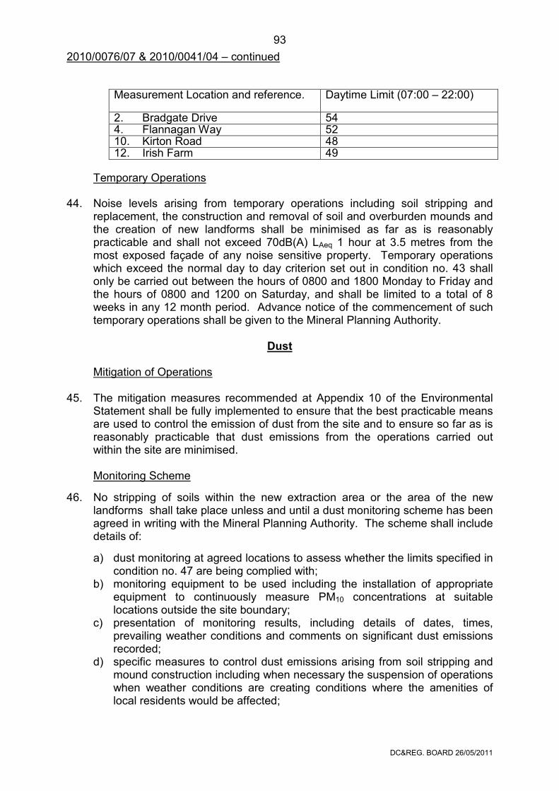
DC®. BOARD 26/05/2011
93
2010/0076/07 & 2010/0041/04 – continued
Measurement Location and reference.
Daytime Limit (07:00 – 22:00)
2. Bradgate Drive 54 4. Flannagan Way 52 10. Kirton Road 48 12. Irish Farm 49
Temporary Operations 44. Noise levels arising from temporary operations including soil stripping and
replacement, the construction and removal of soil and overburden mounds and the creation of new landforms shall be minimised as far as is reasonably practicable and shall not exceed 70dB(A) LAeq 1 hour at 3.5 metres from the most exposed façade of any noise sensitive property. Temporary operations which exceed the normal day to day criterion set out in condition no. 43 shall only be carried out between the hours of 0800 and 1800 Monday to Friday and the hours of 0800 and 1200 on Saturday, and shall be limited to a total of 8 weeks in any 12 month period. Advance notice of the commencement of such temporary operations shall be given to the Mineral Planning Authority.
Dust
Mitigation of Operations 45. The mitigation measures recommended at Appendix 10 of the Environmental
Statement shall be fully implemented to ensure that the best practicable means are used to control the emission of dust from the site and to ensure so far as is reasonably practicable that dust emissions from the operations carried out within the site are minimised.
Monitoring Scheme
46. No stripping of soils within the new extraction area or the area of the new landforms shall take place unless and until a dust monitoring scheme has been agreed in writing with the Mineral Planning Authority. The scheme shall include details of:
a) dust monitoring at agreed locations to assess whether the limits specified in condition no. 47 are being complied with;
b) monitoring equipment to be used including the installation of appropriate equipment to continuously measure PM10 concentrations at suitable locations outside the site boundary;
c) presentation of monitoring results, including details of dates, times, prevailing weather conditions and comments on significant dust emissions recorded;
d) specific measures to control dust emissions arising from soil stripping and mound construction including when necessary the suspension of operations when weather conditions are creating conditions where the amenities of local residents would be affected;
DC®. BOARD 26/05/2011
94
2010/0076/07 & 2010/0041/04 – continued
e) maintenance and availability of monitoring results; f) procedures to be implemented if dust emissions exceed approved levels;
and g) a methodology to keep the scheme under regular review subject to written
agreement with the Mineral Planning Authority.
Dust monitoring shall only be undertaken in full accordance with the approved details.
Dust monitoring shall continue to be carried out in accordance with the scheme approved under condition no. 33 of Planning Permission No. 2005/0558/07 in respect of operations at the existing quarry until such time as the above scheme is approved and takes effect.
Limits 47. Dust emissions arising from the development when measured in accordance
with the monitoring scheme approved under condition no. 46 shall not exceed:
• a mean average rate of 200 milligrams per day per square metre; and • a limit of 50µg.m-3 not to be exceeded more than 35 times a year as a 24
hour mean/40µg.m-3 as an annual mean for PM10.
Blasting Mitigation of Operations 48. To ensure that the best practicable means are used to control the effects of
blasting from the new extraction area no blasting shall be undertaken within a 400m distance of the nearest buildings shown on Drawing No. BHE-ES/006 unless and until a new regression analysis based on blasting events within the new extraction area can demonstrate and predict that the vibration limits specified in condition no. 50 can be met within this distance.
No blasting shall be undertaken within 200m of the nearest buildings shown on
Drawing No. BHE-ES/006. Drawing No. BHE-ES/006 shall be updated to include the 400m and 200m
blasting distances and submitted to the Mineral Planning Authority prior to any blasting in the new extraction area.
Monitoring Scheme 49. No stripping of soils within the new extraction area or the area of the new
landforms shall take place unless and until a blast monitoring scheme has been agreed in writing with the Mineral Planning Authority. The Scheme shall include details of:
a) blast monitoring at agreed locations including the use of permanent and
fixed monitors to assess whether the limits specified in conditions nos. 50 and 51 have been complied with;
DC®. BOARD 26/05/2011
95
2010/0076/07 & 2010/0041/04 – continued
b) the type of monitoring equipment to be used; c) presentation of monitoring results, including details of dates, times,
prevailing weather conditions and comments on significant blast results; d) maintenance and availability of monitoring results; d) procedures to be implemented if blasting exceeds approved levels; and e) a methodology to keep the scheme under regular review subject to written
agreement with the Mineral Planning Authority. Blast monitoring shall only be undertaken in full accordance with the approved
details. Blast monitoring shall continue to be carried out in accordance with the scheme
approved under condition no. 30 of Planning Permission No. 2005/0558/07 in respect of operations at the existing quarry until such time as the above scheme is approved and takes effect.
Limits 50. Every blast shall be designed with a 95% confidence level that ground vibration
levels recorded at any vibration sensitive property arising from any blast shall not exceed a peak particle velocity of 6mm per second measured in any mutually perpendicular plane. No blast shall exceed a peak particle velocity of 12mm per second as measured at any vibration sensitive property.
51. Every blast shall be designed to minimise noise or air over pressure by use of
the latest available techniques such that air over pressure shall not exceed 120dB peak linear as measured externally at any vibration sensitive property.
Timing 52. No blasting shall take place except between 10:00 hours and 16:00 hours
Monday to Friday and there shall be no blasting on Saturdays, Sundays, Public or Bank holidays unless in an emergency.
Secondary Blasting 53. No secondary blasting shall be carried out without the prior approval in writing
of the Mineral Planning Authority. In emergencies, the Mineral Planning Authority shall be notified of events within 24 hours.
Lighting
Lighting Scheme 54. No stripping of soils within the new extraction area or the area of the new
landforms shall take place unless and until a lighting scheme has been agreed in writing with the Mineral Planning Authority. The Scheme shall include details of the location, height, design, sensors, hours of operation and luminance of all proposed lighting and a programme for its installation. The lighting shall be designed to minimise the potential nuisance of light spillage to the locality, and shall be implemented in full accordance with the approved details.
DC®. BOARD 26/05/2011
96
2010/0076/07 & 2010/0041/04 – continued
Carbon Management Carbon Management Plan 55. No stripping of soils within the new extraction area or the area of the new
landforms shall take place unless and until a Carbon Management Plan has been agreed in writing with the Mineral Planning Authority. The Plan shall have regard to the details included in Section 20 of the Environmental Statement, and include measures to reduce the carbon footprint of the quarrying operations at the site subject to agreed timescales. The Plan shall be implemented in full accordance with the approved details.
Working Programme
56. No stripping of soils within the new extraction area or the area of the new
landforms shall take place unless and until a working plan covering the operational matters of the development hereby permitted has been agreed in writing with the Mineral Planning Authority. The scheme shall include details of:
a) a summary of the forthcoming annual working programme; b) phasing and timing of operations for vegetation clearance, soil and
overburden stripping and removal; c) phasing and timing of operations for overburden and soil replacement
including the construction of new landforms and new planting and seeding; d) the construction of haul routes; e) direction of mineral working; f) depth of working; g) extraction rates; h) the infilling sequence for the existing quarry; i) the extent and height of stockpiles and mineral storage areas; j) the extent and details of processing areas, including aggregate production,
the coated roadstone plants and concrete products works. The working plan shall be updated and submitted before 31st March each year
following the approval of the initial plan and show the progress of the operations over the previous 12 months and anticipated progress over the forthcoming 12 months. The working of the site shall be undertaken only in accordance with the approved details.
Operations at the existing quarry shall continue to be carried out in accordance
with the details approved under conditions nos. 13 and 14 of Planning Permission No. 2005/0558/07 until such time as the above Working Plan is approved and takes effect.
DC®. BOARD 26/05/2011
97
2010/0076/07 & 2010/0041/04 – continued Hours of Operation
57. The development shall only take place in accordance with the following hours:
Operations Permitted Hours
Monday to Saturday
Sundays, Public & Bank Holidays
• The extraction, primary crushing and internal movement of stone from within the new and previously permitted extraction areas;
07:00 to 22:00 None
• The use of the secondary and tertiary aggregate processing plants;
• The despatch of aggregate and concrete products;
• The use of the aggregate and concrete product stocking areas;
06:00 to 22:00 None
• Emergency works;
• Maintenance and repair of plant and machinery;
• Essential pumping;
• The use of the asphalt plants and despatch of products;
• The manufacture of concrete products;
• The loading, movement and servicing of trains.
Any Time
Restriction of Permitted Development Rights Buildings, Structures, Fixed Plant, Machinery and Ground Works 58. Notwithstanding the provisions of part 19 of Schedule 2 to the Town and
Country Planning (General Permitted Development) Order 1995 or any order revoking and re-enacting that Order, with or without modification:
• no fixed plant or machinery, building, structures and erections, or private ways shall be erected, extended, installed, or replaced within the site without the prior written approval of the Mineral Planning Authority following submission of relevant details and plans.
DC®. BOARD 26/05/2011
98
2010/0076/07 & 2010/0041/04 – continued
Processing Plant and Imported Materials Primary Crushing 59. The primary crusher shall only be used to process mineral won from within the
site. No primary crushing of imported mineral shall take place. Materials and Finishes 60. The cladding of all fixed plant and machinery shall be retained and maintained
thereafter in its original approved colour.
Associated Business Uses Concrete Products Works 61. Within 12 months of the date of mineral extraction finishing at the site the use of
the concrete products works (Charcon Factory) as defined by a dashed pink line on Drawing No. BHE-SS/005 Revision A shall cease and all the buildings removed and the land reinstated in accordance with a reclamation scheme approved under condition no. 63.
Complaints
Forwarding of Details
62. Following the receipt of any complaint about operations on site affecting neighbouring land users or the environment the operator shall notify the Mineral Planning Authority within 24 hours. Details of the investigation and any mitigation measures shall be agreed with the Mineral Planning Authority.
Reclamation
Reclamation Programme
63. No stripping of soils within the new extraction area or the area of the new landforms shall take place unless and until a reclamation scheme covering the whole site and including the land known as Ratchett Hill shown on Drawing No. BHE-SS/001 has been agreed in writing with the Mineral Planning Authority. The scheme shall be based on the restoration concept shown on Drawing No. BHE-SS/017 and as described in section 21 of the Environmental Statement. The scheme shall co-ordinate the implementation of the details approved under the conditions above in respect of:
a) the landscaping works; b) the management of retained, new and translocated vegetation; c) the provision of the ecological mitigation and compensation measures; d) the stream diversion works and provision of adjacent meadows; e) the protection and interpretation of the geological interests; f) the provision of rights of way and public access; and g) the enhancement works at Ratchett Hill.
DC®. BOARD 26/05/2011
99
2010/0076/07 & 2010/0041/04 – continued The programme of restoration works shall provide the initial landscape and
habitat management to facilitate the biodiversity afteruse of the whole site. The development shall be undertaken in accordance with the approved details. Reclamation of Operational Areas 64. Prior to the completion of mineral extraction within the current extraction limit
details for the treatment of all previously permitted extraction areas, the processing plant site, associated business use areas, stockpile areas and other hardstandings and roadways shall be agreed in writing with the Mineral Planning Authority. The areas shall then be reclaimed progressively and managed for biodiversity purposes in accordance with the agreed aftercare details.
The development shall be undertaken in accordance with the approved details.
Premature Cessation Alternative Reclamation Scheme 65. In the event of a cessation of winning and working of minerals prior to the
achievement of the completion of the approved scheme as defined in this permission, and which in the opinion of the Mineral Planning Authority constitutes a permanent cessation within the terms of paragraph 3 of Schedule 9 of the Town and Country Planning Act 1990 a revised scheme to include details of reclamation and aftercare shall be submitted in writing for approval to the Mineral Planning Authority within six months of the cessation of winning and working. The approved revised scheme shall be fully implemented within 12 months of the written approval.
Aftercare
Provision of Scheme 66. Following the restoration of any part of the site in accordance with the agreed
reclamation scheme the restored land shall be treated and managed over a period of 5 years in accordance with an aftercare scheme, which has previously been agreed in writing with the Mineral Planning Authority. The agreed scheme shall provide a strategy for the five-year aftercare period and specify the steps that are to be taken in order to bring the newly restored land to the required standard for the approved biodiversity led after-use. The scheme shall:
a) be submitted for the written approval of the Mineral Planning Authority
within six months of the date of approval of the corresponding reclamation schemes submitted under conditions nos. 63 and 64 above.
DC®. BOARD 26/05/2011
100
2010/0076/07 & 2010/0041/04 – continued
b) provide an outline strategy, having regard to the guidance contained in Mineral Planning Guidance Note 7 (MPG7) (or any superseding Government guidance on the reclamation of mineral sites) for the 5-year aftercare period. This shall specify the steps to be taken and the period during which they are to be taken to return the land to beneficial use and shall provide for annual meetings between the operator, the Mineral Planning Authority and other agencies as appropriate in respect of the restored areas of the site;
c) provide for the annual submission and implementation of a detailed
programme of aftercare works having regard to MPG7 (or any superseding Government guidance on the reclamation of mineral sites) and other relevant guidance regarding biodiversity action plan targets.
The development shall be undertaken in accordance with the approved details.
Reasons 1&5, For the avoidance of doubt. 2. For the avoidance of doubt and to ensure that mineral extraction is confined
to the permitted areas. 3. For the avoidance of doubt and to ensure that the Bardon Hill SSSI is
safeguarded. 4. For the avoidance of doubt and to ensure that the development is carried out
in a satisfactory manner. 6. To comply with the requirements of Section 91 of the Town and Country
Planning Act, 1990 as amended by Section 51 of the Planning and Compulsory Purchase Act 2004.
7. To enable the development to be monitored to ensure compliance with this
permission. 8. To provide for the completion and restoration of the site within the approved
timescale. 9. To ensure the site is accessed with due regard to highway safety and the
local environment. 10. In the interests of highway safety and the amenities of local residents. 11,14, In the interests of highway safety and safeguarding the local environment. &15. 12. To ensure that deleterious material is not carried onto the public highway in
the interests of highway safety and local amenity.
DC®. BOARD 26/05/2011
101
2010/0076/07 & 2010/0041/04 – continued 13. In the general interests of highway safety and to ensure that adequate off-
street parking facilities are available within the curtilage of the development. 16. To ensure that adequate steps are taken to provide a transport choice
including a choice in mode of travel to and from the site 17. In the interests of the landscape and visual amenities of the area and to
enhance the development and bio-diversity. 18. To ensure that vegetation removal is adequately controlled. 19. To ensure that all hedgerows and trees to be retained on site are protected
during the development. 20. To minimise the adverse impact of the operations on ecological interests. 21. To minimise the adverse impact of the operations on the grassland habitats. 22. To monitor the affects of the development on the grassland habitats. 23. To reduce the overall effects of the development on the hedgerow resource. 24. To safeguard the local habitat and protect nesting birds. 25. To monitor the effects of the development on ecological interests and to
safeguard protected species. 26. In the interests of protecting users of the rights of way network. 27. In the interests of protecting the rights of way network and its users. 28. To prevent flooding by ensuring the satisfactory storage of and disposal of
surface water from the site. 29. To ensure adequate drainage of the site. 30,31, To protect the water environment. &32. 33. To ensure the proposed diverted watercourse is developed in a way that
improves the nature conservation value of the river. 34. To assess and monitor the effects of the development arising from changes
in groundwater levels. 35. To minimise structural damage and compaction of the soil and to aid the final
restoration of the site. 36. To ensure the preparation and implementation of an appropriate programme
of archaeological investigation.
DC®. BOARD 26/05/2011
102
2010/0076/07 & 2010/0041/04 – continued 37. To ensure protection of the archaeological assets in the site including
potential in situ preservation. 38. To ensure protection of the archaeological assets in the site through a
phased programme of investigation. 39. To ensure the historic buildings to be lost are recorded. 40. To minimise the effects on geological conservation interests and provide
access to the key geodiversity features. 41,43, To minimise the adverse impact of noise generated by the operations on the &44, local community and environment. 42. To enable the noise related effects of the development to be adequately
monitored during the course of the operations. 45&47 To minimise the adverse impact of dust generated by the operations on the
local community and environment. 46. To enable the dust related effects of the development to be adequately
monitored during the course of the operations. 48. To minimise the adverse impact of blasting on the local community and
environment. 49. To enable the blasting effects of the development to be adequately
monitored during the course of the operations. 50,51, To minimise the adverse impact of blasting generated by the operations on 52&53, the local community and environment. 54. To minimise the adverse impact of light generated by the operations on the
local community and environment. 55. To minimise the adverse impact of carbon emissions generated by the
operations on the local community and environment. 56. To enable the Mineral Planning Authority to monitor and adequately control
the development and to minimise its impact on the amenities of the local area.
57. To protect the amenities of local residents and in the interests of the local
environment. 58. There is an exceptional need here to secure control over additional plant and
machinery, in the interests of the amenity of the area and bearing in mind the degree of discretion otherwise allowed by the GPDO.
59. To restrict mineral processing at the site in the interests of the local
community and environment.
DC®. BOARD 26/05/2011
103
2010/0076/07 & 2010/0041/04 – continued 60. To ensure a satisfactory appearance in the interests of the local community
and environment. 61&63. To ensure the proper restoration of the site and in the interests of habitat
creation and diversity 62. To protect the amenities of local residents and the local environment. 64. To ensure that the operational site areas are reclaimed in an orderly manner
to a condition capable of beneficial after-use. 65. To enable the Mineral Planning Authority to control the development and to
ensure that the land is restored to a condition capable of beneficial after-use. 66. To ensure that the restored areas of the site are brought back to a condition
suitable for long-term beneficial use in the interests of bio-diversity. Notes to applicant Natural England ‘European Protected Species (EPS) such as Bats Chiroptera, Water Vole Arvicola amphibius and Great Crested Newts Triturus cristatus are a rare and declining group of species. Hence, all EPS are fully protected by the The Conservation of Habitats and Species Regulations 2010 making it an offence to intentionally or recklessly kill or injure or disturb these species whilst in a place of shelter or protection. If an EPA is discovered during work on the development, the relevant work should be halted immediately and Natural England should be notified and further advice sought. Failure to comply with this may result in prosecution and anyone found guilty of an offence is liable to a fine of up to £5,000 or to imprisonment for a term not exceeding six months, or both.’ Environment Agency Under the terms of the Water Resources Act 1991, the prior written consent of the Agency is normally required for any discharge of sewage or trade effluent into controlled waters, and may be required for any discharge of surface water to such controlled waters or for any discharge of sewage or trade effluent from buildings or fixed plant into or onto ground or into waters which are not controlled waters. Such consent may be withheld. Controlled waters include rivers, streams, underground waters, reservoirs, estuaries and coastal waters. Based upon the information within the JDIH report, there do not appear to be any significant groundwater dependent or linked features likely to be significantly impacted by this scheme. Any discharge from the site will need to be subject to Consent(s) to Discharge and the Environment Agency will need to be consulted regarding this in the first instance.
DC®. BOARD 26/05/2011
104
2010/0076/07 & 2010/0041/04 – continued Under the Water Framework Directive, there should be no deterioration to waterbodies (this waterbody - GB104028046750 - River Sence from Source to Ibstock Brook) is currently classed as being in 'Bad' ecological status and will be required to meet Good Ecological Status by 2027. The waterbody is failing with high levels of nutrients (phosphate) and poor diatom quality, and investigations will be needed to determine the reasons and causes of the failure to meet good status.
The implications of the Water Framework Directive should also be considered during the restoration of this site - with regard to, but not exclusive of, river restoration, fish passage (if applicable).
Under the terms of the Land Drainage Act 1991, the prior written consent of the Environment Agency is required for the proposed watercourse diversion works and associated access crossing structures (culverts). The Environment Agency resists culverting on nature conservation and other grounds and consent for such works will not normally be granted except for access crossings.
As stated in section 11.4.10 of Section 10 of the Environmental Statement a discharge consent will be required from the Environment Agency for the discharge of settled water from the lagoons into the River Sence.
Any materials used for infilling, restoration, landfill, regrading, landscaping, bunding, screening or roadway infrastructure must be restricted to uncontaminated soils, subsoils and inerts. An Environmental Permit or an Approved Registered Exemption may be required.
There must strictly be no discharge, run-off or seepage of any contaminated waters from the development or its associated areas, which might occur as a result of the development, into any surface water sewer, land drain, ditch, watercourse or other controlled waters, either directly or indirectly.
During the period of construction, oil and fuel storage will be subject to the Control of Pollution (Oil Storage) (England) Regulations 2001. The Regulations apply to the storage of oil or fuel of any kind in any kind of container which is being used and stored above ground, including drums and mobile bowsers, situated outside a building and with a storage capacity which exceeds 200 litres. A person with custody or control of any oil or fuel breaching the Regulations will be guilty of a criminal offence. The penalties are a maximum fine of £5000 in Magistrates' Court or an unlimited fine in Crown Court. Further details of the Regulations are available from the Environment Agency.
Site operators should ensure that there is no possibility of contaminated water entering and polluting surface or underground waters.
Severn Trent Water
There are public sewers which cross the site. No works shall take place within 3 metres of these sewers. The applicant may wish to apply to Severn Trent Water to divert the sewers in accordance with section 185 of the Water Industry Act 1991.
DC®. BOARD 26/05/2011
105
DEVELOPMENT CONTROL AND REGULATORY BOARD
The considerations set out below apply to all the following applications. EQUAL OPPORTUNITIES IMPLICATIONS Unless otherwise stated in the report there are no discernible equal opportunities implications. IMPLICATIONS FOR DISABLED PERSONS On all educational proposals the Director of Children and Young People's Service and the Director of Corporate Resources will be informed as follows: Note to Applicant Department Your attention is drawn to the provisions of the Chronically Sick and Disabled Person’s Act 1970 and the Design Note 18 “Access for the Disabled People to Educational Buildings” 1984 and to the Equality Act 2010. You are advised to contact the County Council’s Human Resources Department if you require further advice on this aspect of the proposal. COMMUNITY SAFETY IMPLICATIONS Section 17 of the Crime and Disorder Act 1998 places a very broad duty on all local authorities 'to exercise its various functions with due regard to the likely effect of the exercise of those functions on, and the need to do all reasonably can to prevent, crime and disorder in its area'. Unless otherwise stated in the report, there are no discernible implications for crime reduction or community safety. BACKGROUND PAPERS Unless otherwise stated in the report the background papers used in the preparation of this report are available on the relevant planning application files. SECTION 38(6) OF PLANNING AND COMPULSORY PURCHASE ACT 2004 Members are reminded that Section 38(6) of the 2004 Act requires that: “If regard is to be had to the development plan for the purpose of any determination to be made under the planning Acts the determination must be made in accordance with the plan unless material considerations indicate otherwise.” Any relevant provisions of the development plan (i.e. any approved Local Plans) are identified in the individual reports. The circumstances in which the Board is required to “have regard” to the development plan are given in the Town and Country Planning Act 1990: Section 70(2) : determination of applications; Section 77(4) : called-in applications (applying s. 70); Section 79(4) : planning appeals (applying s. 70); Section 81(3) : provisions relating to compensation directions by Secretary of State (this
section is repealed by the Planning and Compensation Act 1991); Section 91(2) : power to vary period in statutory condition requiring development to be
begun; Section 92(6) : power to vary applicable period for outline planning permission; Section 97(2) : revocation or modification of planning permission; Section 102(1) : discontinuance orders; Section 172(1) : enforcement notices; Section 177(2) : Secretary of State’s power to grant planning permission on enforcement
appeal; Section 226(2) : compulsory acquisition of land for planning purposes; Section 294(3) : special enforcement notices in relation to Crown land; Sched. 9 para (1) : minerals discontinuance orders.