Embed Size (px)
Citation preview

Development and application Development and application of Tohoku Coastal Webof Tohoku Coastal Web--GIS GIS for supporting recoveries of for supporting recoveries of the Tohoku Earthquakethe Tohoku Earthquake
Sei-Ichi Saitoh1,2, Katsuyoshi Tanaka3, and Fumihiro Takahashi21
Faculty of Fisheries Sciences, Hokkaido University
2
Green & Life Innovation Inc
3 NPO EnVision Conservation [email protected]
PICES 2012 Session 13Risk management in coastal zone ecosystems around the North Pacific

OutlineOutline
BackgroundObjectivesDevelopment of Web-GIS systemApplication of Web-GIS systemConclusions

The disaster management cycleThe disaster management cycle
InformationCommunication
TechnologyICT
1)Prevention&
Mitigation 2)Preparedness
3)Alter
4)Response5)Rehabilitation
&Reconstruction
6)Post Disaster
(Saleh and Allaert, 2011)

海を生産システムに海を生産システムに
““Hakodate Marine BioHakodate Marine Bio--Cluster ProjectCluster Project””
Theme 1Theme 1Coastal EnvironmentCoastal EnvironmentMonitoring/ForecastingMonitoring/Forecasting
Theme 2Theme 2Exploration of ValuablesExploration of ValuablesSustainable ProductionSustainable Production
Theme 3Theme 3Production of Functional Production of Functional Materials and FoodsMaterials and Foods
Theme 4Theme 4Global Expand Global Expand Branded ProductsBranded Products
Regional Innovation Cluster Program (Global Type)Regional Innovation Cluster Program (Global Type) the Grantthe Grant--inin--Aid for University and Society Collaboration Aid for University and Society Collaboration
supported by MEXTsupported by MEXT Sept. 2009 Sept. 2009 –– March 2014 (5 years)March 2014 (5 years)

Integrated Coastal Fisheries Information System
Observation
Numerical Modeling
4-D VAR DataAssimilation
Forecast
Spatial ModelingBuoySatellite
3-D Environment
Time- Series
Ecosystem Model
PhysicalModel
Dissemination
VerticalMulti- variables
Marine-GIS
Prediction of change of Marine Environment
HighPrecise
Acoustic
Supporting System for Marine Precise Production
Monitoring ofMarine Environment
NEMURO-Coastal

Base Map
Buoy & HF radar
Satellite
Forecast
Fisheries
Bathymetry

Observation of current by Ocean VHF radar(Dec. 2010 ‐
March 2012)


Great Tsunami reached to HokkaidoGreat Tsunami reached to Hokkaido
The magnitude 9.0 earthquake off Sendai occurred on 11 March 14:46 JST (5:46 UTC)

Ocean VHS Radar detected the Great Ocean VHS Radar detected the Great Tsunami in HokkaidoTsunami in Hokkaido
March 11,
15:53 March 11,
21:00
No. 6 Southeast Dir.
First TsunamiNorthwest Dir.
Change of Water levelChange of Water level

Tohoku Coastal Web-GIS
Fisheries Oceanography Web-GIS(Hakodate Marine Bio-Cluster )

Construction and Application of Construction and Application of Marine Spatial InformationMarine Spatial Information
Hazard prediction & modelingHazard prediction & modelingRisk Assessment & mappingRisk Assessment & mapping
Development of suitable site selection model for oyster and seaweed aquaculture
Recovery and Early damage assessment

September 3, 2012September 3, 2012

September 3, 2012September 3, 2012

September 3, 2012September 3, 2012

September 3, 2012September 3, 2012

Activities Level
Remove Debris in bottomMonitoring of fishing ground and ecosystem
Temporal housing
Housing constructed after a disaster Sustenance and
recovery of industry
Process for Post-Disaster Recovery and Reconstruction of Fisheries Sectors
Yamao (2012) unpublished
Emergency
Self-reliance
Preparation of physical and societal infrastructure

ObjectivesObjectives
To expand the Web-GIS to Tohoku coastal region for supporting of recoveries of the Great Tohoku Earthquake.To apply this Web-GIS, called Tohoku Coastal Web-GIS, for services and contributions to support activities of recoveries the Great Tohoku Earthquake.

Tohoku Coastal WebTohoku Coastal Web--GISGISServices for Post-Disaster Recovery and Reconstruction of Fisheries Sectors
Satellite ImagesAerial Photos taken after the earthquakeMarine Safety InformationSurvey Results after the earthquakePosition data of several monitoring (Buoy)Several spatial scale bathymetryAccess by Mobile PhoneTwitter(SNS) for communication tool
http://innova01.fish.hokudai.ac.jp/tohokugis/
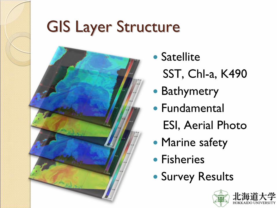
GIS Layer StructureGIS Layer Structure
SatelliteSST, Chl-a, K490BathymetryFundamental ESI, Aerial PhotoMarine safetyFisheries Survey Results

Tohoku Coastal WebGISTohoku Coastal WebGIS
Layer Display Menu
Scaling/zooming
Change background
map
Other functions
Legends


Provide KLZProvide KLZ
file of satellite images file of satellite images and safety informationand safety information


Provide pdf images of SST, Chl-a and K490
SST
Chl-a
K490

Iwate Prefecture Fisheries Technology Center

Tsunami Penetration Line
Iwate Prefecture Fisheries Research Center

Iwate Prefecture Fisheries Technology Center

Iwate Prefecture Fisheries Technology Center

Aerial Photo taken on March 12, 201

Iwate Prefecture Fisheries Iwate Prefecture Fisheries Technology Center (Sept. 3, 2012)Technology Center (Sept. 3, 2012)

Temporal door of main entranceTemporal door of main entrance

First floor is still not recoveredFirst floor is still not recovered

They are working in one roomThey are working in one room

GIS Layer StructureGIS Layer Structure
SatelliteSST, Chl-a, K490BathymetryFundamental ESI, Aerial PhotoMarine safetyFisheries Survey Results

Satellite

Bathymetry
Spatial resolutions: 5m, 50m, 150m

Supported by Japan Space Imaging Inc.
Fundamental
High resolution satellite image

20km circle line fromFukushima I Nuclear Power Plant


Fukushima I Nuclear Power PlantFukushima I Nuclear Power Plant (March 16, 2011)(March 16, 2011)
4 3 2 1
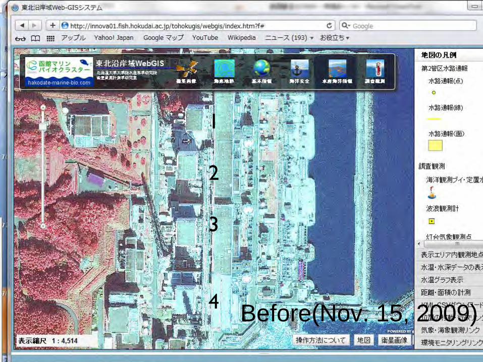
Before(Nov. 15, 2009)
1
2
3
4

After(March 29, 2011)
1
2
3
4

Access by Mobile phoneAccess by Mobile phone
innova01.fish.hokudai.ac.jp/arcgissever/mobile
ConclusionsConclusionsICT with GIS gives baseline and is important tool for supporting to recover the Great Tohoku EarthquakeICT with GIS is used during most of all the phase of disaster cycleTohoku Coastal Web-GIS is portal site for providing integrated information of coastal environment in TohokuTwitter in Web-GIS is new approach for ICT application
http://innova01.fish.hokudai.ac.jp/tohokugis/

Thank you!Thank you!
2012-05-09 05:33:44 GMT
scene 10224
HICO on ISS (JAXA Unit “Kibo”) detecting turbid water distribution in Funka
Bay(Spatial resolution:90m)


![Carley GIS workshop 20101109 [Read-Only] · GIS in Coastal Management Coastal Engineering Physical Model Testings Coastal Processes Climate Change and Sea Level Rise Foreshore Protection](https://img.pdfslide.us/doc/110x75/5e70b53c54818046d600f219/carley-gis-workshop-20101109-read-only-gis-in-coastal-management-coastal-engineering.jpg)