Embed Size (px)
Citation preview
DEVELOPING A PLAN FOR THE NATIONAL COORDINATION OF
GEOSPATIAL TECHNOLOGY EDUCATION:
A COMMUNITY COLLEGE PERSPECTIVE
by
Deidre E. Sullivan
A RESEARCH PAPER
submitted to
THE GEOSCIENCES DEPARTMENT
in partial fulfillment of the requirements for the
degree of
MASTER OF SCIENCE
GEOGRAPHY PROGRAM
December 2007
Committee in Charge: Dawn Wright, Geosciences, Major Professor
Jim Good, Marine Resource Management, Minor Professor Julia Jones, Geosciences, Committee Member
ii
Acknowledgements
I would like to express my sincere appreciation to a number of people for their
guidance, support, and comradeship during my mid-career return to academia as a student. I
would like to thank my committee Dawn Wright (major professor), Julia Jones, and Jim
Good (minor professor) for their infectious passion for their disciplines. I would like to
thank my co-worker and friend Jill Zande for her support, encouragement, and editorial
reviews.
I would like to thank the Advanced Technological Education Program of the
National Science Foundation for funding this study (Developing a Vision and a Plan for a
National Geospatial Technology Center, NSF/DUE 063424). Additionally, I would like to
thank my co-PIs on this project Ann Johnson and Terry Brase and many more colleagues that
contributed to this effort.
Finally, I would like to thank my parents for their encouragement and understanding which has allowed me to follow my dreams.
iii
Developing a Plan for the National Coordination of Geospatial Technology Education: A Community College Perspective
ABSTRACT
Geospatial technology is a rapidly growing and changing field. The term geospatial technology (GST) refers to geographical information systems (GIS), global positioning systems (GPS), and remote sensing (RS), all emerging technologies that assist the user in the collection, analysis, and interpretation of spatial data. The speed at which new fields are adopting GST, along with the speed at which equipment and software are being modified and updated, precludes many industries, much less the educational system, from keeping up to date. The issue is further complicated at the community college level because national coordination of workforce information and educational resources within the community college network is fairly poor.
Developing a Plan for the National Coordination of Geospatial Technology Education: A Community College Perspective was an effort to document the needs and concerns of community college educators and to use this information to produce recommendations for the development and operation of a National Geospatial Technology Center (NGTC).
The following ten issues were identified by community college educators as critical to GST education: 1) workforce needs; 2) core competencies1; 3) professional certification; 4) curriculum development; 5) educational pathways; 6) professional development; 7) communication; 8) awareness and reaching underserved audiences; 9) the role of GST education in supporting college administrative tasks and entrepreneurialism; and 10) future trends in GST.
From the recommendations put forth in this study, it is clear that community college educators want a NGTC that will: represent their interests in national education and workforce initiatives, act as a clearinghouse to provide easy access to existing curricula and workforce information, and provide access to professional development opportunities, among other activities described in this report.
Additionally, it is imperative that a NGTC works with existing competency-related efforts (University Consortium for Geographic Information Science’s (UCGIS) Body of Knowledge; GeoSpatial Workforce Development Center’s (GeoWDC) Geospatial Technologies Competency Model; Geospatial Information and Technology Association (GITA) / Association of American Geographers (AAG) study, Defining and Communicating Geospatial Industry Workforce Demand, Phase I report recommendations, and existing DACUMs2) to bring them closer together so that core competencies, and in turn a core curriculum, that supports many entry-level positions, can be established and agreed upon by a wide range of stakeholders. The consequences of not coming to an agreement will certainly contribute to greater gaps between what the workforce needs and what the educational system is producing.
1 Core competencies define the knowledge and skills required to carry out specific tasks that are common to a particular profession or occupation. Core competencies are critical links between the workplace and the classroom, since they connect job requirements to educational subject areas. 2 DACUM is an acronym for developing a curriculum. It is a one or two day storyboarding process that provides a picture of what the worker does in terms of duties, tasks, knowledge, skills, traits and in some cases the tools the worker uses (DACUM, 2005)
1
INTRODUCTION
Geospatial Technology and the Economy
Geospatial technology is a rapidly expanding industry that crosscuts nearly every
discipline and every sector of the U.S. economy (Gewin, 2004). The term “geospatial
technology” (GST) is a broad term referring to geographical information systems (GIS),
global positioning systems (GPS), and remote sensing (RS), all emerging technologies
that assist the user in the collection, analysis, and interpretation of spatial data (U.S.
Department of Labor, 2005a). It deals with the relationship and condition of manmade
and natural objects within space, be it on Earth, or beyond (Bolstad, 2005). Industries as
diverse as health, agriculture, construction technology, emergency services,
environmental technology, government, information technology, manufacturing
technology, marine science, marketing, national security, resource management, and
transportation use geospatial technologies to collect and analyze data about issues and
occurrences that affect people’s lives. The field of GST enables other fields to improve
productivity, efficiency, and profitability while evaluating the environmental impacts of
our ecosystems. Recent natural disasters from Hurricanes Katrina and Rita to wildfires in
California illustrate the need for coordination and geospatial data sharing among all
levels of government. To apply the lessons learned from these events, no less adapt to an
information age that is increasingly tied to GST, requires a populace and a workforce that
can effectively understand and use the information derived from geospatial technology.
The growth of the GST industry is phenomenal. In 2002, the market for
geospatial technologies was estimated at $5 billion and is projected to have annual
revenues of $30 billion - consisting of $20 billion in the RS market and $10 billion in the

2
GIS market - by 2005 (Gaudet et al., 2002). In the abstract Global Positioning System:
The Road Ahead, it is estimated that market revenue for geospatial technology will be
over $700 billion by the year 2017 (Research & Consultancy Outsourcing Services,
2005).
The U.S. Department of Labor has highlighted the importance of GST in the
President’s High Growth Job Training Initiative. This initiative is designed to provide
national leadership for a workforce with jobs in high-growth/high-demand industries of
the American economy. The latest report identified 14 sectors that are projected to add
substantial numbers of jobs; have a significant impact on the economy; impact the growth
of other industries; are transformed by technology and innovation requiring new skill
sets; and are emerging businesses projected to grow. GST is recognized as one of these
14 sectors (U.S. Department of Labor, 2005b). The tremendous potential for growth in
this industry is only limited by the ability of the educational system to provide individuals
with the technical expertise and geospatial technology awareness needed by government
and industry.
Many environmental events over these past two years — the Asian tsunami,
Hurricanes Katrina and Rita, and wildfires in southern California — have all heightened
the awareness of GIS (e.g., Tsou, 2005). Millions of people have learned more about
these events by using GIS-based maps and visualizations. In addition, the explosion of
web-based GIS sites such as Google Earth, MapQuest, NASA’s World Wind, and MSN
Virtual Earth illustrate that web-based GIS is a substantial and growing medium to
communicate science and geography to the general public (Butler, 2006). Web-based GIS
3
has the potential to increase the general population’s awareness and understanding of
geospatial information as never before (e.g., Peng and Tsou, 2003)
Community College Education
American community colleges have been around since the early 20th century
(American Association of Community Colleges, 2005). Among the factors that
contributed to their rise include the need for workers trained to operate the nation’s
expanding industries and the drive for social equality, which presumably would be
enhanced if more people had access to higher education (Cochen and Brawer, 2003).
Community colleges continued to increase in importance throughout the 20th century as
more and more students graduated from high school and the demand for further education
increased. In 1947, the President’s Commission on Higher Education articulated the
value of a population with free access to two years of study beyond high school and
asserted that half of the young people could benefit from formal studies through grade 14
(Cochen and Brawer, 2003). Fifty years later, in 1998, President Clinton underscored the
importance of making education through grade 14 as universal as a high school diploma.
The composition of student populations attending community colleges is far more
complex than many people realize. Community college students include high school
graduates continuing with grades 13 and 14 who plan to transfer to a four-year institution;
students pursuing a two-year vocational degree or certificate; adults working towards
achieving a General Education Development (GED)3 or entry level workplace
3 The GED is an exam developed in the United States that is available for all adults who want an equivalent of a high school diploma. It tests general academic skills and core content that are covered in four years of high school.
4
competencies, such as those participating in the Welfare-to-Work4 program; middle and
high school age students that are co-enrolling at a community college or may be attending
in lieu of their traditional school; re-entry students that may have been in the workforce
for some time looking for new careers; and a growing number of “reverse transfer”
students, that is, students who have already earned a Bachelor degree and are seeking
new skills and skill upgrades − especially technical knowledge and skills – at a
community college. Because of this growing trend of “reverse transfer,” some have
referred to community colleges as the new form of graduate school (Arnone, 2001).
All total, more students, including those taking credit and non-credit courses,
attend community colleges than four-year universities (Community College Research
Center, 2005). This reality has led the National Science Foundation (NSF) and other
agencies, such as the Department of Labor (DOL), to devote more and more resources to
improving education at the community college level because of the tremendous potential
to impact the nation’s workforce. Additionally, the students at community colleges are
far more diverse in terms of age, ethnicity, and their socio-economic backgrounds. So, if
social equality is a goal, community colleges are logical places to invest resources
(Community College Research Center, 2005).
4 Welfare-to-work is a social program of the United States government. The concept is to wean sole parents and the disabled off their reliance on income support and encourage them back into the work force. For more information see http://www.opm.gov/wtw/index.htm
5
Geospatial Technology Education
GIS programs5 in higher education have grown tremendously over the past 20
years. Currently more than 2,000 of the 4,165 public and private two-year and four-year
colleges and universities in the country use Environmental Systems Research Institute
(ESRI) GIS software (ESRI White Paper, 2002; Infoplease, 2005). Of these,
approximately 400 of the nations 1,157 two-year colleges offer some instruction in GIS;
25 offer a GIS certificate or degree (Allen, 2006). Although other GIS software is
available, the vast majority of colleges and universities are using ESRI products, so these
data are a good approximation of its widespread use in higher education.
GIS is a bit of an oddity within the educational system, as it is offered as both an
academic and an occupational program. The curricula of community college
occupational programs are generally more responsive to local workforce needs, as
mandated by community college missions and their requirements for advisory
committees from business and industry to guide occupational program development and
implementation; many community college GIS courses are taught by occupational faculty
who work fulltime as GIS professionals. For GIS, these programs range from simply
offering courses in GIS and using GIS as a tool in other disciplines to offering GIS
certificates and Associate degrees for GIS technicians. Many of the students enrolled in
community college GIS courses are incumbent workers that need GIS for their job. As a
result, some community colleges, such as Central Oregon Community College, are
offering GIS certificates for people who already have an academic degree.
5 In most cases GIS and GST can be used interchangeably within the context of higher education. Most GIS courses and programs include some type of remote sensing and/or GPS.
6
Four-year college and university missions and funding sources tend to be
different, and the integration of GIS into the curriculum often reflects these differences.
More universities tend to view GIS as a science, rather than a tool, as reflected in the use
of the term GIScience, which is gaining in popularity at universities but not commonly
found at community colleges (Wright et al., 1997; Kemp, 2003). Universities offer
minors or certificates in GIS at the Bachelor, Master and Ph.D. level, with some of these
courses available via distance education (ESRI White Paper, 2002; Wright and DiBiase,
2005). Oftentimes the different philosophies of community colleges and universities
contribute to the difficulty articulating GIS courses between two-year and four-year
institutions. Additionally, GIS courses at community colleges are offered as 100 and 200
level courses and generally as 300 and 400 level courses at four-year institutions (Allen,
2005). As a result, students who plan to continue at four-year institutions can have
difficulty transferring GIS/GST courses.
GIS is also becoming more commonplace in K-12 education as evidenced by a
variety of national GIS programs (GIS for 4-H, EAST, Community Mapping Project), not
to mention the countless local and regional efforts underway as a result of motivated
educators and linkages to higher education programs. The presence of GIS in the K-12
community will continue to increase as the importance of GIS to many sectors of the
economy grows, as clearly articulated in a recent National Research Council Report titled
Learning to Think Spatially: GIS as a Support System in the K-12 Curriculum (National
Research Council, 2005):
Spatial thinking must be recognized as a fundamental part of K-12 education and as an integrator and a facilitator for problem solving across the curriculum. With advances in computing technologies and the increasing availability of geospatial
7
data, spatial thinking will play a significant role in the information-based economy of the 21st-century.
This report describes spatial thinking as a constructive combination of concepts of space, tools of representation, and processes of reasoning that uses space to structure problems, find answers, and express solutions. It is powerful and pervasive in science, the workplace, and everyday life. By visualizing relationships within spatial structures, we can perceive, remember, and analyze the static and dynamic properties of objects and the relationships between objects. Despite its crucial role underpinning the National Standards for Science and Mathematics, spatial thinking is currently not systematically incorporated into the K-12 curriculum. Spatial thinking has gone beyond being a specialized skill set or body of
knowledge; it is entering a new age of expected general literacy. This shift is only now
starting to become evident as colleges and universities are beginning to accept GIS
courses to meet general education requirements in areas such as science,
communications, and analytical thinking.
However, a barrier to accepting GIS as a general education course is that many
people do not understand where to place it within the curriculum since it can be either an
academic or occupational program and is found within a multitude of disciplines that
range from agriculture to anthropology to archeology (and that only covers the first letter
of the alphabet).
GIS/GST education is complex because of two factors: 1) the steep learning
curve, and 2) the increase in the number of people that will need to be educated to meet
workforce demands. First, though all technology has a long and steep learning curve,
geospatial technology is unique because of the variety of integrated technologies; the
speed at which adaptation is occurring; and the speed at which equipment and software
are being modified and updated, which precludes the ability for many businesses, much
less the educational system, to keep up to date (Marble, 2006). Second, geospatial
8
technologies are not just being used by a cadre of specialists and technicians; they are
part of a system-wide integration that includes professionals and managers in all sectors
of the economy. In addition to the GIS, GPS, and RS technicians who will need
advanced and specialized education, there are peripheral support people such as those
who work with the technicians, supervise the technicians, and use the geospatial products
for decision making, who will all need additional education. All of these workers are
growing at unprecedented rates (U.S. Department of Labor, 2005c).
There are a variety of national and state organizations, collegiate and secondary
programs, and NSF and DOL grant projects that are working to improve curricula,
provide resources, and document workforce needs for geospatial technologies. As these
diverse groups develop the necessary instructional materials, offer professional
development, and publish workforce information, there is a concern over duplicating
efforts where there is no structure for nationally coordinating or disseminating these
resources. This is especially true at the community college level. For example, several
community college-based projects have developed geospatial-related task analysis
summaries (DACUMs6) or reports. In many cases these reports are duplicated for a
specific career, while other geospatial careers have had no task analysis at all. By
coordinating efforts through a national center, the duplication of activities can be
reduced, freeing up resources to address neglected and emerging areas in GST.
6 DACUM is an acronym for developing a curriculum. It is a one or two day storyboarding process that provides a picture of what the worker does in terms of duties, tasks, knowledge, skills, traits and in some cases the tools the worker uses (DACUM, 2007)
9
A Review of National Geospatial Technology Education and Workforce Efforts
GIS/GST education has grown and matured over the past 20 years. Several factors
have contributed to a tremendous demand for GIS education − its growing use in a broad
array of applications along with plentiful and easily accessible data, user-friendly
software, increased computing power, and a more computer-literate public (Brown et. al.,
2004; DiBiase et al., 2006). There have been many significant national efforts that have
added cohesion and continuity to GIS education.
One of the earliest national GIS education efforts was conducted by the National
Center for Geographic Information and Analysis (NCGIA)7. Published in 1990, the
NCGIA Core Curriculum in GIS consisted of a detailed outline for a three-course
sequence of 75 one-hour units (Goodchild and Kemp; 1992). In 1995, NCGIA started to
develop a revised and expanded Core Curriculum in GIScience (last updated in 2000)
and a Core Curriculum for Technical Programs (last updated in 1999). Both of these
projects were never completed to the level envisioned (DiBiase et al., 2006). However,
in a 2006 survey of 170 GIS educators (see Appendix A ), the NCGIA Core Curriculum
was still the most referenced GIS curriculum to date. In 1992, the NCGIA began a
Remote Sensing Curriculum project that is still supported and continues to be updated
and expanded under the auspices of the American Society for Photogrammetry and
Remote Sensing (ASPRS, 2007).
In 1994, the University Consortium for Geographic Information Science (UCGIS)
was formed to provide a “unified voice for the geographic information science research
community” (http://www.ucgis.org/aboutucgis/mission_goals.htm ). Currently more than
7 The NCGIA is a consortium of three universities founded in 1988 with funding from the National Science Foundation (University of California at Santa Barbara, State University of New York at Buffalo, University of Maine).
10
80 universities and three professional societies are members with several industry and
government affiliate members. The leading education-focused effort by the UCGIS is the
Model Curricula project, which began in 1999. The first portion of this on-going project,
the Body of Knowledge (BoK) for GIScience and Technology (GI S&T), was published in
2006 (DiBiase et al., 2006). The BoK is not a curriculum, but purports to include all
pertinent GI S&T knowledge broken down into 10 “knowledge areas” (KA). Each KA is
further broken down into “units,” with “topics” for each unit. The topics are defined in
terms of one or more formal educational learning objectives. It is envisioned that by
selecting different KA’s, pathways through the BoK could be defined that lead to
different degree outcomes. Thus, the BoK could be used to develop the content for a
curriculum for different levels of education and disciplines.
More recent national GIS education efforts have focused on defining core
competencies rather than defining a national curriculum. As a brief review, core
competencies define the knowledge and skills required to carry out specific tasks that are
common to a particular profession or occupation. Core competencies are critical links
between the workplace and the classroom, since they connect job requirements to
educational subject areas (Sullivan et al., 2004). The competencies are the basis for the
development of instructional materials, starting with assessments based on the
competencies, and instructional modules based on the assessments. The establishment of
core competencies for a subject area or profession has many benefits. Core competencies
can provide a framework (Sullivan, 2004; DiBiase et al., 2006):
for employers to better understand and evaluate the education of potential employees;
to develop benchmarks for program accreditation, to facilitate articulation agreements;
11
to make it easier to share curriculum among institutions; for exam-based professional certification; and to facilitate the placement of students in internships and jobs.
Students who understand what they know and, more importantly, what they don’t know
are better able to guide their education in an efficient and productive manner.
Several different groups have worked to define GIS core competencies. UCGIS
does not directly refer to the BoK as competencies, but rather an “inventory of the
domain” of GIS&T (DiBiase et al., 2006), however it is still an attempt to define
parameters for the field of GIS&T, albeit more from an academic rather than an industry-
driven perspective. In contrast to the BoK, the GeoSpatial Workforce Development
Center (GeoWDC)8 at the University of Southern Mississippi used industry focus groups
to develop a Geospatial Technology Competency Model (Gaudet et al., 2003; see
Appendix B). The Geospatial Technology Competency Model attempts to identify the
full range of competencies needed by a working geospatial technology professional and
includes areas of business, technical, analytical, and interpersonal competencies that are
independent of the GIS domain. Although the BoK provides much more depth and
breadth to the GIS domain, the GeoWDC provides the framework for producing a well-
rounded employee.
Many other grassroots efforts to define the core competencies for specific
geospatial technology occupations have been untaken largely at community colleges
across the country using the DACUM process (Johnson, 2006). DACUMs have been
used to provide the foundation for developing a GIS curriculum and/or program at a
college that is aligned with local or regional workforce needs. A DACUM carried out at
8 The GeoSpatial Workforce Development Center (GeoWDC) is part of the National Workforce Development Education and Training Initiative (NWDETI) sponsored by the National Aeronautics and Space Administration (NASA).

12
San Diego Mesa College, in California, under A Scaleable GIS Certification Program in
Geographic Information Systems (NSF/DUE 0401990), was used by Del Mar College in
Texas, to define Skills Standards in Texas for a GIS Technician (Texas Skill Standards
Board, 2007). The Texas Skill Standards process extends the outcome of a DACUM to
include the performance criteria necessary to access whether or not a skill or competency
has been met.
Although the GeoWDC Geospatial Technology Competency Model is the most
extensive “workforce” competency model to date (GITA, 2006), it is not being
referenced to the degree that the UCGIS BoK is in national efforts underway. For
example, the United States Geospatial Intelligence Foundation (USGIF)9 has been tasked
to create an Academy to accredit courses and programs qualified to educate Geospatial
Intelligence Analysts. The Academy used portions of the BoK to define the GIS-related
topics required to qualify programs for accreditation (USGIF, 2007).
Another effort that is utilizing the BoK is the GIS Certification Institute
(GISCI)10. The GISCI uses the BoK to identify courses that qualify for educational
points under the certification process. This current process does not include an exam for
certification. The lack of an exam has been a point of criticism by some professions
(pers. comm., Scott Gram, Executive Director of GISCI, 2007). The GISCI is currently
reviewing the BoK and its relevance to certification of GIS professionals to determine if
the BoK “may serve as the backbone for an exam-based certification program” (pers.
9 The purpose of the USGIF is to promote the geospatial-intelligence tradecraft, and to develop a stronger community of interest between government, industry, academic, and professional organizations and individuals who share a mission focus around the development and application of geospatial intelligence data and geo-processing resources to address national security objectives. 10 The GIS Certification Institute (GISCI), is a 501(c) organization founded in 2004 to certify GIS Professionals (GISP). See Appendix C for more background information on the GISCI.

13
comm., Scott Gram, 2007). In 2007, GISCI surveyed their certified GIS Professionals
(GISP) on the need for an exam component to the certification program and the utility of
using the UCGIS BoK to determine certification status for GIS professionals. More than
560 GISPs responded to the survey; more than 70% said “use a percentage of the core
knowledge areas of the BoK to determine certification,” while less than 10% said “don’t
use the core knowledge [BoK] areas to determine certification” (pers. comm., Scott
Gram, 2007). However, some concerns were raised by a number of the GISPs. The
following quotes are examples of the types of concerns (pers. comm., Scott Gram,
2007)):
− I don't mind using a few items from the core knowledge areas for GIS from the GIS&T Body of Knowledge, but I found that document to be loaded with doctoral thesis topics rather than everyday applications of GIS technology.
− I'm all for the academic nature of these core areas and the associated
questions, but they're not reflective of the average GISP that's been utilizing geospatial systems for over a decade. Many of these areas should be common knowledge for practically all GISPs (e.g., principles of map design), but others are simply questions of a purely academic nature that many of us have not encountered since our undergrad days.
Another significant effort was funded by the U.S. Department of Labor and
Education Training Administration and lead by the Geospatial Information and
Technology Association (GITA) 11. GITA, in partnership with the Association of
American Geographers (AAG) and the Wharton School of the University of
Pennsylvania, recommended: 1) standard definitions of the geospatial industry sector that
have been vetted by industry leaders; 2) a rational for market segmentation; 3) new
11 In 2004, the U.S. Department of Labor and Education Training Administration (DOL-ETA) awarded $6.4 million to support six projects related to the geospatial technology industry as part of the DOL’s President’ High-Growth Job Training Initiative. The grant to GITA was originally award to the Spatial Technologies Industry Association. It was transferred to GITA in 2005.

14
occupational titles for the industry; 4) methodology for estimating geospatial workforce
demand; 5) modifications to the GeoWDC Geospatial Technologies Competency Model;
and 6) actions for “closing the gap between geospatial workforce supply and demand”
(GITA, 2006).
Two recommendations, from item 6 above, are particularly pertinent to this study:
− Employers and educators must work together to develop effective strategies to close the gap between geospatial workforce demand and supply. The geospatial industry must articulate its workforce needs to ensure that educators respond with curricula that results in appropriately educated and trained individuals.
− Two year (community-based) colleges should assume a strong role in training new geospatial technologists and meeting on-the-job training needs of local professionals. (See Appendix C for a list of all the recommendations.)
The GITA study has put forward constructive recommendations for the work that
is needed to define, quantify, and ultimately prepare workers for the geospatial industry.
Still, much of this work is yet to be done. More than ever, it is essential that the
stakeholders in the geospatial industry (private, government, education, and others) agree
on industry definitions and requirements including occupational titles, market
segmentation, and the knowledge and skills required, especially for entry level positions
requiring two-year and four-year degrees. It is also vital that the work be effectively
coordinated and efficiently parceled up to ensure its completion in a timely and
productive manner.
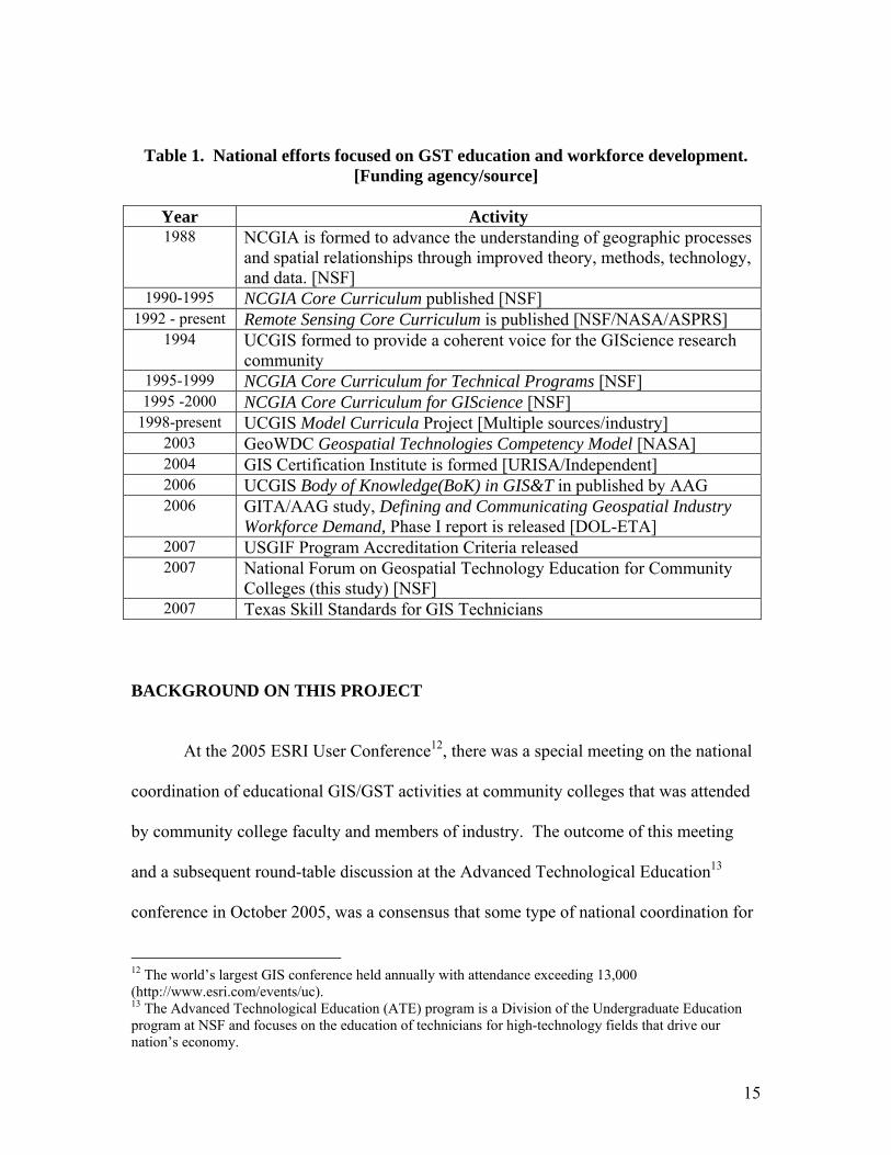
Table 1 below summarizes many of the significant national efforts that have
added continuity and cohesion to GST education.
15
Table 1. National efforts focused on GST education and workforce development. [Funding agency/source]
Year Activity 1988 NCGIA is formed to advance the understanding of geographic processes
and spatial relationships through improved theory, methods, technology, and data. [NSF]
1990-1995 NCGIA Core Curriculum published [NSF] 1992 - present Remote Sensing Core Curriculum is published [NSF/NASA/ASPRS]
1994 UCGIS formed to provide a coherent voice for the GIScience research community
1995-1999 NCGIA Core Curriculum for Technical Programs [NSF] 1995 -2000 NCGIA Core Curriculum for GIScience [NSF]
1998-present UCGIS Model Curricula Project [Multiple sources/industry] 2003 GeoWDC Geospatial Technologies Competency Model [NASA] 2004 GIS Certification Institute is formed [URISA/Independent] 2006 UCGIS Body of Knowledge(BoK) in GIS&T in published by AAG 2006 GITA/AAG study, Defining and Communicating Geospatial Industry
Workforce Demand, Phase I report is released [DOL-ETA] 2007 USGIF Program Accreditation Criteria released 2007 National Forum on Geospatial Technology Education for Community
Colleges (this study) [NSF] 2007 Texas Skill Standards for GIS Technicians
BACKGROUND ON THIS PROJECT At the 2005 ESRI User Conference12, there was a special meeting on the national
coordination of educational GIS/GST activities at community colleges that was attended
by community college faculty and members of industry. The outcome of this meeting
and a subsequent round-table discussion at the Advanced Technological Education13
conference in October 2005, was a consensus that some type of national coordination for
12 The world’s largest GIS conference held annually with attendance exceeding 13,000 (http://www.esri.com/events/uc). 13 The Advanced Technological Education (ATE) program is a Division of the Undergraduate Education program at NSF and focuses on the education of technicians for high-technology fields that drive our nation’s economy.

16
community college GST education was desperately needed. Many issues were discussed,
most of these issues were germane to most fields of technology education and others
were unique to GST (Sullivan et. al., 2005). Ten issues were selected as critical to the
national coordination of GST education and the development of a National Geospatial
Technology Center (NGTC). These issues were:
1) GST workforce needs
2) GST core competencies
3) GST certification
4) GST curriculum and pedagogy
5) GST educational pathways/articulation
6) GST professional development
7) GST community communication
8) GST awareness and reaching diverse audiences
9) The role of GST education in supporting college administrative tasks and
entrepreneurialism14
10) Future trends in GST
A proposal to support research into these issues and to support a plan to develop a
NGTC was submitted to the NSF in October 2006 (Developing a Vision and a Plan for a
National Geospatial Technology Center) and was subsequently funded in June 2006
(NSF/DUE 063424). The author of this paper is the PI on the NSF grant; two Co-PIs and
a steering committee of nine GST professionals also worked on this project. The
following research methods are described in the context of this management structure.
14 Issue 9 was added later and another issue, qualities of a successful national center, was subsequently removed.
17
METHODS
This study was conducted between July 2006 and November 2007 and consisted
of the following five phases.
1. Survey of the GST education community. An online survey was designed to gather
information on practices, views, and challenges of faculty in GST education. In October
2006, many hundreds of faculty were contacted via the ESRI community college, ATE
Program, MATE Center15, and the Agrowknowledge Center16 listserves and invited to
participate in the survey. One hundred and seventy GST professionals, predominantly
community college GST instructors, responded (see Appendix A for the survey results).
2. Conduct background research on the ten critical issues. A team of 12 GST
professionals from community colleges, universities, industry, and professional societies
researched the literature and reviewed survey responses to produce a written synopsis of
the current state of each of the ten critical issues (see
http://www.geotechcenter.org/GSTForumReading.pdf for the written synopsis for each
issue). The team also created a list of questions that remained after their review and
analysis.
3. Hold a national forum on GST education. A national forum was held January 5-7,
2007 in Monterey, California, with forty geospatial technology leaders from industry,
education (predominately community college educators but a few universities educators
attended), and workforce development participating. During the forum, the results of the
background research and the questions that remained were shared and discussed and a set
of draft recommendations for a NGTC was produced (see
15 ATE Center for marine technologies. 16 ATE Center for agricultural technologies.
18
http://www.geotechcenter.org/GSTForumReading.pdf for a forum agenda and list of
participants).
4. Validate and rank the forum recommendations. Five weeks after the forum, the draft
recommendations were sent out in a survey format to participants for validation and
prioritization (see Appendix D for the survey and results).
5. Produce a report and a list of high priority recommendations for a NGTC. A final
report that provides the context for the national coordination of geospatial activities at the
community college level and a prioritized list of work for a NGTC was synthesized.
Portions of this report are contained within this document.
RESULTS
Listed below are short summaries of each issue followed by highlights of the survey and
the top priority recommendations from the national forum.
1) GST workforce needs
Workforce studies can be both complex and expensive, but are essential to
developing GST programs that prepare students for today’s and tomorrow’s workplace.
Given the breadth of recommendations that emerged from the forum and the number that
received a high priority rating in the validation survey, a NGTC will need to devote
considerable resources to assessing the workforce; making best use of existing studies;
developing strategic partnerships with other workforce-related organizations (U.S.
Department of Labor (DOL), Geospatial Information & Technology Association (GITA),
Association of American Geographers (AAG), etc.); and making this information readily
available to community college educators in a user-friendly format.
19
It is recommended that a NGTC should:
a) Thoroughly research former workforce assessment efforts and practices before starting or recommending new studies.
b) Collect and compare GIS/GST DACUMs in an attempt to identify and expand a core set of tasks for GIS/GST technicians.
c) Implement alternative workforce studies such as environmental scans17 for defining workforce needs.
d) Establish a partnership with U.S. Department of Labor. e) Develop a mechanism to track student internships, jobs, and earnings. f) Establish a clearinghouse for internship, work experience, and service learning
programs. g) Develop partnerships with new and emerging sectors of the economy that utilize
geospatial technology. 2) GST core competencies
Core competencies can provide the foundation for the standardization of GST
education if they are widely adopted by the educational community and, within a
particular academic program, are clearly identified. Of the 170 GST educators
surveyed in phase 1, 63% felt core competencies are needed for the national
coordination of GST activities, while 33% were unsure. Only 4% felt that core
competencies are not needed for national coordination. The UCGIS BoK is the most
extensive document produced to date on the breadth of GI Science and Technology.
A key question remains – how well does the BoK embody two-year community
college GST programs that are responding to local and regional workforce needs? At
the National Forum, many community college educators felt that the BoK needs to be
vetted by working GIS/GST professionals as to the applicability of the Knowledge
Areas (KAs) to the work GIS/GST professionals perform.
It is recommended that a NGTC should: a) Determine if the BoK KAs encompass the breadth of the GIS&T field from a
community college perspective. 17 An Environmental Scan is an ongoing process of gathering and analyzing local labor market information.
20
b) Assist UCGIS and AAG in continuing and expanding the BoK and making it more user friendly for undergraduate teaching and educating the incumbent workforce.
c) Create additional units under existing KAs and/or create an additional KAs related to workforce-driven applications of GIS (e.g. emergency response, crime mapping).
d) Create a glossary of terms for the BoK KAs specific to two-year programs. e) Establish partnerships with other academic centers and industries to align KAs
with sector-specific applications of GIS (e.g. agriculture, forestry). f) Using Geography for Life (Boehm and Bednarz, 1994) and other models as
templates, create concrete examples for each level of mastery for the BoK topics that pertain to two-year community college education and establish assessments for each level of mastery.
g) Identified core competencies in the BoK and state them as learning outcomes consistent with accreditation language.
h) Broaden the scope of the competencies and learning outcomes to all of geospatial technology (remote sensing, GPS) realizing that the BoK emphasizes GIS.
3) GST certification
“Certification” is recognition by one’s colleagues and peers that an individual has
demonstrated professional integrity and competence in their field (ASPRS, 2007). In the
survey of 170 educators in phase I, nearly 60% believed that higher education should try
to align its curriculum with professional certification efforts underway. However, very
few faculty are currently doing this. Three GST-related certifications were reviewed and
are summarized in Appendix E (GISCI Professional Certification, ASPRS Certification,
and SPACE STARS Certification).
It is recommended that a NGTC should: a) Serve as a repository of certification, accreditation, and licensing program
information and help facilitate the dissemination of information to faculty and students.
b) Evaluate certification options and provide recommendations to students, faculty, and industry about the advantages of each option.
c) Join organizations that offer GIS/GST certifications in order to provide a unifying voice that represents community college views and interests in existing certification efforts.
21
4) GST curriculum and pedagogy
A plethora of workforce-aligned GST curriculum has been produced by GST
educators, independently and via grant-funded GIS/GST curriculum development
projects. However, most community college GST educators are not aware that this
curriculum exists, which can lead to a duplication of effort, while other important subject
areas may be ignored because of time constraints.
It is recommended that a NGTC should: a) Create an online clearinghouse that encourages submission, review, and search
capabilities for geospatial curriculum materials. b) Develop an introductory course or modules that provide the fundamental (core)
geospatial skills as outlined in the BoK (or subsequent improved version of it) that are needed by the mainstream workforce.
c) Develop a model program of study to assist colleges in new program development and program enhancements.
d) Create a curriculum structure that allows educators to access those resources for adaptation to the local workforce.
e) Provide instructional materials that teach science and math skills as a part of geospatial education.
5) GST educational pathways/articulation
With increasing tuition at all levels of higher education, the American public is
demanding more flexibility in education and training. Colleges and universities are under
tremendous pressure from students and stakeholders, such as employers and taxpayers, to
produce a technically literate workforce in shorter time without loss of course credit. In
the survey in phase I, more than 71% of the faculty indicated that they do not have any
course-to-course articulation agreements.
It is recommended that a NGTC should: a) Develop an online forum and white paper that discusses strategies for achieving
articulation. b) Organize, compile, and compare past and future articulation agreements,
memoranda of understanding (MOU), and other documents used by institutions across the nation and make the results available on a searchable database on the center website.
22
c) Develop career pathways that provide guidelines for a seamless education in geospatial technology from secondary to community college to university.
d) A problem of K12-community college articulation involves faculty credentials. A NGTC should develop standards to integrate GIS into geography AP courses and/or College-Level Examination Program (CLEP) courses to overcome the credential issue.
6) GST professional development
Most faculty currently teaching in community colleges were educated at a time
when GIS was virtually absent from the university curriculum. The dynamic and
evolving nature of geospatial technology dictates a critical need for the professional
development of community college faculty. In the survey of 170 educators in phase I,
84% indicated that they self taught by reading literature, while more than 67% lacked
membership in any professional organization. Barriers to professional development
include the cost, lack of time, travel distance, lack of opportunities, and a lack of
administrative support.
It is recommended that a NGTC should: a) Organize, compile, and disseminate up-to-date information on professional
development opportunities, training materials, tutorials, and links to online resources on the NGTC website.
b) Offer professional development training courses, workshops, and seminars. c) Offer geospatial technology professional development in a variety of formats
including online tutorials, instructions and data, and podcasts via the website as well as face-to -ace.
d) Identify the major barriers to professional development through surveys and feedback from community college faculty, (e.g. limited funds, inflexible schedules, and unappreciative administration) and work to minimize these barriers in order to increase professional development availability and accessibility.
e) Keep abreast of geospatial technology trends and make recommendations on the type of professional development faculty should pursue to keep current in the field.
f) Build partnerships with four-year universities, professional societies, government agencies, industry and NGOs to promote, encourage, and expand professional development opportunities.
23
7) Geospatial community communication
National coordination of workforce information and educational resources within
the community college network is limited because an effective, dedicated,
communication structure for this audience does not exist. Without effective
communication, the evolution of GST education is slowed and less responsive to
workforce needs because it relies on the work of people individually to assess workforce
needs, modify curriculum, and seek professional development.
It is recommended that a NGTC should: a) Act as the representative body for two-year colleges, faculty, and students in the
field of geospatial technology. b) Act as a collective voice to promote community college interests in professional
societies, workforce-related studies, core curriculum projects, certification and accreditation efforts, and other activities of importance to community college audiences.
c) Create a comprehensive website and listserve to facilitate communication. d) Provide up-to-date information on current and past geospatial-related NSF
Advanced Technological Education (ATE) projects, ATE Centers, and other NSF Division of Undergraduate projects via the NGTC website and listserve.
e) Provide the latest information on current and past Department of Labor projects via the NGTC website and listserve.
f) Seek out the best existing communication network(s) that can be used to improve the flow of information.
g) Work closely with existing regional hubs to improve communication on a regional level.
8) GST awareness and reaching underserved audiences
With the need for highly-qualified workers in STEM fields in high demand and a
large portion of the current STEM workforce approaching retirement, this is a critical
time to focus on increasing the diversity of the talent pool. Recruiting diverse students
can be challenging; raising the awareness of geospatial technology is the first step.
It is recommended that a NGTC should: a) Promote GST as a mainstream scientific tool for community college education so
that GST awareness and education is extended to other academic programs (e.g. economic, history, and biology).
24
b) Disseminate stories of successful geospatial awareness events and identify effective GST education tools, such as Google Earth and the National Atlas web mapping services, for community college GST teachers.
c) Provide a comprehensive list of outreach events and marketing materials and make them available online so that community college GST teachers can utilize these resources to promote GST career and technology awareness.
d) Identify effective student recruitment approaches for GIS programs in community colleges and disseminate available resources and recruitment tools to community college teachers.
e) Provide comprehensive information about internship and mentorship opportunities to underserved audiences in community colleges.
f) Identify existing successful programs that reach diverse audiences. 9) The role of GST education in supporting college administrative tasks and
entrepreneurialism
External forces such as declining state support and declining local tax bases have
driven many community colleges to look for new sources of revenue (Evelyn, 2004). As
a result, community college missions have become more complex ⎯ from reactionary
organizations within communities to proactive organizations promoting local economic
expansion (Grub, 1997). For the latter, the demand for institutional research, specifically
the ability to acquire, manage, analyze, and communicate market-place data, has never
been greater. This new way of thinking puts a geographical face, heavily laden in the
demographics and economics of the region, on college entrepreneurial activity. GST can
be very helpful in supporting college administrative tasks, such as workforce/economic
development, institutional research, grant writing, student marketing, and facilities
management.
It is recommended that a NGTC should: a) Develop a searchable clearinghouse with how-to templates, standard data models,
and best practices so that community colleges can duplicate curriculum-driven entrepreneurial activities and experiences linking GST to community college administrative issues.
b) Serve as a clearinghouse for geospatial data as it applies to community college demographics, enrollments, economics, etc.
25
10) Future trends in GST
GST is a rapidly growing and changing industry. In reviewing the various source
documents for geospatial technology trends, there were two recurring themes. The first
was an increasing need to include information technology instruction within the
geospatial curriculum, largely relating to the evolution of GIS to enterprise GIS18. The
second was the increasing need for web-based instruction and web-based data delivery.
It is recommended that a NGTC should: a) Assess trends in the geospatial industry in order to project changes in the industry
and workforce that impact GST curricula and programs at two-year colleges. b) Disseminate the information on trends to two-year colleges via the NGTC
website. c) Assist community colleges with adapting their curricula to future trends.
DISCUSSION
Along with nanotechnology and biotechnology, geospatial technology is one of
the three most important emerging and evolving fields in this country (Gewin, 2004).
The geospatial workforce is growing at a rate of 35% a year ⎯ 100% a year in the
commercial subsection of this market (U.S. Department of Labor, 2005c). This explosive
growth has been driven by dramatic increases in the capabilities of geospatial tools and
the increased availability of high quality geospatial data (Marble, 2006).
However, this growth is not without its challenges. The DOL has not been able to
keep up with standard industry definitions and occupational titles for the geospatial
industry. As a result, labor market data is largely aggregated with other fields, making it
18 Enterprise GIS is an integrated, multidepartmental system composed of interoperable components. It provides broad access to geospatial data, a common infrastructure upon which to build and deploy GIS applications, and significant economies of scale (Definition from ESRI).
26
difficult to define and monitor trends. This also creates problems when trying to prepare a
workforce for employment ⎯ for what jobs should people be educated?
Community colleges and universities have traditionally approached this problem
from different perspectives. Community colleges tend to look at the local workforce
needs in their area, while universities take a broader view of the science and theory that
build the foundation for the discipline. Both approaches have advantages and
disadvantages. Community colleges, if not careful, can “train” students for a particular
job at that moment in time; but as the field and technology evolve, workers may find
themselves “out of a job” if they do not have a foundation that is broad enough to allow
them to learn new knowledge and skills. To the contrary, university students may have a
better foundation on the science and theory, but may lack both the ability to practically
apply this knowledge and the ancillary skills that make them employable.
Regardless of the differences in their approaches, both community colleges and
universities are grasping for air without solid workforce information that identifies the
knowledge, skills, and aptitudes required for entry-level positions. Furthermore, because
of their differing approaches to GST education, the ability of community colleges and
universities to communicate with one another is severely hampered without the
framework of a common language.
Probably no issue plays a more critical role in creating this framework than the
identification of GST core competencies. Core competencies connect job requirements to
educational subject areas, making them a critical link between the classroom – be it a
community college or a university classroom – and the workplace. Of the ten issues
examined in this study, the identification of core competencies is key to addressing many

27
of the other issues, including workforce needs; certification; curriculum; educational
pathways and articulation; and professional development.
The quest to define “core competencies” has made substantial progress, but is far
from over. A multitude of benefits - including efficient curriculum sharing, benchmarks
for program accreditation, widespread articulation, exam-based professional certification,
and effective screening and placement of new workers into the workforce - can be
attained by the national adoption of core competencies. However, in order to realize
these benefits, core competencies that are accepted by two and four-year institutions and
validated by working professionals are needed.
The following three efforts have made progress in this arena: the UCGIS BoK;
the GeoWDC Geospatial Technology Competency Model; and a series of DACUMs,
including the Texas GIS Technician Skill Standards that were derived from the DACUM
process. In addition, many activities are underway that are melding workforce and
educational efforts. For example, the GISCI survey of certified GIS Professionals that
assesses their views on the BoK; the USGIF program accreditation that uses portions of
the BoK; the GITA study that made recommendations for improving the GeoWDC
Geospatial Technology Competency Model; and efforts associated with this study to
examine four DACUMS for common tasks and to determine how they align with the
BoK19.
However, any efforts to tie together workforce and educational information must
be done within a framework that sits within a clearly defined geospatial industry sector.
(Many of the GITA’s recommendations highlight the need for defining the geospatial
industry sector ⎯ standard definitions for the geospatial industry sector, new 19 Although this was part of the grant that funded this study, it is not included in this report.
28
occupational titles, a rational for market segmentation, etc.) Indeed, many parties have
built new competency-related frameworks, and many agencies have funded these efforts
(NSF, DOL, NASA, etc.). It is imperative that a NGTC works with and ties together the
existing competency-related efforts so that core competencies, and in turn a core
curriculum, that supports many entry-level positions, can be established and agreed upon
by a wide range of stakeholders. Community colleges and universities have traditionally
approached the content of a curriculum from very different perspectives – however
understanding and compromise by both parties will be needed to move forward. The
consequences of not coming to an agreement will only contribute to greater gaps between
what the workforce needs and what the educational system is producing.
This study has made every effort to reach broadly and be inclusive (across
disciplines including new and experienced GST faculty in rural and metropolitan regions
around the country) in order to best represent the collective views on the roles that a
NGTC should play in coordinating GST education at the community college level and
facilitating dialogues with industry, professional societies, and four-year universities.
More than 92% of the community college educators who responded to the survey
conducted in phase 1 of this study felt there should be a national organization that
represents community college interests relating to geospatial technologies. As to what a
NGTC should accomplish, the following three recommendations received the highest
rating, with more than 75% of the survey respondents rating them as high priorities:
• A NGTC should provide a means by which geospatial educators can search and retrieve curriculum, instructional materials and workforce information online.
• A NGTC should organize, compile, and disseminate up-to-date information on professional development opportunities, training materials, tutorials and links to online resources on a NGTC website.
29
• A NGTC should act as the representative body for two-year colleges, faculty and students in the field of geospatial technology and act as a collective voice to promote community college interests with professional societies, higher education, the DOL, and other organizations concerned with GST education.
Equally as important as what a NGTC should do, is what it should not do. The survey
respondents felt strongly that a NGTC should NOT:
• Become a geospatial technology certification granting organization. • Be an organization that provides educators with evidence (certification,
certificates or licenses) that they have satisfied the minimum qualifications specific to teaching geospatial technology.
• Be an accreditation body for geospatial programs.
From these recommendations, it is clear that community college educators want a
NGTC that will represent them at national venues; act as a clearinghouse to provide easy-
access to current curriculum and workforce information; and, lastly, provide access to
professional development opportunities.
A NGTC has been proposed to the National Science Foundation by one or more
collaborative groups largely consisting of community colleges. The status of a NGTC
will not be known until early 2008, but, regardless of which group is funded, its success
may very well hinge on its ability to follow the recommendations of this study.
CONCLUSION
GST is a rapidly growing and changing industry that is transforming many sectors
of the economy. The speed at which new fields are adopting GST along with the speed at
which equipment and software are being modified and updated makes it difficult for
many industries, much less the educational system, to keep up to date. To further
complicate the issue, national coordination of workforce information and educational
30
resources within the community college network is fairly poor. If we as a nation are to
remain economically competitive, achieve greater understanding in protecting our
resources, and reduce the chaos and loss of life associated with manmade and natural
disasters, we will need an efficient, responsive, and well-coordinated GST educational
system with good communication between all levels and a better understanding of the
knowledge and skills workers need to be successful in the workplace.
Developing a Plan for the National Coordination of Geospatial Technology
Education: A Community College Perspective was an effort to document the issues,
needs, and concerns of community college educators and produce recommendations for a
NGTC that best reflect this audience while placing the recommendations within the
context of the work that has been accomplished by the Department of Labor, higher
education, and others organizations relating to professional certification and
accreditation. It is essential that some organization, presumably a NGTC, end the
community college silence and act as a collective voice to promote community college
interests in issues and activities of national importance.
31
LITERATURE CITED Allen, J, Brand, O. Beck, R. Johnson, A.B, and Johnson A. 2006. Integrating geographic
information systems and remote sensing for technical workforce training at two-year colleges. http://gistech.delmar.edu/geospatial_ws1.htm Retrieved October 25, 2007.
American Association of Community Colleges. AACC Mission: Building a Nation of Learners http://www.aacc.nche.edu/ Retrieved January 1, 2006.
American Society for Photogrammetry and Remote Sensing. ASPRS Certification Program. http://www.asprs.org/membership/certification/index.html Retrieved October 25, 2007
American Society for Photogrammetry and Remote Sensing. Remote Sensing Core Curriculum. http://www.r-s-c-c.org/index.html Retrieved October 27, 2007.
Arnone, M. 2001. Community Colleges Provide Key Training for new Technologies. Chronicle for Higher Education. November 27, 2001.
Boehm, R. and S. Bednarz. 1994. Geography for Life: National Geography Standards. National Council for Geographic Education. 272 pp.
Bolstad. P. 2005. GIS Fundamentals. Eider Press. White Bear Lake, MN 543pp.
Butler, D. 2006. The web-wide world. Nature. V 439. 16 February 2006. p776-8.
Brown, D.G., G. Elmes, K.K. Kemp, S. Macey, and D. Mark. 2004. Geographic Information Systems. In Geography in America at the Dawn of the 21st Century. G.L. Gaile and C.J. Willmott, eds., Oxford University Press, pp. 353-375.
Clinton, W.J. 1998. State of the Union Address January 27, 1998 http://www.cnn.com/ALLPOLITICS/1998/01/27/sotu/transcripts/clinton/ Retrieved January 1, 2006.
Community College Research Center http://ccrc.tc.columbia.edu/History.asp Retrieved December 29, 2005.
Central Oregon Community College (2007) Geographic Information Systems. http://gis.cocc.edu/ Retrieved October 27, 2007.
DACUM http://www.dacum.org/ Retrieved September 26, 2005.
DiBiase, D. DeMers, M., Johnson, A., Kemp, K., Luck, A.T., Plewe, B. and E. Wentz (eds.) 2006. Geographic Information Science and Technology Body of Knowledge. First Edition. Published by the Association of American Geographers and the UCGIS. Washington DC. 162pp.
ESRI. 2004. Curriculum Development and the Workforce. GIS Educator Special Edition ESRI, Summer 2004 p. 2-3
32
http://www.esri.com/library/newsletters/giseducator/gised_summer04.pdf Retrieved November 2, 2007.
ESRI White Paper. Guidelines for developing a Successful and Sustainable Higher Education GIS program. August, 2002 http://www.esri.com/library/whitepapers/pdfs/higher_ed.pdf Accessed September 14, 2005
Evelyn, J (2004). The Search for New Means of Support. The Chronicle of Higher Education: Community Colleges. http://chronicle.com/weekly/v51/il0/10b00501.htm . Retrieved May 15, 2005.
Gaudet, C.H., H.M. Annulis, and J. C. Carr, 2003. Building the Geospatial Workforce. Urban and Regional Informational Systems Association Journal, Special Education V15, no.1, p.21-30.
Gewin, V. 2004. Mapping Opportunities. Nature V.427 p.376-377.
GITA, 2006. Defining and Communication Geospatial Industry Workforce Demand Phase I Report. Draft for Comments. http://www.aag.org/giwis/ Retrieved December 10, 2006
Goodchild, M.F. and K.K. Kemp. 1992. NCGIA education activities: The core curriculum and beyond. International Journal of Geographical Information Systems, 6(4), p.309-320.
Gram, S., Executive Director of GISCI, Personal correspondence August 15, 2007.
Grubb, N., Badway, N., Bell, D., Bragg, D., & Russman. M. (1997). Workforce, economic, and community development: The changing landscape of the “entrepreneurial” community college. http://vocserve.berkeley.edu/Summaries/1094sum.html . Retrieved September 20, 2007.
Info Please. Number of U.S. Colleges and Universities and Degrees Awarded http://www.infoplease.com/ipa/A0908742.html Retrieved January 1, 2006.
Johnson, A. 2006. Developing a GIS Curriculum ArcUser Online. Http://www.esri.com/new/arcuser/0706/curricula.html. Retrieved November 2, 2007.
Kemp, K.K. 2003. Update on the UCGIS Model Curricula Project. Urban and Regional Informational Systems Association Journal, Special Education Issue V15, no.1, p.47-49.
Marble, D. 2006. Defining the Components of the Geospatial Workforce - Who Are We? ArcNews Online. Winter 2005/2006. Retrieved October 25, 2007. http://www.esri.com/news/arcnews/winter0506articles/defining1of2.html
NCGIA http://www.ucgis.org/aboutucgis/history.htm Retrieved October 25, 2007.
33
National Research Council. 2005. Learning to Think Spatially: GIS as a Support System in the K-12 Curriculum. National Academies Press. 248 pp.
Peng, Z.R. and Tsou, M.H., 2003. Internet GIS: A Distributed Geospatial Information Service for Wired and Wireless Networks, New York: John Wiley and Sons. 679 pp.
Research & Consultancy Outsourcing Services. 2005. Abstract for Global Positioning System (GPS): The Road Ahead http://www.mindbranch.com/catalog/print_product_page.jsp?code=R459-0056 Retrieved October 1, 2005.
Sullivan, D., Zande, J., Ford, B. and T. Murphree. 2004. A Strategy for Improving Marine Technical Education. Offshore Technology Conference Proceedings. May 3-6, 2004
Sullivan, D., Brase, T. and A. Johnson. The Need for National Coordination of GIS/Geospatial Activities. Roundtable Discussion Summary from the Advanced Technological Education PI Conference, October 6, 2005. http://www.aacc.nche.edu/Content/NavigationMenu/ResourceCenter/Projects_Partnerships/Current/AdvancedTechnologicalEducation/10_Summary.pdf Retrieved November 27, 2007.
Texas Skill Standards Board, 2007. Occupational Title: Geographic Information System (GIS) Technician. http://www.tssb.org/wwwpages/gis/ & http://www.tssb.org/wwwpages/gis/home_article.htm Retrieved November 2, 2007.
Tsou, M-H. 2005. The Big Change in Internet GIS. GIS Development, October 2005. http://www.gisdevelopment.net/magazine/years/2005/oct/webgis_tsou44_1.htm Retrieved October 10, 2005.
Welfare to Work. Office of Personnel Management http://www.opm.gov/wtw/ Retrieved November 28, 2005
USGIF Geospatial Intelligence Certificate Program Curriculum Guidelines Geospatial Intelligence Certificate Curriculum Guidelines. http://www.usgif.org/files/USGIF%20Curriculum%20Guidelines.pdf Retrieved October 27, 2007.
U.S. Department of Labor. 2005a. Employment & Training Administration. Geospatial Technology Apprenticeship Program. http://www.doleta.gov/atels_bat/geospatial.cfm Retrieved December 29, 2005.
U.S. Department of Labor. 2005b. President’s High Growth Job Training Initiative http://www.doleta.gov/atels_bat/geospatial.cfm Retrieved October 1, 2005
U.S. Department of Labor. 2005c. Identifying and Addressing Workforce Challenges in America’s Geospatial Technology Sector http://www.doleta.gov/BRG/pdf/Geospatial%20Final%20Report_08212007.pdf Retrieved November 3, 2007.

34
Wright, D.J., M.F. Goodchild, and J.D. Proctor. 1997. Demystifying the Persistent Ambiguity of GIS as "Tool" Versus "Science" The Annals of the Association of American Geographers, 87(2): 346-362.
Wright, D.J. and D. DiBiase. 2005. "Distance Education in Geographic Information Science: Arena Symposium and an Informal Survey." Journal of Geography in Higher Education. 29:1; pp. 91-100.
35
Related GST Projects, Certifications, Studies, and Activities Department of Labor Workforce Projects Geospatial Technology Apprenticeship Project University of Southern Mississippi
http://www.usm.edu/wlpi/research/gtap.html Retrieved November 28, 2007.
The Geospatial Business Hub Project: Preparing the Nation’s Geospatial Workforce – The Institute for GIS Studies (TN), Central Piedmont Community College http://www.doleta.gov/BRG/Indprof/geospatial_profile.cfm Retrieved November 28, 2007.
Geospatial Industry Awareness and Opportunities – Geospatial Information & Technology Association (GITA) http://www.gita.org/ Retrieved November 28, 2007.
Geo 21 Project – Nortel Networks Kidz Online, NASA Center for Distance Learning http://www.kidzonline.org Retrieved November 28, 2007.
Geospatial Imagery Analysis and Practical Applications – William F. Goodling Advanced Skills Center http://www.doleta.gov/BRG/Indprof/geospatial_profile.cfm Retrieved November 28, 2007.
A Model for Connecting the Geospatial Technology Industry to Community College Workforce Development: Geospatial User Needs Assessments – Rancho Santiago Community College District http://www.doleta.gov/BRG/Indprof/geospatial_profile.cfm Retrieved November 28, 2007.
Model Curriculum Projects
University Consortium for Geographic Information Science (UCGIS) Model Curricula http://www.ucgis.org/priorities/education/modelcurriculaproject.asp Retrieved November 28, 2007.
National Center for Geographic Information and Analysis (NCGIA) Curriculum Projects NCGIA Technical Curriculum http://www.ncgia.ucsb.edu/education/curricula/cctp/cctp.html Retrieved November 28, 2007.
National Center for Geographic Information and Analysis NCGIA GIScience Curriculum http://www.ncgia.ucsb.edu/giscc/ Retrieved November 28, 2007.
Remote Sensing Core Curriculum http://www.r-s-c-c.org/ Retrieved November 28, 2007.
Institute for Advanced Education in Geospatial Sciences IAEGS Model Curriculum. http://geoworkforce.olemiss.edu/ Retrieved November 28, 2007.
36
Certification and Accreditation Programs
American Society for Photogrammetry and Remote Sensing (ASPRS) Certification http://www.asprs.org/membership/certification/ Retrieved November 28, 2007.
GIS Certification Institute (GISCI) http://www.gisci.org/ Retrieved November 28, 2007.
STARS (Spatial Technology And Remote Sensing) Certification http://www.digitalquest.com Retrieved November 28, 2007.
U.S. Geospatial Intelligence Foundation (USGIF) Academy Accreditation http://www.usgif.org/Education_Accreditation.aspx Retrieved November 28, 2007.
K-12 GIS Programs
Environmental and Spatial Technology (EAST) Initiative http://www.eastproject.org/SupportTutorials/Tutorials.aspx?Search=Geographic%20Information%20System%20(GIS) Retrieved November 28, 2007.
GIS for 4-H http://www.n4hccs.org/shop/products.asp?action=list&cat=6&subcat=99&l=L1 Retrieved November 28, 2007.
Community Mapping Program http://www.vinsweb.org/education/community_map.html Retrieved November 28, 2007.
Internet GIS Websites
Google Earth http://earth.google.com/ Retrieved November 28, 2007.
MapQuest www.mapquest.com Retrieved November 28, 2007.
NASA’s World Wind http://worldwind.arc.nasa.gov/ Retrieved November 28, 2007.
MSN Virtual Earth http://local.live.com/ Retrieved November 28, 2007.
37
APPENDICES
A. Survey results of 170 GST Educators conducted in October 2006
B. GeoWDC Geospatial Competency Model. From Gaudet, C.H., H.M. Annulis, and J. C. Carr, 2003. Building the Geospatial Workforce. Urban and Regional Informational Systems Association Journal, Special Education V15, no.1, p.21-30.
C. Recommendations for Closing the Gap between Geospatial Workforce Demand and Supply. From Defining and Communication Geospatial Industry Workforce Demand Phase I Report, Draft for Comment GITA, 2006.
D. Validation Survey Results of the National GST Forum Recommendations. E. Certification Efforts Reviewed in this study.
• GIS Certification Institute • American Society for Photogrammetry and Remote Sensing (ASPRS)
Certification • Space STARS Certification
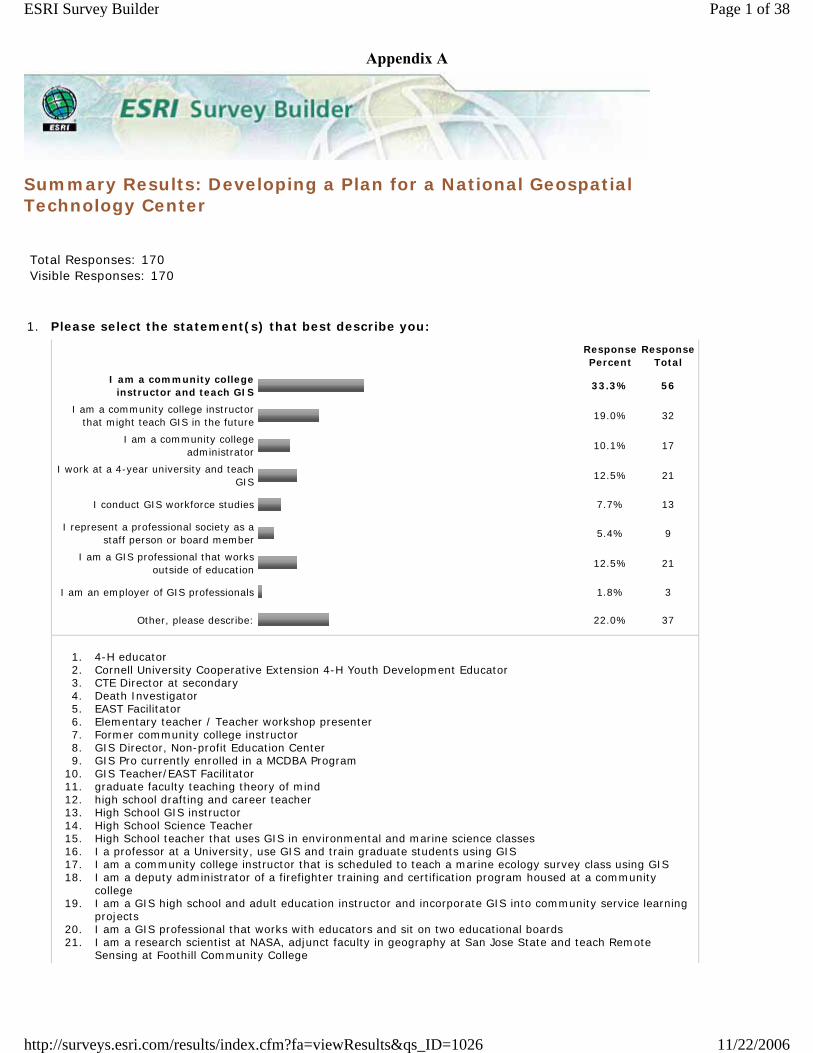
Summary Results: Developing a Plan for a National Geospatial Technology Center
Total Responses: 170 Visible Responses: 170
1. Please select the statement(s) that best describe you:
Response Percent
Response Total
I am a community college instructor and teach GIS
33.3% 56
I am a community college instructor that might teach GIS in the future
19.0% 32
I am a community college administrator
10.1% 17
I work at a 4-year university and teach GIS
12.5% 21
I conduct GIS workforce studies 7.7% 13
I represent a professional society as a staff person or board member
5.4% 9
I am a GIS professional that works outside of education
12.5% 21
I am an employer of GIS professionals 1.8% 3
Other, please describe: 22.0% 37
1. 4-H educator 2. Cornell University Cooperative Extension 4-H Youth Development Educator 3. CTE Director at secondary 4. Death Investigator 5. EAST Facilitator 6. Elementary teacher / Teacher workshop presenter 7. Former community college instructor 8. GIS Director, Non-profit Education Center 9. GIS Pro currently enrolled in a MCDBA Program
10. GIS Teacher/EAST Facilitator 11. graduate faculty teaching theory of mind 12. high school drafting and career teacher 13. High School GIS instructor 14. High School Science Teacher 15. High School teacher that uses GIS in environmental and marine science classes 16. I a professor at a University, use GIS and train graduate students using GIS 17. I am a community college instructor that is scheduled to teach a marine ecology survey class using GIS 18. I am a deputy administrator of a firefighter training and certification program housed at a community
college 19. I am a GIS high school and adult education instructor and incorporate GIS into community service learning
projects 20. I am a GIS professional that works with educators and sit on two educational boards 21. I am a research scientist at NASA, adjunct faculty in geography at San Jose State and teach Remote
Sensing at Foothill Community College
Page 1 of 38ESRI Survey Builder
11/22/2006http://surveys.esri.com/results/index.cfm?fa=viewResults&qs_ID=1026
Appendix A
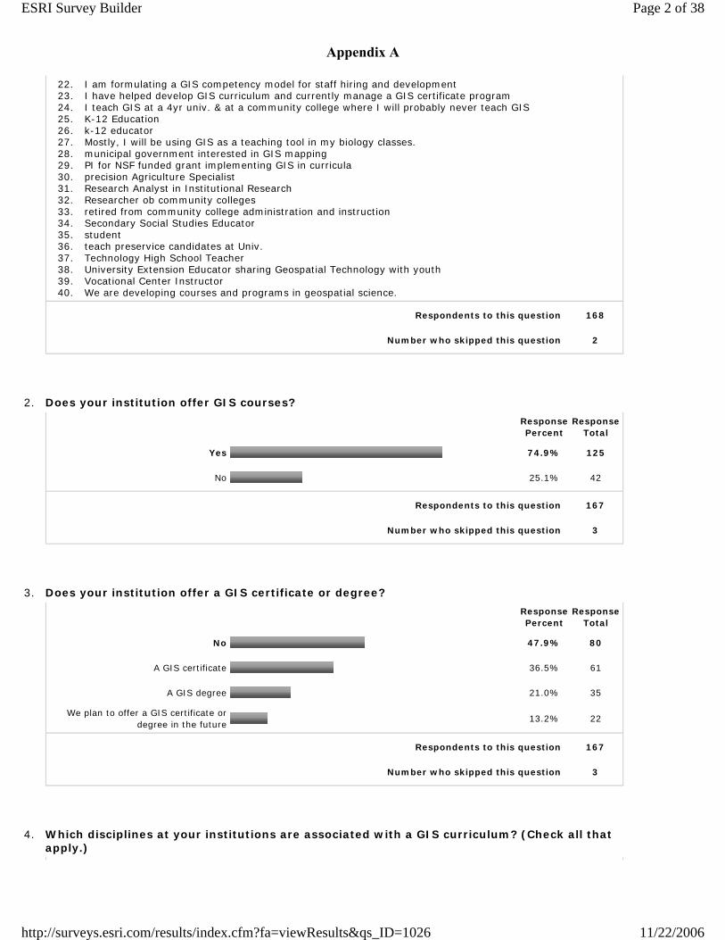
22. I am formulating a GIS competency model for staff hiring and development 23. I have helped develop GIS curriculum and currently manage a GIS certificate program 24. I teach GIS at a 4yr univ. & at a community college where I will probably never teach GIS 25. K-12 Education 26. k-12 educator 27. Mostly, I will be using GIS as a teaching tool in my biology classes. 28. municipal government interested in GIS mapping 29. PI for NSF funded grant implementing GIS in curricula 30. precision Agriculture Specialist 31. Research Analyst in Institutional Research 32. Researcher ob community colleges 33. retired from community college administration and instruction 34. Secondary Social Studies Educator 35. student 36. teach preservice candidates at Univ. 37. Technology High School Teacher 38. University Extension Educator sharing Geospatial Technology with youth 39. Vocational Center Instructor 40. We are developing courses and programs in geospatial science.
Respondents to this question 168
Number who skipped this question 2
2. Does your institution offer GIS courses?
Response Percent
Response Total
Yes 74.9% 125
No 25.1% 42
Respondents to this question 167
Number who skipped this question 3
3. Does your institution offer a GIS certificate or degree?
Response Percent
Response Total
No 47.9% 80
A GIS certificate 36.5% 61
A GIS degree 21.0% 35
We plan to offer a GIS certificate or degree in the future
13.2% 22
Respondents to this question 167
Number who skipped this question 3
4. Which disciplines at your institutions are associated with a GIS curriculum? (Check all that apply.)
Page 2 of 38ESRI Survey Builder
11/22/2006http://surveys.esri.com/results/index.cfm?fa=viewResults&qs_ID=1026
Appendix A
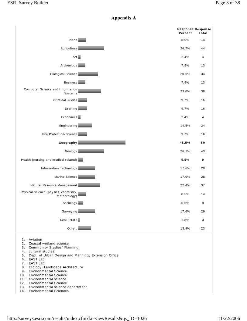
Response Percent
Response Total
None 8.5% 14
Agriculture 26.7% 44
Art 2.4% 4
Archeology 7.9% 13
Biological Science 20.6% 34
Business 7.9% 13
Computer Science and Information Systems
23.0% 38
Criminal Justice 9.7% 16
Drafting 9.7% 16
Economics 2.4% 4
Engineering 14.5% 24
Fire Protection/Science 9.7% 16
Geography 48.5% 80
Geology 26.1% 43
Health (nursing and medical related) 5.5% 9
Information Technology 17.6% 29
Marine Science 17.0% 28
Natural Resource Management 22.4% 37
Physical Science (physics, chemistry, meteorology)
8.5% 14
Sociology 5.5% 9
Surveying 17.6% 29
Real Estate 1.8% 3
Other: 13.9% 23
1. Aviation 2. Coastal wetland science 3. Community Studies/ Planning 4. cultural studies 5. Dept. of Urban Design and Planning; Extension Office 6. EAST Lab 7. EAST Lab 8. Ecology, Landscape Architecture 9. Environmental Science
10. Environmental Science 11. environmental science 12. Environmental Science 13. environmental science department 14. Environmental Sciences
Page 3 of 38ESRI Survey Builder
11/22/2006http://surveys.esri.com/results/index.cfm?fa=viewResults&qs_ID=1026
Appendix A
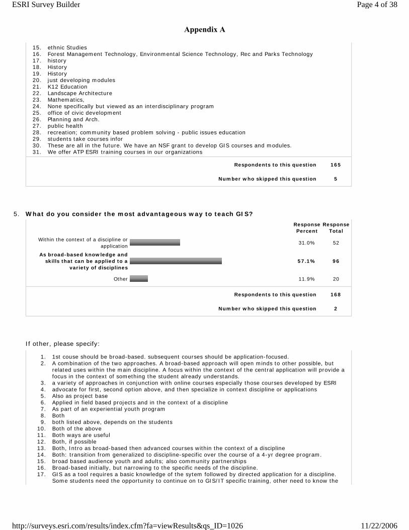
15. ethnic Studies 16. Forest Management Technology, Environmental Science Technology, Rec and Parks Technology 17. history 18. History 19. History 20. just developing modules 21. K12 Education 22. Landscape Architecture 23. Mathematics, 24. None specifically but viewed as an interdisciplinary program 25. office of civic development 26. Planning and Arch. 27. public health 28. recreation; community based problem solving - public issues education 29. students take courses infor 30. These are all in the future. We have an NSF grant to develop GIS courses and modules. 31. We offer ATP ESRI training courses in our organizations
Respondents to this question 165
Number who skipped this question 5
5. What do you consider the most advantageous way to teach GIS?
Response Percent
Response Total
Within the context of a discipline or application
31.0% 52
As broad-based knowledge and skills that can be applied to a
variety of disciplines57.1% 96
Other 11.9% 20
Respondents to this question 168
Number who skipped this question 2
If other, please specify:
1. 1st couse should be broad-based. subsequent courses should be application-focused. 2. A combination of the two approaches. A broad-based approach will open minds to other possible, but
related uses within the main discipline. A focus within the context of the central application will provide a focus in the context of something the student already understands.
3. a variety of approaches in conjunction with online courses especially those courses developed by ESRI 4. advocate for first, second option above, and then specialize in context discipline or applications 5. Also as project base 6. Applied in field based projects and in the context of a discipline 7. As part of an experiential youth program 8. Both 9. both listed above, depends on the students
10. Both of the above 11. Both ways are useful 12. Both, if possible 13. Both, Intro as broad-based then advanced courses within the context of a discipline 14. Both: transition from generalized to discipline-specific over the course of a 4-yr degree program. 15. broad based audience youth and adults; also community partnerships 16. Broad-based initially, but narrowing to the specific needs of the discipline. 17. GIS as a tool requires a basic knowledge of the sytem followed by directed application for a discipline.
Some students need the opportunity to continue on to GIS/IT specific training, other need to know the
Page 4 of 38ESRI Survey Builder
11/22/2006http://surveys.esri.com/results/index.cfm?fa=viewResults&qs_ID=1026
Appendix A
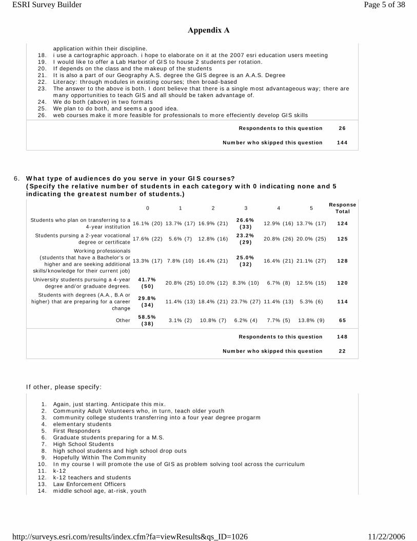
application within their discipline. 18. i use a cartographic approach. i hope to elaborate on it at the 2007 esri education users meeting 19. I would like to offer a Lab Harbor of GIS to house 2 students per rotation. 20. If depends on the class and the makeup of the students 21. It is also a part of our Geography A.S. degree the GIS degree is an A.A.S. Degree 22. Literacy: through modules in existing courses; then broad-based 23. The answer to the above is both. I dont believe that there is a single most advantageous way; there are
many opportunities to teach GIS and all should be taken advantage of. 24. We do both (above) in two formats 25. We plan to do both, and seems a good idea. 26. web courses make it more feasible for professionals to more effeciently develop GIS skills
Respondents to this question 26
Number who skipped this question 144
6. What type of audiences do you serve in your GIS courses? (Specify the relative number of students in each category with 0 indicating none and 5 indicating the greatest number of students.)
0 1 2 3 4 5Response
Total
Students who plan on transferring to a 4-year institution
16.1% (20) 13.7% (17) 16.9% (21)26.6% (33)
12.9% (16) 13.7% (17) 124
Students pursing a 2-year vocational degree or certificate
17.6% (22) 5.6% (7) 12.8% (16)23.2% (29)
20.8% (26) 20.0% (25) 125
Working professionals (students that have a Bachelor’s or
higher and are seeking additional skills/knowledge for their current job)
13.3% (17) 7.8% (10) 16.4% (21)25.0% (32)
16.4% (21) 21.1% (27) 128
University students pursuing a 4-year degree and/or graduate degrees.
41.7% (50)
20.8% (25) 10.0% (12) 8.3% (10) 6.7% (8) 12.5% (15) 120
Students with degrees (A.A., B.A or higher) that are preparing for a career
change
29.8% (34)
11.4% (13) 18.4% (21) 23.7% (27) 11.4% (13) 5.3% (6) 114
Other58.5% (38)
3.1% (2) 10.8% (7) 6.2% (4) 7.7% (5) 13.8% (9) 65
Respondents to this question 148
Number who skipped this question 22
If other, please specify:
1. Again, just starting. Anticipate this mix. 2. Community Adult Volunteers who, in turn, teach older youth 3. community college students transferring into a four year degree progarm 4. elementary students 5. First Responders 6. Graduate students preparing for a M.S. 7. High School Students 8. high school students and high school drop outs 9. Hopefully Within The Community
10. In my course I will promote the use of GIS as problem solving tool across the curriculum 11. k-12 12. k-12 teachers and students 13. Law Enforcement Officers 14. middle school age, at-risk, youth
Page 5 of 38ESRI Survey Builder
11/22/2006http://surveys.esri.com/results/index.cfm?fa=viewResults&qs_ID=1026
Appendix A
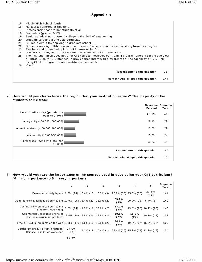
15. Middle/High School Youth 16. No courses offerred at this time. 17. Professionals that are not students at all 18. Secondary (grades 9-12) 19. Seniors graduating to attend college in the field of engineering 20. students pursuing a one year certificate 21. Students with a BA applying to graduate school 22. Students working full-time who do not have a Bachelor's and are not working towards a degree 23. Teachers and others doing it out of interest or for fun 24. teachers and they in turn use it with their students in K-12 education 25. The institution itself does not offer GIS courses, however, our training program offers a simple overview
or introduction to GIS intended to provide firefighters with a awareness of the capability of GIS. I am using GIS for program-related institutional research.
26. Youth
Respondents to this question 26
Number who skipped this question 144
7. How would you characterize the region that your institution serves? The majority of the students come from:
Response Percent
Response Total
A metropolitan city (population over 500,000)
28.1% 45
A large city (100,000 -500,000) 18.1% 29
A medium size city (50,000-100,000) 13.8% 22
A small city (10,000-50,000) 15.0% 24
Rural areas (towns with less than 10,000)
25.0% 40
Respondents to this question 160
Number who skipped this question 10
8. How would you rate the importance of the sources used in developing your GIS curriculum? (0 = no importance to 5 = very important)
0 1 2 3 4 5Response
Total
Developed mostly by me 9.7% (14) 10.4% (15) 6.3% (9) 20.8% (30) 25.0% (36)27.8% (40)
144
Adapted from a colleague’s curriculum 17.9% (25) 16.4% (23) 15.0% (21)25.0% (35)
20.0% (28) 5.7% (8) 140
Commercially produced curriculum products (hard copy)
9.8% (14) 11.9% (17) 19.6% (28)23.1% (33)
19.6% (28) 16.1% (23) 143
Commercially produced online or electronic curriculum products
13.0% (18) 18.8% (26) 18.8% (26)19.6% (27)
19.6% (27)
10.1% (14) 138
Free curriculum products on the web 12.3% (17) 11.6% (16) 15.9% (22)24.6% (34)
19.6% (27) 15.9% (22) 138
Curriculum products from a National Science Foundation workshop
24.6% (33)
14.2% (19) 10.4% (14) 22.4% (30) 15.7% (21) 12.7% (17) 134
52.8%
Page 6 of 38ESRI Survey Builder
11/22/2006http://surveys.esri.com/results/index.cfm?fa=viewResults&qs_ID=1026
Appendix A
Other (28) 7.5% (4) 5.7% (3) 1.9% (1) 7.5% (4) 24.5% (13) 53
Respondents to this question 153
Number who skipped this question 17
Other, please specify:
1. 4-HCCS and Garmin curricula 2. a "model curriculum" such as the Body of Knowledge 3. All sources are all good because they can stimulate thinking. Adaptation of the sources to meet the needs
of the program is paramount, which is why "my" sources are rated most important. 4. business and industry job needs 5. Conferences 6. Current materials were developed in-house, but we are interested in a program developed by Delmar
College under a NSF grant and oriented to first responders. 7. developed by our GIS or subject matter instructors 8. developed for specific research projects 9. EAST Initiative training (CAST/UA at Fayetteville)
10. Endowment Fund 11. ESRI Press 12. ESRI software and written resources; Training opportunities 13. first statement Developed by grant team (not me personally) 14. from people working in the field 15. GIS is simply a way that I can demonstrate how the intellect can be developed by using an exciting
approach that students find highly motivational. 16. Hands On Training 17. Hopefully Within The Community 18. I am required to use a lab manual developed by the UMaine System GIS Curriculum Consortium (that still
needs a lot of work to be truly adequate) 19. I worked with GIS specialists in the community to determine what skills they were looking for in potential
employees and designed the Geographic Information Science Technology, Associate of Applied Science Degree to accommodate their recommendations
20. If I had more resources, I would use them. 21. John Deere training 22. Most important is that exercises are based on datasets use din the region.. 23. NCGIA 24. networking with others 25. No courses offerred at this time. 26. no GIS curriculum yet 27. Ocean Explorers curriculum 28. Other organization's on-line modules 29. Other sources from local business fields 30. Our courses are ATP approved courses created by ESRI 31. Our grant includes salaries for two full time professionals to develop curriculum together with instructors. 32. real time information and usage are really good for teaching students in a varied community college
setting
Respondents to this question 32
Number who skipped this question 138
9. Have you referenced any of the following workforce studies or core curriculum projects in designing your GIS curriculum? (Check all that apply.)
Response Percent
Response Total
UCGIS Model Curricula 39.5% 32
Page 7 of 38ESRI Survey Builder
11/22/2006http://surveys.esri.com/results/index.cfm?fa=viewResults&qs_ID=1026
Appendix A
NCGIA GIS Core Curriculum for Technical Program (CCTP)
30.9% 25
NCGIA Core Curriculum in GIS 45.7% 37
Remote Sensing Core Curricula 33.3% 27
USGIF Academy Curriculum 7.4% 6
IAEGS Model Curriculum 6.2% 5
Department of Labor studies 37.0% 30
Other studies, please specify: 21.0% 17
1. 9.2 workshop 2. BRCC ATE job skills survey 3. C.O.U.R.S.E 4. County sponsored workshops 5. Dacum charts 6. ESRI 7. GIS Advisory Committee recommendations. Studies of internship requirements. Studies of University
curriculum where articulation agreements are in place or possible. 8. GIS Specialists in the field - See "Other" #8 9. GITA
10. I did not design the curriculum 11. MATE Center studies and curriculum projects 12. National 4-H 13. None 14. NWEDETI 15. primarily ESRI virtual campus 16. PSU 17. Studies were used but unsure of the source 18. Texas state-wide DACUM April 2005 19. TSTC Waco, TX DACUM 20. Upper Midwest Aerospace Consortium EdParc division
Respondents to this question 81
Number who skipped this question 89
10. Do you currently have any course to course articulation agreements with 4-year universities?
Response Percent
Response Total
Yes 27.9% 43
No 72.1% 111
Respondents to this question 154
Number who skipped this question 16
If yes, please list the course titles:
1. 1. intro to g.i.s. (learning to use hardware/software for spatial data handling) 2. intermediate g.i.s. (intro to vector & raster spatial analysis) (3. advanced g.i.s. -- offered infrequently)
2. Agri 126 Fundamentals of GIS
Page 8 of 38ESRI Survey Builder
11/22/2006http://surveys.esri.com/results/index.cfm?fa=viewResults&qs_ID=1026
Appendix A
3. Agri 275 Introduction to Precision Farming 4. All 5. All in our CIS AAS degrees 6. ASCI 695 GPS/GIS 7. CET program to WSU and walla Walla College 8. Crime Mapping I and II. These are the GIS classes. Our fundamentals class will be part of new
articulations. I'm assuming you just want the GIS based classes. 9. CRTG 1311. INTRODUCTORY GEOGRAPHY IN GEOGRAPHIC INFORMATION SYSTEMS (GIS) AND GLOBAL
POSITIONING SYSTEMS (GPS) (2-4-3) 45.0702 Introduction to basic concepts of vector GIS using several industry specific software programs including nomenclature cartography and geography. CRTG 1401. CARTOGRAPHY AND GEOGRAPHY IN GEOGRAPHIC INFORMATION SYSTEMS (GIS) AND GLOBAL POSITIONING SYSTEMS (GPS) (3-3-4) 45.0702 Introduction to the principles of cartography and geography. Emphasis on global reference systems and the use of satellites for measurements and navigation. Prerequisite: CRTG 1311.
10. Currently informal but will be made formal in 2007 11. Forestry and Environmental Science courses but no GIS courses 12. Fundamentals of Mapping and GIS 13. GEO 106 Introduction to Geographic Information Science 14. GEOG 1000 Physical Geography GEOG 1300 Regional Geography GEOG 1400 Human Geography
Meteorology 1010 Intro to Meteorology GIS 1800, 1820, 2920 - We are currently working on incorportating more theory throughout the series so that it will articulate with the Intro to GIS classes at the 4 year institutions.
15. Geog/GIS 31: Intro to GIS 16. Geogarphy 150 (Introduction to Mapping and GIS) with San Diego State University. 17. GIS111: Intro to GIS GIS205: Intro to Vector GIS GIS121: Remote Sensing & Aerial Photogrammetry
GIS122: Spatial Modeling with Raster GIS GIS 220: Advanced GIS 18. goal to artiulate Geog 311 at UO (oregon) and 300 level OSU (Oregon State) 19. However we have an agreement with a 2 year for our 4 year 20. I am not entirely sure which classes transfer. 21. In an informal format. many of my physical therapist assistant graduates progress to the university using
NC CCC articulate agreement based on specific courses that are accepted. 22. Informal case by case agreement with Cal Poly Pomona 23. Intro to GIS Advanced GIS Cartography Remote Sensing Technology 24. Intro to GIS AG GIS 25. Intro to GIS 26. Intro to GIS, Cartographic Design, Advanced GIS 27. Introduction to GIS GPS for GIS Remote Sensing Advanced GIS 28. Introduction to GIS Introduction to GPS Aerial Photogrammetry and Remote Sensing 29. Introduction to GIS Remote Sensing and GPS Intermediate GIS Geospatial Analysis and Applications
Advanced GIS 30. Introduction to GIS (Geog 20) 31. Introduction to GIS (Geography 12) 32. Introduction to GIS, GPS, and Cartography 33. Map Fundamentals Introduction to GIS Advanced GIS Techniques in GIS Remote Sensing Cartography
Physical Geography Cultural Geography World Regional Geography 34. none in GIS, too many to list in othert areas 35. Not in GIS 36. Not in GIS, but we plan to do so when our courses begin. 37. Not in GIS, only in Geography: Human Geography, World Regional Geography 38. Smith Leaver funds grant to initiate a Geospatial literacy program throughout NYS. 39. there are hundreds of courses - far too many to list 40. Through the curriculum consortium, our GIS Applications 1 course at Univ of Maine at Machias is
transferable to any other consortium university. 41. Underway 42. WE are a school district. The local college and our district would like to have an articulated agreement
down the line. 43. We are designing our curriculum now. 44. We have offered Introduction to GIS Technology, but dropped the offering after two semesters because of
lack of interest from students. We plan an awareness campaign and pilot projects in K-12 systems. 45. World regional geography Human geography Physical Geology Meteorology 46. Yes and are are working on additional agreements
Respondents to this question 46
Number who skipped this question 124
Page 9 of 38ESRI Survey Builder
11/22/2006http://surveys.esri.com/results/index.cfm?fa=viewResults&qs_ID=1026
Appendix A

11. Do your GIS courses meet any general education requirements?
Response Percent
Response Total
Yes 30.6% 45
No 69.4% 102
Respondents to this question 147
Number who skipped this question 23
If yes, please specify the general education requirement that it satisfies:
1. 7 of 10 in New York State 2. Accreditation Board for Engineering and Technology (ABET) 3. Area A2 - Communication and Analytical Thinking for graduation with an Assoicate's Degree. 4. Area D-2 5. But plans are in the works to do so. 6. communication proficiency, critical thinking, personal and cultural awareness, and understanding of
personal well-being 7. Computer Science 8. critical thinking and science 9. Elective
10. General Science 11. GEOG 104 (Geographic Information Science and Spatial Reasoning) under the GE category of
Mathematics/Quantitative Reasoning in the Foundations of Natural Science and Quantitative Reasoning 12. Geography 13. Geography transfer credit 14. GIS and Science interdiscipline studies 15. GIS concentration option in forestry 16. I am not sure. 17. I believe they will satisfy math/science/computer science requirements. The modules will be in courses
that satisfy requirements in their areas (science, social science, etc.) 18. I don't know enough about that to be able to say, but I would think that it does. 19. Internship Credits 20. Introduction to Cartography 21. It is something we are hoping for in the future. 22. K-12 state standards and benchmarks 23. Lab Science 4 credits 24. Language and Rationality 25. MAS Degree 26. Mathematics and Quantitative Reasoning with SDSU 27. Nat Science Opt II transfer to 4 year school 28. national education standards in geography, technology, science and math 29. Natural Resources 30. Natural Science - Lab Science 31. Not a formal GE requirement as stated by the Minnesota State College and University Guidelines, however
as an institution (Itasca Community College) based requirement (in addition to GEs required for AA degree) that satisfies "Computer Proficiency".
32. Only as an elective. 33. Physical Science Gen Ed: GEOG 1000 (Earth's Surface Environs) Meteorology 1010 (Intro to Meteorology)
GEOG 1700 (Natural Disasters) Interdisciplinary Gen Ed. GEOG 2200 Urban and Environmental Issues GEOG 1300 (Regional) GEOG 1400 (Human) (Others are under consideration)
34. several outcomes from each of the following headings: Integration and Application, Critical Thinking, Communication, Aesthetics & Creativity, Mathematical Reasoning & Technology
35. Social Science (3 of 6 credit hours max.) 36. social science elective 37. They do meet specific program requirements 38. Two courses were included as required for a B.S. degree in agriculture 39. We anticipate that they will. 40. We don't know yet but it is possible that one course will.
Page 10 of 38ESRI Survey Builder
11/22/2006http://surveys.esri.com/results/index.cfm?fa=viewResults&qs_ID=1026
Appendix A
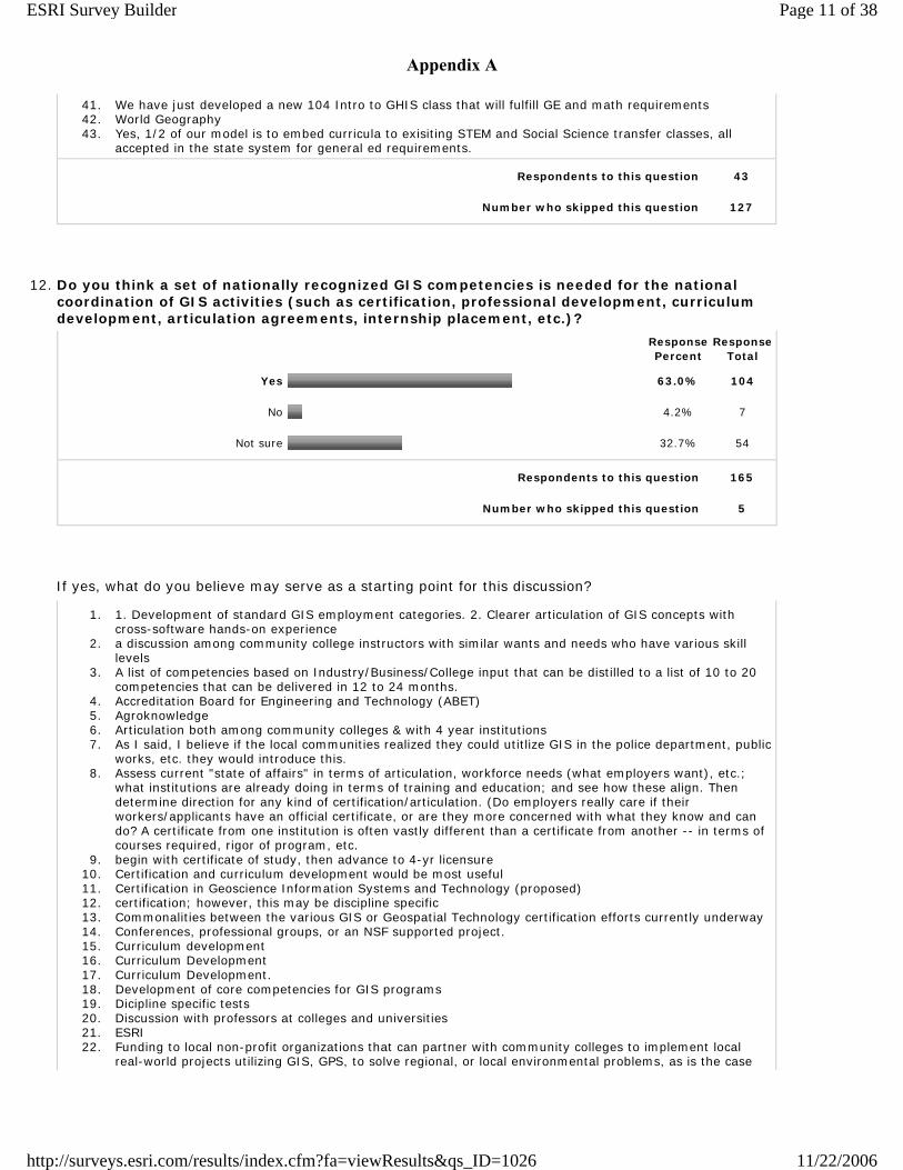
41. We have just developed a new 104 Intro to GHIS class that will fulfill GE and math requirements 42. World Geography 43. Yes, 1/2 of our model is to embed curricula to exisiting STEM and Social Science transfer classes, all
accepted in the state system for general ed requirements.
Respondents to this question 43
Number who skipped this question 127
12. Do you think a set of nationally recognized GIS competencies is needed for the national coordination of GIS activities (such as certification, professional development, curriculum development, articulation agreements, internship placement, etc.)?
Response Percent
Response Total
Yes 63.0% 104
No 4.2% 7
Not sure 32.7% 54
Respondents to this question 165
Number who skipped this question 5
If yes, what do you believe may serve as a starting point for this discussion?
1. 1. Development of standard GIS employment categories. 2. Clearer articulation of GIS concepts with cross-software hands-on experience
2. a discussion among community college instructors with similar wants and needs who have various skill levels
3. A list of competencies based on Industry/Business/College input that can be distilled to a list of 10 to 20 competencies that can be delivered in 12 to 24 months.
4. Accreditation Board for Engineering and Technology (ABET) 5. Agroknowledge 6. Articulation both among community colleges & with 4 year institutions 7. As I said, I believe if the local communities realized they could utitlize GIS in the police department, public
works, etc. they would introduce this. 8. Assess current "state of affairs" in terms of articulation, workforce needs (what employers want), etc.;
what institutions are already doing in terms of training and education; and see how these align. Then determine direction for any kind of certification/articulation. (Do employers really care if their workers/applicants have an official certificate, or are they more concerned with what they know and can do? A certificate from one institution is often vastly different than a certificate from another -- in terms of courses required, rigor of program, etc.
9. begin with certificate of study, then advance to 4-yr licensure 10. Certification and curriculum development would be most useful 11. Certification in Geoscience Information Systems and Technology (proposed) 12. certification; however, this may be discipline specific 13. Commonalities between the various GIS or Geospatial Technology certification efforts currently underway 14. Conferences, professional groups, or an NSF supported project. 15. Curriculum development 16. Curriculum Development 17. Curriculum Development. 18. Development of core competencies for GIS programs 19. Dicipline specific tests 20. Discussion with professors at colleges and universities 21. ESRI 22. Funding to local non-profit organizations that can partner with community colleges to implement local
real-world projects utilizing GIS, GPS, to solve regional, or local environmental problems, as is the case
Page 11 of 38ESRI Survey Builder
11/22/2006http://surveys.esri.com/results/index.cfm?fa=viewResults&qs_ID=1026
Appendix A
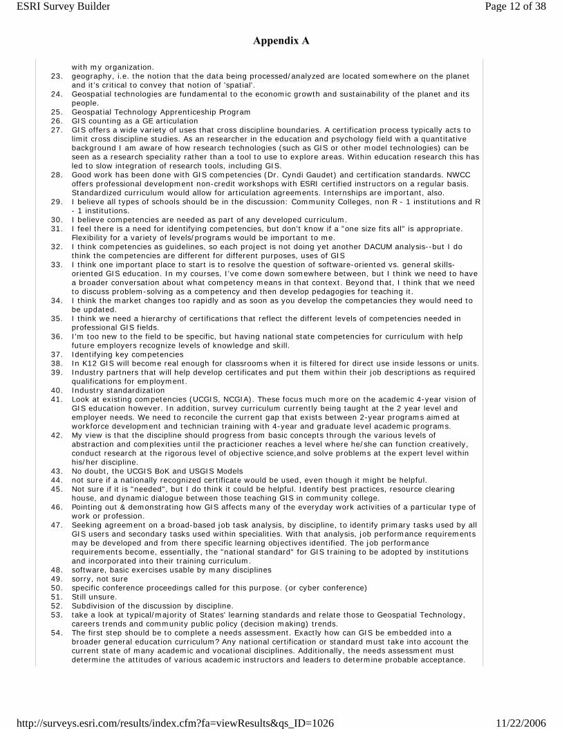
with my organization. 23. geography, i.e. the notion that the data being processed/analyzed are located somewhere on the planet
and it's critical to convey that notion of 'spatial'. 24. Geospatial technologies are fundamental to the economic growth and sustainability of the planet and its
people. 25. Geospatial Technology Apprenticeship Program 26. GIS counting as a GE articulation 27. GIS offers a wide variety of uses that cross discipline boundaries. A certification process typically acts to
limit cross discipline studies. As an researcher in the education and psychology field with a quantitative background I am aware of how research technologies (such as GIS or other model technologies) can be seen as a research speciality rather than a tool to use to explore areas. Within education research this has led to slow integration of research tools, including GIS.
28. Good work has been done with GIS competencies (Dr. Cyndi Gaudet) and certification standards. NWCC offers professional development non-credit workshops with ESRI certified instructors on a regular basis. Standardized curriculum would allow for articulation agreements. Internships are important, also.
29. I believe all types of schools should be in the discussion: Community Colleges, non R - 1 institutions and R - 1 institutions.
30. I believe competencies are needed as part of any developed curriculum. 31. I feel there is a need for identifying competencies, but don't know if a "one size fits all" is appropriate.
Flexibility for a variety of levels/programs would be important to me. 32. I think competencies as guidelines, so each project is not doing yet another DACUM analysis--but I do
think the competencies are different for different purposes, uses of GIS 33. I think one important place to start is to resolve the question of software-oriented vs. general skills-
oriented GIS education. In my courses, I've come down somewhere between, but I think we need to have a broader conversation about what competency means in that context. Beyond that, I think that we need to discuss problem-solving as a competency and then develop pedagogies for teaching it.
34. I think the market changes too rapidly and as soon as you develop the competancies they would need to be updated.
35. I think we need a hierarchy of certifications that reflect the different levels of competencies needed in professional GIS fields.
36. I'm too new to the field to be specific, but having national state competencies for curriculum with help future employers recognize levels of knowledge and skill.
37. Identifying key competencies 38. In K12 GIS will become real enough for classrooms when it is filtered for direct use inside lessons or units. 39. Industry partners that will help develop certificates and put them within their job descriptions as required
qualifications for employment. 40. Industry standardization 41. Look at existing competencies (UCGIS, NCGIA). These focus much more on the academic 4-year vision of
GIS education however. In addition, survey curriculum currently being taught at the 2 year level and employer needs. We need to reconcile the current gap that exists between 2-year programs aimed at workforce development and technician training with 4-year and graduate level academic programs.
42. My view is that the discipline should progress from basic concepts through the various levels of abstraction and complexities until the practicioner reaches a level where he/she can function creatively, conduct research at the rigorous level of objective science,and solve problems at the expert level within his/her discipline.
43. No doubt, the UCGIS BoK and USGIS Models 44. not sure if a nationally recognized certificate would be used, even though it might be helpful. 45. Not sure if it is "needed", but I do think it could be helpful. Identify best practices, resource clearing
house, and dynamic dialogue between those teaching GIS in community college. 46. Pointing out & demonstrating how GIS affects many of the everyday work activities of a particular type of
work or profession. 47. Seeking agreement on a broad-based job task analysis, by discipline, to identify primary tasks used by all
GIS users and secondary tasks used within specialities. With that analysis, job performance requirements may be developed and from there specific learning objectives identified. The job performance requirements become, essentially, the "national standard" for GIS training to be adopted by institutions and incorporated into their training curriculum.
48. software, basic exercises usable by many disciplines 49. sorry, not sure 50. specific conference proceedings called for this purpose. (or cyber conference) 51. Still unsure. 52. Subdivision of the discussion by discipline. 53. take a look at typical/majority of States' learning standards and relate those to Geospatial Technology,
careers trends and community public policy (decision making) trends. 54. The first step should be to complete a needs assessment. Exactly how can GIS be embedded into a
broader general education curriculum? Any national certification or standard must take into account the current state of many academic and vocational disciplines. Additionally, the needs assessment must determine the attitudes of various academic instructors and leaders to determine probable acceptance.
Page 12 of 38ESRI Survey Builder
11/22/2006http://surveys.esri.com/results/index.cfm?fa=viewResults&qs_ID=1026
Appendix A

The needs assessment must also include studies of the current state or articulation between colleges and among the K-16 community. The needs assessment should concentrate on barriers to implementation and their removal.
55. The Penn State World Campus certification program offers a starting model for standardized curiculum. ESRI classes, on the otherhand, or more topical and skill driven verses project driven. Skills are learned best if used in pursuit of a project objective.
56. The program should distinguish GIS casual users from practicing professionals from GIS related business management. Core competencies should be established for each. The program must NOT be GIS software dependent but treat the discipline of GIS independent of the tools. It should recognize differences between theory and practice. IT should invoke technical standards for the care of data. The discussion should involve as many commercial entities as it does public sector participants. It should recognize GIS as a formal discipline of management information systems.
57. The starting point of this study should come from the professionals that would be hiring new graduating students. The skills and knowledge that are needed should be standardized and set. This will allow all curriculum to look at the standards and develop the needed lessons to teach these standards. There also needs to be a standard for levels of competency for the Geo-technology professional, this would included knowledge of not just GIS, all imagery studies, database management, and other areas of expertise the are needed in the geo-technology fields.
58. the work that GITA did last year to develop the GIWIS 59. This surveyed followed with regional meetings 60. US DOL core competencies 61. We need to decide on the scope of competencies and where they fit within the broad range of activitiies
listed above. Seems that different guidlines and flexibility are needed for the varied list above. 62. While a set of nationally recognized competencies may be beneficial and a good model to follow, I feel
that a community college might first consider local or state needs/requirements and adapt to these based on national competencies.
63. Workplace/employer feedback about needed skills/competencies from a broad range of disciplines and industries.
64. Yes and No. On the topic of curriculum development, consider this: I have taken several GIS courses from instructors at different institutions and each has emphasized different components of a curriculum as "important". What I have gained by a lack of coordinated effort is a broader based, academic and private professional perspective on the field and its related emphasis. This has been to my benefit. In a similar way, I teach physical geography as a general education requirement that I am quite certain that while addressing major issues, has placed emphasis in very different areas than that which is experienced by students taking physical geography at other institutions across the nation. It may well be that the diversity of personalities, their experiences and teaching pedagogies serve the needs of the student more than any predefined set of steps or competencies. The real world doesnt appear to work that way (unless you are assembling a car--where there is a specific set of steps that ought to be followed). On the topic of Certification: No. What is the intent of "certification" anyway? And does it deteriorate if you dont use a GIS on a regular basis? Software evolves rapidly. We (at Itasca Community College) offer a 15 credit "Certificate". I tell the students that GIS is an important and evolving skill set that many organizations both public and private are investing large sums of time and money in. They really arent going to care if you walk into an interview and say "I'm certified in GIS". They are going to want to know what you can do with your transferrable GIS skill that will enhance thier organization. Certification at our (CC) level is a bit of a joke because I've seen programs with various curriculums and required college credits all offering certification. My question would be--should we even offer a certificate, and if so, shouldnt we have an ethical obligation to inform certificate pursuers that it is essentially meaningless?? On the topic of professional development: NO. Every individual has his/her own specific professional directives/interests,etc. Maybe developing some sort of summaries of the value of professional development opportunities--i.e. how valuable were they to a group--might help us attend some and avoid others?? Relative to curriculum development: I'd probably lean towards No. The reason is that I believe we can do better service to our community members by tailoring thier learning objectives to their experience levels. Questions that might be considered include: Who is the customer (i.e. returning professional, transfer student, young students with no real idea of what/where they are going to end up)and what do they desire? What are the needs of the local community? What is the plan/intention of surrounding coordinating agencies that utilize GIS/GIS products with whom your graduates might be emplyoed? With regard to articulation agreements, my experience has shown that there is a tremendous amount of "territoriality" at the 4 year university level. I have sent students to 4 year universities who (nearly mock me) wont under any circumstances allow a CC to provide university credit for even the Introduction to GIS course. Students who have gone through my program report that even that universities upper division coursework was "a joke", "easy" and/or "redundant". I believe that I mention that GIS is not rocket science somewhere else in this course. Critical thinking on the other hand is something we could all use alot more of. With regard to internship placement, I'd say No. The reason is that I place students with a variety of locally based private and public organizations who all have specific needs. I maintain a GIS Advisory Committee--representatives from this group and other professionals--who help me understand the current and evolving needs of their organizations. I'm thinking that while there is certainly going to be a "core" set of compete
Page 13 of 38ESRI Survey Builder
11/22/2006http://surveys.esri.com/results/index.cfm?fa=viewResults&qs_ID=1026
Appendix A
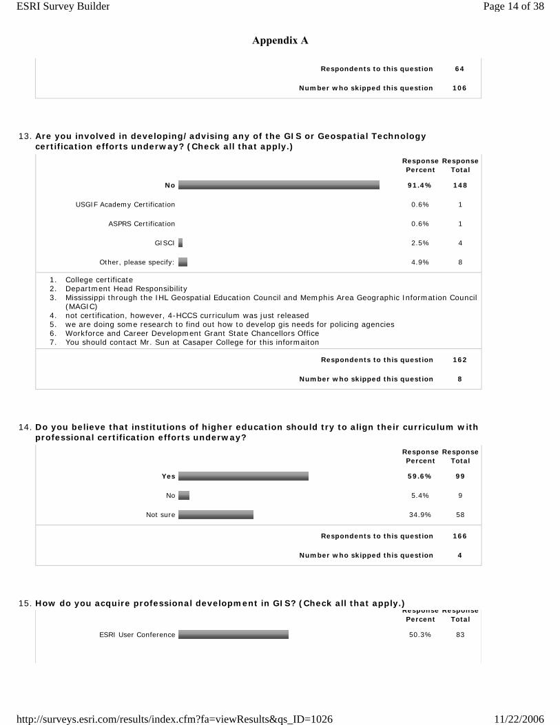
Respondents to this question 64
Number who skipped this question 106
13. Are you involved in developing/advising any of the GIS or Geospatial Technology certification efforts underway? (Check all that apply.)
Response Percent
Response Total
No 91.4% 148
USGIF Academy Certification 0.6% 1
ASPRS Certification 0.6% 1
GISCI 2.5% 4
Other, please specify: 4.9% 8
1. College certificate 2. Department Head Responsibility 3. Mississippi through the IHL Geospatial Education Council and Memphis Area Geographic Information Council
(MAGIC) 4. not certification, however, 4-HCCS curriculum was just released 5. we are doing some research to find out how to develop gis needs for policing agencies 6. Workforce and Career Development Grant State Chancellors Office 7. You should contact Mr. Sun at Casaper College for this informaiton
Respondents to this question 162
Number who skipped this question 8
14. Do you believe that institutions of higher education should try to align their curriculum with professional certification efforts underway?
Response Percent
Response Total
Yes 59.6% 99
No 5.4% 9
Not sure 34.9% 58
Respondents to this question 166
Number who skipped this question 4
15. How do you acquire professional development in GIS? (Check all that apply.)
Response Percent
Response Total
ESRI User Conference 50.3% 83
Page 14 of 38ESRI Survey Builder
11/22/2006http://surveys.esri.com/results/index.cfm?fa=viewResults&qs_ID=1026
Appendix A
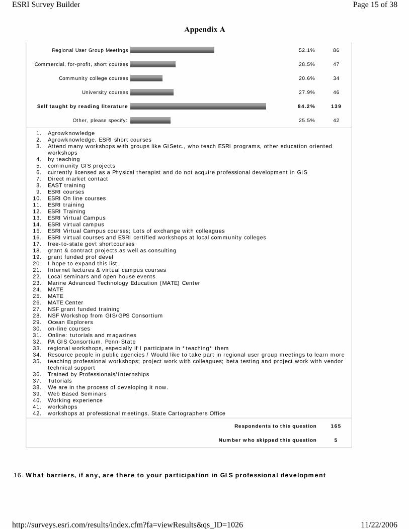
Regional User Group Meetings 52.1% 86
Commercial, for-profit, short courses 28.5% 47
Community college courses 20.6% 34
University courses 27.9% 46
Self taught by reading literature 84.2% 139
Other, please specify: 25.5% 42
1. Agrowknowledge 2. Agrowknowledge, ESRI short courses 3. Attend many workshops with groups like GISetc., who teach ESRI programs, other education oriented
workshops 4. by teaching 5. community GIS projects 6. currently licensed as a Physical therapist and do not acquire professional development in GIS 7. Direct market contact 8. EAST training 9. ESRI courses
10. ESRI On line courses 11. ESRI training 12. ESRI Training 13. ESRI Virtual Campus 14. ESRI virtual campus 15. ESRI Virtual Campus courses; Lots of exchange with colleagues 16. ESRI virtual courses and ESRI certified workshops at local community colleges 17. free-to-state govt shortcourses 18. grant & contract projects as well as consulting 19. grant funded prof devel 20. I hope to expand this list. 21. Internet lectures & virtual campus courses 22. Local seminars and open house events 23. Marine Advanced Technology Education (MATE) Center 24. MATE 25. MATE 26. MATE Center 27. NSF grant funded training 28. NSF Workshop from GIS/GPS Consortium 29. Ocean Explorers 30. on-line courses 31. Online: tutorials and magazines 32. PA GIS Consortium, Penn-State 33. regional workshops, especially if I participate in *teaching* them 34. Resource people in public agencies / Would like to take part in regional user group meetings to learn more 35. teaching professional workshops; project work with colleagues; beta testing and project work with vendor
technical support 36. Trained by Professionals/Internships 37. Tutorials 38. We are in the process of developing it now. 39. Web Based Seminars 40. Working experience 41. workshops 42. workshops at professional meetings, State Cartographers Office
Respondents to this question 165
Number who skipped this question 5
16. What barriers, if any, are there to your participation in GIS professional development
Page 15 of 38ESRI Survey Builder
11/22/2006http://surveys.esri.com/results/index.cfm?fa=viewResults&qs_ID=1026
Appendix A
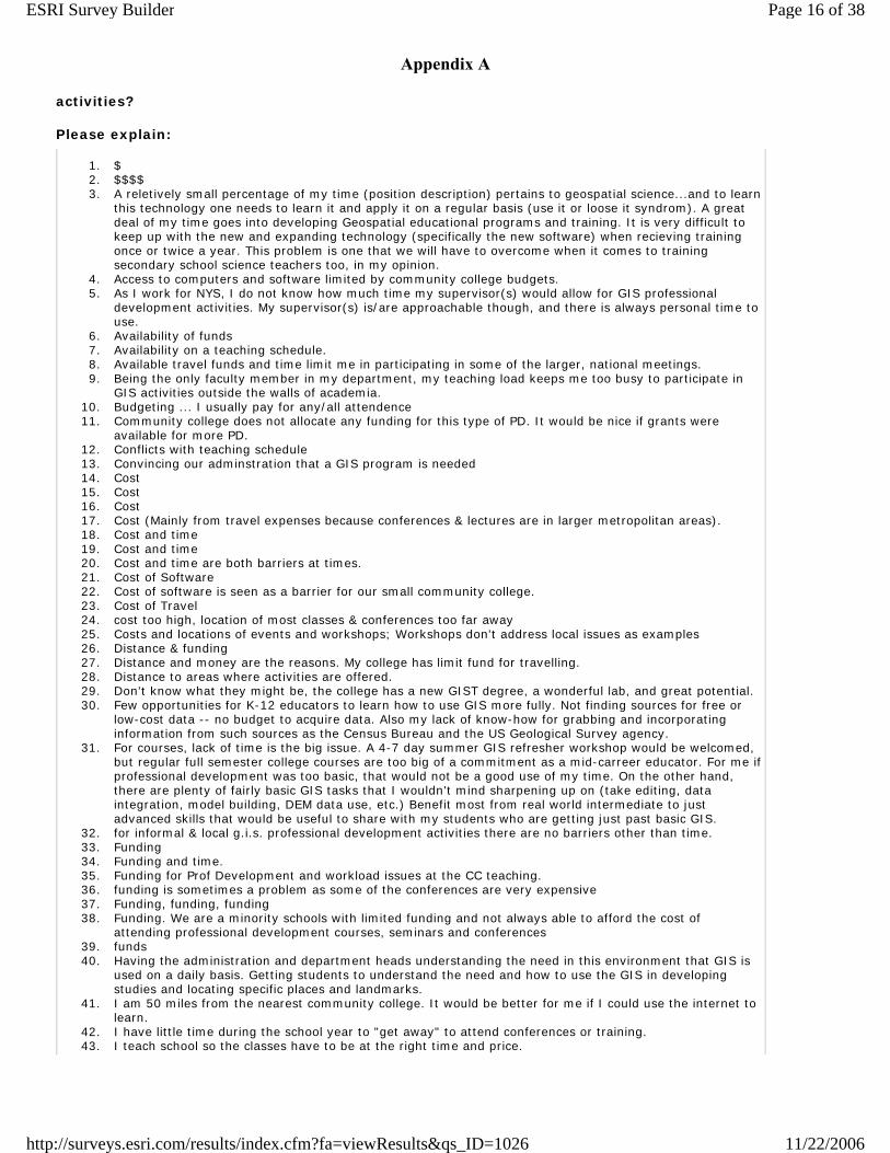
activities? Please explain:
1. $ 2. $$$$ 3. A reletively small percentage of my time (position description) pertains to geospatial science...and to learn
this technology one needs to learn it and apply it on a regular basis (use it or loose it syndrom). A great deal of my time goes into developing Geospatial educational programs and training. It is very difficult to keep up with the new and expanding technology (specifically the new software) when recieving training once or twice a year. This problem is one that we will have to overcome when it comes to training secondary school science teachers too, in my opinion.
4. Access to computers and software limited by community college budgets. 5. As I work for NYS, I do not know how much time my supervisor(s) would allow for GIS professional
development activities. My supervisor(s) is/are approachable though, and there is always personal time to use.
6. Availability of funds 7. Availability on a teaching schedule. 8. Available travel funds and time limit me in participating in some of the larger, national meetings. 9. Being the only faculty member in my department, my teaching load keeps me too busy to participate in
GIS activities outside the walls of academia. 10. Budgeting ... I usually pay for any/all attendence 11. Community college does not allocate any funding for this type of PD. It would be nice if grants were
available for more PD. 12. Conflicts with teaching schedule 13. Convincing our adminstration that a GIS program is needed 14. Cost 15. Cost 16. Cost 17. Cost (Mainly from travel expenses because conferences & lectures are in larger metropolitan areas). 18. Cost and time 19. Cost and time 20. Cost and time are both barriers at times. 21. Cost of Software 22. Cost of software is seen as a barrier for our small community college. 23. Cost of Travel 24. cost too high, location of most classes & conferences too far away 25. Costs and locations of events and workshops; Workshops don't address local issues as examples 26. Distance & funding 27. Distance and money are the reasons. My college has limit fund for travelling. 28. Distance to areas where activities are offered. 29. Don't know what they might be, the college has a new GIST degree, a wonderful lab, and great potential. 30. Few opportunities for K-12 educators to learn how to use GIS more fully. Not finding sources for free or
low-cost data -- no budget to acquire data. Also my lack of know-how for grabbing and incorporating information from such sources as the Census Bureau and the US Geological Survey agency.
31. For courses, lack of time is the big issue. A 4-7 day summer GIS refresher workshop would be welcomed, but regular full semester college courses are too big of a commitment as a mid-carreer educator. For me if professional development was too basic, that would not be a good use of my time. On the other hand, there are plenty of fairly basic GIS tasks that I wouldn't mind sharpening up on (take editing, data integration, model building, DEM data use, etc.) Benefit most from real world intermediate to just advanced skills that would be useful to share with my students who are getting just past basic GIS.
32. for informal & local g.i.s. professional development activities there are no barriers other than time. 33. Funding 34. Funding and time. 35. Funding for Prof Development and workload issues at the CC teaching. 36. funding is sometimes a problem as some of the conferences are very expensive 37. Funding, funding, funding 38. Funding. We are a minority schools with limited funding and not always able to afford the cost of
attending professional development courses, seminars and conferences 39. funds 40. Having the administration and department heads understanding the need in this environment that GIS is
used on a daily basis. Getting students to understand the need and how to use the GIS in developing studies and locating specific places and landmarks.
41. I am 50 miles from the nearest community college. It would be better for me if I could use the internet to learn.
42. I have little time during the school year to "get away" to attend conferences or training. 43. I teach school so the classes have to be at the right time and price.
Page 16 of 38ESRI Survey Builder
11/22/2006http://surveys.esri.com/results/index.cfm?fa=viewResults&qs_ID=1026
Appendix A
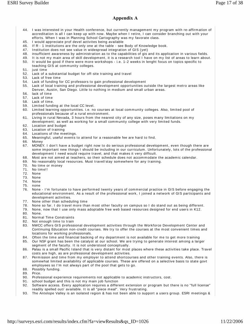
44. I was interested in your Health conference, but currently management my program with re-affirmation of accreditation is all I can keep up with now. Maybe when I retire, I can consider branching out with your efforts. When I was in Planning School Cartography was my favorate class.
45. I would appreciate prof devel activites being available 46. If R - 1 institutions are the only one at the table - see Body of Knowledge book. 47. Institution does not see value in widespread integration of GIS (yet) 48. insufficient awareness by administration as to the capabilities of gis and its application in various fields. 49. It is not my main area of skill development, it is a research tool I have on my list of areas to learn about. 50. It would be good if there were more workshops - i.e. 1-2 weeks in lenght focus on topics specific to
teaching GIS at community colleges. 51. just time 52. Lack of a substantial budget for off-site training and travel 53. Lack of free time 54. Lack of funding for CC professors to gain professional development 55. Lack of local training and professional development opportunities outside the largest metro areas like
Denver, Austin, San Diego. Little to nothing in medium and small urban areas. 56. lack of time 57. Lack of time 58. Lack of time. 59. Limited funding at the local CC level. 60. Limited learning opportunities. i.e. no courses at local community colleges. Also, limited pool of
professionals because of a rural environment. 61. Living in rural Nevada, 3 hours from the nearest city of any size, poses many limitations on my
development; as well as working for a small community college with very limited funds. 62. Location and budget 63. Location of training 64. Locations of the meetings. 65. Meaningful, useful events to attend for a reasonable fee are hard to find. 66. Money 67. MONEY. I don't have a budget right now to do serious professional development, even though there are
some important new things I should be including in our curriculum. Unfortunately, lots of the professional development I need would require travel, and that makes it very difficult.
68. Most are not aimed at teachers, so their schedule does not accommodate the academic calendar. 69. No reasonably local resources. Must travel/stay somewhere for any training. 70. No time or money 71. No time!! 72. None 73. None 74. None 75. none 76. None - I'm fortunate to have performed twenty years of commercial practice in GIS before engaging the
educational environment. As a result of the professional work, I joined a network of GIS participants and development activities.
77. None other than scheduling time 78. None so far. I do travel more than most other faculty on campus so I do stand out as being different. 79. None, now that I use only mass adoptable free web based resources designed for end users in K12. 80. None. 81. Normal Time Constraints 82. Not enough time to train 83. NWCC offers GIS professional development activities through the Workforce Development Center and
Continuing Education non-credit courses. We try to offer the courses at the most convenient times and locations for working professionals.
84. Often the time and financial backing of my department is not available for me to get more training 85. Our NSF grant has been the catalyst at our school. We are trying to generate interest among a larger
segment of the faculty. It is not understood conceptually. 86. Palau is a small Pacific Island that is very distant for most places where these activities take place. Travel
costs are high, as are professional development activities. 87. Permission and time from my employer to attend shortcourses and other training events. Also, there is
somewhat limited availability of applicable courses. These are offered on a selective basis to state govt employees so I'm not always part of the pool that gets to go.
88. Possibly funding. 89. Price. 90. Professional experience requirements not applicable to academic instructors, cost. 91. school budget and this is not my main job function 92. Software access. Every application requires a different extension or program but there is no "full license"
readily spelled out/ available. It is all "piece meal". Very frustrating. 93. The Antelope Valley is an isolated region & has not been able to support a users group. ESRI meetings &
Page 17 of 38ESRI Survey Builder
11/22/2006http://surveys.esri.com/results/index.cfm?fa=viewResults&qs_ID=1026
Appendix A
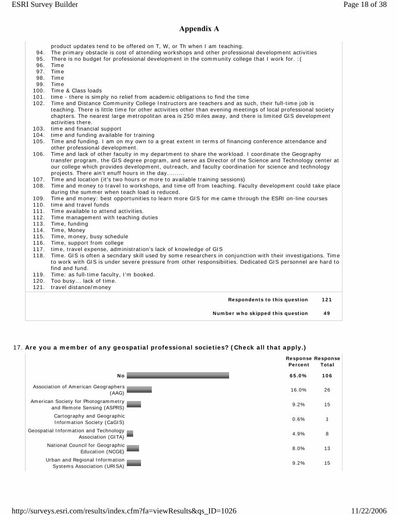
product updates tend to be offered on T, W, or Th when I am teaching. 94. The primary obstacle is cost of attending workshops and other professional development activities 95. There is no budget for professional development in the community college that I work for. :( 96. Time 97. Time 98. Time 99. Time
100. Time & Class loads 101. time - there is simply no relief from academic obligations to find the time 102. Time and Distance Community College Instructors are teachers and as such, their full-time job is
teaching. There is little time for other activities other than evening meetings of local professional society chapters. The nearest large metropolitan area is 250 miles away, and there is limited GIS development activities there.
103. time and financial support 104. time and funding available for training 105. Time and funding. I am on my own to a great extent in terms of financing conference attendance and
other professional development. 106. Time and lack of other faculty in my department to share the workload. I coordinate the Geography
transfer program, the GIS degree program, and serve as Director of the Science and Technology center at our college which provides development, outreach, and faculty coordination for science and technology projects. There ain't enuff hours in the day.........
107. Time and location (it's two hours or more to available training sessions) 108. Time and money to travel to workshops, and time off from teaching. Faculty development could take place
during the summer when teach load is reduced. 109. Time and money: best opportunities to learn more GIS for me came through the ESRI on-line courses 110. time and travel funds 111. Time available to attend activities. 112. Time management with teaching duties 113. Time, funding 114. Time, Money 115. Time, money, busy schedule 116. Time, support from college 117. time, travel expense, administration's lack of knowledge of GIS 118. Time. GIS is often a secndary skill used by some researchers in conjunction with their investigations. Time
to work with GIS is under severe pressure from other responsibiities. Dedicated GIS personnel are hard to find and fund.
119. Time: as full-time faculty, I'm booked. 120. Too busy... lack of time. 121. travel distance/money
Respondents to this question 121
Number who skipped this question 49
17. Are you a member of any geospatial professional societies? (Check all that apply.)
Response Percent
Response Total
No 65.0% 106
Association of American Geographers (AAG)
16.0% 26
American Society for Photogrammetry and Remote Sensing (ASPRS)
9.2% 15
Cartography and Geographic Information Society (CaGIS)
0.6% 1
Geospatial Information and Technology Association (GITA)
4.9% 8
National Council for Geographic Education (NCGE)
8.0% 13
Urban and Regional Information Systems Association (URISA)
9.2% 15
Page 18 of 38ESRI Survey Builder
11/22/2006http://surveys.esri.com/results/index.cfm?fa=viewResults&qs_ID=1026
Appendix A
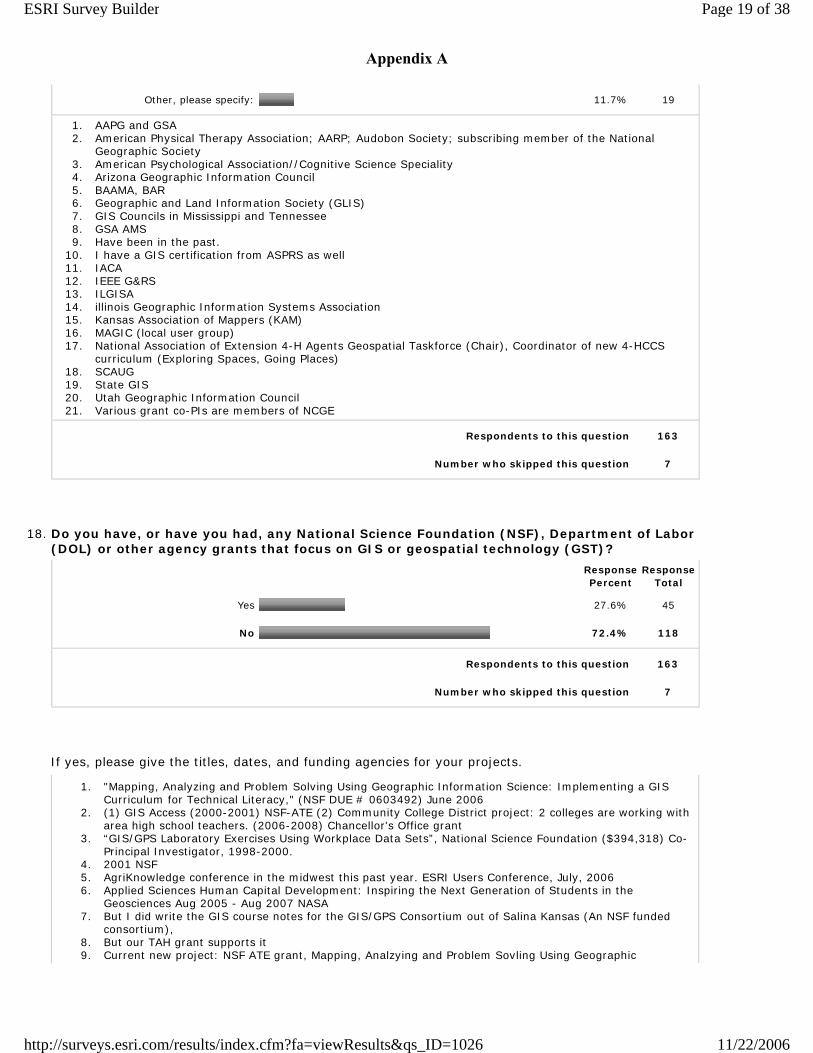
Other, please specify: 11.7% 19
1. AAPG and GSA 2. American Physical Therapy Association; AARP; Audobon Society; subscribing member of the National
Geographic Society 3. American Psychological Association//Cognitive Science Speciality 4. Arizona Geographic Information Council 5. BAAMA, BAR 6. Geographic and Land Information Society (GLIS) 7. GIS Councils in Mississippi and Tennessee 8. GSA AMS 9. Have been in the past.
10. I have a GIS certification from ASPRS as well 11. IACA 12. IEEE G&RS 13. ILGISA 14. illinois Geographic Information Systems Association 15. Kansas Association of Mappers (KAM) 16. MAGIC (local user group) 17. National Association of Extension 4-H Agents Geospatial Taskforce (Chair), Coordinator of new 4-HCCS
curriculum (Exploring Spaces, Going Places) 18. SCAUG 19. State GIS 20. Utah Geographic Information Council 21. Various grant co-PIs are members of NCGE
Respondents to this question 163
Number who skipped this question 7
18. Do you have, or have you had, any National Science Foundation (NSF), Department of Labor (DOL) or other agency grants that focus on GIS or geospatial technology (GST)?
Response Percent
Response Total
Yes 27.6% 45
No 72.4% 118
Respondents to this question 163
Number who skipped this question 7
If yes, please give the titles, dates, and funding agencies for your projects.
1. "Mapping, Analyzing and Problem Solving Using Geographic Information Science: Implementing a GIS Curriculum for Technical Literacy," (NSF DUE # 0603492) June 2006
2. (1) GIS Access (2000-2001) NSF-ATE (2) Community College District project: 2 colleges are working with area high school teachers. (2006-2008) Chancellor's Office grant
3. “GIS/GPS Laboratory Exercises Using Workplace Data Sets”, National Science Foundation ($394,318) Co-Principal Investigator, 1998-2000.
4. 2001 NSF 5. AgriKnowledge conference in the midwest this past year. ESRI Users Conference, July, 2006 6. Applied Sciences Human Capital Development: Inspiring the Next Generation of Students in the
Geosciences Aug 2005 - Aug 2007 NASA 7. But I did write the GIS course notes for the GIS/GPS Consortium out of Salina Kansas (An NSF funded
consortium), 8. But our TAH grant supports it 9. Current new project: NSF ATE grant, Mapping, Analzying and Problem Sovling Using Geographic
Page 19 of 38ESRI Survey Builder
11/22/2006http://surveys.esri.com/results/index.cfm?fa=viewResults&qs_ID=1026
Appendix A
Information Science, MAPS GIS, #0603492 10. Current NSF-ATE grant "A Scalable Skills Certification Projecy in GIS" that will be completed in 2008 11. Developing a Vision and a Plan for a National Geospatial Technology Resource Center, 6/1/06-5/31/07,
NSF. 12. DOJ - Crime Mapping 13. ESRI software grant for survey and civil degree program. Granted 25 seats of ArcGIS and several
extensions. Recieved a NSF grant to do a workshop for high school tech teachers in GPS/GIS 14. GIS Technology Implementation Project (GIS-TECH). NSF project June 2004-May 2007. 15. I am not a PI on either of these grants, but currently we have two grants supporting some of our activites.
NSF Grant 0525118 "Community for Rural Education, Stewardship, and Technology (CREST): A comprehensive project for students and teachers." NSF Grant 0126639 "Developing an integrated undergraduate GIScience curriculum for five University of Maine System campuses." This is Maine GIS Curriculum Consortium grant that is near its end. We also have a small grant from the Maine Coast Protection Initiative for our GIS Service Center to cooperate with the Island Institute to provide GIS services to local land trusts via student service learning projects.
16. I am not a PI, but am working with the groupo that got the following grant: NSF Embedded Internet and Professional-Technical GIS at Lane (may be a working title) 2006-2009
17. I've completed two USDA grant worth over $600 K to enhance Agricultural GIS programs. I just completed a Tech Prep grant (75K) with the State Chancellor's Office for Community Colleges. I just received a $440K two year grant to develop a model program for spatial thinking focused on high school and middle school curriculum.
18. ISLET - Investigative Sciences and Law Enforcement Technology. We received a three year continuing grant a year ago. The GIS component we are to develop is Crime Mapping. We have since developed a fundamentals to GIS course
19. Just received an EPSCoR grant (mini-grant from Hawaii EPSCoR/NSF grant) for the purchase of GIS workstations and large format printer.
20. Lane Community College NSF grant 21. Mapping, Analyzing and Problems Solving (MAPS) Using Geographic Information Science: Implementing a
GIS Curriculum for technical Literacy NSF 0603492 Project Start Date Fall 2006 22. MAPS GIS Mapping, Analyzing & Problem Solving Using Geographic Infomration Science NSF#0603492
July 2006 - June 2009 23. Mentorlinks Grant; AACC funded, 2004-present 24. Micronesian Regioanl GIS Training Program. Octoberr 2003 through December 2004. U.S. Department of
Interior--Operations and Maintenance Improvement Program. 25. NASA - 1975-1982 26. Not just focus on GIS, but utilize it. Each year we receive grant from NSF for Research Experience for the
Undergraduate program. Our projects involved with landform evolution of western Colorado. The interns are required to use GIS and GPS data gathering and analyzing of the geology of the areas.
27. NSF ATE 0603455 "Using a web-based GIS to teach problem based science in high school and college". 9/2006-9/2009
28. NSF Ocean Sciences NSF Digital Government NSF Information Technology Research NOAA CSC GIS Integration and Development NSF Office of Intl Science & Development
29. NSF Support; current project 30. NSF, Biocomplexity in River/Road Networks, 2002 - 2007 31. NSF, Estudio de Las Fortelezas de Tikal 2002-2006. NSF and FAMSI, Proyecto Oztuma-Cutzamala, 1998 32. NSF-ATE, 0401990 - A Scalable Skills Certification Program in Geographic Information Systems (GIS) 33. NSF-ATE, Scalable Skills GIS Certificate Program, 2004-2007 34. One course in GIS is included in our NSF funded Marine Science Curriculum. 35. Our college applied for NSF grant for GIS at 2 year level, but were not granted. 36. PA Department of Environmental Protection-Arc View 3.2 Software and 2 Day Training 37. State University Sytem in Wisconsin 38. Subgrantee with Rancho Santiago Community College for HGJTI grant-time frame 12/1/04 to 5/31/06 " A
Model for connecting the geopspatial technology industry to community college workforce development" 39. Supervisor Training in Integrated Spatially Distributed Sensors in Agriculture, US Department of
Agriculture, 9/04-8/06, $300,000 (PI – Project Director) Training and Internships in Geographic Information Systems to Improve Recruitment Strategies and Student Success for Agriculture Majors, US Department of Agriculture, 9/03-8/05, $260,000 (Co-Project Director, Bill Thiemann, Director) "A GIS Core Curriculum for the 2-year Colleges", NSF Advanced Technological Education (ATE), 7/96-12/98, $188,000, Co-PI's: Michael Goodchild, Karen Kemp.
40. The Finger Lakes GIT Ahead Project: Creating Career Paths for Geospatial Technology Professionals Through Teacher Enhancement and Student Engagement Advanced Technological Education NSF Grant
41. The Northeast Rural Development Center provides dollars for the northeast regional geospatial center project meetings.
42. Title: "Using a Web-based GIS to Teach Problem-based Science in High School and College" Period of Support: September 1, 2006 – August 31, 2009 Funding Agency: NSF Title: NASA Earth Science for Teachers Period of Support 8/15/05 - 8/15/08 (NASA cancelled the grant 7/1/06) Funding agency: NASA Title: Strengthening TCUs Earth Science Curriculum with Mentoring Partnerships and Innovative
Page 20 of 38ESRI Survey Builder
11/22/2006http://surveys.esri.com/results/index.cfm?fa=viewResults&qs_ID=1026
Appendix A
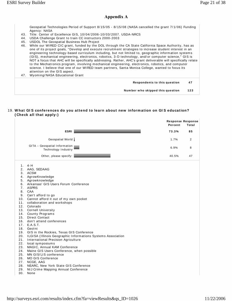
Geospatial Technologies Period of Support 8/15/05 - 8/15/08 (NASA cancelled the grant 7/1/06) Funding Agency: NASA
43. Title: Center of Excellence GIS, 10/04/2006-10/03/2007. USDA-NRCS 44. USDA Challenge Grant to train CC instructors 2000-2003 45. USDOL The Geospatial Business Hub Project 46. While our WIRED CIC grant, funded by the DOL through the CA State California Space Authority, has as
one of its project goals, “Develop and execute recruitment strategies to increase student interest in an engineering technology-based curriculum including, but not limited to, geographic information systems (GIS), mechanical engineering, electronics, robotics, 3-D technology, and/or computer science,” GIS is NOT a focus that AHC will be specifically addressing. Rather, AHC’s grant deliverable will specifically relate to the Mechatronics program, involving mechanical engineering, electronics, robotics, and computer science. I believe that one of our WIRED team partners, Santa Monica College, wanted to focus its attention on the GIS aspect.
47. Wyoming/NASA Educational Grant
Respondents to this question 47
Number who skipped this question 123
19. What GIS conferences do you attend to learn about new information on GIS education? (Check all that apply:)
Response Percent
Response Total
ESRI 73.3% 85
Geospatial World 1.7% 2
GITA – Geospatial Information Technology Industry
6.9% 8
Other, please specify: 40.5% 47
1. 4-H 2. AAG, SEDAAG 3. ACSM 4. AgrowKnowledge 5. Agrowknowledge 6. Arkansas' GIS Users Forum Conference 7. ASPRS 8. CAA 9. Can't afford to go
10. Cannot afford it out of my own pocket 11. collaboration and workshops 12. Colorado 13. Cornell University 14. County Programs 15. Direct Contact 16. don't attend conferences 17. E.A.S.T. 18. GeoInt 19. GIS in the Rockies, Texas GIS Conference 20. ILGISA (Illinois Geographic Informations Systems Association 21. International Precision Agriculture 22. local symposiums 23. MAGIC, Annual KAM Conference 24. Maine GIS Users Conference, when possible 25. MN GIS/LIS conference 26. MO GIS Conference 27. NCGE, AAG 28. NEARC, New York State GIS Conference 29. NIJ Crime Mapping Annual Conference 30. None
Page 21 of 38ESRI Survey Builder
11/22/2006http://surveys.esri.com/results/index.cfm?fa=viewResults&qs_ID=1026
Appendix A
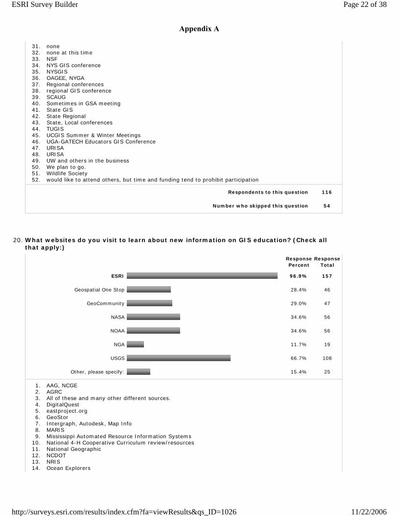
31. none 32. none at this time 33. NSF 34. NYS GIS conference 35. NYSGIS 36. OAGEE, NYGA 37. Regional conferences 38. regional GIS conference 39. SCAUG 40. Sometimes in GSA meeting 41. State GIS 42. State Regional 43. State, Local conferences 44. TUGIS 45. UCGIS Summer & Winter Meetings 46. UGA-GATECH Educators GIS Conference 47. URISA 48. URISA 49. UW and others in the business 50. We plan to go. 51. Wildlife Society 52. would like to attend others, but time and funding tend to prohibit participation
Respondents to this question 116
Number who skipped this question 54
20. What websites do you visit to learn about new information on GIS education? (Check all that apply:)
Response Percent
Response Total
ESRI 96.9% 157
Geospatial One Stop 28.4% 46
GeoCommunity 29.0% 47
NASA 34.6% 56
NOAA 34.6% 56
NGA 11.7% 19
USGS 66.7% 108
Other, please specify: 15.4% 25
1. AAG, NCGE 2. AGRC 3. All of these and many other different sources. 4. DigitalQuest 5. eastproject.org 6. GeoStor 7. Intergraph, Autodesk, Map Info 8. MARIS 9. Mississippi Automated Resource Information Systems
10. National 4-H Cooperative Curriculum review/resources 11. National Geographic 12. NCDOT 13. NRIS 14. Ocean Explorers
Page 22 of 38ESRI Survey Builder
11/22/2006http://surveys.esri.com/results/index.cfm?fa=viewResults&qs_ID=1026
Appendix A
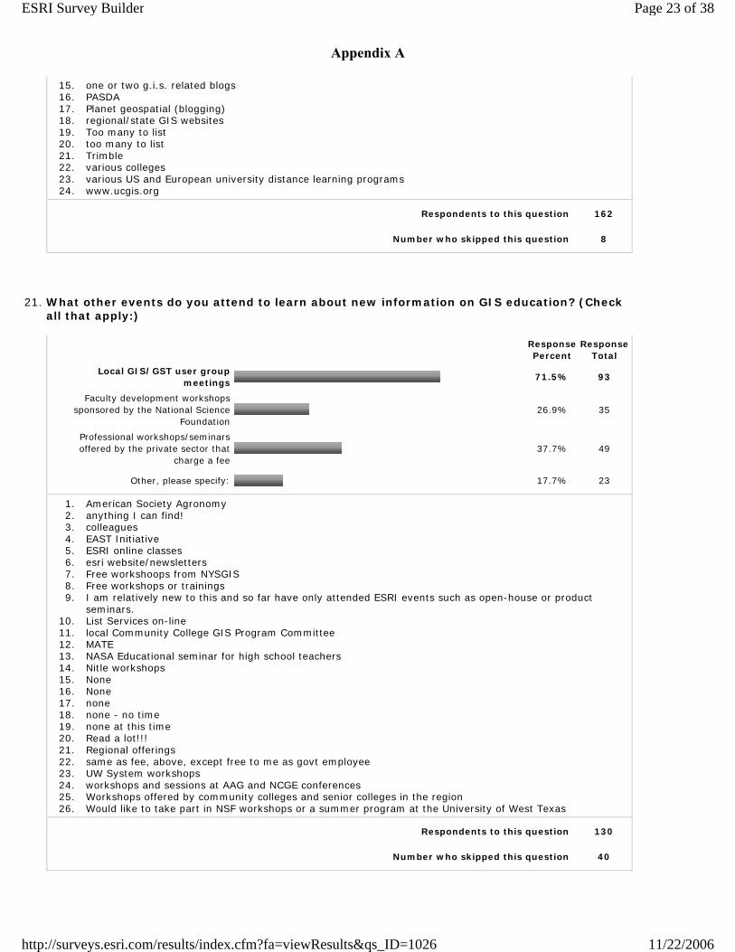
15. one or two g.i.s. related blogs 16. PASDA 17. Planet geospatial (blogging) 18. regional/state GIS websites 19. Too many to list 20. too many to list 21. Trimble 22. various colleges 23. various US and European university distance learning programs 24. www.ucgis.org
Respondents to this question 162
Number who skipped this question 8
21. What other events do you attend to learn about new information on GIS education? (Check all that apply:)
Response Percent
Response Total
Local GIS/GST user group meetings
71.5% 93
Faculty development workshops sponsored by the National Science
Foundation26.9% 35
Professional workshops/seminars offered by the private sector that
charge a fee37.7% 49
Other, please specify: 17.7% 23
1. American Society Agronomy 2. anything I can find! 3. colleagues 4. EAST Initiative 5. ESRI online classes 6. esri website/newsletters 7. Free workshoops from NYSGIS 8. Free workshops or trainings 9. I am relatively new to this and so far have only attended ESRI events such as open-house or product
seminars. 10. List Services on-line 11. local Community College GIS Program Committee 12. MATE 13. NASA Educational seminar for high school teachers 14. Nitle workshops 15. None 16. None 17. none 18. none - no time 19. none at this time 20. Read a lot!!! 21. Regional offerings 22. same as fee, above, except free to me as govt employee 23. UW System workshops 24. workshops and sessions at AAG and NCGE conferences 25. Workshops offered by community colleges and senior colleges in the region 26. Would like to take part in NSF workshops or a summer program at the University of West Texas
Respondents to this question 130
Number who skipped this question 40
Page 23 of 38ESRI Survey Builder
11/22/2006http://surveys.esri.com/results/index.cfm?fa=viewResults&qs_ID=1026
Appendix A
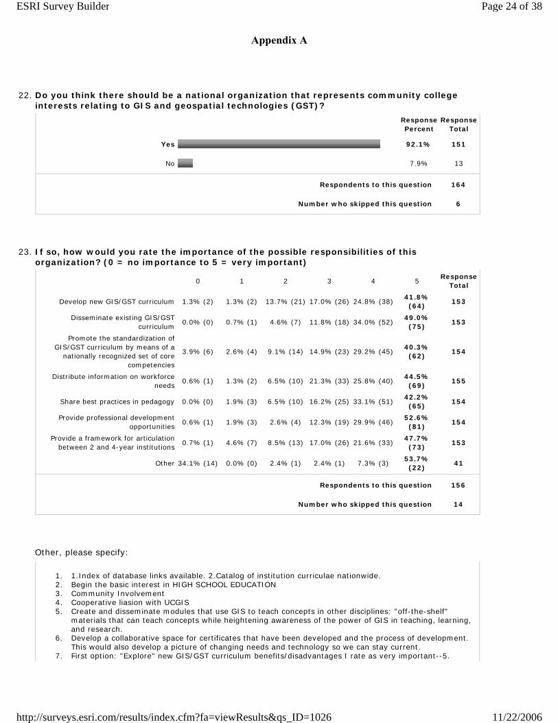
22. Do you think there should be a national organization that represents community college interests relating to GIS and geospatial technologies (GST)?
Response Percent
Response Total
Yes 92.1% 151
No 7.9% 13
Respondents to this question 164
Number who skipped this question 6
23. If so, how would you rate the importance of the possible responsibilities of this organization? (0 = no importance to 5 = very important)
0 1 2 3 4 5Response
Total
Develop new GIS/GST curriculum 1.3% (2) 1.3% (2) 13.7% (21) 17.0% (26) 24.8% (38)41.8% (64)
153
Disseminate existing GIS/GST curriculum
0.0% (0) 0.7% (1) 4.6% (7) 11.8% (18) 34.0% (52)49.0% (75)
153
Promote the standardization of GIS/GST curriculum by means of a
nationally recognized set of core competencies
3.9% (6) 2.6% (4) 9.1% (14) 14.9% (23) 29.2% (45)40.3% (62)
154
Distribute information on workforce needs
0.6% (1) 1.3% (2) 6.5% (10) 21.3% (33) 25.8% (40)44.5% (69)
155
Share best practices in pedagogy 0.0% (0) 1.9% (3) 6.5% (10) 16.2% (25) 33.1% (51)42.2% (65)
154
Provide professional development opportunities
0.6% (1) 1.9% (3) 2.6% (4) 12.3% (19) 29.9% (46)52.6% (81)
154
Provide a framework for articulation between 2 and 4-year institutions
0.7% (1) 4.6% (7) 8.5% (13) 17.0% (26) 21.6% (33)47.7% (73)
153
Other 34.1% (14) 0.0% (0) 2.4% (1) 2.4% (1) 7.3% (3)53.7% (22)
41
Respondents to this question 156
Number who skipped this question 14
Other, please specify:
1. 1.Index of database links available. 2.Catalog of institution curriculae nationwide. 2. Begin the basic interest in HIGH SCHOOL EDUCATION 3. Community Involvement 4. Cooperative liasion with UCGIS 5. Create and disseminate modules that use GIS to teach concepts in other disciplines: "off-the-shelf"
materials that can teach concepts while heightening awareness of the power of GIS in teaching, learning, and research.
6. Develop a collaborative space for certificates that have been developed and the process of development. This would also develop a picture of changing needs and technology so we can stay current.
7. First option: "Explore" new GIS/GST curriculum benefits/disadvantages I rate as very important--5.
Page 24 of 38ESRI Survey Builder
11/22/2006http://surveys.esri.com/results/index.cfm?fa=viewResults&qs_ID=1026
Appendix A
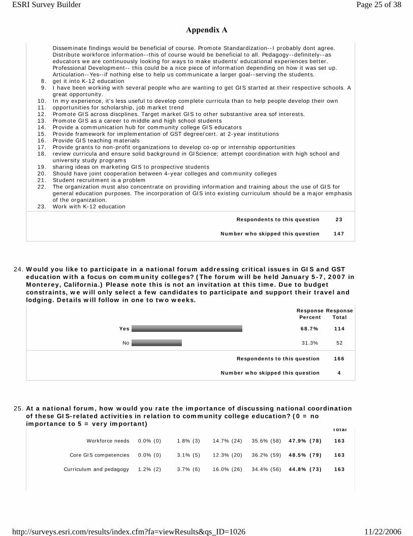
Disseminate findings would be beneficial of course. Promote Standardization--I probably dont agree. Distribute workforce information--this of course would be beneficial to all. Pedagogy--definitely--as educators we are continuously looking for ways to make students' educational experiences better. Professional Development-- this could be a nice piece of information depending on how it was set up. Articulation--Yes--if nothing else to help us communicate a larger goal--serving the students.
8. get it into K-12 education 9. I have been working with several people who are wanting to get GIS started at their respective schools. A
great opportunity. 10. In my experience, it's less useful to develop complete curricula than to help people develop their own 11. opportunities for scholarship, job market trend 12. Promote GIS across discplines. Target market GIS to other substantive area sof interests. 13. Promote GIS as a career to middle and high school students 14. Provide a communication hub for community college GIS educators 15. Provide framework for implementation of GST degree/cert. at 2-year institutions 16. Provide GIS teaching materials 17. Provide grants to non-profit organizations to develop co-op or internship opportunities 18. review curricula and ensure solid background in GIScience; attempt coordination with high school and
university study programs 19. sharing ideas on marketing GIS to prospective students 20. Should have joint cooperation between 4-year colleges and community colleges 21. Student recruitment is a problem 22. The organization must also concentrate on providing information and training about the use of GIS for
general education purposes. The incorporation of GIS into existing curriculum should be a major emphasis of the organization.
23. Work with K-12 education
Respondents to this question 23
Number who skipped this question 147
24. Would you like to participate in a national forum addressing critical issues in GIS and GST education with a focus on community colleges? (The forum will be held January 5-7, 2007 in Monterey, California.) Please note this is not an invitation at this time. Due to budget constraints, we will only select a few candidates to participate and support their travel and lodging. Details will follow in one to two weeks.
Response Percent
Response Total
Yes 68.7% 114
No 31.3% 52
Respondents to this question 166
Number who skipped this question 4
25. At a national forum, how would you rate the importance of discussing national coordination of these GIS-related activities in relation to community college education? (0 = no importance to 5 = very important)
Total
Workforce needs 0.0% (0) 1.8% (3) 14.7% (24) 35.6% (58) 47.9% (78) 163
Core GIS competencies 0.0% (0) 3.1% (5) 12.3% (20) 36.2% (59) 48.5% (79) 163
Curriculum and pedagogy 1.2% (2) 3.7% (6) 16.0% (26) 34.4% (56) 44.8% (73) 163
Page 25 of 38ESRI Survey Builder
11/22/2006http://surveys.esri.com/results/index.cfm?fa=viewResults&qs_ID=1026
Appendix A
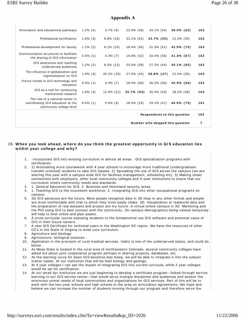
Articulation and educational pathways 1.2% (2) 3.7% (6) 23.9% (39) 33.1% (54) 38.0% (62) 163
Professional certification 1.8% (3) 9.8% (16) 33.1% (54) 33.7% (55) 21.5% (35) 163
Professional development for faculty 1.2% (2) 6.1% (10) 18.4% (30) 31.3% (51) 42.9% (70) 163
Communication structures to facilitate the sharing of GIS information
0.6% (1) 4.3% (7) 19.8% (32) 34.0% (55) 41.4% (67) 162
GIS awareness and reaching underserved audiences
1.2% (2) 8.0% (13) 23.5% (38) 27.2% (44) 40.1% (65) 162
The influence of globalization and regionalization on GIS
1.8% (3) 20.2% (33) 27.6% (45) 28.8% (47) 21.5% (35) 163
Future trends in GIS technology and education
0.6% (1) 4.3% (7) 18.4% (30) 36.2% (59) 40.5% (66) 163
GIS as a tool for conducting institutional research
1.8% (3) 12.9% (21) 30.7% (50) 26.4% (43) 28.2% (46) 163
The role of a national center in coordinating GIS education at the
community college level0.6% (1) 5.6% (9) 18.0% (29) 29.2% (47) 46.6% (75) 161
Respondents to this question 163
Number who skipped this question 7
26. When you look ahead, where do you think the greatest opportunity in GIS education lies within your college and why?
1. -Incorporate GIS into existing curriculum in almost all areas. -GIS specialization programs with certification.
2. 1) Articulating more coursework with 4 year schools to encourage more traditional (undergraduate transfer oriented) students to take GIS classes. 2) Spreading the use of GIS across the campus (we are starting this year with a campus wide GIS for facilities management, scheduling etc). 3) Making closer connections with employers, other local community colleges and 4-year institutions to insure that our curriculum meets community needs and standards.
3. 1. General Education for GIS. 2. Business and Homeland security areas. 4. 1. Teaching GIS to the incumbent workforce. 2. Integrating GIS into other occupational programs on
campus. 5. 3D GIS advances are the future. More people recognize data in 3D than in any other format and people
are most comfortable with that to which they most easily relate. 3D. Visualization or realworld data and the preparation of real datasets and project are my future. A virtual online campus in 3D. Marketing and the PIO using GIS to best connect with the community. On campus demographics being viewed temporaly will help to best utilize and plan assets.
6. A cross curricular course exposing students to the fundamental use GIS software and potential value of GIS in their future careers.
7. A new GIS Certificate for technical users in the Washington DC region. We have the resources of other CC's in the State of Virginia to meet core curriculum.
8. Agriculture and Geology 9. Agriculuture, biological sciences -
10. Application in the provision of rural medical services. Idaho is one of the underserved states, and could do better.
11. As Mesa State is located in the rural area of northwestern Colorado, several community colleges have asked me about joint cooperative program perhaps in sharing projects, databases, etc.
12. As the learning curve for basic GIS becomes less steep, we will be able to integrate it into the subject matter easier. At our institution that will be field biology and geology.
13. At 4 year colleges I can see the impact of integrating GIS into current curricula, while 2 year colleges would be set for certification.
14. At our small 4yr institution we are just beginning to develop a certificate program--linked through service learning to our GIS service center--that would serve multiple disciplines and audiences and answer the enormous unmet needs of local communities and organizations for GIS services. Part of this will be to work with the two-year schools and high schools in the area on articulation agreements. We hope and believe we can increase the number of students moving through our program and therefore serve the
Page 26 of 38ESRI Survey Builder
11/22/2006http://surveys.esri.com/results/index.cfm?fa=viewResults&qs_ID=1026
Appendix A
workforce needs of the area more effectively than a program focused on a narrow audience in a couple of disciplines.
15. At the University of Denver, the greatest opportunity lies in online courses, and I believe, at other universities as well. Another opportunity is for this community to teach online GIS courses for K-12 teachers and even K-12 students.
16. At this point, it is in the area of crime analysis because of the focus of our grant but we have a community service learning project that has given us many opportunities for expanding and well as learning how to apply education to the workplace.
17. Aviation related GIS / GPS applications 18. Because of the growing demand, we are hoping to develop a certification program. On a smaller level. we
want to make all our students at least GIS literate through the use of modules. 19. Certification. Most employers are trying to train existing employees to do GIS tasks because of limited
funding. However, once a certification program becomes successful the next step would be a full degree program.
20. CIS, criminal justice applications 21. Civil & Environmental Engineering Technology, Criminal Justice, Alternative Energy 22. Combination of providing certificates for individuals changing jobs and preparing students for articulation
to 4 year colleges. Also seeing a growing trend to providing services for the community - community mapping projects.
23. Community colleges play two roles: as places for students to prepare for entry into 4-year colleges and as sources of vocational skill enhancement. GIS competency seems to me to fit the latter role. It is a tool to extract more value from other disciplines.
24. Continue to provide GIS education to provide our student access to jobs available in this sector/employers access to technicians.
25. Coordinated efforts within multiple departments 26. Creation of a GIS course specifically for students majoring in other disciplines with an emphasis on how
GIS can support that discipline. 27. Currently we are working on raising the level of GIS awareness, by educating both faculty and students.
This includes helping faculty across the curriculum to develop modules using GIS for teaching their subject matter.
28. Currently, all GIS courses are taught in the Geology/Geography Department. I see a great opportunity to foster cross disciplinary curriculum, research, and teaching between the GIS faculty and hard/applied science faculty across campus.
29. Currently, so little is being taught regarding GIS that any addition to agriculture, animal science, construction, and other majors would be a 100% improvement. However, the greatest opportunity lies in agriculture and engineering.
30. Definitely in the Community Colleges 31. Developement of Alternative Agriculture, because the industry is small and needs to examine its market
reach and distribution network 32. Developing an understanding on the part of faculty as to how broad an application GIS is and why it
should be taught across the curriculum. GIS should be expanded into a much wider range of disciplines and this can only happen through repeated exposures to the tools and an understanding of how it can help address a wide range of problems.
33. Due to increasing stresses on our natural resources, GIS is the key to managing these limited resources, and most students that are now entering the work force in these areas are realizing the critical role that GIS plays.
34. EAST students because they learn on their own and can potentially learn more than a class teacher can teach.
35. Economic development, healthcare, and environmental studies 36. Education of working professionals. The response to our professional certificate has been overwhelming.
Also, collaboration with other units such as computer science, business, and public health, which are showing new interest in GIS.
37. Enabling other spatial disciplines with GIS. GIS is a tool used in many fields. Even if some students don't know it yet, they will be using GIS in their future.
38. Environmental Sciences Most interested and motivated discipline and most opportunity for using the technology for environmental data mapping. We are spearheading in Marine Science but the terrestrial side is interested.
39. Expand the role of Geography in education 40. Expanding GIS across the curriculum and into the administration of the college (marketing, institutional
research, facilities management, emergency response planning, etc. In other words, everywhere across the campus. It's not being used nearly as much as it should. Some new administrator have recently come to the campus, and I am working with them -- headway is being made.
41. Focused topical workshops-- epidemology, emergency management-- alternating with technical workshops liek database management, programming, etc. Marketing the topical workshops is challenging, however, because it is essential to find the right audience.
42. From my perspective, the greatest challenge for community colleges is currently the lack of consistent articulation between 2- and 4-year programs. This creates an obstacle between those students interested
Page 27 of 38ESRI Survey Builder
11/22/2006http://surveys.esri.com/results/index.cfm?fa=viewResults&qs_ID=1026
Appendix A
in a GIS career who begin their education at a community college, and career opportunities at companies which hire only 4-year or M.Sc. degree holders. Assuming the growing need for GIS professionals is part of the U.S. trend toward a "knowledge-based economy," the demand for 4-yr or M.Sc. degree holders in GIS education will dominate growth in the profession. Without articulation between 2- and 4-yr program, community colleges will see their role in responding to this growth become progressively less significant.
43. General awareness of the uses of the technology in so many disciplines and building the concept into various courses. Our college, in partnership with The University of Mississippi, plans to work with at least five high schools in the state to implement community projects using GIS technology. The projects will be determined by planning with local elected officials and community leaders. Mentors will be volunteer community colleges and senior colleges in the area.
44. Geospatial technologies are applied across disciplines and are ideally suited to integrate data of many types and from multiple sources--educators should be using the technologies both to teach multi-dimensional and analytical thinking, as well as interdisciplinary problem solving (at local and global scales)...because these skills are necessary to remain technologically viable and innovative in a global environment and to promote sustainability for local communities and regions
45. Getting my HIGH SCHOOL kids learning social studies and other social sciences through advanced technologies, like GIS, allow students to move quickly to higher order concepts.
46. GIS education will become a tool that almost all degree programs will need to be familiar with. GIS has made huge advancements in nontraditional geospatial arenas, and combining those advancements and the advancements in the technology it really is a field with the potential to outpace the supply of trained professionals.
47. GIS has been "owned" in many cases by geography departments. This would be similar to Computer Science owning Excel. GIS needs to break free of this and evolve as a common tool in many disciplines.
48. GIS integrated into Surveying Curriculum 49. GIS is now about age 35. It should be a common resource denominator in human information intelligence.
Students in GIS need to reach deep into practical skills in the geographic information trades to sustain themselves and their businesses. GIS skill is a peculiar mix of information awareness, spatial analytics, information technology proficiency and social conscience. Few other courses reach across such an ambitious spectrum of knowledge. The community college role is to create confidant, knowledgeable practitioners of this GIS thing who can turn an idea into a visual information asset.
50. GIS skills across a broad range of disciplines. This would be an accurate reflection of the power of GIS technology, and it would help reduce the cost burden on any one program.
51. Giving students the basic skills needed to collect, interpret and present GPS and GIS data. 52. I am currently an instructor at a vocational center. Although I am not currently at a community college, I
have and am working in an advisory capacity to two community colleges. For these schools the immediate opportunity lies in creating GIS as a "value added" component of existing programs. This type of addition can be quickly implemented and deployed frequently using adjunct faculty. Deploying GIS training this way allows the school to begin developing labs and expertise to create a more complete program. By offerring an introductory GIS course, followed by GIS infused in other programs as an intregal part helps the students appreciate the power and breath of application of GIS. Applied GIS may be included in programs such as; Business, Health, Agriculture, Natural Resouce Management, Urban and Landscape Planning, Drafting, and Pre-Engineering curriculum.
53. I am developing the first GIS course for our College 54. I am not in a Jr College. I am an coop extension specialist, off campus working with non-traditional
audiences 55. I am not sure anyone in adminstration currently is considering GIS as an options, but I see it could be a
great opportunity for a lot of folks in our region. We are becoming the new FL and with development trends and baby boomers retiring to our area, good work with GIS could help Planners make appropriate decisions. Think we may be in an Ostrich Syndrome where our heads are in the sand; or maybe it has not be considered. I will forward the survey to our VP of Technology.
56. I believe that the greatest opportunity exist within business curriculum. 57. I teach at a high school, but I see the greatest role of GIS as addressing issues of global importance -
such as global warming. I see the greatest opportunity in GIS education as a being a tool to enable people to become literate in the concept of geospatial issues.
58. I think the greatest opportunity in GIS education lies with the large body of students who don't have any idea about GIS and students who are not sure about their career goal. I think more students will be interested about GIS if they are aware of the applications and opportunities.
59. I think the greatest opportunity lies at exposing students from other disciplines to GIS. I think it is something that everyone should have exposure to for their specific needs.
60. I think the greatest opportunity lies in offering GIS courses in other disciplines - not just geography. I also think that teaching GIS to pre-service teachers is extremely important to getting the technology into the K-12 setting.
61. I think there is a great deal of potential to integrate GIS with other programs at my college such as fire science, criminal justice, landscape architecture, etc. I have made presentations to students in these programs and have attracted some to my GIS courses. I also hope in the future to integrate the GIS/Remote Sensing courses with the Geography Department. This has been a problem because Geography is in Arts and Sciences while we are in Trades and Technology. This is a problem. I have tried
Page 28 of 38ESRI Survey Builder
11/22/2006http://surveys.esri.com/results/index.cfm?fa=viewResults&qs_ID=1026
Appendix A
to initiate a relationship with some of our administrative departments to do institutional research without much success--they just don't seem interested. I am also keen to get some grants for student research--I am full of ideas, but as the only full-time instructor and Chairperson, my time is quite limited.
62. I would like to see our community college partner with Western Kentucky University in developing a seemless Associate Degree to a four-year GIS transition degree either online or in a hybrid form. Currently, GIS in Kentucky isn't supported very highly at the community college level, and I would like to see more collaborative efforts with our regional and state research institutions in the GeoSpatial Technology field.
63. Imbedding gps/gis within current course offerings and expanding skill levels with at least two full course offerings
64. In developing applications for GIS education with regard to natural resource management -- that is the strength of the program at CSU.
65. In partnership with other disciplines. 66. In the applications of GIS technologies to disciplines which need it such as agriculture, wildlife. Because
GIS add value to degree given in these fields, both in term "student training" and "finding a job" after graduation.
67. Including students outside of Geography - encouraging other disciplines to accept GIS as a tool - not a separate technology
68. Incorporating GIS education into other disciplines beyond computer science would be the single greatest oppotunity (and challenge) within the college - this give students from a brouad range of disciplines one more "tool" to take with them into the workforce.
69. Infusing the technology into present and future programs of study teaching GIS as a tool of the respective industries.
70. Integration into associated degress 71. Inter-disciplinary research Promoting spatial thinking and analysis Restoring geographic education 72. Internet-served GIS needs to be developed more. 73. Involvement of other departments in our curriculum to supplement and enhance their course offerings. 74. It lies within K-12 b/c we can use GIS to foster analytical skills while opening up potential career
opportunities. 75. Job Training 76. Most of our GIS students are working professionals or career-changers. I would like to get more
traditional students interested in GIS. Also, we have started a crime analysis program within our criminal justice degree/certificate which will use GIS. This could be a good start.
77. My institution is Cornell University Cooperative Extension. We have a unique role in that our audience is much more broad than that of a community college. However, many of the youth (and young adult volunteers) who gain skills and knowledge from Extension programs go on to community/two year colleges and Agricultural Universities. Therefore my views/ideas on curriculum development in GIS education and geospatial literacy comes from a broad community based perspecitve. It also encompasses a wide age range of learners from upper elementary age levels through college age.
78. N/A 79. NA 80. NA 81. Opportunity to provide an entire curriculum of GIS studies for transfer or professional certification.
Growing need for trained professionals in all job sectors. Planning initiatives in our county involve using GIS.
82. Our current program is centered within the grography department. We also have a regional police academy, which could benefit from the integration of this curriculum.
83. Our grant team has a vision of Lane having a seamless, stable embedded GIS curriculm with a course sequence to highlight careers options for students. A future Professional technology (PT) program, workforce training seminars and a smooth transfer to a 4 year insititution are options we believe we can provide for our community. Our administration (President and Vice President of Instruction) has a clear understanding of our vison for GIS and the opportunity our team presents. With plans to collaboratively pursue more grants, partnerships and ties we belive we can accomplish our goals.
84. Our NSF ATE grant is the first step toward bringing GIS education to our students. We think building literacy among students and faculty will be the foundation to the three-course sequence we will design. Our aim is the GIS end user, not the technician. So we are interested in bridging the gap between the "technical" GIS person and the knowledgeable problem-solver.
85. Our one year certificate seems to meet the needs of the smaller communities in our region. Keeping the curriculum up to date & focused on workforce needs is most important.
86. Our programs that provide technicians for coastal wetland preservation, restoration, and rebuilding. 87. Over the next year I will be developing an Oceanography program that I hope will incorporate some GIS
training for students. Although GIS is part of the strategic plan for the Physical Science department at Cuesta, it has yet to be implemented.
88. Preparing civil and survey technicians wil the ability to use GIS as a tool to integrate within the engineering sector. Having a two year civil/survey graduate that can do CADD as well as GIS is a prime candidate for the workforce in engineering.
89. Preparing individuals to work with GIS related technologies in the local business sectors; to drive GIS into
Page 29 of 38ESRI Survey Builder
11/22/2006http://surveys.esri.com/results/index.cfm?fa=viewResults&qs_ID=1026
Appendix A
academic areas where appropriate. 90. Probably in the agriculture industry. The revenue generated in crops is huge in the central coast. The
application of GIS/GPS can greatly enhance agricultural practices to lower costs and raise profits. 91. Programming devices. Use of devices as tools. 92. Providing awareness of the potential of GIS within selected disciplines. Providing basic GIS user training
within selected disciplines. State budgetary issues most likely preclude development of a standalone GIS technician program within our college; training courses within selected disciplines is a viable strategy.
93. Providing practical GIS offerings to technical programs. The average CC student has not developed critical thinking skills sufficiently to adequately understand advanced GIS topics. The failure of several CC GIS efforts have come from attempting to teach GIS at the theoretical level rather than the practical.
94. Providing the capability for technical advancement to those in the work force; also for application and use in all science labs
95. Setting up a pipeline of students from the high schools through the college and into internship and employment positions. This means having a connection between the high schools and college (faculty and counselors). It means creating and using a very clear, incremental curriculum which produces students who can meet the needs of the local employers. And it means spreading the word of its success back to highschools and college campuses.
96. Social sciences probably has the greatest need but aren't ready to accept the technology. Engineering probably is the most open and available.
97. Solving environmental and economic redevelopment opportunities in Northeastern PA, where environmental damage caused by past mining practices have scarred the land and waterways, leaving many, many opportunities for GIS, GPS, and educational opportunities to solve regional and local problems within reach of some of our community colleges
98. some type of in-service program because of the current situation for needed trained GIS techs in Micronesia, and the lack of existing positions for GIS professionals. GIS is emerging in Micronesia, but there are not that many paying positions for it in the region, yet.
99. Stennis Space Center, MS actually has a fairly robust GIS industry. Providing this industry with the number of entry level employees, with the necessary skills, which the industry demands combined with the needed on going workforce training.
100. Studing the environment and the condition of the city on how its has change after the Hurricanes. Locating the dead spots before the Hurricane and how the land mass has change.
101. Teacher education. If K-12 students are introduced to GIS, facility with the technology may be extended well beyond their base learning as they move through their college years. To begin GIS experience at the college level is to delay potential gains beyond the basic levels of competency.
102. Teaching across the curriculum and utilizing GIS in an administrative role to demonstrate to both administration and faculty the power of GiS to visualize big issues.
103. Tech Ed. curriculum and related academics 104. The biggest challenge is recruiting students & making the community aware of GIS. Antelope Valley
College has a good relationship with the community & our GIS students work on community based real GIS projects as part of their curriculum.
105. The extraction industries are booming here in Wyoming and GIS is an excellent tool for both regulatory agencies and industry. Funding for educating workforce for these groups is potentiatlly very available.
106. The graetest opportunity would be developing a GIS curriculum for K12 teachers and developing few courses using GIS a s a tool research analysis
107. The greatest opportunity at our college is to use GIS as a technique to support the current curriculum. Academic disciplines should be able to use GIS as a tool to support general education goals and departmental learning outcomes. Additionally, our institution in participating in a statewide K-16 initiative to "standardize" learning outcomes, standards, and curriculum. This would be an excellent opportunity to introduce GIS as a necessary technique to incorporate into the K-16 initiative.
108. The greatest opportunity lies in expanding awareness of the utility of GIS to disciplines that currently do not standardly make much use of GIS or who do not incourage their students to develop some level of proficiency in GIS
109. The greatest opportunity lies in two areas. The first is to infuse GIS curriculum into existing programs, Business, Environmental Science, Humanities, etc. The second area is to deliver expertise and training to local businesses so that they can use GIS to their advantage.
110. The greatest opportunity will be for the students and their future employers if we can get other departments to adopt the curriculum.
111. The greatest role it will play will be to introduce freshman and sophomores to the technology and hopefully turn them on enough so they explore further study. It would be nice to have additional classes and certification but that is not in the cards politically at the moment.
112. The integration of GIS as a teaching tool within other disciplines. This has already occurred to a minor degree within Environmental Science and Geology. It is required within Forestry, Law Enforcement, Wildland Firefighting and Geography. Additionally, a movement to educate high school faculty in the utilization of GIS technology in the classroom. We already participate in a joint grant funded program with the Minnesota Alliance for Geographic Education and MN State Department of Natural Resources project called FIREWISE. Itasca Community College (our location) has been selected the past 3 years to serve as a host--and was singled out for 2007 due to successes experienced there in administering the program.
Page 30 of 38ESRI Survey Builder
11/22/2006http://surveys.esri.com/results/index.cfm?fa=viewResults&qs_ID=1026
Appendix A
This project has put GIS in the hands of junior high and high school students--who have become excited about its possibilities. Towards this high school faculty idea, GIS is not rocket science. My 5 year old son can open ArcMap add data sets and find information about locations across the globe (I'll read to him where his skills are not quite developed enough). Junior high and High school students can easily make use of the technology to participate in multi-agency on the ground projects. Our ability to integrate the concepts and ideas of GIS within high schools means we will recieve "experienced" GIS users at the CC level. This will expedite our ability to push critical thinking and project design/database management/programming concepts within the curriculum. I believe this can create a more skilled generation of GIS'ers.
113. There are several opportunities to be explored regarding the future of GIS. Like many skills, thee is a vocational tract aimed at turning out skilled analysts who can put enterprise-wide systems in place on networks and consult with those looking for solutions within their particular interest, and then there are skills to be used to augment other disciplines--like a minor degree. The trick is teachining the versatility that will provide a curiculum useful and hold the interest of an economist, biologist, and geographer.
114. three items: 1. it appears there's less and less need for intro g.i.s. classes at the community college level. because we're in a metro area, the majority of our students are employees of city/county organizations which have migrated to g.i.s. ten years ago, we were the only show in town, so to speak. we got numerous employees in our classes who wanted to learn the new technology. as the pool of competent g.i.s. folks w/in those organizations grew, they started to run in-house workshops for their staffs. our enrollments are dwindling as we are getting fewer and fewer professionals in our g.i.s. classes. 2. concomitant w/ the rise of in-house training for g.i.s. in city/county organizations has been increasing competition from on-line courses. we offer an intro to g.i.s. course via the internet in addition to the on-campus course. the internet intro to g.i.s. course has been getting good enrollments. the failure rate is high, however. furthermore, the students who complete the on-line intro to g.i.s. course are poorly prepared for intermediate g.i.s. i think there's opportunity in on-line courses, but we haven't found a way to make it work successfully for us...yet. 3. i think the greatest opportunity for teaching g.i.s. is as part of existing courses in biology, geology, geography, business, etc. in the future, g.i.s. will for the most part disappear w/in fields that can use it, like word processing software, or spreadsheet software. i've worked w/ history classes, science majors, archeology students, business students, and engineering professionals who are looking for tools to help w/ their area of interest and study. they don't want to 'major' in g.i.s. their professional and/or academic plates are full. how can we make g.i.s. more transparent, and still substantive w/o requiring a degree.... if that's even possible. i've had no success integrating g.i.s. in an intro geography class using google earth and nasa world wind. i'd love to have course materials that successfully integrates g.i.s. w/ intro g.i.s. i even used 'g.i.s. for everyone' book from esri, but w/ limited success.
115. To have the center located at my institution. We have a building for it. To strengthen ties between all user groups. Secondary, Postsecondary seamless education. Develop standards. Certification for industry and government.
116. To train adults who are working in fields that are beginning to use and aplly GIS practices. These people will have a need to know how GIS works and to learn the skills required to operate a GIS system. (Younger students who see GIS applications in their fields of study will be encouraged to take at least introductory courses in GIS.) Also, coordination with county or regional GIS centers to provide expertise and internships.
117. Training GIS professionals, and in integrating GIS as a tool for spatial thinking within existing curriculum and for diffusion of curriculum to high school and middle schools levels.
118. Training technicians to fill the numerous geospatial technology positions that will be available through state, local, and federal agencies within our region. Being the state capital, home to an Air Force base and national guard, and having a variety of other government agencies in the area opens these opportunites.
119. unlimited 120. Using GIS to teach the spatial skills identified in our California academic standards. 121. We are attempting to integrate the gIS curriculum with other disciplines: agribusiness, business,
environmental science, etc. We also see it as a workforce development issue. Many of the students currently in the program are taking these courses for professional development. Our best opportunities lie within workforce development.
122. We are currently developing concentration, diploma, and certificate programs, not only to get students more interested in GIS, but to get area employers more interested in hiring graduates with GIS skills. We are in a rural area with small natural resources businesses that don't use GIS becuase of the cost of implementation and training. If we can produce a workforce and show employers the long-term financial benefits of incorportating GIS into their business, we can increase the demand for GIS education from current and prospective students.
123. We are currently developing Internet-Based GIS modules which are embedded in a variety of disciplines across the community college. Our next step a three-course sequence in GIS. We need to facilitate articulation between the community college and the local universities to support the continued teaching and learning of GIS. In the future we will develop a professional technical program with strong college articulation and industry wide support.
124. We are currently in the process of rolling out our 1st GIS courses (and hopefully soon a curriculum as well). In preparation, I did a institution-wide audit of current curricula & career paths served. What I
Page 31 of 38ESRI Survey Builder
11/22/2006http://surveys.esri.com/results/index.cfm?fa=viewResults&qs_ID=1026
Appendix A
found was ~ 2/3 of the current curricula could benefit from GIS training. The problem is the general lack of understanding as to what GIS is. Getting GIS into these areas provides an exciting challenge where all involved stand to benefit.
125. We are looking at developing a GIS course and to integrate it in science and engineering courses. We have no current classes or faculty who are knowledgeable in teaching. I am currently attending the University of Rhode Island on a one-year sabbatical to learn it.
126. We could make use of it best in Environmental studies. 127. We have the physical facililty in place and have a large population, (over 20,000 students), and just great
potential. 128. We need to initiate interest in the Panhandle for AG purposes, waterway instruction, Arbor interests. 129. We serve a rural population of students and are incorporating one basic introductory GPS course as core
to an AS Degree in Agriculture. 130. We want to incorporate more GIS into our precision agriculture program as well as add other disciplines
such as 1st responders through our criminal justice program. 131. While I think all of the above concepts are top priorities, most college adminstrators are going to zero in
on "workforce needs". Most of the students in this area are focused on job preperation and it is courses that meet this need that boosts enrollment. The beauty of GIS is that the student not only prepares for a specific job, but also develops his/her intellect in ways that I consider far superior to what many other major fields are able to accomplish.
132. With a new AA degree, we hope to engage more of the traditional transfer stduents. We have many student internship opportunities go unutilized since most students are carrying enough units. Also, with greater tranferability of GIS courses to 4-year institutions, the GIS courses become more attractive to the transfer student. A second opportunity is to develop a seminar series so that local professionals with particular skills/knowledge can share them with our GIS community.
133. With the integration of at least one GIS course in other disciplines. I see history, sociology,etc. as fertile fields for GIS expansion.
134. Workforce Development
Respondents to this question 134
Number who skipped this question 36
27. Do you have additional comments you would like to share with us?
1. A National Geospatial Technology Center and industries employing GIS professionals would be well served by a dialogue which develops a mutual understanding and alignment of the foundational competencies appropriate for GIS technology and the knowledge and skills needed to deploy and sustain GIS within a business environment. Hopefully such alignment would lead to identification of competencies appropriate for application of GIS in industry, and better understanding and utilization of the technology by industry.
2. Articulation with a 4 year school may hurt programs if, like SACS, a Master degree in the discipline is required for transfer courses. We focus on training students in basic GIS skills so that they can obtain entry level positions.
3. As a start-up project, we very much want to be part of this National Discussion. Lane CC is a member of the League for Innovation; the college administration strongly supports our efforts to develop GIS curriculum here. We have the opportunity to do this right, and to benefit from the thinking of the larger GIS CC community. I talked with Deidre at the NSF ATE meeting last month and our whole grant team is very excited about this conference and how it might inform our project and further GIS efforts at Lane. Our core team is: Jane Benjamin, PI; myself, Lynn Songer and Linda Loft as co-PIs; and Eric Sproles, as GIS instructional designer. Thanks!
4. As an educator in an academic discipline (history), I have successfully incorporated the use of GIS into my courses. This has been extremely valuable to students as another research technique. I have the opportunity to informally discuss these techniques with local collegues and as a memeber of the Illinois State Board of Higher Education's History Panel. This panel tackles articulation issues between community colleges and universities. The interest in the use of GIS is in demand, however, the knowledge, experience, and technology is lacking. When educators are given a brief "look" at the possible uses of GIS, they are excited, but disappointed because of technical issues.
5. At my institution, we have an empty building, access to a major airport and industry stakeholders that are involved in GIS. Industry could partner and stamp its approval on a center.
6. Best wishes for success! 7. Bring it to people who have no other alternatives. 8. Currently we have prpared proposal to offer certificate in Geoscience Information Systems & Technology.
If everything goes well, we may start offering certificate in fall semester, 2007. Currently the biggest hurdle at this time is the vast rural area of NW Colorado. Many people living so far would like to take GIS program here at Mesa State. However distance, time, and money prevent them from coming to Mesa
Page 32 of 38ESRI Survey Builder
11/22/2006http://surveys.esri.com/results/index.cfm?fa=viewResults&qs_ID=1026
Appendix A
State. They do have community college campuses, but small in size and don't have the resources to get GIS software.
9. Education leads to Careers... and our High Schools are the portals to college. We need to create the awareness with the Junior and Seniors in high school and plant the seeds for college bound adults.
10. Ever since I discovered GIS my motivating thought has been, "what a great tool for developing the cognitive powers of the mind." Especially, I believe that GIS, properly utilized, would be a godsend for all those young boys who have such a difficult time trying to stay focused on what the teacher is saying, but wind up tuning out. With GIS the kids would have something in hand. They would be active. They would be be getting immediate feed back. Further, a single GIS project could be designed to permit the teacher to develop language skills, math, social studies, and art as well as many other cognitive, emotional, social aspects of knowledge. Of course you wouldn't want the students at the computer all day, but again, part of the beauty of GIS is the various opportunities it creates for the development of other academic skills including field work,team work, and library work. For example, students of all ages would enjoy going into the community to collect GPS data that could be added to a map. Then drawing conclusions from thier work and making a presnetation to city council members, etc. GIS programs could be designed that would be appropriate for students at least by the third grade. Just in time to prevent the "fourth grade slump," and the subsequent "acting out" behavior that results in a perscription for Ritalin. Well, I'm sure you can see where I'm going at this point, so I will stop here. If the need should arise, however, I could easily turn this into a full length essay, and with a grant it could become a major research project.
11. GIS is so very important to the global community; however, exposure to the tremendous capabilities of the information system seems to be lacking.
12. GIS programs in the college from which I retired were ahead of their time and therefore suffered from lack of students. A greater awareness of GIS, its use and job opportunities will be important for any future success of the program.
13. Glad you got the planning grant. Be happy to participate in the national conference in January (though we have a short winter break this year and I haven't cleared it with the family yet.) While I do feel I have a lot to offer, I know there are many capable and knowledgeable folks out there these days, so I won't mind if you don't invite me. It would be nice to identify workplace competencies/skill sets (such as CAD to GIS conversion, or layer annotation, or preparation for large format output, or real-world editing tasks/mastery) and have small plug-n-play units developed that instructors could add as they see fit to their GIS courses/program.
14. Having worked in the public sector for most of my career, I think the biggest hurdle to GIS acceptance in rural communities is a means to find legitimacy for geospatial technology as a whole with the 'old guard' officials. Most often penny-pinching commissioners and officials see GIS as a toy and fail to understand the real benefit because the technology integrates transparently with so many things. That said, some strategy besides dog & pony shows with pretty maps must be devised to sell these folks on GIS if students coming out of our colleges are to find gainful employment in rural settings.
15. I admire the effort to promote professional involvement for the community college crowd. We are a second class group of professionals in most arenas and really need our own group to promote our unique interest.
16. I am currently enrolled in the GIS program with Penn State University, as well as, applying to the Ph.D. Geographic Education program at Texas State University San Marcos. Serving on this national forum would be an honor I would accept fully and responsibly at the national, state, and local levels of education.
17. I am not an instructor and cannot possibly answer the questions that relate to the faculty side of the college. The Research Office uses GIS for planning purposes. Our latest report was done to investigate possible locations for a new extension center in our county.
18. I am not associated with one college or university, as I work for the State of Utah's GIS coodinating office. But, I am working, through my office in developing a K-12 program bring GIS into the classroom as a teaching tool and as a learning tool. I am also working with educators at the Community College to develop a 2 by 2 program with the High School in Geo-technologies that would allow the student to progress through either a Geo-technology certification at the high school level, a AAS degree at the Community College level, or a complete Bachelor's degree at the University level. Also I work to promote the use of GIS across disciplines, not just science or geography. I feel the the geo-technologies are a 21st century technology that will grow and be in demand and that standardization and utilization of this technology is fundamental to the education of all students.
19. I have a problem with community colleges teaching a certificate program that sound comparable to the programs in 4-year colleges. They list courses that are comnparable to our upper division courses, however, their istitution does not teach (nor should they) the higher level prerequiste courses that 4 yr colleges do. If they had the charter to teach the quality & intellectual level of our upper division courses, they would be 4-yr colleges. I have no problem with Community colleges teaching lowere division introductory courses, but not the upper division level of course. For me it's also a matter of maintaining a very high level of intellectual compendacy within the graduates who become professionals in the field. There is enough "down-grading" of intellectual requirements & qualifications for students in American academia already. Is GIS a "votech" field or do we want professionals who are capable of mastering the periferal, supporting knowledge that goes to developing a truely competent professional in the field?
20. I have worked with developing a competency based GIS component for my Computer Aided Drafting
Page 33 of 38ESRI Survey Builder
11/22/2006http://surveys.esri.com/results/index.cfm?fa=viewResults&qs_ID=1026
Appendix A
Class. My program is essentially a survey class in computer aided drafting and engineering. Students come in to the class with a wide range of interests and expectations, exposing them to GIS and geospatial technologies opens their eyes to more opportunities. I presented the concept of competency based training for secondary students using the computer aided drafting labs at the ESRI Education Conference 2002. http://gis.esri.com/library/userconf/educ02/pap5044/p5044.htm
21. I hope that you are successful and I would like to know more about your efforts in GIS. 22. I like the idea of a national organization for the community colleges to promote GIS/GST. However,
without more information I would have more concerns than kudos. Who will adminster the national organization and what structure will there be for getting the information out into the field? Will there be regional offices with some clout to do the moving and shaking or will it be directed from the west coast? What resources will be made available so that faculty can REALLY work towards a strong national organization. it has to be more than just a paper tiger. The absolute BIGGEST thing a national org. could do would be to provide a coordinated presence for the community college programs - especialy those that have GIS programs... not just GIS courses. The articulation programs we developed with our transfer institutions are phenomenal - and a testament to the way the four year schools see our program and our students (some of our courses transfer in at the junior and senior level). However, as you know the community college programs as a whole are looked at as second rate programs at best. The national organization, if it develops, must make a concerted effort to work with the four year schools to take our courses in transfer for their full course value.
23. I love the community college and another love is earth sciences. I think that have the opportunity to work in CIS in Community college would be great.
24. I really believe an emphasis is needed in the area of educating faculty because the technology is changing rapidly and I would think a large contingent of faculty don't know what it is or have a very narrow view of what it can be used for.
25. I teach distance courses at the U. of Washington from a remote elocation in southern Oregon. Most of my students are from the Seattle area but others are elsewhere.
26. I think a national collaboration for GST is a great move forward and will only lead to more programs and opportunities for education with a standardized set of skills.
27. I think many community college faculty and administrators "just don't get it" in terms of the potential of GIS. Veteran faculty are resistant to moving out of their comfort zone and learning new ways to help their students learn. Administrators must realize that GIS can and will help the campus run more smoothly and effectively, and some of the facilities personnel should use GIS in everyday operation of the campus and planning. We know that GIS is not just a tool for use in academic geography/cartography or something for vocational students who are seeking jobs in GIS. It's happening, but much too slowly (see item # 26).
28. I think the need has been growing for a regional and/or national center, and believe that national recognition of a center has be recognized. Substantial funding opportunities exist to fill the gap as has happened recently with funding of GIS/GPS grants specifically targeting students in California.
29. I think this is a very important effort that you are undertaking. 30. I think this is an interesting endeavor and long overdue. It seems that some of the people I know that
have gotten NSF grants are not the same people I see at the community college functions at AAG, NCGE, GSA and AMS meetings. Sometimes they are at the ESRI UC. I have served on several NSF ATE panels, have been active in DOL and NASA geospatial workforce development and have been a reviewer on other geospatial grants. The concept of "articulation" with the wider GIS community and even peer institutions are key items lacking in most of these discussions. Coupled with the difficulty in gaining professional development funds for two-year college faculty this results in us operating in our own little isolated boxes. I feel this isolation and I am fairly professionally active!
31. I think what you are doing here is wonderful. I think creating a community of CC educators to share ideas regarding curriculum and workforce requirements is extremely important. If there's any other way I can help or get involved, please let me know. Another issue I would like to see some discussion about is how to attract students to the program. This remains my greatest challenge to date.
32. I truly believe that community colleges are the best place to bring widespread GIS education to the most people. We are affordable, convenient and student friendly. We however have serious challenges providing GIS education to the masses - namely obtaining adequate funding for purchasing high-level software and computers. We cannot comptete with the 4-year schools who can secure funding for technology and have GIS as required courses for geography etc. majors. We struggle with getting enough students to run a single class. If I do not send out mass marketing brochures, I do not reach enough people to potentially fill a class. Of course, we have little to no budget for marketing, too. This is the comunity college conundrum.
33. I would VERY much like to see what is being considered to be taught at the 2-year level. 34. I'd like to see this information filter down to K-12. If you have kids hooked on this they will demand it
down the line in education. Let the consumers supply your demand. Also, all of this needs to be more user friendly to K-12 educators. I would be happy to advocate for that.
35. i'm wondering about the integration of geographical information systems and geographical information science. i think enough time has passed for the g.i. science folks to have some substance to offer g.i.s. folks. what are those g.i.science topics and how can they best be integrated into g.i.s.?
36. Iam not associated with a community college. However, I graduated from a community college with a degree in drafting. My employer needed a GIS individual but had limited resources. Therefore, My degree
Page 34 of 38ESRI Survey Builder
11/22/2006http://surveys.esri.com/results/index.cfm?fa=viewResults&qs_ID=1026
Appendix A

was as close to GIS as they could get. All of my GIS knowledge is self-taught. That is why I think your idea for GIS education at a Comm. College level is truly a great idea. On a local level, Iam involved in a community college advisors committee. Once a year we discuss issues and trends in our field (drafting). GIS has started to become a topic.
37. In a perfect world there should be no need to separate Community Colleges and Universities in curriculum development. However, due to the different natures of the people we serve, courses designed for university delivery do not work well when they must be parsed to tailor them to a specific audience. This leaves open the need for a unification process at the community college level.
38. It would be wonderful to have a template for the design and implementation of a GIS program for Cuesta College.
39. Let us get it started. We are in need of some leadership. 40. Make sure there is a demand for 2-year GIS professionals. If there is a demand, show me current
numbers and where they came from. Maybe this organization could provide guidance on how to integrate GIS into other disciplines. PS. It seems that Geomatics is more accepted around the world. What is the relationship of geomatics to geospatial? Are we making things more confusing?
41. MECC currently has an ongoing NSF GIS project. WE also have a complete on-line GIS certificate available to anyone in the country.
42. Most companies are on a limited budget, which does not allow for a lot of training for GIS professionals. ESRI's virtual campus is a wonderful way to learn GIS. Because the field is so broad and diverse in applications, one can take virtual courses and apply them to the facet of GIS that they are involved in in their local company. This is the most affordable and practical to enlarge the level of GIS professionals in our world because ERSI staff makes it so easy to learn more. The courses are extremely well done and easy to master.
43. Most of this survey didn't apply since I am not with an institution that teaches GIS. I tried to provide some input in some instances.
44. Most professional employment requires baccalaureate or advanced degrees in GIS oriented subjects. At a community college our job is to provide technical or freshman-sophomore transfer education. Don't develop a graduate level curriculum and then expect community colleges to adapt it.
45. N/A 46. NA 47. no 48. No more comments at this stage. 49. No. 50. No. 51. Not really, but I would simply insist that GIS applications is where the future is. 52. Off the shelf, easy to use, and mass adoptable should be your key issues for K12 end users of GIS. 53. One central issue in developing GIS curriculum and competencies is figuring out how we can teach critical
thinking and problem solving, rather than just giving those ideas lip service (don't even get me started!). I've been working with new pedagogies myself and would very much like to hear what other people are doing to crack that nut. How are they ensuring their students can apply their skills to novel situations and know clearly what their maps and analyses mean? I don't teach GIS at a community college and will be away during the January meeting.
54. Our college is currently becoming more distance education-oriented than ever before, particularly in the Computer Technology department (where GIS resides). I would love to hear from other distance ed teachers as well as be interested in best practices for teching GIS using mostly online and other distance education methods.
55. Our Grant Team and I would very much like to join the discussion in January. 56. Our organization has a shortage of people who are skillful enough in the area of GIS, GPS deployment,
even while in college, so through an internship or cooperative program that focuses on workforce development and learning skills necessary to do an effective job in the field would be a plus. Our regional non-profit organization has developed great relationships with our community colleges and regional 4 yr colleges that have an environmental focus or GIS program, including the Penn-State University.
57. Please continue to support these types of efforts in GIS--it is greatly appreciated! 58. Please hurry!! I'm tired of feeling like I'm inventing the wheel. 59. Please visit our web-site at 60. Sure. I think that as a group of CC's (and universities as well), if we are interested in examining the
benefits of a coordinated curriculum, we should focus less on the actual software and more on the concepts. So often I observe students in the classroom whose thinking is bounded by the abilities of the software--and not the realities of a) the real world, or b) what they could actually accomplish if they wanted--independent of the software itself. On question #15: Why are you singling out ESRI? Why not include the many other GIS conferences that are vendor specific? On question #19: Again, Why ESRI? I am able to attend conferences that are applicable to a wide range of GIS constituencies. ESRI is pushing a GIS angle for profit and despite a prominence in GIS world, if you are interested in core commonalities, are you suggesting GIS as a discipline--or GIS as it comes from ESRI? I dont believe they should be a part of your survey. On Question 20: Same comment regarding ESRI. On Question #22: Interests yes, curriculum not so sure. Thanks for doing this work. I'm sincerely interested in improving the way I teach GIS and constantly re-examining whether the topics I'm teaching are effectively serving the students and
Page 35 of 38ESRI Survey Builder
11/22/2006http://surveys.esri.com/results/index.cfm?fa=viewResults&qs_ID=1026
Appendix A

agencies they are working for. I believe that working with other colleges, universiteis and local organizations can do alot of good towards maintaining currency in the evolving set of skills required for success in professional GIS employment.
61. The conference in January may be a problem for me. It is a short fuse and there may be conflicts. There may be other instructors here available for that conference however.
62. This century is spatail thinking one and we should more to reachout to eduacate our community with the GIS application
63. This is an exciting and timely project! 64. This is an international issue and needs to be opened to others outside the USA 65. We have also discovered the positive impact that volunteers (both professional and avocational)familiar
with geospatial technology can have in the community. We have seen their interest adn involvement increase interest, enthusiasm and competency levels for teachers in secondary schools as well as community colleges. Community partnerships can be a strong componet in GIS education and geospatial learning in general. Although I consider myself near the beginning of the geospatial (GIS)learning curve, my MPS degree is in Adult and Continuing Education and Curriculum Development. I find the emerging geospatial technolgies field intriguing. It is rapidly becoming a new criticle base of knowledge that will be needed in almost every field of study/career. I serve as the key staff leader for the recently formed New York State 4-H Geospatial Leadership Team, a task force of youth and adults determining GIS/GPS resources and direction for future Cornell Cooperative Extension 4-H Programs. I would look forward to being involved to some extent with a National Geospatial Technology Center, Especially inlight of potentially mutually benificial relationships with Exension and community colleges
66. We very much need awareness of GIS technology and its uses for local and state entities. Katrina brought home the fact that our local, state,and national GIT resources must be coordinated and data must be shared between various agencies at all levels.
67. While I am not teaching at a community college, I'd like to share some "off-the-cuff" thoughts. If a student at a community college AND college administration and faculty recognizes that there are GIS career and/or transfer opportunities for the 2-year student, it makes the degree/technology more marketable. I also feel while a set of national standards may be important, the community college faculty should recognize that these standards may/should be modified to better fit the local needs, job-market, students.
68. While we are not a community or technical college, we currently work with an underserved individuals age 16-24 preparing them for opportunities in the workplace and in higher education. We have seen how GIS can help them develop a broader understanding of issues and their communities.
Respondents to this question 68
Number who skipped this question 102
Page 36 of 36ESRI Survey Builder
11/22/2006http://surveys.esri.com/results/index.cfm?fa=viewResults&qs_ID=1026
Appendix A
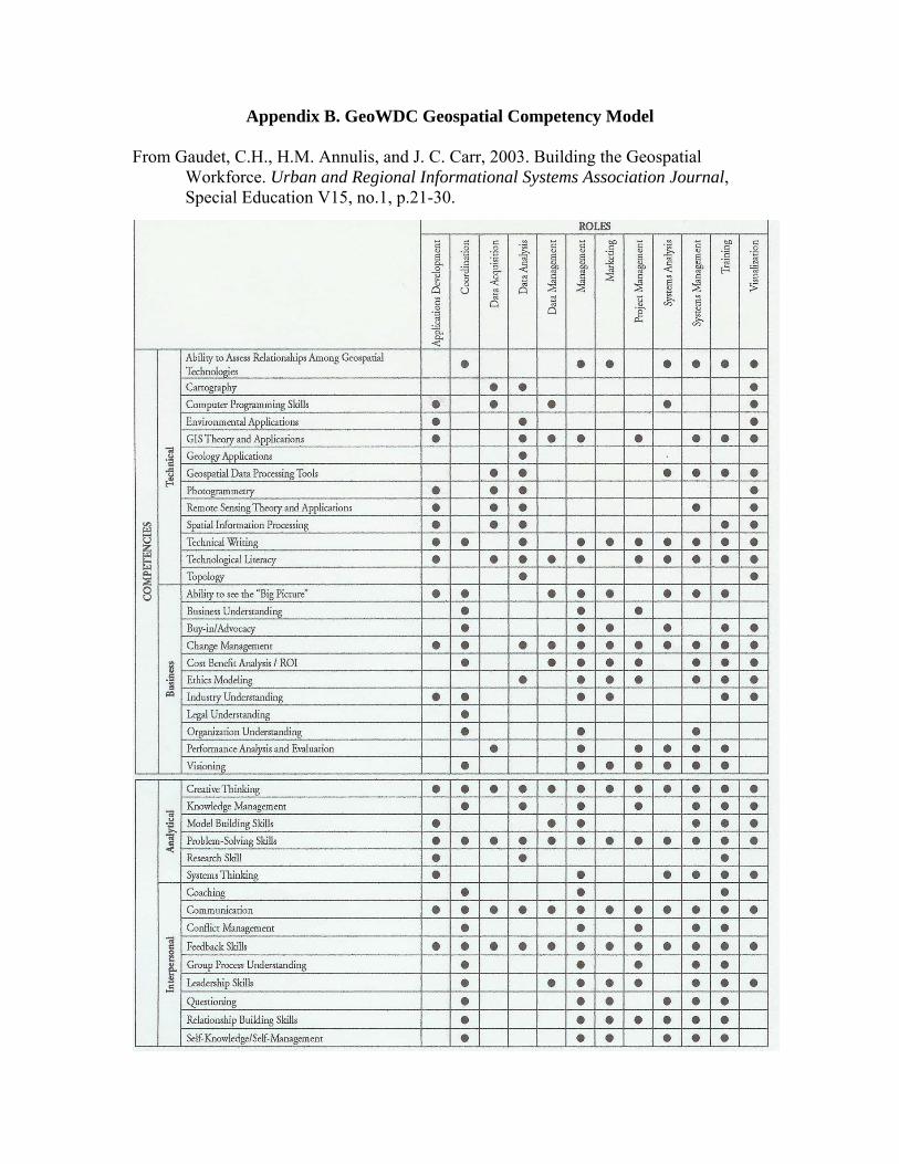
Appendix B. GeoWDC Geospatial Competency Model
From Gaudet, C.H., H.M. Annulis, and J. C. Carr, 2003. Building the Geospatial Workforce. Urban and Regional Informational Systems Association Journal, Special Education V15, no.1, p.21-30.

Appendix C. Recommendations for Closing the Gap between Geospatial Workforce
Demand and Supply
From Defining and Communication Geospatial Industry Workforce Demand Phase I Report, Draft for Comment
GITA, 2006.
Recommendations for Closing the Gap between Geospatial Workforce Demand and Supply
• GIS education needs to become much more prevalent in all levels and links between related areas of study, such as CAD design classes, to geospatial applications need to be strengthened. The percentage of students enrolled in GIS programs needs to be significantly increased through aggressive outreach campaigns and by building awareness of the geospatial industry in general.
• Geographical sciences and geospatial technologies must be embedded in core curricula of K-12 and K-16. The entire educational continuum (from K-12, community colleges, undergraduate and graduate programs, to life-long continuing education) must be involved.
• The National Research Council’s publication Learning to Think Spatially: GIS as a Support System in the K-12 Curriculum should be used to better integrate geospatial thinking into existing courses. The report is available on line at http://www.nap.edu/catalog/11019.html.
• In addition to the NRC report, efforts by professional associations, such as the AAG’s Enhancing Departments and Graduate Educations (EDGE) project and Teacher’s Guide to Modern Geography, the forthcoming Geographic Information Science and Technology (GI S&T) Body of Knowledge, and the NCGIA’s Core Curriculum in GISci, should be leveraged to help build a comprehensive educational strategy to help meet the current and future geospatial workforce demand.
• Employers and educators must work together to develop effective strategies to close the gap between geospatial workforce demand and supply. The geospatial industry must articulate its workforce needs to ensure that educators respond with curricula that result in appropriately educated and trained individuals.
• Two year (community-based) colleges should assume a strong role in training new geospatial technologists and meeting on-the-job training needs of local professionals.
Within social, behavioral and economic sciences, there is not enough emphasis on use of geospatial methods and techniques. There is a need for training in spatial analysis within the domains of statistics and quantitative analysis.
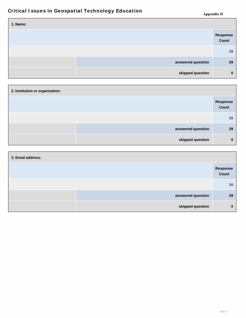
Critical Issues in Geospatial Technology Education
1. Name:
Response
Count
39
answered question 39
skipped question 0
2. Institution or organization:
Response
Count
39
answered question 39
skipped question 0
3. Email address:
Response
Count
39
answered question 39
skipped question 0
Page 1
Appendix D
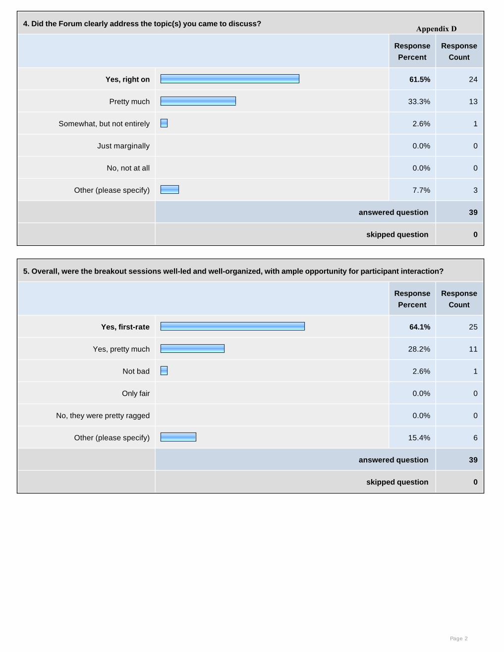
4. Did the Forum clearly address the topic(s) you came to discuss?
Response
Percent
Response
Count
Yes, right on 61.5% 24
Pretty much 33.3% 13
Somewhat, but not entirely 2.6% 1
Just marginally 0.0% 0
No, not at all 0.0% 0
Other (please specify) 7.7% 3
answered question 39
skipped question 0
5. Overall, were the breakout sessions well-led and well-organized, with ample opportunity for participant interaction?
Response
Percent
Response
Count
Yes, first-rate 64.1% 25
Yes, pretty much 28.2% 11
Not bad 2.6% 1
Only fair 0.0% 0
No, they were pretty ragged 0.0% 0
Other (please specify) 15.4% 6
answered question 39
skipped question 0
Page 2
Appendix D
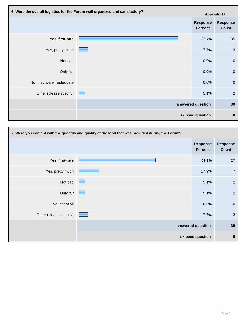
6. Were the overall logistics for the Forum well organized and satisfactory?
Response
Percent
Response
Count
Yes, first-rate 89.7% 35
Yes, pretty much 7.7% 3
Not bad 0.0% 0
Only fair 0.0% 0
No, they were inadequate 0.0% 0
Other (please specify) 5.1% 2
answered question 39
skipped question 0
7. Were you content with the quantity and quality of the food that was provided during the Forum?
Response
Percent
Response
Count
Yes, first-rate 69.2% 27
Yes, pretty much 17.9% 7
Not bad 5.1% 2
Only fair 5.1% 2
No, not at all 0.0% 0
Other (please specify) 7.7% 3
answered question 39
skipped question 0
Page 3
Appendix D
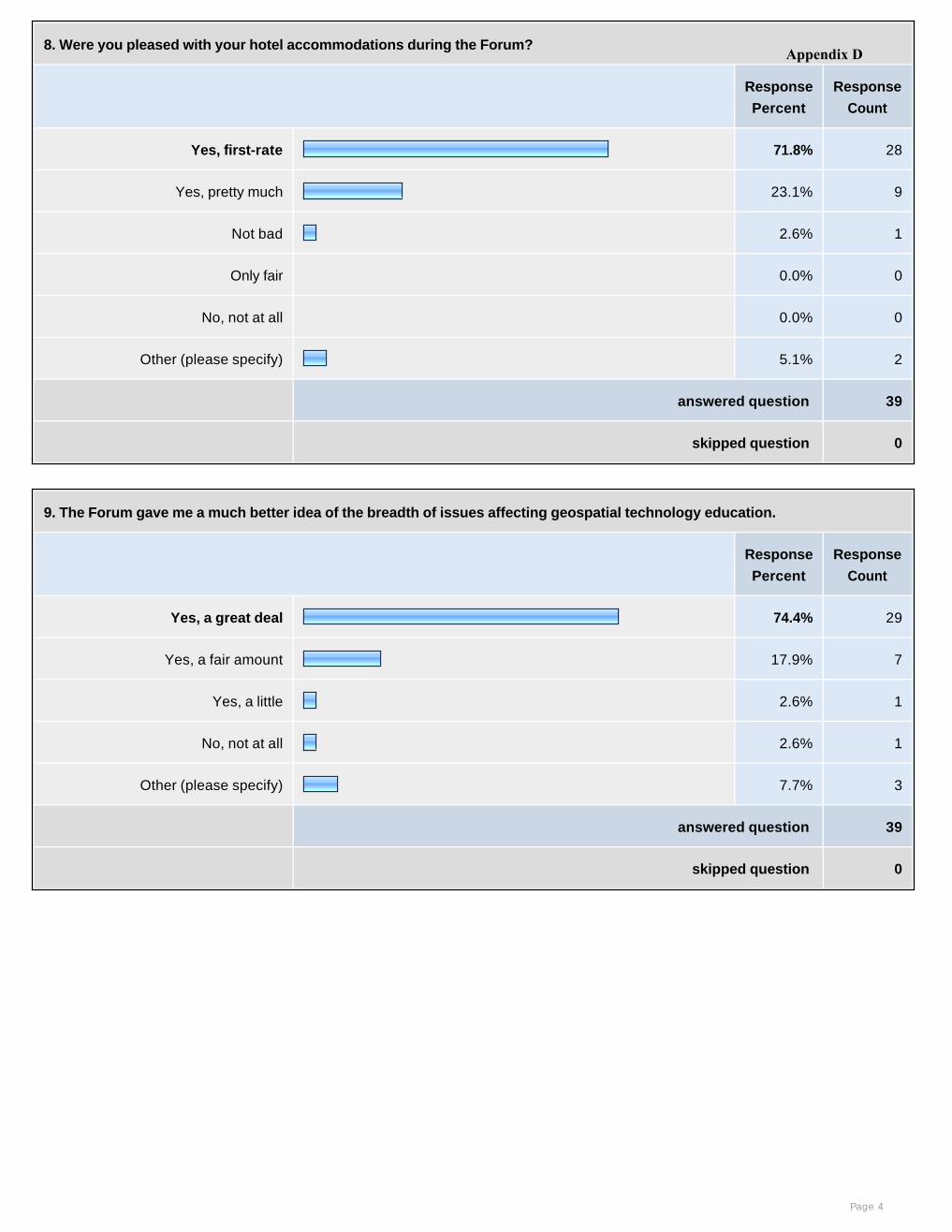
8. Were you pleased with your hotel accommodations during the Forum?
Response
Percent
Response
Count
Yes, first-rate 71.8% 28
Yes, pretty much 23.1% 9
Not bad 2.6% 1
Only fair 0.0% 0
No, not at all 0.0% 0
Other (please specify) 5.1% 2
answered question 39
skipped question 0
9. The Forum gave me a much better idea of the breadth of issues affecting geospatial technology education.
Response
Percent
Response
Count
Yes, a great deal 74.4% 29
Yes, a fair amount 17.9% 7
Yes, a little 2.6% 1
No, not at all 2.6% 1
Other (please specify) 7.7% 3
answered question 39
skipped question 0
Page 4
Appendix D
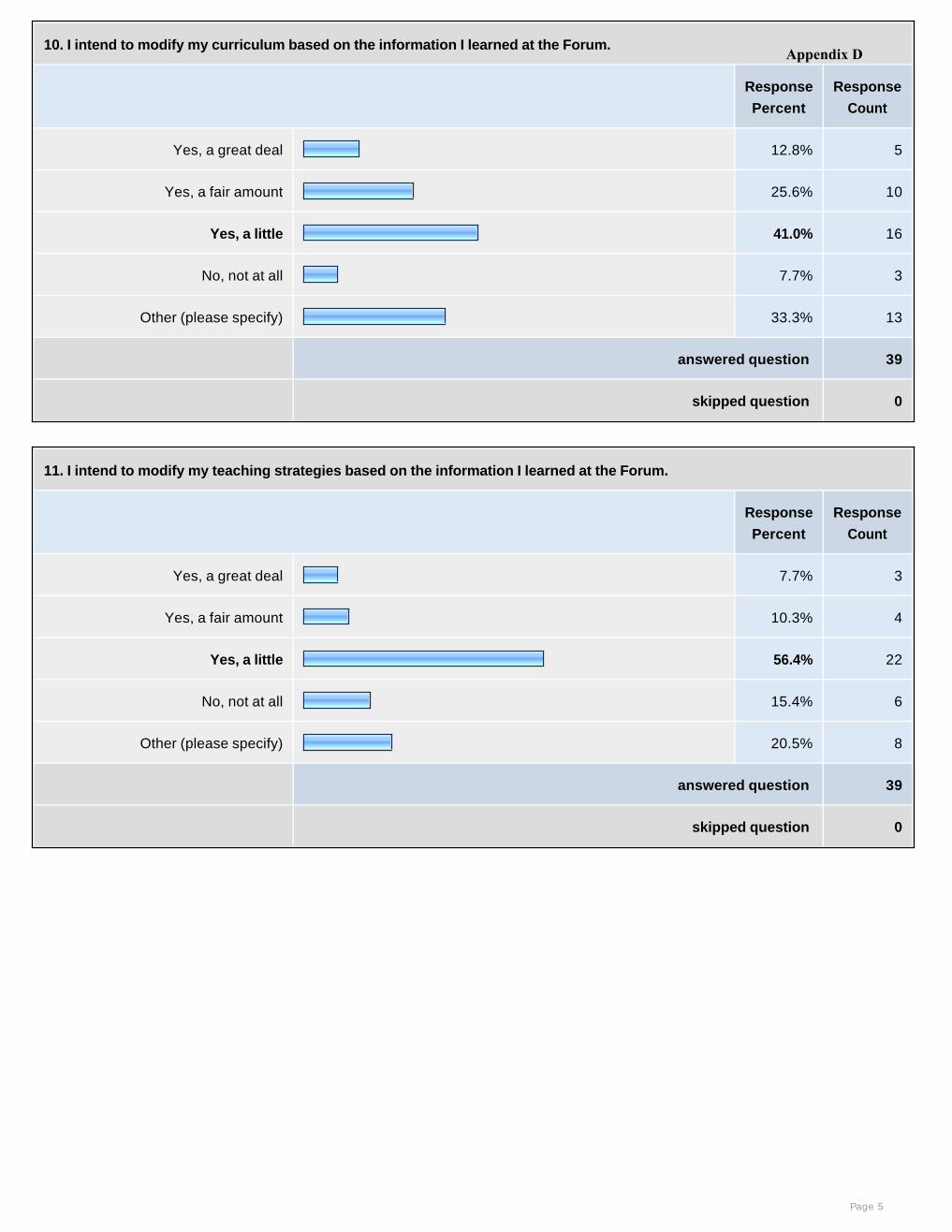
10. I intend to modify my curriculum based on the information I learned at the Forum.
Response
Percent
Response
Count
Yes, a great deal 12.8% 5
Yes, a fair amount 25.6% 10
Yes, a little 41.0% 16
No, not at all 7.7% 3
Other (please specify) 33.3% 13
answered question 39
skipped question 0
11. I intend to modify my teaching strategies based on the information I learned at the Forum.
Response
Percent
Response
Count
Yes, a great deal 7.7% 3
Yes, a fair amount 10.3% 4
Yes, a little 56.4% 22
No, not at all 15.4% 6
Other (please specify) 20.5% 8
answered question 39
skipped question 0
Page 5
Appendix D
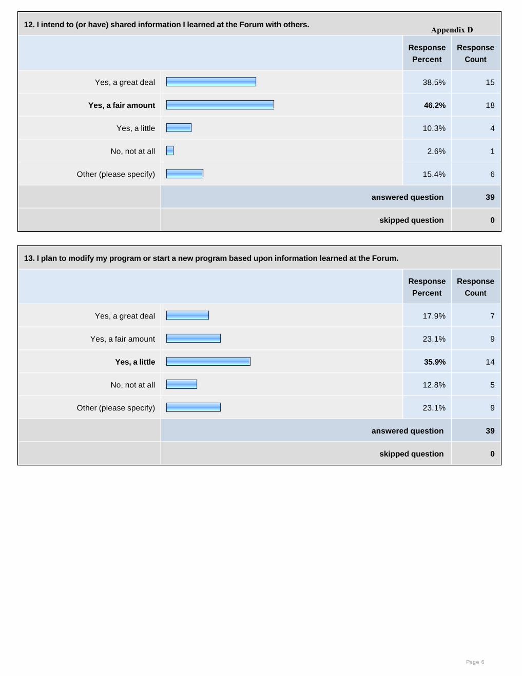
12. I intend to (or have) shared information I learned at the Forum with others.
Response
Percent
Response
Count
Yes, a great deal 38.5% 15
Yes, a fair amount 46.2% 18
Yes, a little 10.3% 4
No, not at all 2.6% 1
Other (please specify) 15.4% 6
answered question 39
skipped question 0
13. I plan to modify my program or start a new program based upon information learned at the Forum.
Response
Percent
Response
Count
Yes, a great deal 17.9% 7
Yes, a fair amount 23.1% 9
Yes, a little 35.9% 14
No, not at all 12.8% 5
Other (please specify) 23.1% 9
answered question 39
skipped question 0
Page 6
Appendix D
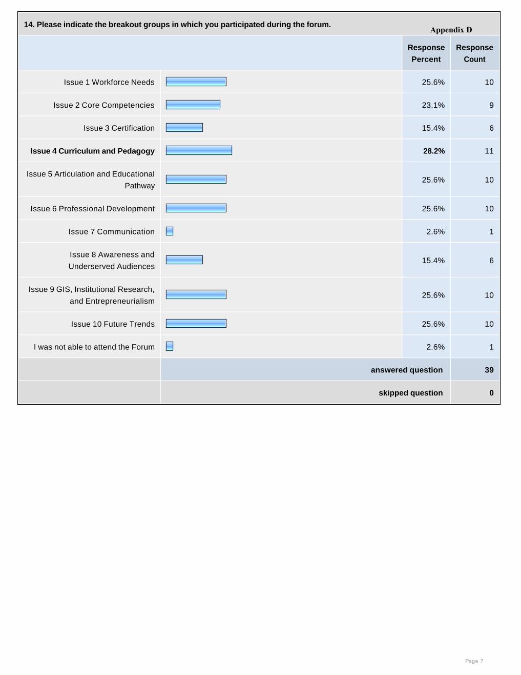
14. Please indicate the breakout groups in which you participated during the forum.
Response
Percent
Response
Count
Issue 1 Workforce Needs 25.6% 10
Issue 2 Core Competencies 23.1% 9
Issue 3 Certification 15.4% 6
Issue 4 Curriculum and Pedagogy 28.2% 11
Issue 5 Articulation and Educational
Pathway25.6% 10
Issue 6 Professional Development 25.6% 10
Issue 7 Communication 2.6% 1
Issue 8 Awareness and
Underserved Audiences15.4% 6
Issue 9 GIS, Institutional Research,
and Entrepreneurialism25.6% 10
Issue 10 Future Trends 25.6% 10
I was not able to attend the Forum 2.6% 1
answered question 39
skipped question 0
Page 7
Appendix D
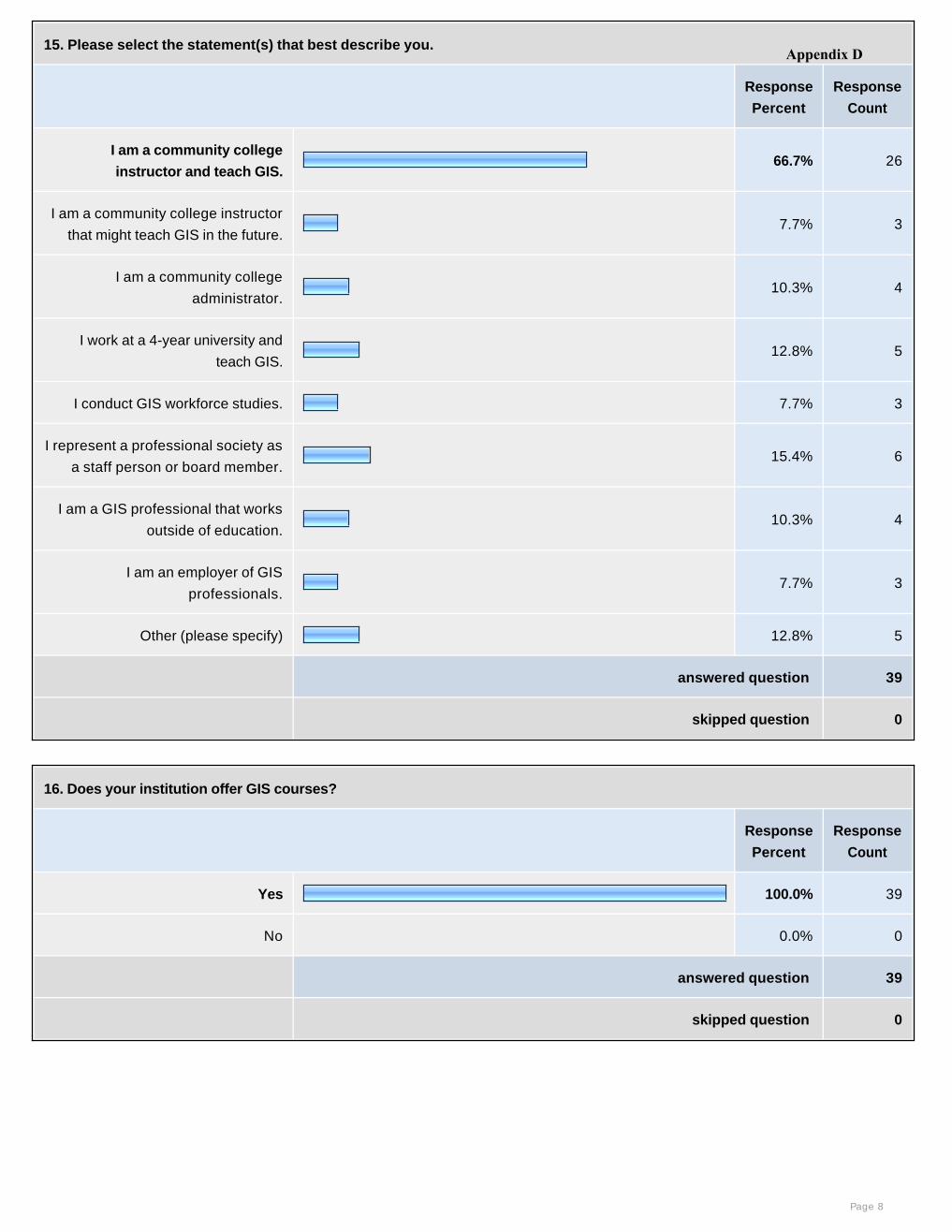
15. Please select the statement(s) that best describe you.
Response
Percent
Response
Count
I am a community college
instructor and teach GIS.66.7% 26
I am a community college instructor
that might teach GIS in the future.7.7% 3
I am a community college
administrator.10.3% 4
I work at a 4-year university and
teach GIS.12.8% 5
I conduct GIS workforce studies. 7.7% 3
I represent a professional society as
a staff person or board member.15.4% 6
I am a GIS professional that works
outside of education.10.3% 4
I am an employer of GIS
professionals.7.7% 3
Other (please specify) 12.8% 5
answered question 39
skipped question 0
16. Does your institution offer GIS courses?
Response
Percent
Response
Count
Yes 100.0% 39
No 0.0% 0
answered question 39
skipped question 0
Page 8
Appendix D

17. Does your institution offer a GIS certificate or degree?
Response
Percent
Response
Count
No 12.8% 5
A GIS certificate 64.1% 25
A GIS degree 41.0% 16
We plan to offer a GIS certificate or
degree in the future17.9% 7
answered question 39
skipped question 0
18. Which disciplines at your institution are associated with a GIS curriculum? (Check all that apply.)
Response
Percent
Response
Count
None 5.1% 2
Agriculture 10.3% 4
Art 0.0% 0
Archeology 15.4% 6
Biological Science 17.9% 7
Business 17.9% 7
Computer Science and Information
Systems 20.5% 8
Criminal justice 10.3% 4
Economics 5.1% 2
Engineering 7.7% 3
Fire Protection/Science 2.6% 1
Geography 48.7% 19
Geology 30.8% 12
Health (nursing and medical
related) 2.6% 1
Page 9
Appendix D
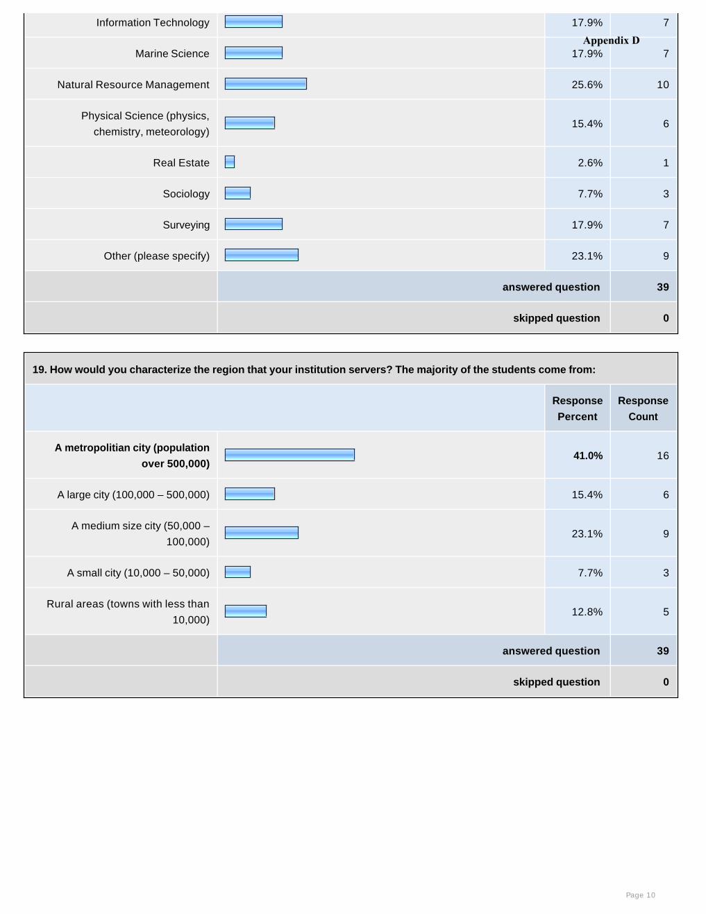
Information Technology 17.9% 7
Marine Science 17.9% 7
Natural Resource Management 25.6% 10
Physical Science (physics,
chemistry, meteorology) 15.4% 6
Real Estate 2.6% 1
Sociology 7.7% 3
Surveying 17.9% 7
Other (please specify) 23.1% 9
answered question 39
skipped question 0
19. How would you characterize the region that your institution servers? The majority of the students come from:
Response
Percent
Response
Count
A metropolitian city (population
over 500,000)41.0% 16
A large city (100,000 – 500,000) 15.4% 6
A medium size city (50,000 –
100,000)23.1% 9
A small city (10,000 – 50,000) 7.7% 3
Rural areas (towns with less than
10,000)12.8% 5
answered question 39
skipped question 0
Page 10
Appendix D

20. A National Geospatial Technology Center (NGTC) will thoroughly research former workforce assessment efforts and
practices before starting or recommending new studies.
Response
Percent
Response
Count
High Priority (a center must do this) 48.7% 19
Medium Priority (a center should do
this)41.0% 16
Low Priority (only do if time and
money allow) 5.1% 2
A NGTC should not do this. 0.0% 0
I don’t know enough to comment on
this but the statement makes sense.5.1% 2
This statement does not make
sense. 0.0% 0
0.0% 0
answered question 39
skipped question 0
Page 11
Appendix D

21. A NGTC will encourage new DACUMs to be conducted by partner institutions and others across the country.
DACUM stands for "Developing A CurriculUM". The DACUM process is a structured type of occupational or task analysis that is used by businesses, industry, and educational institutions to identify knowledge and skills required to perform the job. See www.dacumohiostate.com/ for more information.
Response
Percent
Response
Count
High Priority (a center must do this) 25.6% 10
Medium Priority (a center should
do this)53.8% 21
Low Priority (only do if time and
money allow) 15.4% 6
A NGTC should not do this. 2.6% 1
I don’t know enough to comment on
this but the statement makes sense.2.6% 1
This statement does not make
sense. 0.0% 0
0.0% 0
answered question 39
skipped question 0
Page 12
Appendix D
22. A NGTC will organize, compile, and compare past and future DACUMs and make the results available on the center website.
By maintaining a repository of DACUMS, the center can better recommend future DACUMs in terms of geography and job titles to examine. It was also noted that DACUMS should be conducted for occupations where GIS is considered an ancillary knowledge and skill set (e.g. resource management, crime analysis, etc.). It was also noted that DACUM participants, many times, come from the public sector. It is recommended that a center encourage greater participation from the private sector. There is skepticism regarding whether or not a core set of tasks can be identified across several DACUMs. It was also noted that DACUMs are not possible in worker-poor, expert-poor regions.
Response
Percent
Response
Count
High Priority (a center must do this) 51.3% 20
Medium Priority (a center should do
this)38.5% 15
Low Priority (only do if time and
money allow) 10.3% 4
A NGTC should not do this. 0.0% 0
I don’t know enough to comment on
this but the statement makes sense. 0.0% 0
This statement does not make
sense. 0.0% 0
0.0% 0
answered question 39
skipped question 0
Page 13
Appendix D

23. The NGTC will complement the DACUM process with other techniques, such as “environmental scans” that identify regional
economic trends and assist practitioners in defining current and future workforce needs.
Response
Percent
Response
Count
High Priority (a center must do this)
Medium Priority (a center should
do this)
61.5% 24
Low Priority (only do if time and
money allow) 30.8% 12
A NGTC should not do this. 2.6% 1
I don’t know enough to comment on
this but the statement makes sense.5.1% 2
This statement does not make
sense. 0.0% 0
0.0% 0
answered question 39
skipped question 0
Page 14
Appendix D
24. A NGTC will link DACUM tasks to the Body of Knowledge.
The Body of Knowledge (BoK) attempts to define the scope breadth of GI Science and Technology. This effort has been undertaken by UCGIS. Please see www.ucgis.org/priorities/education/modelcurriculaproject.asp for more information or refer to the BoK book you received at the Forum.
Response
Percent
Response
Count
High Priority (a center must do this) 38.5% 15
Medium Priority (a center should
do this)41.0% 16
Low Priority (only do if time and
money allow) 17.9% 7
A NGTC should not do this. 2.6% 1
I don’t know enough to comment on
this but the statement makes sense. 0.0% 0
This statement does not make
sense. 0.0% 0
0.0% 0
answered question 39
skipped question 0
Page 15
Appendix D
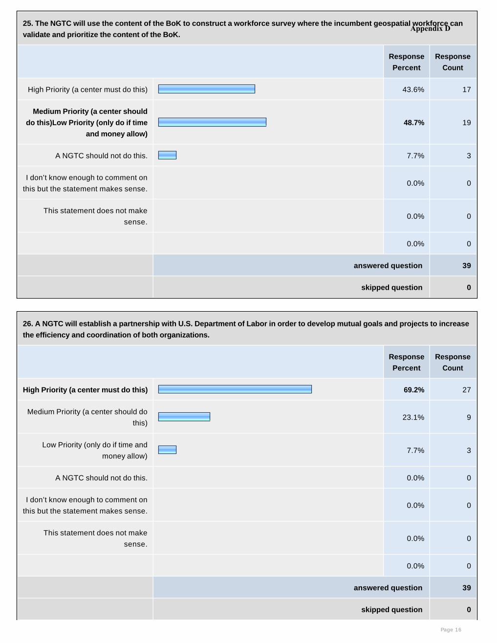
25. The NGTC will use the content of the BoK to construct a workforce survey where the incumbent geospatial workforce can
validate and prioritize the content of the BoK.
Response
Percent
Response
Count
High Priority (a center must do this) 43.6% 17
Medium Priority (a center should
do this)Low Priority (only do if time
and money allow)
48.7% 19
A NGTC should not do this. 7.7% 3
I don’t know enough to comment on
this but the statement makes sense. 0.0% 0
This statement does not make
sense. 0.0% 0
0.0% 0
answered question 39
skipped question 0
26. A NGTC will establish a partnership with U.S. Department of Labor in order to develop mutual goals and projects to increase
the efficiency and coordination of both organizations.
Response
Percent
Response
Count
High Priority (a center must do this) 69.2% 27
Medium Priority (a center should do
this)23.1% 9
Low Priority (only do if time and
money allow) 7.7% 3
A NGTC should not do this. 0.0% 0
I don’t know enough to comment on
this but the statement makes sense. 0.0% 0
This statement does not make
sense. 0.0% 0
0.0% 0
answered question 39
skipped question 0
Page 16
Appendix D
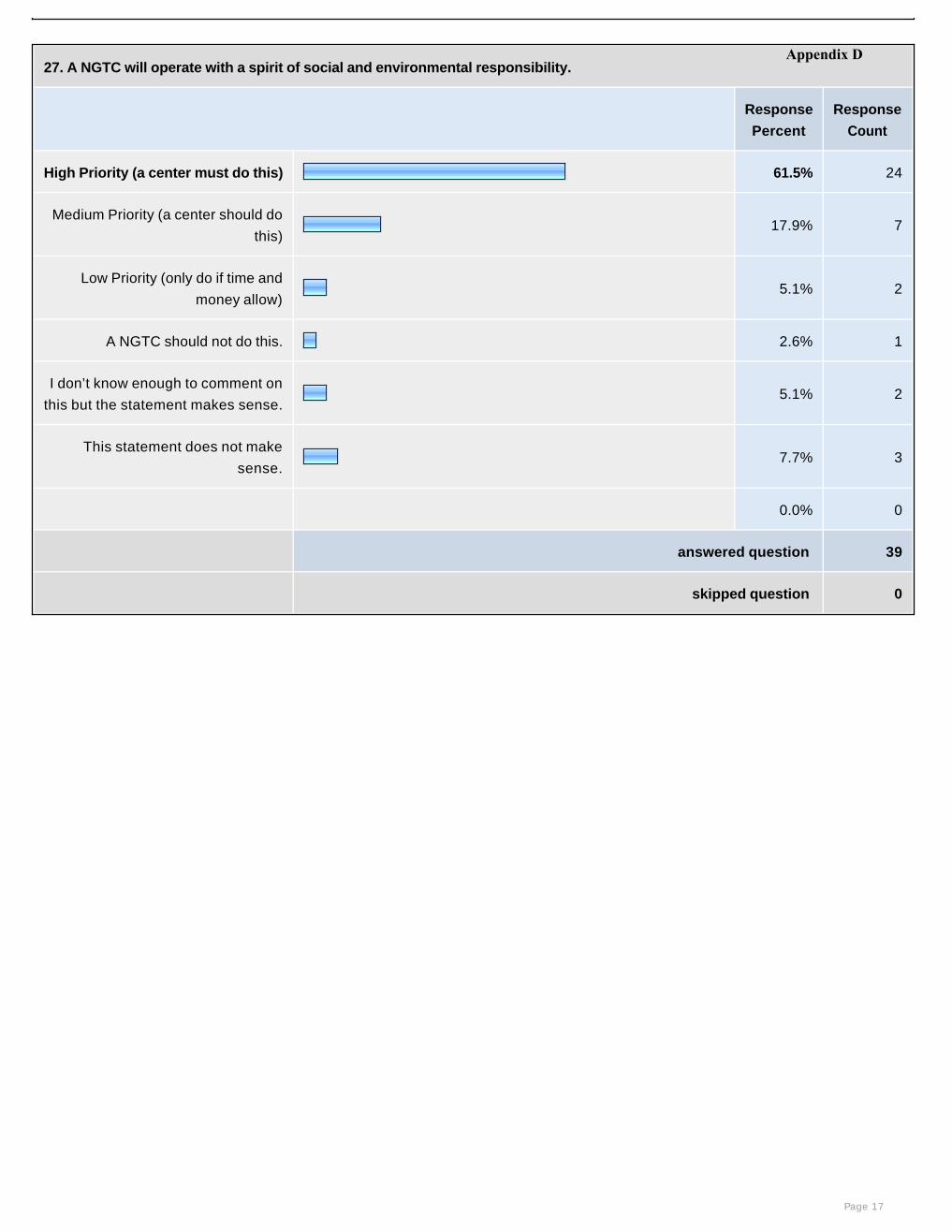
27. A NGTC will operate with a spirit of social and environmental responsibility.
Response
Percent
Response
Count
High Priority (a center must do this) 61.5% 24
Medium Priority (a center should do
this)17.9% 7
Low Priority (only do if time and
money allow) 5.1% 2
A NGTC should not do this. 2.6% 1
I don’t know enough to comment on
this but the statement makes sense.5.1% 2
This statement does not make
sense.7.7% 3
0.0% 0
answered question 39
skipped question 0
Page 17
Appendix D
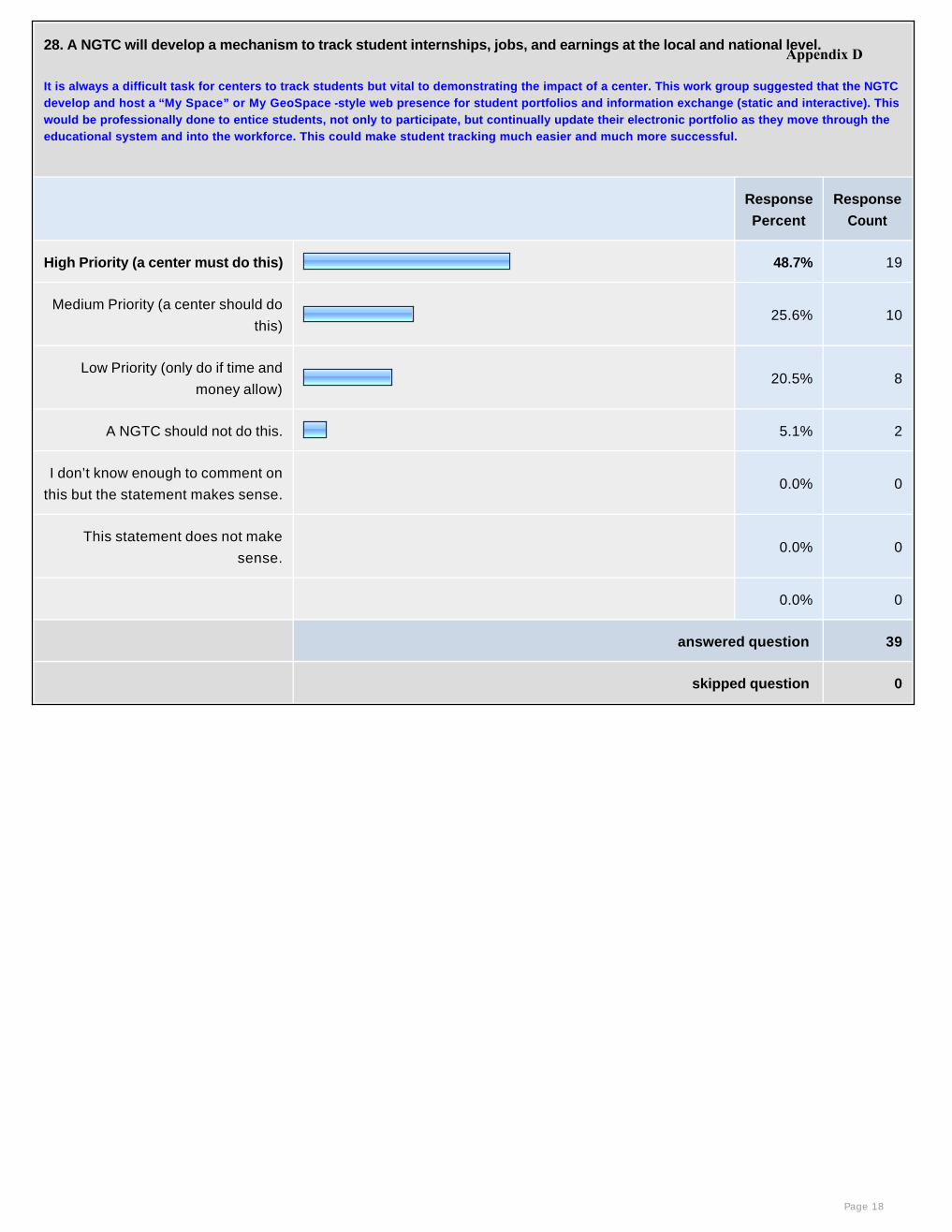
28. A NGTC will develop a mechanism to track student internships, jobs, and earnings at the local and national level.
It is always a difficult task for centers to track students but vital to demonstrating the impact of a center. This work group suggested that the NGTC develop and host a “My Space” or My GeoSpace -style web presence for student portfolios and information exchange (static and interactive). This would be professionally done to entice students, not only to participate, but continually update their electronic portfolio as they move through the educational system and into the workforce. This could make student tracking much easier and much more successful.
Response
Percent
Response
Count
High Priority (a center must do this) 48.7% 19
Medium Priority (a center should do
this)25.6% 10
Low Priority (only do if time and
money allow) 20.5% 8
A NGTC should not do this. 5.1% 2
I don’t know enough to comment on
this but the statement makes sense. 0.0% 0
This statement does not make
sense. 0.0% 0
0.0% 0
answered question 39
skipped question 0
Page 18
Appendix D
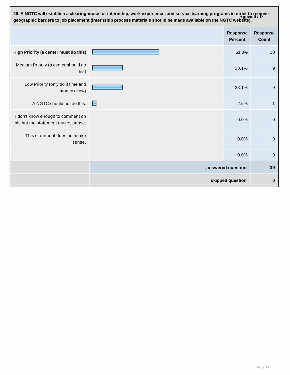
29. A NGTC will establish a clearinghouse for internship, work experience, and service learning programs in order to remove
geographic barriers to job placement (internship process materials should be made available on the NGTC website).
Response
Percent
Response
Count
High Priority (a center must do this) 51.3% 20
Medium Priority (a center should do
this)23.1% 9
Low Priority (only do if time and
money allow) 23.1% 9
A NGTC should not do this. 2.6% 1
I don’t know enough to comment on
this but the statement makes sense. 0.0% 0
This statement does not make
sense. 0.0% 0
0.0% 0
answered question 39
skipped question 0
Page 19
Appendix D
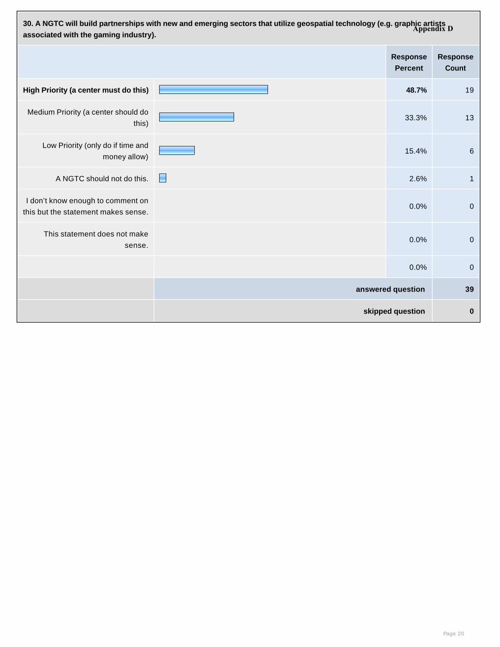
30. A NGTC will build partnerships with new and emerging sectors that utilize geospatial technology (e.g. graphic artists
associated with the gaming industry).
Response
Percent
Response
Count
High Priority (a center must do this) 48.7% 19
Medium Priority (a center should do
this)33.3% 13
Low Priority (only do if time and
money allow) 15.4% 6
A NGTC should not do this. 2.6% 1
I don’t know enough to comment on
this but the statement makes sense. 0.0% 0
This statement does not make
sense. 0.0% 0
0.0% 0
answered question 39
skipped question 0
Page 20
Appendix D
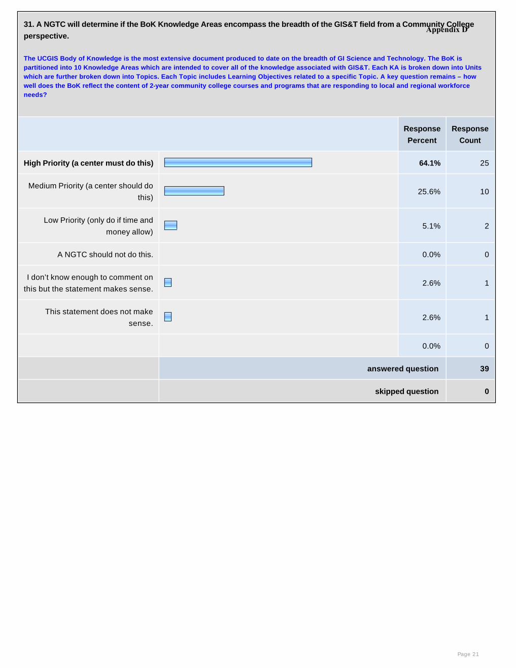
31. A NGTC will determine if the BoK Knowledge Areas encompass the breadth of the GIS&T field from a Community College
perspective.
The UCGIS Body of Knowledge is the most extensive document produced to date on the breadth of GI Science and Technology. The BoK is partitioned into 10 Knowledge Areas which are intended to cover all of the knowledge associated with GIS&T. Each KA is broken down into Units which are further broken down into Topics. Each Topic includes Learning Objectives related to a specific Topic. A key question remains – how well does the BoK reflect the content of 2-year community college courses and programs that are responding to local and regional workforce needs?
Response
Percent
Response
Count
High Priority (a center must do this) 64.1% 25
Medium Priority (a center should do
this)25.6% 10
Low Priority (only do if time and
money allow) 5.1% 2
A NGTC should not do this. 0.0% 0
I don’t know enough to comment on
this but the statement makes sense.2.6% 1
This statement does not make
sense.2.6% 1
0.0% 0
answered question 39
skipped question 0
Page 21
Appendix D
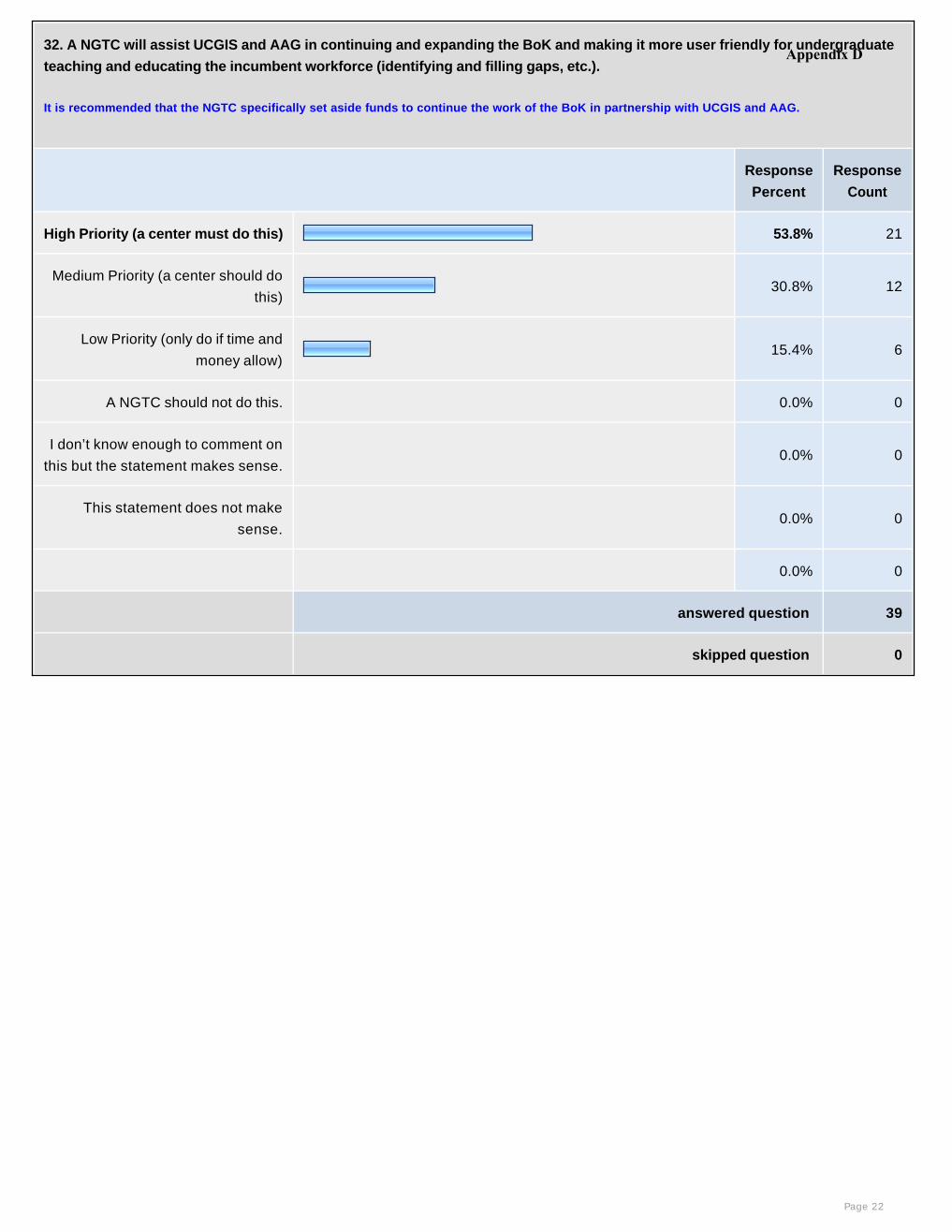
32. A NGTC will assist UCGIS and AAG in continuing and expanding the BoK and making it more user friendly for undergraduate
teaching and educating the incumbent workforce (identifying and filling gaps, etc.).
It is recommended that the NGTC specifically set aside funds to continue the work of the BoK in partnership with UCGIS and AAG.
Response
Percent
Response
Count
High Priority (a center must do this) 53.8% 21
Medium Priority (a center should do
this)30.8% 12
Low Priority (only do if time and
money allow) 15.4% 6
A NGTC should not do this. 0.0% 0
I don’t know enough to comment on
this but the statement makes sense. 0.0% 0
This statement does not make
sense. 0.0% 0
0.0% 0
answered question 39
skipped question 0
Page 22
Appendix D
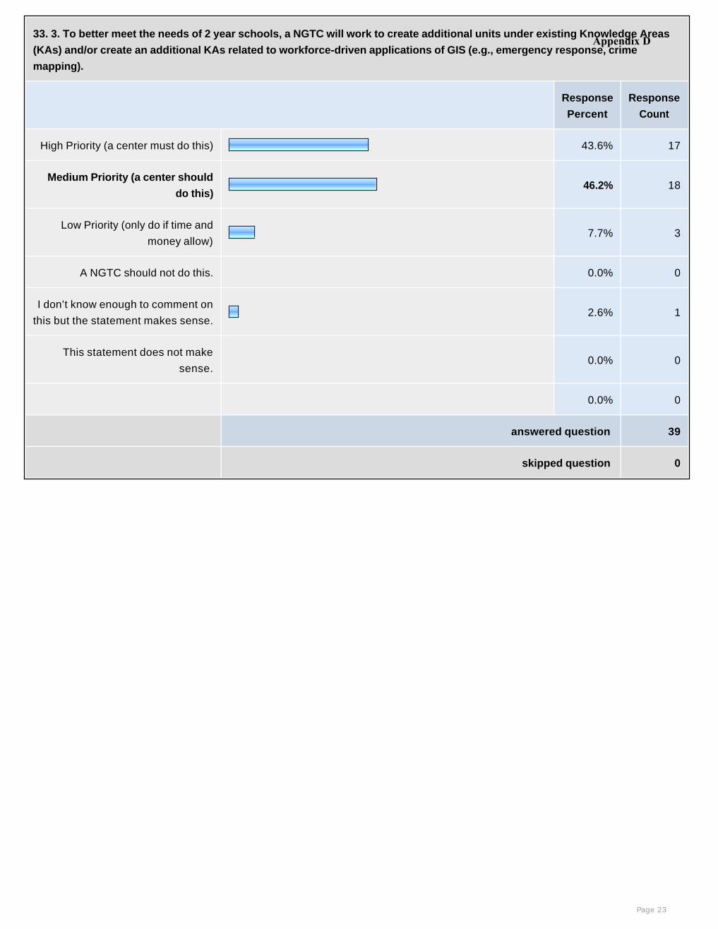
33. 3. To better meet the needs of 2 year schools, a NGTC will work to create additional units under existing Knowledge Areas
(KAs) and/or create an additional KAs related to workforce-driven applications of GIS (e.g., emergency response, crime
mapping).
Response
Percent
Response
Count
High Priority (a center must do this) 43.6% 17
Medium Priority (a center should
do this)46.2% 18
Low Priority (only do if time and
money allow) 7.7% 3
A NGTC should not do this. 0.0% 0
I don’t know enough to comment on
this but the statement makes sense.2.6% 1
This statement does not make
sense. 0.0% 0
0.0% 0
answered question 39
skipped question 0
Page 23
Appendix D
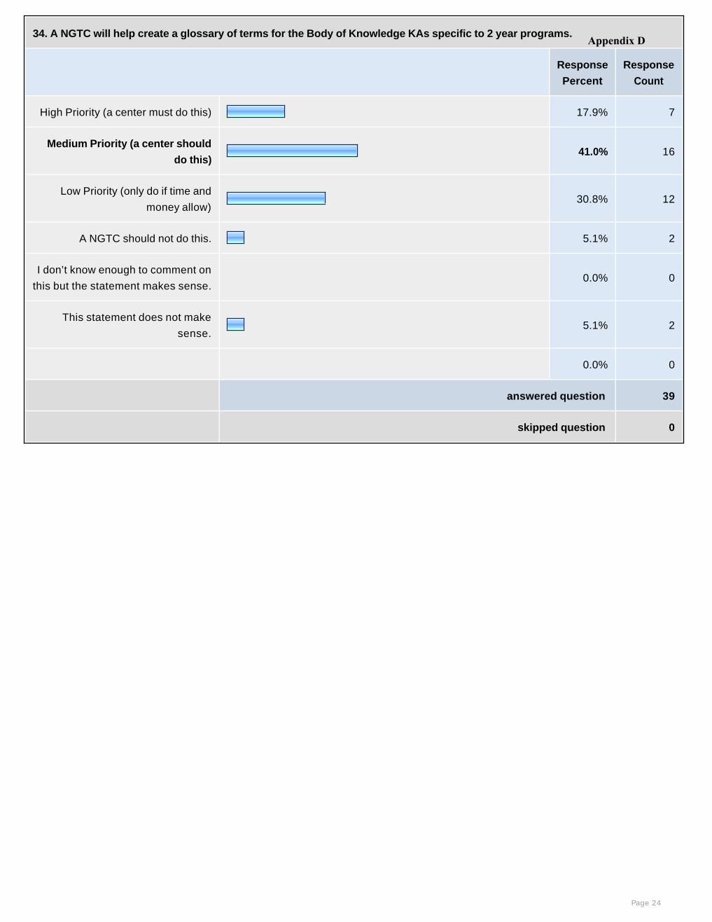
34. A NGTC will help create a glossary of terms for the Body of Knowledge KAs specific to 2 year programs.
Response
Percent
Response
Count
High Priority (a center must do this) 17.9% 7
Medium Priority (a center should
do this)41.0% 16
Low Priority (only do if time and
money allow) 30.8% 12
A NGTC should not do this. 5.1% 2
I don’t know enough to comment on
this but the statement makes sense. 0.0% 0
This statement does not make
sense.5.1% 2
0.0% 0
answered question 39
skipped question 0
Page 24
Appendix D

35. A NGTC will establish partnerships with other academic centers and industries to align Knowledge Areas with sector-
specific applications of GIS (e.g. agriculture, forestry).
Response
Percent
Response
Count
High Priority (a center must do this) 53.8% 21
Medium Priority (a center should do
this)28.2% 11
Low Priority (only do if time and
money allow) 17.9% 7
A NGTC should not do this. 0.0% 0
I don’t know enough to comment on
this but the statement makes sense. 0.0% 0
This statement does not make
sense. 0.0% 0
0.0% 0
answered question 39
skipped question 0
Page 25
Appendix D
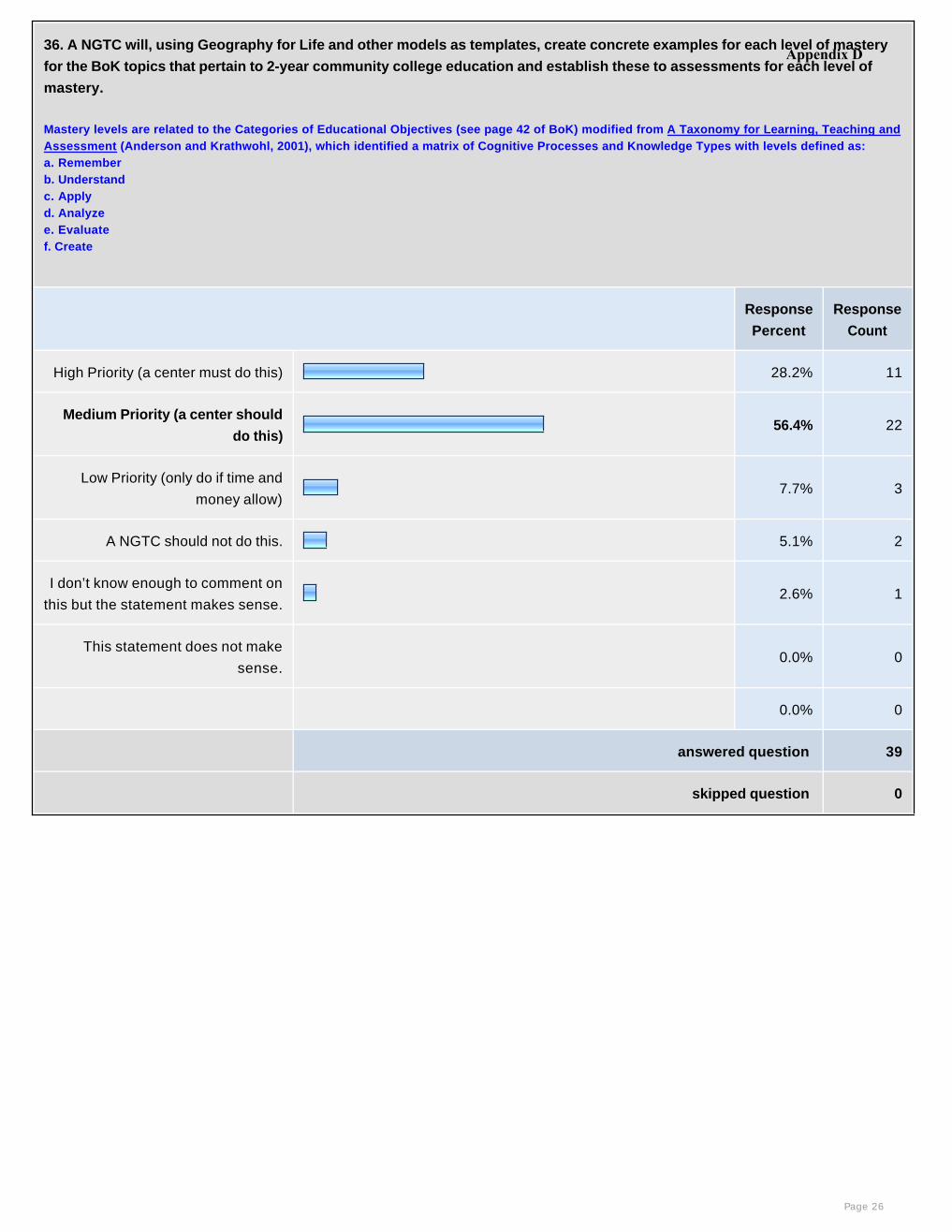
36. A NGTC will, using Geography for Life and other models as templates, create concrete examples for each level of mastery
for the BoK topics that pertain to 2-year community college education and establish these to assessments for each level of
mastery.
Mastery levels are related to the Categories of Educational Objectives (see page 42 of BoK) modified from A Taxonomy for Learning, Teaching and Assessment (Anderson and Krathwohl, 2001), which identified a matrix of Cognitive Processes and Knowledge Types with levels defined as: a. Rememberb. Understandc. Applyd. Analyzee. Evaluatef. Create
Response
Percent
Response
Count
High Priority (a center must do this) 28.2% 11
Medium Priority (a center should
do this)56.4% 22
Low Priority (only do if time and
money allow) 7.7% 3
A NGTC should not do this. 5.1% 2
I don’t know enough to comment on
this but the statement makes sense.2.6% 1
This statement does not make
sense. 0.0% 0
0.0% 0
answered question 39
skipped question 0
Page 26
Appendix D
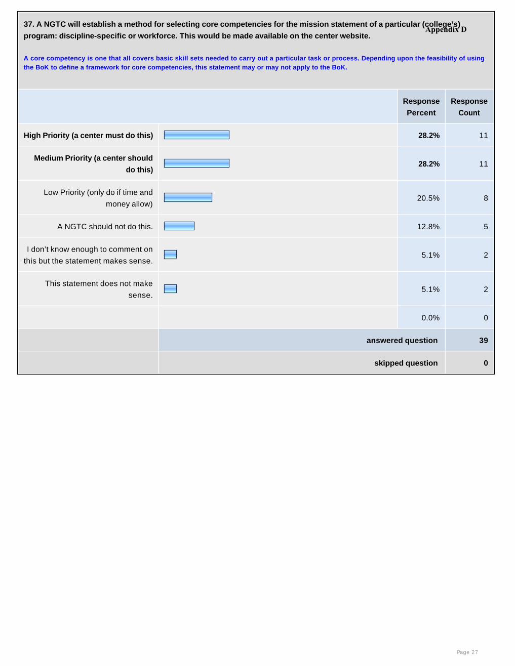
37. A NGTC will establish a method for selecting core competencies for the mission statement of a particular (college’s)
program: discipline-specific or workforce. This would be made available on the center website.
A core competency is one that all covers basic skill sets needed to carry out a particular task or process. Depending upon the feasibility of using the BoK to define a framework for core competencies, this statement may or may not apply to the BoK.
Response
Percent
Response
Count
High Priority (a center must do this) 28.2% 11
Medium Priority (a center should
do this)28.2% 11
Low Priority (only do if time and
money allow) 20.5% 8
A NGTC should not do this. 12.8% 5
I don’t know enough to comment on
this but the statement makes sense.5.1% 2
This statement does not make
sense.5.1% 2
0.0% 0
answered question 39
skipped question 0
Page 27
Appendix D
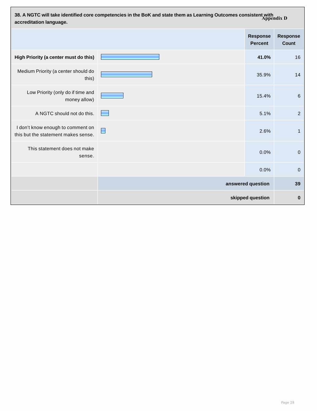
38. A NGTC will take identified core competencies in the BoK and state them as Learning Outcomes consistent with
accreditation language.
Response
Percent
Response
Count
High Priority (a center must do this) 41.0% 16
Medium Priority (a center should do
this)35.9% 14
Low Priority (only do if time and
money allow) 15.4% 6
A NGTC should not do this. 5.1% 2
I don’t know enough to comment on
this but the statement makes sense.2.6% 1
This statement does not make
sense. 0.0% 0
0.0% 0
answered question 39
skipped question 0
Page 28
Appendix D

39. A NGTC will help to broaden the scope of the competencies and Learning Outcomes to all of geospatial technology (remote
sensing, GPS) realizing that the BoK emphasizes GIS.
Response
Percent
Response
Count
High Priority (a center must do this) 41.0% 16
Medium Priority (a center should
do this)41.0% 16
Low Priority (only do if time and
money allow) 12.8% 5
A NGTC should not do this. 5.1% 2
I don’t know enough to comment on
this but the statement makes sense. 0.0% 0
This statement does not make
sense. 0.0% 0
0.0% 0
answered question 39
skipped question 0
Page 29
Appendix D
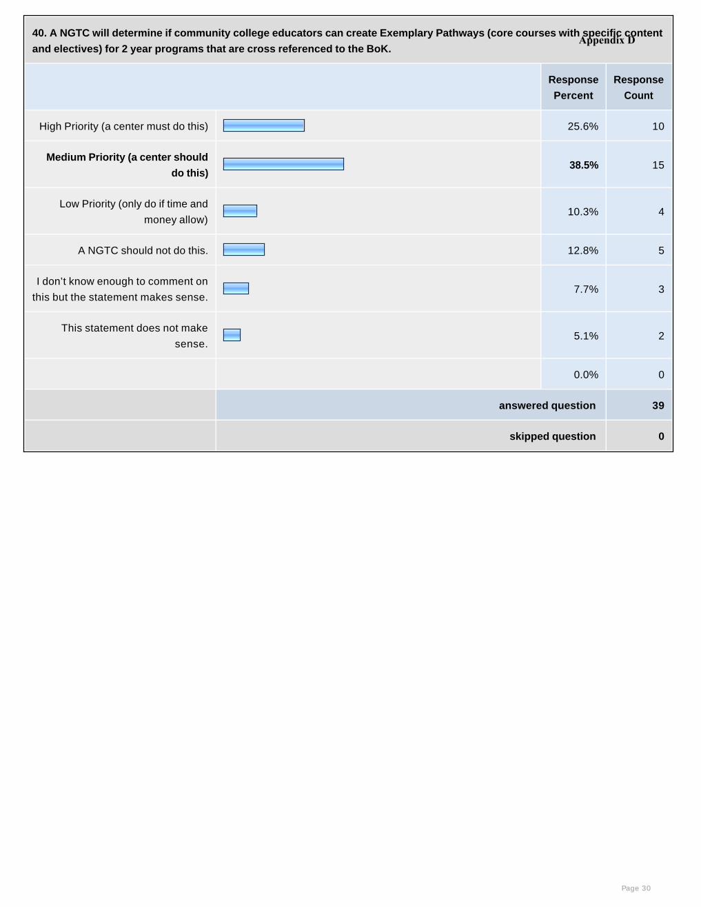
40. A NGTC will determine if community college educators can create Exemplary Pathways (core courses with specific content
and electives) for 2 year programs that are cross referenced to the BoK.
Response
Percent
Response
Count
High Priority (a center must do this) 25.6% 10
Medium Priority (a center should
do this)38.5% 15
Low Priority (only do if time and
money allow) 10.3% 4
A NGTC should not do this. 12.8% 5
I don’t know enough to comment on
this but the statement makes sense.7.7% 3
This statement does not make
sense.5.1% 2
0.0% 0
answered question 39
skipped question 0
Page 30
Appendix D
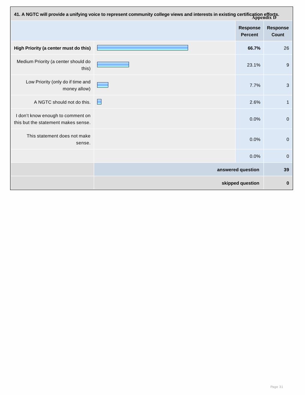
41. A NGTC will provide a unifying voice to represent community college views and interests in existing certification efforts.
Response
Percent
Response
Count
High Priority (a center must do this) 66.7% 26
Medium Priority (a center should do
this)23.1% 9
Low Priority (only do if time and
money allow) 7.7% 3
A NGTC should not do this. 2.6% 1
I don’t know enough to comment on
this but the statement makes sense. 0.0% 0
This statement does not make
sense. 0.0% 0
0.0% 0
answered question 39
skipped question 0
Page 31
Appendix D

42. A NGTC will create a repository of certification and licensing programs and disseminate information about certification and
licensing programs to faculty and students (newsletter, web page, other).
Response
Percent
Response
Count
High Priority (a center must do this) 64.1% 25
Medium Priority (a center should do
this)28.2% 11
Low Priority (only do if time and
money allow) 7.7% 3
A NGTC should not do this. 0.0% 0
I don’t know enough to comment on
this but the statement makes sense. 0.0% 0
This statement does not make
sense. 0.0% 0
0.0% 0
answered question 39
skipped question 0
Page 32
Appendix D

43. A NGTC will evaluate certification options and make recommendations to students, faculty and industry about the
advantages of each.
Response
Percent
Response
Count
High Priority (a center must do this) 35.9% 14
Medium Priority (a center should do
this)28.2% 11
Low Priority (only do if time and
money allow) 23.1% 9
A NGTC should not do this. 7.7% 3
I don’t know enough to comment on
this but the statement makes sense.5.1% 2
This statement does not make
sense. 0.0% 0
0.0% 0
answered question 39
skipped question 0
Page 33
Appendix D
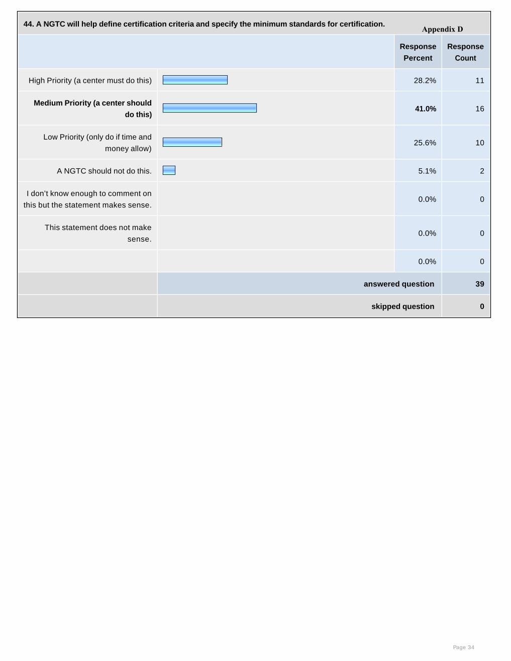
44. A NGTC will help define certification criteria and specify the minimum standards for certification.
Response
Percent
Response
Count
High Priority (a center must do this) 28.2% 11
Medium Priority (a center should
do this)41.0% 16
Low Priority (only do if time and
money allow) 25.6% 10
A NGTC should not do this. 5.1% 2
I don’t know enough to comment on
this but the statement makes sense. 0.0% 0
This statement does not make
sense. 0.0% 0
0.0% 0
answered question 39
skipped question 0
Page 34
Appendix D
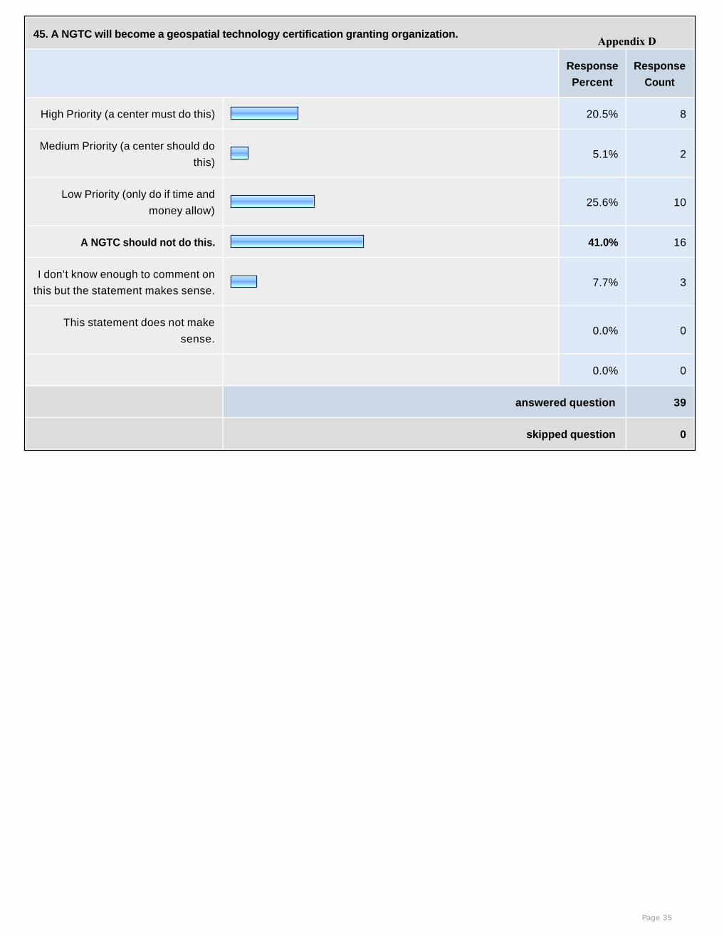
45. A NGTC will become a geospatial technology certification granting organization.
Response
Percent
Response
Count
High Priority (a center must do this) 20.5% 8
Medium Priority (a center should do
this)5.1% 2
Low Priority (only do if time and
money allow) 25.6% 10
A NGTC should not do this. 41.0% 16
I don’t know enough to comment on
this but the statement makes sense.7.7% 3
This statement does not make
sense. 0.0% 0
0.0% 0
answered question 39
skipped question 0
Page 35
Appendix D
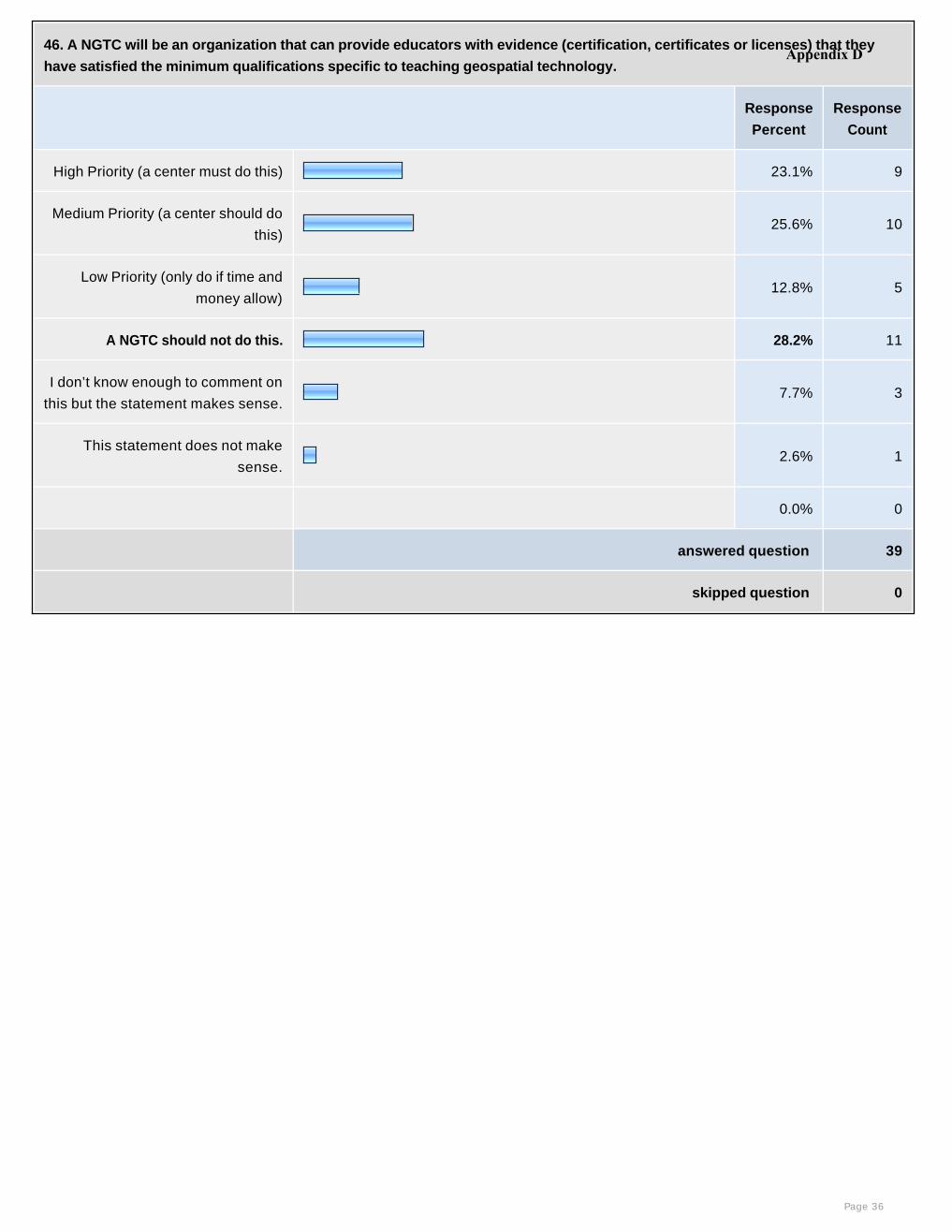
46. A NGTC will be an organization that can provide educators with evidence (certification, certificates or licenses) that they
have satisfied the minimum qualifications specific to teaching geospatial technology.
Response
Percent
Response
Count
High Priority (a center must do this) 23.1% 9
Medium Priority (a center should do
this)25.6% 10
Low Priority (only do if time and
money allow) 12.8% 5
A NGTC should not do this. 28.2% 11
I don’t know enough to comment on
this but the statement makes sense.7.7% 3
This statement does not make
sense.2.6% 1
0.0% 0
answered question 39
skipped question 0
Page 36
Appendix D
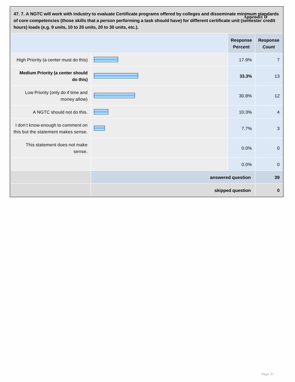
47. 7. A NGTC will work with industry to evaluate Certificate programs offered by colleges and disseminate minimum standards
of core competencies (those skills that a person performing a task should have) for different certificate unit (semester credit
hours) loads (e.g. 9 units, 10 to 20 units, 20 to 30 units, etc.).
Response
Percent
Response
Count
High Priority (a center must do this) 17.9% 7
Medium Priority (a center should
do this)33.3% 13
Low Priority (only do if time and
money allow) 30.8% 12
A NGTC should not do this. 10.3% 4
I don’t know enough to comment on
this but the statement makes sense.7.7% 3
This statement does not make
sense. 0.0% 0
0.0% 0
answered question 39
skipped question 0
Page 37
Appendix D
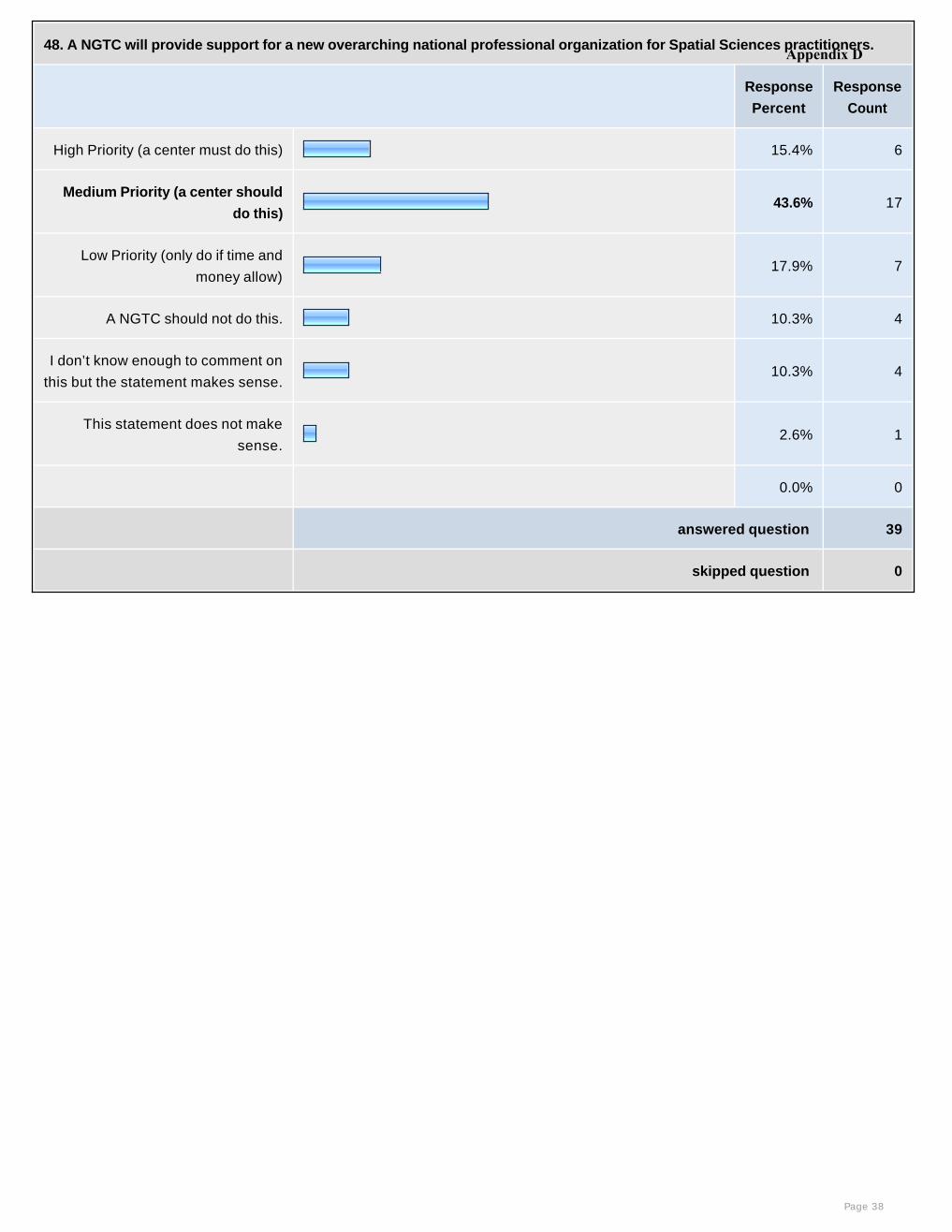
48. A NGTC will provide support for a new overarching national professional organization for Spatial Sciences practitioners.
Response
Percent
Response
Count
High Priority (a center must do this) 15.4% 6
Medium Priority (a center should
do this)43.6% 17
Low Priority (only do if time and
money allow) 17.9% 7
A NGTC should not do this. 10.3% 4
I don’t know enough to comment on
this but the statement makes sense.10.3% 4
This statement does not make
sense.2.6% 1
0.0% 0
answered question 39
skipped question 0
Page 38
Appendix D
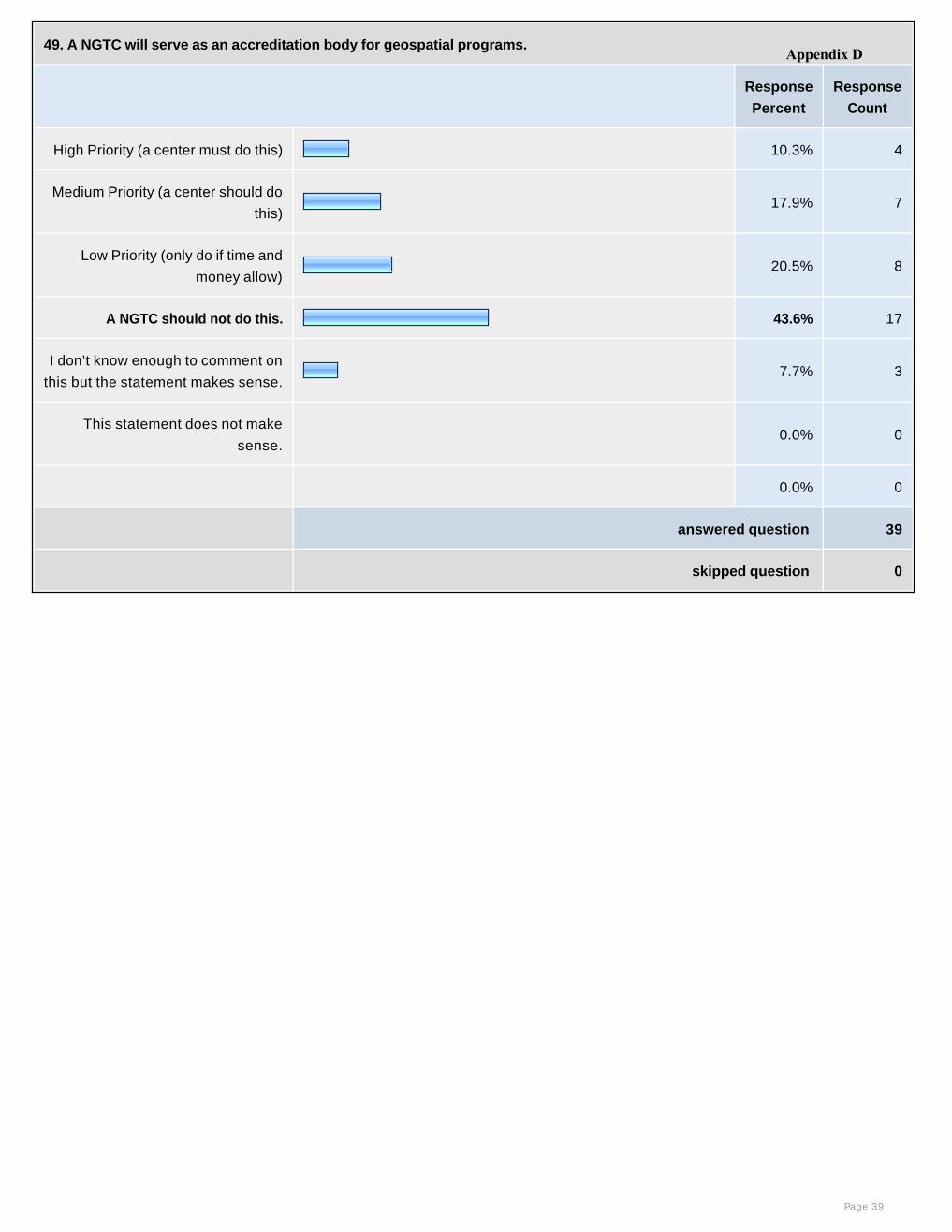
49. A NGTC will serve as an accreditation body for geospatial programs.
Response
Percent
Response
Count
High Priority (a center must do this) 10.3% 4
Medium Priority (a center should do
this)17.9% 7
Low Priority (only do if time and
money allow) 20.5% 8
A NGTC should not do this. 43.6% 17
I don’t know enough to comment on
this but the statement makes sense.7.7% 3
This statement does not make
sense. 0.0% 0
0.0% 0
answered question 39
skipped question 0
Page 39
Appendix D
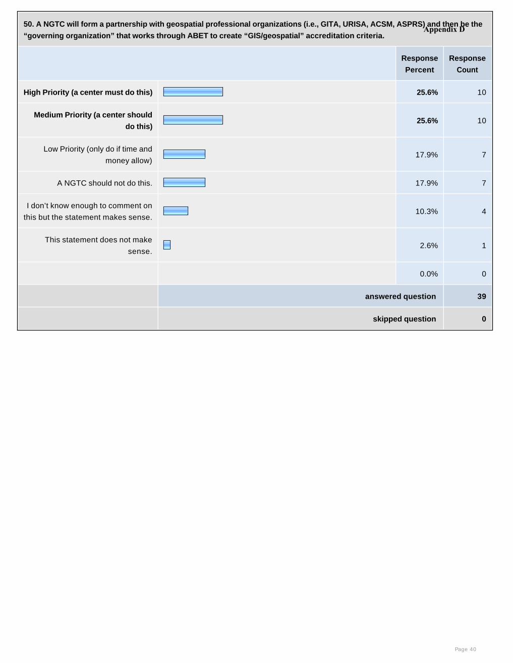
50. A NGTC will form a partnership with geospatial professional organizations (i.e., GITA, URISA, ACSM, ASPRS) and then be the
“governing organization” that works through ABET to create “GIS/geospatial” accreditation criteria.
Response
Percent
Response
Count
High Priority (a center must do this) 25.6% 10
Medium Priority (a center should
do this)25.6% 10
Low Priority (only do if time and
money allow) 17.9% 7
A NGTC should not do this. 17.9% 7
I don’t know enough to comment on
this but the statement makes sense.10.3% 4
This statement does not make
sense.2.6% 1
0.0% 0
answered question 39
skipped question 0
Page 40
Appendix D
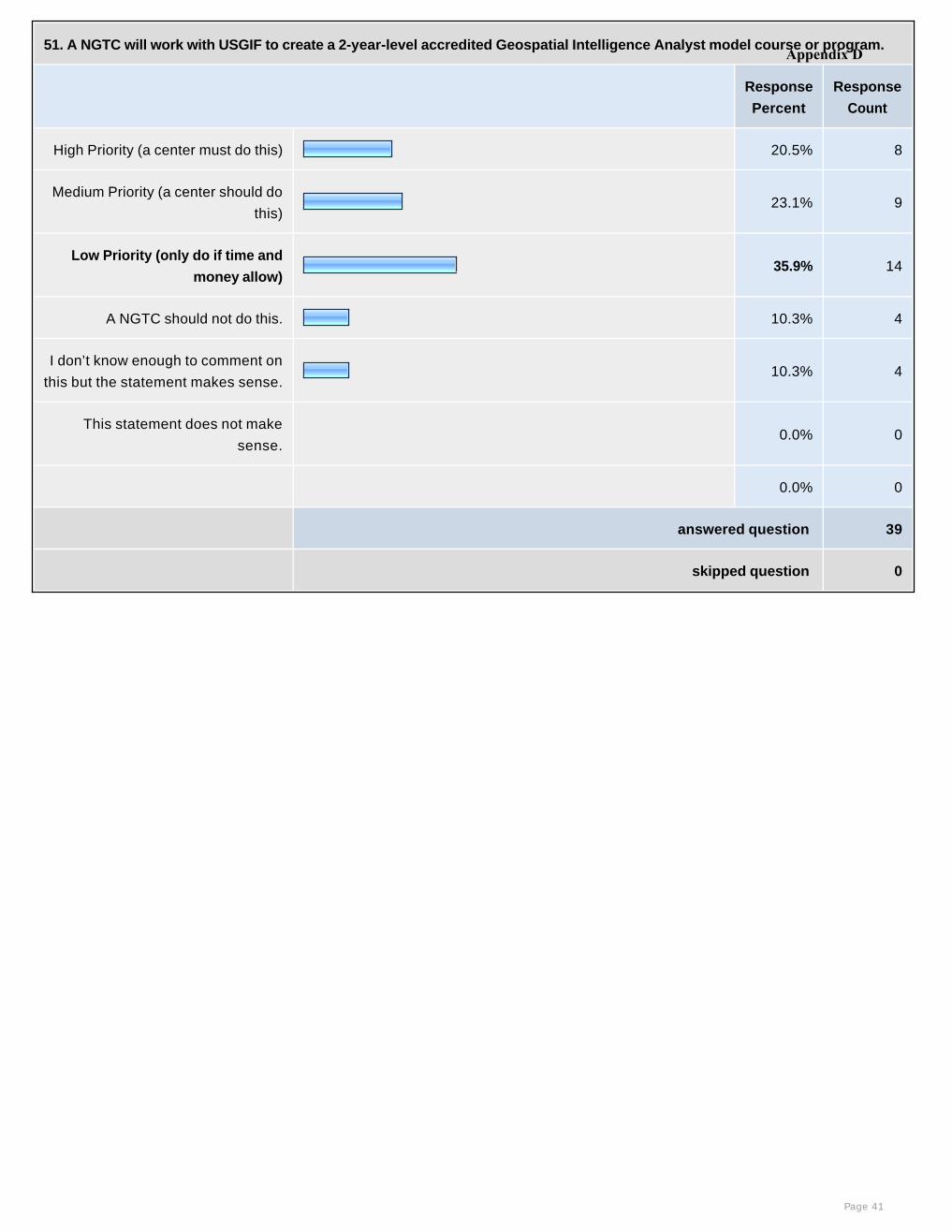
51. A NGTC will work with USGIF to create a 2-year-level accredited Geospatial Intelligence Analyst model course or program.
Response
Percent
Response
Count
High Priority (a center must do this) 20.5% 8
Medium Priority (a center should do
this)23.1% 9
Low Priority (only do if time and
money allow) 35.9% 14
A NGTC should not do this. 10.3% 4
I don’t know enough to comment on
this but the statement makes sense.10.3% 4
This statement does not make
sense. 0.0% 0
0.0% 0
answered question 39
skipped question 0
Page 41
Appendix D
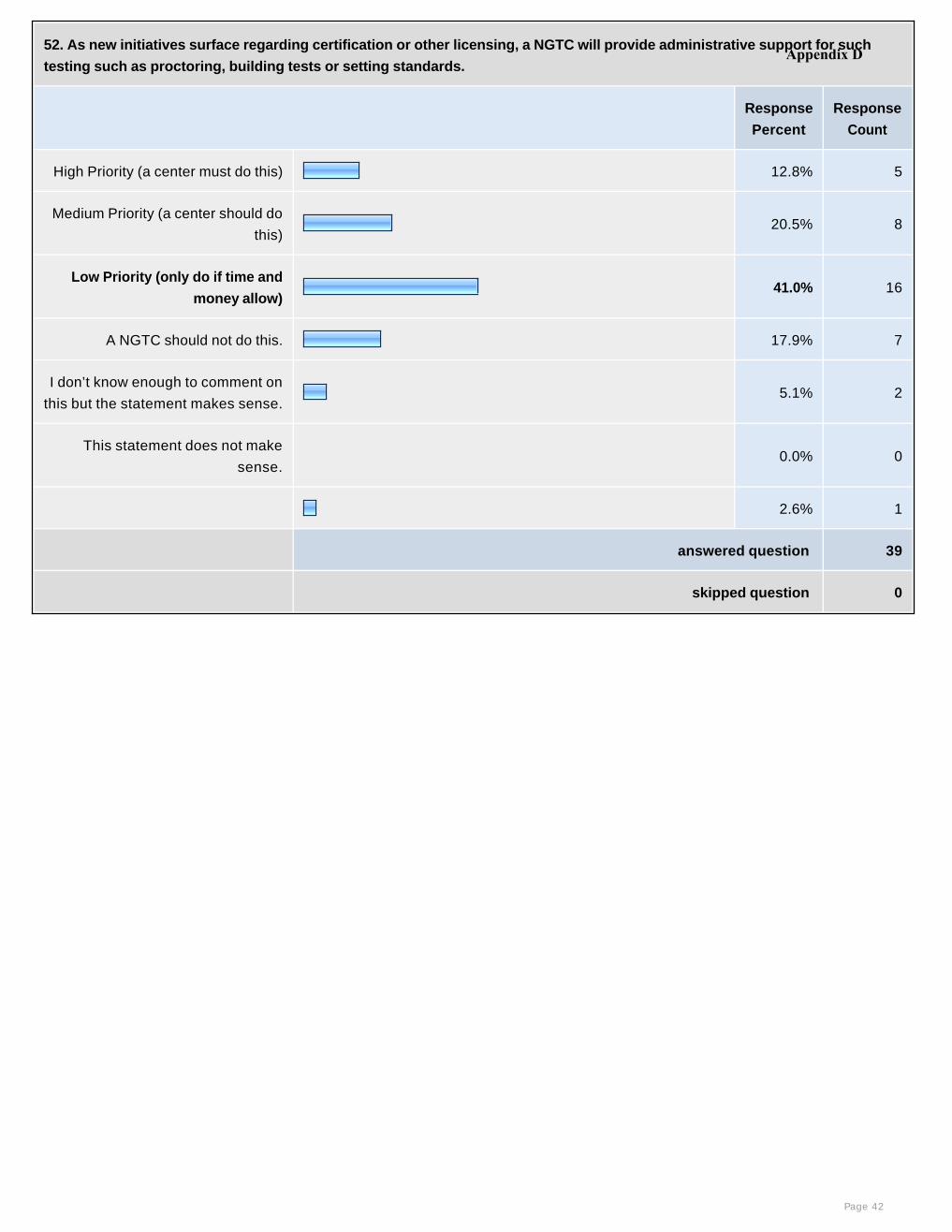
52. As new initiatives surface regarding certification or other licensing, a NGTC will provide administrative support for such
testing such as proctoring, building tests or setting standards.
Response
Percent
Response
Count
High Priority (a center must do this) 12.8% 5
Medium Priority (a center should do
this)20.5% 8
Low Priority (only do if time and
money allow) 41.0% 16
A NGTC should not do this. 17.9% 7
I don’t know enough to comment on
this but the statement makes sense.5.1% 2
This statement does not make
sense. 0.0% 0
2.6% 1
answered question 39
skipped question 0
Page 42
Appendix D
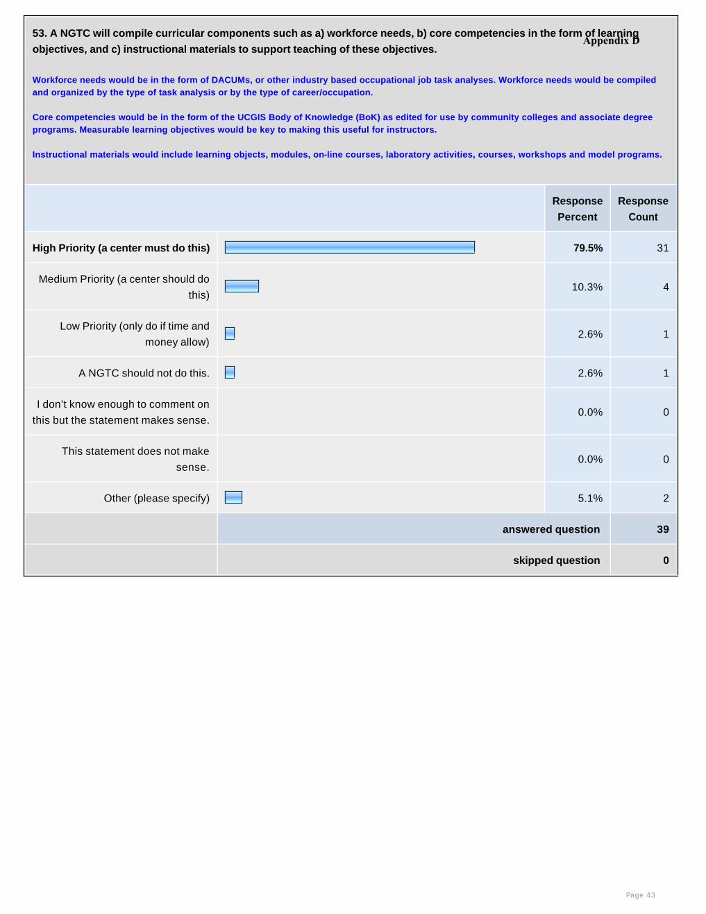
53. A NGTC will compile curricular components such as a) workforce needs, b) core competencies in the form of learning
objectives, and c) instructional materials to support teaching of these objectives.
Workforce needs would be in the form of DACUMs, or other industry based occupational job task analyses. Workforce needs would be compiled and organized by the type of task analysis or by the type of career/occupation.
Core competencies would be in the form of the UCGIS Body of Knowledge (BoK) as edited for use by community colleges and associate degree programs. Measurable learning objectives would be key to making this useful for instructors.
Instructional materials would include learning objects, modules, on-line courses, laboratory activities, courses, workshops and model programs.
Response
Percent
Response
Count
High Priority (a center must do this) 79.5% 31
Medium Priority (a center should do
this)10.3% 4
Low Priority (only do if time and
money allow) 2.6% 1
A NGTC should not do this. 2.6% 1
I don’t know enough to comment on
this but the statement makes sense. 0.0% 0
This statement does not make
sense. 0.0% 0
Other (please specify) 5.1% 2
answered question 39
skipped question 0
Page 43
Appendix D
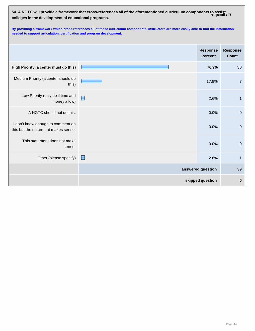
54. A NGTC will provide a framework that cross-references all of the aforementioned curriculum components to assist
colleges in the development of educational programs.
By providing a framework which cross-references all of these curriculum components, instructors are more easily able to find the information needed to support articulation, certification and program development.
Response
Percent
Response
Count
High Priority (a center must do this) 76.9% 30
Medium Priority (a center should do
this)17.9% 7
Low Priority (only do if time and
money allow) 2.6% 1
A NGTC should not do this. 0.0% 0
I don’t know enough to comment on
this but the statement makes sense. 0.0% 0
This statement does not make
sense. 0.0% 0
Other (please specify) 2.6% 1
answered question 39
skipped question 0
Page 44
Appendix D

55. A NGTC will provide the processes and best practices by which a curriculum framework is used to develop a program that
meets the local industry needs.
Response
Percent
Response
Count
High Priority (a center must do this) 43.6% 17
Medium Priority (a center should do
this)38.5% 15
Low Priority (only do if time and
money allow) 10.3% 4
A NGTC should not do this. 5.1% 2
I don’t know enough to comment on
this but the statement makes sense. 0.0% 0
This statement does not make
sense.2.6% 1
0.0% 0
answered question 39
skipped question 0
Page 45
Appendix D
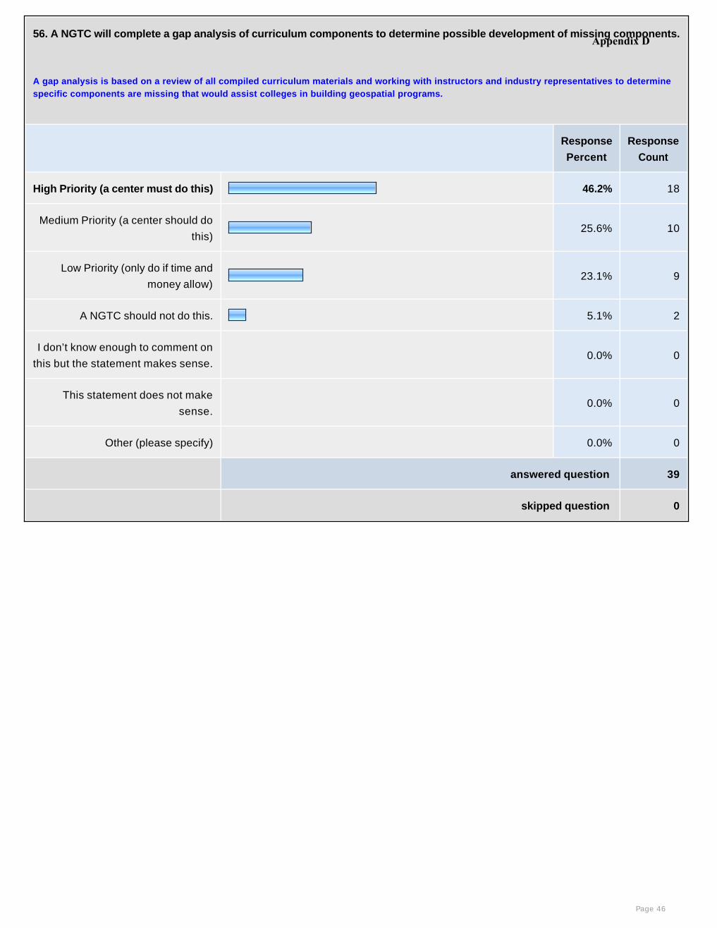
56. A NGTC will complete a gap analysis of curriculum components to determine possible development of missing components.
A gap analysis is based on a review of all compiled curriculum materials and working with instructors and industry representatives to determine specific components are missing that would assist colleges in building geospatial programs.
Response
Percent
Response
Count
High Priority (a center must do this) 46.2% 18
Medium Priority (a center should do
this)25.6% 10
Low Priority (only do if time and
money allow) 23.1% 9
A NGTC should not do this. 5.1% 2
I don’t know enough to comment on
this but the statement makes sense. 0.0% 0
This statement does not make
sense. 0.0% 0
Other (please specify) 0.0% 0
answered question 39
skipped question 0
Page 46
Appendix D
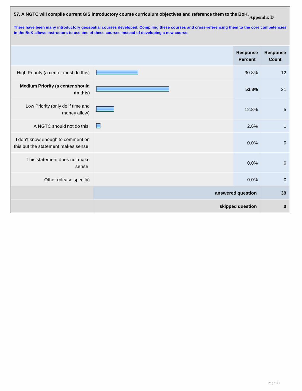
57. A NGTC will compile current GIS introductory course curriculum objectives and reference them to the BoK.
There have been many introductory geospatial courses developed. Compiling these courses and cross-referencing them to the core competencies in the BoK allows instructors to use one of these courses instead of developing a new course.
Response
Percent
Response
Count
High Priority (a center must do this) 30.8% 12
Medium Priority (a center should
do this)53.8% 21
Low Priority (only do if time and
money allow) 12.8% 5
A NGTC should not do this. 2.6% 1
I don’t know enough to comment on
this but the statement makes sense. 0.0% 0
This statement does not make
sense. 0.0% 0
Other (please specify) 0.0% 0
answered question 39
skipped question 0
Page 47
Appendix D
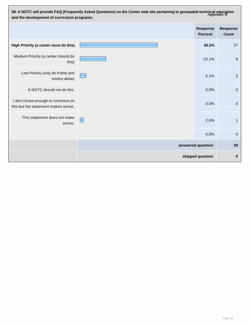
58. A NGTC will provide FAQ (Frequently Asked Questions) on the Center web site pertaining to geospatial technical education
and the development of curriculum programs.
Response
Percent
Response
Count
High Priority (a center must do this) 69.2% 27
Medium Priority (a center should do
this)23.1% 9
Low Priority (only do if time and
money allow) 5.1% 2
A NGTC should not do this. 0.0% 0
I don’t know enough to comment on
this but the statement makes sense. 0.0% 0
This statement does not make
sense.2.6% 1
0.0% 0
answered question 39
skipped question 0
Page 48
Appendix D
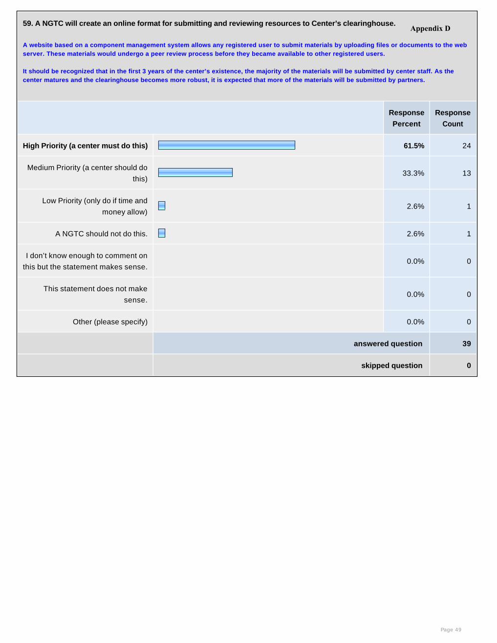
59. A NGTC will create an online format for submitting and reviewing resources to Center’s clearinghouse.
A website based on a component management system allows any registered user to submit materials by uploading files or documents to the web server. These materials would undergo a peer review process before they became available to other registered users.
It should be recognized that in the first 3 years of the center’s existence, the majority of the materials will be submitted by center staff. As the center matures and the clearinghouse becomes more robust, it is expected that more of the materials will be submitted by partners.
Response
Percent
Response
Count
High Priority (a center must do this) 61.5% 24
Medium Priority (a center should do
this)33.3% 13
Low Priority (only do if time and
money allow) 2.6% 1
A NGTC should not do this. 2.6% 1
I don’t know enough to comment on
this but the statement makes sense. 0.0% 0
This statement does not make
sense. 0.0% 0
Other (please specify) 0.0% 0
answered question 39
skipped question 0
Page 49
Appendix D
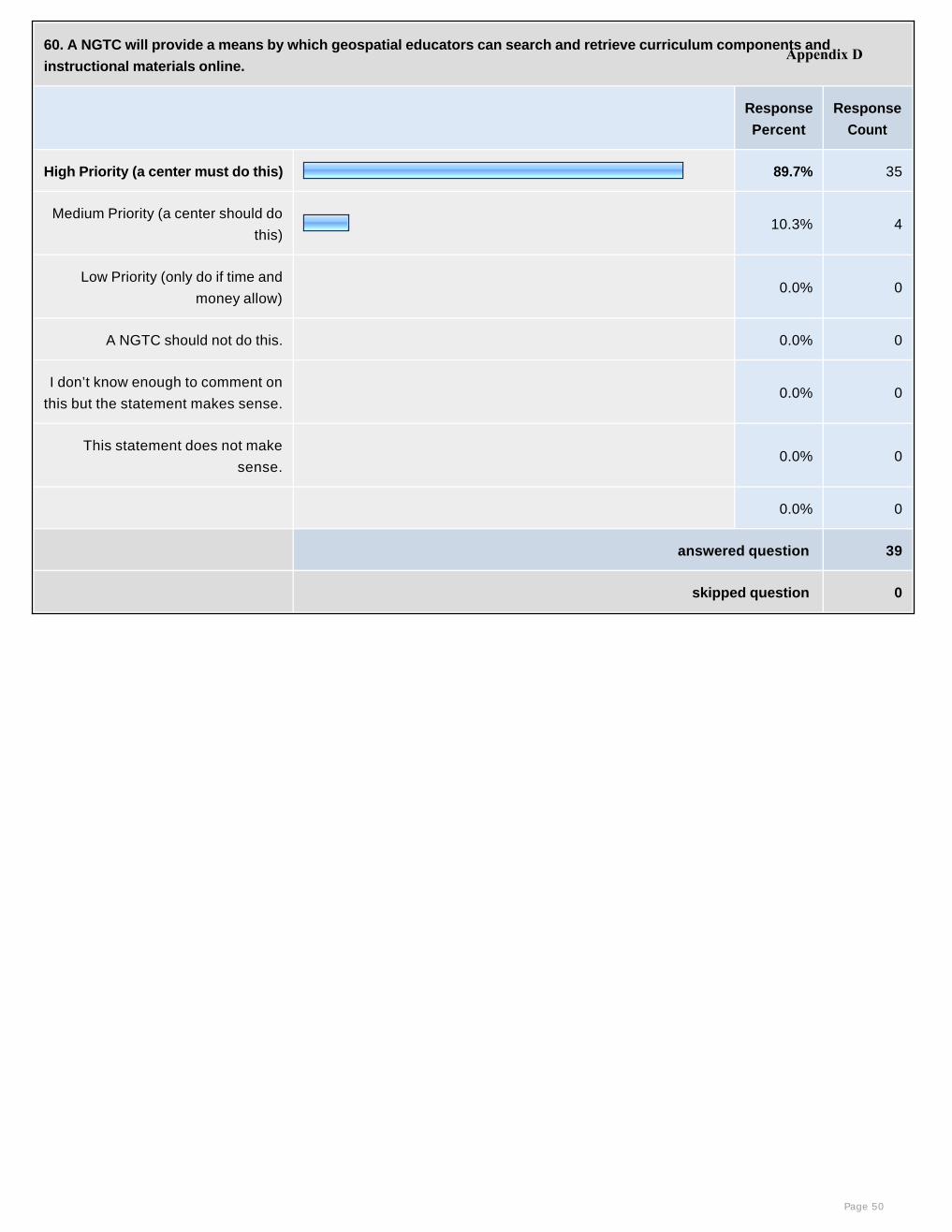
60. A NGTC will provide a means by which geospatial educators can search and retrieve curriculum components and
instructional materials online.
Response
Percent
Response
Count
High Priority (a center must do this) 89.7% 35
Medium Priority (a center should do
this)10.3% 4
Low Priority (only do if time and
money allow) 0.0% 0
A NGTC should not do this. 0.0% 0
I don’t know enough to comment on
this but the statement makes sense. 0.0% 0
This statement does not make
sense. 0.0% 0
0.0% 0
answered question 39
skipped question 0
Page 50
Appendix D

61. A NGTC will compile and make available, as part of the clearinghouse activities, instructional materials that use geospatial
technologies to teach concepts of science, math and technology.
Response
Percent
Response
Count
High Priority (a center must do this) 43.6% 17
Medium Priority (a center should
do this)48.7% 19
Low Priority (only do if time and
money allow) 5.1% 2
A NGTC should not do this. 2.6% 1
I don’t know enough to comment on
this but the statement makes sense. 0.0% 0
This statement does not make
sense. 0.0% 0
0.0% 0
answered question 39
skipped question 0
Page 51
Appendix D
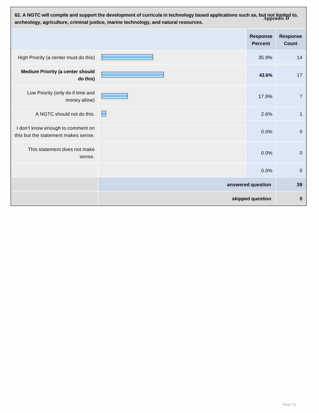
62. A NGTC will compile and support the development of curricula in technology based applications such as, but not limited to,
archeology, agriculture, criminal justice, marine technology, and natural resources.
Response
Percent
Response
Count
High Priority (a center must do this) 35.9% 14
Medium Priority (a center should
do this)43.6% 17
Low Priority (only do if time and
money allow) 17.9% 7
A NGTC should not do this. 2.6% 1
I don’t know enough to comment on
this but the statement makes sense. 0.0% 0
This statement does not make
sense. 0.0% 0
0.0% 0
answered question 39
skipped question 0
Page 52
Appendix D
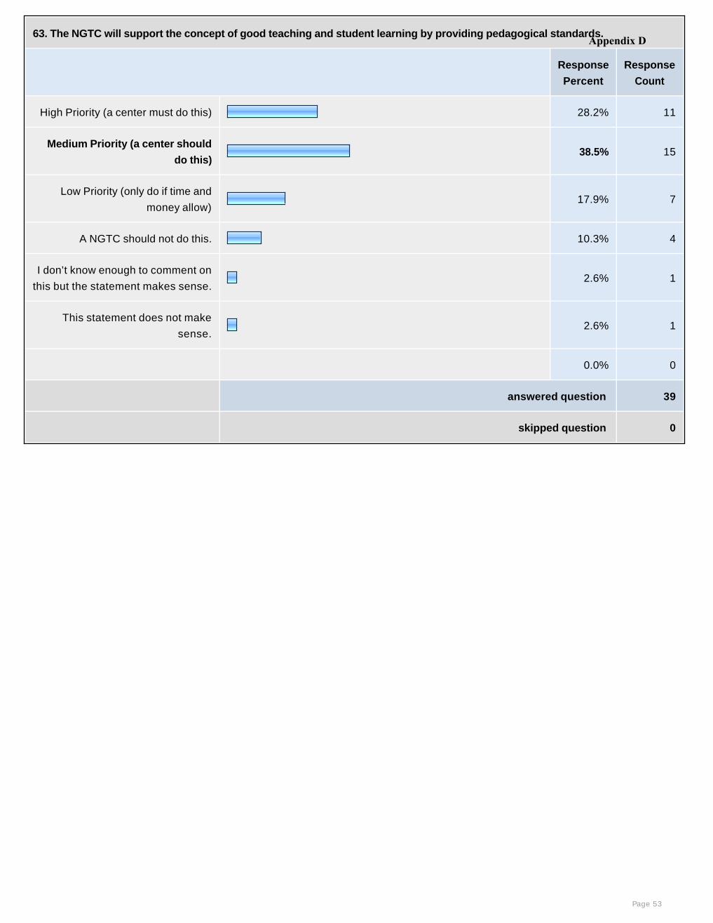
63. The NGTC will support the concept of good teaching and student learning by providing pedagogical standards.
Response
Percent
Response
Count
High Priority (a center must do this) 28.2% 11
Medium Priority (a center should
do this)38.5% 15
Low Priority (only do if time and
money allow) 17.9% 7
A NGTC should not do this. 10.3% 4
I don’t know enough to comment on
this but the statement makes sense.2.6% 1
This statement does not make
sense.2.6% 1
0.0% 0
answered question 39
skipped question 0
Page 53
Appendix D
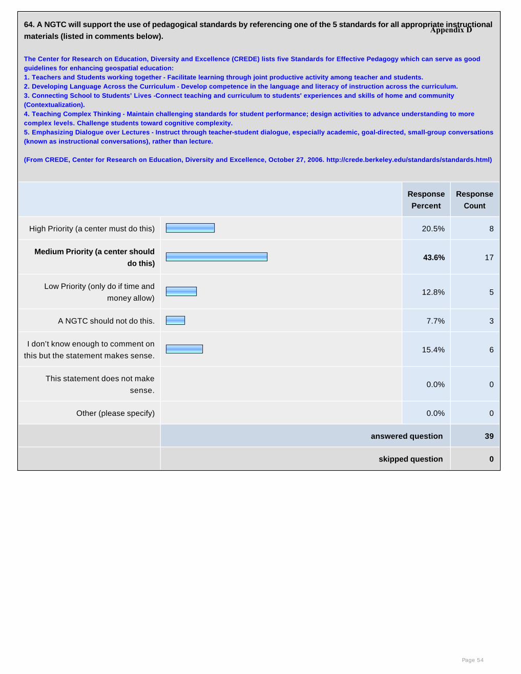
64. A NGTC will support the use of pedagogical standards by referencing one of the 5 standards for all appropriate instructional
materials (listed in comments below).
The Center for Research on Education, Diversity and Excellence (CREDE) lists five Standards for Effective Pedagogy which can serve as good guidelines for enhancing geospatial education:1. Teachers and Students working together - Facilitate learning through joint productive activity among teacher and students. 2. Developing Language Across the Curriculum - Develop competence in the language and literacy of instruction across the curriculum. 3. Connecting School to Students’ Lives -Connect teaching and curriculum to students' experiences and skills of home and community (Contextualization).4. Teaching Complex Thinking - Maintain challenging standards for student performance; design activities to advance understanding to more complex levels. Challenge students toward cognitive complexity.5. Emphasizing Dialogue over Lectures - Instruct through teacher-student dialogue, especially academic, goal-directed, small-group conversations (known as instructional conversations), rather than lecture.
(From CREDE, Center for Research on Education, Diversity and Excellence, October 27, 2006. http://crede.berkeley.edu/standards/standards.html)
Response
Percent
Response
Count
High Priority (a center must do this) 20.5% 8
Medium Priority (a center should
do this)43.6% 17
Low Priority (only do if time and
money allow) 12.8% 5
A NGTC should not do this. 7.7% 3
I don’t know enough to comment on
this but the statement makes sense.15.4% 6
This statement does not make
sense. 0.0% 0
Other (please specify) 0.0% 0
answered question 39
skipped question 0
Page 54
Appendix D
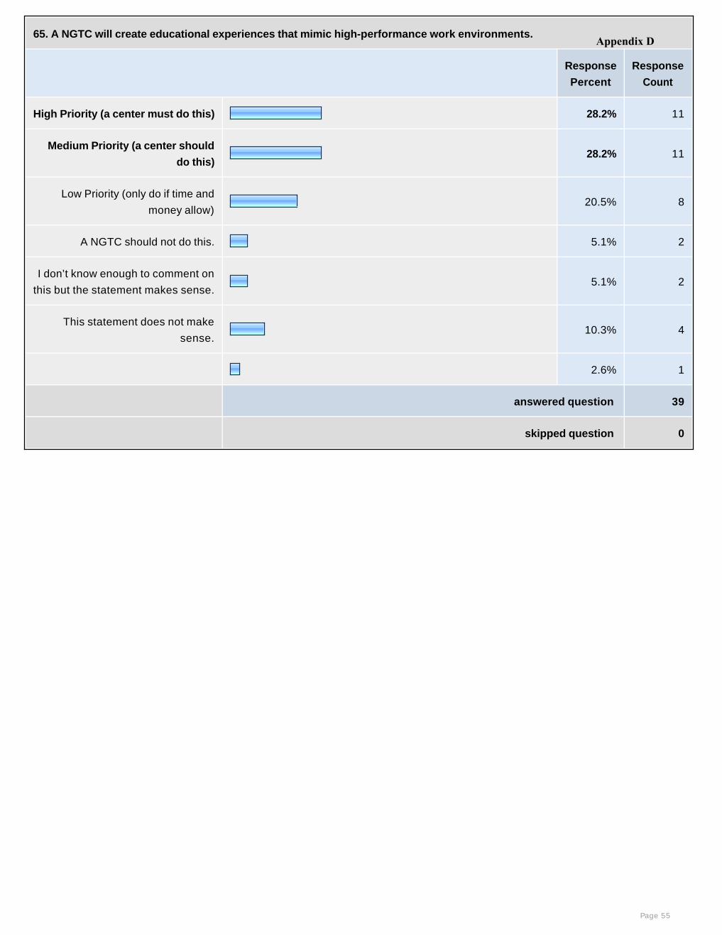
65. A NGTC will create educational experiences that mimic high-performance work environments.
Response
Percent
Response
Count
High Priority (a center must do this) 28.2% 11
Medium Priority (a center should
do this)28.2% 11
Low Priority (only do if time and
money allow) 20.5% 8
A NGTC should not do this. 5.1% 2
I don’t know enough to comment on
this but the statement makes sense.5.1% 2
This statement does not make
sense.10.3% 4
2.6% 1
answered question 39
skipped question 0
Page 55
Appendix D
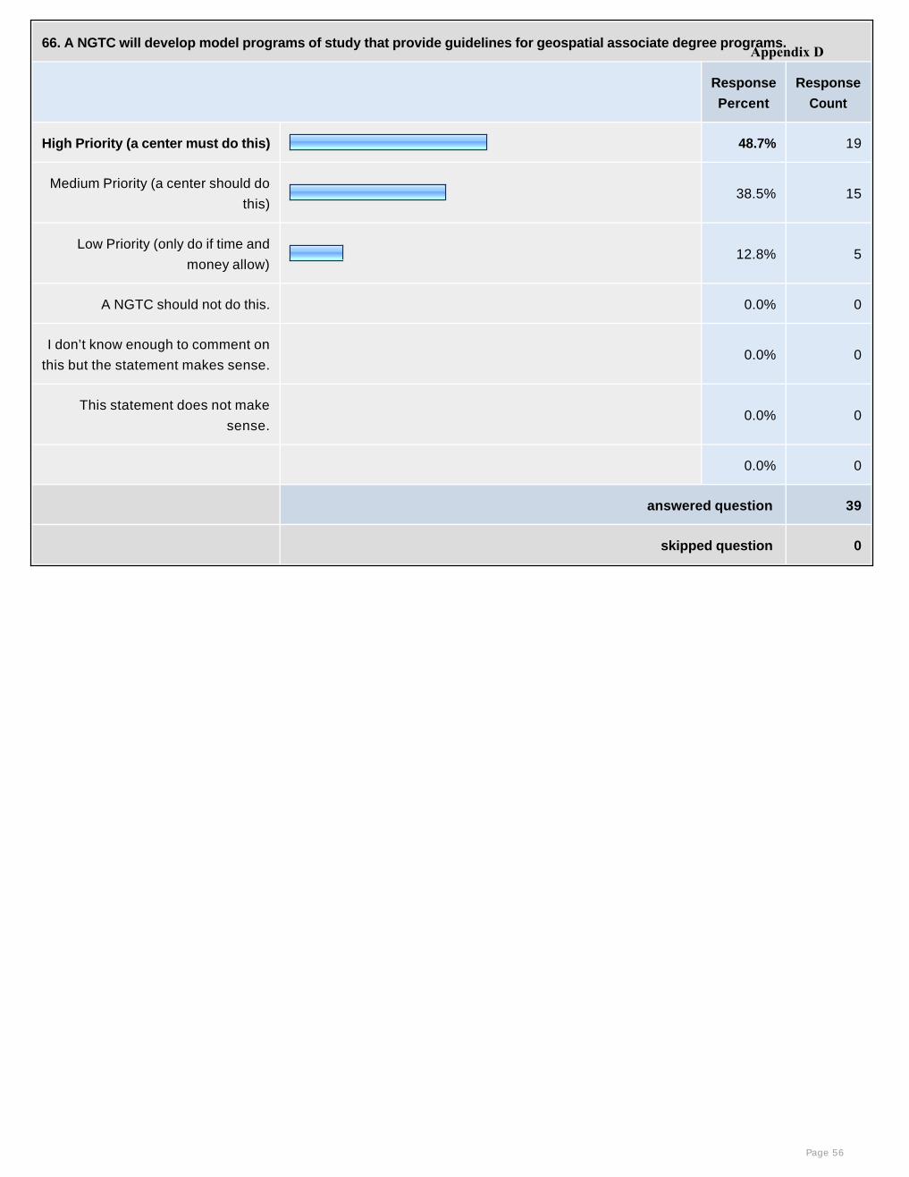
66. A NGTC will develop model programs of study that provide guidelines for geospatial associate degree programs.
Response
Percent
Response
Count
High Priority (a center must do this) 48.7% 19
Medium Priority (a center should do
this)38.5% 15
Low Priority (only do if time and
money allow) 12.8% 5
A NGTC should not do this. 0.0% 0
I don’t know enough to comment on
this but the statement makes sense. 0.0% 0
This statement does not make
sense. 0.0% 0
0.0% 0
answered question 39
skipped question 0
Page 56
Appendix D
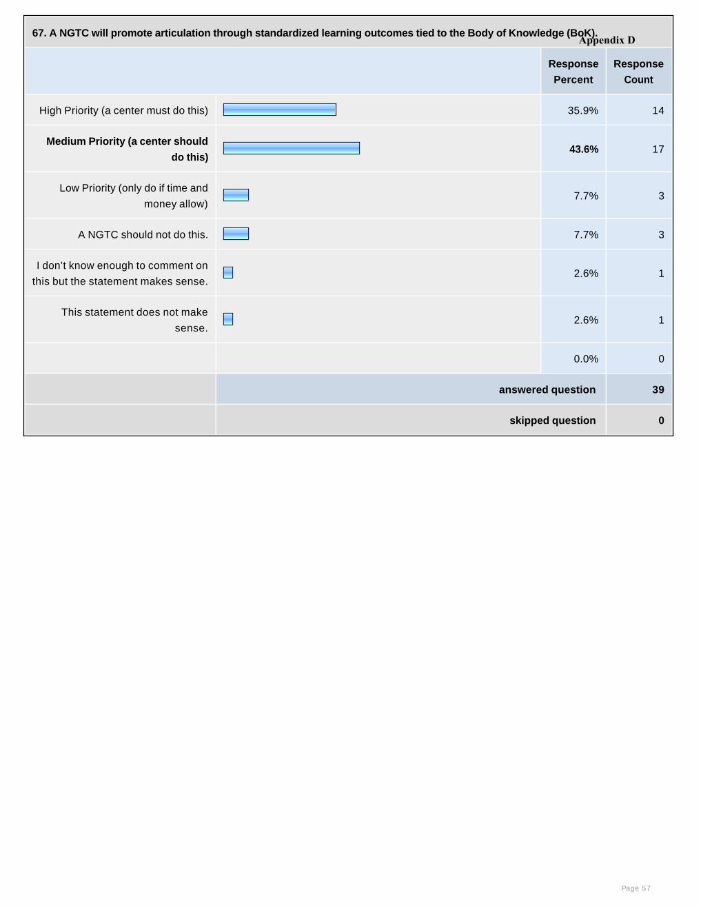
67. A NGTC will promote articulation through standardized learning outcomes tied to the Body of Knowledge (BoK).
Response
Percent
Response
Count
High Priority (a center must do this) 35.9% 14
Medium Priority (a center should
do this)43.6% 17
Low Priority (only do if time and
money allow) 7.7% 3
A NGTC should not do this. 7.7% 3
I don’t know enough to comment on
this but the statement makes sense.2.6% 1
This statement does not make
sense.2.6% 1
0.0% 0
answered question 39
skipped question 0
Page 57
Appendix D
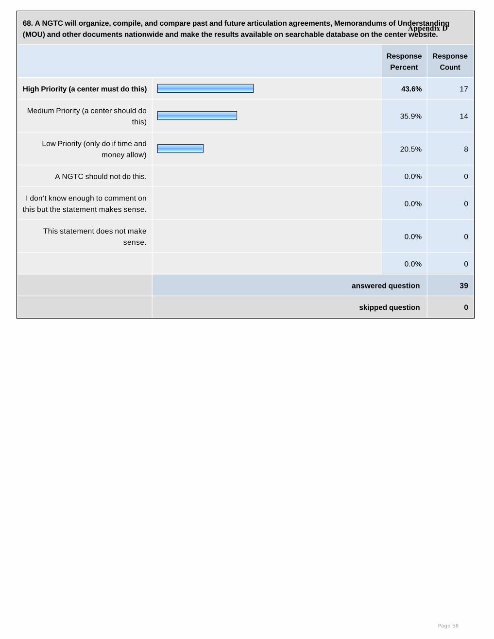
68. A NGTC will organize, compile, and compare past and future articulation agreements, Memorandums of Understanding
(MOU) and other documents nationwide and make the results available on searchable database on the center website.
Response
Percent
Response
Count
High Priority (a center must do this) 43.6% 17
Medium Priority (a center should do
this)35.9% 14
Low Priority (only do if time and
money allow) 20.5% 8
A NGTC should not do this. 0.0% 0
I don’t know enough to comment on
this but the statement makes sense. 0.0% 0
This statement does not make
sense. 0.0% 0
0.0% 0
answered question 39
skipped question 0
Page 58
Appendix D

69. A NGTC will review and summarize policies of state and regional accrediting agencies to facilitate articulation.
Response
Percent
Response
Count
High Priority (a center must do this) 30.8% 12
Medium Priority (a center should do
this)28.2% 11
Low Priority (only do if time and
money allow) 33.3% 13
A NGTC should not do this. 7.7% 3
I don’t know enough to comment on
this but the statement makes sense. 0.0% 0
This statement does not make
sense. 0.0% 0
0.0% 0
answered question 39
skipped question 0
Page 59
Appendix D
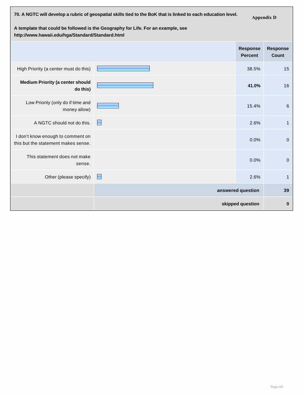
70. A NGTC will develop a rubric of geospatial skills tied to the BoK that is linked to each education level.
A template that could be followed is the Geography for Life. For an example, see
http://www.hawaii.edu/hga/Standard/Standard.html
Response
Percent
Response
Count
High Priority (a center must do this) 38.5% 15
Medium Priority (a center should
do this)41.0% 16
Low Priority (only do if time and
money allow) 15.4% 6
A NGTC should not do this. 2.6% 1
I don’t know enough to comment on
this but the statement makes sense. 0.0% 0
This statement does not make
sense. 0.0% 0
Other (please specify) 2.6% 1
answered question 39
skipped question 0
Page 60
Appendix D

71. A problem of K12-CC articulation involves faculty credentials. A NGTC will develop standards to integrate GIS into geography
AP courses and/or College-Level Examination Program® or CLEP courses to overcome the credential issue.
Response
Percent
Response
Count
High Priority (a center must do this) 38.5% 15
Medium Priority (a center should do
this)28.2% 11
Low Priority (only do if time and
money allow) 10.3% 4
A NGTC should not do this. 12.8% 5
I don’t know enough to comment on
this but the statement makes sense.10.3% 4
This statement does not make
sense. 0.0% 0
0.0% 0
answered question 39
skipped question 0
Page 61
Appendix D
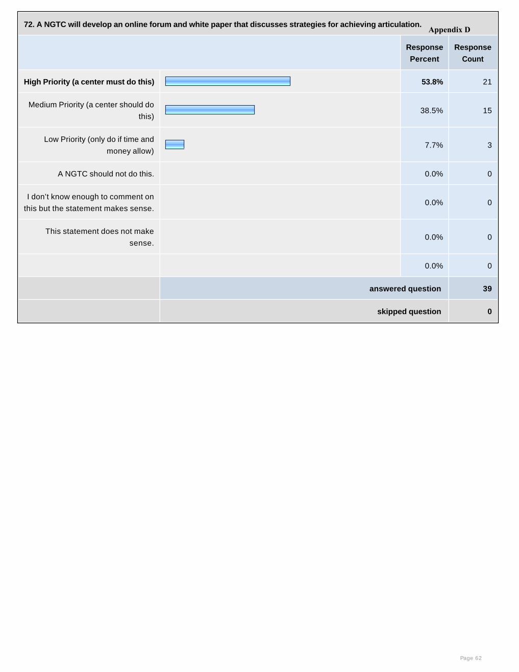
72. A NGTC will develop an online forum and white paper that discusses strategies for achieving articulation.
Response
Percent
Response
Count
High Priority (a center must do this) 53.8% 21
Medium Priority (a center should do
this)38.5% 15
Low Priority (only do if time and
money allow) 7.7% 3
A NGTC should not do this. 0.0% 0
I don’t know enough to comment on
this but the statement makes sense. 0.0% 0
This statement does not make
sense. 0.0% 0
0.0% 0
answered question 39
skipped question 0
Page 62
Appendix D
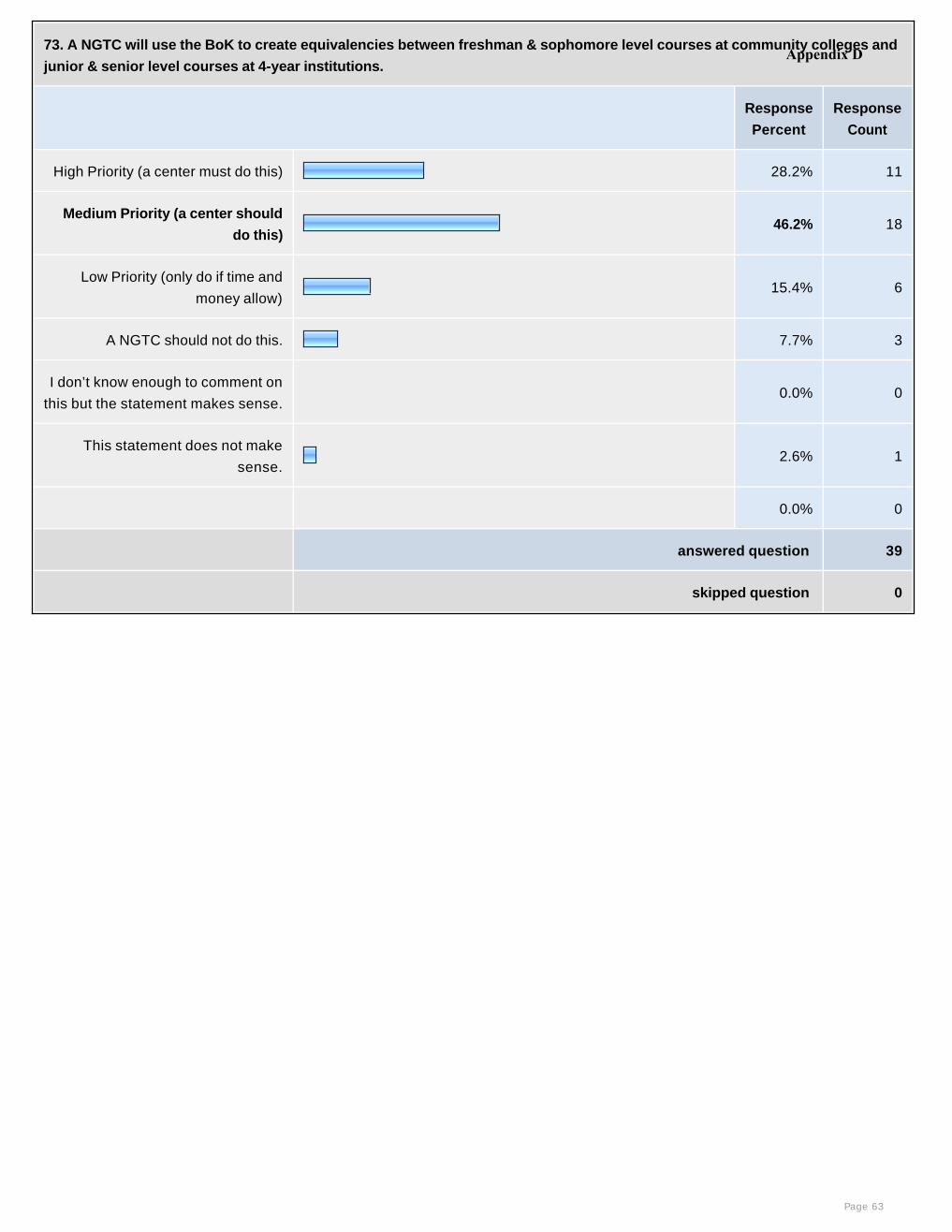
73. A NGTC will use the BoK to create equivalencies between freshman & sophomore level courses at community colleges and
junior & senior level courses at 4-year institutions.
Response
Percent
Response
Count
High Priority (a center must do this) 28.2% 11
Medium Priority (a center should
do this)46.2% 18
Low Priority (only do if time and
money allow) 15.4% 6
A NGTC should not do this. 7.7% 3
I don’t know enough to comment on
this but the statement makes sense. 0.0% 0
This statement does not make
sense.2.6% 1
0.0% 0
answered question 39
skipped question 0
Page 63
Appendix D

74. A NGTC will perform a cost/benefit analysis that would indicate the cost if there were no articulation agreement (credit
hours lost and dollar costs) between schools and colleges and universities.
Response
Percent
Response
Count
High Priority (a center must do this) 12.8% 5
Medium Priority (a center should do
this)23.1% 9
Low Priority (only do if time and
money allow) 41.0% 16
A NGTC should not do this. 17.9% 7
I don’t know enough to comment on
this but the statement makes sense.5.1% 2
This statement does not make
sense. 0.0% 0
0.0% 0
answered question 39
skipped question 0
Page 64
Appendix D
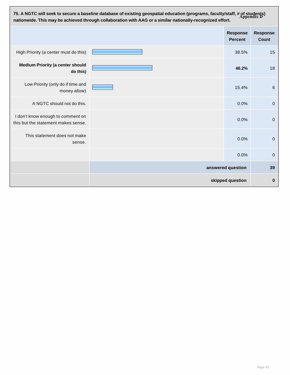
75. A NGTC will seek to secure a baseline database of existing geospatial education (programs, faculty/staff, # of students)
nationwide. This may be achieved through collaboration with AAG or a similar nationally-recognized effort.
Response
Percent
Response
Count
High Priority (a center must do this) 38.5% 15
Medium Priority (a center should
do this)46.2% 18
Low Priority (only do if time and
money allow) 15.4% 6
A NGTC should not do this. 0.0% 0
I don’t know enough to comment on
this but the statement makes sense. 0.0% 0
This statement does not make
sense. 0.0% 0
0.0% 0
answered question 39
skipped question 0
Page 65
Appendix D
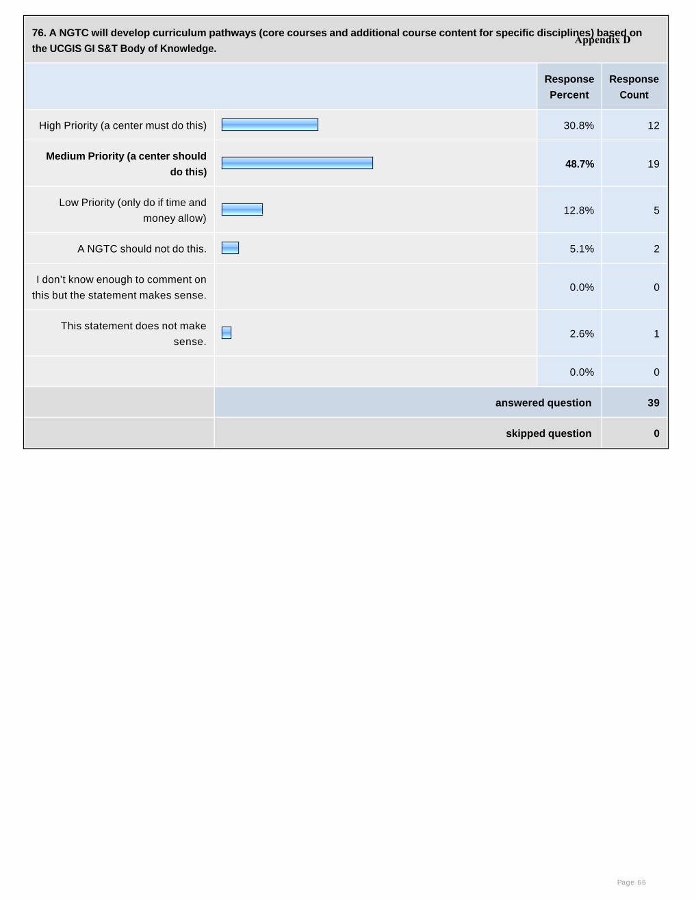
76. A NGTC will develop curriculum pathways (core courses and additional course content for specific disciplines) based on
the UCGIS GI S&T Body of Knowledge.
Response
Percent
Response
Count
High Priority (a center must do this) 30.8% 12
Medium Priority (a center should
do this)48.7% 19
Low Priority (only do if time and
money allow) 12.8% 5
A NGTC should not do this. 5.1% 2
I don’t know enough to comment on
this but the statement makes sense. 0.0% 0
This statement does not make
sense.2.6% 1
0.0% 0
answered question 39
skipped question 0
Page 66
Appendix D

77. A NGTC will develop career pathways that provide guidelines for a seamless education in geospatial technology from
secondary to community college to university.
Response
Percent
Response
Count
High Priority (a center must do this) 51.3% 20
Medium Priority (a center should do
this)25.6% 10
Low Priority (only do if time and
money allow) 15.4% 6
A NGTC should not do this. 2.6% 1
I don’t know enough to comment on
this but the statement makes sense.5.1% 2
This statement does not make
sense. 0.0% 0
0.0% 0
answered question 39
skipped question 0
Page 67
Appendix D

78. A NGTC will organize, compile, and disseminate up-to-date information on professional development opportunities, training
materials, tutorials and links to online resources on a NGTC website.
Response
Percent
Response
Count
High Priority (a center must do this) 76.9% 30
Medium Priority (a center should do
this)15.4% 6
Low Priority (only do if time and
money allow) 7.7% 3
A NGTC should not do this. 0.0% 0
I don’t know enough to comment on
this but the statement makes sense. 0.0% 0
This statement does not make
sense. 0.0% 0
0.0% 0
answered question 39
skipped question 0
Page 68
Appendix D
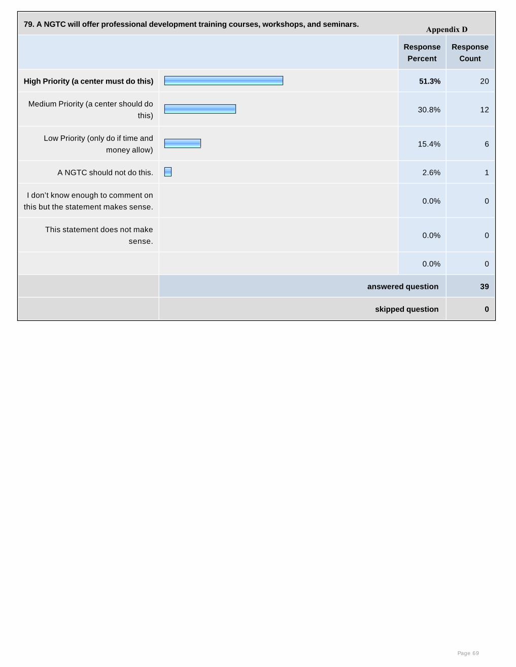
79. A NGTC will offer professional development training courses, workshops, and seminars.
Response
Percent
Response
Count
High Priority (a center must do this) 51.3% 20
Medium Priority (a center should do
this)30.8% 12
Low Priority (only do if time and
money allow) 15.4% 6
A NGTC should not do this. 2.6% 1
I don’t know enough to comment on
this but the statement makes sense. 0.0% 0
This statement does not make
sense. 0.0% 0
0.0% 0
answered question 39
skipped question 0
Page 69
Appendix D
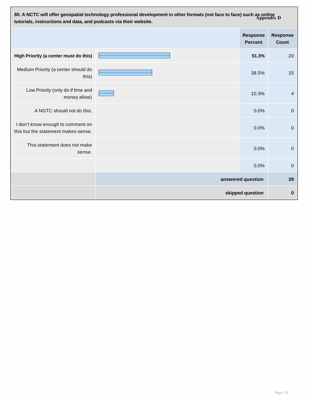
80. A NCTC will offer geospatial technology professional development in other formats (not face to face) such as online
tutorials, instructions and data, and podcasts via their website.
Response
Percent
Response
Count
High Priority (a center must do this) 51.3% 20
Medium Priority (a center should do
this)38.5% 15
Low Priority (only do if time and
money allow) 10.3% 4
A NGTC should not do this. 0.0% 0
I don’t know enough to comment on
this but the statement makes sense. 0.0% 0
This statement does not make
sense. 0.0% 0
0.0% 0
answered question 39
skipped question 0
Page 70
Appendix D
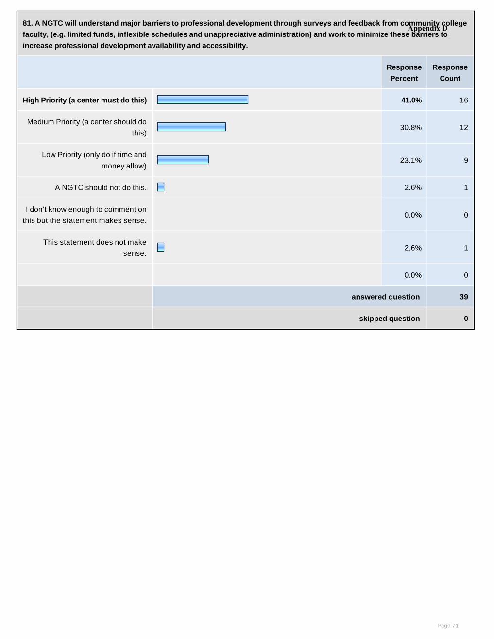
81. A NGTC will understand major barriers to professional development through surveys and feedback from community college
faculty, (e.g. limited funds, inflexible schedules and unappreciative administration) and work to minimize these barriers to
increase professional development availability and accessibility.
Response
Percent
Response
Count
High Priority (a center must do this) 41.0% 16
Medium Priority (a center should do
this)30.8% 12
Low Priority (only do if time and
money allow) 23.1% 9
A NGTC should not do this. 2.6% 1
I don’t know enough to comment on
this but the statement makes sense. 0.0% 0
This statement does not make
sense.2.6% 1
0.0% 0
answered question 39
skipped question 0
Page 71
Appendix D
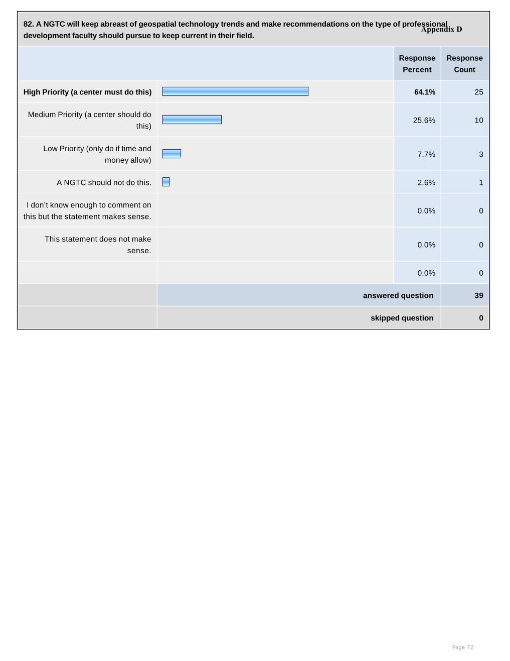
82. A NGTC will keep abreast of geospatial technology trends and make recommendations on the type of professional
development faculty should pursue to keep current in their field.
Response
Percent
Response
Count
High Priority (a center must do this) 64.1% 25
Medium Priority (a center should do
this)25.6% 10
Low Priority (only do if time and
money allow) 7.7% 3
A NGTC should not do this. 2.6% 1
I don’t know enough to comment on
this but the statement makes sense. 0.0% 0
This statement does not make
sense. 0.0% 0
0.0% 0
answered question 39
skipped question 0
Page 72
Appendix D
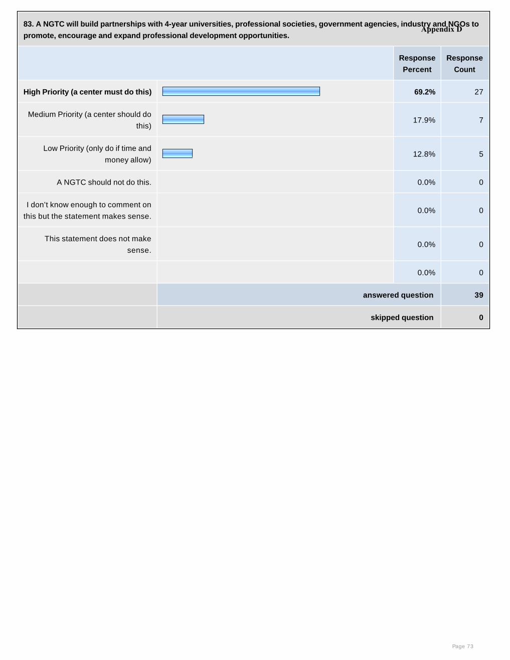
83. A NGTC will build partnerships with 4-year universities, professional societies, government agencies, industry and NGOs to
promote, encourage and expand professional development opportunities.
Response
Percent
Response
Count
High Priority (a center must do this) 69.2% 27
Medium Priority (a center should do
this)17.9% 7
Low Priority (only do if time and
money allow) 12.8% 5
A NGTC should not do this. 0.0% 0
I don’t know enough to comment on
this but the statement makes sense. 0.0% 0
This statement does not make
sense. 0.0% 0
0.0% 0
answered question 39
skipped question 0
Page 73
Appendix D

84. NGTC will provide up-to-date information on current and past geospatial-related NSF Advanced Technological Education
(ATE) projects, ATE Centers, and other NSF Division of Undergraduate projects via website and listserve.
Response
Percent
Response
Count
High Priority (a center must do this) 61.5% 24
Medium Priority (a center should do
this)20.5% 8
Low Priority (only do if time and
money allow) 12.8% 5
A NGTC should not do this. 5.1% 2
I don’t know enough to comment on
this but the statement makes sense. 0.0% 0
This statement does not make
sense. 0.0% 0
0.0% 0
answered question 39
skipped question 0
Page 74
Appendix D

85. NGTC will provide latest information on current and past Department of Labor projects via website and listserve.
Response
Percent
Response
Count
High Priority (a center must do this) 43.6% 17
Medium Priority (a center should do
this)33.3% 13
Low Priority (only do if time and
money allow) 15.4% 6
A NGTC should not do this. 7.7% 3
I don’t know enough to comment on
this but the statement makes sense. 0.0% 0
This statement does not make
sense. 0.0% 0
0.0% 0
answered question 39
skipped question 0
Page 75
Appendix D
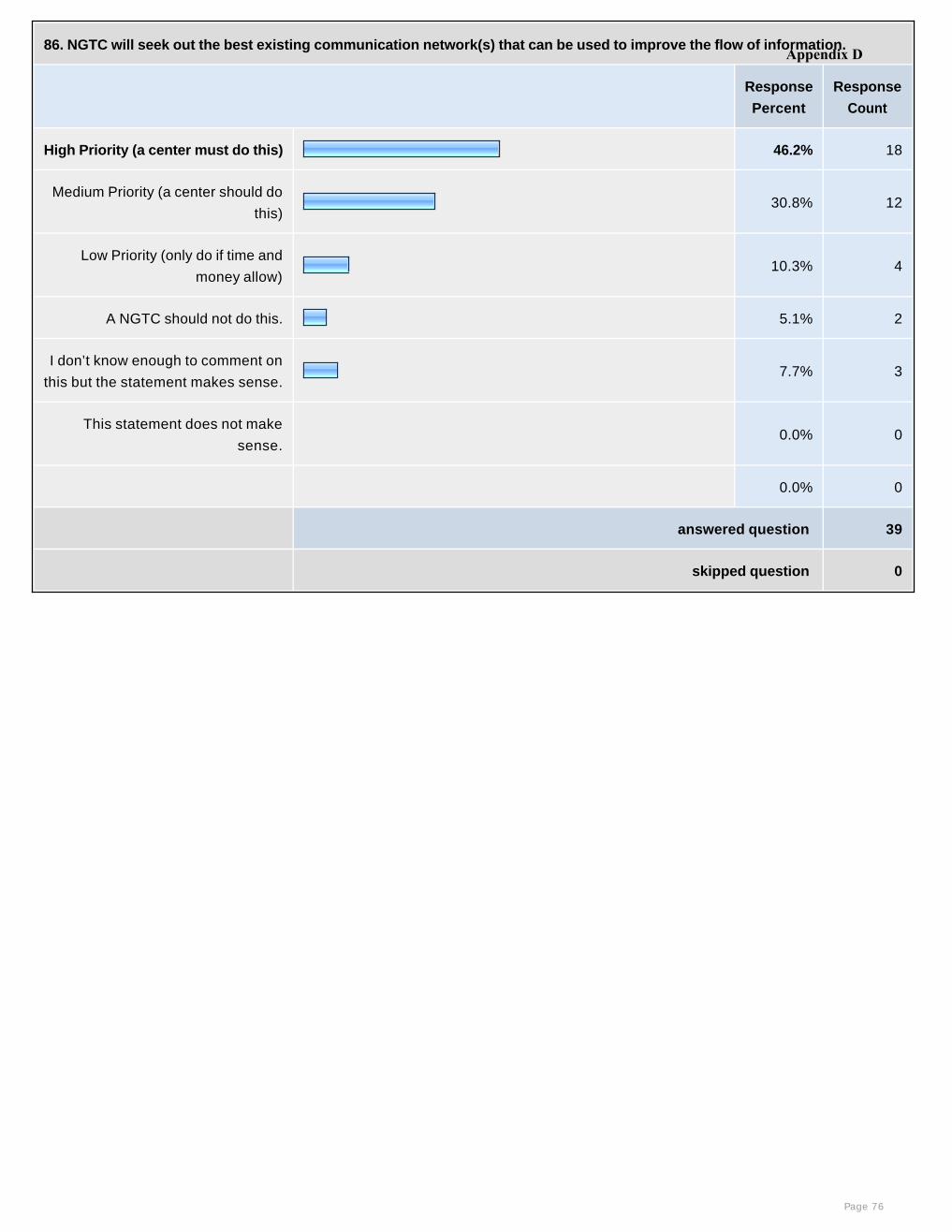
86. NGTC will seek out the best existing communication network(s) that can be used to improve the flow of information.
Response
Percent
Response
Count
High Priority (a center must do this) 46.2% 18
Medium Priority (a center should do
this)30.8% 12
Low Priority (only do if time and
money allow) 10.3% 4
A NGTC should not do this. 5.1% 2
I don’t know enough to comment on
this but the statement makes sense.7.7% 3
This statement does not make
sense. 0.0% 0
0.0% 0
answered question 39
skipped question 0
Page 76
Appendix D
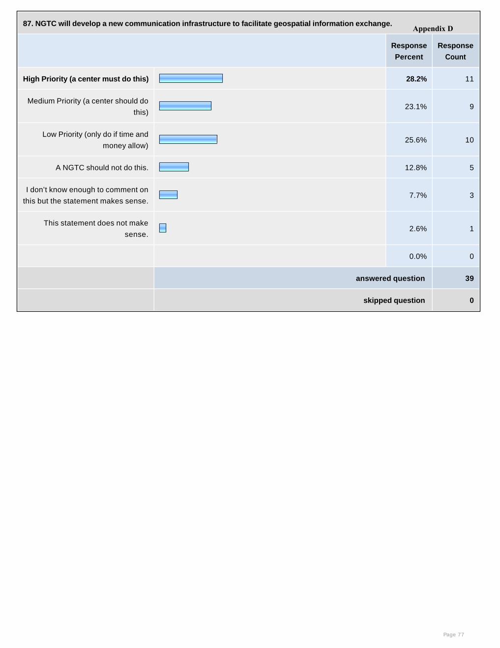
87. NGTC will develop a new communication infrastructure to facilitate geospatial information exchange.
Response
Percent
Response
Count
High Priority (a center must do this) 28.2% 11
Medium Priority (a center should do
this)23.1% 9
Low Priority (only do if time and
money allow) 25.6% 10
A NGTC should not do this. 12.8% 5
I don’t know enough to comment on
this but the statement makes sense.7.7% 3
This statement does not make
sense.2.6% 1
0.0% 0
answered question 39
skipped question 0
Page 77
Appendix D
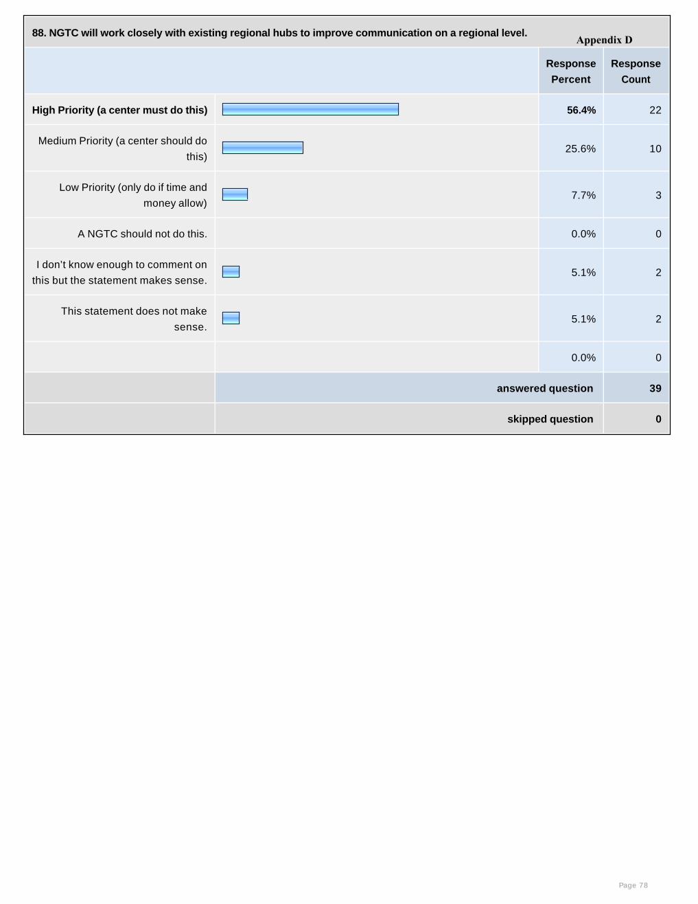
88. NGTC will work closely with existing regional hubs to improve communication on a regional level.
Response
Percent
Response
Count
High Priority (a center must do this) 56.4% 22
Medium Priority (a center should do
this)25.6% 10
Low Priority (only do if time and
money allow) 7.7% 3
A NGTC should not do this. 0.0% 0
I don’t know enough to comment on
this but the statement makes sense.5.1% 2
This statement does not make
sense.5.1% 2
0.0% 0
answered question 39
skipped question 0
Page 78
Appendix D
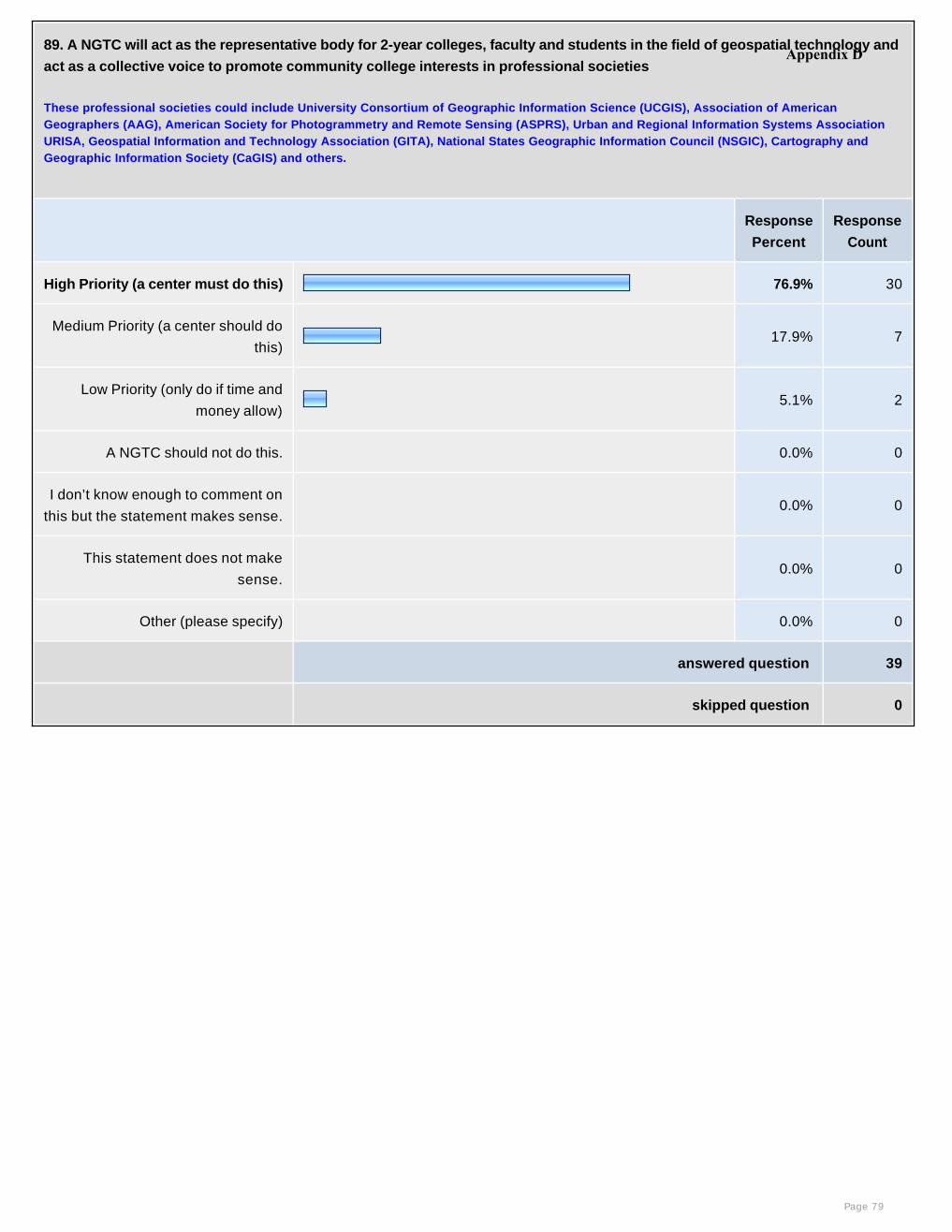
89. A NGTC will act as the representative body for 2-year colleges, faculty and students in the field of geospatial technology and
act as a collective voice to promote community college interests in professional societies
These professional societies could include University Consortium of Geographic Information Science (UCGIS), Association of American Geographers (AAG), American Society for Photogrammetry and Remote Sensing (ASPRS), Urban and Regional Information Systems Association URISA, Geospatial Information and Technology Association (GITA), National States Geographic Information Council (NSGIC), Cartography and Geographic Information Society (CaGIS) and others.
Response
Percent
Response
Count
High Priority (a center must do this) 76.9% 30
Medium Priority (a center should do
this)17.9% 7
Low Priority (only do if time and
money allow) 5.1% 2
A NGTC should not do this. 0.0% 0
I don’t know enough to comment on
this but the statement makes sense. 0.0% 0
This statement does not make
sense. 0.0% 0
Other (please specify) 0.0% 0
answered question 39
skipped question 0
Page 79
Appendix D

90. A NGTC will identify effective student recruitment approaches for GIS programs in community colleges and disseminate
available resources and recruitment tools for community college teachers.
Response
Percent
Response
Count
High Priority (a center must do this) 51.3% 20
Medium Priority (a center should do
this)35.9% 14
Low Priority (only do if time and
money allow) 7.7% 3
A NGTC should not do this. 5.1% 2
I don’t know enough to comment on
this but the statement makes sense. 0.0% 0
This statement does not make
sense. 0.0% 0
0.0% 0
answered question 39
skipped question 0
Page 80
Appendix D
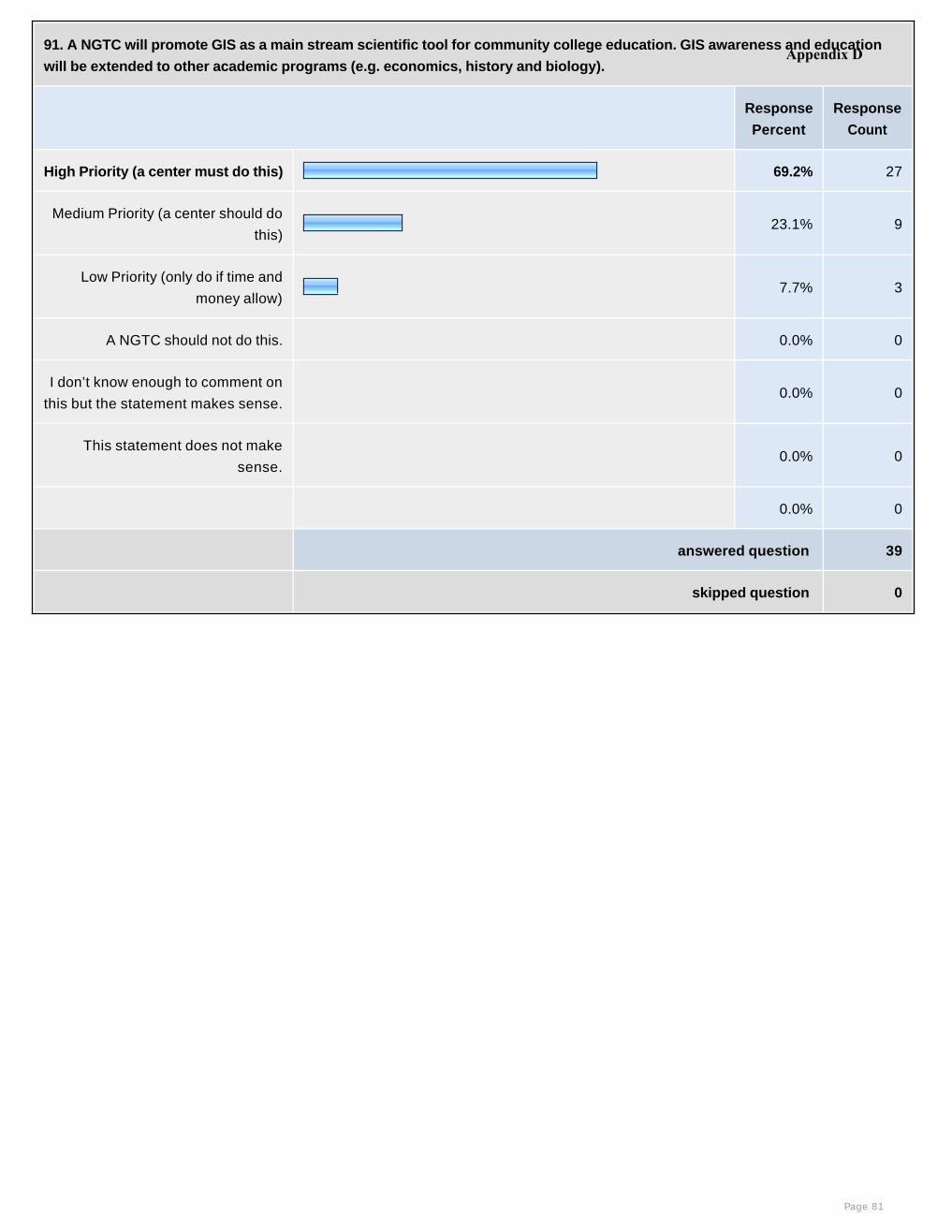
91. A NGTC will promote GIS as a main stream scientific tool for community college education. GIS awareness and education
will be extended to other academic programs (e.g. economics, history and biology).
Response
Percent
Response
Count
High Priority (a center must do this) 69.2% 27
Medium Priority (a center should do
this)23.1% 9
Low Priority (only do if time and
money allow) 7.7% 3
A NGTC should not do this. 0.0% 0
I don’t know enough to comment on
this but the statement makes sense. 0.0% 0
This statement does not make
sense. 0.0% 0
0.0% 0
answered question 39
skipped question 0
Page 81
Appendix D

92. A NGTC will disseminate success stories of geospatial awareness events and identify effective GIS education tools, such
as Google Earth and the National Atlas web mapping services, for community college GIS teachers.
Response
Percent
Response
Count
High Priority (a center must do this) 66.7% 26
Medium Priority (a center should do
this)23.1% 9
Low Priority (only do if time and
money allow) 10.3% 4
A NGTC should not do this. 0.0% 0
I don’t know enough to comment on
this but the statement makes sense. 0.0% 0
This statement does not make
sense. 0.0% 0
0.0% 0
answered question 39
skipped question 0
Page 82
Appendix D
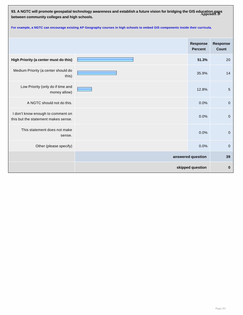
93. A NGTC will promote geospatial technology awareness and establish a future vision for bridging the GIS education gaps
between community colleges and high schools.
For example, a NGTC can encourage existing AP Geography courses in high schools to embed GIS components inside their curricula.
Response
Percent
Response
Count
High Priority (a center must do this) 51.3% 20
Medium Priority (a center should do
this)35.9% 14
Low Priority (only do if time and
money allow) 12.8% 5
A NGTC should not do this. 0.0% 0
I don’t know enough to comment on
this but the statement makes sense. 0.0% 0
This statement does not make
sense. 0.0% 0
Other (please specify) 0.0% 0
answered question 39
skipped question 0
Page 83
Appendix D
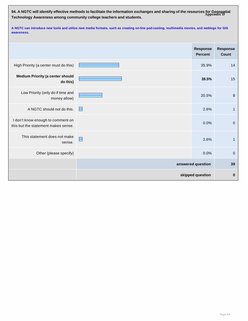
94. A NGTC will identify effective methods to facilitate the information exchanges and sharing of the resources for Geospatial
Technology Awareness among community college teachers and students.
A NGTC can introduce new tools and utilize new media formats, such as creating on-line pod-casting, multimedia movies, and weblogs for GIS awareness.
Response
Percent
Response
Count
High Priority (a center must do this) 35.9% 14
Medium Priority (a center should
do this)38.5% 15
Low Priority (only do if time and
money allow) 20.5% 8
A NGTC should not do this. 2.6% 1
I don’t know enough to comment on
this but the statement makes sense. 0.0% 0
This statement does not make
sense.2.6% 1
Other (please specify) 0.0% 0
answered question 39
skipped question 0
Page 84
Appendix D
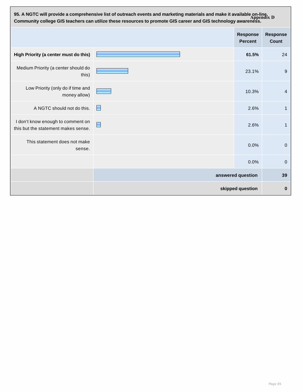
95. A NGTC will provide a comprehensive list of outreach events and marketing materials and make it available on-line.
Community college GIS teachers can utilize these resources to promote GIS career and GIS technology awareness.
Response
Percent
Response
Count
High Priority (a center must do this) 61.5% 24
Medium Priority (a center should do
this)23.1% 9
Low Priority (only do if time and
money allow) 10.3% 4
A NGTC should not do this. 2.6% 1
I don’t know enough to comment on
this but the statement makes sense.2.6% 1
This statement does not make
sense. 0.0% 0
0.0% 0
answered question 39
skipped question 0
Page 85
Appendix D
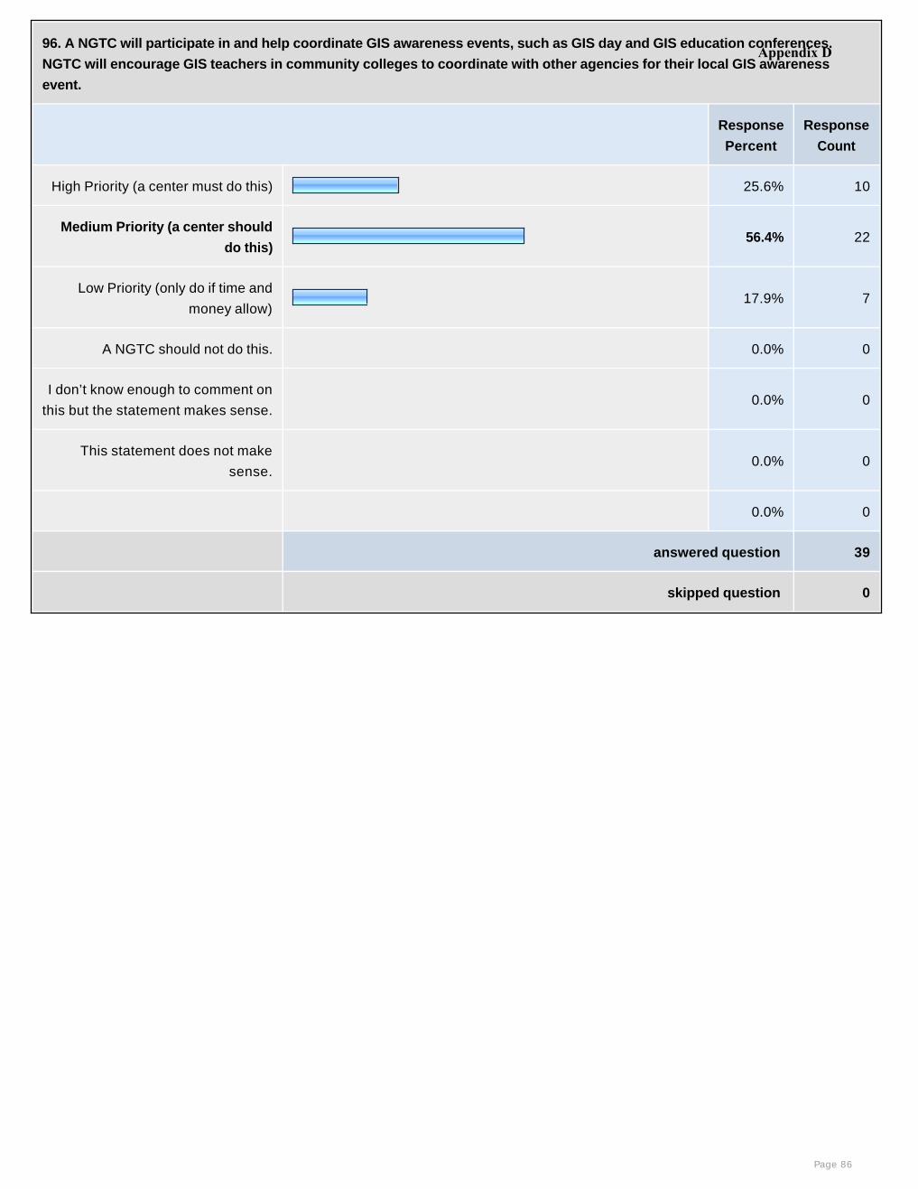
96. A NGTC will participate in and help coordinate GIS awareness events, such as GIS day and GIS education conferences.
NGTC will encourage GIS teachers in community colleges to coordinate with other agencies for their local GIS awareness
event.
Response
Percent
Response
Count
High Priority (a center must do this) 25.6% 10
Medium Priority (a center should
do this)56.4% 22
Low Priority (only do if time and
money allow) 17.9% 7
A NGTC should not do this. 0.0% 0
I don’t know enough to comment on
this but the statement makes sense. 0.0% 0
This statement does not make
sense. 0.0% 0
0.0% 0
answered question 39
skipped question 0
Page 86
Appendix D
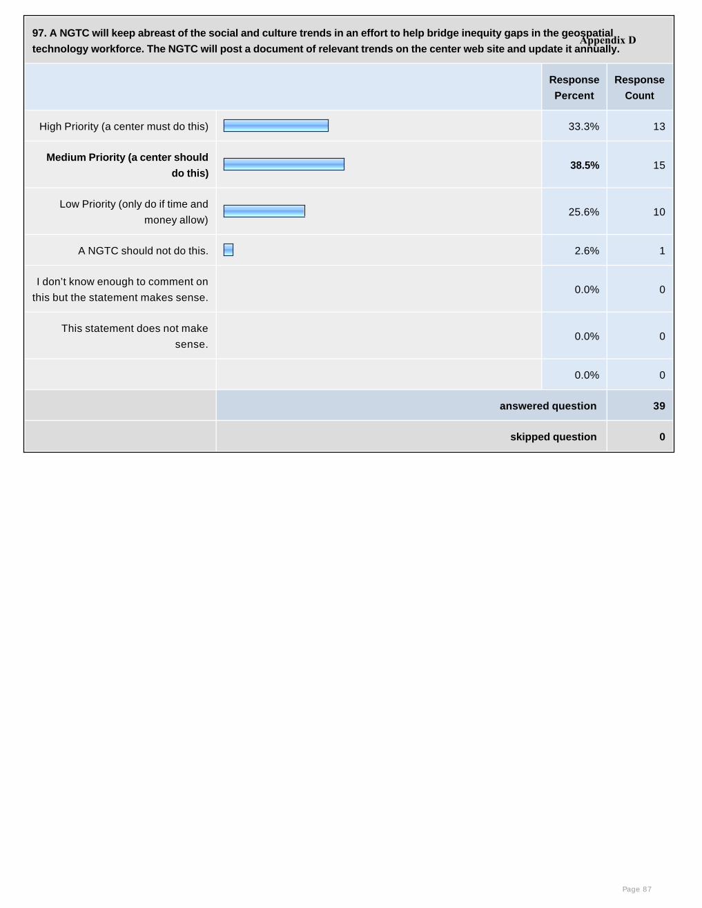
97. A NGTC will keep abreast of the social and culture trends in an effort to help bridge inequity gaps in the geospatial
technology workforce. The NGTC will post a document of relevant trends on the center web site and update it annually.
Response
Percent
Response
Count
High Priority (a center must do this) 33.3% 13
Medium Priority (a center should
do this)38.5% 15
Low Priority (only do if time and
money allow) 25.6% 10
A NGTC should not do this. 2.6% 1
I don’t know enough to comment on
this but the statement makes sense. 0.0% 0
This statement does not make
sense. 0.0% 0
0.0% 0
answered question 39
skipped question 0
Page 87
Appendix D
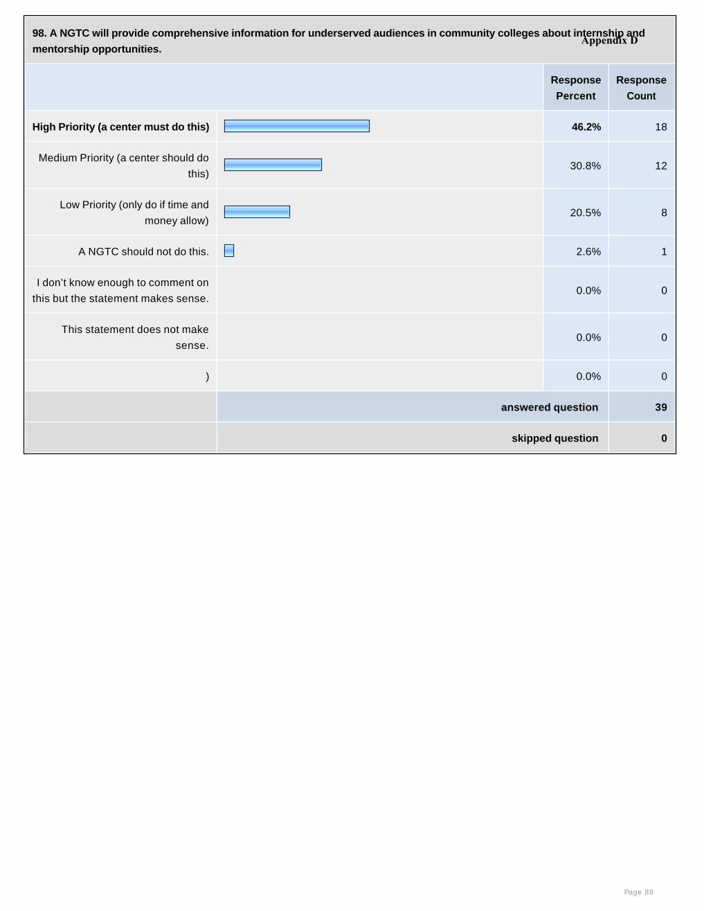
98. A NGTC will provide comprehensive information for underserved audiences in community colleges about internship and
mentorship opportunities.
Response
Percent
Response
Count
High Priority (a center must do this) 46.2% 18
Medium Priority (a center should do
this)30.8% 12
Low Priority (only do if time and
money allow) 20.5% 8
A NGTC should not do this. 2.6% 1
I don’t know enough to comment on
this but the statement makes sense. 0.0% 0
This statement does not make
sense. 0.0% 0
) 0.0% 0
answered question 39
skipped question 0
Page 88
Appendix D

99. A NGTC will develop a system to evaluate the progress of increasing the number of underserved students in the GIS
programs at community colleges.
Response
Percent
Response
Count
High Priority (a center must do this) 33.3% 13
Medium Priority (a center should
do this)41.0% 16
Low Priority (only do if time and
money allow) 23.1% 9
A NGTC should not do this. 2.6% 1
I don’t know enough to comment on
this but the statement makes sense. 0.0% 0
This statement does not make
sense. 0.0% 0
0.0% 0
answered question 39
skipped question 0
Page 89
Appendix D
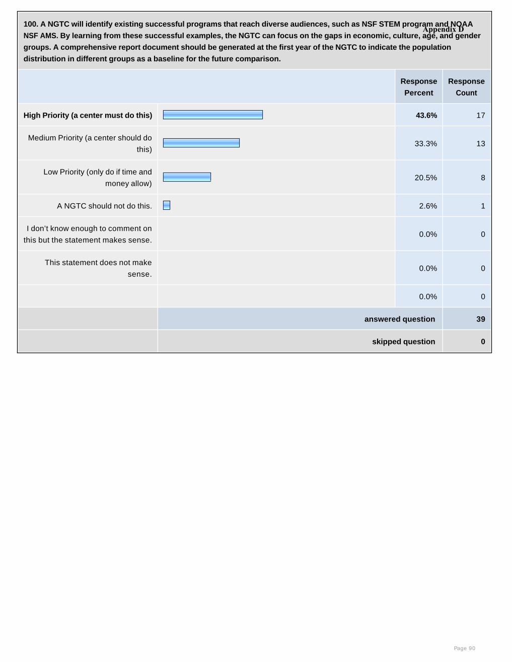
100. A NGTC will identify existing successful programs that reach diverse audiences, such as NSF STEM program and NOAA
NSF AMS. By learning from these successful examples, the NGTC can focus on the gaps in economic, culture, age, and gender
groups. A comprehensive report document should be generated at the first year of the NGTC to indicate the population
distribution in different groups as a baseline for the future comparison.
Response
Percent
Response
Count
High Priority (a center must do this) 43.6% 17
Medium Priority (a center should do
this)33.3% 13
Low Priority (only do if time and
money allow) 20.5% 8
A NGTC should not do this. 2.6% 1
I don’t know enough to comment on
this but the statement makes sense. 0.0% 0
This statement does not make
sense. 0.0% 0
0.0% 0
answered question 39
skipped question 0
Page 90
Appendix D
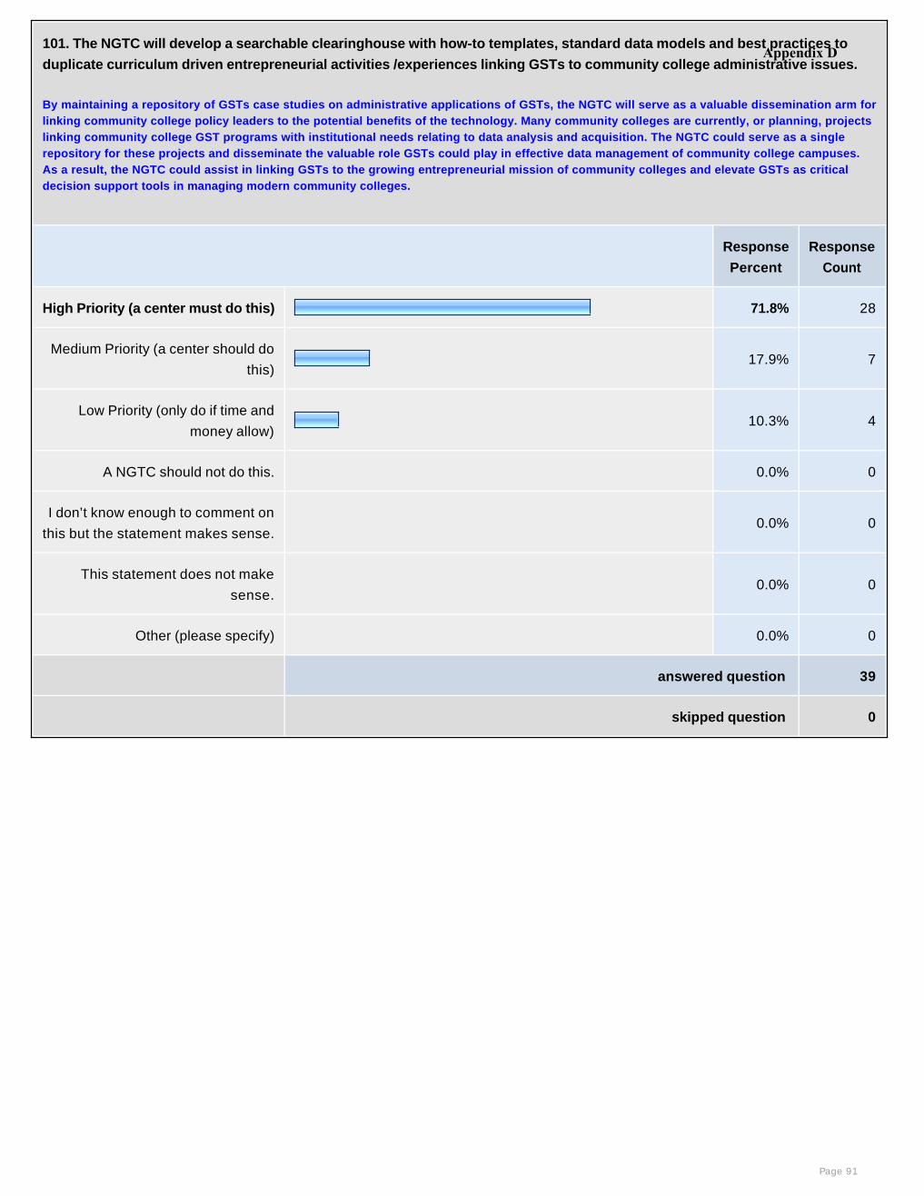
101. The NGTC will develop a searchable clearinghouse with how-to templates, standard data models and best practices to
duplicate curriculum driven entrepreneurial activities /experiences linking GSTs to community college administrative issues.
By maintaining a repository of GSTs case studies on administrative applications of GSTs, the NGTC will serve as a valuable dissemination arm for linking community college policy leaders to the potential benefits of the technology. Many community colleges are currently, or planning, projects linking community college GST programs with institutional needs relating to data analysis and acquisition. The NGTC could serve as a single repository for these projects and disseminate the valuable role GSTs could play in effective data management of community college campuses. As a result, the NGTC could assist in linking GSTs to the growing entrepreneurial mission of community colleges and elevate GSTs as critical decision support tools in managing modern community colleges.
Response
Percent
Response
Count
High Priority (a center must do this) 71.8% 28
Medium Priority (a center should do
this)17.9% 7
Low Priority (only do if time and
money allow) 10.3% 4
A NGTC should not do this. 0.0% 0
I don’t know enough to comment on
this but the statement makes sense. 0.0% 0
This statement does not make
sense. 0.0% 0
Other (please specify) 0.0% 0
answered question 39
skipped question 0
Page 91
Appendix D
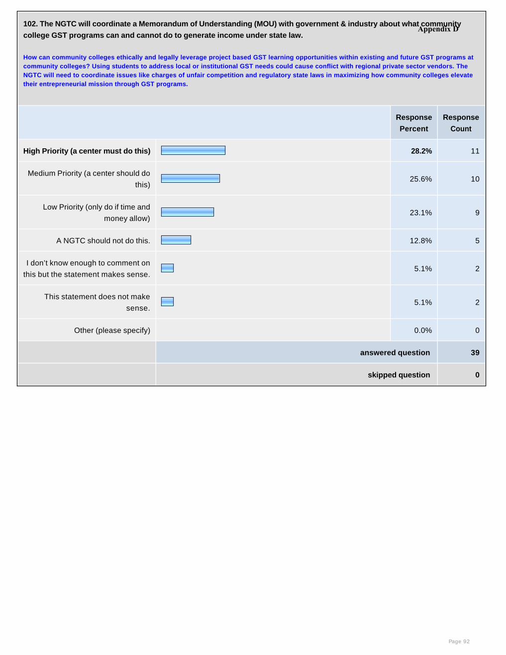
102. The NGTC will coordinate a Memorandum of Understanding (MOU) with government & industry about what community
college GST programs can and cannot do to generate income under state law.
How can community colleges ethically and legally leverage project based GST learning opportunities within existing and future GST programs at community colleges? Using students to address local or institutional GST needs could cause conflict with regional private sector vendors. The NGTC will need to coordinate issues like charges of unfair competition and regulatory state laws in maximizing how community colleges elevate their entrepreneurial mission through GST programs.
Response
Percent
Response
Count
High Priority (a center must do this) 28.2% 11
Medium Priority (a center should do
this)25.6% 10
Low Priority (only do if time and
money allow) 23.1% 9
A NGTC should not do this. 12.8% 5
I don’t know enough to comment on
this but the statement makes sense.5.1% 2
This statement does not make
sense.5.1% 2
Other (please specify) 0.0% 0
answered question 39
skipped question 0
Page 92
Appendix D
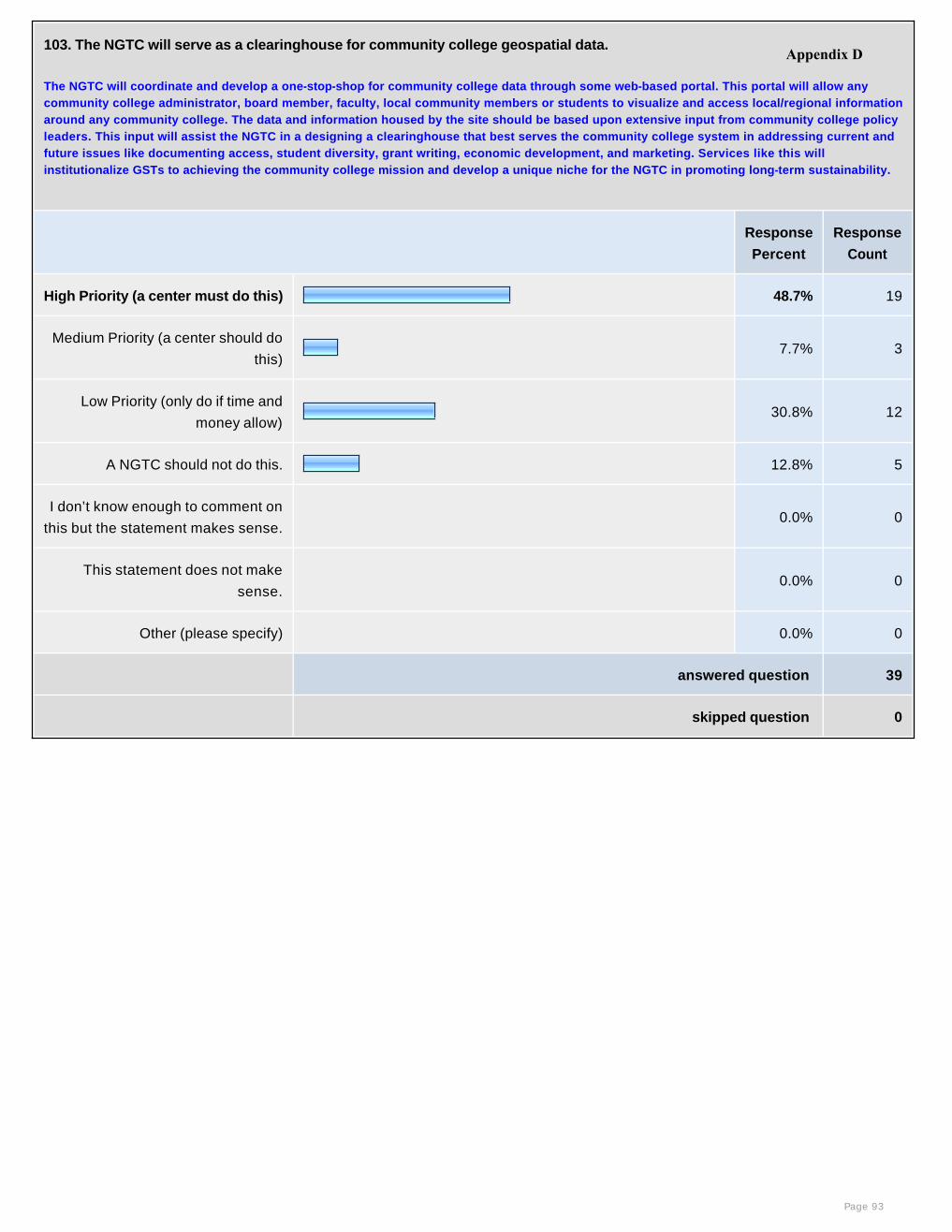
103. The NGTC will serve as a clearinghouse for community college geospatial data.
The NGTC will coordinate and develop a one-stop-shop for community college data through some web-based portal. This portal will allow any community college administrator, board member, faculty, local community members or students to visualize and access local/regional information around any community college. The data and information housed by the site should be based upon extensive input from community college policy leaders. This input will assist the NGTC in a designing a clearinghouse that best serves the community college system in addressing current and future issues like documenting access, student diversity, grant writing, economic development, and marketing. Services like this will institutionalize GSTs to achieving the community college mission and develop a unique niche for the NGTC in promoting long-term sustainability.
Response
Percent
Response
Count
High Priority (a center must do this) 48.7% 19
Medium Priority (a center should do
this)7.7% 3
Low Priority (only do if time and
money allow) 30.8% 12
A NGTC should not do this. 12.8% 5
I don’t know enough to comment on
this but the statement makes sense. 0.0% 0
This statement does not make
sense. 0.0% 0
Other (please specify) 0.0% 0
answered question 39
skipped question 0
Page 93
Appendix D
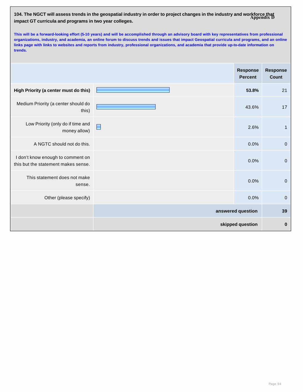
104. The NGCT will assess trends in the geospatial industry in order to project changes in the industry and workforce that
impact GT curricula and programs in two year colleges.
This will be a forward-looking effort (5-10 years) and will be accomplished through an advisory board with key representatives from professional organizations, industry, and academia, an online forum to discuss trends and issues that impact Geospatial curricula and programs, and an online links page with links to websites and reports from industry, professional organizations, and academia that provide up-to-date information on trends.
Response
Percent
Response
Count
High Priority (a center must do this) 53.8% 21
Medium Priority (a center should do
this)43.6% 17
Low Priority (only do if time and
money allow) 2.6% 1
A NGTC should not do this. 0.0% 0
I don’t know enough to comment on
this but the statement makes sense. 0.0% 0
This statement does not make
sense. 0.0% 0
Other (please specify) 0.0% 0
answered question 39
skipped question 0
Page 94
Appendix D
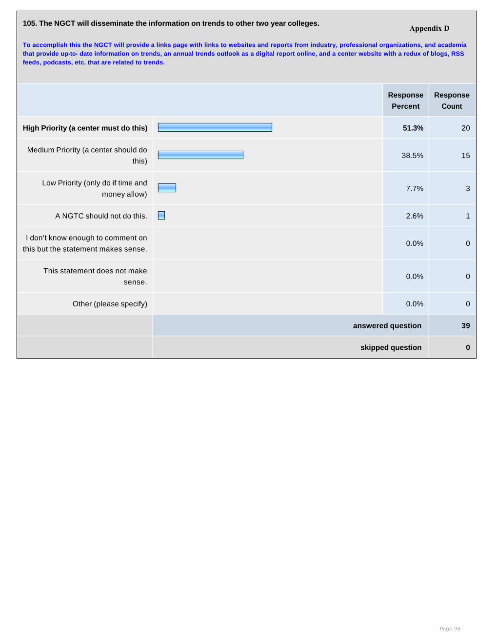
105. The NGCT will disseminate the information on trends to other two year colleges.
To accomplish this the NGCT will provide a links page with links to websites and reports from industry, professional organizations, and academia that provide up-to- date information on trends, an annual trends outlook as a digital report online, and a center website with a redux of blogs, RSS feeds, podcasts, etc. that are related to trends.
Response
Percent
Response
Count
High Priority (a center must do this) 51.3% 20
Medium Priority (a center should do
this)38.5% 15
Low Priority (only do if time and
money allow) 7.7% 3
A NGTC should not do this. 2.6% 1
I don’t know enough to comment on
this but the statement makes sense. 0.0% 0
This statement does not make
sense. 0.0% 0
Other (please specify) 0.0% 0
answered question 39
skipped question 0
Page 95
Appendix D
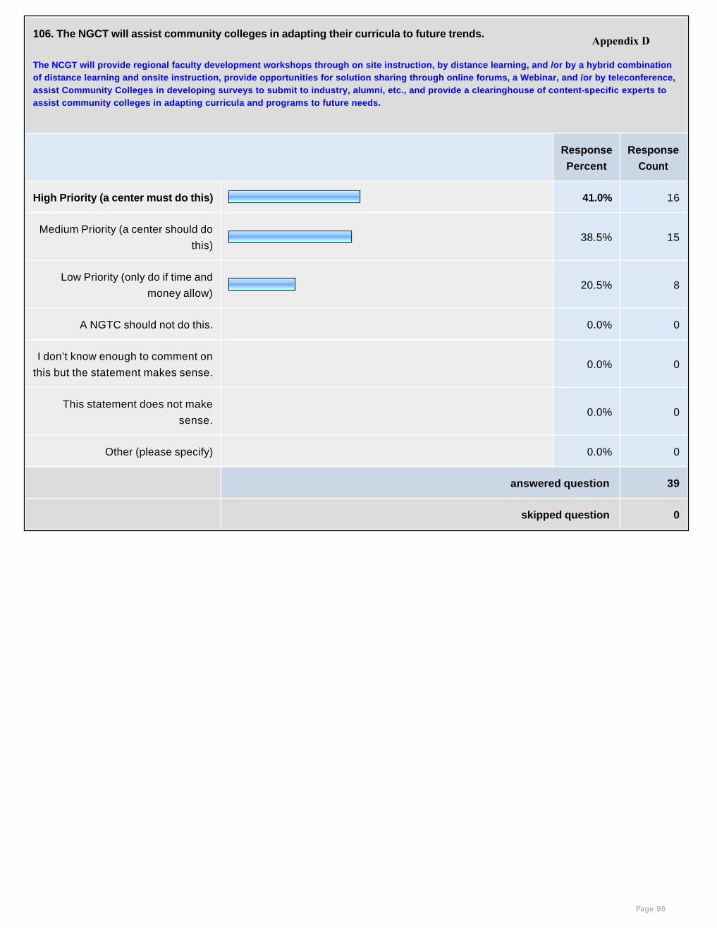
106. The NGCT will assist community colleges in adapting their curricula to future trends.
The NCGT will provide regional faculty development workshops through on site instruction, by distance learning, and /or by a hybrid combination of distance learning and onsite instruction, provide opportunities for solution sharing through online forums, a Webinar, and /or by teleconference, assist Community Colleges in developing surveys to submit to industry, alumni, etc., and provide a clearinghouse of content-specific experts to assist community colleges in adapting curricula and programs to future needs.
Response
Percent
Response
Count
High Priority (a center must do this) 41.0% 16
Medium Priority (a center should do
this)38.5% 15
Low Priority (only do if time and
money allow) 20.5% 8
A NGTC should not do this. 0.0% 0
I don’t know enough to comment on
this but the statement makes sense. 0.0% 0
This statement does not make
sense. 0.0% 0
Other (please specify) 0.0% 0
answered question 39
skipped question 0
Page 96
Appendix D
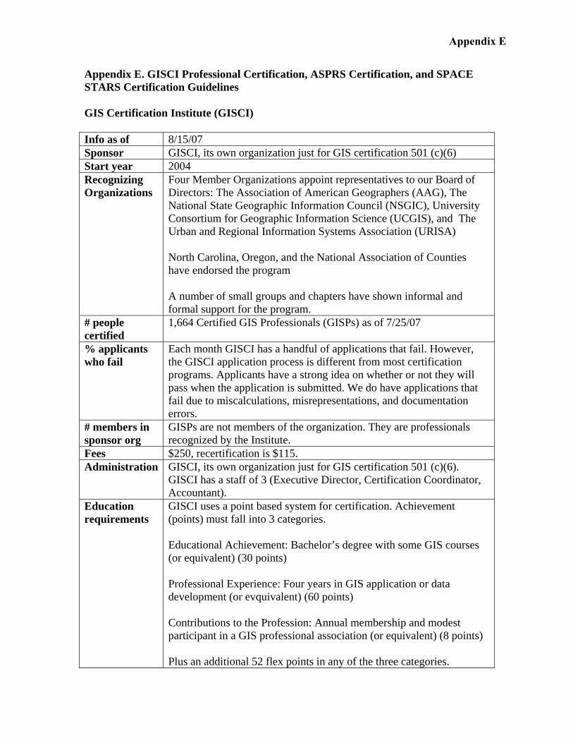
Appendix E. GISCI Professional Certification, ASPRS Certification, and SPACE STARS Certification Guidelines GIS Certification Institute (GISCI) Info as of 8/15/07 Sponsor GISCI, its own organization just for GIS certification 501 (c)(6) Start year 2004 Recognizing Organizations
Four Member Organizations appoint representatives to our Board of Directors: The Association of American Geographers (AAG), The National State Geographic Information Council (NSGIC), University Consortium for Geographic Information Science (UCGIS), and The Urban and Regional Information Systems Association (URISA) North Carolina, Oregon, and the National Association of Counties have endorsed the program A number of small groups and chapters have shown informal and formal support for the program.
# people certified
1,664 Certified GIS Professionals (GISPs) as of 7/25/07
% applicants who fail
Each month GISCI has a handful of applications that fail. However, the GISCI application process is different from most certification programs. Applicants have a strong idea on whether or not they will pass when the application is submitted. We do have applications that fail due to miscalculations, misrepresentations, and documentation errors.
# members in sponsor org
GISPs are not members of the organization. They are professionals recognized by the Institute.
Fees $250, recertification is $115. Administration GISCI, its own organization just for GIS certification 501 (c)(6).
GISCI has a staff of 3 (Executive Director, Certification Coordinator, Accountant).
Education requirements
GISCI uses a point based system for certification. Achievement (points) must fall into 3 categories. Educational Achievement: Bachelor’s degree with some GIS courses (or equivalent) (30 points) Professional Experience: Four years in GIS application or data development (or evquivalent) (60 points) Contributions to the Profession: Annual membership and modest participant in a GIS professional association (or equivalent) (8 points) Plus an additional 52 flex points in any of the three categories.
Appendix E
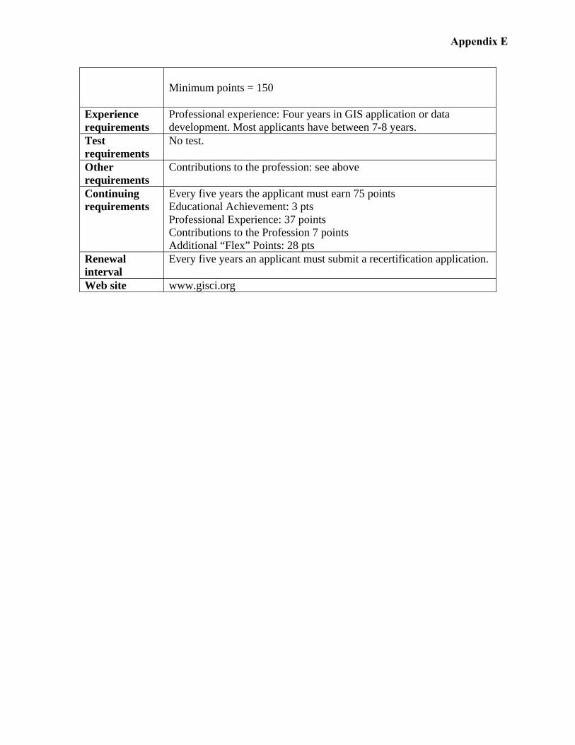
Minimum points = 150
Experience requirements
Professional experience: Four years in GIS application or data development. Most applicants have between 7-8 years.
Test requirements
No test.
Other requirements
Contributions to the profession: see above
Continuing requirements
Every five years the applicant must earn 75 points Educational Achievement: 3 pts Professional Experience: 37 points Contributions to the Profession 7 points Additional “Flex” Points: 28 pts
Renewal interval
Every five years an applicant must submit a recertification application.
Web site www.gisci.org
Appendix E
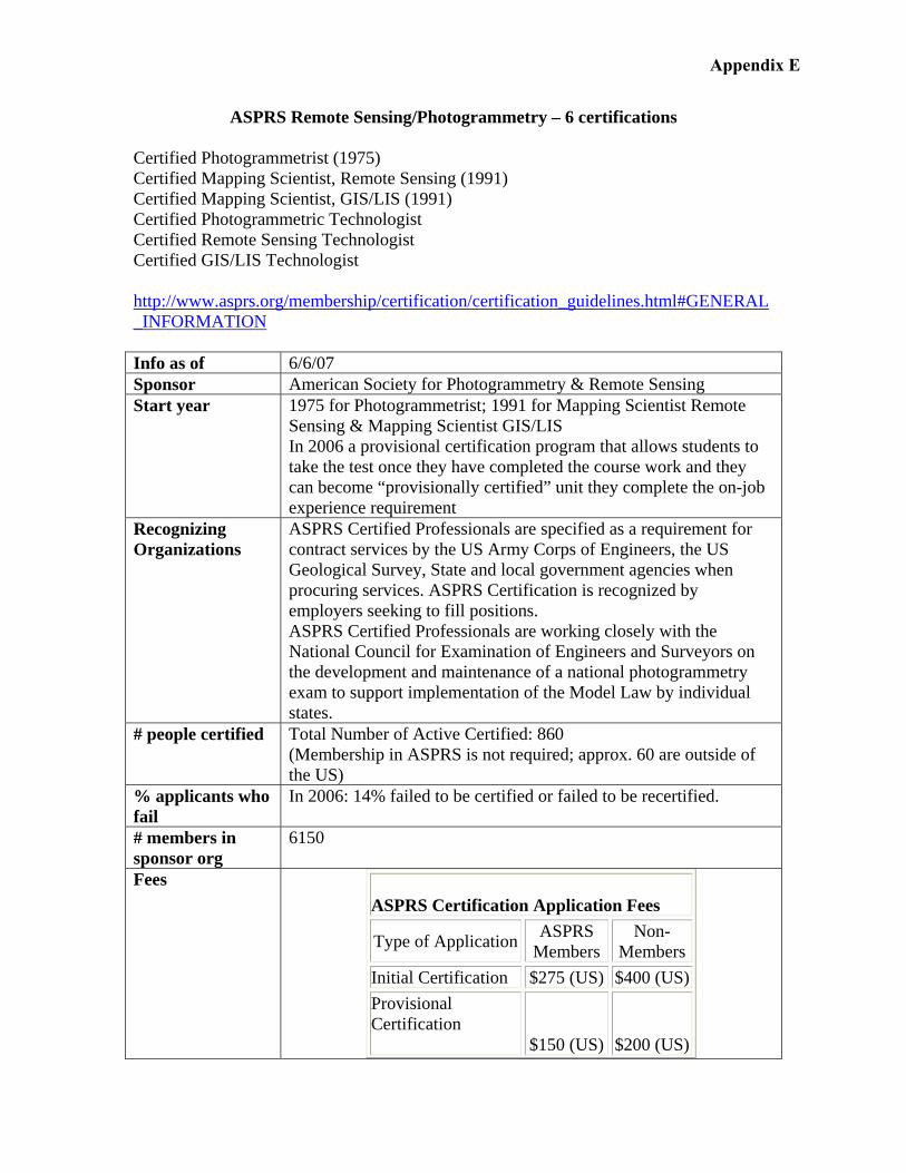
ASPRS Remote Sensing/Photogrammetry – 6 certifications Certified Photogrammetrist (1975) Certified Mapping Scientist, Remote Sensing (1991) Certified Mapping Scientist, GIS/LIS (1991) Certified Photogrammetric Technologist Certified Remote Sensing Technologist Certified GIS/LIS Technologist http://www.asprs.org/membership/certification/certification_guidelines.html#GENERAL_INFORMATION Info as of 6/6/07 Sponsor American Society for Photogrammetry & Remote Sensing Start year 1975 for Photogrammetrist; 1991 for Mapping Scientist Remote
Sensing & Mapping Scientist GIS/LIS In 2006 a provisional certification program that allows students to take the test once they have completed the course work and they can become “provisionally certified” unit they complete the on-job experience requirement
Recognizing Organizations
ASPRS Certified Professionals are specified as a requirement for contract services by the US Army Corps of Engineers, the US Geological Survey, State and local government agencies when procuring services. ASPRS Certification is recognized by employers seeking to fill positions. ASPRS Certified Professionals are working closely with the National Council for Examination of Engineers and Surveyors on the development and maintenance of a national photogrammetry exam to support implementation of the Model Law by individual states.
# people certified Total Number of Active Certified: 860 (Membership in ASPRS is not required; approx. 60 are outside of the US)
% applicants who fail
In 2006: 14% failed to be certified or failed to be recertified.
# members in sponsor org
6150
Fees ASPRS Certification Application Fees
Type of Application ASPRS Members
Non-Members
Initial Certification $275 (US) $400 (US) Provisional Certification
$150 (US)
$200 (US)
Appendix E
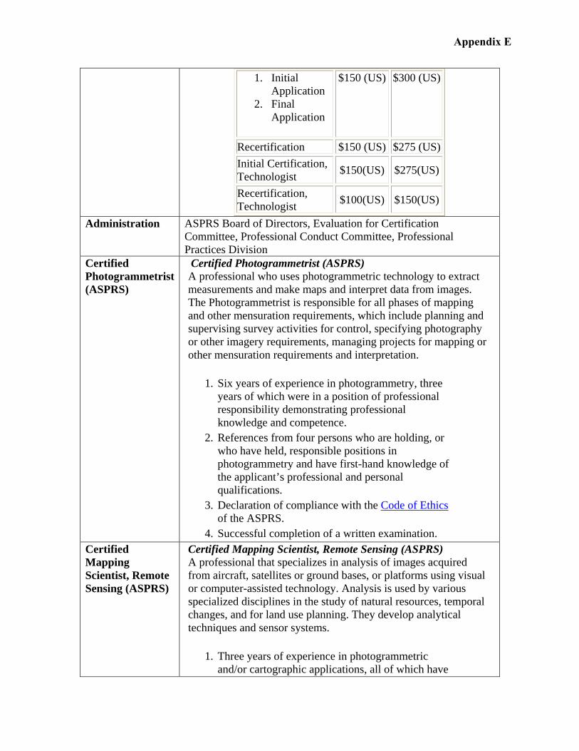
1. Initial Application
2. Final Application
$150 (US) $300 (US)
Recertification $150 (US) $275 (US) Initial Certification, Technologist $150(US) $275(US)
Recertification, Technologist $100(US) $150(US)
Administration ASPRS Board of Directors, Evaluation for Certification
Committee, Professional Conduct Committee, Professional Practices Division
Certified Photogrammetrist (ASPRS)
Certified Photogrammetrist (ASPRS) A professional who uses photogrammetric technology to extract measurements and make maps and interpret data from images. The Photogrammetrist is responsible for all phases of mapping and other mensuration requirements, which include planning and supervising survey activities for control, specifying photography or other imagery requirements, managing projects for mapping or other mensuration requirements and interpretation.
1. Six years of experience in photogrammetry, three years of which were in a position of professional responsibility demonstrating professional knowledge and competence.
2. References from four persons who are holding, or who have held, responsible positions in photogrammetry and have first-hand knowledge of the applicant’s professional and personal qualifications.
3. Declaration of compliance with the Code of Ethics of the ASPRS.
4. Successful completion of a written examination. Certified Mapping Scientist, Remote Sensing (ASPRS)
Certified Mapping Scientist, Remote Sensing (ASPRS) A professional that specializes in analysis of images acquired from aircraft, satellites or ground bases, or platforms using visual or computer-assisted technology. Analysis is used by various specialized disciplines in the study of natural resources, temporal changes, and for land use planning. They develop analytical techniques and sensor systems.
1. Three years of experience in photogrammetric and/or cartographic applications, all of which have
Appendix E
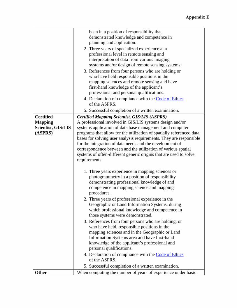
been in a position of responsibility that demonstrated knowledge and competence in planning and application.
2. Three years of specialized experience at a professional level in remote sensing and interpretation of data from various imaging systems and/or design of remote sensing systems.
3. References from four persons who are holding or who have held responsible positions in the mapping sciences and remote sensing and have first-hand knowledge of the applicant’s professional and personal qualifications.
4. Declaration of compliance with the Code of Ethics of the ASPRS.
5. Successful completion of a written examination. Certified Mapping Scientist, GIS/LIS (ASPRS)
Certified Mapping Scientist, GIS/LIS (ASPRS) A professional involved in GIS/LIS systems design and/or systems application of data base management and computer programs that allow for the utilization of spatially referenced data bases for solving user analysis requirements. They are responsible for the integration of data needs and the development of correspondence between and the utilization of various spatial systems of often-different generic origins that are used to solve requirements.
1. Three years experience in mapping sciences or photogrammetry in a position of responsibility demonstrating professional knowledge of and competence in mapping science and mapping procedures.
2. Three years of professional experience in the Geographic or Land Information Systems, during which professional knowledge and competence in those systems were demonstrated.
3. References from four persons who are holding, or who have held, responsible positions in the mapping sciences and in the Geographic or Land Information Systems area and have first-hand knowledge of the applicant’s professional and personal qualifications.
4. Declaration of compliance with the Code of Ethics of the ASPRS.
5. Successful completion of a written examination. Other When computing the number of years of experience under basic
Appendix E
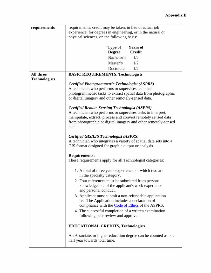
requirements requirements, credit may be taken, in lieu of actual job experience, for degrees in engineering, or in the natural or physical sciences, on the following basis:
Type of Degree
Years of Credit
Bachelor’s 1/2 Master’s 1/2 Doctorate 1/2
All three Technologists
BASIC REQUIREMENTS, Technologists
Certified Photogrammetric Technologist (ASPRS) A technician who performs or supervises technical photogrammetric tasks to extract spatial data from photographic or digital imagery and other remotely-sensed data.
Certified Remote Sensing Technologist (ASPRS) A technician who performs or supervises tasks to interpret, manipulate, extract, process and convert remotely sensed data from photographic or digital imagery and other remotely-sensed data.
Certified GIS/LIS Technologist (ASPRS) A technician who integrates a variety of spatial data sets into a GIS format designed for graphic output or analysis.
Requirements: These requirements apply for all Technologist categories:
1. A total of three years experience, of which two are in the specialty category.
2. Four references must be submitted from persons knowledgeable of the applicant's work experience and personal conduct.
3. Applicant must submit a non-refundable application fee. The Application includes a declaration of compliance with the Code of Ethics of the ASPRS.
4. The successful completion of a written examination following peer review and approval.
EDUCATIONAL CREDITS, Technologists
An Associate, or higher education degree can be counted as one-half year towards total time.
Appendix E
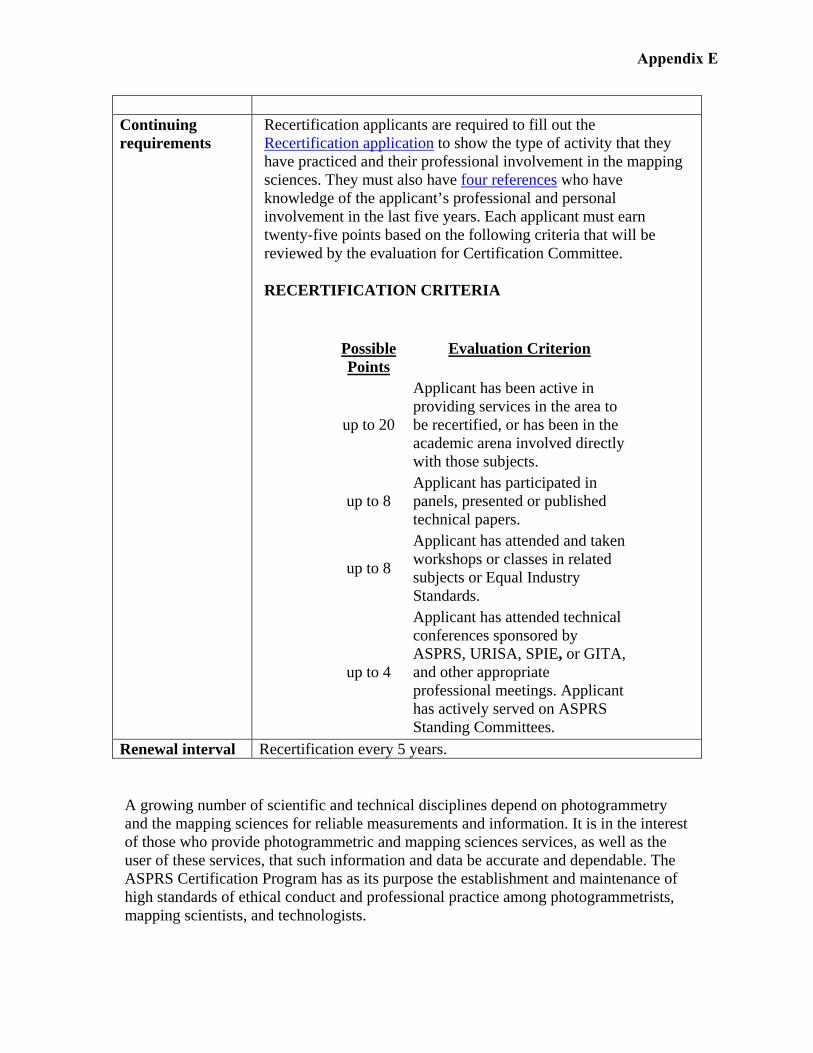
Continuing requirements
Recertification applicants are required to fill out the Recertification application to show the type of activity that they have practiced and their professional involvement in the mapping sciences. They must also have four references who have knowledge of the applicant’s professional and personal involvement in the last five years. Each applicant must earn twenty-five points based on the following criteria that will be reviewed by the evaluation for Certification Committee.
RECERTIFICATION CRITERIA
Possible Points
Evaluation Criterion
up to 20
Applicant has been active in providing services in the area to be recertified, or has been in the academic arena involved directly with those subjects.
up to 8 Applicant has participated in panels, presented or published technical papers.
up to 8
Applicant has attended and taken workshops or classes in related subjects or Equal Industry Standards.
up to 4
Applicant has attended technical conferences sponsored by ASPRS, URISA, SPIE, or GITA, and other appropriate professional meetings. Applicant has actively served on ASPRS Standing Committees.
Renewal interval Recertification every 5 years.
A growing number of scientific and technical disciplines depend on photogrammetry and the mapping sciences for reliable measurements and information. It is in the interest of those who provide photogrammetric and mapping sciences services, as well as the user of these services, that such information and data be accurate and dependable. The ASPRS Certification Program has as its purpose the establishment and maintenance of high standards of ethical conduct and professional practice among photogrammetrists, mapping scientists, and technologists.
Appendix E
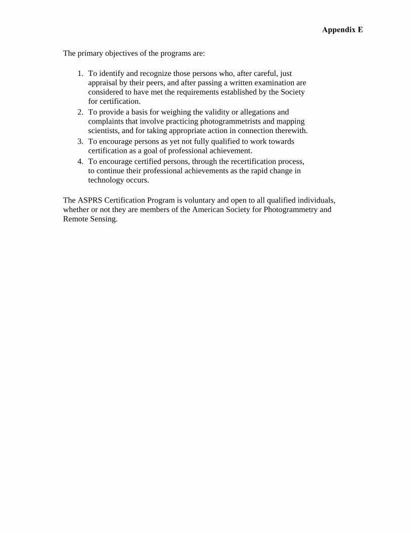
The primary objectives of the programs are:
1. To identify and recognize those persons who, after careful, just appraisal by their peers, and after passing a written examination are considered to have met the requirements established by the Society for certification.
2. To provide a basis for weighing the validity or allegations and complaints that involve practicing photogrammetrists and mapping scientists, and for taking appropriate action in connection therewith.
3. To encourage persons as yet not fully qualified to work towards certification as a goal of professional achievement.
4. To encourage certified persons, through the recertification process, to continue their professional achievements as the rapid change in technology occurs.
The ASPRS Certification Program is voluntary and open to all qualified individuals, whether or not they are members of the American Society for Photogrammetry and Remote Sensing.
Appendix E
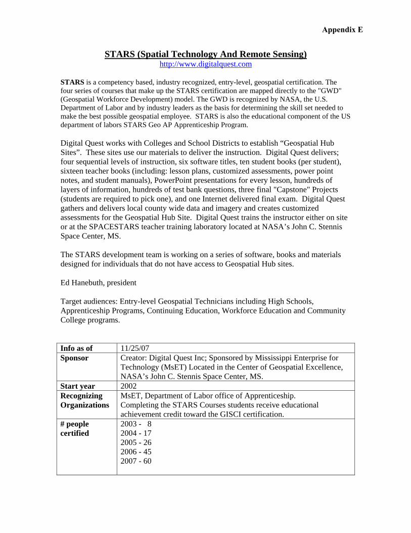
STARS (Spatial Technology And Remote Sensing) http://www.digitalquest.com
STARS is a competency based, industry recognized, entry-level, geospatial certification. The four series of courses that make up the STARS certification are mapped directly to the "GWD" (Geospatial Workforce Development) model. The GWD is recognized by NASA, the U.S. Department of Labor and by industry leaders as the basis for determining the skill set needed to make the best possible geospatial employee. STARS is also the educational component of the US department of labors STARS Geo AP Apprenticeship Program.
Digital Quest works with Colleges and School Districts to establish “Geospatial Hub Sites”. These sites use our materials to deliver the instruction. Digital Quest delivers; four sequential levels of instruction, six software titles, ten student books (per student), sixteen teacher books (including: lesson plans, customized assessments, power point notes, and student manuals), PowerPoint presentations for every lesson, hundreds of layers of information, hundreds of test bank questions, three final "Capstone" Projects (students are required to pick one), and one Internet delivered final exam. Digital Quest gathers and delivers local county wide data and imagery and creates customized assessments for the Geospatial Hub Site. Digital Quest trains the instructor either on site or at the SPACESTARS teacher training laboratory located at NASA’s John C. Stennis Space Center, MS. The STARS development team is working on a series of software, books and materials designed for individuals that do not have access to Geospatial Hub sites.
Ed Hanebuth, president
Target audiences: Entry-level Geospatial Technicians including High Schools, Apprenticeship Programs, Continuing Education, Workforce Education and Community College programs.
Info as of 11/25/07 Sponsor Creator: Digital Quest Inc; Sponsored by Mississippi Enterprise for
Technology (MsET) Located in the Center of Geospatial Excellence, NASA’s John C. Stennis Space Center, MS.
Start year 2002 Recognizing Organizations
MsET, Department of Labor office of Apprenticeship. Completing the STARS Courses students receive educational achievement credit toward the GISCI certification.
# people certified
2003 - 8 2004 - 17 2005 - 26 2006 - 45 2007 - 60
Appendix E
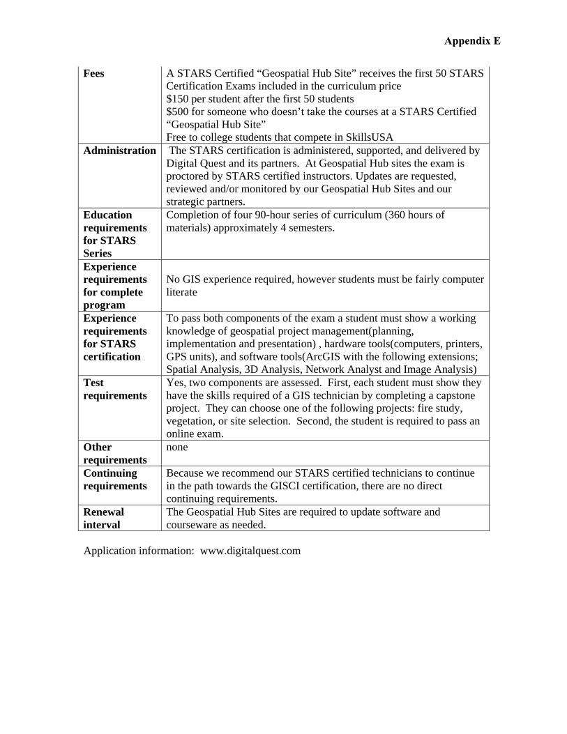
Fees A STARS Certified “Geospatial Hub Site” receives the first 50 STARS Certification Exams included in the curriculum price $150 per student after the first 50 students $500 for someone who doesn’t take the courses at a STARS Certified “Geospatial Hub Site” Free to college students that compete in SkillsUSA
Administration The STARS certification is administered, supported, and delivered by Digital Quest and its partners. At Geospatial Hub sites the exam is proctored by STARS certified instructors. Updates are requested, reviewed and/or monitored by our Geospatial Hub Sites and our strategic partners.
Education requirements for STARS Series
Completion of four 90-hour series of curriculum (360 hours of materials) approximately 4 semesters.
Experience requirements for complete program
No GIS experience required, however students must be fairly computer literate
Experience requirements for STARS certification
To pass both components of the exam a student must show a working knowledge of geospatial project management(planning, implementation and presentation) , hardware tools(computers, printers, GPS units), and software tools(ArcGIS with the following extensions; Spatial Analysis, 3D Analysis, Network Analyst and Image Analysis)
Test requirements
Yes, two components are assessed. First, each student must show they have the skills required of a GIS technician by completing a capstone project. They can choose one of the following projects: fire study, vegetation, or site selection. Second, the student is required to pass an online exam.
Other requirements
none
Continuing requirements
Because we recommend our STARS certified technicians to continue in the path towards the GISCI certification, there are no direct continuing requirements.
Renewal interval
The Geospatial Hub Sites are required to update software and courseware as needed.
Application information: www.digitalquest.com
Appendix E