Embed Size (px)
Citation preview

1
Details, Objectives and Maps for Adopted MPAs in the North Central Coast Study Region
MPA: Point Arena State Marine Reserve Area (sq. mi.): 4.38 Along-shore span (mi): 3.0 Depth range (ft): 0-173 Primary habitat types: rocky intertidal and cliff, subtidal soft substrate, subtidal hard substrate, and kelp Regulations: Take of all living marine resources is prohibited. Boundaries: This area is bounded by the mean high tide line and straight lines connecting the following points in the order listed:
38° 57.35’ N. lat. 123° 44.50’ W. long.; 38° 59.00’ N. lat. 123° 44.50’ W. long.; 38° 59.00’ N. lat. 123° 46.00’ W. long.; 38° 56.40’ N. lat. 123° 46.00’ W. long.; and 38° 56.40’ N. lat. 123° 43.82’ W. long. MPA: Point Arena State Marine Conservation Area Area (sq. mi.): 6.73 Along-shore span (mi): 3.0 Depth range (ft): 153-324 Primary habitat types: subtidal soft substrate and subtidal hard substrate Regulations: Take of all living marine resources is prohibited EXCEPT the recreational take of salmon by trolling and the commercial take of salmon with troll fishing gear.
Boundaries: This area is bounded by straight lines connecting the following points in the order listed except where noted: 38° 59.00’ N. lat. 123° 46.00’ W. long.; 38° 59.00’ N. lat. 123° 48.16’ W. long.; thence southward along the three nautical mile offshore boundary to 38° 56.40’ N. lat. 123° 48.35’ W. long.; 38° 56.40’ N. lat. 123° 46.00’ W. long.; and 38° 59.00’ N. lat. 123° 46.00’ W. long. MPA: Sea Lion Cove State Marine Conservation Area Area (sq. mi.): 0.22 Along-shore span (mi): 0.7 Depth range (ft): 0-39 Primary habitat types: sandy or gravel beaches, rocky intertidal and cliff, subtidal hard substrate, and kelp

2
Regulations: The recreational and commercial take of all marine invertebrates and marine aquatic plants is prohibited. Take of all other species is allowed. Boundaries: This area is bounded by the mean high tide line and straight lines connecting the following points in the order listed:
38° 56.40’ N. lat. 123° 43.82’ W. long.; 38° 56.40’ N. lat. 123° 44.00’ W. long.; 38° 55.79’ N. lat. 123° 44.00’ W. long.; and 38° 55.79’ N. lat. 123° 43.74’ W. long.
MPA: Saunders Reef State Marine Conservation Area Area (sq. mi.): 9.35 Along-shore span (mi): 3.0 Depth range (ft): 0-276 Primary habitat types: sandy or gravel beaches, rocky Intertidal and cliff, subtidal soft substrate, subtidal hard substrate, and kelp Regulations: Take of all living marine resources is prohibited EXCEPT: 1. The recreational take of salmon by trolling

3
2. The commercial take of salmon with troll fishing gear, and urchin Boundaries: This area is bounded by the mean high tide line and straight lines connecting the following points in the order listed except where noted: 38° 51.80’ N. lat. 123° 39.23’ W. long.; 38° 51.80’ N. lat. 123° 44.78’ W. long.; thence southward along the three nautical mile offshore boundary to 38° 50.00’ N. lat. 123° 42.58’ W. long.; and 38° 50.00’ N. lat. 123° 37.60’ W. long.
MPA: Del Mar Landing State Marine Reserve Area (sq. mi.): 0.22 Along-shore span (mi): 0.6 Depth range (ft): 0-87 Primary habitat types: rocky intertidal and cliff, subtidal hard substrate, and kelp Regulations: Take of all living marine resources is prohibited.

4
Boundaries: This area is bounded by the mean high tide line and straight lines connecting the following points in the order listed:
38° 44.70’ N. lat. 123° 31.00’ W. long.; 38° 44.20’ N. lat. 123° 31.00’ W. long.; 38° 44.20’ N. lat. 123° 30.30’ W. long.; and 38° 44.43’ N. lat. 123° 30.30’ W. long.
MPA: Stewarts Point State Marine Reserve Area (sq. mi.): 25.22 Along-shore span (mi): 7.0 Depth range (ft): 0-294 Primary habitat types: sandy or gravel beaches, rocky intertidal and cliff, subtidal soft substrate, subtidal hard substrate, and kelp Regulations: Take of all living marine resources is prohibited. Boundaries: This area is bounded by the mean high tide line and straight lines connecting the

5
following points in the order listed except where noted:
38° 40.50’ N. lat. 123° 25.37’ W. long.; 38° 40.50’ N. lat. 123° 30.24’ W. long.; thence southward along the three nautical mile offshore boundary to 38° 35.60’ N. lat. 123° 26.01’ W. long.; and 38° 35.60’ N. lat. 123° 20.80’ W. long. MPA: Salt Point State Marine Conservation Area Area (sq. mi.): 3.12 Along-shore span (mi): 2.4 Depth range (ft): 0-241 Primary habitat types: sandy or gravel beaches, rocky intertidal and cliff, subtidal soft substrate, subtidal hard substrate, and kelp Regulations: Take of all living marine resources is prohibited EXCEPT: the recreational take of abalone and finfish.
6
Boundaries: This area is bounded by the mean high tide line and straight lines connecting the following points in the order listed:
38° 35.60’ N. lat. 123° 20.80’ W. long.; 38° 35.60’ N. lat. 123° 21.00’ W. long.; 38° 33.50 N. lat. 123° 21.00’ W. long.; and 38° 33.50 N. lat. 123° 18.91’ W. long. MPA: Gerstle Cove State Marine Reserve Area (sq. mi.): 0.1 Along-shore span (mi): 0.2 Depth range (ft): 0-10 Primary habitat types: sandy or gravel beaches, rocky intertidal and cliff Regulations: Take of all living marine resources is prohibited. Boundaries: This area lies within the Salt Point State Marine Conservation Area and is bounded by the mean high tide line and a straight line connecting the following points:
38° 33.95' N. lat. 123° 19.92' W. long.; and 38° 33.95' N. lat. 123° 19.76' W. long. MPA: Russian River State Marine Recreational Management Area Area (sq. mi.): 0.35 Along-shore span (mi): 1.8 Depth range (ft): 0-10
Primary habitat types: sandy or gravel beaches, coastal marsh, estuary, and subtidal soft substrate
Regulations: Take of all living marine resources is prohibited except recreational hunting of waterfowl is allowed unless otherwise restricted by hunting regulations (sections 502, 550, 551, and 552).
Boundaries: This area includes the waters below the mean high tide line eastward of the mouth of the Russian River Estuary defined as a line connecting the following two points:
38° 27.16' N. lat. 123° 07.91' W. long.; and 38° 27.01' N. lat. 123° 07.74’ W. long. And westward of the Highway 1 Bridge. MPA: Russian River State Marine Conservation Area Area (sq. mi.): 0.86 Along-shore span (mi): 1.0 Depth range (ft): 0-57

7
Primary habitat types: sandy or gravel beaches, rocky intertidal and cliff, and subtidal hard substrate Regulations: Take of all living marine resources is prohibited EXCEPT: 1. The recreational take of Dungeness crab by trap, and surf smelt by hand-held dip nets or
beach nets. 2. The commercial take of Dungeness crab by trap.
Boundaries: This area is bounded by the mean high tide line, the mouth of the Russian River estuary as defined in subsection 632(b)(14)(A), and straight lines connecting the following points in the order listed: 38° 27.38' N. lat. 123° 08.58' W. long.; 38° 26.38' N. lat. 123° 08.58' W. long.; and 38° 26.38' N. lat. 123° 07.70' W. long.
MPA: Bodega Head State Marine Reserve Area (sq. mi.): 9.30 Along-shore span (mi): 2.5 Depth range (ft): 0-266

8
Primary habitat types: sandy or gravel beaches, rocky intertidal and cliff, surfgrass, subtidal soft substrate, and subtidal hard substrate Regulations: Take of all living marine resources is prohibited.
Boundaries: This area is bounded by the mean high tide line and straight lines connecting the following points in the order listed except where noted: 38° 20.10' N. lat. 123° 04.04' W. long.; 38° 20.10' N. lat. 123° 08.38' W. long.; thence southward along the three nautical mile offshore boundary to 38° 18.00' N. lat. 123° 08.08' W. long.; and 38° 18.00' N. lat. 123° 03.64' W. long. MPA: Bodega Head State Marine Conservation Area Area (sq. mi.): 12.34 Along-shore span (mi): 3.8 Depth range (ft): 0-267 Primary habitat types: rocky intertidal and cliff, surfgrass, subtidal soft substrate, and subtidal hard substrate Regulations: Take of all living marine resources is prohibited EXCEPT: 1. The recreational take of pelagic finfish by trolling, Dungeness crab by trap and market squid by hand-held dip net. 2. The commercial take of pelagic finfish with troll fishing gear or seine, Dungeness crab by trap, and market squid by round haul net. Boundaries: This area is bounded by the mean high tide line and straight lines connecting the following points in the order listed except where noted: 38° 18.00' N. lat. 123° 03.64' W. long.; 38° 18.00' N. lat. 123° 08.08' W. long.; thence southward along the three nautical mile offshore boundary to 38° 13.34' N. lat. 123° 03.51' W. long.; and 38° 17.93' N. lat. 123° 03.51' W. long. MPA: Estero Americano State Marine Recreational Managed Area Area (sq. mi.): 0.15 Along-shore span (mi): 1.2 Depth range (ft): 0-10 Primary habitat types: sandy or gravel beaches, rocky intertidal and cliff, coastal marsh, eelgrass, estuary and subtidal soft substrate Regulations: Take of all living marine resources is prohibited EXCEPT: the recreational hunting of waterfowl is allowed unless otherwise restricted by hunting regulations (sections 502, 550, 551, and 552). Boundaries: This area includes the waters below the mean high tide line within Estero Americano westward of longitude 122° 59.25' W.

9
MPA: Estero de San Antonio State Marine Recreational Managed Area Area (sq. mi.): 0.09 Along-shore span (mi): 1.0 Depth range (ft): 0-10 Primary habitat types: sandy or gravel beaches, rocky intertidal and cliff, coastal marsh, tidal flats, estuary, and subtidal soft substrate Regulations: Take of all living marine resources is prohibited EXCEPT: the recreational hunting of waterfowl is allowed unless otherwise restricted by hunting regulations (sections 502, 550, 551, and 552). Boundaries: This area includes the waters below the mean high tide line within Estero de San Antonio westward of longitude 122° 57.40' W.
MPA: Point Reyes State Marine Reserve Area (sq. mi.): 9.38 Along-shore span (mi): 7.5 Depth range (ft): 0-132 Primary habitat types: sandy or gravel beaches, rocky intertidal and cliff, tidal flats, surfgrass, eelgrass, subtidal soft substrate, subtidal hard substrate, and kelp

10
Regulations: Take of all living marine resources is prohibited. Boundaries: This area is bounded by the mean high tide line straight lines connecting the following points in the order listed:
37° 59.90' N. lat. 123° 01.29’ W. long.; 37° 59.90' N. lat. 123° 02.00' W. long.; 37° 59.00' N. lat. 123° 02.00' W. long.; 37° 59.00’ N. lat. 123° 57.34' W. long.; and 38° 01.75’ N. lat. 122° 55.00' W. long.; MPA: Point Reyes State Marine Conservation Area Area (sq. mi.): 12.11 Along-shore span (mi): 4.2 Depth range (ft): 51-217 Primary habitat types: subtidal soft substrate and subtidal hard substrate Regulations: Take of all living marine resources is prohibited, EXCEPT:
1. The recreational take of salmon by trolling, and Dungeness crab by trap. 2. The commercial take of salmon with trolling gear, and Dungeness crab by trap.
Boundaries: This area is bounded by straight lines connecting the following points in the order listed except where noted: 37° 59.00' N. lat. 123° 02.00' W. long.; 37° 56.71’ N. lat. 123° 02.00' W. long.; thence eastward along the three nautical mile offshore boundary to 37° 56.36’ N. lat. 122° 57.34' W. long.; 37° 59.00’ N. lat. 122° 57.34' W. long.; and 37° 59.00’ N. lat. 123° 02.00' W. long. Special Closure: Point Reyes Headlands Special Closure Area Regulations: No person except department employees or employees of the United States Fish and Wildlife Service, National Park Service, or United States Coast Guard, in performing their official duties, shall enter this area at any time. Boundaries: A special closure is designated on the south side of the Point Reyes Headlands from the mean high tide line to a distance of 1000 feet seaward of the mean lower low tide line of any shoreline between the following two points: 37° 59.65’ N. lat. 123° 01.00’ W. long; and 37° 59.39’ N. lat. 122° 57.80’ W. long. MPA: Estero de Limantour State Marine Reserve Area (sq. mi.): 1.49 Along-shore span (mi): 5.3
11
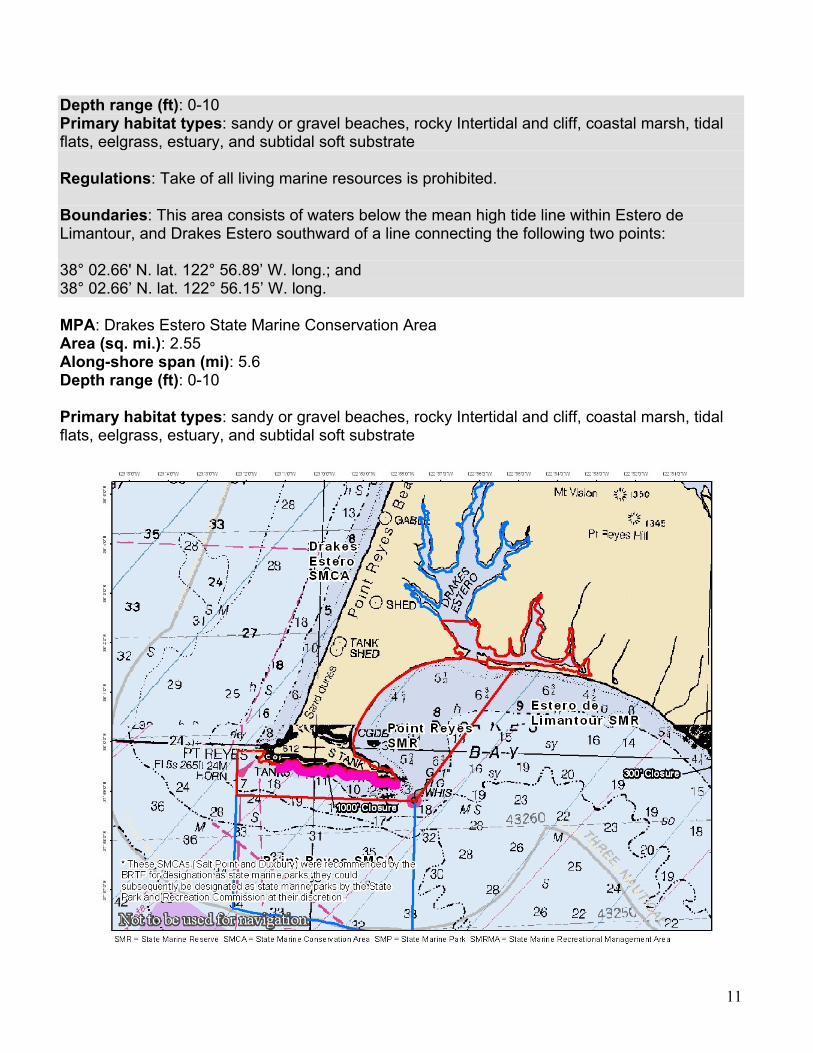
Depth range (ft): 0-10 Primary habitat types: sandy or gravel beaches, rocky Intertidal and cliff, coastal marsh, tidal flats, eelgrass, estuary, and subtidal soft substrate Regulations: Take of all living marine resources is prohibited. Boundaries: This area consists of waters below the mean high tide line within Estero de Limantour, and Drakes Estero southward of a line connecting the following two points:
38° 02.66' N. lat. 122° 56.89’ W. long.; and 38° 02.66’ N. lat. 122° 56.15’ W. long. MPA: Drakes Estero State Marine Conservation Area Area (sq. mi.): 2.55 Along-shore span (mi): 5.6 Depth range (ft): 0-10 Primary habitat types: sandy or gravel beaches, rocky Intertidal and cliff, coastal marsh, tidal flats, eelgrass, estuary, and subtidal soft substrate

12
Regulations: Take of all living marine resources is prohibited EXCEPT: 1. The recreational take of clams. 2. The commercial aquaculture of shellfish pursuant to a valid State Water Bottom Lease and permit. Boundaries: This area includes the waters below the mean high tide line within Drakes Estero northward of a line connecting the following two points: 38° 02.66' N. lat. 122° 56.89’ W. long.; and 38° 02.66’ N. lat. 122° 56.15’ W. long. Special Closure: Point Resistance Rock Special Closure Regulations: No person except department employees or employees of the United States Fish and Wildlife Service, National Park Service, or United States Coast Guard, in performing their official duties, or unless permission is granted by the department, shall enter this area at any time. Boundaries: A special closure is designated in all areas closer than 300 feet from the mean lower low tide line of any shoreline of Point Resistance Rock, located in the vicinity of 37° 59.92' N. lat. 122° 49.75’ W. long. Special Closure: Double Point/Stormy Stack Special Closure Regulations: No person except department employees or employees of the United States Fish and Wildlife Service, National Park Service, or United States Coast Guard, in performing their official duties, or unless permission is granted by the department, shall enter this area at any time. Boundaries: A special closure is designated in all areas closer than 300 feet from the mean lower low tide line of any shoreline of Stormy Stack Rock, located in the vicinity of 37° 56.83' N. lat. 122° 47.14’ W. long. MPA: Duxbury Reef State Marine Conservation Area Area (sq. mi.): 0.66 Along-shore span (mi): 3.0 Depth range (ft): 0-10 Primary habitat types: sandy or gravel beaches, rocky Intertidal and cliff, and surfgrass Regulations: Take of all living marine resources is prohibited EXCEPT: the recreational take of finfish from shore only, and the recreational take of abalone. Boundaries: This area is bounded by the mean high tide line, a distance of 1000 feet seaward of mean lower low water, and the following points: 37° 55.52' N. lat. 122° 44.17' W. long.; 37° 55.42' N. lat. 122° 44.31' W. long.; 37° 53.65' N. lat. 122° 41.91' W. long.; and 37° 53.77' N. lat. 122° 42.02' W. long.

13
Special Closure: Egg (Devil’s Slide) Rock to Devil’s Slide Special Closure. Regulations: Special regulations on boating and access apply as follows: 1. Transit in between the rock and the mainland between these points is prohibited at any time. 2. No person except department employees or employees of the United States Fish and Wildlife Service, U.S. Bureau of Land Management, National Oceanic and Atmospheric Administration, or United States Coast Guard, in performing their official duties, or unless permission is granted by the department, shall enter this area. Boundaries: A special closure is designated from the mean high tide line to a distance of 300 feet seaward of the mean lower low tide line of any shoreline of any of the three rocks comprising Egg (Devil’s Slide) Rock, located in the vicinity of 37° 34.64’ N. lat. 122° 31.29’ W. long.; 37° 34.66’ N. lat. 122° 31.32’ W. long; and 37° 34.63’ N. lat. 122° 31.29’ W. long.; and the area bounded by the mean high tide line and straight lines connecting the following points in the order listed: 37° 34.74’ N. lat. 122° 31.08’ W. long.; 37° 34.72’ N. lat. 122° 31.31' W. long.; 37° 34.60’ N. lat. 122° 31.33’ W. long.; and 37° 34.52’ N. lat. 122° 31.21’ W. long.

14
MPA: Montara State Marine Reserve Area (sq. mi.): 11.76 Along-shore span (mi): 3.1 Depth range (ft): 0-168 Primary habitat types: sandy or gravel beaches, rocky Intertidal and cliff, surfgrass, subtidal soft substrate, subtidal hard substrate, and kelp Regulations: Take of all living marine resources is prohibited. Boundaries: This area is bounded by the mean high tide line and straight lines connecting the following points in the order listed except where noted: 37° 32.70' N. lat. 122° 31.00’ W. long.; 37° 32.70' N. lat. 122° 34.91’ W. long.; thence southward along the three nautical mile offshore boundary to 37° 30.00' N. lat. 122° 34.61’ W. long.; and 37° 30.00' N. lat. 122° 29.93’ W. long. MPA: Pillar Point State Marine Conservation Area Area (sq. mi.): 6.66 Along-shore span (mi): 1.9 Depth range (ft): 0-174 Primary habitat types: sandy or gravel beaches, rocky Intertidal and cliff, surfgrass, subtidal soft substrate, and subtidal hard substrate Regulations: Take of all living marine resources is prohibited EXCEPT: 1. The recreational take of pelagic finfish by trolling, Dungeness crab by trap and squid by hand-held dip net. 2. The commercial take of pelagic finfish with troll fishing gear or seine, Dungeness crab by trap and market squid by round haul net. Boundaries: This area is bounded by the mean high tide line and straight lines connecting the following points in the order listed except where noted: 37° 30.00' N. lat. 122° 29.93’ W. long.; 37° 30.00' N. lat. 122° 34.61’ W. long.; thence southward along the three nautical mile offshore boundary to 37° 28.33' N. lat. 122° 33.47’ W. long.; 37° 28.33’ N lat. 122° 30.83’ W. long.; 37° 29.18’ N lat. 122° 30.36’ W. long.; and 37° 29.74’ N lat. 122° 29.97’ W, long.
15
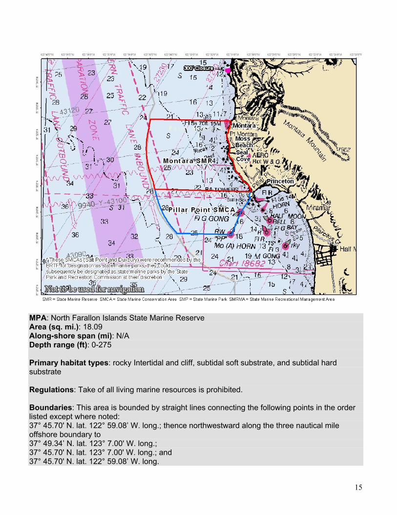
MPA: North Farallon Islands State Marine Reserve Area (sq. mi.): 18.09 Along-shore span (mi): N/A Depth range (ft): 0-275 Primary habitat types: rocky Intertidal and cliff, subtidal soft substrate, and subtidal hard substrate
Regulations: Take of all living marine resources is prohibited.
Boundaries: This area is bounded by straight lines connecting the following points in the order listed except where noted: 37° 45.70' N. lat. 122° 59.08’ W. long.; thence northwestward along the three nautical mile offshore boundary to 37° 49.34’ N. lat. 123° 7.00' W. long.; 37° 45.70' N. lat. 123° 7.00' W. long.; and 37° 45.70' N. lat. 122° 59.08’ W. long.
16
Special Closure: North Farallon Islands Special Closure Regulations: Special regulations on boating and access apply to the North Farallon Islands as follows: 1. No person except department employees or employees of the United States Fish and Wildlife Service, National Oceanic and Atmospheric Administration, or United States Coast Guard, in performing their official duties, or unless permission is granted by the department, shall enter the area defined in subsection 632(b)(29)(B). 2. All vessels shall observe a five (5) nautical mile per hour speed limit within 1,000 feet of any shoreline of the three southern islets defined in subsection 632(b)(29)(B). 3. In an area bounded by the mean high tide line and a distance of one nautical mile offshore any of the four islets comprising the North Farallon Islands, the following restrictions apply:
a. All commercial diving vessels operating in the defined area shall terminate their vessel engine exhaust system either through a muffler for dry exhaust systems, or below the vessel waterline for wet exhaust systems. b. All commercial diving vessels equipped with an open, deck-mounted air compressor system, while operating in the defined area, shall have the air compressor's engine exhaust system terminate below the vessel waterline.
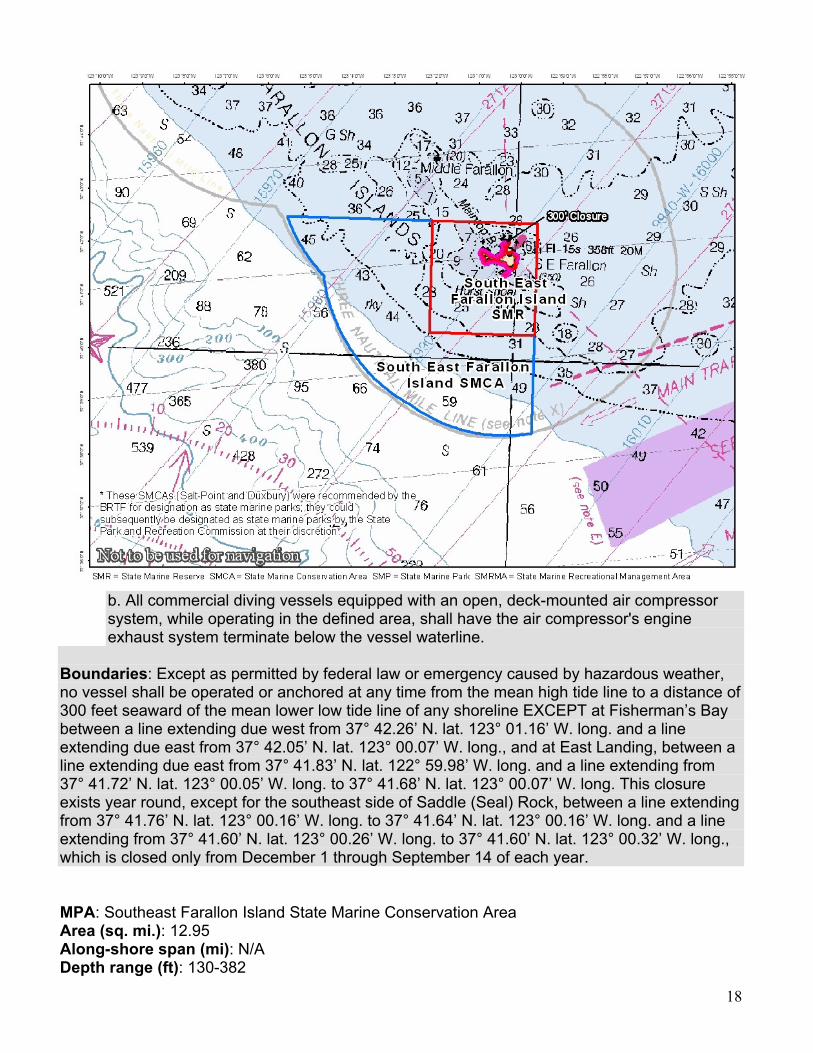
Boundaries: Except as permitted by federal law or emergency caused by hazardous weather, no vessel shall be operated or anchored at any time from the mean high tide line to a distance of 1000 feet seaward of the mean lower low tide line of any shoreline of North Farallon Island, or to a distance of 300 feet seaward of the mean lower low tide line of any shoreline of the remaining three southern islets, including the Island of St. James, in the vicinity of 37° 46' N. lat. 123° 06' W. long. MPA: Southeast Farallon Island State Marine Reserve Area (sq. mi.): 5.34 Along-shore span (mi): N/A Depth range (ft): 0-238
Primary habitat types: sandy or gravel beaches, rocky Intertidal and cliff, surfgrass, subtidal soft substrate, and subtidal hard substrate
Regulations: Take of all living marine resources is prohibited.
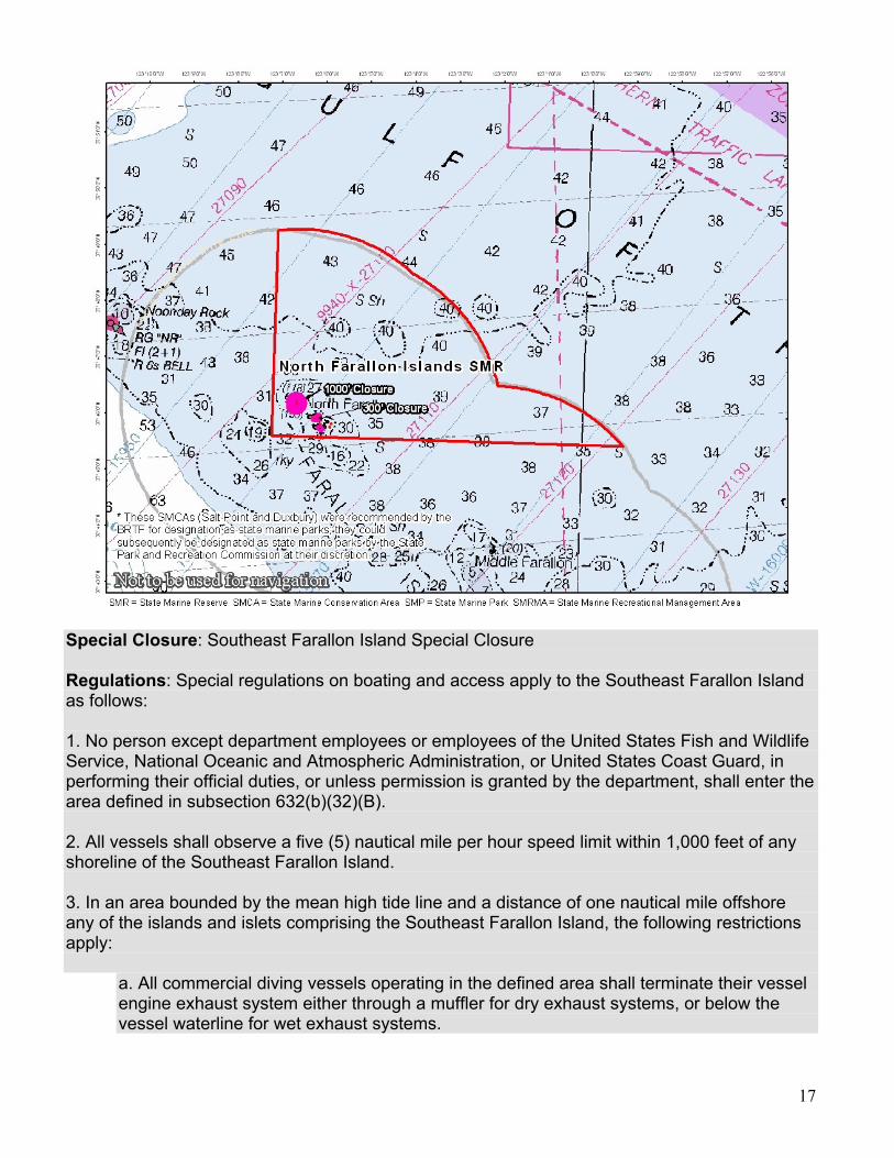
Boundaries: This area is bounded by straight lines connecting the following points in the order listed: 37° 42.60' N. lat. 122° 59.50' W. long.; 37° 42.60' N. lat. 123° 02.00' W. long.; 37° 40.50' N. lat. 123° 02.00' W. long.; 37° 40.50' N. lat. 122° 59.50' W. long.; and 37° 42.60' N. lat. 122° 59.50' W. long.
17
Special Closure: Southeast Farallon Island Special Closure Regulations: Special regulations on boating and access apply to the Southeast Farallon Island as follows: 1. No person except department employees or employees of the United States Fish and Wildlife Service, National Oceanic and Atmospheric Administration, or United States Coast Guard, in performing their official duties, or unless permission is granted by the department, shall enter the area defined in subsection 632(b)(32)(B). 2. All vessels shall observe a five (5) nautical mile per hour speed limit within 1,000 feet of any shoreline of the Southeast Farallon Island. 3. In an area bounded by the mean high tide line and a distance of one nautical mile offshore any of the islands and islets comprising the Southeast Farallon Island, the following restrictions apply:
a. All commercial diving vessels operating in the defined area shall terminate their vessel engine exhaust system either through a muffler for dry exhaust systems, or below the vessel waterline for wet exhaust systems.
18
b. All commercial diving vessels equipped with an open, deck-mounted air compressor system, while operating in the defined area, shall have the air compressor's engine exhaust system terminate below the vessel waterline.
Boundaries: Except as permitted by federal law or emergency caused by hazardous weather, no vessel shall be operated or anchored at any time from the mean high tide line to a distance of 300 feet seaward of the mean lower low tide line of any shoreline EXCEPT at Fisherman’s Bay between a line extending due west from 37° 42.26’ N. lat. 123° 01.16’ W. long. and a line extending due east from 37° 42.05’ N. lat. 123° 00.07’ W. long., and at East Landing, between a line extending due east from 37° 41.83’ N. lat. 122° 59.98’ W. long. and a line extending from 37° 41.72’ N. lat. 123° 00.05’ W. long. to 37° 41.68’ N. lat. 123° 00.07’ W. long. This closure exists year round, except for the southeast side of Saddle (Seal) Rock, between a line extending from 37° 41.76’ N. lat. 123° 00.16’ W. long. to 37° 41.64’ N. lat. 123° 00.16’ W. long. and a line extending from 37° 41.60’ N. lat. 123° 00.26’ W. long. to 37° 41.60’ N. lat. 123° 00.32’ W. long., which is closed only from December 1 through September 14 of each year.
MPA: Southeast Farallon Island State Marine Conservation Area Area (sq. mi.): 12.95 Along-shore span (mi): N/A Depth range (ft): 130-382

19
Primary habitat types: subtidal soft substrate
Regulations: Take of all living marine resources is prohibited EXCEPT: the recreational take of salmon by trolling and the commercial take of salmon with troll fishing gear Boundaries: This area is bounded by straight lines connecting the following points in the order listed except where noted: 37° 42.60' N. lat. 123° 02.00' W. long.; 37° 42.60' N. lat. 123° 05.46’ W. long.; thence southeastward along the three nautical mile offshore boundary to 37° 38.66’ N. lat. 122° 59.50' W. long; 37° 40.50' N. lat. 122° 59.50' W. long; 37° 40.50' N. lat. 123° 02.00' W. long.; and 37° 42.60' N. lat. 123° 02.00' W. long.

20
Individual MPA Objectives Integrated Preferred Alternative (IPA)
North Central Coast Study Region In the following document, Goals (G) and Objectives (O) refer to “Regional goals, objectives, and design and implementation considerations for the north central coast regional component of a statewide MPA network.” Point Arena SMR Proposed Regulations: Take of all living marine resources is prohibited MLPA Goals and associated objectives G1-O1, G1-O2, G1-O3, G1-O4, G1-O5 G2-O1, G2-O2, G2-O3, G3-O1, G3-O2, G3-O3, G5-O1, G5-O3 Stakeholder-Identified Regional Objectives:
• Protect diverse species, unique and complex habitats (pinnacles, wash rocks, caverns, clefts, honeycomb formation, undercut & vertical rock walls, cobbles, deep sand, kelp), in an area of persistent upwelling.
• Restore declining yelloweye, canary & china rockfish populations. (G2-O1, G2-O2) • Leave fishing open for the harbor, popular fishing and diving spots north & south of
harbor, most of Manchester Beach crab grounds, shore fishing on Manchester, extensive salmon fishing areas & cultural uses near Garcia River mouth & Manchester Beach. (G3-O1)
• Improve fish productivity in SMR to benefit local rockfish fishing outside. (G3-O2) • Provide an iconic place with MPA designation. (G3-O3)
Point Arena SMCA Proposed Regulations: Take of all living marine resources is prohibited EXCEPT the
recreational take of salmon by trolling and the commercial take of salmon with troll fishing gear
MLPA Goals and associated objectives G1-O2, G1-O3, G1-O4, G2-O1, G2-O2, G2-O3, G2-O4, G3-O1, G3-O2, G5-O1, G5-O3 Stakeholder-Identified Regional Objectives:
• Extend protection to state boundary to encompass deeper habitat & associated species in regional center of high productivity (see above). (G1-O2, G1-O3, G2-O1 and G2-O2)
• Protect nearshore reef species & habitats on which they depend while allowing commercial and/or recreational harvest of migratory, highly mobile, or other species where appropriate through the use of SMCA. (G2-O4, G5-O1)

21
Sea Lion Cove SMCA Proposed Regulations: The recreational and commercial take of all marine invertebrates and
marine aquatic plants is prohibited. Take of all other species is allowed MLPA Goals and associated objectives G2-O1, G2-O3, G3-O1, G3-O2, G3-O3 Stakeholder-Identified Regional Objectives:
• Contribute to the protection of vulnerable abalone populations and intertidal ecosystem. • Create opportunities for education and enjoyment related to intertidal areas and
invertebrate communities in an unusually scenic spot. Saunders Reef SMCA Proposed Regulations: Take of all living marine resources is prohibited EXCEPT:
1. The recreational take of salmon by trolling 2. The commercial take of salmon with troll fishing gear, and urchin
MLPA Goals and associated objectives G2-O1, G2-O2, G2-O3, G2-O4, G5-O1 Stakeholder-Identified Regional Objectives:
• Protect complex and highly productive rocky reef and kelp habitat including part of an extensive stand of bull kelp, and associated species, including nearshore finfish and multiple abalone species.
• Protect deeper sand and rock habitat in a regional center of high productivity. Del Mar Landing SMR Proposed Regulations: Take of all living marine resources is prohibited MLPA Goals and associated objectives G2-O3, G3-O1, G3-O2, G3-O3 Stakeholder-Identified Regional Objectives:
• Protect community of marine species and their habitat. • Provide greater ecosystem protection at an existing MPA originally established as an
"ecological reserve." Stewarts Point SMR Proposed Regulations: Take of all living marine resources is prohibited

22
MLPA Goals and associated objectives G1-O1, G1-O2, G1-O3, G1-O4, G1-O5, G2-O1, G2-O2, G2-O3, G3-O2, G5-O3 Stakeholder-Identified Regional Objectives:
• Provide the highest protection to complex rocky habitat and kelp (including coves, wash rocks, shelves, walls, cobble and boulders), dependent communities and ecosystem functions within a preferred-size SMR.
• Include area with a relatively steep depth gradient. • Provide opportunity for continuous land-sea protection and management of scenic area
for natural heritage purposes by portion sited adjacent to Salt Point State Park. Salt Point SMCA1 Proposed Regulations: Take of all living marine resources is prohibited EXCEPT the
recreational abalone and finfish MLPA Goals and associated objectives G3-O1, G3-O2, G5-O1 Stakeholder-Identified Regional Objectives:
• Enhance recreational experience via proximity to Stewarts Point and Gerstle Cove SMRs. Gerstle Cove SMR Proposed Regulations: Take of all living marine resources is prohibited MLPA Goals and associated objectives G1-O1, G1-O3, G1-O3 G2-O1, G2-O2 G3-O1, G3-O2, G5-O1 Stakeholder-Identified Regional Objectives:
• Protect intertidal habitat in an existing MPA that appears to be working for resident species, including abalone.
• Enhance biodiversity protection from existing MPA via proximity to Rocky Pt -Horseshoe Pt. SMR. (G1-O1)
• Preserve traditional site for educational and non-consumptive recreation; This SMR is a heritage site. (G3-O2)
23
Russian River SMRMA Proposed Regulations: Take of all living marine resources is prohibited EXCEPT recreational
hunting of waterfowl is allowed unless otherwise restricted by hunting regulations (sections 502, 550, 551 and 552)
MLPA Goals and associated objectives G1-O5, G2-O1, G3-O1, G3-O2, G3-O3, G4-O1 Stakeholder-Identified Regional Objectives:
• Protect nursery ground habitat. • Protect communities associated with areas of diverse estuarine habitats including open
channels, mud flats, eel grass beds, etc. • Protect estuary, steelhead, Russian River Chinook & Coho salmon, birds, mammals etc. • Protect salmonid species subject to increased fishing impacts when estuary mouth is
closed and fish are unable to transit into the ocean. Russian River SMCA Proposed Regulations: Take of all living marine resources is prohibited EXCEPT:
1. The recreational take of Dungeness crab by trap, and surf smelt by hand-held dip net or beach net
2. The commercial take of Dungeness crab by trap MLPA Goals and associated objectives G3-O1, G3-O2, G3-O3, G4-O1 Stakeholder-Identified Regional Objectives:
• Protect Russian River Chinook and Coho salmon (Evolutionary Significant Units), at localized estuarine collection point.
Bodega Head SMR Proposed Regulations: Take of all living marine resources is prohibited MLPA Goals and associated objectives G1-O1, G1-O2, G1-O3, G1-O5, G2-O1, G2-O2, G2-O3, G3-O1, G3-O2, G3-O3, G3-O4, G5-O1, G5-O3 Stakeholder-Identified Regional Objectives:
• Protect area of high benthic species diversity & maintain species diversity & abundance characteristic of north central coast region north of Point Reyes. (G1-O1)

24
• Monitor appropriate indicator species with focus on Nearshore & Deeper Nearshore Fishery Management Plan species. (G1-O5)
• Protect natural trophic structure & food webs, including prey for other fish, marine birds & marine mammals.
• Provide protection to area that contains one of most persistent & important upwelling plumes along entire California Coast & provides for significant down stream larval dispersal. (G1-O5)
• Help restore depleted species, such as near shore & deeper nearshore species. (G2-O1) • Protect larval sources & enhance reproductive capacity of shelf species including
rockfishes. (G2-O2) • Protect area with diverse habitats & associated species including kelp forest ecosystems. • Protect natural heritage location while minimizing socioeconomic impacts to local
communities. (G5-O1) • Protect forage base for colonies of marine mammals & sea birds as well as protect
colonies from disturbance. • Provide comparison analysis environment by providing SMR adjacent to SMCA across
range of depths & fully accessible area within single reef complex in close proximity to Bodega Bay Marine Lab. (G1-O2, G3-O1)
Bodega Head SMCA Proposed Regulations: Take of all living marine resources is prohibited EXCEPT:
1. The recreational take of pelagic finfish by trolling, Dungeness crab by trap, and market squid by hand-held dip net
2. The commercial take of pelagic finfish with troll fishing gear or round haul net, Dungeness crab by trap, and market squid by round haul dip net
MLPA Goals and associated objectives G1-O2, G1-O3, G2-O1, G2-O2, G2-O3, G2-O4, G3-O1, G3-O2, G3-O3, G3-O4, G5-O1, G5-O3 Stakeholder-Identified Regional Objectives:
• Minimize effect of fishing on area of high benthic species diversity characteristic of north central coast region north of Point Reyes while allowing specific recreational and commercial harvest. (G5-O1)
• Protect natural trophic structure & food webs, including prey for other fish, marine birds & marine mammals.
• Help restore depleted species, such as near shore and deeper nearshore species. (G2-O1)
• Protect larval sources & enhance reproductive capacity of shelf species including rockfishes. (G2-O2)
• Protect area with diverse habitats and associated species including kelp forest ecosystems.
25
• Protect natural heritage location while minimizing socioeconomic impacts to local communities. (G5-O1)
• Provide comparison analysis environment by providing SMCA adjacent to SMR across a range of depths and fully accessible area within single reef complex in close proximity of Bodega Bay Marine Lab. (G1-O2, G3-O1, G3-O3)
• Protect one of rare hard bottom reef complexes in NCCSR that extend from shore seaward to state water boundary.
Estero Americano SMRMA Proposed Regulations: Take of all living marine resources is prohibited EXCEPT the
recreational hunting of waterfowl is allowed unless otherwise restricted by hunting regulations (502, 550, 551, and 552)
MLPA Goals and associated objectives G1-O1, G1-O3, G1-O4, G2-O2, G2-O3, G3-O3, G4-O1 Stakeholder-Identified Regional Objectives:
• Protect species diversity and abundance, trophic structure & food webs, natural age structure & genetic diversity in representative habitats. (G1-O1, G1-O3, G1-O4)
• Sustain or increase reproduction of species by protecting & retaining large individuals & protecting breeding, foraging, rearing & nursery areas. (G2-O2, G2-O3)
• Enhance scientific validity with similar habitat replicated in close proximity. (G3-O3) Estero de San Anotonio SMRMA Proposed Regulations: Take of all living marine resources is prohibited EXCEPT the
recreational hunting of waterfowl is allowed unless otherwise restricted by hunting regulations (502, 550, 551, and 552)
MLPA Goals and associated objectives G1-O1, G1-O3, G1-O4, G2-O2, G2-O3, G3-O3, G4-O1 Stakeholder-Identified Regional Objectives:
• Protect species diversity & abundance, trophic structure and food webs, natural age structure & genetic diversity in representative habitats. (G1-O1, G1-O3, G1-O4)
• Sustain or increase reproduction of species by protecting & retaining large individuals & protecting breeding, foraging, rearing & nursery areas. (G2-O2, G2-O3)
• Enhance scientific validity with similar habitat replicated in close proximity. (G3-O3) •

26
Point Reyes SMR Proposed Regulations: Take of all living marine resources is prohibited MLPA Goals and associated objectives G1-O1, G1-O2, G1-O3, G1-O4, G1-O5, G2-O1, G2-O2, G2-O3, G3-O1, G3-O2, G5-O3 Stakeholder-Identified Regional Objectives:
• Protect diverse fish, seabird & marine mammals associated with multiple habitats including exposed high energy rocky shoreline, sand & gravel beaches, offshore islets, surf grass, soft & hard substrates set against oceanic features of major headlands at receiving end of coastal upwelling system of global significance.
• Protect natural tropic & natural ecosystem structure & function with minimal human-induced changes. (G1-O4, G1-O5)
• Protect larval retention zone of regional import for many fish & invertebrate species. (G2-O2)
• Reduce disturbances to major mainland seabird colonies & elephant seal rookeries within study region. (G2-O3)
• Preserve an iconic place. (G3-O1) • Include areas with diverse habitat types within one MPA cluster. (G1-O2)
Point Reyes SMCA Proposed Regulations: Take of all living marine resources is prohibited EXCEPT:
1. The recreational take of salmon by trolling, and Dungeness crab by trap
2. The commercial take of salmon with troll fishing gear, and Dungeness crab by trap
MLPA Goals and associated objectives G1-O2, G1-O3, G2-O1, G2-O2, G2-O3, G2-O4 G3-O1, G3-O2, G5-O3 Stakeholder-Identified Regional Objectives:
• Extend protection offshore to state boundary for diverse fish, seabird & marine mammal species in deeper hard & soft bottom. (G1-O2, G3-O1, G5-O3)
• Protect near shore reef species & habitats on which they depend while allowing commercial and/or recreational harvest of migratory, highly mobile, or other species where appropriate through use of SMCA. (G2-O4)
• Help protect diversity of species, including fish & mammals. • Cover diversity of bottom habitats & oceanographic/wind conditions.

27
Estero de Limantour SMR Proposed Regulations: Take of all living marine resources is prohibited MLPA Goals and associated objectives G1-O1, G1-O3, G1-O4, G1-O5, G2-O1, G2-O2, G2-O3, G3-O1, G3-O3, G4-O1, G5-O3 Stakeholder-Identified Regional Objectives:
• Expands on long-term protections for complex estuarine habitats & dependent species, including eelgrass beds & mudflat ecosystems. (G1-O1, G1-O4, G1-O5, G2-O3, G4-O1)
• Provide connectivity between tributaries & tidal marshes & diverse near-shore habitats with contiguous Point Reyes SMR. (G1-O5, G2-O3, G4-O1)
• Protect significant nursery area for Dungeness crab, & numerous rockfish & flatfish species. (G2-O3)
• Protect essential habitat for Black Brandt geese & a key foraging area for shorebirds, coastal waterfowl & brown pelicans. (G2-O3)
• In designated federal wilderness area. (G1-O1, G3-O2) • Support current NPS coho salmon & steelhead trout migration habitat restoration projects
on multiple tributaries. (G2-O1) • Protect major harbor seal pupping & haul-out sites. (G2-O3)
Drakes Estero SMCA Proposed Regulations: Take of all living marine resources is prohibited EXCEPT:
1. The recreational take of clams 2. The commercial aquaculture of shellfish pursuant to a valid Sate
Water Bottom Lease and permit MLPA Goals and associated objectives G1-O3, G2-O1, G2-O2, G2-O3, G3-O1, G3-O3, G4-O1, G5-O3 Stakeholder-Identified Regional Objectives:
• Protects estuarine habitats while allowing existing aquaculture activities as well as recreational clamming to continue.
Duxbury SMCA1 Proposed Regulations: Take of all living marine resources is prohibited EXCEPT the
recreational finfish from shore only and the recreational take of abalone

28
MLPA Goals and associated objectives G2-O4, G3-O1 Stakeholder-Identified Regional Objectives:
• Protect species while allowing traditional recreational access. (G2-O4) • Protect an area of important marine natural heritage.
Montara SMR Proposed Regulations: Take of all living marine resources is prohibited MLPA Goals and associated objectives G1-O1, G1-O2, G1-O3, G1-O4, G1-O5, G2-O1, G2-O2, G2-O3, G3-O1, G3-O2, G3-O3, G3-O4, G5--O1, G5-O3 Stakeholder-Identified Regional Objectives:
• Protect area of high benthic species diversity & maintain species diversity & abundance characteristic of north central coast region north of Point Reyes. (G1-O1)
• Monitor appropriate indicator species with focus on Nearshore and Deeper Nearshore Fishery Management Plan species. (G1-O5)
• Protect natural trophic structure & food webs, including species that serve as prey for other fish, marine birds & marine mammals. (G1-O4)
• Enhance non-consumptive recreational & educational experiences by protecting intertidal ecosystems by reducing congestion & increasing size & abundance of species most likely to benefit from MPAs. (G3-O2)
• Help restore depleted species, such as near shore & deeper nearshore species. (G2-O1) • Protect larval sources & enhance reproductive capacity of shelf species including
rockfishes. (G2-O2) • Protect area with diverse habitats and associated species including kelp forest
ecosystems. (G1-O2) • Protect natural heritage location while minimizing socioeconomic impacts to local
communities. (G5-O1) • Protect forage base for colonies of marine mammals as well as protect colonies from
disturbance. (G1-O5) • Provide comparison analysis environment by providing SMR adjacent to SMCA across
range of depths. Pillar Point SMCA Proposed Regulations: Take of all living marine resources is prohibited EXCEPT:
1. The recreational take of pelagic finfish by trolling, Dungeness crab by trap and squid by hand-held dip net

29
2. The commercial take of pelagic finfish with troll fishing gear or round haul net, Dungeness crab by trap and market squid by round haul net
MLPA Goals and associated objectives G1-O2, G1-O3, G2-O1, G2-O2, G2-O3, G2-O4, G3-O1, G3-O2, G3-O3, G3-O4, G5-O1,G5-O3 Stakeholder-Identified Regional Objectives:
• Enhance non-consumptive recreational & educational experiences by protecting intertidal ecosystems by reducing congestion & increasing size & abundance of species most likely to benefit from MPAs. (G3-O2)
• Help restore depleted species, such as near shore & deeper nearshore species. (G2-O1) • Protect larval sources & enhance reproductive capacity of shelf species including
rockfishes. (G2-O2) • Protect area with diverse habitats & associated species including kelp forest ecosystems.
(G1-O2) • Protect natural heritage location while minimizing socioeconomic impacts to local
communities. (G5-O1) • Provide comparison analysis environment by providing SMR adjacent to SMCA across
range of depths. North Farallon Islands SMR Proposed Regulations: Take of all living marine resources is prohibited MLPA Goals and associated objectives G1-O1, G1-O2, G1-O3, G1-O4, G1-O5, G2-O1, G2-O2, G2-O3, G3-O1, G3-O2, G3-O3, G4-O1, G5-O1, G5-O3 Stakeholder-Identified Regional Objectives:
• Include a portion of unique tidal, subtidal, benthic & pelagic habitat of Farallones. • Help protect concentrations of prey & foraging predators - fish & breeding colonies of
seabirds & marine mammals - at highly productive & unique mix of habitats. • Protect natural diversity & structure & function of unique marine ecosystem (G1-O1, G1-
O5) • Help assure continued recovery of ground fish (G2-O1) • Enhance reproductive success of seabirds & marine mammals using islands (G2-O3) • Increase supply of large adults & larval fish which can disperse to adjacent areas for
fisheries harvest outside MPA (G3O2) • Protects globally significant biological site. (G1-O1, G1-O2, G1-O3, G1-O4, G1-O5, G2-
O1, G2-O3, G4-O1)
30
Southeast Farallon Island SMR Proposed Regulations: Take of all living marine resources is prohibited MLPA Goals and associated objectives G1O1, G1O2, G1O3, G1O4, G1O5, G2O1, G2O2, G2O3, G3O1, G3O2, G3O3, G4O1, G5O3 Stakeholder-Identified Regional Objectives:
• Allow natural ecosystem function in key portion of subregion. (G1-O5) • Include portion of unique tidal, subtidal, benthic & pelagic habitat of Farallones. (G4-O1) • Protect natural diversity and structure and function of unique marine ecosystem, increase
rockfish larval production. (G1-O1, G2-O1, G2-O2) • Help assure continued recovery of groundfish. (G2-O1) • Enhance reproductive success of seabirds & marine mammals using islands. (G2-O3) • Increase supply of large adults & larval fish which can disperse to adjacent areas for
fisheries harvest outside MPA. (G3-O2) • Protects globally significant biological site.
Southeast Farallon Island SMCA Proposed Regulations: Take of all living marine resources is prohibited EXCEPT the
recreational take of salmon by trolling and the commercial take of salmon with troll fishing gear
MLPA Goals and associated objectives G1O1, G1O2, G1O3, G1O4, G1O5, G2-O1, G2O2, G2O3, G3O1, G3O2, G3O3, G4O1, G5O3 Stakeholder-Identified Regional Objectives:
• Protect benthic habitat and forage base for fish, birds and mammals at islands, while allowing salmon trolling. (G1-O2, G2-O3, G2-O4, G3-O2, G4-O1,G5-O1)
• Improve fish productivity in SMR to benefit local rockfish fishing outside MPA. (G3-O2) • Protect nearshore reef species & habitats on which they depend while allowing
commercial and/or recreational harvest of migratory, highly mobile, or other species where appropriate through use of a SMCA. (G2-O4)
1 Note: These areas, recommended by stakeholders to become state marine parks, will be designated as state marine conservation areas by the Fish and Game Commission, and could subsequently be designated as state marine parks at the discretion of the State Park and Recreation Commission.