Embed Size (px)
Citation preview

Destination Earth
Survey on “Digital Twins” technologies and activities, in
the Green Deal area
Stefano NATIVI, Blagoj DELIPETREV, and Max CRAGLIA.
2020
EUR 30438 EN

2
This publication is a Technical report by the Joint Research Centre (JRC), the European Commission’s science and knowledge service. It aims to provide evidence-based scientific support to the European policymaking process. The scientific output expressed does not imply a policy
position of the European Commission. Neither the European Commission nor any person acting on behalf of the Commission is responsible for the use that might be made of this publication. For information on the methodology and quality underlying the data used in this publication for which the source is neither Eurostat nor other Commission services, users should contact the referenced source. The
designations employed and the presentation of material on the maps do not imply the expression of any opinion whatsoever on the part of the European Union concerning the legal status of any country, territory, city or area or of its authorities, or concerning the delimitation of its frontiers or boundaries.
Contact information Name: Stefano NATIVI
Address: E. Fermi 749, 21027 Ispra VA (Italy) Email: [email protected] Tel.: +39 0332 785075
Name: Max CRAGLIA Address: E. Fermi 749, 21027 Ispra VA (Italy)
Email: [email protected] Tel.: +39 0332 786269
EU Science Hub https://ec.europa.eu/jrc
JRC122457
EUR 30438 EN
PDF ISBN 978-92-76-25160-6 ISSN 1831-9424 doi:10.2760/430025
Luxembourg: Publications Office of the European Union, 2020
© European Union, 2020
The reuse policy of the European Commission is implemented by the Commission Decision 2011/833/EU of 12 December 2011 on the reuse of Commission documents (OJ L 330, 14.12.2011, p. 39). Except otherwise noted, the reuse of this document is authorised under the Creative Commons Attribution 4.0 International (CC BY 4.0) licence (https://creativecommons.org/licenses/by/4.0/). This means that reuse is allowed provided appropriate credit is given and any changes are indicated. For any use or reproduction of photos or other material that is not owned by the EU, permission must be sought directly from the copyright holders.
All content © European Union, 2020, except: Cover image ©greenbutterfly©AdobeStock; page 9 –figure 1, spyglass icon and microscope
icon (Openclipart); page 10 –figure 3 (Icon0.com via Flickr).
How to cite this report: NATIVI Stefano, DELIPETREV Blagoj, and CRAGLIA Max, Destination Earth: Survey on “Digital Twins” technologies and activities, in the Green Deal area, EUR 30438 EN, Publications Office of the European Union, Luxembourg, 2020, ISBN 978-92-76-25160-6, doi:10.2760/430025, JRC122457

3
Table of Contents Executive Summary ............................................................................................................................. 6
Introduction ........................................................................................................................................ 8
Digital Twin definitions ....................................................................................................................... 8
The Digital Twins philosophy .............................................................................................................. 8
Digital Twin components ................................................................................................................ 9
Connection between the physical and the digital entities ......................................................... 9
Digital Twins interaction/composition ............................................................................................ 9
The Digital Twin ecosystem and reference framework ...................................................................... 9
Digital Twins for Science Purposes ................................................................................................... 11
Digital Twins for Industry .................................................................................................................. 11
Digital Twin Standardization Landscape ........................................................................................... 12
EUROPEAN UNION PROJECTS and ACTIVITIES ...................................................................................... 14
Horizon 2020 projects ....................................................................................................................... 14
↗ ExtremeEarth (H2020 Consortium; Food Security, Polar region) ............................................. 14
↗ SPHERE (H2020 Consortium; BIM, Energy) .............................................................................. 14
Consortium ................................................................................................................................ 14
↗ DIGITAL URBAN EUROPEAN TWINS: the DUET project (H2020 Consortium; Smart City) ........ 15
Consortium ................................................................................................................................ 15
Foreseen pilots .......................................................................................................................... 16
↗ CRESCENDO (Progressing on the next generation of European Earth System models) .......... 16
↗ LEAD (Digital Twins for low emission last mile logistics) .......................................................... 16
Consortium ................................................................................................................................ 17
Projects in the Member States ......................................................................................................... 17
Austria ............................................................................................................................................... 18
↗ Sentinel-1 backscatter data cube ............................................................................................. 18
↗ Drought Watch ......................................................................................................................... 18
Belgium ............................................................................................................................................. 18
↗ Digital Twin of the city of Antwerp: the DUET project (Belgium-The Netherlands; Smart City)
...................................................................................................................................................... 18
Finland ............................................................................................................................................... 19
↗ A Digital Twin of the Finnish Forests - Forest Inventory Program in Finland (Forest).............. 19
Company ................................................................................................................................... 19
↗ ZeroGravity (Finland; SmartCity, Transportation) .................................................................... 19
Company ................................................................................................................................... 19
↗ Helsinki Digital Twin ................................................................................................................. 20

4
France................................................................................................................................................ 20
↗ DATA TERRA .............................................................................................................................. 20
↗ GAIA Data ................................................................................................................................. 21
↗ AI4GEO Project ......................................................................................................................... 21
↗ CO3D ......................................................................................................................................... 22
↗ 3DExperienCity (Virtual Singapore and Virtual Rennes) ........................................................... 22
↗ Nosvillesvertes .......................................................................................................................... 23
↗ Toward an operational hydrology with the SWOT downstream program ............................... 23
Germany ............................................................................................................................................ 24
↗ ESM - Advanced Earth System Modelling Capacity project (2017-2020) ................................. 24
↗ Digital Earth: Towards SMART Monitoring and Integrated Data Exploration of the Earth System
- Implementing the Data Science Paradigm .................................................................................. 24
↗Earth System Modeling ............................................................................................................. 25
↗ Modular Observation Solutions for Earth Systems (MOSES) ................................................... 25
↗ DWD Numerical Weather Prediction models ........................................................................... 26
Greece ............................................................................................................................................... 26
↗ LIFE-IP AdaptInGR ..................................................................................................................... 26
Italy ................................................................................................................................................... 27
↗ ECOTWIN: Towards the definition of digital twins of specific ecosystems .............................. 27
↗ Knowledge Hub to analyze and simulate organic pollution ..................................................... 27
↗ VLab (Virtual Laboratory orchestrator for Digital Twins) ......................................................... 28
Norway .............................................................................................................................................. 28
↗ Kongsberg (Maritime simulation, Energy) ................................................................................ 28
Company ................................................................................................................................... 29
Sweden .............................................................................................................................................. 29
↗ A Digital Twin of The Finnish Forests - Forest Inventory Program in Finland (Forest) ............. 29
The Netherlands ................................................................................................................................ 30
↗ Marine data streams capacity .................................................................................................. 30
SeaDataNet ............................................................................................................................... 30
EMODnet ................................................................................................................................... 30
Jerico-S3 .................................................................................................................................... 30
↗ PortForward: the Digital Twin of the port of Rotterdam (Smart infrastructures/City) ............ 31
↗ Digital Twin of cities, the DUET project (Smart City) ................................................................ 31
Other relevant activities on Smart Cities .......................................................................................... 31
SOME RELEVANT INTERNATIONAL PROJECTS and ACTIVITIES ............................................................. 33
International Consortia ..................................................................................................................... 33

5
↗ CMIP Phase 6 (CMIP6): Overview CMIP6 Experimental Design and Organization (Climate
modeling) ...................................................................................................................................... 33
↗ OneGeology 4.0 (Geology) ....................................................................................................... 33
↗ International Union of Geological Sciences (IUGS): Deep Time Digital Earth (DDE) initiative
(Geology) ....................................................................................................................................... 34
↗ Space Climate Observatory (SCO) International Initiatives ...................................................... 34
Australia ............................................................................................................................................ 35
↗ NSW Digital Twin (Spatial data visualization, Digital Earth) ..................................................... 35
NSW foundation spatial data framework visualisation - NSW spatial digital twin ................... 35
NSDI - QLD digital twin .............................................................................................................. 35
Digital Earth Australia ............................................................................................................... 35
Canada .............................................................................................................................................. 36
↗ Maplesoft (Canada; System-level simulations and analysis) .................................................... 36
Singapore .......................................................................................................................................... 36
↗ 3DExperienCity (Virtual Singapore and Virtual Rennes) ........................................................... 36
USA .................................................................................................................................................... 36
↗ Open Mobility Foundation (Safety, Smart City, Transportation) ............................................. 36
Founding Members ................................................................................................................... 37
↗ NSF EarthCube (Digital Earth) ................................................................................................... 37
↗ iModel.js (USA; Civil infrastructures, BIM) ............................................................................... 38
↗ Descartes Labs: Digital Twin of planet Earth ............................................................................ 38
Company ................................................................................................................................... 38
Relevant international activities on Smart Cities .............................................................................. 39
Annex: Digital Twin definitions ......................................................................................................... 40
Acknowledgements ........................................................................................................................... 43
References ........................................................................................................................................ 43
Glossary ............................................................................................................................................. 44

6
Executive Summary Digital Twins have been around for decades, especially in industrial processes. However, with the
recent advent of transformative digital technologies (i.e. IoT, AI, ML, Big Data analytics, and ubiquitous
connectivity) Digital Twins are changing most of the society sectors, providing the most advance
pattern to make the physical and the digital worlds interact.
Naturally, this is also true for the scientific sector, and in particular those disciplines that are engaged
in understanding and addressing the Global Change effects. Thanks to the Digital Twins growing
development, for the first time, it is possible to envision a digital replica of important natural and social
phenomena and processes, trying to anticipate their behavior.
There exist diverse definitions of Digital Twins, reflecting the diverse concerns of the industrial,
scientific, and standardization sectors (in particular IEEE and ISO/IEC), which have been working on
their description and realization.
The main interaction features characterizing a Digital Twin are:
Interoperability;
Information Model;
Data Exchange;
Administration;
Synchronization;
Push mode (Publish Subscribe).
According the scientific research, there is still the need to address the following challenges to push
Digital Twins implementation and effective use:
Unify data and model standards;
Share data and models;
Innovate on services;
Establish forums.
In industry, Digital Twins are well used in “vertical” sectors/application areas, including:
manufacturing, energy, smart cities, farming, building, healthcare.
For the applied scientific and research areas, this preliminary study recognized the following areas:
Main research and development areas
Activities recognized Source (European funded activity and/or country/Consortium that reported the activity)
Earth System Modeling/Digital Earth
CRESCENDO; DATA TERRA; GAIA DATA; Advanced Earth System Modelling Capacity project (ESM); Digital Earth: Towards SMART Monitoring and Integrated Data Exploration of the Earth System - Implementing the Data Science Paradigm; DWD Numerical Weather Prediction models; CMIP Phase 6;
H2020 project; France; Germany; CMIP; OneGeology; IUGS; Australia; USA;

7
OneGeology 4.0; Deep Time Digital Earth (DDE) initiative; NSW Digital Twin; EarthCube; Descartes Labs: Digital Twin of planet Earth;
3D Imaging AI4GEO; 3DExperienceCity; CO3D France
Water monitoring Sentinel-1 backscatter data cube; SWOT downstream program;
Austria; France
Drought monitoring Drought Watch Austria
Forest monitoring Forest Inventory Program in Finland Finland; Sweden
Ecosystems monitoring ECOTWIN; Nosvillesvertes Italy, France
Maritime simulation and monitoring
Kongsberg; Marine data streams capacity; SeaDataNet; EMODnet; Jerico-S3
Norway; The Netherlands
Polar region monitoring
ExtremeEarth H2020 project
Extreme natural phenomena monitoring
Modular Observation Solutions for Earth Systems (MOSES); ExtremeEarth
Germany; H2020;
Food Security monitoring
ExtremeEarth H2020 project
Pollution monitoring Knowledge Hub to analyze and simulate organic pollution Italy
Smart cities/City Twins DUET; The city of Antwerp; Helsinki Digital Twin; 3DExperienceCity; PortForward: the Digital Twin of the port of Rotterdam; Open Mobility Foundation; Digital Built Britain; Cambridge initiative; US smart cities (Boston, Pasadena, Portland, ..); Chinese Smart cities; Amaravati; Nosvillesvertes.
H2020 project; Belgium, The Netherlands; Finland; France; Singapore; USA; UK; China; India.
Smart Transportation/Infrastructures
UrbanAI; PortForward: the Digital Twin of the port of Rotterdam; Open Mobility Foundation; Cambridge initiative;
Finland; The Netherlands; USA; UK;
Smart buildings SPHERE H2020 project
Smart Energy SPHERE; Kongsberg H2020 project; Norway
Climate Change adaptation strategies in urban areas
LIFE-IP AdaptInGR; Greece
Virtual Laboratories VLab (Virtual Laboratory orchestrator for Digital Twins); Maplesoft; iModel.js
Italy; Canada; USA

8
Introduction The joint use of: AI, broadband and ubiquitous connectivity, (embedded) sensors, big data processing
techniques, and cloud computing, has led to the creation of digital twins, artificial intelligent virtual
replicas of physical systems (BARRICELLI, CASIRAGHI, & FOGLI, 2019).
“If the Internet of Thing is a disruptive technology that is applied to all industries and services and
brings radical changes in human life, the Digital Twin will integrate and interwork the real world and
the virtual world based on the Internet of Things. For this reason, the Digital Twin can be recognized
as a dimension bridging technology in which a link is established between the real world and the virtual
world” (ISO/IEC JTC 1, 2019).
Digital Twin definitions Several definitions exist for the “Digital Twin” concept and systems, stemming from the diverse sectors
and disciplines that have been using them. In the Annex, a set of significant definitions are reported.
In the following, three definitions are outlined; they were respectively introduced by the ICT
standardization, scientific research, and industrial sectors.
A digital twin is a virtual representation of a device or a group of devices that resides on a cloud or
edge node. It can be used to represent real-world devices which may not be continuously online, or
to run simulations of new applications and services, before they get deployed to the real devices
[W3C]
A digital twin is a digital replica of a living or non-living physical entity. By bridging the physical and the
virtual world, data is transmitted seamlessly allowing the virtual entity to exist simultaneously with
the physical entity [El Saddik, A.]
A digital twin is a virtual representation of a physical object or system – but it is much more than a
high-tech lookalike. Digital twins use data, machine learning, and the Internet of Things (IoT) to help
companies optimize, innovate, and deliver new services [SAP]
The Digital Twins philosophy As showed in Figure 1, the Digital Twins philosophy consists in decoupling a digital system from its
physical entity(ies), making it easier to change one without changing the other. It also allows to utilize
advanced data-driven modeling procedures in order to generate those insights that could not be
carried out using the traditional observation models.

9
Figure 1. The Digital Twin approach
Digital Twin components A Digital Twin considers three main components:
Physical Entity;
Digital Representation; and
Connection between the physical and the digital entities.
Connection between the physical and the digital entities The connections between the two entities is represented by the data that flows from the physical to
the digital/virtual representation and the information/insight that is generated from the digital/virtual
representation to the physical environment. The specific information/insight generated by the digital
twins is driven by use cases. For example, a digital twin can be used for monitoring, diagnostics and
prognostics to optimize processes and entities performances and utilizations. Sensory data can be
combined with historical data, human expertise and simulation learning to improve the outcome of
prognostics.
Digital Twins interaction/composition The main interaction features are:
Interoperability;
Information Model;
Data Exchange;
Administration;
Synchronization;
Push mode (Publish Subscribe).
The Digital Twin ecosystem and reference framework The Digital Twin ecosystem and reference framework, as defined by ISO JTC1, are depicted in Figure 2
and Figure 3.

10
Figure 2. Digital Twin ecosystem (an elaboration of ISO JTC AG11 on Digital Twin)
Figure 3. Digital Twin reference framework (an elaboration of the ISO 23247 Digital Twin manufacturing framework)

11
Digital Twins for Science Purposes Digital Twins are changing how technologies such as IoT, AI, ML, and Big Data analytics are being
thought about. These innovative technologies are utilized to create virtual representations of physical
processes/entities and understand their behavior anticipating their possible reactions to simulated
events. Digital Twin is based on a multi-disciplinary approach and team, playing an important role to
advance the scientific state-of-art. Physical domain experts must work with engineers, computer
scientists and process experts to develop an effective (e.g. self-learning) Digital Twin. The range of
disciplines needed will widen as applications diversify.
This is particularly important to contribute to the European Green Deal strategy, where key objectives
are, for example, the energy efficiency of built environment (i.e. the most important decarbonization
strategy) and the adaptation of our Society and economy to the climate change –such as the resilience
of urban centres, the adaptation of agriculture production, and the risk reduction to natural hazards.
Today, Digital Twin technology is commonly used as a key instrument towards the implementation of
the Digital Earth concept –i.e. a comprehensive virtual representation of the planet (ISDE, 2020).
Sveral projects and initiative have developed virtual/digital representations of natural or social
entities, processes or phenomena.
Academia and Research are asked, in addition to improving modelling techniques, to further focus on
data optimization and interoperability with modeling platforms. According to a manuscript (Fei &
Qinglin, 2019) recently published by Nature on pushing Digital Twins, the scientific sector must work
on four challenges:
(a) Unify data and model standards;
(b) Share data and models;
(c) Innovate on services;
(d) Establish forums.
Digital Twins for Industry Digital Twins have been used for decades in industry. However, they have seen a new spring with the
advent of Industry 4.0. According to the “Vertical” sectors/application areas, Digital Twins and their
applications can be classified as reported by Table 1.
Table 1. Industries and applications of Digital Twins [source: ISO JTC1]

12
Digital Twin Standardization Landscape In 2019, ISO JTC1 (Information Technology) created an Advisory Group (i.e. AG11) to recognize the
standardization landscape, the possible existing gaps, and eventually recommend the creation of
Systems Integration entity in the form of a new Subcommittee on Digital Twins. This possible
Subcommittee should cover the following subjects:
Foundational standards;
Functional requirements of a digital twin;
Integration and collaboration among digital twins;
Testing and evaluation;
Use cases and applications.
They all seem to be of interest for Destination Earth.
AG11 distinguished between Support Technologies and Application Areas standardization activities,
producing a list of relevant specifications –see Table 2.

13
Table 2. relevant standardization activities for Digital Twins
Topic Relevant standardization activity
Support Technologies
Simulation IEEE 1516, SISO
Identification and Sensing
ISO/IEC JTC 1/SC 31
AR/VR ISO/IEC JTC 1/AG 13, ISO/IEC JTC 1/SC 24, IEEE P2048, Khronos Group
Product properties IEC SC3D, ISO/TC 184/SC 4
IoT ISO/IEC JTC1 SC 41
AI ISO/IEC JTC1 SC 42
IT Security ISO/IEC JTC1 SC 27
Cloud computing and distributed platforms
ISO/IEC JTC 1/SC 38
Application/Vertical Areas
Energy IEC/TC 57
Smart Cities IEC SyC Smart Cities, ISO/IEC JTC1 WG11
Farming ISO/TC 23/SC 19, ITU-T
Building ISO/TC 59/SC 13
Healthcare ISO/TC 215
Manufacturing and Process industries
ISO/TC 184, IEC/TC 65, JWG 21, IEC SyC SM, IEEE P2806

14
EUROPEAN UNION PROJECTS and ACTIVITIES
Horizon 2020 projects
↗ ExtremeEarth (H2020 Consortium; Food Security, Polar region) The objective of ExtremeEarth project is to extract valuable knowledge and commercial value from
data, noticeably Copernicus.
ExtremeEarth addresses a couple of use cases that bring together the Food Security and Polar TEPs.
Knowledge extraction is done through deep learning techniques that work at the extreme scale of
data expected in Copernicus.
Funding: ExtremeEarth is an H2020 project (about 6 M euro) started on the 1st of January 2019.
───────
↗ SPHERE (H2020 Consortium; BIM, Energy) SPHERE1 is a 4-year Horizon 2020 project that aims to provide a BIM-based Digital Twin Platform to
optimize the building lifecycle, reduce costs and improve energy efficiency in residential buildings.
Carried out by 19 SMEs, RTOs and Large Enterprises2 across Europe, it aims to provide citizens,
stakeholders as well as city administrations and urban developers with an integrated ICT platform that
will allow a better assessment and development of the Design, Construction and Performance of
residential buildings thanks to its two planes of innovation: a Building-centred Digital Twin
Environment based on an Integrated Design and Delivery Solutions (IDDS) framework for seamless
and efficient updating and synchronization:
SPHERE will help boost buildings’ energy performance throughout their lifecycle and reduce time,
costs & the environmental impact of construction and renovation processes
25% Less CO2 and GHG emissions in buildings.
25% Reduction in construction time.
15% Less energy demand during the operational phase.
Consortium Composed of 20 partners from 10 different EU countries, consisting of SME technology leaders as well
as software tool providers and expert researchers. The combination and integration of their
knowledge and experience is the key to SPHERE’s success.
IDP Ingeniería y Arquitectura Iberia S.L.U. is an innovative and multidisciplinary SME with services ranging from civil & infrastructure engineering, environmental sciences, ICT to project
1 https://sphere-project.eu 2 https://sphere-project.eu/consortium/

15
management & consultancy. With six offices between Spain and Latin America, IDP currently consists of a team of approximately 250 professionals.
VTT technical coordinator. BIM, ICT systems & UCD. Pilot support.
Other project partners are: R2M solution, Comsa, Octopussy & co., Eurecat, Comet, TNO, BASF, Eanex, Ekodenge, Caverion, Cree, De5, Nuig, Vrm tech, Ascora, Empresarios agrupados
───────
↗ DIGITAL URBAN EUROPEAN TWINS: the DUET project (H2020 Consortium; Smart
City) DUET3 is a brand new innovation initiative which leverages the advanced capabilities of cloud and
high-performance computing (HPC), in the form of Digital Twins, to help public sector decision-making
become more democratic and effective. By creating digital replicas of a city, people, no matter their
background, can use the Digital Twins 3D and 2D interfaces for easy policy impact exploration and
experimentation across entire cities and regions.
DUET's use of Digital Twins truly changes the policy game, disrupting the field of Smart Cities and
transitioning to a new age of Responsive Cities. With Responsive Cities, solutions are not designed
around citizens, they are designed with the citizen placed firmly at the center of the action. Where
Smart Cities are technology driven and produce large amounts of data from fixed or centrally
controlled sensors, Responsive Cities recognise that citizens are also a major player in data generation
which helps to shape real-time city decisions.
As a cooperative endeavour, involving 15 different partners from across Europe, DUET are always on
the look out for new collaboration opportunities. If you are interested in Digital Twins, have an
initiative to share, or want to connect for any reason at all just drop us a line using the contact form
below.
Consortium DUET are a European wide consortium who have come together to stimulate, learn from and
collaborate with each other to create the EU's first digital twin's dedicated to urban policy making.
Part funded by the European Union, the project has received a grant under the H2020 progamme.
3 https://www.digitalurbantwins.com

16
Foreseen pilots Three pilots are foreseen by DUET:
Athens
Pilsen
Flanders
───────
↗ CRESCENDO (Progressing on the next generation of European Earth System models) The main objectives of CRESCENDO4 are: (a) improve the representation of key processes in European
Earth System Models (ESMs); (b) Evaluate thoroughly the scientific performance of these models; (c)
Use the models to generate a new set of Earth system projections for the coming century and
coordinate a European contribution to CMIP6 ensuring new socio-economics scenarios; (d) Ensure
knowledge developed in the project is communicated to key stakeholder communities in an engaging
and understandable form.
The CRESCENDO project, led by the National Centre for Atmospheric Science (NCAS) and the University
of Leeds facilitates a coordinated European contribution to the 6th Coupled Model Intercomparison
Project (CMIP6) where the climate research community compares a range of International Earth
System Models using common sets of experimental protocols, to improve our knowledge of the
Earth’s climate processes and provide the best possible future projections to governments and
decision-makers. CRESCENDO in particular better informs a number of key Model Intercomparison
Projects (MIPs) where biogeochemical and aerosol components are of critical importance to delivering
realistic future projections. Such components include: the terrestrial and marine carbon cycle,
vegetation processes, permafrost, atmospheric chemistry and aerosols.
CRESCENDO is structure in 5 Research Themes (RTs) plus a Project management work package. Each
RT addresses a science or dissemination goal of the project. RTs are further divided into work packages
(WPs) allowing increased research focus.
CRESCENDO brings together 7 European Earth System Modelling (ESM) teams and 3 European
Integrated Assessment Modelling (IAM) groups, with experts in ESM performance evaluation, ESM
future projection analysis, climate impacts, regional downscaling and science communication,
representing 10 European countries.
───────
↗ LEAD (Digital Twins for low emission last mile logistics) LEAD 5will create Digital Twins of urban logistics networks in six cities (Budapest, Lyon, Madrid, Oslo,
Porto The Hague), to support experimentation and decision making with on-demand logistics
operations in a public-private urban setting. Value cases co-design. The project is based around the
principles of:
Value cases co-design: The project will develop a contextual framework to support the design and
implementation of cost-effective sustainable integrated city logistics systems, by involving
stakeholders in the co-creation of innovative last mile solutions and services that address the needs
of the on-demand economy.
4 https://www.crescendoproject.eu/ 5 https://www.leadproject.eu/

17
Digital Twinning Tools: The project will design and develop a simulation-based impact assessment
environment and a Digital Twin Model, for evaluating alternative city logistics strategies, measuring
the impact of interventions and supporting well informed data-driven decision and policy making.
Validation in Living Labs: The project will demonstrate and validate project concepts and tools in six
intervention areas (Madrid, The Hague, Lyon, Budapest, Oslo, Porto), with heterogeneous urban,
social and governance conditions and logistics profiles, representative of the European diversity,
involving all actors in exploring combinations of different measures toward implementing optimal
logistics solutions.
Scale-up: The project will formulate a Roadmap towards PI-inspired zero emission city logistics
consolidating project experiences from the Living Labs, accelerate take-up of sustainable solutions
through stakeholder engagement and capacity building and provide practical guidelines on the use of
LEAD tools and Digital Twins in SUMPs and SULPs process steps.
Consortium
Projects in the Member States

18
Austria
↗ Sentinel-1 backscatter data cube TU Wien and EODC are developing a global, high-resolution Sentinel-1 backscatter data cube to
monitor soil moisture, water bodies, wetlands, frozen ground conditions, wet snow extent, and other
dynamic land surface variables (Schubert, 2020). The resulting multi-variable data cube system can
contribute to the all four areas addressed by the destination earth initiative –scientific contact:
Wolfgang Wagner, TU Vienna.
───────
↗ Drought Watch Funded by EU and ESA-funded, TU Vienna is contributing to the https://droughtwatch.eu/ portal
(Schubert, 2020). The portal exposes the thematic areas characterizing the Interreg DRIDANUBE
(Drought Risk in the Danube Region). Based on data from the AustrianDataCube, the meteorological
forecast data from ZAMG, and machine learning approaches, TU Vienna is working on an improved
fire risk forecast system for the Alpine region
(https://climers.geo.tuwien.ac.at/climers/themes/wildfires/confirm/). In addition, TU Vienna
operates several other soil moisture and drought services, e.g. CCI, C3S, CGLS, HSAF, etc. (e.g.
https://dataviewer.geo.tuwien.ac.at/?state=e76559) –scientific contact: Wouter Dorigo, TU Vienna.
───────
Belgium
↗ Digital Twin of the city of Antwerp: the DUET project (Belgium-The Netherlands;
Smart City) Imec, the world's leading research and innovation hub in the field of nanoelectronics and digital
technology, and the Dutch innovation organisation TNO are launching a 'digital twin' of the city of
Antwerp6. This digital 3D replica of the city combines noise pollution data with real-time sensor
information from air quality and traffic, and computer models. It offers an up-to-date and predictive
view of the situation in the city whereby the impact of planned measures can be simulated and tested.
Cities face major and complex challenges to reduce CO2 emissions, noise and traffic pollution in the
city centre and to keep the city attractive, liveable and healthy. Interventions to improve a situation
in a particular neighbourhood can have an impact on multiple factors and/or multiple locations in a
city. For example, making a particular street car-free can have a positive impact on the air quality and
noise pollution of adjacent neighbourhoods, but could also cause mobility and air quality in other
places to deteriorate.
The digital twin presented this week by Imec and TNO is a highly realistic virtual representation of the
city of Antwerp. It bridges the digital and physical worlds and supports policymakers and area
developers in making complex decisions about urban quality of life. With the 'push of a button' the
effects of certain scenarios on traffic, noise and air quality can be predicted in advance. The availability
of more and up-to-date data from various sensors in the city makes future forecasts even more
accurate and enables planners to make the best decisions for short-term measures. The digital twin
was created on the basis of the simulation platform 'Urban Strategy' of the Dutch research institute
6 https://www.imec-int.com/en/articles/imec-and-tno-launch-digital-twin-of-the-city-of-antwerp

19
TNO, on which imec builds a new interactive interface and provides sensor data to enable the real-
time linking and enrichment of the models. Partners in the project are Dept. MOW (Mobility and Public
Works) of the Flemish Government, TomTom and PTV Group.
───────
Finland
↗ A Digital Twin of the Finnish Forests - Forest Inventory Program in Finland (Forest) Finnish Forest Centre conducts an operational level forest inventory in Finland based on state of the
art remote sensing technologies7. This program started in 2010 and lasts up to 2020.
At the moment there is a database that covers more than 12 million hectares of private forest land.
By the year 2020 it will have high precision forest data from all the privately owned forests in Finland.
With a digital reproduction of real forest assets, you can optimise your supply chain, spot and prevent
potential damage and manage your forest in virtual reality.8
The future of forestry is digital and virtual. Digital Forest Twin is a digital reproduction of a real-world
forest area. It helps, for example, to calculate the value of a forest, steer forest planning, trade in
wood, and plan and model functions related to wood, purchasing, harvesting and transportation.
Company The project is managed by Tieto EVRY an international company (with headquarters in Finland and
Sweden) that aims to create digital advantage for businesses and society.
───────
↗ ZeroGravity (Finland; SmartCity, Transportation) ZeroGravity9 core product is UrbanAI: a data fusion tool based on satellite imagery to model the city
environment, be the city digital twin and enhance autonomous navigation in urban mobility
applications.
Company The company mission is to:
Foster innovation in various industries by means of earth observation data
Build a city digital twin that facilitates the transparency of the environmental, land usage, mobility state of urban areas in the past, present and future
Get acquainted population with satellite imagery and unveil its lasting potential.
───────
7 https://www.arcgis.com/apps/MapJournal/index.html?appid=860d0103d1c74aa8bdb371ef3d5a57f9 8 https://www.tieto.com/en/who-we-serve/forest-pulp-and-paper/wood-and-fibre/wood-and-fibre-ecosystem-and-integration/digital-forest-twin/ 9 https://www.zerogravity.fi

20
↗ Helsinki Digital Twin Finland is building a Digital twin of its capital10. Helsinki 3D+ is an ICT development project that was
started in 2015. It is now a full-time job for a team of three mavens. Helsinki 3D+ is not a traditional
city survey or planning service. It is a tool that can collaborate across all multiple functions of the city
for whenever the use of a city model could provide value.
France
↗ DATA TERRA In France a global project was initiated by building on the DATA TERRA databases and on knowledge
gathered and produced by research teams about all the components of the Earth system and the
users' needs (Benezeth, 2020) –the contact point is DATA TERRA Director Frédéric Huynh (IRD).
The DATA TERRA Research Infrastructure builds upon existing data hubs dedicated to specific Earth
System compartments (AERIS for atmosphere, FORM@TER for solid Earth, ODATIS for ocean, and
THEIA for land surfaces) and on cross-cutting services (Moreno, 2020): in particular, DINAMIS for
accessing VHR and HR satellite images. Each data hub aims to ease access to satellite, aerial and in-
situ data acquired and managed by research laboratories or federative structures (OSUs, FRs, etc.), by
national infrastructures like national observation departments (SNOs) and environmental research
observation and experimentation systems (SOERE), and by the oceanographic fleet, aircraft, balloons
and space missions.
In the context of the THEIA data hub, CNES is developing the Hysope II data hub, dedicated to
hydrology. Hysope II includes a web based platform and associated services to access hydrological
data coming from heterogeneous sources (multi-sensors satellites, in-situ data, numerical models
products), provide visualization and on-demand analysis and virtual development environments,
generate added-value products. Products provided by Hysope II at the global scale include water
masks, water quality, snow cover, water height and discharge, soil moisture, etc.
One of the DATA TERRA objectives is to provide science-driven discovery and seamless access to multi-
source and multi-disciplinary data in and across the different Earth system compartments. It will
facilitate and accelerate their use by scientific communities that may be far removed from those that
produced them and for applications that may very differ from the context in which data have been
acquired. This will be enabled by developing and implementing:
User-oriented interfaces with data and knowledge portals (science gateways) built on a
common language between all parties involved;
Data services that will mask data geographic distribution and abstract the heterogeneity of
storage facilities and models across the distributed data and service centres;
Cloud-type distributed Digital Object Architecture (DOA) of data and computing services to
support transparent data and computing resource sharing for processing, analysis and
modelling wide area workflows across the DSCs and the associated data and computing
infrastructures.
───────
10 https://www.virtualhelsinki.fi/

21
↗ GAIA Data A future project (starting beginning of 2021) is GAIA DATA. This project will allow to extend the
concepts and the federation implemented by DATA TERRA to two other Research Infrastructures:
CLIMERI-France is the national climate modelling infrastructure. It supports production of and
access to results of reference climate simulations from two French models within the
framework of international simulation projects for the World Climate Research Programme
(WCRP). These climate simulations form the basis for IPCC reports and underpin the
development of climate services.
PNDB, the national biodiversity data hub, aims to federate existing data approaches within
‘living Earth’ research infrastructures and to encourage interactions between the Living Earth
and Solid and Fluid Earth compartments, ensuring a high level of interoperability with
information systems outside research infrastructures using biodiversity data, in particular the
federating information systems of OFB, the French biodiversity office. PNDB is also working
with the French node of the Global Biodiversity Information Facility (GBIF).
The GAIA DATA project is primarily aimed at scientific communities working to observe, understand
and model the various domains of the Earth system, both in the geosphere and the biosphere, and
their interactions. The project is being driven by the requirements of observation and modelling
infrastructures and of enabling research at the interfaces of these domains, i.e., the solid Earth,
oceans, atmosphere, land surfaces, biodiversity and climate, in order to meet the challenges facing
research now and in the future.
Furthermore, GAIA DATA is underpinned by a European vision, through its involvement in the
European and international observation systems contributing to the Copernicus programme, the
European Open Science Cloud (EOSC), the European Strategy Forum on Research Infrastructures
(ESFRI) and GEO. The consortium also includes the shared platform providing access to the multi-
model results of international reference climate simulations (IPCC). GAIA DATA will enhance the
consortium capacity to accommodate future reference simulations, open them to a wider range of
climate research communities and enable cross-analysis of climate model data and observations.
GAIA DATA is supported by around thirty organizations and universities (CNRS, CNES, INRAE, Météo-
France, IGN, MNHN, CEA, BRGM, IFREMER, IRD, Sorbonne University, Lille and Toulouse Universities,
etc.) –the contact point is DATA TERRA Director Frédéric Huynh (IRD).
───────
↗ AI4GEO Project AI4GEO project11 aims at developing an automatic solution for producing 3D geospatial information
and offer new value-added services leveraging innovative methods adapted to 3D imaging. The
production of 3D geospatial information is a key stake for many sectors, and will benefit from the
abundance of available data, such as CO3D data. Anyhow, skilled manual intervention is still needed
to secure a certain level of quality, which is a barrier to mass production. In order to overcome this
barrier, the AI4GEO initiative aims at developing an automatic solution for producing 3D geospatial
information and offer new value-added services leveraging innovative methods adapted to 3D
imaging. The four-year project revolves around:
11 https://www.ai4geo.eu/index.php

22
Developing a set of technology building blocks to enable automatic production of qualified 3D
maps and additional layers of information (3D objects and related semantics).
Adapting these technology building blocks to different services such as 3D semantic urban
mapping, macroeconomic indicators, decision support for water resources planning,
autonomous transport systems, consumer search engines and IT platforms.
Funding: €30 million is to be invested over a period of 4 years. €13.5 million is funding from the French
government “The Future for Investment Programme” (PIA) led by the Secretariat General for
Investment and operated by the public investment bank, BPI France. AI4GEO is certified by the
Aerospace Valley, Cap Digital and Finance Innovation competitiveness clusters. Thanks to this support,
the project gets funding from the French investment funds (PIA).
Members of the AI4GEO consortium:
CS Group, the project coordinator, is an expert in big data and cloud solutions and is in charge
of developing the platform,
CNES, the French space agency, IGN, the national mapping, survey and forestry agency and
ONERA, the French aerospace research agency, contribute with their data, know-how and
expertise in artificial intelligence and geospatial data processing to produce semantic 3D
information. They ensure the link to the SMEs working on the project,
The industry partners are Airbus Defence & Space, responsible for 3D urban mapping; CLS, for
environment; CS group in charge of the R&D platform; GEOSAT for autonomous transport;
QuantCube for business intelligence; and Qwant for the 3D search engine
───────
↗ CO3D Global high precision DEM is of considerable interest for a wide variety of applications. In the
framework of a public (CNES) / private (Airbus) partnership, the CO3D constellation, including 4
satellites in the 0.5m class imagery, will be launched in 2023. The ground segment will allow 3D
automatic production at global scale. The DEM altimetric accuracy is around 1 m. CO3D data will feed
digital platforms aiming at producing value-added data in various thematic areas. These data will be
of considerable value for many of the services provided by DATA TERRA.
───────
↗ 3DExperienCity (Virtual Singapore and Virtual Rennes) Creation of a digital 3D representation of the cities of Singapore (Singapore) and Rennes (France)12.
Thanks to the real-time input of several data related to demography, energy, mobility and
transportations, vegetation, etc., the project aims to better understand how the city works, evaluate
solutions, and understand how the city can be improved.
For Singapore, this initiative is managed by the National Research Foundation Singapore and Dassault
Système (Virtual Singapore) (2015 – 2020). While for France (2017 – Ongoing) is managed by the
Rennes Métropole and Dassault Système (Virtual Rennes).
Funding:
12 https://ifwe.3ds.com/construction-cities-territories/3dexperiencityr

23
Singapore: Public funding (National Research Foundation). Total investment: SGD 70 million
(ca. €45 million).
Rennes: Public funding (Rennes Métropole, French government). Total investment €???
Stakeholders:
Singapore : National Research Foundation Singapore, Singapore Land Authority, Singapore
Government Technology Agency, Dassault Système.
Rennes : Rennes Métropole, Images & Réseaux, local startups, Dassault Système.
───────
↗ Nosvillesvertes13 Creation of a digital representation of the green parts of all the French cities by combining aerial
imagery and 3D (a cooperation between Kermap and the French national mapping IGN) and a
demonstration on 20 world cities based on Pleiades imagery to come soon (a cooperation between
Kermap, CNES the French space agency and Airbus).
───────
↗ Toward an operational hydrology with the SWOT downstream program The future SWOT (Surface Water and Ocean topography), scheduled to be launch in February 2022,
will provide the first global inventory and monitoring of terrestrial water bodies, an estimation of
global storage change and give an estimate of river discharge. These unprecedented data open up
new avenue for scientific research and leverage new services in hydrology. The SWOT downstream
program has been set up to promote the SWOT data and ease the use of satellite-based data for the
water cycle.
Basically, it first consists in developing operational products form Earth Observation like water
surfaces mapping with Sentinel 1 and 2, water levels from altimetry, land cover map, soil moisture
products (like drought index, surface water fraction), water quality indicators (turbidity, suspended
matter, etc.). The global scale is targeted when possible with appropriate spatial and temporal
resolutions.
All those data will be gathered into a platform named HYDROWEB-NG which is under development.
Its main purpose is to give one single access to all water-related products coming from Earth
Observation, modeling and in-situ and for all types of users from scientists to decision-makers.
Concurrently with these developments, pilot sites help users to evaluate the added-value of Earth
Observation in water resources management and to integrate them into their own tools to develop
new applications, indicators and services. For instance, more than 500 water elevation points derived
from altimetry have been integrated in the hydrological information system of the CICOS, the Congo
basin organism, to have a better hydrological state of the whole Congo basin. Those virtual stations
complement to the few dozen working in-situ gauges. And over the Lake Chad, along with UNESCO,
Earth Observation helps to monitor the water quality of the lake and its tributaries in the framework
of the Biosphere Heritage of Lake Chad (BIOPALT) program.
13 https://www.nosvillesvertes.fr

24
Germany
↗ ESM - Advanced Earth System Modelling Capacity project (2017-2020) This German project14 aims to develop an Earth system modelling infrastructure leading to an Earth
System Simulator. The objective is to use this modelling capacity to help solving challenges such as
climate change, food availability, clean water, etc. The strategic objective of the project is also to
develop an Earth System modelling strategy for the Helmholtz Association for the next 20 years (2020-
2040) that takes into account cooperation with external stakeholders.
This project revolves around four Work Packages:
- WP1: Earth System Model Development. The main objective is to enhance the fidelity of Earth system
models by improving the realism of key processes in Earth system model compartments and by
establishing a common framework that facilitates the coupling of different Earth system components.
- WP2: Earth system data assimilation. This WP will allow to develop a data assimilation framework in
order to improve models, provide best estimates of the current state of the Earth system, initialize
predictions and design integrated Earth observing systems.
- WP3: Frontier simulations. Design, carry-out and analyze a set of cutting-edge simulations, using the
latest Earth system modelling technology, to provide solutions to grand challenges.
- WP4: Strategic Development and Education.
Funding: the project is funded by the Helmholtz Association
Stakeholders:
Alfred Wegener Institute, Helmholtz Centre for Polar and Marine Research (AWI)
German Aerospace Centre (DLR)
Jülich Research Centre (FZJ)
GEOMAR, Helmholtz Centre for OCean Research Kiel
German Research centre for Geosciences, Helmholtz Centre Potsdam (GFZ)
Helmholtz Centre Geesthacht, Centre Materials and Coastal Research (HZG)
Karlsruhe Institute of Technology (KIT)
Helmholtz Centre for Environmental Research (UFZ)
───────
↗ Digital Earth: Towards SMART Monitoring and Integrated Data Exploration of the
Earth System - Implementing the Data Science Paradigm The objective of the Digital Earth project15 provides a holistic understanding of the Earth System in
order to give answers to “Grand Challenge” questions (global change, sustainable use of resources,
ecosystem dynamics and biodiversity, and causes and impacts of natural hazards). The project is
organized into five Work Packages:
WP1: SMART (Specific, Measurable, Accepted, Relevant and Trackable) Monitoring Designs.
The aim is to develop frameworks for combining measurements from terrestrial, oceanic and
atmospheric stations or short-term field campaigns.
14 Link: https://www.esm-project.net/ 15 Link: https://www.digitalearth-hgf.de/home

25
WP2: Data Exploration Framework. This WP will address challenges related to data provision
and data analysis.
WP3: Sustainable Collaboration. Governance structures to allow/facilitate exchange of
services between centres.
WP4: Success Evaluation.
WP5: Project Management.
Funding: Total amount of €10 millions.
Stakeholders:
Alfred Wegener Institute, Helmholtz Centre for Polar and Marine Research (AWI)
Helmholtz Zentrum München, German Research Centre for Environmental Health
Jülich Research Centre (FZJ)
GEOMAR, Helmholtz Centre for OCean Research Kiel
German Research centre for Geosciences, Helmholtz Centre Potsdam (GFZ)
Helmholtz Centre Geesthacht, Centre Materials and Coastal Research (HZG)
Karlsruhe Institute of Technology (KIT)
Helmholtz Centre for Environmental Research (UFZ)
───────
↗Earth System Modeling The Helmholtz "Earth System Modeling" project16 started in 2017, the aim is to develop and apply
innovative Earth system modelling capacity to contribute to solving grand challenges faced by
mankind. Work will concentrate on enhancing the representation of Earth system model
compartments, for which world-leading expertise is available within the consortium.
Another cornerstone of the project is the development of a flexible framework for the effective
coupling of Earth system model components. Furthermore, advanced data assimilation capacity has
been developed, which brings the ability to combine Earth system models with observations to the
next level. The Earth system modelling infrastructure will be used in a set of coordinated simulations
– referred to as frontier simulations – that push the boundaries of existing knowledge.
Funding: funded by the Helmholtz Association over a period of three years, the ESM project started
on 1 April 2017. It will continue as a Cross-Cutting Activity in the new research program "Changing
Earth – Sustaining our Future" (2021–2027).
───────
↗ Modular Observation Solutions for Earth Systems (MOSES) MOSES17 is a novel observing system of the Helmholtz Association, developed by the Helmholtz
Centres in the research field “Earth and Environment”. It comprises highly flexible and mobile
observation modules which are specifically designed to investigate the interactions of short-term
events and long-term trends across Earth compartments. Heat waves, hydrological extremes, ocean
eddies and permafrost thaw will be in the focus of this new event-oriented observation and research
initiative.
16 https://www.esm-project.net 17 https://www.ufz.de/moses/index.php?en=44514

26
───────
↗ DWD Numerical Weather Prediction models Deutscher Wetterdienst (DWD) has a focus on the development of numerical weather prediction
models, but also applies these model for the reconstruction of realistic atmospheric patterns for the
last decades. Currently the focus of these ‘reanalysis’ activities is on high resolution products for
Europe. Significant progress has been made within the last years and the datasets are now widely used
in a broad range of applications (see for example in a recent review on these activities Kaspar et al.
202018). Together with other partners, DWD is also working on the expansion of these model systems
with additional components of the Earth System (e.g. the development of Terrestrial Systems
Modeling Platform (TerrSysMP) (see Figura et al., 201919).
The new generation of DWD’s weather prediction models (ICON) allows a local refinement within
global simulations and is developed together with the Max-Planck-Institute for Meteorology (Zängl et
al., 201520). Within that cooperation the focus of MPI is on an Earth System version of the model:
ICON-ESM describes atmosphere, ocean and land by means of model components that are coupled
by fluxes of energy, momentum, water, and carbon dioxide at the surface21. DWD has currently
ongoing activities to develop a next generation regional reanalysis based on the ICON-NWP-model.
Such datasets also form the basis for an analysis of extreme events, as for example carried out by the
German ClimXtreme consortium22.
Greece
↗ LIFE-IP AdaptInGR The LIFE-IP AdaptInGR project23 has the main objectives to boost the implementation of Climate
Change Adaptation Strategy of Greece both at National and Regional scales and to monitor and
evaluate pilot adaptation actions at Regional and Municipal level (Zerefos, 2020).
Within the project, the scientific evidence of climate change in Greece is revealed with the
participation of scientific experts from the Academy of Athens and other institutions. More
specifically, state-of-the-art and high spatial resolution regional climate model results are used to
provide future climate projections and to assist the study of climate change impacts through the
calculation climatic indices (e.g. for extreme weather events). These indices are related to the priority
sectors of the Greek Climate Change Adaptation Strategy (e.g. biodiversity and natural ecosystems,
agriculture and forestry etc.).
All the scientific data and outcomes of the project will be visualized and presented in an Adaptation
Hub as an online knowledge and information sharing platform for climate adaptation. The Adaptation
Hub will:
a) provide tools and resources for assisting decision-makers at different levels and sectors in the
different steps of the adaptation policy cycle,
18 https://doi.org/10.5194/asr-17-115-2020 19 https://meetingorganizer.copernicus.org/EMS2019/EMS2019-508-1.pdf 20 https://doi.org/10.1002/qj.2378 21 https://www.mpimet.mpg.de/en/science/models/icon-esm 22 www.climxtreme.net 23 https://www.adaptivegreece.gr/el-gr/home/artmid/732/articleid/23/greeks-consider-climate-change-as-the-second-biggest-challenge-according-to-a-survey-by-the-life-ip-adaptingr-project-

27
b) raise awareness among the different target groups on adaptation, including citizens, and
c) promote the sharing of good practice among adaptation stakeholders.
───────
Italy
↗ ECOTWIN: Towards the definition of digital twins of specific ecosystems The ECOTWIN project (Provenzale & Basset, 2020) builds upon the results of the ECOPOTENTIAL EU
H2020 project, with its system of Virtual Laboratory Platforms, and the activities of the EU LifeWatch
ERIC Common Facilities and their notion of Virtual Research Environments. ECOTWIN provides an
integrated understanding and virtual description/modelling of ecosystems and of the related
geosphere-biosphere interactions. The goal of the project is to build digital twins (“ecotwins”) of
specific ecosystems, to allow exploration of the potential effects of climate and land-use change,
pollution, and introduction of alien species before such forcing factors impact the real ecosystems,
also validating potential adaptation and risk mitigation strategies. The ECOTWIN project thus intends
to provide answers to “Grand Challenge” questions in the realm of natural ecosystems, intended – as
in the founding work of Tansley – as “…the whole system (in the sense of physics), … forming what we
call the environment”. Parallel to the research activities, several dissemination actions are ongoing,
including the set-up of an interactive “Virtual Museum” of ecosystems for schools and the general
public.
Funding: the project is funded by the Italian Government, through national projects to LifeWatch (e.g.,
PON IR LifeWatch Plus), for a total of about 10 million Euro.
Partners:
National Research Council (CNR)
University of Salento
University of Bologna
National Institute of Nuclear Physics (INFN)
───────
↗ Knowledge Hub to analyze and simulate organic pollution Organic pollutants are big environmental and human health concern. International treats aim to
support Governments and all interested Parties in the evaluation of the effectiveness of measures
undertaken to reduce the impact of organic contamination on human health, food, and ecosystems.
CNR-IIA developed a Knowledge Hub (KH): a user-oriented tool designed to support interested Parties
to evaluate the effectiveness of different policy scenarios aiming to reduce the impact of organic
contamination –starting from Mercury. The KH makes use of a platform denominated HERMES, which
is the core of the downstream integrated tools that are part of the KH. The main policy relevant
questions to be answered by using the KH are (Pirrone, 2020):
What is the relative contribution of each anthropogenic emission source to the global
atmospheric pollutant budget?

28
What is the relative contribution of anthropogenic sources compared to emissions from
natural processes?
What Best Available Technologies are there to reduce pollutant emissions from anthropogenic
sources?
What are the feasible scenarios of anthropogenic emission reduction by source type?
What would be the benefit of anthropogenic emission reduction in terms of reduction of
pollutant bio-accumulated in biological endpoints such as fish and marine mammals?
What would be the time lag between reductions in anthropogenic emissions reduction and
reduction in pollutant bio-accumulated in fish and marine mammals?
What would be the cost of emission reduction strategies by source category?
What would be the effectiveness of measures implemented to reduce Hg emissions by source
category?
What is the relationship between atmospheric deposition of pollutant to marine waters and
pollutant bio-accumulated in fish?
Would a reduction in anthropogenic pollutant emissions to the atmosphere lead to a
reduction of pollutant bio-accumulated in marine biota such as fish at different trophic levels?
What would be the change in atmospheric pollutant deposition over land and oceans if a 50%
reduction in emissions would be achieved in i.e., North America, Europe and Central Asia?
What would be the response to a 50% reduction in atmospheric pollutant deposition to
oceans today by pollutant bio-accumulated in marine biota during the following 10, 20, 30
years?
Point of contact: CNR-IIA –Rende and Rome departments
───────
↗ VLab (Virtual Laboratory orchestrator for Digital Twins) The National Research Council (CNR) of Italy, in collaboration with the JRC, has developed an
orchestration framework to generate Digital Twin services starting from distributed resources,
accessed through scalable infrastructures –i.e. heterogeneous clouds environments.
The first version of the framework has been utilized in some H2020 projects dealing with SDGs and
the generation of actionable knowledge from Earth observation data streams and process-driven
analytical models.
Contact points: CNR-IIA –Florence department and JRC B6 unit
───────
Norway
↗ Kongsberg (Maritime simulation, Energy) Kongsberg24 is engaged in building an autonomous ship that will be operated from shore. An operator
in the onshore control room needs to know what the ship is going to do when unplanned events occur,
and that is where a digital twin comes in. Let's say two ships meets. Input tells the digital twin the
24 https://www.kongsberg.com/digital/resources/news-archive/2019/digital-twin---the-road-to-autonomy/

29
directions and speed of the ships. The digital twin analyzes the situation and can tell the operator what
the ships will do in the next five minutes. Then the operator can rest assured that the systems in the
ship make the right decision. In the future this technology can be scaled so that an operator can
operate a fleet of autonomous ships. A digital twin will then become an integral part of the entire
system.
Kongsberg Digital also provides digitalization solutions to wind farms to make renewable energy
production more cost efficient. Renewable energy sources are growing in importance, but the
inflexible and decentralized nature of renewable energy production, combined with increasing use,
can put a new demand on power grids.
Moving from today’s situation where power generation happens at a few locations to a situation
where power will be consumed and produced (the so called prosumer) scattered across nations, the
demand on existing grid infrastructure will be challenged. The supply and demand situation will be
more unpredictable and coupled with advancement in batteries for storage and electric cars, we will
need a more intelligent system to assist in operating the grid. This is the purpose of the digital twin. It
can use real time data, historical data, physics-based models, machine learning models etc. to
optimize operations of the grid. Kongsberg Digital even imagines twins in different nations connected
and collaborating to the optimize power distribution on a continental scale. The project wants to be
able to look at the total netload in connection with production and control the electricity grid
efficiently. That requires flexibility for the times electric cars are being charged or Christmas dinner is
cooked, but also batteries for storage of renewable energy. A digital twin will help organize and
coordinate the power flow. In the future, a digital twin can analyse the wind conditions in Germany
and suggest how the power producers in Telemark should optimize their production. According to
Kongsberg Digital, “one day digital twins might optimize and coordinate power production in Europe
via the power markets”.
Company Kongsberg Digital is a Norwegian provider of innovative software and digital solutions to customers
within maritime, oil & gas and utilities. Together with the rest of KONGSBERG, Kongsberg Digital offers
solutions within autonomy, smart data, augmented reality and other areas.
───────
Sweden
↗ A Digital Twin of The Finnish Forests - Forest Inventory Program in Finland (Forest) See Finland
───────
There is a Swedish bid related to the ESA call on precursors for the digital twin (area water
management). Thus to be seen if they will be successful or not in the end (Nilsson, 2020).
SMHI, as well other institutes, are very interested in the topic and follow what ECMWF (and
EUMETSAT) will do regarding Destination Earth (Nilsson, 2020).
───────

30
The Netherlands
↗ Marine data streams capacity The Netherlands is active in many important activities and initiatives that are essential to enable the
many possible marine Digital Twins (Schaap, 2020). Three are particularly significant:
SeaDataNet SeaDataNet25 is a distributed Marine Data Infrastructure for the management of large and diverse sets
of data deriving from in situ of the seas and oceans.
Professional data centres, active in data collection, constitute a Pan-European network providing on-
line integrated databases of standardized quality.The on-line access to in-situ data, meta-data and
products is provided through a unique portal interconnecting the interoperable node platforms
constituted by the SeaDataNet data centres.
The development and adoption of common communication standards and adapted technology ensure
the platforms interoperability. The quality, compatibility and coherence of the data issuing from so
many sources, is assured by the adoption of standardized methodologies for data checking, by
dedicating part of the activities to training and preparation of synthesized regional and global
statistical products from the most comprehensive in-situ data sets made available by the SeaDataNet
partners.
EMODnet The European Marine Observation and Data Network (EMODnet)26 is a network of organisations
supported by the EU’s integrated maritime policy. These organisations work together to observe the
sea, process the data according to international standards and make that information freely available
as interoperable data layers and data products.
This "collect once and use many times" philosophy benefits all marine data users, including policy
makers, scientists, private industry and the public. It has been estimated that such an integrated
marine data policy will save at least one billion Euros per year, as well as opening up new opportunities
for innovation and growth.
Jerico-S3 JERICO-RI: Joint European Research Infrastructure of Coastal Observatories27 – a system of systems
strengthening the European network of coastal observatories providing a powerful and structured
European Research Infrastructure (RI) dedicated to observe and monitor the complex marine coastal
seas and to:
Provide services for the delivery of high quality environmental data,
Access to solutions and facilities as services for researchers and users,
Create product prototypes for EU marine core services and users,
Support excellence in marine coastal research to better answer societal and policy needs.
JERICO-S3 will provide a state-of-the-art, fit-for-purpose and visionary observational RI, expertise and
high- quality data on European coastal and shelf seas, supporting world-class research, high-impact
25 https://www.seadatanet.org/ 26 https://www.emodnet.eu/en 27 https://www.jerico-ri.eu/

31
innovation and a window of European excellence worldwide. It will significantly enhance the current
value and relevance of the JERICO-RI, through the implementation of the science and innovation
strategy elaborated as part of the JERICO-NEXT project.
Funding: the project is an H2020 project (about 10 Meur) started on the 1st February 2020.
───────
↗ PortForward: the Digital Twin of the port of Rotterdam (Smart infrastructures/City) PortForward28 includes software tools that enables port authorities to manage their port operations
more efficiently and safely and reduce costs on the assets. They encourage collaboration and
coordination between all port users, allowing for faster handling of ships, trains and inland vessels.
This leads to a strengthening of the port’s competitive position.
PortForward additionally offers digital solutions for shippers, freight forwarders and traders who want
to increase their insight and control of their logistic chains. Consider for example a smart route planner
that displays all the transport options from the coast through to the hinterland.
The automotive sector has set the precedent with the trend for connected cars; now, cargo ship
manufacturers are following suit by connecting their vessels. In line with this trend, the Port of
Rotterdam is teaming up with IBM to automate its ship clearance operations across its approximately
42-kilometer-long site. To this end, all relevant operations are to be digitalized by 2025. Various
sensors that will continuously record data relating to water and weather, wind, temperature, visibility,
ship movements, and free berths are currently being installed at the port.
───────
↗ Digital Twin of cities, the DUET project (Smart City) See Belgium
───────
Other relevant activities on Smart Cities Digital twin for smart cities is relatively wide shared concept and research and innovation area29
The following table includes a list of other relevant activities in this vertical domain in the EU (sources:
DG CNECT H.5 and ELISE project study on Digital Twins, and “Digital Twin Cities Analysis Report, 2020:
Solution Providers' and City-Centric Perspective” report30):
Cities Topics Related Links(s)
Helsinki (Finland) the Digital Twin as a testing tool open to the public https://kartta.hel.fi/3d/mesh/Kalasatama/ https://kartta.hel.fi/3d/solar/#/ https://kartta.hel.fi/3d/#/ https://www.hel.fi/helsinki/en/administration/information/general/3d/view/
Rennes (France) a digital project built around specific use case studies
http://3d.rennes2030.fr/Rennes2030/
28 https://www.portofrotterdam.com/en/port-forward/products 29 Farsi, M., Daneshkhah, A., Hosseinian-Far, A., Jahankhani, H. (Eds.), 2020, Digital Twin Technologies and Smart Cities. Spriger editor. ISBN 978-3-030-18732-3. 30 https://www.researchandmarkets.com/r/z6dkx8

32
Amsterdam (The Netherland)
https://ec.europa.eu/jrc/communities/en/community/digitranscope/useful-link/digital-twin-amsterdam
Angers (France) 3d model of the city to optimize service delivery https://www.angers.villactu.fr/territoire-intelligent-la-modelisation-3d-dangers-et-de-son-agglomeration-est-lancee/
Herrenberg (Germany)
Digital twin for sustainability https://phys.org/news/2020-05-digital-twins-sustainable-cities.html
Rotterdam (The Netherland)
a Digital Twin for managing the city's infrastructure assets
https://www.portofrotterdam.com/de/nachrichten-und-pressemitteilungen/hafen-rotterdam-arbeitet-mit-ibm-internet-of-things-an

33
SOME RELEVANT INTERNATIONAL PROJECTS and ACTIVITIES
International Consortia
↗ CMIP Phase 6 (CMIP6): Overview CMIP6 Experimental Design and Organization
(Climate modeling) The overview paper on the CMIP6 experimental design and organization has now been published in
GMD (Eyring et al., 2016)31. This CMIP6 overview paper presents the background and rationale for the
new structure of CMIP, provides a detailed description of the CMIP Diagnostic, Evaluation and
Characterization of Klima (DECK) experiments and CMIP6 historical simulations, and includes a brief
introduction to the 23 CMIP6-Endorsed MIPs.
A brief summary can be found in the following overview presentation
(CMIP6FinalDesign_GMD_180329.pdf) and below. After a long and wide community consultation, a
new and more federated structure has been put in place. It consists of three major elements:
a handful of common experiments, the DECK (Diagnostic, Evaluation and Characterization of
Klima) and CMIP historical simulations (1850 – near-present) that will maintain continuity and
help document basic characteristics of models across different phases of CMIP,
common standards, coordination, infrastructure and documentation that will facilitate the
distribution of model outputs and the characterization of the model ensemble, and
an ensemble of CMIP-Endorsed Model Intercomparison Projects (MIPs) that will be specific to
a particular phase of CMIP (now CMIP6) and that will build on the DECK and CMIP historical
simulations to address a large range of specific questions and fill the scientific gaps of the
previous CMIP phases.
───────
↗ OneGeology 4.0 (Geology) OneGeology is an international initiative of the geological surveys of the world who are working
together with international and regional organisations and industry sponsors to improve accessibility
and usefulness of global geoscience data needed to address many societal issues including mitigation
of hazards, meeting resource requirements, and climate change.
Over the next 10 years, OneGeology will migrate its focus to the application, technology and
opportunities arising from developing a multiscale suite of digital twin earth system models. These
models will be an ensemble of 4D geospatial data (including sensor networks, parameters and
properties), models and visualisations. One of the key elements will be the cyber-physical interaction,
whereby sensor perturbation monitored in the real world will ultimately be reflected within the virtual
twin model in near-real time.
31 https://www.wcrp-climate.org/wgcm-cmip/wgcm-cmip6

34
OneGeology is a consortium of member organisations with similar goals. Members are currently at
different levels of expertise and engagement in digital twin technologies. Pilot initiatives: As a first
step, the OneGeology Strategic Steering Committee identified several initial digital twin pilots (March
2019, Uppsala) to be worked on between interested members, to be presented at the International
Geological Congress in Delhi in March 202032:
1. Crustal-scale minerals systems - jointly led by the Geological Survey of Canada and
Geosciences Australia urban subsurface interactions - led by TNO-Geological Survey of the
Netherlands
2. Catchment scale - jointly led by Geological Survey of Brazil and TNO-Geological Survey of the
Netherlands
3. High-resolution energy corridors - led by the British Geological Survey Coastal hazard - led by
the Geological Survey of Japan
4. Active volcano: Paektu Mountain, Korea - led by the Geological Survey of South Korea
5. Permafrost - led by the Geological survey of Canada (discussed but unlikely to be ready for
2019)
───────
↗ International Union of Geological Sciences (IUGS): Deep Time Digital Earth (DDE)
initiative (Geology) The DDE initiative33 aims to link geological databases and make them accessible seamlessly from one
portal - like a geoscience search engine or ‘geological Google’.
DDE’s primary aim is to focus on so-called ‘long-tail’ data—the difficult-to-get-at data that sit in
institutes, libraries and on the computers of individual scientists. Informatics specialists contrast such
data with the smaller number of large, more accessible data sets associated with sensors. DDE will link
georeferenced databases and models together so that they can be used more efficiently, for example
in the study of porphyry copper mineral deposits.
This network of earth science databases would be a one-stop link allowing earth scientists to access
all the data they need to tackle big questions, such as patterns of biodiversity over geologic time, the
distribution of metal deposits, and the workings of Africa’s complex groundwater networks.
Funding: The DDE vision has stimulated large amounts of funding, including $75 million from the
Government of China to build a DDE-dedicated centre of excellence at Suzhou near Shanghai, with
access to one of the world’s fastest supercomputers, the Shenwei TaihuLight.
In the United States, plans are developing for a DDE centre of excellence looking at geological
resources.
In Europe, it is hoped that the DDE can be linked with the ‘OneGeology’ concept.
───────
↗ Space Climate Observatory (SCO) International Initiatives As an informal group of space agencies and international organizations, the Space Climate
Observatory (SCO) International Initiative addresses the need to step up international coordination
for accurate assessment and monitoring of the consequences of climate change from observations
32 http://www.onegeology.org/docs/newsEvents/digital-Twin-leaflet.pdf 33 https://www.sciencemag.org/news/2019/02/earth-scientists-plan-meld-massive-databases-geological-google

35
and numerical models. By conceiving methodologies that combine various data sources to provide
scenarios for action, the SCO aims to become an important tool for decision-making on preparedness,
adaptation and resilience to the impacts ofclimate change at the local level.
SCO projects make the best possible use of available satellite, environmental and socio-economic data
to develop solutions to meet regional needs. They use existing data infrastructure such as DATA
TERRA, DIAS, etc. as well as operational services (e.g. Copernicus). One key feature of SCO projects is
to enable the adaptation of tools across several region and to larger scales. As an example, a flood
recovery observatory (FLAUDE SCO project), combining regular satellite imagery and in-situ data, has
been initiated by DDTM Aude and CNES thanks to a 2 years’ collaboration agreement. This observatory
allows to monitor the recovery process, with priority being given to the detection of log-jams on rivers
and damaged vineyards. It consequently helps identifying agricultural, suburban and urban areas,
where a change in land use can be initiated to reduce their vulnerability to future extreme rainfall
events.
───────
Australia
↗ NSW Digital Twin (Spatial data visualization, Digital Earth) TerriaJS34 started as a web based platform prototype to test how to easily visualise the spatial data.
Its core approach is data federation and slick user interface, all in a web browser. The platform grew
from a handful of datasets from the then Department of Communications, to over 11,000 datasets
today from over 50 organisations, ranging from Australian Commonwealth agencies, State and Local
governments, cities and universities.
NSW foundation spatial data framework visualisation - NSW spatial digital twin35 The platform is under development for the NSW Department of Customer Service (DCS), Spatial
Services. The project aims to respond to the NSW State Infrastructure Strategy by developing a web
platform which allows visualisation and interrogation of 3D and 4D data models such as: buildings,
strata, underground water and sewage pipelines, trees, reality meshes, BIMs etc. It combines the 3D
elements with real time data, such as transport, air quality, fuel check, water gauges and others.
Access to the platform is granted by the product owner, NSW Spatial Services.
NSDI - QLD digital twin Similar to NSW Digital Twin, the NSDI - QLD Digital Twin is currently under development and will be
released as a Proof of Concept in 2020. The platform aims to assist with assets identification and
structural information for the planning and development of the South East Queensland (SEQ) City
Deal.
Digital Earth Australia36 Digital Earth Australia (DEA) Maps is a website for map-based access to DEA’s products. developed by
Data61 CSIRO for Geoscience Australia.
34 https://terria.io/applications 35 https://nsw.digitaltwin.terria.io 36 http://de-australia.terria.io
36
DEA uses satellite data to detect physical changes across Australia in unprecedented detail. It identifies
soil and coastal erosion, crop growth, water quality and changes to cities and regions. DEA Maps aim
to provide easy access to DEA’s products to help users to make more informed decisions.
───────
Canada
↗ Maplesoft (Canada; System-level simulations and analysis) Maplesoft Engineering Solutions company37 aims at reducing risk and lowering costs by developing a
digital twin to use in system-level simulations and analysis.
Engineering Solutions for Virtual Prototyping Maplesoft Engineering Solutions is positioned to offer cutting-edge software tools and
expertise to support a virtual prototyping or "digital twin" design process that will help you
meet the challenges of your engineering design projects. With experts in a variety of
engineering fields, extensive experience in model-based design, and the superior system-level
modeling and analysis tools MapleSim and Maple, Maplesoft can help you reduce
development risk and bring high-quality products to market faster.
Maplesoft Engineering Solutions support:
Virtual prototyping of the complete system in a single environment
Early detection of problems related to subsystem interactions
Parameter optimization and design analysis at the system level
Optimized model code for in-the-loop simulations ───────
Singapore
↗ 3DExperienCity (Virtual Singapore and Virtual Rennes) See France
───────
USA
↗ Open Mobility Foundation (Safety, Smart City, Transportation) The Open Mobility Foundation38 (OMF) is an open-source software foundation that governs a platform
called the “Mobility Data Specification” (MDS). MDS is comprised of a set of Application Programming
Interfaces (APIs) and code projects that enable standard communications between cities and users of
the public right-of-way (i.e. e-scooter companies or city-run bus services) to improve safety and
37 https://www.maplesoft.com/ns/manufacturing/digital-twin.aspx
38 https://www.openmobilityfoundation.org

37
protect residents. Now used by over 50 cities, MDS was originally developed by the Los Angeles
Department of Transportation.
Founding Members Growing from work pioneered at the Los Angeles Department of Transportation, the founding
municipal members of the coalition are Austin, Chicago, Los Angeles, Louisville, Miami Dade,
Minneapolis, New York City DOT, New York City Taxi and Limo Commission, Philadelphia, Portland,
San Francisco, San Jose, Santa Monica, Seattle, and Washington DC. Non-founding Municipal
members will be solicited throughout the life of the Foundation. Additional board members will be
added periodically as the number of municipal memberships increase.
Much of the work of the Foundation will be based on the “digital twin” model39 described in the
appended white paper, which specifies that municipalities own and control a definitive digital data
model of urban mobility. This model represents the real-time and historic state of vehicles and other
devices operating within the right-of-way managed by the city.
All technical Foundation work will support a service mesh of interoperable microservices using
standardized APIs and data models, which can be hosted locally or in the cloud, and is designed to be
cloud vendor-agnostic. All Foundation work will support federated identity services, role-based access
control (RBAC), authentication and authorization based on open standards.
───────
↗ NSF EarthCube (Digital Earth) EarthCube40 was initiated by the National Science Foundation (NSF) in 2011 to transform geoscience
research by developing cyberinfrastructure to improve access, sharing, visualization, and analysis of
all forms of geosciences data and related resources. As a community-governed effort, EarthCube's
goal is to enable geoscientists to tackle the challenges of understanding and predicting a complex and
evolving solid Earth, hydrosphere, atmosphere, and space environment systems. The NSF's
Directorate for Geosciences (GEO) and the Division of Advanced Cyberinfrastructure (ACI) partnered
to sponsor EarthCube, which NSF anticipates supporting through 2022.
Since the beginning, the key principles guiding community-driven development of EarthCube
cyberinfrastructure have been:
standards for interoperability;
leveraging and exploiting advanced technologies to better integrate, visualize, and analyze
data;
democratizing and improving access to data.
EarthCube has attracted an evolving, dynamic virtual community of more than 2,500 contributors,
including earth, ocean, polar, planetary, atmospheric, geo-space, computer and social scientists,
educators, and data and information professionals. We actively seek to engage individual researchers,
students, and partners from across the geosciences and cyberinfrastructure sectors. EarthCube
community members work together to:
influence how data will be collected accessed, analyzed, visualized, shared and archived;
39 https://members.openmobilityfoundation.org/wp-content/uploads/2019/06/OMF-White-
Paper.pdf?utm_campaign=citylab-
maplab&utm_medium=email&silverid=%25%25RECIPIENT_ID%25%25&utm_source=newsletter 40 https://www.earthcube.org/

38
participate in interdisciplinary and collaborative research;
contribute to the transformation of geoscience research through the emerging practices of
digital scholarship, data and software stewardship, and open science.
Collectively, these activities are aimed to foster a better understanding of our complex and changing
planet and enable the geosciences community to understand and predict responses of the Earth as a
system, from the space-atmosphere boundary to the inner core of our planet.
───────
↗ iModel.js (USA; Civil infrastructures, BIM) The iModel41 open source solution is powered by Bentley Systems42. The company defines “Digital
Twin” as a digital “replica” of a real physical thing and (optionally) related processes, including the
functionality of systems and the roles of people and organizations. The Digital Twin may also include
analysis and simulation models of the infrastructure and processes.
The Open Platform for Infrastructure Digital Twins
iModel.js is a platform for creating, accessing, leveraging and integrating infrastructure digital twins.
An Infrastructure digital twin is a digital representation of an asset or system and the context and
controls of its surrounding environment. Infrastructure owners and operators are embracing digital
twins for better planning, delivery, operation and maintenance of their assets.
The heart of an Infrastructure Digital Twin is a relational database — known as an iModel — that
contains components assembled from many sources. Changes to an iModel are managed by
iModelHub and synchronized with distributed copies — creating a distributed database. The iModel.js
platform can be used to integrate your infrastructure digital twin into your digital workflows, and
contains tools for creating, visualizing, querying, mining, synchronizing, aligning, and securing your
digital twin.
───────
↗ Descartes Labs: Digital Twin of planet Earth Descartes Labs company is building a digital twin of planet Earth43 using a pipeline of data from a
diverse collection of satellites, at scale, to provide instant access to analysis-ready images of the entire
world via a searchable, on-demand interface. It will be continuously updated with massive volumes of
new information from historical and current satellite data, sensors, and data from their customers, to
generate actionable intelligence.
Funding: The company has to-date raised almost $60 million, the latest $20 million through
completion of Series B-2 bridge financing round.
Company New Mexico-based Descartes Labs, is a startup founded in 2014 aiming to solves the geospatial
industry’s big data problem. Classing itself as a ‘data refinery’, the platform provides quick access to
the complete catalogue of satellite imagery from Landsat, Sentinel, and Airbus OneAtlas, among other
sources. Using machine learning and AI technologies, the company builds algorithms that unravel
hidden patterns from the datasets. Into 2020, the company plans to grow further and apply its
41 https://www.imodeljs.org 42 https://www.bentley.com/en 43 https://techcrunch.com/2019/10/11/descartes-labs-snaps-up-20m-more-for-its-ai-based-geospatial-imagery-analytics-platform/

39
technology to more use cases. Looking ahead, the company is building what it describes as a “digital
twin” of the earth, the idea being that in doing so it can better model the imagery that it ingests and
link up data from different regions more seamlessly.
───────
Relevant international activities on Smart Cities The following table includes a list of relevant activities in the Smart City vertical domain for outside EU
(sources: ELISE project study on Digital Twins, and “Digital Twin Cities Analysis Report, 2020: Solution
Providers' and City-Centric Perspective” report44):
Cities Topics Related Links(s)
Zurich (Switzerland) https://cesium.com/blog/2019/02/28/zurich-3d https://link.springer.com/article/10.1007/s41064-020-00092-2
Singapore the most advanced Digital Twin to date
https://www.nrf.gov.sg/programmes/virtual-singapore/video-gallery https://www.youtube.com/watch?time_continue=29&v=y8cXBSI6o44&feature=emb_title/
Digital Twin Cadaster – Victoria (Australia)
https://www2.delwp.vic.gov.au/__data/assets/pdf_file/0023/446450/20191210-Victorian-Spatial-Showcase-Craig-Sandy-The-roadmap-to-the-3D-digital-cadastre-v1.0.pdf https://www.propertyandlandtitles.vic.gov.au/media-releases/fishermans-bend-goes-4d-in-a-victorian-first
Digital Underground (Singapore)
https://digitalunderground.sg/
Digital Built Britain (United Kingdom)
https://www.cdbb.cam.ac.uk/
Cambridge a Digital Twin applied to traffic management
Newcastle a Digital Twin to help the city plan for disasters
Boston a Digital Twin for supervising urban planning projects
Pasadena a useful supervisory tool for the city's public sector players
Portland a Digital Twin activated by residents' cellular data
Dubai a Digital Twin project focused on the user experience
Jaipur a Digital Twin to underpin urban planning and supervision
Yingtan the 5G Digital Twin
Amaravati a city created from a Digital Twin
Waterfront Toronto smart city project managed by its Digital Twin
───────
44 https://www.researchandmarkets.com/r/z6dkx8
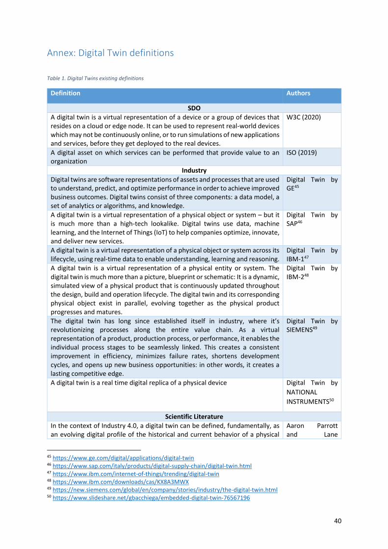
40
Annex: Digital Twin definitions
Table 1. Digital Twins existing definitions
Definition Authors
SDO
A digital twin is a virtual representation of a device or a group of devices that resides on a cloud or edge node. It can be used to represent real-world devices which may not be continuously online, or to run simulations of new applications and services, before they get deployed to the real devices.
W3C (2020)
A digital asset on which services can be performed that provide value to an organization
ISO (2019)
Industry
Digital twins are software representations of assets and processes that are used to understand, predict, and optimize performance in order to achieve improved business outcomes. Digital twins consist of three components: a data model, a set of analytics or algorithms, and knowledge.
Digital Twin by GE45
A digital twin is a virtual representation of a physical object or system – but it is much more than a high-tech lookalike. Digital twins use data, machine learning, and the Internet of Things (IoT) to help companies optimize, innovate, and deliver new services.
Digital Twin by SAP46
A digital twin is a virtual representation of a physical object or system across its lifecycle, using real-time data to enable understanding, learning and reasoning.
Digital Twin by IBM-147
A digital twin is a virtual representation of a physical entity or system. The digital twin is much more than a picture, blueprint or schematic: It is a dynamic, simulated view of a physical product that is continuously updated throughout the design, build and operation lifecycle. The digital twin and its corresponding physical object exist in parallel, evolving together as the physical product progresses and matures.
Digital Twin by IBM-248
The digital twin has long since established itself in industry, where it’s revolutionizing processes along the entire value chain. As a virtual representation of a product, production process, or performance, it enables the individual process stages to be seamlessly linked. This creates a consistent improvement in efficiency, minimizes failure rates, shortens development cycles, and opens up new business opportunities: in other words, it creates a lasting competitive edge.
Digital Twin by SIEMENS49
A digital twin is a real time digital replica of a physical device Digital Twin by
NATIONAL
INSTRUMENTS50
Scientific Literature
In the context of Industry 4.0, a digital twin can be defined, fundamentally, as an evolving digital profile of the historical and current behavior of a physical
Aaron Parrott and Lane
45 https://www.ge.com/digital/applications/digital-twin 46 https://www.sap.com/italy/products/digital-supply-chain/digital-twin.html 47 https://www.ibm.com/internet-of-things/trending/digital-twin 48 https://www.ibm.com/downloads/cas/KX8A3MWX 49 https://new.siemens.com/global/en/company/stories/industry/the-digital-twin.html 50 https://www.slideshare.net/gbacchiega/embedded-digital-twin-76567196

41
object or process that helps optimize business performance. The digital twin is based on massive, cumulative, real-time, real world data measurements across an array of dimensions. These measurements can create an evolving profile of the object or process in the digital world that may provide important insights on system performance, leading to actions in the physical world such as a change in product design or manufacturing process.
Warshaw (Deloitte Insight, 2017)51
The Digital Twin is a set of virtual information constructs that fully describes a
potential or actual physical manufactured product from the micro atomic level
to the macro geometrical level. At its optimum, any information that could be
obtained from inspecting a physical manufactured product can be obtained
from its Digital Twin.
Grieves & Vickers
(2016)52
A Digital Twin is an integrated multiphysics, multiscale, probabilistic simulation
of an as-built vehicle or system that uses the best available physical models,
sensor updates, fleet history, etc., to mirror the life of its corresponding flying
twin
Glaessgen &
Stargel, (2012)53
Digital twin is a real mapping of all components in the product life cycle using
physical data, virtual data and interaction data between them
Tao, Sui, Liu, Qi,
Zhang, Song,
Guo, Lu & Nee,
(2018)54
A dynamic virtual representation of a physical object or system across its
lifecycle, using real-time data to enable understanding, learning and reasoning
Bolton, McColl-
Kennedy,
Cheung, Gallen,
Orsingher, Witell
& Zaki, (2018)55
Using a digital copy of the physical system to perform real-time optimization Söderberg, R.,
Wärmefjord, K.,
Carlson, J. S., &
Lindkvist, L.
(2017)56
A digital twin is a digital replica of a living or non-living physical entity. By
bridging the physical and the virtual world, data is transmitted seamlessly
allowing the virtual entity to exist simultaneously with the physical entity.
El Saddik, A.
(2018)57
In the context of Digital Built Britain a digital twin is a realistic digital
representation of assets, processes or systems in the built or natural
environment
The Gemini
Principles
(2018)58
51 https://www2.deloitte.com/us/en/insights/focus/industry-4-0/digital-twin-technology-smart-factory.html 52 Grieves, M. and J. Vickers, Digital Twin: Mitigating Unpredictable, Undesirable Emergent Behavior in Complex Systems, in Trans-Disciplinary Perspectives on System Complexity, F.-J. Kahlen, S. Flumerfelt, and A. Alves, Editors. 2016, Springer: Switzerland. p. 85-114 53 https://ntrs.nasa.gov/archive/nasa/casi.ntrs.nasa.gov/20120008178.pdf 54 https://www.researchgate.net/publication/323397001_Digital_twin-driven_product_design_framework 55 https://www.repository.cam.ac.uk/handle/1810/280207 56 https://www.sciencedirect.com/science/article/abs/pii/S0007850617300380 57 https://ieeexplore.ieee.org/document/8424832 58 https://www.cdbb.cam.ac.uk/system/files/documents/TheGeminiPrinciples.pdf

42

43
Acknowledgements The Authors would like to acknowledge the contribution received from Lorena Hernandez and
Francesco Pignatelli, in the framework of their study on Digital Twins for the ELISE (European Location
Interoperability Solutions for e-Government) project.
The Authors would also thank the EuroGEOSS and the European GEO High-level Working Group for
their inputs on activities related to Digital Twins.
References BARRICELLI, B., CASIRAGHI, E., & FOGLI, D. (2019). A Survey on Digital Twin: Definitions,
Characteristics, Applications, and Design Implications. IEEE Access, 7, 167653-167671.
Benezeth, I. (2020, July). Personal communication to GEO European HLWG on Destination Earth.
Fei, T., & Qinglin, Q. (2019). Make more Digital Twins. Nature, 573, 490-491.
ISDE. (2020, Aug 26). 11th International Symposium on Digital Earth: Florence Declaration. Tratto da
International Society for Digital Earth: http://www.digitalearth-isde.org/news/851
ISO/IEC JTC 1. (2019). Technology Trend Report on Digital Twin. Geneva: ISO/IEC-JTC1.
Moreno, R. (2020). Personal communication to GEO European HLWG on Destination Earth.
Nilsson, S. (2020, July). Personal communication to GEO European HLWG on Destination Earth.
Pirrone, N. (2020, July). Personal communication to GEO European HLWG on Destination Earth.
Provenzale, A., & Basset, A. (2020, July 30). Personal communication to GEO European HLWG on
Destination Earth.
Schaap, D. (2020, June). Personal communication on ongoing activities relevant for Destination Earth.
Schubert, C. (2020, July). Personal communication to GEO European HLWG on Destination Earth.
Zerefos, C. (2020, July). Personal communication to GEO European HLWG on Destination Earth.

44
Glossary
AI Artificial Intelligence
APIs Application Programming Interfaces
BIM Building Information Modeling
DE Destination Earth
DT Digital Twin
IEC International Electrotechnical Commission
IEEE Institute of Electrical and Electronics Engineers
IoT Internet of Things
ISO International Organization for Standardization
ML Machine Learning
TEP Thematic Exploitation Platform
W3C World Wide Web Consortium

45
GETTING IN TOUCH WITH THE EU
In person
All over the European Union there are hundreds of Europe Direct information centres. You can find the address of the centre
nearest you at: https://europa.eu/european-union/contact_en
On the phone or by email
Europe Direct is a service that answers your questions about the European Union. You can contact this service:
- by freephone: 00 800 6 7 8 9 10 11 (certain operators may charge for these calls),
- at the following standard number: +32 22999696, or
- by electronic mail via: https://europa.eu/european-union/contact_en
FINDING INFORMATION ABOUT THE EU
Online
Information about the European Union in all the official languages of the EU is available on the Europa website at:
https://europa.eu/european-union/index_en
EU publications
You can download or order free and priced EU publications from EU Bookshop at: https://publications.europa.eu/en/publications. Multiple copies of free publications may be obtained by contacting Europe Direct or your local information centre (see
https://europa.eu/european-union/contact_en).

46
KJ-N
A-30
43
8-EN
-N
doi:10.2760/430025
ISBN 978-92-76-25160-6