Embed Size (px)
Citation preview
Vassar College Vassar College
Digital Window @ Vassar Digital Window @ Vassar
Senior Capstone Projects
2019
Designing a 21st century community: an exploration of the ford Designing a 21st century community: an exploration of the ford
plan in Saint Paul, Minnesota plan in Saint Paul, Minnesota
Sophie Blumenstock Vassar College
Follow this and additional works at: https://digitalwindow.vassar.edu/senior_capstone
Recommended Citation Recommended Citation Blumenstock, Sophie, "Designing a 21st century community: an exploration of the ford plan in Saint Paul, Minnesota" (2019). Senior Capstone Projects. 887. https://digitalwindow.vassar.edu/senior_capstone/887
This Open Access is brought to you for free and open access by Digital Window @ Vassar. It has been accepted for inclusion in Senior Capstone Projects by an authorized administrator of Digital Window @ Vassar. For more information, please contact [email protected].
Designing a 21st Century Community:
An Exploration of the Ford Plan in Saint Paul, Minnesota
Sophie Blumenstock
April 26, 2019
Senior Thesis
Submitted in partial fulfillment of the requirements for the Bachelor of Arts in Urban
Studies at Vassar College
Adviser, Tim Koechlin
Table of Contents
Acknowledgements……………………………………………………………………………………………….2
Introduction…………………………………………………………………………………………………………3
Chapter 1: Saint Paul Historical Context: The Old Ford Plant……………………………….…14
Chapter 2: The Master Plan ………………………………………………………………………………….18
Chapter 3: Sustainability……………………………………………………………………………………...35
Chapter 4: Community Reactions………………………………………………………………………....44
Conclusion: Envisioning the Past, Present, and Future of the Ford Site…………………….54
References…………………………………………………………………………………………………………..56
1
Acknowledgements
To the Vassar Urban Studies Department, for my education
To Tim, for your unconditional and unwavering enthusiasm, optimism, and support
To Margaret, for the harshest editing and best friendship I’ve ever known
To Evelyn, for everything
2
Introduction
While interning with the City of Austin last summer, there were always stretches of
several days in which I was not given very many assignments. In order to pass the time but still
be in the realm of productivity, I read every available online news publication, including
CityLab, an online publication about urban areas and their functions. The morning of June 26,
2018, I was surprised to see my hometown of Saint Paul featured in the cover article, entitled
“How an Ambitious Minnesota Eco-Project Became a Density Battleground.” This article 1
became the springboard for my thesis.
It discusses the Ford Plan, an ongoing development project with the goal of transforming
the 122 acres along the Mississippi River that housed the Saint Paul Ford Manufacturing Plant
until its closure in 2011. The Ford Plan caught the attention of CityLab partly because it is so
ambitious, and partly because it is so hotly contested by a group of citizens in Saint Paul. The
Ford Plan is a design for a high-density, sustainable, mixed-income, mixed-use residential
community along the Mississippi. Very little of the Old Ford Plant remains on the site, so it
presents an opportunity to build a new community in a major city from the ground-up,
incorporating new green technology and sustainable infrastructure, with the goal of using
net-zero energy. This plan would be ambitious anywhere, but it seems especially unlikely in
Minnesota, which does not have a reputation for innovative residential design, and where the
temperature can be below-zero for weeks on end, making heating systems difficult to maintain.
On top of this, this utopian-sounding plan is unpopular with many of the current residents, who
worry about lowering existing property values and increasing traffic flow in their neighborhood.
I was excited for the opportunity to apply urban theory to an active, ongoing project,
especially in my hometown. Over the course of my four years as an Urban Studies student at
1 Walljasper, Jay. “How an Ambitious Minnesota Eco-Project Became a Density Battleground.” City Lab, June 26, 2018. Accessed June 2018.
3
Vassar, I’ve often felt a disconnect between what I learn in the classroom and my life in Saint
Paul. The Twin Cities are endlessly fascinating to me as unique urban spaces, both with access
to the other, as well as the Mississippi River, but somehow were never mentioned in any of my
classes. I, somewhat self-indulgently, wanted to use this thesis to bridge the gap between my
education living in New York and my observations living in Minnesota. As a citizen of Saint
Paul, I had inherent biases and preconceived opinions about the Ford Plan and its major players
before I began this thesis. However, I attempted to keep my mind as open as possible, and use
my familiarity with Saint Paul and Minnesotans to guide my research process.
Spatial and Demographic Context
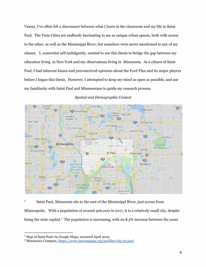
Saint Paul, Minnesota sits to the east of the Mississippi River, just across from 2
Minneapolis. With a population of around 306,000 in 2017, it is a relatively small city, despite
being the state capital. The population is increasing, with an 8.5% increase between the years 3
2 Map of Saint Paul via Google Maps, accessed April 2019. 3 Minnesota Compass, https://www.mncompass.org/profiles/city/st-paul
4
2010 and 2017. 20.4% of residents have an annual income that places them below the poverty 4
line. 52% of the population were recorded on the census as white, with 15% of the population
recorded as black, 17% as Asian or Pacific Islander, 4% as mixed race, and 9.7% Latino or
Hispanic. The Twin Cities have significant immigrant populations of Hmong people as well as 5
people from West African countries, specifically Somalia.
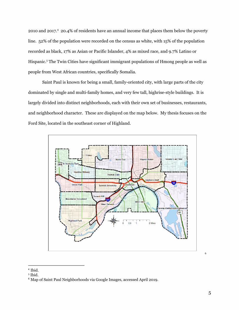
Saint Paul is known for being a small, family-oriented city, with large parts of the city
dominated by single and multi-family homes, and very few tall, highrise-style buildings. It is
largely divided into distinct neighborhoods, each with their own set of businesses, restaurants,
and neighborhood character. These are displayed on the map below. My thesis focuses on the
Ford Site, located in the southeast corner of Highland.
6
4 Ibid. 5 Ibid.
6 Map of Saint Paul Neighborhoods via Google Images, accessed April 2019.
5
Defining a 21st Century Community
One of the first things that struck me about the Ford Plan, other than its location, was
the repeated use of the phrase “a 21st century community.” How, almost 20 years into the 21st
century, are we just now building the communities that belong to the century? Isn’t every
community that currently exists “a 21st century community?” What is it about this specific
proposal that sets it apart from the others? By unpacking and unraveling the Ford Plan as a
solution, I wanted to better understand the problem that they are trying to solve. Using the Ford
Plan as a case study, I began to question: What are the major issues our society is facing in the
21st century? How can the built environment combat these issues?
Qualities of a “21st Century Community”
Philip Lawton, lecturer in Geography at Maynooth University, Ireland, discusses the role
of urban public space in his 2007 article “Commodity or Community? The Role of Urban Public
Space in the Early 21st Century.” He describes building a public space as “building the space for
everyday life,” physically constructing the space for daily social interactions. In this way, urban 7
public space forms the foundation for community to develop. Lawton acknowledges that
different communities occur on many different scales, across many different identities. In this 8
way, public space should be designed to enable interactions on a variety of scales and should be
inclusive of all ages, races, genders, and abilities in order to create vibrant, healthy communities.
Lawton also makes the point that communities are becoming increasingly privatized, and, in
many cases, commercialized, as people with money and power more and more frequently make
decisions designed to create and maintain social orders. This privatization, combined with 9
7 Lawton, Philip. “Commodity or Community? The role of urban public space in the early 21st
Century.” Building Material 16 (2007): 36. 8 Ibid. 9 Ibid., 37.
6
spaces managed by policing and signage, make public spaces into a battleground, with different
groups contesting the others’ right to occupy space.
Author Charles Montgomery, in his book Happy City, addresses the fact that cities not
only present physical design problems, but psychological ones. Planners, attempting to
maximize efficiency of space without considering the happiness of the people who will live and
work there, can design perfect, sterile communities that look more dystopian than utopian. 10
Montgomery gives the infamous example of Le Corbusier’s proposal for a new Paris, complete
with his signature cruciform skyscrapers. Montgomery sets out a list of principles he believes a 11
city should follow in order to facilitate the happiness and wellbeing of its citizens, including
● The city should strive to maximize joy and minimize hardship.
● It should lead us toward health rather than sickness,
● It should offer us real freedom to live, move, and build our lives as we
wish.
● It should build resilience against economic or environmental shocks .
● It should be fair in the way it apportions space, services, mobility, joy,
hardships, and cost…. 12
He advocates for evaluating cities on the grounds of how happy their citizens are and
transforming happiness through design techniques, “changing the shape” of the city to increase
the residents’ quality of life.
In order to accomplish these goals, Jeff Speck, city planner and author of the book
Walkable City: How Downtown Can Save America One Step at a Time advocates for increasing
pedestrian infrastructure, prioritizing walkability in urban spaces, shifting the emphasis away
from cars and back to people. His “General Theory of Walkability” distills his observations into
four distinct conditions: walking should, in his mind, be “useful,” “safe,” “comfortable,” and
10 Montgomery, Charles. Happy City, 26. Toronto: Doubleday Canada, 2013. 11
Ibid. 12 Ibid., 43.
7
“interesting.” Walking should facilitate the accomplishment of tasks, make people feel secure 13
in their environment, facilitate positive interactions between people, and be pleasing to the eye
in its offer of variety. This can contribute to increasing happiness and psychological 14
well-being in the users of the space in addition to significantly benefiting the environment,
reducing the number of cars on the road and the emissions they create.
Prashant Goswami, a geoscientist and climatologist based in New Delhi, India, puts the
recent rapid urbanization in India in the context of climate change. Over the course of his
opinion piece, Goswami defines several different aspects he sees as essential in the formation of
a “smart city.” He stresses the need to form a quantifiable definition of a smart city in order to
use it as a planning model. For Goswami, a true “smart city” cannot only rely on technology, but
must also be sustainable in order to function in the long term. As well as the need for basic 15
health and safety, Goswami makes the argument that smart cities also need to maximize
efficiency in transportation, with people spending the least time possible on the road. A smart
city should be sustainable, compatible with the climate in which it is built, and ultimately,
carbon neutral. Goswami, again in the context of increasingly rapid urbanization taking place,
makes the point that cities should be the epicenter of an “urban-rural interface,” meeting the
needs of the surrounding suburbs and bridging the gap between them and the city itself. In
order to accomplish these goals, Goswami recommends new, master planned communities using
comprehensive design. 16
This concept of the smart city is substantiated by Singapore-based architects Mun Summ
Wong, Richard Hassell, and Alina Yeo in their 2016 article “Garden City, Megacity: Rethinking
13 Speck, Jeff. Walkable City: How Downtown Can save America, One Step at a Time, 11. New York:
Farrar, Straus and Giroux, 2012. 14
Ibid. 15
Goswami, Prashant. “Matrix for a Smart City.” Current Science Vol. 109 No. 2 (2015): 245-246.
Accessed March 2019. 16
Ibid., 246.
8
Cities For the Age of Global Warming.” They address the fact that in order to be resilient, cities
must adapt to climate change. Urbanization is contributing to climate change, concentrating 17
more people in smaller areas and prompting more construction and development. In order to 18
solve both the issue of city populations rising and the climate problems this causes, the authors
present Singapore as a model of a “garden city megacity.” They designed different prototypes 19
of new models for urban areas with the goals of creating places with “greenery, community, civic
generosity, ecosystems, and self-sufficiency.” 20
Wong, Hassell, and Yeo called for a drastic re-envisioning of land use in cities, an
increase in density by building vertically, and an incorporation of green spaces throughout the
layers of buildings. This vision calls for buildings to be multi-use, each layer contributing a 21
different function. In order to combat issues with shading and plant growth, the authors also
proposed building a city with an “inverted skyline,” allowing thesun to filter through with
minimal shading from the buildings, as well as “sky gardens,” greenery planted at the tops of the
buildings receiving the most sun. They also place an emphasis on “breathability” using both 22
greenery and passive house technology to design natural ventilation systems, allowing the
architecture to “breathe” as naturally as possible without relying on mechanical systems. The 23
ultimate goal of the authors’ designs is to create a “self-sufficient city” that provides all of its own
energy, food, and water within the confines of the city limits. 24
Taking all of these concepts into account, a more complete image of a “21st century
community” begins to emerge. In the 21st century, people of all identities and demographics
17 Wong, Mun Summ, Richard Hassell, and Alina Yeo. “Garden City, Megacity: Rethinking Cities
For the Age of Global Warming.” CTBUH Journal No. 4: (2016): 46. 18
Ibid., 46. 19
Ibid. 20 Ibid. 21
Ibid., 47. 22 Ibid., 48. 23 Ibid. 24 Ibid.
9
should be taken into account in the design process, and accessibility for all should be a priority
for any planner. In addition to being people-focused, a plan for a new community in the 21st
century should address technological advances in a society, maximizing efficiency of energy
usage, transportation, and infrastructure. Communities should be designed to be resilient, both
protected against the adverse effects of climate change as well as preventing further emissions
with sustainable design tactics, with the goal of total self-sufficiency in energy and resources.
Put simply, a “21st century community” is the vision of an ideal future, in which everyone has
access to all public spaces in cities, and cities are able to withstand any disaster, perfect
fortresses reinforced with sustainable, net-zero emission technology. It seems utopian and
unattainable, but plans for these communities, like the Ford Plan, are already being put into
motion.
In the Context of the Ford Plan
The phrase “a 21st century community” was used by by city officials, planners, and
stakeholders to describe the Ford Plan very early in the planning process. In an interview about
the Ford Plan in the summer of 2018, Tom Fisher, the director of Minnesota Design Center, was
quoted saying, “‘this is an opportunity to envision what a 21st-century community is.’” The 25
phrasing that Fisher used pushed the concept even a step further: in the design of the Ford Plan,
planners were not simply checking the boxes of how others have previously defined different
21st century communities, but doing something totally new. They were, in essence, leading the
way into the future of planned communities in cities.
The concept of building a community for a new era of life was central to every aspect of
the Ford Plan, from the industrial, working class roots of the site to the planned innovations in
sustainability and green technology. With so much open space to work with in a major urban
25 Walljasper, “How an Ambitious Minnesota Eco-Project Became a Density Battleground.”
10
area, the Ford Plan presents a unique opportunity to lead the way in reshaping the urban fabric
of Saint Paul.
Over the course of this thesis, I consider the major themes of transforming an industrial
space to a mixed-use residential space, private versus public space, privately owned public
space, and their potential impacts on access and connectivity, the concept of sustainability and
the different ways to achieve it, and the role of community engagement in the planning process.
The concept of the “21st century community,” how to define it, and how it shapes the Ford Plan,
remains central throughout. I looked at local news publications, scholarly articles, websites and
social media pages, and official city documents and reports to pick apart the many different
nuances of the Ford Plan and the context in which it arose. In the scope of this thesis, I know
that I was unable to devote time to fully explore all nuances of the Ford Plan, but I chose certain
aspects that most exemplified the “21st century community” identity that it has been given.
Because I chose to study an ongoing project, I imposed a January 1, 2019 cut-off date, and did
not include any research published in 2019, although there have been several community
meetings and updates to the plan.
In the first chapter, I provide historical context for the Ford Site, examining the spatial
history of the site, the development of the Ford Plant, and its impacts on the community.
Although the development of the Ford Site will not maintain the buildings or infrastructure used
in auto manufacturing, the site’s legacy as an industrial space and as a space for employment
shape the development principles used in the drafting of the Ford Site Zoning and Master Plan.
In the second chapter, I go through the Master Plan, unpacking the timeline that lead to
its approval in 2017, and breaking the plan down, evaluating its individual chapters. I introduce
the major forces at work behind the drafting of the Master Plan (Ford, the City of Saint Paul, and
the State of Minnesota, and the private developer, Ryan Companies) and examine the
11
intersections of their power and influence over the development process. I examine the impact
that these different entities have on the development of an accessible, diverse community,
putting the development plans in the context of privately-owned, public space.
To better understand the impact of green technology and the creation of a “sustainable”
identity for the Ford Site, in the third chapter, I zero in on the aspects of the Master Plan
involving sustainability, examining the role of economic, social, but mainly environmental
sustainability in shaping both the physical development plans as well as the project’s branding a
“21st century community.” I put these concepts into context with the necessary process of
brownfield remediation that was necessary in order to shift the land from an auto
manufacturing plant into a safe, healthy, residential community.
In the final chapter, I return to the idea of power and agency in shaping the development
process, examining community resistance to the Ford Plan and the processes of due diligence
and public comment. I conclude the chapter by using a reading of Henri Lefebvre’s concept of
“right to the city” to shape my argument.
In my conclusions, I examine the timeline of the Ford Site from its beginnings as an
industrial space to now, and I return to the concept of a “21st century community,” putting it
into context with each aspect of the Ford Site I explored, and evaluating it as a viable way to
describe the Ford Plan.
12
Saint Paul Historical Context: The Old Ford Plant
When the Old Ford Plant closed in 2011, Ford began the process of removing almost all
existing buildings and infrastructure and restoring the soil, leaving almost nothing of the plant
behind. The Old Ford Plant has very little physical connection to what is now called the Ford
Site, the empty land waiting for redevelopment, but the history of the site as a place of
employment and as a place of efficient manufacturing can be connected to many of the concepts
and priorities that dominate the current master plan. Because Ford Motor Companies still owns
the land, it is important to be conscious of the legacy of the Old Ford Plant when considering
and evaluating the Ford Plan. In this chapter, I provide a brief timeline of the rise and fall of the
Ford Plant, as well as further examining Henry Ford’s desire for hydroelectric power that lead
him to the Twin Cities in the First Place. This chapter draws heavily on the work of Minnesota
historian Brian McMahon, who has published several articles, a book, and a short ebook on the
topic of the Saint Paul Ford Assembly Plant and Ford’s activities in Minnesota.
The Old Ford Plant (1923-2011): A Brief Timeline
Ford began expansion out from the Dearborn, Michigan manufacturing plant around the
turn of the century. In 1908, the Model T was creating, revolutionizing the auto manufacturing 26
industry and necessitating the construction of assembly plants that could fit the assembly line
required to build the car. One of the main events pushing Ford to expand elsewhere was a 27
strike at a factory in Buffalo, NY around the same time he turned to the Twin Cities. Ford 28
established a pattern of getting around issues with workers and with city ordinances by
establishing power: having one of his factories in a city was desirable because of the economic
26 McMAHON, BRIAN. "Model T for the Northwest Territories: Ford Arrives in Minnesota." In
The Ford Century in Minnesota, 2. Minneapolis; London: University of Minnesota
Press, 2016. http://www.jstor.org/stable/10.5749/j.ctt1t89kb3.4. Accessed December 2018. 27 Ibid., 6 28 Ibid., 7.
13
boost and jobs it would provide. If things were made difficult for him, he would simply take his
business elsewhere. In this vein, Ford originally wanted to locate his new plant in Minneapolis,
which had a reputation for being more densely populated and more suited to industry than Saint
Paul, as well as having the same access to the Mississippi River and the Canadian Pacific rail
lines. However, Minneapolis could not get the necessary policies to allow construction to begin 29
approved, so Saint Paul eagerly took the bid, rezoning the site of 135 acres from residential to
industrial. 30
Ford first visited the Saint Paul Plant in 1923. Well located, overlooking the river, and
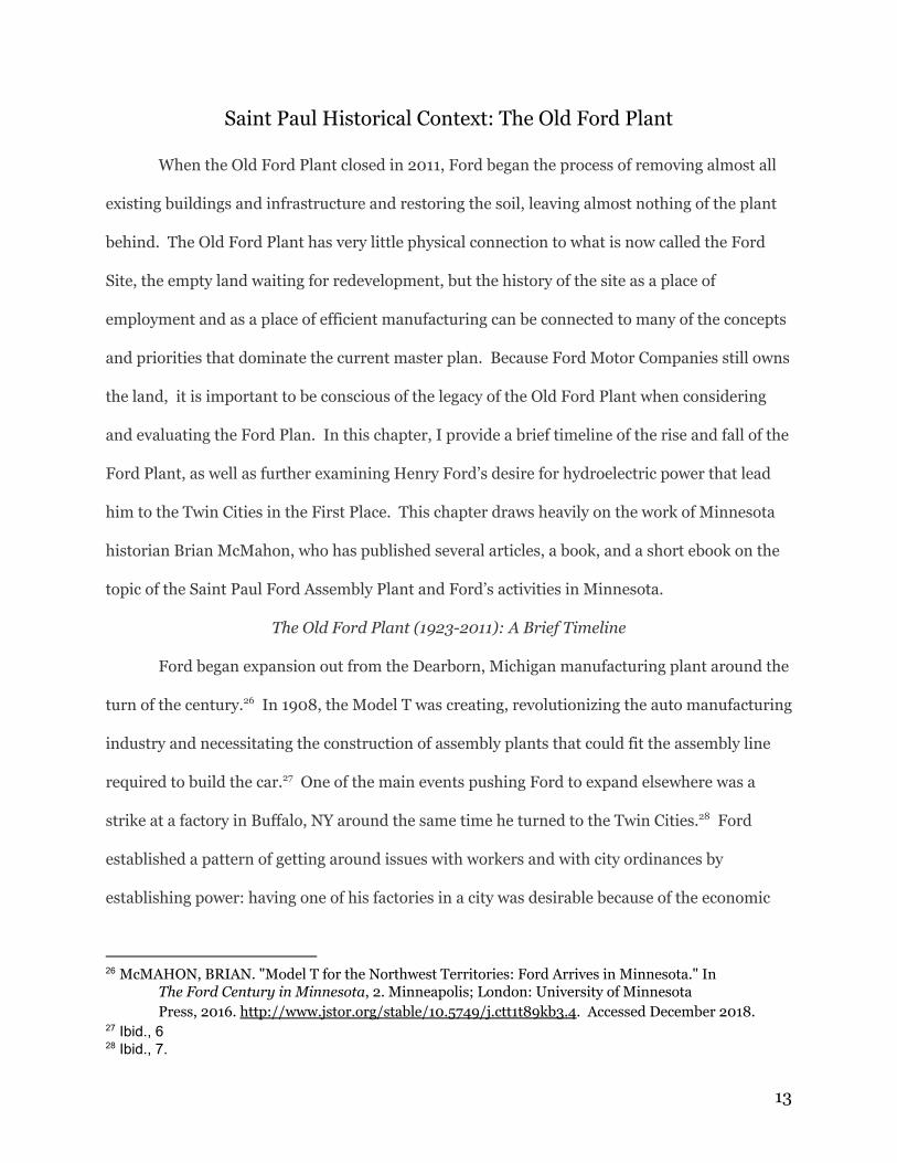
with plenty of room for eventual expansion, the new plant was ideal. Ford employed the
architect Albert Kahn to design a state of the art, modern, beautiful factory. McMahon describes
the factory as seemingly a “monument to Ford,” a piece of art on the river. 31
32
29 Ibid., 13 30 McMahon, Brian. A Short History of the Ford Plant, 8. Minnesota Historical Society Press.
March 15, 2013. Ebook accessed January 2019. 31 McMahon, “A Short History,” 9. 32
Highland Park Ford Assembly Plant designed by Albert Kahn, image via Google Images accessed April
2019.
14
Production at the Highland Park Plant ensued, bringing more people into the city in
search of work, drawn by Ford’s famed five dollar daily pay policy. The plant also was the
catalyst for infrastructure projects in the city, such as the streetcar line that was built straight
into the site, and the construction of Saint Paul Avenue. Manufacturing was shut down during 33
the depression, and briefly halted for the war effort 1932-1937, but then increased
manufacturing for the war effort brought Saint Paul more economic prosperity. In the 1970s, 34
industry changed, with the need to comply with new EPA regulations about oil use. The 1980s
saw another shift: in order to compete with Japanese cars, the plant expanded and modernized.
In 1999, the company constructed the United Auto Workers training center, providing classes 35
for workers, but this project was short lived. 2000 was the beginning of the end, less job 36
security. McMahon’s opinion on the closure of the plant was, “The closure of the Twin Cities
Assembly Plant was a predictable and inevitable outcome of the manufacturing system that
Henry Ford helped to create,” referencing the Ford concepts of efficiency and consolidation that
were the force behind the creation of the plant in the first place. 37
Ford’s Desire for Self-Sufficiency: The Use of Hydroelectric Power
With the Saint Paul Assembly Plant, Ford wanted a closed energy system, completely
independent from the city grid, employing self-sufficiency of energy to increase efficiency of
production. Saint Paul provided a lot of options for power sources, with the potential for the 38
use of steam, powered by coal, and gas able to be transported from other areas in the midwest.39
Ford privatized his source of energy by constructing hydroelectric plant. Boilers were fed with
33 Ibid. 34
Ibid., 13, 20. 35
Ibid., 25, 26 36
Ibid., 29 37 Ibid., 31. 38 Ibid., 12. 39
Ibid.
15
water from the Mississippi, and natural gas from Oklahoma and propane from Chicago provided
backup power sources. 40
Desire to be independent from the city stemmed from distrust in centralization., but also
self-indulgence and a fascination with power sources. It was more efficient to construct a plant 41
at the site of power instead of transporting power, although he still did this with the multiple
backup systems to ensure ongoing manufacturing. Around the time the plant was constructed, 42
Minneapolis and Saint Paul battled over energy sources, specifically over membership in the
Municipal Electric company and use of the hydroelectric power source available with the
construction of the new High Dam in the river. Ford was working behind the scenes. In 1922
Ford moved in, promising power, infrastructure, factories, and employment. The company
submitted its own competing application for the use of the dam, and Saint Paul withdrew their
own application to to support Ford’s. With the addition of hydroelectric power, employment 43
at the plant jumped from 3000 to 14,000.
The timeline of Ford’s activity in Minnesota, specifically in the battle for hydroelectric
power, provides a legacy of Ford working behind the scenes to get city policy that they needed
approved, a desire for a closed source of power, and promises of employment. The influence of
this legacy will be further unpacked in the next chapter, in which I introduce and evaluate the
2017 Ford Site Zoning and Master Plan.
40 Ibid.
41 McMAHON, BRIAN. "Drawn to the River: Hydroelectric Power, Navigation, and a New Plant in St.
Paul." In The Ford Century in Minnesota, 61. Minneapolis; London: University of Minnesota Press, 2016.
http://www.jstor.org/stable/10.5749/j.ctt1t89kb3.5. 42 Ibid., 62. 43 Ibid., 89
16
The Master Plan
After closing the Saint Paul-based plant in 2011, Ford conducted its first steps of the
redevelopment process, clearing the Ford Site of all pre-existing buildings used in
auto-manufacturing and beginning to decontaminate the land, bringing the quality up to
residential standards. In December 2017, Ford put their 144 acres of land in west Saint Paul 44
on the market to be purchased and developed by a master planner. The city approved the 45
rezoning process necessary to develop the land in September, 2017. Formerly zoned for
industry, the Ford Site was approved for medium-high density and mixed-use residential
zoning, with 20% of housing units designated as low income housing. 46
The Ford Site Zoning and Master Plan was approved with a 5-2 vote by City Council. The
ward’s representative, Council Member Chris Tolbert, was quoted in the Star Tribune voicing
his support for the plan: “‘With this plan I know we can honor the things that have made St. Paul
and Highland Park special for decades, while moving forward to strengthen our neighborhood
and city for future generations.’” Tolbert’s thoughts are emblematic of the struggle faced by all 47
cities when embarking upon a new development: how to maintain the identity of the
neighborhood while simultaneously transforming it into a radical, a new space of the future.
The struggle between these two opposing visions for future developments shapes much of the
conflict surrounding such projects and community dissent, as discussed in the next chapter in
greater detail.
44 Melo, Frederick. “St. Paul’s former Ford plant site hits the market.” Pioneer Press, December
19, 2017. Accessed November 2018. 45
Ford Site Zoning and Master Plan, 12. 46
Melo, “St. Paul’s former Ford plant site hits the market.” 47 Van Berkel, Jessie. “Ford plant site plan approved by City Council on 5-2 vote.” Star Tribune,
September 28, 2017. Accessed February 2019.
17
Unpacking the Ford Site Zoning and Master Plan
The Ford Site Zoning and Public Realm Master Plan was adopted by Saint Paul City
Council on September 27, 2017. This master plan outlines the general context, zoning, and
design principles agreed upon by the city for the development of the Ford Site. This was drafted
and adopted before a planning firm was hired to fully realize and develop the project, and is
subject to some change as plans for the Ford Site progress. However,ut the guiding principles of
the project will remain the same as originally outlined.
The master plan is divided into nine chapters: Preface, Vision and Guiding Principles.
Existing Conditions, Zoning- Districts and General Standards, Zoning- Building Types,
Infrastructure, Parks and Open Space, Public Art, and Sustainability. In this section, I will
provide a summary and analysis of each chapter in the master plan document provided by the
city. I condensed the two chapters on zoning into one section for the purpose of efficiency.
Chapter 1: Preface
The Master Plan opens with a discussion of the unique opportunity presented by this
project, emphasizing the rarity of such a large quantity of developable land along a major river
in a major city. It focuses on the future transformation of the Ford Site, which will become “a 48
connected, livable, and sustainable site that will serve as a world-wide model for a 21st Century
Community.” This is one of the first official uses of the phrase “21st century community” in 49
reference to the Ford Site. This particular usage is largely aspirational and abstract, with no
formal definition given. As the Preface continues, it describes more basic tenets of the project,
stressing the importance of “clean technologies and high quality design for energy, buildings,
and infrastructure,” and “walking, biking, and transit” opportunities. Another important 50
48 Master Plan, 8. 49 Ibid. 50
Ibid.
18
aspect of the design expressed from the very beginning is accessibility and economic benefit.
The Preface paints a picture of an efficient, thriving community, attractive and pleasant to live in
with a low environmental impact, providing jobs to many people. This is ambitious, to say the 51
least. The purpose of the Ford Plan is not only to design a large-scale, master planned
community in a major city but to revolutionize residential communities all over the world. The
Twin Cities, although they occasionally make it onto lists of the “most liveable” and “most
bikeable” cities in the United States, are not often held up as examples of design innovation or
sustainability in the planning world. The Ford Plan represents a desire for a new order, in which
this new Saint Paul community takes center stage, paving the way for greater efficiency and
resilience in mixed-use design.
The Preface also briefly outlines the timeline of events in the development of the Ford
Site. Early in the process, the city worked with various consultants and researchers looking at
the site, determining its viability as an eventual residential community. Since 2012, Ford 52
worked to clean up the land, ridding it of the industrial waste accumulated over 90 years of auto
manufacturing. When the Master Plan was approved in 2017, it was anticipated that Ford 53
would put the land on the market and sell it to a “Master Developer” by 2018. Although the 54
city was heavily involved in the development of the Ford Plan since its nascency, the Ford Site is
still private property that will be privately developed. The city can guide this development
through laws and zoning codes, but the residential development on the Ford Site will not be
public. Construction is not expected to begin until 2020, and is anticipated to take between 12
and 20 years. 55
51 Ibid.
52 Ibid.
53 Ibid., 9.
54 Ibid. 55
Ibid.
19
Chapter 2: Vision and Guiding Principles
This section begins with the Vision Statement developed by the Ford Site Planning Task
Force in 2007, It reads as follows:
The redeveloped Ford site will balance economic, social, and environmental
sustainability in a way that conserves and improves the unique Highland Park
neighborhood and Mississippi River valley in which it sits while advancing the
City’s economic wealth and community goals, resulting in a forward-thinking 21st
Century development. 56
Even in 2007, before the old Ford Plant closed its doors, the future-planned community was
envisioned as a harmonious balance of old and new, socially and environmentally sustainable,
and economically prosperous, the hallmarks of a “21st Century Community.” This vision stayed
constant over the next ten years, despite drastic changes in political climate and technology.
Guiding the development of the Ford Site were the basic principles of being mixed-use
(residential and commercial), having a range of different housing options (especially in
affordability), and providing the potential for many different businesses and jobs, growing the
tax base for the region. Using technology, the development should utilise sustainable design 57
principles, protecting natural resources and generating its own energy. Many different transit 58
options should be included in the plan, which should be laid out to allow for safe, pleasant travel
through the site, connecting both to the river and the surrounding city. Lastly, the chapter 59
emphasizes the importance of green spaces and public art, making the development a vibrant
place to be. These green spaces would ideally connect the space with the legacy of the industrial
Old Ford Plant and continue its connection to the Mississippi. 60
56 Ibid., 18.
57 Ibid.
58 Ibid., 20.
59 Ibid.
60 Ibid.
20
In this chapter, the planners outline a vision of a bustling, diverse, healthy community
with a strong sense of identity, grounded in the history of the space and its location along the
river. These ideas are not incredibly radical by themselves, but the addition of environmental
technology and sustainable building practices (with the development generating all of its own
energy), especially in frigid Minnesota, makes this something special.
Chapter 3: Existing Conditions
This section provides some context into the physical landscape and current zoning codes
at the Ford Site. Highland Park, the neighborhood surrounding the site, was first majorly
developed for residential use in 1939, a little over a decade after the Ford Plant opened.
Businesses grew around the neighborhood’s first apartments, and the area went through a
housing boom over the next few decades. The majority of housing in Highland is single-family,
built between the 1920s and the 1950s. The Plan acknowledges the fact that Highland is a 61
predominantly white, predominantly wealthier neighborhood in comparison to the rest of the
city. 62
The zoning code for the Ford Site was formerly “Light Industrial,” with the surrounding
area zoned for single- and multi-family residential, business, and mixed-use. The Ford Site is 63
just a few miles away from the Minneapolis-Saint Paul International Airport, which places some
height restrictions on any future construction. The plant is also located just alongside the 64
Mississippi, placing it within the Mississippi River Corridor Critical Area (MRCCA) and giving it
special zoning constraints designed to preserve the existing features and functions of this stretch
of the river. These constraints include restrictions on the placement of buildings, building
61 Ibid., 22.
62 Ibid.
63 Ibid.
64 Ibid., 24
21
height, removal of existing plants, and alterations of the land. The development process will 65
have to factor these constraints in as it progresses.
Chapters 4 and 5: Zoning
The Ford Site Zoning and Master Plan has two chapters devoted to zoning: “Districts and
General Standards,” as well as “Building Types.” The chapter devoted to districts introduces and
outlines the six different zoning districts that will be present in the development. It then moves
into general guidelines for location, land use, floor area ratio (FAR), lighting, roofing, solar,
green spaces, and parking. Zoning District F1 (River Residential) will contain a variety of sizes 66
of residences “compatible with the look of Mississippi River Boulevard,” an existing street which
winds along the bank of the river and typically has larger, more expensive homes. Zoning 67
District F2 (Residential Mixed Low) is designated for primarily residential development, with a
few multi-family homes and townhouses interspersed with businesses. Zoning District F3 68
(Residential Mixed Mid) is similar to F2, but with slightly greater density and a wider variety of
business types represented. Buildings are allowed to be slightly taller than in the F2 zoning
district, with buildings in F2 at a maximum of 55 ft high, and buildings in F3 at a maximum of
either 65 ft high or 75 ft high with a stepback. The following Zoning District F4 continues the 69
pattern, simply allowing for more density of multi-family residential units and businesses. 70
Zoning District F5 (Business Mixed) steps away from residential units, designated to be an area
primarily for retail and service businesses with a few multi-family homes. The final Zoning
District F6 (Gateway) is intended to forman opening at the north and south edges of the site,
attracting people into the development and connecting the Ford Site to the rest of the city. 71
65 Ibid., 25.
66 Ibid., 27.
67 Ibid., 31.
68 Ibid.
69 Ibid.
70 Ibid.
71 Ibid.
22
Building heights increase moving east across the site, away from the bank of the
Mississippi. This gradation allows for views and access of the river in addition to maximizing
light on rooftop solar installations. The general standards that the Zoning and Master Plan 72
provide are to ensure that future development of the site will maximize sustainability and
efficiency in all areas of life. Standards are provided for the inclusion and maintenance of 73
street trees and landscaping, solar panels (rooftop and adjacent), green roofs and patios, and a
wide variety of parking for bikes and cars. 74
The second zoning chapter outlines the requirements for building types in the
development of the Ford Site. A wide variety of building types is necessary to meet the goals of
maximizing efficiency in the development and including residential units accessible to people of
a variety of incomes:
● multi-family homes (2-6 units per building),
● carriage houses (1-2 units per building),
● live/work homes(2-8 residential units above businesses and offices on the first
floor),
● town/rowhouses (3-16 units per building attached horizontally),
● multi-family low-income homes (6-40 units per building, with mixed sizes),
● multi-family, medium-income homes (40 or more units per building),
● mixed residential and commercial homes,
● commercial and employment spaces(serving commercial purposes),
● civic and institutional spaces (government and community spaces), and, lastly,
parking structures (providing off street parking). 75
These building types, incorporated into the variety of zoning districts and their respective
density and height requirements, have the potential to form the dense, bustling urban fabric the
city envisions with this master plan.
Chapter 6: Infrastructure
72 Ibid., 33.
73 Ibid., 46.
74 Ibid., 47-62.
75 Ibid., 62-79.
23
The chapter about the infrastructure necessary for the development of the site is broken
into two major sections: constructing a transportation network and constructing a water feature
for the purpose of stormwater management. Both of these aspects of the plan are central to its
overall livability, as well as connecting the Ford Site to both the Mississippi River and the
surrounding city. Each road in the street network is outlined and mapped, complete with a cross
section. Examining each road, a few central themes emerge.
Pedestrians and cyclists are prioritized in the transportation network. All of the roads,
including the pre-existing major roads leading to Highland Village, will have dedicated bike
lanes in addition to being accessible on foot. Each road is lined with greenery. Some roads to be
constructed in the Ford Site are only accessible by bike or by foot and connect with the greenway
along the river. In the design of the transportation network, the planners prioritized connection
within the Ford Site as well as connection to the surrounding roads, communities, and public
transit networks. These plans have the potential to give the city access to a part of the river 76
and surrounding green spaces that were previously blocked off and dominated by the auto
industry.
The other main infrastructural feature central to the design for the Ford Site is the
stormwater management system. In the creation of this system, the city hopes to
“Recreate the historic Hidden Falls Headwaters feature, naturalize the
existing downstream creek, reconnect the future neighborhood to the river by
means of an open-water flow path, and create a model for sustainable and
resilient infrastructure development.” 77
Hidden Falls creek, an offshoot of the Mississippi, is located at Hidden Falls Regional Park, at
the southern tip of the Ford Site. It was altered through the development of the Ford Plant and
Highland Park, and is primarily fed through stormwater runoff from these developments. In 78
76 Ibid., 79-102.
77 Ibid., 104.
78 Ibid., 105.
24
order to combat the potential for increased stormwater runoff through the development of the
Ford Site, the Master Plan calls for the restoration of Hidden Falls Creek, connecting it to
planned green spaces in the development. This water feature would be constructed to mimic 79
natural features, seamlessly blending in with the natural restoration of the creek. 80
Stormwater management, especially close to the river, is essential in Minnesota. The
long winters with constant temperatures below freezing lead to a large accumulation of snow
and ice which all melt in May, causing the Mississippi to flood. Minnesota summers are
frequented by thunderstorms with heavy rainfall, increasing runoff. However, the Master Plan
does not stipulate the function or appearance of the stormwater management water feature in
the winter, which can be used for up to eight months out of the year. Planning for function in
freezing temperature is essential in planning outdoor spaces in Minnesota.
Chapter 7: Parks and Open Space
The “Parks and Open Space” chapter outlines the different types of green spaces to be
included throughout the Ford Site. These include gateway parks, a civic square, neighborhood
parks, pocket parks, the Hidden Falls Headwaters Feature, and walking and biking paths. The 81
water feature is central to the design, providing both function and greenery and acting as a
“spine” to the rest of the green spaces through the site. A “gateway park” is planned for the 82
northwest corner of the site, designed to provide a space for recreation in nature, connecting the
city to the site, and drawing people in. A civic plaza, located more centrally, will only be 83
accessible to pedestrians and is designed as a flexible outdoor community space. A more 84
79 Ibid., 106.
80 Ibid., 107.
81 Ibid., 110.
82 Ibid., 111.
83 Ibid., 112.
84 Ibid. 113.
25
traditional neighborhood park, with recreational facilities and picnic areas, will also be included.
85
The plan also calls for smaller “pocket parks” to be dispersed throughout the site,
providing additional access to green spaces. The water feature, as has previously been 86
discussed, will be designed to reduce runoff and erosion and to provide an additional green
space, complete with bike and pedestrian areas, picnic tables, and access to trails. 87
This chapter begins with the emphasis that public green space is essential to a vibrant,
healthy community, and is careful to include a wide variety of spaces. There is hardly any
mention of what these spaces will be like in different seasons, which is essential to designing for
life in Minnesota. The “neighborhood park” section briefly mentions an ice skating facility, but
it is unclear if there are plans for the rest of the green spaces when the weather changes. This
calls into question the potential resiliency of these parks and open spaces.
The Master Plan also does not detail ADA accessibility for the spaces, which seem
primarily designed for able-bodied people. All graphics and renderings provided only feature
people who are able to walk, which also calls into question if these public green spaces will truly
be accessible to all members of the community.
Chapter 8: Public Art
This chapter outlines a plan for incorporating public art features into as many aspects of
the design as possible. Initiated with temporary, “tactical urbanism” techniques, the Master
Plan outlines ideas to visually reinforce the Ford Site’s identity as a modern, sustainable
community. “Futuristic” art installations incorporated into the green infrastructure are planned
85 Ibid., 114.
86 Ibid., 115.
87 Ibid., 116.
26
to give people visual access to the heritage of the space, beginning with its origins as indigenous
land and then illustrating the history of the Ford Plant. 88
This plan for public art is much less fleshed-out than other aspects of the Master Plan.
Although it hopes to show the indigenous history of the space, it does not say that indigenous
artists’ works will be prioritized nor does it incorporate the indigenous history of the land into
any other aspect of the plan, again calling into question the accessibility of the development.
The city has the ability to support indigenous artists and people of color in all aspects of the
plan; however,and race and heritage are not mentioned until this section, which reads as
somewhat of an oversight. Although the plan is still in its early developmental stages, and these
sections only provide outlines of the potential for development, the city must do better in these
areas in order to ensure their vision of a diverse, accessible, thriving community.
Chapter 9: Sustainability
Sustainability and green technology are at the very heart of the Ford Plan and are
essential to the vision of the Ford Site as a modern, “21st century community.” The Master Plan
outlines a vision for sustainability in three key areas: economic, social, and environmental
sustainability. In order to accomplish this vision, the Master Plan emphasizes the economic
importance of the site, which will provide more jobs and economic exchange for the area. With 89
the mixed-use and mixed-income aspects of the design, it is hoped that the community will be
more diverse, vibrant, and, thus, socially sustainable.
The Master Plan calls for the incorporation of green technology in the designs for
buildings, energy, and infrastructure in order to accomplish environmental sustainability. The
city conducted several studies regarding sustainability and resiliency of the Ford Site in all
aspects, which will be discussed in much greater detail in the following chapter.
88 Ibid., 122.
89 Ibid.
27
Ryan Companies
In June 2018, Ford announced their selection for a developer for the Ford Site: the
Minnesota-based Ryan Companies (frequently abbreviated to Ryan Cos.). Ryan Cos. was 90
established in Minnesota in the 1930s. With roots as a lumber company, Ryan Cos. began to
work in real estate management and development in the 1970s, moving into the Twin Cities. 91
and has since expanded the reach of their work to complete projects in 38 states. A private 92
company specializing in commercial real estate, Ryan has a wide variety of different types of
developments under their belt, including healthcare, office space, retail stores, industrial
buildings, multi-family dwellings, and mixed-use master plans in the same vein as the Ford Site.
Their two prominent mixed-use developments are the Kirkland Urban campus in Kirkland, 93
Washington, and 222 Hennepin, located across the river from the Ford Site in Minneapolis.
On a surface level, Ryan’s Kirkland Urban project is very similar to the guidelines
developed by the City of Saint Paul for the Ford Site. It is a mixed-use residential community,
combining business and retail with apartment units, although it is much smaller than the Ford
Site, at only 12 acres. The main concept was to redo a former commercial space on the 94
waterfront in Washington and create a vibrant residential community. With the first phase of
construction completed in March 2019, Ryan’s vision of Kirkland Urban is, “both a home and a
destination, the development incorporates the best of the waterfront community of Kirkland,
WA, combining an authentic, neighborhood feel with an urban energy...balancing the need for
90 Melo, Frederick. “Ryan Cos. will develop the 122-acre former Ford campus in Highland Park.”
Pioneer Press, June 25, 2018. Accessed November 2018. 91
Ryan Companies, https://www.ryancompanies.com/about. 92
Ibid. 93
Ryan Companies, https://www.ryancompanies.com/about. 94
Ryan Companies, “Kirkland Urban” https://www.ryancompanies.com/project/kirkland-urban
28
growth and economic opportunity without losing touch with the comfortable, small town roots
of its past.” Ryan employed sustainable building technology, with several apartment buildings 95
LEED certified.
The main difference between the two projects, apart from the size, is affordability.
Kirkland Urban, as made very clear from the development’s website, was designed to attract
wealthy young professionals. Kirkland Urban is located a stone’s throw away from Microsoft
and Google, and is aimed at attracting young tech workers. The website advertises the 96
development as full of retail and outdoor recreation activities, with “eclectic boutiques, eateries,
art galleries and performance centers.” The language on the website, as well as the aspects of 97
the development it features, paint a picture of a gentrifying, exclusive, elite development in a
desirable location for young professionals in the tech industry. This is a far cry from the goals
outlined by Saint Paul for the Ford Site, emphasizing socio-economic diversity and affordable
housing.
222 Hennepin, located in the heart of Uptown Minneapolis, is very similar to Kirkland
Urban. Completed in 2013, it is one of Ryan’s first fully realized master planned communities.
According to Ryan Cos., this was their first project in which they were able to take “the project
from idea, to completion, to sale, the development drew upon Ryan’s unique ability to manage a
large, complex project almost entirely internally, drawing upon skills and expertise across the
company.” Like Kirkland Urban, this development is on a much smaller scale than the Ford 98
Site, in this case just one apartment building, and caters to an exclusively wealthy crowd. Ryan
Cos. describes 222 Hennepin as “286 luxury apartments and a Whole Foods Market.” 99
95 Ibid. 96
Ryan Companies, Kirkland Urban 97
Ibid. 98
Ryan Companies, 222 Hennepin, https://www.ryancompanies.com/project/222-hennepin 99
Ibid.
29
Apartments range from about 1.5-3.5 thousand dollars per month, far outside the range of
affordable housing in the Twin Cities. The vision for the project was to serve the community by
filling in a physical gap with housing and adding a grocery store to serve the surrounding
Uptown neighborhoods, but only wealthier people can afford access.
Ryan Companies presented their ideas for the Ford Site in October 2018 at a community
planning meeting open to the public. They began by acknowledging the importance of the Ford
Site to the community, prompting their several months of community engagement and meetings
with the public. Another aspect of their due diligence period they emphasized was ensuring 100
that the remediation process undertaken by Ford had successfully decontaminated the land and
brought it up to residential standards. Ryan Cos.’ vision for the Ford Site aligns with the core 101
concepts in the Master Plan adopted by the City in the previous year. The central aspects of
their design, as influenced by public comment, are as follows:
Over 50 acres of public and open space that includes:
● World class central water feature
● Multiple green spaces, with 1,000 trees and a range of traditional and
creative green spaces including green rooftops and pocket parks
● New grid road system
● Public gathering spaces/plazas
● Pedestrian & bicycle trails
● The Highland Little League ballfields
And private development including:
● Retail
● Healthcare
● Office
● Wide range of for sale and rental housing options including:
● Single family homes
● Senior living
● Condos
● Rowhomes
● Affordable housing
100 Ryan Companies, “Ryan presents vision for development of Ford Site,” October 10, 2018.
https://www.ryancompanies.com/news/ryan-presents-vision-development-ford-site 101 Ibid.
30
● Market-rate rental housing 102
Ryan estimates the project to bring in around one billion dollars of revenue to the area, with
around 14,000 temporary construction jobs generated in the building process, and 1,300
permanent jobs. With city approval, work on infrastructure is anticipated to begin in the fall 103
of 2019. 104
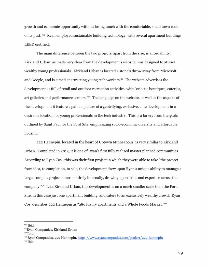
Ryan included a few different concept drawings of their vision for the Ford Site.
105
102 Ibid.
103 Ibid. 104 Ibid. 105
Image via https://www.ryancompanies.com/news/ryan-presents-vision-development-ford-site
31
106
107
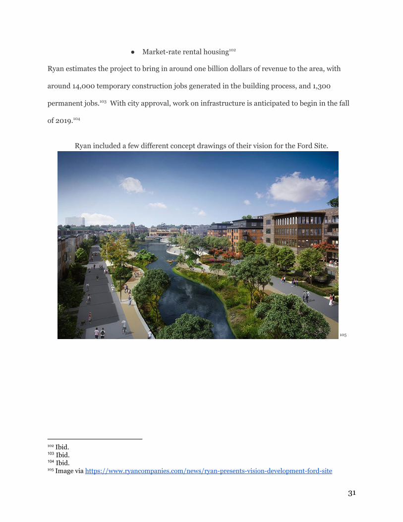
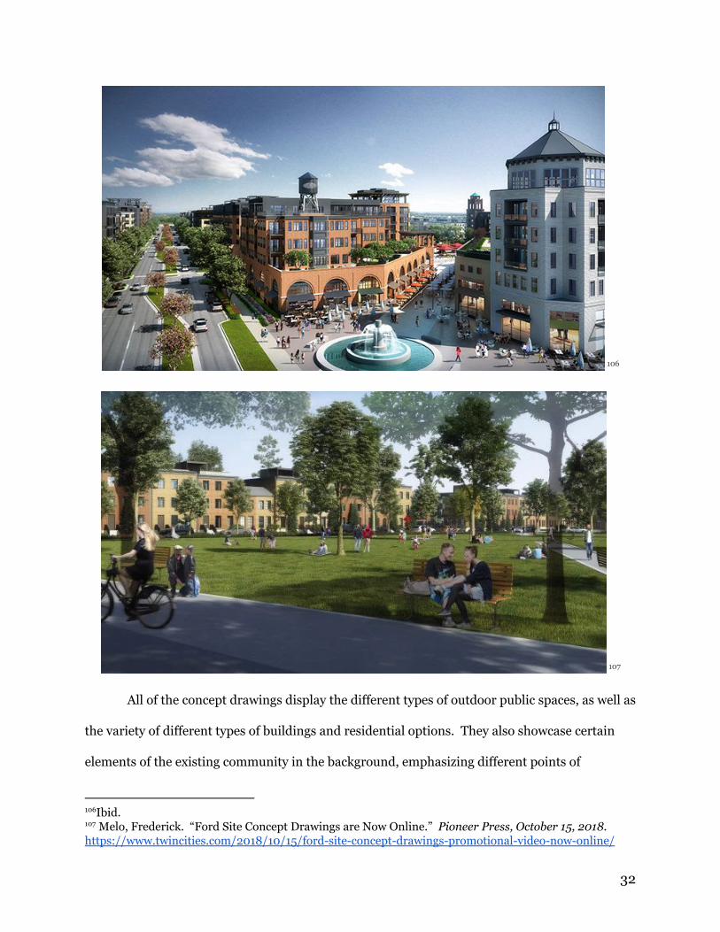
All of the concept drawings display the different types of outdoor public spaces, as well as
the variety of different types of buildings and residential options. They also showcase certain
elements of the existing community in the background, emphasizing different points of
106Ibid.
107 Melo, Frederick. “Ford Site Concept Drawings are Now Online.” Pioneer Press, October 15, 2018.
https://www.twincities.com/2018/10/15/ford-site-concept-drawings-promotional-video-now-online/
32
connection with Highland Park. If fully realised, Ryan’s vision of the Ford Site has the potential
to check all of the boxes, fulfilling the ideals of a vibrant, diverse urban community with a lot of
public outdoor spaces. However, none of the concept drawings conceptualize what these
outdoor spaces will be like in winter. Again, if the crux of the community is dependent on
accessing and engaging with public outdoor spaces, this is worrisome for a neighborhood in
Minnesota.
Implications for Development
In examining the Ford Site Zoning and Master Plan, it falls in line with the developers’
original vision of a “21st century community.” The guiding principles behind the design aim to
create a dense, mixed-use space utilizing sustainable technology and infrastructure to maximize
efficiency. The Master Plan emphasizes the importance of connection with the surrounding
neighborhoods, proposing connection through existing public transit hubs, outdoor space, and
potentially through energy systems. However, due to the early stages of development, it is
unclear whether this vision will be fully realized, and whether or not this almost utopian
community will come about.
Although they have some experience with master planning mixed-use communities, even
as urban infill projects in the Twin Cities, I am unsure that Ryan Cos. was the best choice of
developer for this project. Their track record of creating apartment complexes for the elite with
money to burn does not recommend them for developing what is supposed to be a large,
socio-economically diverse community. So far, although Ryan has held several public,
community meetings to hear citizen comment, their efforts to ensure accessibility of all spaces to
all residents are unclear.
Ensuring that development proceeds in line with these goals is difficult to guarantee.
The city and state government policies can guide development through mandating soil quality
33
testing and approving or denying rewriting zoning codes, or requests for funding, but the land
ultimately belongs to Ford Motor Company, who had control over what developer would take
the reigns of the project. Ford chose Ryan, another private company. For a project that leans so
heavily on public infrastructure and public green space, the fact that it is privately owned could
pose a problem down the line. In order to develop the Ford Site, Ryan is required to put in a
certain amount of affordable housing, but this does not mean that the businesses will be
accessible or affordable to people of different incomes, or they will necessarily feel comfortable
in all spaces. Simply mixing housing that qualifies as affordable with pricier apartments does
not mean that a community is diverse or healthy. Ideas of ownership in communities and
exploring who should have a voice during the development process will be explored in the last
chapter.
34
Sustainability
Creating a sustainable, lasting community is a key part of designing a “21st century
community.” The Ford Site Zoning and Master Plan emphasizes three types: economic, social,
and environmental sustainability, that are all developed together to create a complete, holistic
residential community. The developers plan to attain economic sustainability through the
mixed-use aspect of the Ford Site, bringing in new jobs through the offices and businesses that
will be included in the site. Social sustainability is to be attained through the socio-economic
diversity of residents in the site, developed through the inclusion of a variety of different types of
housing and affordable housing units. In addition to plans for economic and social
sustainability, environmental sustainability is at the forefront of the plan, and has been since the
beginning. On the one hand, implementing green technology and sustainable designs is
essential in order to restore the land on the site polluted by industrial activities. Moreover, with
the large amount of land available to be built from the ground up, the site presents an
opportunity to build sustainably from the start, without having to retrofit with new technology
and infrastructure later. On the other hand, the Ford Site’s identity as a sustainable
development is a large part of branding and advertising surrounding it, and is specifically
central to the concept of a “21st century community. In this chapter, I examine two major
studies conducted in researching the potential for environmental sustainability in the
development of the Ford Site, and put them into the broader context of brownfield remediation.
Roadmap to Sustainability (2007): Initial Evaluations
This study was conducted before the Ford Plant even closed. It was published in 2007,
and updated in 2011, after the close of the plant. It provides a summary of several months of
consultation between the Ford Site Sustainable Development Team, the City of Saint Paul, and
35
the Minnesota Pollution Control Agency. From the beginning of environmental research on 108
the site, Ford, a private company, worked in conjunction with both the City and State
governments during the due diligence period. As stated by the report, the goal of the research
was “to recommend performance thresholds for site redevelopment, inspiring policy makers and
developers to make this site a national model for sustainable brownfield redevelopment.” 109
Another aspect of note in the “Roadmap to Sustainability” report is the heavy association with
Ford and its established identity as a company. The introduction of the report states: “Ford’s
comprehensive vision and efficient use of the property using manmade and natural amenities
was a precursor to today’s vision for well planned and sustainable redevelopment of the Ford
site, if the plant closes as announced.” Although the Ford Site’s legacy as an 110
auto-manufacturing plant is not a driving force behind the design and development proposals,
it’s presence is still felt.
This early report also establishes the principles of sustainability that will guide future
studies and design proposals. It separates the concept of sustainability into different aspects,
noting the significance of each to the Ford Site. The introductory pages state: “Social and
economic sustainability depends on redeveloping a strong base of employment on site, as well as
housing, businesses, and community amenities that serve a diverse population…. They also 111
note the unique opportunities presented by the Ford Site as a space for residential development,
allowing for the development of new, green infrastructure from the ground up, instead of
retrofitting older systems. In order to accomplish the goals for sustainability in the eventual 112
development of the Ford Site, the report proposes a plan broken down into eleven different
108 “Roadmap to Sustainability: Saint Paul Ford Site,” 2007, 2.
109 Ibid.
110 Ibid., 4.
111 Ibid., 7.
112 Ibid., 8.
36
components. These cover all aspects of the development, including building energy,
transportation networks, building materials, water/wastewater, solid waste, stormwater, soil,
vegetation and habitat, public space, night sky radiation, and urban heat island. The techniques
proposed to make all of these aspects of the development more sustainable rely heavily on the
use of sustainable technologies, such as implementing a fully integrated district energy system
for the heating and cooling of the buildings. Other techniques listed are more strategic, such 113
as reusing existing buildings, infrastructure, and building materials already present. The 114
report recommends some aspects of the development to utilize both technology and reuse, such
as in the water and wastewater system, with the installation of gray water recycling systems,
black water composting systems, and low flow water appliances in the buildings. 115
From the beginning of the Ford Plan, sustainability was a priority. The Ford Site was
always envisioned as a model of transforming an industrial space to a residential space, utilizing
all sustainable technologies and techniques available to create a green, thriving community.
Saint Paul Ford Site Energy Study Report (2015): Establishing a District Energy System
The Saint Paul Ford Site Energy Study Report, published in 2015, was undertaken by the
City in collaboration with the company Krifcon Energy in order to further investigate potential
sustainable energy sources for the Ford Site. It expands upon ideas about sustainable energy
first proposed in the “Roadmap to Sustainability” report. The study begins by restating the
overarching goals for the Ford Site: “to be an economic, social, and environmentally sustainable
place that provides good jobs, services, community amenities and living spaces and serves as a
lighthouse project for future developments.” It aims to address the following five objectives: 116
● Resilience: Security of energy supply
113 Ibid., 15.
114 Ibid., 22.
115 Ibid., 24.
116 Bjerregaard, Jakob and Pernille M. Overbye. “St. Paul Ford Site Energy Study Report.”
December 4, 2015. Accessed April 2019. 2.
37
● Innovation: Rethinking energy supply and energy systems not being
limited by current practices
● “Net Zero” Limiting the energy consumption and CO2 emissions to a
minimum while maximizing the share of renewable energy
● Energy efficiency: Making the best use of the energy with low conversion
and distribution losses and efficient building stock
● Cost-effectiveness: Ensuring affordable energy for the site 117
In the efforts to meet these objectives, several different kinds of energy production were
evaluated. It focuses on the potential uses of thermal energy and the establishment of a local
energy network, or “district energy system,” for heating and cooling. Certain restrictions were 118
factored in, such as the necessity for a relatively small energy system, not a lot of access for
transporting biofuels onto the site, and the Mississippi River as the only local, natural energy
resource available. The Ford Site is unique in its remaining industrial infrastructure, an 119
underground network of steam and sand tunnels throughout the site, as well as access to gas
and electric utilities formerly utilized by the plant. However, after evaluation, it is unlikely 120
that these tunnels will be used in the creation of a local energy system.
The study concludes that a district energy system is the most viable option for a
long-term, carbon-neutral energy source for heating and cooling purposes. This system would 121
be composed of solar panels and water pumps, using water from the Mississippi, with a thermal
storage system and gas boilers for back-up. This type of district energy system is largely 122
inspired by existing heating and cooling systems in buildings in Copenhagen and Stockholm.
Both of these cities face many of the same energy challenges as Saint Paul does, with both
extreme cold temperatures and ready access to bodies of water. The report makes the point that
Saint Paul already has a functioning district energy system, serving a few hundred buildings in
117 Ibid.
118 Ibid., 4.
119 Ibid., 5.
120 Ibid., 6.
121 Ibid., 5.
122 Ibid.
38
the downtown area. There is a potential for the new Ford Site district energy system to connect
with the downtown system in the future, as Saint Paul moves towards becoming a
carbon-neutral city. The development of the district energy system is an essential part of the 123
Ford Site being a net-zero energy development, a crucial piece of its branding as a “21st century
community.” Looking to make both the present and the future more energy-efficient, the
district energy system has the potential to meet sustainability goals for the Ford Site, as well as
transform building practices in Saint Paul.
Incorporation Into the Master Plan (2017)
Both the Roadmap to Sustainability and the Energy Study Report were incorporated into
the “Sustainability” section of the 2017 Ford Site Zoning and Master Plan, which repeated the
major findings of both reports. It lists the eleven different components set out in the Roadmap
with very little variation. The next subsection of the chapter reaffirms the plan set out in the
energy study report, recommending the construction and implementation of a district energy
system. The final subsection is a departure from the principles of environmental sustainability
that dominate this section of the Master Plan, returning to the concepts of economic/social
sustainability. It lists affordable housing as a priority, with the percentages of total housing 124
units designated for people in different income brackets in the low income spectrum. It further
dictates that the affordable housing units should be evenly dispersed throughout the Ford Site,
and not concentrated in one area. 125
In the Context of Brownfield Restoration
Polluted from the almost century as an active auto-manufacturing plant, cleaning up the
land and restoring the soil was an essential part of the initial work to transform the Old Ford
123 Ibid., 9.
124 Master Plan, 130.
125 Ibid., 132.
39
Plant into a space with the potential to become a residential community. Remediation of the site
was conducted by Ford through Arcadis, an environmental consulting firm the company hired,
and overseen by the Minnesota Pollution Control Agency (MPCA). The City of Saint Paul 126
hired their own consultant to run tests on the land over the course of the remediation process. 127
No reports suggesting that there have been any problems with this process thus far have been
released. The fact that the Ford Site is located on a brownfield is part of the appeal for the
project, as well as the developers’ hope that it will become a model for new, sustainable
development.
“Brownfield” is a legal designation, currently defined by the EPA as “a property, the
expansion, redevelopment, or reuse of which may be complicated by the presence or potential
presence of a hazardous substance, pollutant, or contaminant.” The process of remediation, 128
restoring brownfields to the point in which they can be safely used for new purposes, has both
environmental and economic benefits, reclaiming part of the natural environment with the
potential to use the space to increase the tax base, as is planned for the Ford Site. Since the
1990s, the EPA began a series of Brownfields Programs, in which they allocated grant money to
states to incentivize cleaning up the brownfields. With over 450,000 brownfields currently
listed in the United States, the potential for redevelopment should not be underestimated. 129
Leading up to the first federal laws regarding brownfields, three initial acts were used for
the purpose of restoring industrial land: the Resource Conservation and Recovery Act of 1976,
the Comprehensive Environmental Response Compensation and Liability Act (CERCLA) of
126 Saint Paul Government, Ford Site “Site Cleanup,”
https://www.stpaul.gov/departments/planning-economic-development/planning/ford-site-21st-century-
community/site-cleanup. Accessed March 2019. 127
Ibid. 128
EPA, “Brownfields Overview.” https://www.epa.gov/brownfields/overview-epas-brownfields-program. Accessed March 2019. 129 Ibid.
40
1980, and the Small Business and Liability Relief and Brownfield Revitalization Act of 2002. 130
These policies provided a framework and funding for restoration to occur, usually motivated by
the potential for economic development with the use of the land. 131
The legacy of a space as an industrial or toxic site can linger, affecting the community’s
reaction to redevelopment proposals. Prioritizing transparency is essential in initial phases of
remediation so as to not create distrust within a community. Meltem Erdem and Joan Iverson 132
Nassauer, scholars of architecture, ecology, and engineering, stress the unique ethical issues and
design opportunities available to planners developing a former brownfield. They stress the
importance of solving multiple problems through the design, by “introducing landscape
elements that cue humans and wildlife behaviors to limit exposure to contaminants, design can
achieve more multi-functional landscapes and more resilient remediation over the long term.” 133
However, it is also important to not use design to obscure the remediation process or the “toxic
legacy” of the site, which can be perceived as deceitful by members of the community. 134
The other aspect of brownfield restoration that is important to center in discussions
around redevelopment are the people who are predominantly affected by the brownfield, who
are statistically poor people and people of color. It is important to question which 135
demographics the redevelopment will serve, as well as any potential consequences of the
redevelopment process. In the case of a mixed-use development such as the Ford Site, it is 136
130 Erdem, Melten and Joan Iverson Nassauer. “Design of Brownfield Landscapes Under Different
Containment Remediation Policies in Europe and the United States.” Landscape
Journal Vol 32 No. 2 (2013): 279. Accessed March 2019
131 Ibid., 278. 132 Eady, Veronica. “Brownfields Redevelopment: Reconnecting Economy, Ecology, and Equity.” In
Preserving and Enhancing Communities edited by Elisabeth M. Hamin, Priscilla Geigis, and Linda Silka,
195. University of Massachusetts Press, 2007. 133 “Design of Brownfield Landscapes,” 283. 134
Ibid. 135
Eady, “Brownfields Redevelopment,” 198. 136 Ibid., 199.
41
necessary to consider what types of housing options and jobs are being created, and who they
are intended for. 137
Thus far, Ford, in tandem with the City, has effectively been transparent about the
remediation process, publishing studies and reports and making them available through the City
of Saint Paul Government website. Although there is more work to be done as the site develops
to ensure that poor people and people of color will be centered in the development process,
there are constant opportunities for public engagement with this project. Although the concept
of restoring a brownfield is not new, restoring a brownfield and developing a mixed-use,
net-zero community of this size is uncommon, and is responsible for the large amount of
national buzz already surrounding the Ford Site at this stage of the development process.
21st Century Technology
The three main principles of sustainability remained consistent across over a decade.
From the very beginning, the Ford Site was envisioned as a lasting, vibrant, environmentally
friendly neighborhood in Saint Paul. From the beginning, this was an essential part of branding
for the development of the Ford Site, as well as an essential part of the rhetoric of the “21st
century community.” In every conceptualization of a 21st century community, the use of green
technology, integrated into walkable communities with a lot of open, public space, is central to
the design. The proposed environmental technologies fit this description. The Ford Site’s
district energy system, powered by both the Mississippi and solar panels installed on the roofs of
the buildings, will enable it to be one of the first mixed-use, net-zero communities in the
country. Brownfield remediation, the other essential part of the identity of a 21st century
community, adds another factor. Although the development process for the Ford plan is
relatively transparent in its remediation efforts, and both Ford and Ryan Cos. are going through
137 Ibid., 200.
42

periods of due diligence with many community meetings to discuss the plans, it is important to
acknowledge the fact that brownfield restoration is only a small piece of the puzzle in regards to
building more sustainable communities. With plans to potentially connect the disperate district
energy systems in Saint Paul as the city moves towards carbon neutrality, most areas in Saint
Paul will need to be retrofitted with new energy systems and infrastructure. The Ford Plan is an
excellent opportunity to build a “21st century community” from empty space, but most
communities existing in this century are already in existence, and are unable to make use of the
technologies used to make the Ford Site carbon neutral. As a design, it works well for what it is,
but as a vision of a new type of sustainable community with techniques that can be applied
world-wide, it does not hold up.
43

Community Reactions
From the time the first major plans for the Old Ford Plant site were approved by Saint
Paul City Council, citizens were already protesting. In September 2017, City Council voted with
a 5-2 majority to approve a proposal for a massive rezoning and master plan that would enable
the vision of a new, mixed-use community to be realized on the former industrial site. 138
Members of the community group Neighbors for a Livable Saint Paul were in the audience to
protest the plan, many of them holding red signs with the message “Stop the Ford Plan.” They
lobbied for a referendum, which was ultimately denied, to put the Ford Plan on the 2018 ballot
to allow the opportunity of repeal. Their main problems with the plan are that it allows for too 139
much density, which is not in keeping with Saint Paul’s mainly single family home neighborhood
structure, that it would cause too much traffic, and that it would take away from otherwise
public green spaces in the city.
Who Lives in Highland?: A Demographic Breakdown
140
138 Van Berkel, Jessie. “Ford plant site plan approved by City Council on 5-2 vote.” Star Tribune, September 28, 2017. Accessed February 2019.
139 Ibid. 140 Map of Saint Paul with Highland outlined in red, the Ford Site indicated by a red star. Via Google
Maps. Accessed April 2019.
44
A lot of the community dissent to the Ford Plan comes from the Saint Paul neighborhood
Highland. Located in the southeast corner of the city, Highland is flanked by the Mississippi
River on three sides. It is a mainly residential neighborhood with single family homes, many of
them 2-3 bedroom houses built in the 1940s. At the center of Highland there is a small
shopping street known as Highland Village, with several restaurants, a bookstore, a home goods
store, and a movie theater. It is also home to Allina Health Clinic, an eye doctor, and a dentist.
Over the past few years, a few mixed-use apartment buildings were constructed in Highland
Village. The apartments are on the more expensive side for the area, and have a yoga studio and
more expensive cafe underneath them, respectively.
Minnesota Compass, a project that compiles data in a variety of different areas including
race, housing, education, and health, created a complete profile of Highland, mainly using data
from the Minnesota census. Highland is a predominantly white neighborhood, with 77% of the
population marked as white on the census. The black population is recorded at 13%, Asian and
Pacific Islander at 4%, mixed race at 3%, and Hispanic or Latino at 4%. 63% of the population 141
is between the ages of 18 and 64. The neighborhood is divided by median income, with 35%
listed in the highest bracket ($100,000 or more/year) and 24% listed in the lowest bracket (less
than $35,000/year) in 2017. Highland has a total population of 24,744 people with 11,357 142
total housing units. 54.8% of households are family households with children. 48.8% of 143
Highland’s population moved into their homes in 2010 or later. 42.5% of households own at
least one vehicle. 144
141 Minnesota Compass, https://www.mncompass.org/profiles/neighborhoods/st-paul/highland 142
Ibid. 143 Ibid. 144
Ibid.
45
This data paints a picture of Highland as a majority white neighborhood with a large
number of wealthier residents and an almost equally large number of poorer residents. This
stratification plays out in their reactions to the proposal for the neighboring Ford Site.
Neighbors for a Livable Saint Paul
Although it is not stated specifically on their website, a large number of people involved
with the group Neighbors for a Livable Saint Paul (NLSP) are residents of the neighborhood
Highland Park, a few streets to the east of the Old Ford Plant, as exemplified by the number of
“Stop the Ford Plan” signs in front yards in the neighborhood. As residents of Highland, they
feel that their quality of life is threatened by the Ford Plan and have lobbied from the beginning
to stop it all together, or at least to alter it. In the “Our Goals” section of their website, NLSP
states that, “Our goal is to assure that the Ford Development complements and adds to the
livability and safety of Highland Park and St. Paul.” They give a list of the kind of planning 145
they support as a group, including “rational, incremental growth that happens naturally, not
large, transformational projects,” “traffic that allows drivers, pedestrians of all ages, bicyclists
and others to traverse the neighborhood safely,” and more green space. The next two 146
statements that they make are pointed, to say the least:
We SUPPORT development which is truly market driven, which will house, office
and serve reasonable clientele without lowering property values. If a city which
is already so cash-strapped that it must raise property tax rates into double digit
ranges and still cannot care for its streets and schools, available funds should be
used for those purposes, not for the glory of developers and city planners. 147
The words that they choose in these statements express a lot. Their choice of “reasonable
clientele” implies either that they do not like the fact that the Ford Plan has more affordable
housing options, or that the number of residents the plan proposes is unreasonable. The last
145 Neighbors for a Livable Saint Paul, https://www.livablefordvillage.com/our-vision-2 146 Ibid. 147
Ibid.
46
statement passive-aggressively questions the entirety of the Ford Plan, proposing that money be
used to maintain current developments and infrastructure, as opposed to building large,
transformative developments. It is clear that NLSP stands in almost complete opposition to
every aspect of the project.
Further examination of their website confirms this. They provide a list of problems they
have with the plan:
We believe the city's current plan of 122-135 acres of densely-packed residential and
commercial buildings, locked by a river on two sides and located far from freeway access,
will lead to significant negative effects for all of Highland and the surrounding
neighborhoods, including:
● Excessive population density increase
● Dramatic increase in traffic
● Limited community greenspace
● Decrease in property values 148
Once again, NLSP shows that their main concern is the specific maintenance of the
status quo in Highland Park. On other pages of their website, they show statistics about
projected traffic and density, claiming that the proposed density of the Ford Plan would make
the community more dense than some areas of New York City. Across the website, the passive
aggressive tone remains consistent, presenting very pointed statements regarding their concerns
with the proposal and leading the reader in a very specific direction: in opposition to the Ford
Plan. Ultimately, through statements, statistics, and images, NLSP attempts to paint a picture of
the Ford Plan as overly dense, costly, and harmful to Highland and its residents. To back up
concerns about density and traffic, they make it known that the type of community the Ford
Plan proposes: mixed-use, mixed-income, and efficient in space and energy usage, is simply not
how Saint Paul does things. This is summarized with this graphic that they placed next to their
mission statement:
148 Ibid.
47
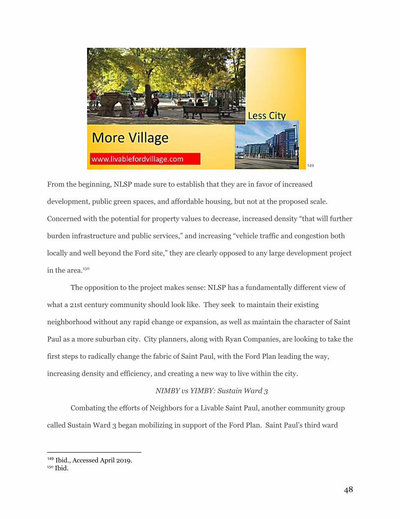
149
From the beginning, NLSP made sure to establish that they are in favor of increased
development, public green spaces, and affordable housing, but not at the proposed scale.
Concerned with the potential for property values to decrease, increased density “that will further
burden infrastructure and public services,” and increasing “vehicle traffic and congestion both
locally and well beyond the Ford site,” they are clearly opposed to any large development project
in the area. 150
The opposition to the project makes sense: NLSP has a fundamentally different view of
what a 21st century community should look like. They seek to maintain their existing
neighborhood without any rapid change or expansion, as well as maintain the character of Saint
Paul as a more suburban city. City planners, along with Ryan Companies, are looking to take the
first steps to radically change the fabric of Saint Paul, with the Ford Plan leading the way,
increasing density and efficiency, and creating a new way to live within the city.
NIMBY vs YIMBY: Sustain Ward 3
Combating the efforts of Neighbors for a Livable Saint Paul, another community group
called Sustain Ward 3 began mobilizing in support of the Ford Plan. Saint Paul’s third ward
149 Ibid., Accessed April 2019. 150
Ibid.
48
encompasses the southwestern corner of the city, including the Ford Site, Highland, and
Mac-Groveland (the next neighborhood over). Their mission statement is as follows: “Sustain
Ward 3 is a group of neighbors in St. Paul who advocate for community, fiscal and
environmental sustainability in the Highland Park and Mac-Groveland neighborhoods in Saint
Paul, MN.” They advocate for projects like the Ford Plan that will create jobs and attract more 151
people to the city. Sustain Ward 3 also advocates for environmental sustainability, connecting 152
the Saint Paul to the natural environment, leading the way for other communities in the area. 153
In this way, their view of the future of Saint Paul is much more in line with the planners behind
the master plan for the Ford Site, hoping to increase jobs and density in the city in
environmentally sustainable ways.
This fight over the vision for the future of the city may not ever be resolved. Different
bloggers theorized the potential cause for this dramatic divide between those advocating for less
density and those advocating for more density in Saint Paul. Debra Keefer Ramage, a columnist
for Southside Pride, questions whether this divide is generational, with older people in the
community advocating for maintaining current levels of density and younger advocating for
increasing density. Nathaniel M. Hood, founding member of streets.mn, a nonprofit 154
organization dedicated to facilitating inclusive dialogue about urban spaces in Minnesota, as
well as a member of Sustain Ward 3, developed this theory in a 2017 Strong Towns article. He
argues that in fights about density, millenials are those who typically support increasing it. He 155
also argues that this divide is consistent with the equity divide, with wealthier homeowners
151 Sustain Ward 3, http://sustainward3.com/. Accessed April 2019.
152 Ibid. 153
Ibid.
154 Ramage, Debra Keefer. “Density? Or Just Getting Real About the Future?” Southside Pride, July 16, 2018. Accessed February 2019.
155 Hood, Nathaniel M. “Who Gets to Decide How a Neighborhood is Redeveloped?’ Strong
Towns, September 6, 2017.
https://www.strongtowns.org/journal/2017/9/5/ford-plant-redevelopment-st-paul-neighbors. Accessed
February 2019.
49
desiring to maintain the status quo in their city and the less wealthy advocating for increased
density with more affordable housing. In order to illustrate this point, Hood provides a series of
photographs taken around Saint Paul, showing that the red “Stop the Ford Plan” signs are
frequently in front of large, expensive homes in Highland, and the green “Say Yes to the Ford
Site” signs are frequently in front of smaller homes and apartment buildings. 156
Hood emphasizes the difference in vision as contributed to by the age and equity gap :
younger people with less money need more affordable housing, and they are willing to put up
with living in a denser area with more traffic in order to accomplish this. Older, wealthier
people in homes that they’ve owned for decades do not have the same need, instead prioritizing
the maintenance of the character of the neighborhood in which they invested themselves. 157
Deciding who to listen to is an essential part of the planning process.
Finding Similarities in Austin, TX
In the Strong Towns article, Hood also makes the point that this struggle of visions for
the future is not unique to Saint Paul. I observed this same struggle when I interned with the
City of Austin Neighborhood Housing and Community Development Office in the summer of
2018. Over the course of the summer, the city officials debated whether or not to adopt
CodeNext, a complete overhaul of Austin’s zoning codes that would move the city away from
single-family homes and promote an increase in density.
Austin, like Saint Paul, is a more suburban city with a small, higher density downtown,
and much of the city zoned for single family residences. Austin is also highly segregated, with
black people historically living in neighborhoods in East Austin. The city is rapidly expanding
with many young professionals flooding in, especially from the tech industry. With so many
single family homes, the demand for housing is high, and prices are skyrocketing. As a result,
156 Ibid.
157 Ibid.
50
poor people and people of color, many of whom have lived in the same neighborhoods for
decades, can no longer afford to live there. They are pushed out into the suburbs as their
historic neighborhoods are gentrified. At the beginning of my internship, my supervisor
stressed this point as one of the biggest challenges the city was facing. Austin is one of the only
cities in the country that has an increasing population but a decreasing black population.
In order to combat this problem as well as align Austin with the goals outlined in
Imagine Austin, the city’s 30-year plan, the city invested several years into creating a proposal
for the radical rezoning plan called CodeNext. The vision for the city that Imagine Austin details
is utopian in the same way that the vision for the Ford Site is: a “vibrant, liveable, sustainable”
city focused on increased density. However, CodeNext was also met with extreme community 158
pushback. Many of the citizens who came to speak during citizen comment were concerned with
gentrification and being priced out. However,they were ultimately more concerned with
preserving their neighborhoods as they were at the time they were growing up. They worried,
much like Saint Paul residents worry, that increasing density would transform the city into
something else, causing it to lose its essential character. They were also concerned with who
would ultimately benefit from the increased density: the predominantly white, wealthier people
who were moving to Austin for the tech industry, or the predominantly black, poorer people who
were trying to hang onto their historic communities.
Ultimately, after protests all summer, City Council voted no on CodeNext, sending the
city back to the drawing board. Next steps for Austin remain unclear. If they do not increase
density, real estate and tax prices will continue to skyrocket, further gentrifying the city and
forcing long term residents to relocate elsewhere. If they do increase density, there is a risk that
158 Austintexas.gov, http://www.austintexas.gov/department/about-imagine-austin
51
this could still happen. However, Austin proved that they strive for and value community input,
so the citizens will be involved in the planning process every step of the way.
Community Opposition in Context with Lefebvre’s “Right to the City”
Purcell, Mark. “Excavating Lefebvre: The right to the city and its urban politics of the
inhabitant.” Geojournal 58, 99-108 (2002).
In considering the process of community engagement surrounding the development of
the Ford Site, it is important to first acknowledge the entities in positions of power surrounding
the project. The major players include Ford Motor Companies (current owner of the Ford Site),
Ryan Companies (the private developer hired by Ford), the City of Saint Paul, and more broadly,
the State of Minnesota. In due diligence periods, both the City and Ryan Companies have both
consistently held community engagement meetings, publicly advertised and usually held at a
local middle school in the evenings. Especially with such a contentious project, the question of
which citizens have should influence over the project is inevitable.
Mark Purcell, scholar of democratic urban planning and development, unpacks the
philosopher Henri Lefebvre’s concept of the “right to the city” in an examination of power and
influence in city planning. He acknowledges that the people’s “right to the city” is an
increasingly popular concept in the face of neoliberalism, which strips individuals of their voices
in local governance. Lefebvre’s concept of space breaks it down into three different aspects: 159
perceived space, conceived space, and lived space, which is created at the intersection of
perceived and conceived space. Purcell clarifies that for Lefebvre, the production of urban 160
space, such as with a development project like the Ford Plan, “necessarily involves reproducing
the social relations that are bound up in it.” Inhabitants of urban space are given both the 161
159 Purcell, Mark. “Excavating Lefebvre: The right to the city and its urban politics of the
inhabitant.” Geojournal 99. (2002). 160 Ibid., 102. 161
Ibid.
52
“right to participation,” exemplified by the protests and counter-protests of Neighbors for a
Liveable Saint Paul and Sustain Ward 3, respectively, as well as the “right to appropriation,”
which gives inhabitants “the right of inhabitants to physically access, occupy, and use urban
space.” Purcell makes the comment that this “right to appropriation,” or “right to physically 162
access,” is historically the “primary focus of those who advocate the right of the people to be
physically present in the space of the city.” In this way, over the course of the development 163
process, Ryan Cos. should carefully consider whose voices are amplified in meetings for citizen
comment. In order to produce an effective equitable space, Ryan should prioritize listening to
the voices of people who do not have or have less physical access to the spaces created at the
Ford Site. Although these concepts ar complicated by both scale (as the contestation is over a
residential community as opposed to a city) and by the fact that the Ford Site is a private
development, and not a public one, the developers should consider the voices of people who are
historically underserved by urban areas: poor people and people of color.
162 Ibid., 103. 163 Ibid.
53
Conclusion: Envisioning The Past, Present, and Future of the Ford Site
One of the problems with choosing an ongoing development project for a year-long
thesis project is that there is very little resolution available. At the time I am writing, the
development process is continuing, with community engagement meetings almost every month.
Ryan is continuing their due diligence period, but also applying for public funding, with the
hope of starting construction on infrastructure this summer. Although I was able to evaluate the
articles, reports, and plans that have been published thus far, evaluating the Ford Site as
successful or not as a development is impossible as it does not exist yet. That being said, I was
still able to form certain conclusions over the course of my work on this thesis.
In considering the Ford Site and its potential for redevelopment, it is essential to keep its
legacy as an industrial space, as well as a space owned, and currently owned by Ford Motor
Companies in mind. In the community, the Ford Site has a history of being a place of
employment and economic prosperity, as well as a place of innovative, autonomous industry.
Both of these concepts carry through to the Ford Plan. From the standpoint of brownfield
remediation, it is also essential for transparency and ethical to not obscure the fact that the land
that the site is situated on was formerly polluted. Ford’s power and influence as a company is
not to be underestimated, as seen in the company’s history of pushing development projects
through the City’s legal process. Despite working in tandem with city planners and hiring Ryan
Companies to develop the Ford Site, Ford as a company is a major player in the development
process.
Thus far, from a planner’s standpoint, there is very little to object to about the nuts and
bolts of the Ford Site Zoning and Master Plan. On a surface level, it is consistent with the
overarching goals of economic, social, and environmental sustainability. As I noted in previous
chapters, the Master Plan still has some work to do in planning public spaces for all seasons, as
54
well as actively ensuring that they live up to their plans of socioeconomic diversity and
accessibility to people of all ages, races, and abilities, but these are impossible to fully evaluate at
this stage of the development process. Throughout the development process, it will be essential
to note who has the power to make decisions and whom they are truly building the community
for.
Throughout my research into different aspects of the Ford Plan, the (always undefined)
concept of a “21st century community” returned over and over again. It is most frequently used
as a catch-all term to simultaneously give the reader a futuristic image of the Ford Site, as well
as to efficiently describe the Master Plan’s three guiding principles of sustainability. In my
opinion, this term does not accurately fit either the aspirations of the planners behind the
Master Plan, or how the development is actually playing out. Firstly, situating the Ford Plan in
the 21st century ignores the legacy and history of the space, which is both unethical and ignores
Ford Motor Companies past and continuing power in the scope of the Ford Plan. Secondly,
situating the Ford Plan in the 21st century is counter to the driving principles of sustainability
that the phrase is used to describe. If they truly wish to develop a lasting Saint Paul
neighborhood, surely it should be referred to as a “22nd century community,” especially since
the development will not likely be completed until almost halfway through the 21st century.
With any development project, but especially one of this magnitude, looking into the future is
essential.
55
References
Austin Texas Government, “About Imagine Austin.”
http://www.austintexas.gov/department/about-imagine-austin
Bjerregaard, Jakob and Pernille M. Overbye. “St. Paul Ford Site Energy Study Report.”
December 4, 2015. Accessed April 2019.
Eady, Veronica. “Brownfields Redevelopment: Reconnecting Economy, Ecology, and
Equity.” In Preserving and Enhancing Communities edited by Elisabeth M. Hamin,
Priscilla Geigis, and Linda Silka, 195-205. University of Massachusetts Press,
2007.
EPA, “Brownfields Overview.”
https://www.epa.gov/brownfields/overview-epas-brownfields-program. Accessed
March 2019.
Erdem, Melten and Joan Iverson Nassauer. “Design of Brownfield Landscapes Under Different
Containment Remediation Policies in Europe and the United States.” Landscape
Journal Vol 32 No. 2 (2013): 277-292. Accessed March 2019
“Ford Site Zoning and Public Realm Master Plan.” City of Saint Paul. Adopted September 27,
2017. Accessed December 2018.
Goswami, Prashant. “Matrix for a Smart City.” Current Science Vol. 109 No. 2 (2015): 245-246.
Accessed March 2019. https://www.jstor.org/stable/24905845
Hasan, Syeda. “Austin City Council Votes Unanimously To Scrap CodeNEXT.” KUT.org, August
9, 2018. https://www.kut.org/post/austin-city-council-votes-unanimously-scrap-codenext
Hood, Nathaniel M. “Who Gets to Decide How a Neighborhood is Redeveloped?’ Strong
Towns, September 6, 2017. Accessed February 2019.
Lawton, Philip. “Commodity or Community? The role of urban public space in the early 21st
Century.” Building Material 16 (2007): 36-41. Accessed March 2019.
https://www.jstor.org/stable/29792307
McMAHON, BRIAN. "Model T for the Northwest Territories: Ford Arrives in Minnesota." In
The Ford Century in Minnesota, 1-56. Minneapolis; London: University of Minnesota
Press, 2016. http://www.jstor.org/stable/10.5749/j.ctt1t89kb3.4.
McMAHON, BRIAN. "Drawn to the River: Hydroelectric Power, Navigation, and a New Plant in
St. Paul." In The Ford Century in Minnesota, 57-100. Minneapolis; London: University
56
of Minnesota Press, 2016. http://www.jstor.org/stable/10.5749/j.ctt1t89kb3.5.
McMahon, Brian. A Short History of the Ford Plant. Minnesota Historical Society Press.
March 15, 2013. Ebook accessed January 2019.
Melo, Frederick. “Ford Site Concept Drawings are Now Online.” Pioneer Press, October 15,
2018.
https://www.twincities.com/2018/10/15/ford-site-concept-drawings-promotional-video
-now-online/
Melo, Frederick. “St. Paul’s former Ford plant site hits the market.” Pioneer Press, December
19, 2017. Accessed November 2018.
Minnesota Compass, Highland Neighborhood Profile.
https://www.mncompass.org/profiles/neighborhoods/st-paul/highland. Accessed
March 2019.
Minnesota Compass, City Profile Saint Paul. https://www.mncompass.org/profiles/city/st-paul. Accessed March 2019.
Montgomery, Charles. Happy City. Toronto: Doubleday Canada, 2013.
Neighbors For a Livable Saint Paul. https://www.livablefordvillage.com/. Accessed February
2019.
Opper, Richard G. “The Brownfield Manifesto.” The Urban Lawyer Vol 37 No. 1 (2005):
163-190. Accessed March 2019
Purcell, Mark. “Excavating Lefebvre: The right to the city and its urban politics of the
inhabitant.” Geojournal 58, 99-108 (2002).
Roadmap to Sustainability: Saint Paul Ford Site, 2007, Accessed March 2019.
Ryan Companies. https://www.ryancompanies.com/
Ryan Companies, “About.” https://www.ryancompanies.com/about
Ryan Companies, “Kirkland Urban. ”http://www.kirklandurban.com/residential
Ryan Companies, “Ryan presents vision for development of Ford Site,” October 10, 2018.
https://www.ryancompanies.com/news/ryan-presents-vision-development-ford-site
Ryan Companies, “ Ryan Companies Awarded Development of Ford Site” June 6, 2018.
https://www.ryancompanies.com/news/ryan-companies-awarded-development-ford-sit
e
57
Saint Paul Government, Ford Site “Site Cleanup,”
https://www.stpaul.gov/departments/planning-economic-development/planning/ford-site-21st
-century-community/site-cleanup. Accessed March 2019.
Saint Paul Government “2040 Comprehensive Plan: Saint Paul for All.”
https://www.stpaul.gov/departments/planning-economic-development/planning/2040
-comprehensive-plan
Speck, Jeff. Walkable City: How Downtown Can save America, One Step at a Time. New York:
Farrar, Straus and Giroux, 2012.
Sustain Ward 3, http://sustainward3.com/. Accessed February 2019.
Van Berkel, Jessie. “Ford plant site plan approved by City Council on 5-2 vote.” Star Tribune,
September 28, 2017. Accessed February 2019.
Walljasper, Jay. “How an Ambitious Minnesota Eco-Project Became a Density Battleground.”
City Lab, June 26, 2018. Accessed June 2018.
Wong, Mun Summ, Richard Hassell, and Alina Yeo. “Garden City, Megacity: Rethinking Cities
For the Age of Global Warming.” CTBUH Journal No. 4: (2016): 46-51. Accessed
March 2019. https://www.jstor.org/stable/10.2307/90006409
58