Embed Size (px)
Citation preview
Design of a GIS for the Design of a GIS for the Ala Ala KahakaiKahakai National Historic National Historic Trail Stewardship ProgramTrail Stewardship Program
Presented byPresented byKaren K. Kemp, PhDKaren K. Kemp, PhD
ContributorsContributorsManda Wood, MSGISManda Wood, MSGISAndrew Land, MSGISAndrew Land, MSGIS
Robert WilliamsRobert Williams
MS GIS ProgramMS GIS ProgramUniversity of RedlandsUniversity of Redlands
2
3
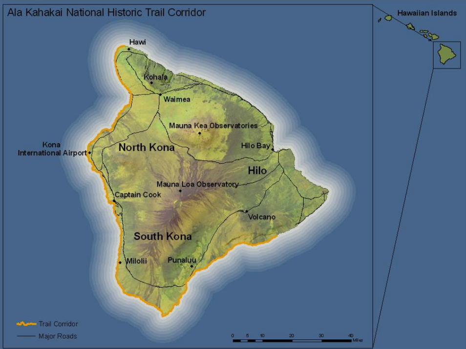
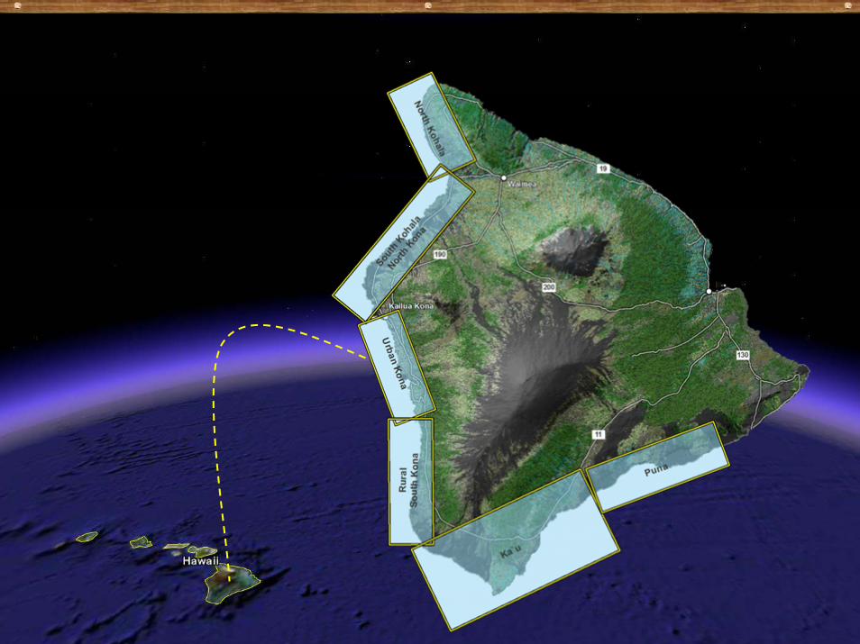
Ala Kahakai National Historic TrailAla Kahakai National Historic TrailEstablished in 2000 to preserve, protect and Established in 2000 to preserve, protect and interpret traditional Native Hawaiian culture interpret traditional Native Hawaiian culture and natural resourcesand natural resources175+ mile trail corridor along the west coast 175+ mile trail corridor along the west coast of the Island of Hawaiiof the Island of Hawaii
Captures existing coastal trail and Captures existing coastal trail and maukamauka--makaimakai segmentssegmentsRequires establishment of new trail segmentsRequires establishment of new trail segments
Not yet open, completion of the Not yet open, completion of the comprehensive management plan is pendingcomprehensive management plan is pending

4
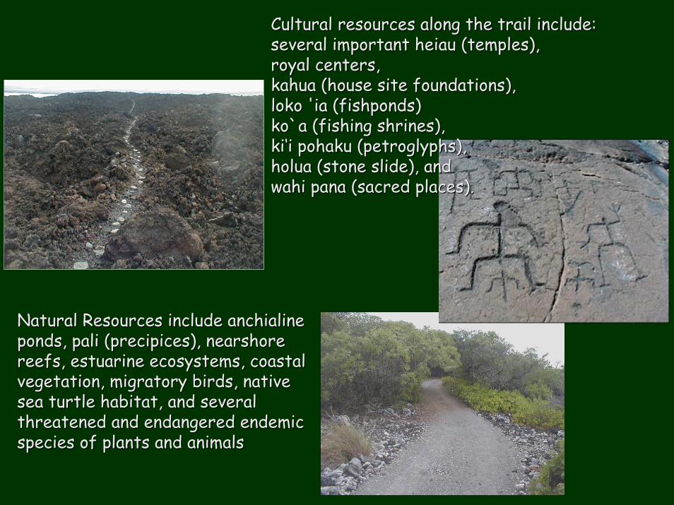
5Cultural resources along the trail include: Cultural resources along the trail include: several important several important heiauheiau (temples), (temples), royal centers, royal centers, kahuakahua (house site foundations), (house site foundations), lokoloko ''iaia (fishponds) (fishponds) ko`ako`a (fishing shrines), (fishing shrines), kiki‘‘ii pohakupohaku ((petroglyphspetroglyphs), ), holuaholua (stone slide), and (stone slide), and wahiwahi panapana (sacred places). (sacred places).
Natural Resources include Natural Resources include anchialineanchialineponds, ponds, palipali (precipices), (precipices), nearshorenearshorereefs, estuarine ecosystems, coastal reefs, estuarine ecosystems, coastal vegetation, migratory birds, native vegetation, migratory birds, native sea turtle habitat, and several sea turtle habitat, and several threatened and endangered endemic threatened and endangered endemic species of plants and animals species of plants and animals
6
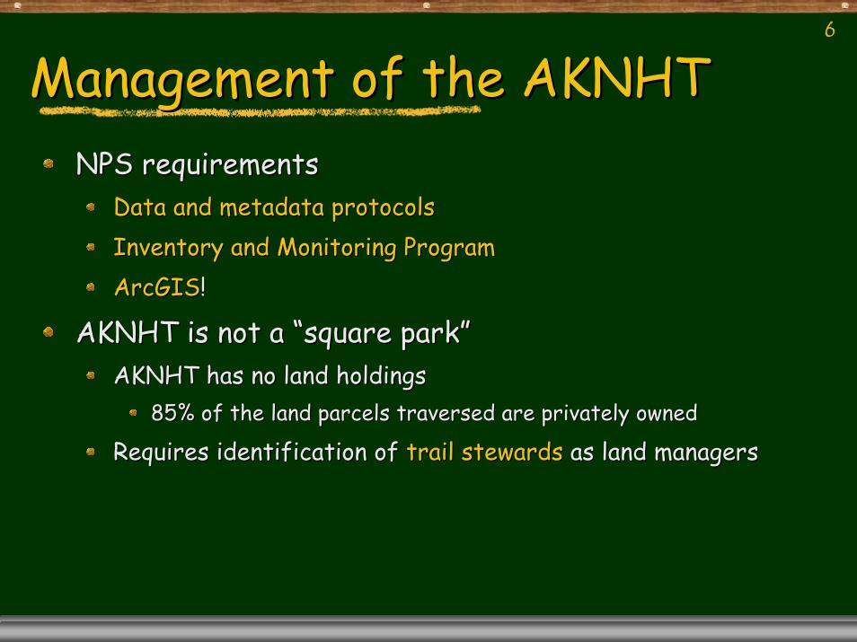
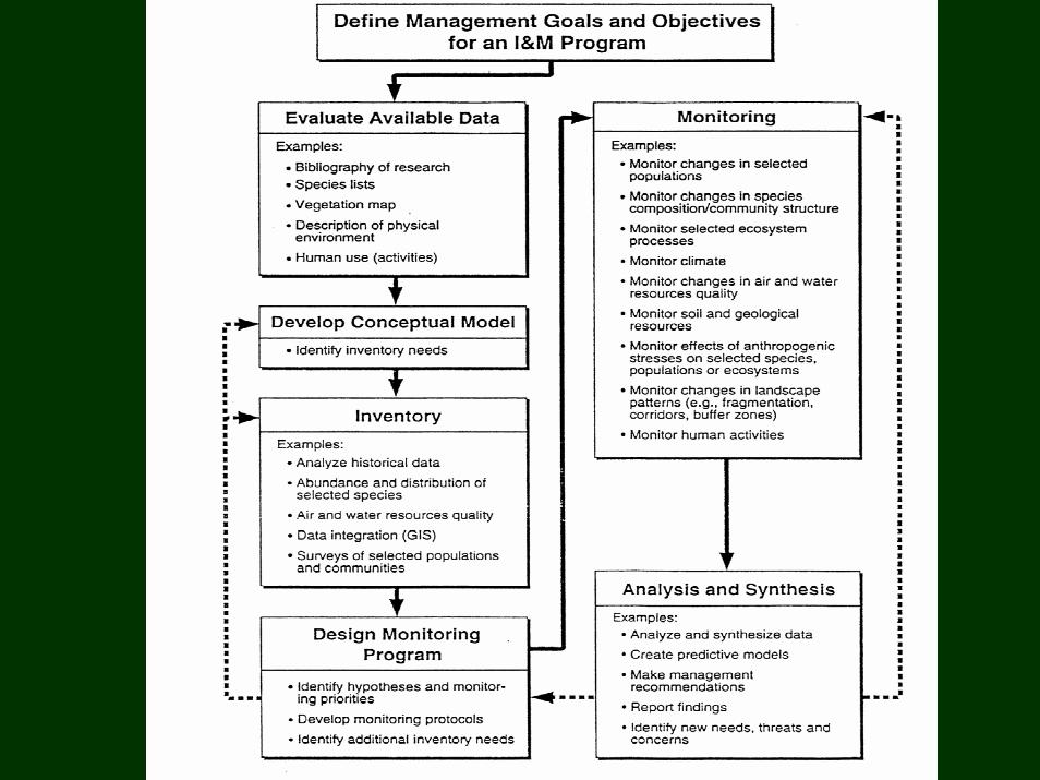
Management of the AKNHTManagement of the AKNHTNPS requirementsNPS requirements
Data and metadata protocolsData and metadata protocolsInventory and Monitoring ProgramInventory and Monitoring ProgramArcGISArcGIS!!
AKNHT is not a AKNHT is not a ““square parksquare park””AKNHT has no land holdingsAKNHT has no land holdings
85% of the land parcels traversed are privately owned85% of the land parcels traversed are privately owned
Requires identification of Requires identification of trail stewardstrail stewards as land managersas land managers
7
AKNHT Trail Stewardship ProgramAKNHT Trail Stewardship Program
"One of our goals here at Ala Kahakai NHT is to develop demonstration inventory and monitoring (I&M) projects using GIS as a tool for the community-based management of cultural and natural features found along the trail and for the maintenance of the trail itself.”
Aric Arakakai, Park Superintendent
8
Trail stewardsTrail stewardsMay be May be
Families with traditional ties to the land divisionsFamilies with traditional ties to the land divisionsSchoolsSchoolsCanoe clubsCanoe clubsService clubs Service clubs Private land owners such as large resort hotels or Private land owners such as large resort hotels or developments. developments.
Each responsible for overseeing approximately Each responsible for overseeing approximately 3 miles of trail3 miles of trailLevel of technical expertise and access to Level of technical expertise and access to technology varies from none to experttechnology varies from none to expert
9
Management of the AKNHTManagement of the AKNHTNPS requirementsNPS requirements
Existing data and metadata protocolsExisting data and metadata protocolsInventory and Monitoring ProgramInventory and Monitoring ProgramArcGIS!ArcGIS!
AKNHT is not a AKNHT is not a ““square parksquare park””AKNHT has no land holdingsAKNHT has no land holdings
85% of the land parcels traversed are privately owned85% of the land parcels traversed are privately ownedRequires establishment of trail stewards as land managersRequires establishment of trail stewards as land managers
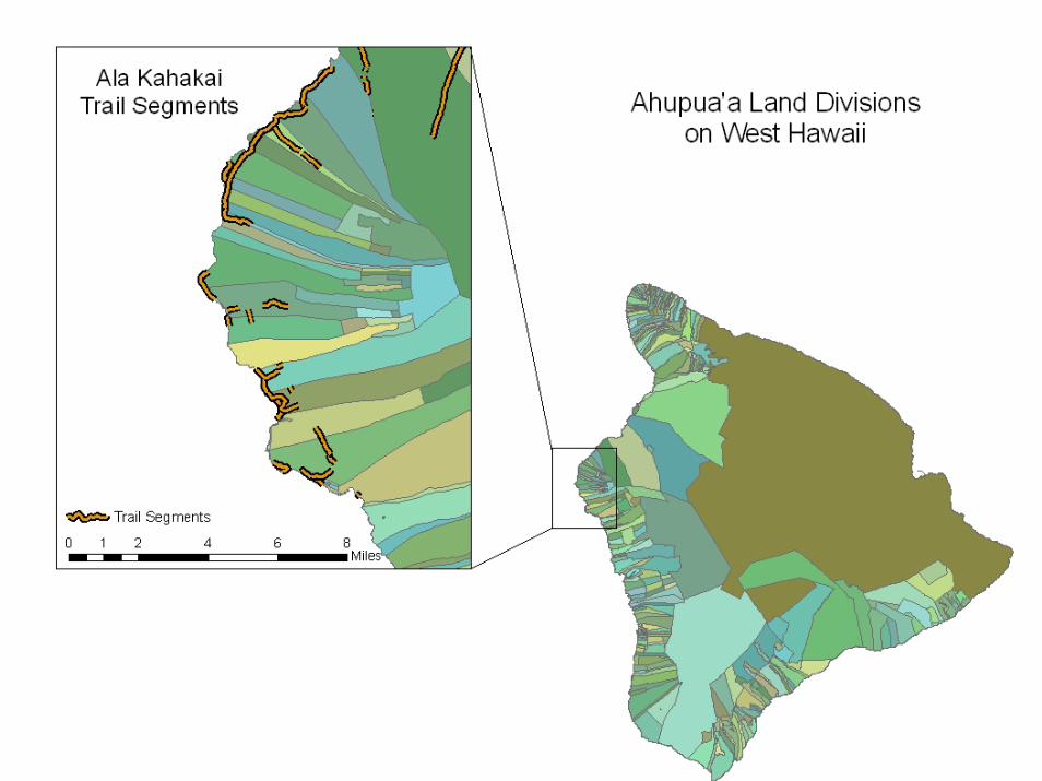
To be managed using To be managed using traditional methodstraditional methods as much as as much as possiblepossible
Thus, trail segments for individual steward groups correspond toThus, trail segments for individual steward groups correspond totraditional traditional ahupuaahupua’’aa land divisionsland divisions
10
11
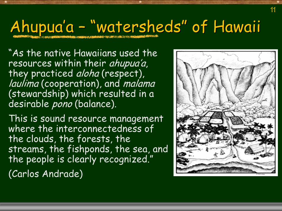
AhupuaAhupua’’aa –– ““watershedswatersheds”” of Hawaiiof Hawaii“As the native Hawaiians used the resources within their ahupua’a, they practiced aloha (respect), laulima (cooperation), and malama(stewardship) which resulted in a desirable pono (balance). This is sound resource management where the interconnectedness of the clouds, the forests, the streams, the fishponds, the sea, and the people is clearly recognized.”(Carlos Andrade)

12
Hawaiian Science/Traditional knowledgeHawaiian Science/Traditional knowledge
Many Many ‘‘ōōlelolelo nono‘‘eaueau (proverbs) take on the form of (proverbs) take on the form of correlative statements, as in:correlative statements, as in:
PuaPua ka ka wiliwiliwiliwili, , nanahunanahu ka ka manmanōōThe The wiliwiliwiliwili is blooming, the shark is biting is blooming, the shark is biting
The blooming season for The blooming season for wiliwiliwiliwili is at the end of the is at the end of the KauKau welawela(hot season) and before the rains of the (hot season) and before the rains of the HoHo‘‘oilooilo (wet season).(wet season).This matches peak aggregations of sharks in shallow waters This matches peak aggregations of sharks in shallow waters called "called "llāālanilani kalaleakalalea" (rows of protruding fins) that occur at the " (rows of protruding fins) that occur at the same time. same time. The practical consequence of prediction of shark behavior The practical consequence of prediction of shark behavior through a land phenomenon (blooming of a particular plant) is through a land phenomenon (blooming of a particular plant) is obvious. Long before you enter the water, you know to be obvious. Long before you enter the water, you know to be watchful for sharks.watchful for sharks.
13
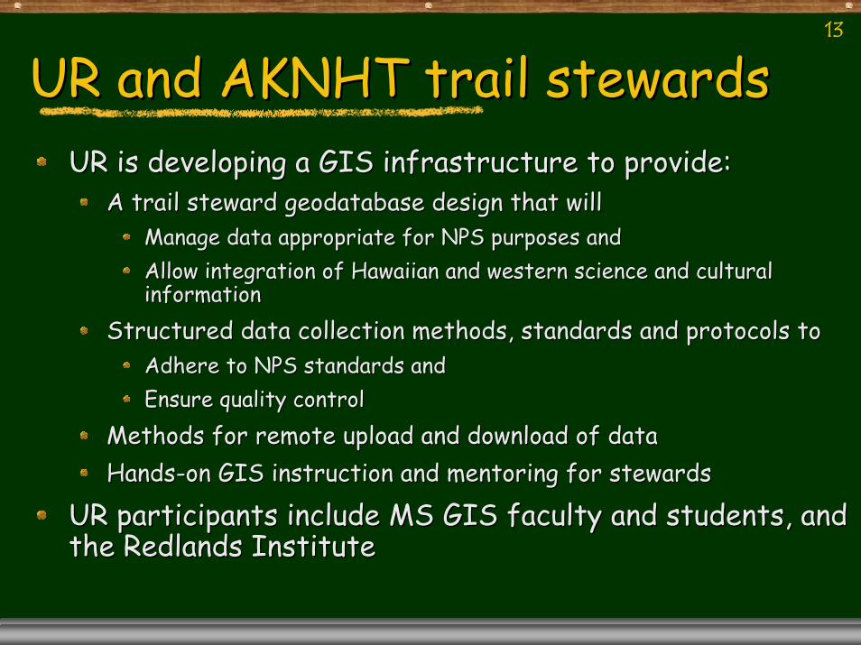
UR and AKNHT trail stewardsUR and AKNHT trail stewardsUR is developing a GIS infrastructure to provide:UR is developing a GIS infrastructure to provide:
A trail steward geodatabase design that will A trail steward geodatabase design that will Manage data appropriate for NPS purposes andManage data appropriate for NPS purposes andAllow integration of Hawaiian and western science and cultural Allow integration of Hawaiian and western science and cultural informationinformation
Structured data collection methods, standards and protocols toStructured data collection methods, standards and protocols toAdhere to NPS standards andAdhere to NPS standards andEnsure quality controlEnsure quality control
Methods for remote upload and download of dataMethods for remote upload and download of dataHandsHands--on GIS instruction and mentoring for stewards on GIS instruction and mentoring for stewards
UR participants include MS GIS faculty and students, and UR participants include MS GIS faculty and students, and the Redlands Institutethe Redlands Institute
14
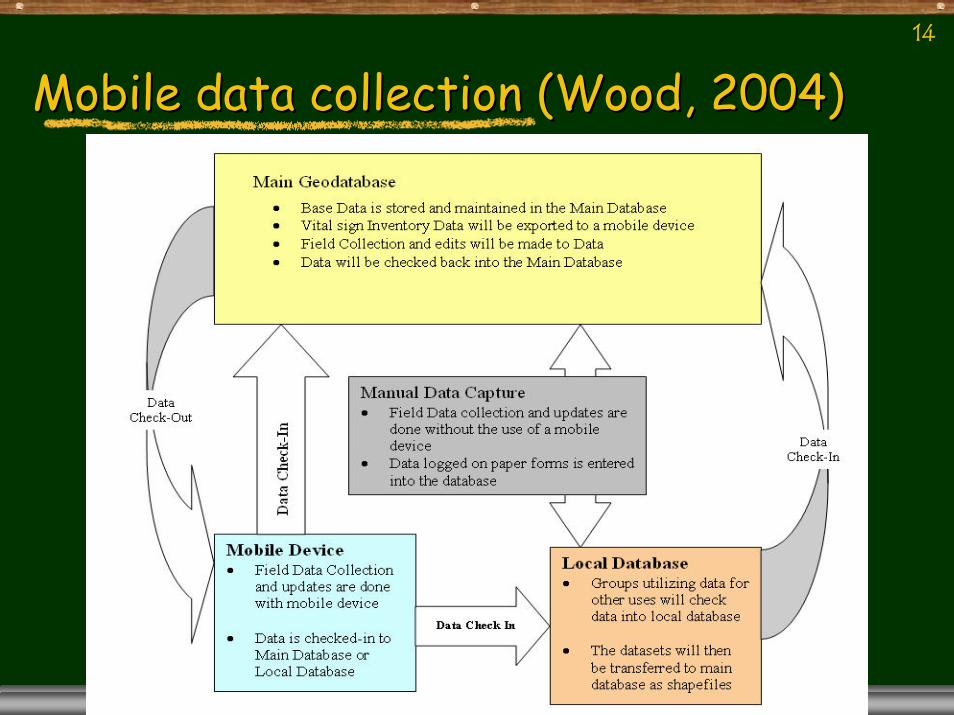
Mobile data collection (Wood, 2004)Mobile data collection (Wood, 2004)
15
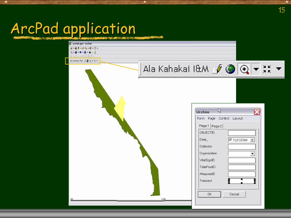
ArcPadArcPad applicationapplication
16
PPGIS for ALKA NHT I&M
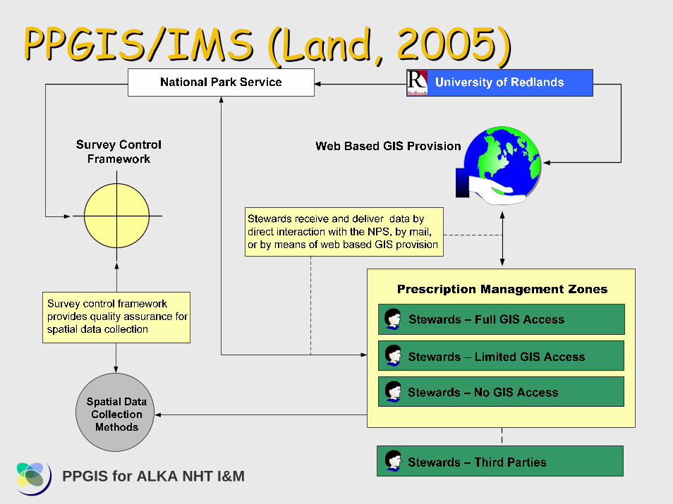
PPGIS/IMS (Land, 2005)PPGIS/IMS (Land, 2005)

17
LowLow--End ProcessEnd ProcessFor user groups without access to For user groups without access to Mobile DeviceMobile Device
Field Data Collection with paper formsField Data Collection with paper formsAdding X,Y data to the DatabaseAdding X,Y data to the Database

18
HighHigh--End ProcessEnd ProcessFor user groups with Mobile DeviceFor user groups with Mobile Device
Collection AssessmentCollection AssessmentData PrepData PrepData CheckData Check--OutOutField Data CaptureField Data CaptureCheckCheck--InIn

19
AKNHT IMS SiteAKNHT IMS Site
20
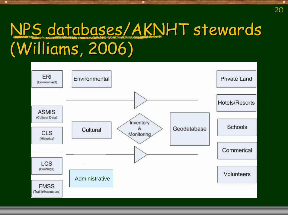
NPS databases/AKNHT stewards NPS databases/AKNHT stewards (Williams, 2006)(Williams, 2006)
s
l
Administrative
21
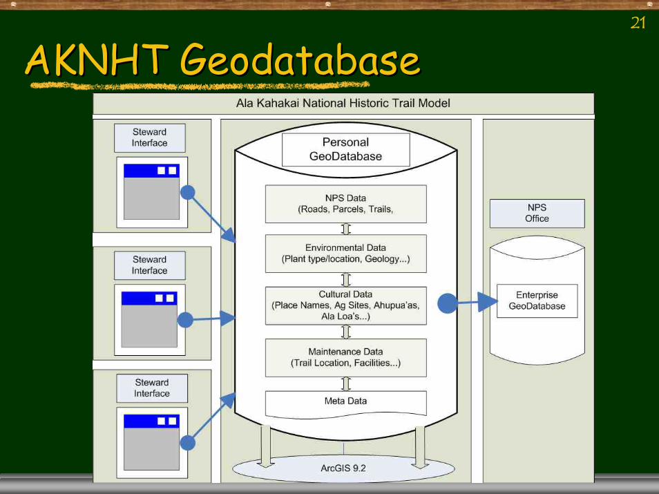
AKNHT GeodatabaseAKNHT Geodatabase
22
AKNHT Stewards Data ProgramAKNHT Stewards Data ProgramStewards collect and manage data according Stewards collect and manage data according to standards and protocolsto standards and protocolsStewards own their collected dataStewards own their collected data
Share only data they wish for NPS use and, Share only data they wish for NPS use and, possibly, for public accesspossibly, for public access
Manage all data in consistent format for Manage all data in consistent format for current or future integrationcurrent or future integrationFor those with GIS, a common geodatabase For those with GIS, a common geodatabase model is used by each steward groupmodel is used by each steward group
23
ChallengesChallengesDesigning data collection protocols and Designing data collection protocols and systems thatsystems that
Ensure data collected will be useful for park Ensure data collected will be useful for park managementmanagementCan be used by stewards with various levels of Can be used by stewards with various levels of expertise and technologyexpertise and technologyEnsure individual steward groups have ownership Ensure individual steward groups have ownership of their dataof their data
Representing Hawaiian science and culture Representing Hawaiian science and culture values and culturally significant placesvalues and culturally significant placesIntegrating Hawaiian science Integrating Hawaiian science ““datadata”” with with Western science data. Western science data.

24
WhatWhat’’s next?s next?Working with Working with URUR’’ss Redlands Institute Redlands Institute toto
Design and implement a Design and implement a GI Infrastructure integrating GI Infrastructure integrating Hawaiian Science and Western Science Hawaiian Science and Western Science to support research and education to support research and education activities Islandactivities Island--wide with wide with KohalaKohala Center Center as an extension of the AKNHT projectas an extension of the AKNHT project
25
26Questions? Comments?
27
KohalaKohala CenterCenterThe Kohala Center uses its unique island setting as a living The Kohala Center uses its unique island setting as a living laboratory and classroom to generate new knowledge about laboratory and classroom to generate new knowledge about global ecological phenomena and provide systemic solutions to global ecological phenomena and provide systemic solutions to global environmental challenges, so that communities on the global environmental challenges, so that communities on the island and around the world can thrive island and around the world can thrive ---- economically, socially, economically, socially, and culturally. and culturally. By consciously operating at the intersection of culture, scienceBy consciously operating at the intersection of culture, science, , and community, The Kohala Center understands that its and community, The Kohala Center understands that its collaborative work will sustain the Island of Hawai'i, as well acollaborative work will sustain the Island of Hawai'i, as well as s develop knowledge that will be of value to the world as a whole.develop knowledge that will be of value to the world as a whole.Residents of Hawai'i Island understand that research and Residents of Hawai'i Island understand that research and education are key to understanding how to develop the Island's education are key to understanding how to develop the Island's economy in ways that are ecologically sound and culturally economy in ways that are ecologically sound and culturally respectful. By operating a premier center for applied scientificrespectful. By operating a premier center for applied scientificeducation and research, The Kohala Center is dedicated to education and research, The Kohala Center is dedicated to helping Hawai'i Island residents preserve and enhance the helping Hawai'i Island residents preserve and enhance the intellectual, cultural, and natural assets of the Island and intellectual, cultural, and natural assets of the Island and thoughtfully address the challenges noted above.thoughtfully address the challenges noted above.
28
Citizen scienceCitizen scienceOrganizationsOrganizations
GLOBEGLOBEAudbonAudbonSociety for Amateur ScientistsSociety for Amateur Scientists
ToolsToolsProtocolsProtocolsDatasheetsDatasheets
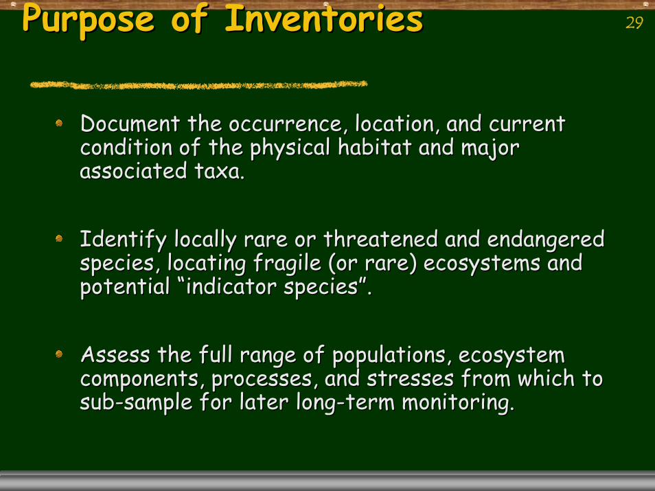
29Purpose of InventoriesPurpose of Inventories
Document the occurrence, location, and current Document the occurrence, location, and current condition of the physical habitat and major condition of the physical habitat and major associated taxa.associated taxa.
Identify locally rare or threatened and endangered Identify locally rare or threatened and endangered species, locating fragile (or rare) ecosystems and species, locating fragile (or rare) ecosystems and potential potential ““indicator speciesindicator species””..
Assess the full range of populations, ecosystem Assess the full range of populations, ecosystem components, processes, and stresses from which to components, processes, and stresses from which to subsub--sample for later longsample for later long--term monitoring.term monitoring.
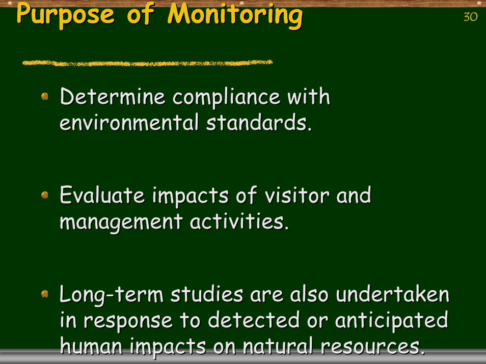
30Purpose of MonitoringPurpose of Monitoring
Determine compliance with Determine compliance with environmental standards.environmental standards.
Evaluate impacts of visitor and Evaluate impacts of visitor and management activities. management activities.
LongLong--term studies are also undertaken term studies are also undertaken in response to detected or anticipated in response to detected or anticipated human impacts on natural resources.human impacts on natural resources.
31
32
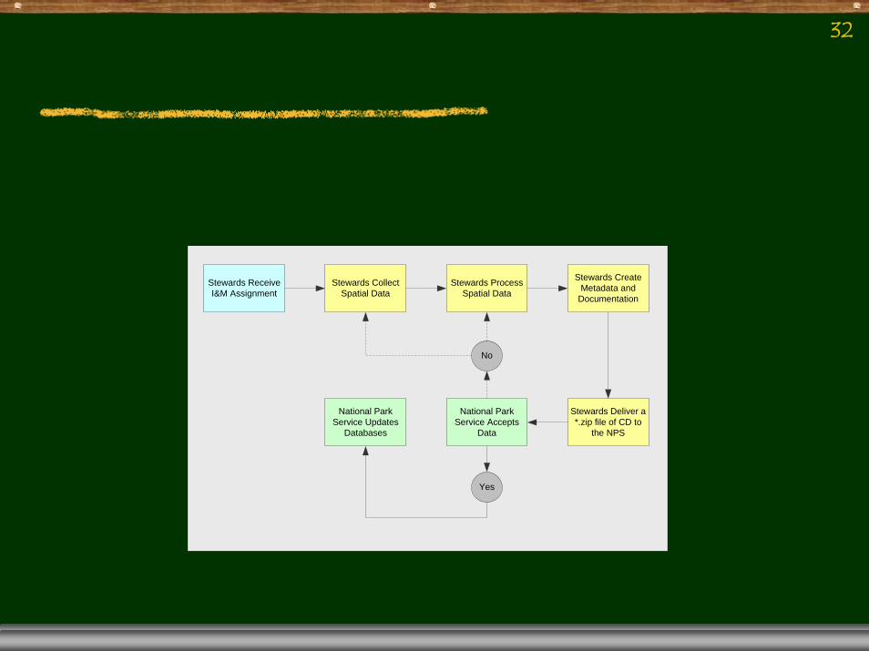
Stewards Receive I&M Assignment
Stewards Collect Spatial Data
Stewards Process Spatial Data
Stewards Create Metadata and
Documentation
Stewards Deliver a *.zip file of CD to
the NPS
National Park Service Accepts
Data
National Park Service Updates
Databases
Yes
No