Embed Size (px)
Citation preview

Chapter 1: Site Design DRAFT February 17, 2009 i
Roanoke County Design Handbook
Roanoke County Design Handbook Adopted May 26, 2009
Amended March 22, 2011

(Page intentionally blank)

Table of Contents March 22, 2011 i
Roanoke County Design Handbook
ELEMENT PAGE
Chapter 1: Site Design
Section 1.1 Site Layout Example 1-1
Chapter 2: Landscaping
Section 2.1 Screening Materials 2-1
2.2 Landscaped Buffer Yards 2-3
2.3 Right-of-Way Planting Strips 2-8
2.4 Landscaped Medians within Parking Areas 2-10
2.5 Recommended Native/Naturalized Plant List 2-11
2.6 Highly Invasive Species List 2-16
2.7 Native Plant Guide for Stormwater Management Areas 2-17
Chapter 3: Transportation
Section 3.1 Parking Area Design 3-1
3.2 Typical Paving 3-5
3.3 Permeable Paving 3-5
3.4 Sidewalks 3-9
3.5 Shared Use Paths 3-10
3.6 Trails 3-12
3.7 Bicycle Accommodations 3-15
3.8 Private Roads 3-16
Appendices:
A Board of Supervisors Ordinances A-1
B Sidewalk, Shared Use Path and Private Road Standards References
B-1

(Page intentionally blank)

Chapter 1: Site Design March 22, 2011 1-1
Roanoke County Design Handbook
1 Chapter 1: Site Design
Section 1.1 – Site Layout
Figure 1.1-1 Site Layout Example

1-2 March 22, 2011 Chapter 1: Site Design
Roanoke County Design Handbook
(Page intentionally blank)

Chapter 2: Landscaping March 22, 2011 2-1
Roanoke County Design Handbook
2 Chapter 2: Landscaping
Section 2.1 – Screening Materials
Figure 2.1-1 Stockade Fence
Figure 2.1-2 Decorative Masonry Wall
Figure 2.1-3Brick Wall

2-2 March 22, 2011 Chapter 2: Landscaping
Roanoke County Design Handbook
Figure 2.1-4 Three (3) Foot Tall Earth Berm
Figure 2.1-5 Six (6) Foot Tall Earth Berm
Figure 2.1-6 Varying Height Earth Berm spanning two different grade elevations

Chapter 2: Landscaping March 22, 2011 2-3
Roanoke County Design Handbook
Section 2.2 – Landscaped Buffer Yards
Figure 2.2-1Type A Buffer
“Row” should not be construed as meaning that the plants must be uniformly planted.

2-4 March 22, 2011 Chapter 2: Landscaping
Roanoke County Design Handbook
Figure 2.2-2 Type B Buffer
“Row” should not be construed as meaning that the plants must be uniformly planted.

Chapter 2: Landscaping March 22, 2011 2-5
Roanoke County Design Handbook
Figure 2.2-3 Type C Buffer
“Row” should not be construed as meaning that the plants must be uniformly planted.

2-6 March 22, 2011 Chapter 2: Landscaping
Roanoke County Design Handbook
Figure 2.2-4 Type D Buffer
“Row” should not be construed as meaning that the plants must be uniformly planted.

Chapter 2: Landscaping March 22, 2011 2-7
Roanoke County Design Handbook
Figure 2.2-5 Type E Buffer
“Row” should not be construed as meaning that the plants must be uniformly planted.

2-8 March 22, 2011 Chapter 2: Landscaping
Roanoke County Design Handbook
Section 2.3 – Right-of-Way Planting Strips
Figure 2.3-1 Typical Planting Strip

Chapter 2: Landscaping March 22, 2011 2-9
Roanoke County Design Handbook
Figure 2.3-2 Planting Strip with Overhead Power Lines

2-10 March 22, 2011 Chapter 2: Landscaping
Roanoke County Design Handbook
Section 2.4 – Landscaped Medians
Figure 2.4-1 Landscaped Median within a Parking Area

Chapter 2: Landscaping March 22, 2011 2-11
Roanoke County Design Handbook
Section 2.5 – Recommended Native/Naturalized Plant List
Chart 2.5-1 Large Deciduous Trees:
LATIN NAME COMMON NAME
ST
RE
ET
TR
EE
SC
RE
EN
ING
PA
RK
ING
LO
T
ISL
AN
D
PL
AN
TIN
G
ST
RIP
GE
NE
RA
L
LA
ND
SC
AP
ING
Acer rubrum Red Maple X X
Acer saccharum Sugar Maple X
Aesculus flava Yellow Buckeye X
Betula alleghensis Yellow Birch X
Betula lenta Sweet Birch X
Betula nigra River Birch X
Carya glabra Pignut Hickory X
Diospyros virginiana Persimmon X
Fagus grandifolia American Beech X
Fraxinus americana White Ash X X
Fraxinus pensylvanica Green Ash X X
Liquidambar styraciflua Sweetgum X
Liriodendron tulipifera Tulip Poplar X
Magnolia acuminate Cucumber Magnolia X X
Nyssa sylvatica Black Gum X X
Prunus serrulata Oriental Cherry X
Quercus alba White Oak X
Quercus coccinea Scarlet Oak X
Quercus falcate Southern Red Oak X
Quercus palustris Pin Oak X
Quercus rubra Red Oak X
Quercus stellata Post Oak X
Quercus velutina Black Oak X
Tilia cordata Littleleaf Linden X X
Tilia americana American Linden X
2-12 March 22, 2011 Chapter 2: Landscaping
Roanoke County Design Handbook
Chart 2.5-2 Small Deciduous Trees:
LATIN NAME COMMON NAME
ST
RE
ET
TR
EE
SC
RE
EN
ING
PA
RK
ING
LO
T
ISL
AN
D
PL
AN
TIN
G
ST
RIP
GE
NE
RA
L
LA
ND
SC
AP
ING
FL
OW
ER
ING
Amelanchier arborea Downy Serviceberry X X X X
Amelanchier canadensis Canada Serviceberry X X X X
Amelanchier laevis Smooth Serviceberry X X X X
Asimina triloba Paw Paw Tree X
Cercis canadensis Eastern Redbud X X X X
Chionanthus virginicus Fringetree X X X X
Cornus alternifolia Alternate Leaf Dogwood X X X X
Cornus florida Flowering Dogwood X X X X
Crateagus crus-galli Cockspur Hawthorne X X X
Crataegus flava October Hawthorne X X X
Halesia tetraptera Carolina Silverbell X X X
Morus rubra Red Mulberry X X X
Ostra virginiana Eastern Hop Hornbeam
X
X
X
X
Prunus americana American Wild Plum X X X X X
Rhus glabra Smooth Sumac X X X
Salix nigra Black Willow X X
Syringa vulgaris Common Lilac X X

Chapter 2: Landscaping March 22, 2011 2-13
Roanoke County Design Handbook
Chart 2.5-3 Large Evergreen Trees:
LATIN NAME COMMON NAME
ST
RE
ET
TR
EE
SC
RE
EN
ING
PA
RK
ING
LO
T
ISL
AN
D
PL
AN
TIN
G
ST
RIP
GE
NE
RA
L
LA
ND
SC
AP
ING
Ilex opaca American Holly X X
Juniperus virginiana Eastern Red Cedar X X
Magnolia grandiflora Southern Magnolia X X
Picea glauca White Spruce X X
Picea abies Norway Spruce X X
Picea orientalis Oriental Spruce X X
Pinus bungeana Lacebark Pine X X
Pinus echinata Shortleaf Pine X X
Pinus koraiensis Korean Pine X X
Pinus virginiana Virginia Pine X X
Thuja occidentalis White Cedar X X
Tsuga canadensis Eastern Hemlock X X
Tsuga caroliniana Carolina Hemlock X X
Chart 2.5-4 Large Evergreen Shrubs & Small Evergreen Trees:
LATIN NAME COMMON NAME
ST
RE
ET
TR
EE
SC
RE
EN
ING
PA
RK
ING
LO
T
ISL
AN
D
PL
AN
TIN
G
ST
RIP
GE
NE
RA
L
LA
ND
SC
AP
ING
Buxus sempervirens Common Boxwood X X X X
Camellia oleifera Tea Oil Camellia X
Chamaecyparis obtuse Hinoki Falsecypress X X X
Ilex × attenuate Foster’s Holly X X X X
Ilex verticillata Winterberry Holly X X X X
Juniperus chinensis Chinese Juniper X X X X
Magnolia virginiana Sweet Bay Magnolia X
Picea glauca ‘conica’ Dwarf White Spruce X X X X
Thuja occidentalis Eastern Arborvitae X X X X
2-14 March 22, 2011 Chapter 2: Landscaping
Roanoke County Design Handbook
Chart 2.5-5 Large Deciduous Shrubs:
LATIN NAME COMMON NAME
ST
RE
ET
TR
EE
SC
RE
EN
ING
PA
RK
ING
LO
T
ISL
AN
D
PL
AN
TIN
G
ST
RIP
GE
NE
RA
L
LA
ND
SC
AP
ING
FL
OW
ER
ING
Acer palmatum Japanese Maple X
Aronia pyrifolia Red Chokeberry X X
Callicarpa americana American Beautyberry X X
Calycanthus floridus Eastern Sweetshrub X X
Chaenomeles × superb Flowering Quince X X X
Clethra alnifolia Summersweet X X X
Cornus amomum Silky Dogwood X X X X
Cornus sericea Redosier Dogwood X X X X
Cornus alba ‘Sibirica’ Tatarian Dogwood X X X X
Cotinus coggygria Smokebush X X X
Fothergilla major Large Fothergilla X X
Hydrangea paniculata Panicle Hydrangea X X
Hydrangea quercifolia
Hydrangea quercifolia
Oak Leaf Hydrangea X
X
X
X Lagerstroemia indica Crape Myrtle X X X X
Morella pensylvanica Northern Bayberry X X X
Physocarpus opulifolius
Physocarpus opulifolius
Ninebark
ninebark
X X X
Rhododendron calendulaceum Flame Azalea X X X X
Rhododendron
periclymenoides,
Pinxterbloom Azalea X X X X
Rhododendron prinophyllum Roseshell Azalea X X X X
Rhus aromatic Fragrant Sumac X X X
Salix purpurea ‘Nana’ Dwarf Purpleosier Willow X X
Sambucus nigra ‘Variegata’ Variegated Elderberry X X X X
Spiraea prunifolia Bridalwreath Spirea X X X X
Viburnum carlesii Korean Spice Viburnum X X X X
Viburnum burkwoodii Burkwood Viburnum X X X X
Viburnum juddii Judd Viburnum X X X X
Viburnum dentatum Arrowood Viburnum X X X X
Viburnum macrocephalum Large Flowered Chinese
Viburnum
X X X X
Viburnum nudum Possumhaw Viburnum X X X X
Viburnum acerifolium Mapleleaf Viburnum X X X X
Weigela florida Flowering Weigela X X X X
Chapter 2: Landscaping March 22, 2011 2-15
Roanoke County Design Handbook
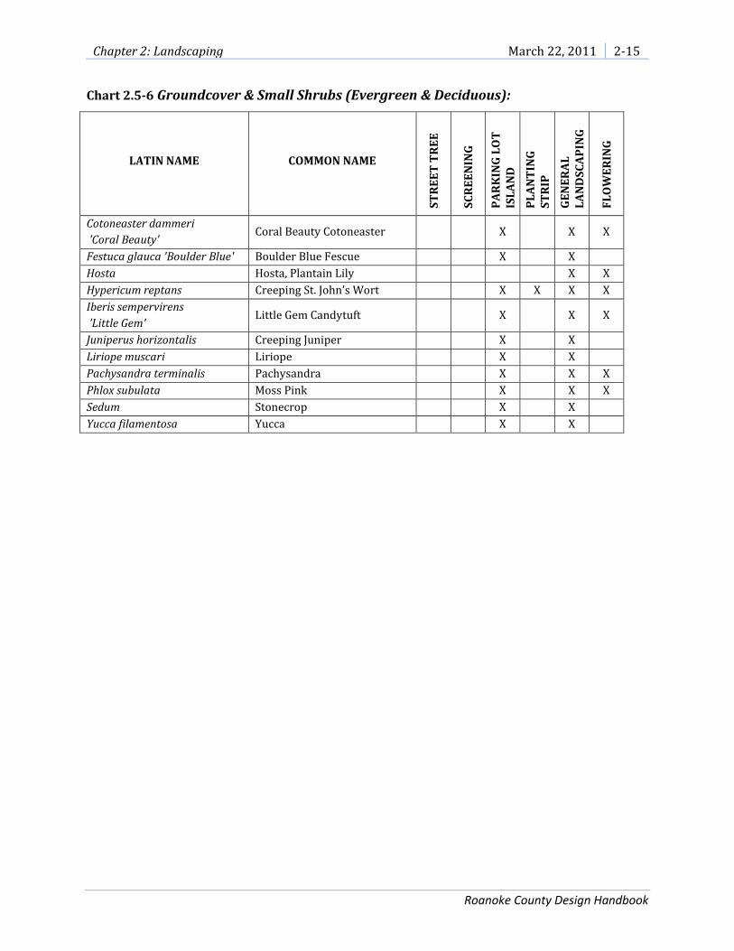
Chart 2.5-6 Groundcover & Small Shrubs (Evergreen & Deciduous):
LATIN NAME COMMON NAME
ST
RE
ET
TR
EE
SC
RE
EN
ING
PA
RK
ING
LO
T
ISL
AN
D
PL
AN
TIN
G
ST
RIP
GE
NE
RA
L
LA
ND
SC
AP
ING
FL
OW
ER
ING
Cotoneaster dammeri
'Coral Beauty' Coral Beauty Cotoneaster X X X
Festuca glauca 'Boulder Blue' Boulder Blue Fescue X X
Hosta Hosta, Plantain Lily X X
Hypericum reptans Creeping St. John’s Wort X X X X
Iberis sempervirens
'Little Gem' Little Gem Candytuft X X X
Juniperus horizontalis Creeping Juniper X X
Liriope muscari Liriope X X
Pachysandra terminalis Pachysandra X X X
Phlox subulata Moss Pink X X X
Sedum Stonecrop X X
Yucca filamentosa Yucca X X

2-16 March 22, 2011 Chapter 2: Landscaping
Roanoke County Design Handbook
Section 2.6 – Highly Invasive Species
It should be noted the list is not regulatory in nature, and thus does not prohibit the use of the listed plant species. Chart 2.6-1 Highly Invasive Species List LATIN NAME COMMON NAME
Ailanthus altissima Tree-of-Heaven
Alliaria petiolata Garlic Mustard
Alternanthera philoxeroides Alligator Weed
Ampelopsis brevipedunculata Porcelain-Berry
Carex kobomugi Asiatic Sand Sedge
Celastrus orbiculata Oriental Bittersweet
Centaurea dubia Short-Fringed Knapweed
Centaurea biebersteinii Spotted Knapweed
Cirsium arvense Canada Thistle
Dioscorea oppositifolia Chinese Yam
Elaeagnus umbellata Autumn Olive
Euonymus alata Winged Burning Bush
Hydrilla verticillata Hydrilla
Imperata cylindrica Cogon Grass
Lespedeza cuneata Chinese Lespedeza
Ligustrum sinense Chinese Privet
Lonicera japonica Japanese Honeysuckle
Lonicera morrowii Morrow’s Honeysuckle
Lonicera standishii Standish’s Honeysuckle
Lythrum salicaria Purple Loosestrife
Microstegium vimineum Japanese Stilt Grass
Murdannia keisak Aneilema
Myriophyllum aquaticum Parrot Feather
Myriophyllum spicatum European Water-Milfoil
Phragmites australis Common Reed
Polygonum cuspidatum Japanese Knotweed
Polygonum perfoliatum Mile-A-Minute
Pueraria montana Kudzu Vine
Ranunculus ficaria Lesser Celandine
Rosa multiflora Multiflora Rose
Rubus phoenicolasius Wineberry
Sorghum halepense Johnson-Grass

Chapter 2: Landscaping March 22, 2011 2-17
Roanoke County Design Handbook
Section 2.7 – Native Plant Guide for Stormwater Management Areas in the Mid-Atlantic, USA from the Virginia State Stormwater Management Handbook, Volume 1, Chapter 3
Chart 2.7-1 Trees and Shrubs
Tree/Shrub *Zone Form Available Inundation Tolerance
Wildlife Value Notes
American Beech (Fagus grandifolia)
5,6 Dec. Tree no no High, mammals and birds. Prefers shade and rich, well-drained soils.
American Holly (Ilex opaca)
5,6 Dec. Tree yes some High,songbirds, food, cover, nesting.
Coastal plain only. Prefers shade and rich soils.
American Hornbeam (Carpinus caroliniana)
4,5 Dec. Tree yes yes Moderate, food, browsing. Most common in flood plains and bottom land of Piedmont and mountains.
Arrowwood Viburnum (Viburnum dentatum)
2,3,4 Dec. Shrub yes no High, songbirds and mammals. Grows best in sun to partial shade.
Bald Cypress (Taxodium distichum)
3,4 Dec. Tree yes yes Little food value but good perching site for waterfowl.
Forested Coastal Plain wetlands. North of normal range. Tolerates drought.
Bayberry (Myricia pensylvanica)
4,5,6 Dec. Shrub yes no High, nesting, food cover. Berries last into winter.
Coastal Plain only. Roots fix N. Tolerates slightly acidic soil.
Bitternut Hickory (Carya cordiformis)
3,4,5 Dec. Tree no yes High, food. Moist soils or wet bottom land areas.
Black Cherry (Prunus serotina)
5,6 Dec. Tree yes yes High, fruit is eaten by many birds.
Temporarily flooded forested areas. Possible fungus infestation.
Black Walnut (Juglans nigra)
5,6 Dec. Tree yes yes High, food. Temporarily flooded wetlands along flood plains. Well drained, rich soils.
Blackgum or Sourgum (Nyssa sylvatica)
4,5,6 Dec. Tree yes yes High, songbirds, egrets, herons, raccoons, owls.
Can be difficult to transplant. Prefers sun to partial shade.
Black Willow (Salix nigra)
3,4,5 Dec. Tree yes yes High, browsing and cavity nesters.
Rapid growth, stabilizes stream banks. Full sun.
Buttonbush (Cephalanthus occidentalis)
2,3,4,5 Dec. Shrub yes yes High, ducks and shorebirds. Seeds, nectar and nesting.
Full sun to partial shade. Will grow in dry areas.
Chestnut Oak (Quercus prinus)
5,6 Dec. Tree no no High. Cover, browse and food. Gypsy moth target. Dry soils.
Common Choke Cherry (Prunus virginiana)
5,6 Dec. Tree no some High, birds, mammals. Fruit and cover.
Prefers drier conditions.
Common Spicebush (Lindera benzoin)
4,5 Dec. Shrub yes no Very high, songbirds. Shade and rich soils. Tolerates acidic soils. Good understory species.

2-18 March 22, 2011 Chapter 2: Landscaping
Roanoke County Design Handbook
Tree/Shrub (continued)
*Zone Form Available Inundation Tolerance
Wildlife Value Notes
Eastern Cottonwood (Populus deltoides)
4,5 Dec. Tree yes yes Moderate, cover, food. Shallow rooted, subject to windthrow. Invasive roots. Rapid growth.
Eastern Hemlock (Tsuga conadensis)
5,6 Conif. Tree yes yes Moderate. Mostly cover and some food.
Tolerates all sun/shade conditions. Tolerates acidic soil.
Eastern Red Cedar (Juniperus virginiana)
4,5,6 Conif. Tree yes no High. Fruit for birds. Some cover.
Full sun to partial shade. Common in wetlands, shrub bogs and edge of streams.
Elderberry (Sambucus canadensis)
4,5,6 Dec. Shrub yes yes Extremely high for food and cover, for birds and mammals.
Full sun to partial shade.
Flowering Dogwood (Cornus florida)
4,5,6 Dec. Tree no yes High, birds, food. Prefers rich, moist soils. Dogwood anthracnose possible problem.
Fringe Tree (Chionanthus viginicus)
3,4,5 Dec. Shrub or small tree
yes some Moderate. Food and cover. Full sun to partial shade. Tolerates acidic soil.
Green Ash, Red Ash (Fraxinus pennysylvanica)
4,5 Dec. Tree yes yes Moderate, songbirds. Rapid growing stream bank stabilizer. Full sun to partial shade.
Hackberry (Celtis occidentalis)
5,6 Dec. Tree yes yes High, food and cover. Full sun to partial shade.
Ironwood/ Hophornbeam (Ostrya virginiana)
5,6 Dec. Tree yes yes Moderate, food and browse. Tolerant of all sunlight conditions.
Larch, Tamarack (Larix laricina)
3,4 Conif. Tree no yes Low, nest tree and seeds. Rapid initial growth. Full sun, acidic boggy soils.
Loblolly Pine (Pinus taeda)
5,6 Conif. Tree yes yes Moderate, food, nesting, squirrels.
Coastal Plain only. Tolerant of extreme soil conditions.
Mountain Laurel (Kalmia latifolia)
6 Evergreen no some Low, cover, and nectar. Foliage is toxic to cattle and deer.
Partial shade, acidic soils.
Persimmon (Diospyros virginiana)
4,5,6 Dec. Tree yes no Extremely high, birds, mammals.
Not shade tolerant. Well-drained soils.
Pin Oak (Quercus palustris)
4,5,6 Dec. Tree yes yes High, mast. Tolerates acidic soil.
Gypsy moth target. Prefers sun to partial shade.
Red Chokeberry (Pyrus arbutifolia)
3,4,5 Dec. Shrub no yes Moderate, songbirds. Bank stabilizer. Partial sun.
Red Maple (Acer rubrum)
4,5,6 Dec. Tree yes yes High, seeds and browse. Tolerates acidic soil.
Rapid growth.
Red Oak (Quercus rubra)
5,6 Dec. Tree yes no High, food and cover. Gypsy moth target. Prefers well drained, sandy soils.

Chapter 2: Landscaping March 22, 2011 2-19
Roanoke County Design Handbook
Chart 2.7-2 Wetland Plants
Tree/Shrub (continued)
*Zone Form Available Inundation Tolerance
Wildlife Value Notes
River Birch (Betula nigra)
3,4 Dec. Tree yes yes Low, but good for cavity nesters.
Bank erosion control. Full sun.
Scarlet Oak (Quercus coccinea)
3,4 Dec. Tree no no High, food and cover. Gypsy moth target. Difficult to transplant.
Shadbush, Serviceberry (Amelanchier canadensis)
5,6 Dec. Tree yes yes High, nesting, cover and food. Birds and mammals.
Prefers partial shade. Common in forested wetlands and upland woods.
Silky Dogwood (Cornus amomum)
5,6 Dec. Shrub yes yes High, songbirds, mammals. Shade and drought tolerant. Good bank stabilizer.
Wetland Plants *Zone Form Available Inundation Tolerance
Wildlife Value Notes
Arrow arum (Peltandra virginica)
2 Emergent yes up to 1 ft. High, berries are eaten by wood ducks.
Full sun to partial shade.
Arrowhead/Duck potato (Saggitaria latifolia)
2 Emergent yes up to 1 ft. Moderate, tubers and seeds eaten by ducks.
Aggressive colonizer.
Broomsedge (Andropogon virginianus)
2,3 Perimeter yes up to 3 in. High, songbirds and browsers. Winter food and cover.
Tolerant of fluctuating water levels and partial shade.
Cattail (Typha spp.)
2,3 Emergent yes up to 1 ft. Low, except as cover. Aggressive. May eliminate other species. Volunteer. High pollutant treatment.
Coontail (Ceratophyllum demersum)
1 Submergent no yes Low, food, good habitat and shelter for fish and invertebrates.
Free floating SAV. Shade tolerant. Rapid growth.
Common Three Square (Scipus pungens)
2 Emergent yes up to 6 in. High, seeds, cover, waterfowl, songbirds.
Fast colonizer. Can tolerate periods of dryness. Full sun. High metal removal.
Duckweed (Lemna sp.)
1,2 Submergent /Emergent
yes yes High, food for waterfowl and fish.
May biomagnify metals beyond concentrations found in water.
Lizard’s Tail (Saururus cernuus)
2 Emergent yes up to 1 ft. Low, except wood ducks. Rapid growth. Shade tolerant.
Marsh Hibiscus (Hibiscus moscheutos)
2,3 Emergent yes up to 3 in. Low, nectar. Full sun. Can tolerate periodic dryness.
Pickerelweed (Pontederia cordata)
2,3 Emergent yes up to 1 ft. Moderate, ducks, nectar for butterflies.
Full sun to partial shade.

2-20 March 22, 2011 Chapter 2: Landscaping
Roanoke County Design Handbook
Zone 1: Submergent Aquatic Vegetation Zone 2: Shallow Water Bench - 6-12 inches Deep Zone 3: Shoreline Fringe - Regularly Inundated Area Zone 4: Riparian Fringe - Periodically Inundated Area, Wet Soils Zone 5: Floodplain Terrace - Infrequently Inundated, Moist Soils Zone 6: Upland Slopes - Seldom or Never Inundated, Moist To Dry Soils
Wetland Plants (continued)
*Zone Form Available Inundation Tolerance
Wildlife Value Notes
Pond Weed (Potamogeton pectinatus)
1 Submergent yes yes Extremely high, waterfowl, marsh and shore-birds.
Removes heavy metals.
Rice Cutgrass (Leersia oryzoides)
2,3 Emergent yes up to 3 in. High, food and cover. Full sun, although tolerant of shade. Shoreline stabilization.
Sedges (Carex spp.)
2,3 Emergent yes up to 3 in. High, waterfowl, songbirds. Many wetland and several upland species.
Soft-stem Bulrush (Scipus validus)
2,3 Emergent yes up to 1 ft. Moderate, good cover and food. Full sun. Aggressive colonizer. High pollutant removal.
Smartweed (Polygonum spp.)
2 Emergent yes up to 1 ft. High, waterfowl, songbirds, seeds and cover.
Fast colonizer. Avoid weedy aliens such as P. Perfoliatum.
Spatterdock (Nuphar luteum)
2 Emergent yes up to 1.5 ft. Moderate, for food but high for cover.
Fast colonizer. Tolerant of fluctuating water levels.
Switchgrass (Panicum virgatum)
2,3,4, 5,6
Perimeter yes up to 3 in. High, seeds, cover. Waterfowl, songbirds.
Tolerates wet/dry conditions.
Sweet Flag (Acorus calamus)
2,3 Perimeter yes up to 3 in. Low, tolerant of dry periods. Tolerates acidic conditions. Not a rapid colonizer.
Waterweed (Elodea canadensis)
1 Submergent yes yes Low. Good water oxygenator. High nutrient, copper, manganese and chromium removal.
Wild Celery (Valisneria americana)
1 Submergent yes yes High, food for waterfowl. Habitat for fish and invertebrates.
Tolerant of murkey water and high nutrient loads.
Wild Rice (Zizania aquatica)
2 Emergent yes up to 1 ft. High, food. Birds. Prefers full sun.

Chapter 3: Transportation March 22, 2011 3-1
Roanoke County Design Handbook
3 Chapter 3: Transportation
Section 3.1 – Parking Area Design
(A) Automobile Parking Diagrams and Dimensions
Figure 3.1-1 Standard Parking Space and Aisle Dimensions

3-2 March 22, 2011 Chapter 3: Transportation
Roanoke County Design Handbook
Figure 3.1-2 Compact Parking Space and Aisle Dimensions

Chapter 3: Transportation March 22, 2011 3-3
Roanoke County Design Handbook
(B) Bicycle Parking
Chart 3.1-1 Bicycle Parking Standards
Impervious Spaces
Provided
Bicycle Spaces
Required*
Extra Bicycle Spaces
Provided
Total Bicycle Spaces
Provided
Maximum Impervious Space
Reduction** (Extra Spaces / 4)
20 0 4 4 1 50 3 4 7 1 75 4 12 16 3 100 5 20 25 5 150 8 28 36 7 200 10 40 50 10 250 13 48 61 12 300 15 60 75 15 350 18 68 86 17 400 20 90 110 20 *No more than 20 bicycle spaces shall be required
** The number of impervious spaces that can be reduced is calculated by dividing the extra bicycle spaces provided by four. Impervious vehicular parking spaces reduced shall not exceed 5% of the total impervious spaces provided.
Figure 3.1-3 Bicycle Sign Examples

3-4 March 22, 2011 Chapter 3: Transportation
Roanoke County Design Handbook
Figure 3.1-4 Bicycle Racks
i.
a
Chart 3.1-2 Bicycle Rack Recommended Features
1. Support the bicycle upright by at least two points of contact
2. Prevent the wheel of the bicycle from tipping over
3. Enable the frame and one or both of the wheels to be secured
4. Accommodate a U-Shaped locking device
5. Lock the frame and both wheels to the rack with a chain or cable not longer than six (6) feet

Chapter 3: Transportation March 22, 2011 3-5
Roanoke County Design Handbook
Section 3.2 – Typical Paving
Figure 3.2-1 Impervious Pavement Cross Section
Section 3.3 – Permeable Paving
Figure 3.3-1 Permeable Paver Cross Section
3-6 March 22, 2011 Chapter 3: Transportation
Roanoke County Design Handbook
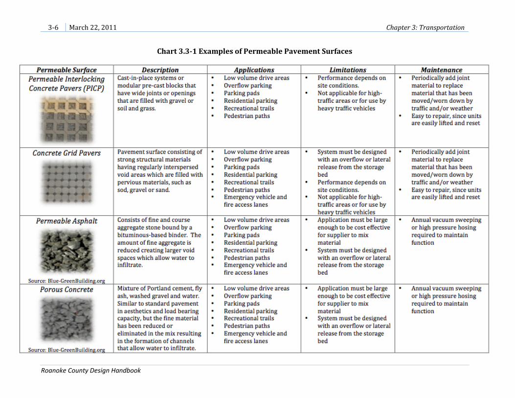
Chart 3.3-1 Examples of Permeable Pavement Surfaces

Chapter 3: Transportation March 22, 2011 3-7
Roanoke County Design Handbook
(Page intentionally blank)

3-8 March 22, 2011 Chapter 3: Transportation
Roanoke County Design Handbook
Figure 3.3-2 Examples of Permeable Pavement Applications

Chapter 3: Transportation March 22, 2011 3-9
Roanoke County Design Handbook
Section 3.4 – Sidewalks
(A) Intent: Sidewalks are encouraged in areas with potential for moderate to high
pedestrian activity along public and private rights-of-way, particularly within and
between the following areas:
1. High employment
2. Commercial (service) areas
3. Dense residential areas (multifamily and small-lot, single-family residential
subdivisions)
4. Public facilities (schools, libraries, parks, recreational centers)
(B) General standards (refer to current VDOT standardsa, as amended, for additional
standards and detail)
1. Materials:
a. Concrete which may be stamped and colored; or
b. Solid paving units such as brick or concrete.
2. Sidewalk depth: 4 inches minimum
3. Curb Ramps: Provide at all road intersections and crosswalksb

3-10 March 22, 2011 Chapter 3: Transportation
Roanoke County Design Handbook
Chart 3.4-1 Sidewalk and Planting Strip Standards
Location
Sidewalk Width
Sidewalk Clear
Width**
Planting Strip / Buffer Width
Adjacent to
Curb
With Street Trees
Without Street Trees
Min
imu
m
Re
com
me
nd
ed
Min
imu
m
Re
com
me
nd
ed
Min
imu
m
Re
com
me
nd
ed
Concentrated Business Areas or High
Pedestrian Volumes No 10 10 to 15 10 6 6 3 5 to 6
Other Business Areas No 5 6 to 8 5 6 6 3 5 to 6
Yes 8 8 to 10 5 n/a n/a
Residential Areas on Public (VDOT) Roads
No 5 4 6 3
Yes 8 4 n/a n/a
Residential Areas on Private Roads
No 4* 5 4 4 6 2 2 to 4
Yes 5 6 4 n/a n/a
*Sidewalks less than 5 feet in width shall have 5-foot-wide passing spaces located at reasonable intervals. ** Sidewalk clear width is the portion of sidewalk that excludes obstructions and any attached curb (AASHTO)
Section 3.5 – Shared Use Paths
(A) Intent: Two-directional shared use paths are encouraged to be constructed in
locations along public roads where pedestrians, bicyclists and other non-motorized
users (and including motorized wheelchair users) can utilize the path either as a
recreational amenity in itself or as a means to get from one location to another.
Accessibility should be a fundamental consideration in the design and development of
shared use paths.c
(B) General Standards (refer to current VDOT and AASHTO standards, as amended, for
additional standards and detail)
1. Material: Hard, all-weather pavement surface

Chapter 3: Transportation March 22, 2011 3-11
Roanoke County Design Handbook
2. Width:
a. 10 feet minimum with a 2-foot-wide graded area adjacent to both sides of
the pathd
b. 8 feet minimum with a 2-foot-wide graded area adjacent to both sides of
the path may be permitted when one or more of the following conditions
are presente:
i. Bicycle traffic is expected to be low, even on peak days or during
peak hours,
ii. Pedestrian use of the facility is not expected to be more than
occasional,
iii. There will be good horizontal and vertical alignment providing
safe and frequent passing opportunities, and
iv. During normal maintenance activities the path will not be
subjected to maintenance vehicle loading conditions that would
cause pavement edge damage.
3. Location: 5 feet minimum from edge of pavement or less with a suitable
physical barrier between the path and the edge of the shoulderf
4. Grade: The path should generally match the grade of the road and should not
exceed 5 percent except for short distances as referenced in the chart below:
Chart 3.5-1 Shared Use Path Grades Permitted Grade
(percent) Maximum Length
(feet) 5-6 800 7 400 8 300 9 200
10 100 11+ 50
Based on the 1999 AASHTO Guide for the Development of Bicycle Facilitiesg
5. Clear zone: 3 feet wide on either side of the pathh
6. Curb Ramps: Provide at all road intersections and crosswalksi

3-12 March 22, 2011 Chapter 3: Transportation
Roanoke County Design Handbook
Section 3.6 – Trails
(A) Intent: Private trails may be constructed in residential, commercial, industrial or other
types of developments as recreational amenities or as a means to get from one location
to another. Users may include pedestrians, bicyclists, equestrians, and persons in
wheelchairs. These regulations are not intended for public trails which are typically
located within public lands.
(B) Design Considerations: Trails should be designed to be sustainable in order to protect
the environment, to meet the needs of users, to require little maintenance and to
minimize conflict between different user groups.j Trails should be designed with a
natural shape and should consider anchors, edges, gatewaysk and incorporating loops
to maximize trail interest. Well-designed trails take advantage of natural land features.l
(C) General Standards
1. Hard Surface Trails
a. Trail Width: 4 feet wide, minimum
b. Trail Corridor Clearing Limit Recommendation: Trim vegetation and
remove obstacles within two feet of either side of the trail.
c. Trail Ceiling Recommendation: 8 feet high, 10 feet high if equestrian use
is anticipatedm
d. Road Separation: 2 foot minimum grass strip or landscaped buffer
Figure 3.5-1 – Shared Use Path Cross
Section

Chapter 3: Transportation March 22, 2011 3-13
Roanoke County Design Handbook
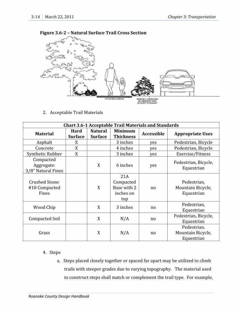
2. Natural Surface Trails
a. Trail Width: 3 feet wide, minimum, unless a narrower trail width is
required by a state or federal agency.
b. Trail Corridor Clearing Limit Recommendation: Trim vegetation to the
ground and remove obstacles within one foot of either side of the trailn.
c. Trail Ceiling Recommendation: 8 feet high, 10 feet high if equestrian use
is anticipatedo
d. Grade: The average trail grade should be 10 percent or less to be most
sustainablep. The maximum sustainable trail grade is typically 15 to 20
percentq and should not be exceeded. Follow the Half Rule that a trail’s
grade should not exceed half the grade of the hillside or sideslope that the
trail traversesr.
e. Accommodating Erosion: Design rolling contour trails with gentle grades,
grade reversals every 20 to 50 feet and a tread with a five percent
outslope. Avoid locating trails along fall lines or within flat areas that will
collect waters.
f. Riparian Areas: Riparian vegetation shall be carefully considered in the
planning and construction of trails in riparian areas. Wherever possible,
the disturbance of existing vegetation shall be minimized and native and
non-invasive species shall be planted to mitigate losses.
g. Road Separation: 2 foot minimum grass strip or landscaped buffer
Figure 3.6-1 – Hard Surface Trail Cross Section
3-14 March 22, 2011 Chapter 3: Transportation
Roanoke County Design Handbook
2. Acceptable Trail Materials
Chart 3.6-1 Acceptable Trail Materials and Standards
Material Hard
Surface Natural Surface
Minimum Thickness
Accessible Appropriate Uses
Asphalt X 3 inches yes Pedestrian, Bicycle Concrete X 4 inches yes Pedestrian, Bicycle
Synthetic Rubber X 3 inches yes Exercise/Fitness Compacted Aggregate:
3/8” Natural Fines X 6 inches yes
Pedestrian, Bicycle, Equestrian
Crushed Stone: #10 Compacted
Fines X
21A Compacted Base with 2
inches on top
no Pedestrian,
Mountain Bicycle, Equestrian
Wood Chip X 3 inches no Pedestrian, Equestrian
Compacted Soil X N/A no Pedestrian, Bicycle,
Equestrian
Grass X N/A no Pedestrian,
Mountain Bicycle, Equestrian
4. Steps
a. Steps placed closely together or spaced far apart may be utilized to climb
trails with steeper grades due to varying topography. The material used
to construct steps shall match or complement the trail type. For example,
Figure 3.6-2 – Natural Surface Trail Cross Section

Chapter 3: Transportation March 22, 2011 3-15
Roanoke County Design Handbook
large rocks would complement a gravel trail or wooden railroad ties
would complement a wood chip trail.
b. If placed closely together, the step rise should measure between 6 and 8
inches and the run should measure between 10 and 12 inches. Landings
shall measure at least 6.5 feet.t
c. A handrail may be installed adjacent to the steps to assist hikers in
climbing steep terrain.
5. Easements
a. Access easements shall be recorded with a width five feet greater than the
trail width.
Section 3.7 – Bicycle Accommodations
(A) Applicable regulations for bicycle accommodations:
1. Current VDOT standards, as amended
2. AASHTO Guide for the Development of Bicycle Facilities, as amended
3. Regional bikeway plans, as amended, available from the Roanoke Valley
Alleghany Regional Commission and the Roanoke Valley Area Metropolitan
Planning Organization

3-16 March 22, 2011 Chapter 3: Transportation
Roanoke County Design Handbook
Section 3.8 – Private Roads
(A) Intent
1. The intent of this section is to provide adequate standards for Roanoke County
private roads. Such roads may be provided only in selected urban residential
developments including the Cluster Subdivision Option, the Planned Residential
Development District, Townhouse and Manufactured Home Park developments.
Private roads may also be permitted in locations identified by the Zoning
Ordinance.
2. For related topics not covered in this section, refer to other County, State or
Federal regulations.
(B) Definitions
1. Alley: An open way that affords a service (i.e. garbage collection, delivery, mail)
means of access to an abutting property, but is not maintained by any local, state,
or federal government. (Roanoke County Subdivision Ordinance and Zoning
Ordinance) Alleys may also contain underground utilities.
2. Driveway: A private roadway providing access for vehicles to a parking space,
garage, dwelling, or other structure. (Roanoke County Zoning Ordinance) A
driveway is intended to provide access to no more than two dwelling units.
3. Easement: A right expressed in recorded writing, given by the owner of land to
another party of specific limited use of that land (i.e., access, pedestrian,
greenway, drainage, water, sewer, public utility). (Roanoke County Subdivision
Ordinance)
4. Plat, Final: The plat of a proposed subdivision of land that has been
preliminarily approved and signed by the agent as a preliminary plat,
subsequently recorded or to be recorded with the Clerk’s Office. (Roanoke
County Subdivision Ordinance)
5. Private Street/Road: A vehicular way owned, operated, provided, and
maintained by an individual, developer, homeowners’ association, or any other
entity other than a local, state, or federal government. (Roanoke County
Subdivision Ordinance) A private road is intended to provide access to three or
more dwelling units.
6. Right-of-Way: A legally established area or strip of land on which an irrevocable
public right of passage has been or is to be recorded, and which may be occupied
or intended to be occupied by a street, utility service, water main, sanitary or

Chapter 3: Transportation March 22, 2011 3-17
Roanoke County Design Handbook
storm sewer main, or other similar use. (Roanoke County Subdivision
Ordinance)
7. VDOT: The Virginia Department of Transportation (Roanoke County Subdivision
Ordinance)
(C) Design
1. New private roads shall be designed to connect to Local Access Roads or
Collectors and shall be designed to provide access to each residential lot.
2. Shoulder and Ditch Section Requirements.
a. Intent. Shoulder and ditch sections are intended primarily for Planned
Residential Developments characterized by larger residential lots
(generally ¼ acre or greater) that may have longer driveways that allow
parking for several vehicles. Only in rare instances would residents or
guests park along the shoulder of a private road.
b. General Parking. If shoulders will be frequently utilized for parking, each
shoulder shall measure four feet in widthu and shall be constructed of
either stone or bituminous pavement. Parking is not recommended along
road sections with grades greater than 15 percent.
c. Guest Parking. On- or off-street guest parking may be provided but is not
required on roads designed with shoulder and ditch.
^ To find the Average Daily Trip Generation (ADT) for a proposed land use, refer to the Institute
of Transportation Engineers (ITE) Manual, as amended.
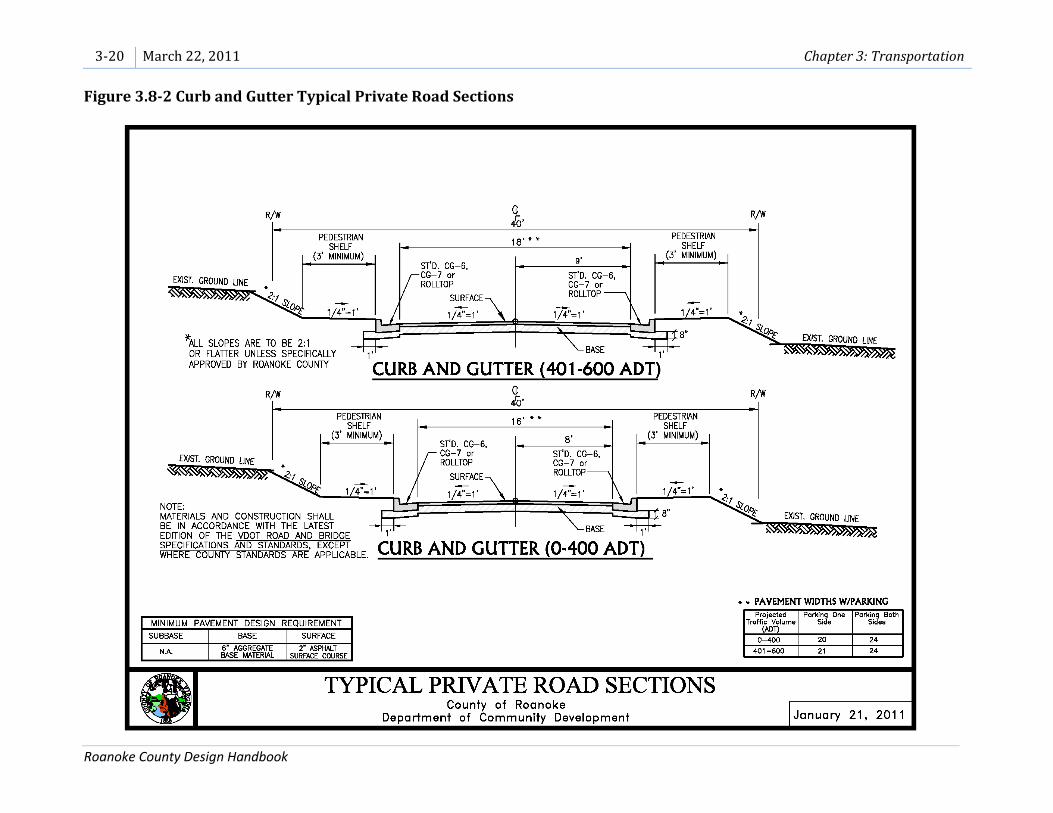
3. Curb and Gutter Section Requirements.
a. Intent. Curb and gutter sections are intended for both Cluster and
Planned Residential Development residential neighborhoods that are
densely developed with small lot sizes (generally ¼ acre or less).
Chart 3.8-1 Shoulder and Ditch Standards Projected Traffic Volume (ADT)^
Travelway Width (pavement only)
Roadway Width (including shoulders)
0-400 16v 20w 401-600 18x 22y Over 600 Refer to current VDOT standards, as amended
Referenced Standards: AASHTO Very Low Rural, 15-40MPH; AASHTO Very Low Local in Urban Areas, 2 or less du/acre

3-18 March 22, 2011 Chapter 3: Transportation
Roanoke County Design Handbook
b. General Parking. Residential lots may have driveways spaced closely
together that are shorter in length, allowing for parking of between two
and four vehicles in the driveway. Parking is not recommended along
road sections with grades greater than 15 percent.
c. Guest Parking. One-half (1/2) parking space shall be provided for each
dwelling unit for guest parking. Any fraction equaling or exceeding one-
half (1/2) shall be construed as requiring one (1) full parking space.
Parking spaces may be located off-street in a marked space or on-street in
compliance with Chart 3.8-2., Curb and Gutter Standards.
d. Curb and Gutter. Use CG-6, CG-7 or roll-top curb. See 5(e) Curb and
Gutter Design for additional information.
Chart 3.8-2 Curb and Gutter Standards
Projected
Traffic Volume
(ADT)^
Pavement Widths Only
No Parking Parking One
Side Parking Both
Sides
0-400 16 20 24 401-600 18 21 24 Over 600 Refer to current VDOT standards, as amended
Referenced Standards: AASHTO Very Low Rural, 15-40MPH
^ To find the Average Daily Trip Generation (ADT) for a proposed land use, refer to the Institute
of Transportation Engineers (ITE) Manual, as amended.

Chapter 3: Transportation March 22, 2011 3-19
Roanoke County Design Handbook
Figure 3.8-1 Shoulder and Ditch Typical Private Road Sections
3-20 March 22, 2011 Chapter 3: Transportation
Roanoke County Design Handbook
Figure 3.8-2 Curb and Gutter Typical Private Road Sections

Chapter 3: Transportation March 22, 2011 3-21
Roanoke County Design Handbook
4. Turnarounds. z Every effort shall be made to provide through roads within a
subdivision to minimize the need for dead end streets. If dead end streets must
be used, turnarounds shall be required at the end of all private streets and alleys
and are encouraged at the end of all shared driveways.
a. Grade: Turnarounds shall have a maximum 5 percent centerline grade
with a minimum cross slope of ¼ inch to 1 foot.aa
b. Landscaped Islands: To reduce impervious area, curbed or un-curbed
landscaped islands may be permitted within 45-foot radius or larger cul-
de-sacs. The landscaped area shall have a maximum radius of 25 feet and
a maximum 5-foot-wide concrete raised median strip (VDOT MS-1bb) may
be located along the edge of the island. Bioretention areas may be
permitted in such islands.
c. Cul-de-sac Parking: To allow access for solid waste collection and other
delivery vehicles, parking shall not be permitted in cul-de-sacs with
landscaped islands. Parking shall not be permitted on cul-de-sacs with an
edge-of-pavement or a face-of-curb radius less than 45 feet. Parking shall
be permitted on cul-de-sacs with an edge-of-pavement or a face-of-curb
radius of 45 feet or greater.
d. Alternative Turnaround Parking: Parking shall not be permitted in T-
Type or Branch-Type Turnarounds.

3-22 March 22, 2011 Chapter 3: Transportation
Roanoke County Design Handbook
Figure 3.8-3 Shoulder and Ditch Concentric Cul-de-Sacs

Chapter 3: Transportation March 22, 2011 3-23
Roanoke County Design Handbook
Figure 3.8-4 Curb and Gutter Concentric Cul-de-Sacs

3-24 March 22, 2011 Chapter 3: Transportation
Roanoke County Design Handbook
Figure 3.8-5 Shoulder and Ditch Offset Bulb Cul-de-Sacs

Chapter 3: Transportation March 22, 2011 3-25
Roanoke County Design Handbook
Figure 3.8-6 Curb and Gutter Offset Bulb Cul-de-Sacs

3-26 March 22, 2011 Chapter 3: Transportation
Roanoke County Design Handbook
Figure 3.8-7 Alternative Turnarounds

Chapter 3: Transportation March 22, 2011 3-27
Roanoke County Design Handbook
5. Design Elements:
a. Alleys. Alleys shall be owned and maintained by the Homeowners’
Association, and notes to this effect shall be indicated on the final plat.
i. One-way alleycc:
(A) Minimum Width: 12 feet wide paved width
(B) Minimum Right-of-Way Width: 20 feet widedd
ii. Two-way alley:
(A) Minimum Width: 16 feet wide paved width
(B) Minimum Right-of-Way Width: 24 feet wide
b. Bridge and Culvert Design Criteria. Current VDOT standardsee, as
amended.
c. Clear Zone. Current VDOT standardsff, as amended.
d. Compaction. Current VDOT standards, as amended.
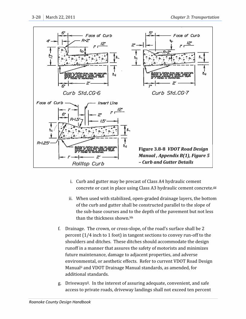
e. Curb and Gutter Design. Current VDOT standards, as amended. Use CG-6,
CG-7 or roll-top curb.
3-28 March 22, 2011 Chapter 3: Transportation
Roanoke County Design Handbook
i. Curb and gutter may be precast of Class A4 hydraulic cement
concrete or cast in place using Class A3 hydraulic cement concrete.gg
ii. When used with stabilized, open-graded drainage layers, the bottom
of the curb and gutter shall be constructed parallel to the slope of
the sub-base courses and to the depth of the pavement but not less
than the thickness shown.hh
f. Drainage. The crown, or cross-slope, of the road’s surface shall be 2
percent (1/4 inch to 1 foot) in tangent sections to convey run-off to the
shoulders and ditches. These ditches should accommodate the design
runoff in a manner that assures the safety of motorists and minimizes
future maintenance, damage to adjacent properties, and adverse
environmental, or aesthetic effects. Refer to current VDOT Road Design
Manualii and VDOT Drainage Manual standards, as amended, for
additional standards.
g. Drivewaysjj. In the interest of assuring adequate, convenient, and safe
access to private roads, driveway landings shall not exceed ten percent
Figure 3.8-8 VDOT Road Design
Manual , Appendix B(1), Figure 5
– Curb and Gutter Details

Chapter 3: Transportation March 22, 2011 3-29
Roanoke County Design Handbook
for a length of 30 feetkk, measuring from the private road edge of
pavement. At all driveway entrances, standard entrance gutter (Std. CG-
9B or CG-9D) shall be used with Standard CG-6 or CG-7 curb and gutterll.
See the graphic below for additional detail.
h. Grade.
i. To allow for fire and rescue access the maximum grade shall comply
with current VDOT standards, as amendedmm at private driveway
entrances and at fire hydrant locations.
ii. At all other locations the maximum grade shall not exceed 17
percent unless a Design Exception is approved.
iii. For locations other than at driveway entrances and at fire hydrant
locations, a Design Exception request may be submitted to the
Director of Community Development to increase the maximum
grade for a certain length of private road only if one or more of the
following circumstances are present:
1. The length of road fronts ½ acre lots or larger;
2. The length of road is 150 feet or shorter;
3. The length of road has a 150-foot tangent section;
Figure 3.8-9 VDOT Road Design Manual, Appendix B(1), Figure 9 – Private Entrance
Detail

3-30 March 22, 2011 Chapter 3: Transportation
Roanoke County Design Handbook
4. Environmental constraints such as wetlands, FEMA floodways ,
jurisdictional waters or County-designated floodways are
located in the immediate vicinity and will not be impacted
because of the Design Exception; or
5. All dwelling units at and beyond the limit of the Design
Exception are sprinkled.
The Director of Community Development in consultation with the
Fire and Rescue Department shall make the final decision regarding
the Design Exception.
Additional information that may be requested to assist in the final
decision could include an alternative route to the Design Exception
request to show that the Design Exception route presents fewer
negative impacts than the alternative route.
i. Green Shoulders. Current AASHTO standards, as amended.
j. Guardrail. Current VDOT standardsnn, as amended.
k. Horizontal and Vertical Controls. Current AASHTO standards, as
amended (see charts below). All private roads shall be designed with a
normal crown section; however, private roads measuring a maximum of
100 feet long with a maximum superelevation of 8 percent and serving no
more than three dwelling units may be designed without a normal crown
section.
Chart 3.8-3 Design Controls for Stopping Sight Distance and for Crest Vertical Curves
Design Speed (mph)
Stopping Sight Distance (ft)
Rate of Vertical Curvature, Kª
Calculated Design 20 115 6.1 7 25 155 11.1 12 30 200 18.5 19
Rate of vertical curvature, K, is the length of curve per percent algebraic difference in intersecting grades (A). K = L/A Based on the 2004 AASHTO Green Bookoo

Chapter 3: Transportation March 22, 2011 3-31
Roanoke County Design Handbook
Chart 3.8-5 Minimum Radii for Low-Speed Urban Streets Design Speed
(mph) 20 mph 25 mph 30 mph
Radius (ft) 107 198 333 Based on the 2004 AASHTO Green Bookqq
l. Intersectionsrr (Excluding Alley Intersections)
i. Cross Road Grade.ss The maximum difference between the
pavement cross slope and the approach road grade shall not exceed
8 percent at stop intersections or 4 percent at continuous-
movement intersections. (Current VDOT Road Design Manual and
Subdivision Street Design Guide as amended) A landing having a
minimum length of 50 feet and a maximum vertical grade of 5
percent shall be provided at each intersection.
ii. Angles. Streets should intersect at right angles; however,
intersecting angles between 60 and 90 degrees are permitted.
(Current VDOT Subdivision Street Design Guide, as amended)
iii. Spacing. Offset intersections are not allowed. Intersections or
intersecting streets on the same side or opposite side shall be
spaced at a minimum of 200 feet and this distance shall be adjusted
upward based on upstream and downstream intersection turning
movements. (Based on current VDOT Subdivision Street Design
Guide, as amended)
iv. Minimum Radius. For skew intersections the radius shall not be less
than 25 feet for the acute angle and 30 feet for the obtuse angle of
the intersection street. (Current VDOT Subdivision Street Design
Guide, as amended)
v. Visibility. At intersections, a minimum clear sight triangle shall be
maintained as illustrated in the Intersection Design graphic below.
Chart 3.8-4 Design Controls for Sag Vertical Curves
Design Speed (mph)
Stopping Sight Distance (ft)
Rate of Vertical Curvature, Kª Calculated Design
20 115 16.5 17 25 155 25.5 26 30 200 36.4 37
Rate of vertical curvature, K, is the length of curve (m) per percent algebraic difference intersecting grades (A). K = L/A Based on the 2004 AASHTO Green Bookpp

3-32 March 22, 2011 Chapter 3: Transportation
Roanoke County Design Handbook
It shall be the responsibility of the developer/Homeowners’
Association to maintain a clear sight triangle at all times.
m. Lightingtt. The installation, maintenance and operating expenses of
lighting shall be provided by and at the sole expense of the developer or
Homeowners’ Association.
n. One-Way, One-Lane Streets. One-way streets shall meet the dimensional
requirements below and shall have two access points. Horizontal and
vertical curvature shall meet the requirements stated above in Section 5k,
Horizontal and Vertical Controls. Parking shall not be permitted along
one-way, one-lane streets.
^ To find the Average Daily Trip Generation (ADT) for a proposed land use, refer to the Institute of
Transportation Engineers (ITE) Manual, as amended.
o. Parking. Parking is not recommended along road sections with grades
greater than 15 percent. In any location where parking is prohibited, “No
Parking” signs shall be installed. Off-street parking spaces are permitted
Chart 3.8-6 One-Way, One-Lane Street Standards
Projected Traffic Volume (ADT)^
Shoulder and Ditch Curb and Gutter Travelway
Width (pavement only)
Roadway Width (including shoulders)
Pavement Width
Up to 600 12 16 12 Based on the 2004 AASHTO Green Bookuu
Figure 3.8-10
VDOT Road
Design Manual,
Appendix B(1),
Figure 3 –
Intersection
Design

Chapter 3: Transportation March 22, 2011 3-33
Roanoke County Design Handbook
in the private road right-of-way to provide overflow and guest parking.
To allow access for solid waste collection and other delivery vehicles,
parking shall not be permitted in cul-de-sacs with landscaped islands.
p. Pavement Design. Current VDOT standards, as amended. All private
roads shall be designed with a normal crown section, except as otherwise
noted.
q. Pedestrian Shelf. Where curb and gutter is used, a ¼ inch per foot (two
percent) graded area, a minimum three feet in width, shall be provided
behind the back of the curbvv to transition from steeper adjacent grades.
The pedestrian shelf is intended for pedestrian use and may include
sidewalks and other related pedestrian amenities.
r. Plat Covenant Language. Add the following note to each page of the plat
of subdivision:
"The road serving this lot is private and its maintenance, including
snow removal, is not a public responsibility. It shall not be eligible
for acceptance into the state secondary system for maintenance
until such time as it is constructed and otherwise complies with all
requirements of the Virginia Department of Transportation for the
addition of subdivision streets current at the time of such request.
Any costs required to cause this street to become eligible for
addition into the state system shall be provided with funds other
than those administered by the Virginia Department of
Transportation or Roanoke County."
s. Right-of-Way. Minimum 30 foot width required. See current VDOT
standardsww, as amended, for additional information.
t. Sight Distance to include Stopping Sight Distance, Intersection Sight
Distance and Sight Distance Triangles (see AASHTO tables and VDOT
graphic below).
Chart 3.8-7 Stopping Sight Distance on Grades
Design Speed (mph)
Stopping Sight Distance (ft)
Downgrades Upgrades
3% 6% 9% 3% 6% 9%
20 116 120 126 109 107 104
25 158 165 173 147 143 140
30 205 215 227 200 184 179
Based on the 2004 AASHTO Green Bookxx

3-34 March 22, 2011 Chapter 3: Transportation
Roanoke County Design Handbook
Chart 3.8-8 Design Controls for Stopping Sight Distance and for Crest and Sag Vertical Curves
Initial Speed (mph)
Design stopping sight
distance (ft)
Rate of vertical curvature, Kª (ft/%)
Crest Sag
20 115 7 17
25 155 12 26
30 200 19 37 Rate of vertical curvature, K, is the length of curve per percent algebraic difference in the intersecting grades (i.e., K = L/A) Based on the 2004 AASHTO Green Bookyy
Chart 3.8-9 Design Intersection Sight Distance - Case B1 – Left Turn from Stop
Design Speed (mph)
Stopping Sight
Distance (ft)
Intersection Sight Distance for Passenger Cars
Calculated (ft) Design (ft)
20 115 220.5 225
25 155 275.6 280
30 200 330.8 335
Note: Intersection sight distance shown is for a stopped passenger car to turn left onto a two-lane highway with no median and grades 3 percent or less. For other conditions, the time gap must be adjusted and required sight distance recalculated. Based on the 2004 AASHTO Green Bookzz

Chapter 3: Transportation March 22, 2011 3-35
Roanoke County Design Handbook
u. Shared Driveways. Shared driveways shall be permitted to serve no more
than two houses. Shared driveways shall be created using access
easements measuring 20 feet in width. Access easements shall be shown
and noted on the Final Plat.
v. Sidewalks. Sidewalks are encouraged to be located along private roads to
encourage residents and their guests to walk in a designated pedestrian
area separated from automobiles. Sidewalks shall be permitted within
the right-of-way or within a public access easement and shall be
maintained by the Homeowners’ Association. Public access easements
shall be shown and noted on the Final Plat. See Section 3.4, Sidewalks, for
additional requirements.
w. Speed Control/Traffic Calming Design Features. Speed control design
features such as speed bumps, speed humps, etc., shall not be installed
Figure 3.8-11 VDOT Road Design Manual, Appendix B(1), Figure 2 –
Sight Distance Triangle

3-36 March 22, 2011 Chapter 3: Transportation
Roanoke County Design Handbook
unless approved by Roanoke County Community Development with input
from the staff of County Schools, County General Services, and Fire and
Rescue Departments.
x. Standard Notes. Include a notation on the construction plans identifying
the proposed private roads.
y. Stormwater Management Facilities. Entry to privately owned and
maintained stormwater management facilities and accesses shall be
provided per the latest County of Roanoke Stormwater Management
Design Manual. An easement shall be provided to Roanoke County for
access and maintenance of a stormwater management facility. Such
easements shall be noted on the plat. See Section (D)1. Drainage
Easements, for additional standards.
z. Traffic Control Devices and Signage. Each private road shall be identified
with a street name sign at each intersection which shall be white with
green lettering, per Roanoke County standards. Provide stop signs at
entrance and interior intersections. Comply with the MUTCD Manual, as
amended. Traffic signs and street name signs do not require sign permits.
For all other signs, refer to Zoning Ordinance Section 30-93, Signs, to
determine the need for a Sign Permit. Additional regulations:
i. Installation and Maintenance: The developer shall be
responsible for purchasing, installing and maintaining all signs.
When the private road is turned over to the Homeowners’
Association it shall then be the responsibility of the
Homeowners’ Association to maintain all signs.
ii. Enforcement: The Roanoke County Police Department is unable
to enforce traffic regulations on private roads. Parking
enforcement shall be the responsibility of the owner of the
private road or the Homeowners’ Association.
iii. Maintenance of Traffic through Construction Areas: Refer to the
MUTCD Manual, as amended.
aa. Trip Generation/Average Daily Trips (ADT). Refer to the Institute of
Transportation Engineers (ITE) Trip Generation manual, as amended.
bb. Vertical Clearance Height. Private roads through forested areas or under
other overhead obstructions must maintain proper clearance heights
above the traveled way to allow passage of emergency vehicles. Tree

Chapter 3: Transportation March 22, 2011 3-37
Roanoke County Design Handbook
branches must be trimmed and maintained to obtain a minimum
overhead clearance of 14 feet.
(D) Easements
1. Drainage Easements:
a. The width and location of drainage and stormwater pond facility
easements shall comply with the Stormwater Management Ordinance and
Stormwater Design Manual, as amended.
b. Private drainage easements shall be platted and dedicated to the
homeowners' association for maintenance and notes to this effect shall be
indicated on the final plat.
c. Public drainage easements shall be platted and dedicated for public use.
2. Sight Distance Easements: Width and location to be determined by VDOT for
public and private road intersections. For intersections of two or more private
roads, dedicated right-of-way may be needed to preserve the line-of-sight. A
sight distance easement may be an alternative to dedicated right-of-way.
3. Water and Sewer Easements: Width and location to be determined by the
Western Virginia Water Authority or the Town of Vinton Department of Public
Works depending upon the service provider.
4. Public/Private Utility Easements: Width and location to be determined by the
appropriate utility company(ies)
(E) Public Services
1. School Bus Service: The private road standards generally meet Roanoke County
Public Schools standards for school bus service; however, Roanoke County
School Administration staff reserve the right to discontinue or relocate service
on private roads if school buses cannot safely pick up children, pending advance
notice to the owner of the private road, due to the following situations:
a. Cars are frequently parked in No Parking zones or in other locations
where parking is not permitted, prohibiting the bus from passing or
turning around;
b. Snow has not been plowed adequately from private roads to allow school
buses to safely navigate them on more than one occasion;
c. Ongoing construction creates an unsafe condition for either the children
or the bus;

3-38 March 22, 2011 Chapter 3: Transportation
Roanoke County Design Handbook
d. Other conditions which would create an unsafe condition for either the
children or the bus; or
e. The Homeowners’ Association requests that the bus be removed due to
noise, lighting, road damage or other unforeseen reasons.
2. Solid Waste: To receive public solid waste collection, a Private Road Waiver shall
be completed and signed prior to site plan/subdivision plan approval. If a
Private Road Waiver is not completed, the homeowners and/or homeowners’
association has the responsibility for addressing the collection of solid waste.
3. Fire and Rescue Service: A representative of the Fire and Rescue Department
shall review the design and location of all proposed private streets, and shall
advise the applicant whether or not the proposed private streets meet the
standards for emergency services.
(F) Process
1. Plan Submittal Requirements: Refer to the Roanoke County Land Development
Procedures, as amended.
2. Erosion and Sediment Control: All land disturbing activities shall comply with the
Roanoke County Erosion and Sediment Control Ordinance, as amended.
3. Inspections: A third-party inspector shall inspect private roads following the
requirements below:
a. Developer must contract with a licensed inspection firm certified to
perform inspections not related to or affiliated with the developer or
contractor;
b. Inspection procedures, testing methodology, and frequency of inspections
are completed in accordance with VDOT Materials Division’s Manual of
Instructions and the Virginia Department of Transportation Road and
Bridge Specifications. Inspections include but are not limited to:
i. Completion of subgrade, prior to the placement of any ballast
material;
ii. Completion of ballast, prior to the placement of any top course of
material; and
iii. Completion of installation of road signs, installation of any
appurtenant structures, and reseeding of disturbed area and slopes.

Chapter 3: Transportation March 22, 2011 3-39
Roanoke County Design Handbook
4. Final Report and As-Built Drawings: At the completion of the road construction a
report including two copies of As-Built drawings shall be submitted to Roanoke
County Community Development by the developer. Roanoke County shall
provide one copy of the As-Built drawings to the Roanoke County Fire Marshal.
a. Final Report: The Final Report shall include all material receipts, dates of
inspection, work performed, changes or repairs ordered, inspection steps
completed, certification of the results of inspections referenced in (F)3b,
above, and confirmation that the streets were built to the approved plans,
specifications and pavement design. The Final Report shall be signed and
stamped by a Virginia licensed Professional Engineer.
b. As-built drawings: Requirements for As-Built drawings are as follows:
i. Changes to water, sewer, storm sewer, road grade and alignments.
ii. Drainage improvements as required by the Roanoke County
Stormwater Management Ordinance and the Stormwater Design
Manual, as amended.
iii. Public water and public sewer improvements per the Town of
Vinton, if applicable.
iv. Private water and private sewer improvements per the Virginia
Department of Health.
v. If requested, slope verification for road sections designed with
grades of 15 percent or greater.
vi. If requested, a centerline as-built or right-of-way staking for
confirmation of the road location.
5. Turnover to Homeowners’ Association: To ensure that the Homeowners’
Association does not receive substandard private roads, include the following
notation on the plans:
“Immediately prior to the turnover of the private roads to the Homeowners’
Association, Roanoke County shall inspect the private roads and any defects
shall be repaired by the responsible party before the turnover occurs.”
6. Maintenance: A Homeowners’ Association is required to be established to be
responsible for all private roads, to include maintenance and upkeep of the
private roads. The HOA shall also enforce parking restrictions.aaa

3-40 March 22, 2011 Chapter 3: Transportation
Roanoke County Design Handbook
(Page intentionally blank)

Appendices March 22, 2011 A-1
Roanoke County Design Handbook
A Appendix A: Board of Supervisors Ordinances
Figure A-1 Board of Supervisors Ordinance 052609-23

A-2 March 22, 2011 Appendices
Roanoke County Design Handbook

Appendices March 22, 2011 A-3
Roanoke County Design Handbook

A-4 March 22, 2011 Appendices
Roanoke County Design Handbook
Figure A-2 Board of Supervisors Ordinance 032211-8

Appendices March 22, 2011 A-5
Roanoke County Design Handbook

A-6 March 22, 2011 Appendices
Roanoke County Design Handbook
(Page intentionally blank)

Appendices March 22, 2011 B-1
Roanoke County Design Handbook
B Appendix B: Sidewalk, Shared Use Path, Trail and Private Road Standards References
Figure B-1 Sidewalk, Shared Use Path, Trail and Private Road Standards References
a VDOT Road Design Manual, p. B(1)-31
b VDOT Road Design Manual, p. B(1)-27
c AASHTO Guide for the Planning, Design, and Operation of Pedestrian Facilities, p. 71
d VDOT Road Design Manual, p. B(1)-33; AASHTO Guide for the Development of Bicycle Facilities (1999) p. 35
e VDOT Road Design Manual, p. B(1)-33
f VDOT Road Design Manual, p. B(1)-33
g VDOT Road Design Manual, p. B(1)-35; AASHTO Guide for the Development of Bicycle Facilities (1999) p. 39
h VDOT Road Design Manual, p. B(1)-34
i VDOT Road Design Manual, p. B(1)-27 j Trail Solutions IMBA’s Guide to Building Sweet Singletrack, p. 40
k Natural Surface Trails by Design Physical and Human Design Essentials of Sustainable, Enjoyable Trails, p. 13-20
l USDA Trail Construction and Maintenance Notebook, p. 24 m
Trail Solutions IMBA’s Guide to Building Sweet Singletrack, p. 137 n USDA Trail Construction and Maintenance Notebook, p. 44
o Trail Solutions IMBA’s Guide to Building Sweet Singletrack, p. 137
p Trail Solutions IMBA’s Guide to Building Sweet Singletrack, p. 64
q Trail Solutions IMBA’s Guide to Building Sweet Singletrack, p. 66
r Trail Solutions IMBA’s Guide to Building Sweet Singletrack, p. 63
s Trail Solutions IMBA’s Guide to Building Sweet Singletrack, p. 56-69
t USDA Trail Construction and Maintenance Notebook, p. 119
u VDOT Road Design Manual, p. A-57
v AASHTO Green Book, p. 384 (added 2 feet)
w AASHTO Design of Very Low-Volume Roads, p. 18 (added 2 feet)
x AASHTO Green Book, p. 384
y AASHTO Green Book, p. 384 (added 2 feet)
z Cul-de-sac dimensions per VDOT Road Design Manual, p. B(1)-24, B(1)-25
aa City of Manassas (VA) Road Standards and Brian Blevins at VDOT; based on previous VDOT Standards
bb VDOT Road and Bridge Standards, 2001, p. 202.02
cc VDOT Road Design Manual p. A-16
dd AASHTO Green Book, p. 396
ee VDOT Road Design Manual, p. B(1)-37
ff VDOT Road Design Manual, p. B(1)-41
gg VDOT Road Design Manual, p. B(1)-26
hh VDOT Road Design Manual, p. B(1)-26
ii VDOT Road Design Manual, p. B(1)-38
jj VDOT Road Design Manual, p. B(1)-30
kk 30 foot length per Roanoke County Engineer
ll VDOT Road Design Manual, p. B(1)-28
mm VDOT Road Design Manual, p. B(1)7, B(1)8
nn VDOT Road Design Manual, p. B(1)-43
oo AASHTO Green Book, p. 272
pp AASHTO Green Book, p. 277
qq AASHTO Green Book, p. 151
rr VDOT Road Design Manual, p. B(1)-21 and 22
ss VDOT Road Design Manual, p. C-4 and G-35
tt VDOT Road Design Manual, p. B(1)-53

B-2 March 22, 2011 Appendices
Roanoke County Design Handbook
uu
AASHTO Green Book, p. 396 vv
VDOT Road Design Manual, p. B(1)-27 ww
VDOT Road Design Manual, p. B(1)40 xx
AASHTO Green Book, p. 115 yy
AASHTO Green Book, p. 381 zz
AASHTO Green Book, p. 661; VDOT Road Design Manual, p. B(1)-7 and C-31 aaa
City of Corona (CA) Public Works Department Private Street Standards