Embed Size (px)
Citation preview
Design and Access Statement
Design and Access Statement Kettering HWRC.doc 1
Land to the Rear of Kettering Depot,
Proposed Household Waste Recycling Centre
(HWRC)Appendix B.1
Design and Access Statement
April 2009

Design and Access Statement
Design and Access Statement Kettering HWRC.doc 2
Land to the Rear of Kettering depot, Robinson Way, Household Waste Recycling Centre ( HWRC)
Design and Access Statement
April 2009 Notice This report was produced by Atkins Ltd for Northamptonshire County Council for the specific purpose of supporting a planning application for a household waste recycling facility on surplus land to the rear of Kettering Borough Council’s Robinson Way depot.
This report may not be used by any person other than Northamptonshire County Council without Northamptonshire County Council’s express permission. In any event, Atkins accepts no liability for any costs, liabilities or losses arising as a result of the use of or reliance upon the contents of this report by any person other than Northamptonshire County Council.
Atkins Limited
Document History
JOB NUMBER: 5080830 DOCUMENT REF: Design and Access Statement (Draft)2009.04.22.(JD)
01 Draft D&A YP RB JD
Revision Purpose Description Originated Checked Reviewed Authorised Date

Design and Access Statement
Design and Access Statement Kettering HWRC.doc 3
This page has been intentionally left blank.
Design and Access Statement
Design and Access Statement Kettering HWRC.doc 4
Contents Section Page Abbreviations 6
1 Introduction 8 1.1 Outline 8 1.2 Aim 8 1.3 Structure of the Report 8 2 Purpose of the Development 9 2.1 Background 9 2.2 Proposal 9 3 Application Site and Environs 13 3.1 Physical context 13 3.2 The Site 13 3.3 The Surroundings 13 3.4 The Socio Economic Context 14 4 Community Involvement 15 4.1 Public consultation 15 4.2 Consultation results 16 4.3 Pre Submission discussions 16 5 The Design of the Scheme 17 5.1 Policy Context 17 5.2 Amount 17 5.3 Use 18 5.4 Staff Numbers 18 5.5 Layout 18 5.6 Appearance 18 5.7 Scale 20 5.8 Landscaping 20 5.9 Noise 21 6 Access 22 6.1 Access to the Site 22 6.2 Access within the Site 22 6.3 Access during construction 23 7 Summary and Conclusions 24 Appendices Appendix 1
Consultation information pack containing a letter, conceptual designs and a comment form

Design and Access Statement
Design and Access Statement Kettering HWRC.doc 5
This page has been intentionally left blank.

Design and Access Statement
Design and Access Statement Kettering HWRC.doc 6
Abbreviations Term Full Term
AOD Above Ordnance Datum
BPEO Best Practicable Environmental Option
COSHH Control of Substances Hazardous to Health
DAS Design and Access Statement
EA Environment Agency
EIA Environmental Impact Assessment
EMRA East Midlands Regional Assembly
EMRSS East Midlands Regional Spatial Strategy
FRA Flood Risk Assessment
HGV Heavy Goods Vehicle
HWRC Household Waste Recycling Centre
NCC Northamptonshire County Council
PPG Planning Policy Guidance
PPS Planning Policy Statement
RSS Regional Spatial Strategy
SCI Statement of Community Involvement
SPD Supplementary Planning Document
WPA Waste Planning Authority

Design and Access Statement
Design and Access Statement Kettering HWRC.doc 7
This page has been intentionally left blank.
Design and Access Statement
Design and Access Statement Kettering HWRC.doc 8
1 Introduction 1.1 Outline
Atkins Ltd has been instructed by NCC to submit an application for full and permanent planning permission for the relocation of the existing Kettering Household Waste Recycling Centre (HWRC) located within Telford Way Industrial Estate, to the land situated at the rear of the Kettering Borough Council depot on Robinson Way, Telford Way Industrial Estate.
The submission of Design and Access Statement (DAS) to accompany planning applications for certain types of development is a requirement imposed by section 42 of the Planning and Compulsory Purchase Act (2004). Circular 01/06 published by the Department for Communities and Local Government gives guidance on the rationale, status and content of these statements. The requirement to submit the statements came into force on 10th August 2006.
1.2 Aim This Design and Access Statement is prepared as part of the information submitted in support of the planning application for the relocation of Kettering HWRC. The planning application accompanying this document is submitted by the Waste Disposal Authority for Northamptonshire County Council (NCC).
The aim of this Statement is to demonstrate that integrated design principles and access considerations have been included in the thought processes behind the development from the earliest possible opportunity.
1.3 Structure of the Report This statement contains the following:
Purpose of the Development and explanation of what is proposed;
Community Involvement;
Context of the Development;
The Design of the Scheme;
Access; and
Summary, and Conclusions

Design and Access Statement
Design and Access Statement Kettering HWRC.doc 9
2 Purpose of the Development 2.1 Background
The performance of HWRCs are reliant on maximising the throughput of the facility and source separation of waste streams by householders. Therefore, the design must have the capacity to meet local need, maximise usability, minimise drive times and be accessible, these design factors must be balanced with the potential environmental impacts.
Such facilities are required to fulfil national requirements for the sustainable management of waste. The proposed HWRC provide a larger facility with a modern design to give a greater capacity and improved recycling service in line with national guidance.
2.2 Proposal Full details of the scheme are set out in the Planning Supporting Statement.
There are 4 broad areas within the application site. These are:
The at-grade drop off area for recycling bins (Area 1);
Split Level drop off (Disposal) area (Area 2);
Resale area (Area 3); and
Operations area (Area 4).
The following are proposed within this application:
A new site access from Garrard Way;
A Split Level Drop-off area for bulky goods and general waste;
An At Grade Drop-off area for Recyclable Materials;
Re-sale area;
Operations area;
3 Portakabins;
Parking spaces;
A staff parking area; and
Trade waste weighbridge;
Design and Access Statement
Design and Access Statement Kettering HWRC.doc 10
New Access (From Garrard Way)
As a result the proposed new access arrangement, a new lining scheme will be agreed with the Highways Authority for Garrard Way (drawing 5080830/PLN/106). This will involve the reconfiguration of the existing hammer head to create a give way junction at the end of Garrard Way.
The new arrangement will give priority to vehicles entering the new HWRC. New road markings will be placed on the adopted road (Garrard Way) immediately adjacent to the site entrance to ensure vehicles give way to traffic leaving the HWRC.
The proposed access arrangement will also include a dedicated right turn lane to the existing car wash facility (California Car Wash). The new entrance incorporates an ‘in’ lane which leads in the one way circulation system and an ‘out’ lane to exit the facility. HGV’s will utilise the main entrance but once within the site, avoid the main circulation road by entering and leaving the operations area (to use the weighbridge) via separate and dedicated ingress and egress points.
The new access also incorporates the existing pedestrian footpath
The access has been designed to link the application site directly onto Garrard Way, as well as being able to accommodate the largest size vehicle that is anticipated to require access to the site (maximum articulated vehicle length of 16.5m).
The At-Grade Drop off area for recycling bins (Area 1)
The At Grade Drop off area will accommodate a variety recycling bins and receptacles for different types of materials to be recycled. A total of 8 car parking bays (including 1 disabled parking bay) are proposed within this area to enable visitors to the site park their vehicles close to the recycling bins. Generally the items dropped off in this location will be smaller items such as glass, plastics, textiles etc.
The meet and greet / weighbridge control office (portakabin) will be located in this area opposite the weighbridge, the unit will also include WC facilities for use by members of the public. The weighbridge will be accessed by vehicles with trade-waste from the circulatory road, following weighing they can return to the one-way system in order to access the Split Level Drop-off area.
Split Level Drop-off (Disposal) areas (Area 2)
The split level drop-off (disposal) area will hold 13 skip containers which will be accessible to the public for the dropping off of more bulky items of recyclables and trade-waste. Vehicles will access the drop off area from the pull-in lane which has been incorporated into the layout to maintain the flow of traffic .There will be a

Design and Access Statement
Design and Access Statement Kettering HWRC.doc 11
clear delineation between the pull-in lane and the parking bay area. The vehicle parking area will allow 12 vehicles to be situated in front of the skips. A split level concrete paved area is proposed between the parking bay and the skip area.
Each skip will be clearly signed with the relevant recycling stream. These will include:
Hardcore;
General waste
Wood;
Green waste;
Metals etc.
A portakabin containing an office and welfare facilities for staff will be located at the East end of the Split Level Drop Off Area close to the circulatory road. There will be paved area providing a continued link from the drop-off area and steps adjacent to the portakabin to provide access to the resale area.
Re-sale area (Area 3)
The re-sale area is proposed to consist of an area covered by a canopy where goods brought onto site and considered suitable for reuse are offered for sale to the public. The proposal includes 4 car parking spaces including 1 disabled parking space as well as a portakabin resale shop. A safety barrier will be erected between the parking area and the resale shop.
Operations area (Area 4)
The operations area is the proposed working area for HGV’s and site personnel. HGV’s will be able to access the operations area through a one-way entry system, this will allow them to remove and replace the collection skips without the need to traverse the circulatory road.
Vehicles will exit the operations area via a dedicated exit onto the one way circulatory system which leads to Garrard Way. It is proposed that the area will be surfaced with concrete paving.
The will be a give way arrangement on the circulatory road between the entrance and exit entrance point. This will allow Trade Waste vehicles which have discharged there load to re-enter the At Grade Drop area and access the weighbridge.
The operation area provides 4 staff car parking spaces
Design and Access Statement
Design and Access Statement Kettering HWRC.doc 12
In addition, the proposal includes:
Soft landscaping along the boundary of the application site to enhance the visual appearance of the area;
Lighting to provide adequate visibility internally and externally;
2.4m high Galvanised Steel Palisade Security Fencing and Security Cameras – Closed Circuit Television (CCTV) to ensure adequate security of the application site; and

Design and Access Statement
Design and Access Statement Kettering HWRC.doc 13
3 Application Site and Environs 3.1 Physical context
The proposed new site is located within Telford Way Industrial Estate and will be accessed via Garrard Way. It is situated to the rear of Kettering Borough Council’s depot. This land is currently used as additional depot space by Kettering Borough Council. It houses a greenhouse and storage area. However, it has been identified as surplus to the depot’s requirements.
3.2 The Site The application site breaks down into principle areas. The Southern element of part scheme comprises surplus grassland and hardstanding and the access to the existing Car Wash Facility. The Northern section of the site is used by Kettering Borough Council as part of its depot area. The site houses a greenhouse propagating plants for the Borough Council’s Municipal landscaping schemes, and storage area.
Currently the site slopes down from the west to the east with a terrace area used as the extension to the Council Depot. The site is screened from the railway by an existing tree line.
The application site is shown in drawing no. 5080830/PLN/001 – Site Location plan in Appendix A1 of the Planning Statement.
3.3 The Surroundings The site is located on the easterly extent of the Telford Way Industrial Estate, which comprise a wide variety of commercial and industrial largely steel warehouse style buildings. The Industrial Estate extends to some 800m to the North and 500m to the West of the application site.
Adjacent to the eastern boundary of the site is a large balancing pond built to accommodate excess surface water from the industrial estate. There are also trees and vegetation running along the western edge of the balancing pond beyond which is a Railway Line.
A commercial area located between the railway line and Northfield Avenue, beyond which is a main residential area.
To the south of the site is a car wash facility and a number of industrial/ commercial properties.which back onto a series residential properties situated on Rothwell Road. Kettering General Hospital is located to the South of Rothwell Road.
Design and Access Statement
Design and Access Statement Kettering HWRC.doc 14
3.4 The Socio Economic Context The main driver for the scheme is the delivery of improved facilities for the local community of Kettering which will enable residents to recycle increased amounts and more varied types of household waste. The new facility has been designed to sustain the growing population in the Kettering area, in addition to the growing volume of traffic which is having an impact on access for local businesses and their employees and their safety.
Negative impacts on the local community from the relocation of this waste recycling centre are expected to be negligible. The nearest residential area to the site is approximately 130m to the south of the site.
Due to the distance between the site and the nearest residential property, construction noise will not be considered a problem. In addition, once constructed, the HWRC is not expected to cause any additional noise pollution which may be considered an annoyance for local residents.
The proposed development will reduce waste to landfill which will have a positive overall impact on the environment.
The existing site employs a total of 7 staff. It is proposed that all the staff will be transferred to the new application site upon completion of the development. The existing staff number will be maintained on the proposed development.
Design and Access Statement
Design and Access Statement Kettering HWRC.doc 15
4 Community Involvement 4.1 Public consultation
Pre-application public consultation has been carried out to ensure that key stakeholders, including the local community, are informed and consulted on these proposals. This is in accordance with the requirements of NCC’s Statement of Community Involvement (SCI).
The consultation included the following statutory bodies and other stakeholders:
Natural England;
Environment Agency (EA);
Network Rail;
Land agents regarding various parcels of land around the application site;
Kettering Borough Council;
NCC Councillors and cabinet members;
Local residents;
Community groups; and
Local business owners.
Consultation was carried out in three ways as follows:
An information pack containing a letter, conceptual designs and a comment form (see Appendix 1) was sent directly to the following:
All business owners on Telford Way Industrial Estate;
Private households within the vicinity of the proposed HWRC location;
All town and parish councils within the borough of Kettering; and
Community groups and organisations.
A total of 211 information packs were sent
A display detailing the scheme, plans and conceptual designs was erected at the present recycling centre (See Appendix 1). Comment forms were provided for site visitors to complete and return to NCC.
The scheme was displayed on the NCC website where a form was also available for comments (See Appendix 1).
Design and Access Statement
Design and Access Statement Kettering HWRC.doc 16
The consultation was for a period of three weeks from Monday 24th November until Friday 12th December 2008.
4.2 Consultation results A total of 11 replies were received from local businesses and Parish Councils via the comments form and by e-mail (See Appendix 1)
Summary of the comments are as follows:
5 respondents raised concerns regarding the impact of increased traffic from the recycling centre. At present cars are parked along the full length of Garrard Way and the adjacent grassed verges. It appears that most of this traffic is derived from visitors and staff to the nearby hospital.
5 respondents raised queries which pertained to the actual operations and contract management of the service. Such examples included on site traffic management, provision of containers for certain waste streams and the management of litter.
1 respondent (a company adjacent) stated that they would be pleased to see the scheme succeed but they objected to the proposed access road lay-out. However NCC has negotiated access rights with the company and the above issue has been resolved.
1 respondent stated that he was in favour of the proposed re-location of the HWRC
4.3 Pre Submission discussions Pre-submission discussions were held with planning officers at Northamptonshire County Council on 25th March 2009.
The purpose of the discussions was to inform planning officers of the proposed development, principles involved and seek comments in respect of the overall design and information required for the submission of planning application. The comments from the planning officers during these discussions have been incorporated into the preparation of the documents submitted in support of this planning application.
Design and Access Statement
Design and Access Statement Kettering HWRC.doc 17
5 The Design of the Scheme 5.1 Policy Context
Planning and Compulsory Purchase Act 2004 requires that development proposals should demonstrate a high quality of design in terms of layout, form and contribution to the character of the area. In accordance with this requirement, the planning application for the proposed development is accompanied with the appropriate drawings.
The Northamptonshire Waste Local Plan (adopted in March 2006) sets out planning context for waste management within the County; and Kettering Local Plan (1995) sets out policy in which such sites be located on existing or designated industrial land. It is considered that the proposed development and the improved recycling facilities to be provided will make an important contribution to the County’s sustainable waste management system, and will also make full use of the land which is located within an industrial area.
The Northamptonshire Development and Implementation Principles Supplementary Planning document (SPD) adopted March 2007 sets out design principles for waste management facilities. The SPD requires proposals for waste facilities to show what measures are to be taken, in the clearing of the site and the construction of the development, for minimisation and generation of waste, and for the management and disposal of the waste to be generated. Proposed design should have regard to the visual appearance of the development in the context of the defining characters of the local area.
Within the Kettering Local Plan, the area is designated as industrial land for employment1.
5.2 Amount The total area covered is considered to be an appropriate amount of development to provide the number of recycling bays (13) necessary to meet the recycling needs of local residents in the Kettering area.
The approximate proposed total area coverage for the 3 portakabins is 108m2, and the estimated canopy area is 40m2 in the resale area.
The amount of development is to some extent a function of the operational requirements of the facility i.e. volume of incoming waste and frequency of
1 Kettering Local Plan adopted 1995 (saved policies)

Design and Access Statement
Design and Access Statement Kettering HWRC.doc 18
exports. The proposed development has balanced incoming waste and frequency of exports against the need to provide an adequate and safe circulation around the site and the different recycling areas.
5.3 Use The site is brownfield, currently comprising part of the Council depot and the access and surplus land adjacent to California Car Wash. The proposed use is considered to be compatible with the adjacent commercial/ industrial uses.
5.4 Staff Numbers There are currently a total of 7 members of staff employed at the Kettering HWRC during the week, and at quieter times this figure is reduced to 4 members of staff. It is proposed that this number will be maintained on the application site.
5.5 Layout The new HWRC will be located in the Northern section of the site, the new access form the Southern Section of the application area. A one-way circulatory roadway will be constructed which will direct public traffic around the perimeter of the site to the separate waste disposal and recycling areas. This will maximise the throughput of traffic and so far as is possible minimise the conflict between cars users and HGV’s associated with operations.
The plans included as part of the application show the general proposed layout of the HWRC and how the proposed development has been designed to best accommodate the existing topography and shape of the site. As shown on the plans, a split level site is proposed to enable the skips to be accessed by the public without having to use pedestrian steps or ramps. The
The site layout and location of the four areas (as described in 2.2 above) within the facility enables clear and safe movement through the site by the public and ensures that the different services offered on site are clearly visible and accessible for all members of the public.
5.6 Appearance The operations area of the site will be clearly separate from parts of the site which are accessible to the public and as such will minimise any safety issues related to the bulk movement of waste materials around and from the site.
The dimensions of the proposed development are stated in drawing number 5080830/PLN/100 General Arrangement. Elevations are also stated in drawing number: 5080830/PLN/101 and 102 (Elevations & Sections).

Design and Access Statement
Design and Access Statement Kettering HWRC.doc 19
Recycling containers
The containers proposed for recycling within the Operations area would be approximately 6.48m long by 2.4m wide by 2.6m high.
Fencing
The height of the external fencing is proposed to be 2.4m high galvanised steel palisade fencing is proposed around the boundary of the HWRC.
Portakabins
The portakabins would be Titan Buildings or a similar type which is based on a structural steel framework and composite wall panels. The units will be flat-roofed and coloured Goosewing Grey. The position and layout of fenestrations, will be dictated by the internal uses and layout.
Signage
The proposal include for the display of signage at the entrance of the site. The dimensions of the principle external entrance sign is 3.0m (height) by 3.66m (width) by 1.52m (depth). Details of the proposed entrance signage including information boards are included in Appendix C of the Planning Supporting Statement.
Lighting
The proposed design for the lighting of the application site will be in accordance with Health and Safety Standards to ensure that the site can be safely accessed by the public during opening hours.
Energy efficient lighting will be fitted internally and externally. Lighting is proposed around the periphery of the application site, as well as the circulatory road within the HWRC. To reduce light spillage, the standard column heights would be reduced and directional lamp fittings are proposed.
Street lighting from the HWRC to the junction of Garrard Way within the adopted highway boundary will be installed to highway standards.
Lights will also be fitted underneath the proposed canopy area. This will comprise of hi-bay light fittings directed to minimise light spillage beyond the site boundary.
During the periods that the site will be closed adequate visibility will be maintained for security.
Design and Access Statement
Design and Access Statement Kettering HWRC.doc 20
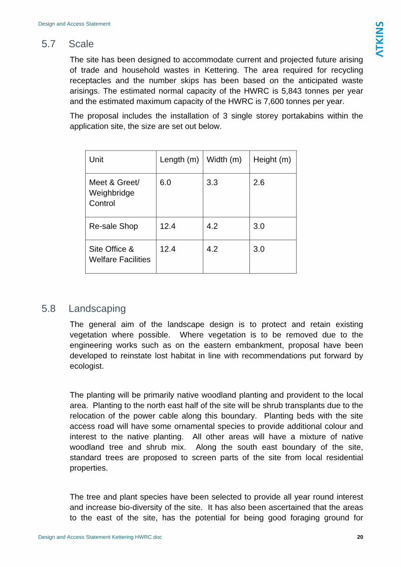
5.7 Scale The site has been designed to accommodate current and projected future arising of trade and household wastes in Kettering. The area required for recycling receptacles and the number skips has been based on the anticipated waste arisings. The estimated normal capacity of the HWRC is 5,843 tonnes per year and the estimated maximum capacity of the HWRC is 7,600 tonnes per year.
The proposal includes the installation of 3 single storey portakabins within the application site, the size are set out below.
Unit Length (m) Width (m) Height (m)
Meet & Greet/ Weighbridge Control
6.0 3.3 2.6
Re-sale Shop 12.4 4.2 3.0
Site Office & Welfare Facilities
12.4 4.2 3.0
5.8 Landscaping The general aim of the landscape design is to protect and retain existing vegetation where possible. Where vegetation is to be removed due to the engineering works such as on the eastern embankment, proposal have been developed to reinstate lost habitat in line with recommendations put forward by ecologist.
The planting will be primarily native woodland planting and provident to the local area. Planting to the north east half of the site will be shrub transplants due to the relocation of the power cable along this boundary. Planting beds with the site access road will have some ornamental species to provide additional colour and interest to the native planting. All other areas will have a mixture of native woodland tree and shrub mix. Along the south east boundary of the site, standard trees are proposed to screen parts of the site from local residential properties.
The tree and plant species have been selected to provide all year round interest and increase bio-diversity of the site. It has also been ascertained that the areas to the east of the site, has the potential for being good foraging ground for
Design and Access Statement
Design and Access Statement Kettering HWRC.doc 21
dormouse. We have therefore, in consultation with the project ecologists, selected species to enhance the areas by proposing hazel (Corylus), ash (Fraxinus), Wayfare (Viburnum lantana) pear (Malnus) and cherry (Prunus). Bat boxes will also be erected in suitable mature trees to the east of the site..
5.9 Noise Two areas of potential noise impact have been assessed – Off site traffic and Recycling Facility Operations. The predicted change in noise levels from increased traffic flow on the local road during the peak period of operation is not considered to be significant.
Noise impacts are predicted to be of less than marginal significance at the rear of properties on Rothwell Road and Poppy Fields. The BS4142 assessment is of the peak period of operation; therefore typical noise levels associated with the recycling facility are anticipated to be lower.
Design and Access Statement
Design and Access Statement Kettering HWRC.doc 22
6 Access 6.1 Access to the Site
The proposed development will have a new access arrangement onto Garrard Way, which joins onto the A4300 at the Telford Way / Warren Hill / Garrard Way roundabout. This will enable vehicles to access the site without passing through the existing Council Depot to the north. The proposed new assess from Garrard Way will be a one way entry and exit system providing a circulatory access road around the application site. The new access will also include a dedicated right turn access to the California car wash facility. A new access also incorporates the existing pedestrian footpath from Garrard Way to the HWRC site.
Through the creation of a new means of access to the proposed application site, the roads surrounding the site will not experience any unacceptable increases in traffic and it is considered that the scheme will have an overall positive impact on the local transport network. The potential issue of traffic congestion caused by the current parking problems along Garrard Way will be addressed through the implementation of a traffic regulation order to reduce on street parking.
6.2 Access within the Site Within the site a circulatory road will be constructed to enable public access to all disposal and recycling areas of the facilities. This will be a one way system which clearly directs visitors around the site and to the parking areas for the different facilities on site. The circulatory road and public areas will be surfaced with bituminous paving. This will allow easy and safe public access to the various recycling facilities and parking areas.
All facilities will be accessible to wheelchair users, including the waste drop-off skips, which will be accessible at-grade. This will be a great improvement on the current HWRC facility in Kettering. Car parking bays dedicated to disabled badge holders have also been included in the facility.
Three parking areas will be provided within the site, these will be at the recycling area, re-sale area and waste drop-off area. Details of these areas are shown on the General Arrangement drawing accompanying the application. At the recycling area, raised drop off area is proposed.
Design and Access Statement
Design and Access Statement Kettering HWRC.doc 23
6.3 Access during construction During the construction period, temporary access for construction vehicles to the application site will be gained via Robinson Way through the existing Kettering Borough Council depot (to the north of the application site) until the construction of the new access from Garrard Way is completed. This is shown in drawing no. 5080830/PLN/102.
Design and Access Statement
Design and Access Statement Kettering HWRC.doc 24
7 Summary and Conclusions It is considered that the design of the proposed development is not in conflict with existing buildings and uses surrounding the site. It will be a low level development, which includes much of the operational elements (e.g. the compacting and bulk movement of material) in the centre and east of the site, away from neighbouring uses. The development will provide an easy to use and well maintained facility for the public.
The site’s location in an existing commercial / industrial area and it’s previously developed nature means that the low key development proposed, with minimal built structures, will not be out of place or intrusive.
Pre-application consultation on the proposed scheme has been undertaken with stakeholders. Overall respondents appeared to be positive about the possibility of a new household waste recycling centre. However there was concern regarding current parking and traffic problems which could be potentially exacerbated by the new recycling centre. These concerns have been taken into account and traffic regulation orders are proposed to be introduced on Garrard Way and the round-about at the top of Garrard Way
The proposed new access arrangements will mitigate current parking and traffic problems and will potentially improve traffic flows on parts of the surrounding road network.
Overall, it is considered that the proposed scheme for the relocation of Kettering’s HWRC will provide a high quality facility for the public, which will be a great improvement on the facilities offered at the existing HWRC. The proposed development has been designed to ensure minimal environmental impact in accordance with sustainability requirements whilst ensuring a reduction of waste to landfill within the area.

Design and Access Statement
Design and Access Statement Kettering HWRC.doc 25
This page has been intentionally left blank.
Design and Access Statement
Design and Access Statement Kettering HWRC.doc 26
Appendix 1.
Consultation information pack containing a letter, conceptual designs and a comment form

Design and Access Statement
Design and Access Statement Kettering HWRC.doc 27
This page has been intentionally left blank.
NORTHAMPTONSHIRE COUNTY COUNCIL
Waste Management
20th December 2008
Report by
Susan Payne
Project Manager
Statement of Community Involvement
Kettering Household Waste Recycling Project
1. Intended Outcome
1.1 To inform Northamptonshire County Council’s planning department of the results of public engagement which was carried out during November and December 2008.
2. Relevant Council Strategic Goal and Priority
2.1 The Medium Term Plan vision is "one council focused on customers and community leadership priorities", to be achieved by the following strategic goals and priorities:.
Corporate Outcomes Council Priority
A cleaner, greener more prosperous county
We will enhance the heritage and environment of Northamptonshire
We will create the conditions for a dynamic economy which ensures that managed growth, infrastructure investment, together with skills and enterprise, increase opportunity for all.
A smaller, more enabling council focused on our customers
We will optimise resources, ensuring appropriate value for money services are provided at the rate of inflation.
2 SCI report final v1.0 5th January 2009 Susan Payne, Project Manager, NCC
The development of a new recycling facility for Kettering will contribute to these key objectives within the Council Plan, helping NCC realise its Strategic aims in relation to the vision for Environment, Growth and Commissioning.
The project also meets with the NCC Waste Management Service Plan 2008-2009 objectives:
To provide existing and future waste management services that are cost effective, high performing and limit the financial impact associated with the Landfill Allowance Trading Scheme.”
3. Background
Northamptonshire County Council’s Waste Management team is currently planning to provide the town of Kettering with a brand new household waste recycling centre (HWRC).
The existing recycling centre in Kettering is located on a small industrial estate on Cunliffe Drive which is accessed directly off Northfield Avenue. It is a well used facility, but is now too small to accommodate the number of visitors wishing to use the centre.
As a consequence the site suffers from queuing traffic on a regular basis. In addition, it is served by a congested highway access route, and traffic from the site often adds to the congestion.
The site also suffers the challenges of being a single level design which necessitates the need for ramps to access the waste containers.
The new HWRC will be relocated and be large enough to accommodate present visitor numbers but also provide for future population growth. It will be a flagship HWRC for the Kettering area that is nearly three times the size of the existing site, and that will provide an excellent customer experience for the rapidly growing local community. It will also contribute towards higher recycling rates and landfill diversion for the county
Kettering Borough Council (KBC) has available land within its Robinson Way Depot, which has been offered to NCC in a spirit of partnership working. The ‘partnership’ provides enhanced working between local authorities, where the land is owned by KBC, and the site is managed by NCC to the joint benefit of the Kettering community.
The HWRC will need to be built and ready for operation as a HWRC by 1st March 2010. This date will coincide with the start of the new long term contract for the HWRC provision which will be procured under the HWRC project which is running concurrently with this project.
Consultation As part of the planning process public consultation has been carried out to ensure that key stakeholders, such as the local community, are aware and consulted on planning proposals involving mineral and waste related development within Northamptonshire. The resulting report will be submitted as part of the planning application.
3 SCI report final v1.0 5th January 2009 Susan Payne, Project Manager, NCC
Consultation was carried out in three ways as follows:
1. An information pack containing a letter, conceptual designs and a comment form (see Appendix A) was sent directly to the following:
All business owners on Telford Way Industrial Estate Private households within the vicinity of the proposed HWRC location All town and parish councils within the borough of Kettering Community groups and organisations
2. A display detailing the scheme, plans and conceptual designs was erected at the present
recycling centre (see appendix B). Comment forms were provided for site visitors to complete and return to NCC.
3. The scheme was displayed on the NCC website where a form was also available for comments. (see appendix C)
The consultation was for a period of three weeks from Monday 24th November until Friday 12th December. Consultation has also been carried out with other groups as follows:
Group Sub-groups / key people NCC Councillors and cabinet members (during a learning lunch 14th October)
Clr Ben Smith NCC Clr Bill Parker NCC Cllr Micheal Hill NCC
HWRC project board Kettering HWRC project board Wade Siddiqui – NCC Waste Operations and Capital
Manager Cllr Micheal Hill – board member Doug Wilkinson – KBC Head of Environmental Services
NCC planning team NCC corporate communications team
NCC highways team District and Borough Councils Kettering Borough Council
Cllr Micheal Hill, Northampton Borough Council Local residents Community groups Local business owners
Council consultation
Cabinet Member for the Environment
4 SCI report final v1.0 5th January 2009 Susan Payne, Project Manager, NCC
Results
A total of 211 information packs were sent directly to local business owners and residents, Parish councils and other community groups. (See appendix D)
A total of 11 replies were received via the comment form and by email (See appendix E)
A breakdown of the comments are as follows:
5 respondents raised concerns regarding the impact of increased traffic from the recycling centre. At present cars are parked along the full length of Garrard Way and the adjacent grassed verges. It appears that most of this traffic is from visitors and staff from the hospital nearby.
5 respondents raised queries which pertained to the actual operations and contract management of the service. Such examples included on site traffic management, provision of containers for certain waste streams and the management of litter.
1 respondent (a company adjacent) stated that they would be pleased to see the scheme succeed but they objected to the proposed access road lay-out. However NCC have negotiated access rights with the company and the above issue has been resolved.
1 respondent stated that he was in favour of the proposed re-location of the HWRC.
Conclusion
Overall respondents appeared to be positive about the possibility of a new household waste recycling centre. However there was concern regarding current parking and traffic problems which could be potentially exacerbated by the new recycling centre.
At present Garrard Way suffers from a high number of vehicles being parked along the length of Garrard Way and the grassed verges. It appears that the vehicles are being left by employees and visitors from the nearby hospital. This has an impact on access for local businesses and their employees and also safety.
Recommendation
To mitigate traffic queues on site a passing lane will be created to enable users to bypass the unloading bays. There will be ample car parking spaces for users to access the re-use area, small recyclables area and unloading bays. The site will be split level to reduce windblown rubbish and make it easier for people to unload their vehicles and deposit their waste into the waste containers.
With regards to the parking and traffic issues along Garrard Way; Highways were contacted for advice and as a result a highways officer visited the road in question.
The resulting advice was that parking restrictions would be required to ensure that the road is unobstructed for traffic visiting what will be a local amenity. A traffic management plan will be submitted as part of the planning application detailing our proposals.
5 SCI report final v1.0 5th January 2009 Susan Payne, Project Manager, NCC
Highways also advised that a transport statement detailing the expected numbers and types/sizes of service vehicles will also be submitted within the planning application. To ensure that the above is resolved we will continue to work closely with highways.
4. List of Appendices
Appendix A - information pack Appendix B - public information display Appendix C - information displayed on NCC website Appendix D - contacts used Appendix E - responses
Author: Name: Susan Payne Team: Waste Management
Contact details: Tel: 01604 237266 Email: [email protected]
Appendix A

6 SCI report final v1.0 5th January 2009 Susan Payne, Project Manager, NCC
Information pack Appendix B

7 SCI report final v1.0 5th January 2009 Susan Payne, Project Manager, NCC
Public information display Appendix C

8 SCI report final v1.0 5th January 2009 Susan Payne, Project Manager, NCC
Information displayed on NCC website Appendix D

9 SCI report final v1.0 5th January 2009 Susan Payne, Project Manager, NCC
Contacts used Appendix E Responses

10 SCI report final v1.0 5th January 2009 Susan Payne, Project Manager, NCC
Waste Management P.O. Box No. 163 County Hall Northampton NN1 1AX w. www.northamptonshire.gov.uk t. 01604 237440 f. 01604 237331
hi f @ h hi k
I am writing you a courtesy letter to inform you of our plans to build a replacement Household Waste Recycling Centre (HWRC) for the town of Kettering. As part of the process we would like to give an opportunity for the local community to have their say; the outcome of which will form a ‘Statement of Community Involvement’ which will be submitted as part of the planning application. A Statement of Community Involvement ensures that key stakeholders, such as the local community, are aware and consulted on planning proposals involving mineral and waste related development within Northamptonshire. The existing recycling centre in Kettering is located on a small industrial estate on Cunliffe Drive which is accessed directly off Northfield Avenue. It is a well used facility, but is now too small to accommodate the number of visitors who wish to use it. As a consequence the site suffers from queuing traffic on a regular basis. The site also suffers the challenges of being a single level design which necessitates the need for ramps to access the waste containers. The proposed new HWRC will be relocated to the land which forms part of the Kettering Borough Council Depot, Telford Way Industrial Estate, Kettering and will be accessed from Garrard Way. Its primary purpose will be to improve customer satisfaction and contribute towards a higher recycling performance for the county of Northamptonshire. It will also be large enough to accommodate present visitor numbers but provide for future population growth. We also hope to introduce a small trade waste service which will accommodate waste from local businesses. The site will be landscaped on all sides with trees and shrubs and the waste containers will be located on the lower level area as detailed in the enclosed plan. It will meet all planning guidelines and provide the town of Kettering with a much improved facility. As already carried out on the current site, strict management of litter, odour and pest control will apply to the new site.
The Occupier To Whom It May Concern
Date: 21st November 2008
The opening hours will be no more than from 8.30am – 7.00pm throughout the year. Existing traffic count information indicates that peak usage will occur at weekends. We hope to apply for planning permission by the end of this year and if successful the new Kettering HWRC is planned to be built and ready to open to the public by April 2010. Enclosed is a plan of the site layout and also a 3D image showing the split level design ; however please note that these plans and images are conceptual but do give a good indication of how the site will appear. Should you wish to make any comments we have enclosed a form for you to complete and return to us by Friday 12th December 2008. You can also log your response on the Northamptonshire County Council Waste Management website. The deadline for electronic submissions is Friday 12th December 2008. The website address is as follows: www.northamptonshire.gov.uk/environment/waste There will also be a display of the project at the current household waste recycling centre on Cunliffe Drive, Kettering where there will be forms available to complete and send to us by Friday 12th December 2008. Yours sincerely Susan Payne Project Manager Waste Management County Hall PO Box 163 Northampton NN1 1AX
Waste Management P.O. Box No. 163 County Hall Northampton NN1 1AX w. www.northamptonshire.gov.uk t. 01604 237440 f. 01604 237331
hi f @ h hi k
We would like to inform you of our plans to build a replacement Household Waste Recycling Centre (HWRC) for the town of Kettering. As part of the process we would like to give an opportunity for the local community to have their say; the outcome of which will form a ‘Statement of Community Involvement’ which will be submitted as part of the planning application. A Statement of Community Involvement ensures that key stakeholders, such as the local community, are aware and consulted on planning proposals involving mineral and waste related development within Northamptonshire. The existing recycling centre in Kettering is located on a small industrial estate on Cunliffe Drive which is accessed directly off Northfield Avenue. It is a well used facility, but is now too small to accommodate the number of visitors who wish to use it. As a consequence the site suffers from queuing traffic on a regular basis. The site also suffers the challenges of being a single level design which necessitates the need for ramps to access the waste containers. The proposed new HWRC will be relocated to the land which forms part of the Kettering Borough Council Depot, Telford Way Industrial Estate, Kettering and will be accessed from Garrard Way. Its primary purpose will be to improve customer satisfaction and contribute towards a higher recycling performance for the county of Northamptonshire. It will also be large enough to accommodate present visitor numbers but provide for future population growth. We also hope to introduce a small trade waste service which will accommodate waste from local businesses. The site will be landscaped on all sides with trees and shrubs and the waste containers will be located on the lower level area as detailed in the enclosed plan. It will meet all planning guidelines and provide the town of Kettering with a much improved facility. As already carried out on the current site, strict management of litter, odour and pest control will apply to the new site. The opening hours will be no more than from 8.30am – 7.00pm throughout the year. Existing traffic count information indicates that peak usage will occur at weekends.
Date: 21st November 2008
We hope to apply for planning permission by the end of this year and if successful the new Kettering HWRC is planned to be built and ready to open to the public by April 2010. Click the links below to a plan of the site layout and also a 3D image showing the split level design; however please note that these plans and images are conceptual but do give a good indication of how the site will appear. Should you wish to make any comments please print off the comments form and return to us by Friday 12th December 2008. There will also be a display of the project at the current household waste recycling centre on Cunliffe Drive, Kettering where there will be forms available to complete and send to us by Friday 12th December 2008.

Waste Management is currently planning to provide the town of Kettering with a brand new household waste recycling centre.
The current centre is a well used facility, but is too small to accommodate the number of visitors and as consequence the site suffers from queuing traffic on a regular basis.
The site also suffers the challenges of being a single level design which necessitates the need for ramps to access the waste containers.
A new recycling centre for Kettering Town

The proposed new HWRC will be relocated to the land which forms part of the Kettering Borough Council Depot, Telford Way Industrial Estate, Kettering and will be accessed from Garrard Way.
Its primary purpose will be to improve customer satisfaction and contribute towards a higher recycling performance for the county of Northamptonshire.
It will also be large enough to accommodate present visitor numbers but provide for future population growth.
The new Kettering HWRC is planned to be built and ready to open to the public by April 2010

Proposed new site location off Gerrard Way, Telford Way Industrial Estate, Kettering.
The conceptual designs below are not the final designs but they do give a good indication of how the site may look.

Statement of Community Involvement
As part of the process we would like to give an opportunity for the local community to have their say; the outcome of which will form a ‘Statement of Community Involvement’ which will be submitted as part of the planning application.
A Statement of Community Involvement ensures that key stakeholders, such as the local community, are aware and consulted on planning proposals involving mineral and waste related development within Northamptonshire.

You can submit your comments by completing a form that can be obtained from a member of the recycling centre staff and returning it to Northamptonshire County Council by Friday 12th December 2008.
You can also log your response on the Northamptonshire County Council Waste Management website at the following address by Friday 12th December 2008.www.northamptonshire.gov.uk/environment/waste
Have your say...
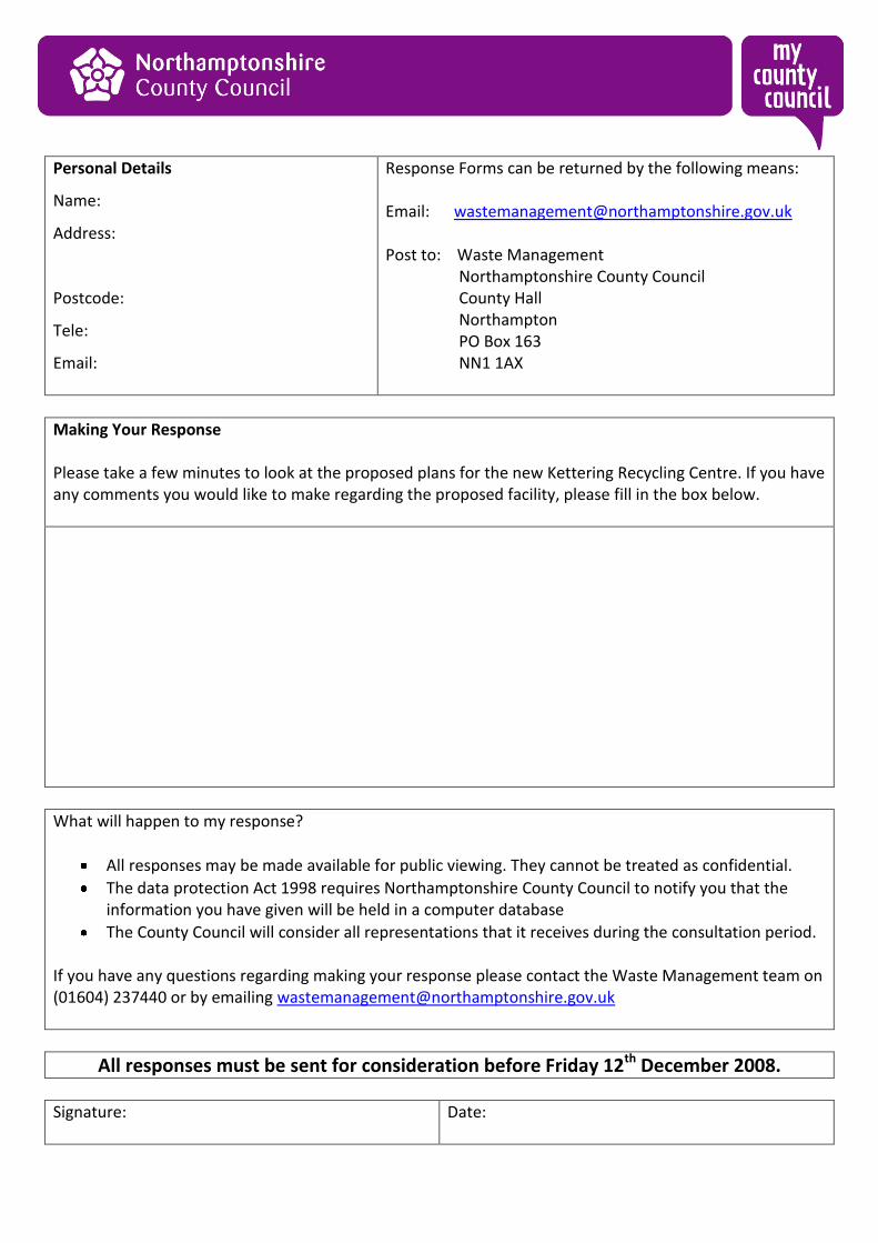
Personal Details
Name:
Address:
Postcode:
Tele:
Email:
Response Forms can be returned by the following means: Email: [email protected] Post to: Waste Management Northamptonshire County Council County Hall Northampton PO Box 163 NN1 1AX
Making Your Response Please take a few minutes to look at the proposed plans for the new Kettering Recycling Centre. If you have any comments you would like to make regarding the proposed facility, please fill in the box below.
What will happen to my response?
All responses may be made available for public viewing. They cannot be treated as confidential.
The data protection Act 1998 requires Northamptonshire County Council to notify you that the information you have given will be held in a computer database
The County Council will consider all representations that it receives during the consultation period. If you have any questions regarding making your response please contact the Waste Management team on (01604) 237440 or by emailing [email protected]
All responses must be sent for consideration before Friday 12th December 2008.
Signature:
Date:

Personal Details
Name:
Address:
Postcode:
Tele:
Email:
Response Forms can be returned by the following means: Email: [email protected] Post to: Waste Management Northamptonshire County Council County Hall Northampton PO Box 163 NN1 1AX
Making Your Response Please take a few minutes to look at the proposed plans for the new Kettering Recycling Centre. If you have any comments you would like to make regarding the proposed facility, please fill in the box below.
What will happen to my response?
All responses will be made available for public viewing. They cannot be treated as confidential.
The data protection Act 1998 requires Northamptonshire County Council to notify you that the information you have given will be held in a computer database
The County Council will consider all representations that it receives during the consultation period. If you have any questions regarding making your response please contact the Waste Management team on (01604) 237440 or by emailing [email protected]
All responses must be sent for consideration before Friday 12th December 2008.
Signature:
Date:
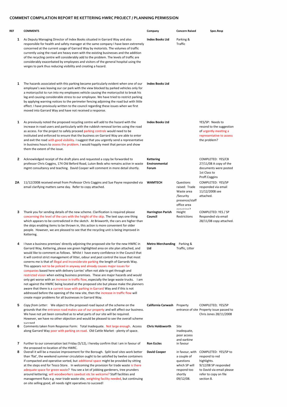
COMMENT COMPILATION REPORT RE KETTERING HWRC PROJECT / PLANNING PERMISSION
REF COMMENTS Company Concern Raised Spec.Resp
1 As Deputy Managing Director of Index Books situated in Garrard Way and also responsible for health and safety manager at the same company I have been extremely concerned at the current usage of Garrard Way by motorists. The volumes of traffic currently using the road are heavy even with the existing businesses and the addition of the recycling centre will considerably add to the problem. The levels of traffic are considerably exacerbated by employees and visitors of the general hospital using the verges to park thus reducing visibility and creating a hazard.
Index Books Ltd
1 The hazards associated with this parking became particularly evident when one of our employee’s was leaving our car park with the view blocked by parked vehicles only for a motorcyclist to run into my employees vehicle causing the motorcyclist to break his leg and causing considerable stress to our employee. We have tried to restrict parking by applying warning notices to the perimeter fencing adjoining the road but with little effect. I have previously written to the council regarding these issues when we first moved into Garrard Way and have not received a response.
Index Books Ltd
1 As previously noted the proposed recycling centre will add to the hazard with the increase in road users and particularly with the rubbish removal lorries using the road as access. For the project to safely proceed parking controls would need to be instituted and enforced to ensure that the business on Garrard Way are able to enter and exit the road with good visibility. I suggest that you urgently send a representative in business hours to assess the problem. I would happily meet that person and show them the extent of the issue.
Index Books Ltd YES/SP: Needs to resond to the suggestion of urgently meeting a representative to assess the problem?
2 Acknowledged receipt of the draft plans and requested a copy be forwarded to professor Chris Coggins, 174 Old Beford Road, Luton Beds who remains active in waste mgmt consultancy and teaching. David Cooper will comment in more detail shortly.
Kettering Environmental Forum
COMPLETED: YES/CB 27/11/08 A copy of the documents were posted 1st Class to Proff.Coggins
2A 11/12/2008 received email from Professor Chris Coggins and Sue Payne responded via email clarifying matters same day. Refer to copy attached.
WAMTECH Questions raised: Trade Waste area /Security presence/staff office area provision?
COMPLETED: YES/SP responded via email 11/12/2008 see attached.
3 Thank you for sending details of the new scheme. Clarification is required please concerning the level of the cars with the height of the skip. The text says one thing which appears to be contradicted in the sketch. At Brixworth, the cars are higher than the skips enabling items to be thrown in, this action is more convenient for older people. However, we are pleased to see that the recycling unit is being improved in Kettering.
Harrington Parish Council
Height Restrictions
COMPLETED: YES / SP Responded via email 28/11/08 copy attached.
4 I have a business premises' directly adjoining the proposed site for the new HWRC in Garrard Way, Kettering, please see green highlighted area on site plan attached, and would like to comment as follows. Whilst I have every confidence in the Council that it will control strict management of litter, odour and pest control the issue that most conerns me is that of illegal and inconsiderate parking the length of Garrards Way. This appears not to be policed in anyway and already causes major issues for companies based here with delivery Lorries' often not able to get through and restricted vision when exiting business premises. These are major hazards and would only get worse with an increase in traffic flow, especially the large waste trucks. I am not against the HWRC being located at the proposed site but please make the planners aware that there is a current issue with parking in Garrard Way and if this is not addressed before the opening of the new site, then the increase in traffic flow will create major problems for all businesses in Garrard Way.
Metro Merchanding Ltd
Parking & Traffic, Litter
5 Copy from Letter: We object to the proposed road layout of the scheme on the grounds that the entrance road makes use of our property and will affect our business. We have not yet been consulted as to what parts of our site will be required. However, we have no other objection and would be pleased to see the overall scheme succeed.
California Carwash Property entrance of site
COMPLETED; YES/SP Property issue passed to Chris Jones 28/11/2008
6 Comments taken from Response Form: Total Inadequate. Not large enough. Access along Garrard Way poor with parking on road. Old Cattle Market ‐ plenty of space.
Chris Holdsworth Site inadequate, poor access and parking
7 Further to our conversation last Friday (5/12), I hereby confirm that I am in favour of the proposed re‐location of the HWRC.
Ron Eccles in favour
8 Overall it will be a massive improvement for the Borough. Split level sites work better than 'flat', the weekend summer circulation ought to be satisfied by twelve containers if compacted and operative sorted, but additional space might be provided by sitting at the steps end for Tesco Store. In welcoming the provision for trade waste is there adequate space for green waste? You see a lot of jobbing gardeners, tree prunders around kettering; will woodworkers sawdust etc be welcome? Staff facilities and management fluts e.g. near trade waste site, weighting facility needed, but continuing on site selling good, all needs right operatives to succeed!
David Cooper in favour, with a couple of questions which SP will respond too shortly 09/12/08.
COMPLETED: YES/SP to respond to red highlights. 9/12/08 SP responded to David via email please refer to copy on file section 8.
Parking & Traffic
9 Response Form reads: Our main concern is the increased traffic flow likely in Garrard Way. Currently there is unrestricted parking in Garrard Way which can impact on access to Garrard Court. Increased traffic flow will exacerbate this problem which in turn could reduce the propertys appeal to occupiers both existing and potential and to other businesses in the vicinity. Restricting parking on Garrard Way by way of double yellow lines would ease the problem for both existing businesses and people wishing to use the proposed recycling plant.
Phillip Betts increased traffic flow
10 Response Form reads: Rothwell Town Council is pleased that the recycling centre in Kettering is to be enlarged and updated. However, the causal parking on Garrard Way will need to be addressed so that access to the new recycling centre is kept open and free of obstruction.
Carolyn Mackay Clerk Rothwell Town Council
casual parking
11 Response Form reads: * Site access road currently used by car wash. Customer will have to cross the road and share main entrance. Suggested road width of 7.6m which will allow 2 lorries to pass and a car in dedicated turning lane. * 12.3M rad to site access is not possible as this will encroach on antoher property. * Visitors will be required to reverse into parking bays against the flow of traffic which will be a problem. By parking cars side by side to off load there is no room for offloading from car doors as well as boot. Apart from the obvious space restriction, damage to neighboruing cars is very unlikely. * Many delays are currently caused by people holding up the queueing traffic because they are waiting for a space by a specific bay. The design that is shown would not improve this problem. *Full fire suppression system should be mandatory with special note taken to ensure that no spillage can go on to the railway line which forms part of boundary. *The recycling area needs to be drained to a tank which is emptied and not let into the existing surface water drainage
Mrs Ros Gresham Broughton Parish Council

Design and Access Statement
Design and Access Statement Kettering HWRC.doc 28
Land to the Rear of Kettering Depot,
Proposed Household Waste Recycling Centre
(HWRC)Planning Supporting Statement
April 2009

This page has been intentionally left blank.
Planning Supporting Statement Kettering HWRC.doc
Land to the Rear of Kettering depot, Robinson Way, Proposed Household Waste Recycling Centre ( HWRC)
Planning Supporting Statement
April 2009 Notice This report was produced by Atkins Ltd for Northamptonshire County Council for the specific purpose of supporting a planning application for a Household Waste Recycling Centre on surplus land to the rear of Kettering Borough Council’s Robinson Way depot.
This report may not be used by any person other than Northamptonshire County Council without Northamptonshire County Council’s express permission. In any event, Atkins accepts no liability for any costs, liabilities or losses arising as a result of the use of or reliance upon the contents of this report by any person other than Northamptonshire County Council.
Atkins Limited
Document History
JOB NUMBER: 5080830 DOCUMENT REF: Planning Supporting Statement Kettering HWRC
01 Draft (PSS previously prepared and reviewed 15/01/2007)
YP RB JD
Revision Purpose Description Originated Checked Reviewed Authorised Date

Planning Supporting Statement
Planning Supporting Statement Kettering HWRC.doc 4
This page has been intentionally left blank.
Planning Supporting Statement
Planning Supporting Statement Kettering HWRC.doc 5
Contents Section Page 1. Introduction 10 1.1 Outline 10 1.2 Structure of the Report 10 1.3 Background 11 1.4 The Proposal 12 1.5 Existing Site Use 12 2. Description of the site and surroundings 13 2.1 Location 13 2.2 The Application Site 13 2.3 Surroundings 13 3. Description of the development 15 3.1 Overview 15 3.2 Characteristics of the proposed (HWRC) development 15 3.3 Purpose of the proposed new HWRC development 16 3.4 Need to Relocate Kettering’s HWRC 16 3.5 The Proposed Site and Operations 17 4. Planning Policy 27 4.1 Introduction 27 4.2 National Planning Policy 27 4.3 Regional Planning Policy 29 4.4 Northamptonshire Waste Local Plan 30 4.5 Northamptonshire Minerals and Waste Development Framework 33 4.6 Kettering Local Plan 37 4.7 Conclusion 37 5. Scheme Impacts 38 5.1 Introduction 38 5.2 Ecological Impacts 38 5.3 Lighting 39 5.4 Noise 39 5.5 Air Quality 39 5.6 Surface and Foul Water 40 5.7 Archaeological Impacts 40 5.8 Transport Impacts 40 6. Summary and Conclusions 41
Planning Supporting Statement
Planning Supporting Statement Kettering HWRC.doc 6
Appendices Appendix A A.1 5080830/PLN/001 – Site Location Plan A.2 5080830/PLN/002 – Application Boundary A.3 5080830/PLN/100 – General Arrangement Plan A.4 5080830/PLN/101 – Sections A.5 5080830/PLN/102 – Elevations A.6 5080830/PLN/103 – Portakabin Layout / Elevations (Sheet 1 of 2) A.7 5080830/PLN/104 – Portakabin Layout / Elevations (Sheet 2 of 2) A.8 5080830/PLN/105 – Landscaping Plan A.9 5080830/PLN/106 – Access Road Appendix B B.1 Design and Access Statement (DAS); B.2 Environmental Review of a factual Ground Investigation Report; B.3 Ecological Assessments: B.4 Landscaping Scheme; B.5 Transport Assessment; B.6 Noise Assessment; and B.7 Air Quality Assessment. Appendix C C.1 Site Entrance Signage C.2 Site Entrance Information Boards Appendix D D.1 Waste Audit Case Studies: Appendix E E.1 Building Specification Appendix F F.1 Site Photos
List of Tables
Table 1.1-Portakabin Dimensions 18

Planning Supporting Statement
Planning Supporting Statement Kettering HWRC.doc 7
This page has been intentionally left blank.

Planning Supporting Statement
Planning Supporting Statement Kettering HWRC.doc 8
Abbreviations Abbreviation Full Term
AOD Above Ordnance Datum
BPEO Best Practical Environmental Option
BPEO Best Practicable Environmental Option
BS British Standards
C&I Commercial & Industrial
CCTV Closed Circuit Television
COSHH Control of Substances Hazardous to Health
DPD Development Plan Document
EA Environment Agency
EIA Environmental Impact Assessment
EMRA East Midlands Regional Assembly
EMRSS East Midlands Regional Spatial Strategy
FRA Flood Risk Assessment
FRA Flood Risk Assessment
GCN Great Crested Newts
HGV Heavy Goods Vehicle
HP High Powered
HWRC Household Waste Recycling Centre
LPA Local Planning Authority
MSW Municipal Solid Waste
MWDF Minerals and Waste Development Framework
NCC Northamptonshire County Council
NE Natural England
NO2 Nitrogen Dioxide
PM10 Particulate Matter
PMW Precautionary Method of Working
PPG Planning Policy Guidance
PPS Planning Policy Statement
RSS Regional Spatial Strategy
SCI Statement of Community Involvement
SPD Supplementary Planning Document
TA Transport Assessment
TROs Traffic Regulation Orders
WPA Waste Planning Authority

Planning Supporting Statement
Planning Supporting Statement Kettering HWRC.doc 9
This page has been intentionally left blank.
Planning Supporting Statement
Planning Supporting Statement Kettering HWRC.doc 10
1. Introduction 1.1 Outline
Atkins Ltd has been instructed by Northamptonshire County Council (NCC) to submit an application for full and permanent planning permission for the relocation of the existing Kettering Household Waste Recycling Centre (HWRC), to the land situated at the rear of the Kettering Borough Council depot on Robinson Way located within Telford Way Industrial Estate, Kettering.
The requirement for this application by NCC is driven by the review of the existing HWRC facilities for Kettering, which identified a need to relocate the existing HWRC on Cunliffe Drive to a nearby site situated at the rear of Kettering Borough Council’s Depot. The new HWRC will replace the existing facility and serve the Kettering area. The new facility will provide recycling, and waste disposal facilities to the public, and an improved vehicular access.
A previous planning application that proposed the relocation of the Kettering HWRC was submitted and subsequently withdrawn in 2007. That scheme included the construction of an access road to the east of the site, along the edge of an existing balancing lagoon. The proposals were later reviewed and developed with a revised location for the access road; this option was named the Derwent Option, involving the reconfiguration on an exiting entrance formation of an access road directly from Garrard Way, providing a dedicated right turn access to the existing car wash facility.
This planning application is for a proposal which is based on the Derwent access option.
1.2 Structure of the Report This statement, which has been prepared to support the planning application for the proposed development contains the following:
A description of the site and the surroundings;
A description of the proposed development including dimensions, materials, drainage;
Demonstration of the need for the development;
A review of national, regional and local planning policy focussing on sustainability, waste management and other material planning matters;
An assessment of the impact of the proposed development; and
A summary.
Appendix A contains the following drawings
5080830/PLN/001 – Site Location Plan
5080830/PLN/002 – Application Boundary
5080830/PLN/100 – General Arrangement Plan
5080830/PLN/101 – Sections
Planning Supporting Statement
Planning Supporting Statement Kettering HWRC.doc 11
5080830/PLN/102 – Elevations
5080830/PLN/103 – Portakabin Layout / Elevations (Sheet 1 of 2)
5080830/PLN/104 – Portakabin Layout / Elevations (Sheet 2 of 2)
5080830/PLN/105 – Landscaping Plan
5080830/PLN/106 – Access Road
Appendix B contains the following various assessments/information in support of the planning application:
Design and Access Statement (DAS);
Environmental Review of a Factual Ground Investigation Report;
Ecological Assessments;
Landscaping Scheme;
Transport Assessment;
Noise Assessment; and
Air Quality Assessment.
Appendix C contains:
Site Entrance Signage; and
Site Entrance Information Boards.
Appendix D contains:
Waste Audit Case Studies
Appendix E contains:
Building Specification
Appendix F contains:
Site Photos
1.3 Background With regard to the potential requirement for an Environmental Impact Assessment (EIA) for the original development proposals, a letter was sent to Northamptonshire County Council requesting a screening opinion in accordance with the Town and Country Planning (EIA) (England and Wales) Regulations 1999 (as amended). The County Council, as Waste Planning Authority subsequently responded, stating that it is satisfied that the scheme will not result in significant environmental impacts and therefore does not consider the proposal to require an EIA. The circumstances have not changed significantly from the previous application. Pre-application

Planning Supporting Statement
Planning Supporting Statement Kettering HWRC.doc 12
discussions with the Waste Planning Authority indicated that an Screening Process would be undertaken on receipt application and if the scheme was similar to the previous proposal and supported by the same level of information it was unlikely a EIA would be required. The current scheme introduces a new access which is located to minimise impacts to the lagoon area but in essence it is similar in nature to the original proposals and supported by a variety of surveys and studies considering key aspect of the scheme. Therefore, it is considered an EIA would not be required.
1.4 The Proposal The existing Kettering HWRC located on Cunliffe Drive, has been identified following a Strategic Review of HWRC’s for improvement as a requirement to fulfil national requirements for the sustainable management of waste. The existing HWRC is too small to accommodate an extensive recycling service.
Furthermore, the growing volume of traffic during peak times of operation particularly at weekends and during times when Kettering Town Football Club is playing its home matches has led to traffic congestion in the area.
The proposed new site for the Kettering HWRC is on the land situated to the rear of the existing Kettering Borough Council Robinson Way Depot which is located within Telford Way Industrial Estate. The new facility will be accessed from Garrard Way via a new access road which will be reconfigured from the existing entrance to the California Car Wash.
The new HWRC includes a number of new structures including the permanent installation of three portakabin type units providing shop, office and welfare facilities and the installation of a new weighbridge for weighing trade waste.
The scheme will include a cut and fill exercise to re-contouring of the site and the construction of a series of retaining structures which will create the split level HWRC.
The development includes a proposal re-engineer a section of the western lagoon embankment to support the new facility. The affected section of the existing lagoon embankment will be cleared and the soil materials will be removed to and then engineered to form a 1 in 1.5 reinforced earth retaining structure.
Further details of the components and features of the proposed Household Waste Recycling Centre are set out in paragraph 3.2 Characteristics of the proposed HWRC development below. .
1.5 Existing Site Use The application site is currently used as additional depot space by Kettering Borough Council (KBC).
The site contains a greenhouse used for propagating plants for the Borough Council’s Municipal landscaping schemes, and a casual temporary storage area. A new and smaller propagation greenhouse is to be relocated within the KBC depot; this is currently the subject of planning application to reconfigure various aspect of the depot being considered by the Local Planning Authority. The site slopes down from the west to the east with a terrace area used as the extension to the Council Depot. The land has been identified by the Council as surplus to the depot’s requirements.
Planning Supporting Statement
Planning Supporting Statement Kettering HWRC.doc 13
2. Description of the site and surroundings 2.1 Location
The application site is located on Garrard Way within the Telford Way Industrial Estate on the south-west side of Kettering. The site is approximately 1km North West of Kettering Town Centre and approximately 1.0km to the South East of the A14/A43 junction providing access to the primary road network. Currently, access to the site is through the existing Kettering Borough Council Depot to the north of the site via Robinson Way. Drawing 5080830/PLN/001 indicates the location of the application site.
The current HWRC serving the Kettering area is located on Cunliffe Drive, off Northfield Avenue (A600) which is approximately 400m to the North East of the proposed facility.
The location of the existing HWRC and the application site is shown within drawing 5080830/PLN/001 (Site Location Plan), Appendix A.
2.2 The Application Site The application site is approximately 0.95 hectares in size and located on the north-west side of Kettering, grid reference SP859794 (Easting: 485922; Northing: 279431).
The site is brownfield, currently comprising a surplus area of the Council depot, a small section of an adjacent drainage lagoon, and is located within Telford Way Industrial Estate. The existing buildings, yards and car parks are set in an irregular shaped plot. Within the Kettering Local Plan, the area is designated for employment*.
The application site area also includes the access and a surplus area of land on the western fringe of the California Car Wash Site, the land comprises grassland and concrete hardstanding forming part of the internal road system. Part of the application site includes the western lagoon embankment.
The application site is situated at an elevation of between 80-86m AOD (Above Ordnance Datum). The nearest flood risk zone relates to Slade Brook that flows north to south approximately 275m to the east beyond the railway. The channel of the Brook lies at approximately 70m AOD at its proximal point.
2.3 Surroundings The site is located in a predominantly industrial area on the edge of Kettering urban area within Telford Road Industrial Estate. Approximately 130m to the south of the site are the nearest residential properties. The main residential area is situated beyond the railway line to the east of the site. Industrial properties adjacent to the site are largely clad steel frame warehouse style buildings. To the east of the site is a railway line, which runs along an embankment. To the south of the site is a car wash facility which in part forms the new access. The area is extensively illuminated by street and security lighting at the adjacent industrial and commercial premises and advertising lighting at the car wash.
* Kettering Local Plan adopted 1995 (saved policies)
Planning Supporting Statement
Planning Supporting Statement Kettering HWRC.doc 14
The application site consists of two principal areas. The southern section of the site comprises surplus grassland and hardstanding and the access to the existing Car Wash Facility. The northern section of the site is the surplus area of the Kettering Borough Council depot. Located to the east of the site is a large balancing pond (lagoon) built to accommodate excess surface water from the industrial estate. Beyond the lagoon area, the site is screened from the railway by an existing tree line.
Planning Supporting Statement
Planning Supporting Statement Kettering HWRC.doc 15
3. Description of the development 3.1 Overview
NCC proposes develop a new HWRC at Garrard Way, Telford Way Industrial Estate, Kettering. The HWRC will be located in the northern section of the site while the new access arrangement forms the southern section of the application area.
The HWRC will provide Kettering with a replacement facility for the disposal of trade waste and general household waste, the site will offer recycling areas for materials such as green garden waste, DIY related building waste, paper, cardboard, glass, cans, plastics and metal. The design of the facility will enable the public to easily access recycling bins and skips for different waste streams.
3.2 Characteristics of the proposed (HWRC) development The proposed development will include:
A new vehicular site access from Garrard Way and circulatory road around the edge of the site, to be surfaced with bituminous paving. The new access will also incorporate a pedestrian access.
A split level drop-off area for large recyclables with approximately 13 skip containers which will provide the public with easy access for dropping off recyclable items. Each skip will be clearly signed with the relevant material to be recycled.
A ‘Portakabin’ style structure containing an office for the site manager and welfare facilities for staff;
An at Grade Recycling area with recycling bins for small recyclables, and a ‘Portakabin’ style structure providing a meet and greet /weighbridge control office incorporating an accessible toilet available to users of the site The recycling areas will include freestanding containers and vaults;
Operations area has been designed to accommodate 13 skips approximately 6.48m long by 2.4m wide by 2.6m high and sufficient space for HGV’s to manoeuvre in order to empty of skips and removal of materials from the site. This area will be surfaced with concrete paving;
Re-sale area covered by a canopy where goods brought onto site are offered for sale to the public. A ‘Portakabin’ style structure containing a Shop for Resale of Goods to the Public. A wall will separate the operations area from the resale area which will be approximately 2.6m lower than the operation area;
24 parking spaces for members of the public who use the site; 4 located at the resale area, 8 at the recycling area and 12 adjacent to the split level drop-off area;
A staff parking area with approximately 4 spaces;
A 3.66m by 1.52m site sign will be erected outside the entrance to the HWRC. The sign will identify the facility and is to be located to the east of the new security gates;
Planning Supporting Statement
Planning Supporting Statement Kettering HWRC.doc 16
It is proposed to locate a Community Art Wall within the facility, to highlight and promote the waste minimisation and recycling within the local community. Details of the art wall have not been finalised. Therefore, the applicant would accept a condition relating to the detail, size and position of the feature.
Trade waste weighbridge;
Soft landscaping around the periphery of the site and replacement habitat planting;
Lighting; and
New 2.4m high Perimeter Security Fencing and Close Circuit Television (CCTV) system.
3.3 Purpose of the proposed new HWRC development In 2003 a HWRC working group was set up by NCC to assess the current provision of HWRCs in the County and formulate ways in which the service would be improved. The working group comprised of elected members from two scrutiny committees assessing the HWRCs to reach a set of recommendations for improving the current service.
The working group recommended generic improvements for all HWRCs in the County. These were aimed at providing increased recycling facilities, improved public access to the sites and safer, easier movement within the sites. Additionally, the group identified issues with specific sites. For Kettering the group concluded that the existing HWRC was not adequate for its purpose and that support should be given for a capital bid to replace it. Therefore, an alternative site was identified near to the existing HWRC.
The main limitations of the existing HWRC site are:
A lack of space for adequate recycling and waste sorting areas; and
Problems caused by traffic congestion at peak use times (the traffic issues are looked at in more detail later in this section).
3.4 Need to Relocate Kettering’s HWRC The existing HWRC is located on a small industrial estate on Cunliffe Drive which is accessed directly off Northfield Avenue. It is a well used facility, with a limited ability to cope with the large number of vehicles trying to access the site at peak periods of activity.
As a consequence the site suffers from queuing traffic on a regular basis. In addition, it is served by a congested highway access route, and traffic from the site often adds to the congestion.
The site also suffers the challenges of being a single level design which necessitates the need for ramps to access the waste containers.
The need to relocate the existing HWRC to an open space next to the existing KBC depot off Robinson Way is based on the need to provide a facility large enough to accommodate present visitor numbers as well as catering for future population growth in the Kettering area. The proposed development will provide a HWRC with an improved modern facility operating efficiently to a level which will enable sustainability as well as providing the disposal areas for other recycling materials. It will also contribute towards higher recycling rates and landfill diversion for the county.
Planning Supporting Statement
Planning Supporting Statement Kettering HWRC.doc 17
The proposed location offers a good and easily accessible facility with better vehicular connections to the road network to alleviate the existing traffic congestion at peak periods on the existing site.
3.5 The Proposed Site and Operations The proposal is for a Household Waste Recycling Centre (HWRC) which will consist of predominately hardstanding areas with landscaping around the perimeter of the site. The users of the application site will include members of the public depositing waste and / or recyclables and employees operating the site.
Access
The new site access road from Garrard Way includes the retention of an existing footpath (drawing 5080830/PLN/106) and installation of vehicular and pedestrian gates to ensure the security of the site.
Following approval by the Highways Authority a scheme of new road markings will be placed on the adopted highway (Garrard Way) immediately adjacent to the application area, the lining scheme will give priority to traffic entering and leaving the HWRC, the scheme will introduce a give way arrange for traffic leaving the existing complex of industrial buildings at the end of Garrard Way.
Traffic flow within the site will be controlled through the circulatory one way access system (approx. 3.6m wide), and be managed by a combination of signage, kerbed separators and painted road markings. The road will be surfaced with bituminous paving.
At Grade Drop Off Area
The At Grade drop off area includes parking bays, the Meet and Greet office / Weighbridge control (portakabin) (as shown on drawing no.5080830/PLN/104) and the recycling bins. There are proposed steps to allow the public access to this area from the parking area (off the circulatory access) in front of the recycling skips. This area will be separated from the operations area and access restricted through a gate for staff access. The weighbridge will be accessed from the one way circulation lane road, road markings are proposed to separate the weighing area from the through lane. In order to determine the amount of trade waste being deposited at the facility vehicles carrying trade waste will be weighed upon entry to the site and then again following the discharge there loads.
Split Level Drop Off Area
The proposal is for a split level facility, the circulatory road includes a 1:10 incline for vehicles to access the Split Level Drop Off Area. The recycling skips will be access by members of the public parking their vehicles in the bays off the circulatory one way system which will be delineated with a kerbed traffic separator. A footpath along the front of the skips will allow the public to drop their recyclables in the appropriate skips.
Staff welfare facilities will be provided in this area. The portakabin, as shown on drawing no.5080830/PLN/104 will include a mess room, drying room, shower and WC and would be flat-roofed and coloured Goosewing Grey and will also house the site manager’s office. This will be situated on the eastern side of the car parking area for the recycling skips.
Vehicles will leave this via decline with a gradient of 1:12 on the eastern side, the road levels out providing access to the Resale Area.
Planning Supporting Statement
Planning Supporting Statement Kettering HWRC.doc 18
Re-sale Area
The Re-sale area includes car parking facilities, a canopy area (10m long by 4m wide suspended at 3.0m high) consisting of a simple open sided steel frame with sloping metal roof (mono pitch), safety barrier and the Re-sale shop (portakabin).
The on-site sales area proposed are for the re-sale of items, such as unwanted furniture. It is anticipated that the retail use will predominantly serve members of the public already visiting the site to dispose of waste.
Pedestrian handrail/guard railings are proposed to the steps from the staff site office/welfare facilities down to the resale area.
Vehicles leaving this area will rejoined the circulatory road and a 1 in 10 incline will bring the road back to a level grade with the adjacent operations area.
Operations Area
Access to the Operations area from the main access will be restricted to HGV (to collect the recycling skips) and staff vehicles (to access the staff parking area) through the operations entrance (2.74m wide) and exit (6.8m wide) the operations area back onto the one way circulatory system. Markings on the circulatory road between the operation’s entrance and exit point are intended to allow vehicles to give way.
The operations area, which will be closed to the public, will provide sufficient space for staff to carry out the handling of waste on site and the loading of vehicles taking material off site.
A proposed 1.1m high parapet is proposed on top of the retaining wall (2.6m high) which delineated the boundary between the Operations and Resale areas. The total height of the wall will be 3.7m high.
The operations area will be surfaced with concrete hardstandings.
Overall, it is considered that the design of the site ensures an easily accessed and easy to use site for the public which will make the disposal of household waste into the various waste streams as convenient as possible.
3.5.1 Fencing It is proposed that the perimeter of the main body of the HWRC site will be bounded by a 2.4m high galvanised palisade fence.
3.5.2 Security A closed circuit television (CCTV) system is proposed to be installed at the site to maintain security. Proposal for the security system have yet to be finalised but cameras will be positioned in obvious locations and mounted at a height where they will be out of reach of criminals and vandals. Dome enclosures will be used to reduce the opportunity for criminals to detect camera direction.
Maximised sight lines have been incorporated into the scheme and isolated structures which could either provide hiding places or make users feel vulnerable have been avoided.
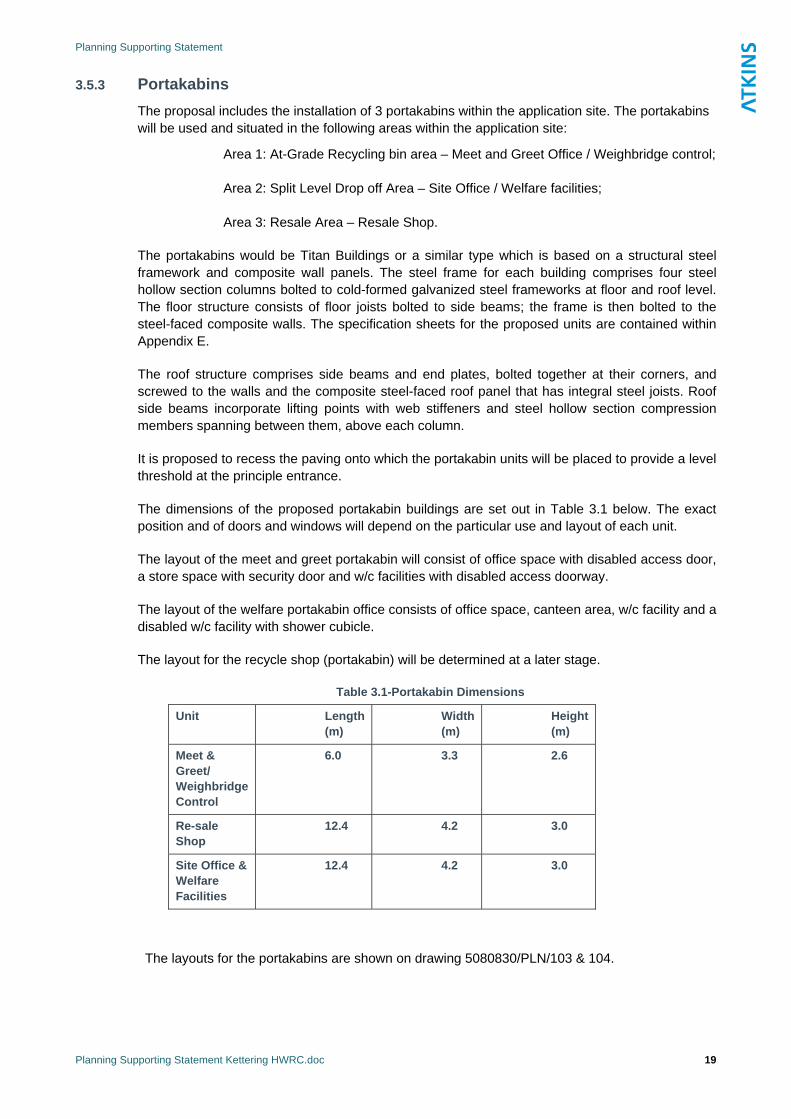
Planning Supporting Statement
Planning Supporting Statement Kettering HWRC.doc 19
3.5.3 Portakabins The proposal includes the installation of 3 portakabins within the application site. The portakabins will be used and situated in the following areas within the application site:
Area 1: At-Grade Recycling bin area – Meet and Greet Office / Weighbridge control;
Area 2: Split Level Drop off Area – Site Office / Welfare facilities;
Area 3: Resale Area – Resale Shop.
The portakabins would be Titan Buildings or a similar type which is based on a structural steel framework and composite wall panels. The steel frame for each building comprises four steel hollow section columns bolted to cold-formed galvanized steel frameworks at floor and roof level. The floor structure consists of floor joists bolted to side beams; the frame is then bolted to the steel-faced composite walls. The specification sheets for the proposed units are contained within Appendix E.
The roof structure comprises side beams and end plates, bolted together at their corners, and screwed to the walls and the composite steel-faced roof panel that has integral steel joists. Roof side beams incorporate lifting points with web stiffeners and steel hollow section compression members spanning between them, above each column.
It is proposed to recess the paving onto which the portakabin units will be placed to provide a level threshold at the principle entrance.
The dimensions of the proposed portakabin buildings are set out in Table 3.1 below. The exact position and of doors and windows will depend on the particular use and layout of each unit.
The layout of the meet and greet portakabin will consist of office space with disabled access door, a store space with security door and w/c facilities with disabled access doorway.
The layout of the welfare portakabin office consists of office space, canteen area, w/c facility and a disabled w/c facility with shower cubicle.
The layout for the recycle shop (portakabin) will be determined at a later stage.
Table 3.1-Portakabin Dimensions
Unit Length (m)
Width (m)
Height (m)
Meet & Greet/ Weighbridge Control
6.0 3.3 2.6
Re-sale Shop
12.4 4.2 3.0
Site Office & Welfare Facilities
12.4 4.2 3.0
The layouts for the portakabins are shown on drawing 5080830/PLN/103 & 104.

Planning Supporting Statement
Planning Supporting Statement Kettering HWRC.doc 20
3.5.4 Lighting scheme The proposed design for the lighting of the application site will be in accordance with Health and Safety Standards to ensure that the site can be safely accessed by the public during opening hours.
Energy efficient lighting will be fitted internally and externally. HP sodium lamps which will limit light spill and glare will be used.
Lighting of the site will be provided using lighting columns with high pressure sodium lamps to both the HWRC and the access road. Street lighting from the HWRC to the junction of Garrard Way within the adopted highway boundary will be installed to highway standards.
To reduce light spillage, the standard column heights would be reduced and directional lamp fittings are proposed.
Lighting is proposed around the periphery of the application site, as well as the circulatory road within the HWRC. Lights will also be fitted underneath the proposed canopy area. This will comprise of hi-bay light fittings directed to minimise light spillage beyond the site boundary. The closest residential properties to the site are approximately 130m away. It is not anticipated that light emanating from the site will adversely affect existing properties.
During the periods that the site will be closed adequate visibility will be maintained for security.
3.5.5 Noise An assessment of noise levels in respect of the proposal indicated that the access from Garrard Way would give rise to an increase in noise level of 0.4dB(A) during peak period of operation on a Sunday and weekend. This is not considered to be significant.
The BS4142 noise assessment for the peak period of operation on weekends and weekdays considers that there is a positive indication that complaints from residents with properties in the area are unlikely. The Noise Assessment is contained in Appendix B.6.
3.5.6 Air Quality An assessment has considered historical local air quality conditions and the future situation with and without the relocation of the HWRC. The assessment focused on two pollutants of most concern – NO2 and PM10 – In two scenarios: the ‘Do Minimum’ – without the relocation, and the ‘Do Something’.
The assessment indicated that there is likely to be a negligible change in pollutant concentrations at a transect of modelling positions, including positions adjacent to the main road affected as a result of the relocation, indicating that the proposed development would not have a significant impact on local air quality.
With regard to construction impacts, these will have potential to generate dust over the period of the construction works. However this will be mitigated by dust suppression techniques during periods of dry weather.
The Air Quality Assessment is contained in Appendix B.7.
3.5.7 Archaeology A review of the designated cultural heritage sites on the MAGIC website (the Multi-Agency Geographic Information for the Countryside) confirmed that no Scheduled Monuments, Registered Parks and Gardens of Special Historic Interest, Registered Battlefields or World Heritage sites lie within the proposed development site boundary or in proximity to the proposed development. A

Planning Supporting Statement
Planning Supporting Statement Kettering HWRC.doc 21
detailed review of the Historic Environment Record (HER) for Northamptonshire also revealed that no known sites of archaeological importance lie within the proposed development site boundary. Although the HER contains details of several sites of cultural heritage and archaeological importance within 250m of the proposed development site boundary most relate to the post-medieval period and record the locations of former (mostly industrial) structures or make reference to the railway line. There is no indication based on the evidence held within the HER that remains of archaeological importance survive within the proposed development site boundary. Further to this, the recent ground remodelling, including the creation of the lagoon, is likely to have disturbed the ground across much of the site.
Taking these factors into account and the likely construction work required to facilitate the proposed development, it has been concluded that there are no issues relating to cultural heritage that would preclude the proposed development
3.5.8 Flood Risk Assessment The Environment Agency (EA) flood zone map indicates that the application site is within Flood Zone 1. This is an area which falls outside the extent of the extreme flood, at the time of the Agency’s assessment of the likelihood of flooding. This means that the chance of flooding each year from rivers is 0.1% (1 in 1000) or less.
PPS25 indicates that planning applications for development proposals of 1 hectare or greater in Flood Zone 1 and all proposals for new development located in Flood Zones 2 and 3 should be accompanied by a FRA. The application site covers an area of 0.95 hectare which falls below the 1 hectare threshold; therefore, in line with national policy guidance a FRA is not required.
3.5.9 Foul Water Drainage The application site does not currently have a foul water drainage system. The nearest public foul water sewers are located to the south and south west of the site.
It is proposed foul water would then be drained from the site by means of an underground gravity drainage system to the mains situated on Garrard Way.
3.5.10 Surface Water Drainage The only drainage system on the application site is an existing ditch draining to an off-site attenuation lagoon located to the east of the site. Surface water sewers are located to the south and south west of the site.
Surface water runoff from the application site would be collected using a combination of road gullies and drainage channels.
The design of the surface water collection and disposal has yet to finalised. Investigations are being undertaken to confirm the method of operation and catchment served by the existing lagoon. This may demonstrate that the lagoon could be used as an integral part of the drainage, otherwise alternative options may involve source control methods and/or underground attenuation facilities. Surface water could then be drained from the site by means of an underground gravity drainage system to the mains situated on Garrard Way.
3.5.11 Ground Conditions An environmental review of a factual ground investigation was undertaken on the application site. The findings of the review are presented in the Ground Investigation Report. The investigation on
Planning Supporting Statement
Planning Supporting Statement Kettering HWRC.doc 22
the site was undertaken during April and May 2006, and comprised of drilling four boreholes, five trial pits and two window sample exploratory holes.
It is proposed that the soil material around the vicinity of the borehole (TP03) to a depth of 0.8m should not be re-used on the site due to the elevated concentrations of Polycyclic Aromatic Hydrocarbons (PAH) reported. However, it was determined that by placing a 600mm layer of concrete hardstanding, the material could be left in situ, however, the area of the bore hole (TP03) will be covered with concrete to eliminate the vapour inhalation pathway.
3.5.12 Waste Audit NCC is committed to preparing a waste audit using the WRAP (Waste & Resources Action Programme) Net Waste Tool, and has signed up for this programme. WRAP has developed a Net Waste method as a way of measuring:
The use of building materials made from recycled content and the reuse of waste materials; and
The waste generated during a construction project.
The Net Waste Tool is a best practice method to identify the waste that is likely to arise from the development.
Examples of 2 WRAP case studies which outline the financial and environmental benefits of setting waste targets for the project, using the Net Waste Tool:
Balfour Beatty Child Development Centre, Hackney 2008; and
Bovis Lend Lease, Pendle Vale School, 2008.
These case studies have been included within Appendix D.
The completed waste audit for the proposed development (relocation of Kettering HWRC), using WRAP Net Waste Tool, and in accordance with the requirements of Northamptonshire’s Supplementary Planning Guidance: Development and Implementation Principles, March 2007 paragraph 2.25, will be available in due course.
3.5.13 Transport The proposed development has good links to the surrounding highway network. Although there are existing parking issues along Garrard Way it is proposed to address these issues with the introduction of traffic regulation order.
There will be a new access and egress constructed from Garrard Way, which joins onto the A4300 at the Telford Way / Warren Hill / Garrard Way roundabout. This will enable vehicles to access the site without passing through the existing Council Depot to the north. The proposed new access from Garrard Way will be a one way entry and exit system providing a circulatory access around the 4 broad areas within the application site. The new access will also include a dedicated right turn access to the California car wash facility.
The trip generation for the application site has been estimated based on traffic flow information from the existing site. As the catchment area of the proposed development will be the same as the

Planning Supporting Statement
Planning Supporting Statement Kettering HWRC.doc 23
existing site, it is likely the trip generation of the sites will also be very similar. An allowance for additional trade waste vehicle trips (5%) has been made with 36 arrivals and departures in the weekday, PM peak and 91 during the Saturday peak period.
The distribution of trips generated by the development using information gathered from visitor origins at the existing site, predicted that approximately 80% of vehicles will head east down Rothwell Road when exiting Garrard Way. It is predicted that the other 20% will head west along Warren Hill when existing Garrard Way.
3.5.14 Access and egress A new access to the site will be created from Garrard Way, which joins onto the A4300 at the Telford Way / Warren Hill / Garrard Way roundabout. This will enable vehicles to access the site without passing through the existing Council Depot to the north.
Detailed Transport Assessment is included within Appendix B.
3.5.15 Access during construction During the construction period, temporary access for construction vehicles to the application site will be gained via Robinson Way through the existing one way system of Kettering Borough Council depot (to the north of the application site) until the construction of the new access from Garrard Way is completed.
This is shown in drawing no. 5080830/PLN/002 Application Boundary (Appendix A)
3.5.16 Car parking Parking bays for the public within the boundary of the application site is short term only whilst waste is being offloaded and is within the site main activity areas.
Staff car parking is also provided and is located within the operational area.
Three parking areas for the public will be provided within the site including provision for disabled parking bays. These will be at the recycling area, re-sale area and bulky recycling drop-off area. Details of these areas are shown on the General Arrangement drawing accompanying this application (Ref No 5031651/004/100).
3.5.17 Ecology A walkover survey and ecological assessment of the study site was undertaken by Atkins Ltd in 2006. This report recommended that targeted surveys of Great Crested Newts be carried out in the balancing lagoon which was identified as a suitable habitat for this species.
Consultation with Natural England was undertaken as part of a planning application for the scheme submitted by Northamptonshire County Council in November 2007. As a result of this consultation, Natural England requested that the 2006 walkover surveys carried out by Atkins be updated, and that targeted surveys for great crested newts be carried out, prior to the planning application being determined.
The updated surveys were undertaken by Cresswell Associates for NCC between April and June 2008. The survey was based on the original proposal which included the construction of an access road to the east of the site, along the edge of an existing balancing lagoon. The report concludes the balancing lagoon did not support Great Crested Newts but it did identify a variety of habitats with the potential to support reptiles, birds and dormice.
Following withdrawal of the original application, further design work was undertaken with a revised location for the access road which was subsequently proposed by NCC. This option was named the Derwent Option and involves the location of the access road directly from Garrard Way through the access to the existing car wash facility.
Planning Supporting Statement
Planning Supporting Statement Kettering HWRC.doc 24
Cresswell Associates provided a further report in August 2008 which considered the implications of the Derwent option for access into the site. The report concluded it would result in very little or no ecological impact, as it is proposed in an area of land considered to be of negligible nature conservation value which supported very little habitat suitable for use by protected species or species of conservation concern. Potential ecological impacts would be minimal.
A tree inspection survey was undertaken in March 2009 to determine presence/ absence of bats in the oak tree affected by the proposal. The survey concluded there was no evidence indicating that bats were using the oak tree as a roost.
3.5.18 Trees The surplus depot site contained a variety of species of trees including Leylandi and a relatively poor quality oak tree; the trees were largely located around the boundary of the site and were intend to screen the site from view. The Leylandii trees have now been felled and cleared from the site.
3.5.19 Landscape proposals The planting proposal aims to enhance the visual appearance of the site. The planting beds within the site access road will have some ornamental species and other areas of planting will have a mixture of native woodland tree and shrub mix. It is also proposed to planting tree along the south east boundary of the site.
Details of a landscaping scheme are contained within Appendix A (Drawing No. 5080830/PLN/105.
3.5.20 Construction hours Construction for the proposed development is expected to occur between:
Monday to Friday 07.00 and 18.00; and
Saturday 07.00 and 13.00 (not including Sunday and Bank Holidays).
3.5.21 Construction details Construction of the proposed development has been scheduled to occur over approximately 26 weeks period. During the construction the existing HWRC will continue to function.
3.5.22 Operational hours During the summer the HWRC will be open to the public between
Monday to Friday 08.30 – 19.00; and
Saturday and Sunday 08:30 –17:30.
During the winter it will be open to the public between
Monday to Friday 08.30 – 17:00; and
Saturday and Sunday 08:30 –17:00.

Planning Supporting Statement
Planning Supporting Statement Kettering HWRC.doc 25
The site will be open on all Banks Holidays with the exception of the following days when the site will be closed on:
Christmas Day ;
Boxing Day; and
New Year’s Day.
3.5.23 Utilities infrastructure The proposed development will require access to the following services:
Telecoms;
Water;
Mains Drainage for surface and foul water; and
Electricity
Connection to these utilities will be to the mains which are situated at the entrance of the application site on Garrard Way. The appropriate service provider will be contacted to establish connection for the facility to the mains. The proposed development will run appropriate connections to the mains.
3.5.24 Site Signs There will be new entrance signage including information boards erected outside the HWRC adjacent to the proposed security gates. Further signage is proposed to be displayed within the development site to direct members of the public to the appropriate recycling and disposal areas. The dimensions of the principle entrance sign is 3.0m (height) by 3.66m (width) by 1.52m (depth) the approximate size of wording on the proposed sign will be:
Upper Case – 46cm
Lower Case – 35cm
Details of the proposed entrance signage including information boards are included in Appendix C. The location of the new entrance sign is identified on drawing number 5080830/PLN/100 A.
3.5.25 Alternatives As explained in paragraph 3.3, in 2003, a NCC HWRC working group produced a report identifying and recommending both generic and site specific improvements to the HWRCs. The Kettering HWRC was identified as being particularly affected by traffic queuing which resulted in poor customer satisfaction and complaints from neighbouring commercial businesses. As a consequence the longer waiting times and traffic queues deterred residents from using their local HWRC and forcing them to use services further afield. These pressures will also be compounded by the effects of future population growth which is planned for the Kettering area and the site was therefore considered a priority for service improvements.
With very little option to upgrade and no option to expand the existing site the only option was to relocate the site.

Planning Supporting Statement
Planning Supporting Statement Kettering HWRC.doc 26
A small number of alternative locations were considered in and around Kettering. Exploratory talks were held with land owners in various locations directly North of Kettering and sites within Telford Way Industrial Estate. However these sites were either deemed unsuitable due to redevelopment plans or were considered less attractive due to being located in open countryside. During this time Kettering Borough Council (KBC) offered land within their depot on Telford Way Industrial Estate in the spirit of partnership. This was the favoured option due to its location within the urban area and its proximity to the existing Cunliffe Drive HWRC.
The application is surplus brownfield land and is located in an area identified as a preferred location for waste management activities in the proposed submission document ‘Minerals and Waste Development Framework (MWDF) Location for Waste Development’ (supplementary options Aug 2008). The new facility will provide a split level site offering much improved access for members of the public and also enhanced facilities for reuse, recycling and disposal.
Planning Supporting Statement
Planning Supporting Statement Kettering HWRC.doc 27
4. Planning Policy 4.1 Introduction
The relevant national, regional and local policy and guidance is set out below, along with an assessment of its implications for the proposed development.
4.2 National Planning Policy 4.2.1 PPS 1: Delivering Sustainable Development
PPS1 sets out the overarching planning policies on the delivery of sustainable development through the planning system.
PPS1 indicates that Development Plan Policies should take account of environmental issues such as ‘the management of waste in ways that protect the environment and human health, including producing less waste and using it as a resource wherever possible” (paragraph 20). PPS 1 indicates that LPA’s general approach in delivering sustainable development should include the promotion of waste recycling wherever possible, and : “the provision of essential infrastructure, including for sustainable waste management…” (paragraph 27).
One of the main drivers for the relocation of the existing HWRC is to provide improved recycling facilities for Kettering which can be easily accessed by the public.
4.2.2 PPS 10: Planning for Sustainable Waste Management PPS 10 sets out criteria to be used when considering new sites for waste management facilities. New sites must consider:
The other policies of PPS10;
Physical and environmental constraints, including impacts on neighbouring uses;
Cumulative effects of previous waste disposal facilities on the local community;
Capability of the transport infrastructure to support the use; and
Priority given to the re-use of previously-developed land.
In respect of new development, PPS10 states: “Planning strategies should enable sufficient and timely provision of waste management facilities to meet the needs of their communities” (paragraph 3).
“In searching for sites and areas suitable for new or enhanced waste management facilities, waste planning authorities should consider a broad range of locations including industrial sites, looking for opportunities to co-locate facilities together with complementary activities” (paragraph 20).
Planning Supporting Statement
Planning Supporting Statement Kettering HWRC.doc 28
“should make sufficient provision for waste management, and promote designs and layouts that secure the integration of waste management facilities without adverse impact on the local landscape” (paragraph 35).
In light of these criteria it is considered that the proposed relocated HWRC accords with the aims of PPS10 as it will provide an improved facility for the recycling of waste and will improve public access to recycling facilities. The site chosen for the HWRC is within an existing industrial area, some distance from residential properties, thus minimising potential conflicts with neighbouring uses.
As the application is for the relocation, of the existing Kettering HWRC, as opposed to the provision of additional facilities it is considered that there will not be any cumulative effects on the local community.
The facility will be somewhat larger than the existing HWRC to accommodate the improved recycling facilities. However, it is assumed that the new HWRC will serve the same catchment area as the previous and as such will not result in larger numbers of visitors, thus not having any greater impacts on the local community or the local transport infrastructure than at present. From the traffic assessment work carried out it has been demonstrated that the re-location to the new site would help alleviate some traffic problems currently experienced on the local road network, and will have positive impacts on the amenity of residential properties close to the existing site.
The site is currently used for storage and Council depot activities and therefore is considered to be previously-developed.
With regard to unallocated sites, PPS10 states that new or enhanced waste facilities should be considered favourably if they are in accordance with the guidance in PPS10 and do not undermine the local planning authority’s planning strategy. In this case the Telford Way Industrial Estate is identified in the MWDF as a preferred location for potential waste management activities; therefore, it is considered that the proposed development accords with PPS10 and that it will not have a negative impact on the overall planning strategy of Kettering Borough or NCC.
4.2.3 PPG 13 - Transport
PPG13 aims to promote a reduction in the need to travel and overall distances actually travelled, particularly by private vehicles. It also aims to focus traffic generating development within urban areas.
Paragraphs 87-91 promote “the widespread use of travel plans and local authorities are expected to set local targets for the adoption of travel plans by local business and other organisations”.
The nature of the proposed development means it will largely be visited by customers in private vehicles, moving their own materials for recycling and disposal.
However, the location chosen is within the existing urban area and within a short drive from a large residential area. As such the length of vehicle trips will be kept to a minimum, thus minimising the impact of the development on the wider highway network.
While it is not considered that the proposed development would have any significant transport implications, for completeness, a Transport Assessment (TA) has been carried out and accompanies this application in Appendix B. The TA concludes that the proposed development would have a positive impact upon the local road network. As such it is considered that the proposed development is in accordance with the guidance set out in PPG 13.
Planning Supporting Statement
Planning Supporting Statement Kettering HWRC.doc 29
4.2.4 PPS 23 - Planning and Pollution Control PPS 23 states that the potential for contamination from new development schemes must be fully considered. ‘The LPA should satisfy itself that the potential for contamination and any risks arising are properly assessed and that the development incorporates any necessary remediation and subsequent management measures to deal with unacceptable risks, including those covered by Part IIA of the EPA 1990. Intending developers should be able to assure LPAs they have the expertise, or access to it, to make such assessments’ (paragraph 23).
The development incorporates a drainage scheme that will collect surface water drainage through a series of gulleys and into an interceptor prior to discharge via a gravity feed to the surface water sewer on Garrard Way.
Ground Investigations have been undertaken to determine the baseline conditions in relation to pollution at the site, this data has been used to assess the extent of possible contamination. The results identify only a limited area contamination which is not considered to be a significant risk.
4.2.5 PPG 24: Planning and Noise PPG24 guides local authorities in England on the use of their planning powers to minimise the adverse impact of noise. It goes on to state “The impact of noise can be a material consideration in the determination of planning applications. The planning system has the task of guiding development to the most appropriate locations. It will be hard to reconcile some land uses…with other activities which generate high levels of noise...new development involving noisy activities should… be sited away from noise-sensitive land uses… Where it is not possible to achieve such a separation of land uses, local planning authorities should consider whether it is practicable to control or reduce noise levels, or to mitigate the impact of noise, through the use of conditions or planning obligations” (paragraph 2).
An assessment of potential noise level of the proposed development has been considered, the report concludes the impacts are not likely to be significant and complaints from residents with properties in the area are unlikely.
4.2.6 PPS 25: Development and Flood Risk PPS 25 sets out Government policy on development and flood risk. “It aims to ensure that flood risk is taken into account at all stages in the planning process to avoid inappropriate development in areas at risk of flooding, and to direct development away from areas of highest risk. Where new development is, exceptionally, necessary in such areas, policy aims to make it safe, without increasing flood risk elsewhere, and, where possible, reducing flood risk overall” (paragraph 5).
The application site is less than 1 hectare, and located in a Flood Zone 1, therefore a FRA is not necessary.
4.3 Regional Planning Policy 4.3.1 East Midlands Regional Spatial Strategy (EMRSS)
The East Midlands Regional Plan (officially known as the “Regional Spatial Strategy”' or “RSS8”) provides the long term development strategy for the region over a 15-20 year period. Prepared by the East Midlands Regional Assembly (EMRA) it covers the scale and distribution of new housing, priorities for the environment, transport, infrastructure, economic development, minerals extraction and waste management. The current Regional Spatial Strategy was approved in March 2005. This incorporates the Milton Keynes and South Midlands Sub-Regional Strategy. RSS8 is now being

Planning Supporting Statement
Planning Supporting Statement Kettering HWRC.doc 30
reviewed and having its end date rolled forward from 2021 to 2026 and will be adopted by early 2009.
Policy 38 sets out Regional Priorities for Waste Management, encouraging the promotion of policies and proposals that will result in zero growth in all forms of controlled waste by 2016. The policy advocates a minimum target for recycling and composting of Municipal Solid Waste of 25% by 2005, 30% by 2010 and 50% by 2015. The policy promotes sustainable waste management policies and proposals through the development of the Mineral and Waste Development Frameworks by the development of additional waste management capacity to meet the requirements of the area:
The RSS is supported by the Regional Waste Strategy (RWS), which although required to be prepared is not a statutory document. It contains the following principles:
working towards zero growth in waste by 2016;
reducing the amount of waste sent to landfill;
exceeding government targets for recycling and composting to achieve levels of current best practice; and
taking a flexible approach to other forms of waste recovery on the basis that technology in this area is developing very quickly.
The RWS was issued in January 2006. It identifies apportionments of the waste management capacity required for the three main waste streams by sub-region for the period until 2020. The total quantities are split into categories of recycling/composting requirement, landfill diversion, re-use and disposal. They anticipate zero growth from 2016 and assume recycling rates for municipal waste in line with the RSS.
4.4 Northamptonshire Waste Local Plan The Northamptonshire Waste Local Plan was adopted in March 2006 and sets out the policy with respect to waste management within the County. All policies have been saved (with the exception of Policy 12) and will remain in force until the adoption of the Development Plan Documents to be contained in the Northamptonshire Minerals and Waste Development Framework. With regard to the development of new local waste facilities, Policy 4 states that such facilities will be permitted if it can be demonstrated they will contribute to a sustainable waste management system for Northamptonshire. Such sites should also, where possible, be located on existing or designated industrial land. It is considered that the proposed development and the improved recycling facilities to be provided will make an important contribution to the County’s sustainable waste management system, and will also make full use of land within an industrial area.
Policy 1: Principles of Waste Development requires a clear establishment of need which is consistent with regional requirements for the management and disposal of waste; reduction in reliance on landfilling; reduction in the movement of waste across WPA boundaries; Best Practical Environmental Option for waste stream; integration of waste management facilities; and minimising harm to the environment, human health, natural resources, local amenity and highway safety.
Planning Supporting Statement
Planning Supporting Statement Kettering HWRC.doc 31
Policy 2: Location of Waste Development this policy seek to permits new waste facilities which have been identified within the Proposals Map or complies with the policies set out in this document. The application site for the proposed development lies within the area identified as shown in Inset 10 of the Proposal Map.
Policy 4: Development of Local Waste Facilities indicates proposals for waste development (dealing with 50,000 tonnes or less per annum of non-hazardous waste) will be permitted if it can be demonstrated they will contribute to a sustainable waste management system for Northamptonshire. Such development should comply with one or more of the following:
- be located on existing or designated industrial land;
- be on derelict, despoiled or brownfield land or building;
- contribute to agricultural diversification or to rural regeneration;
- be a former or existing mineral working or waste management facility;
- be on a site linked to rail or water transport; or
- be a part of and specifically serve one of the identified Strategic Development Areas at Daventry, Rothwell/Desborough, Towcester and Wellingborough East (or any other urban extension of over 1,000 dwellings).
The proposed development meets the requirements of this policy in that the application site is located within an existing designated industrial area, on brownfield land. Furthermore, the proposed development will contribute to the sustainable waste management system for Northamptonshire.
Policy 5: Development – related Waste Minimisation policy requires proposals for new developments to show what measures are to be taken, in the clearing of the site and the construction of the development, for minimising the generation of waste, and for the management and disposal of the waste to be generated. The proposed development meets this requirement. It is proposed that construction waste from the development will be reused on the site, where possible.
Policy 6: The Integration of Neighbourhood Waste Facilities with other Development – Proposals for new residential, industrial and commercial development will be expected to incorporate, into their design and layout, neighbourhood facilities for the separation, storage and collection of waste to increase the efficiency of its subsequent re-use, recycling and treatment. Proposals for such neighbourhood facilities to serve existing developments will be encouraged.
In all cases, proposals should:
comply with the policies of the Plan aimed at safeguarding the environment and local amenity; and
include as part of the planning application, practical measures for securing the satisfactory management of the facilities.
Policy 7: Design requires proposals for waste development to be of a design that has regard to the visual appearance of the development in the context of the defining characteristics of the local
Planning Supporting Statement
Planning Supporting Statement Kettering HWRC.doc 32
area. The proposed development meets the requirements of this policy. Due regard and consideration has been given to the existing topography and vegetation; the materials and colouring of the proposed development, whilst incorporating appropriate landscaping to enhance the visual appearance of the proposed development.
A Transport Assessment has been undertaken to ensure that the proposed development meets the requirements of Policy 8: Traffic and Access. Site access to the application site can safely accommodate traffic associated with the proposed development, in relation to the local highway network.
A landscaping scheme will be implemented to ensure that the proposed development is not in conflict with Policy 9 (Natural and Historic Environment- Local Landscape Character) and ensures minimal impact on the local landscape.
The application site is not in located in an area where the development proposed would prejudice any designations as listed within Policy 10: Natural and Historic Environment - National and International Designations and Protected Species. Therefore, the proposal is not in conflict with Policy 10.
Policy 13: Water Resources and Flooding requires proposals for waste development to demonstrate that there will be no risk of flooding, or impediment to the flow of surface/ground water and no contamination to surface/ground water courses as well as incorporating sustainable drainage system, unless the nature of the waste management process makes it inappropriate.
Policy 15: Local Amenity requires proposals for waste management facilities to ensure that there will be no adverse effects impacts on local residential amenity in terms of noise and vibration, air quality, odours, vermin, birds, litter, visual intrusion and light spillage as well as operational hours. The proposed development has ensured compliance with the requirements of Policy 15.
Policy 17 gives more detail on the development of new waste transfer, recovery and recycling facilities, including HWRCs. Such facilities should:
demonstrate that the development will assist the efficient collection and recovery of waste materials;
minimise open-air storage; and
maximise screening.
The proposed development has been designed to comply with the requirements of Policy 17. The development will provide easily accessible facilities for the efficient sorting and disposal of recyclable material by the public. Open-air storage will be kept to a minimum through the regular emptying of skips on site and the careful sorting and transfer of materials to recycling facilities. Finally, the scheme will be screened by existing industrial and commercial premises, as well as existing planting alongside the railway line.
It is considered that the proposed development accords with all the planning policy principles above. The proposal will promote the recycling and reuse of waste materials and it will be located near to the residential properties which generates waste and recyclables. The design of the scheme is considered to be of a high quality, in keeping with the surrounding area and will provide adequate space and access arrangements for a well run HWRC.

Planning Supporting Statement
Planning Supporting Statement Kettering HWRC.doc 33
4.5 Northamptonshire Minerals and Waste Development Framework NCC is the minerals and waste planning authority for the area of Northamptonshire. Therefore it is responsible for setting out the development planning framework for minerals (eg quarries) and waste-related (eg recycling facilities) development, including the use of aggregates and waste minimisation and management in new development (such as residential, commercial and industrial).
Nationally, Minerals and Waste Local Plans are being progressively replaced by Minerals and Waste Development Frameworks (MWDFs). During the initial transition period, adopted Local Plans can retain their status as a "saved" plan. The Northamptonshire Waste Local Plan has been saved beyond the 3 year period expiring on 6th March 2009.
Any planning applications for waste facilities will have to adhere to the policies set out in the Waste Local Plan (2006) until the Northamptonshire MWDF is adopted. Development Plan Documents approved as part of the MWDF will provide the basis on which planning applications for, or covering, minerals and waste related development will be decided in Northamptonshire. The Northamptonshire MWDF will include:
The Core Strategy Development Plan Document (DPD) which sets out the broad strategy for minerals and waste in the county and the amount of provision we will need to make for such development;
Locations for Waste Development DPD which identifies specific sites and key locations for waste-related development;
The Proposals Map which identifies the sites and other key designations on a detailed map;
Control and Management of Development DPD which covers aspects of controlling and managing minerals and waste-related development, such as traffic, environmental impact, amenity impact and after use following temporary development;
The Development and Implementation Principles Supplementary Planning Document (SPD) which provides guidance on waste minimisation and the provision of waste management facilities in new development, as well as the design and restoration of minerals and waste facilities.
Following several stages of public consultation, The Core Strategy was submitted to the Secretary of State in December 2008 for Public Examination. The public hearing sessions started on 31st March 2009. The hearing sessions have been adjourned until further notice.
The Core Strategy forecasts waste arising for Northamptonshire and thus the capacity requirements to achieve waste management targets. The requirements are contained within Policy CS1 of the Core Strategy:
The development of a sustainable waste management network to support growth within Northamptonshire will involve the provision of facilities to meet the following indicative waste management capacities during the plan period:
Recycling and composting (MSW and C&I) capacity of 822,000 and 970,000 tonnes per annum for 2016 and 2026 respectively;

Planning Supporting Statement
Planning Supporting Statement Kettering HWRC.doc 34
Landfill diversion (MSW and C&I) capacity of 451,000 and 522,000 tonnes per annum for 2016 and 2026 respectively;
Inert recycling capacity of 928,000 and 1,089,000 tonnes per annum for 2016 and 2026 respectively; and
Hazardous waste management of 45,000 and 50,000 tonnes per annum for 2016 and 2026 respectively.
Other policies within the Core Strategy that will be relevant to an application for a waste Management Facility are:
Policy CS1: Northamptonshire’s waste management capacity
Policy CS2: Spatial strategy for waste management
Policy CS3: Strategy for waste disposal
Policy CS7: Sustainable design and use of resources
Policy CS8: Integration of waste management facilities in new development
Policy CS9: Encouraging sustainable transport movements
Policy CS11: Safeguarding waste management and minerals related development from alternative uses
Policy CS13: Restoration and after-use of minerals and waste development, and
Policy CS14: Addressing the impact of proposed minerals and waste development
As part of the MWDF, the Locations for Waste Development DPD has been developed. It has undergone several stages of public consultation and the Submission Document (Jan 2009) is currently undergoing public consultation prior to submission.
Policy W3 identifies 20 Industrial Areas where in principle waste management activities would be acceptable, the Telford Way Industrial Estate is identified as site WL13. These sites were put forward through the MWDF preparation process and have been identified as being appropriate for this use.
4.5.1 Northamptonshire Development and Implementation Principles –SPD The Northamptonshire Minerals and Waste Development Framework also includes: the ‘Development and Implementation Principles Supplementary Planning Document (SPD)’. The SPD sets out a number of principles for the provision of waste management facilities, including the promotion of a:
Waste hierarchy – where prevention and minimisation are the most preferred, followed by re-use and recycling. Landfill is the least preferred option;
Proximity principle – waste should be disposed of as close to its source as possible;
Planning Supporting Statement
Planning Supporting Statement Kettering HWRC.doc 35
High quality innovative design – new facilities should be sympathetic to the surrounding area and be of high quality;
Environmental protection and enhancement – new facilities should avoid adverse impacts on the surrounding environment and human health. Any impacts should be minimised and mitigated;
Adequate space and access – new facilities should ensure adequate space for, and access, to the facilities for separation, storage and collection of waste; and
Public safety – Design, layout and landscaping components associated with waste management facilities should seek to ‘plan out crime’ by creating safe and secure environments.
The proposed relocation of the HWRC will ensure the continued recycling of household waste within the Kettering area thereby reducing waste to landfill. Access and space within the proposed relocated HWRC will allow for a modernised, spacious facility to ensure an improved and efficient waste management operation. The environmental impact has been assessed and the impacts on the surrounding environment will be minimal. Furthermore, the design, layout and landscaping proposed ensures public safety by incorporating security measures such as: Lighting, CCTV, and maximising sight lines.
4.5.2 Planning Out Crime in Northamptonshire – SPG Northampton County Council’s SPG on Planning out Crime, published in February 2004, sets out guidance on how the effects of crime can be minimised in new developments. For commercial and industrial developments the SPG recommends that plots should have a secure perimeter boundary and only one entry point. Where a rear access is required it should be ensured that it can be properly secured, particularly after hours. Access routes should be well lit and where appropriate thorny or spiny shrub species should be planted in front of vulnerable boundaries to deter unlawful access.
The SPG goes on to recommend that the use of negative measures such as razor or barbed wire and cacti anti-scaling devices should be minimised. The height and type of boundary materials should be in-keeping with the character of the local area, as well as taking into account the prevention of crime.
The proposed development has been designed to incorporate the recommendations of the Planning out Crime SPG. There will be one access point into the site and the boundary treatment will be of a sufficient height to make entry to other sections of the site difficult. The design of the lighting, CCTV, boundary treatment and landscaping will be in-keeping with the surrounding properties, while deterring break-ins and vandalism.
4.5.3 Employment Site Development Principles – SPG Kettering Borough Council’s SPG on Employment site development principles, adopted March 2007, sets out guidance on the principles for sites allocated employment development. The guidance recommends that:
The site shall be served by one point of vehicular access from Garrard Way and a footpath shall be provided along the Garrard Way frontage;
Buildings should normally be no higher than two storeys plus roof;
Landscaping belts are required along the northern and western boundaries of the site to supplement existing features; and

Planning Supporting Statement
Planning Supporting Statement Kettering HWRC.doc 36
Open landscaping form should be provided along Garrard Way frontage
The development proposes a new vehicular access with pedestrian footpath from Garrard Way on to the application site. The proposed portakabin buildings are no higher than one storey. The proposed landscaping aims to supplement the existing as well as enhance the environment surrounding the boundary and frontage of the site.
4.5.4 Industrial and Commercial Layout and Design – SPG Kettering Borough Council’s SPG on Industrial and Commercial layout and design guidance elaborates on the policies relating to the layout and design of industrial and commercial development primarily aimed at developments on Greenfield sites or those on the urban fringe. Greater flexibility in the application of this guidance will be shown in relation to development proposals on more central urban sites.
The guidance expects proposals for industrial and commercial development to:
ensure that layout and design are energy efficient, incorporate the principles of the ‘Secured by Design’ concept and adequate space around buildings, with ancillary buildings discreetly sited away from highway frontages; and comprehensive landscaping between adjacent buildings;
make provision for future extensions to allow for expansion while retaining adequate parking, delivery and landscaping areas;
make provision for adequate car parking (normally at the front of the building), servicing and manoeuvring facilities; and
ensure appropriate boundary treatment:
service areas and other ancillary features (e.g. boiler units) should normally be bounded by screen walls; and
boundaries between adjacent buildings should not normally be defined except by extensive landscaping.
careful consideration must be given to space around buildings, elevational design, detailing and surface materials. The scale of development should be appropriate to the location. Ancillary features should be discretely designed and located.
proposals for industrial and commercial development to consider the provision of signs and advertisements as an integral part of the development proposal in order to give directions and to afford appropriate advertisement of business activity and location. The thoughtful use of design devices such as hanging signs, floodlighting and individual lettering will be encouraged.
Landscaping should be undertaken as an integral part of the development and should complement building design. Wherever possible native species should be used and consideration should be given to seasonal changes and vegetative cover.
The proposed development is compliant with the guidance for industrial and commercial development in relation to the security, use of space, providing adequate parking, incorporating landscaping and appropriate boundary treatment as well as the careful use of appropriate signage.

Planning Supporting Statement
Planning Supporting Statement Kettering HWRC.doc 37
4.6 Kettering Local Plan Kettering Local Plan (1995) does not allocate the site for a specific use. Policy 111 Minerals / Waste Recycling Facilities, states that such facilities will be permitted subject to them being located in an existing or proposed industrial area and not resulting in significant adverse effects on the highway network. It is considered that the proposed development is in accordance with this policy as it is located within a designated industrial area and is appropriately located in terms of transportation access.
4.7 Conclusion In conclusion, it is considered that the proposed development is in accordance with national, regional and local planning guidance in respect to both the need to provide increased numbers of recycling facilities for household waste, and the requirement to adequately assess the potential environmental effects of development proposals on the surrounding area.
Planning Supporting Statement
Planning Supporting Statement Kettering HWRC.doc 38
5. Scheme Impacts 5.1 Introduction
This section considers the potential environmental impacts of the proposed development.
5.2 Ecological Impacts The Ecological Assessments for the application site identified the main body of the site and new access road to be of reasonably low nature conservation value, however, an area of mixed habitats (including broad leaved landscape planting, scrub, and ruderal inundation vegetation) associated with the adjacent balancing lagoon part of which fall within the site was considered to have the potential to support some legally protected species (common reptiles, nesting birds and dormice).
It is proposed to re-engineer a section of the lagoon embankment. The reinforced earth slope which will support the circulation road will result in some loss of the habitats associated with the balancing lagoon. The areas to be lost mainly comprise semi-mature landscape planting and inundation vegetation.
Having considered the nature of the proposed development, it is considered that there will not be any significant impacts on features of ecological importance.
The Scheme will result in the loss of a mature oak tree located on the footprint of the proposed access road which is suitable for roosting bats. All species of bats found in the UK are protected under European law. A Bat Inspection was undertaken 12th March 2009 (the Report is attached in Appendix B) the survey identified one potential bat roost within the mature oak tree to be lost. However, there was no evidence indicating that bats were using this feature as a roost. It is proposed four bat boxes will be installed to mitigate / enhance for the loss of the potential bat roosting habitat.
With regard to Great Crested Newt, surveys have been undertaken and it is not considered that there are any suitable water bodies on site to support newts. The lagoon has not held significant amounts of water for some time. As such no further survey work is proposed.
Best working practices will be adhered to in relation to reptiles that may be present within the working areas. A document (precautionary method of working) detailing how works and vegetation clearance will be undertaken to avoid killing or injuring any reptiles will be prepared prior to site works.
The Phase 1 Habitat survey undertaken in June 2008 determined the habitat within the lagoon area to have the potential to support dormice, a European Protected Species. The probability of dormice being present is low. However, the habitat does have potential to support the species. It is unlikely that (if any dormice are present) they would be breeding in the habitat but rather that they may use the site as resting or commuting habitat. Consequently, it is proposed to assume that dormice are present but, given the small scale and localised nature of the works, but it is considered that the risk of a legal offence (under The Conservation (Natural Habitats &c.) Regulations 1994 (as amended)) as a result of the habitat loss to be reasonably unlikely if the works are carried out under a Precautionary Method of Working (PMW). This advice is based on guidance provided by Natural England and knowledge of the species. It is proposed that a detailed method statement will be produced prior to commencement of works to justify the opinion of why a legal offence is considered to be unlikely and detail how the works will be undertaken to
Planning Supporting Statement
Planning Supporting Statement Kettering HWRC.doc 39
minimise all possible impacts to dormice. An ecologist would be present on site to check vegetation before it is removed under the PMW.
The detailed Ecological Assessments are contained within Appendix B.
5.3 Lighting Due to the existing high levels of night time illumination from lighting at the surrounding premises it is not considered that the security lighting required for the HWRC would have a significant impact on the lighting of the area or the amenity of any nearby residential properties. The lighting to be installed would be designed to minimise any light spill. Such lighting would serve as a deterrent to any break-ins to the site and would also ensure customer and staff safety when using the site in the early hours of the morning and late evening. British standards code of practice will be adopted to minimise impacts and reduce light spillage.
5.4 Noise
An assessment of the potential noise impacts of the proposed development was carried out. This has demonstrated that at the rear of the properties on Rotherwell Road and at Poppy Fields the noise level difference between the predicted noise level of the proposed development and the measured background noise levels is of less than marginal significance.
At the Inland Revenue offices, during the peak period during the weekday, without the JS160 excavator operating the level of difference is of less than marginal significance. When the JS160 excavator is operating, transferring and compressing waste in the bins, the noise level difference is above marginal significance but not at a high enough level to cause complaints. The noise assessment carried out, in accordance with BS4142, is of the peak period of operation; therefore, typical noise levels associated with the recycling facility are anticipated to be lower.
Overall, the noise assessment demonstrates that the proposed development would not result in unacceptable noise impacts on the surrounding area.
The Noise Assessment is contained within Appendix B.
5.5 Air Quality An air quality assessment was also carried out. The assessment focused on two pollutants of concern –Nitrogen Dioxide (NO2 ) and Particulate Matter (PM10 ) in relation to EU standards. The assessment of the air quality considered historical local conditions and the future situation with and without the relocation of the HWRC. The result indicated that pollutant levels would be below air quality objectives in this location.
Potential construction impacts as well as operational dust and odour impacts have been outlined in the Air Quality Assessment. Dust will be controlled to minimise impact during the construction stage of the proposed development. British standards code of practice will be applied during the operational phase to ensure dust produced is minimal.
The Air Quality Assessment is contained within Appendix B.
Planning Supporting Statement
Planning Supporting Statement Kettering HWRC.doc 40
5.6 Surface and Foul Water Surface water runoff from the application site would be collected using a combination of road gullies and drainage channels. Surface and foul water would then be drained from the site by means of an underground gravity drainage system to the mains situated on Garrard Way.
5.7 Archaeological Impacts No records of archaeological sites or features of cultural interest have been identified on or near to the site therefore ther are no archaeological impact expected.
5.8 Transport Impacts The traffic impact of the development has been accessed at two offsite junctions in the vicinity of the proposed development. These are:
Garrard Way / Rothwell Road / Haweswater Road / Warren Hill / Telford Way roundabout junction; and
Northfield Avenue / Lower Street / Rothwell road roundabout junction
The capacity assessments show that the Garrard Way roundabout junction operates well, with spare capacity available in all scenarios. In the future year of 2015 when the development traffic is added to the network a maximum queue of three vehicles is predicted. The development traffic has no adverse impact on this roundabout junction in terms of queues or delays.
The Northfield Avenue roundabout junction capacity assessment shows that the junction operates within capacity in its existing situation and in the opening year 2010 with the development traffic added. When the base traffic is growthed to the future year of 2015 some arms on the roundabout are predicted to operate over capacity. Even though some arms are predicted to operate over capacity queues and delays are minimal and the roundabout still operates effectively.
The Transport Assessment concludes that the proposed site layout is unlikely to generate excessive vehicle stacking on site and it is extremely unlikely to impact upon the local highway network.
It is proposed to mitigate the existing parking issues on Garrard Way through the introduction of Traffic Regulation Orders. Two options have been put forward to the Highways Authority but the proposals will prevent parking along one side of the road; provide enough room for vehicles to pass one another without having to give way. In addition, it is proposed to introduce parking restrictions on the entry to Garrard Way / Rothwell roundabout.
The Transport Assessment is contained within Appendix B.
Planning Supporting Statement
Planning Supporting Statement Kettering HWRC.doc 41
6. Summary and Conclusions The proposed development is for the relocation of the existing Kettering Household Waste Recycling Centre (HWRC), the new site will be situated on land to the rear of Kettering Borough Council’s Depot on Robinson Way. The existing HWRC is located on a site which is an inadequate size to provide a full range of recycling facilities safely. The new split level site will provide improved household waste disposal and recycling facilities for the residents of Kettering.
The application site is an underused piece of land situated within an existing industrial area. Assessments of the potential impacts of the proposed development on traffic, air quality and noise have demonstrated that there would not be any unacceptable impacts on the surrounding area. The proposed development has been designed so as to minimise any environmental impacts on the surrounding area and provide an easily accessible and user friendly facility for the public, which will allow for the recycling of greater quantities of household waste within the Kettering area.
The proposed site is within Flood Zone 1, indicating that the risk of flooding is 0.1% or less. The design and layout of the development will minimise the risk of the site contributing to the local flood risk by providing an adequate collection and management system that can accommodate all intercepted surface water run–off as well as any allowance for climate change increases.
All drainage systems will be designed to a recognised industry standard such as ‘Sewers for Adoption’, 5th Edition (WRC 2001). The design of any artificial drainage system will be agreed with the LPA.
A review of the relevant planning policy and guidance has demonstrated that the proposed development is in accordance with national, regional and local planning guidance in respect to both the need to provide increased numbers of recycling facilities for household waste, and the requirement to adequately assess the potential environmental effects of development proposals on the surrounding area.
It is proposed that mitigating measures will be undertaken to protect the habitats adjacent to the application area. This would include measures to control dust levels and silt-laden runoff from reaching identified habitats during construction, and to minimise impacts on species. The habitat on the lagoon embankment which is affected by the proposals will cleared under a Precautionary Method of Working and the re-engineered earth slope.
British standards code of practice will be adopted during the construction and operational phase to minimise environmental impacts.
Mitigation measures have been proposed within the transport assessment to deal with the existing parking issues and minimise the development impact, as the development will increase traffic on Garrard Way. Two options have been proposed, both in the form of TROs. These will prevent parking along one side of the road; provide enough room for vehicles to pass one another without having to give way. Parking restrictions have also been proposed on entry to Garrard Way / Rothwell roundabout. The existing site is in a poor location and currently has an adverse impact on the highway network due to vehicles stacking back from the site. The proposed relocation of the HWRC will remove this adverse impact from the highway network.
Furthermore, the proposed development will enable the County Council to provide a modernised recycling facility which is in line with both national and local planning policies for the growing Kettering area thereby reducing the transportation of waste to landfill site.
Officers are requested to recommend that this planning application be approved.

Planning Supporting Statement
Planning Supporting Statement Kettering HWRC.doc 42
This page has been intentionally left blank.
Planning Supporting Statement
Planning Supporting Statement Kettering HWRC.doc 43
Appendix A
A.1 5080830/PLN/001 – Site Location Plan
A.2 5080830/PLN/002 – Application Boundary
A.3 5080830/PLN/100 – General Arrangement Plan
A.4 5080830/PLN/101 – Sections
A.5 5080830/PLN/102 – Elevations
A.6 5080830/PLN/103 – Portakabin Layout / Elevations (Sheet 1 of 2)
A.7 5080830/PLN/104 – Portakabin Layout / Elevations (Sheet 2 of 2)
A.8 5080830/PLN/105 – Landscaping Plan
A.9 5080830/PLN/106 – Access Road

Planning Supporting Statement
Planning Supporting Statement Kettering HWRC.doc 44
This page has been intentionally left blank.
Planning Supporting Statement
Planning Supporting Statement Kettering HWRC.doc 45
Appendix B
B.1 Design and Access Statement (DAS);
B.2 Environmental Review of a factual Ground Investigation Report;
B.3 Ecological Assessments:
Atkins Ecology Report February 2006;
Cresswell Ecology Report June 2008;
Cresswell Ecology Adendum Report August 2008; and
Bat Report Kettering Rev A, April 2009.
B.4 Landscaping Scheme;
B.5 Transport Assessment;
B.6 Noise Assessment; and
B.7 Air Quality Assessment.

Planning Supporting Statement
Planning Supporting Statement Kettering HWRC.doc 46
This page has been intentionally left blank.
Planning Supporting Statement
Planning Supporting Statement Kettering HWRC.doc 47
Appendix C
C.1 Site Entrance Signage
C.2 Site Entrance Information Boards

Planning Supporting Statement
Planning Supporting Statement Kettering HWRC.doc 48
This page has been intentionally left blank.

Planning Supporting Statement
Planning Supporting Statement Kettering HWRC.doc 49
Appendix D
D.1 Waste Audit Case Studies:
Balfour Beatty Child Development Centre, Hackney 2008
Bovis Lend Lease, Pendle Vale School, 2008

Planning Supporting Statement
Planning Supporting Statement Kettering HWRC.doc 50
This page has been intentionally left blank.
Planning Supporting Statement
Planning Supporting Statement Kettering HWRC.doc 51
Appendix E
E.1 Building Specification

Planning Supporting Statement
Planning Supporting Statement Kettering HWRC.doc 52
This page has been intentionally left blank.

Planning Supporting Statement
Planning Supporting Statement Kettering HWRC.doc 53
Appendix F
F.1 Site Photos

Planning Supporting Statement
Planning Supporting Statement Kettering HWRC.doc 54
This page has been intentionally left blank.

Planning Supporting Statement
Planning Supporting Statement Kettering HWRC.doc 55