Embed Size (px)
Citation preview

NPS Form 10-900-a OMB Approval No. 1024-0018 (8-86) United States Department of the Interior National Park Service NATIONAL REGISTER OF HISTORIC PLACES CONTINUATION SHEET
Bridgeton School Burrillville Providence County, RI
Name of Property City/Town County and State
Section Number 7 Page 1
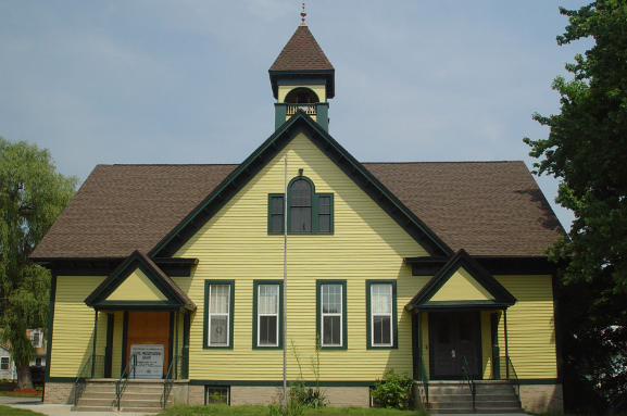
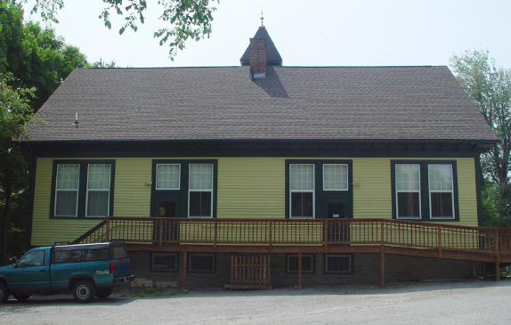
DESCRIPTION The Bridgeton School is a plain 1 ½-story rectangular wood-frame structure, 40x60', set under a high T-gable roof. The two-room schoolhouse faces south at the intersection of Laurel Hill Avenue, Church Street, and Wallum Lake Road, on a partially paved lot in the residential neighborhood of Bridgeton, near the village of Pascoag in the town of Burrillville. The school is 6 bays wide and 3 bays deep and is set long side to Laurel Hill Avenue. There is a pedimented entry porch at each end of the front elevation. The end of the T-gable is the principal architectural feature of the façade; its broad roof is capped by a heavy hip-roof square belfry, and a Palladian window is set under its apex; a shortened version of the Palladian window is set in each of the short (east and west) gable ends.
The building is set on a high foundation, rubblestone to grade level and buff-colored brick above. There is a short red brick chimney at the center of the building. The exterior walls are covered with clapboards with a 4" exposure; there are flat corner boards, heavy eaves, and exposed rafter ends. A long wheelchair ramp of unpainted timbers wraps around the west end and the rear of the building.
The two doorways are set under gable-roof entrance porches, somewhat altered from their original
appearance. The porches now have concrete steps and decks (installed in 1970), replacing wooden ones. Slender iron columns have replaced half-height round wooden columns; the appearance of the original columns is suggested by the matching engaged versions at the back of each porch. Wrought iron and pipe railings have replaced the simple wooden balusters shown in historic photographs, and the pediment of each porch is now paneled with flat boards—once there was a decorative relief (showing a lamp and laurel branches?) on each of them. But the sharp angle of each porch pediment still reflects the angle of the cross-gable. The porches remain important features, and restoration of the wood elements is planned. The original doorways are still intact—double-leaf paneled doors (glazed on the upper half), with flat-board surrounds and transoms.
The tall rectangular window openings are single on the front of the school, paired on the rear elevation.
On the ends of the building there are both paired and single openings. They are surrounded by flat boards with a simple molding and are filled with replacement double-hung sash, vinyl-covered wood, with simulated muntins dividing the sash into 12/2 on the rear of the building and 9/2 on the front, with both arrangements on the end elevations, an historic pattern; the tripartite windows in the gables have their original sash.
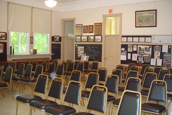
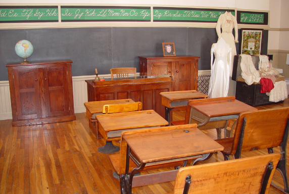
The interior of the building is divided into two equal size roughly square classrooms with service areas
ranged along the front (south) side of the school. Through each of the two main doors, one passes into a small

NPS Form 10-900-a OMB Approval No. 1024-0018 (8-86) United States Department of the Interior National Park Service NATIONAL REGISTER OF HISTORIC PLACES CONTINUATION SHEET
Bridgeton School Burrillville Providence County, RI
Name of Property City/Town County and State
Section Number 7 Page 2
(8x8') foyer and then directly into each of the classrooms. On each side of each foyer is a small closet or office; the office on the west side has been converted to a small kitchen; the closet at the southeast corner has been fitted as a bathroom. Additional closets separate the two classrooms from each other. The attic/basement stair is located at the center of the front elevation in a tiny hall that also allows passage between the classrooms without exit and re-entry. The western classroom contains the Burrillville Historical & Preservation Society's research library; the east classroom serves as a meeting place.
Throughout the interior, the schoolhouse retains original finishes and fittings. The ceilings are plaster or
pressed tin (installed in 1914). A picture molding runs around each of the classrooms. The walls are plastered and are lined with chalkboards in the classrooms. The woodwork is largely intact—paneled doors, surrounded by heavy moldings, have their early 20th-century brass hardware. Low wooden shelves set on metal brackets line the window walls. There is a small porcelain sink in each classroom on the closet wall. The flooring is 2¼" oak strips, installed in 1944, and covered by vinyl tiles in the east classroom.
The attic is unfinished; access to the belfry is by a wooden ladder. The basement is roughly finished,
with a concrete floor and bead board partitions. The school's heating plant is located here. Toilet facilities installed in the basement in 1928 replaced the privies which originally served the school. A small partitioned area, fitted with tables and benches, served as a lunch room for students.
The school lot is partially paved for parking, partially lawn. Just west of the schoolhouse is a small cast-
iron trough, moved here in 1999 from a nearby location. Also on the site are two millstones moved here from the site of a nearby gristmill.

NPS Form 10-900-a OMB Approval No. 1024-0018 (8-86) United States Department of the Interior National Park Service NATIONAL REGISTER OF HISTORIC PLACES CONTINUATION SHEET
Bridgeton School Burrillville Providence County, RI
Name of Property City/Town County and State
Section Number 7 Page 3
PHOTOGRAPHS The information for items 1 through 5 is the same for all of the photographs, as follows:
1. Bridgeton School 2. Providence County, Rhode Island 3. Betty Mencucci, Photographer 4. July 2005 5. Original digital image on file at: Rhode Island Historical Preservation & Heritage Commission
150 Benefit Street, Providence, RI 02903 6. View of the south (façade) and west elevations of Bridgeton School, from Laurel Hill Avenue. View facing northeast. 7. Photograph #1 6. View of the south (façade) elevation of Bridgeton School. View facing north. 7. Photograph #2 6. View of the west elevation of Bridgeton School. View facing east. 7. Photograph #3 6. View of the north elevation of Bridgeton School. View facing south. 7. Photograph #4 6. Interior view of the east classroom of the Bridgeton School. View facing southeast. 7. Photograph #5 6. Interior view of the west classroom of the Bridgeton School. View facing east. 7. Photograph #6
NPS Form 10-900-a OMB Approval No. 1024-0018 (8-86) United States Department of the Interior National Park Service NATIONAL REGISTER OF HISTORIC PLACES CONTINUATION SHEET
Bridgeton School Burrillville Providence County, RI
Name of Property City/Town County and State
Section Number 8 Page 1
SIGNIFICANCE
The Bridgeton School (1897) is significant for its ability to document some significant patterns of settlement and development in the town of Burrillville and for its association with the history of public education in Burrillville. One of several small school buildings constructed in the town's mill villages in the 1890s, Bridgeton School is the best preserved of the group. While the others have been demolished or converted to alternative uses, Bridgeton School is maintained by the Burrillville Historical & Preservation Society as a museum of the town's history. The well preserved turn-of-the-century interior documents the appearance and feeling of a school built for the children of the town's farm and factory workers a century ago.
Burrillville was first settled in the late 17th century, but it remained a sparsely populated agricultural
area, its rocky wooded landscape dotted by a few subsistence homesteads, until well into the 19th century. Beginning in early 19th century, the town's streams and small rivers, the Branch River and its tributaries, the Chepachet, the Clear, and the Pascoag Rivers, were harnessed to power small textile and other mills.
Through the 19th century, some of the settlements surrounding these mill sites remained small, but others
grew into substantial communities, and the characteristic pattern of development in Burrillville was set-- the town never developed a single center, but became an aggregation of villages. While some farms continued to operate in the 19th century, the mill villages were the real nodes of development. New residents came to work in the mills, from surrounding areas and from northern Europe and southern Canada, and by the turn of the century, there were more than a dozen industrial villages in Burrillville.
Burrillville's villages were centers of civic as well as working life for their residents. While the tiniest
hamlets comprised no more than a small mill and a few houses, the larger villages had churches, schools, libraries, meeting halls, and stores. Even into the 20th century, as Burrillville developed into a suburban community and a regional recreation center, the town's villages remain an important organizing principle for development.
Bridgeton is one of Burrillville's smaller villages. Located near Pascoag village on the Clear River, the
Bridgeton area developed originally as several tiny hamlets (Huntsville, Laurel Hill, and Saxonville), each centered on a minor mill site. By the late 19th and early 20th century, the distinct character of each settlement had disappeared, and the area was known as Bridgeton. Today, the village includes a mill, a number of historic mill sites, and several houses from the 19th and 20th centuries. Its center is the triangular intersection of Laurel Hill Avenue, Wallum Lake Road, and Church Street.

NPS Form 10-900-a OMB Approval No. 1024-0018 (8-86) United States Department of the Interior National Park Service NATIONAL REGISTER OF HISTORIC PLACES CONTINUATION SHEET
Bridgeton School Burrillville Providence County, RI
Name of Property City/Town County and State
Section Number 8 Page 2
The Town of Burrillville constructed a number of district schools in the middle decades of the 19th
century, most of them small, 1-story frame buildings with a single classroom. By the later decades of the century, the town's population had increased substantially and new schools were required, both as replacements for earlier buildings and to serve newer areas, now more heavily populated. In the decades at the turn of the century the Town constructed schools at Mapleville (c1890), Nasonville (c1890), Pascoag (1893), Bridgeton (1897), and Harrisville (1904)—all of them 1- or 2-story wood-frame buildings. Larger than the earlier set of school buildings, these have 2 or 4 classrooms each.
The Burrillville School Committee had noted in the mid-1890s that a new building was needed in the
Bridgeton area. The existing school, dating from mid-century, was condemned by the State Commissioner for Public Schools in early 1897, and by May the School Committee had engaged architect George W. Spaulding to draw plans for a new 2-room school to serve elementary students from Bridgeton and an overflow of students from the new primary school in nearby Pascoag.
Spaulding was a native Rhode Islander who had worked for several decades as a mechanical engineer
for the Woonsocket Machine & Press Company, a textile machine shop in nearby Woonsocket, RI. In 1885 he set up as an engineer and architect, with an office located in Woonsocket's Exchange Block.
Bridgeton School was constructed on land purchased from Nehemiah Kimball who also served as
contractor and builder of the school. In August 1897 the foundation had been constructed; construction work continued until November of that year when the school was opened.
As with the other 1890s schools in Burrillville, Bridgeton School was built to serve the primary grades 1
through 4. For much of the student population of the town, schooling ended after these early grades. With its expanding mills offering work, many students applied for labor certificates after the fourth or fifth grade—so that the early grades were overflowing, and there were few students in the upper grades. In 1905, for example, the town had 140 students in its first grade classrooms, but only 13 students in its eighth grade.
For the first two years of operation at Bridgeton, only one classroom was occupied. The school's first
teacher was Bertha N. Smith who was paid $42 per week. Seventy-six students were enrolled, though only 39 attended on an average day. After 1900, grades 1 and 2 were taught in one classroom, grades 3 and 4 in the other. Enrollment increased in the early decades of the 20th century; by 1935, the school had 101 students in its classes. The Bridgeton School continued to operate until 1966 when it was closed by the Town; in 1970 it was reopened as a neighborhood kindergarten and re-named Joseph Sweeney School (after a Burrillville superintendent of schools). When the Town built the Steere Farm Elementary School in 1995, it closed Bridgeton finally and transferred ownership to the Burrillville Preservation & Historical Society.
NPS Form 10-900-a OMB Approval No. 1024-0018 (8-86) United States Department of the Interior National Park Service NATIONAL REGISTER OF HISTORIC PLACES CONTINUATION SHEET
Bridgeton School Burrillville Providence County, RI
Name of Property City/Town County and State
Section Number 9 Page 1
BIBLIOGRAPHY Pascoag Herald and Burrillville News Gazette: 1897. Rhode Island Historical Preservation Commission. Historic and Architectural Resources of Burrillville, Rhode Island: A Preliminary Report. Providence, R.I., 1982. Sanborn Fire Insurance Co. Maps of Pascoag-Harrisville, R.I.: 1921. Town of Burrillville. Annual Reports of the Town of Burrillville School Committee: 1896-1971. Town Council Minutes: 1897.
NPS Form 10-900-a OMB Approval No. 1024-0018 (8-86) United States Department of the Interior National Park Service NATIONAL REGISTER OF HISTORIC PLACES CONTINUATION SHEET
Bridgeton School Burrillville Providence County, RI
Name of Property City/Town County and State
Section Number 10 Page 1
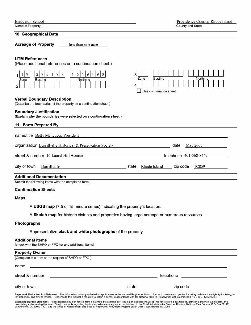
GEOGRAPHICAL DATA Verbal Boundary Description The boundaries of the nominated property follow the lot lines of the entire parcel occupied by the Bridgeton School (A.P. 157, Lot 198). Boundary Justification The boundaries of the nominated property comprise all of the land area historically associated with the Bridgeton School.