Embed Size (px)
Citation preview

8/3/2019 Des Moines River Valley State Trail Master Plan Draft
http://slidepdf.com/reader/full/des-moines-river-valley-state-trail-master-plan-draft 1/89
DES MOINES RIVER V ALLEY
STATE TRAIL
M ASTER PLAN
Minnesota Department of Natural Resources
Division of Parks and Trails
DRAFT – November 2011

8/3/2019 Des Moines River Valley State Trail Master Plan Draft
http://slidepdf.com/reader/full/des-moines-river-valley-state-trail-master-plan-draft 2/89
The Minnesota Department of Natural Resources, Parks and Trails Division
would like to thank all who participated in this master planning process. Many
individuals and groups in trail communities have been working for many years
to help establish this trail. The Friends of Jackson County Trails has played a
leading role in these efforts and continues to do so. Many DNR staff, city,
county, state and federal officials, trail association members and local citizens
contributed their time and energy to the planning process as well.
Project Team
• Suzanne Rhees, AICP, Principal Planner
• Phil Nasby, Area Supervisor
• Vicki Robinson, Acquisition and Development Specialist
• Jenny Wood, Conservation Corps of Minnesota Planner
Technical Assistance
• Holly Larson, National Park Service, Rivers, Trails and Conservation
Assistance Program
• Emily Shively, National Park Service, SCA/Americorps Fellow
November 2011, Minnesota Department of Natural Resources.
Equal opportunity to participate in and benefit from programs of the Minnesota
Department of Natural Resources is available to all individuals regardless of
race, color, creed, religion, national origin, sex, marital status, status with regard
to public assistance, age, sexual orientation, membership or activity in a local
commission, or disability. Discrimination inquiries should be sent to MN-DNR,
500 Lafayette Road, St. Paul, MN 55155-4031; or the Equal Opportunity Office,
Department of the Interior, Washington, DC 20240.
This document is available in alternative formats to individuals with disabilities
by calling 651-296-6157 (Metro Area) or 1-888-MINNDNR (MN Toll Free) or
Telecommunication Device for the Deaf/TTY: 651-296-5484 (Metro Area) or 1-
800-657-3929 (Toll Free TTY).
For general information regarding DNR’s programs, contact:
Minnesota Department of Natural Resources
500 Lafayette Road
St. Paul, MN 55155-4040
http://www.dnr.state.mn.us
651-296-6157 (Metro area and outside Minnesota)
1-888-MINNDNR (MN Toll Free)
TDD: 651-296-5485 (Metro Area)
TDD: 1-800-657-3929 (MN Toll Free)
8/3/2019 Des Moines River Valley State Trail Master Plan Draft
http://slidepdf.com/reader/full/des-moines-river-valley-state-trail-master-plan-draft 3/89
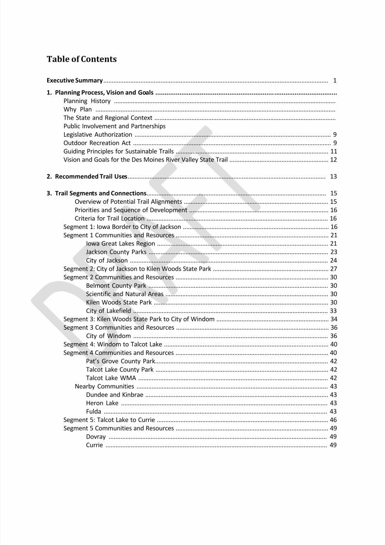
Table of Contents
Executive Summary ...................................................................................................................................... 1
1. Planning Process, Vision and Goals ..................................................................................................Planning History ....................................................................................................................................
Why Plan ...............................................................................................................................................
The State and Regional Context ............................................................................................................
Public Involvement and Partnerships
Legislative Authorization ..................................................................................................................... 9
Outdoor Recreation Act ...................................................................................................................... 9
Guiding Principles for Sustainable Trails ........................................................................................... 11
Vision and Goals for the Des Moines River Valley State Trail ........................................................... 12
2. Recommended Trail Uses...................................................................................................................... 13
3. Trail Segments and Connections........................................................................................................... 15Overview of Potential Trail Alignments ...................................................................................... 15
Priorities and Sequence of Development ................................................................................... 16
Criteria for Trail Location ............................................................................................................ 16
Segment 1: Iowa Border to City of Jackson ....................................................................................... 16
Segment 1 Communities and Resources ........................................................................................... 21
Iowa Great Lakes Region ...................................................................................................... 21
Jackson County Parks ........................................................................................................... 23
City of Jackson ...................................................................................................................... 24
Segment 2: City of Jackson to Kilen Woods State Park ..................................................................... 27
Segment 2 Communities and Resources ........................................................................................... 30
Belmont County Park ........................................................................................................... 30Scientific and Natural Areas ................................................................................................. 30
Kilen Woods State Park ........................................................................................................ 30
City of Lakefield .................................................................................................................... 33
Segment 3: Kilen Woods State Park to City of Windom ................................................................... 34
Segment 3 Communities and Resources ........................................................................................... 36
City of Windom .................................................................................................................... 36
Segment 4: Windom to Talcot Lake .................................................................................................. 40
Segment 4 Communities and Resources ........................................................................................... 40
Pat’s Grove County Park....................................................................................................... 42
Talcot Lake County Park ....................................................................................................... 42
Talcot Lake WMA ................................................................................................................. 42
Nearby Communities .................................................................................................................. 43
Dundee and Kinbrae ............................................................................................................. 43
Heron Lake ........................................................................................................................... 43
Fulda ..................................................................................................................................... 43
Segment 5: Talcot Lake to Currie ...................................................................................................... 46
Segment 5 Communities and Resources ........................................................................................... 49
Dovray .................................................................................................................................. 49
Currie .................................................................................................................................... 49

8/3/2019 Des Moines River Valley State Trail Master Plan Draft
http://slidepdf.com/reader/full/des-moines-river-valley-state-trail-master-plan-draft 4/89
Lake Shetek State Park ......................................................................................................... 50
Avoca .................................................................................................................................... 50
Slayton .................................................................................................................................. 50
4. Trail Management ................................................................................................................................. 52
Projected Trail Use ............................................................................................................................ 52
Trail Maintenance ............................................................................................................................. 52
Information and Education ............................................................................................................... 53
Trail User Orientation ................................................................................................................. 53
Identification of Services ............................................................................................................ 54
Trail Courtesy and Safety Information........................................................................................ 54
Interpretation of Natural and Cultural Resources ...................................................................... 54
Information and Education Recommendations ................................................................... 55
Enforcement ............................................................................................................................... 55
Recommendations for Enforcement .................................................................................... 56
5. Trail Corridor Resources........................................................................................................................ 57
Ecological Classification System ........................................................................................................ 57Climate .............................................................................................................................................. 58
Vegetation ......................................................................................................................................... 59
Presettlement Vegetation .......................................................................................................... 59
Present-Day Vegetation .............................................................................................................. 59
Vegetation Management Recommendations ...................................................................... 61
Water Resources ............................................................................................................................... 62
Des Moines River ........................................................................................................................ 62
Tributaries ................................................................................................................................... 63
Lakes ........................................................................................................................................... 63
Floodplains .................................................................................................................................. 64
Wetlands ..................................................................................................................................... 64Water Quality ............................................................................................................................. 65
Working Lands for Wildlife Initiative.................................................................................... 65
Shoreland Zoning and Designations ..................................................................................... 66
Water Resource Management Recommendations .............................................................. 66
Wildlife ........................................................................................................................................ 67
Mammals.............................................................................................................................. 67
Birds ..................................................................................................................................... 67
Reptiles and Amphibians ...................................................................................................... 68
Fish ....................................................................................................................................... 68
Invertebrates ........................................................................................................................ 69
Species in Greatest Conservation Need ............................................................................... 69
Threatened, Endangered and Special Concern Species ....................................................... 70
Wildlife and Habitat Recommendations .............................................................................. 70
Historic and Cultural Resources .................................................................................................. 71
Historical and Archaeological Context ................................................................................. 71
Presettlement ...................................................................................................................... 71
Exploration, settlement and agricultural development ....................................................... 72
The railroad age and modern industry ................................................................................ 72
Historic Districts, Buildings and Sites ................................................................................... 73

8/3/2019 Des Moines River Valley State Trail Master Plan Draft
http://slidepdf.com/reader/full/des-moines-river-valley-state-trail-master-plan-draft 5/89
Socioeconomic Resources .......................................................................................................... 74
Financial Impacts of Trail Development ..................................................................................... 75
6. Implementation..................................................................................................................................... 77
What Happens After the Master Plan is Finished? ........................................................................... 77
Actions Local Governments Can Take to Support Trail Development .............................................. 79
Appendices
Appendix A: Natural Communities and Special Concern, Threatened, or
Endangered Species .................................................................................................................................... 81
List of FiguresFig 1. State Trail System .............................................................................................................................. 7
Fig. 2. Regional Context................................................................................................................................ 8
Fig. 3. Trail Segment 1A: Iowa border to City of Jackson ........................................................................... 17Fig. 4. Trail Segment 1B .............................................................................................................................. 18
Fig. 5. Trail Segment 1C .............................................................................................................................. 20
Fig. 6. Iowa Great Lakes Region ................................................................................................................. 22
Fig. 7. City of Jackson ................................................................................................................................. 25
Fig. 8. Segment 2: City of Jackson to Kilen Woods State Park ................................................................... 29
Fig. 9. Kilen Woods Detail .......................................................................................................................... 32
Fig. 10. Segment 3: Kilen Woods State Park to City of Windom ................................................................ 35
Fig. 11. City of Windom .............................................................................................................................. 37
Fig. 12. Segment 4: Windom to Talcot Lake............................................................................................... 41
Fig. 13. Nearby Trail Communities ............................................................................................................. 45
Fig. 14. Segment 5: Talcot Lake to Currie ................................................................................................... 47Fig. 15. Presettlement Vegetation ............................................................................................................. 60

8/3/2019 Des Moines River Valley State Trail Master Plan Draft
http://slidepdf.com/reader/full/des-moines-river-valley-state-trail-master-plan-draft 6/89
PAGE LEFT BLANK INTENTIONALLY
8/3/2019 Des Moines River Valley State Trail Master Plan Draft
http://slidepdf.com/reader/full/des-moines-river-valley-state-trail-master-plan-draft 7/89
NOVEMBER 2011 1
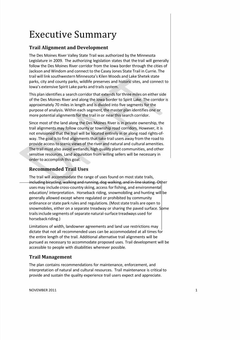
Executive SummaryTrail Alignment and Development
The Des Moines River Valley State Trail was authorized by the Minnesota
Legislature in 2009. The authorizing legislation states that the trail will generallyfollow the Des Moines River corridor from the Iowa border through the cities of
Jackson and Windom and connect to the Casey Jones State Trail in Currie. The
trail will link southwestern Minnesota’s Kilen Woods and Lake Shetek state
parks, city and county parks, wildlife preserves and historic sites, and connect to
Iowa’s extensive Spirit Lake parks and trails system.
This plan identifies a search corridor that extends for three miles on either side
of the Des Moines River and along the Iowa border to Spirit Lake. The corridor is
approximately 70 miles in length and is divided into five segments for the
purpose of analysis. Within each segment, the master plan identifies one or
more potential alignments for the trail in or near this search corridor.
Since most of the land along the Des Moines River is in private ownership, the
trail alignments may follow county or township road corridors. However, it is
not envisioned that the trail will be located entirely in or along road rights-of-
way. The goal is to find alignments that take trail users away from the road to
provide access to scenic views of the river and natural and cultural amenities.
The trail must also avoid wetlands, high quality plant communities, and other
sensitive resources. Land acquisition from willing sellers will be necessary in
order to accomplish this goal.
Recommended Trail Uses
The trail will accommodate the range of uses found on most state trails,including bicycling, walking and running, dog walking, and in-line skating. Other
uses may include cross-country skiing, access for fishing, and environmental
education/ interpretation. Horseback riding, snowmobiling and hunting will be
generally allowed except where regulated or prohibited by community
ordinance or state park rules and regulations. (Most state trails are open to
snowmobiles, either on a separate treadway or sharing the paved surface. Some
trails include segments of separate natural-surface treadways used for
horseback riding.) Limitations of width, landowner agreements and land use restrictions may
dictate that not all recommended uses can be accommodated at all times for
the entire length of the trail. Additional alternative trail alignments will bepursued as necessary to accommodate proposed uses. Trail development will be
accessible to people with disabilities wherever possible.
Trail Management
The plan contains recommendations for maintenance, enforcement, and
interpretation of natural and cultural resources. Trail maintenance is critical to
provide and sustain the quality experience trail users expect and appreciate.

8/3/2019 Des Moines River Valley State Trail Master Plan Draft
http://slidepdf.com/reader/full/des-moines-river-valley-state-trail-master-plan-draft 8/89
NOVEMBER 2011 2
The plan recommends that an adequate level of enforcement be provided via a
multifaceted approach, to help maintain a safe and secure trail environment. It
is also a goal to encourage trail users to understand and obey trail rules, respect
other trail users and respect adjoining properties.
Natural and Cultural Resources
The ecological value of the trail corridor will be enhanced wherever possible
through intensive resource management. The vegetation within the trail right-
of-way will be managed to provide a healthy diversity of native woodland,
wetland, and prairie communities for wildlife habitat and for the enjoyment of
trail users and adjoining landowners. Native flowers, grasses, trees and shrubs
that are consistent with the natural plant communities of the area will be
planted and managed. Areas disturbed during construction will be seeded with
native plants. Cultural resources will be preserved and managed for interpretive
purposes. Some native plant community management may include cooperative
efforts with adjacent land owners. Trail users will have opportunities to
experience the history of the region through existing historical and proposed
interpretive sites.

8/3/2019 Des Moines River Valley State Trail Master Plan Draft
http://slidepdf.com/reader/full/des-moines-river-valley-state-trail-master-plan-draft 9/89
NOVEMBER 2011 3
1. Planning Process, Vision and
Goals
The Des Moines River Valley State Trail Master Plan was prepared by theMinnesota Department of Natural Resources, Division of Parks and Trails, with
assistance from the National Park Service Rivers, Trails and Conservation
Assistance Program, Friends of Jackson County Trails, and the Des Moines River
Valley Trail Steering Committee.
Planning History
The Des Moines River Valley State Trail was authorized by the Minnesota
Legislature in 2009. This step marked the culmination of over a decade of work
by the Friends of Jackson County Trails and local governments.
The initial impetus for trail development in Jackson County was an effort by a
group of tourism professionals in Jackson County and the Belmont Foundationto develop a trail near the Fort Belmont site south of I-90. Participants organized
as the Friends of Jackson County Trails and toured over 90 miles of the county in
search of trail routes. With the participation of the Jackson County Highway
Department and the City of Jackson, trail development began. Today the county
trail system includes four completed trails and at least three additional trails in
the planning stage. Completed trails (shown in Figures ___ and ____) are
located in the City of Jackson and adjacent to the Iowa border, connecting to
the Spirit Lake area trail system.
The Friends group began to imagine a future trail system that would connect to
Kilen Woods State Park and potentially to the Casey Jones Trail. The group
worked with area legislators to advocate for designation of a state trailextending the length of the Des Moines River in Minnesota. The river is already
designated as a State Water Trail used for canoeing and canoe camping
between the Minnesota-Iowa border and Talcot Lake County Park, a distance of
68 river miles.
Following the state trail designation in 2009, Friends of Jackson County Trails
applied for and received technical assistance from the National Park Service’s
Rivers, Trails and Conservation Assistance Program. NPS is working with DNR on
trail planning and meeting facilitation, with an emphasis on building awareness
and support for the trail and local planning capacity.
Why Plan?
Master planning for state trails is conducted in order to:
• Provide a unifying vision for trail advocates who are working to secure a
trail alignment and funds for development and maintenance of the trail.
• Guide the development, management, maintenance and operation of
the trail so that quality recreational, transportation and healthful
exercise opportunities are provided.

8/3/2019 Des Moines River Valley State Trail Master Plan Draft
http://slidepdf.com/reader/full/des-moines-river-valley-state-trail-master-plan-draft 10/89

8/3/2019 Des Moines River Valley State Trail Master Plan Draft
http://slidepdf.com/reader/full/des-moines-river-valley-state-trail-master-plan-draft 11/89
8/3/2019 Des Moines River Valley State Trail Master Plan Draft
http://slidepdf.com/reader/full/des-moines-river-valley-state-trail-master-plan-draft 12/89
NOVEMBER 2011 6
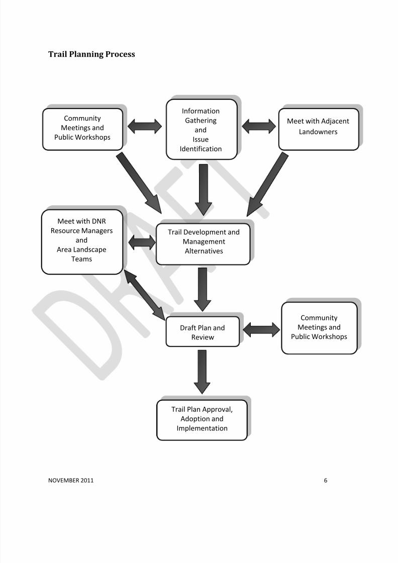
Trail Planning Process
Information
Gathering
and
Issue
Identification
Trail Development and
Management
Alternatives
Draft Plan and
Review
Trail Plan Approval,
Adoption and
Implementation
Meet with DNR
Resource Managers
and
Area Landscape
Teams
Community
Meetings and
Public Workshops
Community
Meetings and
Public Workshops
Meet with Adjacent
Landowners
8/3/2019 Des Moines River Valley State Trail Master Plan Draft
http://slidepdf.com/reader/full/des-moines-river-valley-state-trail-master-plan-draft 13/89
Minnesota Stat e Trai ls
Existing and legislatively authorized (2011
With major regional trails
Legend
Minnesota State Trails
Legislatively Authorized State Trails
Major Regional Trails
µ
International Falls
Tower
Grand Rapids
Ely
Duluth
Bemidji
Park Rapids
Brainerd
Grand
Marais
Two Harbors
Hinckley
Fergus Falls
Alexandria Osakis
Walker
Willmar
Paynesville
Hutchinson
Plymouth
St. Paul
Stillwater
Belle Plaine
Eden
Prairie
Red Wing
Pine Island
Rochester Eyota
Faribault
Mankato
Northfield
Albert Lea
Le Roy Harmony
Fountain Houston
Currie
Pipestone Lake Wilson
Arrowhead
TaconiteCJ Ramstad /North Shore
Gitchi-Gami
Heartland
PaulBunyan
WillardMunger
Matthew Lourey
CentralLakes
GlacialLakes
Gateway
Luce Line
MN Valley
SakatahSingingHills
Goodhue Pioneer
Douglas
Great River Ridge
BlazingStar Shooting
Star Harmony-Preston Valley
Root River
Casey Jones
MillTowns
Ortonville
Stagecoach
Des MoinesRiver
CuyunaLakes
Country View
Brown's Creek
Superior Vista
Prairie Wildflower Blufflands Trail
System(Olmsted, Winona, Fillmore and Houston C
LaCrescent
Luverne
Windom
Jackson
Appleton
Redwood Falls
Moorhead
Detroit Lakes
Frazee
Cass Lake
Cloquet
MN River
Camp Ripley Veterans
1/11
Lake Wobegon
Cannon Valley
Mesabi
Red Jacket
8/3/2019 Des Moines River Valley State Trail Master Plan Draft
http://slidepdf.com/reader/full/des-moines-river-valley-state-trail-master-plan-draft 14/89
!(
!(
!(
!(
!(
!(
!(
!(
!(
!(
!(
!(
!(
!(
!(
!(
!(
!(
!(
!(
!(
!(
!(
!(
!(
!(
!(!(
!(
!(
!(
!(
!(
!(
!(
!(
!(
!(
!(
!(
!(
!(
!(
!(
!(!(
!(
!(
!(
!(
!(
!(
!(
!(
!(
!(
!(
!(
!(
!(
!(
!(
!(
Casey Jones State Trail
Lake Shetek SP
Blue Mounds SP
Split Rock Creek SP
Kilen Woods SP
C a s e
y J o n
e s S t
a t e T r a i l
OsceolaDickinson
Lyon
!(
!
!(
Spirit Lake
Rock RapidsLake Park
!(Orleans
Nobles
Murray
Rock
Jackson
Martin
Cottonwood
Pipestone
Brown
Watonwan
Redwood
§̈¦90
£¤75
£¤71
£¤59
¬ « 30
¬ « 23
¬ « 60
¬ « 91
¬ « 62
¬ « 4
¬ « 86
¬ « 266
¬ « 263
¬ « 258
¬ « 270
¬ « 268
¬ « 264
¬ « 267
¬ « 269
¬ « 60
¬ « 30¬ « 30
¬ « 23
¬ « 60
¬ « 4
Windom
Slayton
Luverne
Jackson
St. Jam
Pipestone
Worthington
Odin
Iona
Steen
Ihlen
Hills
Fulda
Avoca
Alpha
Wilder
Trosky
Revere
Ormsby
Jasper
Hadley
Garvin
Dundee
Dovray
Darfur
Currie
Ceylon
Adrian
Wilmont
Welcome
Trimont
Storden
SanbornRuthton
Okabena
Lismore
Kinbrae
Kenneth
Jeffers
Holland
Dunnell
Comfrey
Bigelow
SherburnRushmore
Magnolia
La S
Hatfield
Hardwick
Edgerton
Chandler
Brewster
Woodstock
Westbrook
Lakefield
EllsworthRound Lake
Heron Lake
Lake Wilson
Butterfield
Bingham Lake
Beaver Creek
Mountain Lake
Des Moines River Valley Sta te Trail: Trail Search Corridor and Region al Connections
context.mx
Legend
Minnesota State Trails
Authorized Undeveloped State Trails
Trail Search Corridor
Minnesota Water Trails
State Parks
Scientific and Natural Areas
Wildlife Management Areas
USFWS Waterfowl Production Areas
Iowa Parks and Conservation Areas
Interstates
Federal Trunk Highways
State Trunk Highways
Railroads
´DNR Division of Parks and Trails
October 201
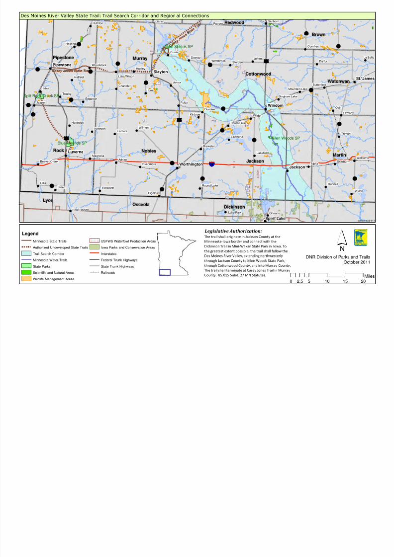
The trail shall originate in Jackson County at the
Minnesota-Iowa border and connect with the
Dickinson Trail in Mini-Wakan State Park in Iowa. To
the greatest extent possible, the trail shall follow the
Des Moines River Valley, extending northwesterly
through Jackson County to Kilen Woods State Park,
through Cottonwood County, and into Murray County.
The trail shall terminate at Casey Jones Trail in Murray
County. 85.015 Subd. 27 MN Statutes.
Legislative Authorization:
0 5 10 15 202.5M

8/3/2019 Des Moines River Valley State Trail Master Plan Draft
http://slidepdf.com/reader/full/des-moines-river-valley-state-trail-master-plan-draft 15/89
NOVEMBER 2011 9
Legislative AuthorizationThe Des Moines River Valley State Trail was authorized by the Minnesota
Legislature in 2009 (Minnesota Statutes, Chapter 85.015). The legislation is as
follows:
Subd. 27. Des Moines River Valley State Trail. The trail shall originate in
Jackson County at the Minnesota-Iowa border and connect with theDickinson Trail in Mini-Wakan State Park in Iowa. To the greatest extent
possible, the trail shall follow the Des Moines River Valley, extending
northwesterly through Jackson County to Kilen Woods State Park, through
Cottonwood County, and into Murray County. The trail shall terminate at
Casey Jones Trail in Murray County. 85.015 Subd. 27 MN Statutes.
Outdoor Recreation Act The Des Moines River Valley State Trail is one of the legislatively authorized
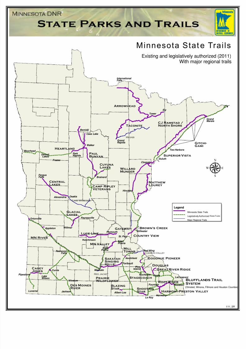
state trails in the Minnesota State Trail System (see Figure 1). State trails are
one unit of the state’s outdoor recreation system established by the Legislature.In 1975, the Minnesota Legislature enacted the Outdoor Recreation Act (ORA)
(Minnesota Statues, Chapter 86A.05, Subdivision 4 and Chapter 85.015). This act
established an outdoor recreation system comprised of eleven components or
“units” classifying all state-managed recreation lands. The ORA requires that the
managing agency prepare a master plan for the establishment and development
of each unit. This plan fulfills this mandate. The Des Moines River Valley State
Trail meets the following criteria established for state trails in the ORA:
a. A state trail shall be established to provide a recreational travel route which
connects units of the outdoor recreational system or the national trail
system, provides access to or passage through other areas which have
significant scenic, historic, scientific, or recreational qualities or reestablishesor permits travel along an historically prominent travel route or which
provides commuter transportation.
b. No unit shall be authorized as a state trail unless its proposed location
substantially satisfies the following criteria:
1. permits travel in an appropriate manner along a route which provides at
least one of the following recreational opportunities:
(i). travel along a route which connects areas or points of natural,
scientific, cultural, and historic interest;
There is a rich diversity of natural, scientific, cultural and historical
resources along the Des Moines River Valley trail corridor, as illustratedby the sampling below:
o In Jackson County, a cluster of three regionally significant county
parks, Anderson, Brown and Robertson, around Loon and Pearl
Lakes
o Village of Petersburg – creamery and town hall in a scenic rural
setting

8/3/2019 Des Moines River Valley State Trail Master Plan Draft
http://slidepdf.com/reader/full/des-moines-river-valley-state-trail-master-plan-draft 16/89
NOVEMBER 2011 10
o The Jackson Commercial Historic District, County Courthouse, and
other historic buildings – cultural and visitor attractions
o Historical sites of interest, including the former townsites of
Brownsburg and Big Bend, historic buildings at Pat’s Grove County
Park, and the original Fort Belmont site
o Kilen Woods State Park – steep ravines, oak savanna, prairie and
river bottom meadows
o Three Scientific and Natural Areas (SNAs) – Des Moines River
Prairie, Holthe Prairie, and Prairie Bush Clover – include outstanding
examples of hill prairies, calcareous fens, and shrub swamps
o In Windom, the historic county courthouse and courthouse square,
plus other cultural and visitor attractions
o In Cottonwood County, Talcot Lake and Pat’s Grove county parks,
both with water access; the former has camping and other facilities
o Lake Shetek State Park – remnants of tallgrass prairie, woodedravines, lakes and sloughs; history of early exploration and
settlement; WPA/Rustic Style Historic District and Group Camp
o Historic railroad turntable and collected historic buildings in End-o-
Line Park, Currie.
(ii) travel through an area which possesses outstanding scenic beauty;
The trail will be situated in the agricultural landscape of the upper Great
Plains, offering striking contrasts between the rolling farmland of the
uplands, the deep wooded ravines of creek and river valleys, and the
vast shallow lakes and marshes that provide critical waterfowl habitat.
Remnant and restored prairies provide glimpses of the landscape priorto European-American settlement.
(iii) travel over a route designed to enhance and utilize the unique
qualities of a particular manner of travel in harmony with the natural
environment;
The trail will be designed, where possible, to provide views of the
landscape and particularly of the river valley. The segment between
Jackson and Windom is particularly scenic, as the river flows between
wooded bluffs 100 to 200 feet in height.
Additionally, the trail will afford biker, hikers, and wildlife enthusiasts a
way to safely enjoy the scenery and cultural and natural amenities byseparating slower-paced trail users from faster-paced highway users.
(iv) travel along a route which is historically significant as a route of
migration, commerce, or communication;
The proposed trail corridor traverses an area shaped by successive eras
of settlement and transportation, from riverboat, horse and oxcart to
the era of the railroads. While the trail search corridor generally does
8/3/2019 Des Moines River Valley State Trail Master Plan Draft
http://slidepdf.com/reader/full/des-moines-river-valley-state-trail-master-plan-draft 17/89
NOVEMBER 2011 11
not follow former railroad routes, it crosses many such routes and links
small communities created or shaped by the railroads in the late 1800s.
(v) travel between units of the state outdoor recreation system or the
national trail system; and
The Des Moines River Valley State Trail will eventually link Kilen Woods
and Lake Shetek state parks, the Casey Jones State Trail, regional trails
and natural areas. It will provide a scenic route paralleling and providing
access to the Des Moines River, a designated State Water Trail for much
of its length. It will also provide a connection to the Great Lakes region
of northwestern Iowa, with numerous state parks, trails and natural
areas.
2. Utilizes, to the greatest extent possible consistent with the purposes of
this subdivision, public lands, rights-of-way, and the like;
Public land will be used when trail development is compatible with
management objectives of the administering agency. State, county, and
township road rights-of-way may also be used.
3. Provides maximum potential for the appreciation, conservation, and
enjoyment of significant scenic, historical, natural, or cultural qualities of
the areas through which the trail may pass; and
Overlooks and interpretive facilities are proposed to increase trail users’
appreciation and understanding of the natural and cultural resources of
the area. Plant community restoration projects, wildlife habitat
improvement projects, and development of environmental education
information are all projects that could benefit trail users.
The trail corridor can be a corridor for both habitat and recreation,
across landscapes developed for agricultural, commercial, andresidential use. The ecological value of the corridor could be enhanced
by working to restore healthy native plant communities.
4. Takes into consideration predicted public demand and future uses.
The master plan evaluates and uses current research on existing trail
use, demand for trail opportunities, demographic data and recreational
trends. Current demographic data is taken into account, as well as
information gathered at public workshops and through other avenues of
public participation.
Guiding Principles for Sustainable Trails
Guiding principles for ecologically sustainable trails, developed by DNR, provide
the underlying rationale for actions related to protecting, restoring, and
managing natural environments associated with trail development. There are
seven core principles:
1. Avoid sensitive ecological areas and critical habitats.
2. Develop trails in areas already influenced by human activity.
3. Provide buffers to protect sensitive ecological and hydrologic systems.

8/3/2019 Des Moines River Valley State Trail Master Plan Draft
http://slidepdf.com/reader/full/des-moines-river-valley-state-trail-master-plan-draft 18/89
NOVEMBER 2011 12
4. Use natural infiltration and best practices for stormwater management.
5. Provide ongoing stewardship of the trails and adjoining natural systems.
6. Ensure that trails remain sustainable.
7. Formally decommission and restore unsustainable trail corridors.2
Applications of these principles will minimize the impact of trails on naturalresources and sensitive ecological systems. Importantly, the strict application of
these guiding principles has to be balanced against the need to locate trails
where they will be of high recreational value to the targeted users, who often
want to be close to nature, enjoy beautiful scenes, and observe wildlife. This is
an important consideration and underscores the need for resource managers,
trail designers, and other interested individuals to work together to determine
which values are the most important for any given trail alignment.
Vision and Goals for the Des Moines River Valley State Trail
Vision
The Des Moines River Valley State Trail is a multi-use interstate trail thatprovides recreational opportunities for visitors and residents, and connects
communities to existing parks, trails, historical sites, and natural points of
interest in Southwest Minnesota in order to promote active and healthier
lifestyles.
Goals
• Improve the quality of life for local residents of all ages.
• Provide a safe way recreate, and to commute to work or school.
• Attract visitors, promote tourism and showcase the scenic, historic and
natural assets and amenities of Southwest Minnesota.
• Encourage tourism related businesses, such as lodging and retail
services.
• Design, construct, and maintain the trail in a way that enhances the
natural environment and minimizes trail users’ impact.
• Restore and manage plant communities, wildlife, soil and water
resources in a manner appropriate to the landscape setting.
• Provide access for a wide range of people with varying degrees of
capabilities, including those with disabilities.
• Develop and maintain the trail so that impacts on adjacent landowners
are avoided or minimized.
• Coordinate land management activities with adjacent land owners when
possible and appropriate.
2MN DNR, Trail Planning, Design and Development Guidelines. 2007.
8/3/2019 Des Moines River Valley State Trail Master Plan Draft
http://slidepdf.com/reader/full/des-moines-river-valley-state-trail-master-plan-draft 19/89
NOVEMBER 2011 13
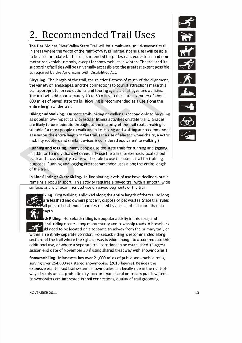
2. Recommended Trail UsesThe Des Moines River Valley State Trail will be a multi-use, multi-seasonal trail.
In areas where the width of the right-of-way is limited, not all uses will be able
to be accommodated. The trail is intended for pedestrian, equestrian, and non-
motorized vehicle use only, except for snowmobiles in winter. The trail and its
supporting facilities will be universally accessible to the greatest extent possible,
as required by the Americans with Disabilities Act.
Bicycling. The length of the trail, the relative flatness of much of the alignment,
the variety of landscapes, and the connections to tourist attractions make this
trail appropriate for recreational and touring cyclists of all ages and abilities.
The trail will add approximately 70 to 80 miles to the state inventory of about
600 miles of paved state trails. Bicycling is recommended as a use along the
entire length of the trail.
Hiking and Walking. On state trails, hiking or walking is second only to bicycling
as popular low-impact cardiovascular fitness activities on state trails. Gradesare likely to be moderate throughout the majority of the trail route, making it
suitable for most people to walk and hike. Hiking and walking are recommended
as uses on the entire length of the trail. (The use of electric wheelchairs, electric
mobility scooters and similar devices is considered equivalent to walking.)
Running and Jogging. Many people use the state trails for running and jogging.
In addition to individuals who regularly use the trails for exercise, local school
track and cross-country teams will be able to use this scenic trail for training
purposes. Running and jogging are recommended uses along the entire length
of the trail.
In-Line Skating / Skate Skiing. In-line skating levels of use have declined, but it
remains a popular sport. This activity requires a paved trail with a smooth, wide
surface, and is a recommended use on paved segments of the trail.
Dog Walking. Dog walking is allowed along the entire length of the trail so long
as dogs are leashed and owners properly dispose of pet wastes. State trail rules
require all pets to be attended and restrained by a leash of not more than six
feet in length.
Horseback Riding. Horseback riding is a popular activity in this area, and
informal trail riding occurs along many county and township roads. A horseback
trail would need to be located on a separate treadway from the primary trail, or
within an entirely separate corridor. Horseback riding is recommended along
sections of the trail where the right-of-way is wide enough to accommodate thisadditional use, or where a separate trail corridor can be established. (Suggest
season end date of November 30 if using shared treadway with snowmobiles.)
Snowmobiling. Minnesota has over 21,000 miles of public snowmobile trails,
serving over 254,000 registered snowmobiles (2010 figures). Besides the
extensive grant-in-aid trail system, snowmobiles can legally ride in the right-of-
way of roads unless prohibited by local ordinance and on frozen public waters.
Snowmobilers are interested in trail connections, quality of trail grooming,

8/3/2019 Des Moines River Valley State Trail Master Plan Draft
http://slidepdf.com/reader/full/des-moines-river-valley-state-trail-master-plan-draft 20/89
NOVEMBER 2011 14
safety, and funding stability for their programs. As urban and suburban
development expands, existing grant-in-aid routes may be lost. Snowmobiling is
recommended as a use along the entire length of the trail except where
restricted by local ordinance or park regulations.
Cross-Country Skiing and Snowshoeing. The relatively flat terrain of much of
this trail corridor makes cross-country skiing a possible winter use when snowconditions permit. Snowshoeing is also feasible within the trail corridor, outside
of cross-country ski lanes. Snowmobile use on portions of the trail may make it
less desirable for skiing and snowshoeing.
Hunting. State trails allow hunting within the trail right-of-way during the legal
hunting season, except where restricted by local ordinance. The current rule
states: “No firearm or bow and arrow shall be discharged within the trail at any
time, except for the purpose of lawful hunting during the period from
September 15 to March 30 only. No rifle, shotgun with slug, or bow and arrow
shall be discharged upon, over, or across the trail treadway at any time.”
Communities may restrict firearms or bow and arrow discharge, or trapping, by
ordinance. These ordinances take precedence over state trail rules.
Environmental Education/Interpretation. Use of the state trail for
environmental education, both for individual trail users and formal groups, is
encouraged. Schools or organizations that wish to use a trail can work with DNR
staff on specific projects. Interpretive displays on the environment and history
of the trail can enhance the trail users’ experience.
Accessibility. The trail will be accessible to people with disabilities wherever
possible. Grades in excess of 5% may be unavoidable in some locations where
the trail must match a parallel transportation corridor or where one of the
exceptions in the Federal accessibility guidelines is met.
Fishing Access. The trail will provide access to the Des Moines River and its
tributaries, many of which are popular for fishing. Depending on the location
and conditions of the trail right-of-way, this activity may be accommodated
from the trail where practical.
8/3/2019 Des Moines River Valley State Trail Master Plan Draft
http://slidepdf.com/reader/full/des-moines-river-valley-state-trail-master-plan-draft 21/89
NOVEMBER 2011 15
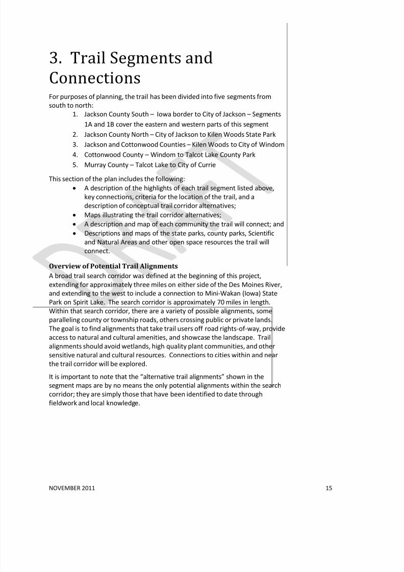
3. Trail Segments and
Connections
For purposes of planning, the trail has been divided into five segments fromsouth to north:
1. Jackson County South – Iowa border to City of Jackson – Segments
1A and 1B cover the eastern and western parts of this segment
2. Jackson County North – City of Jackson to Kilen Woods State Park
3. Jackson and Cottonwood Counties – Kilen Woods to City of Windom
4. Cottonwood County – Windom to Talcot Lake County Park
5. Murray County – Talcot Lake to City of Currie
This section of the plan includes the following:
• A description of the highlights of each trail segment listed above,
key connections, criteria for the location of the trail, and adescription of conceptual trail corridor alternatives;
• Maps illustrating the trail corridor alternatives;
• A description and map of each community the trail will connect; and
• Descriptions and maps of the state parks, county parks, Scientific
and Natural Areas and other open space resources the trail will
connect.
Overview of Potential Trail Alignments
A broad trail search corridor was defined at the beginning of this project,
extending for approximately three miles on either side of the Des Moines River,
and extending to the west to include a connection to Mini-Wakan (Iowa) State
Park on Spirit Lake. The search corridor is approximately 70 miles in length.Within that search corridor, there are a variety of possible alignments, some
paralleling county or township roads, others crossing public or private lands.
The goal is to find alignments that take trail users off road rights-of-way, provide
access to natural and cultural amenities, and showcase the landscape. Trail
alignments should avoid wetlands, high quality plant communities, and other
sensitive natural and cultural resources. Connections to cities within and near
the trail corridor will be explored.
It is important to note that the “alternative trail alignments” shown in the
segment maps are by no means the only potential alignments within the search
corridor; they are simply those that have been identified to date through
fieldwork and local knowledge.

8/3/2019 Des Moines River Valley State Trail Master Plan Draft
http://slidepdf.com/reader/full/des-moines-river-valley-state-trail-master-plan-draft 22/89
NOVEMBER 2011 16
Priorities and Sequence of Development
This master plan assumes that trail segments between Kilen Woods State Park,
the City of Jackson, and the Iowa Great Lakes Trail System are the first priority
for acquisition and development, followed by segments to the north, ultimately
connecting to the Casey Jones State Trail. These northern segments are equally
important, but are expected to be developed over a longer time frame.
This assumption is based on the past history of trail development in this area.
The motivation for trail development, and development of local and regional
trails to date, have come from Jackson County, the Friends group and the City of
Jackson. Meanwhile, the priority in Murray County has been completion of the
Casey Jones State Trail from Pipestone to the trail loop in Currie. It is anticipated
that as southerly segments of the Des Moines River Valley State Trail are
developed, interest and support will increase in Cottonwood and Murray
County.
Criteria for Trail Location
The following criteria will apply generally throughout the trail search corridor.
More specific criteria will apply to specific trail segments.
• Work with willing landowners to acquire right-of-way that showcases
features of the landscape.
• Seek alignments that detour away from roads to follow property
boundaries and field edges wherever possible. Default to road rights-of-
way when necessary.
• Avoid acquisition of high quality agricultural lands.
• Minimize impact on wetlands.
• Avoid negative impacts on rare and endangered species and avoid
fragmentation or disturbance of significant native plant communities.
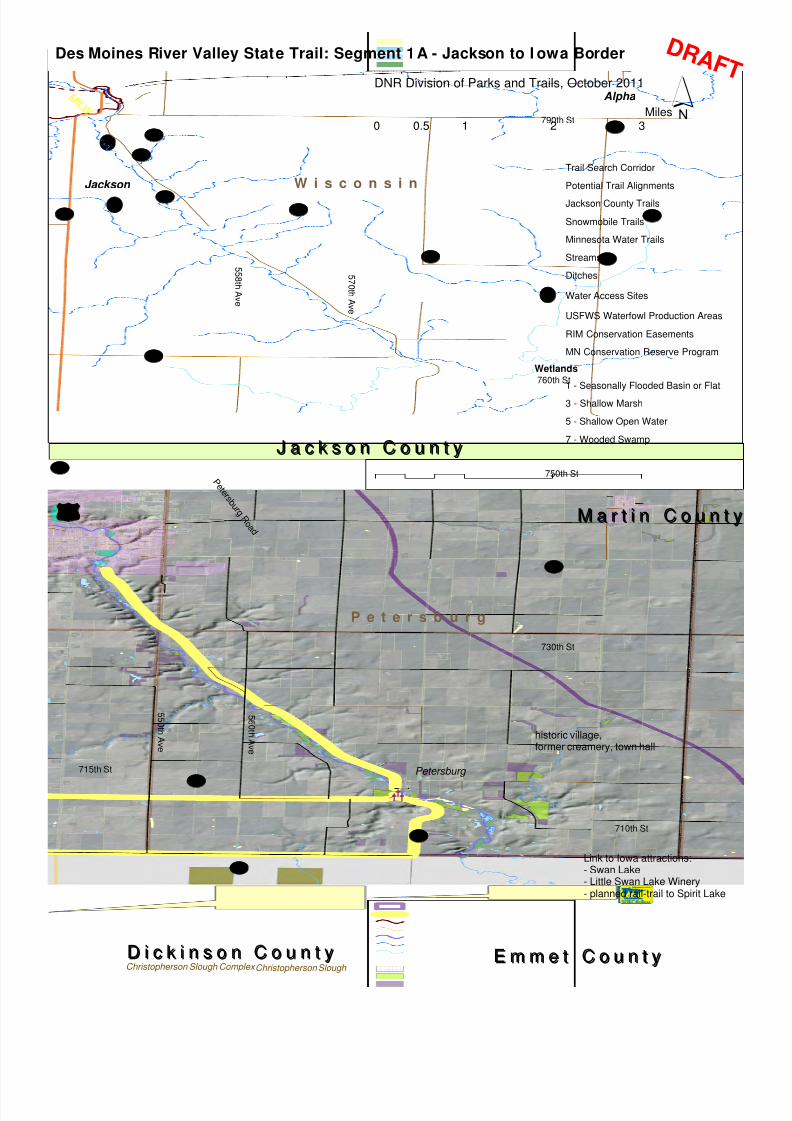
Segment 1: Jackson County South - Iowa border to City
of Jackson
Existing Trails and Points of Interest
Southeastern Jackson County is oriented both to the City of Jackson and to the
lake-oriented communities of Iowa’s Great Lakes area (see profile under
“Segment 1 Communities”). The Iowa Great Lakes Trail System in Dickinson
County includes a 14-mile “Spine Trail” connecting the communities of Spirit
Lake, Okoboji, Arnolds Park and Milford and additional non-motorized off-road
trails (see Figure __).
The Loon Lake Trail extends for about 2 miles from Mini-Wakan State Park on
the Iowa border north to Loon Lake, where it connects three Jackson County
parks, Anderson, Brown and Robertson, to the Iowa Great Lakes Trail System.
8/3/2019 Des Moines River Valley State Trail Master Plan Draft
http://slidepdf.com/reader/full/des-moines-river-valley-state-trail-master-plan-draft 23/89
[d
[d
[d Petersburg
W i s c o n s i n
P e t e r s b u r g
715th St
710th St
5 6 0 t h A v e
5 5 0 t h A v e
5 5 8 t h A v e
5 7 0 t h A v e
760th St
790th St
750th St
730th St
P e t e r s b u r g R
o a d
ï
£¤71
M I L W
Jackson
Alpha
UV23
UV25
UV29UV85
UV14
UV38
UV4
UV8
UV87
UV40
UV34UV51
UV6
UV45
UV41
UV23
UV87
Christopherson Slough Christopherson Slough Complex D i c k i n s o n C o u n t yD i c k i n s o n C o u n t y E m m e t C o u n t yE m m e t C o u n t y
J a c k s o n C o u n t yJ a c k s o n C o u n t y
M a r t i n C o u n t yM a r t i n C o u n t y
Des Moines River Valley State Trail: Segment 1A - Jackson to I owa Border
Trail Search Corridor
Potential Trail Alignments
Jackson County Trails
Snowmobile Trails
Minnesota Water Trails
Streams
Ditches
[d Water Access Sites
USFWS Waterfowl Production Areas
RIM Conservation Easements
MN Conservation Reserve Program
Wetlands
1 - Seasonally Flooded Basin or Flat
3 - Shallow Marsh
5 - Shallow Open Water
7 - Wooded Swamp
historic village,former creamery, town hall
Link to Iowa attractions:- Swan Lake- Little Swan Lake Winery- planned rail-trail to Spirit Lake
´DNR Division of Parks and Trails, October 2011
0 1 2 30.5Miles
D R AF T
8/3/2019 Des Moines River Valley State Trail Master Plan Draft
http://slidepdf.com/reader/full/des-moines-river-valley-state-trail-master-plan-draft 24/89
[d
[d[d
[d
[d
[d
[d
[d
[d
[d
M i d d l e t o w n
e rD e s M o i n e s
o t a
715th St
5 3 0 t h A v e
5 2 0 t h A v e
5 1 0 t h A v e
725th St
730th St
740th St
750th St
760th St
770th St
790th St
ï
700th St
Old wagon trail
Minimum Maintenance Road
Historic site: octagonalschoolhouse / town hall
Robertson County Park
Brown County Park nderson County Park
§̈¦90
£¤71
Pavelko WMA
Dead Horse WMA
Summers WMA
M I L W
Loon
Clear
Rush
Little Spirit
Pearl
Spirit
Chandler
Grovers
Unnamed
Unnamed
Anderson's Marsh
Unnamed
Jackson
UV34
UV17
UV73
UV2 UV75
UV23
UV68
UV70
UV81
UV10
UV14
UV50
UV38UV77
UV19
UV75
UV17
UV34
UV73
UV14
Spirit Lake Kettleson-Hogback Complex Mecclelland Beach Trickle Slough WMAGull Point St. Park D i c k i n s o n C o u n t yD i c k i n s o n C o u n t y
J a c k s o n C o u n t yJ a c k s o n C o u n t y
Des Moines River Valley State Trail: Segment 1B - Jackson to I owa Great Lakes
Trail Search Corridor
Potential Trail Alignments
Jackson County Trails
Snowmobile Trails
[d Water Access Sites
Streams
Ditches
Wildlife Management Area
USFWS Waterfowl Production Areas
City / County Parks
RIM Conservation Easements
MN Conservation Reserve Program
Abandoned Railroads (private)
Wetlands
1 - Seasonally Flooded Basin or Flat
3 - Shallow Marsh
5 - Shallow Open Water
7 - Wooded Swamp
´0 1 2 30.5Miles
DNR Division of Parks and Trails, October 2011
D R AF T
8/3/2019 Des Moines River Valley State Trail Master Plan Draft
http://slidepdf.com/reader/full/des-moines-river-valley-state-trail-master-plan-draft 25/89
NOVEMBER 2011 19
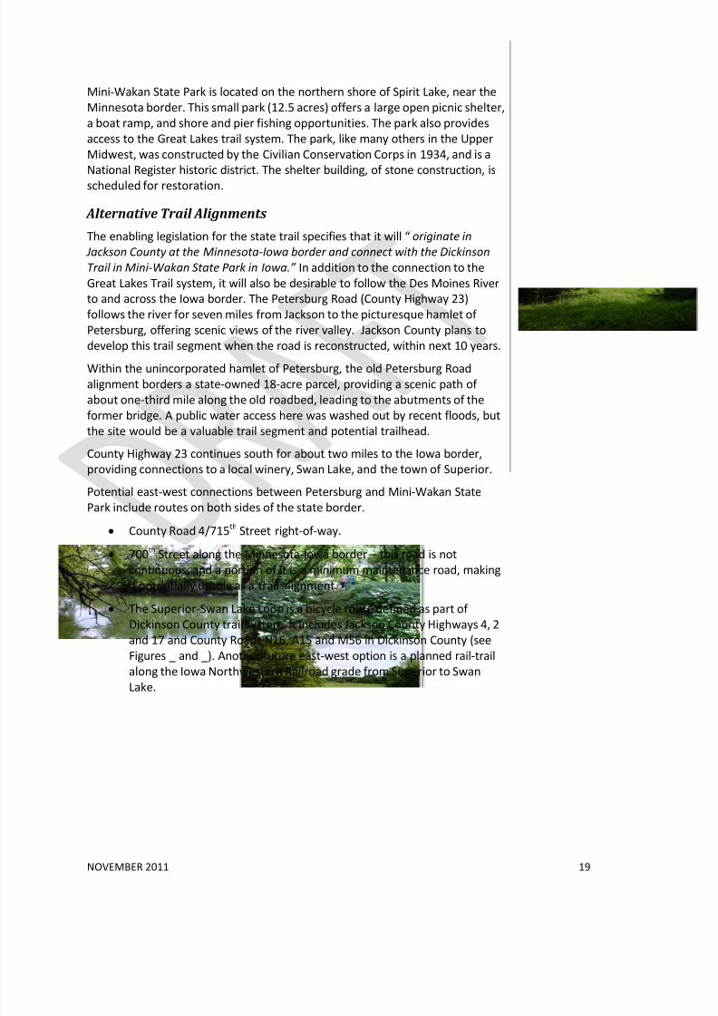
Mini-Wakan State Park is located on the northern shore of Spirit Lake, near the
Minnesota border. This small park (12.5 acres) offers a large open picnic shelter,
a boat ramp, and shore and pier fishing opportunities. The park also provides
access to the Great Lakes trail system. The park, like many others in the Upper
Midwest, was constructed by the Civilian Conservation Corps in 1934, and is a
National Register historic district. The shelter building, of stone construction, is
scheduled for restoration.
Alternative Trail Alignments
The enabling legislation for the state trail specifies that it will “ originate in
Jackson County at the Minnesota-Iowa border and connect with the Dickinson
Trail in Mini-Wakan State Park in Iowa.” In addition to the connection to the
Great Lakes Trail system, it will also be desirable to follow the Des Moines River
to and across the Iowa border. The Petersburg Road (County Highway 23)
follows the river for seven miles from Jackson to the picturesque hamlet of
Petersburg, offering scenic views of the river valley. Jackson County plans to
develop this trail segment when the road is reconstructed, within next 10 years.
Within the unincorporated hamlet of Petersburg, the old Petersburg Road
alignment borders a state-owned 18-acre parcel, providing a scenic path of
about one-third mile along the old roadbed, leading to the abutments of the
former bridge. A public water access here was washed out by recent floods, but
the site would be a valuable trail segment and potential trailhead.
County Highway 23 continues south for about two miles to the Iowa border,
providing connections to a local winery, Swan Lake, and the town of Superior.
Potential east-west connections between Petersburg and Mini-Wakan State
Park include routes on both sides of the state border.
• County Road 4/715th
Street right-of-way.• 700th Street along the Minnesota-Iowa border – this road is not
continuous, and a portion of it is a minimum maintenance road, making
it potentially usable as a trail alignment.
• The Superior-Swan Lake Loop is a bicycle route defined as part of
Dickinson County trail system. It includes Jackson County Highways 4, 2
and 17 and County Roads N16, A15 and M56 in Dickinson County (see
Figures _ and _). Another future east-west option is a planned rail-trail
along the Iowa Northwestern Railroad grade from Superior to Swan
Lake.

8/3/2019 Des Moines River Valley State Trail Master Plan Draft
http://slidepdf.com/reader/full/des-moines-river-valley-state-trail-master-plan-draft 26/89
[d
[d[d
[d
[d[d
[d Petersburg
M i d d l e t o w n
e o t a
P e t e r s b u r g
Mini-Wakan State Park
715th St
5 6 0 t h A v e
5 5 0 t h A v e
5 3 0 t h A v e
5 2 0 t h A v e
5 1 0 t h A v e
725th St
730th St
740th St
750th St
750th St
730th St
P e t e r s b u r g R
o a d
ïï
Swan Lake
I o w a N o r th w e s t e r n R R
S u p e r i o r /S w a n La k e Lo o p ( o n - r o a d )
Robertson County Park
Brown County Park
nderson County Park
£¤
71
Pavelko WMA
Loon Rush
Little Spirit
Pearl
Spirit
Chandler
Grovers
Unnamed
Unnamed
Anderson's Marsh
Unnamed
UV23
UV17
UV73
UV2UV75
UV6
UV85
UV
UV66
UV8
UV81UV73
UV23
UV75
Orleans
Spirit Lake
Superior Spirit Lake
Spirit Lake Kettleson-Hogback Complex
Christopherson Slough Complex
Christopherson Slough WPA
East Okoboji Lake Jemmerson Slough WPA
Hales Slough WMA
Jemmerson Slough Complex
Anderson Prairie W
Christopherson Slough
Spring Run WPA
Kettleson Hogsback WPA
Spring Run Wetland Complex
Anderson Prairie St. Pres
Mecclelland Beach
Gull Point St. Park
Trickle Slough WMA
Orlean Fish Hatchery
Spirit Lake Access
Templer Park St. Recreation Area
East Okoboji Slough WMA
Orleans Access
D i c k i n s o n C o u n t yD i c k i n s o n C o u n t y
J a c k s o n C o u n t yJ a c k s o n C o u n t y
Des Moines River Valley State Trail: Segment 1 - Jackson to Petersburg
Trail Search Corridor
Potential Trail Alignments
Regional and Local Trails
Rail Trail East (Planned)
Snowmobile Trails
Minnesota Water Trails
[d Water Access Sites
County Parks
Wildlife Management Area
USFWS Waterfowl Production Areas
RIM Conservation Easements
MN Conservation Reserve Program
Iowa Parks and Preserves
Iowa WMAs
State Parks
Des Moines River Valley State Trail: Segment 1C - Potent ial East- West Connections
´DNR Division of Parks and Trails, October 2011
0 1 2 30.5Miles
D R AF T

8/3/2019 Des Moines River Valley State Trail Master Plan Draft
http://slidepdf.com/reader/full/des-moines-river-valley-state-trail-master-plan-draft 27/89
NOVEMBER 2011 21
Potential trail alignments between Mini-Wakan State Park and the City of
Jackson include:
• Some combination of County Highways 73, 17 and 66 around the Loon
Lake “chain of lakes” and the three county parks. Another option to be
explored in this area is a former wagon trail right-of-way, now privately
owned, that follows the west side of Loon Lake past the Loon Lake Golf Course.
• County Highway 17 north to County 10, which follows the shoreline of
Clear Lake and connects to the Springfield Parkway trail in the City of
Jackson.
• Other options could include some combination of east-west section-line
roads such as County Highways 34, 6 and 68, or 770th Street, and the
north-south 530th Avenue. The township roads have lower traffic
volumes, but are largely unpaved, creating some challenges for trail
development.
Note: these alternative alignments are not intended to exclude other potentialalignments within the trail search corridor.
Segment 1 Communities and Resources
Iowa Great Lakes Region
Northwest Iowa’s chain of lakes extends from the Minnesota border southwest
for about 15 miles and covers approximately 15,000 acres. The Iowa Great Lakes
include Iowa’s largest natural lake, Spirit Lake and five interconnected lakes:
West Okoboji, East Okoboji, Upper Gar, Lower Gar, and Minnewashta. The
system of lakes, including the Little Spirit Lake and Loon Lake in Jackson County,
mark the southwest edge of the ice sheet known as the Des Moines Lobe, whichadvanced southward about 13,500 years ago.3
The Iowa Great Lakes region is located in Dickinson County, Iowa and includes
the communities of Spirit Lake, Orleans, Arnolds Park, Milford, West Okoboji,
Wahpeton, and Okoboji. The region is one of Iowa’s most popular vacation
destinations, with year-round recreation opportunities that include boating,
fishing, swimming, an amusement park, numerous parks and trails, historical
sites, and golf courses.
History
The Iowa Great Lakes region was probably used primarily as a hunting ground
and temporary encampment by nomadic bands of Sioux Indians. Settlers were
in the area by the 1850s, drawn by the rich soil, abundant water, and wild game.In 1857 a Wahpetuke band of Santee Sioux attacked settlements near Okoboji
3 Seigley, Lynette S. and Deborah J. Quade. Gull Point State Park: A Glacial Legacy. Iowa
Geology 1996, No.21, Iowa Department of Natural Resources.
http://www.igsb.uiowa.edu/Browse/gullpt/gullpt.htm
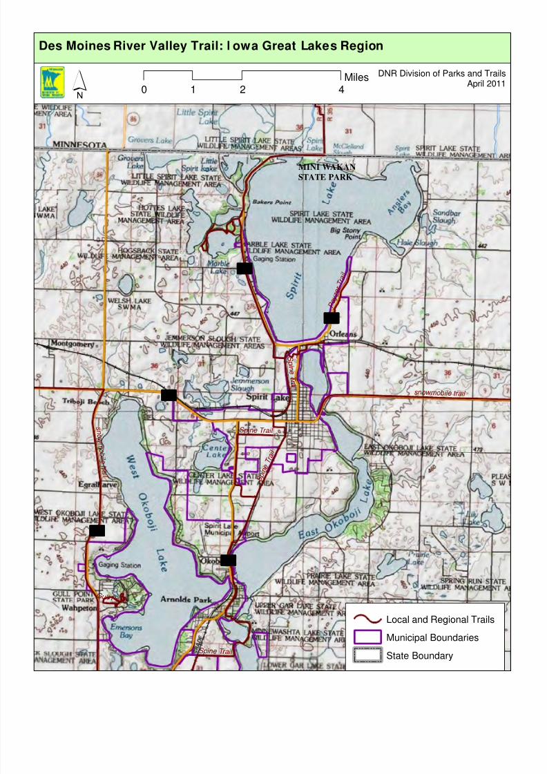
8/3/2019 Des Moines River Valley State Trail Master Plan Draft
http://slidepdf.com/reader/full/des-moines-river-valley-state-trail-master-plan-draft 28/89
MINI WAKAN
STATE PARK
³ ±86
³ ±71
³ ±276
³ ±9
³ ±327
s n o w m o b i l e
t r a i l
S p i n e
T r a i l
P o y z e
r T r a i l
G u l l P o i n t
S p i ne T r ai l
S p
i n e T r a i l
s n o w m o b il e t r a i l
S p in e T ra i l
Local and Regional Trails
Municipal Boundaries
State Boundary
0 2 41Miles
´DNR Division of Parks and Trails
April 2011
Des Moines River Valley Trail: I owa Great Lakes Region

8/3/2019 Des Moines River Valley State Trail Master Plan Draft
http://slidepdf.com/reader/full/des-moines-river-valley-state-trail-master-plan-draft 29/89
NOVEMBER 2011 23
and Spirit lakes, killing 35-40 settlers and taking four young women captive. One
of them, Abbie Gardner, was released after several months and eventually
wrote a popular memoir. Her family cabin remains as a museum in Arnolds Park.
As the area was resettled in the 1860s, it became famous for both recreational
and market fishing, and as a vacation destination.
The Great Lakes Region Today
The 2010 population of Dickinson County was 16,667, with a larger seasonal
population; the population has increased by about 12% since 1990.
Tourism is the largest industry in the Great Lakes region with many lodging,
entertainment and shopping opportunities throughout the area. There are also
numerous state parks, wildlife management areas, preserves, beaches, and city
parks. The Iowa Great Lakes Recreational Trails system is made up of 25 miles
of multi-use trails that allow for year-round recreation and provide access to
beaches, parks, and 60 miles of biking routes.
Mini-Wakan State Park is located on the northern shore of Spirit Lake, near the
Minnesota border. The park offers fishing, both from shore and on a pier, aboat launch, and a picnic shelter. The Great Lakes trail system goes through
Mini-Wakan State Park and connects to the Jackson County trail system. Other
state parks provide access to the lakes throughout the area.
Jackson County Parks
The three interconnected county parks that border the Loon Lake chain of lakes
include the following.
• Robertson County Park: Located on the east shore of Loon Lake, this
46-acre park is completely wooded and is abundant with natural flora
and fauna. The park was purchased and developed with federal Land
and Water Conservation Funds as well as state funds. Facilities include apicnic area, rest rooms, shelter house with fireplace and electricity, well
with hand pump, observation tower, trails and playground equipment; a
full-service campground with 22 trailer campsites, and a primitive tent
camping area. A contact station provides park and activity information
as well as snacks, bait, and fishing and hunting licenses.
• Brown County Park: This 15-acre park is located on the shores of both
Pearl and Loon lakes and combines woodland and open space. A creek
runs through the center of the park and serves as the outlet from Pearl
Lake, which enters into Loon Lake. Facilities include a picnic area,
restrooms, shelter house with fireplace and electricity, pressure water
system, footbridge, playground equipment; and a 30-unit full-service
campground.
• Anderson County Park: This 25-acre park, purchased in the early 1970s,
is located on the west shore of Pearl Lake. Major improvements have
increased the use of this park over the past few years. Facilities include
rest rooms, boat ramp, dock, picnic area with grills and tables, shelter
8/3/2019 Des Moines River Valley State Trail Master Plan Draft
http://slidepdf.com/reader/full/des-moines-river-valley-state-trail-master-plan-draft 30/89
NOVEMBER 2011 24
house with fireplace and electricity, observation tower; playground
equipment, and a 25-unit full-service campground.
The Loon Lake Trail connects all three parks. Robertson and Brown parks were
surveyed by the Minnesota Historical Society in 1975 and are considered
important archaeological sites dating from the Woodland cultural period.
City of Jackson
The City of Jackson is the county seat of Jackson County and is located
approximately 9 miles north of the Iowa border. The Des Moines River flows
through the center of town, providing many recreational opportunities including
canoeing and fishing.
History
During the first half of the nineteenth century, the entire southern part of
Minnesota was still inhabited by tribes of the Dakota (Sioux) Indians. What is
now Jackson County was the domain of the Lower Sisseton Sioux Tribe until
1851 when the Traverse Des Sioux treaty ceded 23,750,000 acres to the U.S.
government at a price of $2,968,750 and officially opened up the area to whitesettlement.
Although early trappers and explorers are likely to have visited the area, the first
white settlers in Jackson were brothers – William, George, and Charles Wood of
Indiana, by way of Mankato. In July of 1856, they established a trading post and
named the proposed town “Springfield” because there was a spring near where
they built their cabin, a large one-room log building near the Des Moines River.
Forty settlers followed in that summer of 1856, most of them of English and
Scottish descent, coming from Webster City, Iowa. Over a dozen log cabins were
built by that fall.
The winter of 1856-1857 was one of the most severe that was ever experiencedbecause of its bitter cold, deep snows, and violent storms. Food was scarce as
all the white settlers had come too late to raise a crop or plant gardens.
Consequently, all provisions had to be hauled from the nearest settlements of
Webster City or Mankato. Tensions between white settlers and Dakota (Sioux)
tribes in the region resulted in attacks in the Okoboji and Spirit Lake area, and
culminated in an attack on the Springfield settlement in March of 1857. Seven
settlers were killed and the remaining settlers left for Fort Dodge.
Just two months after the massacre and when the area was completely
depopulated, the Minnesota State Legislature made the county a political
division, naming it Jackson County – after the first merchant of St. Paul. The
temporary county seat was located the town site of Springfield, now renamed“Jackson.” Resettlement was slow, since settlers still feared the Indians. The
federal census of 1860 listed 52 households and 181 people in the county. The

8/3/2019 Des Moines River Valley State Trail Master Plan Draft
http://slidepdf.com/reader/full/des-moines-river-valley-state-trail-master-plan-draft 31/89
Springfie l d P k w y
North Hway
4 t h S t
6 t h S t
3 r d S t
2 n d S t
1 s t S t
R i v er S t
Grant St
Sherman St
White St
South St
South Hway
Thomas Hill Rd
P ar k S t
B r own S t
L o g anA v e
S v er d r u pA v e
B u t l er A v e
M or r i s onA v e
W e s t S t
D ew e y S t
South HwaySouth Hway
R i v e r s i d e D r
I n d u s t r i a
l P a r k w a y
5 3 2 n d A v e
B l a c k B r i d g eR d
Jackson Golf Club
Fort Belmont
Benes Recreation Area
Dann's Island Wayside Park
Ashley Park
Central Park
M I L W
UV38
UV34
UV50
UV23
UV14
UV40
UV51
UV41
UV34
§̈¦90
£¤71
Des Moines River Valley State Trail: City of Jackson
Jackson County Trails
Proposed Trails
Snowmobile Trails
Minnesota Water Trails
Railroads
Abandoned Railroads
´0 0.5 10.25Miles
DNR Division of Parks and TrailsJune 2011
Former RR bridge
Future Fort Belmont Trail
8/3/2019 Des Moines River Valley State Trail Master Plan Draft
http://slidepdf.com/reader/full/des-moines-river-valley-state-trail-master-plan-draft 32/89
NOVEMBER 2011 26
settlers’ birthplaces were recorded; most of them were born in eastern states,
with a substantial number from Norway.4
During the Dakota conflict of 1862, the settlement of Belmont, about seven
miles northwest of Jackson, was attacked and 13 settlers were killed; the
survivors fled to Iowa. Resettlement of the area did not resume in earnest until
after the Civil War in 1865. The 1865 Minnesota State Census showed 47households within Jackson County.
Settlers turned the prairie wilderness into farms and communities. The advent
of railroads hastened the influx of immigrants into the county, and with them,
the conversion of the prairie into cropland. Blizzards, droughts, grasshoppers
and windstorms plagued early settlers of the river valley throughout the years.
Jackson Today
Jackson’s 2010 population is 3,299. While agriculture is the main industry,
Jackson is also home to many other businesses. The farm machinery and
equipment manufacturing company AGCO Corporation is the largest employer
in the community, employing over 1,000 people. In early 2011, the company
announced the expansion of its Jackson operations to include the production of
high-horsepower row crop tractors and a visitor’s center. The expansion is
expected to bring new jobs to the community along with a boost in the local
economy caused by increased tourism related to the AGCO visitors’ center.
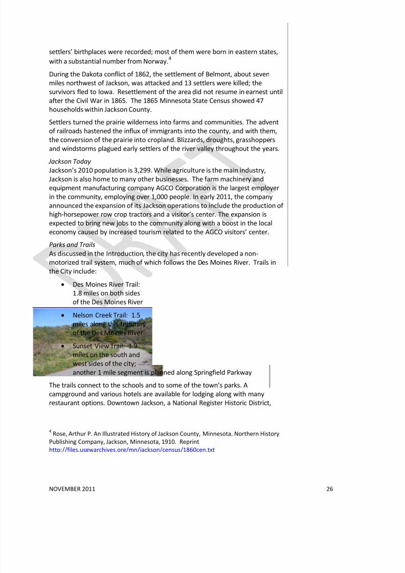
Parks and Trails
As discussed in the Introduction, the city has recently developed a non-
motorized trail system, much of which follows the Des Moines River. Trails in
the City include:
• Des Moines River Trail:
1.8 miles on both sides
of the Des Moines River
• Nelson Creek Trail: 1.5
miles along this tributary
of the Des Moines River
• Sunset View Trail: 1.9
miles on the south and
west sides of the city;
another 1 mile segment is planned along Springfield Parkway
The trails connect to the schools and to some of the town’s parks. A
campground and various hotels are available for lodging along with many
restaurant options. Downtown Jackson, a National Register Historic District,
4Rose, Arthur P. An Illustrated History of Jackson County, Minnesota. Northern History
Publishing Company, Jackson, Minnesota, 1910. Reprint
http://files.usgwarchives.org/mn/jackson/census/1860cen.txt

8/3/2019 Des Moines River Valley State Trail Master Plan Draft
http://slidepdf.com/reader/full/des-moines-river-valley-state-trail-master-plan-draft 33/89
NOVEMBER 2011 27
offers opportunities for shopping and entertainment. There are many historical
sites throughout the city including Jackson County Courthouse. Fort Belmont
Park, located just south of Interstate 90, offers a re-creation of Fort Belmont as
it was in the 1800s. The park includes a sod house, 1873 farmhouse, a
blacksmith shop, log cabin, and stockade.
Jackson is home to many community festivals, activities, and events throughoutthe year. Through the Jackson Active Living Partnership, the city works with
Jackson County and other partners to identify increase physical activity, improve
nutrition and promote healthy lifestyles.
A project to remove the Des Moines River Dam in Jackson was completed in
2010. The dam was originally built in 1913 as part of a municipal hydroelectric
plant. The deteriorating dam caused dangerous currents and did not allow fish
and other aquatic species to pass. The dam was replaced by a series of rapids
that will bring additional recreational opportunities such as canoeing, kayaking,
and fishing along the Des Moines River.
Trail Routes and Potential Trailheads in Jackson
Connections to Jackson’s trail system can be made from the south and west via
County Highway 34 (780th Street), which connects with the Nelson Creek and
Des Moines River trails, County Highway 10/14, which joins the Springfield
Parkway trail, and via the Petersburg Road (County 23), which connects with the
downtown trail system on the east bank of the river.
Connections to the north may include one of the following options:
• The Fort Belmont Trail, currently in the design stage, is expected to
parallel Highway 71 through the Jackson Golf Course to Fort Belmont.
From the park, a former railroad overpass, once part of the Southern
Minnesota Railroad, leads across Interstate 90. It may be possible to
establish a trail alignment across the bridge to connect with 532 nd
Avenue, or possibly to a new river crossing. (The former rail grade leads
to the abutments of the “Black Bridge,” once a well-known railroad
landmark).
• Black Bridge Road – named for the railroad bridge – leads north from
County Highway 10, crossing under Interstate 90 and paralleling the
west side of the Des Moines River to 805th Street, connecting to County
Highway 14. While this is a scenic road, it is unpaved and includes some
steep slopes, creating challenges for potential trail development.
• County Highway 14, located about a mile west of Jackson, is a paved
road that also provides a crossing of Interstate 90, but lacks the scenic
views of the valley that the other two options provide.
There are many trailhead options within the city, including Ashley Park and
Dann’s Island Wayside Park. [COMMENTS? NEW ‘DAM SITE’ PARK?]
8/3/2019 Des Moines River Valley State Trail Master Plan Draft
http://slidepdf.com/reader/full/des-moines-river-valley-state-trail-master-plan-draft 34/89
NOVEMBER 2011 28
Segment 2: Jackson County North – City of Jackson to
Kilen Woods State Park
Points of Interest
This segment extends for about four miles between Interstate 90 and Kilen
Woods State Park. This area is particularly scenic: the river flows betweenwooded bluffs 100 to 200 feet in height. Roads on bluff tops provide sweeping
views across the valley, and roads that cross the river are generally quite steep.
The valley has remained largely wooded because of its steep topography. It was
divided into woodlots when first platted, and used as such by early settlers.
Many of these wooded parcels are currently used as private hunting lands.
Belmont County Park and Kilen Woods State Park both provide camping, trails,
canoe access points, picnic grounds and other amenities. Several Scientific and
Natural Areas protect important native plant communities, including hill prairies
and rare calcareous seepage fens, where cold groundwater wells up on hillsides
and valley sideslopes.
This corridor segment includes a number of historic sites that are largely known
only to local residents, including the original Fort Belmont site, the site of the
now vanished village of Brownsburg, and the Holthe Cabin, used as a stopping
point for fur traders coming from Lake Shetek en route to Des Moines and east.
A number of historic churches, former church sites and cemeteries are also
found in the area.
Alternative Trail Alignments
As mentioned above, there are several potential trail alignments on both the
east and west sides of the Des Moines River that connect to Kilen Woods.
• On the east side, some combination of township roads (532nd
, 535th
and525th avenues) could lead north to Belmont County Park and from there
to County Highway 76 and the river crossing at Kilen Woods. (County
Highway 16 also crosses the river, and connects to County 19, but is too
steep for most cyclists).
• On the west side, some combination of County Highway 19, Black Bridge
Road, and other connecting township roads.
• Property boundaries, edges, and other options that allow trail users to
detour away from the road and enjoy the natural and scenic qualities of
the landscape.
A new river crossing, while costly, should also be considered, especially if existing bridge abutments could be used.
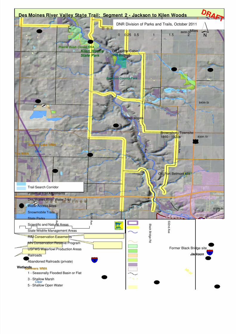
8/3/2019 Des Moines River Valley State Trail Master Plan Draft
http://slidepdf.com/reader/full/des-moines-river-valley-state-trail-master-plan-draft 35/89
B e l m o n t
D e s M o i n e s
5 1 0 t h A v e
5 3 2 n d A v e
5 3 5 t h A v e
5 0 0 t h A v e
5 2 5 t h A v e
Kilen Woods State Park
B l a c k B
r i d g e R d
840th St
830th St
860th St
810th
Prairie Bush Clover SNA
Belmont County Park
Bootleg Lake WMA
Toe WMA
Summers WMA M I L W
Clear
Boot
Jackson
UV14
UV16
UV79
UV19
UV24
UV10
UV76
UV38
UV34
UV22
UV77
UV50
UV41
UV16
§̈¦90
§̈¦90
£¤71
Des Moines River Valley State Trail: Segment 2 - Jackson to Kilen Woods
Trail Search Corridor
Potential Trail Alignments
Des Moines River Water Trail
[d Water Access Sites
Snowmobile Trails
State Parks
Scientific and Natural Areas
State Wildlife Management Areas
RIM Conservation Easements
MN Conservation Reserve Program
USFWS Waterfowl Production Areas
Railroads
Abandoned Railroads (private)
Wetlands
1 - Seasonally Flooded Basin or Flat
3 - Shallow Marsh
5 - Shallow Open Water
Brownsburg Townsite:1860 - 1920s
Old Fort Belmont site
Ole Holthe Cabinand Dugout
´0 0.5 1 1.5 20.25Miles
DNR Division of Parks and Trails, October 2011
Former Black Bridge site
D R AF T
Steep slopes

8/3/2019 Des Moines River Valley State Trail Master Plan Draft
http://slidepdf.com/reader/full/des-moines-river-valley-state-trail-master-plan-draft 36/89
NOVEMBER 2011 30
Segment 2 Communities and Resources
Belmont County Park
This 80-acre park is located a short distance south of Kilen Woods, on the east
bank of the river, and could be accessed via the trail. The park has an
interesting history: the Spirit Lake Massacre (also known as the Sioux Uprising)of 1857 involved this area. Also, the well-documented Belmont Massacre
during the Dakota War of 1862 centered around the park area, and the original
site of Fort Belmont is within three miles of the park. The park area was first
surveyed in 1874 by the St. Paul Railroad and divided into woodlots ranging
from three to five acres in size. These woodlots provided food, fuel and shelter
for pioneers moving into the area. Park facilities include restrooms, log shelter
house with fireplace and electricity, well with hand pump, grills and picnic
tables, self-guiding nature trail, and a canoe-access campsite.
Scientific and Natural Areas
Important native plant communities are protected and highlighted in several
Scientific and Natural Areas located in the river corridor. The Prairie Bush
Clover SNA consists of 13 acres located within Kilen Woods State Park on the
west side of the Des Moines River. The hill prairies within this SNA, although
dominated by sideoats grama and little bluestem, support one of the world's
largest populations of the federally threatened prairie bush clover. Also notable
is a small calcareous fen located on one of the prairie hillsides.
Kilen Woods State Park
Kilen Woods State Park has been referred to as “an oasis in the farm belt of
Minnesota.” At 228 acres in size, Kilen Woods is one of the smaller parks in the
state system, but includes a wide diversity of habitats, from oak forest to river
bottom meadows, flood plain forest, oak savanna and prairie. Oak trees grow on
the steep river valley slopes. Scattered bur oak trees, wild plums and hawthorns
occur among prairie grasses and wildflowers at the edge of the Des Moines
River Valley. Species such as big bluestem, Indian grass, blazing-star, and purple
coneflowers grow along the grassy ravines. Seven-foot tall prairie grasses,
butterfly milkweed, and grey-headed coneflowers dominate the late summer
river bottom prairie. The park includes five miles of hiking trails and 3.5 miles of
un-groomed snowmobile trail, a semi-modern drive-in campground, and a trail
shelter with fireplace.
The Des Moines River within the park provides aquatic habitat for beaver and
muskrat. Anglers can catch walleyes, northern pike, catfish, and bullheads from
the river's pools and numerous snags. Woodducks nest in tree cavities along the
river's edge while herons quietly stalk the shallows and back waters. Deer,
squirrels and woodpeckers are abundant in the park. Red admiral butterflies are
seen all summer long while the swallowtail butterflies are around during late
summer.
In 1945, the Minnesota State Legislature authorized the creation of a state park
along the Des Moines River. The park was named for Agil Kilen, from whom
8/3/2019 Des Moines River Valley State Trail Master Plan Draft
http://slidepdf.com/reader/full/des-moines-river-valley-state-trail-master-plan-draft 37/89
NOVEMBER 2011 31
most of the park land was purchased. Included in the purchase were 21 pioneer
homestead woodlots.
According to the park’s management plan, developed in 1980, park expansion
was the major issue in the planning process. The plan proposed potential
expansion through purchase of adjoining lands, up to an additional 660 acres.
The plan states:
If the park is not expanded, it may be turned over to a local unit of government to
function as a county or regional park. If this is not possible, the remaining option is
disposal of the park. This can be done in two ways: through classification as a
wildlife management area and water access site, or outright sale. The park’s present
small size precludes management as a state park.
To date, Kilen Woods has remained within the state park system at the same
size it was in 1980, 228 acres. Its future status remains uncertain. Addition of
trail connections to and through the park could increase its appeal to visitors
and broaden the base of park users.
Potential Trail Routes Through Kilen Woods State Park
County Highway 19 crosses the southern end of the park but does not provide a
connection to the main entrance, which is on County Highway 24. Ideally, a trail
alignment through the park can be determined. An existing snowmobile trail
follows the southern and western edges of the park. A trail alignment would
need to be sited to avoid steep slopes and rare plant communities, while
connecting the south side of the park to the facilities on the north side. The
Prairie Bush Clover SNA, located adjacent to the park’s southwest corner, is not
a suitable location for a paved trail; an existing walking trail provides access to
this site.

8/3/2019 Des Moines River Valley State Trail Master Plan Draft
http://slidepdf.com/reader/full/des-moines-river-valley-state-trail-master-plan-draft 38/89
[\
¼
¼
Z
¼
Kilen Woods
State Park m
m
!
!
D
--
>
Prairie Bush Clover SNA
UV79
UV24
Des Moines River Valley State Trail: Kilen Woods State Park
State Park Boundary
Potential Trail Alignments
Hiking Trails
Snowmobile Trails
Des Moines River Water Trail
[\ Water Access Sites
Scientific and Natural Areas
RIM Conservation Easements
MN Conservation Reserve Program
Parcel Boundaries
Topography - 10 Foot Interval
´0 400 800 1,200 1,600200Feet
DNR Division of Parks and Trails, October 2011
D R A F T

8/3/2019 Des Moines River Valley State Trail Master Plan Draft
http://slidepdf.com/reader/full/des-moines-river-valley-state-trail-master-plan-draft 39/89
NOVEMBER 2011 33
City of Lakefield
Lakefield is located along County Highway 14 about __ miles west of County
Highway 19, in the geographical center of Jackson County. The city was founded
by Anders R. Kilen, a Norwegian-born Jackson County pioneer whose family had
homesteaded in Belmont Township in 1867. He selected a tract in Heron Lake
Township that was higher in elevation than the surrounding area well drainedon all sides. For many years the earliest trappers who passed through the area
had known of this beautiful piece of ground called “The First Mound” by the
Indians. The lakes in the area were abundant in fish and waterfowl, which
provided early residents a source of food, and there were many muskrats to be
trapped for fur. Heron Lake, just a mile and a half away, was famous as a
hunters’ paradise and was the site of considerable market hunting.
Kilen had visions of a town being located on this tract of land. Not knowing who
owned the land, he walked to Jackson, the county seat, consulted the records
and learned in whose name the 80-acre tract was assessed. He then walked to
Windom and took a train to St. Paul, where he located the owner of the land
and returned home with the deed in his pocket. He had purchased the townsitefrom the St. Paul and Sioux City Railroad Company for $420. Kilen then met
with officials of the Southern Minnesota Railroad (later known as the Milwaukee
Road) and reached an agreement for a side-track on the land. Finally, he hired
James E. Palmer to survey and plat the new townsite.
The new town was initially called Bethania, but was dedicated by Anders Kilen in
September of 1879 as Lakefield. A train depot was built and train service began
on November 3, 1879, less than two months after the town’s christening.
Within a year a hotel, a post office, two hardware stores, a lumber yard, a
saloon, several grocery stores and several grain dealers had sprung up to serve
the people of the surrounding area.
One of Anders Kilen’s sons, Agil Kilen, sold the land and lent his name to Kilen
Woods State Park in 1945.
Lakefield’s 2010 population was 1,694. The city is home to several parks, a
swimming pool, and the Jackson County Historical Society and Museum, which
offers exhibits and archival material. The Prairie Ecology Bus, a mobile nature
center classroom that offers school workshops, camps and programs, is
headquartered in Sparks County Park on the northwest side of the city.
Lakefield’s trail plans include a connection to the Des Moines River Valley State
Trail via County Highway 14 / 820th Street. The city’s planned Old Mill Trail will
connect the elementary school on 820th Street to the City Pool and Ballpark, and
from there to the Prairie Ecology Bus Center.
8/3/2019 Des Moines River Valley State Trail Master Plan Draft
http://slidepdf.com/reader/full/des-moines-river-valley-state-trail-master-plan-draft 40/89
NOVEMBER 2011 34
Segment 3: Jackson County North – Kilen Woods State
Park to City of Windom
Points of Interest
This segment is similar in character to Segment 2, with the river flowing in a
wooded valley between steep bluffs, bordered by agricultural land. One riveraccess point, the Christiania Bridge at County Highway 30, includes a picnic area
and a canoe-in campsite a short distance downstream. County Highway 30
provides the only river crossing between Kilen Woods State Park and U.S.
Highway 71 just south of Windom. Two Scientific and Natural Areas in this
segment preserve significant native plant communities:
• Holthe Prairie SNA is located on the east side of the Des Moines River
Valley a short distance north of Kilen Woods State Park. This 148-acre SNA
has the largest known calcareous seepage fen in the Des Moines River
Valley, along with a hill prairie from which over 60 species of native forbs
have been documented. A small population of the federally threatened
prairie bush clover is also found at the site. The combination of native fenindicator species, tall and dry prairie grasses, and many wildflowers make
a summer visit to this unusual site an interesting and colorful expedition.
A total of 94 bird species have been recorded in the SNA.
• Des Moines River Prairie SNA is located on the east side of the river just
north of the Christiania (County 30) Bridge. This 210-acre high quality hill
prairie is home to numerous prairie plant species, including one of the
largest known populations of the federally threatened prairie bush clover.
The prairie bush clover is now rare, its dry gravely hill prairie habitat
largely destroyed. A member of the pea family, prairie bush clover is
silvery green in color, with narrow, clover-like leaves, and pale pink to
cream colored flowers that bloom briefly in mid-July. Other prairie plantsinclude bird's foot violets, puccoon, finger tickseed, blazing stars and wild
bergamot. Several old fields on the site are being planted with seeds
collected from the site to provide better habitat for native plant and
animal species. Trees that have grown up in the absence of wildfires are
also being removed to enhance the prairie community. Future prescribed
burns will keep trees from recolonizing the site in the future.
Alternative Trail Alignments
As discussed under Segment 2, County Highway 17 provides the most direct
north-south route between Kilen Woods State Park and the southern edge of
the city of Windom. Highway 17 turns west and continues north, crossing thecounty line to become Cottonwood County Highway 25, which intersects with
Trunk Highway 71. As discussed below, finding a viable route through Windom
that avoids Highway 71 traffic is challenging.
An alternative alignment on the east side of the Des Moines River could parallel
510th Avenue/ County Highway 79 past Lake Independence, then north along
County Highway 39 to the county line. County Highway 36 runs east-west to
Cottonwood County Highway 26, which could provide a route into the city that

8/3/2019 Des Moines River Valley State Trail Master Plan Draft
http://slidepdf.com/reader/full/des-moines-river-valley-state-trail-master-plan-draft 41/89
[d
[d
[d
[d
[d
[d
[d
[d
[d
[d[d
L a k e
B e l m o n t
l a f i e l dC h r i s t i a n i
850th St
860th St
870th St
5 2 0 t h A v e
5 1 0 t h A v e
880th St
890th St
900th St
910th St
920th St
930th St
440th St
4 7 0 t h A v e
Christiana Bridge -Water access/rest area
Kilen Woods State Park
Des Moines River SNA
Holthe Prairie SNA
Belmont County Park
Oble Knutson Park
Caraway WMA
Laurs Lake WM
Wolf Lake WMA
Lillegard WMA
Banks WMA
Fish
Wolf Summit
Independence
Three
Unnamed
South Lowe
Windom
UV39
UV17
UV79
UV36
UV30
UV24
UV76
UV15
UV82
UV78
UV26
UV25
UV2UV17
£¤71
")86
")60
")62Des Moines River Valley State Trail: Segment 3 - Kilen Woods to Windom
Trail Search Corridor
Des Moines River Water Trail
[d Water Access Sites
Snowmobile Trails
Scientific and Natural Areas
State Wildlife Management Areas
RIM Conservation Easements
MN Conservation Reserve Program
USFWS Waterfowl Production Areas
Railroads
Abandoned Railroads (private)
1 - Seasonally Flooded Basin or Flat
3 - Shallow Marsh
5 - Shallow Open Water
7 - Wooded Swamp
´0 1 2 30.5Miles
DNR Division of Parks and Trails, September 2011
D R AF T
R1 mi
8/3/2019 Des Moines River Valley State Trail Master Plan Draft
http://slidepdf.com/reader/full/des-moines-river-valley-state-trail-master-plan-draft 42/89
NOVEMBER 2011 36
avoids the high-speed traffic of Trunk Highway 71. On the other hand, this
route would require crossing Highway 71 about one mile south of the city
boundary.
As shown in Figure __, much of the farmland along Highway 39 is restricted by
easements for the Conservation Reserve Program. As these easements near
their expiration dates, possibilities should be explored for negotiating trailalignments along property or field boundaries or less productive farmland.
Segment 3 Communities and Resources
City of Windom
The city of Windom is the county seat of Cottonwood County and is located
approximately 20 miles upstream from Jackson along the Des Moines River,
which flows through the center of town. The river and many surrounding lakes
provide many recreational opportunities including boating, canoeing and
fishing.
History Cottonwood County was established on May 23, 1857. The only inhabitants in
the area prior to settlement were Native Americans, specifically the Dakota
tribe. Early settlers of Cottonwood County were a mix of Yankees and
immigrants with diverse ethnic heritages.
Windom was named by Gen. Judson W. Bishop of St. Paul in honor of William
Windom, a state senator and Secretary of Treasury under Presidents Garfield
and Harrison. The village was platted in 1871 by A.L. Beach, an engineer of the
Sioux City and St. Paul Railroad. Plats for other towns along the railroad, such as
Worthington in Minnesota and Sibley in Iowa, were laid out the same as
Windom, with a central square surrounded by business lots. But Windom was
the only village to place a courthouse on the central square, and one of only twoMinnesota county seats to follow this pattern (the other one is Preston).
About a dozen lots were sold on the first day of sales for $100 each. By August
of that year, many stores were open for business including a hardware store, a
saloon, two bakeries, a grocery store, a meat market, among others. Windom
was named the county seat of Cottonwood County in 1872.
The first school house was built in 1873 and the first lessons were taught there
in the winter of 1873-1874. A flouring mill was built in 1878 along with a mill
dam. The dam consistently washed out and was replaced in 1885 by a dam
made of brush, hay and gravel. By 1890, Windom’s population had reached 835
and in 1900 it was 1,944.Windom Today
Windom’s 2010 population was 4,646. Its location at the junction of US
Highway 71 and Minnesota Highway 60 makes it a transportation hub for the
region. The City has a diverse economy including agriculture, manufacturing,
medical care and adult care facilities. Manufacturing is the largest industry in
Windom, employing over 25% of the work force. The Toro Company, a lawn

8/3/2019 Des Moines River Valley State Trail Master Plan Draft
http://slidepdf.com/reader/full/des-moines-river-valley-state-trail-master-plan-draft 43/89
Wolf Lake WPA
Cottonwood Lake WPA
;
;
4 2 3 r d S t
¬ « 15
¬ « 26
¬ « 17
¬ « 13
¬ « 25
¬ « 36
¬ « 17
Clear
Wolf
Cottonwood
Three
F
Summit
Three
Warren
Unnamed
Summit
Unnamed
Warren Pond
Unnamed
Dynamite Park
Obie Knutson County Park
D e s M
o i n e s R i v e r
£¤71
£¤71
")62
")60
Island Park
Canoe Landing
Mayflower Park
Windom Recreation Area
Tegels Park
Kastle Kingdom Park
Jen Park
Schmultz Park
Witt Park
Abby Park
Maple Park Circle
6th St
17th St
8th St
1st St
W i n n
i e A
v e
H i g h l a n d R d
L a n g l e
y
Cind y S t
L a k e v i e
w
A v e
R i v e r R
d
22nd St
Wolf Lake WMA
Des Moines River Valley Trail: City of WindomDNR Division of Parks and Trails
October 2011
City Trail Study Corridors
Potential Trail Alignments
Snowmobile Trails
"\ Water Access
Minnesota Water Trails
County Park
City Parks
n School
"¥ DNR Office
Waterfowl Production Area
Wildlife Management Area
0 1 20.5Miles ´
USFWS Visitor Center andwalking trail
Dam removal adds new shoreland,potential for trails
Potential trailhead
Potential trailhead
8/3/2019 Des Moines River Valley State Trail Master Plan Draft
http://slidepdf.com/reader/full/des-moines-river-valley-state-trail-master-plan-draft 44/89
NOVEMBER 2011 38
mower manufacturer, and a meat-packing plant, PM Windom, are major
employers.
The city’s 14 parks, the Des Moines River, and Cottonwood Lake offer many
recreational opportunities within the city, including camping and canoeing.
Wolf Lake Walking Trail, a three-quarter-mile walking and nature trail is located
just east of Windom on County Road 17. Parking is available at the US Fish andWildlife Service office.
Local events in Windom include a weekly farmers’ market, the Cottonwood
County Fair, and Riverfest, a weeklong celebration in mid-June that includes a
softball tournament, turtle races, live music, a parade and fireworks, among
other activities.
Trail users can find opportunities for lodging in Windom’s campground or
various hotels. There are also many different restaurants and a grocery store.
Windom has a variety of retail opportunities including department stores, gift
shops, antique shops, and a flower shop. The Cottonwood County Courthouse,
located in the heart of Windom, is listed on the National Register of Historic
Places.
Windom offers many recreational amenities including 14 parks covering 124
acres. The Windom Recreation Area has three softball fields, a baseball field,
soccer field, and over a mile of walking trails. Island Park, located along the Des
Moines River, has a camping area and a community pool that is open during the
summer months. Kastle Kingdom, a 10,000 sq ft playground, and a skateboard
park are other popular attractions. A disc golf course was recently developed in
Mayflower Park, located on the east side of the river. The U.S. Fish and Wildlife
Service Visitor Center, located just east of Wolf Lake, includes a three-quarter
mile walking trail, located in a Waterfowl Production Area.
In addition to its parks, Windom is also home to the Cottonwood CountyFairgrounds, which includes the Windom Arena, a multi-purpose facility
containing racquetball courts, two ice rinks, and an indoor batting cage and golf
driving range. Racquetball and wallyball tournaments, youth hockey games,
figure skating lessons, broomball and open skating are held at the Arena.
During the summer, the facility hosts horse shows, auto shows, county fair
activities, and other special events.
The Windom dam, located on the Des Moines River in Island Park, originally
built in 1878, has periodically washed out and been rebuilt until 2007, when the
abutment washed out and the dam failed. The city worked with the DNR, the
U.S. Army Corps of Engineers, and an engineering firm conducted feasibility
studies looking at both repairing and removing the dam. The city is currentlymoving ahead with plans to remove the dam and ultimately replace it with a
series of rock riffles, similar to the Jackson dam project.
The Jeffers Petroglyphs Historic Site is located about fifteen miles north of
Windom in northern Cottonwood County. Over 2,000 images have been drawn
in the rock that was worn smooth by glaciers 14,000 years ago. The carvings
show depictions of bison, turtles, elk, salamanders, human stick figures,
thunderbirds, and weapons such as atlatls, spear points, arrowheads, and

8/3/2019 Des Moines River Valley State Trail Master Plan Draft
http://slidepdf.com/reader/full/des-moines-river-valley-state-trail-master-plan-draft 45/89
NOVEMBER 2011 39
lances. The oldest drawings are roughly 7,000 to 9,000 years old. The exposed
rock is approximately 150 ft by 600 ft and is surrounded by virgin prairie. The
Jeffers Petroglyphs site is listed on the National Register of Historic Places and is
maintained by the Minnesota Historical Society. The visitor center has
interpretive and hands-on exhibits and offers many educational events and
programs.
Trail Routes and Potential Trailheads in Windom
As mentioned above, bringing a trail into the city from the south is challenging,
because of the alignment of Highway 71, which enters the city from the
southeast, and of Highway 60, which enters from the southwest in tandem with
an active railroad line. As a result, the only potential routes into the city must
cross Highway 71 at some point.
Several potential trail routes, sidewalks and on-street bike routes through the
city are being studied by city and county park and planning staff. As shown in
Figure __, these include County Roads 26 and 17, Lakeview Avenue, 6 th Street,
16th and 17th Streets, and County Roads. The state trail and/or local trails should
provide access to city parks and schools, and to the USFWS Visitor Center andwalking trail. The city has received a Safe Routes to School grant to improve
walking and biking access to the Windom Area High School, located on 17th
Street. The results of these studies and initiatives will help to determine an
alignment for the state trail through the city.

8/3/2019 Des Moines River Valley State Trail Master Plan Draft
http://slidepdf.com/reader/full/des-moines-river-valley-state-trail-master-plan-draft 46/89
NOVEMBER 2011 40
Segment 4: Windom to Talcot Lake
Points of Interest
This segment, which spans Cottonwood County, is quite different in landscape
character from segments 2 and 3, where the Des Moines River runs generally
north-south. Through Cottonwood County, the river makes a large bend – asindicated by place names such as Great Bend Township – from north to south as
one travels upstream. Hills and broad floodplains are found along the river in
the eastern half of the county; the landscape becomes flatter to the west. Heron
Lake drains a large subwatershed, and the Heron Lake Outlet contributes much
of the Des Moines River’s flow.
The remains of several historic sites are located within the river valley, but none
have been restored or interpreted.
One site of potential recreational and historic value is Pat’s Grove County Park,
located where the Heron Lake Outlet joins the main channel of the Des Moines
River. Talcot Lake County Park, located at the western edge of this segment, is
developed for seasonal recreational use, and would serve as an important rest
stop (see descriptions below).
Alternative Trail Alignments
One of the challenges to be considered in this segment is the lack of nearby
services. Depending on the chosen alignment, the nearest services for over 15
miles may be located in one of the small towns near the corridor – Heron Lake,
Dundee or Kinbrae (see discussion under “Communities).
A related issue is which points of interest should be accessed by the trail. Pat’s
Grove, while currently undeveloped, seems to have great potential as a rest
stop and trailhead. Trunk Highway 62 leads to a pair of township roads, 423
rd
Street and 420th Street, which provide access to the park and also offer a scenic
route through a gently rolling wooded area between the String Lakes. This
route offers the most direct access to Talcot Lake County Park. However, the
presence of extensive wetlands along Highway 62 near Talcot Lake could
present challenges for a trail alignment.
Another option is a longer route that more closely follows the “great bend” of
the Des Moines River. This alignment could follow County Highways 14 and 15
(continuing as 400th Street), connecting to County Highway 7 , leading south to
Highway 62 and Talcot Lake County Park. This route would provide better views
of the river valley but is considerably longer and more distant from services.

8/3/2019 Des Moines River Valley State Trail Master Plan Draft
http://slidepdf.com/reader/full/des-moines-river-valley-state-trail-master-plan-draft 47/89
S o u t h b r o o k
R o s e H i l lA m o
G r e a t B e n dS p r i n g f i e l d
D e l a f i e l d
W e i m e rL a C r o s s e
D a l e
Pat's Grove County Park
Talcot Lake County Park
Lady Bird County Park
Dynamite County Park
4 7 0 t h A v e
4 2 3 r d S t
4 4 0 t h A v e
4 3 0 t h A v e
4 0 0 t h
A v e
4 1 0 t h A v e
400th St400th St
Co. Club Dr
405th St
4 6 0 t h A v e
395th St
4 5 0 t h A v e
370th St
420th St
440th St
390th St
380th St
420th St
3 9 0 t h A v e
3 7 0 t h A v e
3 6 0 t h A v e
3 4 0 t h A v e
3 3 0 t h A v e
3 9 0 t h A v e
4 2 0 t h A v e
930th St
930th St
390th St
410th St
360th St
D e s M o i n e s R i v e r
Talcot Lake WMA
Expandere WMA
Timber Lake WMA
Cotton-Jack WMA
Pats Pasture WMA
Winkler WMA
Voit WMAWo
Lillegard WM
Little
Wilder WMA
Barrier WMA
C N W
M I L W
Talcot
Timber
Carey Harder
North Oaks
String
Long
Heron (Duck)
South Clear
Wa
C
nbrae
Unnamed
Round
Oak Outlet
st Graham
Heron (NW Bay)
W
Talcot Pond
Windom
Wilder
Dundee
Heron Lake
UV15
UV86
UV82
UV14
UV13
UV4
UV24
UV7
UV5UV6
UV47
UV22
UV32
UV1
UV9
UV40
UV3
UV21
UV18
UV28
UV66
UV55
UV19
UV46
UV25
UV13
UV15
UV7
UV6
UV86
UV17
UV18
£¤71
")62
")60
")86
C o t t o n w o o d C o u n t yC o t t o n w o o d C o u n t y
J a c k s o n C o u n t yJ a c k s o n C o u n t y
Des Moines River State Trail: Segment 4: Windom to Talcot Lake
overview.mxd 9/29/10 ssr
´0 1 2 3 40.5
Miles
DNR Division of Parks and TrailsSeptember 2011
Trail Search Corridor
Potential Trail Alignments
Des Moines River Water Trail
[d Water Access Sites
Snowmobile Trails
Wildlife Management Areas
County Parks
USFWS Waterfowl Production Areas
MN Conservation Reserve Program
RIM Active Conservation Easements
Railroads
Abandoned Railroads (private)
National Wetland Inventory
1 - Seasonally Flooded Basin or Flat
2 - Wet Meadow
3 - Shallow Marsh
4 - Deep Marsh
5 - Shallow Open Water
6 - Shrub Swamp
7 - Wooded Swamp
Municipal and Industrial Activities
Riverine Systems
Fur trading postsite, 1820s
Big Bend townsiteCivil War vet gravesite
site of dugout
Jeffers PetrogState Historic+/- 15 miles
H e r o n L a k e O u t l e t
Overlook
Highest point in county
old school house
D R
Scenic area
8/3/2019 Des Moines River Valley State Trail Master Plan Draft
http://slidepdf.com/reader/full/des-moines-river-valley-state-trail-master-plan-draft 48/89
NOVEMBER 2011 42
Segment 4 Communities and Resources
Pat’s Grove County Park
The site has an interesting history, having been settled as early as 1866 by Pat
Conlan, one of the region’s earliest settlers. A stone house on the property, built
in 1878, is assumed to be the remains of an unfinished flour mill, with wallsmore than a foot thick and 20 feet tall. Two log cabins are also located on the
site. The park includes large stands of black walnut and basswood, providing
habitat for a diversity of birds and wildlife. This county park is currently
maintained in a primitive condition. An entrance road and a basic canoe launch
site provide access to the Heron Lake Outlet, but there are no sanitary or other
facilities.
Talcot Lake County Park
Talcot Lake County Park started as a hunting preserve on state-owned land in
1957. In 1976 it was leased to the Cottonwood County Park System for
development and maintenance under the DNR’s guidance. In 1975, the County
purchased 30 acres adjacent to the state-owned leased property. A LAWCON/
LCMR grant provided for park facility development. The county and the DNR
recently undertook a joint shoreline restoration project along the southwest
shore of Talcot Lake adjacent to the county-owned land. This state-owned
property now serves as a public access and day use area. The park now occupies
40 acres and includes:
• 67 camping sites with water and electricity • Tenting areas
• Shelter house • Picnic tables and grills • Bathrooms with shower facilities • Swimming area with sandy beach • Playground area • Sand volleyball • Camper dump station
The park is open from early May through the fall. [???]
Talcot Lake WMA
This WMA is comprised of 4,676 acres, and includes Talcot Lake and its marshes,
bottomlands along the west branch of the Des Moines River, and adjacent
grassland and cropland. This unit has been historically important for migrating
waterfowl. The WMA includes a wildlife sanctuary where hunting and
trespassing are prohibited, and a waterfowl refuge where no waterfowl hunting
is allowed. Hunting options include: deer, small game, pheasant, waterfowl, and
doves. Facilities include wheelchair-accessible blinds

8/3/2019 Des Moines River Valley State Trail Master Plan Draft
http://slidepdf.com/reader/full/des-moines-river-valley-state-trail-master-plan-draft 49/89
NOVEMBER 2011 43
Nearby Communities
These communities are located a short distance outside the trail search corridor,
and will likely offer the best opportunities for services, especially beyond the
summer season. Road shoulder and off-road trail connections to the state trail
should be explored in conjunction with state trail development.
Dundee and Kinbrae
These small cities are located in the northeast corner of Nobles County close to
the boundaries of Cottonwood, Murray and Jackson counties and a short
distance south of Talcot Lake County Park in Cottonwood County. Dundee was
established in 1879 on a branch line of the St. Paul and Sioux City Railway
Company, known as the Heron Lake & Black Hills Railroad. Most of the city’s
growth occurred in the 1890s.
As of the 2010 census, Dundee’s population was 68 and Kinbrae’s population
was 12, making it the third smallest city in Minnesota. Both cities lost
population during the 2000-2010 period, but both offer services for trail users.
The Kinbrae Supper Club, located in the city’s downtown, is a local landmark.
Heron Lake
Heron Lake is located in northwestern Jackson County, about 10 miles
southwest of Windom, and just south of the trail search corridor segment in
Cottonwood County.
Heron Lake was founded in 1871 and named after the nearby lake, on the main
line of the Chicago, St. Paul, Minneapolis, & Omaha railroad. The town was the
terminus of the Black Hills branch of that line. Once the railroad was in place,
the town developed very quickly. Its merchants drew trade from a large
territory, since it was the only railroad town in the area. Heron Lake was also
the distributing point for a much larger territory, much of the goods sold to
merchants of Jackson, Spirit Lake, Iowa, and other interior points coming by way
of Heron Lake. The early settlers in the area were predominately families
seeking opportunities for themselves and their children. The three priorities of
settlers were to build shelters for themselves and livestock, to establish
churches, and to provide education. By 1875, Heron Lake had a population of
nearly 100.
The area became well-known in the late 19th century for its waterfowl nesting
and staging areas, making it a center for market and recreational hunting.
Drainage of wetlands and stream channelization have resulted in loss of much
of this habitat.
Present-day Heron Lake has an estimated population of 698. The main industry
in the area is farming. The Heron Lake BioEnergy ethanol plant is located one
mile northeast of the city. Amenities include a city park and community center.
Fulda
The city of Fulda is located about about two miles west of the trail search
corridor, near Talcot Lake County Park. The city was another of the Catholic

8/3/2019 Des Moines River Valley State Trail Master Plan Draft
http://slidepdf.com/reader/full/des-moines-river-valley-state-trail-master-plan-draft 50/89
NOVEMBER 2011 44
colonies established by Bishop John Ireland in 1879 and incorporated in 1881. It
was settled primarily by German settlers, along with Scandinavian and Irish, and
was named after a city in central Germany.
Fulda’s population was 1,318 at the 2010 census. Although the rail line was
discontinued in 1980, the two-story depot building, along with a section of
track, has been preserved and is listed on the National Register of HistoricPlaces. The lower level of the depot is currently used as an antique museum and
store. The former Citizens State Bank building is also listed on the National
Register.
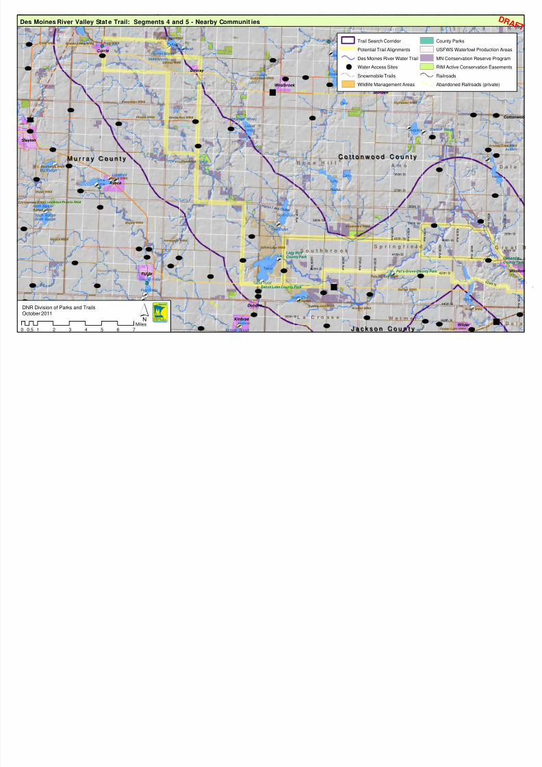
8/3/2019 Des Moines River Valley State Trail Master Plan Draft
http://slidepdf.com/reader/full/des-moines-river-valley-state-trail-master-plan-draft 51/89
C
Lake Shetek SP
Lime
South Badger
Louisa
S o u t h b r o o k
R o s e H i l lA m o
G r eS p r i n g f i e l d
DW e i m e rL a C r o s s e
D a
Pat's Grove County Park
Talcot Lake County Park
Lady Bird County Park Dy
Co
4 2 3 r d S t
4 4 0 t h A v e
4 3 0 t h A v e
4 0 0 t h A v e
4 1 0 t h A v e400th St
400th St
40
4 6 0 t h A v e
39
4 5 0 t h A v e
370th St
420th St
440th St
390th St
380th St
420th St
3 9 0 t h
A v e
3 7 0 t h A v e
3 6 0 t h A
v e
3 4 0 t h A
v e
3 3 0 t h A v e
3 9 0 t h A v e
4 2 0 t h A v e
930th St
930th St
390th St
410th St
360th St
Talcot Lake WMA
Expandere WMA
Dovray WMA
Badger WMA
Budolfson WMA
H.C. Southwick WMA
Buffalo Lake WMA
Timber Lake WMA
Beaver Creek WMA
Wirock WMA
Cotton-Jack WMA
Irruption WMA
Pats Pasture WMA
Rupp WMA
Wajer WMA
Arnolds Lak
Haberman WMA
Winkler WMA
Phelan WMA Devils Run WMA
Voit WMA
Highwater WMA
Avoca WMA
Mcgee WMA
Hurricane Lake WMA
ristensen WMA
Sweetman WMA
Elder WMA
Wilder WMA
Barrier WMA
C N W
M I L W
C N W
Talcot
Shetek
Bean
Lime
Louisa
Harder
North Oaks
String
Long
Snow
Augusta
Carey
South Clear
Double
Buffalo
Smith
South Badger
North Badger
Julia
Big Slough
Kinbrae
First Fulda
Clear
Round
Oak Outlet
A
Hurricane
Unnamed
Second Fulda
Hanson Marsh
Buffalo Marsh
Sieverding Marsh
Duck
Unnamed (Silver)
Kinbrae Slough
Metty Marsh
Sheldorf Slough
Talcot Pond
Avoca
Slayton
Fulda
Currie
Kinbrae
Wilder
Westbrook
Jeffers
Storden
Dundee
Dovray
UV15
UV53
UV86
UV52
UV33
UV21
UV8
UV2
UV34
UV14
UV4
UV68
UV13
UV37
UV7
UV5UV6
UV24
UV72
UV42
UV66
UV67
UV88
UV38
UV44
UV70
UV47
UV22
UV3
UV35
UV91
UV9
UV40
UV30
UV51
UV36
UV39
UV63
UV82
UV55
UV19
UV12
UV77
UV46
UV95
UV53
UV4
UV7
UV40
UV86
UV6
UV6
UV3
UV40
UV4
UV21
UV38
UV7
UV7
UV3
UV33
UV9
£¤59
Lundblad Prairie SNA
")30
")62
")60
M u r r a y C o u n t yM u r r a y C o u n t y C o t t o n w o o d C o u n t yC o t t o n w o o d C o u n t y
N o b l e s C o u n t yN o b l e s C o u n t yJ a c k s o n C o u n t yJ a c k s o n C o u n t y
Des Moines River Valley Stat e Trail: Segments 4 and 5 - Nearby Communit ies
´0 1 2 3 4 5 6 70.5
Miles
DNR Division of Parks and TrailsOctober 2011
Trail Search Corridor
Potential Trail Alignments
Des Moines River Water Trail
[d Water Access Sites
Snowmobile Trails
Wildlife Management Areas
County Parks
USFWS Waterfowl Production Are
MN Conservation Reserve Progra
RIM Active Conservation Easeme
Railroads
Abandoned Railroads (private)
H e r o n L a k e O u t l e t
D R
8/3/2019 Des Moines River Valley State Trail Master Plan Draft
http://slidepdf.com/reader/full/des-moines-river-valley-state-trail-master-plan-draft 52/89
NOVEMBER 2011 46
Segment 5: Talcot Lake to Currie
Points of Interest
This segment extends from Talcot Lake about 18 miles north to the small city of
Dovray, and an additional seven miles west to the city of Currie, where Lake
Shetek State Park and a loop of the Casey Jones Trail are located. Like theCottonwood County segment, it is largely composed of farmland, with few
services outside of the small towns around the corridor. The Des Moines River
is relatively narrow throughout this segment as it meanders through a level
landscape of numerous small waterways and wetlands.
Several sites of interest include a gravel-mining area that may have potential for
future off-highway vehicle recreational use, a former brick factory site that may
have historical interest, and a local winery near Dovray [NAME?].
The Dovray area also includes the Slaughter Slough monument, within the
Waterfowl Production Area of that name, a U.S. Fish and Wildlife Service site.
During the 1862 U.S. Dakota War, this was the site of a battle in which thirteen
settlers and two Dakota were killed. The slough was later drained and farmed
until 2003. USFWS, together with Ducks Unlimited, has worked since 2002 to
restore the upland prairie and refill the slough.
Potential Alignments
Because of the concentration of resources and scenic quality of the Dovray area,
one alignment shows a connection north of Dovray and west to Currie, just
outside the primary trail search corridor. A second potential alignment follows
County Highway 7, 240th Avenue, 141st Street and County Highway 38 to Currie.
Connections to nearby communities such as Avoca and Slayton should also be
considered, since these communities offer services and points of interest that
could attract trail users.
The trail search corridor in this segment is close to the planned corridor for the
Casey Jones State Trail between Pipestone, Lake Wilson, Slayton and Currie. If
that segment is developed prior to the Des Moines River Valley State Trail in this
area, connections to Casey Jones trail communities such as Slayton will become
more important.

8/3/2019 Des Moines River Valley State Trail Master Plan Draft
http://slidepdf.com/reader/full/des-moines-river-valley-state-trail-master-plan-draft 53/89
End-O-Line County Park
L i m e L a k e
D o v r a y
D e s M o i n e sR i v e r
M u r r a y
41st St
51st St
61st St
81st St
101st St
91st St
111th St
121st St
131st St
141st St
2 9 0 t h A v e
3 0 0 t h A v e
2 7 0 t h A v e
2 5 0 t h A v e
2 3 0 t h A v e
2 4 0 t h A v e
2 2 0 t h A v e
2 1 0 t h A v e
1 9 0 t h A v e
161st St
Brick factory site
Winery
Gravel pits
SlaughterSloughWPA
To Slayton
Shetek
Lime
Fox Bloody
Buffalo
Louisa
Snow
Smith
Unnamed
Julia
Park
Dibble Marsh
Hanson Marsh
Buffalo Marsh
Hanover Slough
Big Slough
Fremont
Webster Slough
Duck
Robbins Marsh
Armstrong Slough
Unnamed (Silver)
Shetek Pond #1
Metty Marsh
Malone Pond
Shetek Pond #2
Talcot Lake W
Buffalo Lake WMA
Dovray WMA
Budolfson WMA
Beaver Creek WMA
Wirock WMA
Irruption WMAH.C. Southwick WMA
Rupp WMA
Haberman WMA
Shetek WMA
Phelan WMA Devils Run WMA
Avoca WMA
Mcgee WMA
Buttermilk Run WMA
Sweetman WMA
Badger WMA
Avoca
Currie
Dovray
UV8
UV2
UV34
UV11
UV68
UV37
UV14
UV72
UV42UV7
UV67
UV6
UV38
UV44
UV47
UV17
UV35
UV3
UV50
UV39
UV104
UV4
UV15
UV13
UV45
UV51
UV2
UV1
UV102UV96
UV40
UV
UV38
UV15
UV13
£¤59
")30
Lake Shetek State Park
C a s e y J
o n e s
S t a t e
T r a
i l
Des Moines River Valley State Trail: Segment 5 - Talcot Lake to Currie
Minnesota State Trails
Authorized Undeveloped State Tra
Trail Search Corridor
Potential Trail Alignments
Snowmobile Trails
[d Water Access Sites
Ditch
Stream
State Parks
Wildlife Management Areas
Scientific and Natural Areas
USFWS Waterfowl Production Area
County Parks
MN Conservation Reserve Program
RIM Conservation Easements
Railroads
Abandoned Railroads (private)
National Wetlands Inventory
1 - Seasonally Flooded Basin or Fla
3 - Shallow Marsh
5 - Shallow Open Water
6 - Shrub Swamp
7 - Wooded Swamp
D R AF

8/3/2019 Des Moines River Valley State Trail Master Plan Draft
http://slidepdf.com/reader/full/des-moines-river-valley-state-trail-master-plan-draft 54/89
NOVEMBER 2011 48
Page left blank

8/3/2019 Des Moines River Valley State Trail Master Plan Draft
http://slidepdf.com/reader/full/des-moines-river-valley-state-trail-master-plan-draft 55/89
NOVEMBER 2011 49
Segment 5 Communities and Resources
Dovray
Dovray is located on the edge of the trail search corridor on Trunk Highway 30,
and about six miles east of Currie. The first settlers in the area came from Dovre,
Gudbrandsdalen in Norway, and when the town was organized, it was namedDovray. Today, the Norwegian traditions continue in the town’s celebration of
Uffda Day, which is held every even numbered year.
The unique historical fact about Dovray is that in 1904 the town site was moved
to be closer to the Chicago St. Paul railroad line. Originally, the town was one
mile north and one mile east of the present location. The town flourished until
1916 when the “big fire” destroyed many of the buildings.
This small agricultural town has a population of 58. Community spirit and
involvement can be seen in the volunteers of the fire department and members
of the Booster Club.
Currie
Currie was founded by Archibald Currie and his son Neil, immigrants from
Scotland by way of Canada, in 1872. Both were prominent businessmen, with
Archibald serving as county treasurer and Neil building the first store, founding
a bank, and serving as postmaster. The pair also built a flour mill on the Des
Moines River one mile from Lake Shetek. Currie was also the first county seat in
Murray County from 1872 until 1889, when it was moved to Slayton.
In the 1880s, Currie became the site of one of the Catholic colonies established
under the auspices of Bishop John Ireland of St. Paul for impoverished
immigrants (see discussion under “Cultural Resources). The Currie colony was
established by John Sweetman, a wealthy landowner from County Meath,
Ireland, who divided his time between Currie and his Irish estate.
The Omaha Railroad opened a branch line in 1899 connecting Bingham Lake to
Currie. The railroad brought new prosperity to Currie.
With a population of 233 at the 2010 census, Currie has several restaurants but
no lodging facilities. Lake Shetek is one of the major attractions in the area,
with many seasonal homes, resorts, and campgrounds that can provide lodging
to trail users. A six mile paved loop segment of the Casey Jones State Trail
connects Currie to Lake Shetek State Park.
Currie is home to the End-O-Line Railroad Park and Museum which serves as a
trailhead for the Casey Jones State Trail. The park includes a variety of historic
buildings and structures, including a section foreman’s house, a diesel switcher
and caboose, and a manually-operated turntable, among other historical
buildings. The park also has nature trails, a picnic area with a shelter, a
playground, modern restrooms, and a visitor center.

8/3/2019 Des Moines River Valley State Trail Master Plan Draft
http://slidepdf.com/reader/full/des-moines-river-valley-state-trail-master-plan-draft 56/89
NOVEMBER 2011 50
Lake Shetek State Park
Lake Shetek State Park is located 1 mile from Currie on the southeastern shore
of Lake Shetek. Shetek is an Ojibwe word for “pelican.” There are an estimated
150,000 visits to the park annually. The park consists of 1,108 acres of fields,
prairie, and oak, basswood, hackberry, elm, and ash forests.
The wooded shoreline of Lake Shetek provides cover for white-tail deer, fox,
mink, beaver, fox squirrels, muskrat, woodchuck and coyote. Several wetlands
in the park provide opportunities to view waterfowl, reptiles and amphibians. At
Eastlick Marsh, interpretive signs and an observation deck with a spotting scope
allow for close-up viewing and easy identification of coots, grebes, ducks,
herons, and pelicans. Many species of waterfowl nest in and around the park in
spring and early summer.
Fourteen miles of hiking trails meander throughout the prairie with five miles of
snowmobile trails open each winter. Other recreational opportunities for park
users include boat rental and access, a swimming beach, two campgrounds,
playground, and picnic areas.
Before modern agriculture was introduced, most of the Lake Shetek area was a
treeless prairie with hundreds of species of wildflowers and grasses. In an effort
to restore the natural prairie, prescribed burns and invasive species control are
used. Although it will take decades to even partially restore the prairie, progress
is being made. Blazing star, black-eyed Susans, coneflowers, vervain, sunflowers,
and bottle gentian are a few of the showy wildflowers growing in the park.
Avoca
Avoca is located 10 miles south of Currie on the shores of Lime Lake. Its location
about one mile from the edge of the trail search corridor makes it of interest for
possible connecting trails or bike routes, and as a location of trail user services.The town, named after a river in County Wicklow, Ireland, was founded in 1878
as one of the Catholic colonies established by Bishop John Ireland and the
Catholic Colonization Bureau (see discussion under “Cultural Resources”). The
presence of the Chicago Northwestern Railroad helped bring settlers and in the
early 1900s, early erection of a church, immigrant house, and other public
buildings greatly facilitated settlement.
Avoca was one of the larger communities in Murray County, but devastating
fires in 1907 and 1952 destroyed much of the business district.
Avoca’s population was 147 at the 2010 census. There are various festivals and
events throughout the year, including Fun in the Sun Days in July and an annual
area softball tournament in June. Lime Lake offers many recreation
opportunities, including a county park with camping, fishing, boating and
hunting. The Avoca Park has a playground, picnic shelter, and tennis court.
Slayton
Located about five miles west of the trail corridor and about 10 miles southwest
of Currie, Slayton is the Murray County seat, and serves as the county’s service,
8/3/2019 Des Moines River Valley State Trail Master Plan Draft
http://slidepdf.com/reader/full/des-moines-river-valley-state-trail-master-plan-draft 57/89
NOVEMBER 2011 51
retail, government and medical center. Located at the junction of two major
highways, U.S. Highway 59 and State Highway 30, Slayton is known as the “Hub
City” of southwest Minnesota. The city’s population was 2,173 in 2010.
Slayton was established as a train station for the St. Paul and Sioux City Railroad
Company in 1881, and named after Charles Wesley Slayton, a land agent for the
railroad company. The town was platted in 1881 and incorporated in 1887.
Slayton offers many services and amenities to trail users, including coffee shops
and restaurants, downtown retail and lodging. Recreational amenities include
four city parks and an aquatic center, Slaytona Beach West. Points of interest
include the historic 4-H Round Barn at the Murray County Fairgrounds, and the
Murray County Historical Museum, which consists of three buildings: the
museum proper, a building containing antique and vintage agricultural
machinery and equipment, and an 1872 log cabin.
The planned alignment of the Casey Jones State Trail connects Slayton to Currie.
No specific alignment for the trail has been identified. However, Slayton is
located on Beaver Creek, which flows into the Des Moines River just below the
dam in Currie, and a trail alignment following the creek would be desirable.

8/3/2019 Des Moines River Valley State Trail Master Plan Draft
http://slidepdf.com/reader/full/des-moines-river-valley-state-trail-master-plan-draft 58/89
NOVEMBER 2011 52
4. Trail Management
Projected Trail Use
It is difficult to project the level of trail use based on levels of use on other stateand regional trails in Southwest Minnesota and Iowa, since trail usage has not
been surveyed in this area. However, similar trails in other parts of Minnesota
show high levels of use. Summer use of the Douglas State Trail, a 12-mile trail
from Rochester to Pine Island that is predominantly used by local residents, had
about 65,000 “user hours” in the summer season of 2007. By comparison, the
popular Root River State Trail, used predominantly by tourists, had over 111,500
hours of use (a trail user spending one hour on the trail is a “user hour”)
State park attendance figures at nearby parks also indicate the numbers of
recreational users in the area.
2009 State Park Annual Attendance (in visitor-days)
Lake Shetek State Park: 124,281
Kilen Woods State Park: 16,350
Trail use will vary by segment and proximity to communities and area
attractions. For example, a connection from the cities of Jackson or Windom to
Kilen Woods State Park is likely to attract high numbers of local trail users.
Connections from the Spirit Lake trail system to Jackson are more likely to
attract tourists who may be vacationing in the Iowa Great Lakes area.
Trail MaintenanceAdequate maintenance of state trails is critical to provide and sustain the
experience trail users appreciate. Maintenance activities are numerous and
diverse, as the following list illustrates. Specifically, maintaining the Des Moines
River Valley State Trail will include:
• Monitoring trail conditions, which includes scheduling and
documentation of inspections; monitoring the condition of railings,
bridges, trail surfaces, and signage; hazard tree inspection; and removal
of debris such as downed trees
• Scheduling of maintenance tasks
• Mowing of vegetation: shoulders, rest areas, and parking lots (see
Recommendation 3 below)
• Winter grooming and plowing
• Tree and shrub pruning
• Trash removal
• Trail repair – fixing washouts and controlling erosion are examples
• Maintaining bridge decking and railings
• Trail drainage control
• Trail surface maintenance

8/3/2019 Des Moines River Valley State Trail Master Plan Draft
http://slidepdf.com/reader/full/des-moines-river-valley-state-trail-master-plan-draft 59/89
NOVEMBER 2011 53
• Repair of animal damage to trail or facilities
• Checking and repairing fence lines and gates
• Mowing and brushing farm crossings
• Cleaning out ditches and culverts, replacing failing culverts
• Controlling invasive species
• Maintaining equipment• Painting posts and picnic tables
• Graffiti control and vandalism repair, especially to signs
• Maintaining boundary signs, and working to resolve encroachment
issues
• Coordination of volunteer efforts
• Training and supervision of employees, Conservation Corps of
Minnesota, or Sentence to Service crews
• Sweeping asphalt surfaces
In areas with sensitive natural resources, such as Kilen Woods State Park, and at
any water accesses along the corridor, the Parks and Trails Division would follow
the guidelines established under Operational Order #113, “Invasive Species,” inconsultation with the Division of Ecological and Water Resources. The guidelines
prescribe methods for avoiding the introduction or spread of invasive species,
and managing and treating infestations of such species.
Maintenance Recommendations
Recommendation 1: Additional maintenance funds will be required to maintain
the trail after it is developed.
Recommendation 2: The trail should be seal coated approximately six years
after initial development. Research shows that this will prolong the life of the
trail.
Recommendation 3: Consideration should be given to mowing remnant and
restored prairie once in the fall to retain robust prairie species and reduce the
risk of introducing invasive species. Resource management staff will provide
additional direction regarding maintenance within Kilen Woods State Park.
Recommendation 4: Prescribed burning on prairie areas should be a priority
maintenance practice. Portions of the trail may need to be closed during a
prescribed burn event.
Information and Education
Trail User Orientation
Trail users must have good information about the trail system so they can make
choices about destinations appropriate for their time frame, skill level, need for
services such as food and lodging, links to regional or local trails, and the type of
scenery and other recreational opportunities available along the route. This
type of information should be displayed on information boards at parking areas,
in communities and at trail junctions. It should be available on maps, and on
8/3/2019 Des Moines River Valley State Trail Master Plan Draft
http://slidepdf.com/reader/full/des-moines-river-valley-state-trail-master-plan-draft 60/89
NOVEMBER 2011 54
the DNR Website. It should include distances between communities, options for
other trail connections and locations of services. If any significant deviation
from the typical trail design occurs – e.g., when a trail enters a community – it
should be noted on signs or informational kiosks to assist trail users in
understanding what the trail experience will be.
Identification of Services
Trail users benefit from knowing where they can obtain services (medical
assistance, telephones, gasoline, food, lodging, restrooms, campgrounds, repair
facilities, or other retail) and local businesses benefit from an increase in
customers. A listing of the services available in each community developed,
maintained and updated by the community could be displayed on information
boards at parking areas in each community.
Trail Courtesy and Safety Information
Trail courtesy and safety information aimed at educating trail users about
appropriate behavior, promoting safe trail use, and protecting the quality of thetrail environment should be developed and posted at trailheads and other key
locations.
Volunteer trail ambassadors could be used to distribute information on
appropriate trail behavior and etiquette relative to specific problems such as
unleashed dogs, passing of other users, and the need to clean equipment to
prevent the spread of invasive species.
Interpretation of Natural and Cultural Resources
There are many natural and cultural resources of significance and interest along
the trail. These include varied topography, native vegetation, wildlife habitat,
wetlands, rivers and lakes. In addition, there are many places that tell thehistory of the region. Providing information about these resources can add
enjoyment to the trail experience.
One or more interpretive themes are identified for state trails during the
planning process. The interpretive theme helps tie together spatially separated
interpretive sites and provides continuity in the messages presented.
Each state park has interpretive themes, programs, and signs for interpreting its
cultural and natural resource setting covering the themes identified for the
state trail as well as others. Coordination between park and trail interpretation
and programming will benefit park visitors and trail users. The interpretive
themes used for the state parks in the region indicate some potential directionsfor trail interpretation. Themes highlighted at Kilen Woods State Park include:
• The long history of nomadic indigenous people in the region;
• The history of exploration of the “Coteau des Prairie,” or “highland of
the prairie”
• Early European exploration and settlement patterns, treaties and
conflicts
8/3/2019 Des Moines River Valley State Trail Master Plan Draft
http://slidepdf.com/reader/full/des-moines-river-valley-state-trail-master-plan-draft 61/89
NOVEMBER 2011 55
• The glacial processes that formed the landscape
Themes highlighted at Lake Shetek State Park include:
• Human use of the land over time; human influence on the landscape,
i.e. from prairie to agriculture, prairie restoration
• Native American settlement patterns and use of resources• White settlement and the U.S. – Dakota Conflict of 1862
Both parks also highlight the glacial processes that formed the Coteau Moraines
landscape. Additional themes that could be interpreted include agriculture as
the dominant activity in the region, the history of the ethnic groups that settled
the area, and the role of the railroads in spurring settlement. Other interpretive
elements include geology, wind farms, plant communities and plant species
found in and adjacent to the corridor, and wildlife species likely to be observed
by trail users.
Interpretive signs will be developed in consultation with other DNR divisions and
the Minnesota Historical Society (MHS). Some initial ideas are listed above.Additional sites will be interpreted over time.
Information and Education Recommendations
Recommendation 1: Develop a kiosk and trail logo design that reflects the
interpretive theme for the trail that can be used in communities and at rest
areas along the trail. Use of native stone should be used in the design of kiosks
and/or sites as they are located.
Recommendation 2: Community services information, trail orientation, trail
rules and trail courtesy information should be developed and installed on a kiosk
at the same time the trail is developed.
Recommendation 3: Parks and Trails staff should cooperate with schools to usethe trail for environmental education purposes.
Recommendation 4: Interpret the natural and cultural features along the trail.
Include information on the fishing opportunities of the trail. The Division of
Fisheries local offices and MinnAqua staff should be consulted as resources.
Enforcement
Enforcement
Minnesota State Trails are very safe and generate very few complaints.
However, adequate enforcement is a vital aspect of maintaining a safe andsecure trail environment. User conflicts, unauthorized use of the trail, and trail
users leaving the treadway designated for their use are often among the
concerns identified during the planning process, and are all likely areas for
enforcement.
Enforcement of state trails rules and regulations, information and education,
trail design, trail maintenance, and the mix of trail uses are all factors that
contribute to the maintenance of a safe, secure trail environment. The DNR has

8/3/2019 Des Moines River Valley State Trail Master Plan Draft
http://slidepdf.com/reader/full/des-moines-river-valley-state-trail-master-plan-draft 62/89
NOVEMBER 2011 56
the primary responsibility for law enforcement on DNR-owned and operated
recreation areas. Enforcement assistance is also sought from local police
departments and county sheriffs as necessary.
The DNR’s goal is to deal with issues as they arise and provide an adequate level
of enforcement to maintain a safe and secure trail environment, to encourage
trail users to understand and obey trail rules and respect other trail users andadjoining properties.
Recommendations for Enforcement
Recommendation 1: Provide an adequate level of enforcement via a
multifaceted approach, to help maintain a safe and secure trail environment,
and to encourage trail users to understand and obey trail rules, and respect
other trail users and adjoining properties.
Recommendation 2: Develop on-site information that targets important trail
courtesies and rules necessary for a safe and enjoyable experience, specific to
uses of a particular segment and problems and conflicts occurring there.
Recommendation 3: Increase visibility of Parks and Trails staff during peak use
times for an enforcement effect.
Recommendation 4: Investigate the feasibility of a state trail ambassadors
program to communicate with trail users regarding trail safety and etiquette.
Recommendation 5: Parks and Trails will include the cost of enforcement when
providing information about the cost of the trail when communicating with
legislators, trail advocates, and local government officials.
8/3/2019 Des Moines River Valley State Trail Master Plan Draft
http://slidepdf.com/reader/full/des-moines-river-valley-state-trail-master-plan-draft 63/89
NOVEMBER 2011 57
5. Trail Corridor Resources
Ecological Classification System
The Ecological Classification System is part of a nationwide system for ecologicalmapping and landscape classification. The ECS classifies regions based on
climate, geology, topography, soils, hydrology, and vegetation information.
There are six tiers to the ECS: provinces, sections, subsections, land type
associations, land types, and communities. The ECS allows for natural resource
managers to better understand the landscape and manage resources in a more
sustainable manner.
Minnesota is located in the center of North America and has four ecological
provinces: the Eastern Broadleaf Forest, the Laurentian Mixed Forest, the Prairie
Parkland, and the Tallgrass Aspen Parklands. Southwestern Minnesota is
located completely within the Prairie Parkland province. This province extends
north into Manitoba, west into the Dakotas, and south into the Central Plainsregion of the United States.
The Des Moines River Valley Trail is located within the North Central Glaciated
Plains section. This region of the state is covered with glacial till that predates
the Wisconsin glaciations. The area is dominated by upland prairie and other
treeless, fire-dependent communities such as rolling till plains, moraines, lake
plains, and outwash plains.
The trail’s search corridor spans two subsections: the Minnesota River Prairie
and the Coteau Moraines5
The Minnesota River Prairie is an area of rolling hills and end moraines on thewestern portion near the Coteau Moraines. Much of this section is covered by
100 to 400 feet of glacial drift over bedrock that is made of cretaceous shales,
sandstones, and clays. The soils are well- to moderately well-drained loams
with the rolling areas having dry prairie soils.
. The Minnesota River Prairie covers a very small area
along the southeastern edge of the search corridor.
The Coteau Moraines subsection is part of a high glacial landform that extends
into southeastern South Dakota and northwestern Iowa, topped by the Buffalo
Ridge (1,995 feet above sea level) in northern Pipestone County.
A steep escarpment marks the northeast edge of the Coteau Moraines
subsection, which becomes less pronounced to the southeast. Most of the
bedrock in this subsection is covered by 600 to 800 feet of glacial till. Well-
drained loamy soils are most common, with drier soils around areas that have
experienced erosion. This subsection is divided into two distinct landforms. The
middle Coteau is a landscape of rolling moraine ridges of late-Wisconsin drift
5 http://www.dnr.state.mn.us/ecs/251Bb/index.html

8/3/2019 Des Moines River Valley State Trail Master Plan Draft
http://slidepdf.com/reader/full/des-moines-river-valley-state-trail-master-plan-draft 64/89
NOVEMBER 2011 58
mantled with loess 1 to 3 feet thick. The outer Coteau, a series of terminal and
end moraines separated by ground moraines, ranges from gently undulating to
steeply rolling and hilly.
Agriculture, including both row crops and pastures, is the predominant land use
in the Coteau Moraines subsection today. This type of use has led to tiling and
ditching of the land and channelization of the river systems, causing habitat
degradation and disturbed aquatic connectivity.
This topography is described in this master plan because it represents the
composite ecological features that are important to interpret along the trail and
to protect during trail development and operations.
ClimateSouthwestern Minnesota experiences a continental climate which is influenced
by cold Arctic air in the winter and warm air from the Gulf of Mexico in the
summer months. The area experiences long and harsh winters compared to
warm and semi-humid summers. Occasional severe storms and drought can

8/3/2019 Des Moines River Valley State Trail Master Plan Draft
http://slidepdf.com/reader/full/des-moines-river-valley-state-trail-master-plan-draft 65/89
NOVEMBER 2011 59
occur in the summer months. The majority of the search corridor receives 24 to
27 inches of precipitation annually with the northwest receiving the least
amount of precipitation and southeast receiving the most. The majority of
precipitation in this part of Minnesota occurs between April and October. The
mean annual snowfall for this area of the state is 35 inches. The average length
of the growing season is 145 to 150 days and windy conditions are common.
Vegetation
Presettlement Vegetation
Presettlement vegetation in the vicinity of the trail search corridor is based on
the Public Land Survey records from 1853-1854, as interpreted by Francis J.
Marschner.6
Nearly the entire search corridor area was characterized as “prairie,” now
known as tallgrass prairie. This type of prairie is an herbaceous plant community
with species such as big bluestem, prairie dropseed, little bluestem, and othermid-height grasses. Tallgrass prairie plants have extensive root systems that
help protect against erosion by holding the plants in place. The root systems
also make the plants more resistant to times of little or no rainfall. Wet prairies,
comprised of many of the same species found in tallgrass prairies, made up a
small portion of the area, generally near lakes and the Des Moines River. A
small section along the Des Moines River in Jackson County consisted of oak
openings and barrens with species such as bur oak, basswood, and ferns. Small
sections near the “great bend” of the Des Moines River in Cottonwood County
and in the Lake Shetek area were river bottom forests.
Prior to settlement, fire was the most common disturbance in this part of
Minnesota. These fires played an important role in maintaining the prairie plantcommunities. Tornadoes associated with thunderstorms were, and continue to
be, common disturbances in this area.
Present Day Vegetation
Less than one percent of the original tallgrass prairie remains in Minnesota
today. The loss of this ecosystem has been caused by extensive agriculture, the
primary land use in the region. Over 80% of the current land cover for the
Coteau Moraines Subsection is dedicated to row crops. An additional 13% is in
pasture. The soils in the trail search area are primarily loams and are well
drained with thick dark surface horizons. Soil erosion is often a concern in the
area.
6 Marschner, F.J. 1974. The original vegetation of Minnesota, compiled from U.S. General Land
Office Survey notes [map, scale 1:500,000]. U.S. Department of Agriculture, Forest Service, North
Central Forest Experiment Station, St. Paul. (redraft of the 1930 original).
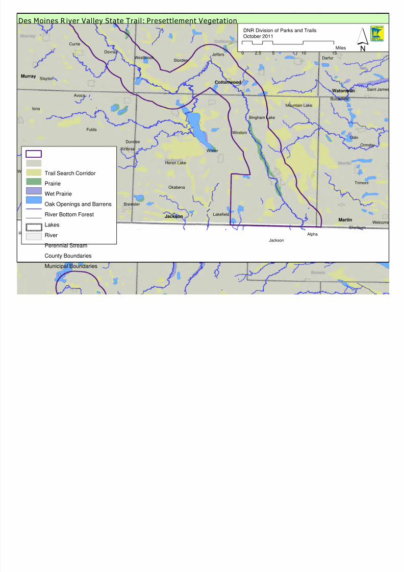
8/3/2019 Des Moines River Valley State Trail Master Plan Draft
http://slidepdf.com/reader/full/des-moines-river-valley-state-trail-master-plan-draft 66/89
Worthington
Jackson
Windom
Slayton
Avoca
Fulda
Iona
Brewster
Kinbrae Wilder
Lakefield
Trimont
Sherburn
Mountain Lake
Heron Lake
Currie
C
Round Lake
Wilmont
Odin
WestbrookJeffers
Darfur
Bingham Lake
Saint J
Comfrey
Bigelow
Ormsby
Butterfield
Storden
Dunnell
Dundee
Okabena
Alpha
Dovray
We
Rushmore
JacksonNobles
Murray
Cottonwood
Martin
Watonwan
Brown
Trail Search Corridor
Prairie
Wet Prairie
Oak Openings and Barrens
River Bottom Forest
Lakes
River
Perennial Stream
County Boundaries
Municipal Boundaries
Des Moines R iver Valley State Trail: Presettlement Vegetation
´0 5 10 152.5
Miles
DNR Division of Parks and TrailsOctober 2011

8/3/2019 Des Moines River Valley State Trail Master Plan Draft
http://slidepdf.com/reader/full/des-moines-river-valley-state-trail-master-plan-draft 67/89
NOVEMBER 2011 61
Other native plant communities found in the area include dry hill prairie, mesic
prairie7
Prescribed burns and invasive species management are being used within Lake
Shetek State Park in an attempt to restore native prairie. The park also has alarge portion of old fields and forests of oak, hackberry, basswood, elm, and
ash. Showy wildflowers such as blazing star, black-eyed susans, sunflowers, and
coneflowers can be seen around the park.
, Basswood – Burr Oak forests and wet prairie. Floodplain forests are
concentrated within the Des Moines River valley, specifically in the southern
Cottonwood and northern Jackson County stretch of the river.
Kilen Woods State Park has an oak forest, river bottom meadows, floodplain
forests, oak savanna, and prairie landscapes. Bur oaks, wild plums, and
hawthorns grow among prairie grasses and wildflowers along the Des Moines
River Valley.
Vegetation Management Recommendations
Recommendation 1: Avoid threatened and endangered species and avoid or
minimize any impacts to special concern species and high quality plant communities, as defined by the Minnesota County Biological Survey (MCBS)
maps or additional resource inventories.
Recommendation 2: Develop a vegetation inventory and management plan for
the trail.
Recommendation 3: Efforts will be made to avoid impacting wetlands.
Wetlands will be inventoried and a wetland mitigation plan will be prepared to
address any identified impacted wetlands.
Recommendation 4: Restore or, if necessary, reestablish or reconstruct native
plant communities along the trail to minimize maintenance, minimize the use of
pesticides, control invasive species, and increase natural species abundance and biodiversity for enhanced user experience.
Recommendation 5: Follow the guidelines established for invasive species
management by Operational Order # 113. Consult with and follow the
guidelines of the Division of Ecological and Water Resources in areas adjacent to
Scientific and Natural Areas and water accesses.
Recommendation 6: Revegetate areas disturbed by construction or in need of
rehabilitation with plant species native to the area by collecting seeds from
remnant prairie communities or by purchasing local genotype seed from a
7 The term mesic refers to the normal moisture content of the prairie soil, which in this
case is somewhere between wet and dry. Mesic prairies are fire-dependent
communities. They were once the dominant vegetation type in southern and western
Minnesota, but since the time of European settlement they have been largely replaced
by agriculture. See http://www.dnr.state.mn.us/restoreyourshore/pg/mesicprairie.html
8/3/2019 Des Moines River Valley State Trail Master Plan Draft
http://slidepdf.com/reader/full/des-moines-river-valley-state-trail-master-plan-draft 68/89
NOVEMBER 2011 62
certified vendor. Use locally-sourced native shrubs and trees in landscaping trail
access sites and waysides.
Water ResourcesThe middle portion of the subsection – known as the middle Coteau – is
characterized by few lakes and a moderately developed dendritic drainage
network. The outer Coteau, toward the western boundary of the subsection,
has more wetlands and a greater number of lakes than the middle Coteau. Most
lakes are shallow ones, typically dominated by wetlands and less than 15 feet
deep.
Des Moines River
The Des Moines River Valley Trail search corridor falls completely within the
West Fork Des Moines River watershed. The watershed extends across seven
counties and covers an area of 1,333 square miles. The West Fork of the Des
Moines River originates in the northwestern part of the watershed from several
lakes including its principal source, Lake Shetek. The river flows from the Lake
Shetek outlet near Currie in a southeasterly direction for 94 miles to the
Minnesota/Iowa border and eventually enters the Mississippi River at Keokuk,
Iowa. From the Talcot Lake Dam to the Iowa border, the river drops a total of
135 feet, an average of 1.98 feet per mile.
Although the river has not undergone significant channelization, other
alterations to the water body have occurred in the form of dams, which are
located at several locations along the river. These include mainstem dams at the
lower ends of Lake Shetek and Talcot Lake and in the cities of Windom and
Jackson (the latter now removed). Smaller dams include those at North Heron
Lake, Fulda Lake, the Graham lakes, and a fish barrier on the Heron Lake Outlet.
The river is mainly slow flat water except for some moderate rapids near Kilen
Woods State Park. The overall gradient from the Talcot dam to Jackson is
approximately 2.1 feet per mile. The river is used for fishing, hunting, and
canoeing in the summer and snowmobiling and ice fishing in the winter.
Peak stream flow is usually in early to mid-April when heavy rains can cause the
river to flood.
The Des Moines River appeared on French maps as early as 1703. The origin of
the word ‘Des Moines’ is somewhat unclear, but likely came from the French
name ‘La Rivière des Moines’ which literally translates to ‘River of the Monks’.
The river was very important for commercial transportation in Iowa before the
development of railroads in the late 1800s.
The northern portion of the Des Moines River, from Lake Shetek to Windom,
flows through flat farmland with few trees interrupting the prairie landscape.
From Windom to Kilen Woods State Park, the land surrounding the river is low
hills with willow, green ash, slippery elm, and various grasses. Near the State
Park, the banks become higher and the river flows between 100-200 foot bluffs
covered with oak and basswood forest. From Kilen Woods State Park to Jackson,
there are increasingly taller bluffs and hills with woodlands along the river

8/3/2019 Des Moines River Valley State Trail Master Plan Draft
http://slidepdf.com/reader/full/des-moines-river-valley-state-trail-master-plan-draft 69/89
NOVEMBER 2011 63
hiding the view of the agricultural landscape. Because there are few rapids, the
water level is usually sufficient for canoeing.
The Des Moines River is designated as a State Water Trail from Talcot Lake to
the Iowa border, a distance of 68 river miles. Water access, campsites, and rest
stops are located along the water trail. The river is also a water trail through
parts of Iowa including Boone, Polk, Van Buren, and Webster counties andurban Des Moines. There are 8 dams along Iowa’s designated water trail
sections.
Classification: The Des Moines River is classified as an Agricultural River under
the Shoreland Classification System in Murray and Jackson County, with the
exception of two segments designated as Transitional River segments.
• in Jackson County between Kilen Woods State Park and 810th Street
• between the Cottonwood/Murray county boundary and the east side of
Talcot Lake WMA – essentially the segment within the WMA.
TributariesThe Des Moines River watershed has poorly developed drainage patterns as
indicated by streams with very few tributaries and lakes with no outlets.
Among the major tributaries to the Des Moines River, in downstream order, are
Beaver Creek, Lime Creek, Heron Lake Outlet, Scheldorf Creek (a designated
trout stream), Division Creek and Story Brook.
Many smaller unnamed intermittent streams and drainage ditches also feed
into the Des Moines River. Ditching of land and channelizing river systems have
changed the aquatic connectivity in the watershed.
LakesThere are few lakes in the middle portion of the Coteau Moraines subsection.
Most of the lakes are in Cottonwood and Murray County, although a small
cluster of lakes is located in southern Jackson County near the Iowa border. A
majority of these lakes are shallow lakes, typically less than fifteen feet in depth.
These shallow lakes are important waterfowl refuge areas providing feeding and
resting areas along with breeding and migration habitat for many species in
greatest conservation need. Many lakes and wetlands in the area were drained
in the early 1900s to increase the amount of arable land. A number of the
shallow lakes have been severely degraded by high water levels and introduced
rough fish populations.
Some of the larger lakes in the search corridor include Lake Shetek, Talcot Lake,Heron Lake, and North Oaks, Cottonwood and Fish lakes. There are many other
lakes, marshes, sloughs and ponds throughout the search area. A walleye
rearing pond is located north of Windom.
North and South Heron Lakes were once a nationally recognized migratory
waterfowl habitat with over 700,000 staging canvasbacks, 50,000 nesting
Franklin’s gulls, and large numbers of other birds. However, drainage of
Agricultural Rivers are in
intensively cultivated areas,
mainly southern and western
areas of the state
Transition Rivers are in a mix
of cultivated, pasture, and
forested lands.

8/3/2019 Des Moines River Valley State Trail Master Plan Draft
http://slidepdf.com/reader/full/des-moines-river-valley-state-trail-master-plan-draft 70/89
NOVEMBER 2011 64
wetlands, stream channelization, diking and intensive modern agricultural
production created flooding, pollution and loss of habitat. Today the lake is
primarily used by smaller flocks of mallards and other puddle ducks mainly for
refuge during migration.
Floodplains
Severe flooding events are rather rare along the Des Moines River in its
northern reaches. The National Oceanic and Atmospheric Administration
(NOAA) has documented a dozen severe floods in Jackson County over the last
50 years, but not all of these were on the Des Moines River.
The areas adjacent to the river in Murray County are within the 100 year
floodplains. In Jackson County, roughly 40 homes have been built within the
mapped floodplain area. Floodplain data for Cottonwood County and Murray
County was gathered for the National Flood Insurance Program in the 1970s,
and has not been converted to digital form, and thus is not shown in this plan.
It is not uncommon for trails to be located within floodplain areas and to be
flooded occasionally. Trails must be designed to avoid interfering withstreamflow or raising flood elevations, and to withstand occasional flooding.
Wetlands
A variety of wetland types are found within or near the trail search corridor, and
are shown on the trail segment maps. The U.S. Fish and Wildlife Service and
DNR identify eight primary types of wetlands. These include both Public Waters
Inventory (PWI) wetlands, regulated by the DNR, and non-PWI wetlands,
regulated by local governments under the Wetland Conservation Act. Wetlands
provide important wildlife and fisheries habitat, erosion and flood control, and
ground water recharge. It is estimated that about 95 percent of Southwest
Minnesota’s wetlands have been lost since settlement, most of them drained inthe early 1900s to provide more arable land.
Many of the remaining wetlands are publically owned and on state and federal
wildlife areas while a few are Public Waters Inventory wetlands8
8 Public Waters are a designated class of lakes, wetlands, and watercourses over which
DNR Waters has regulatory jurisdiction. Public waters wetlands are defined by
Minnesota statute 103G.005, Subd. 15a as all types 3, 4, and 5 wetlands as defined in
United States Fish and Wildlife Service (USFWS) Circular No. 39 (1971 edition), not
included within the definition of public waters, that are ten (10) or more acres in size in
unincorporated areas or 2.5 acres or more in incorporated areas.
on private
lands. The major wetlands in and near the search corridor are located in the
Heron Lake, Talcot Lake, Hanson Marsh, and Lake Shetek areas. Most of the
wetlands in or near the corridor are classified under the Circular 39 system as
seasonally flooded flats (Type 1), shallow marshes (Type 3), shallow open water
(Type 5) or wooded swamp (Type 7).

8/3/2019 Des Moines River Valley State Trail Master Plan Draft
http://slidepdf.com/reader/full/des-moines-river-valley-state-trail-master-plan-draft 71/89
NOVEMBER 2011 65
One type of wetland common within the trail search area is the “prairie
pothole,” a type of wetland that has no defined inflow or outflow. The prairie
pothole region extends across the Great Plains of North America from Alberta,
Canada to Nebraska and Iowa. Prairie potholes were formed 10,000 years ago
when the glaciers receded and left millions of depressions that eventually
became wetlands. These wetlands provide extremely important resting areas,
nesting areas, and breeding habitat for migrating waterfowl populations. Most
prairie potholes in this region appear as seasonally flooded flats or shallow
marshes under the Circular 39 classification.
Water Quality
Because agriculture is the predominant land use in this area, water quality and
quantity are significant concerns. Nonpoint pollution such as nitrates,
phosphates, and pesticides are present in many shallow aquifers. Nonpoint
sources are not regulated and therefore must be addressed through voluntary
actions. Point sources such as storm sewer outfalls are addressed through the
MPCA’s National Pollutant Discharge Elimination System (NPDES) permit
programs.
The Minnesota Pollution Control Agency has listed 15 stream reaches in the
West Fork Des Moines River (WFDMR) watershed as impaired for excess fecal
coliform bacteria (a human health concern that limits recreational use of the
water) and 15 stream reaches for excess turbidity (a measure of cloudiness of
water that affects aquatic life). (Some of these reaches were listed for both
impairments and some were listed for either fecal coliform or turbidity.) In
addition, the MPCA listed North and South Heron Lake as impaired due to
excess nutrients (which limits both its recreational use and ecological/wildlife
function). Related to the Heron Lake problem is a listing for pH within the Heron
Lake Outlet.
A TMDL (Total Maximum Daily Load) report was completed in 2008 for the West
Fork Des Moines River and Heron Lake. A TMDL study is a pollution reduction
plan – it identifies the maximum amount of a pollutant the water body can
receive and still meet the standards for water quality. The report found that the
primary sources of fecal coliform bacteria are livestock on overgrazed riparian
pasture, surface-applied manure on cropland, feedlots lacking adequate runoff
controls, and inadequate septic systems. Turbidity impairmnents are caused by
streambank/streambed erosion, row cropland, algae and, to a lesser extent,
benthic feeders (e.g., carp), overgrazed pasture and inadequate buffers near
streams and waterways.
The TMDL report provides a general strategy for actions needed to addressnonpoint source-related impairments, focusing on stakeholder involvement,
education and outreach, and evaluation of best management practice options.
Working Lands for Wildlife Initiative
The program is a joint effort of DNR, the Board of Water and Soil Resources and
the U.S. Fish and Wildlife Service. It brings together public, private, and non-
profit organizations in local project teams to assist landowners in identifying
8/3/2019 Des Moines River Valley State Trail Master Plan Draft
http://slidepdf.com/reader/full/des-moines-river-valley-state-trail-master-plan-draft 72/89
NOVEMBER 2011 66
economically viable conservation focus areas and strategies. The program’s
goals include sustainable and increasing wildlife populations and agronomic
enhancement for landowners. Among the counties that are the focus of the
program are Murray, Cottonwood, Jackson and Nobles; 2011 Target Areas are
found throughout these counties, particularly around Heron Lake and the Boot
Lake and Caraway WMAs. Note that the program results in purchase of
easements on lands to be protected; these easements typically prohibit trail
development.
Shoreland Zoning and Designations.
The State of Minnesota regulates the use of shoreland—land within 300 feet of
a river or 1,000 feet of a lake. The DNR identifies three river types in the trail
search corridor: Transition River Segments, Agricultural River Segments, and
Tributary River segments.
Common land uses on transitional rivers include, forested riparian strips with
mixtures of cultivated cropland and pasture some seasonal and year round
residential development exists. Agricultural river segments are located in
intensely cultivated areas. Cultivated crops, pastures, and occasional feedlots
are common. Tributary river segments consist of smaller watercourses mapped
in the Protected Waters Inventory that have not been assigned as transitional or
agricultural/
Lakes are classified as Natural Environment, Recreational Development and
General Development lakes. Guidelines for the development of lakes were
developed by the DNR and adopted by the counties in their zoning codes.
Most lakes in the trail search region are classified as Natural Environment lakes:
generally small, often shallow lakes with limited capacities for assimilating the
impacts of development and recreational use. They often have adjacent lands
with substantial constraints for development such as high water tables, exposedbedrock, and unsuitable soils. These lakes, particularly in rural areas, usually do
not have much existing development or recreational use.
Recreational development lakes are generally medium-sized lakes of varying
depths and shapes, often with moderate levels of recreational use and existing
development. Development consists mainly of seasonal and year-round
residences and recreational-oriented commercial uses. Recreational
Development lakes include Loon Lake and Little Spirit Lake in Jackson County,
and Cottonwood Lake in Windom.
In Murray County, Lake Shetek and Lime Lake (in Avoca) are classified as
General Development lakes. These are typically large, deep lakes of varying sizes
and depths with high levels and mixes of existing development. These lakes
often are extensively used for recreation and, except for the very large lakes,
are heavily developed around the shoreline.
Water Resource Management Recommendations
Recommendation 1: Minimize trail development and maintenance impacts to
adjacent water resources through the use of mulching, geo-textiles, silt screens
and seeding to establish vegetation.

8/3/2019 Des Moines River Valley State Trail Master Plan Draft
http://slidepdf.com/reader/full/des-moines-river-valley-state-trail-master-plan-draft 73/89
NOVEMBER 2011 67
Recommendation 2: Strive to limit water crossings and obtain permits for any
needed crossing. Bridges should be designed for conveyance of flood flows and
to accommodate existing or future water recreation.
Recommendation 3: Create angling and education opportunities where the trail
intersects lakes and rivers that provide fishing opportunities.
Recommendation 4: Assess trailheads and trail-river and lake connections as to
their suitability for development of “fishing pads” that promote fishing
opportunities for people with mobility impairments.
WildlifeThe trail search area is home to many different wildlife species. The Des Moines
River provides aquatic habitat for beavers and muskrat. The prairie landscape is
home to many bird and small mammal species. The prairie potholes and
wetlands provide important habitat for waterfowl and migrating birds. The few
wooded areas provide shelter for many woodland species such as deer, fox, and
squirrels. The state parks, wildlife management areas, waterfowl productionareas, and scientific and natural areas protect many of the habitats required by
the diverse wildlife in the trail area.
Mammals
Common mammal species in the trail area include: white-tailed deer, beavers,
squirrels, mink, muskrats, fox, woodchucks, and coyote. Badgers and otters
may also be seen in the area. Many mammals that depend on a prairie
landscape for habitat, such as the prairie vole and prairie pocket mouse, are
listed as state species of special concern.
Birds
Minnesota is located within the Mississippi flyway, a heavily used route for
migrating waterfowl that generally follows the Mississippi River to the Gulf of
Mexico. About 40% of North America’s migrating waterfowl and shorebirds use
this route.9
The Prairie Pothole wetland and associated grassland complexes found in the
Coteau Moraines subsection provide important habitat for American bitterns,
Franklin’s gulls, northern harriers, short-eared owls, Forster’s terns, and a
multitude of nesting ducks and associated wetland birds. The potholes provide
critical nesting habitat for many species of waterfowl such as mallards, gadwall,
blue-winged teal and canvasbacks.
Both Kilen Woods and Lake Shetek State Parks provide habitat for manydifferent types of birds. Kilen Woods State Park is home to wood ducks, herons,
and woodpeckers. Lake Shetek State Park has several wetlands that often have
9 http://www.ducks.org/conservation/prairie-pothole-region
8/3/2019 Des Moines River Valley State Trail Master Plan Draft
http://slidepdf.com/reader/full/des-moines-river-valley-state-trail-master-plan-draft 74/89
NOVEMBER 2011 68
coots, grebes, ducks, heron, bobolinks, and the park’s namesake pelicans.
Other common bird species in the area include owls, hawks, bank swallows,
Baltimore orioles, blue herons, and kingfishers.
Reptiles and Amphibians
Turtle species in the search corridor include the common snapping turtle,
painted turtle, and spiny softshell turtle. The Blanding’s turtle, a threatened
species in Minnesota, is also found here. Blanding’s turtles are the most
threatened by habitat loss and degradation of uplands and wetlands and road
mortality.
Numerous snakes can be found in the Des Moines River Valley. Some of the
common snake species include the smooth green snake, common and plains
garter snakes, and the redbelly snake. The prairie skink is also found in the area.
Prairie skinks are often found along stream banks or openings in pine barrens,
oak savannas, and grasslands.
Amphibians in the area include the Eastern tiger salamander, American toad,
Great Plains toad, and numerous species of frogs. American bullfrogs are ahighly aquatic species and most often found in large bodies of water such as
lakes, slow-moving streams, and ponds. The northern leopard frog habitat
consists of wet meadows and open fields near wetlands. Boreal chorus frogs are
also common to the Des Moines River Valley.10
Fish
Because many of the lakes in the search corridor are shallow lakes, large
populations of game fish are less common. The lower levels of dissolved oxygen
in the water tend to limit the numbers of game fish populations the shallow
lakes can support. Unhealthy shallow lakes generally support larger populations
of “rough” fish such as carp and black bullhead.
The Des Moines River contains many species of fish including northern pike,
walleye, crappie, channel catfish, yellow perch, and black bullheads. Scheldorf
Creek is a fishable trout stream in Cottonwood County, northwest of Windom.
The DNR stocks brown trout in Scheldorf Creek in April prior to the fishing
opener.
Lake Shetek is a popular fishing lake . In 1987, the DNR began to stock the lake
with walleye, northern pike, yellow perch, crappie, sunfish, and black bass. An
aeration system was installed in 1974 because the shallow lake froze solid once
every seven years on average, causing fish kills. The aeration system has also
improved habitat for game fish. The lake depth was increased through
improvements to the Currie Dam in 1995.
10 http://www.dnr.state.mn.us/eco/mcbs/amphibian&reptile_maps.html

8/3/2019 Des Moines River Valley State Trail Master Plan Draft
http://slidepdf.com/reader/full/des-moines-river-valley-state-trail-master-plan-draft 75/89
NOVEMBER 2011 69
Invertebrates
Freshwater mussels are a very important part of marine ecosystems in
Minnesota. These mollusks live on river and lake bottoms and filter oxygen and
particles from the water. This process cleans the water in the area and provides
nutrients to the river bottom. They modify the habitat around them to make it
more suitable for both themselves and other aquatic organisms. Mussels arealso an important food source for many other animals such as several species of
fish, muskrats, and raccoons.11
Mussel species are threatened by nonpoint source pollution, habitat
degradation, channelization, dams, and dredging, and the presence of non-
native zebra mussels. Zebra mussels can attach themselves in large numbers to
the shells of native mussels, eventually causing death by suffocation. Two
mussel species of special concern, the Black Sandshell and Spike, and three
threatened species, the Monkeyface, Mucket, and Round Pigtoe, have been
found in the trail search corridor.
Species in Greatest Conservation Need
Species in Greatest Conservation Need (SGCN) have been identified for each
ecological subsection in Minnesota. This category, which includes both plant
and animal species, includes:
• Species whose populations are identified as being rare, declining, or
vulnerable in Minnesota, including species with legal protection status
(federal or state endangered or threatened species);
• Species at risk because they depend upon rare, declining, or vulnerable
habitats;
• Species subject to specific threats that make them vulnerable (i.e.
invasive species);
• Species with certain characteristics that make them vulnerable (i.e.highly localized distribution);
• Species with stable populations in Minnesota that are declining outside
of Minnesota.
There are 78 SGCN in the Coteau Moraines subsection, including 30 species that
are federal or state endangered, threatened, or of special concern. More than
half of the species are birds
Key habitats in the Coteau Moraines subsection include prairie, wetland, and
stream habitats. Areas near the search corridor such as the numerous state
Wildlife Management Areas, federal Waterfowl Production Areas, Kilen Woods
and Lake Shetek State Parks, and the Des Moines River and Prairie Bush CloverSNAs are important for SGCN. A complete list of SGCN by subsection is included
11 http://www.dnr.state.mn.us/mussels/importance.html

8/3/2019 Des Moines River Valley State Trail Master Plan Draft
http://slidepdf.com/reader/full/des-moines-river-valley-state-trail-master-plan-draft 76/89
NOVEMBER 2011 70
in Minnesota’s State Wildlife Action Plan: Tomorrow’s Habitat for the Wild and
Rare.
Threatened, Endangered and Special Concern Species
Based on a search of the Natural Heritage Information database, the species
listed in Appendix A as threatened, endangered, or species of special concern
are found within or near (within one mile) of the trail search corridor. These
species are protected by state law and should be considered during trail
development. Some of these species are water-based (i.e., freshwater mussels)
and would see little impact if water quality is protected during trail
development. Others such as plant species are more vulnerable.
Wildlife and Habitat Recommendations
Recommendation 1: Avoid threatened and endangered species and minimize
any impacts to special concern species in trail planning, development and
maintenance. Parks and Trails staff will keep current with Natural Heritage
data, consult with regional plant ecologists and land managers, and perform on-
the-ground surveys when an exact trail alignment is proposed.
Recommendation 2: Wildlife may be affected by the trail and recreational uses.
Species with limited mobility, sensitive habitat requirements, or that are
vulnerable to disturbance or exploitation require consideration in trail planning.
Design considerations may include avoiding critical habitats, installing bridges or
culverts in upland settings to provide wildlife travel ways, considering fish and
wildlife needs when designing water crossings, managing and enhancing
habitats along the proposed trail corridor, and using native species, consistent
with the natural communities of the area, when re-vegetating areas disturbed
by trail construction and maintenance.

8/3/2019 Des Moines River Valley State Trail Master Plan Draft
http://slidepdf.com/reader/full/des-moines-river-valley-state-trail-master-plan-draft 77/89
NOVEMBER 2011 71
Historical and Cultural Resources:
Historical and Archaeological Context
This section discusses the historical and cultural resources of the region, and is
organized thematically rather than geographically, according to these broad
interpretive themes:
• Presettlement
• Exploration of the territory
• Settlement and agricultural development
• The railroad age and modern industry
Presettlement 12
Migratory bands of people started moving into Minnesota during the
Paleoindian Period (10,000 B.C. – 6,000 B.C.) as the glaciers retreated from the
Upper Midwest. Stone knives and projectile points found throughout
Minnesota suggest that hunters of the late Paleoindian Tradition pursued prairie
animals such as mastodons and bison, as well as the deer and elk of thenorthern forests.
The Archaic Period (6,000 B.C. – 800 B.C.) was a time of increased diversity of
plant and animal communities resulting from a changing climate. Humans also
diversified their hunting, trapping, fishing, foraging, and woodworking
technologies. Chipped stone tools, notched projectile points, and pecked and
ground stone tools are evidence of this time period.
The Woodland Period (800 B.C. to Historic Contact) brought the beginnings of
plant domestication and more intense settlement patterns, especially near
stream and lake areas. The development of ceramics and mound construction
for burial activities were significant advances in this time period.During the Oneota/Plains Village Occupation (900 A.D. to Historic Contact) in
southern Minnesota, there was much development along major river valleys.
Subsistence strategies were developed based on simple agriculture, gathering,
and bison hunting.
The Jeffers Petroglyphs are located in northern Cottonwood County. Over 2,000
images have been drawn by early Native American in the rock that was worn
smooth by glaciers 14,000 years ago. The carvings depict bison, turtles, elk,
salamanders, human stick figures, thunderbirds, and weapons such as atlatls,
spear points, arrowheads, and lances. The oldest drawings at the site are
roughly 7,000 to 9,000 years old.
12 http://www.osa.admin.state.mn.us/mnarch/mnoverview.html

8/3/2019 Des Moines River Valley State Trail Master Plan Draft
http://slidepdf.com/reader/full/des-moines-river-valley-state-trail-master-plan-draft 78/89
NOVEMBER 2011 72
Exploration, settlement and agricultural development
The Des Moines River valley was home to the Yankton Dakota (Sioux) at the
time of European settlement.
The Historic Contact period began in the late 1600s, when French fur traders
moved into Minnesota followed by English and American traders. In 1838
French scientist and explorer Joseph Nicollet led a government expedition
through the area to explore the Minnesota and Missouri rivers. European
settlement accelerated during the 1800s following the establishment of Fort
Snelling. Agricultural communities developed in the southern and western
portions of the state during the mid- to late 1800s.
The Des Moines River valley was initially settled by farming families during the
1850’s, spurred by the U.S. government’s relocation and resettlement of
American Indians onto reservations. Throughout the 1850s, relations between
American Indians and the government continued to deteriorate, culminating in
the 1862 Dakota Uprising. The Lake Shetek settlement was raided and fourteen
settlers were killed and twelve taken captive but later released. These events
are marked by monuments at Lake Shetek State Park and the nearby Slaughter
Slough Waterfowl Production Area, a U.S. Fish and Wildlife Service preserve
northeast of Currie.
As the area was slowly resettled after the Civil War, agriculture took hold.
Wheat and flax were among the most common crops, with many grain mills
along the Des Moines River. The soils in the area could withstand drought,
making them ideal for farming. Dairy and livestock farms also developed in the
area due to the abundance of prairie pastures. By the early 1900s, corn had
become the staple crop in southwestern Minnesota. In 1873, what is known as
“the grasshopper plague” occurred. Millions of Rocky Mountain Locusts
descended on southern Minnesota, wiping out the crops for five years. The
locusts were so thick that they sometimes even stopped trains by congregating
on the tracks and making it too slippery for trains to make it up steeper grades.
Farmers were offered state assistance to help compensate for the losses caused
by the locusts.
A number of the small towns in Murray County, including Currie, Avoca, Fulda
and Iona, were Catholic colonies, established by Archbishop John Ireland in the
1880s. The colonies were established for Catholic immigrants who were
suffering from famine and poverty in their home countries or in the industrial
cities of the East. Working with the railroads, the Archbishop provided land and
supplies for the colonies, as well as priests to serve them. By 1885, 4,000
German, Irish, and Belgian Catholic families were living in southwestern and
west-central Minnesota. While many of the colonists could not tolerate the
isolation, cold winters, droughts and grasshopper invasions, others settled
permanently in their communities.
The railroad age and modern industry
The advent of the railroads made it possible to bring agricultural products to
market. Railroad corporate and building histories illustrate how the agricultural
market areas of southwest Minnesota were connected to a growing
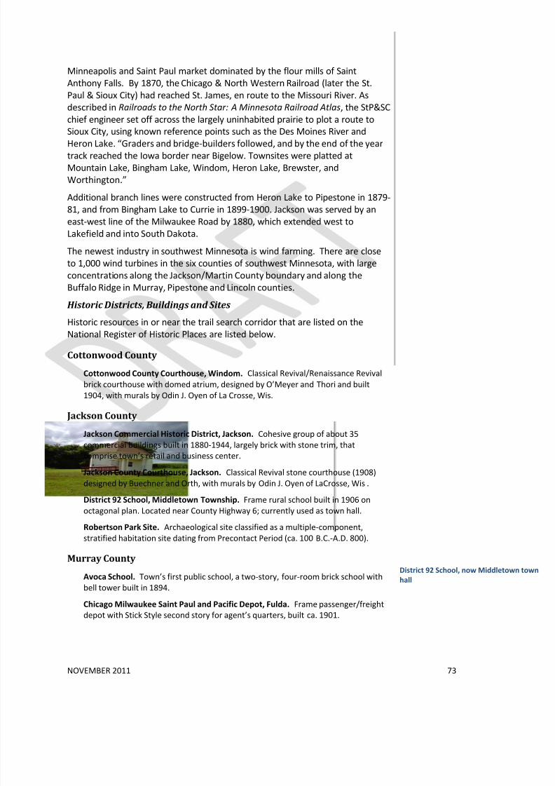
8/3/2019 Des Moines River Valley State Trail Master Plan Draft
http://slidepdf.com/reader/full/des-moines-river-valley-state-trail-master-plan-draft 79/89
NOVEMBER 2011 73
Minneapolis and Saint Paul market dominated by the flour mills of Saint
Anthony Falls. By 1870, the Chicago & North Western Railroad (later the St.
Paul & Sioux City) had reached St. James, en route to the Missouri River. As
described in Railroads to the North Star: A Minnesota Railroad Atlas, the StP&SC
chief engineer set off across the largely uninhabited prairie to plot a route to
Sioux City, using known reference points such as the Des Moines River and
Heron Lake. “Graders and bridge-builders followed, and by the end of the year
track reached the Iowa border near Bigelow. Townsites were platted at
Mountain Lake, Bingham Lake, Windom, Heron Lake, Brewster, and
Worthington.”
Additional branch lines were constructed from Heron Lake to Pipestone in 1879-
81, and from Bingham Lake to Currie in 1899-1900. Jackson was served by an
east-west line of the Milwaukee Road by 1880, which extended west to
Lakefield and into South Dakota.
The newest industry in southwest Minnesota is wind farming. There are close
to 1,000 wind turbines in the six counties of southwest Minnesota, with large
concentrations along the Jackson/Martin County boundary and along theBuffalo Ridge in Murray, Pipestone and Lincoln counties.
Historic Districts, Buildings and Sites
Historic resources in or near the trail search corridor that are listed on the
National Register of Historic Places are listed below.
Cottonwood County
Cottonwood County Courthouse, Windom. Classical Revival/Renaissance Revival
brick courthouse with domed atrium, designed by O’Meyer and Thori and built
1904, with murals by Odin J. Oyen of La Crosse, Wis.
Jackson County
Jackson Commercial Historic District, Jackson. Cohesive group of about 35
commercial buildings built in 1880-1944, largely brick with stone trim, that
comprise town’s retail and business center.
Jackson County Courthouse, Jackson. Classical Revival stone courthouse (1908)
designed by Buechner and Orth, with murals by Odin J. Oyen of LaCrosse, Wis.
District 92 School, Middletown Township. Frame rural school built in 1906 on
octagonal plan. Located near County Highway 6; currently used as town hall.
Robertson Park Site. Archaeological site classified as a multiple-component,
stratified habitation site dating from Precontact Period (ca. 100 B.C.-A.D. 800).
Murray County
Avoca School. Town’s first public school, a two-story, four-room brick school with
bell tower built in 1894.
Chicago Milwaukee Saint Paul and Pacific Depot, Fulda. Frame passenger/freight
depot with Stick Style second story for agent’s quarters, built ca. 1901.
District 92 School, now Middletown
hall

8/3/2019 Des Moines River Valley State Trail Master Plan Draft
http://slidepdf.com/reader/full/des-moines-river-valley-state-trail-master-plan-draft 80/89
NOVEMBER 2011 74
Chicago Saint Paul Minneapolis and Omaha Turntable, Currie. Manually operated,
wood-and-steel turntable built in 1901 by American Bridge Company of Chicago to
turn locomotives at western end of branch line. Part of End-o-Line County Park.
Lake Shetek State Park WPA/Rustic Style Historic District. Buildings/structures,
mostly of split stone construction, and island causeway, all built in 1938–41 by WPA
workers in park with extensively designed landscape.Lake Shetek State Park WPA/Rustic Style Group Camp. Board-and-batten
recreation building and mess hall with split stone fireplaces, built for public use in
1940–41 by WPA workers.
Socioeconomic Resources:The table below illustrates population change in the counties and cities of the
area between 1990 and 2010. All three counties’ populations have declined in
the past two decades. Most of the cities also show declines, with a few
exceptions: Windom and Fulda show increases and Avoca and Lakefield are
relatively stable.
While populations are generally declining, the number of households (occupied
housing units) in some cities remained relatively constant or even increased
slightly between 2000 and 2010. For example, the City of Jackson seems to have
lost almost 6% of its population but actually gained about 30 households. Often
this phenomenon indicates an increase in one- or two-person households,
perhaps through development of senior housing.
All of the local communities offer many choices for lodging, shopping, and food
services. While agriculture and manufacturing are the primary industries in the
area, the Des Moines River Valley Trail could provide many new opportunities
for increased tourism in the communities, bringing outside money and positive
financial impacts to the area.
Table _: Population Change, 1990 – 2000
Counties 1990 2000 2010 Percent
change
2000-2010
Cottonwood 12,694 12,167 11,687 -3.9%
Jackson 11,677 11,268 10,266 -8.9%
Murray 9,660 9,165 8,725 -4.8%
Cities 1990 2000 2010
Avoca 150 146 147 0.7%
Bingham Lake 155 167 126 -24.6%
Currie 303 225 233 3.6%
Dovray 60 67 57 -14.9%
8/3/2019 Des Moines River Valley State Trail Master Plan Draft
http://slidepdf.com/reader/full/des-moines-river-valley-state-trail-master-plan-draft 81/89
NOVEMBER 2011 75
Dundee 107 102 68 -33.3%
Fulda 1,212 1,283 1,318 2.7%
Heron Lake 730 768 698 -9.1%
Jackson 3,559 3,501 3,299 -5.8%
Kinbrae 18 21 12 -42.9%
Lakefield 1,679 1,721 1,694 -1.6%
Wilder 83 69 60 -13.0%
Windom 4,283 4,490 4,646 3.5%
Table _: Households, 2000-2010
Counties 2000 2010 Percent
change
2000-2010
Cottonwood 4,917 4,857 -1.2%
Jackson 4,556 4,429 -2.8%
Murray 3,722 3,717 -0.1%
Cities 2000 2010
Avoca 67 55 -17.9%
Bingham Lake 60 54 -10.0%
Currie 109 105 -3.7%
Dovray 33 31 -6.1%
Dundee 51 41 -19.6%
Fulda 528 549 4.0%
Heron Lake 285 287 0.7%
Jackson 1,487 1,517 2.0%
Kinbrae 10 7 -30.0%
Lakefield 731 734 0.4%
Wilder 29 27 -6.9%
Windom 1,910 1,944 1.8%
Financial Impacts of Trail Development Communities that support trails and respond to the needs of trail users have
seen positive effects on their local economies. DNR trail studies indicate that

8/3/2019 Des Moines River Valley State Trail Master Plan Draft
http://slidepdf.com/reader/full/des-moines-river-valley-state-trail-master-plan-draft 82/89
NOVEMBER 2011 76
tourists attracted to the trails use local facilities for eating, shopping, and
lodging.
The DNR estimates that for five trails surveyed between 2007 and 2009,
summer spending totaled nearly $5 million.13
Trails also appear to increase property values and enhance the quality of life in
the communities through which they run. Homes close to trails have become
increasingly desirable. A number of studies of existing bike trails have shown
that the average value of property near the trails is similar to or slightly above
the value of other properties in the area.
Most of that spending (95% in
total) comes from trail users who reside outside the local economy of the trail,
and the spending represents “new” dollars to the local economy. Trail userswho have traveled a long distance to the trail, not surprisingly, outspend local
users by a factor of about 20 on a daily basis, primarily on food, travel, and
overnight accommodations.
14
Trails also yield significant public health benefits. There is growing interest in
the multiple benefits to public health that can result from the use of trails for
outdoor recreation. Trail use has been shown to be valuable not only in
combating obesity and related public health problems but also in reducing
stress, improving mental health, and encouraging healthy lifestyles. To the
extent that trail use replaces motor vehicle use, it can also result in monetary
savings from lower air pollution, congestion, and oil imports.
13See previous reference. Trails surveyed in the 2007-2009 period were the Paul
Bunyan, Heartland, Root River, Douglas, and Paul Bunyan-Bemidji State Park segment.14
For example, see “Home Sales Near Two Massachusetts Rail-Trails,” 2005.
http://www.americantrails.org/resources/adjacent/dellapennasales.html
8/3/2019 Des Moines River Valley State Trail Master Plan Draft
http://slidepdf.com/reader/full/des-moines-river-valley-state-trail-master-plan-draft 83/89
NOVEMBER 2011 77
6. ImplementationWhat Happens After the Master Plan is Finished?
Chapter 86A.09 of Minnesota Statutes requires that a master plan be prepared
for state trails before trail development can begin – although planning, design,and land acquisition can take place before the plan is complete. Trail users and
trail advocates need to recognize that the completion of a master plan is only
one step in what typically is a long process of implementation.
Throughout the planning process for this trail extension, local trail advocates
have asked for guidance as to how to implement the plan – that is, how to
establish feasible alignments, contact landowners, and work with DNR regional
staff on land acquisition. The process can be lengthy and complex.
The first generation of state trails in Minnesota were developed primarily on
abandoned rail rights-of-way that state or local governments were able to
acquire. Since that time, most of the remaining abandoned rail rights-of-way inthe state have reverted to private ownership. The next generation of trails must
cross a variety of public and private lands, making them much more challenging
to develop than the rail-trails of the past.
DNR Parks and Trails staff work with individual landowners to acquire land or
easements on a willing seller basis, keeping in mind that a series of acquisitions
on adjoining properties will be needed in order to create a trail segment with a
logical beginning and end. In other words, a trail segment should begin at an
existing park or town center that can serve as a trailhead, preferably with
parking and restroom facilities, and end at some type of destination – a city, a
park, a wildlife preserve, or a historic site.
In this process, DNR acquisition and development staff frequently work with cityand county governments, conservation organizations, and local trail interest
groups to assess the feasibility of a particular trail alignment. Acquisition is
done on a willing seller basis. The DNR strongly discourages local governments
from using other means.
Land can be acquired or otherwise set aside for trail development through a
variety of methods:
• A trail may be located on non-DNR public land, such as county or city-
owned land, through a cooperative agreement.
• A local government or not-for-profit organization can acquire land from
a willing seller and then sell it to the DNR.
• Local interest groups and/or DNR staff may make the initial contact with
landowners, then DNR staff will assess the feasibility of a particular trail
alignment and complete the land acquisition.
No matter which method is used, advance coordination with DNR staff is
essential in order to ensure that the selected trail alignment is feasible to
develop.

8/3/2019 Des Moines River Valley State Trail Master Plan Draft
http://slidepdf.com/reader/full/des-moines-river-valley-state-trail-master-plan-draft 84/89
NOVEMBER 2011 78
In the course of trail implementation, it may become apparent that a needed
trail alignment will not be obtainable for some time – for example, until a parcel
is sold or passed to another family member. In such situations, it may be
advisable to assess the feasibility of interim routes on road shoulders or on
lightly-traveled streets. Street routes may be particularly important in cities
where there is little undeveloped or publically-owned land available.
The following is a typical sequence of events in trail planning and development.
However, the steps will likely overlap and the process will often require several
rounds of feasibility assessment and landowner contacts.
1. Complete the master plan. The plan identifies a broad search corridor
for the trail, within which one or more alternative alignments are
identified. The intent of the plan is to provide flexibility while
identifying the most feasible alignments, rather than “locking in” a
specific route.
2. Explore feasibility of each alignment. Assess land ownership, road
right-of-way width (is there enough room for a trail within the right-of-
way?), connectivity, and physical conditions such as slope, wetlands and
natural and cultural resources. The alignment must allow state and
federal design guidelines and rules to be met, including trail width,
shoulders, curvature, accessibility, etc. Therefore, it is important for
local governments and trail groups to coordinate their efforts with DNR
staff.
3. Initial informal landowner contact. It is often preferable for
landowners to be contacted by local trail supporters rather than DNR
staff. Landowner concerns frequently relate to privacy, safety and
liability, and there are many information resources available to address
these concerns.
4. Formal landowner contact; complete acquisition process. As
mentioned above and with proper coordination, DNR or other entities
may take the lead on land acquisition.
5. Trail engineering and design. The design process offers a final
opportunity to assess feasibility, including the need to avoid sensitive
natural or cultural resources and address constraints such as wetlands
or steep slopes. Trail alignments may shift during the design process.
6. Construction on one or more segments, while the processes of
negotiation and design continue on others.
7. Ongoing maintenance and stewardship. Trail associations often act as“eyes on the trail” to monitor conditions, notify DNR of concerns and
volunteer on certain efforts. Local units of government may provide
trail maintenance via a cooperative agreement.
8. Orientation and Interpretation. All trails are developed with traffic
safety and directional signs. Some trails provide interpretive signs that
highlight notable natural and cultural resources and landscape features.
BASIC DESIGN STANDARDS
FOR PAVED, SHARED-USE
STATE TRAILS
The following standards brie
highlight key points from the
DNR publication Trail PlanniDesign and Development
Guidelines. See the full
document for more details o
the design of many types of
trails.
• Pavement width: 10 fee
typical; 12 feet an optio
in high-use areas, 8 feet
an option where
limitations exist or lowe
use is expected.• Shoulders: 2 to 5 feet,
depending on condition
such as side-slopes and
hazards
• Maximum grade: 5%
except where accessibil
exceptions apply.
• 2% maximum cross-slop
(the slope from one side
a trail to the other)
• Corners gently curved to
meet standards rather
than right angles
• 100’wide corridor width
where possible to allow
buffers, storm water
control and grading.
Trail Planning, Design and
Development Guidelines is
available through the DNR o
Minnesota’s Bookstore,http://www.dnr.state.mn.u
ublications/trails_waterway
ndex.html
8/3/2019 Des Moines River Valley State Trail Master Plan Draft
http://slidepdf.com/reader/full/des-moines-river-valley-state-trail-master-plan-draft 85/89
NOVEMBER 2011 79
An interpretive plan may be developed to identify themes and features
that will be interpreted.
Actions Local Governments Can Take to Support Trail
Development:
City and county governments can play an important role in trail developmentthrough their planning and development review processes, including the
following:
• Integrate the trail concept into community plans, including
comprehensive and land use plans, park and open space plans, and
transportation plans.
o Through the local park and trail plan, link the state trail corridor to
local and regional trails; integrate it with local parks.
o Seek opportunities to meet multiple goals through trail
development – i.e., to improve water quality, protect natural areas,
provide educational opportunities, or provide additional
transportation options.• Require park and trail set-asides. Through their subdivision ordinances,
cities and counties may require that developers dedicate a reasonable
portion of land within a development to public use for such things as
streets, utilities, drainage, and parks, trails and recreational facilities. 15
• Work with DNR staff to seek funding for state trail acquisition and
development. State trails are typically funded by the State Legislature
via bonding money or special appropriations, or through the Legislative-
Citizen Commission on Minnesota Resources (LCCMR). Some federal
grants are also eligible to be used in conjunction with state funding for
development. Transportation enhancement project grants and other
transportation funding sources may also be used for state trails. It is
important for local government representatives to work closely with
DNR regional staff in any pursuit of state trail funding.
(If the set-aside is for a state trail, coordinate with DNR staff in
advance.)
• Seek funding for local and regional trail connections. Local and
regional trails can be funded through a variety of sources, available
through DNR and other agencies, including:
o Parks and Trails Legacy Grant Program -
http://www.dnr.state.mn.us/grants/recreation/pt_legacy.html
o Local Trail Connections Grant Program -
http://www.dnr.state.mn.us/grants/recreation/trails_local.html
15 Minn. Stat. §462.358 subd 2b (a) applies to cities; §394.25 subd. 7(c) to counties

8/3/2019 Des Moines River Valley State Trail Master Plan Draft
http://slidepdf.com/reader/full/des-moines-river-valley-state-trail-master-plan-draft 86/89
NOVEMBER 2011 80
o Federal Recreation Trail Grant Program (also available for state
trails) -
http://www.dnr.state.mn.us/grants/recreation/trails_federal.html
o Regional Trail Grant Program
http://www.dnr.state.mn.us/grants/recreation/trails_regional.html
o Transportation Enhancement Projects awarded by Mn/DOT with
Federal Highway Administration funding (also available for state
trails) http://www.fhwa.dot.gov/environment/te/index.htm
o Safe Routes to School: funding for local trail connections through
Mn/DOT http://www.dot.state.mn.us/safero utes/index.html
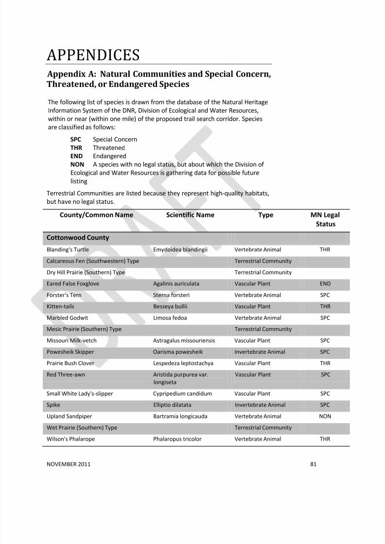
8/3/2019 Des Moines River Valley State Trail Master Plan Draft
http://slidepdf.com/reader/full/des-moines-river-valley-state-trail-master-plan-draft 87/89
NOVEMBER 2011 81
APPENDICES Appendix A: Natural Communities and Special Concern,
Threatened, or Endangered Species
The following list of species is drawn from the database of the Natural Heritage
Information System of the DNR, Division of Ecological and Water Resources,
within or near (within one mile) of the proposed trail search corridor. Species
are classified as follows:
SPC Special Concern
THR Threatened
END Endangered
NON A species with no legal status, but about which the Division of
Ecological and Water Resources is gathering data for possible future
listing
Terrestrial Communities are listed because they represent high-quality habitats,
but have no legal status.
County/Common Name Scientific Name Type MN Legal
Status
Cottonwood County
Blanding's Turtle Emydoidea blandingii Vertebrate Animal THR
Calcareous Fen (Southwestern) Type Terrestrial Community
Dry Hill Prairie (Southern) Type Terrestrial Community
Eared False Foxglove Agalinis auriculata Vascular Plant ENDForster's Tern Sterna forsteri Vertebrate Animal SPC
Kitten-tails Besseya bullii Vascular Plant THR
Marbled Godwit Limosa fedoa Vertebrate Animal SPC
Mesic Prairie (Southern) Type Terrestrial Community
Missouri Milk-vetch Astragalus missouriensis Vascular Plant SPC
Powesheik Skipper Oarisma powesheik Invertebrate Animal SPC
Prairie Bush Clover Lespedeza leptostachya Vascular Plant THR
Red Three-awn Aristida purpurea var.
longiseta
Vascular Plant SPC
Small White Lady's-slipper Cypripedium candidum Vascular Plant SPC
Spike Elliptio dilatata Invertebrate Animal SPC
Upland Sandpiper Bartramia longicauda Vertebrate Animal NON
Wet Prairie (Southern) Type Terrestrial Community
Wilson's Phalarope Phalaropus tricolor Vertebrate Animal THR

8/3/2019 Des Moines River Valley State Trail Master Plan Draft
http://slidepdf.com/reader/full/des-moines-river-valley-state-trail-master-plan-draft 88/89
NOVEMBER 2011 82
Cottonwood, Jackson counties
Mucket Actinonaias ligamentina Invertebrate Animal THR
Spike Elliptio dilatata Invertebrate Animal SPC
Trumpeter Swan Cygnus buccinator Vertebrate Animal THR
Jackson County
American Ginseng Panax quinquefolius Vascular Plant SPC
Arogos Skipper Atrytone arogos Invertebrate Animal SPC
Bald Eagle Haliaeetus leucocephalus Vertebrate Animal SPC
Black Sandshell Ligumia recta Invertebrate Animal SPC
Bullfrog Rana catesbeiana Vertebrate Animal NON
Calcareous Fen (Southwestern) Type Terrestrial Community
Dry Hill Prairie (Southern) Type Terrestrial Community
Fescue Sedge Carex festucacea Vascular Plant THRHair-like Beak-rush Rhynchospora capillacea Vascular Plant THR
Henslow's Sparrow Ammodramus henslowii Vertebrate Animal END
King Rail Rallus elegans Vertebrate Animal END
Loggerhead Shrike Lanius ludovicianus Vertebrate Animal THR
Marsh Arrow-grass Triglochin palustris Vascular Plant NON
Mesic Prairie (Southern) Type Terrestrial Community
Monkeyface Quadrula metanevra Invertebrate Animal THR
Mucket Quadrula metanevra Invertebrate Animal THR
Native Plant Community,
Undetermined Class
Terrestrial Community
Northern Grasshopper Mouse Onychomys leucogaster Vertebrate Animal NON
Ottoe Skipper Hesperia ottoe Invertebrate Animal THR
Prairie Bush Clover Lespedeza leptostachya Vascular Plant THR
Rattlesnake-master Eryngium yuccifolium Vascular Plant SPC
Regal Fritillary Speyeria idalia Invertebrate Animal SPC
Round Pigtoe Pleurobema coccineum Invertebrate Animal THR
Small White Lady's-slipper Cypripedium candidum Vascular Plant SPC
Snow Trillium Trillium nivale Vascular Plant SPC
Southern Seepage Meadow/Carr Class Terrestrial Community
Spike Elliptio dilatata Invertebrate Animal SPC
Sullivant's Milkweed Asclepias sullivantii Vascular Plant THR
Upland Sandpiper Bartramia longicauda Vertebrate Animal NON

8/3/2019 Des Moines River Valley State Trail Master Plan Draft
http://slidepdf.com/reader/full/des-moines-river-valley-state-trail-master-plan-draft 89/89
Western Harvest Mouse Reithrodontomys megalotis Vertebrate Animal NON
Wet Prairie (Southern) Type Terrestrial Community
Wet Seepage Prairie (Southern) Type Terrestrial Community
Whorled Nut-rush Scleria verticillata Vascular Plant THR
Murray County
Trumpeter Swan Cygnus buccinator Vertebrate Animal THR
Western Harvest Mouse Reithrodontomys megalotis Vertebrate Animal NON
SPC Special Concern
THR Threatened
END Endangered
NON A species with no legal status, but about which the Division of
Ecological and Water Resources is gathering data for possible future listing