Embed Size (px)
Citation preview

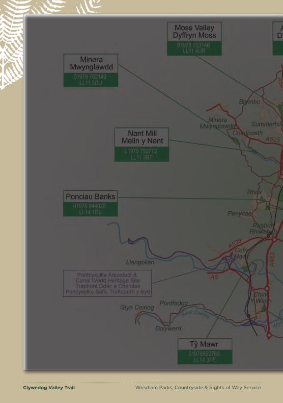
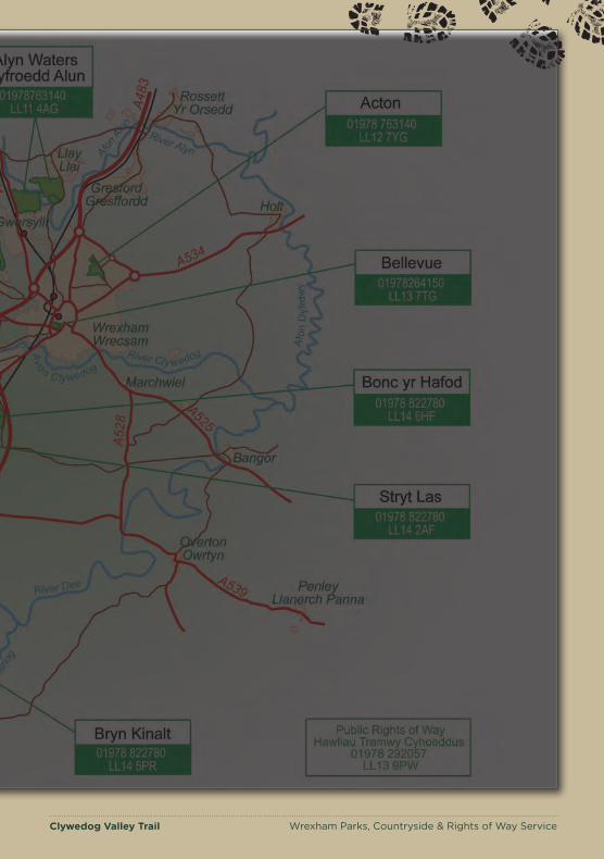
Clywedog Valley Trail Wrexham Parks, Countryside & Rights of Way Service
Country Parks Walk Leaflet
Wrexham Parks, Countryside & Rights of Way Service
Clywedog Valley Trail
ww w.wrexham.gov.uk / ww w.wrecsam.gov.uk

Clywedog Valley Trail Wrexham Parks, Countryside & Rights of Way Service
The Clywedog Valley Trail runs from Minera Lead Mines located
around 5 miles to the west of Wrexham and finishes at King’s Mill
approximately 1 mile to the south-east of the town centre.
It is an easy to follow waymarked path along the river helping you to enjoy the natural beauty of this peaceful valley and uncover its rich history. The Clywedog Trail is approximately 5.5 miles from start to finish and can also be enjoyed in shorter sections. The trail contains a number of stiles and gates. The final section of the walk after crossing Sontley Rd towards Kings Mill can be very muddy during winter or wet weather. An alternative is to finish the walk at Sontley Road at stage 12 on the guide.
Parking is available at Minera Lead Mines (LL11 3DU) and Nant Mill (LL11 3BT). There is also on road parking at Bersham and King’s Mill
For more information on the trail please go to: www.wrexham.gov.uk/countryside
Or contact Tel: 01978 763140 Email: [email protected]
For information on local buses please contact: Traveline Cymru: 0871 200 22 33 This leaflet has been produced by the Parks, Countryside and Rights of Way Service. Whilst every effort has been made to ensure accuracy, Wrexham County Borough Council cannot accept responsibility for any consequences of any errors in this publication.
Clywedog Valley Trail
Clywedog Valley Trail Wrexham Parks, Countryside & Rights of Way Service
Clywedog Valley Trail Wrexham Parks, Countryside & Rights of Way Service
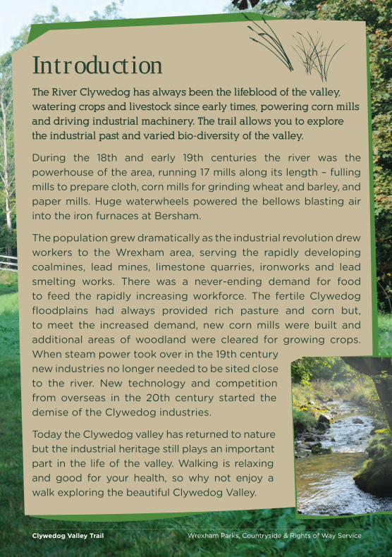
Clywedog Valley Trail Introduction The River Clywedog has always been the lifeblood of the valley,
watering crops and livestock since early times, powering corn mills
and driving industrial machinery. The trail allows you to explore
the industrial past and varied bio-diversity of the valley.
During the 18th and early 19th centuries the river was the powerhouse of the area, running 17 mills along its length – fulling mills to prepare cloth, corn mills for grinding wheat and barley, and paper mills. Huge waterwheels powered the bellows blasting air into the iron furnaces at Bersham.
The population grew dramatically as the industrial revolution drew workers to the Wrexham area, serving the rapidly developing coalmines, lead mines, limestone quarries, ironworks and lead smelting works. There was a never-ending demand for food to feed the rapidly increasing workforce. The fertile Clywedog floodplains had always provided rich pasture and corn but, to meet the increased demand, new corn mills were built and additional areas of woodland were cleared for growing crops. When steam power took over in the 19th century new industries no longer needed to be sited close to the river. New technology and competition from overseas in the 20th century started the demise of the Clywedog industries.
Today the Clywedog valley has returned to nature but the industrial heritage still plays an important part in the life of the valley. Walking is relaxing and good for your health, so why not enjoy a walk exploring the beautiful Clywedog Valley.
Clywedog Valley Trail Wrexham Parks, Countryside & Rights of Way Service

Clywedog Valley Trail Wrexham Parks, Countryside & Rights of Way Service
Clywedog Valleys Biodiversity Limestone flora Wildflowers flourish on the thin limestone soils near the lead mines at Minera. Look for the array of orchids in early summer and flowers such as Knapweed with its purple thistle-like flowers and Creeping Yellow Birds Foot Trefoil. The variety of flowers play host to a range of butterflies including the Common Blue.
Riverside wildlife The river has its own specialised plants and animals. Watch for dark brown and white Dippers and graceful Grey Wagtails along the river, attracted by the wealth of insects and other tiny creatures that live in the water. Trout thrive
in the river below Big Weir near Bersham, along with Eels and small Bullhead fish, that hide in the gaps between stones. If you are lucky you may see Heron and Kingfisher feeding along the river.
Bats Nant Mill is home to many bats. Lesser Horseshoe Bats use the tunnel under the road that drained water from the wheelpit into the river and smaller Pipistrelle Bats roost in the roof. At dusk on summer evenings you can see them emerging from their daytime roosts to hunt for insects.
The caves at Minera also provide a habitat for bats along with the many ivy-clad trees along the route.
Clywedog Valley Trail Wrexham Parks, Countryside & Rights of Way Service
Clywedog Valley Trail Wrexham Parks, Countryside & Rights of Way Service
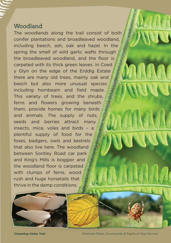
The woodlands along the trail consist of both conifer plantations and broadleaved woodland, including beech, ash, oak and hazel. In the spring the smell of wild garlic wafts through the broadleaved woodland, and the floor is carpeted with its thick green leaves. In Coed y Glyn on the edge of the Erddig Estate there are many old trees, mainly oak and beech but also more unusual species including hornbeam and field maple. This variety of trees, and the shrubs, ferns and flowers growing beneath them, provide homes for many birds and animals. The supply of nuts, seeds and berries attract many insects, mice, voles and birds – a plentiful supply of food for the foxes, badgers, owls and kestrels that also live here. The woodland between Sontley Road car park and King’s Mills is boggier and the woodland floor is carpeted with clumps of ferns, wood rush and huge horsetails that thrive in the damp conditions.
Woodland
Clywedog Valley Trail Wrexham Parks, Countryside & Rights of Way Service
Clywedog Valley Trail Wrexham Parks, Countryside & Rights of Way Service
A
BC
DE
F
GH
I
JK
L
1 km½ mile
Scale© Crown Copyright. All rights reserved. Wrexham County Borough Council 2005 Licence No. 010002342914
A
B
Minera Lead Mines Car Park
Start
C
D Watch out for the
feeding Dippers and Wagtails along the river.
Nant Mill Car Park
E
F
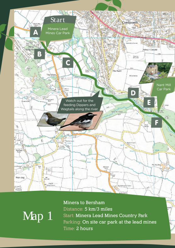
Minera to Bersham
Distance: 5 km/3 miles
Start: Minera Lead Mines Country Park
Parking: On site car park at the lead mines
Time: 2 hours
Map 1
Clywedog Valley Trail Wrexham Parks, Countryside & Rights of Way Service
A
BC
DE
F
GH
I
JK
L
1 km½ mile
Scale© Crown Copyright. All rights reserved. Wrexham County Borough Council 2005 Licence No. 010002342914
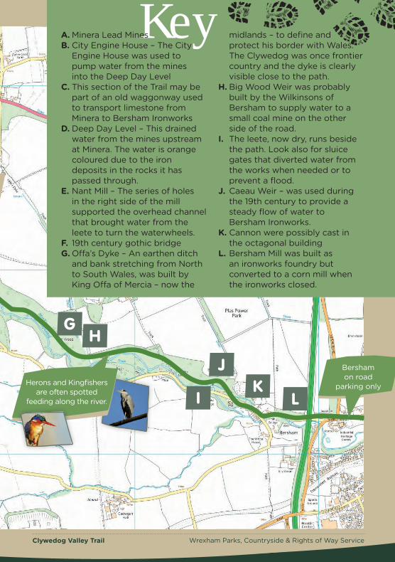
Key
Nant MillCar Park
A. Minera Lead Mines B. City Engine House – The City
Engine House was used to pump water from the mines into the Deep Day Level
C. This section of the Trail may be part of an old waggonway used to transport limestone from Minera to Bersham Ironworks
D. Deep Day Level – This drained water from the mines upstream at Minera. The water is orange coloured due to the iron deposits in the rocks it has passed through.
E. Nant Mill – The series of holes in the right side of the mill supported the overhead channel that brought water from the leete to turn the waterwheels.
F. 19th century gothic bridge G. Offa’s Dyke – An earthen ditch
and bank stretching from North to South Wales, was built by King Offa of Mercia – now the
midlands – to define and protect his border with Wales. The Clywedog was once frontier country and the dyke is clearly visible close to the path.
H. Big Wood Weir was probably built by the Wilkinsons of Bersham to supply water to a small coal mine on the other side of the road.
I. The leete, now dry, runs beside the path. Look also for sluice gates that diverted water from the works when needed or to prevent a flood.
J. Caeau Weir – was used during the 19th century to provide a steady flow of water to Bersham Ironworks.
K. Cannon were possibly cast in the octagonal building
L. Bersham Mill was built as an ironworks foundry but converted to a corn mill when the ironworks closed.
Bersham on road
parking only
G H
I
J K
L Herons and Kingfishers
are often spotted feeding along the river.
Clywedog Valley Trail Wrexham Parks, Countryside & Rights of Way Service

Clywedog Valley Trail Wrexham Parks, Countryside & Rights of Way Service
The Trail – Please refer to Map 1
Although well marked, the following guide will help you navigate
the trail from Minera to King’s Mill with the help of the enclosed
maps. The maps break the trail down into two sections.
1. From the main car park at Minera Lead Mines head up the path
towards the mine workings. At the top of this path turn left down
the hill towards the wooden gate.
Mining dominated this stretch of the trail as the underlying limestone around Minera is rich in metal ores, particularly lead and zinc.
This is the site of the deepest shaft and once one of the busiest mining centres (Map Point A&B).
Between 1819 and 1914, over 30 different companies prospected for lead nearby, digging 50 shafts and extracting lead ore worth over £4 million!
The biggest hazard in the mines was the risk of flooding, particularly as the shafts deepened. Drainage channels
2.
refers to this part of the track).
Clywedog Valley Trail Wrexham Parks, Countryside & Rights of Way Service
were dug and the deepest of these, known as the Deep Day Level emerges beside the Clywedog near Nant Mill.
The Romans were probably the first to mine the lead – the name ‘Minera’ comes from the Latin word for ore. Mining continued throughout the Middle Ages and, by the 14th
century, lead was such an important commodity that the miners received special privileges such as exemptions from taxes.
Through the wooden gate, head to the road and turn right. Follow
the road for a short distance until you reach the next way marker
on the opposite side by farm buildings. Follow this track to the
stile and then once over you we need to head over 2 more stiles,
then the path is easy to follow between the fences. (Map Point C
Clywedog Valley Trail Wrexham Parks, Countryside & Rights of Way Service
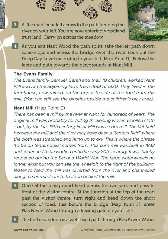
3. At the road, bear left across to the path, keeping the
river on your left. You are now entering woodland
trust land. Carry on across the meadow.
4. As you exit Nant Wood the path splits, take the left path down
some steps and across the bridge over the river. Look out the
Deep Day Level emerging to your left (Map Point D). Follow the
leete and path towards the playgrounds at Nant Mill.
The Evans Family The Evans family, Samuel, Sarah and their 10 children, worked Nant Mill and ran the adjoining farm from 1889 to 1930. They lived in the farmhouse, now ruined, on the opposite side of the ford from the mill. (You can still see the pigsties beside the children’s play area).
Nant Mill (Map Point E) There has been a mill by the river at Nant for hundreds of years. The original mill was probably for fulling thickening woven woollen cloth – but, by the late 18th century, Nant Mill was a corn mill. The flat field between the mill and the river may have been a ‘tenters field’ where the cloth was stretched and hung up to dry. This is where the phrase ‘to be on tenterhooks’ comes from. This corn mill was built in 1832 and continued to be worked until the early 20th century. It was briefly reopened during the Second World War. The large waterwheels no longer exist but you can see the wheelpit to the right of the building. Water to feed the mill was diverted from the river and channelled along a man-made leete that ran behind the mill.
5. Once at the playground head across the car park and pass in
front of the visitor centre. At the junction at the top of the road
past the visitor centre, turn right and head down the short
section of road. Just before the bridge (Map Point F), enter
Plas Power Wood through a kissing gate on your left.
6. The trail meanders on a well-used path through Plas Power Wood.
Clywedog Valley Trail Wrexham Parks, Countryside & Rights of Way Service
Clywedog Valley Trail Wrexham Parks, Countryside & Rights of Way Service
Bersham profitably. John, an innovative engineer and far-sighted
John Wilkinson
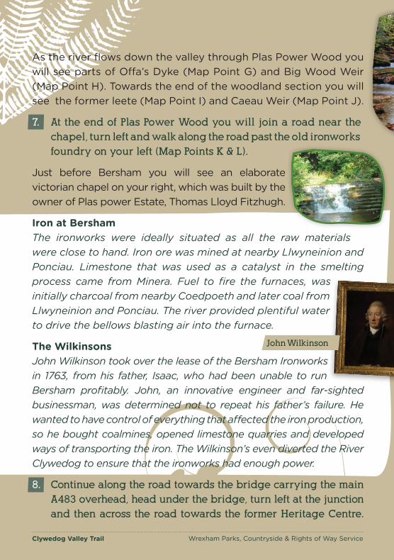
As the river flows down the valley through Plas Power Wood you will see parts of Offa’s Dyke (Map Point G) and Big Wood Weir (Map Point H). Towards the end of the woodland section you will see the former leete (Map Point I) and Caeau Weir (Map Point J).
7. At the end of Plas Power Wood you will join a road near the
chapel, turn left and walk along the road past the old ironworks
foundry on your left (Map Points K & L).
Just before Bersham you will see an elaborate victorian chapel on your right, which was built by the owner of Plas power Estate, Thomas Lloyd Fitzhugh.
Iron at Bersham The ironworks were ideally situated as all the raw materials were close to hand. Iron ore was mined at nearby Llwyneinion and Ponciau. Limestone that was used as a catalyst in the smelting process came from Minera. Fuel to fire the furnaces, was initially charcoal from nearby Coedpoeth and later coal from Llwyneinion and Ponciau. The river provided plentiful water to drive the bellows blasting air into the furnace.
The Wilkinsons John Wilkinson took over the lease of the Bersham Ironworks in 1763, from his father, Isaac, who had been unable to run
businessman, was determined not to repeat his father’s failure. He wanted to have control of everything that affected the iron production, so he bought coalmines, opened limestone quarries and developed ways of transporting the iron. The Wilkinson’s even diverted the River Clywedog to ensure that the ironworks had enough power.
8. Continue along the road towards the bridge carrying the main
A483 overhead, head under the bridge, turn left at the junction
and then across the road towards the former Heritage Centre.
Clywedog Valley Trail Wrexham Parks, Countryside & Rights of Way Service

Clywedog Valley Trail Wrexham Parks, Countryside & Rights of Way Service
John Wilkinson
11.
Once at the centre head down into the car park and go
left past the playground. At the end of the grass area
go down the steps and at the bottom turn left and then
right along the road through Bersham village.
Once you have left the village carry on the track at the side of
the river, then cross a bridge over the river and turn left over
stile. The path eventually opens up into a meadow (Map Points
N & O). Keeping to the right hand side of the meadow head to
the stile at the far end. Go over the stile and turn left up a track
until you reach a footbridge.
Paper Mills Papermaking needed a good supply of rags, as a raw material, and clean, relatively hard water with an even flow to power the mills. A series of weirs and leetes were built to ensure an even water supply. Rags were plentiful - the 1851 Wrexham census shows there were large numbers of Irish immigrants collecting rags for the paper mills. The rags were soaked in water and then pulped by water-powered hammers to separate the fibres. The mixture of water and fibres was then formed into sheets.
Clywedog Valley Trail Wrexham Parks, Countryside & Rights of Way Service
9.
10. After the bridge turn right and take the right fork in the path.
Follow the path through the field and over the footbridge. Carry
on under the bridges and through a small wooded area. Climb
the steep path to reach Felin Puleston (Map Point P).
Refer to information on King’s Mill regarding Felin Puleston.
Cross the footbridge just in front of the red-bricked house and
go through the kissing gate on the right into Erddig Estate
following the riverside path.
Please use Map 2 from this point
Clywedog Valley Trail Wrexham Parks, Countryside & Rights of Way Service
1 km½ mile
Scale© Crown Copyright. All rights reserved. Wrexham County Borough Council 2005 Licence No. 010002342914
M NO
P
QR
ST
Q
Felin Puleston M N
O P
Bersham on road
parking only
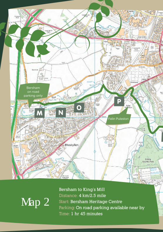
Bersham to King’s Mill
Distance: 4 km/2.5 mile
Start: Bersham Heritage Centre
Parking: On road parking available near by
Time: 1 hr 45 minutes
Map 2

Clywedog Valley Trail Wrexham Parks, Countryside & Rights of Way Service
1 km½ mile
Scale© Crown Copyright. All rights reserved. Wrexham County Borough Council 2005 Licence No. 010002342914
M NO
P
QR
ST
N. This weir provided a steady flow of water for the Turkey Paper Mill.
O. Site of the Turkey paper Mill that
Q. Coed y Glyn R. Kings Mill Leete - The ditch
running along the woodland edge is the leete that fed water from the Clywedog to
KeyM.Bersham
produced the highest quality paper, used for banknotes, cheques, account books and fine writing paper.
P. Felin Puleston is now an educational centre but the buildings were one of the tenanted farms on the estate.
Kings Mill. S. The domed brick structure
beside Kings Mill is a beehive kiln that was moved from a nearby brickworks.
T. Kings Mill
Coed y Glyn is made up of mainly oak and
beech, what other species can you see?
Q
Kings Mill on road
parking only
Finish
S T
R Look for stems of Great Horsetails. A primitive
plant that was common millions of years ago.
Clywedog Valley Trail Wrexham Parks, Countryside & Rights of Way Service
Clywedog Valley Trail Wrexham Parks, Countryside & Rights of Way Service
The wide, meandering river threads through fertile farmland in this final Section. Most of the surrounding land belongs to the Erddig estate, once one of the most important in northeast Wales. The house was built for Joshua Edisbury in 1683 when he became High Sheriff of Denbighshire but each subsequent owner has left his mark on the house and estate. The Yorke family was the last owners of the house, leaving it to the National Trust in 1973.
12. Carry on along the path through the 1st kissing gate. At the next
kissing go through and head right. The path brings you to a pair
of kissing gates either side of a tarmac road. (Please note this
section towards Kings Mill can be very muddy during winter/
wet weather) Head through both the kissing gates, straight
across the road. The path then meanders through Coed y Glyn
(Map Point Q), when you reach the road go through the gate,
head right and then go through the kissing gate on the other
side of the road. The path then carries on through woodland.
Wealth from coal had supported the estate since the 18th century but, ironically, coal almost destroyed it in the 20th century. The National Coal Board drove shafts from Bersham colliery directly under the house in the late 1940s, causing subsidence that seriously damaged the house.
The National Trust started the restoration of the house in 1973, partly funded by compensation from the Coal Board. The house, gardens and parkland are open to the public.
Philip Yorke I (1743-1804) was the first owner to be born on the estate and he did more to shape the special character of Erddig than any other. He inherited the estate, aged 23, when he had just been called to the bar in London. He had 13 children – his first wife died in childbirth aged 30, having given birth to 7 children in 81⁄2 years but he remarried two years later and had another 6 children!! He diverted the course of the Clywedog to provide a more reliable water source for King’s Mill and to protect it from flooding.
Clywedog Valley Trail Wrexham Parks, Countryside & Rights of Way Service
Clywedog Valley Trail Wrexham Parks, Countryside & Rights of Way Service
13. Ignore the first stile into the field and carry on until you reach
the second. Go over this stile and turn left. Follow the edge of
the woodland through the gap in the hedge (Map Point R).
14. (Please note this section can be very muddy during winter/wet
weather) Once through the entrance the field opens up, head across
to the far right corner. Go through the kissing gate and across the
field to the tunnel under the road which takes you to Kings Mill
and the end of the trail (Map Points S&T). Congratulations we hope
you have enjoyed the Clywedog Trail and its interesting history.
King’s Mill King’s Mill, that dates from the 14th century, was always Wrexham’s foremost mill. Its owners had ‘suit of mill’ that obliged all residents of Wrexham and Ansty to grind their corn and malt there. Despite this there was still much illegal competition, particularly from Felin Puleston. Felin Puleston was built in the 16th century by the father of the King’s Mill tenant. King’s Mill was then in a poor state of repair and couldn’t cope with the increasing demand for milling. If King’s Mill couldn’t perform its function the ‘suit of mill’ didn’t apply, so nearby Puleston Mill was well sited to pick up the surplus milling.
In 1624 the capacity of King’s Mill was increased so people no longer had a legal justification to go elsewhere. However Puleston Mill continued to work illegally. The two mills shared the same leete and, as Puleston Mill took the first water, it could restrict the water flow to King’s Mill. By keeping their sluice gates open, even when they weren’t milling, they drained water from the leete. This continued until a separate weir and leete were built in 1668.
The competition finally ended when Philip Yorke rebuilt King’s Mill in 1769 but also bought Puleston Mill and converted it for farm use. The monopoly on milling was fully broken in 1854 when 29 influentialn innkeepers, brewers, millers, malters and auctioneers formed an association to resist what they claimed were illegal tolls. Once steam-driven mills were built in Wrexham, King’s Mill was unable to compete. It closed down totally in 1940.
Clywedog Valley Trail Wrexham Parks, Countryside & Rights of Way Service
Clywedog Valley Trail Wrexham Parks, Countryside & Rights of Way Service Clywedog Valley Trail Wrexham Parks, Countryside & Rights of Way Service
Clywedog Valley Trail Wrexham Parks, Countryside & Rights of Way Service Clywedog Valley Trail Wrexham Parks, Countryside & Rights of Way Service