Embed Size (px)
Citation preview

Deploying Federal Geospatial Services in the Cloud:in the Cloud:Federal Geographic Data Committee (FGDC) and GSA GeoCloud Sandbox Initiative
Doug NebertUSGS/FGDCD b 2010December 2010
1
Draft – For Official Use Only

Background on GeoCloud Sandbox Initiative
Initiated as an Architecture and Technology Working Group activity in D b 2009 ith ll t f d l i t i t ti lDecember 2009 with a call to federal agencies to nominate geospatial applications for testing in the Cloud environment for a one-year prototyping process coordinated by FGDC and GSA
Eleven projects have been nominated by federal agencies as existing projects with existing software suites to be deployed in commercial-p j g p yor government-hosted Cloud environments
Two deployment environments (platforms) were abstracted from theTwo deployment environments (platforms) were abstracted from the nominated projects: Open source service stack on Linux64 and a Commercial service stack on Windows 2008 Server
2

Deploying Federal Geospatial Services in the Cloud GeoCloud Goals and Activities
One-year+ project to test and monitor externally-hosted Cloud data and service solutions for the geospatial domain to support the Geospatial Platform activityfor the geospatial domain, to support the Geospatial Platform activity
A hit tActivities, Outcomes
Architectures• Identify requirements-driven solution architectures and
platforms for various sized deployments of geospatial data and services
Acquire, compose, document, and deploy reference platform cloud thatsupport Geospatial
Platform standardsand services
Cost Models• Document and assess cost models to support scalability,
reliability and redundancy
Monitor costs, loads, issues and options in support of OMB IT project document guidance
reliability, and redundancy
Certification• Expedite FISMA (security) certification and accreditation for
agency adoption of packaged solution architectures
Certify Geospatial Solution Packages to facilitate re-use
agency adoption of packaged solution architectures
Comparisons• Support and collect cost comparison information from
f C
Document Best Practices and guides to agencies on adoption
of geospatial Cloud
3
agencies for existing and externally-hosted Cloud solutions• Document lessons learned and best practices
of geospatial Cloud infrastructure

Notional Cloud Computing Stack
• GSA apps gov is now• GSA apps.gov is now offering Infrastructure as a Service (IaaS) solutions f i i ifor acquisition• This is roughly equivalent to “shared-
(Software as a Service)
equivalent to sharedhosting” of raw computers with an operating system i th Cl d d iin the Cloud domain• Platform as a Service (PaaS) provides ( ) pconfigurable software components and services
4http://en.wikipedia.org/wiki/Cloud_computing

Platform as a Service (PaaS)
“A cloud platform (PaaS) delivers a computing p ( ) p gplatform and/or solution stack as a service, generally consuming cloud infrastructure and supporting cloud applications. It facilitates deployment of applications without the cost anddeployment of applications without the cost and complexity of buying and managing the underlying hardware and software layers.”*
The GeoCloud is piloting the deployment of candidate services via solution architectures (suites of software) by composing reference
(PaaS)
( ) y p gplatforms on top of the GSA IaaS to provide common geospatial capabilities. (IaaS)
5
* http://en.wikipedia.org/wiki/Cloud_computing

GeoCloud Community Platform Value Proposition
FGDC A 1
FGDC App 2Pool of geospatial
8 More
App 1projects identified for cloud migration Platform
Revenue Stream
…AppsNeed
Platforms Platform Savings
…Federal Platform Reference Implementations
Platform building time & effort
Reduced mainten-
ancecosts
Faster deploy-ment
Cost effective develop-ment /
t t
GeoCloudCommunityPlatformPlatforms
AmplifyI S
Enable Infrastructure Savings
effort costs test
Infrastructure as A Service SavingsHardware Savings Operations Savings Scalability Savings
IaaSSavings
6

Platform as a Service Architectural FrameworkDistinguishing Application, Platform and Infrastructure
Applications10 identified GeoSpatial Applications + more agency apps
Application Servers: Provide the deployment environment for actual business applications with access to enablers, frameworks and runtimes,
Platform asa Service
10 identified GeoSpatial Applications + more agency apps… , ,including interfaces and payload standards endorsed by the FGDC.
Platform Enablers: Platform enablers provide core supporting capabilities for developing , testing
(PaaS)core supporting capabilities for developing , testing and deploying code, including DBMS, Directory, Queue, Service Bus, etc. A relational database is the most common enabler example but is not present in all platforms
PlatformApplication Servers
Platform Enablers (DB’s, etc)Frameworks provide bundled access to common behaviors and services, which applications can rely upon.
Libraries are reusable code modules which can
App Frameworks / Libraries
Runtime Systems
( , )
Infrastructure
b a es a e eusab e code odu es c cabe called directly from an application.
Frameworks and Libraries save time and expense freeing developers from having to build common code and behaviors.Operating System
(IaaS)
Virtual Machines / CPU
Storage
Runtimes: provide the execution support for developing and running the code. Examples include Java, Python, Microsoft Common Language Runtime etc
Operating System
7
Language Runtime, etc.

Cloud Community Platform Service ActivitiesPrimary Activity Cycle
Prototype
• Create series of Federal Cloud Computing reference platform prototypes
• Support the wide range of target apps
Prototype
Create Prototype Platforms
• Ensure platforms work with identified
Validate
Validate With
Platforms
agency applications
DocumentDocument
With Agency Apps
• Document best practices and lessons learned
• Document cost models and benchmarks• Bundle the platforms and artifacts
P l F d l Cl d C i f
and Promulgate
• Promulgate to Federal Cloud Community of Interest
8

Cloud Community Platform Service Activities Preliminary Platform Architecture
Basic Image
GSA Wi d 2008
y
Base Platforms
O S
Specialized Platforms
G
GSA Windows 2008 Server Image
.NET, IIS
Open Source AdditionsJava, PHP,
PostGRES Tomcat, FLEX Apache
ArcGIS ServerGeospatialPlatform
GeospatiaWindows
Custo
FLEX, Apache
S ti D l
l, HH
S an
Windows Platform
Open Source
om U
Is and S
Harden, Build Base Platforms Specialize for Target Apps
Linux (CentOS)
Open Source Core
Apache, PostGreS/MySQL
Semantic DrupalGlassFish 3, Axis,
SunMQ
OpenGeo:
nd Seman
pPlatform
Standard APIPostGreS/MySQL,
Java, Ruby on Rails, Tomcat, Perl,
Python)
GeoServer, GeoNetwork
ntic AppsTHREDDS
Is
Tiers (e.g. database, app server) can be split or combined as needed
9
( g , pp ) p
Note: Software requirements for the candidate platforms were dictated by the eleven projects nominated by federal agencies. Standards are dictated by the FGDC endorsed standards list, Commonalities were identified in defining the stack. Additional software suites could be defined in the future using the same design process.

Deployment options within GeoCloud
C l i f h f h i i i l j f d i•Cost evaluation for each of the initial projects was performed using online ‘calculator’ based on data transfer, storage, CPU, and demand requirements
• Most projects could be feasibly hosted in AWS (~$350-500/month)• Some projects were cost-prohibitive in the Cloud due to large data storage or transfer costs
•Amazon Web Services (EC2) was selected as the primary ‘public’ cloud computing environment for various sizes and numbers of virtual machines (AWS via Apptis is a GSA apps.govIaaS offering on BPA)•Dell/VMWarevCloud environment was selected for government-hosted cloud infrastructure – at USGS EROS Data Center
10
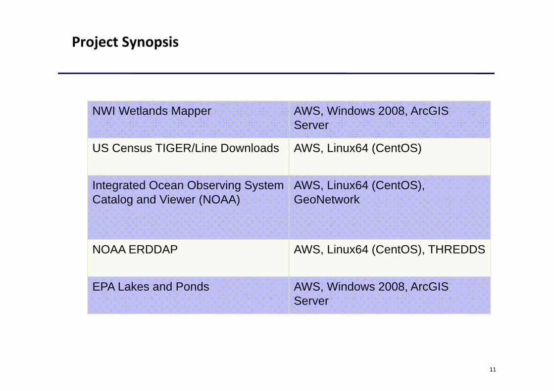
Project Synopsis
NWI W tl d M AWS Wi d 2008 A GISNWI Wetlands Mapper AWS, Windows 2008, ArcGISServer
US Census TIGER/Line Downloads AWS, Linux64 (CentOS)US Census TIGER/Line Downloads AWS, Linux64 (CentOS)
Integrated Ocean Observing System C t l d Vi (NOAA)
AWS, Linux64 (CentOS), G N t kCatalog and Viewer (NOAA) GeoNetwork
NOAA ERDDAP AWS, Linux64 (CentOS), THREDDS
EPA Lakes and Ponds AWS Windo s 2008 ArcGISEPA Lakes and Ponds AWS, Windows 2008, ArcGISServer
11

Project Synopsis, Continued
USGS N ti l El ti D t t VMW Cl d D ll HWUSGS National Elevation Dataset (NED) service and data
VMWarevCloud on Dell HW, Windows 2008, ArcGIS Server
USGS N ti l M M Til VMW Cl d D ll HWUSGS National Map Map Tile Cache
VMWarevCloud on Dell HW, Windows 2008 or Linux64
Particles in the Cloud (NOAA) AWS Linux64 (CentOS)Particles in the Cloud (NOAA) particle tracking computationalservice for air or water dispersion/ diffusion
AWS, Linux64 (CentOS)
diffusionGEOSS Clearinghouse Catalog AWS, Linux64 (CentOS)
USDA FSA or NRCS data service AWS Windows 2008 ArcGISUSDA FSA or NRCS data service application
AWS, Windows 2008, ArcGISServer
12

GeoCloud Status and Plans, as of January 2011
Provided login credentials(encrypted key pairs) for AWS and its management interface to indi id als sing AWSmanagement interface to individuals using AWS
Initiating image builds of OS plus base software dependencies for CentOS (RedHat) and scripting the geospatial module activation
Scripting Windows 2008 Server using hardening guidelines used by GSA and other agencies with ESRI ArcGIS Server as image baseline
Installation and monitoring of the deployment environment with sta at o a d o to g o t e dep oy e t e o e t tagency-facing Web services (January-March)
Initial public-facing Web Services (January)Initial public-facing Web Services (January)
13

Questions & Answers
Contact Information:Contact Information:
–Doug Nebert (ddnebert@fgdc gov)Doug Nebert ([email protected])
–Robert Patt-CornerRobert Patt Corner, eGlobalTech/GSA (robert.patt-corner@gsa gov)[email protected])
14