Embed Size (px)
Citation preview
Kent County
Department of Planning Services Division of Planning
SARAH E. KEIFER, AICP Phone: 302/744-2471 Director of Planning Services FAX: 302/736-2128 KRISTOPHER S. CONNELLY, AICP Assistant Director of Planning Services
KENT COUNTY COMPLEX 555 Bay Road Dover, DE 19901 (Handicapped Accessible)
STAFF RECOMMENDATION REPORT October 7, 2021
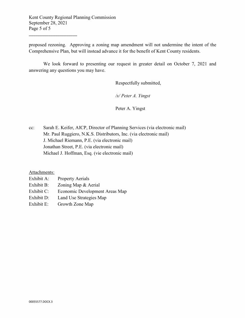
Ordinance : LC21-16 Application Number : CZ-21-05 Capital Cities Present Zoning / : AC (Agricultural Conservation) / Comp Plan Map Designation : Low Density Residential Proposed Zoning / : BG (General Business) / Comp Plan Map Designation : Highway Commercial Relation to Growth Zone : Inside Area and Location : 6.23 ± acres located off the southbound side of Route
1, approximately 675’ south of Big Oak Road and approximately 1,760’ north of W. Big Woods Road, south of Smyrna
I. STAFF RECOMMENDATION:
Based on the information presented, the Kent County Code, and the Comprehensive Plan, Staff recommends APPROVAL of the request to amend the Zoning Map and Comprehensive Plan Future Land Use Map. The following are the findings of fact for Staff’s recommendation of approval:
• The property is currently zoned AC and is located within the Growth Zone Overlay District.
• The Future Land Use Map (7-B) of the 2018 Kent County Comprehensive Plan indicates that the subject
site be utilized for low-density residential purposes. However, the Land Use Strategy Map (7-C) reflects a long term development strategy where specific mixed use, higher density, commercial, industrial, and employment center development could be supported, provided it is in keeping with the character of the area and adequate infrastructure is in place or planned to serve it. Map 7-C recommends Highway Commercial uses for the subject site. The Land Use Chapter of the Comprehensive Plan states the following:
Rezoning applications in keeping with the descriptions of these areas would be considered compliant with the Comprehensive Plan and should be supported. While the Regional Planning Commission and Levy Court should use Map 7-C as a guide in evaluating applications for rezoning, the standards included in the Zoning Ordinance regarding compatibility with
RPC Recommendation Report CZ-21-05 Capital Cities October 7, 2021 Page 2 of 3
surrounding land uses and availability of infrastructure remain in effect and should have equal weight in rezoning property.
• The proposed re-zoning does meet the conditions for approval of a zoning change under Section 205-
408 B of Kent County Code: A. There was a mistake in the Zoning Map, or the character of the neighborhood has changed to
such an extent that the Zoning Map should be changed.
There was no mistake in the Zoning Map. As part of the 2018 Comprehensive Plan, the County designated strategic areas for long-term development where commercial uses could be supported. The subject site is surrounded by commercial, industrial and high-density residential zoning. Recognizing that the existing zoning for agricultural and low-density residential use is no longer compatible with the character of the area, the Comprehensive Plan designated this parcel for highway commercial use to support and complement the surrounding non-residential uses.
B. The new zoning classification conforms to the Comprehensive Plan for Kent County in relation to
land use, number of dwelling units or type and intensity of nonresidential buildings and location.
The proposed BG zoning district does conform to the Land Use Strategy Map (7C) of the 2018 Comprehensive Plan, which outlines a long term development strategy where commercial uses may be supported. Further, the parcel is located inside the Growth Zone which “encompasses an area that Kent County has determined new development should be encouraged”, according to Kent County Code Section 205-397.2(A)(1).
C. Transportation facilities, water and sewerage systems, storm drainage systems, schools and fire
suppression facilities adequate to serve the proposed use are either in existence or programmed for construction.
Transportation Facilities: The subject site is located off the southbound side of Route 1, but does not have access to the highway. There is no other road frontage accessing the site, which makes it a landlocked parcel. In the event that the site is developed, access from an adjacent parcel would be required.
Water & Sewerage Systems: The subject site is located within the Kent County Sewer District (KCSDD 1), and central water service is available from Artesian.
Storm Drainage Systems & Fire Suppression Facilities: Any new project would need to be reviewed by the Kent Conservation District for stormwater impact and by the State Fire Marshall for fire suppression service.
D. There is compatibility between the uses of the property as reclassified and the surrounding land
uses, so as to promote the health, safety and welfare of present and future residents of the county.
There would be compatibility between the uses of the property as reclassified and the surrounding land uses that would promote the health, safety, and welfare of present and future residents of the County. Highway commercial uses would complement and support the nature of the area, which is predominantly highway commercial and industrial, and would not adversely affect the vacant land to the north which is zoned for high-density residential use.
RPC Recommendation Report CZ-21-05 Capital Cities October 7, 2021 Page 3 of 3 II. BACKGROUND INFORMATION:
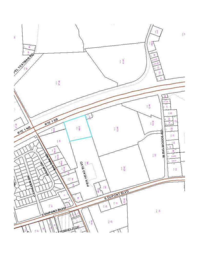
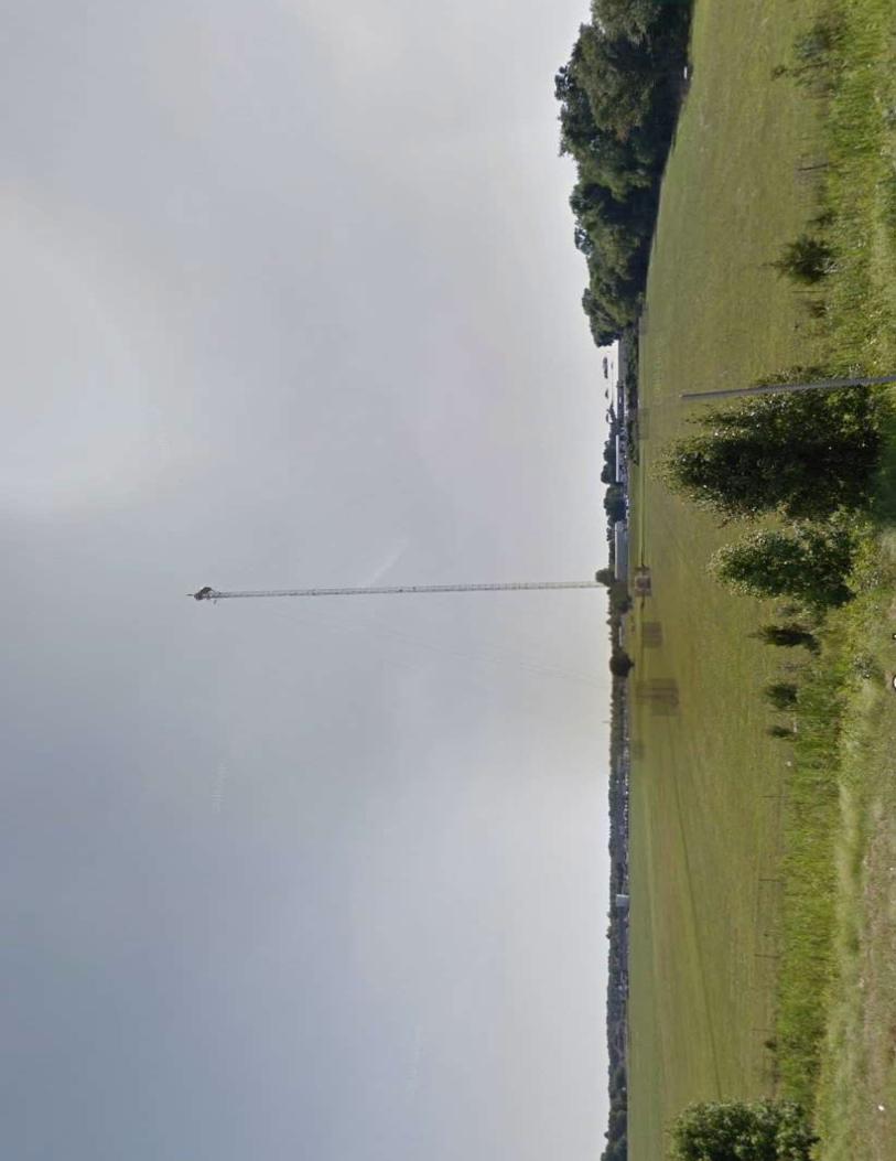
• The subject site is approximately 6.23 + acres, and is currently unimproved with the exception of a telecommunications tower. The parcel is bounded on the east by Route 1, which is not accessible from the site. With no other road frontage or access, the parcel is landlocked for all intents and purposes.
• The subject site is located within the Growth-Zone Overlay District.
• The character of the surrounding area is predominantly commercial and industrial in nature. There are
14+ acres of undeveloped high-density residential zoning located to the north. To the west of the subject site is the Pier Head industrial park, and to the south is the newly developed NKS Distributors warehouse.
• There have been seven (7) previous rezoning applications in the nearby vicinity:
o Z-75-05 approved the rezoning of 18.9 acres located southwest of the subject site, from AC to BG in February 1975
o Z-87-21 approved the rezoning of 10 acres located adjacent to and west of the subject site, from AC & BG to IG in May 1987
o Z-90-43 approved the rezoning of 19.1752 acres located adjacent to and south of the subject site, from AC to BG in December 1990
o Z-92-09 approved the rezoning of 1.4531 acres located adjacent to and west of the subject site, from IG to BG in February 1992
o Z-98-04 approved the rezoning of 9.35 acres located adjacent to and west of the subject site, from IG & AC to IG in April 1998
o Z-01-13 approved the rezoning of 7.3 acres located adjacent to and south of the subject site, from AC to BG in June 2001
o CZ-06-04 approved the rezoning of 12.64 acres located adjacent to and north of the subject site, from AC to RM in March 2006
III. AGENCY COMMENTS:
• The Delaware Department of Transportation has criteria that Traffic Impact Studies (TIS) are warranted for developments generating more than 500 vehicle trip ends per day, or 50 vehicle trip ends per hour in any hour of the day. If the County approves this rezoning, DelDOT will revisit the need for a TIS when a land development plan is proposed.
IV. OWNER/APPLICANT: This recommendation is offered without the benefit of public testimony and is based on the information presented when the application was received by the Department of Planning Services. The Regional Planning Commission shall give considerable weight to public testimony received during public hearing in considering its recommendation to Levy Court in this matter.
ENC: Ordinance LC21-16
Data Sheet Exhibit A – Location and Zoning Map Support Facilities Request Response from DelDOT dtd. 9/14/21 Letter from Tarabicos, Grosso & Hoffman, LLP dtd. 9/28/21
Kent County
Department of Planning Services Division of Planning
SARAH E. KEIFER, AICP Director of Planning Services
Phone: 302/744-2471 FAX: 302/736-2128
KRISTOPHER S. CONNELLY, AICP Assistant Director of Planning Services
KENT COUNTY COMPLEX 555 Bay Road Dover, DE 19901 (Handicapped Accessible)
DATA SHEET FOR ZONING MAP AMENDMENT
Regional Planning Commission Public Hearing of: Thursday, October 7, 2021
Regional Planning Commission Business Meeting of: Thursday, October 14, 2021
Levy Court Public Hearing of: Tuesday, October 26, 2021 Ordinance # : LC21-16 Application # and Name : CZ-21-05 Capital Cities Applicant : NKS Distributors, Inc. c/o Paul Ruggiero 399 New Churchmans Road New Castle, DE 19720 Owner : Capital Cities / ABC, Inc. c/o Chris Silva 4100 City Line Avenue Philadelphia, PA 19131 Engineer : Becker Morgan Group Attn: J. Michael Riemann 309 S. Governors Avenue
Dover, DE 19904 Present Zoning / Comp Plan Map Designation : AC (Agricultural Conservation) / Low Density Residential Proposed Zoning / Comp Plan Map Designation : BG (General Business) / Highway Commercial Relation to Growth Zone : Inside Levy Court District : 1st - Masten
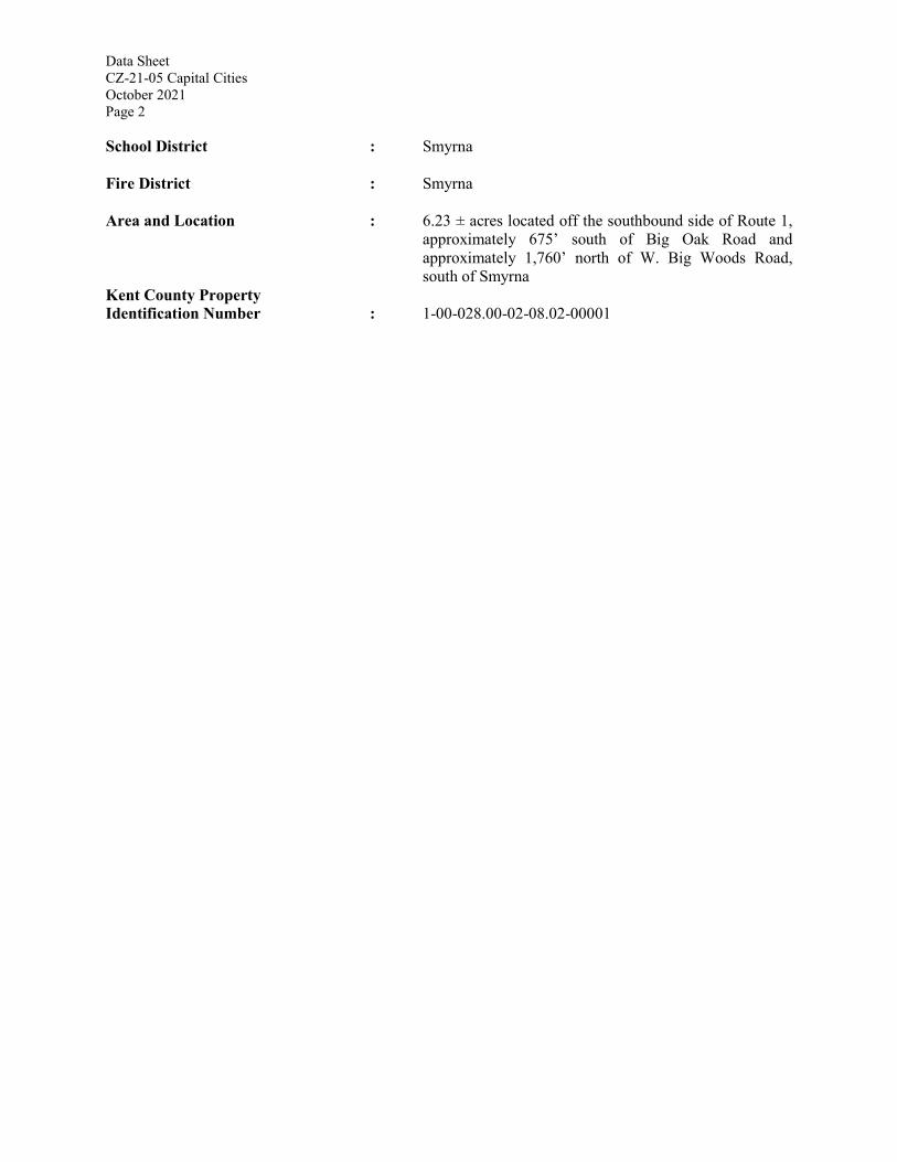
Data Sheet CZ-21-05 Capital Cities October 2021 Page 2 School District : Smyrna Fire District : Smyrna Area and Location : 6.23 ± acres located off the southbound side of Route 1,
approximately 675’ south of Big Oak Road and approximately 1,760’ north of W. Big Woods Road, south of Smyrna
Kent County Property Identification Number : 1-00-028.00-02-08.02-00001
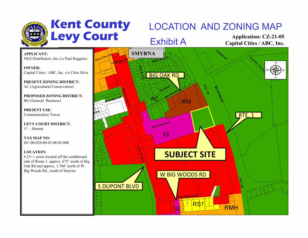
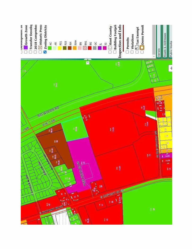
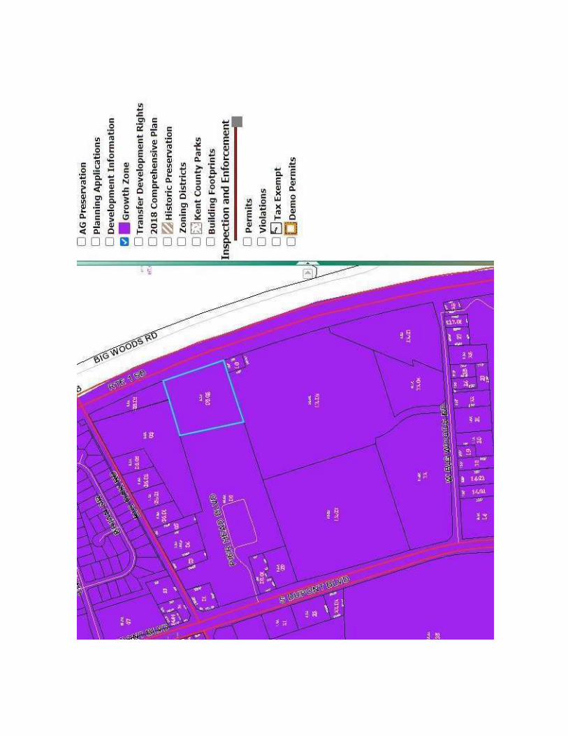
Exhibit ALOCATION AND ZONING MAP
Application: CZ-21-05Capital Cities / ABC, Inc.
APPLICANT:NKS Distributors, Inc c/o Paul Ruggiero
OWNER: Capital Cities / ABC, Inc. c/o Chris Silva
PRESENT ZONING DISTRICT:AC (Agricultural Conservation)
PROPOSED ZONING DISTRICT: BG (General Business)
PRESENT USE:Communication Tower
LEVY COURT DISTRICT: 1st - Masten
TAX MAP NO: DC-00-028.00-02-08.02-000
LOCATION:6.23+/- acres located off the southbound side of Route 1, approx. 675’ south of Big Oak Rd and approx. 1,760’ north of W. Big Woods Rd., south of Smyrna
Kent CountyLevy Court
SUBJECT SITE
BIG OAK RD
W BIG WOODS RD
SMYRNA
RTE. 1
S DUPONT BLVD
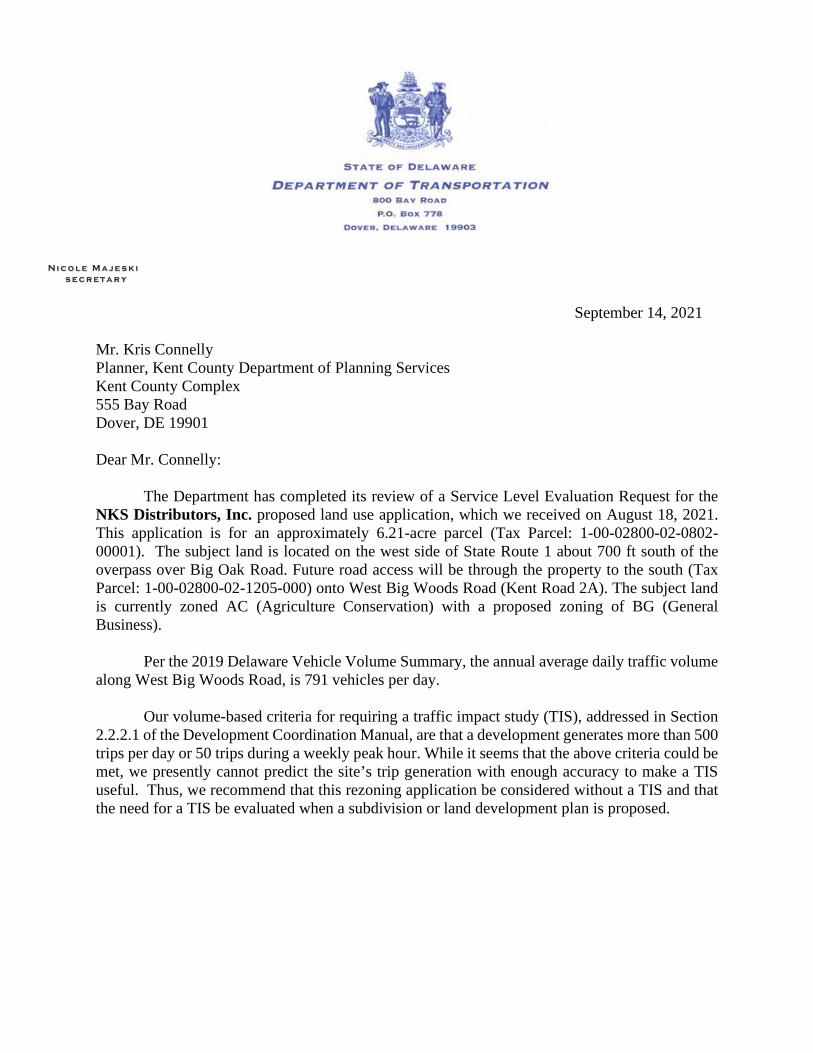
N i c o l e M a j e s k i s e c r e t a r y
September 14, 2021
Mr. Kris Connelly Planner, Kent County Department of Planning Services Kent County Complex 555 Bay Road Dover, DE 19901 Dear Mr. Connelly:
The Department has completed its review of a Service Level Evaluation Request for the NKS Distributors, Inc. proposed land use application, which we received on August 18, 2021. This application is for an approximately 6.21-acre parcel (Tax Parcel: 1-00-02800-02-0802-00001). The subject land is located on the west side of State Route 1 about 700 ft south of the overpass over Big Oak Road. Future road access will be through the property to the south (Tax Parcel: 1-00-02800-02-1205-000) onto West Big Woods Road (Kent Road 2A). The subject land is currently zoned AC (Agriculture Conservation) with a proposed zoning of BG (General Business).
Per the 2019 Delaware Vehicle Volume Summary, the annual average daily traffic volume
along West Big Woods Road, is 791 vehicles per day. Our volume-based criteria for requiring a traffic impact study (TIS), addressed in Section
2.2.2.1 of the Development Coordination Manual, are that a development generates more than 500 trips per day or 50 trips during a weekly peak hour. While it seems that the above criteria could be met, we presently cannot predict the site’s trip generation with enough accuracy to make a TIS useful. Thus, we recommend that this rezoning application be considered without a TIS and that the need for a TIS be evaluated when a subdivision or land development plan is proposed.
Mr. Kris Connelly Page 2 of 2 September 14, 2021
Please contact Ms. Annamaria Furmato, at (302) 760-2710, if you have questions concerning this correspondence.
Sincerely,
T. William Brockenbrough, Jr.County CoordinatorDevelopment Coordination
TWB:afm CC: NKS Distributors, Inc, Applicant
Jason Berry, Kent County Department of Planning Services David Edgell, State Planning Coordinator, Cabinet Committee on State Planning Issues Todd Sammons, Assistant Director, Development Coordination Thomas Felice, Corridor Capacity Preservation Program Manager, Development Coordination Olayiwola Okesola, Kent County Review Coordinator, Development Coordination Joshua Schwartz, Kent County Subdivision Manager, Development Coordination Ryan Schroder, Kent County Subdivision Manager, Development Coordination Jeff Steward, Central District Project Reviewer, Maintenance & Operations Troy Brestel, Project Engineer, Development Coordination Claudy Joinville, Project Engineer, Development Coordination Annamaria Furmato, Project Engineer, Development Coordination
00055577.DOCX.3
September 28, 2021 VIA ELECTRONIC MAIL Kent County Department of Planning Services c/o Sarah E. Keifer, AICP – Director 555 Bay Road Dover, Delaware 19901 [email protected] RE: N.K.S. Distributors, Inc. – Rezoning of 340 Big Oak Road Application No. CZ-21-05___________________________ Dear Chairman Jester and Members of the Regional Planning Commission: Our firm represents N.K.S. Distributors, Inc. (“NKS”), the contract purchaser of the above-referenced property; specifically, that approximately 6.23 acres in unincorporated Kent County located at 340 Big Oak Road, being further identified as Tax Parcel No. 1-00-028.00-02-08.02-00001 (the “Property”).1 The legal owner of the Property is Capital Cities/ABC, Inc. NKS proposes to demolish an existing commercial antenna tower located on the Property and rezone the Property from an Agricultural Conservation District (AC) to General Business (BG).
NKS submitted an application to rezone the Property to the Kent County Department of Planning Services. This request has been scheduled for a public hearing before the Regional Planning Commission on October 7, 2021. This letter, and the documentation referenced herein, offers additional background and information in support of the requested rezoning. 1 Exhibit A.
Larry J. Tarabicos Geoffrey L. Grosso Scott L. Matthews Michael J. Hoffman Daniel F. McAllister Lauren R. Otto (GA and PA only) Noah D. Chamberlain Cameron P. Wolfson (PA only) Maria R. Madison (IL and NE only) Peter Yingst (Certified Limited Practice Licensee)
Peter A. Yingst
[email protected] (o) 302-757-7812
One Corporate Commons 100 West Commons Boulevard
Suite 415 New Castle, DE 19720
302-757-7800 www.tarabicosgrosso.com
Kent County Regional Planning Commission September 28, 2021 Page 2 of 5 ______________________
00055577.DOCX.3
Property Description and Background
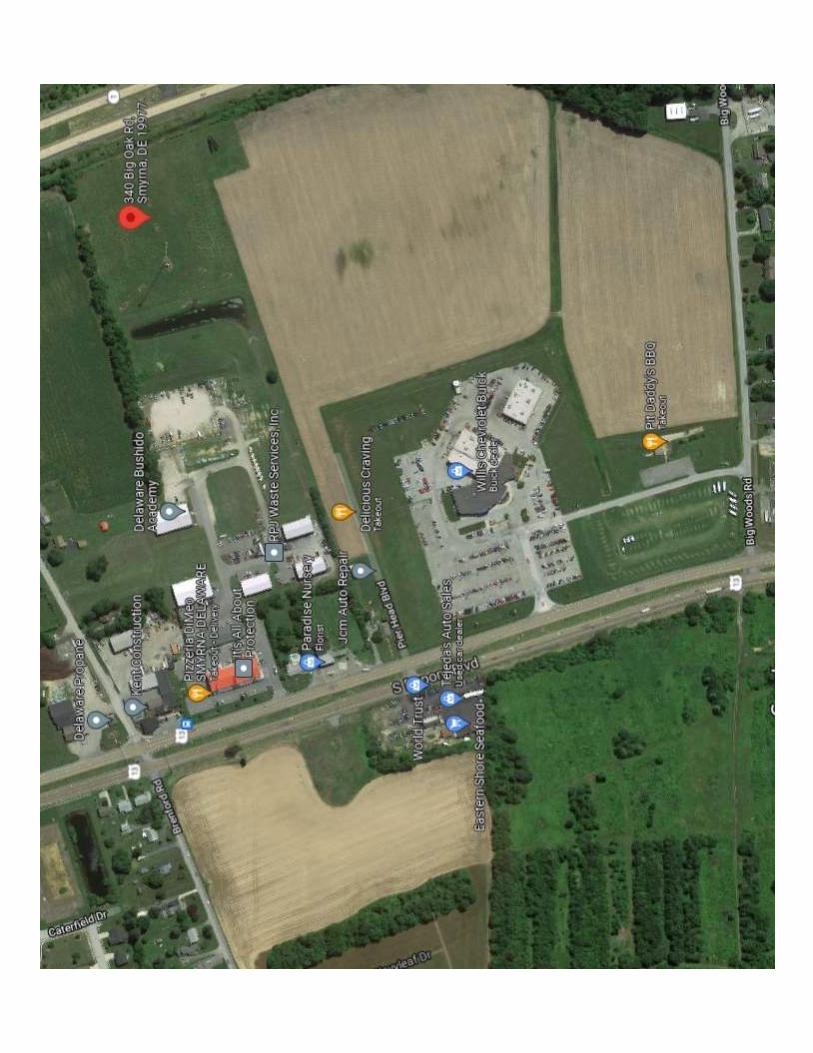
As previously stated, the Property is presently within an Agricultural Conservation District (AC) and supports an inactive commercial antenna tower. NKS intends to demolish the tower and rezone the Property, which is situated amongst an assortment of commercial properties and uses.2 NKS recently secured approvals to construct a new, state-of-the-art warehouse/distribution facility just south of the Property along W. Big Woods Road, being further identified as Kent County Tax Parcel No. DC-00-02800-02-1205-000. NKS has been proudly operating in Delaware for seventy years and jumped on the opportunity to expand its footprint in Kent County. The proposed facility includes warehouse/distribution space and supporting office space. This adjacent, approximately 25.6-acre property accommodating the NKS warehouse is zoned General Business (BG).
Other neighboring properties similarly support commercial uses; specifically, an
automobile dealership and a vacant former golf driving range, among other commercially-zoned parcels. Directly to the west of the Property is property zoned General Industrial (IG), with a portion of the same land being zoned General Business (BG), supporting a small retail center. Directly north of the Property are five parcels totaling approximately fourteen (14) acres zoned for Multifamily Residential (RM) use. The five larger parcels positioned south of the Property are zoned General Business (BG), consistent with NKS’s requested rezoning. Notably, the 2018 Kent County Comprehensive Plan (the “Comprehensive Plan”) identifies the area comprising the Property as appropriate for commercial development and uses, as explained in greater detail below.
Standards for Zoning Map Amendment As the Regional Planning Commission and the Department of Planning Services are aware, applicants for a zoning map amendment must establish compliance with the Kent County Code’s Section 205-408 guidelines and standards for zoning map amendments. Accordingly, each applicable standard is briefly reviewed below:
A. There was a mistake in the Zoning Map, or the character of the neighborhood has changed to such an extent that the Zoning Map should be changed.
The character of the area comprising the Property supports a General Business (BG)
zoning. General Business (BG) zoning districts, per Section 205-166 of the Kent County Code, “provide for a broad range of commercial activities ... occupying prime retail land and serving a regional community.” Conversely, Agricultural Conservation Districts (AC), within which the Property currently exists, are more appropriate in Low Density Residential areas, per Chapter 7 of
2 Exhibit B.
Kent County Regional Planning Commission September 28, 2021 Page 3 of 5 ______________________
00055577.DOCX.3
the Comprehensive Plan, and are designed to provide for a wide range of agricultural uses and farm-related services, per Section 205-44 of the Kent County Code.
The character of the surrounding area better supports the commercial uses contemplated
for General Business (BG) district. While some large neighboring lots remain unimproved, within the immediate area is a pizzeria, a barbecue takeout restaurant, a florist, and an automobile dealership, among others. As mentioned previously, a small retail center sits west of the Property along S. DuPont Boulevard (U.S. Route 13). Meanwhile, NKS is developing land just south of the Property with the warehouse/distribution facility detailed above. These uses and zoning districts that predominate the area represent the character of the neighborhood and help to support the proposed rezoning.
B. The proposed zoning change results in consistency between the zoning
classification to which the property is subject under Chapter 205 and the Comprehensive Plan for Kent County in relation to land use, number of dwelling units or type and intensity of nonresidential buildings and location.
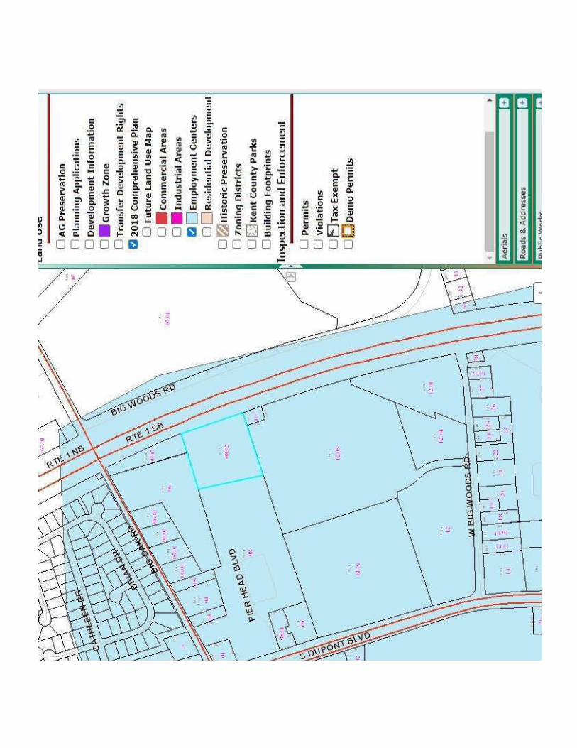
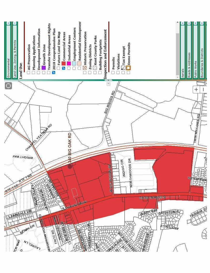
Chapter 2 of the Comprehensive Plan identifies the subject area as a proposed
“Employment Center,” which stresses “uses that create jobs – offices of all types and light industrial development.” NKS is developing the neighboring property with a warehouse that accomplished these objectives. In addition, and consistent with this designation, Map 2A depicting Economic Development Areas isolates areas where rezoning should be supported and highlights “all of the proposed industrial, employment centers, and commercial areas” in Kent County.3 The subject area is within both a Highway Commercial Area and classified as a Potential Employment Center. The Future Land Use section of Chapter 7 of the Comprehensive Plan indicates that the Applicable Zoning District contemplated for said Highway Commercial designation is, appropriately, General Business (BG).
The Comprehensive Plan, per Map 7C illustrating Land Use Strategies, again categorizes
the Property within a Highway Commercial area.4 These areas “are generally located in an around areas of existing larger scale commercial development and along major roadways.” The subject area is sandwiched between U.S. Route 13 and Delaware Route 1, emphasizing the appropriateness of the proposed rezoning. Notably, the Comprehensive Plan indicates that rezoning applications “keeping with the descriptions of these areas,” as identified in Map 7C, “would be considered compliant with the Comprehensive Plan and should be supported.”
3 Exhibit C. 4 Exhibit D.
Kent County Regional Planning Commission September 28, 2021 Page 4 of 5 ______________________
00055577.DOCX.3
C. Transportation facilities, water and sewerage systems, storm drainage systems, schools and fire suppression facilities adequate to serve the proposed uses for the rezoning or zoning change are either in existence or programmed for construction.
According to the Comprehensive Plan, “areas designated for commercial and industrial
development would meet the existing requirements for rezoning provided the infrastructure is planned for or in place.” The Property, as previously stated, is situated between two heavily-traveled highways. In addition, a bus stop is positioned at the U.S. Route 13 intersection with Big Oak Road. The Property is within a Kent County sewer district, meaning sewer service is available for the Property. Crucially, the Property is located within the Growth Zone Overlay District, which, per Section 205-397.2 of the Kent County Code, is an area where “infrastructure such as water, sewer, and transportation facilities exists or is planned to serve development.”5 This designation and the existing amenities, together with the neighboring commercial properties, bolster the suitability of the requested zoning designation.
D. There is compatibility between the uses of the property as rezoned under the
proposed zoning change under Chapter 205 and the surrounding land uses, so as to promote the health, safety and welfare of present and future residents of the County.
Properties bordering the subject lot are zoned General Business (BG), including the five parcels just south of the Property. Additional property amongst the surrounding land is zoned General Industrial (IG), while other lots are zoned Multifamily Residential (RM). Across Delaware Route 1 and north of Big Oak Road primarily comprises Agricultural Conservation Districts (AC). Although there are a multitude of zoning districts in the vicinity, the most prevalent zoning district for the surrounding land is General Business (BG). Approving a zoning map amendment that rezones the Property General Business (BG) will provide additional cohesion to the area in accordance with the Comprehensive Plan. This fact, coupled with the Comprehensive Plan’s objectives and strategies detailed above, contributes to the promotion of the health, safety, and welfare of Kent County residents.
Conclusion
Given the objectives, strategies, and future land use designations articulated in the Comprehensive Plan, a General Business (BG) zoning is preferred for the Property. Moreover, the character of the surrounding area, pursuant to the neighboring zoning and uses, support the
5 Exhibit E.
Kent County Regional Planning Commission September 28, 2021 Page 5 of 5 ______________________
00055577.DOCX.3
proposed rezoning. Approving a zoning map amendment will not undermine the intent of the Comprehensive Plan, but will instead advance it for the benefit of Kent County residents.
We look forward to presenting our request in greater detail on October 7, 2021 and
answering any questions you may have.
Respectfully submitted, /s/ Peter A. Yingst Peter A. Yingst
cc: Sarah E. Keifer, AICP, Director of Planning Services (via electronic mail)
Mr. Paul Ruggiero, N.K.S. Distributors, Inc. (via electronic mail) J. Michael Riemann, P.E. (via electronic mail) Jonathan Street, P.E. (via electronic mail) Michael J. Hoffman, Esq. (vie electronic mail) Attachments: Exhibit A: Property Aerials Exhibit B: Zoning Map & Aerial Exhibit C: Economic Development Areas Map Exhibit D: Land Use Strategies Map Exhibit E: Growth Zone Map


![[Type text] LAND USE SERVICES DEPARTMENT PLANNING COMMISSION STAFF REPORT · land use services department planning commission staff report. hearing date: march 3, 2016 agenda item](https://img.pdfslide.us/doc/110x75/5f09ac907e708231d427f823/type-text-land-use-services-department-planning-commission-staff-land-use-services.jpg)