Embed Size (px)
Citation preview
Prof. Joanne Irene Gabrynowicz Editor-in-Chief Emerita, Journal of Space Law
Visiting Professor, BIT School of Law Professor Emerita, University of Mississippi
Department of Commerce/National Oceanic
and Atmospheric Administration Advisory Committee on
Commercial Remote Sensing
5 December 2014
1
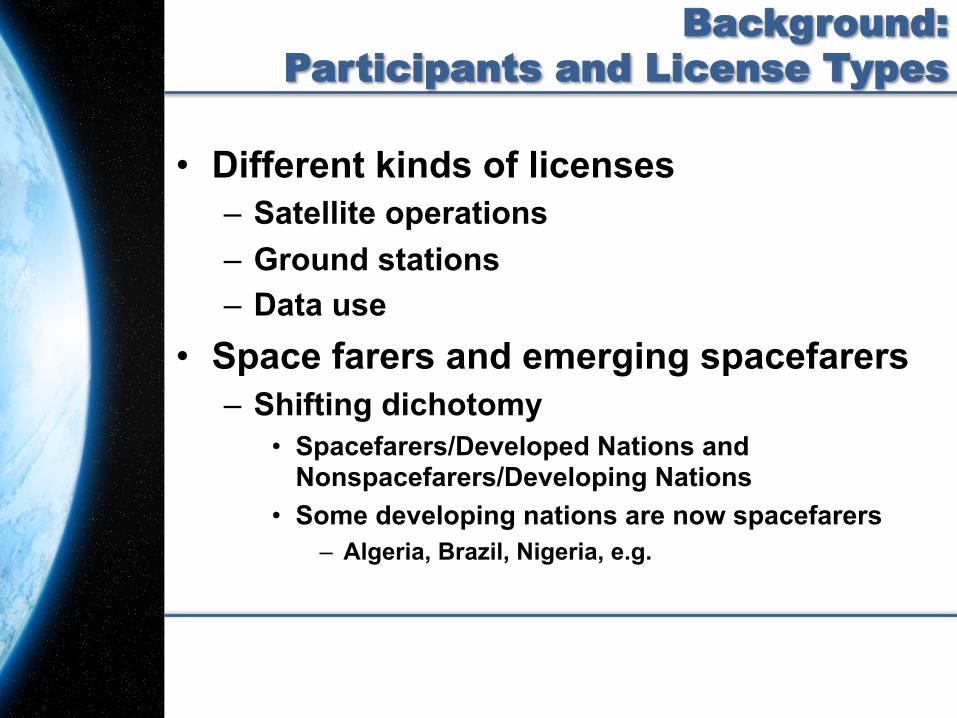
Background: Participants and License Types
• Different kinds of licenses – Satellite operations – Ground stations – Data use
• Space farers and emerging spacefarers – Shifting dichotomy
• Spacefarers/Developed Nations and Nonspacefarers/Developing Nations
• Some developing nations are now spacefarers – Algeria, Brazil, Nigeria, e.g.
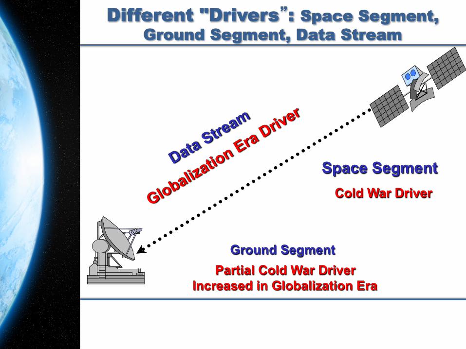
Different "Drivers”: Space Segment, Ground Segment, Data Stream
Space Segment
Ground Segment
Cold War Driver
Partial Cold War Driver Increased in Globalization Era
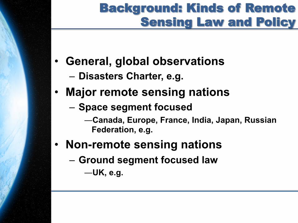
Background: Kinds of Remote Sensing Law and Policy
• General, global observations – Disasters Charter, e.g.
• Major remote sensing nations – Space segment focused
― Canada, Europe, France, India, Japan, Russian Federation, e.g.
• Non-remote sensing nations – Ground segment focused law
― UK, e.g.
5
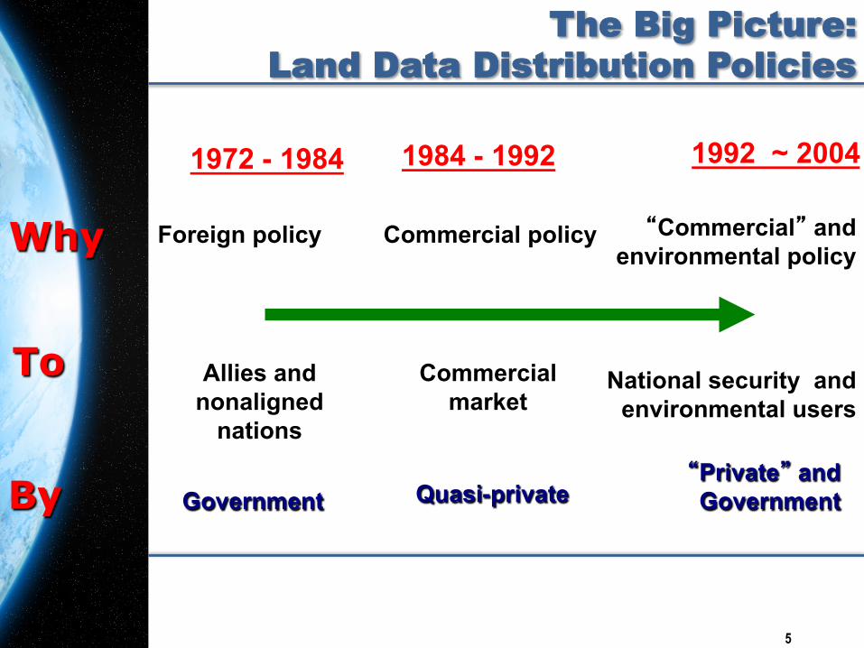
The Big Picture: Land Data Distribution Policies
National security and
environmental users Commercial
market Allies and
nonaligned nations
Government Quasi-private “Private” and Government
Foreign policy Commercial policy
1972 - 1984 1984 - 1992! 1992 ~ 2004!
“Commercial” and environmental policy
To
Why
By
6
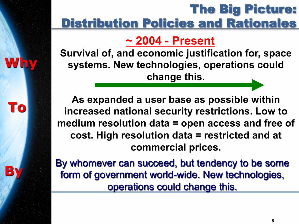
The Big Picture: Distribution Policies and Rationales
As expanded a user base as possible within increased national security restrictions. Low to
medium resolution data = open access and free of cost. High resolution data = restricted and at
commercial prices.
Survival of, and economic justification for, space systems. New technologies, operations could
change this.
~ 2004 - Present
By whomever can succeed, but tendency to be some form of government world-wide. New technologies,
operations could change this.
Why
To
By
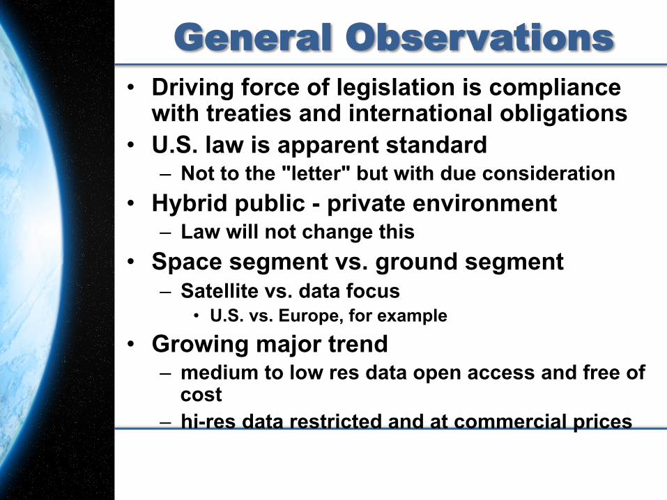
General Observations
• Driving force of legislation is compliance with treaties and international obligations
• U.S. law is apparent standard – Not to the "letter" but with due consideration
• Hybrid public - private environment – Law will not change this
• Space segment vs. ground segment – Satellite vs. data focus
• U.S. vs. Europe, for example
• Growing major trend – medium to low res data open access and free of
cost – hi-res data restricted and at commercial prices
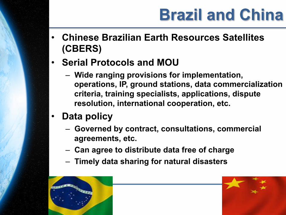
Brazil and China • Chinese Brazilian Earth Resources Satellites
(CBERS) • Serial Protocols and MOU
– Wide ranging provisions for implementation, operations, IP, ground stations, data commercialization criteria, training specialists, applications, dispute resolution, international cooperation, etc.
• Data policy – Governed by contract, consultations, commercial
agreements, etc. – Can agree to distribute data free of charge – Timely data sharing for natural disasters
8
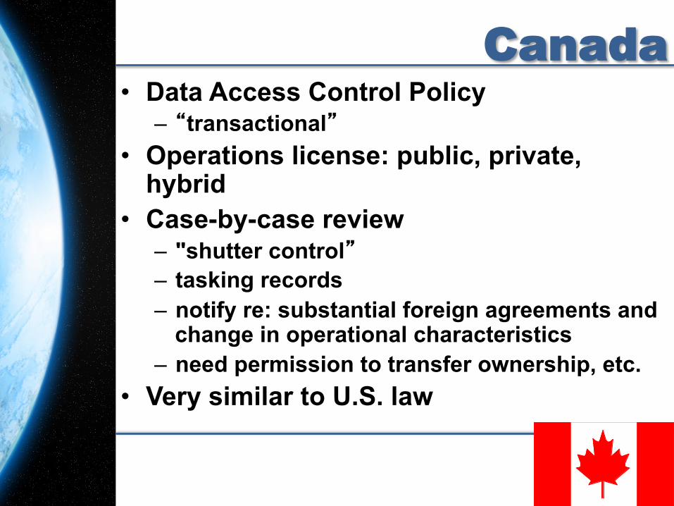
Canada • Data Access Control Policy
– “transactional” • Operations license: public, private,
hybrid • Case-by-case review
– "shutter control” – tasking records – notify re: substantial foreign agreements and
change in operational characteristics – need permission to transfer ownership, etc.
• Very similar to U.S. law
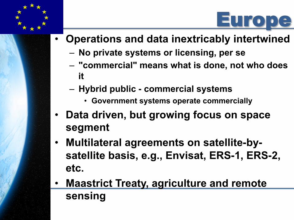
Europe • Operations and data inextricably intertwined
– No private systems or licensing, per se – "commercial" means what is done, not who does
it – Hybrid public - commercial systems
• Government systems operate commercially
• Data driven, but growing focus on space segment
• Multilateral agreements on satellite-by-satellite basis, e.g., Envisat, ERS-1, ERS-2, etc.
• Maastrict Treaty, agriculture and remote sensing!
Europe Joint Principles Sentinel Data Policy
• Objective: maximize beneficial use of EO data and information
• Anybody can access – no difference between public, commercial,
scientific, European or non-European users • Free data licenses • Available free via a "generic" online access
– subject to user registration, accepting terms and conditions
• Additional tailored access modes and conditions
11
Europe
• Regulation (EU) No 911/2010 of the European Parliament and of the Council of 22 September 2010 – on the European Earth monitoring program
Copernicus (previously known as Global Monitoring for Environment and Security GMES)
– Objective: provide data and information services for environmental and security applications tailored to user requirements
12
Europe • Data Availability Directives:
– Infrastructure for Spatial Information in the EC, “INSPIRE Directive” (2007/2)
• Continues to evolve, guidelines (2012) – “PSI Directive” (2003/98) – “Aarhus Directive” (2003/4)
• Directives on IPR and data protection: – “Copyright Directive” (2001/29) – “Database Directive” (96/9) – “Protection of Privacy Directive” (2002/58)
• Metadata: Data Specs; Data Service and Sharing; Network Services
13
France • Data driven
– Focus: return on investment of public funds
– Open civil regime • SPOT considered "privatized" not
"commercialized” • LOI no. 2008-518 du 3 juin 2008
relative aux opérations spatiales
15
France • “primary space-based data” must be
declared to the administrative authority – Determination is made that data does not
harm foreign policy or defense interests – Measures may be prescribed to safeguard
these interests – 200,000€ fine for noncompliance
• Provisions do not apply to – Ministry of Defense activities – Satellite operations – Data reception
16
Germany • Three kinds of licenses
– satellite operation – general data distribution – specific data transactions
• Two-tiered “security data policy” analogous U.S.
• National security; commercial secondary – Data distribution mechanism creates system in which
operator (“Betreiber”), distributor (“Datenanbieter”) or operator/distributor (“Betreiber zugleich Datanbieter”) will be licensed
– Required to implement a “geomatrix” provided by government
• includes check list to determine transaction sensitivity • potential liability if a distribution mistake is made
– Penalties may include incarceration.
India 2011 Revised Remote Sensing Data Policy (RSDP)
– Comprehensive; space and ground segment driven; catalyzed by availability of hi-res imagery on-line
– Low resolution data 1 meter and coarser is unrestricted
• Distributed on “non-discriminatory” and “as requested” basis
– High resolution data 1 meter and finer is restricted • Still screened and cleared by appropriate agency
– No longer need clearance to use data • Government ministries, departments, R&D institutions,
educational and academic institutions • public sector, autonomous bodies
– Private sector agencies supporting development • Need recommendation of a government agency
Japan • 2008 Japan’s Basic Space Law
– establish data use system in 1 - 2 years • Still pending; impacted by frequent political changes and natural
disasters • Collect User Opinions
– User and supplier coordination committee • More User-Friendly Satellite Data Use System
– make the most of private sector current assets and know-how • Make Standardized Data Policy
– balance limits on distributable resolution and price with publicly funded data as widely as possible
• “analyzed information” policy • “Guardian of the Environment” concept
• 2010 Important Measures in Space Activities: Strategic Space Policy to Promote Japan’s Growth – Promotes
• use of remote sensing satellites to enhance economy and environment
• increased utilization of data
Japan • Proposal for standalone remote sensing
law not accepted until recently • 3rd Basic Plan for Space Activities to be
adopted in December 2014 – Provisions
• Data Policy Act – Catalyzed by successful launch of commercial high
resolution satellite • Space Activities Act
• Space Activities Act will go to the Japanese Diet in 2016 at the earliest
• All subject to pending general election
Russian Federation (CIS) • Resolution higher than 2m per pixel images of
Russian territory in process of being legalized – “restricted areas” specially designated by military and Federal
Security Service will remain classified • Sale of high resolution satellite imagery
– Historical conflicts between intelligence and commerce – Requests for lists of available images and image orders have
been denied, delayed and canceled due to national secrecy • Particularly pre - 1992
• Operations – Broad federal legislation – Licensing, certification, liability, safety, insurance and
government control – License required, few specifics: insurance – Protects IP and commercial secrets of foreign entities operating
under Federation's jurisdiction – RS includes environmental monitoring and meteorology
• Different rules over time, e.g., SPIN, ALMAZ, etc.
United Kingdom • Ground-segment focus
– Space segment focus follows later • House of Lords
– “Main effort should be ground and user segment”
– Specialize in radar – National data distribution network – Support postgraduate education in remote
sensing and digital cartography • National legislation: Space Act
– No specific mention of remote sensing – Authorizes government to require licenses
22
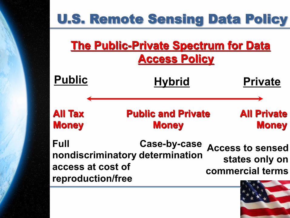
United States • 1992 Land Remote Sensing Policy Act
– Public sector and environmental focus – Public and private distinction – Commerce Department licenses and regulates
private systems • Company must disclose amount of government
resources that went into launch or operation of the system
– Fully government funded: all raw data available on nondiscriminatory basis
– Entirely privately funded: data provided according to reasonable commercial terms and conditions. Data must be made available to a "sensed state”
– Partial government support: some access to raw data on nondiscriminatory basis
» Case by case basis with provisions included in license
23
U.S. Remote Sensing Data Policy
The Public-Private Spectrum for Data Access Policy
Full nondiscriminatory access at cost of reproduction/free
Access to sensed states only on
commercial terms
All Tax Money
All Private Money
Hybrid
Public and Private Money
Case-by-case determination
Private Public
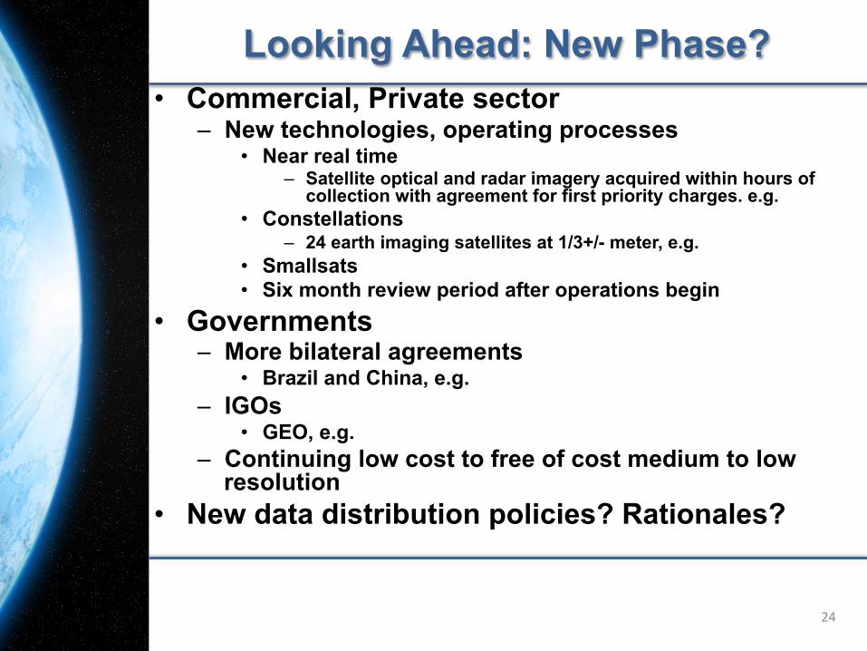
Looking Ahead: New Phase? • Commercial, Private sector
– New technologies, operating processes • Near real time
– Satellite optical and radar imagery acquired within hours of collection with agreement for first priority charges. e.g.
• Constellations – 24 earth imaging satellites at 1/3+/- meter, e.g.
• Smallsats • Six month review period after operations begin
• Governments – More bilateral agreements
• Brazil and China, e.g. – IGOs
• GEO, e.g. – Continuing low cost to free of cost medium to low
resolution • New data distribution policies? Rationales?
24

Thank you.
Questions? Comments?