Embed Size (px)
Citation preview

Demeter, Gábor – Bottlik, Zsolt – Csaplár-Degovics, Krisztián
Ethnic maps as instruments of nation-building on the Balkans (1900-1914). *
Introduction
One of the best instrument for the visualisation of the unified and combined geographical
space, the political niche and the different spheres of identity is ethnic mapping. Ethnic maps
are special manifestations of the space, and represent the way of thinking of a group about
itself and the surrounding communities. Nevertheless ethnic mapping raises many
methodological questions. The present study is to enlighten the problems of (I) the
interpretation or reliability of raw data and (II) the methods of visualisation. An improper
selection of data and visualization methods may easily distort results, as it is described and
explained on the following pages. Although ethnic mapping can contribute to the
strengthening of a nation’s self-consciousness, thus to the realisation of national dreams, it
is usually not impartial, and often serves political interests or exerted to political pressure
(III).
The following study focuses on the above mentioned problems, i.e. data selection and
visualisation techniques on the example of some new maps found at Haus- Hof- und
Staatsarchiv in Vienna, that were used in the Macedonian reform movement after the
Mürzsteg convention in 1903. The authors’ idea to make maps – that were originally based
on different data sources and created by different techniques (patch-maps and pie-chart
maps) - comparable required the selection of a reliable basemap (as basis of comparison)
and the redrawing-rescaling of existing maps using GIS-aided techniques. In this way a series
of maps were created either to illustrate the ethnic heterogenity in the region and the
temporal-spatial changes over the decades or to illustrate the problems of data-
interpretation that different sources can cause. Using the data of the Austro-Hungarian
consul Kral, brand new maps were created based on the Austrian concept on ethnic identity
(using a classification that can be traced back to Sax, 1877) with pie-chart technique.
(I) Data and their interpretation
When creating an ethnic map one should be aware of the fact, that (1) data on the Balkans
are contradictorious, (2) identity is a complex phenomenon, (3) the numerous changes
throughout the 19th century (as a result of wars and forced migration) made the comparison
of data and maps difficult (even the selection of a reliable source serving as a basis for
comparison is disputable), (4) identity of individuals is unconsolidated in the case of young
nations.
(1) Reliability of raw data. Beyond technical obstacles (like the changing borders of
territorial units, that make comparative approach difficult) the lack of data can be another
problem. Turkish population censuses are not reliable prior to 1906, since these focus on
religious issues regardless of language, nationality, etc. as their main purpose was to
estimate the taxable population. Some scientists say that the proportion of Christians is
overestimated in these conscriptions as they were more important from the aspect of
taxability, and Moslems were often omitted from these documents. Others say, that from

the 1860s – after the implementation of compulsory military service for the Moslems – the
conscription of Moslems was more reliable, thus they were overrepresented in these
documents. Others claim, that prior to the 1860s when the taxation system was changed,
Christians tended to live in larger families (zadruga) as the basis of taxation was the
household and not the adult person. This means that the number of Christians was
underestimated in the conscriptions. An example: according to Teplov’s data 48 thousand
Moslems and 90 thousand Christians were living at the seashore of Bulgaria, while the
official salname of 1873 puts the former to 55 thousand, the latter only to 26 thousand,
which means that official data were more reliable regarding the number of Moslems.1 Even
in 1910 during the last attempt of the Ottoman government to secure peace in Macedonia
by implementing a religious reform and a redistribution of ecclesiastic proprety between
exarchists and patriarchists to decrease tensions, the population was conscribed in
households and based on religion (millet) (table 1).
Table 1. Religious (ethnic) distribution in the Kostursko kaza among settlements seceeded from the
Patriarchate after 1903, prior to the redistribution of Christian ecclesiastic property in 1910
15. 05. 1910. Exarchist
households Patriarchist households
Moslem households
total population
year of secession
church school
Gorjanci 161 170 175 2645 1909 2 2
Kumanichevo 86 24 42 755 1908 3 1
Snichani 58 23 0 420 1903 2 1
Zhelevo 110 110 ? 1406
2 (1 Bulgarian)
2
Sofia, ЦДА, ф. 331. oп. 1. a.e. 309. л. 74-75 and 35-38.
Table 2. Proportion of Moslems in Rumelia around 1870 according to 2 estimations at vilaet level
Population in thousands
Istanbul Edirne Tuna Sofia Selanik Yanya Manastir Iskodra Bosnia Islands
„Turks” 342 597 945 154 265 430 860 141 520 80 Karpat % 57 39 45 23 49 36 56 47 40 50 Totev % - 37 38 - 40 - 33 - - -
Karpat, K.: Ottoman Population 1830-1914. Demographic and Social Characteristics. The University of
Wisconsin Press. 1985. p. 56; Totev, At.: Cenen dokument za istoricheskata etnicheska demografija na
Balkanskija poluostrov. Istoricheski Pregled, 1982/5. pp. 105-113.
The comparison of Ottoman (census, 1908), Bulgarian (conscription of households)
and Austrian statistics (census of occupied lands, 1916) enlightens, that the interpretation of
data (and thus the confines of the Albanian nation) are completely different (see Appendix).
Ottomans and Moslems were counted as Albanians based on the Ottoman census in the
book of Kruja,2 and the displacement and expulsion of the population within 8 years also
contributed to the changing ethnic pattern (see Austrian census), not to mention the
Bulgarian conscription that found Bulgarian majority in many places where Ottomans and
Austrians did not.
Table 3. Contradictorius estimations and censuses on the population of Ottoman Rumelia (end of 19th c.)
* This study has been supported by the János Bolyai Research Scholarship of the Hungarian Academy of Sciences. 1 Teplov, Vl.: Materiali dlja statistikii Bolgarii, Thrakii i Makedonii. St. Petersburg, 1877. pp. 159-160. Nr. 332, 354.
2 Kruja, M.: Ne historine Shqiptare. OMSCA-1, Tirana, 2012.
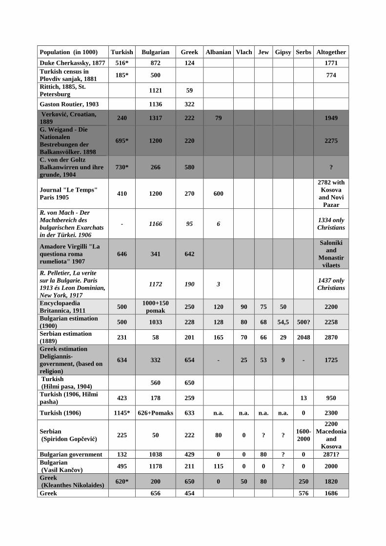
Population (in 1000) Turkish Bulgarian Greek Albanian Vlach Jew Gipsy Serbs Altogether
Duke Cherkassky, 1877 516* 872 124
1771 Turkish census in Plovdiv sanjak, 1881
185* 500
774
Rittich, 1885, St. Petersburg
1121 59
Gaston Routier, 1903
1136 322
Verković, Croatian, 1889
240 1317 222 79
1949
G. Weigand - Die Nationalen Bestrebungen der Balkansvölker. 1898
695* 1200 220
2275
C. von der Goltz Balkanwirren und ihre grunde, 1904
730* 266 580 ?
Journal "Le Temps" Paris 1905
410 1200 270 600
2782 with Kosova
and Novi Pazar
R. von Mach - Der Machtbereich des bulgarischen Exarchats in der Türkei. 1906
- 1166 95 6
1334 only Christians
Amadore Virgilli "La questiona roma rumeliota" 1907
646 341 642
Saloniki and
Monastir vilaets
R. Pelletier, La verite sur la Bulgarie. Paris 1913 és Leon Dominian, New York, 1917
1172 190 3 1437 only Christians
Encyclopaedia Britannica, 1911
500 1000+150
pomak 250 120 90 75 50
2200
Bulgarian estimation (1900)
500 1033 228 128 80 68 54,5 500? 2258
Serbian estimation (1889)
231 58 201 165 70 66 29 2048 2870
Greek estimation Deligiannis-government, (based on religion)
634 332 654 - 25 53 9 - 1725
Turkish (Hilmi pasa, 1904)
560 650
Turkish (1906, Hilmi pasha)
423 178 259
13 950
Turkish (1906) 1145* 626+Pomaks 633 n.a. n.a. n.a. n.a. 0 2300
Serbian (Spiridon Gopčević)
225 50 222 80 0 ? ? 1600-2000
2200 Macedonia
and Kosova
Bulgarian government 132 1038 429 0 0 80 ? 0 2871? Bulgarian (Vasil Kančov)
495 1178 211 115 0 0 ? 0 2000
Greek (Kleanthes Nikolaides) 620* 200 650 0 50 80 250 1820
Greek 656 454 576 1686

(Nikolaides 2),
French (Gersin) 500 1182 Slavs 228 28 80 67 ? 1182 Slavs 2085*
Laveleye-Ritter, 1868 500 1300+200 Pomaks
200 100 76 90 28 - 2500
Italian 300 450 250 300 375 100 ? 50 1825
Macedonian 400 1950 Slavs 270 210 105 45 30 1950 Slavs
3000
Russian (1899) 800 1200 220 ? ? ? ? ? 2220
Brančov, Bulgarians, 1905
900+270 Patriarchists
+100 Pomaks
190+270
HHStA, Nachlass Kral, cca. 1900
480 600+155
Patriarchists 500 1380
210
3300 without Thrace, but with Albania
*Moslems altogether (including Albanians)
Even conscriptions from the late 19th century are contradictorious (table 3). There are
certain correspondences between the more than 20 estimations cited from the literature
and many of these have common roots. Greece considered the subjects of the patriarchate
Greeks regardless of their Slavic or Albanian language. Turkish censuses made difference
between patriarchists and exarchists, but these are not always equivalent for Serbian and
Bulgarian nation, since hundreds of thousand bulgarophil patriarchists did exist in
Macedonia. Moslem Albanians, Circassians and Turks were not discerned. Exarchists were
considered Bulgarian. The usage of these conscriptions and estimates can lead to
contradictorious results as it is shown by table 3-4.
Table 4. Differences of contemporary estimations at kaza-level (smallest administrative units)
Ottoman, 1902 Kral cca 1900 Branchov, 1905 Ottoman, 1908
kaza Bulgarian Moslem Greek and
vlach Bulgarian Moslem* Greek and
vlach Bulgarian Greek
and vlach Albanian Serbs Bulgarians Aromun
Prilep 35890 14200 1000 46000 12000+3500 18308 6504 38790 212
Ohrid 17500 8100 750 24000 22000 44000 3100 20369 1564 34060 345
Monastir 30800 24700 30000 71000 32000+12000 23000 30999 489 47521 41158
Florina 33000 18000 4000 43500 100
Seres 25000 36000 35000 47500 28500
Drama 4000+11000 33000 8000 11000 3890
Demirhisar 11100 630 15000 15000 8000
Kichevo 20000 13500 22000 18000
* Albanians+Ottomans; Turkish data from Kruja, M.: Ne historine Shqiptare. OMSCA-1,
Tirana, 2012. pp. 327-331.
Even data of estimations and conscriptions relatively close to each other and driven back to
kaza level are completely different (table 4). Those who refer to Branchov’s data supress the
number of Moslems in their statistics and use his data simply to prove that Bulgarians are
outnumbering Greeks, instead of giving correct percentage data.3 The Ottomans mixed
3 The Bulgarian point of view is presented by Tsanov based on Branchoff’s statistics: D. M. Brancoff: La Macedoine et la
population chretienne. Paris, Librairie Plon et Co, 1905. and Radoslav Andrea Tsanoff: Bulgaria’s case. Reprinted from The

ethnic and religious categories (using the term Moslem, incorporating Moslem Albanians,
Ottomans, and Slavs into one group, thus weakening other groups). The Austrian consul, Kral
uses the term Exarchists and Patriarchists, which is not equivalent of Bulgarians, Serbs and
Greeks respectively, however it is still the most reliable statistics, as he makes difference
between Bulgarian, Serb and Greek patriarchists at least at kaza level (table 5). Dozens of
thousand of men were missing from Macedonia due to seasonal migration.
Table 5. Parts from the statistics found in Nachlass Kral, HHStA, Wien (Monastir sanjak)
Albanians Slavs Greeks
Vlahs Turks Gypsy Jew Total
Moslem Orthodox Exarchists Patriarchists* Moslem Patriarchist Moslem
Monastir 32000 2200 47000 24000
100
23000 12000 2500 5000 148000
Prilep 12000
39000 7000 1800
500 3500 800
64600
Ohrid 22000 300 27500 2500
20
2500 80 500
55400
Krchova 11500
16000 6500 6500
60
80
40640
Florina 6500 2600 17000 16000
4000 12000 2000 20 60120
*16 thousand Patriarchists are Serbs, the others are Bulgarians
(2) Complexity of the identity. As it can be seen on the above mentioned examples identity is
a complex, multi-layered phenomenon – a simple map focusing on only one feature, like
religion or language is not suitable for the Balkan conditions (see differences between maps
published in the Appendix). It is better to use maps, that take more than one dimension of
the nationality into consideration, like Austrian cartographers did so at the end of the 19th
century following the first attempt of Sax, who took both language and religion into
consideration in 1877. A similar attempt was done by Asbóth, illustrating religious
distribution and the proportion of landlords and landless social strata together on a map-
series on the example of Bosnia in order to measure the relationship between social status
and ethnicity. The map on Macedonia published in the Geographische Rundschau in 1892
also referred to both ethnicity and religion and did not mix the two categories.
Nevertheless, a map showing Bulgarians differs from that of showing orthodox
Bulgarians, while a patch map showing Moslems is much more ’convincing’ than a map
showing Turks, Albanians and Pomaks separately (Appendix).
(3) The instability of identity. Beyond its multi-layered complexity identity cannot be
considered stable in case of awakening nations. A good example for this is the case of
Silistria, which showed Romanian-Turkish majority in 1878, but by 1905 it turned to be
Bulgarian (table 6). Such a process can be the result of natural change in minds, can be
forced, or can be the result of continuous migration or ethnic replacement. Certain political
tendencies were to distort and manipulate the identity appearing in statistics (if these
efforts were fruitless on the level of individuals themselves), like the Greeks did in 1913,
when they claimed, that large masses of Albanians are Grecophiles (Albanophone Greeks),
thus creating a majority over 50% in several district of Southern Albania in 1913 (table 7).
Fake statistics are definitely cheaper, than creating schools and modifying minds or replacing
the population. However, this phenomenon is not unique: this group also appear on the map
Journal of Race Development. Vol. 8, No. 3, January, 1918; Misheff, The truth about Macedonia. Berne, 1917. A series of
maps on the ethnic pattern of Macedonia (Die Bulgaren in ihren historischen, ethnographischen und politischen Grenzen by
Ishirkoff & Zlatarski. Preface by D. Rizoff.) was published to support Bulgarian claims on Macedonia at the Versailles Peace
Treaty, 1918-1919.
of Sax from 1877 and Greco-Albanians occur in the Austrian map created for the Mürzsteg
convention (Appendix).
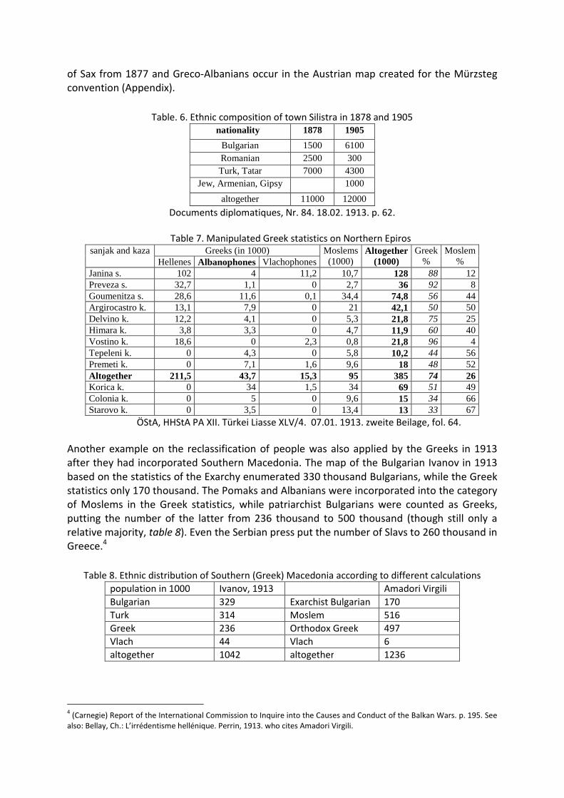
Table. 6. Ethnic composition of town Silistra in 1878 and 1905
nationality 1878 1905
Bulgarian 1500 6100 Romanian 2500 300 Turk, Tatar 7000 4300
Jew, Armenian, Gipsy 1000
altogether 11000 12000
Documents diplomatiques, Nr. 84. 18.02. 1913. p. 62.
Table 7. Manipulated Greek statistics on Northern Epiros
sanjak and kaza Greeks (in 1000) Moslems (1000)
Altogether (1000)
Greek %
Moslem % Hellenes Albanophones Vlachophones
Janina s. 102 4 11,2 10,7 128 88 12 Preveza s. 32,7 1,1 0 2,7 36 92 8 Goumenitza s. 28,6 11,6 0,1 34,4 74,8 56 44 Argirocastro k. 13,1 7,9 0 21 42,1 50 50 Delvino k. 12,2 4,1 0 5,3 21,8 75 25 Himara k. 3,8 3,3 0 4,7 11,9 60 40 Vostino k. 18,6 0 2,3 0,8 21,8 96 4 Tepeleni k. 0 4,3 0 5,8 10,2 44 56 Premeti k. 0 7,1 1,6 9,6 18 48 52 Altogether 211,5 43,7 15,3 95 385 74 26 Korica k. 0 34 1,5 34 69 51 49 Colonia k. 0 5 0 9,6 15 34 66 Starovo k. 0 3,5 0 13,4 13 33 67
ÖStA, HHStA PA XII. Türkei Liasse XLV/4. 07.01. 1913. zweite Beilage, fol. 64.
Another example on the reclassification of people was also applied by the Greeks in 1913
after they had incorporated Southern Macedonia. The map of the Bulgarian Ivanov in 1913
based on the statistics of the Exarchy enumerated 330 thousand Bulgarians, while the Greek
statistics only 170 thousand. The Pomaks and Albanians were incorporated into the category
of Moslems in the Greek statistics, while patriarchist Bulgarians were counted as Greeks,
putting the number of the latter from 236 thousand to 500 thousand (though still only a
relative majority, table 8). Even the Serbian press put the number of Slavs to 260 thousand in
Greece.4
Table 8. Ethnic distribution of Southern (Greek) Macedonia according to different calculations
population in 1000 Ivanov, 1913 Amadori Virgili
Bulgarian 329 Exarchist Bulgarian 170
Turk 314 Moslem 516
Greek 236 Orthodox Greek 497
Vlach 44 Vlach 6
altogether 1042 altogether 1236
4 (Carnegie) Report of the International Commission to Inquire into the Causes and Conduct of the Balkan Wars. p. 195. See
also: Bellay, Ch.: L’irrédentisme hellénique. Perrin, 1913. who cites Amadori Virgili.

(4) Population movements and ethnic mapping: Migration makes comparison of the content
of ethnic maps difficult as sometimes even minor changes (expressed in numbers) may occur
on patch maps, while larger changes may remain untraceable: i.e. if urban dwellers
concentrated to a point or a disseminated minority is affected by the process. In the latter
cases the number of migrants may reach dozens of thousand, but the process does not
appear on patch maps contrary to pie-chart maps. This leads us also to the question of
visualization. Kemal Karpat and Justin McCarthy are on the opinion that population
movements influenced the ethnic pattern of Bulgaria decisively between 1853-1912, not to
mention the period after the Balkan Wars till 1923. More than 300 thousand Moslems left
Bulgaria soon after 1878 (table 9), while many have arrived from Bosnia and settled down in
Macedonia. The former is not well observable on maps, as those, who left were often skilled
urban dwellers, or inhabitants living in minority, who were underrepresented in case of
using patch-maps like Boué, Lejean, Mackenzie-Irby, etc. did. According to Bulgarian
estimations, roughly 200 thousand Macedonian Bulgarians lived in Bulgaria prior to the
Balkan Wars exerting pressure on everyday diplomacy and further 100 thousand refugees
arrived soon after the Balkan Wars.5 Nevertheless, the relevance of these estimations can be
questioned as the statistics serving as a basis for comparison are not reliable. (See point 1).
Table 9. The population of Eastern Rumelia in 1875 and 1878
folk prior to 1876-78
after the war
proportion in 1878
measured to 1875 %
proportion in 1875, %
proportion in 1878, %
Turk 220000 90000 41 29 15,5 Pomak 25000 25000 100 3,3 4,3 Tatar 10000 8000 80 1,3 1,3
Circassian 10000 0 0 1,3 0 Gipsy 25000 16000 64 3,3 2,7
Bulgars 400000 380000 95 52,6 65,5 Grecophile
Bulgars 35000 30000 86 4,6 5,1
Greek 35000 30000 86 4,6 5,1 Altogether 760000 580000 76 100 100
Foreign Office, 424/75 (Drummons-Wolff to Salisbury, 26.09.1878.) own calculation
Anyway, the occurance of new, large patches is rare, either because immigrants tend
to settle down in towns or in villages, where they constituted the majority formerly too, or
because the instruments of ethnic mapping have developed at such a rate, that sometimes
even maps based on similar methods (like of Sax in 1877 and the Austrian in 1900) cannot be
compared accurately – not to mention problems of patch maps stemming from different
projection systems. In some cases (like the Austrian map of Macedonia from 1892 and from
1900, see Appendix) the patches on maps relatively close to each other look to be the same,
but entitled differently – but this leads us to the question of political concepts on ethnic
mapping.
5 The Report of the International Commission… p. 385.
(II) Visualization techniques
Beyond manipulation of raw data, visualized data can also distort real ethnic proportions.
Patch maps tell us nothing about the population number, density and proportions. Thus a
certain population group can easily and misleadingly be considered majority on a territorial
unit, while urban dwellers of different origin may exceed them in numbers, but appear on a
smaller patch. Furthermore, scarcely populated areas, like mountains with colour fill may
also distort ethnic proportions. The main advantage of patch maps is the possibility for the
proper delimitation of ethnic boundaries.
Contrary to the above mentioned type, maps using pie charts may represent ethnic
proportions properly on a territorial unit, but the delimitation of distinct, homogeneous
patches is difficult, and this map-type does not differentiate between sparsely and densely
populated areas either. Resolution can cause another problem: larger territorial units
(vilaets, sanjaks) are useless, if the goal is to justify partition or to separate communities
from each other.
Both types appear on investigated maps serving political aims, either to emphasize
the extent of territories inhabited by a nation, or the role of urbanized areas. Pie-chart is
used to illustrate ethnic distribution of the population in Bitola vilaet, while the patch-map
of Chekrezi6 on southern Albania indicates separate settlements as well beyond patches with
color fill.
Combined or complex maps also did appear: the Bulgarian population census in 1892
was illustrated on patch maps indicating total number of population as well. The patch maps
of Bosnia by Asbóth indicate proportions, and maps on settlement level (either patch or pie
chart) did also exist and served as basis for general maps of smaller resolution.
Colours may also be indicative. Ethnic maps on the Balkans did not tend to decrease
the territory inhabited by different nations by using illustrative colours to overemphasize the
significance of a certain nation. These tendencies appearing in the Hungarian cartography on
the so-called ’carte rouge’ of Pál Teleki (the method itself was proposed first by the
albanologist-adventurer-geologist Ferenc Nopcsa), were later applied by German
cartography in the Handwörterbuch des Ausland- und Grenzdeutschtums, 1933. This map
uses the above mentioned combined techniques of patches and pie charts together.
Patches can bind spaces together without real connections (roads). A correct patch
map has to indicate routes, main directions of communication, like in the case of Istria by
the Austrian Czoernig.7
Transient colours (French map of 1918) and cross-hatching (map of Sax, 1877) were
often used instead of patches with explicite borders, veiling the uncertainity in statistics and
interpretation of identities in the Balkans.
(III) Maps serving political interests
As we have already seen there are many possibilities to manipulate data in order to
exaggerate certain tendencies. These are the (1) critiqueless application or partial selection
of data, (2) the arbitrary reclassification of raw data, (3) mixing ethnic and religious
categories, (4) using colours to overemphasize phenomena, (5) choosing the technic of
6 Chekrezi, C.: Albania. Past and Present. New York, Macmillan, 1919.
7 Czoernig, K.: Ethnographie der österreichischen Monarchie, 3 Bände, 1855-57.

visualisation fitting best to the purposes, (6) neglecting roads and physical geographical
circumstances, thus creating enhanced connectivity of patches.
Beside lack of reliable data, population movements and unstable identities, political
pressure – that was abundant from the 1860s, first plans on the Balkan League – also makes
data interpretation and ethnic mapping (and its evaluation) difficult. The first explorers,
travellers of the Balkans in the 1840s were less influenced by nationalistic movements, but
did not have tools and broad knowledge (ethnographic, linguistic, cartographic) to create
reliable maps. Therefore these maps are neither precise, nor influenced by the ideas of
procurers: the maps reflect the own thoughts of their creators. Being mainly foreigners, they
were able to use both censuses (which were unreliable regarding the numbers) and data
acquired from the local people. As a result of this, patch maps became dominant partly due
to the lack of proper data and parly owing to the field experiences. By the time professional
mapping methods have evolved, ethnic geography also became an instrument of foreign
policy of Powers or Small states, therefore the reliability of newer maps did not improve,
although at first sight these seemed to be more scientific, thus convincing. Shortly, as the
knowledge grew (that could have made ethnic mapping more impartial) so did the number
of observable phenomena determining identity, and the dependence of geography from
policy-makers. Many of the professional geographers or cartographers were unable to check
the data used, and many did not wish to correct them at all, because considered it as an
instrument for the realisation of nacionalistic ideas. Many were merely opportunists, like the
Croatian geographer, Spiridon Gopčević, who published pro-Serbian, pro-Greek and pro-
Albanian writings as well using the same data and method, or Cvijić, who published 2
completely different patch maps on the Balkans (even the names of the nations did not
coincide) within 5 months in order to support growing Serbian aspirations on Macedonia.
The Mürzsteg reform programme after the failure of the Ilinden uprising proposed and
initiated a series of reforms in Macedonia in 1903 under the auspice of Powers. Since
Austria-Hungary was also involved in this process, our primary goal was to collect some aide-
material - like ethnic maps on Ottoman Macedonia - that could support diplomatic activities
of that period.
The contribution of Austro-Hungarian scientists to ethnic mapping was not negligible
by that time. Ethnic maps of the Balkan peninsula in the 1870s relied on the material of Felix
Kanitz beside the data collected by Boué, Reclus, Kiepert, Erben, Lejean, Mackenzie-Irby,
etc.8 The map of Sax used an excellent method of combining (and not substituting!) religious
and ethnic data in 18779 in order to illustrate the complexity of local identites. This
technique was unique compared even to the above mentioned maps. The method of cross-
hatching - adopted after Kiepert - was able to emphasize the obscure situation on the
ethnically mixed territories. Ethnic boundaries were more precise than on the earlier maps
of i.e. Boué (see the ethnic composition in Epiros, Thrace, Dobrudja on his patch-map). The
tradition of this method prevailed: the Austrian map of 1892 on Macedonia repeated its
methodology regarding the complexity of identity.10
8 See: „Die Bulgaren in ihren historischen, ethnographischen und politischen Grenzen.” by Ishirkoff & Zlatarski. Preface by Rizoff, Dimitar. Berlin, Königliche Hoflithographie, Hof-Buch- und -Steindruckerei Wilhelm Greve, 1917 http://www.promacedonia.org/en/dr/index_en.html 9 Ibid. 10 Published in Geographische Rudschau XXI.

Prior to Cvijić western maps did not tend to indicate Macedonian Slavs in Macedonia:
Brailsford in 1906 acknowledged their Bulgarian character,11 the Encyclopaedia Britannica in
1911 did too. Even early Serbian official maps (Davidović, Dejardin, 1853, Hahn-Zach, 1861)12
did not question the Bulgarian character of Macedonian Slavs, calling themselves ’Bugari’
(denied later by Cvijić – according to him the term simply meant peasant, ’reayah’). The
reason of the change marked by the map of Garašanin on Greater Serbia in the 1860s and by
the map of Miloš Milojević13 in 1877 was that while prior to 1878 Serbian national
aspirations were targeted toward Bosnia, after the occupation of Bosnia Austria-Hungary in
a secret treaty accepted the penetration of Serbian propaganda into Macedonia (1881) to
compensate his disillusioned ally. This fit to the Austrian plans to secure economic outlet to
the Aegean Sea via railway through Belgrade. After the deterioration of Austrian-Bulgarian
relations owing to the fall of the Stambolov-government in the mid-1890s, and the secret
Serb-Bulgarian agreement on Macedonian propaganda in 1897, not to mention the Russian-
Bulgarian military agreement in 1902 (targeted mainly against Romania, that time the ally of
Austria-Hungary), Austria-Hungary tried to decrease the Bulgarian influence in Macedonia by
denying the Bulgarian character of Macedonia, in order to secure its way to the Aegean and
to convince other Powers about the ethnic character of the region. That’s the reason why
maps created to support the Mürzsteg process indicated Macedonian Slavs beyond Struma
river and not Bulgarians. Cvijić could rely on the tradition of Austrian ethnic mapping when
creating his maps on Macedonia.
The above mentioned method of Sax to illustrate both religion and spoken language
was also applied on the maps found in ÖStA HHStA14 by Krisztián Csaplár-Degovics dated
back to the turn of the 19-20th centuries. As the map in 1877 was elaborated on similar
basis, it could serve as a basis of comparison regarding ethnic changes (including the
Austrian map of Macedonia from 1892 composed for a smaller territory) together with other
detailed (kaza-level) numeric data found in Nachlass Kral.15 Some of the maps were
published by Teodora Toleva in her book in 2012,16 but in such a bad resolution, that neither
the legend, nor settlement names can be read, thus cannot be compared to other maps.
After the death of Toleva, when we decided to reproduce and publish these maps again
using GIS to make them comparable with maps of other nations in order to measure ethnic
changes, it was recognised that these maps were moved from their original place.
Fortunately in the Kartensammlung aus dem Min. des Äussern, ÖStA, HHStA copies of
the maps published by Toleva did exist, and also two more maps on the Vilaet of Bitola were
found known as Bulgarian maps from 1899-1901.17 The dating of the maps shows, that these
were created prior to the Mürzsteg agreement, and after 1878 with the exception of one
map. But since the latter uses the same projection system and colours as the ethnic map
11 Brailsford, H. N.: Macedonia. Its Races and Their Future. London, Methuen. 1906. 12 See: „Die Bulgaren in ihren historischen, ethnographischen und politischen Grenzen.”… 13 http://en.wikipedia.org/wiki/Milo%C5%A1_Milojevi%C4%87 14 ÖStA HHStA, AB XIX, Nachlass Szapáry 15 ÖStA, HHStA, AB XIX/84. Nachlass Kral, K2. 16 Toleva, Teodora: Vlijanieto na Avstro-Ungarija za sazdavaneto na Albanskata nacija, 1896-1908. Sofija, Ciela, pp. 540-544. 17 (1) Nationalitätenkarte der Europäischen Türkei cca. 1900. (2) Etnographische Karte Vilajet Bitola (Monastir, 1901). See: Stoytcheva, Stanislava – Martinovski, Deyan: Ethnodemographic Characteristic of a “Closed” Region in the First Half of the 20th Century: The Case of Prespa Valley. In: Regions, Borders, Societies, Identities in Central and Southeast Europe 17th -21st Centuries. Eds.: Peykovska, Penka - Demeter, Gábor, Sofia-Budapest, 2013. (in press). (3)Religionskarte: Kosovo, Saloniki, Scutari, Janina, Monastir vilaeten. 1877 (???) (4) Christlische Schulen in Makedonien um 1900 - not identical with that of published in Toleva’s book (see below).

from 1900s does, it seems to be sure that it was created by the same scientific school and
since many patches are identical, both maps should be based on the same data from the
same period.
Unfortunately we hardly know anything about the origin and metadata of these
maps, as the documentation (author, data sources, purpose) is missing in the
Kartensammlung (only the maps were preserved). The hypothesis, that these maps are the
simple reproduction of Kančov’s research, therefore they are based on Bulgarian sources, is
not verified, since (1) some of these Austrian maps accepted the existence of the
Macedonian nation (it might have served political goals, to keep Bulgarians away from the
Vardar axis and Saloniki important for Austria-Hungary for economic reasons), and (2) maps
extended to larger territories that Kanchov investigated (however, the Austrian map of 1892
and that of Kanchov on Macedonia are very similar).
The raw ethnic data found in Nachlass Kral (also published by Toleva, but without
control) were organised in kaza-level, sanjak-level and vilaet level appearing in tables.
Adding up lines made it sure that kaza-level data needs recalculation and minor corrections.
Compared with other maps and population censuses (Gopčević, Kančov, Nikolaides, etc.),
this can be a good contribution to the examination of the question of nationality. After
having compared the patch maps found in the Kartensammlung and data found in Nachlass
Kral, it became evident, the two techniques of visualisation differ and thus could serve
different (political) purposes. From methodological aspect of illustration patch-maps are
able to show the area covered by a nation, but can distort ethnic proportions as they lack
information on population number and density. Thus, certain nations can be over- or
underrepresented based on colours (i.e urban-dwellers and those living in the countryside).
Therefore, based on the statistical data of Kral on kaza-level two new maps showing the
percentage values of different nationalities were created using pie chart-technique
proportional with the population number. The two map-types (patch and pie chart)
produced different results regarding the ethnic pattern. 18
To make maps comparable (1) with older maps, (2) with maps of other nations, and
(3) to measure correlation between the number of schools established and ethnic
proportions we decided to build a GIS-aided database, that enabled us to overlay maps. This
process included the georeferencing of data (fitting map-parts together, eliminating
distortion, creating a common projection system, legend and reference unit /kazas/ for the
maps) in order to obtain good resolution. This was followed by digitising (redrawing entities
in Arc View 8.0) and database building (assigning qualitative and quantitative data to
patches/kazas as entities), enabling us to carry out an analysis of the map-series from 1877-
1903 regarding ethnic changes.
Although the database is still under construction and evaluation, some new maps
incorporated to GIS are published here as a preliminary study together with a short general
criticism of the ethnic mapping in the 19th century.
18 ÖStA HHStA, XIX, Nachlass Szapáry, Kt. 3 b

APPENDIX
(1) The ethnographic patch-map of Macedonia and Albania by Sax (1877), redrawn and
fit to other maps by Zsolt Bottlik

(2) The ethnographic patch-map of Macedonia and Albania in the HHStA
Kartensammlung (Vienna), redrawn and fit to other maps (cca. 1900) by Zsolt Bottlik

(3) The ethnographic pie-chart map of Macedonia and Albania with diagrams at kaza
level based on the data found in Nachlass Kral (cca. 1900), redrawn and fit to other
maps

(4) The religious pie-chart map of Macedonia and Albania based on the data found in
Nachlass Kral, redrawn and fit to other maps (cca. 1900)

(5) The religious patch map of Macedonia and Albania (1877?), redrawn and fit to other
maps

(6) Christian schools in Macedonia around 1900, redrawn after Toleva

(7) Differences in the interpretation of the ethnic pattern from the same era.
The Albanian nation according to the Ottoman census (1908), the Austro-Hungarian
census in 1916, and the Bulgarian conscription of households (for the colours, see
map 3)
Moslems and Turks are incorporated into the Albanians according to the book of M. Kruja.
Austrian version (see the depopulation and ethnic change in Kosova). Bulgarian: counted from households