Embed Size (px)
Citation preview
Malaysian Journal of Environmental Management 10(1) (2009) :
Ahris Yaakup, Siti Zalina Abu Bakar and Susilawati Sulaiman 101
Decision Support System for Urban SustainabilityPlanning in Malaysia
AHRIS YAAKUP, SITI ZALINA ABU BAKAR
& SUSILAWATI SULAIMAN
ABSTRACT
Development planning requires an effective approach to achieve the desired goals and objectives, evaluate alternative as well as control development programs that are in line with current and future prospects. In the quest toward urban sustainability planning, a support tool in the form of an information system is required for enhancing analyses and deriving rational decisions. Planning support system (PSS) and decision support system (DSS) are among the tools for achieving quality planning for optimum development. They support the tasks of plan formulation, monitoring and review which inevitably involve the assembly and integration of geographic information and are known to be widely used in considering alternative spatial development strategies as well as assessing development potentials involved in land use planning. This article discusses various uses of DSS with a focus on its functionalities in supporting development planning and management at various levels.
ABSTRAK
Perancangan pembangunan memerlukan satu pendekatan berkesan bagi mencapai matlamat dan objektif, menilai alternatif serta mengawal program-program pembangunan sejajar dengan arus dan prospek masa depan. Dalam persoalan perancangan kelestarian bandar, satu alat sokongan dalam sistem maklumat amat diperlukan untuk meningkatkan analisis dan untuk memperoleh keputusan yang rasional. Sistem sokongan perancangan (PSS) dan sistem sokongan keputusan (DSS) adalah antara cara untuk mencapai perancangan berkualiti dalam perkembangan optimum. Mereka menyokong tugas-tugas bagi merumuskan perancangan, memantau dan mengkaji semula perkara yang tidak dapat dielakkan yang melibatkan pengumpulan dan integrasi maklumat geografi dan digunakan secara meluas dalam mempertimbangkan alternatif strategi-
102 Ahris Yaakup, Siti Zalina Abu Bakar and Susilawati Sulaiman
Malaysian Journal of Environmental Management 10(1) (2009) :
strategi pembangunan ruang serta menaksir pembangunan berpotensi yang melibatkan perancangan guna tanah. Artikel ini membincangkan pelbagai kegunaan DSS yang memberi tumpuan pada fungsi-fungsinya dalam menyokong perancangan pembangunan dan pengurusan pada pelbagai peringkat.
INTRODUCTION
The framework for urban development and management can be viewed as a complex system as changes in one area, for instance intensification of use or changes in management practice, will often lead to change and pressure elsewhere. Acknowledgement of this situation is of vital importance to planners and policy-makers for attempts to resolve a particular policy problem must consider the potential relationship between itself and other policy problems. Information systems can serve as the eyes and ears to the development planning and monitoring processes. It provides for the monitoring and surveillance of compliance with planning regulations and also serves as an early warning system with regard to sources of friction, imbalances, shortfalls and failures in the process of planning and management (Yaakup et al., 1997). The advancement of ICT in the field of planning provides great opportunities for planning authorities to migrate from the conventional working procedures to a computerised system environment to support strategic planning and rational decision making.
DECISION SUPPORT SYSTEM FORSUSTAINABILITY PLANNING
The role of planning and development policies and guidelines in Malaysia’s planning system is quite clear. The Town and Country Planning Act, 1976 (Act 172) (amended in 2001) requires the formulation of plans at various spatial and administrative levels to ensure effective planning, namely:
• The National Physical Plan (RFN), which outlines the strategic policies for the purpose of determining the general direction and trend of the nation physical development.
• The Regional Plan, which establishes policies to guide and coordinate development for a region especially in the provision of infrastructure and facilities within the region.

Malaysian Journal of Environmental Management 10(1) (2009) :
Ahris Yaakup, Siti Zalina Abu Bakar and Susilawati Sulaiman 103
• The State Structure Plan (RSN), which sets out the policies and proposals for the development and use of the land in a state.
• The District Local Plan (RTD), which translates the state policies at the local level.
In addition, several policies and strategies were implemented to ensure urban sustainability planning such as the National Urbanisation Policy and application of Urban Sustainable Indicators. At present, the advancement of geo-information technology has considerably affects the dynamic nature of urban planning in Malaysia and consequently improved decision-making, planning and management. The amended Act plays a major role in the reform of the development planning system in the sense that it insists on the incorporation of GIS into the development plan preparation process at all levels of the planning hierarchy, be it the macro or micro level. The concern of adopting GIS in the development planning process, especially in the preparation and review of development plans as well as development control involving evaluation of planning applications had encouraged many local/planning authorities to embark on small scale, multi-faceted GIS-based Decision Support System applications to suit their functions and work procedures (Johar et al., 2003).
DSS FOR MULTI-LEVEL DEVELOPMENT PLAN PREPARATION
A planning and Decision Support System is often an important feature of countries undergoing rapid development growth such as Malaysia. Planning support system (PSS) and decision support system (DSS) are among tools for achieving quality planning for optimum development. Planning Decision Support Systems (PDSS) support the tasks of plan formulation, monitoring and review which inevitably involve the assembly and integration of geographic information and are known to be widely used in considering alternative spatial development strategies as well as assessing development potentials involved in land use planning. GIS notably provide a strong platform to decision maker in its role as the main component in the Planning Support System (PSS) and Decision Support System (DSS). GIS is a part of the Planning Support Systems (PSS), which alone can support decision-making and urban problem solving to a considerable extent. However, planners will have to adapt existing GIS tools to meet their requirements and there may be a need

104 Ahris Yaakup, Siti Zalina Abu Bakar and Susilawati Sulaiman
Malaysian Journal of Environmental Management 10(1) (2009) :
to integrate existing analytical techniques and GIS packages by adding modelling software directly into such GIS software or developing easy to use interfaces with already developed planning models (Openshaw, 1987; Worral, 1989; Harris, 1990; Brail, 1990). The PSS which is a combination of GIS data, urban model and presentation techniques using computers has been increasing used for planning support and more enhanced end products.
National Physical Planning
At the National level, the plan essentially requires information of broad land use. It uses GIS to determine land availability according to various criteria taking into account major factors such as existing urban areas, areas with physical constraints, agricultural areas to be preserved and so forth. The objective for carrying out the land availability analysis is to identify land which would be available for future urban development based on the two objectives of maximizing existing resources and the preservation of the natural environment and national assets. The land availability analysis is carried out based on the sieve map technique. Criteria for identification of land available for development include existing urban areas, areas with physical constraints, as well as agricultural, water catchment proposed dams and environmentally sensitive areas to be preserved.
State Level Planning
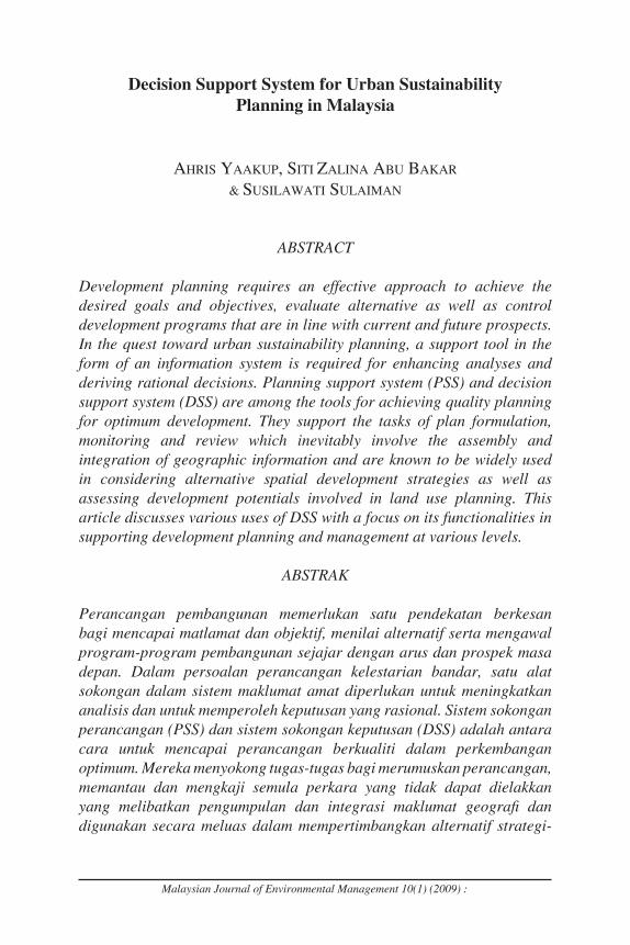
The inspection and reevaluation process in the RSN study involves enormous collection of data to be analysed for the purpose of policies, strategies and key diagram formulation, which support the direction of state development. For that, the role of PSS is made explicit in the design and development of a system for data entry, storing, updating, analysis and presentation. The state level GIS developed, as in the case of Pahang, serves two main purposes. One is planning, which includes the preparation of the key diagram for the State Structure Plan. The other is the monitoring of current development. The preparation of the key diagram involves a combination of analyses including determination of areas having the potential for future development and areas for conservation. The database developed for the State Structure Plan Study is based on guidelines outlined by the Department of Town and Country Planning (JPBD) to support sectoral studies and relevant analyses. In generating
Malaysian Journal of Environmental Management 10(1) (2009) :
Ahris Yaakup, Siti Zalina Abu Bakar and Susilawati Sulaiman 105
the development and conservation scenarios for the State of Pahang, for example, the Multi Criteria Decision Making (MCDM) method was adopted. The process incorporated the use of What if? software for generation of spatial scenarios and Definite for defining of the weight and rating as well as evaluation of the scenarios.
Figure 1 - GIS used for Preparing the State Structure Plan Key Diagram
Local Level Planning
At the local government level, the district local plans are legal documents that become the basis of development guidelines and control. The plans contain such details as land use zoning, development density, building height and plot ratio which require detailed information of each plot of land. The tasks of preparing and analyzing this information can be speeded up and made easy with the help of GIS. A zoning plan, for example, cover a large area that contains various land uses and it is a great advantage to be able to evaluate each alternative of a zoning plan using a DSS (Yaakup and Healey, 1994). At the District Local Plan level, lot based data is used as spatial analysis will involve determination of land suitability, combining the technique of multi-criteria evaluation. GIS display capabilities are also utilized for the purpose of public participation which is legally required in the plan preparation. An

106 Ahris Yaakup, Siti Zalina Abu Bakar and Susilawati Sulaiman
Malaysian Journal of Environmental Management 10(1) (2009) :
executive information system (EIS) was developed to assist display and query of information through a user-friendly interface especially for those without or with limited GIS skills. This is important to gain feedback from the public for the review of the plan.
URBAN METROPOLITAN REGIONAL PLANNING WITH SUPPORT OF DSS –THE CASE OF KLANG VALLEY
The challenges and responsibilities faced by the authorities in executing administrative functions involving spatial dimensions is enormous, especially in areas experiencing rapid physical as well as economic growth like the Klang Valley Region. The introduction of DSS had enhanced the decision-making process by improving data accuracy and accessibility for regional analysis and as a consequence leads to ‘better’ decisions. The information at this level would help to describe the existing situation and also contributes to improve understanding of regional problems by providing key factors and variable that can be analysed using regional modeling and other spatial modeling techniques. The understanding of the urban system that promotes urban growth is imperative for the purpose of policy making, formulating development strategies as well as development plans preparation. Apparently, the dynamic nature of planning and monitoring of development in Klang Valley, the fastest growing region in Malaysia, necessitates a ‘tool’ for continuous monitoring, evaluation and analysis of current environment as well as assessing the capacity for future development. The development of a comprehensive database and GIS-based planning application under the project named “Application of Geographical Information System for Klang Valley Region (AGISwlk)” was initiated in 1995and its implementation had been directed toward organisation of the system to facilitate immediate query and analysis, monitoring of development planning as well as spatial modelling. The project had since undergone intensive enhancement in its database structure, data quantity and quality, analysis approach and techniques as well as system customisation and integration to include the ability to generate development scenario alternatives.
The Comprehensive Database Development
The AGISwlk’s database formerly developed adopted the coverage data model approach which consisted of various elements and data layers prepared to cater for nine application modules as identified by the

Malaysian Journal of Environmental Management 10(1) (2009) :
Ahris Yaakup, Siti Zalina Abu Bakar and Susilawati Sulaiman 107
regional authority including base map, administrative boundary, physical characteristics, land development, population and socio-economic, environmental quality, traffic and urban transportation, green and recreational areas, public facilities and utilities (Yaakup et al., 1999). A considerable time and effort was spent in gathering the data and bringing it up to a common platform and standard data format. The data was used to support various regional level analyses under each application module. The recent enhancement of the database took into consideration the need for multi-user and simultaneous access especially for the purpose of data updating. These require an effective database management system and GIS tools to manage the large pools of geographic data. Hence, the enhancement framework had adopted the geodatabase data model approach, using Microsoft SQL Server as the DBMS and ArcSDE which provides open interface to the relational database for data storing, updating and management apart from serves as the application server for exchanging data with various application including ArcGIS Desktop and the internet. The database previously developed base on macro data approach was subsequently upgraded to provide comprehensive lot-based data especially for supporting analyses needed for deriving solutions to specific problems at micro level.
Spatial Analysis and Modelling
Relative to the rapid land use growth, various issues and problems arise especially those pertaining to environmental pollution, land use conflicts, as well as the availability of land for future development. The changes that occur necessitate continuous monitoring to ensure sustainable development in the environmental as well as socio-economic aspects. More important, assessment of these changes is crucial not only to understand and review current development scenarios, but also to predict changes that will occur, formulate policies and strategies, as well as control development. The application modules of AGISwlk were initially developed base on relevant sectors associated with development planning and monitoring of the region. Various analyses were carried out under each module through adoption of the spatial modeling techniques using various GIS spatial analysis functions. They were used to generate scenarios and predict “What-if” situation base on the various sets of predetermined criteria. In the past, the number of alternative planning scenarios was rather limited due to the difficulties in producing them. This is mainly due to the time consuming procedures of creating scenarios as well as the

108 Ahris Yaakup, Siti Zalina Abu Bakar and Susilawati Sulaiman
Malaysian Journal of Environmental Management 10(1) (2009) :
CLAND ASSESSMENT
C=SS3
C=SS2
C=SS1
Current Scenarios
ALAND
RESOURCES
A2. Locality Factors
BLAND
CAPACITY
B1. Construction Suitability
B2. Carrying Capacity
B3. Development PlansB4.
Population
Integrated Land Use AssessmentRelationship within Decision Making Systems
Implementation
Sub Models
A. Land Resources B. Land CapacityC. Land Assessment
Integrated Land Use Assessment (ILA)
•Land use, Built-up Area & Physical Characteristics•Green & Recreational Area•Industries & Commerce•Population & Socio-economy•Low-cost housing & Squatters•Environment•Public amenities & Utilities•Transport Planning•Geohazard•Tourism
APPLICATIONS
AGISwlkApplication of GIS
for Klang Valley Region
PlanningAssessment
Decision
Klang Valley Regional Master Plan
1. Projection2. Policy &
Strategy3. Planning
Strategy
A1. Environmental Sensitive Area
evaluation that follows. The evaluation process appeared to be quite static and limited. Thus, policy-makers, like most decision-makers, face the difficult task of evaluating and examining the impact of various resource allocations. Recently, more efforts were directed at assessing the ability to supply land and supporting infrastructure to meet future needs. The Ministry of Federal Territories has embarked on developing a regional planning support system (RPSS) focussing on scenario building, measuring development impact and a tracking module to monitor and measure regional plan targets (including structure plans). To support the system, AGISwlk have concentrated on three types of planning applications: sector-based applications; Integrated Landuse Assessment (ILA); and specific case studies. Various analyses were carried out through adoption of the spatial modelling techniques using various GIS spatial analysis functions including identification of land availability and area suitable for development; assessment of land use change and environment quality; as well as supply and demand for public facilities. Gradually, AGISwlk application is enhanced through improvement of analysis methods, model and criteria based on regional planning needs.
Integrated Land Use Assessment
Figure 2: Klang Valley Integrated Landuse Assessment (ILA) Framework

Malaysian Journal of Environmental Management 10(1) (2009) :
Ahris Yaakup, Siti Zalina Abu Bakar and Susilawati Sulaiman 109
Apparently, a tool was needed to better manage outward growth and channel development into designated growth areas so as to strike a sustainable balance for economic growth and protection of environmental assets. The Integrated Land Use Assessment (ILA) framework (Figure 2) is developed within AGISwlk, aimed at providing an integrated spatial analysis model with the ability to consider alternative spatial development strategies as well as visualise development potentials involved in land use planning by integrating physical and socioeconomic information. The introduction of ILA as an integrated land use planning approach that applies the GIS analysis capabilities while supported by the use of planning support system (What if?) is seen as a good alternative for achieving better and more rational decisions. The developed model is expected to dynamically support the preparation of the Klang Valley Regional Master Plan. The methodology was developed and organized based on the GIS spatial analysis process and planning support system framework as well as the identification of policy and strategy to be used as guideline and direction of study in achieving the desired output. The ILA Model is dynamic in approach, providing flexibility for users in manipulating the selection criteria and organising them on priority basis for the development of the scenarios. The assessment technique in ILA adopts the GIS spatial analysis technique combined with the weighting and sequential techniques. ILA involves two type of assessment namely Land Resources Assessment and Land Capacity Assessment.
Web-based GIS for public access and stakeholder collaboration
Public participation is also an essential means to facilitate the adaptability of the planning system and improve information. As such, a user interface and web-based GIS were developed to facilitate an easy and friendly use of the system. Web-based GIS for Klang Valley is initiated as an extension to the prior developed AGISwlk, which is aimed towards inviting public participation apart from providing information in the form of maps and data for public access, and paving the path for data sharing with agencies having the same interest. The operations offered a means for the users to display maps, submit query as well as display data sources and data structure base on selected maps. However, to coordinate development in Klang Valley, the use of GIS for planning and monitoring extends beyond the development of a comprehensive database. The AGISwlk database needs to be integrated with the local authorities as well as agencies directly involved in planning

110 Ahris Yaakup, Siti Zalina Abu Bakar and Susilawati Sulaiman
Malaysian Journal of Environmental Management 10(1) (2009) :
and monitoring of the region. As such, two modules were developed to serve two different target user groups base on the requirement and role of each one. A web-based GIS stakeholders application for Klang Valley was then developed to integrate the data set and to encourage data sharing between various agencies involved in shaping the urban environment in Klang Valley region. The application developed adopted the three-tier client/server architecture comprising three main parts namely Clients, Middleware/Application Server and Data Storage (Yaakup et al., 2001) and was prepared using the ArcIMS software and provides two types of web viewer namely the HTML Viewer for Public Interactive Maps Application and Java Viewer for Stakeholders Application. The web-based interface has provided enhanced system accessibility and better means for data dissemination, collaboration and public participation through the online public and stakeholder applications. The effort toward information sharing across agencies and departments through distributed databases, and standardization of procedures will certainly facilitate multi-stakeholder engagement. The current effort include the employment of Web-based GIS Server technology to provide an online single point of entry for simple access to the required information, analyses models and other services.
DEVELOPMENT PLANS MONITORING SYSTEM
Monitoring the implementation of development plans are crucial to ensure that activities are in line with the implementation schedule and whether the resources or implementation procedures are used effectively. The monitoring framework should consider the issues of coordination, institutional responsibilities and linkages, indicators and timeframe to establish mechanism for measuring performance against targets. The monitoring procedures enable timely action to be taken to correct the deficiencies detected. The development plans monitoring system for Negeri Sembilan was designed base on the crucial need for assessment of the progress and effectiveness, as well as, review of development programs and policies. The system is strongly supported by the GIS9 database formerly developed to accommodate geospatial data for the whole state of Negeri Sembilan. Due to the requirement of various stakeholders, the database was designed base on the geodatabase model approach and developed using data from various sources which was channeled through State Town and Country
Malaysian Journal of Environmental Management 10(1) (2009) :
Ahris Yaakup, Siti Zalina Abu Bakar and Susilawati Sulaiman 111
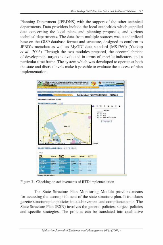
Planning Department (JPBDNS) with the support of the other technical departments. Data providers include the local authorities which supplied data concerning the local plans and planning proposals, and various technical departments. The data from multiple sources was standardized base on the GIS9 database format and structure, designed to conform to JPBD’s metadata as well as MyGDI data standard (MS1760) (Yaakup et al., 2006). Through the two modules prepared, the accomplishment of development targets is evaluated in terms of specific indicators and a particular time frame. The system which was developed to operate at both the state and district levels make it possible to evaluate the success of plan implementation.
Figure 3 - Checking on achievements of RTD implementation
The State Structure Plan Monitoring Module provides means for assessing the accomplishment of the state structure plan. It translates gazette structure plan policies into achievement and compliance units. The State Structure Plan (RSN) involves the general policies, subject policies and specific strategies. The policies can be translated into qualitative

112 Ahris Yaakup, Siti Zalina Abu Bakar and Susilawati Sulaiman
Malaysian Journal of Environmental Management 10(1) (2009) :
and quantitative form of measurement. The accomplishment of RSN is measured through the assessment of changes in development scenarios based on evaluation of the outlined strategies through comparison with the key diagram. While the Local District Plan Monitoring Module emphasizes on physical planning involving spatial data, location and land use activities of proposed development. It will be possible to check whether land use development in the district complies with the zoning strategies in the district and local plans (RTD) by comparing current land use development with that proposed in the district and local plans (Figure 3). Progress of projects’ implementation at the district level can be constantly monitored and development control can be carried out more systematically.
PLANNING APPROVAL AND DEVELOPMENT CONTROL SYSTEM FOR URBAN SUSTAINABILITY PLANNING
Planning control is carried out to ensure the development programmes complies with the development plan toward securing sustainable development. Local authorities are the key players in the planning and development control process, functioning as decision makers as well as service-providers. The shift from conventional working procedures to a computerised system environment is crucial to be able to provide appropriate information for the purposes in an efficient and effective manner. The support of a digital system that could facilitate and enhance routine planning and development control processes which involve, among others, formulation of physical plans and spatial policies and carrying out development regulation is very much necessary. In local planning authorities, DSS are used at various points in the planning process, including analytical and synthesis-oriented tasks such as plan preparation and evaluation (Yaakup et al., 2007). The process of analyzing the appropriateness of planning submissions requires many stages of decision-making and expertise from various fields and hence necessitates for collaboration among the parties involved to allow the proposed development to be properly evaluated by the relevant decision making body before a planning permission is rendered. The Computerised Planning Approval System implemented by the City Hall of Kuala Lumpur (CHKL), is one of the ICT applications undertaken to facilitate the procedures to control and monitor the city development. The system was designed to cover all the necessary work process involved in development approval. The developed system
Malaysian Journal of Environmental Management 10(1) (2009) :
Ahris Yaakup, Siti Zalina Abu Bakar and Susilawati Sulaiman 113
integrates several subsystems which execute specific functions while at the same time interact with one another by sharing information sources (Yaakup et al., 2004a). Overall, the system was designed to incorporate the functions of information dissemination, evaluation of proposal, document management, monitoring of work progress and application status and online GIS. The seven subsystems developed are:
i. Planning Authorization Subsystemii. Building Control Subsystem iii. Enforcement Subsystemiv. Information Kiosk Subsystemv. Meeting Presentation Subsystemvi. Documentation Processing Subsystemvii. Geospatial and Planning Information Subsystem
The system has managed to integrate and streamline processes between different departments. The comprehensive GIS and planning database developed could be used by many parties involve in the process as reference point in evaluating a planning proposal. Having access to the database will provide the flexibility in assessing a development project and deciding on the overall urban growth management program in the most cost-effective manner. This ensures transparency and consistency in the development control procedure. The step taken by the City Hall of Kuala Lumpur through the development of the integrated system is also seen as an innovative approach to urban sustainability planning.
PRACTICALITY IN THE CURRENT USE OF PDSS
A PDSS is part of the mechanism for reducing uncertainty in the knowledge and understanding of the environment and can contribute to a much clearer understanding of real planning problems as well as prescriptive planning scenarios to enhance the quality of planning. Thus, the system developed should be able to provide solutions to those issues and support the procedures of planning and monitoring as well as decision making. What needs to be emphasized is the practicality in utilization of the DSS.
Data availability and Reliability
Since urban and regional planning involves different administrative units and with different data accuracy requirements, the data would needs

114 Ahris Yaakup, Siti Zalina Abu Bakar and Susilawati Sulaiman
Malaysian Journal of Environmental Management 10(1) (2009) :
to be accurate enough for all users. In defining information levels and details, users have to be clear of their aim and objective of the database development so that the data stored is able to support the intended analysis to be carried out. The database needs to be designed base on several important considerations which include the applications to be developed, the data needs of each application, availability and format of existing data, size/volume of the database, hardware platform/configuration, users background and organizational structure of the users and facility. On the other hand, acquiring and updating of data tends to be the biggest challenge in the implementation of planning support systems as it influences the accuracy of data. Data availability would very much depend on the cooperation from all stakeholders involved either at the state, regional or local level. In addition, the understanding and commitment from all staffs involved would help speed up the process of acquiring, updating and use of data.
Data Integration and Standardization
The use of the PDSS has helped reduce the cost of RSN/RTD studies and preparation due to data availability. It enables smooth process of development management and implementation due to the data-sharing framework adopted. It can be used by various departments/agencies for the purpose of data updating and enhancement due to common data structure/format.
Modeling capabilities
Different spatial level and form of plans require different support in term of modeling needs. While the same type of analyses may be carried out at every level of planning but the scope and scale of study as well as the criteria differs from broad in the case of the national level, to detail in the case of the local level in terms of determinant factors and weight. Analysis techniques and models used should be able to highlight the relevant issues and produce reliable results. GIS is a part of the Planning Support Systems (PSS), which alone can support decision-making and urban problem solving to a considerable extent. However, planners will have to adapt existing GIS tools to meet their needs. A combination of sophisticated GIS macro commands and traditional programming language can also be used to develop analytical models closely linked to full-featured GIS toolkits

Malaysian Journal of Environmental Management 10(1) (2009) :
Ahris Yaakup, Siti Zalina Abu Bakar and Susilawati Sulaiman 115
(Klosterman, 2001). The PSS which is a combination of GIS data, urban model and presentation technique using computer for planning support has been increasing in use for more enhanced end products. They combine traditional tools for urban and regional planning with other technologies such as expert system (Han and Kim, 1989), decision support aids such as multi-attribute utility theory (Lee and Hopkins, 1995), hyper media systems (Shiffer, 1992), and group decision support systems (Armstrong, 1993; Finaly and Marples, 1992).
Trainings and transfer of technology
For smooth and effective employment of PDSS, institutional arrangement is essential for directing implementation and monitoring proper and timely execution as in the case of development plans. To facilitate co-ordination of development effort at various levels, respective development committees at various levels could be proposed. Apart from system development and maintenance, preparation of the human resources is also crucial. As such, programmes should be outlined for users to acquire the appropriate knowledge and skills. These include series of workshops and trainings to ensure smooth technology transfer to users apart from receive feedbacks to further enhance the components wherever appropriate for effective system implementation.
CONCLUSION
In the planning evaluation process, it is important to have several alternatives, in which various factors such as the cost-benefit and the socio-economic characteristics is taken into account. In the past, the number of alternative planning scenarios was rather limited due to the difficulties in producing them. This is mainly due to the time-consuming procedures of creating scenarios as well as the evaluation that follows. Now, having prepared the evaluation model, the operation can be accomplished within a much shorter time frame by computer processing of the data and computer mapping of the results. Up-to-date and reliable information is apparently needed at all levels of planning and monitoring, from the national level right through the local authorities, to facilitate administrative procedures of policy planning and plan implementation. As such, database development and system implementation need to consider requirements for data integration

116 Ahris Yaakup, Siti Zalina Abu Bakar and Susilawati Sulaiman
Malaysian Journal of Environmental Management 10(1) (2009) :
and sharing between relevant agencies and departments involved. In addition, the system must expand correspondingly if anything like effective understanding and control is to be achieved. More important, for smooth and effective implementation, institutional arrangement is also imperative for directing implementation and monitoring proper and timely execution of development plans.
REFERENCES
Armstrong, M.P. 1993. Perspective on the development of group decision support system for local problem solving. Geographical System, 1, 67-81.
Finaly, P. N., and Marples, C. 1992. Strategic group decision support systems – A guide for the unwary. Long Range Planning, 25, 98-107.
Johar, F., Yaakup, A.B., Abu Bakar, S.Z. and Sulaiman, S. 2003. Geographical information system for development planning in Malaysia, Proceedings 8th International Conference on Computers in Urban Planning and Urban Management (CUPUM’03), Sendai, Japan, May 27-29, 2003.
Klostermann, R.E. 2001. Planning Support Systems: A New Perspective on Computer Aided Planning, in Brail, R.K. and Klosterman, R.E. (eds) Planning Support System, Redland, California: ESRI Press.
Lee, I., and Hopkin, L.D. 1995. Procedural expertise for efficient multi-attribute evaluation: A procedural support strategy. Journal of Planning Education and Research, 14 (4, Summer), 255-69.
Low, A.M. and Kelton, W.D 1982. Simulation Modelling and Analysis. McGraw-Hill Book Co., New York.
Mohamad, M.R. 1984. Developing a GIS for Malaysian local authorities: Benefits derived and problems encountered. Paper presented at the Local Government Seminar. Universiti Teknologi Malaysia, 15-16, December 1994.
Shiffer, M.J. 1992. Toward a collaborative planning system. Environment and Planning B: Planning and Design, 19, 709-22.
Steyaert, L.T. 1993. A perspective on the state of environmental simulation modelling. In Goodhild, M.F., Parks, B.O. and Steyaert, L.T. (eds.), Environment Modelling with GIS. Oxford University Press, Oxford.

Malaysian Journal of Environmental Management 10(1) (2009) :
Ahris Yaakup, Siti Zalina Abu Bakar and Susilawati Sulaiman 117
Yaakup, A.B., Abu Bakar, Y. and Sulaiman, S. 2004a. Web-based GIS for collaborative planning and public participation toward better governance. Proceedings 7th International Seminar on GIS for Developing Countries. Johor Bahru, 10-12, May 2004.
Yaakup, A.B. and Healey, R.G. 1994. A GIS approach to spatial modelling for squatter settlement planning in Kuala Lumpur. Environment and Planning B: Planning and Design. Vol.21,21-34.
Yaakup A.B., Idris R., Sulaiman S. and Mat Yaakob M. 2006. GIS As New Tools And Approach In State Planning And Monitoring: The Experience of Negeri Sembilan, Malaysia. Paper presented at Map Asia 2006 Conference. Bangkok, 29 August-1 September 2006.
Yaakup, A.B., Jama’an, J., Abu Bakar Y. and Sulaiman, S. 2001. Web-based GIS for public participation in urban planning and management – case study: Klang Valley Region. Proceedings Asia GIS 2001 International Symposium. Tokyo, Japan, 20-22, June 2001.
Yaakup, A., Johar, F. and Dahlan, N.A. 1997. GIS and decision support systems for local authorities in Malaysia. In H. Timmermans (ed) Decision Support Systems in Urban Planning. E & FN SPON, London, 1977, pp. 212-228.
Yaakup, A.B., Said, M.N. Shamsuddin, K. and Musa, N. 1999. GIS development and application for planning and monitoring of urban growth in Klang Valley Region, West Malaysia. Proceedings 6th International Conference on Computerization in Urban Planning and Urban Management. Venice, Italy, 8-11, September 1999.
Yaakup, A. B and Sulaiman, S. 2006. GIS as new approach and method in preparing and implementing the development plan in Malaysian planning system. ESRI User Conference. Kuala Lumpur.
Yaakup, A. B., Johar, F., Che Ngah, M., and Sulaiman, S. 2007. Computerised Planning Approval System for a Local Authority in Malaysia. Paper presented to International Conference on Computerization in Urban Planning and Urban Management. Iguassu Falls, Brazil, 11-13, July 2007.
Department of Urban and Regional Planning, Faculty of Built Environment, Universiti Teknologi Malaysia, 81310 Skudai, Johor, Malaysia.E-mail: [email protected]

118 Ahris Yaakup, Siti Zalina Abu Bakar and Susilawati Sulaiman
Malaysian Journal of Environmental Management 10(1) (2009) :