Embed Size (px)
Citation preview
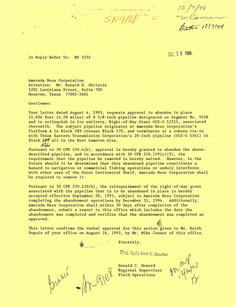
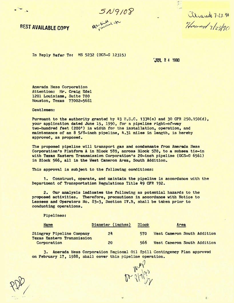
In Reply Refer To: MS 5232 DEC 2 8 1994.
Amerada Hess Corporation Attention: Mr. Ronald D. Christie 1201 Louisiana Street, Suite 700 Houston, Texas 77002-5681
Gentlemen:
Your l e t t e r dated August 4, 1993, requests approval to abandon i n place 22,604 feet (4.28 miles) of 8 5/8-inch pipeline designated as Segment No. 9108 and to relinquish i n i t s e n t i r e t y , Right-of-Way Grant OCS-G 12315, associated therewith. The subject pipeline originates at Amerada Hess Corporation's Platform A i n Block 589 crosses Block 570, and terminates at a subsea t i e - i n with Texas Eastern Transmission Corporation's 20-inch pipeline (OCS-G 6561) i n Block SKT a l l i n the West Cameron Area.
Pursuant to 30 CFR 250.4(b), approval i s hereby granted to abandon the above-described pipeline, and i n accordance with 30 CFR 250.159(c)(9), the requirement that the pipeline be removed is hereby waived. However, i n the future should i t be determined that t h i s abandoned pipeline constitutes a hazard to navigation or commercial f i s h i n g operations or unduly interferes with other uses of the Outer Continental Shelf, Amerada Hess Corporation shall be required to remove i t .
Pursuant to 30 CFR 250.150(b), the relinquishment of the right-of-way grant associated with the pipeline that i s to be abandoned i n place i s hereby accepted effective September 20, 1993, subject to Amerada Hess Corporation completing the abandonment operations by December 31, 1994. Additionally, Amerada Hess Corporation shall w i t h i n 30 days aft e r completion of the abandonment, submit a report to t h i s o f f i c e which includes the date the abandonment was completed and v e r i f i e s that the abandonment was completed as approved.
This l e t t e r confirms the verbal approval for t h i s action given to Mr. Keith Dupuis of your o f f i c e on August 16, 1993, by Mr. Mike Conner of t h i s o f f i c e .
I
Sincerely,
fOng. Sgd.J Kent £. Stauffer
Donald C. Howard (" Regional Supervisor ^^ Field Operations
i
bcc: [1501-01 (P/L OCS-G 12315) w/enclosures (MS 5232) 1502-01 (P/L OCS-G 12315) (microfilm) (MS 5033) MS 5421 MS 5270
MS 5232 (Carto)
MConner:amm:12/2/94:Amerada.315
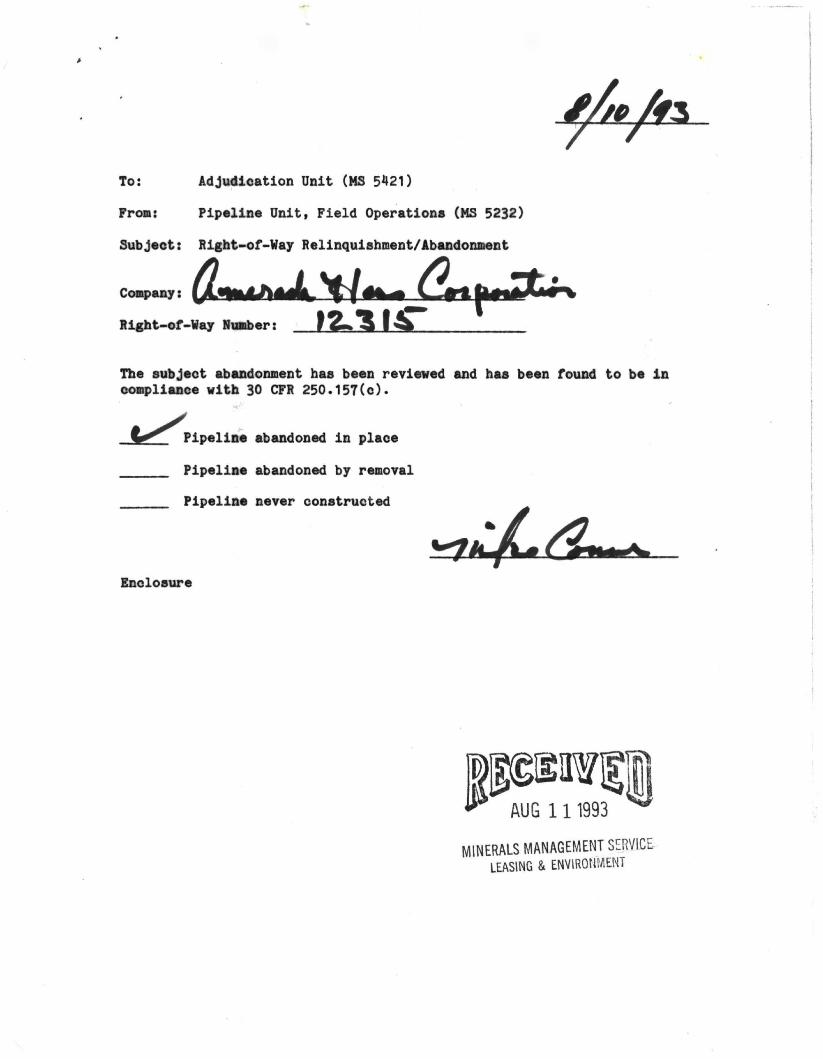
To: Adjudication Unit (MS 5421)
From: Pipeline Unit, Field Operations (MS 5232)
Subject: Right-of-Way Relinquishment/Abandonment
Company:
Right-of-Way Number:
The subject abandonment has been reviewed and has been found to be in compliance with 30 CFR 250.157(c).
Pipeline abandoned in place
Pipeline abandoned by removal
Pipeline never constructed
Enclosure
MINERALS MANAGEMENT SERVICE LEASING & ENVIRONMENT
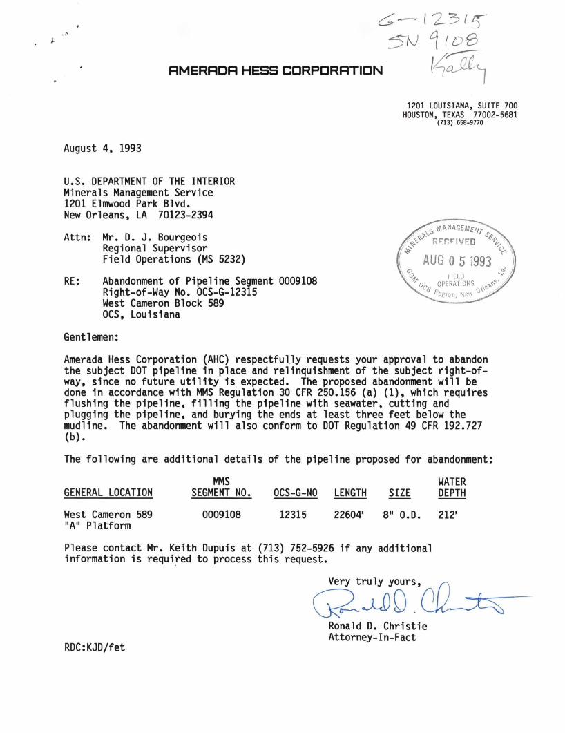
RMERRDR HESS CDRPDRRTIDN
August 4. 1993
1201 LOUISIANA. SUITE 700 HOUSTON, TEXAS 77002-5681
(713) 658-9770
U.S. DEPARTMENT OF THE INTERIOR Minerals Management Service 1201 Elmwood Park Blvd. New Orleans. LA 70123-2394
Attn: Mr. D. J. Bourgeois Regional Supervisor Field Operations (MS 5232)
RE: Abandonment of Pipeline Segment 0009108 Right-of-Way No. OCS-G-12315 West Cameron Block 589 OCS, Louisiana
Gentlemen:
Amerada Hess Corporation (AHC) respectfully requests your approval to abandon the subject DOT pipeline in place and relinquishment of the subject right-of-way, since no future utility is expected. The proposed abandonment will be done in accordance with MMS Regulation 30 CFR 250.156 (a) (1), which requires flushing the pipeline, f i l l i n g the pipeline with seawater, cutting and plugging the pipeline, and burying the ends at least three feet below the mudline. The abandonment will also conform to DOT Regulation 49 CFR 192.727 (b).
The following are additional details of the pipeline proposed for abandonment:
MMS GENERAL LOCATION SEGMENT NO. OCS-G-NO LENGTH SIZE
WATER DEPTH
West Cameron 589 "A" Platform
0009108 12315 22604' 8" O.D. 212'
Please contact Mr. Keith Dupuis at (713) 752-5926 i f any additional information is required to process this request.
Very truly yours. very t r u i y yours, ^
RDC:KJD/fet
Ronald D. Christie Attorney-in-Fact
RMERRDR HESS CDRPDRRTIDN
5
KEITH J. DUPUIS, SUPERVISOR ENVIRONMENTAL/REGULATORY AFFAIRS
1201 LOUISIANA, SUITE 700 HOUSTON, TEXAS 77002-5681
(713) 752-5926 FAX: (71: /13) 752-5660
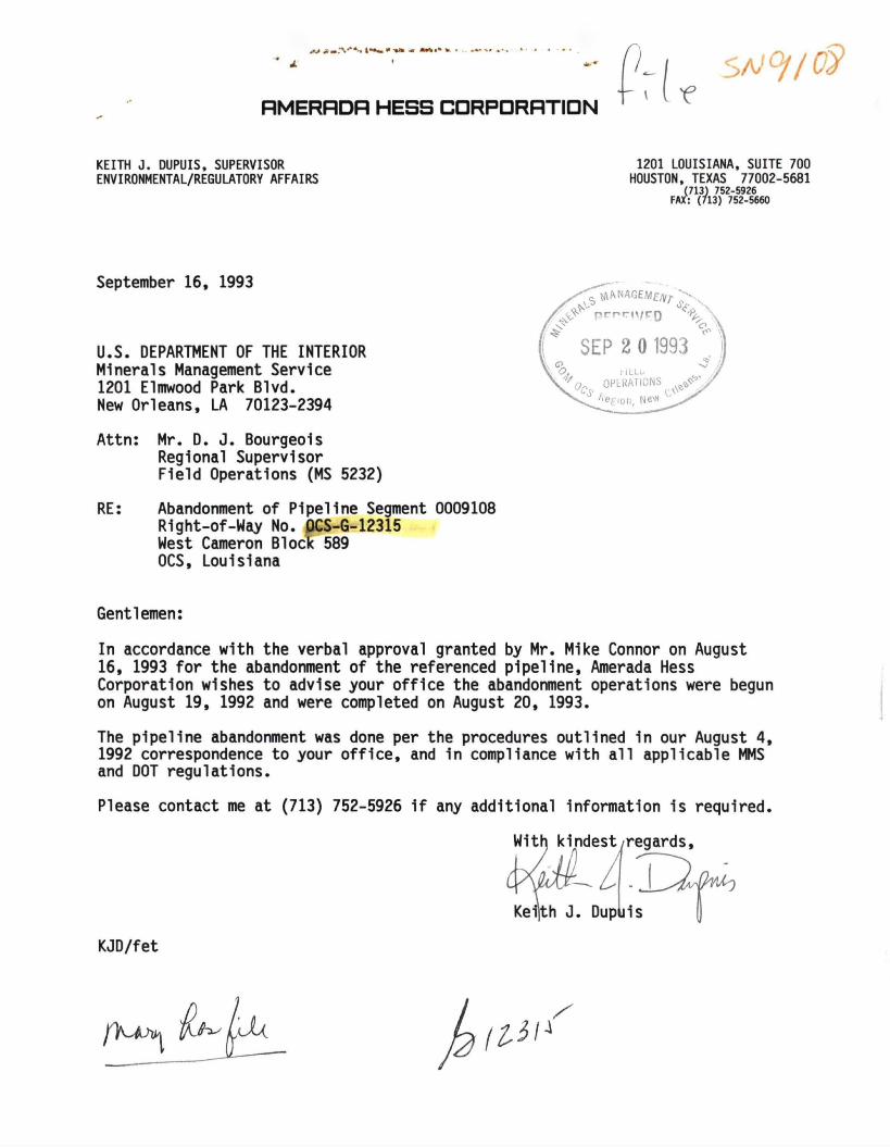
September 16, 1993
U.S. DEPARTMENT OF THE INTERIOR Minerals Management Service 1201 Elmwood Park Blvd. New Orleans, LA 70123-2394
Attn: Mr. D. J. Bourgeois Regional Supervisor Field Operations (MS 5232)
RE: Abandonment of Pipeline Segment 0009108 Right-of-Way No. QCS-G-12315 West Cameron Block 589 OCS, Louisiana
p r n r n / C Q
SEP 2 0 1993
0os
* - OPtRATIONS ^ V
''ef (on, Ne^
Gentlemen:
In accordance with the verbal approval granted by Mr. Mike Connor on August 16, 1993 for the abandonment of the referenced pipeline, Amerada Hess Corporation wishes to advise your office the abandonment operations were begun on August 19, 1992 and were completed on August 20, 1993.
The pipeline abandonment was done per the procedures outlined in our August 4, 1992 correspondence to your office, and in compliance with all applicable MMS and DOT regulations.
Please contact me at (713) 752-5926 if any additional information is required.
With kindest/regards.
Keijth J. DupUis
KJD/fet
$4*<^ nhthc
In Reply Refer To: MS 5232 S W j ^ ^ '
NOV 0 2 1990 Amerada Hesa Corporation Attention: Mr. Craig Edel 1201 Louisiana, Suite 700 Houston, Texas 77002-5681
Gentlemen:
In aooordanoe with 30 CFR 250.158(b), your l e t t e r dated October 19, 1990, transmitted a pipeline construction report for the following right-of-way pipeline:
Pipeline Right-of-way Size Length Humber (inches^ (feet) Service From To
(^OCS-G 12315"^ 8 5/8 22,604 Qas/ Platform A A 20-inoh SSTI ^ Condensate Blook 589 Blook 566
West Cameron West Cameron South Addition South Addition
The data which you provided indicates the following test information and establishes the assigned maximura allowable operating pressure (MAOP) for this pipeline:
Pipeline Right-of-way Test Pressure Duration MAOP MAOP Number (psig) (hours) (psig) Determination
OCS-G 12315 2,172 8 1,440 Receiving Pipeline
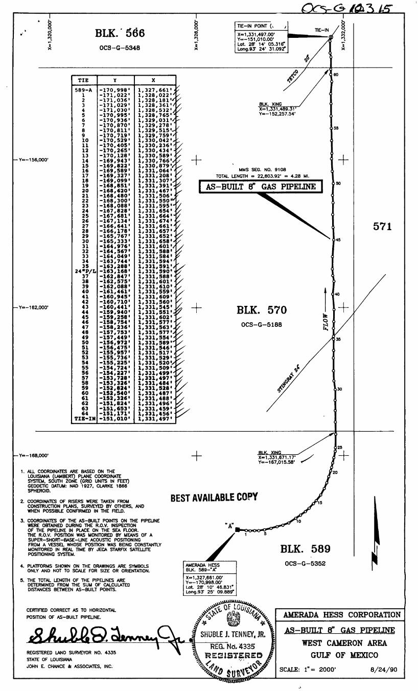
The t o t a l length of the "as-built 1 1 pipeline right-of-way is 4.28 miles.
In future correspondence, please refer to the above pipeline by i t s assigned right-of-way number.
Sincerely,
I'Original signed" -D. J. Bourgeois
D. J. Bourgeois Regional Supervisor Field Operations
bcc: (1502-01 P/L OCS-G 12315 (w/orig report) (MS 5232) (K. Faust) 1502-01 P/L OCS-G 12315 (MS 5033) n ^ MS 5421 \
ABritton:lr:10/31/90 j ^
(r
o
RMERRDR H E S S CDRPDRRTIDN
1201 L O U I S I A N A . S U I T E 7 0 0 H O U S T O N , T E X A S 7 7 0 0 2 - 5 6 8 1
7 1 3 - 6 5 8 - 9 7 7 0
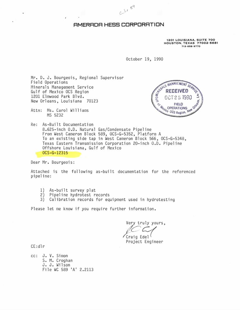
October 19, 1990
Mr. D. J. Bourgeois, Regional Supervisor Field Operations Minerals Management Service Gulf of Mexico OCS Region 1201 Elmwood Park Blvd. New Orleans, Louisiana 70123
Attn: Ms. Carol Williams MS 5232
Re: As-Built Documentation 8.625-inch O.D. Natural Gas/Condensate Pipeline From West Cameron Block 589, OCS-G-5352, Platform A To an existing side tap in West Cameron Block 566, OCS-G-5348, Texas Eastern Transmission Corporation 20-inch O.D. Pipeline Offshore Louisiana, Gulf of Mexico OCS-G-12315
Dear Mr. Bourgeois:
Attached is the fo l lowing as -bu i l t documentation for the referenced p ipe l ine :
1) As-bu i l t survey plat 2) Pipeline hydrotest records
3) Cal ibrat ion records for equipment used in hydrotesting
Please le t me know i f you require fur ther informat ion.
CE:dlr
Very truly yours,
^Craig Edel (
Project Engineer
cc: J. V. Simon S. M. Croghan J. J. Wilson File WC 589 'A' 2.2113
S
m j AVMUBU COPY
Over 35 Yetf«
O GAS CO r,i!!:r Oil & Gas Specialties Company
11321 Todd SI. • Box 55306 • Houiton. T M M 77255 • (713)686-3444 • Tttos 29-3366
CALIBRATION CERTIFICATE Manufacturer AMERICAN METER o f jngtrument RECORDER
Serial Number 52289-1 Range 0.3000* Model Number
Date of Calibration 6/4/90
BEST AVAILABLE COPY
Inspector DAVID ROGERS GIR
CALIBRATION
INCREASING PRESSURE/TEMPERATURE DECREASING PRESSURE/TEMPERATURE
APPLIED INDICATED APPLIED INDICATED
0 0 3000# 3000# •
750 \ 750# 2250# 2250#
1500 \ 1500# ^ ^no» 2250 2250# 750# 750#
3000 3000# n n
•
This is to certify that the above described device has been inspected and tested against the following standard:
Pressure V T X 9 0 a , . 0 0 g 4 C M i a 7 Q 0 NBS Reference £^0112 \
Temperature 19240-2 SNtl52904048 NBS Reference u . s . TESTTXTC B ^ O A Q ?
Testing was conducted with the device in the ( ) Vertical position ( ) Horizontal position
OOASOO BRANCH OFFICEa- BOM 51424 O.CS. L»lay«ll». Louisiana 70505
(318) 235-4444 (318) 235-6823
Box 93 Harvay. Louisiana 70059
(504) 367-7914
P.O Box6157 Tulsa. Oklahoma 74146
(918) 832-6975
OGASCO
• . H I <0 Y(Mi>
Oil ST Gkr Specialties Company > 13ZI rood Sl • Bo« 55306 • Houston. Texas " 2 5 5 • (713)686 3441 t Telex 29-3368
CALIBRATION CERTIFICATE •j'Vict.i:;-er CHANDLER ENGINEERINQype of Instrument DEAD WEIGHT
5-1 Serial Number 1107b-6 Range O-3U00#
"f;1-* of Calibration 7/5/90
QFST AVAILABLE COPY
Inspector
DAVID ROGERS
CALIBRATION
TNCREASTNT. PRESSURE/TEMPERATURE DECREASING PRESSUFE/TE^ERATURE
-\PPLIEr INDICATED APPLIED INDICATED
0 0 3000# 3000#
750# 750# 2^50# 22b0#
1 1500# 1500# 1500# 1500#
, .225.0 # 2251*
ft ft
1
i
•
1
1
"Ms is to ce r t i f y that the above described device has been inspected and tested rvninst the following standard:
•,, VTX 802-0084 sw,279n ^S Ref erence ....p,.-^^ <_
600-2830 sw g f i .n f ia f i NBS deference _ _ 2 3 7 4 8 9 / w g 4 ^
ir'.:-- war-: couciucted with the device in the C ) Vertical position ( ) Horizontal position
OOASCO BKANCH OFFICES Boi S u p i O C S ^Aiayeue Louisiana 70505
(3i8) 235 4444 (318) 235-5623
Bo. •.• • Harvey LGi..$'<ina / 0 0 ; J 9
(5041 367 7914
PO 8o« 6 ' ' i ,
Tuisa OKianoma 74 148 (9181 832 8975
OGASCO OJ'/ & Gas Specialties Company
Over 35 Yea's 11321 Todd Sl. • Box 55306 • Houston. Texas 77255 • (713)666-3444 • Telex 29-3366
CALIBRATION CERTIFICATE Type of Instrument RECORDER Manufacturer BARTON
Model Number _Serial Number 4733-2 Range 0-150 oF
Date of Calibration 6/4/90 Inspector (jZ^- ^O^^^ „ o n n V DAVID ROGERS
<rr AVAILABLE COPY B E S T AVA,LABLE COPY CALIBRATION
INCREASING PRESSURE/TEMPERATURE DECREASING PRESSURE/TEMPERATURE
APPLIED INDICATED APPLIED INDICATED
7 5 0 F 7 5 0 F 100 O F 100 O F
100 O F 1 0 0 o F
150 O P . 150 O F 3 3 0 F 33 0 P
•
This is to certify that the above described device has been inspected and tested against the following standard:
.* Pressure VTX 802-0084 fiN.27qn NBS Reference P-7819
Temperature 1 9 2 4 0 " 2 SN: 152904048 NBS Reference U.S. TESTING 83-0 49 2
Testing was conducted with the device in the ( ) Vertical position ( ) Horizontal position
OOASOO BRANCH OFFICES.' 80x51424 OCS. lalayette. louaiana 70505
(318) 235-4444 (318) 235-5823
Box 93 Harvey. Louisiana 70059
(504) 367-7914
PO Box 6157 Tulsa. Okianoma 74148
(918) 832-8975
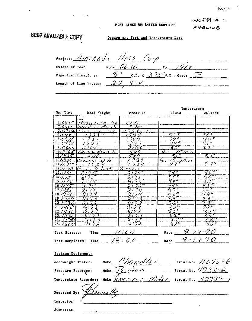
I'll'E LINES UNLIMITED SERVICBS
Deadwelalit Test and Temperature Data
Project!
Extent ti Teats From l'£^)C"'
Fipe Specifications! " O.D. X 3 ^J^W.T. | Grade I 2 _ _
Length of Line Tested! S l S l^ ? V •/
Temperature Ho. Time Dead Weight Pressure F l u i d Ambient
i.c^ vr / - / • .rt/j>r.l..s<p r¥/:,^S ? v#o
\ 'J.lCO/O. / V 0 H ; ^.r^t-.T / " J Q S'
/ 7 J •? / n 0?" . r i . t fYJr / ? 2 i I f * ^ / "
. -O/LtC
9 . ^ 5 " S - J C
<M' / f / 73$ / 1 ' 'J '<( / ?;j<? ^
(ri' .TC. +f-
ST* - 47 -15.//.?<, '
i6 . / /v . r 5y rv. 3 / ?c/
18 . /3 5 / S •/ - -19./ ?60 ?.? 20. S . ^ n./i/DO ' ? -1 .'J/ ? ^ n./Vlr.' Art! 2 3 . / ^ ' / '
24. / . - r in Sti? 3 3; 25. y ^ ^ Y ; •^i i x
Test Started) Time
Test Completed! Time
Testing Equipment!
Deadweight Testen
M-LALL
1°/ • £ <L Date
Date
90
Make
Hake '^OLcA^-Cl
Temperature Recorder! Make / / / T f r , / ' a /7/£''yiv
Pressure Recorder)
Serial No. ^.5 .-.^
Serial No. ^ 7 3 ^ ' A.
Serial No. ^ . Q S ^ ) - I
Recorded By)
Inspector)
Witnesses)
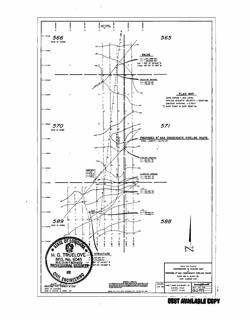
4-
-Yn.-ise.ooo-
-Y=-162.000•
S o o" BLK. 566
OCS-G-5348
TIE
589-A 1 2 3 4 5 6 7 8 9 10 11 12 13 14 IS 16 17 18 19 20 21 22 23 24 25 26 27 28 29 30 31 32 33 34 33
24"P/L 37 38 39 40 41 42 43 44 45 46 47 48 49 50 51 52 53 54 55 36 57 58 39 60 61 62 63 64
TIE-IN
-170,998 -171,022 -171,036 -171,029 -171,030 -170,995 -170,936 -170,870 -170,811 -170,719 -170,529 -170,405 -170,265 -170,128 -169,943 -169,822 -169,589 -169,327 -169,099 -168,851 -168,620 -168,480 -168,300 -168,088 -167,828 -167,681 -167,134 -166,641 -166,178 -165,767 -165,333 -164,976 -164,567 -164,049 -163,744 -163,288 -163,168 -162,847 -162,575 -162,088 -161,461 -160,945 -160,710 -160,441 -159,940 -159,258 -158,734 -158,236 -137,753 -157,449 -136,972 -156,475 -155,937 -155,736 -155,225 -154,724 -154,227 -133,728 -153,326 -152,824 -132,540 -152,326 -131,824 -151,653 -151,171 -151,010
-Y=-168.000'
1. ALL COORDINATES ARE BASED ON THE LOUISIANA (LAMBERT) PLANE COORDINATE SYSTEM. SOUTH ZONE (GRID UNITS IN FEET) GEODETIC DATUM: NAD 1927. CLARKE 1866 SPHEROID.
2. COORDINATES OF RISERS WERE TAKEN FROM CONSTRUCTION PLANS. SURVEYED BY OTHERS. AND WHEN POSSIBLE CONFIRMED IN THE FIELD.
3. COORDINATES OF THE AS-BUILT POINTS ON THE PIPEUNE WERE OBTAINED DURING THE R.O.V. INSPECTION OF THE PIPELINE IN PLACE ON THE SEA FLOOR. THE R.O.V. POSITION WAS MONITORED BY MEANS OF A SUPER-SHORT-BASE-UNE ACOUSTIC POSITIONING FROM A VESSa WHOSE POSITION WAS BEING CONSTANTLY MONITORED IN REAL TIME BY JECA STARFIX SATELLITE POSITIONING SYSTEM.
4. PUTFORMS SHOWN ON THE DRAWINGS ARE SYMBOLS ONLY AND NOT TO SCALE FOR SIZE OR ORIENTATION.
5. THE TOTAL LENGTH OF THE PIPELINES ARE DETERMINED FROM THE SUM OF CALCULATED DISTANCES BETWEEN AS-BUILT POINTS.
CERTIFIED CORRECT AS TO HORIZONTAL POSITION OF AS-BUILT PIPELINE.
REGISTERED LAND SURVEYOR NO. 4sJ35 \
STATE OF LOUISIANA JOHN E. CHANCE te ASSOCIATES, INC.
BEST AVAILABLE CODY ^ 7i<Cv~**/i/z^/fO
In Reply Refer To: MS 5232 (XS-C 12315) rJUL 2 4 1990
Anerada Hess Corporation Attention: Mr. Craig Edel 1201 Louisiana, Suite 700 Houston, Texas 77002-5681
Gentleaen;
Pursuant to the authority granted by 113 U.S.C. 133Me) and 30 CFR 250.150(d), your application dated June 15, 1990, for a pipeline ri^ht-of^way two-hundred feet (200*) in width for the installation, operation, and maintenance of an 8 5/8-inch pipeline, 4.31 ailes in length, is hereby approved, as proposed.
The proposed pipeline w i l l transport gas and condensate fron Anerada Hess Corporation's Platfora A in Blook 589, across Block 570, to a subsea t i e - i n with Texas Eastern Transmission Corporation's 20-inch pipeline {OCS-G 6561) in Block 566, a l l in the West Cameron Area, South Addition.
This approval i s subject to the following conditions:
1. Construct, operate, and oaintain the pipeline in accordance with the Departnent of Transportation Regulations T i t l e 49 CFR 192.
2. Our analysis indicates the foilowing as potentini hazards to the proposed a c t i v i t i e s . Therefore, precautions i n aooordanoe with ffotice to Lessees and Operators Ho, 83-3, Section IV.B, shall be taken prior to conducting operations.
Pipelines:
Hame Dlaaeter (inches) Block Area
Stingray Pipeline Company 24 570 West Caaeron South Addition Texas Eastern Transmission
Corporation 20 566 West Carte ron South Addition
3. Amerada Hess Corporation Regional Oil S p i l l Contingency Plan approved on February 17, 1988, shall cover this pipeline operation.
r 1%
BEST AVAILABLE COPY
Baaed on our analysis of your application, the maxinaam allowable operating pressure for this pipeline w i l l be 1,440 psig.
Sincerely,
(Qrig. Sgd4 D.J, Bourgeois
D. J. Bourgeois Regional Supervisor Field Operations
oo: Department of Transportation 2320 La Branch, Room 2116 Houston, Texas 77004 (w/applioation)
boc: 11502-01 (P/L OCS-G 12315) (w/enol) (MS 5232) (K. Faust) 1502-01 (P/L OCS-O 12315) (MS 5033) (C Williams) MS 5270 MS 5440 MS 5421 (w/receipt) MS 5232 (Carto) (w/plat)
CWilliams:lr:7/23/90:LEXITYPE
f X S - G ? - / 2 3 / 5
HMERRDH HESS CORPORnTION
1201 LOUISIANA, SUITE 7 0 0
June 15, 1990 H O U S T O N ,
7"6X5tS977o7 0 0 2'5 6 8 ,
Mr. D.J. Bourgeois, Regional Supervisor Field Operations Minerals Management Service Gulf of Mexico OCS Region 1201 Elmwood Park Blvd. New Orleans, Louisiana 70123
Attention: Ms. Carol Williams FO-2-2
RE: Application for a Pipeline Right-of-Way-Proposed 8.625-inch O.D. Natural Gas/Condensate Pipeline From West Cameron Block 589, OCS-G-5352, Platform A To an existing side tap in West Cameron Block 566, OCS-G-5352, Texas Eastern Transmission Corporation 20-inch O.D. Pipeline Offshore Louisiana, Gulf of Mexico
Dear Mr. Bourgeois:
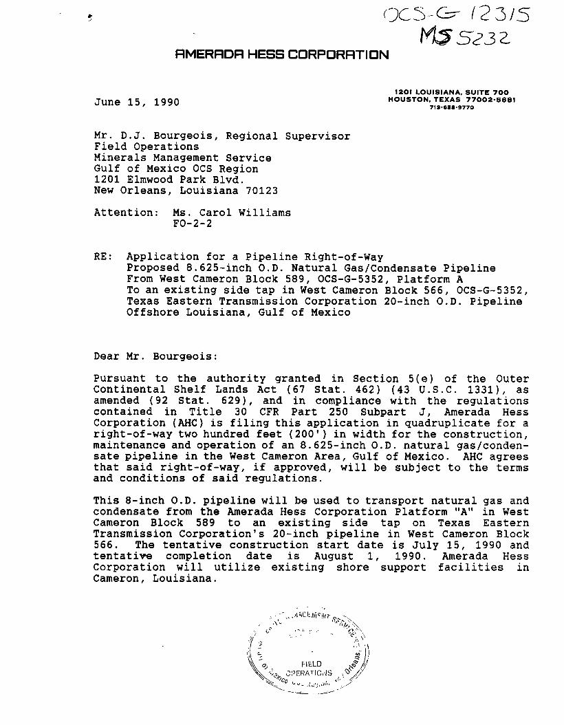
Pursuant to the authority granted in Section 5(e) of the Outer Continental Shelf Lands Act (67 Stat. 462) (43 U.S.C. 1331), as amended (92 Stat. 629), and in compliance with the regulations contained in Title 30 CFR Part 250 Subpart J, Amerada Hess Corporation (AHC) is filing this application in quadruplicate for a right-of-way two hundred feet (200') in width for the construction, maintenance and operation of an 8.625-inch O.D. natural gas/condensate pipeline in the West Cameron Area, Gulf of Mexico. AHC agrees that said right-of-way, i f approved, will be subject to the terms and conditions of said regulations.
This 8-inch O.D. pipeline will be used to transport natural gas and condensate from the Amerada Hess Corporation Platform "A" in West Cameron Block 589 to an existing side tap on Texas Eastern Transmission Corporation's 20-inch pipeline in West Cameron Block 566. The tentative construction start date is July 15, 1990 and tentative completion date is August 1, 1990. Amerada Hess Corporation will utilize existing shore support facilities in Cameron, Louisiana.
•6. ^
'•k. OPERATIONS ^ / /
Minerals Management Service
Page 2
June 15, 1990
This application (and any amendments made hereto) is made with our f u l l knowledge and concurrence with the OCS Lands Act (43 U.S.C. 1331, et seq.), as amended (P.L. 95-372), including the following: Sec. 5(e) addressing pipeline rights-of-way, requirements of the Federal Energy Regulatory Commission relating to notice of hearing, transportation and purchase of o i l and gas without discrimination; Sec. 5(f)(1) addressing operation of pipelines in accordance with competitive principles, including open and nondiscriminatory access to both owner and non-owner shippers; Sec. 5(f)(2) which may allow exemption of the requirements in Sec. 5(f)(1); Sec. 5(e), addressing the assurance of maximum environmental protection, including the safest practices for pipeline installation; and Sec. 5(f)(1)(B) which may require expansion of throughput capacity of any pipeline except for the Gulf of Mexico or the Santa Barbara Channel.
Additionally, Amerada Hess Corporation (AHC) expressly agrees that i f any site, structure, or object of historical or archaeological significance should be discovered during the conduct of any operations within the permitted right-of-way, AHC shall report immediately such findings to the Director, Gulf of Mexico, OCS Region, and make every reasonable effort to preserve and protect the cultural resource from damage until said Director has given directions to i t s preservation.
In accordance with applicable regulations, AHC has delivered a copy of the proposed pipeline route map by certified mail, return receipt requested, to each designated o i l and gas lease operator, and right-of-way or easement holder whose lease, easement or right-of-way i s so affected. A l i s t of such operators and right-of-way or easement holders i s attached (Attachment "A") and copies of the return receipts showing date and signature as evidence of service upon such operators and right-of-way or easement holders are included with this application. In order to expedite the permit process, we have requested a letter from the operator and right-of-way or easement holder expressing no objection to the proposed project. When obtained, these letters w i l l be forwarded to your office. The proposed route of the right-of-way does not adjoin or subsequently cross state submerged lands.
Applicant agrees to be bound by the foregoing regulations, and further agrees to comply with the applicable stipulations set forth in the OCS Pipeline Procedures Guidebook dated March, 1984, revised September, 1984.
In support of our application and for your review and use, the following exhibits have been enclosed herewith and made a part hereof:
Minerals Management Service Page 3 June 15, 1990 BEST AVAILABLE COPY
4
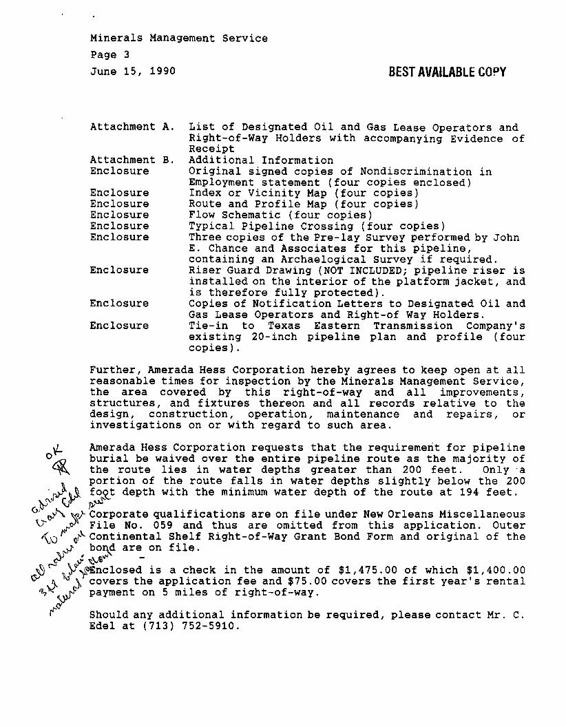
Attachment A.
Attachment B. Enclosure
Enclosure Enclosure Enclosure Enclosure Enclosure
Enclosure
Enclosure
Enclosure
List of Designated Oil and Gas Lease Operators and Right-of-Way Holders with accompanying Evidence of Receipt Additional Information Original signed copies of Nondiscrimination in Employment statement (four copies enclosed) Index or Vicinity Map (four copies) Route and Profile Map (four copies) Flow Schematic (four copies) Typical Pipeline Crossing (four copies) Three copies of the Pre-lay Survey performed by John E. Chance and Associates for this pipeline, containing an Archaelogical Survey i f required. Riser Guard Drawing (NOT INCLUDED; pipeline riser is installed on the interior of the platform jacket, and is therefore f u l l y protected). Copies of Notification Letters to Designated Oil and Gas Lease Operators and Right-of Way Holders. Tie-in to Texas Eastern Transmission Company's existing 20-inch pipeline plan and p r o f i l e (four copies).
Further, Amerada Hess Corporation hereby agrees to keep open at a l l reasonable times for inspection by the Minerals Management Service, the area covered by this right-of-way and a l l improvements, structures, and fixtures thereon and a l l records relative to the design, construction, operation, maintenance and repairs, or investigations on or with regard to such area.
Amerada Hess Corporation requests that the requirement for pipeline burial be waived over the entire pipeline route as the majority of the route lies in water depths greater than 200 feet. Only a
. portion of the route f a l l s in water depths s l i g h t l y below the 200 riKtl foot depth with the minimum water depth of the route at 194 feet.
^ V* /v^ W- Corporate qualifications are on f i l e under New Orleans Miscellaneous
^ y File No. 059 and thus are omitted from this application. Outer 'fo) ^Continental Shelf Right-of-Way Grant Bond Form and original of the
•j- bond are on f i l e .
v£) V^nclosed is a check in the amount of $1,475.00 of which $1,400.00 ^ A A covers the application fee and $75.00 cov< -V" ^ payment on 5 miles of right-of-way.
covers the f i r s t year's rental
Should any additional information be required, please contact Mr. C. Edel at (713) 752-5910.
Minerals Manageu. nt Service Page 4 June 15, 1990
Your efforts to approve the installation of the subject pipeline right-of-way in a timely fashion would be most appreciated.
Very truly yours,
Ronald D. Christie, Attorney-in-Fact
Attachments and Enclosures cc: Companies listed in Attachment A
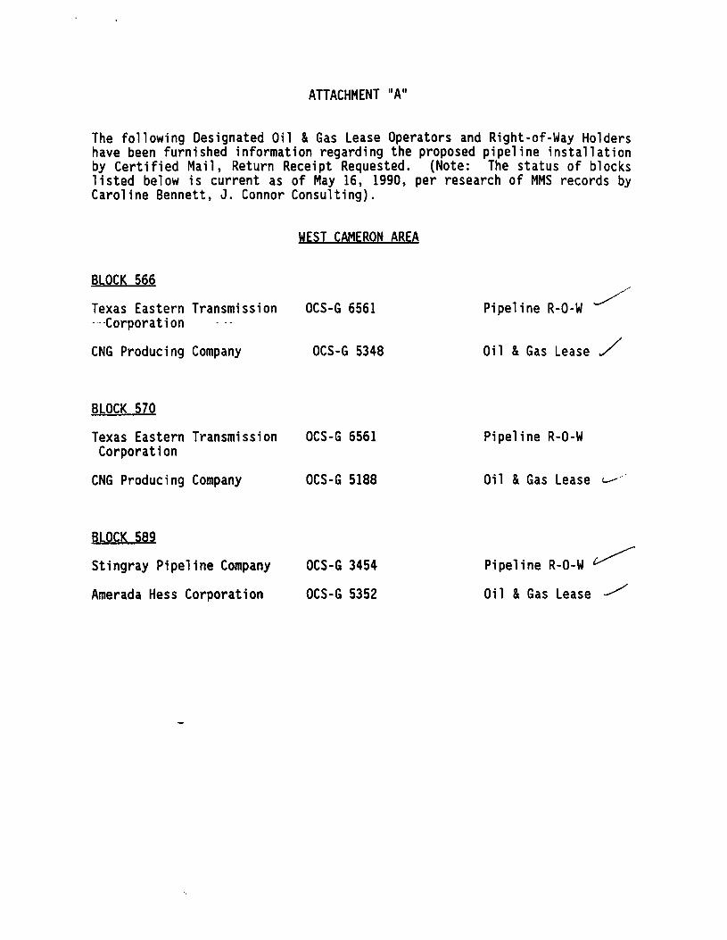
ATTACHMENT "A"
The following Designated Oil & Gas Lease Operators and Right-of-Way Holders have been furnished information regarding the proposed pipeline installation by Certified Mail, Return Receipt Requested. (Note: The status of blocks listed below is current as of May 16, 1990, per research of MMS records by Caroline Bennett, J. Connor Consulting).
WEST CAMERON AREA
BLOCK 566
Texas Eastern Transmission OCS-G 6561 Pipeline R-O-W -Corporation
CNG Producing Company OCS-G 5348 Oil & Gas Lease S
BLOCK 570
Texas Eastern Transmission OCS-G 6561 Pipeline R-O-W Corporation
CNG Producing Company OCS-G 5188 Oil & Gas Lease
BLOCK 589
Stingray Pipeline Company OCS-G 3454 Pipeline R-O-W
Amerada Hess Corporation OCS-G 5352 Oil & Gas Lease
1. • | Show to when d , , ^ , ^ a n d e d d n > l l a < , , ^ " . f H „ „ , „ „ , l n i l
CNG Producing Company CNG Tower 1450 Poydras Street New Orleans, LA 70112
At tn: Yvonne Abadie
4.ArtWtNumiw b
P 740 6I4 fip CNG Producing Company CNG Tower 1450 Poydras Street New Orleans, LA 70112
At tn: Yvonne Abadie
TVptofSmiM: CNG Producing Company CNG Tower 1450 Poydras Street New Orleans, LA 70112
At tn: Yvonne Abadie Ahwyi obtain ilgnature of addmwa or Wnt and DATE DELIVPPpn
X
e. signature - Agent 77—
/.oateofOailvery J / — = * -
PS Form 3811, Feb. 1986 " — " L
ttEST AVAILABLE COPY
9 SENDER: Complete (temt 1 and 2 when additional tervicet are desired, end complete Itemt 3 and 4. Put your eddren In the "RETURN TO" space on the reverse side. Failure to do this will prevent fth
postmaster for fees and checK bo»<es) for additional servlee(s) requested. 1. • Show to whom delivered, date, and addressee's address. 2. • Restricted Delivery.
P 740 614 618 3. Article Addressed to:
Texas Eastern Transmission Corp. P. 0. Box 2521 Houston, Texas 77252 Attn: Mr. James G. Malven
S. Signature - Addressee X 6. Signaturer^fiont X ^ ' 7. Oate of MAY 21
§ TypaofSentM:
RagtiUied CertifM Express (Mail
H Insured I COO
Always obtain signature of addressee or agent andj 8. Addressee's)
requested and fee
P8 Form 3811, Feb. 1986 DOMESTIC RETURN RECEIPT
m SENDER: Complete iteny 1 end 2 wfwn addltjontf^ryfeeiare desired, |n«J axnOlettHteta 3;and^
Z ^ t f u r ^ i n ^ e ' ' R E T U R N l - O " ^
S ^ h T i ^ e r Z L k B s ) for additional senrtcets) reqiwswd. • - ^ x - ^ r * * . data, and addressee's address. 2. • Restricted Delivery
3. Article Addressed to:
Stingray Pipeline Co. P. 0. Box 1642 Houston, Texas 77001
Attn: D. N. Huebner
6. Signature - Addressee X 6. Signature,
/.DateoToSh^J^"1 CtXL.
P8 Form 3811,Feb. 1986
4. ArtWo Number P 740 614 619
TypaofSenrtee: RMMarad • Insured M d Hcoo
_ Express Mail Always obtain ilgnature of addressee or M U * mtt DATE DELIVERED.
requested and fee paUf
DOMESTIC RETURN RECEIPT
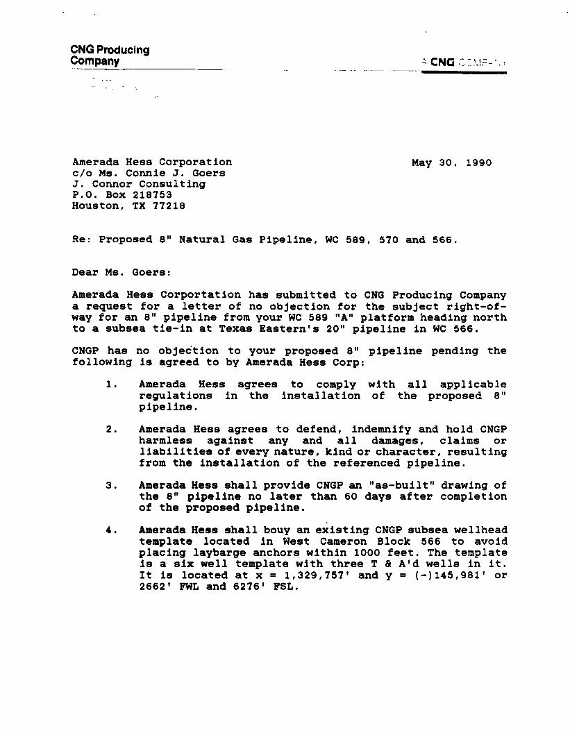
CNG Producing Company ^ CNG CIMP-"
Amerada Hess Corporation May 30, 1990 c/o Ms. Connie J. Goers J. Connor Consulting P.O. Box 218753 Houston, TX 77218
Re: Proposed 8" Natural Gas Pipeline, WC 589, 570 and 566.
Dear Ms. Goers:
Amerada Hess Corportation has submitted to CNG Producing Company a request for a l e t t e r of no objection for the subject r i g h t - o f -way for an 8" pipeline from your WC 589 "A" platform heading north to a subsea t i e - i n at Texas Eastern's 20" pipeline i n WC 566.
CNGP has no objection to your proposed 8" pipeline pending the following i s agreed to by Amerada Hess Corp:
1. Amerada Hess agrees to comply with a l l applicable regulations i n the i n s t a l l a t i o n of the proposed 8" pipeline.
2. Amerada Hess agrees to defend, indemnify and hold CNGP harmless against any and a l l damages, claims or l i a b i l i t i e s of every nature, kind or character, r e s u l t i n g from the i n s t a l l a t i o n of the referenced pipeline.
3. Amerada Hess s h a l l provide CNGP an " a s - b u i l t " drawing of the 8" pipeline no l a t e r than 60 days a f t e r completion of the proposed pipeline.
4. Amerada Hess s h a l l bouy an e x i s t i n g CNGP subsea wellhead template located i n West Cameron Block 566 to avoid placing laybarge anchors w i t h i n 1000 feet. The template i s a s i x we l l template with three T & A'd wells i n i t . I t i s located at x = 1,329,757' and y = M ^ S . g a i 1 or 2662' FWL and 6276' FSL.
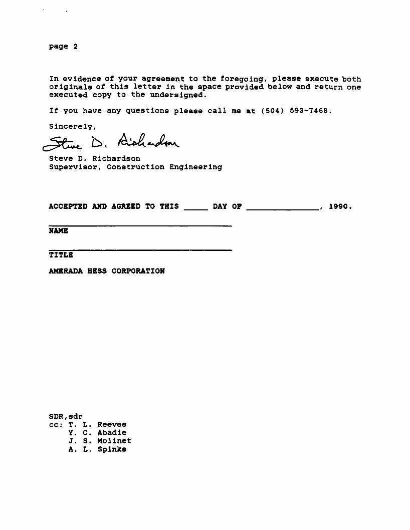
page 2
In evidence of your agreement to the foregoing, please execute both o r i g i n a l s of t h i s l e t t e r i n the space provided below and return one executed copy to the undersigned.
I f you have any questions please c a l l me at (504) 593-7468.
Sincerely,
Steve D. Richardson Supervisor, Construction Engineering
ACCEPTED AND AGREED TO THIS DAY OP , 1990,
NAME
TITLE
AMERADA HESS CORPORATION
SDR,sdr cc: T. L. Reeves
Y. C. Abadie J. S. Molinet A. L. Spinks
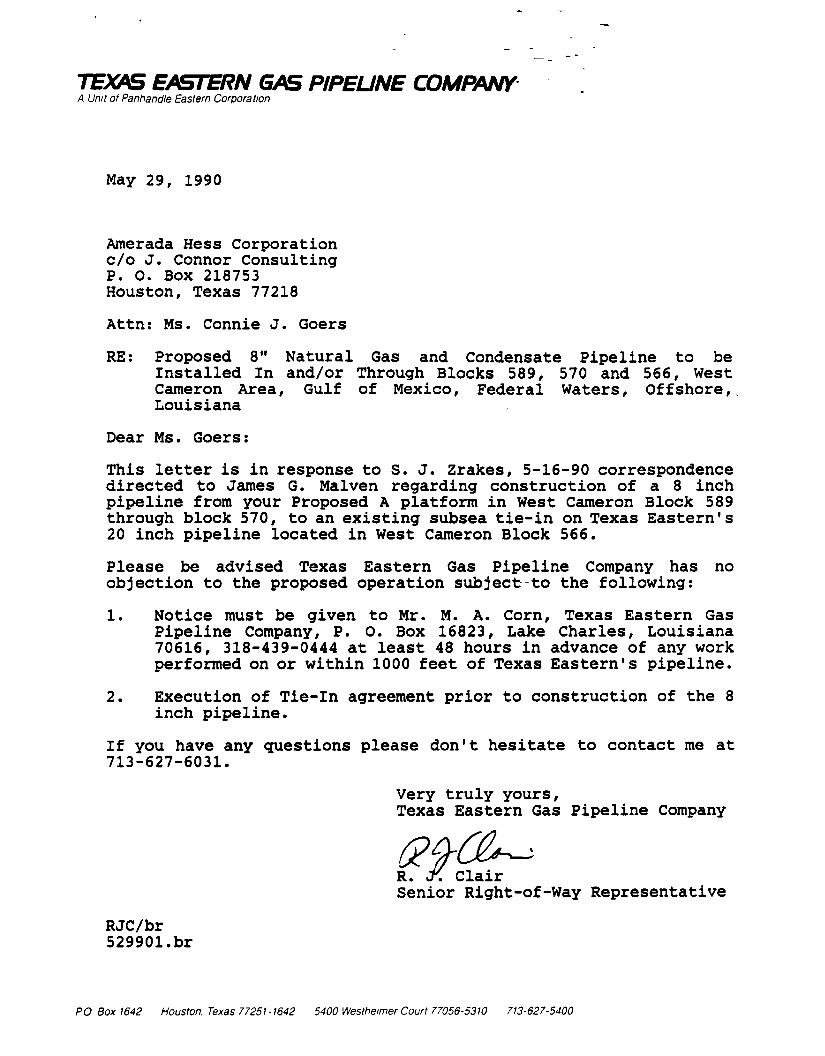
TEXAS EASTERN GAS PIPEUNE COMPANY A Unit of Panhandle Eastern Corporation
May 29, 1990
Amerada Hess Corporation c/o J. Connor Consulting P. O. Box 218753 Houston, Texas 77218
Attn: Ms. Connie J. Goers
RE: Proposed 8" Natural Gas and Condensate Pipeline to be Installed In and/or Through Blocks 589, 570 and 566, West Cameron Area, Gulf of Mexico, Federal Waters, Offshore,, Louisiana
Dear Ms. Goers:
This letter i s in response to S. J. Zrakes, 5-16-90 correspondence directed to James G. Malven regarding construction of a 8 inch pipeline from your Proposed A platform in West Cameron Block 589 through block 570, to an existing subsea tie-in on Texas Eastern's 20 inch pipeline located in West Cameron Block 566.
Please be advised Texas Eastern Gas Pipeline Company has no objection to the proposed operation subject to the following:
1. Notice must be given to Mr. M. A. Corn, Texas Eastern Gas Pipeline Company, P. 0. Box 16823, Lake Charles, Louisiana 70616, 318-439-0444 at least 48 hours in advance of any work performed on or within 1000 feet of Texas Eastern's pipeline.
2. Execution of Tie-in agreement prior to construction of the 8 inch pipeline.
I f you have any questions please don't hesitate to contact me at 713-627-6031.
Very truly yours, Texas Eastern Gas Pipeline Company
R. y. Clair Senior Right-of-Way Representative
RJC/br 529901.br
PO Box1642 Houston. Texas 77251 -1642 5400 Westheimer Court 77056-5310 713-627-5400
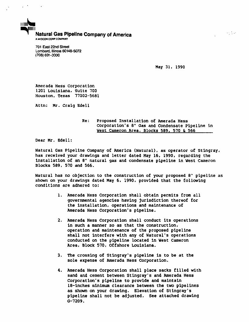
Natural Gas Pipeline Company of America A MIOCON CORP COMPANY
701 East 22nd Street Lombard, Illinois 60148-5072 (708) 691-3000
May 31, 1990
Amerada Hess Corporation 1201 Louisiana, Suite 700 Houston, Texas 77002-5681
Attn: Mr. Craig Edell
Re: Proposed Installation of Amerada Hess Corporation's 8" Gas and Condensate Pipeline in West Cameron Area. Blocks 589, 570 & 566
Dear Mr. Edell:
Natural Gas Pipeline Company of America (Natural), as operator of Stingray, has received your drawings and letter dated May 16, 1990, regarding the installation of an 8" natural gas and condensate pipeline in West Cameron Blocks 589, 570 and 566.
Natural has no objection to the construction of your proposed 8" pipeline as shown on your drawings dated May 6, 1990, provided that the following conditions are adhered to:
1. Amerada Hess Corporation shall obtain permits from all governmental agencies having jurisdiction thereof for the installation, operations and maintenance of Amerada Hess Corporation's pipeline.
2. Amerada Hess Corporation shall conduct its operations in such a manner so as that the construction, operation and maintenance of the proposed pipeline shall not interfere with any of Natural's operations conducted on the pipeline located in West Cameron Area, Block 570, Offshore Louisiana.
3. The crossing of Stingray's pipeline is to be at the sole expense of Amerada Hess Corporation.
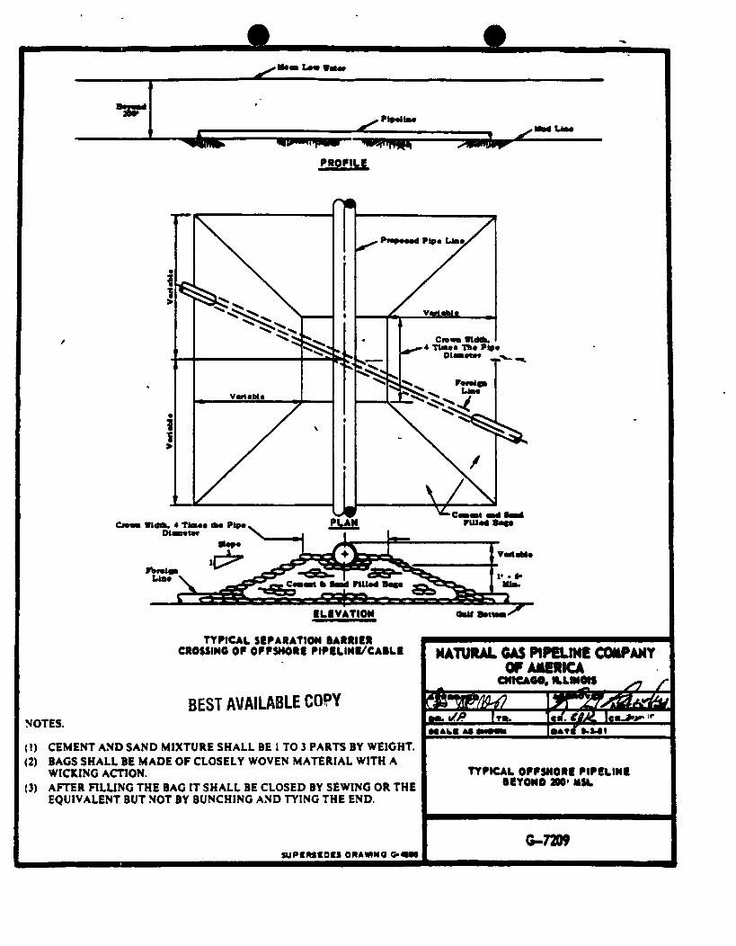
4. Amerada Hess Corporation shall place sacks filled with sand and cement between Stingray's and Amerada Hess Corporation's pipeline to provide and maintain 18-inches minimum clearance between the two pipelines as shown on your drawing. Elevation of Stingray's pipeline shall not be adjusted. See attached drawing G-7209.
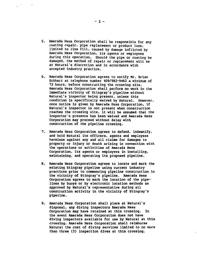
- 2 -
5. Amerada Hess Corporation shall be responsible for any coating repair, pipe replacement or product loss, limited to line f i l l , caused by damage inflicted by Amerada Hess Corporation, its agents or employees during this operation. Should the pipe or coating be damaged, the method of repair or replacement will be at Natural's discretion and in accordance with accepted industry practice.
6. Amerada Hess Corporation agrees to notify Mr. Brian Eckhart at telephone number 409/982-9462 a minimum of 72 hours, before constructing the crossing site. Amerada Hess Corporation shall perform no work in the immediate vicinity of Stingray's pipeline without Natural's inspector being present, unless this condition is specifically waived by Natural. However, once notice is given by Amerada Hess Corporation, if Natural's inspector is not present when construction reaches the crossing site, it will be assumed that the inspector's presence has been waived and Amerada Hess Corporation may proceed without delay with construction of the pipeline crossing.
7. Amerada Hess Corporation agrees to defend, indemnify, and hold Natural its officers, agents and employees harmless against any and all claims for damages to property or injury or death arising in connection with the operations or activities of Amerada Hess Corporation, its agents or employees in installing, maintaining, and operating its proposed pipeline.
8. Amerada Hess Corporation agrees to locate and mark the existing Stingray pipeline using current industry practices prior to commencing pipeline construction in the vicinity of Stingray's pipeline. Amerada Hess Corporation agrees to mark the location of the pipelines by buoys or by electronic location methods as approved by Natural's representative during all construction activity in the vicinity of Stingray's pipeline.
9. Amerada Hess Corporation shall place at Natural's disposal, any diving inspectors Amerada Hess Corporation may have retained at this crossing. In the event Amerada Hess Corporation does not have diving inspectors available for use by Natural at this crossing, Amerada Hess Corporation shall reimburse Natural the cost of diving services limited to no more than three (3) inspection dives at this crossing.
- 3 -
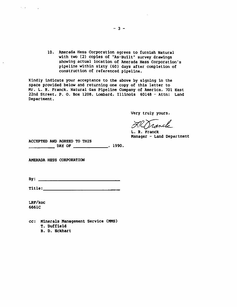
10. Amerada Hess Corporation agrees to furnish Natural with two (2) copies of "As-Built" survey drawings showing actual location of Amerada Hess Corporation's pipeline within sixty (60) days after completion of construction of referenced pipeline.
Kindly indicate your acceptance to the above by signing in the space provided below and returning one copy of this letter to Mr. L. R. Franck, Natural Gas Pipeline Company of America, 701 East 22nd Street, P. O. Box 1208, Lombard, Illinois 60148 - Attn: Land Department.
Very truly yours,
L. R. Franck Manager - Land Department
ACCEPTED AND AGREED TO THIS DAY OF , 1990.
AMERADA HESS CORPORATION
By:
Title:
LRF/koc 6661C
cc: Minerals Management Service (MMS) T. Duffield B. D. Eckhart
• Law WMw
PROPILB
Oo** *t«h, 4 Time* ttt* n p * v
Diamaur ^ ruM r
ELEVATION
TYPICAL SEPARATION BARRIER CROSSING OF OFFSHORE FIFELINE/CABLE
BEST AVAILABLE COPY
NATURAL GAS PIPELINE COMPANY OP AMERICA
CMtCAOO. ILLMOtS
NOTES.
(!) CEMENT AND SAND MIXTURE SHALL BE I TO 3 PARTS BY WEIGHT. (2) BAGS SHALL BE MADE OF CLOSELY WOVEN MATERIAL WITH A
WICKING ACTION. (3) AFTER FILLING THE BAG IT SHALL BE CLOSED BY SEWING OR THE
EQUIVALENT BUT NOT BY BUNCHING AND TYING THE END.
suPtweoes ORAMNO O - « M
TYFICAL OFFSHORE PIPELIN! BEYOND 200* MSC
6-7209
BEST AVAILABLE COPY
RMERHDR HESS CDRPORRTION
1201 L O U I S I A N A . S U I T E 7 0 0 H O U S T O N . T E X A S 7 7 0 0 2 - 5 6 8 1
713-69S-9770
CERTIFIED MAIL - RETURN RECEIPT REQUESTED
May 16, 1990
Stingray Pipeline Co. P. 0. Box 1642 Houston, Texas 77001
Attention: D. N. Huebner
Subject: Proposed 8" Natural Gas and Condensate Pipeline to be Installed In and/or Through Blocks 589, 570 and 566, West Cameron Area, Gulf of Mexico, Federal Waters, Offshore, Louisiana
Gentlemen:
In accordance with 30 CFR 250.160(c) Amerada Hess Corporation hereby gives notice that it Is applying for a pipeline right-of-way originating at Amerada Hess Corporation's West Cameron Block 589, OCS-G 5352, Platform "A" and heading In a northerly direction to a subsea tie-in at Texas Eastern Gas Transmission Company's 20-Inch pipeline in West Cameron Block 566. The entire proposed right-of-way Is located in federal waters in the Gulf of Mexico off the coast of Louisiana.
Amerada Hess Corporation respectfully requests a letter of no objection to the proposed project at your earliest convenience. To assist you in that regard, enclosed please find a letter of response which only need be completed, executed and dated. Also enclosed are plan and profile drawings of the proposed pipeline. Your expeditious efforts completing the letter of no objection will be most appreciated. Should you require additional infonnation, please contact Mr. Craig Edell at (713) 752-5910.
Sincerely,
Jl. ^^L. S. 3. Zrake Supervisor, Regulatory Affairs
SJZ:CJG:bl
(WC5898.PL} Enclosures
RMERRDR HESS CDRPORRTION BEST AVAILABLE COPY
1201 L O U I S I A N A . S U I T E 7 0 0 H O U S T O N . T E X A S 7 7 0 0 2 - S 6 8 I
7IS-CS8-S770
CERTIFIED MAIL - RETURN RECEIPT REQUESTED
May 16, 1990
CNG Producing Company CNG Tower 1450 Poydras Street New Orleans, LA 70112
Attention: Yvonne Abadie
Subject: Proposed 8" Natural Gas and Condensate Pipeline to be Installed In and/or Through Blocks 589, 570 and 566, West Cameron Area, Gulf of Mexico, Federal Waters, Offshore, Louisiana
Gentlemen:
In accordance with 30 CFR 250.160(c) Amerada Hess Corporation hereby gives notice that it is applying for a pipeline right-of-way originating at Amerada Hess Corporation's West Cameron Block 589, OCS-G 5352, Platform "A" and heading in a northerly direction to a subsea tie-in at Texas Eastern Gas Transmission Company's 20-inch pipeline in West Cameron Block 566. The entire proposed right-of-way is located in federal waters in the Gulf of Mexico off the coast of Louisiana.
Amerada Hess Corporation respectfully requests a letter of no objection to the proposed project at your earliest convenience. To assist you In that regard, enclosed please find a letter of response which only need be completed, executed and dated. Also enclosed are plan and profile drawings of the proposed pipeline. Your expeditious efforts completing the letter of no objection will be most appreciated. Should you require additional information, please contact Mr. Craig Edell at (713) 752-5910.
Sincerely,
S. J. Zrake Supervisor, Regulatory Affairs SJZ:CJG:bl
{WC5898.PL) Enclosures
RMERRDR HESS CDRPDRRTIDN 'EST AVAILABLE COPY
1201 L O U I S I A N A . S U I T E 7 0 0 H O U S T O N . T E X A S 7 7 0 0 2 - 5 6 8 1
7 I 3 - 6 S 8 - 9 7 7 0
CERTIFIED MAIL - RETURN RECEIPT REQUESTED
May 16, 1990
Texas Eastern Transmission Corp. P. 0. Box 2521 Houston, Texas 77252
Attention: James G. Malven
Subject: Proposed 8" Natural Gas and Condensate Pipeline to be Installed In and/or Through Blocks 589, 570 and 566, West Cameron Area, Gulf of Mexico, Federal Waters, Offshore, Louisiana
Gentlemen:
In accordance with 30 CFR 250.160(c) Amerada Hess Corporation hereby gives notice that it is applying for a pipeline right-of-way originating at Amerada Hess Corporation's West Cameron Block 589, OCS-G 5352, Platform "A" and heading in a northerly direction to a subsea tie-in at Texas Eastern Gas Transmission Company's 20-inch pipeline in West Cameron Block 566. The entire proposed right-of-way is located in federal waters in the Gulf of Mexico off the coast of Louisiana.
Amerada Hess Corporation respectfully requests a letter of no objection to the proposed project at your earliest convenience. To assist you in that regard, enclosed please find a letter of response which only need be completed, executed and dated. Also enclosed are plan and profile drawings of the proposed pipeline. Your expeditious efforts completing the letter of no objection will be most appreciated. Should you require additional Information, please contact Mr. Craig Edell at (713) 752-5910.
Sincerely,
- r S. J. Zrake Supervisor, Regulatory Affairs
SJZ:CJG:bl
(WC5898.PL} Enclosures
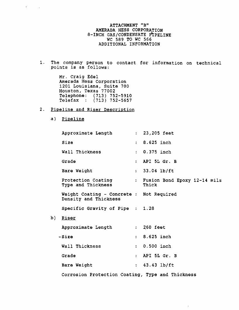
ATTACHMENT "B" AMERADA HESS CORPORATION
8-INCH GAS/CONDENSATE E^PELINE WC 589 TO WC 566
ADDITIONAL INFORMATION
The company person to contact for information on technical points i s as follows:
Mr. Craig Edel Amerada Hess Corporation 1201 Louisiana, Suite 700 Houston, Texas 77002 Telephone: (713) 752-5910 Telefax : (713) 752-5657
Pipeline and Riser Description
a) Pipeline
Approximate Length
Size
Wall Thickness
Grade
Bare Weight
Protection Coating Type and Thickness
Weight Coating - Concrete Density and Thickness
Specific Gravity of Pipe
b) Riser
Approximate Length
-Size
Wall Thickness
Grade
Bare Weight
23,205 feet
8.625 inch
0.375 inch
API 5L Gr. B
33.04 l b / f t
Fusion Bond Epoxy 12-14 mils Thick
Not Required
1.28
260 feet
8.625 inch
0.500 inch
API 5L Gr. B
43.43 l b / f t
Corrosion Protection Coating, Type and Thickness
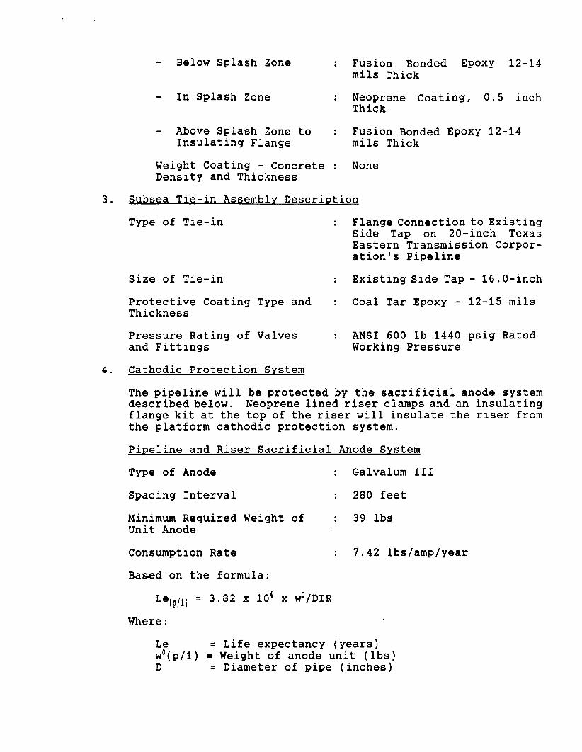
- Below Splash Zone
- In Splash Zone
- Above Splash Zone to Insulating Flange
Weight Coating - Concrete Density and Thickness
Fusion Bonded Epoxy 12-14 mils Thick
Neoprene Coating, 0.5 inch Thick
Fusion Bonded Epoxy 12-14 mils Thick
None
Subsea Tie-in Assembly Description
Type of Tie-in Flange Connection to Existing Side Tap on 20-inch Texas Eastern Transmission Corporation's Pipeline
Existing Side Tap - 16.0-inch
Coal Tar Epoxy - 12-15 mils
ANSI 600 lb 1440 psig Rated Working Pressure
Size of Tie-in
Protective Coating Type and Thickness
Pressure Rating of Valves and Fittings
Cathodic Protection System
The pipeline w i l l be protected by the s a c r i f i c i a l anode system described below. Neoprene lined r i s e r clamps and an insulating flange kit at the top of the riser w i l l insulate the riser from the platform cathodic protection system.
Pipeline and Riser S a c r i f i c i a l Anode System
Type of Anode
Spacing Interval
Minimum Required Weight of Unit Anode
Consumption Rate
Based on the formula:
Le ( p / 1) = 3.82 x 10⁴ x w0/DIR
Galvalum I I I
280 feet
39 lbs
7.42 Ibs/amp/year
Where:
Le = Life expectancy (years) w0(p/l) = Weight of anode unit (lbs) D = Diameter of pipe (inches)
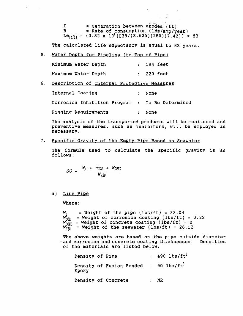
I = Separation between anodes (ft) R = Rate of consumption (Ibs/amp/year)
Le { p / 1 ) = (3.82 x 10*) [ 39/(8 . 625 ) ( 280 ) ( 7 . 42 ) ] = 83
The calculated lif e expectancy is equal to 83 years.
5. Water Depth for Pipeline (to TOP of Pipe)
Minimum Water Depth 194 feet
Maximum Water Depth : 220 feet
6. Description of Internal Protective Measures Internal Coating
Corrosion Inhibition Program
Pigging Requirements
None
To Be Determined
None
The analysis of the transported products will be monitored and preventive measures, such as inhibitors, will be employed as necessary.
Specific Gravity of the Empty Pipe Based on Seawater
The formula used to calculate the specific gravity is as follows:
S G _ yp + ^ + vm<: WH20
a) Line Pipe
Where:
W. = Weight of the pipe (lbs/ft) = 33.04 WQQJ = Weight of corrosion coating (lbs/ft) = 0.22 wC0!!C = Weight of concrete coating (lbs/ft) = 0 WH20 = W e i 9 h t o f t h e seawater (lbs/ft) = 26.12
The above weights are based on the pipe outside diameter -and corrosion and concrete coating thicknesses. Densities of the materials are listed below:
Density of Pipe : 490 lbs/ft 3
Density of Fusion Bonded : 90 lbs/ft 3
Epoxy
Density of Concrete : NR
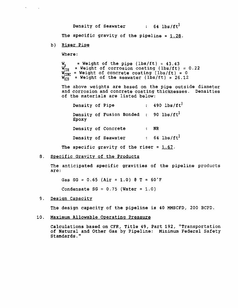
Density of Seawater : 64 lbs/ft 3
The specific gravity of the pipeline = 1.28.
b) Riser Pipe
Where:
W = Weight of the pipe (lbs/ft) = 43.43 w£0[i = Weight of corrosion coating (lbs/ft) = 0.22 wC0HC = W e i g h t of concrete coating (lbs/ft) = 0 WH20 = Weight of the seawater (lbs/ft) = 26.12
The above weights are based on the pipe outside diameter and corrosion and concrete coating thicknesses. Densities of the materials are listed below:
Density of Pipe : 490 lbs/ft 3
Density of Fusion Bonded : 90 lbs/ft 3
Epoxy
Density of Concrete : NR
Density of Seawater : 64 lbs/ft 3
The specific gravity of the riser = 1.67.
8. Specific Gravity of the Products
The anticipated specific gravities of the pipeline products are:
Gas SG = 0.65 (Air = 1.0) @ T = 60°F
Condensate SG = 0.75 (Water = 1.0)
9. Desiqn Capacity
The design capacity of the pipeline is 40 MMSCFD, 200 BCPD.
10. Maximum Allowable Operating Pressure
Calculations based on CFR, Title 49, Part 192, "Transportation of Natural and Other Gas by Pipeline: Minimum Federal Safety Standards."
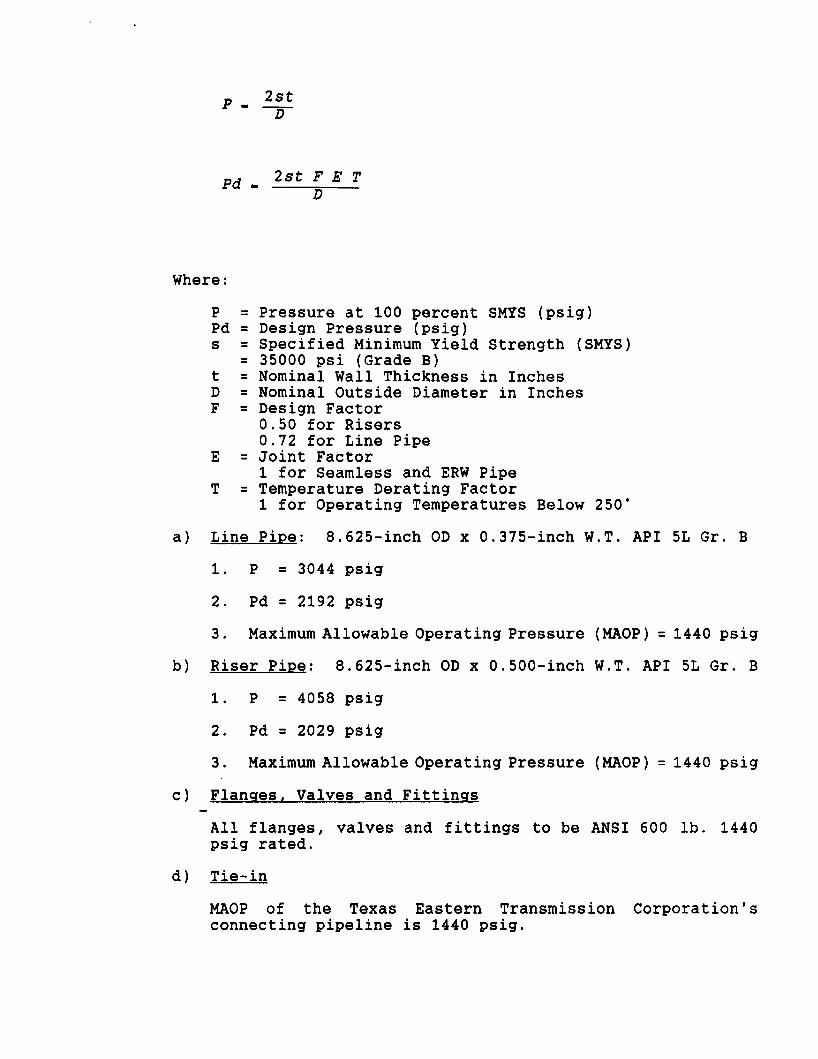
p - l££
Pd - 2 s t F E T
Where:
P = Pressure at 100 percent SMYS (psig) Pd = Design Pressure (psig) s = Specified Minimum Yield Strength (SMYS)
= 35000 psi (Grade B) t = Nominal Wall Thickness in Inches D = Nominal Outside Diameter in Inches F = Design Factor
0 . 50 for Risers 0.72 for Line Pipe
E = Joint Factor 1 for Seamless and ERW Pipe
T = Temperature Derating Factor 1 for Operating Temperatures Below 250°
a) Line Pipe: 8.625-inch OD x 0.375-inch W.T. API 5L Gr. B
1. P = 3044 psig
2. Pd = 2192 psig
3. Maximum Allowable Operating Pressure (MAOP) = 1440 psig
b) Riser Pipe: 8.625-inch OD x 0.500-inch W.T. API 5L Gr. B
1. P = 4058 psig
2. Pd = 2029 psig
3. Maximum Allowable Operating Pressure (MAOP) = 1440 psig
c) Flanges, Valves and Fittings
All flanges, valves and fittings to be ANSI 600 lb. 1440 psig rated.
d) Tie-in
MAOP of the Texas Eastern Transmission Corporation's connecting pipeline i s 1440 psig.
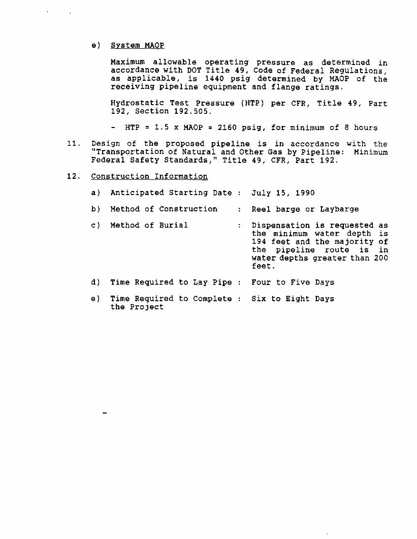
e) System MAOP
11.
12.
Maximum allowable operating pressure as determined in accordance with DOT Title 49, Code of Federal Regulations, as applicable, i s 1440 psig determined by MAOP of the receiving pipeline equipment and flange ratings.
Hydrostatic Test Pressure (HTP) per CFR, T i t l e 49, Part 192, Section 192.505.
- HTP = 1.5 x MAOP = 2160 psig, for minimum of 8 hours
Design of the proposed pipeline i s in accordance with the "Transportation of Natural and Other Gas by Pipeline: Minimum Federal Safety Standards," Title 49, CFR, Part 192.
Construction Information
a) Anticipated Starting Date
b) Method of Construction
c) Method of Burial
d) Time Required to Lay Pipe
e) Time Required to Complete the Project
July 15, 1990
Reel barge or Laybarge
Dispensation i s requested as the minimum water depth i s 194 feet and the majority of the pipeline route i s in water depths greater than 200 feet.
Four to Five Days
Six to Eight Days
UNITED STATES DEPARTMENT OF THE INTERIOR MINERALS MANAGEMENT SERVICE
NONDISCRIMINATION IN EMPLOYMENT
As a condition precedent to the approval of the granting of the subject pipeline right-of-way, the grantee, Amerada Hess Corporation, hereby agrees and consents to the following stipulation which is to be incorporated into the application for said right-of-way.
During the performance of this grant the grantee agrees as follows:
During the performance under this grant, the grantee shall fully comply with paragraphs (1) through (7) of Section 202 of Executive Order 11246, as amended (reprinted in 41 CFR 60-1.4(a)), which are for the purpose of preventing discrimination against persons on the basis of race, color, religion, sex or national origin. Paragraphs (1) through (7) of Section 202 of Executive Order 11246, as amended, are incorporated in this grant by reference.
Signature of Grantee Ronald D. Christie Attorney-in-Fact
Date
BEST AVAILABLE COPY
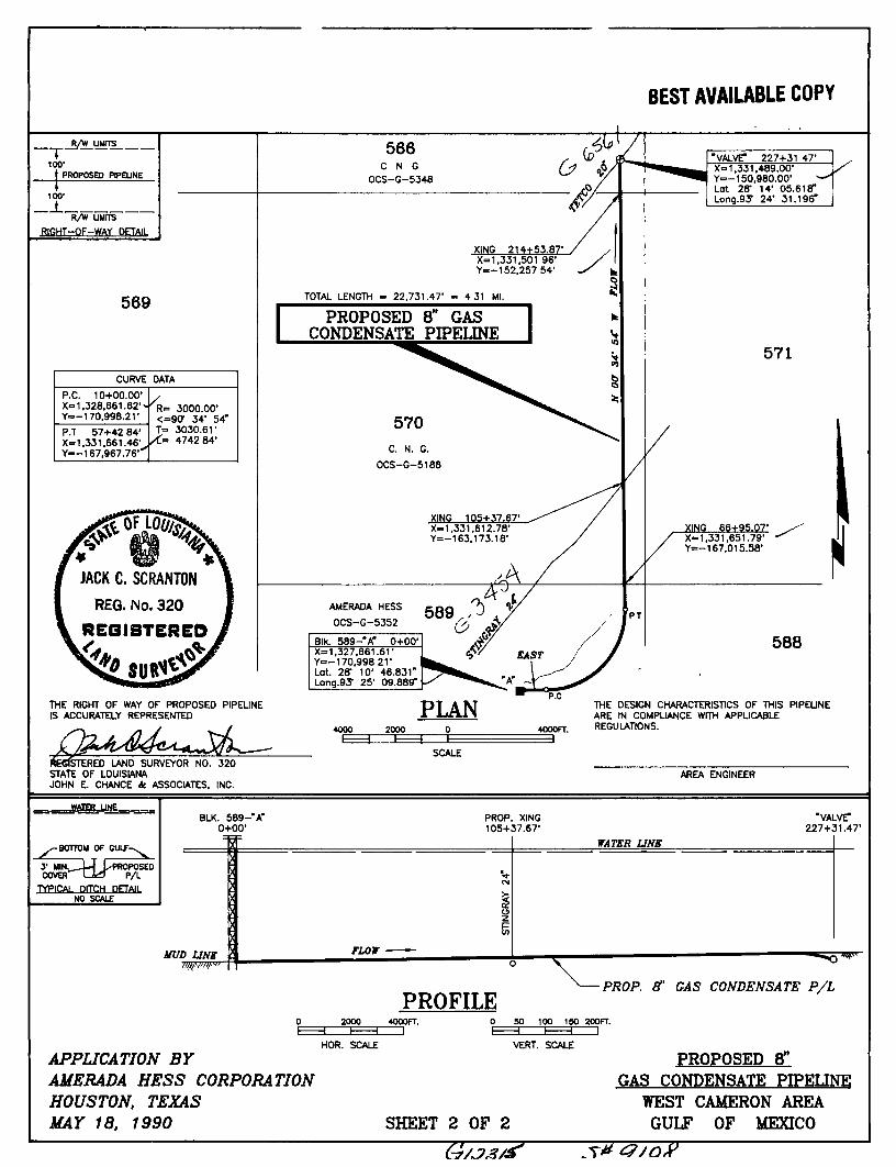
R/Vf UMTTS
100' PROPOSED PIPELINE
100'
_± R/W LIMITS
RIGHT-OF-WAY
"VALVE* 227+31 47' X-1.331.489.00' Y=-150.980.00-Lot 2ff 14- 05.61 er Long.gS- 24' 31.196"
569
CURVE DATA
P.C. 10+00.00-X=1,328.661.62' Y=-170.998.21-
'R* . 3000.00-<=9Cr 34- 54" T= 3030.61-
/ < . " 4742 84-P.T 57+42 84' X=1,331.661.46-Y=-167,967.76'
'R* . 3000.00-<=9Cr 34- 54" T= 3030.61-
/ < . " 4742 84-
THE RIGHT OF WAY OF PROPOSED PIPEUNE IS ACCURATELY REPRESENTED
^EGtSTERED LAND SURVEYOR NO. 320 STATE OF LOUISIANA JOHN E. CHANCE tt. ASSOCIATES. INC.
SCALE
THE DESIGN CHARACTERISTICS OF THIS PIPELINE ARE IN COMPUANCE WITH APPUCABLE REGULATIONS.
AREA ENGINEER
WATER UNE BLK. 589-"A"
o+oo-"VALVT
227+31.47'
BOTTOM OF OULF-
iTIILT L PROPOSED r T - k r P/L
3' MIN. COVER'
TYPICAL DITCH DETAIL NO SCALE
WJD UNE
2000 PROFILE
4000FT. 0
PROP. ET GAS CONDENSATE P/L
• 50 100 ISO
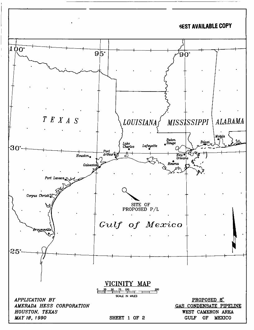
APPLICATION BY AMERADA HESS CORPORATION HOUSTON, TEXAS MAY 18, 1990
HOR. SCALE VERT. SCALE
200FT. HI
SHEET 2 OF 2
G/JJ3/f
PROPOSED 8" GAS CONDENSATE PIPELINE
WEST CAMERON AREA GULF OF MEXICO
BEST AVAILABLE COPY
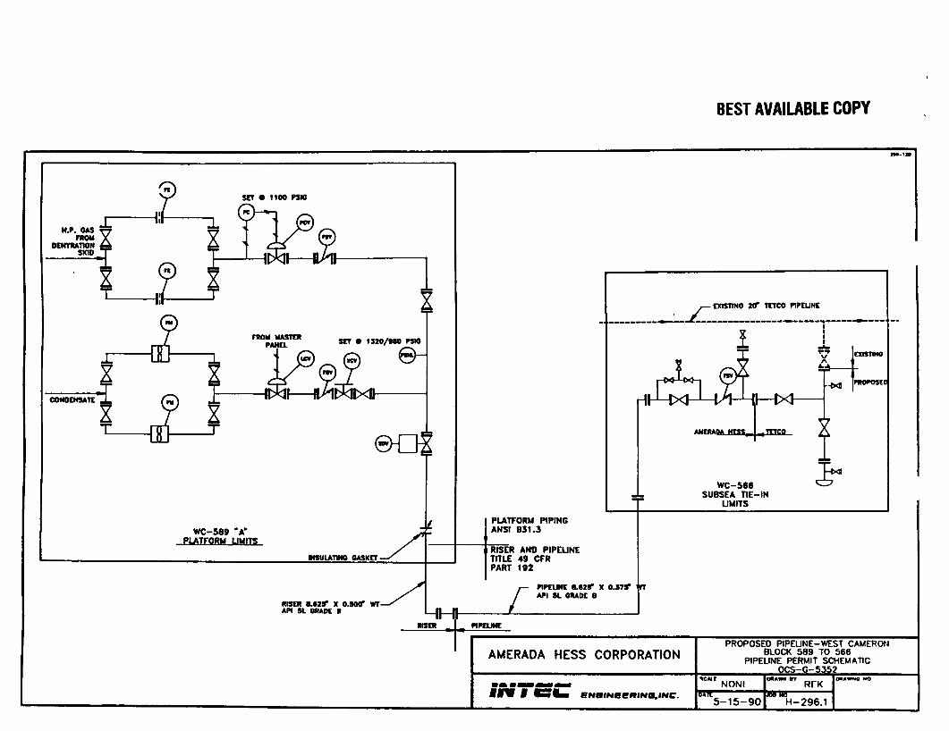
SCT O 1IOO PUG
SCT O 1320/MO PSIQ
en
WC-589 "A" PUTFQRM LIMITS
IHSUIATIMO OASKET -
mscii M T T x o.socr WT-API SL GRADE B
EXISTINO 20" TCTCO PIPEUNE
AUERAOAJSKS.
-MI PHOPOStD
t
PLATFORM PIPING ANSI B31.3
RISER AND PIPELINE TITLE 49 CFR PART 192
L PIPEUNE 8.82*" X 0.575" API SL GRADE 6
WC-566 SUBSEA TIE-IN
UMITS
RISER PIPEUNE
AMERADA HESS CORPORATION
ENBINBeRINa.INC
PROPOSED PIPEUNE-WEST CAMERON BLOCK 589 TO 566
PIPELINE PERMIT SCHEMATIC OCS-O-5352
NONI
5 -15 -90 BTBT
H-296.1

Plp«lla«
PROPILg BEST AVAILABLE COPY
Crown Width. 4 Tlm.t » • Pip* v
Olamattr Mop*
C«a«nt wA Sand PUlad Ba«a
ELEVATION
TYPICAL SEPARATION BARRIER CROSSINO OP OPPSMORE PIPELINE/CASLE
QoU Ba
NOTES.
(1) CEMENT AND SAND MIXTURE SHALL BE I TO 3 PARTS BY WEIGHT. (2) BAGS SHALL BE MADE OF CLOSELY WOVEN MATERIAL WITH A
WICKING ACTION. (3) AFTER FILLING THE BAG IT SHALL BE CLOSED BY SEWING OR THE
EQUIVALENT BUT NOT BY BUNCHING AND TYING THE END.
A4--OI
4
BEST AVAILABLE COPY
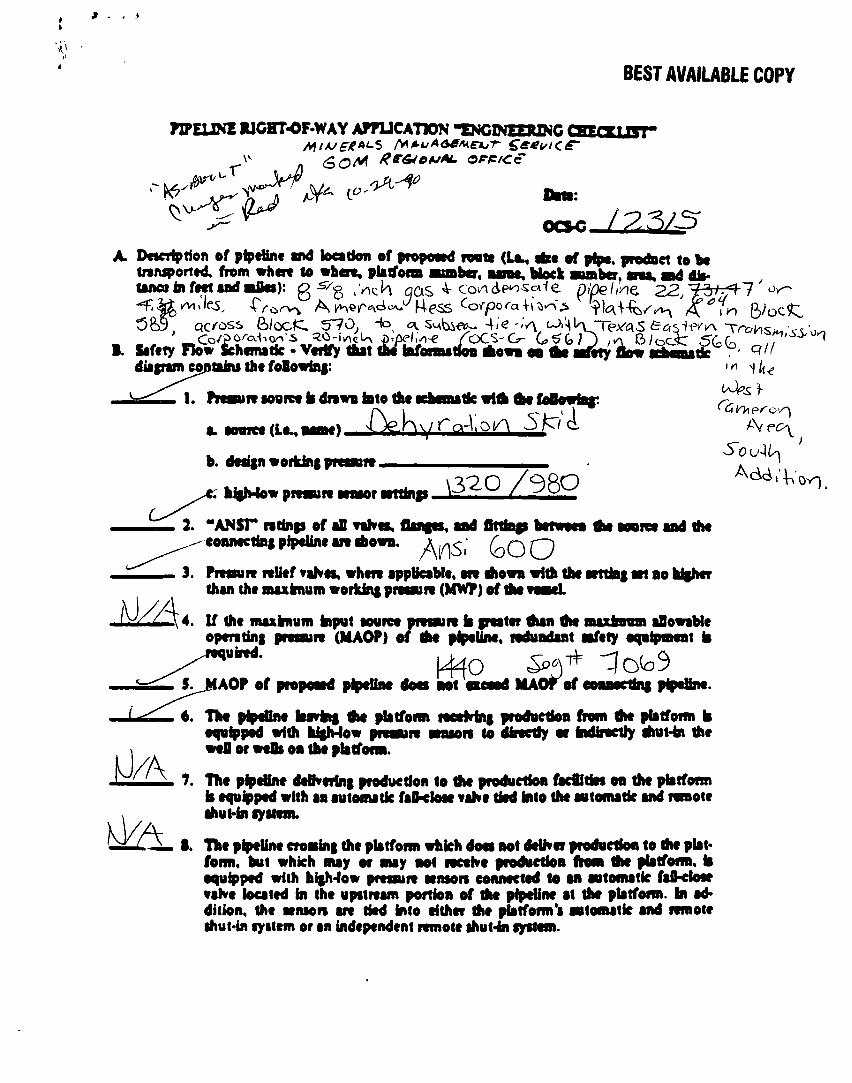
nPEUNE RICHT-OF-WAY AffUCATlON "ENCINEERZNC CSECXLZST"
/CT-Sr
C .Vich qas co/\deo««-fe pipe I ihe. f3
Dwcrtption ef pipeline mA loetdon of propmed toatt (Uu, of pipe, prodaci to bc fniuporttd, from where to where, platfonn auaber, une. Mock auBbcr, cm, ad dto* lance in feet aad aike)
Safety Flow &hcmatfc • Verify that tU bfonut oo *owa oa fte nfety dow a^na£ c / / /
diafram containi the foOowto|:
1. FroBiit IOOICC ii dnwv into the Kheaatk wifli ftc followtaf:
b. d«*i|n workini pm«T»
a. aovrce (Le^ i
hilMow pmnre wmor wttinp, \3^0 / 9 8 Q
1 ^
2. "ANSr ndnp ef aD rahes, flanfes, aad fininp betweea the aoorct aad tfie conmcttai pipeline mdiown. ^ Q Q
3. PmnfT relief vaKes, where apptteable, are riiowa with the ttttfcf Mt ao higher than the auxfcnom workint pitaaiit (MW?) of i
4. If the maxknum input aouree pmaiit k peater Aan the auximm aOowaMe opmdni presure (MAOP) of the pipeline, redundant afety eqeipimat ia required. ^
MAO ef conaectei pipeline. AOP of propoard pipeline docs aot
The pipeline laivini tfie platfonn ieceMn| production from tfie platfonn k equipped with higMow presure aenson to directly or indirectly tfiuHn the weU or weOs on the platfonn.
7. The pipeUne delivering production to the production facflitfct oa the platfonn k equipped with an automatic faD-cIose vaKe tied into the automatic and remote ihut-in lyitem.
1. The pipeUne crosint the platfonn which doea aot delKer production to the plat* forni, but which may or may aot lectKe productioa ftom tfie platfonn. k equipped with hffMow presuie snson connected to an automatic faO-doar vaKe located in the upstieam portion of the pipeline at the platfonn. In addition, the aenson are tied info either the piatform'a automatic and remote ihut-in lystem or an independent remote ihut-in gyttem.
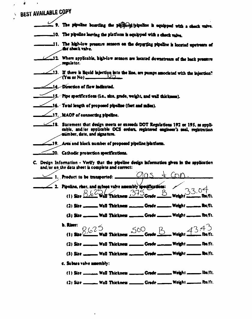
BEST AVAlWBLECpP*
10. Tke p tfiackatfaf the pbtfoa btqalpptdwlA i ctecftnht.
M the dcp«tta| pIpeBne k looted J l . The k%Mo« pitnue rcheekTahe.
11 Whett appBeabk, higMow lenson an looted do Rfulator.
13. tf then k Hquid fajecti^ fato the Mae, (Yea or No).
tpaapi
of AM keek
ted with the h eetioa?
BoffiovMkatad.
Pipe ecifkadom (Lc rite, fnde, weight, and waB thk
1$. Total bagth of propoeed pipeBae (feet aad aalaa).
17. MAOP of eonaeetlng pipdine.
18. Statement that design meets or exceeds DOT Kefulatioas 193 or 195, aa applicable, and/or applicable OCS orden, registered engfaeer's aaal ngktntion
ker, date, and signature.
and block number of proposed pfpellaefrlatfi
20. Cathodic protection spedfkations.
C. Design Infoimation • Verify that the pipeline design hfotmatSoa ghen ki the appUcation and/or on the dau sheet k compkte and correct:
1., Product to be tnnsported:
2. Pipeline rker. and wb^tahe arablyipec£katlons: •er.andpbioltal
(1) site Ui^L-^aB Thkknen 22^Cndt, 6 (2) Sbe
(3»Sixe
b-Rker
. WaO ThkkneB Gnde.
WaO Thkkncs Grade.
(2) Site
(3) tor
.WaO Thkknea
WaO Thkknea
e. Subsea vaKe aaembly:
(1) Size WaO Thkknem
(2l Siie WaO Thkknes
.Gnde.
.Gnde.
.Gnde.
.Gnde.
.Weight
.Weight
.Weight
.Weight
.Weight.
.Weight.
.Weight,
.Weight.
lba/ft.
Ibs/ft.
Ibs/ft.
_ Ibs/ft.
.Ibs/ft.
. ttn/ft.
.lbs/ft.
.Ibs/ft.
BEST AVAILABLE PW
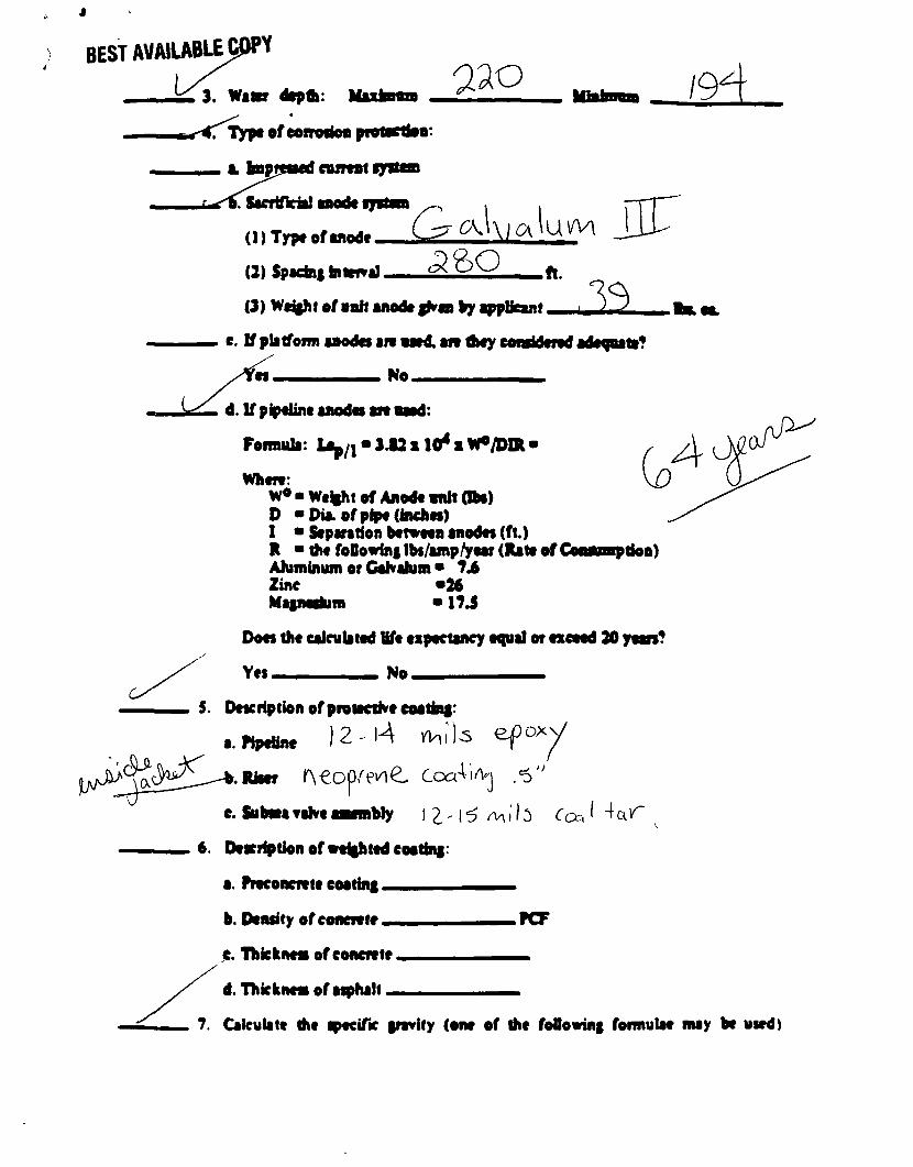
^ 3 . Watsr dcpfli: 020 19 ^Trypc of coiTMfofl protacHon
M M ii ftsprfsod flurtBt qrttn
Sscriflciol iiiwlf fysttn
(1) Typc of anode _
(2) SpednftatmiJ
(3) Wcj|ht of oah anode fKaa by appUeant
e. If platfonn anodes art aaed. aw they conaldeiad adequate?
es No
d. If pipeline anodes aft aaed:
Foimula: Lep/j • J.12 s 10* x W/DDl •
Whete: W0 • we%ht of Anode anh (lbs) D "Dia. of pipe (inches) 1 • Separation between anodes (ft.) R • the foOowini Ibs/amp/year (Rate of Goawmptioa) Ahiminum er CaKahim • 74 Zinc •26 Magnesium • 17 J
Does the calculated Ufe expectancy equal or exceed 20 yean?
Yes No _ _ — _
S. Description of protective coating:
)2-l4 >Wh a. Pipeiine
Riser l ^ € o p ^ ^ CcaVi/Vj ,<5"
e. Subma valve aaambty J^ ' l^ /^ i l s Coa^cK^r
Description of weighted coating:
a. Preconcnte coating
b. Density ofconcnte.
c. Thkknes ofconcnte.
d. Thkknes of asphalt.
7. Calculate the pecifk gravity (one of the foOowing formulae may be used)
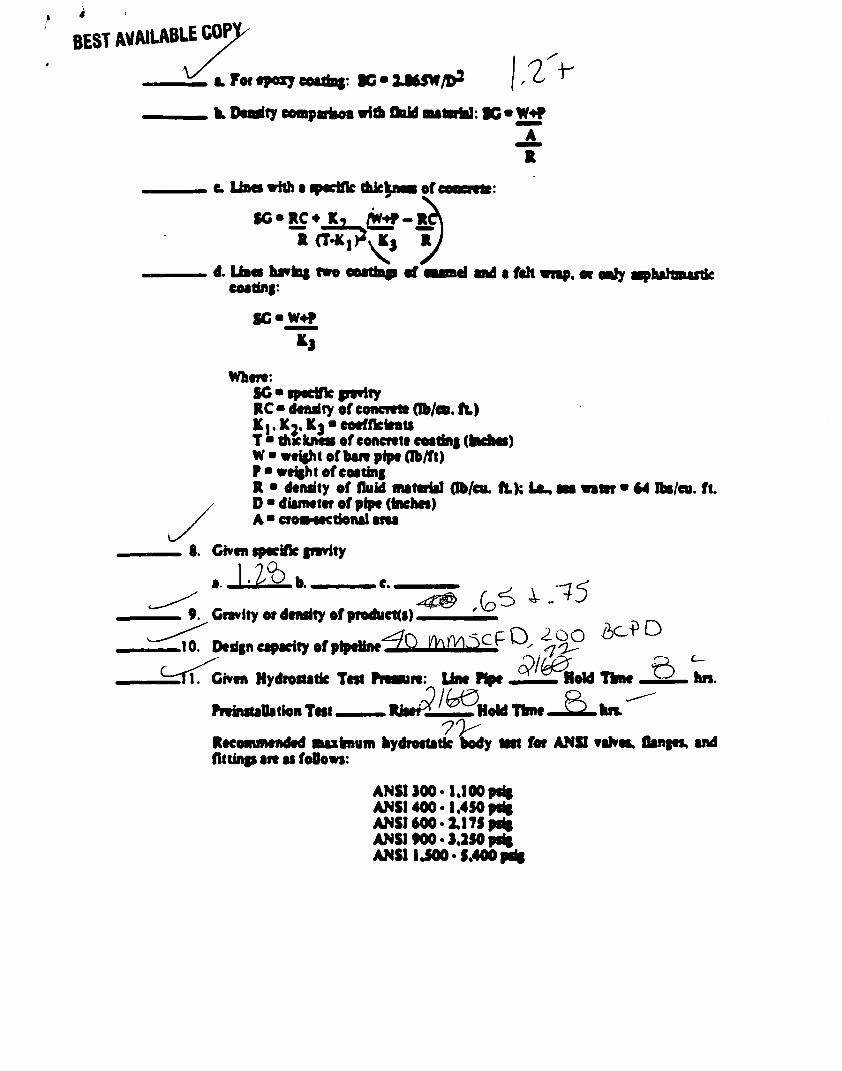
BEST AVWUABLE COP]
I. For tar; KMSBI K-IMSV/D1
h. Deadly eonparfcoa with fhid mateHtf : »G«W+f A
c Uaa with a pecifk thkknea of
SG • RC 4 /W^P-RCA R CT-K^yKj R /
d. Uaei havfai two eoettap ef aaaBd aad a fch wnp. or ealy aaphahmastk coatinf:
SG'W+P
3
When: SC • fptdfk perity RC • denary of concrete db/ca. ft) K^Kj.Ks-coeffkkntt T • thicknes ofconcnte coatinf (MMS) W • weight of ban pipe (lb/ft) P" weight of coating R • density of fluid material Ob/cu. ft); I A , aaa water • 64 tba/cu. ft. D • diameter of pipe (inches) A • croa-sectional ana
8. Given specifk gnvity
^ . . .
9. Gnvity or density of producKs)
.10. Design capacity of pipeMneT^ m^h^^^i^
ft. Given Hydrostatk Test Pnaun: Line Pipe ^ ^Hold Time hn.
PninsuOa tion Tnt Riser^Z^Hold Time hn. ^
Recommended maximum hydrostatk >ody Mat for ANSI ealvca, flanges, and flttinp art M foOows:
ANSI 300* 1.100 psig ANSI 400 • 1.450 prig ANSI 600« 3,175 psig ANSI 900 • 3,350 psig ANSI IJOO-5.400 prig
BEST AVAILABLE COPY
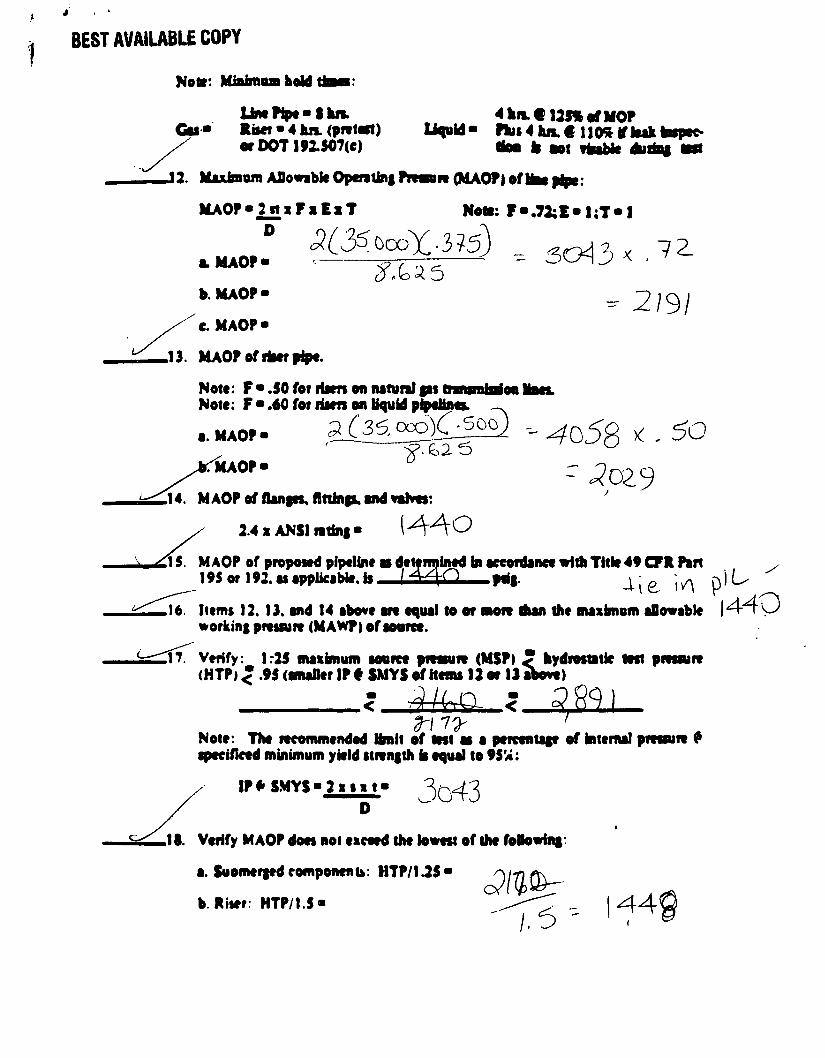
Net*: Mbfanoahold
Umttpe-thn. Ctl • Riser • 4 hn. (pnfart)
or DOT 192.507(e)
4 ha €125% of HOF liquid- Phis 4 hn.€ 110* if leak
tfoo fc oot rfcoble dudni
iiAOP»2it»r»E»T D
-12. Maxiaan Aflovabk Opcntini Pnaun (MAOP) oflkw pipe:
Nota: F«.72;E-1;T-1
fcHAOP. ^——— ~' - 3G45<7^
b.MAOP-
C. MAOP-- 2/9/
.13. MAOP of riser pipe.
Note: F • .50 for risen on natural ps tnramfarioo Note: F-.60 for risen on liquid pipelines. »
5('35,oco)C-5oo) a. MAOP-
SUOP-
^o58 * * 6o
,14. MAOP of flanpa, fininp, and vahes:
2.4 x ANSI ntint • (A\A O
detennined fat accordance with Title 49 CFR Pan ll 5. MAOP of proposed pipeline 195 or 192. as applicable, is
.16 Items 12. 13. and 14 above an equal to or non Aan the maxknum allowable workinf pnssun (MAWp > of source.
17. Verify: 1:25 maxknum source pnssun (MSP) < hydi (HTP) < .95 (smafler IP t SMYS of Hems 12 or 13 above)
hydrostatk test pnssun
^21 Note: The recommended Hmit of lest aa a percentap of knemal pnssun 9 specifked minimum ykld stnngth b equal to 95'«:
IP* SMYS-2xsxi- 3o43 .18. Verify MAOP does nol exceed the lowest of the following:
a. Suomerpd components: HTP/1.25*
b. Riier: HTP/1.5- 44^
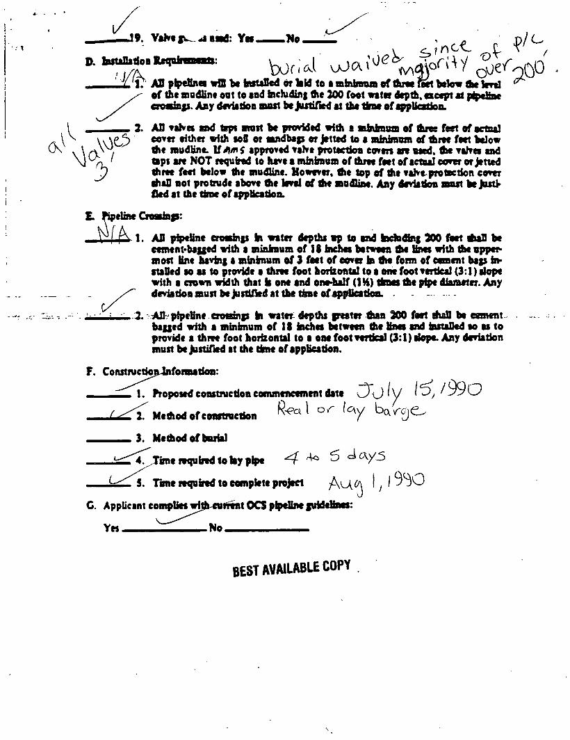
J9. VaKcf^^iead: Yn No Z . , ^ ^ / C
X ' l : AS piptHnct wIS bc fatttaSed or kid to a mbimaa of dim nwt bcknr flw Wrt] ^ of thc modline out to tad hchidinf die 200 foot water depth, except at ptpettae
D. bstalladoB Raqoinmests:
oosiajs. Any deviadoo most be Justified at tha time of application.
AO taKes and tsps most be provided with a mfatlmua of tfutc feet ef sctaal cover either with soil or sandbap or Jetted to a minirenm of three feet below the mudline. VAmf approved vahe protection coven an used, thc vahes and taps an NOT required to have a minimum of three feet of aetaal cover or Jetted three feet below the mudline. However, the top of the vaKe protection cover AaD not protrude above Ac level of Ae mudline. Any deviation mast be Justified at Ac A M of applicadon.
E. Pipeline C
AD pipeline crosahp bi water depths ap to and taduAng 300 feet AaD bc cement-bagged with a minimum of IS inches between the fees with the uppermost Knc having a minbnum of 3 feet of cover in Ae form of cement bap instaDed so as to provide a three foot horizontal to a one foot verdcal (3:1) slope with a crown width Aat is one and one-half (IH) Anas Ae pipe diameter. Any deviation must be justified at Ae Aac of app&catioa.
AD pipefine crosinp to water depths peater Aan 300 feet AaS be cement bagged with a mbtbnum of 18 inches between Ae lines and instaDed so as to provide a Anc foot horizontal to a one foot vertical (3:1) slope. Any deviation must be Justified at Ae Anc of application.
R<ea\ or Icy Wroj^
F. ConstructioiUnfonaation
1. Proposed construction commencement date
J J ^ l . MeAodofceastruction
3. Me Aod of burial
^ r i T j i m e required to lay pipe -4 5 ^ / - ^
i ^ T i T Tunc required to complete project
C. AppUcsnt complies with cut
v~ " No.
it OCS pipeline guideliaes: /
9 0
BEST AVAILABU COPY
MMN E. CHANCE & A S S O C I A T E S , I N C
June 27, 1990
Minerals Management Service MS 5232 1201 Elmwood Boulevard New Orleans, Louisiana 70123-2394
i tvptz*) mo i • FIELD
v % . OPERATIONS fc0CS Region.^ ^
Attention: Ms Carol Williams
RE: Engineering and Hazard Study Blocks 589-566 Uest Cameron Area
Gentlemen:
Please find enclosed three (3) copies of the revised Engineering and Hazard Map for the 8-inch gas condensate pipeline route proposed by Amerada Hess for Blocks 589-566, West Cameron Area. The Revised June 1990 map includes survey line No. 12, and replaces the June 1990 map contained in the interpretive report.
Thank you for this opportunity to be of service, requests, please do not hesitate to call.
Sincerely,
JOHN E. CHANCE AND ASSOCIATES, INC.
If you have any questions or
Gerald Marshall Geophysicist
Enclosures
cc: Craig Edell Amerada Hess Houston, texas
200 DULLES DRIVE LAFAYETTE, LOUISIANA 70506 TELEPHONE 318/237-1300
• Y - - I 4 7 0 0 0
I 5 5 0 0 0
r Y - - I 6 IOOv
o O
o O
o O IO
cvi CM to ro
i
• X X
tn
o g OCS-G-5348 OJ WELL # 1,2 8 3
m i AVAILABLE COPY
O C S - G -
Y - - I 49000
Y - - I 5 I 000
Y - - I 53000
Y - - I 57000
" Y " - I 59000
O C S - G - 5188
Y - - I 6 3 0 0 0
- Y - - I 65000
Y - - I 6 7 0 0 0
- Y - - I 69000
- Y - - I 71000
Y - - 1 7 3 0 0 0 O C S - G - 5 3 5 2
- Y - - I 7 5 0 0 0
PLAN MAP
ZERO DATUM = SEA LEVEL
APPLIED ACOUSTIC VELOCITY = S.OOO'/sec
CONTOUR INTERVAL = 2 FEET
SHOT POINT ft SHOT POINT No.
PROPOSED 8 GAS CONCZNSATE PIPEL NE ROUTE
"A" STRUCTURE
x« Y =
Lot. = Long.=
,327,661.61' - 170,998.21' 28° 10' 46.831" N
93° 25' 09.889" W
Ubuui i
# & % f H. G. TRUELOVE
REG. No. 6045
REGISTERED CIVIL ENGINEER No. 6045 STATE OF LOUISIANA JOHN E. CHANCE 6 ASSOC., INC.
IMPORTANT - PLEASE NOTE
ANY COMMUNICATION AND/OR POWER CABLES THAT MAY BE PRESENT IN THE AREA CANNOT BE LOCATED BY INSTRUMENTS UTILIZED DURING THIS SURVEY. INQUIRIES SHOULD BE MADE TO INTERESTED PARTIES AS TO THE PRESENCE OF SUCH OBSTRUCTIONS.
NOTE- ALL FIELD DATA ACQUIRED MAY 18,22 8 23 1990
REVISED
JUNE, 1990
Amerada Hess Corporation
ENGINEERING 8 HAZARD MAP of
PROPOSED 8" GAS CONDENSATE PIPELINE ROUTE
BLOCK 589 to BLOCK 566
WEST CAMERON AREA
JOHN E. CHANCE a ASSOCIATES, INC.
GEOPHYSICAL DIVISION
LAFAYETTE, LOUISIANA
0 IjOOO S C A L E
2,000
DATE: JUNE 1990
JOB N- 900446
MAP IM- I of 2
BEST AVAILABLE COPY
8 FUTURE CONNECTION 3 / 4 " = 1 ' -0 M
8.625" OO PIPE CUT IM HALF-
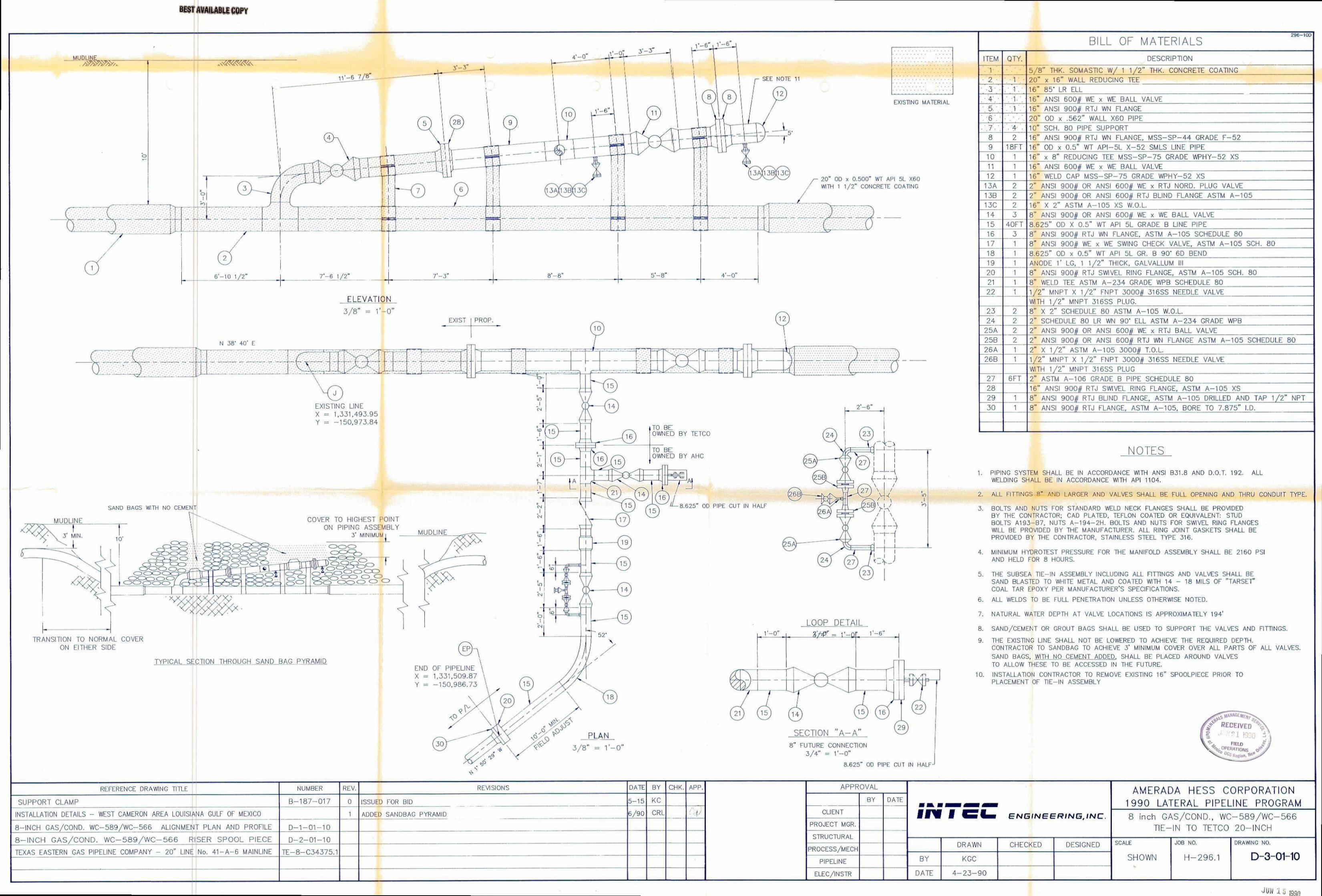
BILL OF MATERIALS 296-1OD
ITEM QTY. DESCRIPTION
• T 5 / 8 " THK. SOMASTIC W/ 1 1/2" THK. CONCRETE COATING
'2 v • 20" x 16" WALL REDUCING TEE 3 . 1 . 16" 85' LR ELL
'.' 4'.- 16" ANSI 600# WE x WE BALL VALVE
/ i r . 1 . 16" ANSI 900# RTJ WN FLANGE •6". 1
20" OD x .562" WALL X60 PIPE
', • 4- 10" SCH, 80 PIPE SUPPORT 8 2 16" ANSI 900# RTJ WN FLANGE, MSS-SP-44 GRADE F-52 9 18FT 16" OD x 0.5" WT API-5L X - 5 2 SMLS LINE PIPE
10 1 16" x 8" REDUCING TEE MSS-SP-75 GRADE WPHY-52 XS 11 1 16" ANSI 600# WE x WE BALL VALVE 12 1 16" WELD CAP MSS-SP-75 GRADE WPHY-52 XS
13A 2 2" ANSI 900# OR ANSI 600# WE x RTJ NORD. PLUG VALVE 13B 2 2" ANSI 900# OR ANSI 600# RTJ BLIND FLANGE ASTM A - l 0 5 13C 2 16" X 2" ASTM A-105 XS W.O.L
3 8" ANSI 900# OR ANSI 600# WE x WE BALL VALVE 15 40FT 8.625" OD X 0.5" WT API 5L GRADE B LINE PIPE 16 3 8" ANSI 9D0# RTJ WN FLANGE. ASTM A-105 SCHEDULE 80 17 1 8" ANSI 900# WE x WE SWING CHECK VALVE, ASTM A-105 SCH. 80 18 1 8.625" OD x 0.5" WT API 5L GR, B 90* 6D BEND 19 1 ANODE 1' LG. 1 1/2" THICK, GALVALLUM (11 20 1 8" ANSI 900// RTJ SWIVEL RING FLANGE, ASTM A-105 SCH, SO 21 1 8" WELD TEE ASTM A - 2 3 4 GRADE WPB SCHEDULE 80 22 1 1/2" MNPT X 1/2" FNPT 3000# 316SS NEEDLE VALVE
WITH 1/2" MNPT 316SS PLUG. 23 2 8" X 2" SCHEDULE 80 ASTM A-105 W.O.L 24 2 2" SCHEDULE 80 LR WN 90' ELL ASTM A - 2 3 4 GRADE WPB
25A 2 2" ANSI 900# OR ANSI 600# WE x RTJ BALL VALVE 25B 2 2" ANSI 900$ OR ANSI 600# RTJ WN FLANGE ASTM A-105 SCHEDULE 80 26A 1 2" X 1/2" ASTM A-105 3000# T.O.L 26B 1 1/2" MNPT X 1/2" FNPT 3000# 316SS NEEDLE VALVE
WITH 1/2" MNPT 316SS PLUG 27 6FT 2" ASTM A - l 0 6 GRADE B PIPE SCHEDULE 80 28 16" ANSI 900# RTJ SWIVEL RING FLANGE, ASTM A-105 XS 29 1 8" ANSI 900# RTJ BLIND FLANGE, ASTM A-105 DRILLED ANO TAP 1/2" NPT 30 1 8" ANSI 900# RTJ FLANGE, ASTM A-105, BORE TO 7.875" l.D,
NOTES
1, PIPING SYSTEM SHALL BE IN ACCORDANCE WITH ANSI B31.8 AND D.O.T. 192. ALL WELDING SHALL BE IN ACCORDANCE WITH API 1104.
ALL FITTINGS SM AND LARGER AND VALVES SHALL BE FULL OPENING AND THRU CONDUIT TYPE.
BOLTS AND NUTS FOR STANDARD WELD NECK FLANGES SHALL BE PROVIDED BY THE CONTRACTOR: CAD PLATED, TEFLON COATED OR EQUIVALENT: STUD BOLTS A193-67. NUTS A-194 -2H . BOLTS AND NUTS FOR SWIVEL RING FLANGES WILL BE PROVIDED BY THE MANUFACTURER. ALL RING JOINT GASKETS SHALL BE PROVIDED BY THE CONTRACTOR. STAINLESS STEEL TYPE 316.
MINIMUM HYDROTEST PRESSURE FOR THE MANIFOLD ASSEMBLY SHALL BE 2160 PSI AND HELD FOR 8 HOURS.
THE SUBSEA TIE-IN ASSEMBLY INCLUDING ALL FITTINGS AND VALVES SHALL BE SAND BLASTED TO WHITE METAL AND COATED WITH U - 18 MILS OF "TARSET" COAL TAR EPOXY PER MANUFACTURER'S SPECIFICATIONS.
6. ALL WELDS TO BE FULL PENETRATION UNLESS OTHERWISE NOTED.
7. NATURAL WATER DEPTH AT VALVE LOCATIONS IS APPROXIMATELY 194'
SAND/CEMENT OR GROUT BAGS SHALL BE USED TO SUPPORT TFIE VALVES AND FITTINGS, THE EXISTING LINE SHALL NOT BE LOWERED TO ACHIEVE THE REQUIRED DEPTH. CONTRACTOR TO SANDBAG TO ACHIEVE 3' MINIMUM COVER OVER ALL PARTS OF ALL VALVES. SAND BAGS, WITH NQ CEMENT ADDED. SHALL BE PLACED AROUND VALVES TO ALLOW THESE TO BE ACCESSED IN THE FUTURE.
10. INSTALLATION CONTRACTOR TO REMOVE EXISTING 16" SPOOLPIECE PRIOR TO PLACEMENT OF TIE-IN ASSEMBLY
W RECEIVED
4 %0fNATIONS
REFERENCE DRAWING TITLE NUMBER REV. REVISIONS DATE BY CHK. APP. APPROVAL
ffffH ff GHCH ENGINEERING, INC.
AMERADA HESS CORPORATON 1990 LATERAL P PEL NE PROGRAM SUPPORT CLAMP B-187 -017 0 ISSUED FOR BID 5-15 KC MY DATE
ffffH ff GHCH ENGINEERING, INC.
AMERADA HESS CORPORATON 1990 LATERAL P PEL NE PROGRAM
INSTALLATION DETAILS • WEST CAMERON AREA LOUISIANA GULF OF MEXICO 1 Ah hi h SANDBAG PYRAMID 6/90 CRL ;S|/ CUENT ffffH ff GHCH ENGINEERING, INC. 8 inch GAS/COND., WC-589/WC-566 TIE-IN TO TETCO 20-INCH 8-INCH GAS/COND. WC-5B9/WC-565 AUGNMENT PLAN AND PROFILE D - 1 - 0 1 - 1 0 PROJECT MGR.
ffffH ff GHCH ENGINEERING, INC. 8 inch GAS/COND., WC-589/WC-566 TIE-IN TO TETCO 20-INCH
8 - I N C H GAS/COND. W C - 5 8 9 / W C - 5 6 6 RISER SPOOL PIECE D - 2 - 0 1 - 1 0 STRUCTURAL
ffffH ff GHCH ENGINEERING, INC. 8 inch GAS/COND., WC-589/WC-566 TIE-IN TO TETCO 20-INCH
8 - I N C H GAS/COND. W C - 5 8 9 / W C - 5 6 6 RISER SPOOL PIECE D - 2 - 0 1 - 1 0 STRUCTURAL DRAWN CHECKED DESIGNED SCALE
SHOWN
JOB NO,
H-296.1
DRAWING NO.
D-3-01-10 TEXAS EASTERN GAS PIPELINE COMPANY - 20" LINE No. 41 -A-6 MAINLINE TE-8-C34375.1 PROCESS/MECH DRAWN CHECKED DESIGNED SCALE
SHOWN
JOB NO,
H-296.1
DRAWING NO.
D-3-01-10 PIPELINE BY KGC
SCALE
SHOWN
JOB NO,
H-296.1
DRAWING NO.
D-3-01-10 ELEC/INSTR DATE 4 - 2 3 - 9 0
SCALE
SHOWN
JOB NO,
H-296.1
DRAWING NO.
D-3-01-10
J,JN ^ J mn
UNITED STATES GOVERNMENT MEMORANDUM
JUL I 2 1990
To: Regional Supervisor, Field Operations, GOM OCS Region (FO)
From: Regional Supervisor, Leasing and Environment, GOM OCS Region (LE)
Subject: National Environmental Policy Act Review for Pipeline Right-of-Way Application OCS-G 12315
Our National Environmental Policy Act (NEPA) review of the subject action is
complete. Environmental protective measure(s), if any, identified to avoid or
mitigate potential impacts associated with the action were included as part of
the NEPA analysis and are shown on the Categorical Exclusion Review (CER).
Attachment
cc: Pipeline File OCS-G 12315
J. Kenneth Adams
(LE-5)
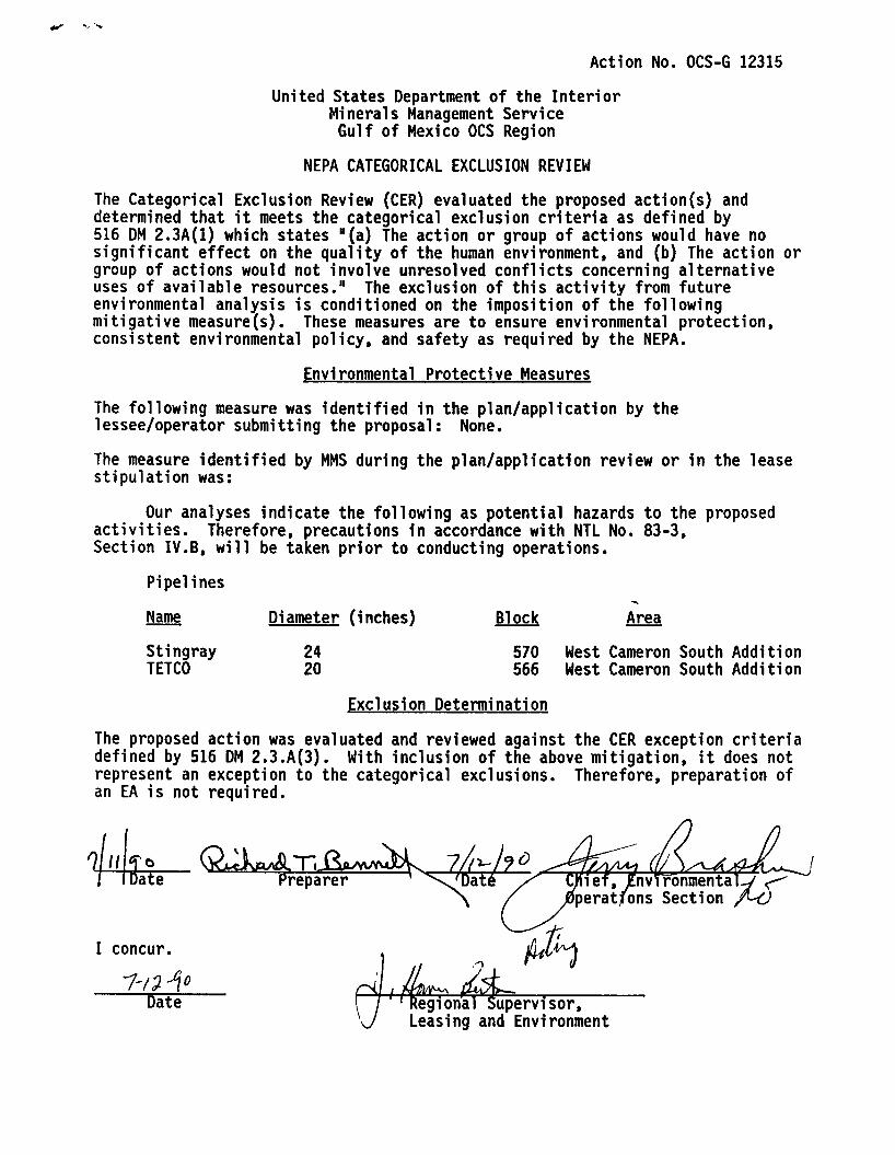
Action No. OCS-G 12315
United States Department of the Interior Minerals Management Service Gulf of Mexico OCS Region
NEPA CATEGORICAL EXCLUSION REVIEW
The Categorical Exclusion Review (CER) evaluated the proposed action(s) and determined that it meets the categorical exclusion criteria as defined by 516 DM 2.3A(1) which states "(a) The action or group of actions would have no significant effect on the quality of the human environment, and (b) The action or group of actions would not involve unresolved conflicts concerning alternative uses of available resources." The exclusion of this activity from future environmental analysis is conditioned on the imposition of the following mitigative measure(s). These measures are to ensure environmental protection, consistent environmental policy, and safety as required by the NEPA.
Environmental Protective Measures
The following measure was identified in the plan/application by the lessee/operator submitting the proposal: None.
The measure identified by MMS during the plan/application review or in the lease stipulation was:
Our analyses indicate the following as potential hazards to the proposed activities. Therefore, precautions in accordance with NTL No. 83-3, Section IV.B, will be taken prior to conducting operations.
Pipelines
Name
Stingray TETCO
Di ameter (inches)
24 20
Block
570 566
Area
West Cameron South Addition West Cameron South Addition
Exclusion Determination
The proposed action was evaluated and reviewed against the CER exception criteria defined by 516 DM 2.3.A(3). With inclusion of the above mitigation, it does not represent an exception to the categorical exclusions. Therefore, preparation of an EA is not required.
7k Date Preparer 1 \'Dat6
I concur.
Date
0^ 1 '^gion^^ upervisor.
Leasing and Environment
lief, EnvTrbnmental-V <• rons Section /^O
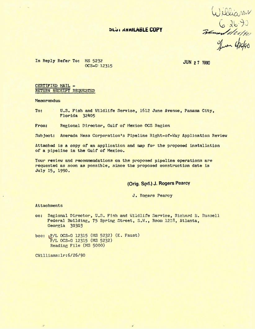
I n Reply Refer To: MS 5232 jyw „ 7 igqf, OCS-G 12315
CERTIFIED HAIL -RETURH RECEIPT RBQUSSTED
MesKjranduQ
To: U.S. Fish and Wildlife Service, 1612 June Avenue, Panama City, Florida 32405
From: Regional Director, Guif of Mexico OCS Region
Subject: Anerada Heas Corporation^ Pipeline Right-of-V.'ay Application Review
Attached i s a copy of an application and taap for the proposed installation of a pipeline i n the Gulf of Mexico.
Your review and recoEBaendations on the proposed pipeline operations are requested es soon as possible, since the proposed construction date is July 15, 1990.
(Orig. Sgd.) J. Rogers Pearcy
J. Rogers Pearcy
Attachaents
cc: Regional Director, U.S. Fish and U i l d l i f e Service, Richard B. Russell Federal Building, 75 Spring Street, S.W., Rooa 1218, Atlanta, Georgia 30303
bcc: iP/L OCS-G 12315 (MS 5232) (K. Faust) P/L OCS-G 12315 (MS 5232) Reading File (MS 5000)
CWilliams:lr:6/26/90
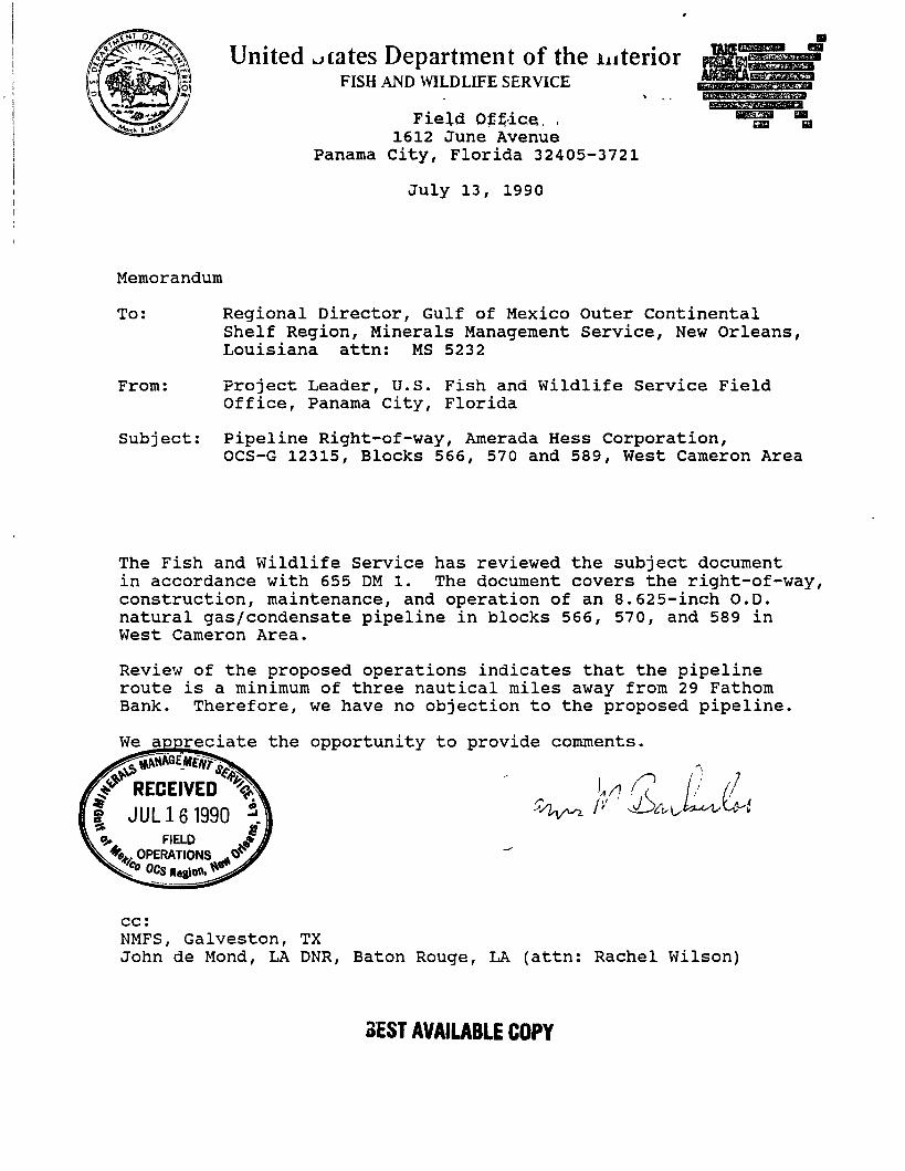
United cates Department of the interior FISH AND WILDLIFE SERVICE
F i e l d Of f i ce . , 1612 June Avenue
Panama C i t y , F lor ida 32405-3721
Ju ly 13, 1990
Memorandum
To: Regional Director, Gulf of Mexico Outer Continental Shelf Region, Minerals Management Service, New Orleans, Louisiana a t t n : MS 5232
From: Project Leader, U.S. Fish and W i l d l i f e Service Field Office, Panama City, Florida
Subject: Pipeline Right-of-way, Amerada Hess Corporation, OCS-G 12315, Blocks 566, 570 and 589, West Cameron Area
The Fish and W i l d l i f e Service has reviewed the subject document i n accordance with 655 DM 1. The document covers the right-of-way, construction, maintenance, and operation of an 8.625-inch O.D. natural gas/condensate pipeline i n blocks 566, 570, and 589 i n West Cameron Area.
Review of the proposed operations indicates that the pipeline route i s a minimum of three nautical miles away from 29 Fathom Bank. Therefore, we have no objection to the proposed pipeline.
We appreciate the opportunity to provide comments.
r
r4r RECEIVED % I JUL 16 1990 A & FIELD
OPERATIONS
cc: NMFS, Galveston, TX John de Mond, LA DNR, Baton Rouge, LA (at t n : Rachel Wilson)
3EST AVAILABLE COPY
RMERRDR HESS CORPORRTI DN ^EST AVAILABLE COPY
1201 LOUISIANA. SUITE 7 0 0 HOUSTON. TEXAS 7 7 0 0 2 - 5 6 8 1
7 1 3 - 6 8 8 - 9 7 7 0
July 18, 1990
Minerals Management Service Gulf of Mexico OCS Region 1201 Elmwood Park Blvd. • New Orleans, Louisiana 70123
Attn: Ms. Carol Williams FO-2-2.
Re: Additional Site Information At Side-Tap Location Application for a Pipeline Right-of-Way Proposed 8.625-inch O.D. Natural Gas/Condensate Pipeline From West Cameron Block 5$9, OCS-G-5352, Platform A To an existing side tap in West Cameron Block 566, OCS-G-5352, Texas Eastern Transmission Corporation 20-inch O.D. Pipeline Offshore Louisiana, Gulf of Mexico
Dear Ms. Williams:
You and Alex Alvarado have requested certain .information for use in evaluating the referenced permit application; we understand this information might affect decisions regarding our request to avoid burial of our pipeline in the portion of the route traversing water less than 200 f t . deep, and regarding methods used to achieve required cover at the tie-in.
We submit the attached sketch,.just received from Subsea International Diving; Subsea is conducting pre-lay inspections for us now at several locations. The sketch shows that:
1) Since the 20" TETCO pipeline was installed, the burial excavation has filled in to within 3 f t . of the natural bottom elevation. (The natural bottom was measured as -198 f t . , and the bottom over the valve assembly was measured at 1 f t . below the elevation of the valve guard, which was -200 ft. )
2) The top of the valve, at approximately -206 f t . , has about 5 f t . of cover; the gear box (not shown) then has about 4' of cover.
The divers reported that the bottom is "sugar" sand, which requires constant suction pumping in order to keep any excavation open. The valve guard shown, according to TETCO, was installed with the pipeline to protect the valve assembly from the jet sled and from damage while passing over the lay stinger when the line was installed. The divers did not report strong currents or sediment movement.
Ms. Carol Williams Jpage & 1 9 9 0 B E S T AVAILABLE COPY
Please let us know i f you require further information. We hope to begin instal lat ion of our pipeline by August 1, 1990.
Very t ru ly yours.
^ r a i g Edel ' Project Engineer
CE:dlr
cc: J . V. Simon Permit File
Gic e \yt: BALL
Lcrr cLosrt
dEST AVAILABLE COPY
(Tom aAw6r\ Flower Pftrfrcmic
MCLE oeeii TO oeevi
;A/ d i m -t-**.f T
Gic^t BALL
ucrr cuosri-
w 8" J
<JDD#
ftrfftCAbA Wess TETCO ^IDC TAP
^ o " uiKi^ ^ 0 q j - f l f r / I t ' 5 T A P
HCuE Of^tli TO vOC* ^ O K T A P ( Set U lsEO) j
dEST AVAILABLE COPY