Embed Size (px)
Citation preview
June 8, 2017 Mr. D.J. Hughes Davis, Bowen & Friedel, Inc. 23 North Walnut Street Milford, DE 19963 Dear Mr. Hughes:
The enclosed Traffic Impact Study (TIS) and Traffic Operational Analysis (TOA) review letter for the I.G. Burton Farm Parcel and North Campus Expansion commercial development (Tax Parcels MD-00-163.00-01-77.00-00001, 77.01-00001, 81.00-00001; MD-00-163.14-01-39.00-00001, 40.00-00001, 41.00-00001, 42.00-00001; MD-00-163.00-01-73.01-00001) has been completed under the responsible charge of a registered professional engineer whose firm is authorized to work in the State of Delaware. They have found the TIS to conform to DelDOT’s Development Coordination Manual and other accepted practices and procedures for such studies. DelDOT accepts this review letter and concurs with the recommendations. If you have any questions concerning this letter or the enclosed review letter, please contact Mr. Troy Brestel at (302) 760-2167.
Sincerely,
T. William Brockenbrough, Jr. County Coordinator Development Coordination
TWB:km Enclosures cc with enclosures: Mr. Ring Lardner, Davis, Bowen & Friedel, Inc. Ms. Sarah Keifer, Division of Planning, Kent County Levy Court Mr. Kris Connelly, Division of Planning, Kent County Levy Court Mr. Andrew Parker, McCormick Taylor, Inc.
DelDOT Distribution
DelDOT Distribution
Ms. Annie Cordo, Deputy Attorney General Mr. Robert McCleary, Director, Transportation Solutions (DOTS) Mr. Drew Boyce, Director, Planning Mr. Mark Luszcz, Chief Traffic Engineer, Traffic, DOTS Mr. Michael Simmons, Assistant Director, Project Development South, DOTS Mr. J. Marc Coté, Assistant Director, Development Coordination Mr. T. William Brockenbrough, Jr., County Coordinator, Development Coordination Mr. Peter Haag, Traffic Studies Manager, Traffic, DOTS Mr. Adam Weiser, Safety Engineer, Traffic, DOTS Mr. David Dooley, Service Development Planner, Delaware Transit Corporation Mr. Anthony Aglio, Planning Supervisor, Statewide & Regional Planning Mr. Stephen G. Wright, Kent County Subdivision Coordinator, Development Coordination Mr. Joshua Schwartz, Subdivision Manager, Development Coordination Mr. Troy Brestel, Project Engineer, Development Coordination Mr. Claudy Joinville, Project Engineer, Development Coordination

June 8, 2017 Mr. Troy E. Brestel Project Engineer DelDOT Division of Planning P.O. Box 778 Dover, DE 19903 RE: Agreement No. 1773 Traffic Impact Study Services Task No. 1 Subtask 2A – I.G. Burton Dear Mr. Brestel:
McCormick Taylor has completed its review of the I.G. Burton Farm Parcel Traffic Impact
Study (TIS) and North Campus Expansion Traffic Operational Analysis (TOA) prepared by
DBF, dated March 2017. DBF prepared the report in a manner generally consistent with
DelDOT’s Development Coordination Manual [formerly Standards and Regulations for
Subdivision Streets]. The TIS for the I.G. Burton Farm Parcel was also prepared in accordance
with the Kent County APFO and complies with the requirements of the ordinance.
The TIS evaluates the existing conditions as well as the impacts of the proposed development of
the I.G. Burton Farm Parcel located on the east side of Tub Mill Pond Road (Kent Road 119) and
west of Delaware Route 1 (Kent Road 8 / Bay Road) in Kent County, Delaware. The proposed
I.G. Burton Farm Parcel site would be a multi-use facility with a new car dealership, automobile
care center, and a shopping center. One new full site access with a shared left-turn/right-turn is
proposed at Tub Mill Pond Road. Access is also proposed via interconnection to the existing I.G.
Burton BMW/Mercedes-Benz right-in/right-out driveway and existing I.G. Burton
Chrysler/Jeep/Dodge full-access driveway (both located along the west side of Delaware Route
1). Construction is anticipated to be complete by 2018.
The TOA evaluates the existing conditions as well as the impacts of the proposed development
of the I.G. Burton North Campus Expansion project on the west side of Delaware Route 1, south
of Williamsburg Drive in Kent County, Delaware. The I.G. Burton North Campus Expansion
project replaces the existing I.G. Burton Chrysler/Jeep/Dodge dealership and relocates an
inventory lot. One new full site access with single, shared lanes along each approach is proposed
along Mercer Avenue, and a second new access as a rights-in-only driveway from southbound
Delaware Route 1 was proposed to serve the relocated vehicle inventory lot. Subsequent to
submission and review of the TOA, the rights-in-only access from southbound Delaware Route 1
was removed from consideration. The Chrysler Dealership is proposed to be also served by three
existing driveways; a full access driveway on Williamsburg Drive, a right-in/right-out driveway
on southbound Delaware Route 1, and a full access driveway on Delaware Route 1 (at the
existing Chrysler/Jeep/Dodge). Construction is anticipated to be complete by 2018.
The I.G. Burton property “Farm Parcel” is currently zoned as AR (Agricultural Residential) and
I.G. Burton June 8, 2017
Page 2
BG (General Business). The I.G. Burton property “North Campus Expansion” is currently zoned
as BG (General Business) within Kent County. No rezoning is needed to permit the proposed
land use for either parcel.
There are two relevant DelDOT projects within the study area. The first project is a grade-
separated intersection at Delaware Route 1 and Thompsonville Road (Kent Road 19). This
project removed an existing at-grade, signalized intersection and constructed a grade-separated
intersection with a Thompsonville Road overpass over Delaware Route 1 and new acceleration
and deceleration lanes on Delaware Route 1. This project also constructed new local access
roadways and removed several intersections, crossovers, and access driveways along Delaware
Route 1 in the area of the modified Thompsonville Road intersection. The 2015 existing analyses
presented in the TIS utilize traffic volumes and roadway geometries that were present prior to
construction of the grade-separated intersection. All 2018 future analysis cases include post-
construction roadway geometries and associated traffic volume projections.
The second project is a Hazard Elimination Program (HEP) project at the intersection of
Delaware Route 1 and Tub Mill Pond Road/New Wharf Road (Kent Road 409). This project
stemmed from Site M of the 2012 HEP which consisted of Delaware Route 1 from south of Tub
Mill Pond Road to north of Old Jenkins Road (Kent Road 423B). During construction of the
Thompsonville Road grade-separated intersection, northbound Delaware Route 1 left-turn and u-
turn movements were restricted and westbound New Wharf Road was restricted to right-turn
only to northbound Delaware Route 1 via pavement markings, signage, and flexible delineator
posts. Per correspondence from DelDOT in April 2017, based in part on the “SR 1 Median
Opening Study, Tub Mill Pond Road/Milford Neck Road to Tub Mill Pond Road/New Wharf
Road” completed by DelDOT’s Traffic Section in November 2016, DelDOT determined that the
temporary northbound and westbound restrictions would become permanent. Furthermore, the
eastbound Tub Mill Road approach would be restricted to right turns only. The southbound
Delaware Route 1 left-turn/u-turn movement will remain. Modifications to the intersection
needed to implement the aforementioned turn restrictions were completed in early May 2017.
DBF and McCormick Taylor analyzed the intersection with all movements allowed from the side
streets in future conditions, as well as with the configuration proposed and now implemented by
DelDOT.
Based on our review, we have the following comments and recommendations:
The following intersections exhibit level of service (LOS) deficiencies without the
implementation of physical roadway and/or traffic control improvements:
Intersection Existing
Traffic Control Situations for which deficiencies occur
Farm Parcel Entrance (via
interconnection to
BMW/Mercedes Benz) /
DE Route 1
Unsignalized
2015 existing Summer Saturday (Case 1);
2018 without development Summer Saturday (Case
2);
2018 with development Summer Saturday (all Case 3)
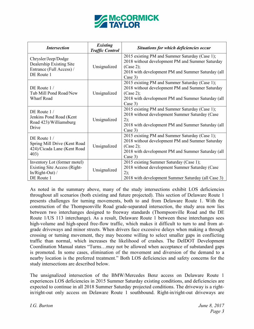
I.G. Burton June 8, 2017
Page 3
Intersection Existing
Traffic Control Situations for which deficiencies occur
Chrysler/Jeep/Dodge
Dealership Existing Site
Entrance (Full Access) /
DE Route 1
Unsignalized
2015 existing PM and Summer Saturday (Case 1);
2018 without development PM and Summer Saturday
(Case 2);
2018 with development PM and Summer Saturday (all
Case 3)
DE Route 1 /
Tub Mill Pond Road/New
Wharf Road
Unsignalized
2015 existing PM and Summer Saturday (Case 1);
2018 without development PM and Summer Saturday
(Case 2);
2018 with development PM and Summer Saturday (all
Case 3)
DE Route 1 /
Jenkins Pond Road (Kent
Road 423)/Williamsburg
Drive
Unsignalized
2015 existing PM and Summer Saturday (Case 1);
2018 without development Summer Saturday (Case
2);
2018 with development PM and Summer Saturday (all
Case 3)
DE Route 1 /
Spring Mill Drive (Kent Road
424)/Cicada Lane (Kent Road
403)
Unsignalized
2015 existing PM and Summer Saturday (Case 1);
2018 without development PM and Summer Saturday
(Case 2);
2018 with development PM and Summer Saturday (all
Case 3)
Inventory Lot (former motel)
Existing Site Access (Right-
In/Right-Out) /
DE Route 1
Unsignalized
2015 existing Summer Saturday (Case 1);
2018 without development Summer Saturday (Case
2);
2018 with development Summer Saturday (all Case 3)
As noted in the summary above, many of the study intersections exhibit LOS deficiencies
throughout all scenarios (both existing and future projected). This section of Delaware Route 1
presents challenges for turning movements, both to and from Delaware Route 1. With the
construction of the Thompsonville Road grade-separated intersection, the study area now lies
between two interchanges designed to freeway standards (Thompsonville Road and the DE
Route 1/US 113 interchange). As a result, Delaware Route 1 between these interchanges sees
high-volume and high-speed free-flow traffic, which makes it difficult to turn to and from at-
grade driveways and minor streets. When drivers face excessive delays when making a through
crossing or turning movement, they may become willing to select smaller gaps in conflicting
traffic than normal, which increases the likelihood of crashes. The DelDOT Development
Coordination Manual states “Turns…may not be allowed when acceptance of substandard gaps
is promoted. In some cases, elimination of the movement and diversion of the demand to a
nearby location is the preferred treatment.” Both LOS deficiencies and safety concerns for the
study intersections are described below.
The unsignalized intersection of the BMW/Mercedes Benz access on Delaware Route 1
experiences LOS deficiencies in 2015 Summer Saturday existing conditions, and deficiencies are
expected to continue in all 2018 Summer Saturday projected conditions. The driveway is a right-
in/right-out only access on Delaware Route 1 southbound. Right-in/right-out driveways are
I.G. Burton June 8, 2017
Page 4
typically a preferred treatment at similar locations, as inbound traffic is usually free-flowing and
outbound drivers only need to select a gap in one direction of traffic. However, due to the high
volumes on Delaware Route 1, the eastbound right turning movement (site egress) still operates
at LOS F in all Summer Saturday analysis scenarios. The 95th
percentile queue length for the
eastbound right movement is approximately 100 feet. Alternate egress exists, by way of
Thompsonville Road and Montour Drive, and during peak periods some drivers will likely
choose that route. Because the LOS for the eastbound right-turn movement cannot be
adequately mitigated without impeding through traffic on Delaware Route 1, the only alternative
to having poor LOS is to prohibit the movement. Because the movement would function
acceptably in off-peak hours and does not appear to be a particular safety hazard, we recommend
that it be retained. Therefore, no improvements are recommended beyond extending the
southbound right-turn lane.
The intersection of the Chrysler/Jeep/Dodge Dealership Existing Site Entrance (Full Access) on
Delaware Route 1 experiences LOS deficiencies in 2015 PM and Summer Saturday existing
conditions, and deficiencies are expected to continue in all 2018 projected conditions. The
unacceptable delays are due in part to the lack of adequate gaps in through traffic on Delaware
Route 1 that are able to accommodate the turning movements at this intersection. Drivers are
likely to select a smaller (and potentially unsafe) gap in conflicting traffic or select an alternate
travel route. In fact, the TIS indicates that many existing I.G. Burton employees, deliveries, and
customers utilize the new Thompsonville Road interchange to crossover Delaware Route 1,
rather than the at-grade intersections.
DelDOT's Traffic Section has recommended a full median closure at the Chrysler Dealership
Entrance, per the “SR 1 Median Opening Study, Tub Mill Pond Road/Milford Neck Road to Tub
Mill Pond Road/New Wharf Road” completed in November 2016. McCormick Taylor concurs
with this recommendation. The TIS points out that a full median closure here may overload the
Delaware Route 1 northbound left-turn/u-turn lane at Williamsburg Drive with additional
volume, thus leading to queues exceeding the existing capacity of the turn lane at Williamsburg
Drive. This may be a valid concern, and the issue would likely require further examination by
DelDOT's Traffic Section. Although the northbound left turn lane at Williamsburg Drive could
be extended if needed, it is likely that northbound left-turn and u-turn traffic will use the
Thompsonville Road grade-separated intersection if the Williamsburg Drive left-turn lane is
experiencing excessive queues and delays. Due to operational and safety concerns, a full median
closure appears to be appropriate at the intersection of Delaware Route 1 and the full-access
Chrysler/Jeep/Dodge Dealership Site Entrance, although the possibility to retain u-turn
movements only is still under consideration and should be coordinated during site plan review as
noted below in Item No. 5. The driveway should be converted to a right-in/right-out access.
The unsignalized intersection of Delaware Route 1 / Tub Mill Pond Road/New Wharf Road
experiences LOS deficiencies in 2015 PM and Summer Saturday existing conditions, and
deficiencies are expected to continue in all 2018 projected conditions. At the time of the traffic
counts, the northbound left-turn was restricted via signage. However, a small number of vehicles
were counted making northbound left-turns and u-turns. During construction of the
I.G. Burton June 8, 2017
Page 5
Thompsonville Road grade-separated intersection, the northbound left-turn and u-turn were
restricted via signage and the westbound approach was restricted to right-turns only with
delineator posts. Due to uncertainty in the permanent condition of this intersection, the TIS
analyzed the intersection with all movements from the side-streets and with DelDOT proposed
restrictions. The DelDOT proposed condition, which was implemented in early May 2017,
includes restricting through and left-turn movements from both of the side streets. With that,
while there are still LOS deficiencies at the intersection, no additional reasonable LOS
mitigation measures appear to be warranted. Therefore, no further improvements are
recommended.
The unsignalized intersection of Delaware Route 1 / Jenkins Pond Road/Williamsburg Drive
experiences LOS deficiencies in 2015 PM and Summer Saturday existing conditions, and
deficiencies are expected to continue in almost all 2018 projected conditions (which reflect
recent modifications to the intersection). This intersection was recently reconfigured by DelDOT
as part of the Thompsonville Road grade-separated intersection project. This project restricted
the side streets to right-turns only to Delaware Route 1 and removed the southbound left-turn
movement. The northbound u-turn/left-turn movement remains. Although LOS and delays
remain unacceptable in future conditions, all 95th
percentile queue lengths are expected be less
than approximately 50 feet. Considering these relatively short queue lengths and the recent
reconfiguration of the intersection by DelDOT, no further mitigation by the developer is required
at this intersection.
The unsignalized intersection of Delaware Route 1 / Spring Hill Drive/Cicada Lane experiences
LOS deficiencies in 2015 PM and Summer Saturday existing conditions, and deficiencies are
expected to continue in all 2018 projected conditions. The unacceptable delays are due to the
lack of adequate gaps in through traffic on Delaware Route 1 that are able to accommodate
movements to and from the side streets, not to mention the skewed geometry of the Cicada Lane
approach. DelDOT's Traffic Section has recommended restricting through and left-turn
movements from the side streets at the intersection, and McCormick Taylor concurs with this
recommendation. Most motorists who would want to make these movements can be easily
accommodated by taking other roads to access the Thompsonville Road and South Frederica
interchanges and then continue on to their destination. Due to operational and safety concerns,
channelizing the intersection of Delaware Route 1 and Spring Hill Drive/Cicada Lane to restrict
side-street through and left-turn movements appears to be the appropriate form of mitigation.
However, given that the proposed development does not add any volume to the side-street
approaches at this intersection, no mitigation by the developer is required at this intersection.
The unsignalized intersection of Inventory Lot (former motel) Existing Site Access (Right-
In/Right-Out) / Delaware Route 1 experiences LOS deficiencies in 2015 Summer Saturday
existing conditions, and deficiencies are expected to continue in all 2018 Summer Saturday
projected conditions. The driveway is a right-in/right-out only access on Delaware Route 1
southbound. Due to the high volumes on Delaware Route 1, the eastbound right turning
movement (site egress) operates at LOS F in all analysis scenarios. However, the eastbound
right-turn egress volume is anticipated to be no more than 10 vehicles in all scenarios, and the
I.G. Burton June 8, 2017
Page 6
95th
percentile queue length for the eastbound right-turn movement is less than 25 feet.
Considering these low volumes and short queue lengths, no LOS mitigation measures appear to
be warranted. Therefore, no improvements are recommended for this intersection.
Should the County choose to approve the proposed development, the following items should be
incorporated into the site design and reflected on the record plan by note or illustration. All
applicable agreements (i.e. letter agreements for off-site improvements and traffic signal
agreements) should be executed prior to entrance plan approval for the proposed development.
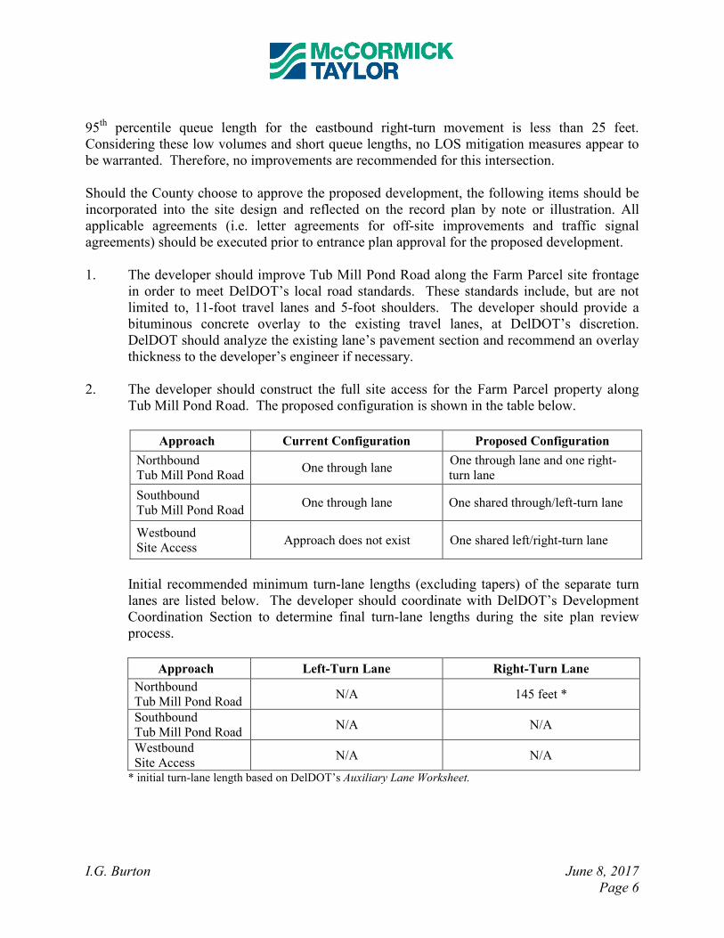
1. The developer should improve Tub Mill Pond Road along the Farm Parcel site frontage
in order to meet DelDOT’s local road standards. These standards include, but are not
limited to, 11-foot travel lanes and 5-foot shoulders. The developer should provide a
bituminous concrete overlay to the existing travel lanes, at DelDOT’s discretion.
DelDOT should analyze the existing lane’s pavement section and recommend an overlay
thickness to the developer’s engineer if necessary.
2. The developer should construct the full site access for the Farm Parcel property along
Tub Mill Pond Road. The proposed configuration is shown in the table below.
Approach Current Configuration Proposed Configuration
Northbound
Tub Mill Pond Road One through lane
One through lane and one right-
turn lane
Southbound
Tub Mill Pond Road One through lane One shared through/left-turn lane
Westbound
Site Access Approach does not exist One shared left/right-turn lane
Initial recommended minimum turn-lane lengths (excluding tapers) of the separate turn
lanes are listed below. The developer should coordinate with DelDOT’s Development
Coordination Section to determine final turn-lane lengths during the site plan review
process.
Approach Left-Turn Lane Right-Turn Lane
Northbound
Tub Mill Pond Road N/A 145 feet *
Southbound
Tub Mill Pond Road N/A N/A
Westbound
Site Access N/A N/A
* initial turn-lane length based on DelDOT’s Auxiliary Lane Worksheet.
I.G. Burton June 8, 2017
Page 7
3. The developer should extend the existing Delaware Route 1 southbound right-turn lane at
the BMW/Mercedes Benz dealership driveway to the maximum extent feasible
(approximately 435 feet total length, including taper).
4. The developer should construct the full site access for the North Campus Expansion
property along Mercer Avenue. The proposed configuration is shown in the table below.
Approach Current Configuration Proposed Configuration
Northbound
Site Access Approach does not exist One shared left/right-turn lane
Eastbound
Mercer Avenue One through lane One shared through/right-turn lane
Westbound
Mercer Avenue One through lane One shared through/left-turn lane
5. For the intersection of Delaware Route 1 and the existing Chrysler/Jeep/Dodge
dealership driveway, the developer should continue to coordinate with DelDOT
regarding modifications to the existing full-access median crossover. During the site
plan review process, the developer should coordinate with DelDOT’s Development
Coordination Section to select and proceed with one of the three following options:
a. The developer should be responsible for modifications that would result in full
closure of the median crossover at this location.
b. If, by the time a decision needs to be made, DelDOT has initiated an official project
in this location, the developer should coordinate with DelDOT regarding an
appropriate contribution toward that project. This option would also result in full
closure of the median crossover at this location.
c. The developer should modify the existing median crossover to physically restrict all
left turns and crossover through movements going to or from the dealership
driveway. The only remaining movements permitted to travel through the median
would be northbound and southbound u-turns on Delaware Route 1. The existing
driveway would therefore be converted to a right-in/right-out access along
southbound Delaware Route 1. The median u-turn only and driveway restrictions
would be accomplished via channelization islands and signage in the median and at
the dealership driveway entrance as needed.
In addition to one of the above options regarding modifications to the median crossover,
the developer should extend the existing Delaware Route 1 southbound right-turn lane at
the Chrysler/Jeep/Dodge dealership driveway to the maximum extent feasible
(approximately 290 feet total length, including taper).
For all modifications to the median crossover, the dealership driveway and the
southbound right-turn lane, the developer should coordinate with DelDOT’s
I.G. Burton June 8, 2017
Page 8
Development Coordination Section during the site plan review process to determine final
design and implementation details.
6. The following bicycle, pedestrian, and transit improvements should be included:
a. A right-turn yield to bikes sign (MUTCD R4-4) should be added at the start of the
right-turn lane on northbound Tub Mill Pond Road at the proposed Farm Parcel site
driveway.
b. Adjacent to the proposed right-turn lane on northbound Tub Mill Pond Road at the
Farm Parcel site entrance, a minimum five-foot wide bicycle lane should be dedicated
and striped with appropriate markings for bicyclists through the turn lane in order to
facilitate safe and unimpeded bicycle travel.
c. Appropriate bicycle symbols, directional arrows, pavement markings, and signing
should be included along bicycle facilities and turn lanes within the project limits.
d. Utility covers should be made flush with the pavement.
e. Bicycle parking should be provided near the building entrances. Where the building
architecture provides for an awning, other overhang, or indoor parking, the bicycle
parking should be covered.
f. A minimum 15-foot wide easement from the edge of the right-of-way should be
dedicated to DelDOT within the Farm Parcel site frontage along Tub Mill Pond Road.
Within the easement along Tub Mill Pond Road, a minimum of a ten-foot wide
shared-use path that meets current AASHTO and ADA standards should be
constructed along the site frontage. The shared-use path should have a minimum of a
five-foot buffer from the roadway. The shared-use path should connect to pedestrian
facilities in the Farm Parcel and to the shoulder of Tub Mill Pond Road in accordance
with DelDOT’s Shared Use Path and/or Sidewalk Termination Policy dated June 19,
2014. The developer should coordinate with DelDOT’s Development Coordination
Section to determine exact locations and details of the shared-use path connections at
the property boundaries.
g. ADA compliant curb ramps and crosswalks should be provided at all pedestrian
crossings, including all site entrances. Type 3 curb ramps are discouraged.
h. Internal sidewalks for pedestrian safety and to promote walking as a viable
transportation alternative should be considered within the development. These
sidewalks should each be a minimum of five feet wide (with a minimum of a five-
foot buffer from the roadway) and should meet current AASHTO and ADA
standards. Internal sidewalks in the Farm Parcel development should connect to the
proposed sidewalk along Tub Mill Pond Road.
i. Where internal sidewalks are located alongside of parking spaces, a buffer should be
added to prevent vehicular overhang onto the sidewalk.
j. Recommendations regarding transit access provided by the Delaware Transit
Corporation (DTC) should be incorporated into the site design. This includes
installation of an ADA compliant bus pad near the proposed site entrance along Tub
Mill Pond Road to accommodate future transit service. Further coordination with
I.G. Burton June 8, 2017
Page 9
DTC will be necessary regarding the existing bus stop along southbound Delaware
Route 1 located just north of the existing right-in/right-out inventory lot driveway.
k. A sidewalk and/or shared-use path is not required along the Delaware Route 1 site
frontage.
Improvements in this TIS may be considered “significant” under DelDOT’s Work Zone Safety
and Mobility Procedures and Guidelines. These guidelines are available on DelDOT’s website
at http://www.deldot.gov/information/pubs_forms/manuals/de_mutcd/index.shtml. For any
additional information regarding the work zone impact and mitigation procedures during
construction please contact Mr. Adam Weiser of DelDOT’s Traffic Section. Mr. Weiser can be
reached at (302) 659-4073 or by email at [email protected].
Please note that this review generally focuses on capacity and level of service issues; additional
safety and operational issues will be further addressed through DelDOT’s subdivision review
process.
Additional details on our review of this TIS are attached. Please contact me at (610) 640-3500 or
through e-mail at [email protected] if you have any questions concerning this
review.
Sincerely, McCormick Taylor, Inc.
Andrew J. Parker, P.E., PTOE Project Manager Enclosure

Detailed TIS/TOA Review by
McCormick Taylor, Inc.
I.G. Burton June 8, 2017
Page 10
General Information
Report date: March 2017
Prepared by: Davis, Bowen & Friedel, Inc. (DBF)
Prepared for: D.A. Burton, LLC
Tax parcel: I.G. Burton Farm Parcel: MD-00-163.00-01-77.00, 77.01, 81.00
I.G. Burton North Campus Expansion: Proposed Inventory Lot Relocation: MD-00-163.14-01-39.00, 40.00, 41.00, 42.00
Relocated Dealership Location: MD-00-163.00-01073.01-000
Generally consistent with DelDOT’s Development Coordination Manual: Yes
Project Description and Background
Farm Parcel (TIS)
Description: The proposed I.G. Burton Property “Farm Parcel” would be a multi-use facility
with new car dealership, automobile care center, and shopping center.
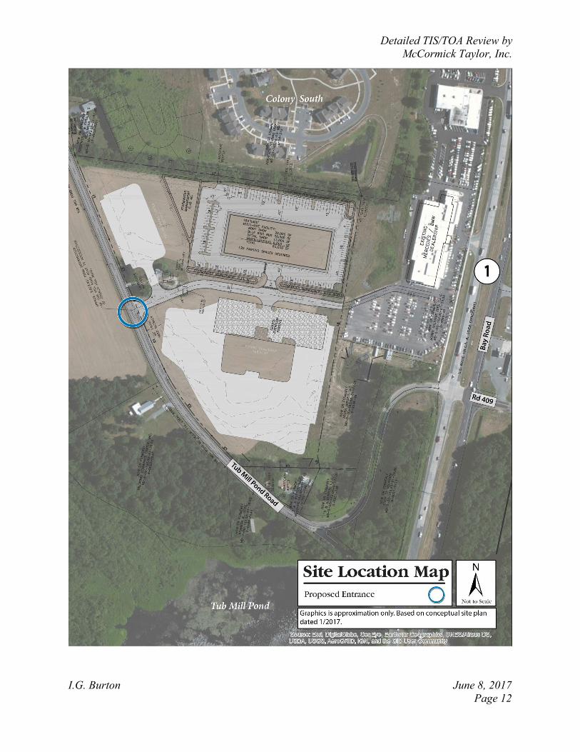
Location: The proposed I.G. Burton Property “Farm Parcel” is located on the east side of Tub
Mill Pond Road (Kent Road 119), adjacent to the west of the existing I.G. Burton dealerships in
Kent County, Delaware. A site location map is included on Page 12.
Amount of land to be developed: Approximately 20.41 acres of land
Land use approval(s) needed: Subdivision approval. The land is currently zoned as BG
(General Business) & AR (Agricultural Residential) within Kent County. No rezoning is needed
to permit the proposed land use.
Proposed completion date: 2018
Proposed access locations: A full-access driveway is proposed along the east side of Tub Mill
Pond Road. Access is also proposed via interconnection to the existing I.G. Burton
BMW/Mercedes-Benz right-in/right-out driveway and existing I.G. Burton Chrysler/Jeep/Dodge
full-access driveway (both located along the west side of Delaware Route 1).
Daily Traffic Volumes (per DelDOT Traffic Summary 2015):
• 2015 Average Annual Daily Traffic on Tub Mill Pond Road: 354 vpd
• 2015 Average Annual Daily Traffic on Delaware Route 1: 43,394
North Campus Expansion (TOA)
Description: The proposed I.G. Burton Property “North Campus Expansion” would consist of
two redevelopment sites:
- Proposed Chrysler Dealership (to replace the existing Chrysler/Jeep/Dodge building)
- Proposed Inventory Lot Relocation
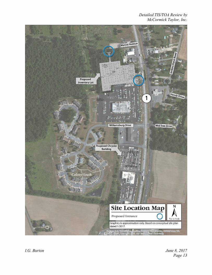
Location: The proposed I.G. Burton Chrysler Dealership is located just north of the existing I.G.
Burton Chrysler/Jeep/Dodge dealership, south of Williamsburg Drive, on the west side of
Delaware Route 1. The proposed Inventory Lot is located just north of the existing I.G. Burton
Chevy dealership, south of Mercer Avenue, on the west side of Delaware Route 1. A site
location map is included on Page 13.
Amount of land to be developed: approximately 6.510 acres for the Proposed Chrysler
Dealership, and approximately 4.75 acres for the Proposed Inventory Lot Relocation
Land use approval(s) needed: Subdivision approval. The lands are currently zoned as BG
(General Business) within Kent County. No rezoning is needed to permit the proposed land use.
Detailed TIS/TOA Review by
McCormick Taylor, Inc.
I.G. Burton June 8, 2017
Page 11
Proposed completion date: 2018
Proposed access locations: Two new access points are proposed for the Inventory Lot
Relocation. A full-access driveway is proposed on the south side of Mercer Avenue, east of
Montour Drive. A rights-in-only driveway was also proposed from southbound Delaware Route
1, north of the Delaware Route 1 & Williamsburg Drive intersection, but subsequent to
submission and review of the TOA, this rights-in-only access was removed from consideration.
The proposed Chrysler Dealership will be served by three existing driveways. These include a
full access driveway on Williamsburg Drive, a right-in/right-out driveway on southbound
Delaware Route 1, and a full access driveway on Delaware Route 1 (at the existing
Chrysler/Jeep/Dodge).
Daily Traffic Volumes (per DelDOT Traffic Summary 2015):
• 2015 Average Annual Daily Traffic on Delaware Route 1: 43,394
Detailed TIS/TOA Review by
McCormick Taylor, Inc.
I.G. Burton June 8, 2017
Page 12
Detailed TIS/TOA Review by
McCormick Taylor, Inc.
I.G. Burton June 8, 2017
Page 13
Detailed TIS/TOA Review by
McCormick Taylor, Inc.
I.G. Burton June 8, 2017
Page 14
2015 Delaware Strategies for State Policies and Spending
Location with respect to the Strategies for State Policies and Spending Map of Delaware:
The proposed Farm Parcel and North Campus Expansion (Chrysler Dealership) developments
are located within an Investment Level 1 area. The North Campus Expansion (Inventory Lot
Relocation) is located within an Investment Level 2 area.
Investment Level 1
Areas of the state designated as Investment Level 1 are most prepared for growth and are where
the state can make cost-effective infrastructure investments in schools, roads, and public safety.
In these areas, state investments and policies should support and encourage a wide range of uses
and densities, promote a variety of transportation options, foster efficient use of existing public
and private investments, and enhance community identity and integrity. Investment Level 1
areas are often municipalities, towns, or urban/urbanizing places. Density is generally higher
than in the surrounding areas. Overall, it is the state’s intent to use its spending and management
tools to maintain and enhance community character, to promote well-designed and efficient new
growth, and to facilitate redevelopment in Investment Level 1 Areas.
Investment Level 2
Investment Level 2 has many diverse characteristics. These areas can be composed of less
developed areas within municipalities, rapidly growing areas in the counties that have or will
have public water and wastewater services and utilities, areas that are generally adjacent to or
near Investment Level 1 Areas, smaller towns and rural villages that should grow consistently
with their historic character, and suburban areas with public water, wastewater, and utility
services. These areas have been shown to be the most active portion of Delaware’s developed
landscape. They serve as transition areas between Level 1 and the state’s more open, less
populated areas. They generally contain a limited variety of housing types, predominantly
detached single-family dwellings.
In Investment Level 2 Areas, like Investment Level 1 Areas, state investments and policies
should support and encourage a wide range of uses and densities, promote other transportation
options, foster efficient use of existing public and private investments, and enhance community
identity and integrity.
Investments should encourage departure from the typical single-family-dwelling developments
and promote a broader mix of housing types and commercial sites encouraging compact, mixed-
use development where applicable. Overall, the State’s intent is to use its spending and
management tools to promote well-designed development in these areas. Such development
provides for a variety of housing types, user-friendly transportation systems, and provides
essential open spaces and recreational facilities, other public facilities, and services to promote a
sense of community.
Detailed TIS/TOA Review by
McCormick Taylor, Inc.
I.G. Burton June 8, 2017
Page 15
Proposed Development’s Compatibility with Strategies for State Policies and Spending:
The proposed I.G. Burton Farm Parcel and North Campus Expansion (Chrysler Dealership)
developments are located within an Investment Level 1 area. The farm parcel project includes
development of a car dealership, automobile care center, and retail center on existing open/farm
space. The North Campus Expansion project includes re-development of an existing car
dealership and construction of a new vehicle inventory lot. This type of development is
consistent with the character of the immediate area, which is already home to several large car
dealerships and low to medium density housing. Delaware Route 1, which carries high-volume
and high-speed traffic, runs adjacent to the proposed developments. This type of development
does not typically provide a variety of transportation options or enhance community identity and
integrity. However, the proposed developments are located just north of the city of Milford,
which is largely classified as Investment Level 1. The proposed developments are also located on
or adjacent to existing commercial properties, which increases density, preserves open space, and
reduces sprawl into areas that are not already well-served by roadways and other public
infrastructure. The proposed developments are located near the recently completed
Thompsonville Road (Kent Road 19) grade separated intersection on Delaware Route 1, which
makes efficient use of existing public investments. The Delaware State Strategies 2015 map
indicates several “Out of Play” areas near the proposed developments. These areas are not
expected to be used for private development, typically due to serious legal or environmental
constraints. The development of these sites should consider natural resources and the
environment, emphasizing the protection of critical natural habitat, wildlife, and stormwater
management/drainage areas. Assuming the planning and construction takes into account the
“Out of Play” areas, the proposed developments generally appear to comply with the policies
stated in the 2015 “Strategies for State Policies and Spending.”
While the North Campus Expansion (Inventory Lot Relocation) is located in an Investment
Level 2 Area, the findings listed above for Investment Level 1 generally apply to this portion of
the proposed development as well.
Comprehensive Plan
Kent County Comprehensive Plan: (Source: Kent County Comprehensive Plan, Adopted October 7, 2008)
The Kent County Comprehensive Plan Future Land Use Map indicates that the proposed Farm
Parcel site is designated “Low Density” and the proposed North Campus Expansion Site is
designated “Highway Commercial.” Inspection of the Kent County Zoning District Map E-11,
which provides more detail on existing zoning, shows that the proposed developments will be
located on lands currently zoned “BG - General Business.”
Both proposed developments are within the designated “Growth Zone.” The intention of the
Growth Zone Overlay is to direct development to areas with existing infrastructure and public
services. Development within the Growth Zone typically reduces sprawl, builds on existing
community centers, and protects natural resources.
Detailed TIS/TOA Review by
McCormick Taylor, Inc.
I.G. Burton June 8, 2017
Page 16
Proposed Development’s Compatibility with Comprehensive Plan: The proposed developments appear to comply with the Kent County Comprehensive Plan.
Perhaps most importantly, the proposed developments are located with the designated Growth
Zone. When new development occurs within the Growth Zone, public services (such as roads,
fire protection services, and sewer service) are more easily accessible. This also preserves rural
and agricultural lands, which are important to the character and economy of Kent County. The
lands proposed for development are currently zoned BG - General Business, and the proposed
land uses appear to be allowed within this zoning.
Relevant Projects in the DelDOT Capital Transportation Program
There are two relevant DelDOT projects within the study area. The first project is a grade-
separated intersection at Delaware Route 1 and Thompsonville Road. This project removed an
existing at-grade, signalized intersection and constructed a grade-separated intersection with a
Thompsonville Road overpass over Delaware Route 1 and new acceleration and deceleration
lanes on Delaware Route 1. This project also constructed new local access roadways and
removed several intersections, crossovers, and access driveways along Delaware Route 1 in the
area of the modified Thompsonville Road intersection. The 2015 existing analyses presented in
the TIS utilize traffic volumes and roadway geometries that were present prior to construction of
the grade-separated intersection. All 2018 future analysis cases include post-construction
roadway geometries and associated traffic volume projections.
Additionally, there is a Hazard Elimination Program (HEP) project at the intersection of
Delaware Route 1 and Tub Mill Pond Road/New Wharf Road (Kent Road 409). This project
stemmed from Site M of the 2012 HEP which consisted of Delaware Route 1 from south of Tub
Mill Pond Road to north of Old Jenkins Road (Kent Road 423B). During construction of the
Thompsonville Road grade-separated intersection, northbound Delaware Route 1 left-turn and u-
turn movements were restricted and westbound New Wharf Road was restricted to right-turn
only to northbound Delaware Route 1 via pavement markings, signage, and flexible delineator
posts. Per correspondence from DelDOT in April 2017, based in part on the “SR 1 Median
Opening Study, Tub Mill Pond Road/Milford Neck Road to Tub Mill Pond Road/New Wharf
Road” completed by DelDOT’s Traffic Section in November 2016, DelDOT determined that the
temporary northbound and westbound restrictions would become permanent. Furthermore, the
eastbound Tub Mill Road approach would be restricted to right turns only. The southbound
Delaware Route 1 left-turn/u-turn movement will remain. Modifications to the intersection
needed to implement the aforementioned turn restrictions were completed in early May 2017.
DBF and McCormick Taylor analyzed the intersection with all movements allowed from the side
streets in future conditions, as well as with the configuration proposed and now implemented by
DelDOT.
Detailed TIS/TOA Review by
McCormick Taylor, Inc.
I.G. Burton June 8, 2017
Page 17
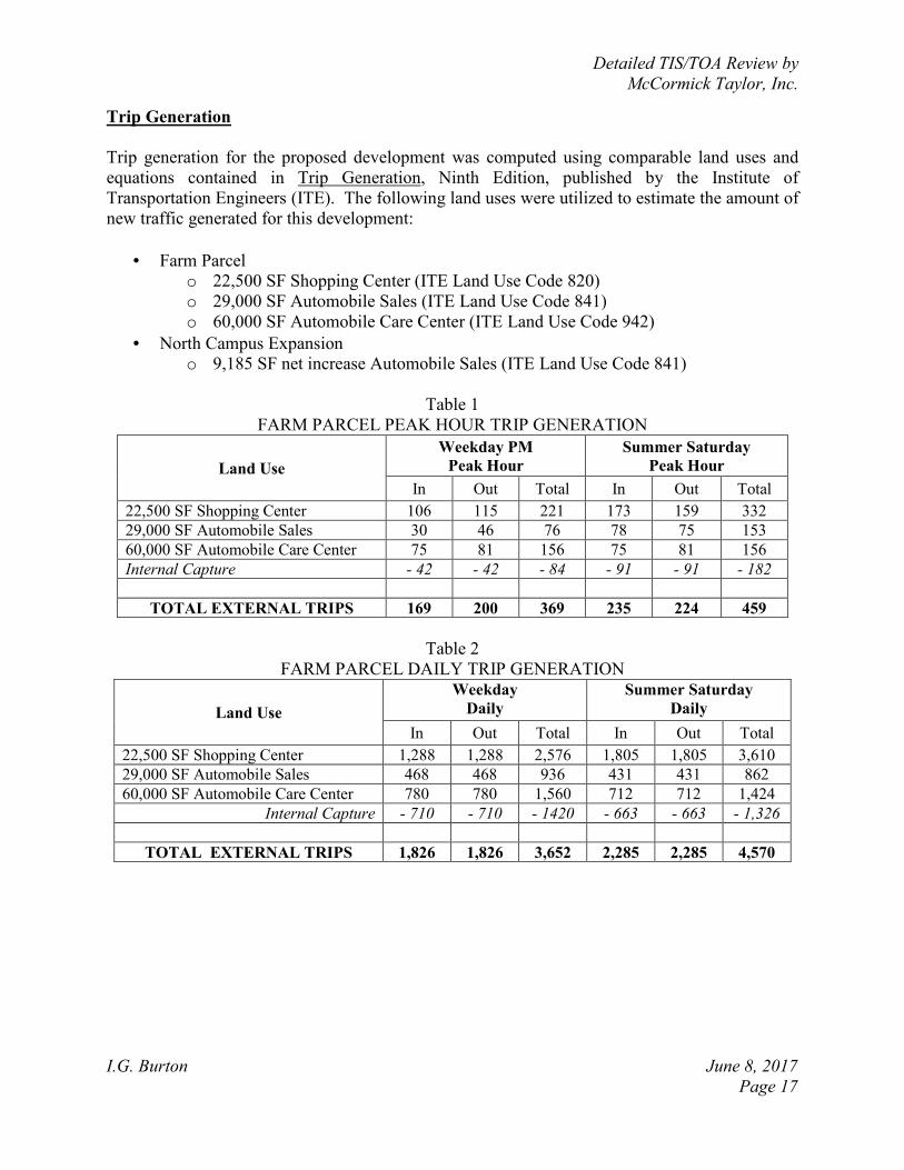
Trip Generation
Trip generation for the proposed development was computed using comparable land uses and
equations contained in Trip Generation, Ninth Edition, published by the Institute of
Transportation Engineers (ITE). The following land uses were utilized to estimate the amount of
new traffic generated for this development:
• Farm Parcel
o 22,500 SF Shopping Center (ITE Land Use Code 820)
o 29,000 SF Automobile Sales (ITE Land Use Code 841)
o 60,000 SF Automobile Care Center (ITE Land Use Code 942)
• North Campus Expansion
o 9,185 SF net increase Automobile Sales (ITE Land Use Code 841)
Table 1
FARM PARCEL PEAK HOUR TRIP GENERATION
Land Use
Weekday PM
Peak Hour
Summer Saturday
Peak Hour
In Out Total In Out Total
22,500 SF Shopping Center 106 115 221 173 159 332
29,000 SF Automobile Sales 30 46 76 78 75 153
60,000 SF Automobile Care Center 75 81 156 75 81 156
Internal Capture - 42 - 42 - 84 - 91 - 91 - 182
TOTAL EXTERNAL TRIPS 169 200 369 235 224 459
Table 2
FARM PARCEL DAILY TRIP GENERATION
Land Use
Weekday
Daily
Summer Saturday
Daily
In Out Total In Out Total
22,500 SF Shopping Center 1,288 1,288 2,576 1,805 1,805 3,610
29,000 SF Automobile Sales 468 468 936 431 431 862
60,000 SF Automobile Care Center 780 780 1,560 712 712 1,424
Internal Capture - 710 - 710 - 1420 - 663 - 663 - 1,326
TOTAL EXTERNAL TRIPS 1,826 1,826 3,652 2,285 2,285 4,570
Detailed TIS/TOA Review by
McCormick Taylor, Inc.
I.G. Burton June 8, 2017
Page 18
Table 3
NORTH CAMPUS EXPANSION PEAK HOUR TRIP GENERATION
Land Use
Weekday PM
Peak Hour
Summer Saturday
Peak Hour
In Out Total In Out Total
Existing 90,572 SF Automobile Sales 119 135 254 186 178 364
Proposed 99,757 SF Automobile Sales 131 148 279 205 196 401
Net increase 9,185 SF Automobile Sales 12 13 25 19 18 37
TOTAL “NEW” TRIPS 12 13 25 19 18 37
Table 4
NORTH CAMPUS EXPANSION DAILY TRIP GENERATION
Land Use
Weekday
Daily
Summer Saturday
Daily
In Out Total In Out Total
Existing 90,572 SF Automobile Sales 1,463 1,463 2,926 1,347 1,347 2,694
Proposed 99,757 SF Automobile Sales 1,611 1,611 3,222 1,483 1,483 2,966
Net increase 9,185 SF Automobile Sales 148 148 296 136 136 272
TOTAL “NEW” TRIPS 148 148 296 136 136 272
Overview of TIS
Intersections examined:
1) Farm Parcel Proposed Site Entrance / Tub Mill Pond Road
2) Farm Parcel Entrance (via interconnection to BMW/Mercedes Benz) / DE Route 1
3) Chrysler/Jeep/Dodge Dealership Existing Site Entrance (Full Access) / DE Route 1
4) North Campus Expansion Proposed Site Entrance (Full Access) / Mercer Avenue
5) Relocated Inventory Lot Proposed Site Entrance (Rights-In Only Access) / DE
Route 1
6) DE Route 1 / Tub Mill Pond Road/New Wharf Road
7) DE Route 1 / US Route 113
8) US Route 113 / Warner Road (Kent Road 406)/North Walnut Street
9) DE Route 1 / Jenkins Pond Road (Kent Road 423)/Williamsburg Drive
10) DE Route 1 / Thompsonville Road
11) DE Route 1 / Spring Hill Drive (Kent Road 424)/Cicada Lane (Kent Road 403)
12) DE Route 1 Southbound Ramp / Thompsonville Road
13) Church Hill Road (Kent Road 404) / Tub Mill Pond Road
14) Church Hill Road / Bowman Road (Kent Road 401)
15) Church Hill Road / Montour Drive
16) Williamsburg Drive / Montour Drive
17) Inventory Lot (former motel) Existing Site Access (Right-In/Right-Out) / DE Route
1
Detailed TIS/TOA Review by
McCormick Taylor, Inc.
I.G. Burton June 8, 2017
Page 19
Conditions examined: 1) 2015 existing traffic volumes (Case 1)
2) 2018 without I.G. Burton development (Case 2)
3) 2018 with I.G. Burton Farm Parcel development (Case 3a)
4) 2018 with I.G. Burton North Campus Expansion and redevelopment (Case 3b)
5) 2018 with all proposed I.G. Burton development (Case 3c)
Peak hours evaluated: Weekday evening and Summer Saturday mid-day peak hours
Committed developments considered: None
Intersection Descriptions
1) Farm Parcel Proposed Site Entrance / Tub Mill Pond Road
Type of Control: proposed one-way stop-controlled (three-leg intersection)
Northbound approach: (Tub Mill Pond Road) existing one through lane; proposed one
through lane and one right-turn lane
Southbound approach: (Tub Mill Pond Road) existing one through lane; proposed one
shared left-turn/through lane
Westbound approach: (Proposed Site Access) proposed one shared left-turn/right turn
lane, stop-controlled
2) Farm Parcel Entrance (via interconnection to BMW/Mercedes Benz) / DE Route 1
Type of Control: one-way stop-controlled (right-in/right-out driveway)
Southbound approach: (DE Route 1) two through lanes and one right-turn lane
Eastbound approach: (Existing BMW/Mercedes Benz Driveway) one right-turn lane,
stop-controlled
3) Chrysler/Jeep/Dodge Dealership Existing Site Entrance (Full Access) / DE Route 1
Type of Control: one-way stop-controlled (median crossover intersection)
Northbound approach: (DE Route 1) one left-turn lane and two through lanes
Southbound approach: (DE Route 1) one u-turn lane, two through lanes, and one right-
turn lane
Eastbound approach: (Existing Site Driveway) one shared left-turn/right-turn lane,
stop-controlled
4) North Campus Expansion Proposed Site Entrance (Full Access) / Mercer Avenue
Type of Control: proposed one-way stop-controlled (three-leg intersection)
Northbound approach: (Proposed Site Driveway) proposed one shared left-turn/right-
turn lane, stop-controlled
Eastbound approach: (Mercer Ave) existing one through lane; proposed one shared
through/right-turn lane
Westbound approach: (Mercer Ave) existing one through lane; proposed one shared
through/left-turn lane
Detailed TIS/TOA Review by
McCormick Taylor, Inc.
I.G. Burton June 8, 2017
Page 20
5) Relocated Inventory Lot Proposed Site Entrance (Rights-In Only Access) / DE
Route 1
Type of Control: proposed uncontrolled right-in only intersection
Southbound approach: (DE Route 1) existing two through lanes; proposed two through
lanes and one right-turn lane
No traffic analysis can be conducted for this rights-in-only site access. Subsequent to
submission of the TOA, this proposed access was removed from consideration.
6) DE Route 1 / Tub Mill Pond Road/New Wharf Road
Type of Control: two-way stop-controlled (median crossover intersection)
Northbound approach: (DE Route 1) two through lanes and one right-turn lane
Southbound approach: (DE Route 1) one left-turn, two through lanes, and one right-
turn lane
Eastbound approach: (Tub Mill Pond Road) existing one shared left-turn/through/right-
turn lane, stop-controlled; DelDOT recent modifications: one right-turn lane, stop-
controlled.
Westbound approach: (New Wharf Road) existing one shared left-turn/through/right-
turn lane, stop-controlled; DelDOT recent modifications: one right-turn lane, stop-
controlled
The through and left-turn movements from both Tub Mill Pond Road and New Wharf
Road are now restricted (as of early May 2017). The southbound left-turn will continue
to be allowed, but the northbound left-turn and u-turn movements will remain physically
restricted in the permanent condition.
7) DE Route 1 / US Route 113
Type of Control: freeway merge and diverge facilities
Northbound (merge) approach: (DE Route 1) two through lanes; (US Route 113) one
parallel merge lane
Southbound (diverge) approach: (DE Route 1) two through lanes; (US Route 113) one
parallel diverge lane
8) US Route 113 / Warner Road/North Walnut Street
Type of Control: Signalized intersection
Northbound approach: (US Route 113) one left-turn lane, two through lanes, and one
right-turn lane
Southbound approach: (US Route 113) one left-turn lane, two through lanes, and one
right-turn lane
Eastbound approach: (Warner Road) two left-turn lanes, one through lane, and one
right-turn lane
Westbound approach: (N Walnut Street) one shared left-turn/through/right-turn lane
and one right-turn lane
Detailed TIS/TOA Review by
McCormick Taylor, Inc.
I.G. Burton June 8, 2017
Page 21
9) DE Route 1 / Jenkins Pond Road/Williamsburg Drive
Type of Control: two-way stop-controlled (median crossover intersection)
Northbound approach: (DE Route 1) one left-turn lane, two through lanes, and one
right-turn lane
Southbound approach: (DE Route 1) existing one left-turn lane, two through lanes, and
one right-turn lane; proposed two through lanes and one right-turn lane
Eastbound approach: (Williamsburg Drive) existing one shared left-turn/through lane
and one right-turn lane; proposed one right-turn lane, stop-controlled
Westbound approach: (Jenkins Pond Road) one shared left-turn/through/right-turn lane;
proposed one right-turn lane, stop-controlled
Intersection was recently reconfigured to proposed condition as part of the
Thompsonville Road grade-separated intersection project.
10) DE Route 1 / Thompsonville Road
Type of Control: existing signalized intersection; proposed grade separated intersection
Northbound approach: (DE Route 1) existing two through lanes and one right-turn lane
Southbound approach: (DE Route 1) existing one left-turn lane and two through lanes
Westbound approach: (Thompsonville Road) existing one shared left-
turn/through/right-turn lane, with right-turn channelization
Signalized intersection was recently removed as part of the Thompsonville Road grade-
separated intersection project. DE Route 1 is now free-flow and Thompsonville Road is
an overpass.
11) DE Route 1 / Spring Hill Drive/Cicada Lane
Type of Control: two-way stop controlled (four-leg intersection)
Northbound approach: (DE Route 1) one left-turn lane, two through lanes, and one
right-turn lane
Southbound approach: (DE Route 1) one left-turn lane, two through lanes, and one
right-turn lane
Eastbound approach: (Cicada Lane) one shared left-turn/through lane/right-turn lane,
stop-controlled
Westbound approach: (Spring Hill Drive) one shared left-turn/through/right-turn lane,
stop-controlled
Detailed TIS/TOA Review by
McCormick Taylor, Inc.
I.G. Burton June 8, 2017
Page 22
12) DE Route 1 Southbound Ramp / Thompsonville Road
Type of Control: proposed two-way stop controlled (four-leg intersection)
Northbound approach: (DE Route 1 ramp) proposed one shared left-turn/through lane
and one right-turn lane, stop-controlled
Southbound approach: (Hertrich Dealerships) proposed one shared left-
turn/through/right-turn lane, stop-controlled
Eastbound approach: (Thompsonville Road) proposed one left-turn lane, one through
lane, and one right-turn lane
Westbound approach: (Thompsonville Road) proposed one left-turn lane and one
shared through/right-turn lane
Intersection was recently constructed as part of the Thompsonville Road grade-separated
intersection project.
13) Church Hill Road / Tub Mill Pond Road
Type of Control: existing one-way stop-controlled (three-leg intersection); proposed
two-way stop-controlled (four-leg intersection)
Northbound approach: (Tub Mill Pond Road) existing one shared left-turn/through
lane; proposed one shared left-turn/through/right-turn lane; stop-controlled
Southbound approach: (Tub Mill Pond Road) existing one shared through/right-turn
lane; proposed one shared left-turn/through/right-turn lane; stop-controlled
Eastbound approach: (Church Hill Road) existing one shared left-turn/right-turn lane,
stop-controlled; proposed one shared left-turn/through/right-turn lane
Westbound approach: (Church Hill Road) proposed one shared left-turn/through lane
and one right-turn lane
Intersection was recently reconfigured to proposed condition as part of the
Thompsonville Road grade-separated intersection project.
14) Church Hill Road / Bowman Road
Type of Control: two-way stop controlled (four-leg intersection)
Northbound approach: (Bowman Road) one shared left-turn/through/right-turn lane
Southbound approach: (Bowman Road) one shared left-turn/through/right-turn lane
Eastbound approach: (Church Hill Road) one shared left-turn/through/right-turn lane,
stop-controlled
Westbound approach: (Church Hill Road) one shared left-turn/through/right-turn lane,
stop-controlled
Detailed TIS/TOA Review by
McCormick Taylor, Inc.
I.G. Burton June 8, 2017
Page 23
15) Church Hill Road / Montour Drive
Type of Control: proposed one-way stop controlled (three-leg intersection)
Northbound approach: (Montour Drive) proposed one shared left-turn/right-turn lane,
stop-controlled
Eastbound approach: (Church Hill Road) proposed one through lane and one right-turn
lane
Westbound approach: (Church Hill Road) proposed one through lane and one left-turn
lane
Intersection was recently constructed as part of the Thompsonville Road grade-separated
intersection project.
16) Williamsburg Drive / Montour Drive
Type of Control: one-way stop controlled (three-leg intersection)
Northbound approach: (Montour Drive) one shared through/right-turn lane
Southbound approach: (Montour Drive) one shared left-turn/through lane
Westbound approach: (Williamsburg Drive) one shared left-turn/right-turn lane, stop-
controlled
Intersection was recently constructed as part of the Thompsonville Road grade-separated
intersection project.
17) Inventory Lot (former motel) Existing Site Access (Right-In/Right-Out) / DE Route
1
Type of Control: one-way stop controlled (right-in/right-out driveway)
Southbound approach: (DE Route 1) two through lanes and one right-turn lane
Eastbound approach: (Existing Site Entrance) one right-turn lane, stop-controlled
Safety Evaluation
Crash Data: Crash data for the study area was obtained through the Delaware Crash Analysis
Reporting System (CARS) in several data sets. According to the TIS, the crash data covers the
last three years. DBF received data for the study area in March 2016. Crash data for Delaware
Route 1 and Thompsonville Road covers September 2012-September 2015 (when the traffic
signal was removed). The crash data for the Chrysler/Jeep/Dodge and Inventory Lot intersections
with Delaware Route 1 and other nearby areas covers March 2013-March 2016 and October
2013-October 2016.
Based on the CDART data provided in the TIS, McCormick Taylor determined there were 176
unique, reportable crashes in the various data sets. Of the 176 total crashes, 46 crashes resulted in
personal injury and 129 crashes resulted in property damage only.
There was one fatal crash reported during the study period. This crash occurred at the
intersection of Delaware Route 1 & Tub Mill Pond Road/New Wharf Road. The crash occurred
under “dark – not lighted” conditions. The weather was “snowfall,” and pavement conditions
Detailed TIS/TOA Review by
McCormick Taylor, Inc.
I.G. Burton June 8, 2017
Page 24
were “wet.” The first harmful event was “stopped motor vehicle,” and the primary contributing
circumstance was “driver under the influence.” The manner of impact was “angle.” A Delaware
State Police News Release, updated January 29, 2014 describes the fatal crash that occurred at
approximately 8:30 pm on January 28, 2014. A tractor-trailer was stopped on the westbound
approach of New Wharf Road. As the tractor-trailer proceeded across the northbound lanes of
Delaware Route 1, the trailer wheels became locked due to a malfunction of the emergency air
line. As a result, the trailer was blocking the northbound lanes of Delaware Route 1. Before the
trailer could be moved from the roadway, a northbound vehicle struck and slid under the trailer.
The driver of the striking vehicle sustained fatal injuries, and a passenger of the striking vehicle
sustained serious injuries. DelDOT officials have since restricted through and left-turns from the
side streets at this intersection.
A fatal crash also occurred at the intersection of Delaware Route 1/I.G. Burton
Chrysler/Jeep/Dodge (Full Access) driveway after the TIS was submitted. The following
description of the incident is based on a Delaware State Police News Release, updated on the
evening of March 23, 2017. The fatal crash occurred at approximately 11:18 am on March 23,
2017. A car hauler was stopped in the median crossover from northbound Delaware Route 1,
preparing to turn left to the I.G. Burton Dealership at 605 Bay Road. As the operator of the car
hauler crossed the southbound lanes of Delaware Route 1, a southbound motorcyclist attempted
to brake and lost control of the motorcycle, subsequently colliding with the trailer portion of the
car hauler in the middle of the southbound lanes. Excessive speeding was a contributing factor.
The motorcyclist sustained fatal injuries in the crash. DelDOT officials are considering a full
median closure at this location.
A majority of the crashes that occurred during the study period (124) occurred between dawn
and dusk, while 37 crashes occurred under dark- not lighted conditions. Eleven (11) crashes
occurred under dark-lighted conditions, three crashes occurred under unknown lighting
conditions, and one crash occurred dark-unknown lighting conditions.
Most crashes (151) occurred under clear or cloudy conditions. Nineteen (19) crashes occurred
during rainfall, three crashes occurred during snowfall, two crashes occurred during unknown
weather, and one crash occurred during fog, smog, or smoke conditions. With regards to
roadway surface conditions, the majority of crashes (139) occurred on dry pavement, 31 crashes
occurred on wet pavement, three crashes occurred on ice/frost, two crashes occurred on snow,
and one crash occurred on unknown pavement conditions.
During the study period, there was one crash involving a pedestrian. Seven crashes were reported
with a primary contributing circumstance of “driving under the influence.”
The crashes had a wide variety of primary contributing circumstances. The five most common
primary contributing circumstances include: driver inattention, distraction, or fatigue (52),
following too close (17), failed to yield right-of-way (16), driving in a careless or reckless
manner (16), and unknown or other (15 and 11, respectively).
The majority of crashes (76) were front to rear, 37 were not a collision between two vehicles, 30
were angle crashes, 19 were sideswipe (same direction), and six crash types were marked
Detailed TIS/TOA Review by
McCormick Taylor, Inc.
I.G. Burton June 8, 2017
Page 25
“other.” The remaining crashes included four front to front collisions, two sideswipe (opposite
direction) collisions, and two unknown manner of impact crashes.
Sight Distance: No significant sight distance issues have been reported or indicated by crash
data. There is a slight vertical curve on Delaware Route 1 northbound approaching Spring Hill
Drive. This curve limits sight distance for turning movements from Spring Hill Drive and from
the median crossover to northbound Delaware Route 1. Sight distance for these movements
should be measured and analyzed to ensure minimum sight distance requirements are met.
Otherwise, the study area generally consists of straight and flat roadways and, and there are few
potential visual obstructions. No major problems were noted during field observations.
Transit, Pedestrian, and Bicycle Facilities
Existing transit service: The Delaware Transit Corporation (DTC) operates DART bus route
303 along Delaware Route 1 in the study area. The route runs between Dover and Georgetown
and operates Monday-Friday from approximately 5am-7pm. Route 303 makes 10-11 trips in
each direction daily, with service times focused on the morning, afternoon, and evening peak
periods. Within the study area, existing bus stops are located on both sides of Delaware Route 1
at Cicada Lane/Spring Hill Drive and on both sides of Delaware Route 1 near Jenkins Pond
Road/Williamsburg Drive. With the exception of the southbound stop at Cicada Lane, the
existing stops are marked with signage only and do not have other amenities, such as a bus pad,
bench, or shelter. The southbound stop at Delaware Route 1 and Cicada Lane has a bus pad with
detectable warning surface adjacent to the roadway shoulder.
Planned transit service: DBF contacted a representative of the Delaware Transit Corporation
(DTC) to determine future transit service in the area and any transit facilities needed for the
proposed development. For the Farm Parcel development, DTC requested that an Americans
with Disabilities Act (ADA) compliant bus pad be installed along Tub Mill Pond Road to
accommodate future transit service. DTC did not respond to a request for comments regarding
the North Campus Expansion portion of the development. However, there is an existing bus stop
located on southbound Delaware Route 1 near the right-in/right-out driveway to the existing I.G.
Burton inventory lot. Additional coordination with DTC will be needed to determine if this stop
should remain in its current location and if any additional improvements will be required.
Existing bicycle and pedestrian facilities: The only marked bicycle facilities noted in the study
area are on N Walnut Street (near the intersection of US Route 113 / Warner Road/N Walnut
Street). A bicycle warning sign (W11-1) is also located on southbound Delaware Route 1 just
north of Williamsburg Drive. Otherwise, there are no marked bicycle facilities along Delaware
Route 1 or other study roadways. Delaware Route 1 provides wide, paved shoulders in each
direction for bicycle traffic. However, high-volume and high-speed vehicular traffic on Delaware
Route 1 discourages bicycle use in the study area. The minor streets in the study area have
variable width shoulders. According to the Kent County Bicycle Map, Delaware Route 1 and US
Route 113 are shown as roadways which are “challenging for cyclists” throughout the study area.
Portions of Tub Mill Pond Road, Bowman Road, Warner Road, and N Walnut Street are shown
as “statewide bicycle route without bikeway.” The map shows N Walnut Street as a “statewide
Detailed TIS/TOA Review by
McCormick Taylor, Inc.
I.G. Burton June 8, 2017
Page 26
bicycle route with bikeway” between US Route 113 and Rehoboth Boulevard. New Wharf Road
is shown as a “connector bicycle route suggestion without bikeway.”
Existing pedestrian facilities within the study area are minimal and discontinuous. The only
existing sidewalks are along the west side of Delaware Route 1 at the frontages of the I.G.
Burton BMW/Mercedes Benz dealership and the Hertrich dealerships. There are no crosswalks,
curb ramps, or other pedestrian accommodation at the signalized intersection of US Route
113/Warner Road/N Walnut Street. The recently completed Thompsonville Road grade-
separated intersection project (located within the study area) did not include any specific bicycle
or pedestrian infrastructure. Although Delaware law allows for persons to walk along a roadway
without sidewalks, pedestrian activity in the study area is likely discouraged by several factors,
including the surrounding automobile-oriented development and high-volume/high-speed motor
vehicle traffic on Delaware Route 1.
Planned bicycle and pedestrian facilities: Along the Farm Parcel site frontage, the developer
intends to widen Tub Mill Pond Road to 11’ through lanes with 5’ shoulders. A right-turn lane
will also be constructed at the site driveway with a 5’ bicycle lane marked between the through
and right-turn lanes. The proposed bicycle facility improvements appear to align with those
requested by DelDOT officials.
The TIS states that DBF contacted DelDOT regarding pedestrian facilities for both the Farm
Parcel and North Campus Expansion projects. For the Farm Parcel, DBF has agreed to provide a
5’ wide sidewalk with a 3’ buffer along the site frontage on Tub Mill Pond Road. For the North
Campus Expansion, DelDOT requested that a 5’ sidewalk with a 32’ buffer be installed along
Delaware Route 1 (similar to existing sidewalk at the BMW/Mercedes Benz dealership). The
developer is not initially agreeable to installation of this sidewalk, citing the fact that the newly
completed Thompsonville Road grade-separated intersection project did not include pedestrian
facilities.
Previous Comments All comments from DelDOT’s Scoping Letter, Traffic Count Review, Preliminary TIS (PTIS) Review and other correspondence appear to have been addressed in the Final TIS submission.
Detailed TIS/TOA Review by
McCormick Taylor, Inc.
I.G. Burton June 8, 2017
Page 27
General HCS Analysis Comments
(see table footnotes on the following pages for specific comments)
1) For unsignalized intersections, the TIS and McCormick Taylor applied heavy vehicle
factors (HV) by movement using existing data. For signalized intersections, the TIS and
McCormick Taylor applied HV by lane group using existing data. The TIS and
McCormick Taylor generally assumed future HV to be the same as existing HV at all
intersections or 3%, which ever was higher.
2) For existing conditions, the TIS and McCormick Taylor determined, for each
intersection, overall intersection peak hour factors (PHF). For future conditions, the TIS
and McCormick Taylor assumed the existing PHF or the PHF based on guidance in the
DelDOT Development Coordination Manual, whichever was higher.
3) For analyses of all intersections, the TIS and McCormick Taylor used a base saturation
flow rate of 1,750 pc/hr/ln per DelDOT’s Development Coordination Manual for the
weekday PM peak hour. Due to heavy volumes in the study area during the Summer
Saturday peak hour, the TIS and McCormick Taylor used a base saturation flow rate of
1,900 pc/hr/ln for all Summer Saturday peak hour analyses.
4) The HCS analyses included in the TIS did not always reflect the lane widths observed in
the field by McCormick Taylor. McCormick Taylor’s HCS analyses incorporated our
field-measured lane widths.
5) The TIS and McCormick Taylor used different signal timings when analyzing the
signalized intersections in some cases.
6) McCormick Taylor utilized field-measured roadway grades for all approaches. It appears
that the TIS used roadway grades of 0% throughout the analyses.
Detailed TIS/TOA Review by
McCormick Taylor, Inc.
I.G. Burton June 8, 2017
Page 28
Table 5
PEAK HOUR LEVELS OF SERVICE (LOS)
based on Traffic Impact Study for I.G. Burton
Report dated March 2017
Prepared by DBF, Inc.
1 For both unsignalized and signalized analyses, the numbers in parentheses following levels of service are average
delay per vehicle, measured in seconds. For signalized analyses, LOS analysis results are given for only the overall
intersection delay. For merge and diverge ramps, the number in parentheses following levels of service are average
vehicle density, measured in passenger cars per mile per lane.
Unsignalized Intersection 1
One-Way Stop Control LOS per TIS
LOS per
McCormick Taylor
Farm Parcel Proposed Site Entrance /
Tub Mill Pond
Weekday
PM
Summer
Saturday
Mid-Day
Weekday
PM
Summer
Saturday
Mid-Day
2018 with Farm Parcel development (Case 3a)
Westbound Site Access – Left/Right B (10.2) B (10.8) B (10.2) B (10.8)
Southbound Tub Mill Pond Road – Left A (7.5) A (7.6) A (7.5) A (7.6)
2018 with all proposed new development
(Case 3c)
Westbound Site Access – Left/Right B (10.2) B (10.8) B (10.2) B (10.8)
Southbound Tub Mill Pond Road – Left A (7.5) A (7.6) A (7.5) A (7.6)
Detailed TIS/TOA Review by
McCormick Taylor, Inc.
I.G. Burton June 8, 2017
Page 29
Table 6
PEAK HOUR LEVELS OF SERVICE (LOS)
based on Traffic Impact Study for I.G. Burton
Report dated March 2017
Prepared by DBF, Inc.
2 For both unsignalized and signalized analyses, the numbers in parentheses following levels of service are average
delay per vehicle, measured in seconds. For signalized analyses, LOS analysis results are given for only the overall
intersection delay. For merge and diverge ramps, the number in parentheses following levels of service are average
vehicle density, measured in passenger cars per mile per lane. 3 Existing traffic counts for the eastbound right turn show 0% heavy vehicles in the weekday PM peak hour and 6%
heavy vehicles in the Summer Saturday peak hour. The TIS used 0% heavy vehicles for all weekday PM and
Summer Saturday scenarios. McCormick Taylor used 3% heavy vehicles for all future weekday PM scenarios and
6% for all Summer Saturday scenarios.
Unsignalized Intersection 2,3
One-Way Stop Control LOS per TIS
LOS per
McCormick Taylor
Farm Parcel Entrance (via interconnection to
BMW/Mercedes Benz) /
DE Route 1
Weekday
PM
Summer
Saturday
Mid-Day
Weekday
PM
Summer
Saturday
Mid-Day
2015 existing (Case 1)
Eastbound Site Access – Right C (23.1) F (55.9) C (22.6) F (57.0)
2018 without development (Case 2)
Eastbound Site Access - Right D (25.2) F (64.4) D (25.0) F (65.7)
2018 with Farm Parcel development (Case 3a)
Eastbound Site Access - Right D (31.1) F (153.6) D (31.0) F (159.0)
2018 with North Campus Expansion and
redevelopment (Case 3b)
Eastbound Site Access - Right D (25.3) F (64.7) D (25.1) F (66.0)
2018 with all proposed new development (Case 3c)
Eastbound Site Access - Right D (31.4) F (155.1) D (31.2) F (160.6)
Detailed TIS/TOA Review by
McCormick Taylor, Inc.
I.G. Burton June 8, 2017
Page 30
Table 7
PEAK HOUR LEVELS OF SERVICE (LOS)
based on Traffic Impact Study for I.G. Burton
Report dated March 2017
Prepared by DBF, Inc.
4 For both unsignalized and signalized analyses, the numbers in parentheses following levels of service are average
delay per vehicle, measured in seconds. For signalized analyses, LOS analysis results are given for only the overall
intersection delay. For merge and diverge ramps, the number in parentheses following levels of service are average
vehicle density, measured in passenger cars per mile per lane. 5 Cells marked with * indicates that HCS 2010 did not provide results for the approach. It appears that delay values
are so high that the software is unable to compute a result.
Unsignalized Intersection 4,5
One-Way Stop Control LOS per TIS
LOS per McCormick
Taylor
Chrysler/Jeep/Dodge Dealership
Existing Site Entrance (Full Access) /
DE Route 1
Weekday
PM
Summer
Saturday
Mid-Day
Weekday
PM
Summer
Saturday
Mid-Day
2015 existing (Case 1)
Eastbound Site Access – Left/Right F (51.6) F (*) E (39.5) F (*)
Northbound DE Route 1 – Left F (192.2) F (1510.8) F (192.2) F (1510.2)
Southbound DE Route 1– U-Turn E (41.1) F (181.3) E (41.1) F (181.3)
2018 without development (Case 2)
Eastbound Site Access – Left/Right F (898.1) F (*) F (2018.7) F (*)
Northbound DE Route 1 – Left F (309.5) F (2259.6) F (309.5) F (2258.6)
Southbound DE Route 1– U-Turn F (50.9) F (250.2) F (50.9) F (250.2)
2018 with Farm Parcel development
(Case 3a)
Eastbound Site Access – Left/Right F (*) F (*) F (*) F (*)
Northbound DE Route 1 – Left F (341.7) F (2547.7) F (341.7) F (2547.3)
Southbound DE Route 1– U-Turn F (53.0) F (266.8) F (53.0) F (266.8)
2018 with North Campus Expansion and
redevelopment (Case 3b)
Eastbound Site Access – Left/Right F (11790.4) F (*) F (*) F (*)
Northbound DE Route 1 – Left F (313.7) F (2286.1) F (313.7) F (2285.1)
Southbound DE Route 1– U-Turn F (51.2) F (253.5) F (51.2) F (253.5)
2018 with all proposed new
development (Case 3c)
Eastbound Site Access – Left/Right F (*) F (*) F (*) F (*)
Northbound DE Route 1 – Left F (345.5) F (2576.4) F (345.5) F (2574.4)
Southbound DE Route 1– U-Turn F (53.3) F (270.3) F (53.3) F (270.3)
Detailed TIS/TOA Review by
McCormick Taylor, Inc.
I.G. Burton June 8, 2017
Page 31
Table 8
PEAK HOUR LEVELS OF SERVICE (LOS)
based on Traffic Impact Study for I.G. Burton
Report dated March 2017
Prepared by DBF, Inc.
6 For both unsignalized and signalized analyses, the numbers in parentheses following levels of service are average
delay per vehicle, measured in seconds. For signalized analyses, LOS analysis results are given for only the overall
intersection delay. For merge and diverge ramps, the number in parentheses following levels of service are average
vehicle density, measured in passenger cars per mile per lane.
Unsignalized Intersection 6
One-Way Stop Control LOS per TIS
LOS per
McCormick Taylor
North Campus Expansion Proposed Site
Entrance (Full Access) /
Mercer Avenue
Weekday
PM
Summer
Saturday
Mid-Day
Weekday
PM
Summer
Saturday
Mid-Day
2018 with North Campus Expansion and
redevelopment (Case 3b)
Westbound Mercer Ave – Through/ Left A (7.2) A (7.2) A (7.2) A (7.2)
Northbound Site Access – Left /Right A (8.6) A (8.6) A (8.6) A (8.6)
2018 with all proposed new development
(Case 3c)
Westbound Mercer Ave – Through/ Left A (7.2) A (7.2) A (7.2) A (7.2)
Northbound Site Access – Left /Right A (8.6) A (8.6) A (8.6) A (8.6)
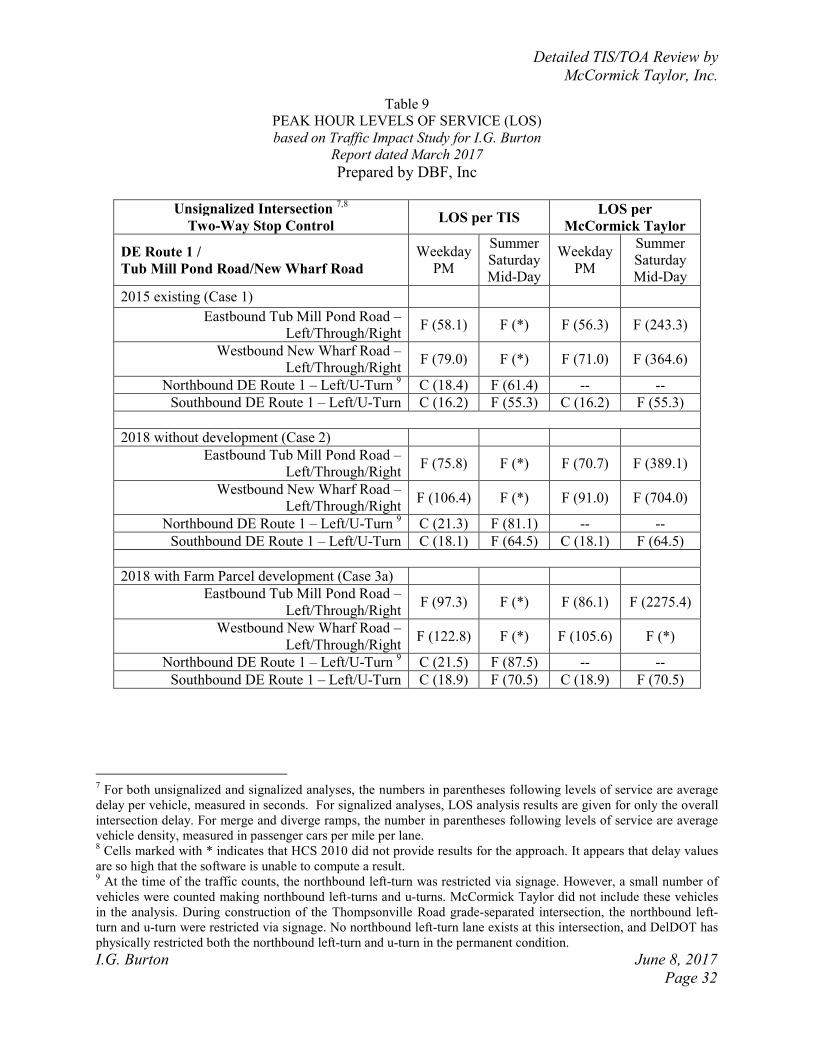
Detailed TIS/TOA Review by
McCormick Taylor, Inc.
I.G. Burton June 8, 2017
Page 32
Table 9
PEAK HOUR LEVELS OF SERVICE (LOS)
based on Traffic Impact Study for I.G. Burton
Report dated March 2017
Prepared by DBF, Inc
Unsignalized Intersection
7,8
Two-Way Stop Control LOS per TIS
LOS per
McCormick Taylor
DE Route 1 /
Tub Mill Pond Road/New Wharf Road
Weekday
PM
Summer
Saturday
Mid-Day
Weekday
PM
Summer
Saturday
Mid-Day
2015 existing (Case 1)
Eastbound Tub Mill Pond Road –
Left/Through/Right F (58.1) F (*) F (56.3) F (243.3)
Westbound New Wharf Road –
Left/Through/Right F (79.0) F (*) F (71.0) F (364.6)
Northbound DE Route 1 – Left/U-Turn 9 C (18.4) F (61.4) -- --
Southbound DE Route 1 – Left/U-Turn C (16.2) F (55.3) C (16.2) F (55.3)
2018 without development (Case 2)
Eastbound Tub Mill Pond Road –
Left/Through/Right F (75.8) F (*) F (70.7) F (389.1)
Westbound New Wharf Road –
Left/Through/Right F (106.4) F (*) F (91.0) F (704.0)
Northbound DE Route 1 – Left/U-Turn 9 C (21.3) F (81.1) -- --
Southbound DE Route 1 – Left/U-Turn C (18.1) F (64.5) C (18.1) F (64.5)
2018 with Farm Parcel development (Case 3a)
Eastbound Tub Mill Pond Road –
Left/Through/Right F (97.3) F (*) F (86.1) F (2275.4)
Westbound New Wharf Road –
Left/Through/Right F (122.8) F (*) F (105.6) F (*)
Northbound DE Route 1 – Left/U-Turn 9 C (21.5) F (87.5) -- --
Southbound DE Route 1 – Left/U-Turn C (18.9) F (70.5) C (18.9) F (70.5)
7 For both unsignalized and signalized analyses, the numbers in parentheses following levels of service are average
delay per vehicle, measured in seconds. For signalized analyses, LOS analysis results are given for only the overall
intersection delay. For merge and diverge ramps, the number in parentheses following levels of service are average
vehicle density, measured in passenger cars per mile per lane. 8 Cells marked with * indicates that HCS 2010 did not provide results for the approach. It appears that delay values
are so high that the software is unable to compute a result. 9 At the time of the traffic counts, the northbound left-turn was restricted via signage. However, a small number of
vehicles were counted making northbound left-turns and u-turns. McCormick Taylor did not include these vehicles
in the analysis. During construction of the Thompsonville Road grade-separated intersection, the northbound left-
turn and u-turn were restricted via signage. No northbound left-turn lane exists at this intersection, and DelDOT has
physically restricted both the northbound left-turn and u-turn in the permanent condition.
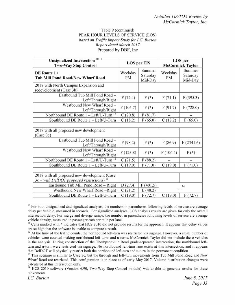
Detailed TIS/TOA Review by
McCormick Taylor, Inc.
I.G. Burton June 8, 2017
Page 33
Table 9 (continued)
PEAK HOUR LEVELS OF SERVICE (LOS)
based on Traffic Impact Study for I.G. Burton
Report dated March 2017
Prepared by DBF, Inc
Unsignalized Intersection
10,11
Two-Way Stop Control LOS per TIS
LOS per
McCormick Taylor
DE Route 1 /
Tub Mill Pond Road/New Wharf Road
Weekday
PM
Summer
Saturday
Mid-Day
Weekday
PM
Summer
Saturday
Mid-Day
2018 with North Campus Expansion and
redevelopment (Case 3b)
Eastbound Tub Mill Pond Road –
Left/Through/Right F (72.4) F (*) F (71.1) F (395.3)
Westbound New Wharf Road –
Left/Through/Right F (105.7) F (*) F (91.7) F (728.0)
Northbound DE Route 1 – Left/U-Turn 12
C (20.8) F (81.7) -- --
Southbound DE Route 1 – Left/U-Turn C (18.2) F (65.0) C (18.2) F (65.0)
2018 with all proposed new development
(Case 3c)
Eastbound Tub Mill Pond Road –
Left/Through/Right F (98.2) F (*) F (86.9) F (2341.6)
Westbound New Wharf Road –
Left/Through/Right F (123.8) F (*) F (106.4) F (*)
Northbound DE Route 1 – Left/U-Turn 12
C (21.5) F (88.2) -- --
Southbound DE Route 1 – Left/U-Turn C (19.0) F (71.0) C (19.0) F (71.0)
2018 with all proposed new development (Case
3c – with DelDOT proposed restrictions) 13
Eastbound Tub Mill Pond Road – Right D (27.4) F (401.5) ---
14
Westbound New Wharf Road –Right C (21.2) E (48.2)
Southbound DE Route 1 – Left/U-Turn C (19.0) F (72.7) C (19.0) F (72.7)
10
For both unsignalized and signalized analyses, the numbers in parentheses following levels of service are average
delay per vehicle, measured in seconds. For signalized analyses, LOS analysis results are given for only the overall
intersection delay. For merge and diverge ramps, the number in parentheses following levels of service are average
vehicle density, measured in passenger cars per mile per lane. 11
Cells marked with * indicates that HCS 2010 did not provide results for the approach. It appears that delay values
are so high that the software is unable to compute a result. 12
At the time of the traffic counts, the northbound left-turn was restricted via signage. However, a small number of
vehicles were counted making northbound left-turns and u-turns. McCormick Taylor did not include these vehicles
in the analysis. During construction of the Thompsonville Road grade-separated intersection, the northbound left-
turn and u-turn were restricted via signage. No northbound left-turn lane exists at this intersection, and it appears
that DelDOT will physically restrict both the northbound left-turn and u-turn in the permanent condition. 13
This scenario is similar to Case 3c, but the through and left-turn movements from Tub Mill Pond Road and New
Wharf Road are restricted. This configuration is in place as of early May 2017. Volume distribution changes were
calculated at this intersection only. 14
HCS 2010 software (Version 6.90, Two-Way Stop-Control module) was unable to generate results for these
movements.
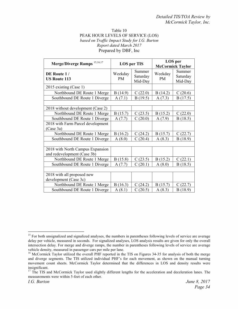
Detailed TIS/TOA Review by
McCormick Taylor, Inc.
I.G. Burton June 8, 2017
Page 34
Table 10
PEAK HOUR LEVELS OF SERVICE (LOS)
based on Traffic Impact Study for I.G. Burton
Report dated March 2017
Prepared by DBF, Inc
Merge/Diverge Ramps 15,16,17
LOS per TIS LOS per
McCormick Taylor
DE Route 1 /
US Route 113
Weekday
PM
Summer
Saturday
Mid-Day
Weekday
PM
Summer
Saturday
Mid-Day
2015 existing (Case 1)
Northbound DE Route 1 Merge B (14.9) C (22.0) B (14.2) C (20.6)
Southbound DE Route 1 Diverge A (7.1) B (19.5) A (7.3) B (17.5)
2018 without development (Case 2)
Northbound DE Route 1 Merge B (15.7) C (23.5) B (15.2) C (22.0)
Southbound DE Route 1 Diverge A (7.7) C (20.0) A (7.9) B (18.5)
2018 with Farm Parcel development
(Case 3a)
Northbound DE Route 1 Merge B (16.2) C (24.2) B (15.7) C (22.7)
Southbound DE Route 1 Diverge A (8.0) C (20.4) A (8.3) B (18.9)
2018 with North Campus Expansion
and redevelopment (Case 3b)
Northbound DE Route 1 Merge B (15.8) C (23.5) B (15.2) C (22.1)
Southbound DE Route 1 Diverge A (7.7) C (20.1) A (8.0) B (18.5)
2018 with all proposed new
development (Case 3c)
Northbound DE Route 1 Merge B (16.3) C (24.2) B (15.7) C (22.7)
Southbound DE Route 1 Diverge A (8.1) C (20.5) A (8.3) B (18.9)
15
For both unsignalized and signalized analyses, the numbers in parentheses following levels of service are average
delay per vehicle, measured in seconds. For signalized analyses, LOS analysis results are given for only the overall
intersection delay. For merge and diverge ramps, the number in parentheses following levels of service are average
vehicle density, measured in passenger cars per mile per lane. 16
McCormick Taylor utilized the overall PHF reported in the TIS on Figures 34-35 for analysis of both the merge
and diverge segments. The TIS utilized individual PHF’s for each movement, as shown on the manual turning
movement count sheets. McCormick Taylor determined that the differences in LOS and density results were
insignificant. 17
The TIS and McCormick Taylor used slightly different lengths for the acceleration and deceleration lanes. The
measurements were within 5-feet of each other.
Detailed TIS/TOA Review by
McCormick Taylor, Inc.
I.G. Burton June 8, 2017
Page 35
Table 11
PEAK HOUR LEVELS OF SERVICE (LOS)
based on Traffic Impact Study for I.G. Burton
Report dated March 2017
Prepared by DBF, Inc
Signalized Intersection 18
LOS per TIS 19
LOS per
McCormick Taylor 20,21
US Route 113 /
Warner Road/North Walnut St
Weekday
PM
Summer
Saturday
Mid-Day
Weekday
PM
Summer
Saturday
Mid-Day
2015 existing (Case 1)
C (29.3) D (41.1) C (24.2) B (16.2)
2018 without development (Case 2)
C (29.7) D (43.2) C (24.9) B (15.9)
2018 with Farm Parcel development
(Case 3a)
C (29.9) D (44.9) C (25.1) B (15.9)
2018 with North Campus Expansion
and redevelopment (Case 3b)
C (29.7) D (43.3) C (24.9) B (15.9)
2018 with all proposed new
development (Case 3c)
C (29.9) D (45.1) C (25.1) B (15.9)
18
For both unsignalized and signalized analyses, the numbers in parentheses following levels of service are average
delay per vehicle, measured in seconds. For signalized analyses, LOS analysis results are given for only the overall
intersection delay. For merge and diverge ramps, the number in parentheses following levels of service are average
vehicle density, measured in passenger cars per mile per lane. 19
The TIS presents two sets of results. One uses timings as per the DelDOT signal timing plan, and the second uses
HCS optimized signal timings. The results shown here are those with timings as per the DelDOT signal timing plan.
It appears that DBF may have checked “Field-Measured Phase Times” in the HCS input window. McCormick
Taylor did not check this box to allow the software to estimate signal phase durations. 20
Results are with timings as per the DelDOT signal timing plan. 21
McCormick Taylor coded an eastbound right-turn overlap to better reflect the operation of this turning movement.
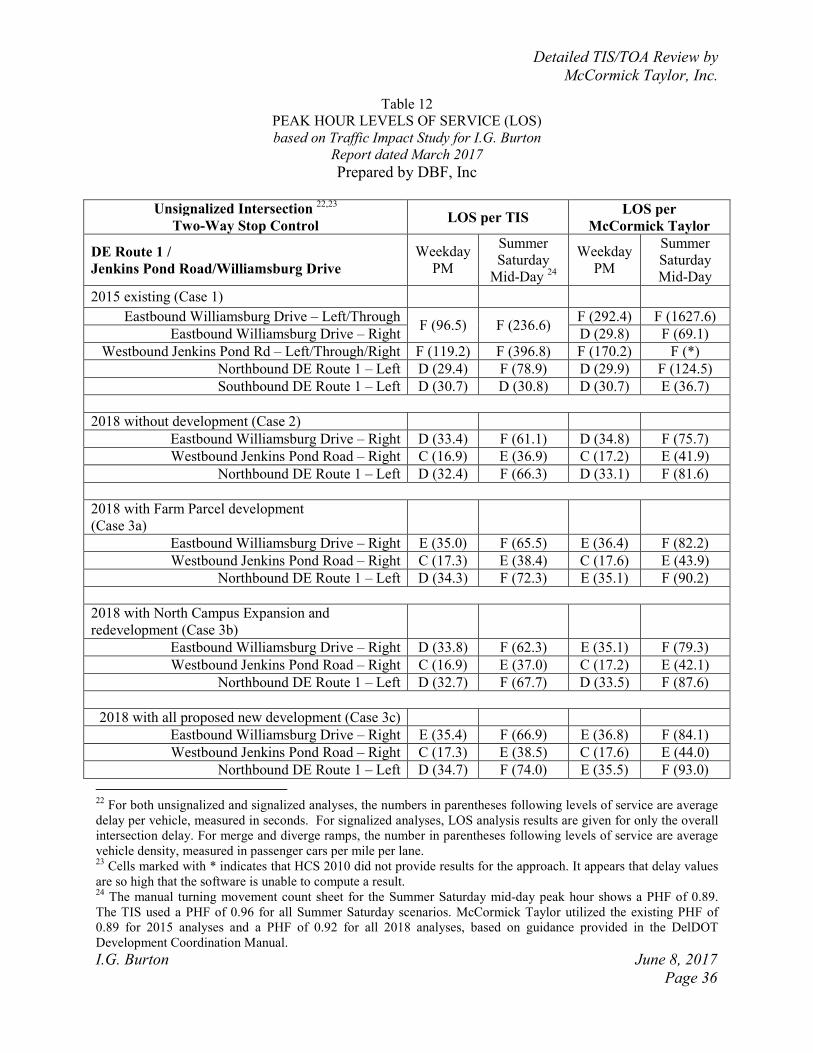
Detailed TIS/TOA Review by
McCormick Taylor, Inc.
I.G. Burton June 8, 2017
Page 36
Table 12
PEAK HOUR LEVELS OF SERVICE (LOS)
based on Traffic Impact Study for I.G. Burton
Report dated March 2017
Prepared by DBF, Inc
Unsignalized Intersection
22,23
Two-Way Stop Control LOS per TIS
LOS per
McCormick Taylor
DE Route 1 /
Jenkins Pond Road/Williamsburg Drive
Weekday
PM
Summer
Saturday
Mid-Day 24
Weekday
PM
Summer
Saturday
Mid-Day
2015 existing (Case 1)
Eastbound Williamsburg Drive – Left/Through F (96.5) F (236.6)
F (292.4) F (1627.6)
Eastbound Williamsburg Drive – Right D (29.8) F (69.1)
Westbound Jenkins Pond Rd – Left/Through/Right F (119.2) F (396.8) F (170.2) F (*)
Northbound DE Route 1 – Left D (29.4) F (78.9) D (29.9) F (124.5)
Southbound DE Route 1 – Left D (30.7) D (30.8) D (30.7) E (36.7)
2018 without development (Case 2)
Eastbound Williamsburg Drive – Right D (33.4) F (61.1) D (34.8) F (75.7)
Westbound Jenkins Pond Road – Right C (16.9) E (36.9) C (17.2) E (41.9)
Northbound DE Route 1 – Left D (32.4) F (66.3) D (33.1) F (81.6)
2018 with Farm Parcel development
(Case 3a)
Eastbound Williamsburg Drive – Right E (35.0) F (65.5) E (36.4) F (82.2)
Westbound Jenkins Pond Road – Right C (17.3) E (38.4) C (17.6) E (43.9)
Northbound DE Route 1 – Left D (34.3) F (72.3) E (35.1) F (90.2)
2018 with North Campus Expansion and
redevelopment (Case 3b)
Eastbound Williamsburg Drive – Right D (33.8) F (62.3) E (35.1) F (79.3)
Westbound Jenkins Pond Road – Right C (16.9) E (37.0) C (17.2) E (42.1)
Northbound DE Route 1 – Left D (32.7) F (67.7) D (33.5) F (87.6)
2018 with all proposed new development (Case 3c)
Eastbound Williamsburg Drive – Right E (35.4) F (66.9) E (36.8) F (84.1)
Westbound Jenkins Pond Road – Right C (17.3) E (38.5) C (17.6) E (44.0)
Northbound DE Route 1 – Left D (34.7) F (74.0) E (35.5) F (93.0)
22
For both unsignalized and signalized analyses, the numbers in parentheses following levels of service are average
delay per vehicle, measured in seconds. For signalized analyses, LOS analysis results are given for only the overall
intersection delay. For merge and diverge ramps, the number in parentheses following levels of service are average
vehicle density, measured in passenger cars per mile per lane. 23
Cells marked with * indicates that HCS 2010 did not provide results for the approach. It appears that delay values
are so high that the software is unable to compute a result. 24
The manual turning movement count sheet for the Summer Saturday mid-day peak hour shows a PHF of 0.89.
The TIS used a PHF of 0.96 for all Summer Saturday scenarios. McCormick Taylor utilized the existing PHF of
0.89 for 2015 analyses and a PHF of 0.92 for all 2018 analyses, based on guidance provided in the DelDOT
Development Coordination Manual.
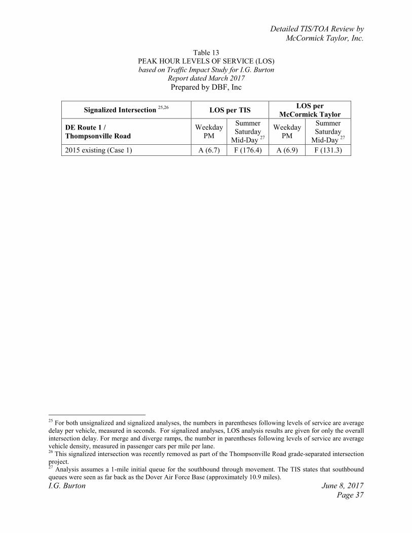
Detailed TIS/TOA Review by
McCormick Taylor, Inc.
I.G. Burton June 8, 2017
Page 37
Table 13
PEAK HOUR LEVELS OF SERVICE (LOS)
based on Traffic Impact Study for I.G. Burton
Report dated March 2017
Prepared by DBF, Inc
Signalized Intersection 25,26
LOS per TIS LOS per
McCormick Taylor
DE Route 1 /
Thompsonville Road
Weekday
PM
Summer
Saturday
Mid-Day 27
Weekday
PM
Summer
Saturday
Mid-Day 27
2015 existing (Case 1) A (6.7) F (176.4) A (6.9) F (131.3)
25
For both unsignalized and signalized analyses, the numbers in parentheses following levels of service are average
delay per vehicle, measured in seconds. For signalized analyses, LOS analysis results are given for only the overall
intersection delay. For merge and diverge ramps, the number in parentheses following levels of service are average
vehicle density, measured in passenger cars per mile per lane. 26
This signalized intersection was recently removed as part of the Thompsonville Road grade-separated intersection
project. 27
Analysis assumes a 1-mile initial queue for the southbound through movement. The TIS states that southbound
queues were seen as far back as the Dover Air Force Base (approximately 10.9 miles).
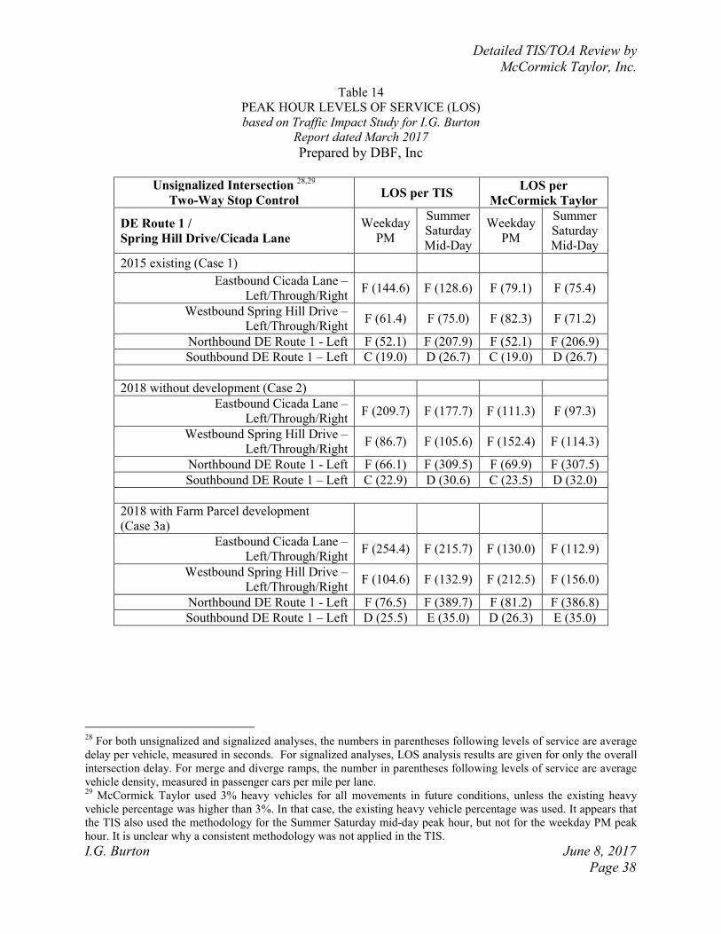
Detailed TIS/TOA Review by
McCormick Taylor, Inc.
I.G. Burton June 8, 2017
Page 38
Table 14
PEAK HOUR LEVELS OF SERVICE (LOS)
based on Traffic Impact Study for I.G. Burton
Report dated March 2017
Prepared by DBF, Inc
Unsignalized Intersection
28,29
Two-Way Stop Control LOS per TIS
LOS per
McCormick Taylor
DE Route 1 /
Spring Hill Drive/Cicada Lane
Weekday
PM
Summer
Saturday
Mid-Day
Weekday
PM
Summer
Saturday
Mid-Day
2015 existing (Case 1)
Eastbound Cicada Lane –
Left/Through/Right F (144.6) F (128.6) F (79.1) F (75.4)
Westbound Spring Hill Drive –
Left/Through/Right F (61.4) F (75.0) F (82.3) F (71.2)
Northbound DE Route 1 - Left F (52.1) F (207.9) F (52.1) F (206.9)
Southbound DE Route 1 – Left C (19.0) D (26.7) C (19.0) D (26.7)
2018 without development (Case 2)
Eastbound Cicada Lane –
Left/Through/Right F (209.7) F (177.7) F (111.3) F (97.3)
Westbound Spring Hill Drive –
Left/Through/Right F (86.7) F (105.6) F (152.4) F (114.3)
Northbound DE Route 1 - Left F (66.1) F (309.5) F (69.9) F (307.5)
Southbound DE Route 1 – Left C (22.9) D (30.6) C (23.5) D (32.0)
2018 with Farm Parcel development
(Case 3a)
Eastbound Cicada Lane –
Left/Through/Right F (254.4) F (215.7) F (130.0) F (112.9)
Westbound Spring Hill Drive –
Left/Through/Right F (104.6) F (132.9) F (212.5) F (156.0)
Northbound DE Route 1 - Left F (76.5) F (389.7) F (81.2) F (386.8)
Southbound DE Route 1 – Left D (25.5) E (35.0) D (26.3) E (35.0)
28
For both unsignalized and signalized analyses, the numbers in parentheses following levels of service are average
delay per vehicle, measured in seconds. For signalized analyses, LOS analysis results are given for only the overall
intersection delay. For merge and diverge ramps, the number in parentheses following levels of service are average
vehicle density, measured in passenger cars per mile per lane. 29
McCormick Taylor used 3% heavy vehicles for all movements in future conditions, unless the existing heavy
vehicle percentage was higher than 3%. In that case, the existing heavy vehicle percentage was used. It appears that
the TIS also used the methodology for the Summer Saturday mid-day peak hour, but not for the weekday PM peak
hour. It is unclear why a consistent methodology was not applied in the TIS.
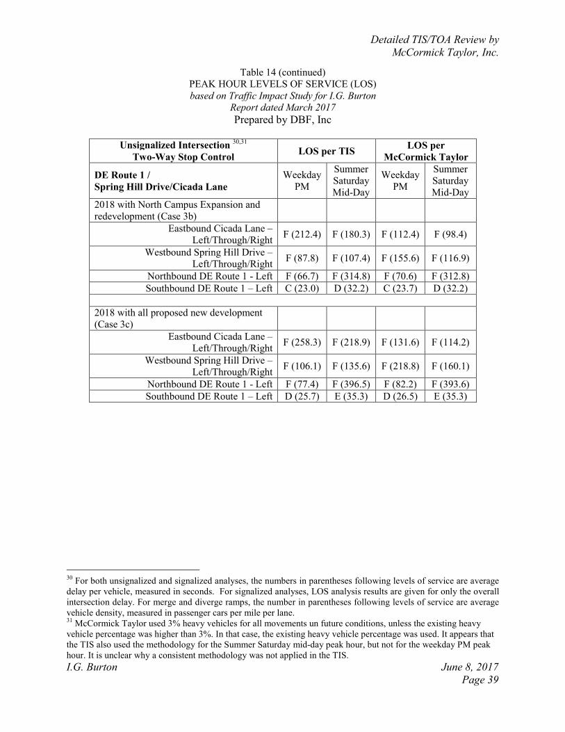
Detailed TIS/TOA Review by
McCormick Taylor, Inc.
I.G. Burton June 8, 2017
Page 39
Table 14 (continued)
PEAK HOUR LEVELS OF SERVICE (LOS)
based on Traffic Impact Study for I.G. Burton
Report dated March 2017
Prepared by DBF, Inc
Unsignalized Intersection
30,31
Two-Way Stop Control LOS per TIS
LOS per
McCormick Taylor
DE Route 1 /
Spring Hill Drive/Cicada Lane
Weekday
PM
Summer
Saturday
Mid-Day
Weekday
PM
Summer
Saturday
Mid-Day
2018 with North Campus Expansion and
redevelopment (Case 3b)
Eastbound Cicada Lane –
Left/Through/Right F (212.4) F (180.3) F (112.4) F (98.4)
Westbound Spring Hill Drive –
Left/Through/Right F (87.8) F (107.4) F (155.6) F (116.9)
Northbound DE Route 1 - Left F (66.7) F (314.8) F (70.6) F (312.8)
Southbound DE Route 1 – Left C (23.0) D (32.2) C (23.7) D (32.2)
2018 with all proposed new development
(Case 3c)
Eastbound Cicada Lane –
Left/Through/Right F (258.3) F (218.9) F (131.6) F (114.2)
Westbound Spring Hill Drive –
Left/Through/Right F (106.1) F (135.6) F (218.8) F (160.1)
Northbound DE Route 1 - Left F (77.4) F (396.5) F (82.2) F (393.6)
Southbound DE Route 1 – Left D (25.7) E (35.3) D (26.5) E (35.3)
30
For both unsignalized and signalized analyses, the numbers in parentheses following levels of service are average
delay per vehicle, measured in seconds. For signalized analyses, LOS analysis results are given for only the overall
intersection delay. For merge and diverge ramps, the number in parentheses following levels of service are average
vehicle density, measured in passenger cars per mile per lane. 31
McCormick Taylor used 3% heavy vehicles for all movements un future conditions, unless the existing heavy
vehicle percentage was higher than 3%. In that case, the existing heavy vehicle percentage was used. It appears that
the TIS also used the methodology for the Summer Saturday mid-day peak hour, but not for the weekday PM peak
hour. It is unclear why a consistent methodology was not applied in the TIS.
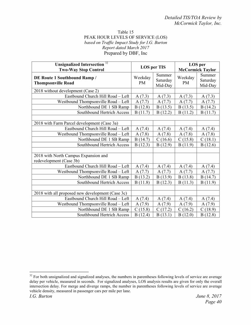
Detailed TIS/TOA Review by
McCormick Taylor, Inc.
I.G. Burton June 8, 2017
Page 40
Table 15
PEAK HOUR LEVELS OF SERVICE (LOS)
based on Traffic Impact Study for I.G. Burton
Report dated March 2017
Prepared by DBF, Inc
Unsignalized Intersection
32
Two-Way Stop Control LOS per TIS
LOS per
McCormick Taylor
DE Route 1 Southbound Ramp /
Thompsonville Road
Weekday
PM
Summer
Saturday
Mid-Day
Weekday
PM
Summer
Saturday
Mid-Day
2018 without development (Case 2)
Eastbound Church Hill Road – Left A (7.3) A (7.3) A (7.3) A (7.3)
Westbound Thompsonville Road – Left A (7.7) A (7.7) A (7.7) A (7.7)
Northbound DE 1 SB Ramp B (12.8) B (13.5) B (13.5) B (14.2)
Southbound Hertrich Access B (11.7) B (12.2) B (11.2) B (11.7)
2018 with Farm Parcel development (Case 3a)
Eastbound Church Hill Road – Left A (7.4) A (7.4) A (7.4) A (7.4)
Westbound Thompsonville Road – Left A (7.8) A (7.8) A (7.8) A (7.8)
Northbound DE 1 SB Ramp B (14.7) C (16.6) C (15.8) C (18.1)
Southbound Hertrich Access B (12.3) B (12.9) B (11.9) B (12.6)
2018 with North Campus Expansion and
redevelopment (Case 3b)
Eastbound Church Hill Road – Left A (7.4) A (7.4) A (7.4) A (7.4)
Westbound Thompsonville Road – Left A (7.7) A (7.7) A (7.7) A (7.7)
Northbound DE 1 SB Ramp B (13.2) B (13.9) B (13.8) B (14.7)
Southbound Hertrich Access B (11.8) B (12.3) B (11.3) B (11.9)
2018 with all proposed new development (Case 3c)
Eastbound Church Hill Road – Left A (7.4) A (7.4) A (7.4) A (7.4)
Westbound Thompsonville Road – Left A (7.9) A (7.9) A (7.9) A (7.9)
Northbound DE 1 SB Ramp C (15.8) C (17.2) C (16.2) C (18.9)
Southbound Hertrich Access B (12.4) B (13.1) B (12.0) B (12.8)
32
For both unsignalized and signalized analyses, the numbers in parentheses following levels of service are average
delay per vehicle, measured in seconds. For signalized analyses, LOS analysis results are given for only the overall
intersection delay. For merge and diverge ramps, the number in parentheses following levels of service are average
vehicle density, measured in passenger cars per mile per lane.
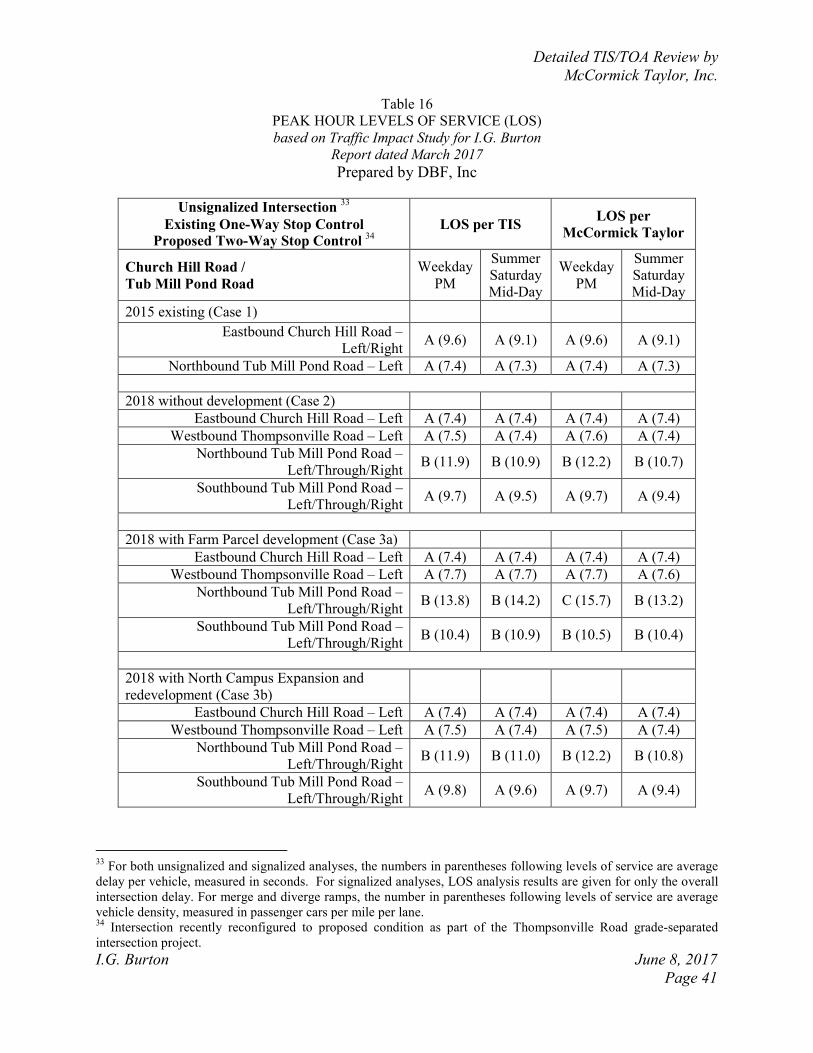
Detailed TIS/TOA Review by
McCormick Taylor, Inc.
I.G. Burton June 8, 2017
Page 41
Table 16
PEAK HOUR LEVELS OF SERVICE (LOS)
based on Traffic Impact Study for I.G. Burton
Report dated March 2017
Prepared by DBF, Inc
Unsignalized Intersection 33
Existing One-Way Stop Control
Proposed Two-Way Stop Control 34
LOS per TIS
LOS per
McCormick Taylor
Church Hill Road /
Tub Mill Pond Road
Weekday
PM
Summer
Saturday
Mid-Day
Weekday
PM
Summer
Saturday
Mid-Day
2015 existing (Case 1)
Eastbound Church Hill Road –
Left/Right A (9.6) A (9.1) A (9.6) A (9.1)
Northbound Tub Mill Pond Road – Left A (7.4) A (7.3) A (7.4) A (7.3)
2018 without development (Case 2)
Eastbound Church Hill Road – Left A (7.4) A (7.4) A (7.4) A (7.4)
Westbound Thompsonville Road – Left A (7.5) A (7.4) A (7.6) A (7.4)
Northbound Tub Mill Pond Road –
Left/Through/Right B (11.9) B (10.9) B (12.2) B (10.7)
Southbound Tub Mill Pond Road –
Left/Through/Right A (9.7) A (9.5) A (9.7) A (9.4)
2018 with Farm Parcel development (Case 3a)
Eastbound Church Hill Road – Left A (7.4) A (7.4) A (7.4) A (7.4)
Westbound Thompsonville Road – Left A (7.7) A (7.7) A (7.7) A (7.6)
Northbound Tub Mill Pond Road –
Left/Through/Right B (13.8) B (14.2) C (15.7) B (13.2)
Southbound Tub Mill Pond Road –
Left/Through/Right B (10.4) B (10.9) B (10.5) B (10.4)
2018 with North Campus Expansion and
redevelopment (Case 3b)
Eastbound Church Hill Road – Left A (7.4) A (7.4) A (7.4) A (7.4)
Westbound Thompsonville Road – Left A (7.5) A (7.4) A (7.5) A (7.4)
Northbound Tub Mill Pond Road –
Left/Through/Right B (11.9) B (11.0) B (12.2) B (10.8)
Southbound Tub Mill Pond Road –
Left/Through/Right A (9.8) A (9.6) A (9.7) A (9.4)
33
For both unsignalized and signalized analyses, the numbers in parentheses following levels of service are average
delay per vehicle, measured in seconds. For signalized analyses, LOS analysis results are given for only the overall
intersection delay. For merge and diverge ramps, the number in parentheses following levels of service are average
vehicle density, measured in passenger cars per mile per lane. 34
Intersection recently reconfigured to proposed condition as part of the Thompsonville Road grade-separated
intersection project.
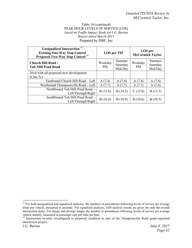
Detailed TIS/TOA Review by
McCormick Taylor, Inc.
I.G. Burton June 8, 2017
Page 42
Table 16 (continued)
PEAK HOUR LEVELS OF SERVICE (LOS)
based on Traffic Impact Study for I.G. Burton
Report dated March 2017
Prepared by DBF, Inc
Unsignalized Intersection 35
Existing One-Way Stop Control
Proposed Two-Way Stop Control 36
LOS per TIS
LOS per
McCormick Taylor
Church Hill Road /
Tub Mill Pond Road
Weekday
PM
Summer
Saturday
Mid-Day
Weekday
PM
Summer
Saturday
Mid-Day
2018 with all proposed new development
(Case 3c)
Eastbound Church Hill Road – Left A (7.4) A (7.4) A (7.4) A (7.4)
Westbound Thompsonville Road – Left A (7.7) A (7.7) A (7.7) A (7.6)
Northbound Tub Mill Pond Road –
Left/Through/Right B (13.8) B (14.3) C (15.8) B (13.3)
Southbound Tub Mill Pond Road –
Left/Through/Right B (10.4) B (10.9) B (10.6) B (10.5)
35
For both unsignalized and signalized analyses, the numbers in parentheses following levels of service are average
delay per vehicle, measured in seconds. For signalized analyses, LOS analysis results are given for only the overall
intersection delay. For merge and diverge ramps, the number in parentheses following levels of service are average
vehicle density, measured in passenger cars per mile per lane. 36
Intersection recently reconfigured to proposed condition as part of the Thompsonville Road grade-separated
intersection project.
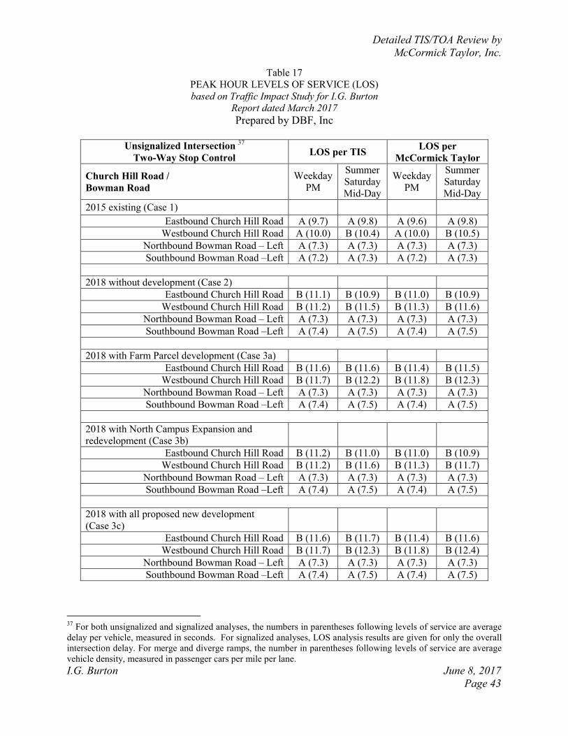
Detailed TIS/TOA Review by
McCormick Taylor, Inc.
I.G. Burton June 8, 2017
Page 43
Table 17
PEAK HOUR LEVELS OF SERVICE (LOS)
based on Traffic Impact Study for I.G. Burton
Report dated March 2017
Prepared by DBF, Inc
Unsignalized Intersection
37
Two-Way Stop Control LOS per TIS
LOS per
McCormick Taylor
Church Hill Road /
Bowman Road
Weekday
PM
Summer
Saturday
Mid-Day
Weekday
PM
Summer
Saturday
Mid-Day
2015 existing (Case 1)
Eastbound Church Hill Road A (9.7) A (9.8) A (9.6) A (9.8)
Westbound Church Hill Road A (10.0) B (10.4) A (10.0) B (10.5)
Northbound Bowman Road – Left A (7.3) A (7.3) A (7.3) A (7.3)
Southbound Bowman Road –Left A (7.2) A (7.3) A (7.2) A (7.3)
2018 without development (Case 2)
Eastbound Church Hill Road B (11.1) B (10.9) B (11.0) B (10.9)
Westbound Church Hill Road B (11.2) B (11.5) B (11.3) B (11.6)
Northbound Bowman Road – Left A (7.3) A (7.3) A (7.3) A (7.3)
Southbound Bowman Road –Left A (7.4) A (7.5) A (7.4) A (7.5)
2018 with Farm Parcel development (Case 3a)
Eastbound Church Hill Road B (11.6) B (11.6) B (11.4) B (11.5)
Westbound Church Hill Road B (11.7) B (12.2) B (11.8) B (12.3)
Northbound Bowman Road – Left A (7.3) A (7.3) A (7.3) A (7.3)
Southbound Bowman Road –Left A (7.4) A (7.5) A (7.4) A (7.5)
2018 with North Campus Expansion and
redevelopment (Case 3b)
Eastbound Church Hill Road B (11.2) B (11.0) B (11.0) B (10.9)
Westbound Church Hill Road B (11.2) B (11.6) B (11.3) B (11.7)
Northbound Bowman Road – Left A (7.3) A (7.3) A (7.3) A (7.3)
Southbound Bowman Road –Left A (7.4) A (7.5) A (7.4) A (7.5)
2018 with all proposed new development
(Case 3c)
Eastbound Church Hill Road B (11.6) B (11.7) B (11.4) B (11.6)
Westbound Church Hill Road B (11.7) B (12.3) B (11.8) B (12.4)
Northbound Bowman Road – Left A (7.3) A (7.3) A (7.3) A (7.3)
Southbound Bowman Road –Left A (7.4) A (7.5) A (7.4) A (7.5)
37
For both unsignalized and signalized analyses, the numbers in parentheses following levels of service are average
delay per vehicle, measured in seconds. For signalized analyses, LOS analysis results are given for only the overall
intersection delay. For merge and diverge ramps, the number in parentheses following levels of service are average
vehicle density, measured in passenger cars per mile per lane.
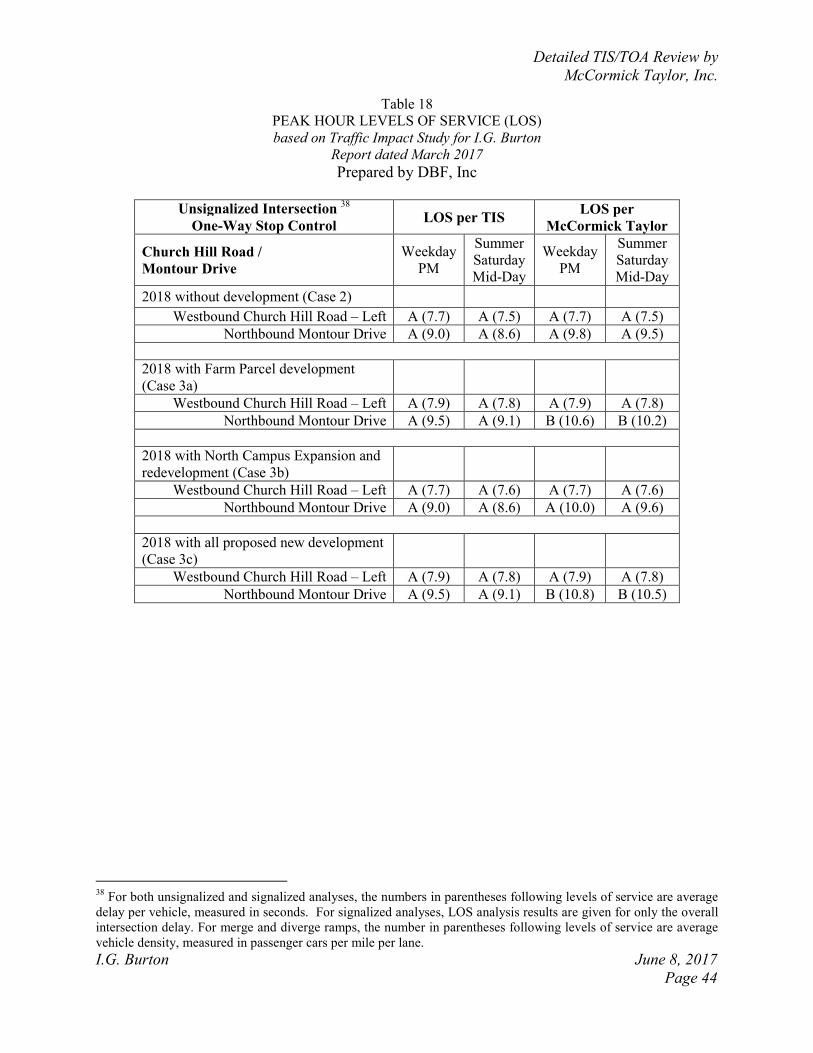
Detailed TIS/TOA Review by
McCormick Taylor, Inc.
I.G. Burton June 8, 2017
Page 44
Table 18
PEAK HOUR LEVELS OF SERVICE (LOS)
based on Traffic Impact Study for I.G. Burton
Report dated March 2017
Prepared by DBF, Inc
Unsignalized Intersection
38
One-Way Stop Control LOS per TIS
LOS per
McCormick Taylor
Church Hill Road /
Montour Drive
Weekday
PM
Summer
Saturday
Mid-Day
Weekday
PM
Summer
Saturday
Mid-Day
2018 without development (Case 2)
Westbound Church Hill Road – Left A (7.7) A (7.5) A (7.7) A (7.5)
Northbound Montour Drive A (9.0) A (8.6) A (9.8) A (9.5)
2018 with Farm Parcel development
(Case 3a)
Westbound Church Hill Road – Left A (7.9) A (7.8) A (7.9) A (7.8)
Northbound Montour Drive A (9.5) A (9.1) B (10.6) B (10.2)
2018 with North Campus Expansion and
redevelopment (Case 3b)
Westbound Church Hill Road – Left A (7.7) A (7.6) A (7.7) A (7.6)
Northbound Montour Drive A (9.0) A (8.6) A (10.0) A (9.6)
2018 with all proposed new development
(Case 3c)
Westbound Church Hill Road – Left A (7.9) A (7.8) A (7.9) A (7.8)
Northbound Montour Drive A (9.5) A (9.1) B (10.8) B (10.5)
38
For both unsignalized and signalized analyses, the numbers in parentheses following levels of service are average
delay per vehicle, measured in seconds. For signalized analyses, LOS analysis results are given for only the overall
intersection delay. For merge and diverge ramps, the number in parentheses following levels of service are average
vehicle density, measured in passenger cars per mile per lane.
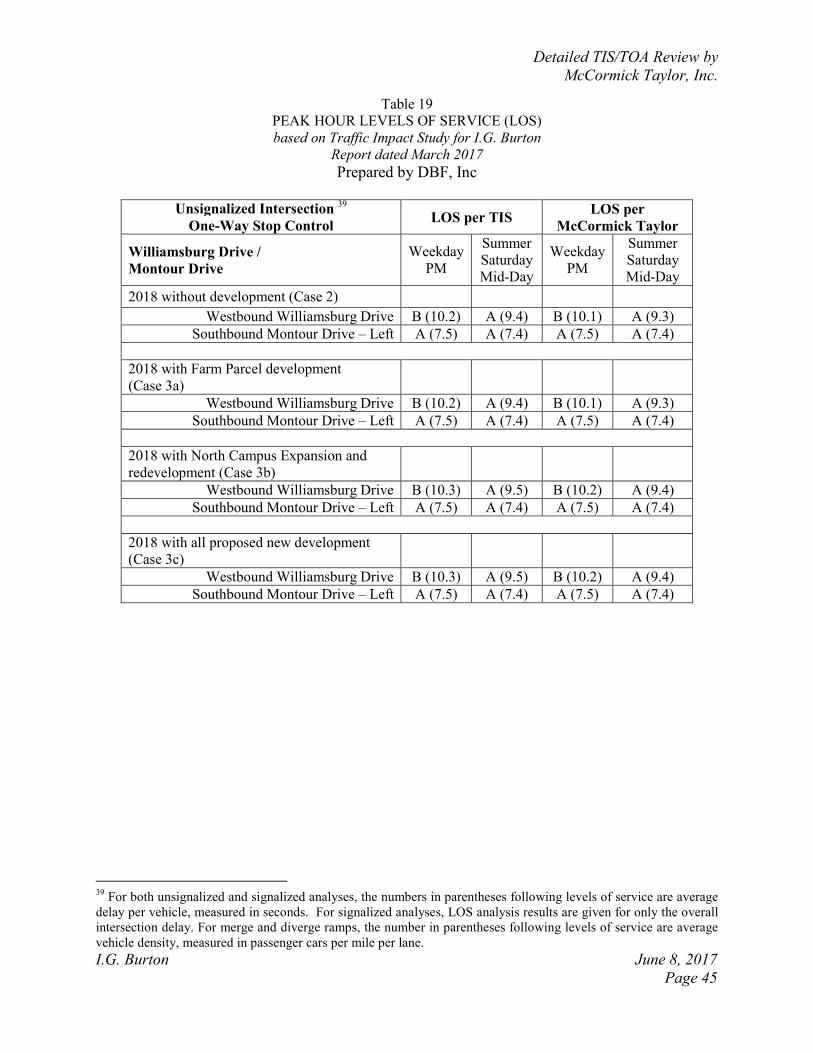
Detailed TIS/TOA Review by
McCormick Taylor, Inc.
I.G. Burton June 8, 2017
Page 45
Table 19
PEAK HOUR LEVELS OF SERVICE (LOS)
based on Traffic Impact Study for I.G. Burton
Report dated March 2017
Prepared by DBF, Inc
Unsignalized Intersection
39
One-Way Stop Control LOS per TIS
LOS per
McCormick Taylor
Williamsburg Drive /
Montour Drive
Weekday
PM
Summer
Saturday
Mid-Day
Weekday
PM
Summer
Saturday
Mid-Day
2018 without development (Case 2)
Westbound Williamsburg Drive B (10.2) A (9.4) B (10.1) A (9.3)
Southbound Montour Drive – Left A (7.5) A (7.4) A (7.5) A (7.4)
2018 with Farm Parcel development
(Case 3a)
Westbound Williamsburg Drive B (10.2) A (9.4) B (10.1) A (9.3)
Southbound Montour Drive – Left A (7.5) A (7.4) A (7.5) A (7.4)
2018 with North Campus Expansion and
redevelopment (Case 3b)
Westbound Williamsburg Drive B (10.3) A (9.5) B (10.2) A (9.4)
Southbound Montour Drive – Left A (7.5) A (7.4) A (7.5) A (7.4)
2018 with all proposed new development
(Case 3c)
Westbound Williamsburg Drive B (10.3) A (9.5) B (10.2) A (9.4)
Southbound Montour Drive – Left A (7.5) A (7.4) A (7.5) A (7.4)
39
For both unsignalized and signalized analyses, the numbers in parentheses following levels of service are average
delay per vehicle, measured in seconds. For signalized analyses, LOS analysis results are given for only the overall
intersection delay. For merge and diverge ramps, the number in parentheses following levels of service are average
vehicle density, measured in passenger cars per mile per lane.
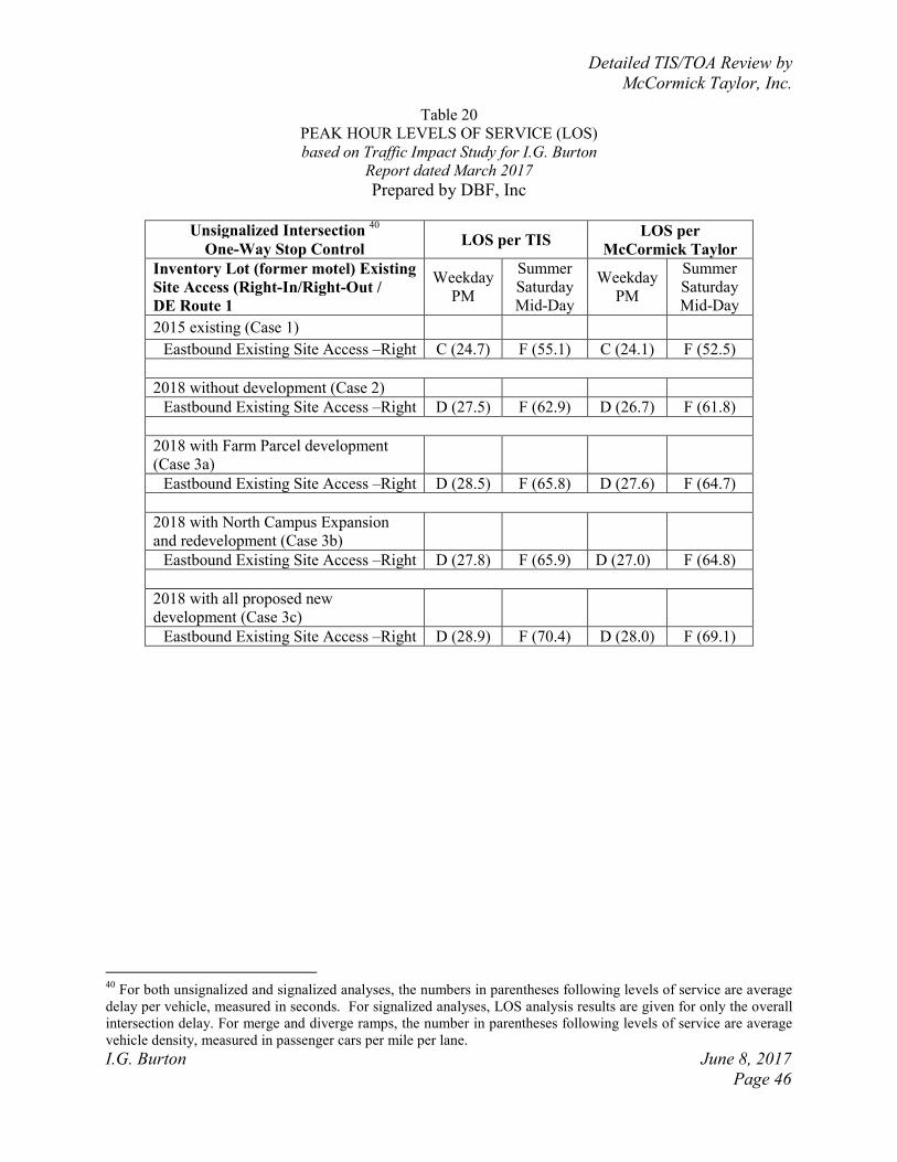
Detailed TIS/TOA Review by
McCormick Taylor, Inc.
I.G. Burton June 8, 2017
Page 46
Table 20
PEAK HOUR LEVELS OF SERVICE (LOS)
based on Traffic Impact Study for I.G. Burton
Report dated March 2017
Prepared by DBF, Inc
Unsignalized Intersection
40
One-Way Stop Control LOS per TIS
LOS per
McCormick Taylor
Inventory Lot (former motel) Existing
Site Access (Right-In/Right-Out /
DE Route 1
Weekday
PM
Summer
Saturday
Mid-Day
Weekday
PM
Summer
Saturday
Mid-Day
2015 existing (Case 1)
Eastbound Existing Site Access –Right C (24.7) F (55.1) C (24.1) F (52.5)
2018 without development (Case 2)
Eastbound Existing Site Access –Right D (27.5) F (62.9) D (26.7) F (61.8)
2018 with Farm Parcel development
(Case 3a)
Eastbound Existing Site Access –Right D (28.5) F (65.8) D (27.6) F (64.7)
2018 with North Campus Expansion
and redevelopment (Case 3b)
Eastbound Existing Site Access –Right D (27.8) F (65.9) D (27.0) F (64.8)
2018 with all proposed new
development (Case 3c)
Eastbound Existing Site Access –Right D (28.9) F (70.4) D (28.0) F (69.1)
40
For both unsignalized and signalized analyses, the numbers in parentheses following levels of service are average
delay per vehicle, measured in seconds. For signalized analyses, LOS analysis results are given for only the overall
intersection delay. For merge and diverge ramps, the number in parentheses following levels of service are average
vehicle density, measured in passenger cars per mile per lane.