Embed Size (px)
Citation preview

DAVIDSON COUNTY PLANNING DEPARTMENT GOVERNMENTAL CENTER
C. SCOTT LEONARD 913 GREENSBORO STREET PLANNING DIRECTOR POST OFFICE BOX 1067 LEXINGTON, NORTH CAROLINA 27293-1067 R. LEE CROOK, JR. ZONING ADMINISTRATOR LEXINGTON 336-242-2220
“PLANNING FOR A BETTER TOMORROW”
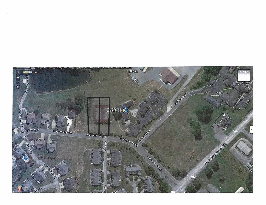
To: Planning Board Members From: Scott Leonard, Director Subject: Planning Board Meeting Date: October 12, 2021 The next Planning Board meeting will be on Tuesday, October 19th at 6:00pm. We currently have four items on the Agenda including three rezoning requests and one Final Plat approval for Ledford South Phase IV. The rezoning requests include one from Justin & Whitney Samuel in Conrad Hill Township who wish to downzone their property from HC to RA-2. Sheilah Smith Young in Abbotts Creek Township is requesting to do the same, by rezoning a portion of her property from RC down to RA-3 while leaving a portion of her property as RC. The third request is from Hurdle Land Development. Mr. Hurdle established his landscaping business adjacent to the Mallard Landing Planned Development, and a portion of his property shares road frontage along Mallard Landing Boulevard. He wishes to build two houses and add them to the HOA of Mallard Landing, therefore he is requesting an MXR zone as an extension of the old PDH (Planned Development Housing) zoning that Mallard Landing was approved under. I will be out of town next week; therefore Mr. Crook will handle the final plat approval for Ledford South Phase IV which a copy of the plat lies within your packet. If you have any questions regarding the items on the Agenda, please let us know. SL/SRW

DAVIDSON COUNTY PLANNING BOARD AGENDA OCTOBER 19, 2021
6:00PM
Persons with disabilities who may need special accommodations to participate in this meeting should notify the County Manager’s office at 336-242-2200 at least twenty-four hours prior to the start of the meeting.
COMMISSIONERS MEETING ROOM
DAVIDSON COUNTY GOVERNMENTAL CENTER 913 GREENSBORO STREET, LEXINGTON, NORTH CAROLINA
I. Welcome by the Chairman
II. Adoption of the Agenda
III. Public Address
IV. Approval of Planning Board Minutes
A. October 5, 2021
V. Rezoning Requests A. Justin & Whitney Samuel- HC to RA-3- Conrad Hill Township B. Sheilah Shean Smith Young- RC to RA-3- Abbotts Creek Township C. Hurdle Land Development, LLC- CS to MX-R- Arcadia Township
VI. Subdivisions A. Ledford South Phase IV- Final Plat Approval- Thomasville Township
VII. Adjournment
10/5/2021 DAVIDSON COUNTY PLANNING BOARD MINUTES
for October 5, 2021, 6:00pm Governmental Center
Lexington, North Carolina
Members Present: Chairman Steve Long, Vice Chairman Greg Greene, Joe Hayworth, Wesley
Kimbrell, Jim Myers
Members Absent: Ted Myers
Staff Present: Scott Leonard, Lee Crook, Travis Swain, Cory Hartsoe, Stephanie Wilson, Sr. Asst. County Attorney Mike Newby, Asst. County Attorney Andrew Howe
Others Present: Titus Tysinger, Christopher Crisp, Randy Thomason
I. WELCOME
II. ADOPTION OF THE AGENDA
Prior to the Adoption of the Agenda, a motion was made by Wes Kimbrell to excuse Ted Myers from the Planning Board meeting, which was seconded by Joe Hayworth. By a vote of 4-0 the motion carried. Wes Kimbrell made a motion to recognize Jim Myers as a voting member in the absence of Ted Myers. Vice Chairman Greg Greene seconded the motion and passed with a vote of 4-0.
With no changes to the agenda, Joe Hayworth motioned to adopt the agenda. Jim Myers seconded the motion and the vote stood at 5-0.
III. PUBLIC ADDRESS
There was no response.
IV. APPROVAL OF PLANNING BOARD MINUTES
A. 9/21/2021 Planning Board Minutes
Joe Hayworth made the motion to approve the minutes for the 9/21/2021 Planning Board Meeting as presented. The motion was seconded by Vice Chairman Greene and carried with a vote of 5-0.
V. ADOPTION OF THE 2022 PLANNING BOARD MEETING SCHEDULE A motion was made by Jim Myers to adopt the proposed Planning Board Meeting Schedule for the 2022 Calendar year. The motion was seconded by Wesley Kimbrell and was approved by a vote of 5-0.

2 | P a g e
VI. REZONING REQUESTS A. Titus Tysinger- RS to RA-1- Emmons Township
Mr. Crook read the legal notice for the record: “Request by Titus Tysinger to rezone property located in Emmons Township, Tax Map 22 Lot 34 containing 7.56 acres more or less. Said property is located on the south side of Regan road approximately 793 feet east of the Frank Road intersection. Rezoning is requested to change from that of RS, Low Intensity Residential District to that of RA-1, Rural Agricultural District.” Cory Hartsoe reported the current RS Zoning of the site does not allow any type of manufactured homes. The Applicant and Owner of the property, Titus Tysinger, would like to place a double-wide mobile home on site with a brick foundation. RA-1 Zoning District is contiguous to the site and permits double-wide manufactured homes with a brick or block foundation. Mr. Tysinger reiterated to the Board he wishes to place a double-wide mobile home on site. He indicated construction costs are too high at this time for site-built home to be taken into consideration. With no further discussion, Mr. Crook read the Staff Analysis & Recommendation in support of the request for the record (see attached). A motion for the Board to recommend approval of the request was made by Jim Myers. The motion was seconded by Vice Chairman Greene and carried with a vote of 5-0. This item is scheduled to be heard at the 10/26/2021 Commissioners Meeting at 6pm.
B. Lexington Investment Properties, LLC/ Christopher Crisp- RS to RC- Lexington Township Mr. Crook read the legal notice for the record: “Request by Lexington Investment Properties, LLC/ Christopher Crisp to rezone property in Lexington Township, Tax Map 332C, Block Q, Lot 1 containing 0.36 acre more or less. Said property is located on the west side of Old US Hwy 52 approximately 230 feet north of the East Elizabeth Street intersection at 1761 Old US Hwy 52. Rezoning is requested to change from that of RS, Low Intensity Residential District, to that of RC, Rural Commercial District.” Travis Swain explained the location of the site to the Board. He pointed out neighboring properties, their uses, and surrounding zoning districts. Mr. Crisp’s adjacent lot to the south is zoned RC and houses his used car dealership. Mr. Crisp wishes to have the subject property rezoned from Low Intensity Residential District to that of Rural Commercial so he can expand the parking lot of his existing business. The Applicant intends to place a buffer of evergreen trees between the location and the adjacent residentially zoned lot north of the site if the request is granted.

3 | P a g e
Mr. Crook informed the Board since the application for the rezoning request had been submitted, the subject property and Mr. Crisp’s neighboring lots have been combined and are collectively recognized as tax parcel 11-332C-00C-0001, making this request now for a portion of lot 1. Christopher Crisp explained the history of the location to the Board, how long he has been in business and how he acquired the lots over time that now make up Tax Lot 1. He reported his plans are to extend parking area for his car lot. No structures will be placed on the site in question and there will not be an additional driveway connection. With the lots having been combined, the majority of the new lot is zoned RC with the location of the subject property still being zoned RS, inhibiting the applicant from using his lot in the manner he wishes. If the request is granted, the lot would be uniform in its zoning and the applicant would be able to move forward with his plans. With no one in the audience to speak for or against the application, Mr. Crook read the Staff Analysis & Recommendation in support of the request for the record (see attached). A motion for the Board to recommend approval of the request was made by Vice Chairman Greene. The motion was seconded by Joe Hayworth and was granted with a vote of 5-0. This item is scheduled to be heard at the 10/26/2021 Commissioners Meeting at 6pm.
VII. SUBDIVISIONS
A. Raven Ridge Phase II- Preliminary Plat Approval- Lexington Township
Mr. Leonard submitted copies to the Board of the preliminary plat for Raven Ridge Phase II, directly south of Raven Ridge Phase I, located on the south side of Arnold Road. The development contains 75 traditional lots, all meeting the County’s minimum standards. A Soil Analysis Report from Piedmont Environmental had been submitted to Staff indicating the majority of the land is suitable for septic systems. A letter from NCDOT requests the developer construct a left-hand turn lane into the development from on Arnold Road. Mr. Leonard talked for a moment regarding a 40’ wide deeded access easement which extends from the end of Jackson Avenue, across tax parcel 11-327-0-000-0003 owned by Kenneth Ray Hyatt Trustee, to the eastern side of the proposed site of Raven Ridge Phase II. The easement does not meet NCDOT road standards but is beneficial to the development for the purpose of adding an emergency access. The plat also represents small portion of the site being deeded to George K. Ware, tax ID 11-327-0-000-0001A, granting him legal access to his adjacent tract of land through the development. Mr. Ware has reportedly never had legal access to his tract of land and is pleased with this decision. Randy Thomason with Piedmont Triad Land Developers LLC reported an HOA will be associated with this development and is already in place for Raven Ridge Phase I. He explained the HOA will be responsible for maintaining the 40’ wide easement in accordance with the law for the purpose of emergency vehicle access only.

4 | P a g e
There was a lengthy discussion regarding the access to Mr. Ware’s property and whether or not the developer would be willing to widen the access order for it to meet state standards, in turn, enhancing the chances for future development. Ultimately, Mr. Thomason said it should not be the responsibility of his company to improve the access to such an extent for the benefit of someone else who would not have invested in the improvement themselves. The proposed access is an improvement in itself, providing increased accessibility to as many as four lots if lot 3 was ever divided in the future. There are several conditions of the land which limit further development of lot 3, such as topo, creeks, and the colonial pipeline right of way.
After additional conversation regarding connectivity, Joe Hayworth made a motion to approve the preliminary plat for Raven Ridge Phase II. The motion was seconded by Wes Kimbrell and was approved by a vote of 5-0.
VIII. ADJOURNMENT
Before adjourning, the Board discussed adding conversation to a future meeting agenda pertaining to possibility of connectivity requirements for future developments. The Planning Board meeting for October 5th, 2021 was adjourned with no further business to bring to the Board’s attention.
________________________________ Secretary to the Planning Board _________________________ Chairman of Davidson County Planning Board

Staff Analysis and Recommendation for the
Titus Tysinger Rezoning to RA-1:
Applicant is requesting to rezone property from RS, Low Intensity Residential District to RA-1, Rural Agricultural District in Emmons Township, Tax Map 22, Lot 34 containing 7.56 acres more or less. Said property is located on the south side of Regan Road approximately 793 feet east of the Frank Road intersection.
The Applicant wishes to rezone the above-mentioned property to place a doublewide manufactured home. The subject property has been zoned RS since zoning was adopted in this part of Davidson County on May 11th, 1990. This area primarily contains larger acreage residential development with lots of 5 acres or more common throughout.
The subject property is contiguous to RA-1 zoning to the south, west and partially to the north. The tract to the east is zoned RS but is over 7 acres and heavily wooded. There is a wide variety of residential development in the area. There are single wide and double wide manufactured homes, as well as modular and stick built residences all in close proximity to the applicant’s property. Due to the large tract size and wooded nature of the area the impact of this diversity of housing type is minimized due to the screening effect of said trees and large lots.
The Davidson County Land Development Plan promotes residential development in this community but does not differentiate as to what types. Staff has to look at the existing development patterns to make a recommendation on the highest and best use for the property. It is staff’s opinion that an additional well maintained doublewide manufactured home on the subject tract would not be detrimental to the maintenance of property values in this area due to the characteristics of the land. Policy Statements 6.2, 6.5, 6.8 and 6.10 support this request. The Davidson County Zoning Ordinance, Article VII Administration, Section VII.10 Amendments offers support to this request of district expansion due to the subject property being contiguous to a RA-1 Zoning District.
Staff feels that the applicant’s request is reasonable and consistent with the existing growth patterns of the local area and would recommend approval of the rezoning request.
Attachment
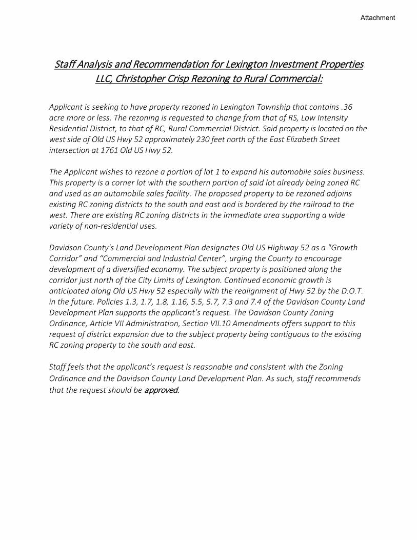
Staff Analysis and Recommendation for Lexington Investment Properties LLC, Christopher Crisp Rezoning to Rural Commercial:
Applicant is seeking to have property rezoned in Lexington Township that contains .36 acre more or less. The rezoning is requested to change from that of RS, Low Intensity Residential District, to that of RC, Rural Commercial District. Said property is located on the west side of Old US Hwy 52 approximately 230 feet north of the East Elizabeth Street intersection at 1761 Old US Hwy 52. The Applicant wishes to rezone a portion of lot 1 to expand his automobile sales business. This property is a corner lot with the southern portion of said lot already being zoned RC and used as an automobile sales facility. The proposed property to be rezoned adjoins existing RC zoning districts to the south and east and is bordered by the railroad to the west. There are existing RC zoning districts in the immediate area supporting a wide variety of non-residential uses. Davidson County's Land Development Plan designates Old US Highway 52 as a "Growth Corridor” and “Commercial and Industrial Center”, urging the County to encourage development of a diversified economy. The subject property is positioned along the corridor just north of the City Limits of Lexington. Continued economic growth is anticipated along Old US Hwy 52 especially with the realignment of Hwy 52 by the D.O.T. in the future. Policies 1.3, 1.7, 1.8, 1.16, 5.5, 5.7, 7.3 and 7.4 of the Davidson County Land Development Plan supports the applicant’s request. The Davidson County Zoning Ordinance, Article VII Administration, Section VII.10 Amendments offers support to this request of district expansion due to the subject property being contiguous to the existing RC zoning property to the south and east. Staff feels that the applicant’s request is reasonable and consistent with the Zoning Ordinance and the Davidson County Land Development Plan. As such, staff recommends that the request should be approved.
Attachment


DAVIDSON COUNTY PLANNING DEPARTMENT Application for Amendment to the Davidson County Zoning Ordinance
@) or Text (Circle One)
Date .. · ___ ..,.. _________ Fees Paid Rcpt. No.:. ___________ _
Applicant(s):. _____ ~--------------------
Address:._· ~--------------~-Telephone No. ______ _
Property Owner._·-----------,-.----------------✓
Address:. __________________ Telephone No.:·-------
Property Location (General Description'-----------------~-
Township:.~ ~-----Map No. __ Blk. No. __ . Lot(s) ________ _
Acres(more or less), ____ Exisiing Zoning District. ___ Proposed Zoning District:. ___ _
Legal Advertisemenl:. _________________________ _
Planning Board Meeting Date:. ________ Recommendation:. ______ _
Public Hearing Date.: _________ Commissioners' Action:. ________ _
Signature, Applicant(s),_..,,/J'--J,_,Jf;_,,,· ~·"'-2"-'. /.....,,,/;&""?c/4""-"'L,-""'--------------
Agent:. ______________ By:~-------------
Address:.~=-----~==--------Telephone No.:. ______ _
2

Davidson County Planning Department
Name:._\~Aun:i_\(.._L_m_d_be:_✓0_\o_,_P:_m_~----Application for Amendment to the Davidson County Zoning Ordinance
Contents of Application: All applications for amendments to this ordinance, without limiting the right to file additional material, shall contain at least the following (applicant may attach additional sheets if necessary):
(a) If the proposed amendment would require a change in the ZONING ATLAS, a fully dimensioned map at a scale of not less than 400 feet nor more than 20 feet to the inch showing the land which would be covered by the proposed amendment.
[b) A legal description of such land, if applicable.
[c) Any alleged error in this ordinance which would be corrected by the proposed amendment with a detailed explanation of such error in the ordinance and detailed reasons how the proposed amendment will correct same.
(d) The changed or changing conditions, if any, in a particular area or in the county generally, whlcl1 make the proposed amendment reasonably necessary to the promotion of the public health, safety, and general welfare.
(e) The manner in which the proposed amendment will carry out the intent and purpose of a comprehensive plan.
[f) All other circumstances, factors. and reasons which applicant offers in support of the proposed amendment.
3

Davidson County Planning Department 913 Greensboro Street Post Office Box 1067 Lexington, North Carolina 27293-1067
Guy L. Cornman, Ill Planning Director
Parcel ID
03011 S0000001
03011 M0000102A
Adjoining Property Owners From the Tax Administrators Office as of:
10105/2021
Owner Name Mailing Address HURDLE LAND DEVELOPMENT LLC PO BOX569
WELCOME
THE VILLAS AT MALLARD LANDING
Toll Free Numbers Lexington: 336-242-2220
Winston-Salem: 336-723-7890 ext. 2220 Denton: 336-859-2194 ext. 2220
NC 27374
00000-
103011 K0000141 EATON PHILLIP MICHAEL 273 MALLARD LANDING BLVD I CLEMMONS NC 27012-03011K0000001B MALLARD LANDING HOMEOWNERS %SCOFIELD BISHOP PROPERTY
WINSTON SALEM NC 27103-03011K0000001 ITHE ESTATES AT MALLARD LANDING 656 MALLARD LANDING BLVD
HOA INC CLEMMONS NC 27012 0301100000033 !HURDLE LAND DEVELOPMENT LLC PO BOX 569
WELCOME NC 27374 0301100000032 ;HURDLE LAND DEVELOPMENT LLC PO BOX 569
WELCOME NC 27374
"Planning for a Better Tomorrow"

ÌLegend
county
centerlines
INTERSTATE
NCHWYUSHWY
SECONDARY
ZONING BOUNDARIES
PROPERTY LINES
2014 Aerial Photography
Scale Drawn By: TGSDate: REVISED:
Applicant:
Property Owner:
TO: MX-R, MIXED USERESIDENTIAL DIST.
ARCADIA TWSP., MAP 11, P/O LOT 32, 0.96 ACRES + OR -
Hurdle Land Development
FROM: CS, COMMUNITYSHOPPING DIST.
Hurdle Land Development, LLC
10/04/20211 inch = 400 feet
Site32
33
1102A
141
1B1
Pelic
anLn
Ma llard
Landing Blvd
N NC Hwy 150
Twin Brook Dr
High land Hills Dr
SiteSunset Rd
Twin Brook Dr
Community Rd
Mt. O
livet
Ch.R
d
N NC Hwy15
0
Su""')'O" C«llfcolo !or Cloo.u«
'"'"'""""""''"'""'''"" ......... .,. .......... , .. ,....,,1oo,,.,.. ~,"",'ti.':.'"H iri'!,~"'.:'..:::::"""" (...., .,..,.,,"" ,.,,,...,.. '" •01 ,...,,,.,.. "' '°"°"' M~•I"'- u,o, \ho tot<> O! p,«_,, o, •-~, ..
i.,,o.(KJO"'"°''"''""l'• .. r<""" .. '"""°'..,."'"''"'-S."·"' .,..,,.., ... , ""'°"'m'o,"l-....,,_.,,.'«<>Houm ... oo;,«< '"~ "" ..,, ,, .>,n,, •.O.. 21)21
Preliminary Map Not for Recordalion Conveyances or Sales
HURDLE LAND DEVELDPMENT, LLC
LOT A PER PB 65 PG 73
0-i I I
I
NEW LOT l 0.481 ACRES 20.967 SO.FT.
< i I I I
---1-
TOwER
68
~ g
~ ~ f 0
;;; ~ C
I
t I I I I I
N 82"36'48"W
.., .. ··~ SQ<>oftu,b Cont<d c.,,...-•·· Con«"• w ...... ="• e.,,,,,..,,. -~no< u1)
f~2:=""~ -u,11.-.0 ... ,~ ~"!.~°"Rod [""'ol?o""""''
™',.....,,~ ... Jo,,,.,.,,....,....,,...,....,,, .... ,..., .. ,, ,._..,..,,...,,..,, .... ...,., ............ , .... ..,,_,. "''"°""""""""'""'--"'"'··' ... ""'""'' -
I/ 74.35' TIE
~t.-1 ;~~ I ~f~ ~;~ I ea,, I i~i ~i] I •;t I
I
i
I LOT 1A / 1.or ,a
I REVISION Of t.OT 1 Of
-, I I I I I I I I I
_J
MALARD LANDING HOMEOWNERS PB 43 PG 61
V1clni\y Mop (N.T.S.)
PLAT OF SURVEY FOR:
HURDLE LAND DEVELOPMENT, LLC PROP£RT'/ .!)l!fl!'SS; "'U.•RO LAN!>ING Bl.VD .• Cl.O,OIICtlS ~C 27011
SCA!.[: 1·-•a• ORA-...! BY: BKC DAn:, 6/7/2021 llt\OSCD:
~RCM>IA TOWNSHIP. O~VIOSON COUNTY, NORTH CAACIUIIA
P/0 PIN ID: 681!>-02-68-1951 JOBI 151110HD
"9JABBOTT'S .....,CREEK ~SURVEYING
... I
1\1<1.D IC. CIIRRY, NS f30&0 WT~ &\ST cn<Ul! sn:n:BT =-
1.CCl«:roK. K.C. "12lll! (:!30) ~•~-010,
E•lllll.: Nc:sutmrroMI.D'.cmm!CJ<r;J mut I c-1001

t ix, 00
I:; "'
z
N 82'36' 48"W I/ 74.36' 11E
..J "' « ,_ "'
0 ~:fw-1 ... "'
~oo,Z
"' ;;i J r.:
" i)lZJS' :;:: i:'.:~ I ' IE~~ I 0
"' ;~"' ix, !" ~ .,§ I 0 w~"' 0
Ul ~a_!l I
r.,
"
ff=-- J__
I.OTM I I I
L01
REVISlON CF U mt ESTA'TE Al MAU
SEC~ON 1 PB 53- PG
I I I I I ---
MALL


September 16, 2021
To Whom It May Concern:
This letter is in regard to the two lots (formerly tennis courts) adjacent to 182 Mallard Landing
Boulevard in Clemmons, North Carolina. The owner, Scott Hurdle of S&R Enterprises has requested that
the Mallard Landing Master HOA accept these lots as part of the Estates HOA subdivision. After careful
consideration, Mallard Landing Estates sub association to the Mallard Landing Master association boards
have agreed to accept these lots under specific conditions.
1. That these lots are rezoned for single family homes only.
2. The 2 new lots would be a member of the "Estates at Mallard Landing" sub association and
all sub associations are part of the "Mallard Landing Master Board" and would need to
comply to all By Laws, Covenants and architectural governance.
3. Homes built must be similar in style to other homes within the Estates subdivision.
4. Homes must follow architectural guidelines within Estates and Master Covenants.
5. All plans must be approved by the Estates Architectural committee and the Master HOA prior to any construction.
6. Once lots are sold, annual dues will be assessed and paid to the Estates at Mallard Landing.
Best r_~gards, ,,,,. ) c--::.-:, _,, /~
(-/ . I ------------------------Chris W1 son
President, Mallard Landing Master HOA
Chris Coulter
President, The Estates and Mallard Landing
DECLARATION OF COVENANTS, CONDITIONS AND.RESTRICTIONS
FOR MALLARD LANDING WATERFRONT PARCELS
THIS DECLARATION OF COVENANTS, CONDITIONS AND RESTRICTIONS, is made on the.11__ day of5-'f~ 202!_by HURDLE LAND DEVELOPMENT, LLC, a North Carolina corporation (h; ~eferred to as "Declarant");
RECITALS:
(A) Declarant has heretofore acquired title to a certain tract or parcel of land which has been subdivided into lots according to a certain map or plat entitled "MALLARD LANDING WATERFRONT PARCELS" recorded in Plat Book __ Page--~ Davidson County Registry, (herein the "Property").
(B) Declarant desires to subject said land and the lots now or hereafter located therein to the covenants, conditions and restrictions set forth below which are for the purpose of protecting the value and desirability of the land and the lots located therein and are for the purpose of distributing .among the Owners (as hereinafter defined) the cost of maintaining and operating the Common Area (as hereinafter defined) and any improvements constructed thereon.
(C) Declarant hereby declares that all of the land described above shall be held, sold and conveyed subject to the following easements, restrictions, covenants and conditions which shall run with the Property ( as hereinafter defined) and each Lot ( as hereinafter defined) and shall bind and insure the benefit of the Declarant , its successors and assigns, and all Owners, their heirs, successors, executors, administrators and assigns.
DEFINITIONS
Section 1. "Association" shall mean and refer to MALLARD LANDING WATERFRONT PARCELS, its successors and assigns.
Section 2. "Owner" shall mean and refer to the present Owner, whether one or more persons or entities, of fee simple title to any lot which is a pait of the Prope1ty, including contract sellers, but excluding those having such interest merely as security for the performance of an obligation.
Section 3. "Prope1ty" shall mean and refer to that ce1tain real property herein before described.

Section 4. "Committee" shall mean and refer to the Architectural Committee.
Section 5. "Common Area" shall mean and refer to any and all real property subject to this Declaration which is defined and bounded by properly referenced and recorded plat(s) designated thereon as "common area(s)" or "open space." Common Area(s) shall include all real property and easement interests owned by the Association for the common use and enjoyment of Members, including entranceways.
Section 6. "Lot" shall mean and refer to any lot designated by number on the recorded subdivision map of the Property referred to above or any subsequently recorded subdivision map of the Property referring to this Declaration as the same may be amended from time to time.
Section 7. "Declarant" shall mean and refer to HURDLE LAND DEVELOPMENT, LLC, a North Carolina corporation, its successors and assigns, if such successors and assigns should acquire all rights, title and interest in the Property then owned by it, and to whom HURD LE LAND DEVELOPMENT, LLC, a No1th Carolina corporation, ·shall expressly transfer, and assign all of its rights, title and interest under this Declaration, or any amendment or modification thereof.
Section 8. "Member" shall mean and refer to every person or entity who holds membership in the Association.
Section 9. "Master Association" shall mean The Mallard Landing Homeowners Master
Association whose Declaration of Covenants, Conditions and Restrictions are recorded in Book 1494, Page 443, Davidson County Registry, as those covenants may be amended from time to time.
ARTICLE II PROPERTY SUBJECT TO THIS DECLARATION
The Property which is and shall be held, transferred, sold, conveyed and occupied subject to this Declaration is located in Davidson County, No1th Carolina, and is more particularly described on Plat Book 41, Page 21, Davidson County Registry. Declarant reserves the right to object other real property to the covenants, conditions and restrictions set forth herein as provided below.
Without further assent or permit, Declarant hereby reserves the right, exercisable from time to time, to subject other real property to the covenants, conditions and restrictions set forth herein, or to extend the scheme of this Declaration to other property to be developed and thereby to bring such additional properties within the jurisdiction of the Association. Additional prope1ty outside the boundaries of the Property may be annexed by Declarant so long as such additional properties are contiguous to the Prope1ty, and so long as the annexation occurs within twelve (12) years of the date ofincorporation of the Association.
The additions herein authorized shall be made by filing of record one of more supplementary declarations in respect to the properties to be then subject to this Declaration and which shall extend the jurisdiction of the Association to such prope1ty and thereby subject such addition to assessment for its just share of the Association's expenses. Any such supplemental declaration or any other such declaration shall not revoke or otherwise amend the provisions of this
2
Declaration as this Declaration pertains to the prope1ties subject hereto and any such supplemental declaration shall be substantially similar in form and content to this Declaration.
ARTICLE III PROPERTY RIGHTS
Section 1. Owner's Easements of Enjoyment. Every Owner shall have a right and easement of enjoyment in and to the Common Area which shall be appurtenant to and shall pass with the title to every Lot, subject to the following provisions:
(a) The right of the Association to charge reasonable admission and other fees for the use of any recreational facility situated upon the Common Area;
(b) The right of the Association to suspend the voting rights and right to use of the recreational facilities by an Owner for any period during which any assessment against his Lot remains unpaid; and for a period not to exceed sixty (60) days for any infraction ofits published rules and regulations;
· ( c) The right of the Association to dedicate or transfer all or any part of the Common Area to any public agency, authority, or utility for such purposes and subject to such conditions as may be agreed by the Members. No such dedication or transfer shall be effective unless an instrument signed by twothirds (2/3) of each class of Members agreeing to such dedication or transfer has been recorded; provided, however, that no membership vote shall be required with respect to easements granted by the Association pursuant to ARTICLE VII hereof;
(d) The right of the Association to limit the number of guests of Members; and The right of the Association, in accordance with its Articles and By-Laws, to borrow money for the purpose of improving the Common Area and facilities and in aid thereof to mortgage said property, and the rights of such mortgagee in said properties shall be subordinate tothe rights of the Owners hereunder.
Section 2. Delegation of Use. Any Owner may delegate, in accordance with the By-Laws, his rights of enjoyment to the Common Area and facilities to the Members of his family, his tenants, or contract purchasers who occupy the residence of the Owner within the Property.
Section 3. Title to Common Area. The Declarant hereby covenants for itself, its successors and assigns, that it will convey fee simple title to the Common Area to the Association, free and clear of all encumbrances and liens except utility easements and the easements, restrictions, covenants and conditions set forth her in. Further, if ad valorem taxes for the current year have been separately assessed against the Common Area, the same shall be prorated between Declarant and the Association as of the transfer date; otherwise such taxes shall be paid by Declarant.
ARTICLE IV
3
MEMBERSHIP AND VOTING RIGHTS
Section I. Every Owner of a Lot which is subject to assessment shall be a Member of the Association. Membership shall be appurtenant to and may not be separated from ownership of any Lot which is subject to assessment.
Section 2. The Association shall have two classes of voting membership:
Class A. Class A Members shall be all Owners with the exception of the Declarant and· shall be entitled to one (1) vote for each Lot owned. When more than one person holds an interest in any Lot, all such persons shall be Members. The vote for such Lot shall be exercised as they among themselves determine, but in no event shal 1 more than one (I) vote be cast with re spect to any Lot.
Class B. The Class B Member(s) shall be the Declarant and shall be entitled to five (5) votes for each Lot owned. The Class B membership shall cease and be converted to Class A membership on the happening of either of the following events, whichever occurs earlier:
(a) Four months after the total votes outstanding in the Class A membership equal the total votes outstanding in the Class B membership, but provided that the Class B membership shall be reinstated if thereafter, and before the time stated in subparagraph (b) below, additional lands are annexed to the Property pursuant to ARTICLE II above and as the result of such annexation, the Declarant, and its successors and assigns, own more than one-fomih (1/4) of the total lots subject to this Declaration.
(b) On December 31, 2022.
Section 3. Any Member who is delinquent in the payment of any charges duly levied by the Association against a Lot owned by such Member shall not be entitled to vote until all such charges, together with such reasonable penalties as the Board of Directors of the Association may impose, have been paid.
Section 4. Members shall vote in person or by proxy executed in writing by the Member. No proxy shall be valid after one (1) year from the date of its execution or upon conveyance by the Member of his Lot. A corporate Member's vote shall be cast by the President of the Member corporation or by any other officer or proxy appointed by the President or designated by the Board of Directors of such corporation, which designation must, if requested by the Association, be in writing.
Section 5. Voting on all matters, except the election of directors, shall be by voice vote or by show of hands unless the majority of the Members present at the meeting shall, prior to voting on any matter, demand a ballot vote on that particular matter. Where directors or officers are to be
4

elected by the Members, the solicitation of proxies for such elections may be conducted by mail.
ARTICLEV COVENANT FOR MAINTENANCE ASSESSMENTS
Section 1. Annual Assessment for Maintenance Fund For each Lot owned within the Prope1ty, every Owner covenants, and each subsequent Owner of any such Lot, by acceptance of a Deed therefore, whether or not it is so expressed in such Deed, is deemed to covenant and agree to pay to the Association for certain expenses of maintenance in accordance with this Declaration:
(a) Annual assessments or charges which are common expenses.
(b) Special assessments as approved by the Association to be established and collected as hereinafter provided.
The annual assessment provided for herein for the Association shall be payable in advance on an annual basis by every Owner of each Lot, unless the Association decides by a majority vote to have the assessment payable monthly. The annual assessment shall be due on January I of each year. At the closing of the purchase of a Lot by an Owner, including builders, the assessment shall begin to accrue and the Owner shall pay to the Association the Owner's pro rata share of the annual assessment for the remainder of the year.
Section 2. Purpose of Assessments. The assessments levied by the Association shall be used exclusively to promote the recreation, health, safety and welfare of the residents of the Prope1ty; to maintain, improve and operate the Common Area, and improvements thereto as herein provided; and to administer the Association's affairs, to include (but not be limited to) the cost of repairs, replacements and additions to the Common Area, included but not limited to roads, the cost of labor, equipment and materials related to the operation of the Common Area, the cost of maintaining all signs and sign area within the Property, yard and landscape maintenance, the cost of management and supervision of the Association's affairs, the payment of taxes assessed against the Common Area, the procurement and maintenance of insurance in accordance with the By-Laws, the employment of agents, attorneys, accountants, consultants and others to represent, advise or assist the Association when necessary, and such other needs as may arise.
Section 3. Creation of the Lien and Personal Obligation of Assessment. In accordance with the terms and provisions hereof, and in order to secure payment at and after the due date, as each assessment becomes due there shall arise a continuing lien and charge against each Lot, the amount of which shall include cost and reasonable attorneys' fees to the extent permissible by law. Each such assessment, together with such interest, cost and reasonable attorneys' fees shall also be the personal obligation of the person who was the Owner of such Lot at the time when the assessment fell due.
Section 4. Annual Maintenance Assessments.
(a) The annual maintenance assessment imposed by the Association shall be set each year by the Association as set forth herein.
5

(b) In establishing the annual assessment for any assessment year, the Board of Directors shall consider all current costs and expenses of the Association, any accrued debts, and reserves for future needs.
Section .5. Special Assessments. In addition to the annual assessment imposed by the Association set forth above, the Association may levy, in any assessment year, a special assessment applicable to that year only.
Section 6. Date of Commencement of Annual Assessment Due Dates; Certificate of Payment.
(a) The annual assessments provided for herein for the Association shall be payable on January I of each year. The assessments shall begin to accrue as to all lots at the time of closing and conveyance of a Lot to an Owner other than the Declarant. At least thirty (30) days before January 1 of each year, the Board of Directors of the Association shall establish the amount of the annual assessment imposed by the Association against each Lot and in the event the Board of Directors of the Association elects not to fix such assessment rate as herein provided, the amount of the prior year's annual assessment shall be the fixed amount. Written notice of any changed. assessment rate shall be sent to every Owner by the Association. The Association shall, upon demand and for a reasonable charge, furnish a certificate signed by an officer of the Association setting forth whether the assessments (whether annual or special or imposed by he Association) on a specified Lot have been paid to date.
Section 7. Effect of Nonpayment of Assessments: Remedies of the Association. Any assessments not paid within thirty (30) days after the due date shall bear interest from the due date at the maximum rate and to the extent allowed by law. The Association or its agents or representatives may bring an action at law against the Owner personally obligated to pay the same or foreclose the lien against the Lot to which the lien relates, and interest, costs and reasonable attorneys' fees for such action or foreclosure shall be added to the amount of such assessment to the extent allowed by the law. No owner may waive or otherwise escape liability for the assessments provided for herein by non-use of the Common Area or abandonment of his Lot.
Section 8. Subordination of the Lien to Mortgages and Ad Valorem Taxes. The liens provided for herein shall be subordinate to the lien of any first lien Deed of Trust (sometimes hereinafter called "mortgage or first mmtgage" and the holder thereof being .sometimes hereinafter referred to as a "first mortgagee") on any Lot if, but only if, all such assessments with respect to such Lot having a due date on or prior to the date such mortgage is filed for record have been paid. The lien and permanent charge hereby subordinated is only a lien and charge as relates to assessments authorized hereunder having a due date subsequent to the date such mortgage is filed for record and prior to the satisfaction, cancellation or foreclosure of such mmtgage or the sale or transfer of the mortgaged property pursuant to any proceeding in lieu of foreclosure or the sale or transfer of the mortgaged prope1ty pursuant to a sale under power contained in such mmtgage. Sale
6

or transfer of any Lot shall not affect any assessment lien. However, the sale or transfer of any Lot which is subject to any mortgage pursuant to a foreclosure thereof or under a power of sale or any proceeding in lieu of foreclosure thereof shall extinguish the lien of such assessment as to payments which became due prior to such sale or transfer, but the Association shall have a lien upon the. proceeds from foreclosure or of sale junior only to the said foreclosed first mortgage and the equity of redemption of the mortgagor or trustor. No sale or transfer shall relieve such Lot from liability for any assessment thereafter becoming due or from the lien thereof, except as provided in Section 11 of this ARTICLE V.
Section 9. Exempt Property. The assessments, charges and liens created under this ARTICLE V shall not apply to the Common Area, nor shall they apply to any Lot, the title to which is vested in the Declarant, or a first mmigagee · subsequent to foreclosure or in the Secretary of Housing and Urban Development or the Administrator of Veterans' Affairs or any other ·state or federal governmental agency which acquires title by reason of such agency's guarantee or insurance of a foreclosed mortgage loan; provided, however, that upon the resale of such Lot by such first mortgagee or such governmental agency, the assessment herein provided shall again commence and accrue and shall be fully applicable to such Lot upon the conveyance to any subsequent Owner. Any Lot which Declarant may hereafter designate for common use as part of the Common Area or otherwise shall be exempt from the assessments and charges created herein. In addition, other than land and improvements devoted to dwelling use, all property dedicated to and accepted by a local public authority and all properties owned by a charitable or non-profit organization exempt from taxation under the laws of the State of North Carolina shall be exempt from the assessments, charges and liens created hereby.
Section 10. Collection of Assessments. The Association shall promptly collect all assessments due from Owners pursuant to the terms and provisions hereof.
ARTICLE VI ARCHITECTURAL CONTROL
Declarant shall have the responsibility of enforcing the restrictions set forth in this A1iicle prior to the formation of the Committee, which upon appointment by the Executive Board of Directors of Mallard Landing Homeowners Master Association, shall assume and be responsible for enforcement. References in this Article to "Committee" shall mean Declarant until the Committee is appointed by the Mallard Landing Homeowners Master Association Executive Board of Directors.
Section 1. Approval of Plans. Each Lot is subject to the provisions of Article VI of the Declaration, Covenants, Conditions and Restrictions for Mallard Landing Homeowners Master Association recorded in Deed Book 1494, Page 443, Davidson County Registry, as amended from time to time.
Section 2. Rules and Regulations. The Executive Board of Directors of the Mallard Landing Homeowners Master Association shall have the power to formulate, publish and enforce reasonable rules and regulations concerning the use and enjoyment of the Common Areas.
7

Section 3. Residential Use. Except for Lots designated as Common Area or open space, unless otherwise designated by Declarant on a recorded plat, each Lot shown on said plat subject to this Declaration shall be used only for private single family residential purposes and for no other purpose whatsoever.
Section 4. Master Association Use Restrictions. The Property is subject to the use restrictions set out in A1iicle VI of the Declaration, Covenants, Conditions and Restrictions for Mallard Landing Homeowners Master Association and the use restrictions set out in Section 5 below. In the event that there is any conflict between the two, the Master Association Declaration shall control.
Section 5. Use Restrictions.
(a) All strnctures, including but not limited to homes, garages, outbuildings, swimming pools and fences, must be built to comply substantially with the plans and specifications as proved by the Committee and before any house may be occupied, it must be completely finished and a ce1iificate of completion must have been issued by-the local or state authority empowered to do so.
(b) No building shall be erected, altered, placed or permitted to remain on any Lot other than a detached, single-family dwelling, not to exceed two (2) stories in height, not including basement and attic space, and a detached private garage for not more than three (3) automobiles.
(c) No one story dwelling shall be built, erected or used unless it shall contain living area of at least 1,800 square feet of heated floor space and no one and one half or two story dwelling shall contain less than 2000 square feet of heated floor space. The floor space herein referred to shall be exclusive of garages, attics, porches, breezeways, terraces, and basement areas. Measurements are to be made from exterior walls. The Committee may, however, permit a variance of up to ten percent (I 0%) of the minimum square footage requirementsset forth herein.
(d) No split level or split foyer dwellings shall be constructed on any Lot.
(e) All exterior siding must be covered with at least Ninety percent (90%) brick. No permanent strncture shall be erected having exposed exterior walls of concrete blocks or basement garages opening toward the front street, and all driveways must be paved with concrete, brick pavers, or colored concrete pavers.
8

(f) The Lots which are subject to this Declaration shall not be subdivided, except that two (2) Owners may subdivide a Lot betweenthem, but only one residence shall he built on the combined original Lot and subdivided portion of any Lot.
(g) Except for steps, stoops, porches, no building or part thereof shall be erected within thirty (30) feet of the front property line, except that steps, stoops, porches, overhanging eaves and cornices may extend no more than three (3) feet over the building's lines. The rear yard shall have a depth of not less than thirty (30) feet. Every building erected on a Lot shall have two (2)side yards and in no case shall the width of either side yard be lessthan ten (10) feet, except that any side yard abutting a street shall not be less than ten (10) feet. Measurements shall be made to exteriorwalls. On three-side or triangular shape Lots, side and rear set back lines shall be determined by the Committee as part of the architectural approval process but in no event shall said requirements be less than that required by the appropriate governmental authorities. No fences may be constructed beyond the rear most portion of any home or garage.
(h) No animals, livestock or poultry of any kind shall be kept or maintained on any Lot or in any building except that no more than two dogs, two cats and/or two of any other household pet may be kept or maintained, provided that they are not kept or maintained for commercial purposes and provided further that the Association may make reasonable rules and regulations regarding such household pets. No animal lots or any type may be maintained on any Lot.
(i) No portion of the Property shall be used for the sale of any items,including automobiles, nor shall junk automobiles or other junk, trash or storage items are allowed .to accumulate on any Lot of the subdivision.
G) Incinerators for garbage, trash or other refuse shall not be used or permitted to be erected or placed on any Lot. Any and all equipment,coolers, wood piles, garbage cans, refuse or storage piles placed on a Lot (whether tempora1y or permanent) shall be screened to conceal same from the view of neighboring Lots, roads, streets or open areas.Plans for all screens, walls and enclosures must be approved by the Committee.
(k) No leaves, trash, garbage or other similar debris shall be burned except as permitted by the appropriate governmental authority. No garbage, trash, construction debris or other unsightly or offensive materials shall be placed upon any portion of any Lot, except as is temporary and incidental to the bona fide improvements of any portion of the Lot.
9

(I) Except with the prior written approval and permission of the Committee, no water well shall be sunk or drilled on any Lot. However, Declarant reserves the right to locate wells, pumping stations and tanks within residential areas or any open space, or on any Lot designated for such use on any recorded plat.
(m) No privies, outside toilet facilities, or septic tanks may be const:ructedor maintained on any Lot.
(n) Stationary outside clotheslines will not be permitted and clothes handling devices such as lines, poles, frames, etc. shall be stored out of sight when not in use.
( o) No Owner shall park any boat, camper, trailer, commercial truck, tractor, van or similar vehicle on any street within the subdivision or permit the same to be stored or regularly parked upon any Lot within the subdivision except in a garage or well-screened enclosure locatedand constructed in accordance with the other provisions of this Declaration.
(p) No temporary structure shall be permitted on any Lot unless screenedfrom view of adjoining Lots, streets and Common Areas, provided, however, temporary buildings and other structures shall be permitted during the construction period of the dwelling or as a temporary real estate sales office for the sale of Lots. No garage, outbuilding or other appurtenant structure shall be used for residential purposes, either temporarily or permanently, except for a finished room or part of the. garage.
(q) All yards shall be properly maintained. The grass shall not be permitted to grow higher than five (5) inches.
(r) The use restrictions set forth in this Section 5 listing those items which may not be maintained on a Lot shall not apply to Lots during the period of construction of the dwelling unit upon the Lot. As soon as the dwelling unit has been completed on a Lot, these use restrictions shall immediately apply to the Lot.
(s) No lot may be used for road purposes, except that the Declarant and any successor Declarant may upon the armexation of additional property pursuant to Article II use any platted lot(s) for road purposes.
10

Section 6. Nuisances and Unsightly Materials. No house or other structure on any Lot shall be used for commercial or business purposes. Each Owner shall refrain from any act or use of his Lot which could reasonably cause embarrassment, discomfort, annoyance or nuisance to the neighborhood. No obnoxious, offensive or illegal activity shall be carried on upon any Lot. No Lot .shall be used in whole or in part for storage of rubbish of any character whatsoever; nor shall any animal substance, thing or material be kept upon any Lot which will admit foul or obnoxious odors, or that will cause any noise that will or might disturb the peace and quiet of the occupants of surrounding property. No trash, rubbish, stored materials, wrecked or inoperable vehicles or similar unsightly items shall be allowed to remain on any Lot. However, the foregoing shall not be construed to prohibit temporary deposits of trash, rubbish and other debris for pickup by garbage and trash removal service units. In the event any Owner of any Lot fails or refuses to keep such property free from any of the foregoing unsightly items, weeds or underbrush, the Association may, at its option, ten (10) days after posting a notice thereon or mailing a notice to said Owner at his property address requesting Owner to comply with the requirements of this section, enter and remove all unsightly items and growth at said Owner's expense, and Owner shall be personally liable to the Association for. the cost and removal, and the cost until paid shall be a permanent charge and lien upon such Lot enforceable to the same extent and collectible as provided for in ARTICLE V. By acquiring property subject to these restrictions, each and every Owner agrees to pay such cost promptly upon demand by the Association, its agents, assigns or representatives. No such entry as provided in this section shall be deemed a trespass. The provisions of this section shall not apply to Lots upon which houses are under construction.
Section 7. Governmental Regulations. Each Owner shall observe all governmental building codes, health regulations, zoning restrictions and other regulations applicable to his Lot. In the event of any conflict between any provisions of any such governmental code, regulation or restriction and any provision of this Declaration, the more restrictive provisions shall apply.
ARTICLE VII EASEMENTS
Section 1. Walks, Drives, Parking Areas and Utilities. All of the properties, including Lots and Common Areas shall be subject to such easements for ·driveways, walkways, parking areas, water lines, sanitary sewers, storm drainage facilities, gas lines, telephone and electric power lines, television antenna lines, and other public utilities as shall be established by the Declarant or its predecessors in title; and the Master Association shall have the power and authority to grant and to. establish in, over, upon and across the Common Area conveyed to it such further easements as are requisite for the convenient use and enjoyment of the property.
Section 2. Utilities and Drainage. The Declarant reserves into itself, its successors and assigns, a perpetual, alienable and releasable easement and right on, across, over and under the ground to erect, maintain, replace and use water, sewer, electric and telephone systems, wires, cables and conduits for the purpose of bringing public service to the Lots and Common Area, said easement to be within (i) ten feet (1 O') of each Lot line fronting on a street, (ii) ten feet (IO') along the side lines of each Lot, (iii) twenty feet (20') along the rear line of such lot, (iv) the rights-of-way of any street or road shown on any recorded plat(s) of the Property, and (v) all areas as are shown on any recorded plats of the Property; provided fmther, that the Declarant or Association make cut, at its own expense, drainways for surface water whenever and whenever such action is required by
11
applicable health or sanitation authorities in order to maintain reasonable standards of health, safety and appearance. These easements and rights expressly include the right to cut any trees, bushes or shrubbery, take or add any soil, or take any other similar action reasonably necessary to provide economical and safe utility installation or to maintain reasonable standards of health, safety and appearance.
Section 3. Emergency. There is hereby reserved without further assign or permit, a general easement to all policemen and security guards employed by Declarant, the Association, fireman, ambulance personnel, and all similar persons to .enter upon the properties or any po1iion thereof which is now or hereafter made subject to this Declaration, in the performance of their respective duties.
ARTICLE VIII GENERAL
PROVISIONS Section 1. Duration. The foregoing restrictions shall be construed to be covenants running
with land and shall be binding and effective for thirty (30) years from the date of recording, at which time they shall be automatically extended for successive periods often (10) years each unless it is agreed by the vote of the majority in interest of the then Owners of the Prope1iy to change, amend or revoke the restrictions in whole or in part. Every purchaser, Owner or subsequent grantee of any interest in any property is now or hereafter made subject to this Declaration, and by acceptance of a Deed or other conveyance therefor, thereby agrees that the covenants and restrictions of this Declaration may be extended as provided in this Article.
Section 2. Amendment. So long as Declarant has the right unilaterally to subject additional property to this Declaration as provided in ARTICLE II hereof, Declarant may
unilaterally amend this Declaration .for .any. other purpose so long as said amendment is not inconsistent with the common plan or scheme of development; provided, however, any such amendment shall not materially adversely affect the substantive rights of any Lot Owner hereunder, nor shall it-adversely affect title to any Lot without the consent of the affected Lot Owner.
In addition to the above, this Declaration may be amended upon the affirmative vote or written consent, or any combination thereof, ofat least sixty percent (60%) of the Owners and with the consent of the Declarant, so long as Declarant has an option unilaterally to subject additional property to this Declaration as provided in ARTICE II hereof.
Every purchaser or subsequent grantee of any interest in any prope1iy now or hereafter made subject to this Declaration by acceptance of a deed or other conveyance therefor, hereby agrees that the covenants and restrictions of this Declaration may be amended as provided in this Article. Amendments as used in this ARTICLE VIII shall not mean the addition of properties as provided in ARTICLEII.
Section 3. Procedure for Certification and Recordation of Amendment. Any instrument amending these covenants, conditions and restrictions ( other than a permitted unilateral amendment by the Declarant, or an amendment by the Board of Directors to correct an error or inconsistency in drafting, typing or reproduction) shall be delivered, following approval by the
12

Owners, to the Board of Directors of this Association. Thereupon, the Board of Directors shall, within thirty (30) days after delivery, do the following:
(a) Reasonably assure itself that the amendment has been approved by the Owners of the required number of Lots as _provided in Section · of this Article. (For this purpose, the Board may rely on its roster of members and shall not be required to cause any title to any Lot to be examined).
(b) Attach to the amendment a certification as to its validity, which certification shall be executed by the Association in the same manner that deeds are executed.
(c) Immediately, and within the thirty (30) day period aforesaid, cause the amendment to be executed by the Association's officers in the same manner that deeds are executed, and recorded in the Office of the Register of Deeds of Davidson County, North Carolina.
All amendments shall be effective from the date of recordation in the Office of the Register of Deeds of Davidson County, North Carolina unless a later effective date is specified therein. When any instrument purporting to amend the covenants, conditions and restrictions has been certified by the Board of Directors, recorded and indexed as provided by this section, it shall be conclusively presumed that such instrument constitutes a valid amendment as to the Owners of all Lots in this development.
Section 4. Enforcement. If any person, firm or corporation shall violate or attempt to violate any of these covenants, conditions and restrictions, it shall be lawful for the Association or for any other person firm or corporation owning any property to bring an action against the violating party at law or in equity for any claim which these covenants, conditions and restrictions may create in such other Owner or interested party either to prevent said person, firm or corporation from so doing such acts or to recover damages for such violation. The violating party shall be responsible for all costs and attorney's fees incurred by the Association of such other Owner in such action. Any failure by the Association or any Owner to enforce any of said covenants and restrictions or other provisions shall in no event be deemed a waiver of the right to do so thereafter. Invalidation of any one or more of these covenants, conditions and restrictions by judgment or court order shall neither affect any of the provisions not expressly held to be void nor the provisions so voided in circumstances or application other than those expressly invalidated, and all such remaining provisions shall remain in full force and effect together with the provisions ruled upon as they apply to circumstances other than those expressly invalidated.
Section 5. Master Association. The Property shall be subject to the terms and conditions of the Master Association. In the event of any irreconcilable conflict between this declaration and the Declaration of the Master Association, the provisions of the Master Association Declaration shall control. In the event of any irreconcilable conflict between the Master Association Declaration or the Bylaws of the Master Association & the Articles of Incorporation of the Master Association, the provisions of the Master Association Articles of Incorporation shall control.
(SIGNATURE PAGE FOLLOWS)
13

IN WITNESS WHEREOF, Declarant has caused this instrument to be executed by its duly authorized officers and its corporate seal affixed hereto, all as of the day and year first above written.
STATEOFNORTH CAROLINA COUNTY OF DAVIDSON
:z;ur Scott R. Hurdle, President
I, a Notary Public of the County and State aforesaid, certify that Scott R. Hurdle personally appeared before me this day and acknowledged the execution of the foregoing instrument, all in her capacity as President in, and in the name and for and on behalf of HURDLE LAND DEVELOPMENT, LLC, a North Carolina corporation, organized under the laws of the State of North Carolina. Witness my hand and official stamp or seal, this J.J_ day of -Sep:i:c.-rbee , 2021.
BRIAN CIOFANI NOTARY PUBLIC
DAVIDSON COUNTY, NC My~E>oplrM 10•1 .z~
My Commission Expires: m •I· is·


The information contained on this map wasfurnished by government and private industrysources. This information is not to be construedas a "land survey" and shall not be used to prepare "legal descriptions". Davidson County, NCspecifically disclaims any and all responsibilityfor errors which may be disclosed by an accurateland survey of the properties shown herein. Inno event shall Davidson County, NC be liable forany damages, direct or consequential, from theuse of the information contained on this map.
®0 410 820205
Feet
Ledford South Phase IV